Subsidence of South Louisiana: Measurement, Causes, … · of heightened land loss ÆFaulting...
34
Subsidence of South Louisiana: Subsidence of South Louisiana: Measurement, Causes, Measurement, Causes, and Human Implications and Human Implications Roy K. Dokka Roy K. Dokka Department of Civil & Environmental Engineering Department of Civil & Environmental Engineering Center for GeoInformatics Center for GeoInformatics Louisiana State University, Baton Rouge, LA 70803 Louisiana State University, Baton Rouge, LA 70803
Transcript of Subsidence of South Louisiana: Measurement, Causes, … · of heightened land loss ÆFaulting...

Subsidence of South Louisiana:Subsidence of South Louisiana:Measurement, Causes,Measurement, Causes,
and Human Implicationsand Human Implications
Roy K. DokkaRoy K. DokkaDepartment of Civil & Environmental EngineeringDepartment of Civil & Environmental EngineeringCenter for GeoInformaticsCenter for GeoInformaticsLouisiana State University, Baton Rouge, LA 70803Louisiana State University, Baton Rouge, LA 70803

Themes in this PresentationThemes in this PresentationScience is about measurement. How these measurements are conductScience is about measurement. How these measurements are conducted ed ultimately determines the quality of our understanding of Natureultimately determines the quality of our understanding of Nature..
Discussion of the scientific paradigm that explains the causes oDiscussion of the scientific paradigm that explains the causes of Americaf America’’s s greatest ongreatest on--going environmental disaster, the inundation and loss of the going environmental disaster, the inundation and loss of the Louisiana coast. This paradigm helps guide the research of a larLouisiana coast. This paradigm helps guide the research of a large ge multidisciplinary group of scientists. It is also the basis for multidisciplinary group of scientists. It is also the basis for the public policy the public policy was developed to was developed to ““restorerestore”” the coast and to provide communities with the coast and to provide communities with protection against storm surge. protection against storm surge.
Explain how a crisis regarding severely moving benchmarks used bExplain how a crisis regarding severely moving benchmarks used by y surveyors, floodplain managers, and levee engineers have led to surveyors, floodplain managers, and levee engineers have led to a a reevaluation of the state of modern landscape change in Louisianreevaluation of the state of modern landscape change in Louisiana. a. Understanding this change is critical to rebuilding south LouisiUnderstanding this change is critical to rebuilding south Louisiana following ana following the hurricanes and for plans to stop coastal land loss. the hurricanes and for plans to stop coastal land loss.
Discuss how the new data has challenged and invalidated essentiaDiscuss how the new data has challenged and invalidated essential l geological features of the paradigm and how various communities geological features of the paradigm and how various communities have have responded.responded.
When a scientific issue become public policy, further scientificWhen a scientific issue become public policy, further scientific inquiry inquiry suffers.suffers.
It is also wrong.It is also wrong.

Measurement 101Measurement 101To measure a quantity properly, three things are To measure a quantity properly, three things are
needed:needed:•• a measurement tool that will actually measure a measurement tool that will actually measure
the property desired (reality).the property desired (reality).•• a measurement tool sensitive enough to a measurement tool sensitive enough to
resolve the quantity at the appropriate spatial resolve the quantity at the appropriate spatial and temporal level to answer the specific and temporal level to answer the specific scientific question of interest (precision).scientific question of interest (precision).
•• access to a precise datum with which to access to a precise datum with which to reference measurements (accuracy). A datum reference measurements (accuracy). A datum is the definition of a reference frame (truth) is the definition of a reference frame (truth) whose topology was determined at a whose topology was determined at a particular time.particular time.
Misunderstandings regarding subsidence in Misunderstandings regarding subsidence in Louisiana are rooted in a lack of underLouisiana are rooted in a lack of under--standing of these measurement tenets.standing of these measurement tenets.

The Paradigm states that the coast is going away The Paradigm states that the coast is going away because of processes that affect only the wetlandsbecause of processes that affect only the wetlands
Water pumpingWater pumping
Canal dredging speeds salt water Canal dredging speeds salt water intrusion which kills the freshwater intrusion which kills the freshwater marsh.marsh.
Sea level riseSea level rise
Compaction of recent sedimentsCompaction of recent sediments
Drainage projectsDrainage projects
ItIt’’s all true to some extent,s all true to some extent,but is there more to it?but is there more to it?
Subsidence due to:Subsidence due to:
Oil & gas extractionOil & gas extraction
Building river levees that starve the wetlands of sediment and fresh water

The Paradigm (red) underpinning plans to restore the The Paradigm (red) underpinning plans to restore the Louisiana coast considers that subsidence only occurs Louisiana coast considers that subsidence only occurs
areas of Holocene sediment accretion. No subsidence in areas of Holocene sediment accretion. No subsidence in upland areas.upland areas.
>3.5’2.1-3.5’
2.1-3.5’
0.0’
0-0.1’
1.1-2’
0.0’

Resolution of Time Associated with Local Resolution of Time Associated with Local Relative Sea Level Rise MeasurementsRelative Sea Level Rise Measurements
TTöörnqvistrnqvist et al. (2004)et al. (2004)
95% confidence interval for95% confidence interval forall measurements is 50 to all measurements is 50 to 300 years. Many are >200yr.300 years. Many are >200yr.
How is it that rates are How is it that rates are quoted in mm/yr rather quoted in mm/yr rather meters/century?meters/century?
Geological methods see veryGeological methods see verylittle if any of the 20little if any of the 20thth centurycenturyand thus are unable to detect and thus are unable to detect many important processes.many important processes.
Geodetic data mainly covers Geodetic data mainly covers the last half of the 20the last half of the 20thth
century.century.
Notice size of error boxes
Ex. 200 years

Features of the Paradigm just donFeatures of the Paradigm just don’’t make sense!t make sense!All previous studies to measure subsidence used methods that All previous studies to measure subsidence used methods that are too crude to resolve 20are too crude to resolve 20thth century change and failed to use century change and failed to use proper proper datumsdatums to reference observations. This meant that to reference observations. This meant that subsidence was underestimated and processes operating subsidence was underestimated and processes operating regionally were missed. Royregionally were missed. Roy’’s first rule of science: s first rule of science: ““You only You only find what you look for.find what you look for.””
Furthermore, explanations of subsidence failed to mention the Furthermore, explanations of subsidence failed to mention the well known (to oil geologists) processes that have created the well known (to oil geologists) processes that have created the Gulf of Mexico basin. Sediment loading, faulting, and salt Gulf of Mexico basin. Sediment loading, faulting, and salt migration and evacuation. Roymigration and evacuation. Roy’’s second rule of science: s second rule of science: ““You You only find those things for which your mind is prepared to see.only find those things for which your mind is prepared to see.””
The massive weight of the combined load of the Mississippi The massive weight of the combined load of the Mississippi River Delta and rising sea is enough to bend downward the River Delta and rising sea is enough to bend downward the EarthEarth’’s crust and to cause the underlying mantle to flow away. s crust and to cause the underlying mantle to flow away. The Paradigm claims that nonThe Paradigm claims that non--wetland areas of the coast are wetland areas of the coast are stable. stable. ““Even Louisiana must obey the laws of physicsEven Louisiana must obey the laws of physics””..
LetLet’’s review the basic geological truths about s review the basic geological truths about modern landscape change in south Louisianamodern landscape change in south Louisiana
The modern Mississippi River delta has formed over last ~8,000 yThe modern Mississippi River delta has formed over last ~8,000 yrs.rs.Landscape is due to the interplay between subsidence, accretion,Landscape is due to the interplay between subsidence, accretion, and global and global sea level rise. Flooding builds land by sediment deposition and sea level rise. Flooding builds land by sediment deposition and stimulates stimulates wetlands biologic processes. Deltas cannot grow much above sea lwetlands biologic processes. Deltas cannot grow much above sea level.evel.The delta is composed of lobes that formed as the river shifted The delta is composed of lobes that formed as the river shifted position with position with time. As a lobe was abandoned, accretion ceased yet the lobe contime. As a lobe was abandoned, accretion ceased yet the lobe continued to tinued to subside. Over time, the lobe is slowly eroded and inundated by tsubside. Over time, the lobe is slowly eroded and inundated by the Gulf.he Gulf.An additional load of ~120m of delta An additional load of ~120m of delta sedsed--mentsments and ocean have been added to the and ocean have been added to the EarthEarth’’s crust and would be expected to s crust and would be expected to cause cause downwarpingdownwarping..Because such a landscape is not favorable Because such a landscape is not favorable for human habitation, current levees were for human habitation, current levees were built by order of Congress to benefit the built by order of Congress to benefit the entire USA. Levees prevent flooding but has entire USA. Levees prevent flooding but has the the unintended consequenceunintended consequence of stopping of stopping accretion. Subsidence, however, continues.accretion. Subsidence, however, continues.Because of their low elevation, wetlands are Because of their low elevation, wetlands are lost first, followed in time by the land where lost first, followed in time by the land where people live and work. Fixing the wetlands, people live and work. Fixing the wetlands, although important, will not be not enough.although important, will not be not enough.

Example: South Louisiana is the product of Example: South Louisiana is the product of 200 million years of sedimentation200 million years of sedimentation
~60,000 ft ~60,000 ft thickthick stackstack of 10 Grand Canyon sections.of 10 Grand Canyon sections.Delta and shallow marine sediments.Delta and shallow marine sediments.The The ““Depositional Space ProblemDepositional Space Problem””
Sea level rise (range = ~1000 feet)Sea level rise (range = ~1000 feet)Salt evacuation due to differential loading.Salt evacuation due to differential loading.Bending of the crust and flow of underlying mantle.Bending of the crust and flow of underlying mantle.
15km15km

Finally, NOAA told the Finally, NOAA told the U.S. Congress that Louisiana U.S. Congress that Louisiana in 2001 that the system used in 2001 that the system used to measure elevations was,to measure elevations was,
Meanwhile, Louisiana Surveyors were faced with a Continuing Problem: Moving Benchmarks!
Meanwhile, Louisiana Surveyors were faced Meanwhile, Louisiana Surveyors were faced with a Continuing Problem: Moving Benchmarks!with a Continuing Problem: Moving Benchmarks!
““inaccurate and inaccurate and obsolete and unable toobsolete and unable tosupport public safety.support public safety.””

GrandGrandIsleIsle
RacelandRaceland
La Hwy 1 sank ~1 foot between 1982 and 2002La Hwy 1 sank ~1 foot between 1982 and 2002
Subsidence has lowered evacuation roadsSubsidence has lowered evacuation roadsthroughout coastal Louisiana throughout coastal Louisiana
2
4
6
8
10
12
B 358 F 220G 358
Q 359H 359
N 221 11
Benchmark
Ort
hom
etri
c H
eigh
t (fe
et)
2002 PRE
2002 GPS
1993
1982
1982
2002
Change measured by superior methods document higher rates of subsidence!

Fools rush inFools rush in……We were tasked by Congress and NOAA to fix the We were tasked by Congress and NOAA to fix the elevation problem in Louisiana. elevation problem in Louisiana.
First step: quantify the subsidence and rates over theFirst step: quantify the subsidence and rates over the2020thth century by analyzing century by analyzing NOAANOAA’’ss best data, 1best data, 1stst
order geodetic leveling. order geodetic leveling. Results of the study published is Shinkle and Dokka Results of the study published is Shinkle and Dokka (2004) and officially sanctioned by NOAA. It is purely (2004) and officially sanctioned by NOAA. It is purely geodetic in nature with little interpretation. The book geodetic in nature with little interpretation. The book was meticulously peerwas meticulously peer--reviewed by NOAA and outside reviewed by NOAA and outside referees (including the USGS and the State of referees (including the USGS and the State of Louisiana). No serious problems were found.Louisiana). No serious problems were found.
We are examining these data in order to understand We are examining these data in order to understand underlying geologic and anthropomorphic processes. underlying geologic and anthropomorphic processes.
Set up stateSet up state--wide GPS CORS network to provide wide GPS CORS network to provide elevations and to measure todayelevations and to measure today’’s and future s and future subsidence. Official positioning service in LA.subsidence. Official positioning service in LA.
IndependentIndependent--no coastal restoration fundingno coastal restoration funding

1st order Geodetic Leveling: 1st order Geodetic Leveling: A measurement tool with A measurement tool with
subsub--mm resolutionmm resolutionTraditional way to establish best elevations in USA by Traditional way to establish best elevations in USA by NOAA/National Geodetic Survey.NOAA/National Geodetic Survey.Leveling measure height differences between Leveling measure height differences between benchmarks.benchmarks.NOAA has wealth of data throughout the USA.NOAA has wealth of data throughout the USA.We have used the data from different surveys to We have used the data from different surveys to compute vertical velocities at over 2700 benchmarks compute vertical velocities at over 2700 benchmarks throughout the souththroughout the south--central USA.central USA.All data was related to the official vertical datum of All data was related to the official vertical datum of the US (NAVD88).the US (NAVD88).Shinkle and Dokka (2004) results correctly predict Shinkle and Dokka (2004) results correctly predict motions of all tide gauges in Louisiana, Mississippi, motions of all tide gauges in Louisiana, Mississippi, Alabama, and Florida.Alabama, and Florida.

© 2003 Louisiana State University
Green square-1/2 inch/yr
VERTICALVELOCITIES
Datum: NAVD88
VERTICALVERTICALVELOCITIESVELOCITIES
Datum: NAVD88Datum: NAVD88
Sta0 inc
uplift
stable
Coastal parishesavg. = ~-1/2 inch/yr
Yellow circle-3/4 inch/yr
Blue square-1/3 inch/yr
Shinkle and Dokka (2004)NOAA Tech. Rept. 50

Subsidence in the last 50 yearsSubsidence in the last 50 years
New OrleansNew Orleans
Baton Baton RougeRouge
TXTX
MSMS ALAL

Regional Processes:Regional Processes:Sediment and water load induced Sediment and water load induced flexure flexure
of the lithosphere of the lithosphere 0 to 0 to --8mm/yr8mm/yr
Local Processes:Local Processes:Consolidation and compactionConsolidation and compactionOrganic soil oxidation Organic soil oxidation Faulting Faulting 0 to 0 to --15mm/yr15mm/yrOil & gas extraction Oil & gas extraction 0 to 0 to --3 mm/yr3 mm/yrWater pumping Water pumping 0 to 0 to --50mm/yr50mm/yrSalt evacuation Salt evacuation 0 to 0 to --15mm/yr15mm/yr
Subsidence of Benchmarks: Subsidence of Benchmarks: The Result of Multiple Regional The Result of Multiple Regional
and Local Processesand Local Processes

The Paradigm (red) underpinning plans to restore the The Paradigm (red) underpinning plans to restore the Louisiana coast cannot explain the observed Louisiana coast cannot explain the observed
subsidence. It is not just the wetlands, it is entire subsidence. It is not just the wetlands, it is entire coast.coast.
Plans to save the coast based on red rates.
8.3’
2.0’2.7’0.0’
6.0’
4.0’
5.4’
6.0’
4.0’
>3.5’2.1-3.5’
2.1-3.5’
0.0’ 0.0’0.0’
0-0.1’
1.1-2’
0.0’
1.5’
0.0’

© 2003 Louisiana State University
Green square-1/2 inch/yr
Stars0 inch/yr
uplift
stable
Coastal parishesavg. = ~-1/2 inch/yr
Yellow circle-3/4 inch/yr
Blue square-1/3 inch/yr
Load ofLoad ofHolocene DeltaHolocene Delta
Vertical motions have Vertical motions have a regional componenta regional component

Ivins et al (2005)
Loading explains some of the observations, but not all. Something else is going on.
Predicted presentPredicted present--day vertical motions day vertical motions in mm/yr from delta & ocean loadsin mm/yr from delta & ocean loads

What is that something else?What is that something else?
Computed Rates with 95% Confidence Intervals
-30
-25
-20
-15
-10
-5
0
5
10
<-- Grand Isle to Pensacola -->
Ver
tica
l Vel
oci
ty (
mm
/yr)
Grand Isle Pensacola
footprint of delta
GRETNAslight subsidence
New Orleans Eastsevere subsidence
Kennermoderate subsidence
stable
1 in/yr
A Regional Subsidence ProfileA Regional Subsidence Profile

Shallow compaction &Shallow compaction &Groundwater Groundwater
19691969--1971 = 1971 = --2 mm/yr2 mm/yr19711971--1977 = 1977 = --2 mm/yr2 mm/yr
M. MioM. Mio--Pleistocene Pleistocene compaction compaction
19691969--1971= 1971= --4.6 mm/yr4.6 mm/yr19711971--1977= 1977= --4.6 mm/yr4.6 mm/yr
Deep <Deep <--2011 m 2011 m Tectonic Tectonic
19691969--1971 = 1971 = --18 mm/yr18 mm/yr19711971--1977 = 1977 = --8 mm/yr8 mm/yr
MichoudMichoud--East N.O. processes documented! East N.O. processes documented!
Dokka (in press) GeologyDokka (in press) Geology
No oil/gasExtraction!!

Strain AccumulatingStrain Accumulating
Bending ofBending ofelastic crustelastic crust
BiloxiBiloxiNewNewOrleansOrleans

Fault motion beginsFault motion begins
Slightly seismicSlightly seismic1.5 cm/yr1.5 cm/yrFootwall unFootwall un--loadedloaded upliftupliftHanging wallHanging wallrolloverrolloverSubsidenceSubsidencerates soar. Sorates soar. Sodoes land loss.does land loss.YouYou’’ve heard of ve heard of the the ““BigOneBigOne””How about the How about the
““Big EasyBig Easy””??

Footwall ReboundFootwall Rebound
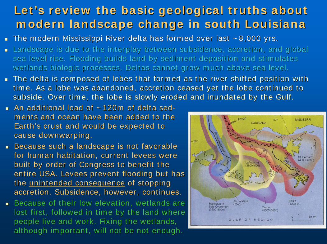
Still movingStill moving““Big EasyBig Easy””slow earthquakeslow earthquake1 cm/yr1 cm/yrFootwall unFootwall un--loadedloaded upupHanging wallHanging wallrolloverrolloverSubsidenceSubsidenceregional andregional anddynamic.dynamic.
Still movingStill moving0.5 cm/yr0.5 cm/yrHi subsidenceHi subsidencelocalized.localized.Faulting stopsFaulting stopsnear 2000, near 2000, a 30 yr a 30 yr ““slowslow””earthquake!earthquake!
A 30 yr A 30 yr ““slowslow”” earthquakeearthquake

Southward Translation Component of SLA2.3 ±1.7 mm/yr
Allochthon conceptAllochthon conceptafter Peel et al. (1995)after Peel et al. (1995)
Red dots=earthquakes

Southward translationcomponent2.3 ±1.7 mm/yr
Subsidence-5.2±2.3 mm/yr
Dokka et al. (in review)Dokka et al. (in review)
A coupled extensionalA coupled extensional--contractional complexcontractional complex

The The ““Big EasyBig Easy”” event coincided with intervalevent coincided with intervalof heightened land lossof heightened land loss
Faulting causes subsidenceFaulting causes subsidence
Subsidence leads to inundationSubsidence leads to inundation
Saltwater intrusion kills the marshSaltwater intrusion kills the marsh
durationduration
peakpeak
Coastal land lossCoastal land loss
Peel et al. (1995)Peel et al. (1995)
USACEUSACE

Radar PS Radar PS InterferometryInterferometry 20022002--late 2005late 2005RadarsatRadarsat CC--Band (6cm)Band (6cm)
Lake Pontchartrain
Red=<-20mm/yr
Yellow =-12-5mm/yr
Orange =-20--12mm/yr
Deep blue = >-5mm/yr
Dixon et al. (2006) NatureDixon et al. (2006) Nature

So, what does all of this mean?So, what does all of this mean?The entire coast and surrounding area are sinking and The entire coast and surrounding area are sinking and it occurring at higher rates than previously thought.it occurring at higher rates than previously thought.
Given the unrelenting natural processes causing much Given the unrelenting natural processes causing much of the subsidence, 20of the subsidence, 20thth century rates will likely be century rates will likely be similar through this century. Rates based on averaging similar through this century. Rates based on averaging longlong--term, millennial change seen in the geological term, millennial change seen in the geological record smooth out critical decadal scale details.record smooth out critical decadal scale details.
Merely fixing the wetlands will not save the coast and Merely fixing the wetlands will not save the coast and alone cannot provide adequate protection against alone cannot provide adequate protection against storm surge for coastal communities.storm surge for coastal communities.
Although federal river levees are the proximal cause of Although federal river levees are the proximal cause of the loss of the coast by disruption of the natural the loss of the coast by disruption of the natural systems, higher and still higher ocean levees will systems, higher and still higher ocean levees will unfortunately be needed for protection of human unfortunately be needed for protection of human populations if Society insists on living in this populations if Society insists on living in this dangerous environment.dangerous environment.


Hot colors = high; cold colors = low. Hot colors = high; cold colors = low. Notice that medium blue marks sea level. Notice that medium blue marks sea level. Areas in dark blue within the flood Areas in dark blue within the flood protection levees are below sea level.protection levees are below sea level.
Flood protection Flood protection leveelevee
Flood protection Flood protection leveelevee
This has already happened in lower This has already happened in lower Plaquemines Parish. Levees now protect Plaquemines Parish. Levees now protect land that has subsided below sea level.land that has subsided below sea level.
Mississippi River
Mississippi River
SouthSouth
NOAA LIDARNOAA LIDAR


Questions!Questions!
Remember Kids: donRemember Kids: don’’t t drink the Kooldrink the Kool--AidAid