SUBJECT AREA: Environmental Management, ISO …€¦ · Source CEC Round 2 Question # CAC-IR-018...
140
Manitoba-Minnesota Transmission Project Source CEC Round 2 Question # CAC-IR-018 April 12, 2017 Page 1 of 5 SUBJECT AREA: Environmental Management, ISO Standard, Auditing REFERENCE: CAC-IR-001; CEC-IR-081; Chapter 22 Environmental Protection, Follow-up and Monitoring, Sections 22.1.1 and 22.6.3; Keeyask CEC Rd. 1 IR CAC-0064; and Bipole III Transmission Project 2015 Biophysical Monitoring and Mitigation Report (Submitted December 2016) QUESTION: CAC-IR-001 question 2 asked “please outline how you intend to conduct audit of the environmental protection plans for this project, in a way that results of such an audit can and will be publicly available.” This question was not answered in the response to CAC-IR-001, so we have rephrased it to facilitate a response from Manitoba Hydro (see questions (a) through (b)). We would like to thank Manitoba Hydro for providing the three components of the most recent ISO 14001 EMS audit of the Riel station. The following questions relate to the information in this audit, and how it impacts the assertion that “The ISO standard ensure quality, performance, and continual improvement in the delivery of Manitoba Hydro's Environmental Protection Program” (p. 22-2). These questions are grouped in three areas: - ISO certification as evidence of environmental stewardship, generally (questions (h) through (k)) - Questions about non-conformities identified in the audit (questions (c) through (g)) - Questions about “future areas of focus and priority” as identified in the report (question (i) and associated sub-bullets) QUESTIONS a) Please indicate how Manitoba Hydro intends to ensure the MMTP audit is publicly available. b) If MB Hydro takes the position that it will not make ISO audits for MMTP publicly available, are there alternative sources to the current PWCS auditor that could be undertaken and made publicly available? For example, could a different auditor be
Transcript of SUBJECT AREA: Environmental Management, ISO …€¦ · Source CEC Round 2 Question # CAC-IR-018...
Manitoba-Minnesota Transmission Project Source CEC Round 2 Question # CAC-IR-018
April 12, 2017 Page 1 of 5
SUBJECT AREA: Environmental Management, ISO Standard, Auditing
REFERENCE: CAC-IR-001; CEC-IR-081; Chapter 22 Environmental Protection, Follow-up and Monitoring, Sections 22.1.1 and 22.6.3; Keeyask CEC Rd. 1 IR CAC-0064; and Bipole III Transmission Project 2015 Biophysical Monitoring and Mitigation Report (Submitted December 2016) QUESTION:
CAC-IR-001 question 2 asked “please outline how you intend to conduct audit of the
environmental protection plans for this project, in a way that results of such an audit can and
will be publicly available.” This question was not answered in the response to CAC-IR-001, so
we have rephrased it to facilitate a response from Manitoba Hydro (see questions (a) through
(b)).
We would like to thank Manitoba Hydro for providing the three components of the most recent
ISO 14001 EMS audit of the Riel station. The following questions relate to the information in
this audit, and how it impacts the assertion that “The ISO standard ensure quality,
performance, and continual improvement in the delivery of Manitoba Hydro's Environmental
Protection Program” (p. 22-2).
These questions are grouped in three areas:
- ISO certification as evidence of environmental stewardship, generally (questions (h)
through (k))
- Questions about non-conformities identified in the audit (questions (c) through (g))
- Questions about “future areas of focus and priority” as identified in the report (question
(i) and associated sub-bullets)
QUESTIONS
a) Please indicate how Manitoba Hydro intends to ensure the MMTP audit is publicly
available.
b) If MB Hydro takes the position that it will not make ISO audits for MMTP publicly
available, are there alternative sources to the current PWCS auditor that could be
undertaken and made publicly available? For example, could a different auditor be

Manitoba-Minnesota Transmission Project Source CEC Round 2 Question # CAC-IR-018
April 12, 2017 Page 2 of 5
selected. Please elaborate on your answer.
At pages i and ii of the 2015 ISO 14001:2004 Audit, three minor non-conformities were
identified.
c) Please provide details relating to your understanding of the identified non-conformities
in training for the last two audits(2014 and 2015), the legal evaluation and the hazardous
waste management.
d) Given that the non-conformities in training were identified in the previous audit, how do
the deficiencies compare between audits? Have there been any improvements?
e) Given that the previous audit identified non-conformities relating to managing and
tracking of staff training and that there were resulting inefficiencies, how do the
deficiencies compare between audits? Have there been any improvements?
f) How is Manitoba Hydro working to address the non-conformities identified by the
auditor? Please provide detailed information on Manitoba Hydro's plan to address each
non-conformity (i.e. the inconsistent systems for managing staff training, tracking of
compliance, and issues related to hazardous material management).
g) How do the deficiencies in hazardous material management identified in the ISO 14001
audit relate to the 2015 Bipole III Monitoring Report information on waste management,
which identified 22 non-reportable instances of environmental releases at the Riel
station?
At page ii of the 2015 ISO 14001:2004 Audit, five opportunities for improvement have been
identified by Manitoba Hydro.
h) Please confirm that the EMAC dashboard is the information system used by Manitoba
Hydro for the ISO certified Environmental Management System (EMS). If it is, please
provide a copy of the EMS/EMAC dashboard. If is not, please explain the structure of
the EMS.
i) Please confirm that the “‘leading indicators”’ for the EMAC Dashboard”, have been
established, and provide a copy of all the indicators.
j) Please provide evidence demonstrating that the “leading indicators” are designed to
foster “continual improvement in the delivery of Manitoba Hydro’s Environmental

Manitoba-Minnesota Transmission Project Source CEC Round 2 Question # CAC-IR-018
April 12, 2017 Page 3 of 5
Protection Program” (p 22-2 of EIS).
k) Please confirm that the “environmental-related expectations or criteria” have been
defined and provide them.
At page ii of the 2015 ISO 14001:2004 Audit, future areas of focus and priorities have been
identified.
l) What has Manitoba Hydro done surrounding the areas of priority and focus, particularly
as it relates to the MMTP? Specifically:
a. How do the plans for MMTP strengthen the “corporate compliance evaluation
framework”? (bullet 1)
b. How do the plans for the MMTP address “governance program and related internal
inspection activities related to the Petroleum Storage Renewal Program”? (bullet two)
RESPONSE:
a) The ISO Audit reports are considered confidential information and are intended for the use 1
of management. The reports are generally not made publicly available. 2
b) At this point in time, Manitoba Hydro has not considered an additional external audit on 3
MMTP for public consumption. 4
c) The non-conformity on training identified instances where internal groups maintained a 5
parallel system for recording training instead of using the existing system. The second finding 6
noted that progress had been made on a new compliance framework but requested that the 7
framework be fully implemented before the finding was closed. The finding on hazardous 8
materials handling (not hazardous waste) related to an internal direction to ensure that 9
hazardous materials were stored on secondary containment. The auditors noted two instances 10
where materials did not conform to this corporate standard. 11
d) Improvements have been made to the internal recording system used for training which will 12
address issues identified by the system users. 13
e) Please see (d) above. 14
Manitoba-Minnesota Transmission Project Source CEC Round 2 Question # CAC-IR-018
April 12, 2017 Page 4 of 5
f) Corrective action plans for each have been attached. 15
g) The non-conformity noted by the ISO 14001 auditors was related to an internal standard 16
requiring secondary containment for hazardous materials. This internal standard is in addition 17
to existing regulatory requirements. The releases noted are as a result of operational activities 18
and are not related to the use of secondary containment. 19
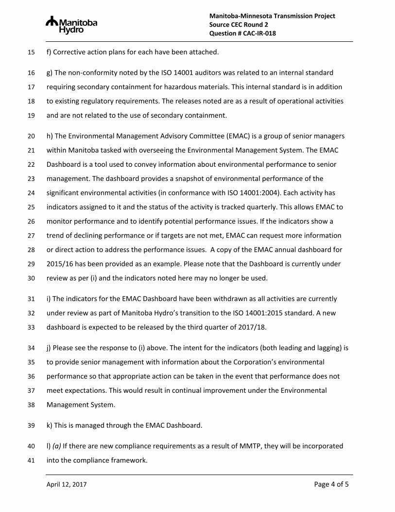
h) The Environmental Management Advisory Committee (EMAC) is a group of senior managers 20
within Manitoba tasked with overseeing the Environmental Management System. The EMAC 21
Dashboard is a tool used to convey information about environmental performance to senior 22
management. The dashboard provides a snapshot of environmental performance of the 23
significant environmental activities (in conformance with ISO 14001:2004). Each activity has 24
indicators assigned to it and the status of the activity is tracked quarterly. This allows EMAC to 25
monitor performance and to identify potential performance issues. If the indicators show a 26
trend of declining performance or if targets are not met, EMAC can request more information 27
or direct action to address the performance issues. A copy of the EMAC annual dashboard for 28
2015/16 has been provided as an example. Please note that the Dashboard is currently under 29
review as per (i) and the indicators noted here may no longer be used. 30
i) The indicators for the EMAC Dashboard have been withdrawn as all activities are currently 31
under review as part of Manitoba Hydro’s transition to the ISO 14001:2015 standard. A new 32
dashboard is expected to be released by the third quarter of 2017/18. 33
j) Please see the response to (i) above. The intent for the indicators (both leading and lagging) is 34
to provide senior management with information about the Corporation’s environmental 35
performance so that appropriate action can be taken in the event that performance does not 36
meet expectations. This would result in continual improvement under the Environmental 37
Management System. 38
k) This is managed through the EMAC Dashboard. 39
l) (a) If there are new compliance requirements as a result of MMTP, they will be incorporated 40
into the compliance framework. 41

Manitoba-Minnesota Transmission Project Source CEC Round 2 Question # CAC-IR-018
April 12, 2017 Page 5 of 5
l) (b) The Petroleum Storage Tank Program ensures that Manitoba Hydro’s registered tanks are 42
fully compliant with provincial and federal requirements. In 2014, the Petroleum Storage 43
Renewal Process was initiated to renew provincial permits. If any registered tanks become a 44
part of the MMTP, they will be included in the program. 45

# Significant Environmental Activity Key Performance Indicators Recommended Target Status
Performance is meeting or exceeding target
There is potential for targets to be missed and CED will monitor performance
Corrective action is required for at least one of the indicators
Status Definitions
(N/A) Overall EMS Performance
1) Repeat external audit findings issued to the Manitoba Hydro EMS by our ISO 14001 registrar.
2) % of open Internal Audit findings past their completion date
3) # of external auditing findings elevated from an OFI or minor N/C
1) Zero repeat audit findings
2) For tracking
3) Zero elevated findings
F81) Reduction in # of exceedences from previous year
2) For trackingTreatment and discharge of wastewater
G6Operation of Hydraulic, Lubricated, and
Insulated Equipment Systems1) # of releases related to hydraulic, lubricated, and insulated equipment systems in Generation Operations
Improvement from previous year
G5 Combustion of fossil fuels for power generation
1) # of Brandon and Selkirk GS operating license conditions exceedences related to air
2) # of releases of hazardous materials associated with the generation of electricity in the four diesel communities
1) 100% system operation within licence conditions
2) For tracking
1) Number of releases associated with the management of PCBs
2) Number of bushings with unknown PCB concentration level in the Transmission BU
1) Reduction from same quarter in previous year
2) Tracking progress towards goal of 0 by 2025
HM2
EMAC Dashboard 2015-16 Annual Summary
1) # of environmental infractions resulting in a charge, a ticket or a warning from regulators
2) # of infractions by contractors that result in a stop work order or improvement order
G3Watercourse Modification and Reservoir
Development
PCB management
1) Zero infractions
2) For tracking
Construction of transmission system
1) # of environmental infractions resulting in a charge, a ticket or a warning from regulators
2) # of infractions by contractors that result in a stop work order or improvement order
1) Zero infractions
2) For tracking
HM1 Hazardous Materials Management1) Compliance with SMS requirements for activation and review of spill response plans.
2) # of CEA priority releases
1) 100% compliance with SMS requirements for activation and review
2) Reduction from same quarter in previous year
Storage of petroleum products1) Number of releases associated with the storage of petroleum products
2) % of SMS checklists completed as required
1) Reduction from same quarter in previous year
2) For tracking
HM3
T2
1) # of wastewater exceedences
2) # of releases of wastewater

385-A1-NC-01 Corrective Action Plan
1 Administration
Audit and Finding Reference No.
385-A1-NC-01
Minor Nonconformity
Date of Audit October 5-9, 2015
Audit Criteria ISO 14001:2004 @ 4.4.2 Competence, Training and Awareness
Investigation of the Non-Conformity
Corporate Environment (CED) met with key managers from the Human Resources Division (Employee Learning & Development) and the Workplace Safety & Health and Corporate Services Division (Workplace Safety) along with HRMS and SMS system administrators to discuss a this finding. Participants agreed that many managers may not understand the distinction between qualifications and requirements. This has been documented for safety, but not for environment. As for the use of HRMS, it was acknowledged that the system is not always easy to use and some managers may prefer to maintain their own spreadsheets. In addition, it is not clear if there is a corporate requirement to use HRMS or not. All of these factors contributed to the finding. Corrective Action(s)
1) Define “environmental qualification” CED will use the current safety qualifications and training guide to create a combined safety and environment qualifications and training guideline for records in HRMS. CED will also seek support from the Environmental Management Advisory Committee (EMAC) before proceeding with this corrective action
2) Obtain Executive support for communicating expectations on the use of HRMS
CED will work with EMAC, WSD and HRD to seek Executive support in evaluating and clarifying the use of HRMS as a tool to record training and qualifications. Once this support is gained and any underlying issues identified, a communication will be sent out to line management outlining expectations on the use of HRMS.

3) Provide system support
HR will provide more front end support in the form of tools and information particularly during the granting of access to new users. Access can only be granted through the E-Learning/PC Training Supervisor (HRD). This support may include items such as training for recording secretaries, documentation and other forms of ongoing support.

385-A1-NC-02 Corrective Action Plan
1. Administration
Audit and Finding Reference No.
385-A1-NC-02: Minor Nonconformity
Date of Audit October 5 - 9, 2015
Audit Criteria ISO 14001:2004 @ 4.4.6 Operational Control
Investigation of the Non-Conformity
The Manager, CED met with the Hazardous Material Officer (HMO), the Dangerous Goods Officer and the Environment Compliance Program Coordinator (all CED) to review the finding and determine the root cause. This issue is systemic across the Corporation, and an investigation determined two possible root causes. The first may be a lack of awareness among staff. However, the second root cause may be that the corporate requirements for chemical storage are out of date or may not be appropriate given changes in regulations. Both root causes will be addressed through the corrective action.
Corrective Action(s)
1) Raise awareness of chemical storage requirements CED will discuss the finding with the EMS Coordinators, the Area Spill Response Coordinators (ASRC) and Field Safety Officers (FSO). The purpose of this will be to remind staff of the chemical storage requirements and encourage them to work with sites to ensure that chemicals are stored properly. This can be done through site visits, safety meetings, etc. The purpose is to raise awareness among staff of the requirements for chemical storage, and ensure that items requiring secondary containment are stored properly. 2) Review current requirements for chemical storage With the appointment of a new Hazardous Materials Officer in October 2015, a number of publications will now be reviewed, including the Chemical Storage Handbook. If there is an opportunity to clarify or revise the current requirements for chemical storage (including secondary containment), it will be carried out during this review. Any clarifications or revisions would then be communicated to staff as needed.
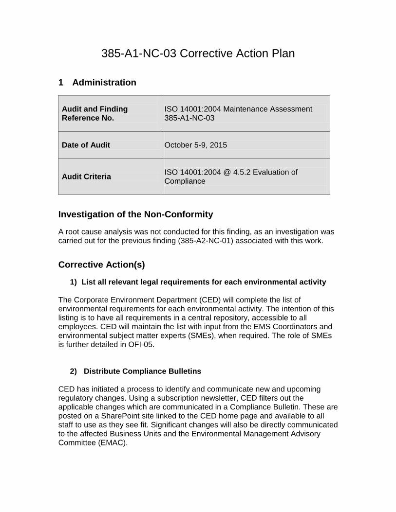
385-A1-NC-03 Corrective Action Plan
1 Administration
Audit and Finding Reference No.
ISO 14001:2004 Maintenance Assessment 385-A1-NC-03
Date of Audit October 5-9, 2015
Audit Criteria ISO 14001:2004 @ 4.5.2 Evaluation of Compliance
Investigation of the Non-Conformity
A root cause analysis was not conducted for this finding, as an investigation was carried out for the previous finding (385-A2-NC-01) associated with this work. Corrective Action(s)
1) List all relevant legal requirements for each environmental activity
The Corporate Environment Department (CED) will complete the list of environmental requirements for each environmental activity. The intention of this listing is to have all requirements in a central repository, accessible to all employees. CED will maintain the list with input from the EMS Coordinators and environmental subject matter experts (SMEs), when required. The role of SMEs is further detailed in OFI-05.
2) Distribute Compliance Bulletins
CED has initiated a process to identify and communicate new and upcoming regulatory changes. Using a subscription newsletter, CED filters out the applicable changes which are communicated in a Compliance Bulletin. These are posted on a SharePoint site linked to the CED home page and available to all staff to use as they see fit. Significant changes will also be directly communicated to the affected Business Units and the Environmental Management Advisory Committee (EMAC).

3) Initiate a process to develop corporate self-assessments
CED and the EMS Coordinators will begin the development of activity-specific corporate self-assessments. These will be used in the Business Units to periodically evaluate compliance. The results will be reported to CED for amalgamation and potential trending; where a trend is observed, it will be communicated to EMAC for further direction. The results of the corporate self-assessments will become an input in the Business Unit Quarterly Report process. This process is further detailed in OFI-04. At least one corporate self-assessment will be developed and implemented before the next Maintenance Audit.
Manitoba-Minnesota Transmission Project Source CEC Round 2 Question # CAC-IR-019
April 12, 2017 Page 1 of 2
SUBJECT AREA: Monitoring, Environmental Management, Learning, Communication & Reporting
REFERENCE: CAC- IR-002; Chapter 22 Environmental Protection, Follow-up and Monitoring (Sections 22.1.3 and 22.2.4); Bipole III Transmission Project Chapter 11.0 Environmental Protection, Follow-up and Monitoring (Section 11.2.12); and Keeyask Impact Statement, Supporting Volume Public Involvement, Appendix 1-C.
QUESTION:
Thank you for clarifying that a formal complaint can be received “via the project website, email
or phone number” (sub-question 1), and that “Manitoba Hydro does not restrict itself to only
sending formal enquiries or complaints to the Environmental Protection Management Team”
(sub-question 2).
It is important to have a more robust understanding of the process through which complaints
are received, reviewed and tracked as the information makes its way through the system, which
was the original intent of sub-questions 3 and 4. For example, in an environmental assessment,
it is not uncommon for a company to have an issues tracking table, such as provided as part of
the Keeyask Impact Statement (referenced above). This includes reference to the general issue,
a more detailed description of the concern, the stakeholder/source, and how it was addressed.
QUESTION
a) Please explain how Manitoba Hydro evaluates whether it has satisfactorily responded to
complaints. Please identify any tools which Manitoba Hydro employs to determine its
response to complaints has been satisfactory resolved.
b) Is there a centralized system, accessible to the public, that documents the complaint and
the action(s) taken by the Environmental Protection Management Team to address the
complaint(s)? For example, is there an opportunity to report on this information in the
annual biophysical monitoring and mitigation reports?
RESPONSE:
a) Manitoba Hydro evaluates whether it has satisfactorily responded to complaints 1
through ongoing feedback from follow-up engagement processes. Manitoba Hydro 2

Manitoba-Minnesota Transmission Project Source CEC Round 2 Question # CAC-IR-019
April 12, 2017 Page 2 of 2
strives for excellent customer service and for positive relationships with internal and 3
external customers. As such, it has a variety of tools and/or mechanisms to determine 4
whether complaints have been resolved to a complainant’s satisfaction, including: 5
a. maintaining continuous relationships with landowners, Indigenous communities, 6
and regulators throughout the development of the project; 7
b. using of Microsoft Sharepoint based landowner and Indigenous relationship 8
management systems; and 9
c. incorporating Customer Service as a part of the core competencies required of 10
Manitoba Hydro staff to achieve successful job performance. 11
b) There is no centralized project focused system for these types of complaints. Manitoba 12
Hydro does use cross communication processes (i.e. regular meetings, sharing of 13
external stakeholder meeting minutes, information management systems) between key 14
departments on a specific project like MMTP to facilitate effective customer service. 15
There may be an opportunity through the Indigenous Community Monitoring Working 16
Group to track complaints and resolutions and publish them in annual reports. 17

Manitoba-Minnesota Transmission Project Source CEC Round 2 Question # CAC-IR-020
April 12, 2017 Page 1 of 2
SUBJECT AREA: Environmental Management, ISO Standard, Auditing
REFERENCE: CAC-IR-003; and Chapter 22 Environmental Protection, Follow-up and Monitoring (Sections 22.3.3); Chapter 6 Environment & Socio-Economic Setting.
QUESTION:
The response to this IR clarified some of the areas of work that has been done since the Impact
Statement was publicized:
“Some aspects of the Environmental Protection Program, such as Golden-winded warbler
(GWW) Habitat Management plan (HMP), were developed after the EIS was publicized.
The GWW HMP (detailed in CEC-IR-050) will contribute to more detailed understandings on the
effectiveness and long-term changes in GWW habitat availability on the ROW”
Later in the response, Manitoba Hydro indicated in reference to the draft monitoring plan that
“these pre-construction surveys will augment and enhance the baseline information collected
as part of the EIS”.
What remains outstanding is a detailed response to the original question, which asked
Manitoba Hydro to “specify (list and explain) the outstanding baseline information not captured
in the EIS”.
QUESTION
a) Please provide a comprehensive list of where current baseline information is inadequate and
identify where augmentation is expected to be required.
RESPONSE:
Please see attached updated draft of the Manitoba-Minnesota Transmission Project 1
Environmental Monitoring Plan (Appendix 22C). 2
To clarify it is Manitoba Hydro’s position that current baseline information for the purposes of 3
the environment impact assessment is extensive and more than adequate to support the 4
conclusions of the EIS. 5
Manitoba-Minnesota Transmission Project Source CEC Round 2 Question # CAC-IR-020
April 12, 2017 Page 2 of 2
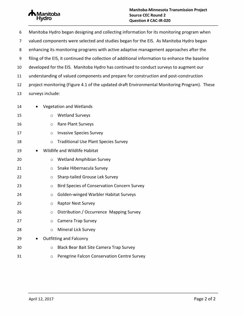
Manitoba Hydro began designing and collecting information for its monitoring program when 6
valued components were selected and studies began for the EIS. As Manitoba Hydro began 7
enhancing its monitoring programs with active adaptive management approaches after the 8
filing of the EIS, it continued the collection of additional information to enhance the baseline 9
developed for the EIS. Manitoba Hydro has continued to conduct surveys to augment our 10
understanding of valued components and prepare for construction and post-construction 11
project monitoring (Figure 4.1 of the updated draft Environmental Monitoring Program). These 12
surveys include: 13
• Vegetation and Wetlands 14
o Wetland Surveys 15
o Rare Plant Surveys 16
o Invasive Species Survey 17
o Traditional Use Plant Species Survey 18
• Wildlife and Wildlife Habitat 19
o Wetland Amphibian Survey 20
o Snake Hibernacula Survey 21
o Sharp-tailed Grouse Lek Survey 22
o Bird Species of Conservation Concern Survey 23
o Golden-winged Warbler Habitat Surveys 24
o Raptor Nest Survey 25
o Distribution / Occurrence Mapping Survey 26
o Camera Trap Survey 27
o Mineral Lick Survey 28
• Outfitting and Falconry 29
o Black Bear Bait Site Camera Trap Survey 30
o Peregrine Falcon Conservation Centre Survey 31

MANITOBA-MINNESOTA TRANSMISSION PROJECT Environmental Monitoring Plan

4/12/2017
Manitoba-Minnesota Transmission Project Environmental Monitoring Plan
Draft
4/12/2017
4/12/2017
I
TABLE OF CONTENTS
1.0 INTRODUCTION ............................................................................... 1
1.1 PROJECT OVERVIEW .............................................................................. 1
1.1.1 Regulatory Requirement ............................................................ 1
1.2 ENVIRONMENTAL PROTECTION PROGRAM ....................................... 3
2.0 ENVIRONMENTAL MONITORING ................................................... 4
2.1 PURPOSE ................................................................................................. 4
2.2 OBJECTIVES ............................................................................................ 4
2.3 SCOPE OF WORK .................................................................................... 5
2.4 MANAGEMENT AND COORDINATION ................................................... 5
2.5 PUBLIC COMMUNICATIONS AND ENGAGEMENT................................ 5
2.6 FIRST NATION AND METIS ENGAGEMENT & TRADITIONAL KNOWLEDGE ........................................................................................... 6
2.6.1 Traditional Knowledge ............................................................... 6
2.6.2 Ongoing First Nations and Metis Engagement Process.......... 6
3.0 PAST, PRESENT AND FUTURE MONITORING PROGRAMS ........ 9
4.0 MMTP MONITORING PROGRAM .................................................. 10
4.1 REQUIREMENTS .................................................................................... 10
4.2 VALUED COMPONENTS ....................................................................... 11
4.2.1 Valued Component Selection .................................................. 11
4.2.2 Valued Component Monitoring Tables and Schedule ........... 14
4.3 FISH AND FISH HABITAT ...................................................................... 17
4.3.1 Water Course Crossings .......................................................... 17
4.4 VEGETATION AND WETLANDS ........................................................... 19
4.4.1 Wetlands .................................................................................... 19
4.4.2 Plant Species of Conservation Concern ................................. 22
4.4.3 Invasive Plant Species ............................................................. 25
4.4.4 Traditional Use Plant Species .................................................. 27
4.5 WILDLIFE AND WILDLIFE HABITAT ..................................................... 29
4.5.1 Amphibians ............................................................................... 29
4/12/2017
II
4.5.2 Common Garter Snakes ........................................................... 32
4.5.3 Bird – Wire Collision ................................................................. 34
4.5.4 Sharp-tailed Grouse Lekking Sites .......................................... 36
4.5.5 Bird Species of Conservation Concern................................... 39
4.5.6 Golden-Winged Warbler Habitat .............................................. 42
4.5.7 Birds of Prey .............................................................................. 45
4.5.8 Ungulates and Predators.......................................................... 47
4.5.9 Black Bear ................................................................................. 51
4.6 SOCIO-ECONOMIC AND RESOURCE USE .......................................... 54
4.6.1 Employment and Economy ...................................................... 54
4.6.2 Infrastructure and Services ...................................................... 56
4.6.2.1 Transportation ...................................................................... 56
4.6.3 Outfitting and Falconry............................................................. 58
4.6.3.1 Outfitter Resource Use ........................................................ 58
4.6.3.2 Peregrine Falcon Conservation Centre .............................. 60
5.0 ADAPTIVE MANAGEMENT ............................................................ 61
6.0 REPORTING ................................................................................... 63
7.0 MONITORING METHODS ............................................................... 64
7.1 FISH AND FISH HABITAT ...................................................................... 64
7.1.1 Stream Crossing Assessments ............................................... 64
7.2 VEGETATION AND WETLANDS ........................................................... 64
7.2.1 Wetlands .................................................................................... 65
7.2.2 Plant Species of Conservation Concern ................................. 66
7.2.3 Invasive Plant Species ............................................................. 66
7.2.4 Traditional Use Plant Species .................................................. 67
7.3 WILDLIFE AND WILDLIFE HABITAT ..................................................... 68
7.3.1 Herptiles..................................................................................... 68
7.3.1.1 Amphibians .......................................................................... 68
7.3.1.2 Common Garter Snakes....................................................... 70
7.3.2 Birds ........................................................................................... 70
7.3.2.1 Bird – Wire Collisions .......................................................... 70

4/12/2017
III
7.3.2.2 Sharp-tailed Grouse Lekking Sites ..................................... 74
7.3.2.3 Birds of Species of Conservation Concern ........................ 76
7.3.2.4 Golden-winged Warbler Habitat .......................................... 78
7.3.2.5 Birds of Prey ......................................................................... 79
7.3.3 Ungulates and Predators.......................................................... 79
7.3.3.1 Elk ......................................................................................... 79
7.3.3.2 White-tailed Deer .................................................................. 83
7.3.3.3 Black Bear ............................................................................ 84
7.3.3.4 Wolves and Coyotes ............................................................ 85
7.4 EMPLOYMENT AND ECONOMY ........................................................... 86
7.4.1 Project Employment ................................................................. 86
7.4.2 Business Opportunities............................................................ 86
7.4.3 Labour Income and Tax Revenue ............................................ 87
7.5 INFRASTRUCTURE AND SERVICES .................................................... 87
7.5.1 Transportation ........................................................................... 87
7.6 OUTFITTING AND FALCONRY .............................................................. 88
7.6.1 Outfitter Resource Use ............................................................. 88
7.6.2 Peregrine Falcon Conservation Center ................................... 88
8.0 REFERENCES ................................................................................ 90
LIST OF MAPS
Map 1-1 Project Components Map .............................................................................................. 2
LIST OF TABLES Table 4-1 Valued Components and Environmental Indicators ................................................... 12
Table 4-2 Fish and Fish Habitat ................................................................................................ 17
Table 4-3 Wetlands ................................................................................................................... 19
Table 4-4 Plant Species of Conservation Concern .................................................................... 22
Table 4-5 Invasive Plant Species .............................................................................................. 25
Table 4-6 Traditional Use Plant Species ................................................................................... 27
Table 4-7 Amphibians ............................................................................................................... 29
Table 4-8 Common Garter Snakes ............................................................................................ 32
Table 4-9 Bird – Wire Collision .................................................................................................. 34
4/12/2017
IV
Table 4-10 Sharp-tailed Grouse Lekking Sites .......................................................................... 36
Table 4-11 Bird Species of Conservation Concern .................................................................... 39
Table 4-12 Birds of Prey ........................................................................................................... 45
Table 4-13 Ungulates and Predators ......................................................................................... 48
Table 4-14 Black Bear ............................................................................................................... 51
Table 4-15 Employment and Economy ..................................................................................... 54
Table 4-16 Transportation ......................................................................................................... 56
Table 4-17 Outfitter Resource Use ............................................................................................ 58
Table 4-18 Peregrine Falcon Conservation Centre ................................................................... 60
LIST OF FIGURES
Figure 1-1 Transmission Environmental Protection Program ....................................................... 3
Figure 4-1 Proposed Monitoring Activities Schedule ................................................................ 15

4/12/2017
V
ACRONYMS
AC Alternating Current
ATK Aboriginal Traditional Knowledge
ATKS Aboriginal Traditional Knowledge Studies
EMP Environmental Monitoring Plan
CEC Clean Environment Commission
CEAA Canadian Environmental Assessment Agency
CEAA 2012 Canadian Environmental Assessment Act 2012
CEnvPP Construction Environmental Protection Plan
CHRPP Cultural and Heritage Resources Protection Plan
DFO Department of Fisheries and Oceans
EA Environmental Assessment
EIS Environmental Impact Statement
EnvPP Environmental Protection Plan
EPIMS Environmental Protection Information Management System
EPP Environmental Protection Program
ESS Environmentally Sensitive Site
FNMEP First Nation and Metis Engagement Process
FRI Forest Resource Inventory
GPS Global Positioning System Unit
km Kilometre
kV Kilovolt
LAA Local Assessment Area
MBCA Migratory Birds Convention Act
MBCDC Manitoba Conservation Data Centre
SD Manitoba Sustainable Development
MESEA Manitoba Endangered Species and Ecosystems Act
MMF Manitoba Metis Federation

4/12/2017
VI
MMTP Manitoba-Minnesota Transmission Project
NEB National Energy Board
PDA Project Development Area
PEP Public Engagement Process
RoW Right-of-way
SARA Species at Risk Act
SOCC Species of Conservation Concern
TSS Total Suspended Solids
VC Valued Component
VES Visual Encounter Surveys

Draft 4/12/17
1
1.0 INTRODUCTION
1.1 PROJECT OVERVIEW
Manitoba Hydro is proposing to construct and operate a 500 kilovolt (kV) alternating current
(AC) international transmission line in southeastern Manitoba that includes additions and
upgrades to three associated transmission stations at Dorsey, Riel and Glenboro South. (Map
1-1) The proposed project is called the Manitoba-Minnesota Transmission Project (the Project)
and consists of approximately 213 km of single circuit, 500 kV AC transmission line (D604I) that
will start at the existing Dorsey Converter Station northwest of Winnipeg, in the RM of Rosser,
and will connect at the Manitoba-Minnesota border to a new transmission line proposed by
Minnesota Power, called the Great Northern Transmission Line. The proposed project is
required for the following reasons:
Export power to the United States based on current sales agreements
Improve reliability and import capacity in emergency and drought situation; and
Increase access to markets in the Unites States
Clearing and construction of the Project is expected to take approximately 2 ¾ years to
complete with activities starting in the Q3 of 2017 and ending in Q1 2020. Subject to regulatory
approvals, the in-service date of the project is 2020.
1.1.1 Regulatory Requirement
The Project is subject to environmental regulatory review and approval. The project is defined
as a Class 3 Development (under the Classes of Development Regulation) that will be reviewed
by Manitoba Sustainable Development (SD) and require an Environment Act License under The
Environment Act (Manitoba).
Authorization for the construction and operation of the transmission line is also required under
the National Energy Board Act and the project is subject to an environmental assessment by the
National Energy Board (NEB) under the Canadian Environmental Assessment Act, 2012 (CEAA
2012).
This Environmental Monitoring Plan (EMP) has also been included in the Manitoba-Minnesota
Transmission Project Environmental Impact Statement (EIS) submission to be reviewed and
approved by regulatory authorities.

4/12/17
2
Map 1-1 Project Components Map
4/12/17
3
1.2 ENVIRONMENTAL PROTECTION PROGRAM
Part of Manitoba Hydro’s commitment to environmental protection includes the development of
a comprehensive Environmental Protection Program (EPP), this is further described in chapter
22 of the EIS. The purpose of the EPP is to provide the framework for implementing, managing,
monitoring and evaluating environmental protection measures that are consistent with
regulatory requirements and environmental guidelines. This EMP is a component of the EPP as
illustrated in Figure 1-1.
Figure 1-1 Transmission Environmental Protection Program

4/12/17
4
2.0 ENVIRONMENTAL MONITORING
This document describes the Environmental Monitoring Plan, which outlines the various
monitoring activities that will occur to address follow-up requirements identified for the valued
components included in the environmental assessment. Monitoring activities will be considered
during all phases of Project development (i.e. pre-construction, construction and post
construction). Follow-up requirements include actions implemented to assess the effectiveness
of the environmental assessment and to confirm compliance with regulatory requirements.
This EMP is intended to describe how and provide assurance to regulators, environmental
organizations, First Nations, the MMF and Indigenous organizations and the general public that
potential environmental effects caused by the Project will be monitored, evaluated and reported
on in a responsible and accountable manner.
An internal Environmental Protection Information Management System (EPIMS) was developed
that will manage, store and facilitate the transfer of Environmental Protection Program data and
information amongst the Project team. EPIMS will facilitate the transferring of knowledge and
experiences encountered on a daily basis during construction activities from Environmental
Inspectors to the Specialists that are responsible for monitoring project effects. EPIMS is an
essential tool that manages vast amounts of data and information that will be generated through
the implementation of this plan, allowing for Manitoba Hydro to employ an adaptive
management approach during this project and apply that experience and knowledge to future
developments.
2.1 PURPOSE
The purpose of this EMP is to outline the potential effects identified in the EIS and the key
activities that will be conducted as part of the monitoring and follow-up component of the EPP.
The intended goal of this plan is to provide details on monitoring activities and how monitoring
results will be used within an adaptive management cycle to make decisions and trigger actions
to further minimize the effects of the Project on the environment.
2.2 OBJECTIVES
The objectives of this monitoring plan are to:
Confirm the nature and magnitude of predicted environmental effects as stated in the
EIS;
Assess effectiveness of mitigation measures implemented;
Establish decision-triggers for action;
4/12/17
5
Identify unexpected environmental effects of the project, if they occur;
Identify additional mitigation measures to address unanticipated environmental effects, if
required;
Confirm compliance with regulatory requirements including approval terms and
conditions; and
Provide additional baseline information to evaluate long-term changes or trends.
2.3 SCOPE OF WORK
The scope of this EMP will include the biological and socio economic components of the
environment. A Cultural and Heritage Resources Protection Plan (CHRPP) will also be
developed that outlines Manitoba Hydro’s commitment to safeguard cultural and heritage
resources and provide information on how to appropriately handle human remains or cultural
and heritage resources discovered or disturbed during construction of the Project.
2.4 MANAGEMENT AND COORDINATION
As part of the EPP, Manitoba Hydro will have staff comprised of senior Manitoba Hydro
management, as well as implementation teams committed to the implementation of the EMP for
the Project. The Environmental Protection Management Team will be responsible for the
management of the environmental protection plans including compliance with regulatory and
other requirements, quality assurance and control, consultation with regulators and activities
related to the Public Engagement Process (PEP) and First Nation and Metis Engagement
Process (FNMEP). The Environmental Protection and Implementation Team, which is
comprised of Manitoba Hydro operational and office staff, will be responsible for the day to day
implementation of environmental protection plans developed for the project which include
monitoring, inspecting and reporting.
Manitoba Hydro will ensure that resources are allocated to the environmental aspects of project
planning, development, implementation and operation for the successful implementation of
environmental protection measures and follow-up including monitoring. Manitoba Hydro will
commit resources early in the planning cycle to ensure effective environmental assessment,
mitigation and monitoring including an environmental staff member from the Licensing and
Environmental Assessment Department that will lead the field monitoring program during the
construction of the Project and provide field level support to the ongoing FNMEP.
2.5 PUBLIC COMMUNICATIONS AND ENGAGEMENT
In addition to extensive public engagement efforts that have occurred to date throughout the
development of the Project, Manitoba Hydro welcomes all members of the public to contact the

4/12/17
6
corporation with questions or comments throughout the construction process. Manitoba Hydro’s
Manitoba-Minnesota Transmission Project website site,
https://www.hydro.mb.ca/projects/mb_mn_transmission, will be maintained and updated
regularly throughout the project with the summary of results of this EMP. As noted on the
Project website, additional information is always available to the public upon request via a toll-
free phone number, dedicated project e-mail address or by mail.
Manitoba Hydro Manitoba–Minnesota Transmission Project C/O Licensing and Environmental Assessment 820 Taylor Ave (3) Winnipeg MB R3M 3T1
1-877-343-1631 or 204-360-7888
2.6 FIRST NATION AND METIS ENGAGEMENT &
TRADITIONAL KNOWLEDGE
2.6.1 Traditional Knowledge
The ATKS Management Team (Black River First Nation, Swan Lake First Nation, Long Plain
First Nation), Peguis First Nation, Dakota Plains Wahpeton Oyate, Roseau River Anishinabe
First Nation, Sagkeeng First Nation and the Manitoba Metis Federation (MMF) submitted ATK
reports for the proposed Project. First Nations and the MMF that conducted ATK studies in the
later stages of the engagement process for the Project were informed that their information
would be used to inform the Environmental Protection Program.
More detailed information regarding Aboriginal Traditional Knowledge Studies completed can be
found in Chapter 4.0 of the project EIS.
2.6.2 Ongoing First Nations and Metis Engagement Process
Manitoba Hydro has developed different approaches to its ongoing post-EIS First Nation and
Metis Engagement Process. These approaches for transmission project follow-up and
monitoring programs began in 2008-2010 with the Wuskwatim Transmission Project, followed
by the Bipole III and Keeyask Transmission Projects in 2013, both projects are planned to
continue until 2018/19. Each of these projects had a different approach tailored to the
geographic region, scope/scale of project and the number of communities involved. Through
these past and current projects, accompanied by the desire to use active adaptive management

4/12/17
7
in its community involvement programs for the construction of transmission projects, Manitoba
Hydro has developed a new approach for this Project.
Manitoba Hydro’s proposed approach to the ongoing FNMEP is based on experiences by other
industries where the project is located within a traditional or current resource use area but not
necessarily in close proximity to the community itself. The approach is also based on ATK field
trips, self-directed reports received to date, and the desire within those reports for further
investigation and mapping of sensitive sites, transfer of knowledge from Elders to youth to
prevent loss of knowledge, updates on project progress and involvement in follow-up and
monitoring.
The ongoing FNMEP would include inviting interested First Nations, MMF and Indigenous
organizations representatives to attend regular field trips to the construction areas with the focus
being the highly valued undisturbed land or land with little disturbance (Black River First Nation,
Long Plain First Nation, Swan Lake First Nation. 2015) as well as areas identified as sensitive
sites (Peguis, 2015 and Roseau River, 2015). Field trips with representatives would take place
throughout both the construction and monitoring and would be guided by various staff
depending on topic, including Construction Supervisors, Environmental Inspectors and
Specialists such as experts in botany, wildlife, and traditional medicinal plants. These field trips
would be supported by a translator as required. During the construction field trips,
representatives would learn and witness activities associated with various topics including:
Mitigation measures;
Project schedule;
Clearing and construction practices;
Inspection results; and
Monitoring results.
During follow-up and monitoring field trips, representatives could participate with the
Environmental Monitor in monitoring activities such as vegetation, traditional plant, stream
crossing, mammal track, bird and camera trap surveys. Both construction and follow-up and
monitoring trips would allocate time for representatives to share concerns and ask questions of
the Project staff along with receiving a materials package and copy of photos/video taken that
day to share with their First Nation, the MMF or Indigenous organization.
To enhance traditional knowledge transfer amongst generations, educate youth about Manitoba
Hydro’s EPP, and explain environmental career opportunities for youth, separate field trips
involving youth and Elders and a Manitoba Hydro representative could occur during school
summer break. These Youth/Elder trips would be similar in nature to the construction and
follow-up and monitoring trips described above but would focus opportunities for traditional
knowledge sharing.

4/12/17
8
While specific details about the field trips are yet to be determined, Manitoba Hydro is looking
forward to working with First Nations, the MMF and Indigenous organizations to develop the
approach for this Project, which will be guided by the following objectives;
Awareness of the Project and EPP;
Manitoba Hydro awareness of community concerns and communication back on how
they are being addressed;
“Boots on the ground” field experiences;
Multiple First Nations, MMF and Indigenous organizations working together; and
A Youth and Elder component.
Manitoba Hydro is committed to an ongoing engagement process to incorporate traditional
knowledge within components of its Environmental Protection Program.

Draft 4/12/17
9
3.0 PAST, PRESENT AND FUTURE MONITORING
PROGRAMS
Monitoring programs allow us to see how predicted effects from environmental assessments
compare to the actual outcome from construction activities.
Good project planning in combination with effective monitoring is a major component for
enhancing the effectiveness of development programs and projects. Monitoring and evaluation
of projects help in the understanding and learning from past project successes and challenges
which in turn helps to inform decision-making so that current and future monitoring programs for
projects can be improved.
In order to ensure continual improvement of monitoring programs for future projects, information
and results from past monitoring programs were reviewed to better understand the effects of
transmission line construction on the biophysical and socio-economic components of the
environment. This results in a reduction of project specific residual effects through project-
based mitigation which demonstrates a commitment to continual improvement and sustainable
development.
Past and current Manitoba Hydro projects that have implemented extensive monitoring
programs include the Wuskwatim Transmission Project (2008 to 2012) and the Bipole III
Transmission Project (currently two years of monitoring completed). Recently, the
Environmental Monitoring Plan was initiated for the Keeyask Transmission project and Lake
Winnipeg East System Improvement transmission project (one year each).
Appropriate methods accepted by Manitoba Hydro and Sustainable Development were used to
monitor environmental components, such as access, aquatics, mammals, birds, and vegetation,
identified for the Wuskwatim, Bipole II, Keeyask and Lake Winnipeg East System Transmission
projects and are also outlined in the MMTP EMP.
Manitoba Hydro manages all its projects monitoring programs in a coordinated fashion so that
knowledge gained from one program is combined with other programs for a more informed
understanding of transmission line environmental effects.

4/12/17
10
4.0 MONITORING PROGRAM
4.1 REQUIREMENTS
As defined under the Canadian Environmental Assessment Act (CEAA) 2012, monitoring and
follow up is required to verify the accuracy of the environmental assessment of a project and
determine the effectiveness of measures taken to mitigate potential adverse environmental
effects (CEAA, 2012). The National Energy Board (NEB) through their Regulatory Framework
also requires “Lifecycle Compliance Monitoring” in which the NEB monitors and enforces
compliance with requirements concerning the safety and protection of employees, the public
and the environment as they may be affected throughout the life of the project (NEB, 2015). In
addition the NEB may monitor and verify compliance with requirements during construction,
operation and decommissioning through the use of audits, inspections, compliance meetings,
investigations and response to concerns and complaints.
Through monitoring and follow up, EIS outcomes are realized, communicated and managed
through refinement and improvement of mitigation strategies.
The EPP includes two main types of monitoring:
Environmental monitoring – periodic or continuous surveillance or testing, according to a
predetermined schedule, of one or more environmental indicators to establish/enhance
knowledge of baseline conditions or to verify the accuracy of an environmental assessment
and the effectiveness of mitigation measures. Pre and post disturbance and control-impact
monitoring are the preferred approaches to monitoring environmental effects.
Compliance monitoring – observation or testing conducted to verify whether a practice or
procedure meets the applicable requirements prescribed by legislation, licence conditions,
and/or Environmental Protection Plans.
Environmental monitoring is addressed through this EMP. Compliance monitoring is
accomplished through the Environmental Protection Program which will involve the use of
dedicated environmental inspectors to observe and verify the implementation of the
environmental protection plans. Information generated from this program will be utilized by an
adaptive management approach to improve both mitigation measure effectiveness and
monitoring program design. A summary of compliance monitoring results will be presented in
an annual report.
4/12/17
11
4.2 VALUED COMPONENTS
This section identifies the Valued Components that were selected for the environmental
assessment that will be monitored including rationale for their selection. Additional information
in this section includes key monitoring activities, task descriptions, duration, frequency and
timing of activities, Environmental Monitor input, Manitoba Hydro commitments and specialist
and SD roles. Manitoba Hydro has developed the plan to address concerns expressed by
stakeholders, local communities, First Nations and Metis, and regulators.
Where applicable, Decision Trigger(s)/Threshold(s) for Action have been identified for each
valued component. These decision triggers or thresholds for action are mechanisms to promote
adaptive management that cause Manitoba Hydro and its Specialists to stop and further
evaluate the monitoring results and, if required, adapt mitigation measures or monitoring
activities. Decisions triggers/thresholds cannot be identified for all situations, there are too
many parameters and variables and lack of scientific data. It is for this reason why many
government agencies, including Manitoba, have not yet published definitive thresholds for action
for different wildlife management scenarios. Manitoba Hydro will continue to fund applicable
research and contribute monitoring information from projects to the regulators.
4.2.1 Valued Component Selection
An initial step of the environmental assessment for the proposed project was the identification of
Valued Components (VCs) that may be adversely affected by the Project this is fully discussed
in Chapter 7 of the EIS).
VCs are environmental elements that have the potential to interact with the Project and that met
one or more of the following criteria:
represent a broad environmental, ecological or human environment component that might be affected
by the Project;
are a part of the heritage of First Nations and Metis or a part of their current use of lands for
traditional purposes;
are of scientific, historical, archaeological importance;
have been identified as important issues or concerns by stakeholders or by other effects
assessments in the region.
Valued Components that require monitoring and follow-up were identified in each applicable
chapter within the EIS. For each VC, one or more environmental indicators were selected to
focus monitoring and follow up efforts.
4/12/17
12
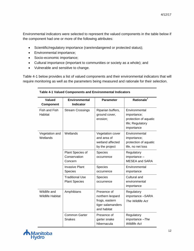
Environmental indicators were selected to represent the valued components in the table below if
the component had one or more of the following attributes:
Scientific/regulatory importance (rare/endangered or protected status);
Environmental importance;
Socio-economic importance;
Cultural importance (important to communities or society as a whole); and
Vulnerable and sensitive to change.
Table 4-1 below provides a list of valued components and their environmental indicators that will
require monitoring as well as the parameters being measured and rationale for their selection.
Table 4-1 Valued Components and Environmental Indicators
Valued
Component
Environmental
Indicator
Parameter Rationale1
Fish and Fish
Habitat
Stream Crossings Riparian buffers,
ground cover,
erosion;
Environmental
importance;
protection of aquatic
life; Regulatory
importance
Vegetation and
Wetlands
Wetlands Vegetation cover
and area of
wetland affected
by the project
Environmental
importance;
protection of aquatic
life, no net loss
Plant Species of
Conservation
Concern
Species
occurrence
Regulatory
importance –
MESEA and SARA
Invasive Plant
Species
Species
occurrence
Environmental
importance
Traditional Use
Plant Species
Species
occurrence
Cultural and
environmental
importance
Wildlife and
Wildlife Habitat
Amphibians Presence of
northern leopard
frogs, eastern
tiger salamanders
and habitat
Regulatory
importance –SARA
The Wildlife Act
Common Garter
Snakes
Presence of
garter snake
hibernacula
Regulatory
importance –The
Wildlife Act

4/12/17
13
Table 4-1 Valued Components and Environmental Indicators
Valued
Component
Environmental
Indicator
Parameter Rationale1
Bird-Wire Collision Abundance and
Mortality
Environmental and
cultural importance;
Regulatory
importance
Sharp-tailed Grouse
Lekking Sites
Lek abundance,
number of males,
mortality changes
Vulnerable and
sensitive to change;
Regulatory
importance
Bird Species of
Conservation
Concern
Presence
/Absence
habitat suitability
Regulatory
importance -
MESEA; SARA; MB
CDC, designated
Golden-winged
Warbler critical
habitat
Golden-winged
Warbler Habitat
Vegetation cover Regulatory
importance –
MESEA and SARA
Birds of Prey Nest site locations Environmental
importance;
Regulatory
importance
Ungulates and
Predators
Occurrence
and/or seasonal
distribution,
vehicle collision
related mortality
Environmental and
cultural importance;
Regulatory
importance
Black Bear Occurrence,
annual prevalence
Environmental and
cultural importance;
Regulatory
importance
Employment
and Economy
Project Employment Total person
years of
employment, total
number of hires,
total number of
employees.
Socio-economic and
cultural importance

4/12/17
14
Table 4-1 Valued Components and Environmental Indicators
Valued
Component
Environmental
Indicator
Parameter Rationale1
Type (job
classifications) of
work available.
Direct/Indirect
Business Effects
Direct project
expenditures
Indirect business
opportunities
Socio-economic
importance and
cultural importance
Direct Labour
Income and Taxes
Direct labour
income.
Project taxes
generated (non-
labour).
Socio-economic and
cultural importance
Infrastructure
and Services
Transportation Traffic volumes
and accidents on
key roadways.
Socio-economic
importance and
cultural importance
Outfitters and
Falconry
Outfitter Resource
Use
Change in
occurrence of
black bears
frequenting bear
bait sites
Socio-economic
importance
Peregrine Falcon
Conservation
Centre
Location of
peregrine perch
sites and total
distance moved
Socio-economic/
environmental
importance
4.2.2 Valued Component Monitoring Tables and Schedule
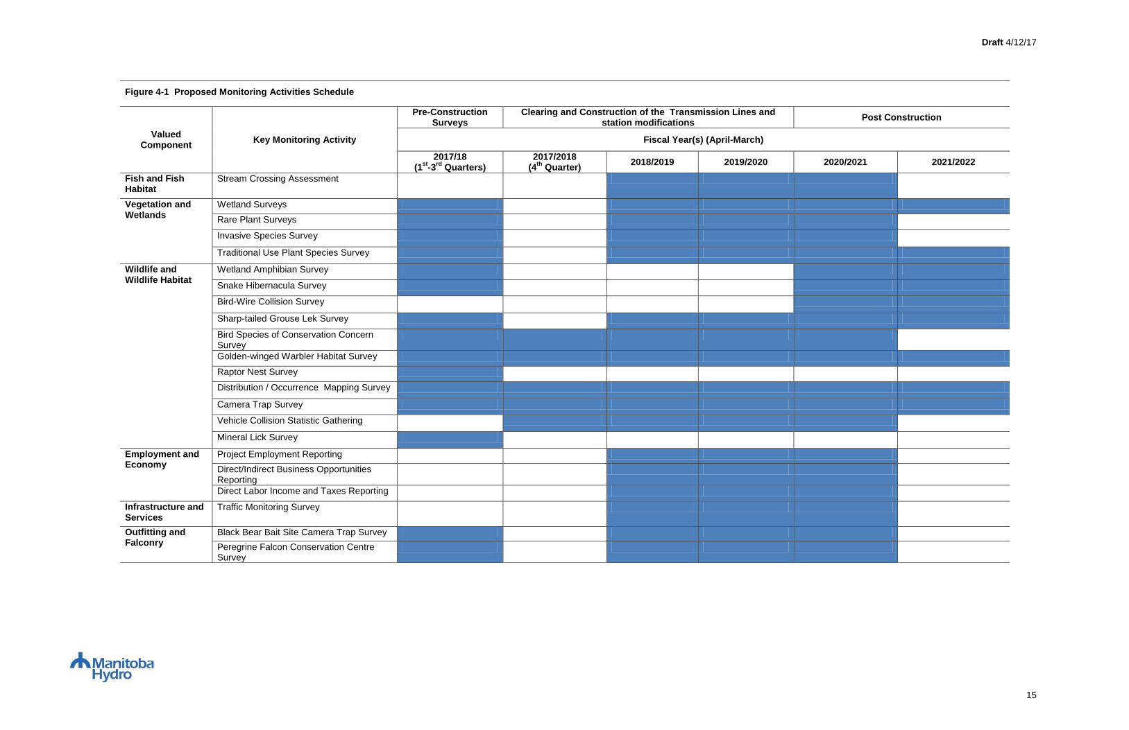
Figure 4-1 illustrates the proposed schedule of monitoring activities. The following tables 4-2
thru 4-17 summarize the key monitoring activities that will be conducted for each of the Valued
Components and Environmental Indicators identified in Section 4.2.1 above. Detailed
methodologies for each key monitoring activity are outlined in Section 7.0 of this report.
Draft 4/12/17
15
Figure 4-1 Proposed Monitoring Activities Schedule
Valued Component
Key Monitoring Activity
Pre-Construction Surveys
Clearing and Construction of the Transmission Lines and station modifications
Post Construction
Fiscal Year(s) (April-March)
2017/18 (1
st-3
rd Quarters)
2017/2018 (4
th Quarter)
2018/2019 2019/2020 2020/2021 2021/2022
Fish and Fish Habitat
Stream Crossing Assessment
Vegetation and Wetlands
Wetland Surveys
Rare Plant Surveys
Invasive Species Survey
Traditional Use Plant Species Survey
Wildlife and Wildlife Habitat
Wetland Amphibian Survey
Snake Hibernacula Survey
Bird-Wire Collision Survey
Sharp-tailed Grouse Lek Survey
Bird Species of Conservation Concern Survey
Golden-winged Warbler Habitat Survey
Raptor Nest Survey
Distribution / Occurrence Mapping Survey
Camera Trap Survey
Vehicle Collision Statistic Gathering
Mineral Lick Survey
Employment and Economy
Project Employment Reporting
Direct/Indirect Business Opportunities Reporting
Direct Labor Income and Taxes Reporting
Infrastructure and Services
Traffic Monitoring Survey
Outfitting and Falconry
Black Bear Bait Site Camera Trap Survey
Peregrine Falcon Conservation Centre Survey

Draft 4/12/17
16
Valued Component Monitoring Table Description Key
Environmental Indicator
Brief description of the environmental indicator in the context of the Project, and the potential effects of the Project on the environmental indicator.
Objectives
List of objectives the monitoring program is designed to fulfill.
Applicable Project Component(s): List of Project components that are being monitored due to the potential interactions between the project component and environmental indicators
Monitoring Activities
Table x-x Name of Environmental Indicator
Key Monitoring Activity Phase Task Description Parameter(s) Site Location Duration Frequency Timing Measurements/Observations
Name of key monitoring
activities (i.e. Bird Point
Count Survey)
The phase of the
project the
activities will take
place (i.e., baseline
information,
pre-construction
construction, post
construction)
Description of the task being
conducted (i.e.
upstream/downstream water
quality monitoring).
Identification of the
parameters being
measured by the
task (i.e. species
counts)
Locations in
which the
measurements of
the parameters
will be conducted
(i.e. Assiniboine
River)
How many years the
activities will take
place (i.e. three
years)
How many times per year
will the activity take place
(i.e. annual – once a
year)
The time of year the
activity will take place
(i.e. Spring and fall)
Units by which the parameters
are being measured (total
number of bird species
observed) Or qualitative
observations of effects (bird
behaviours)
Manitoba Hydro Commitment:
This section will describe the activities the Manitoba Hydro is committed to conducting and resources it will provide to execute the monitoring plan.
Responsibilities of Environmental Monitor include:
This section will describe the activities the Environmental Monitor will conduct and resources they will provide to execute the monitoring plan. The Environmental Monitor Role may be fulfilled by either a
Manitoba Hydro staff, a Manitoba Hydro retained consultant, an Indigenous Community Member selected through the Indigenous Community Monitoring Working Group, or a University student pursuing
bachelors or master’s degree.
Specialist will:
This section describes the activities the Specialist will conduct and resources it will provide to execute the monitoring plan, the specialist may be Manitoba Hydro staff or external consultants.
Decision Trigger(s)/Threshold(s) for Action:
Describes the scenarios which will trigger the requirement for adaptive management to be implemented. This section does not provide how Manitoba Hydro will respond to a particular action as there are an
indefinite amount of possible scenarios and responses, Manitoba Hydro is committed to an adaptive management process as described in Section 5 to fully evaluate the options and develop an appropriate
response. Approach to Adaptive Management:
This is a summary of how adaptive management will be applied for this valued component.

4/12/17
17
4.3 FISH AND FISH HABITAT
4.3.1 Water Course Crossings
As outlined in Chapter 8 of the EIS, the Project will require overhead line crossings of 75 water courses of which 29 are fish bearing. There are no water courses in close proximity to the station upgrades. The Project
crosses two major watersheds, the Assiniboine River Basin and the Red River Basin, and seven sub-watersheds, including the Lower Assiniboine, La Salle River, Red River, Seine River, Cooks Creek/Devils Creek,
Rat River and Roseau River.
A potential effect of the Project to fish habitat is the loss of riparian vegetation (vegetation along the water’s edge) during construction. Riparian vegetation functions as fish habitat by providing bank stability, food and
nutrient inputs (e.g., leaf litter and insect drop), and shading. The loss of riparian vegetation can result in increased sediment in water due to decreased bank stability, increased water temperature and decreased
cover for fish. Increased suspended sediments can decrease light penetration resulting in decreased photosynthesis. Sedimentation of streams can bury or create unsuitable habitats for aquatic invertebrates, infill
spawning habitats and reduce the spawning and feeding success of fish. To validate EIS predictions environmental monitoring will verify effectiveness of prescribed mitigation and to allow for adaptive management.
Objectives:
To verify the implementation and effectiveness of mitigation prescribed for areas adjacent to watercourses including: riparian buffers, erosion control, and temporary stream crossings.
Applicable Project Component(s): D604I Transmission Line
Monitoring Activities:
Table 4-2 Fish and Fish Habitat
Key Monitoring
Activity
Phase Task Description Parameter(s) Site Location Duration Frequency Timing Measurements/Observations
Stream Crossing
Assessment
Baseline Information Fish Habitat Assessments Water course
characterization and
sensitivity
23 sites in LAA 1 field season Once 2014 Fish Habitat (Channel size),
Habitat Sensitivity (High,
Medium, Low)
Construction Stream Crossing Survey Riparian buffers, ground
cover and erosion
ESS During
construction
Annual Spring Riparian buffer width (m),
Vegetative cover (% cover : %
bare ground),
Bank stability and erosion (%),
Re-vegetation where soil was
disturbed (% ground cover: %
bare ground.)
Post-construction Stream Crossing Survey Riparian buffers, ground
cover and erosion
ESS 1 yr. Annual Spring Riparian buffer width (m),
Vegetative cover (% cover : %
bare ground),
Bank stability and erosion (%),
Re-vegetation where soil was
disturbed (% ground cover: %
bare ground.)
4/12/17
18
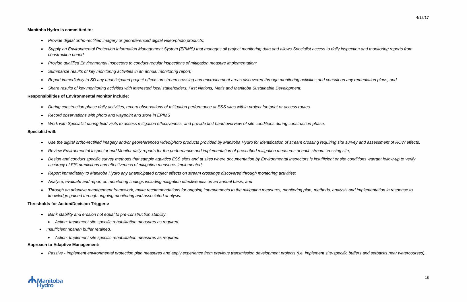
Manitoba Hydro is committed to:
Provide digital ortho-rectified imagery or georeferenced digital video/photo products;
Supply an Environmental Protection Information Management System (EPIMS) that manages all project monitoring data and allows Specialist access to daily inspection and monitoring reports from
construction period;
Provide qualified Environmental Inspectors to conduct regular inspections of mitigation measure implementation;
Summarize results of key monitoring activities in an annual monitoring report;
Report immediately to SD any unanticipated project effects on stream crossing and encroachment areas discovered through monitoring activities and consult on any remediation plans; and
Share results of key monitoring activities with interested local stakeholders, First Nations, Metis and Manitoba Sustainable Development.
Responsibilities of Environmental Monitor include:
During construction phase daily activities, record observations of mitigation performance at ESS sites within project footprint or access routes.
Record observations with photo and waypoint and store in EPIMS
Work with Specialist during field visits to assess mitigation effectiveness, and provide first hand overview of site conditions during construction phase.
Specialist will:
Use the digital ortho-rectified imagery and/or georeferenced video/photo products provided by Manitoba Hydro for identification of stream crossing requiring site survey and assessment of ROW effects;
Review Environmental Inspector and Monitor daily reports for the performance and implementation of prescribed mitigation measures at each stream crossing site;
Design and conduct specific survey methods that sample aquatics ESS sites and at sites where documentation by Environmental Inspectors is insufficient or site conditions warrant follow-up to verify
accuracy of EIS predictions and effectiveness of mitigation measures implemented;
Report immediately to Manitoba Hydro any unanticipated project effects on stream crossings discovered through monitoring activities;
Analyze, evaluate and report on monitoring findings including mitigation effectiveness on an annual basis; and
Through an adaptive management framework, make recommendations for ongoing improvements to the mitigation measures, monitoring plan, methods, analysis and implementation in response to
knowledge gained through ongoing monitoring and associated analysis.
Thresholds for Action/Decision Triggers:
Bank stability and erosion not equal to pre-construction stability.
Action: Implement site specific rehabilitation measures as required.
Insufficient riparian buffer retained.
Action: Implement site specific rehabilitation measures as required.
Approach to Adaptive Management:
Passive - Implement environmental protection plan measures and apply experience from previous transmission development projects (i.e. implement site-specific buffers and setbacks near watercourses).
4/12/17
19
4.4 VEGETATION AND WETLANDS
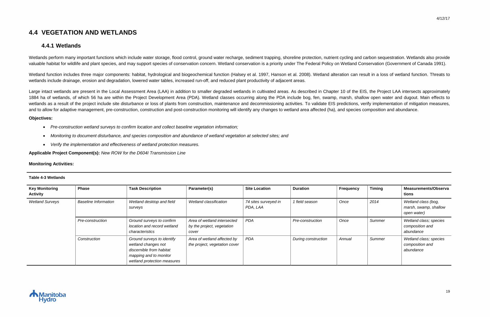
4.4.1 Wetlands
Wetlands perform many important functions which include water storage, flood control, ground water recharge, sediment trapping, shoreline protection, nutrient cycling and carbon sequestration. Wetlands also provide
valuable habitat for wildlife and plant species, and may support species of conservation concern. Wetland conservation is a priority under The Federal Policy on Wetland Conservation (Government of Canada 1991).
Wetland function includes three major components: habitat, hydrological and biogeochemical function (Halsey et al. 1997, Hanson et al. 2008). Wetland alteration can result in a loss of wetland function. Threats to
wetlands include drainage, erosion and degradation, lowered water tables, increased run-off, and reduced plant productivity of adjacent areas.
Large intact wetlands are present in the Local Assessment Area (LAA) in addition to smaller degraded wetlands in cultivated areas. As described in Chapter 10 of the EIS, the Project LAA intersects approximately
1884 ha of wetlands, of which 56 ha are within the Project Development Area (PDA). Wetland classes occurring along the PDA include bog, fen, swamp, marsh, shallow open water and dugout. Main effects to
wetlands as a result of the project include site disturbance or loss of plants from construction, maintenance and decommissioning activities. To validate EIS predictions, verify implementation of mitigation measures,
and to allow for adaptive management, pre-construction, construction and post-construction monitoring will identify any changes to wetland area affected (ha), and species composition and abundance.
Objectives:
Pre-construction wetland surveys to confirm location and collect baseline vegetation information;
Monitoring to document disturbance, and species composition and abundance of wetland vegetation at selected sites; and
Verify the implementation and effectiveness of wetland protection measures.
Applicable Project Component(s): New ROW for the D604I Transmission Line
Monitoring Activities:
Table 4-3 Wetlands
Key Monitoring
Activity
Phase Task Description Parameter(s) Site Location Duration Frequency Timing Measurements/Observa
tions
Wetland Surveys Baseline Information Wetland desktop and field
surveys
Wetland classification 74 sites surveyed in
PDA, LAA
1 field season Once 2014 Wetland class (bog,
marsh, swamp, shallow
open water)
Pre-construction Ground surveys to confirm
location and record wetland
characteristics
Area of wetland intersected
by the project, vegetation
cover
PDA Pre-construction Once Summer Wetland class; species
composition and
abundance
Construction Ground surveys to identify
wetland changes not
discernible from habitat
mapping and to monitor
wetland protection measures
Area of wetland affected by
the project, vegetation cover
PDA During construction Annual Summer Wetland class; species
composition and
abundance
4/12/17
20
Post-construction Ground surveys to identify
wetland changes not
discernible from habitat
mapping
Area of wetland affected by
the project, vegetation cover
PDA 2 yrs. Annual Summer Area affected (ha);
species composition and
abundance
Manitoba Hydro is committed to:
Provide digital ortho-rectified imagery or georeferenced digital video/photo products;
Supply an Environmental Protection Information Management System (EPIMS) that manages all project monitoring data and allows Specialist access to daily inspection and monitoring reports from
construction period;
Provide qualified Environmental Inspectors to conduct regular inspections of mitigation measure implementation;
Map cleared project footprint;
Summarize results of key monitoring activities in an annual monitoring report; and
Share results of key monitoring activities with interested local stakeholders, First Nations, Metis and Manitoba Sustainable Development.
Responsibilities of Environmental Monitor include:
During construction phase daily activities, record observations of mitigation performance at Environmentally Sensitive Sites (ESS) within project footprint or access routes.
Record observations with photo and waypoint and store in EPIMS; and
Work with Specialist during field visits to assess mitigation effectiveness, and provide first hand overview of site conditions during construction phase.
Specialist will:
Use the digital ortho-rectified imagery and/or georeferenced video/photo products provided by Manitoba Hydro for identification of potential wetland sampling sites and assessment of ROW effects;
Conduct pre-clearing surveys in wetlands to classify wetlands;
Review Environmental Inspector and Monitor daily reports for identification of potential wetland sampling sites;
Design and conduct specific survey methods that sample vegetation composition and abundance to verify accuracy of EIS predictions and effectiveness of mitigation measures implemented;
Adhere to Manitoba’s Hydro’s Biosecurity procedures;
Report immediately to Manitoba Hydro any unanticipated project effects on wetlands discovered through monitoring activities;
Analyze, evaluate and report on monitoring findings including mitigation effectiveness on an annual basis; and
Through an adaptive management framework, make recommendations for ongoing improvements to the mitigation measures, monitoring plan, methods, analysis and implementation in response to
knowledge gained through ongoing monitoring and associated analysis.
Thresholds for Action/Decision Triggers:
Partially frozen wetlands are encountered during construction season.
Action: Report to SD Conservation Officer mitigation options to reduce impacts (i.e. matting, ice roads, snow roads, hand clearing).

4/12/17
21
Actual disturbance footprint exceeds the expected disturbance footprint.
Action: Implement site specific rehabilitation measures as required.
Action: Report to SD regional wildlife biologist/manager through annual meetings where reports are presented and results are discussed.
Approach to Adaptive Management:
Passive - Implement environmental protection plan measures and apply experience from previous transmission development projects (i.e. implement restrictions on vehicle use in wetland areas).

4/12/17
22
4.4.2 Plant Species of Conservation Concern
Species of conservation concern include species of plants that are protected under The Endangered Species and Ecosystems Act (MESEA) in Manitoba, the federal Species at Risk Act (SARA), The Committee on
the Status of Endangered Wildlife in Canada (COSEWIC), or are listed by the Manitoba Conservation Data Centre (MBCDC) as plants that are very rare to uncommon. These species generally exist in low numbers,
play a role in helping to preserve species diversity, and/or have limited distributions.
As described in Chapter 10 of the EIS, two historical locations for plant species of conservation concern were previously known to occur along the Project Development Area (PDA); seven were known to occur along
the LAA and 62 along the Regional Assessment Area (RAA) (MBCDC records). No historical occurrences of protected plants are known to occur within the Project PDA or LAA. Protected species have historical
occurrences within the RAA.
Field assessments in 2014 identified three species of conservation concern in the PDA at eight locations. None of these species are listed under MESEA, SARA or COSEWIC. Pre-construction field assessments will
help identify any other locations where species of conservation concern may exist and prescribe appropriate mitigation measures. Construction activities can potentially negatively affect plant species of conservation
concern through the use of heavy equipment (crushing plants) and from clearing and grubbing (removal of roots) of vegetation. Herbicide use during maintenance activities can also negatively affect desirable species.
To validate EIS predictions, verify implementation of mitigation measures, and to allow for adaptive management, pre-construction, construction and post-construction monitoring will identify any impact to vegetation
species of conservation concern.
Objectives:
Pre-construction surveys to identify species of conservation concern;
Monitoring to document presence/absence of species post construction; and
Verify the implementation and effectiveness of protection measures.
Applicable Project Component(s): New ROW for D604I Transmission Line
Monitoring Activities:
Table 4-4 Plant Species of Conservation Concern
Key Monitoring
Activity
Phase Task Description Parameter(s) Site Location Duration Frequency Timing Measurements/Obser
vations
Rare Plant Surveys Baseline Information Desktop, key person
interviews, and field surveys
Species names and
locations
95 sites surveyed in PDA,
LAA
1 field season Once 2014 Species
presence/absence
Pre-construction Ground surveys to record
species of concern
Species occurrence PDA Pre-construction Once Summer Species presence/
absence
Construction Ground surveys to monitor
species of concern and
protection measures
Species occurrence ESS During construction Annual Summer Species presence/
absence
Post-construction Ground surveys to monitor
species of concern
Species occurrence ESS 1yr Annual Summer Species presence/
absence
4/12/17
23
Manitoba Hydro is committed to:
Provide digital ortho-rectified imagery or georeferenced digital video/photo products;
Supply an Environmental Protection Information Management System (EPIMS) that manages all project monitoring data and allows Specialist access to daily inspection and monitoring reports from
construction period;
Provide qualified Environmental Inspectors to conduct regular inspections of mitigation measure implementation;
Summarize results of key monitoring activities in an annual monitoring report; and
Share results of key monitoring activities with interested local stakeholders, First Nations, Metis and Manitoba Sustainable Development.
Responsibilities of Environmental Monitor include:
During construction phase daily activities, record observations of rare plants and mitigation performance at ESS sites within project footprint or access routes;
Record observations with photo and waypoint and store in EPIMS; and
Work with Specialist during field visits to assess mitigation effectiveness, and provide first hand overview of site conditions during construction phase.
Specialist will:
Use the digital ortho-rectified imagery and/or georeferenced video/photo products provided by Manitoba Hydro for identification of potential rare plant habitat sampling sites and assessment of ROW effects;
Conduct pre-clearing rare plant surveys for project areas not previously surveyed;
Review Environmental Inspector and Monitor daily reports for identification of potential rare plant sampling sites;
Design and conduct specific survey methods that sample known rare plant sites for presence/absence to verify accuracy of EIS predictions and effectiveness of mitigation measures implemented;
Adhere to Manitoba’s Hydro’s Biosecurity procedures;
Report immediately to Manitoba Hydro any unanticipated project effects on rare plants discovered through monitoring activities;
Analyze, evaluate and report on monitoring findings including mitigation effectiveness on an annual basis; and
Through an adaptive management framework, make recommendations for ongoing improvements to the mitigation measures, monitoring plan, methods, analysis and implementation in response to
knowledge gained through ongoing monitoring and associated analysis.
Manitoba Sustainable Development may be requested to:
Provide historical and current data of species of concern to inform ongoing analyses related to biophysical monitoring (e.g. population survey data, observations, reports); and
Provide guidance regarding mitigation strategies should unanticipated effects occur as a result of the project.
Decision Trigger(s)/Threshold(s) for Action:
Species of conservation concern has been disturbed by construction activities.
Action: Report to SD regional wildlife biologist/manager through annual meetings where reports are presented and results are discussed.
Action: Implement site specific rehabilitation measures as required.
Discovery of new location of species of conservation concern.

4/12/17
24
Action: Report locations to SD regional wildlife biologist/manager through annual meetings where reports are presented and results are discussed.
Action: Develop and maintain a 30 meter buffer around plant species protected under legislation, and contact Manitoba Conservation Data Centre for further guidance on necessary mitigation.
Approach to Adaptive Management:
Passive - Implement environmental protection plan measures and apply experience from previous transmission development projects (i.e. implement buffers and setback around identified plants or plant
groupings) adjust buffer distance when advised by SD.
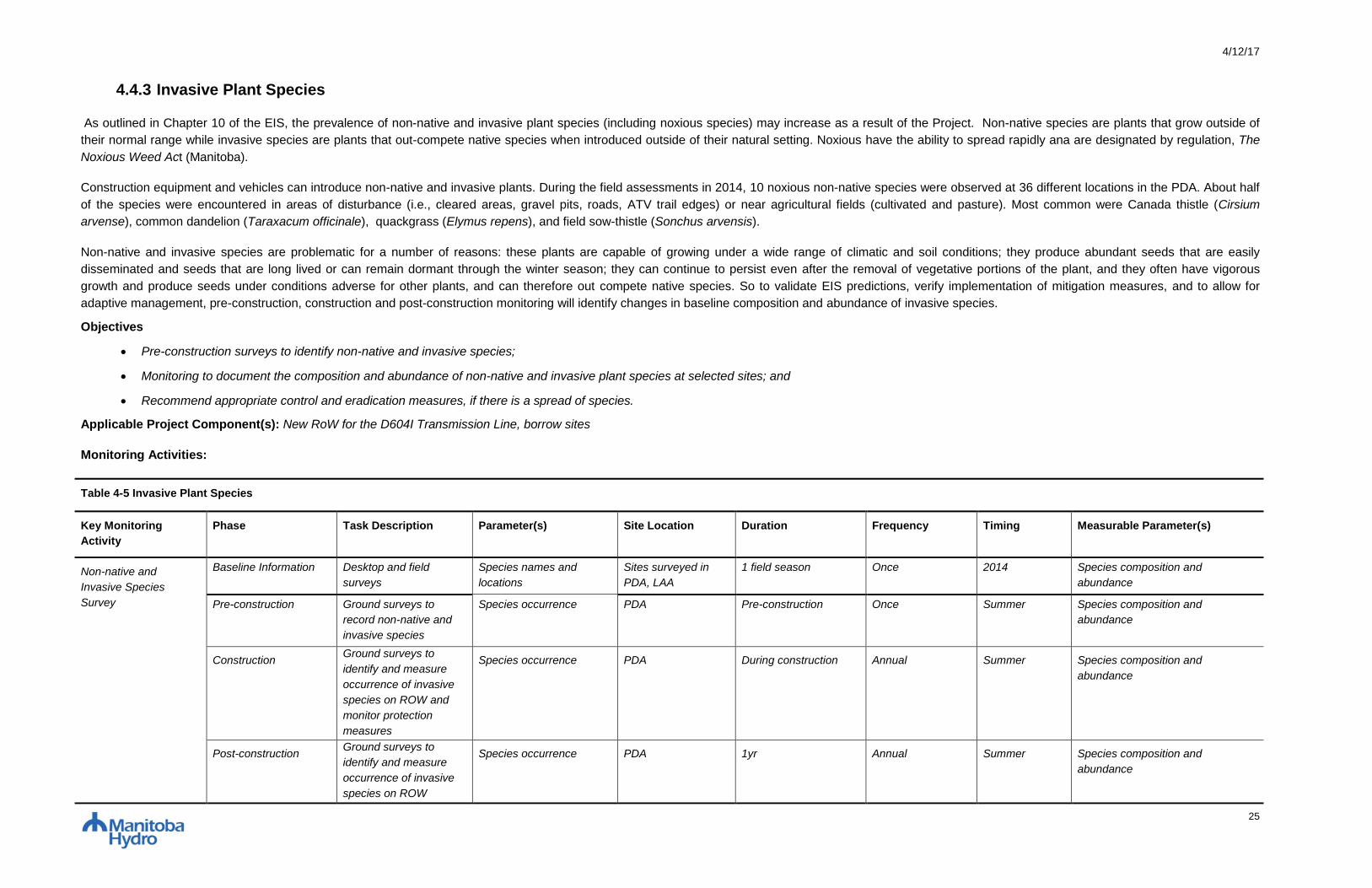
4/12/17
25
4.4.3 Invasive Plant Species
As outlined in Chapter 10 of the EIS, the prevalence of non-native and invasive plant species (including noxious species) may increase as a result of the Project. Non-native species are plants that grow outside of
their normal range while invasive species are plants that out-compete native species when introduced outside of their natural setting. Noxious have the ability to spread rapidly ana are designated by regulation, The
Noxious Weed Act (Manitoba).
Construction equipment and vehicles can introduce non-native and invasive plants. During the field assessments in 2014, 10 noxious non-native species were observed at 36 different locations in the PDA. About half
of the species were encountered in areas of disturbance (i.e., cleared areas, gravel pits, roads, ATV trail edges) or near agricultural fields (cultivated and pasture). Most common were Canada thistle (Cirsium
arvense), common dandelion (Taraxacum officinale), quackgrass (Elymus repens), and field sow-thistle (Sonchus arvensis).
Non-native and invasive species are problematic for a number of reasons: these plants are capable of growing under a wide range of climatic and soil conditions; they produce abundant seeds that are easily
disseminated and seeds that are long lived or can remain dormant through the winter season; they can continue to persist even after the removal of vegetative portions of the plant, and they often have vigorous
growth and produce seeds under conditions adverse for other plants, and can therefore out compete native species. So to validate EIS predictions, verify implementation of mitigation measures, and to allow for
adaptive management, pre-construction, construction and post-construction monitoring will identify changes in baseline composition and abundance of invasive species.
Objectives
Pre-construction surveys to identify non-native and invasive species;
Monitoring to document the composition and abundance of non-native and invasive plant species at selected sites; and
Recommend appropriate control and eradication measures, if there is a spread of species.
Applicable Project Component(s): New RoW for the D604I Transmission Line, borrow sites
Monitoring Activities:
Table 4-5 Invasive Plant Species
Key Monitoring
Activity
Phase Task Description Parameter(s) Site Location Duration Frequency Timing Measurable Parameter(s)
Non-native and
Invasive Species
Survey
Baseline Information Desktop and field
surveys
Species names and
locations
Sites surveyed in
PDA, LAA
1 field season Once 2014 Species composition and
abundance
Pre-construction Ground surveys to
record non-native and
invasive species
Species occurrence PDA Pre-construction Once Summer Species composition and
abundance
Construction Ground surveys to
identify and measure
occurrence of invasive
species on ROW and
monitor protection
measures
Species occurrence PDA During construction Annual Summer Species composition and
abundance
Post-construction Ground surveys to
identify and measure
occurrence of invasive
species on ROW
Species occurrence PDA 1yr Annual Summer Species composition and
abundance
4/12/17
26
Manitoba Hydro is committed to:
Provide digital ortho-rectified imagery or georeferenced digital video/photo products;
Supply an Environmental Protection Information Management System (EPIMS) that manages all project monitoring data and allows Specialist access to daily inspection and monitoring reports from
construction period;
Provide qualified Environmental Inspectors to conduct regular inspections of mitigation measure implementation;
Summarize results of key monitoring activities in an annual monitoring report; and
Share results of key monitoring activities with interested local stakeholders, First Nations, Metis and Manitoba Sustainable Development.
Responsibilities of Environmental Monitor include:
During construction phase daily activities, record observations of invasive plants within project footprint or access routes, and equipment cleaning stations;
Record observations with photo and waypoint and store in EPIMS; and
Work with Specialist during field visits to assess mitigation effectiveness, and provide first hand overview of site conditions during construction phase.
Specialist will:
Use the digital ortho-rectified imagery and/or georeferenced video/photo products provided by Manitoba Hydro for identification of invasive and non-native species sampling sites and assessment of ROW
effects;
Conduct pre-clearing surveys to record invasive and non-native species information;
Review Environmental Inspector and Monitor daily reports for identification of potential invasive and non-native species sampling sites;
Design and conduct specific survey methods that sample invasive and non-native species sites for composition and abundance to verify accuracy of EIS predictions and effectiveness of mitigation and
control measures implemented;
Adhere to Manitoba’s Hydro’s Biosecurity procedures;
Report immediately to Manitoba Hydro any unanticipated project effects on invasive and non-native species discovered through monitoring activities;
Prescribe vegetation management options for invasive species control where required;
Analyze, evaluate and report on monitoring findings including mitigation effectiveness on an annual basis; and
Through an adaptive management framework, make recommendations for ongoing improvements to the mitigation measures, monitoring plan, methods, analysis and implementation in response to
knowledge gained through ongoing monitoring and associated analysis.
Decision Trigger(s)/Threshold(s) for Action:
Establishment and spread of invasive species along ROW.
Action: Report to SD regional wildlife biologist/manager through annual meetings where reports are presented and results are discussed. Discuss the species, nature of spread and management
options.
Approach to Adaptive Management:
Passive - Implement current mitigation measures for existing patches of invasive species and discuss monitoring results with the Regulator and or the local weed supervisor regarding the species, nature of spread and management options.
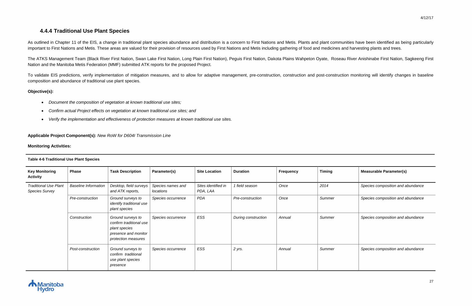
4/12/17
27
4.4.4 Traditional Use Plant Species
As outlined in Chapter 11 of the EIS, a change in traditional plant species abundance and distribution is a concern to First Nations and Metis. Plants and plant communities have been identified as being particularly
important to First Nations and Metis. These areas are valued for their provision of resources used by First Nations and Metis including gathering of food and medicines and harvesting plants and trees.
The ATKS Management Team (Black River First Nation, Swan Lake First Nation, Long Plain First Nation), Peguis First Nation, Dakota Plains Wahpeton Oyate, Roseau River Anishinabe First Nation, Sagkeeng First
Nation and the Manitoba Metis Federation (MMF) submitted ATK reports for the proposed Project.
To validate EIS predictions, verify implementation of mitigation measures, and to allow for adaptive management, pre-construction, construction and post-construction monitoring will identify changes in baseline
composition and abundance of traditional use plant species.
Objective(s):
Document the composition of vegetation at known traditional use sites;
Confirm actual Project effects on vegetation at known traditional use sites; and
Verify the implementation and effectiveness of protection measures at known traditional use sites.
Applicable Project Component(s): New RoW for D604I Transmission Line
Monitoring Activities:
Table 4-6 Traditional Use Plant Species
Key Monitoring
Activity
Phase Task Description Parameter(s) Site Location Duration Frequency Timing Measurable Parameter(s)
Traditional Use Plant
Species Survey
Baseline Information Desktop, field surveys
and ATK reports,
Species names and
locations
Sites identified in
PDA, LAA
1 field season Once 2014 Species composition and abundance
Pre-construction Ground surveys to
identify traditional use
plant species
Species occurrence PDA Pre-construction Once Summer Species composition and abundance
Construction Ground surveys to
confirm traditional use
plant species
presence and monitor
protection measures
Species occurrence ESS During construction Annual Summer Species composition and abundance
Post-construction Ground surveys to
confirm traditional
use plant species
presence
Species occurrence ESS 2 yrs. Annual Summer Species composition and abundance

4/12/17
28
Manitoba Hydro will:
Provide digital ortho-rectified imagery or georeferenced digital video/photo products;
Supply an Environmental Protection Information Management System (EPIMS) that manages all project monitoring data and allows Specialist access to daily inspection and monitoring reports from
construction period;
Provide qualified Environmental Inspectors to conduct regular inspections of mitigation measure implementation;
Summarize results of key monitoring activities in an annual monitoring report;
Share results of key monitoring activities with interested local stakeholders, First Nations, Metis and Manitoba Sustainable Development.
Responsibilities of Environmental Monitor include:
During construction phase daily activities, record observations of tradition use plant species and mitigation performance at ESS sites within project footprint or access routes;
Record observations with photo and waypoint and store in EPIMS; and
Work with Specialist during field visits to assess mitigation effectiveness, and provide first hand overview of site conditions during construction phase.
Specialist will:
Use the digital ortho-rectified imagery and/or georeferenced video/photo products provided by Manitoba Hydro for identification of sampling sites for plant communities important to First Nations and Metis
and assessment of ROW effects;
Conduct pre-clearing vegetation surveys to record baseline information within known plant communities important to First Nations and Metis;
Review Environmental Inspector and Monitor daily reports for identification of potential traditional use plant species sampling sites;
Design and conduct specific survey methods that sample known locations of traditional use plant species for composition and to verify accuracy of EIS predictions and effectiveness of mitigation measures
implemented;
Report immediately to Manitoba Hydro any unanticipated project effects on traditional use plant species discovered through monitoring activities;
Analyze, evaluate and report on monitoring findings including mitigation effectiveness on an annual basis; and
Through an adaptive management framework, make recommendations for ongoing improvements to the mitigation measures, monitoring plan, methods, analysis and implementation in response to
knowledge gained through ongoing monitoring and associated analysis.
First Nations and the MMF may be invited to:
Provide historical and current data of traditional use plant species important to First Nations and Metis people to inform ongoing analyses related to biophysical monitoring; and
Provide guidance regarding mitigation strategies should unanticipated effects occur as a result of the project.
Decision Trigger(s)/Threshold(s) for Action:
Significant decrease in abundance of traditional use plant species (excluding trees) at locations identified by communities in the PDA.
Action: Report results to community that identified the traditional use areas and discuss any potential mitigation measures, such as revised vegetation management options.
Approach to Adaptive Management:
Passive - Report results to communities that identified the traditional use areas and discuss any potential mitigation measures.

4/12/17
29
4.5 WILDLIFE AND WILDLIFE HABITAT
4.5.1 Amphibians
As outlined in Chapter 9 of the EIS, herptiles favoring wetland habitat for part or all of their life cycle may be vulnerable to changes in habitat availability as a result of Project activity. The northern leopard frog
(Lithobates pipiens) is a Species of Conservation Concern (SOCC) found in wetlands within the Project’s Regional Assessment Area (RAA). Eastern tiger salamanders (Ambystoma tigrinum) will also be included in
amphibian monitoring because their distribution and population status are poorly understood in southeastern Manitoba, and may extend into the RAA.
Wetland monitoring, including water quality data collection and amphibian surveys, help characterize baseline habitat conditions and identify sensitive sites at permanent and semi-permanent ponds. Wetland water-
quality information aids in providing baseline conditions or ‘benchmark’ data for comparison of pre-Project water quality to future construction-phase water quality conditions. Amphibian surveys also aid in providing
benchmark data, as related to SOCC abundance and richness, as well as breeding and wintering staging activity for pre- and post-construction conditions.
To establish a robust benchmark for wetland condition prior to construction, further amphibian surveys and water quality parameters will be measured at wetlands known to support northern leopard frogs. To validate
EIS predictions and verify implementation of mitigation protocols, construction-phase wetland monitoring will take place during the amphibian breeding and developmental periods immediately following construction
activity with the goal of detecting any changes in water quality and breeding activity following construction activity. Sites examined will include wetlands and waterbodies previously surveyed (Wildlife and Wildlife
Habitat TDR 2015) and found to support northern leopard frogs. Construction phase monitoring would be conducted at wetlands within 500 m of locations where Project activity had occurred. This buffer represents the
maximum activity restriction setback for northern leopard frog breeding ponds (Environment Canada 2009).
Objectives:
To monitor the presence of amphibians (as represented by the northern leopard frog and eastern tiger salamander) and water quality conditions at wetlands located within the PDA; and
To verify the implementation and effectiveness of prescribed mitigation.
Applicable Project Component(s): New ROW for the D604I Transmission Line
Monitoring Activities:
Table 4-7 Amphibians
Key Monitoring
Activity
Phase Task Description Parameter(s) Site Location Duration Frequency Timing Measurements/Observations
Wetland
Amphibian Survey
Baseline information Assess water quality &
presence of northern leopard
frogs and eastern tiger
salamanders at wetland sites
located on or adjacent to the
PDA
Water quality; Presence of
northern leopard frogs,
eastern tiger salamanders
Suitable wetland
habitat on or adjacent
to PDA
1 field season Once 2014 pH, electrical conductivity, TDS,
TSS, water temperature, turbidity;
Presence/absence of breeding
activity & individual
frogs/salamanders
Pre-construction Assess water quality &
presence of northern leopard
frogs and eastern tiger
salamanders at wetland sites
located on PDA
Water quality; Presence of
northern leopard frogs,
eastern tiger salamanders
Suitable wetland
habitat on or adjacent
to the PDA
Pre-construction Annual Spring, summer
and Fall
pH, electrical conductivity, TDS,
TSS, water temperature, turbidity;
Presence/absence of breeding
activity & individual
frogs/salamanders
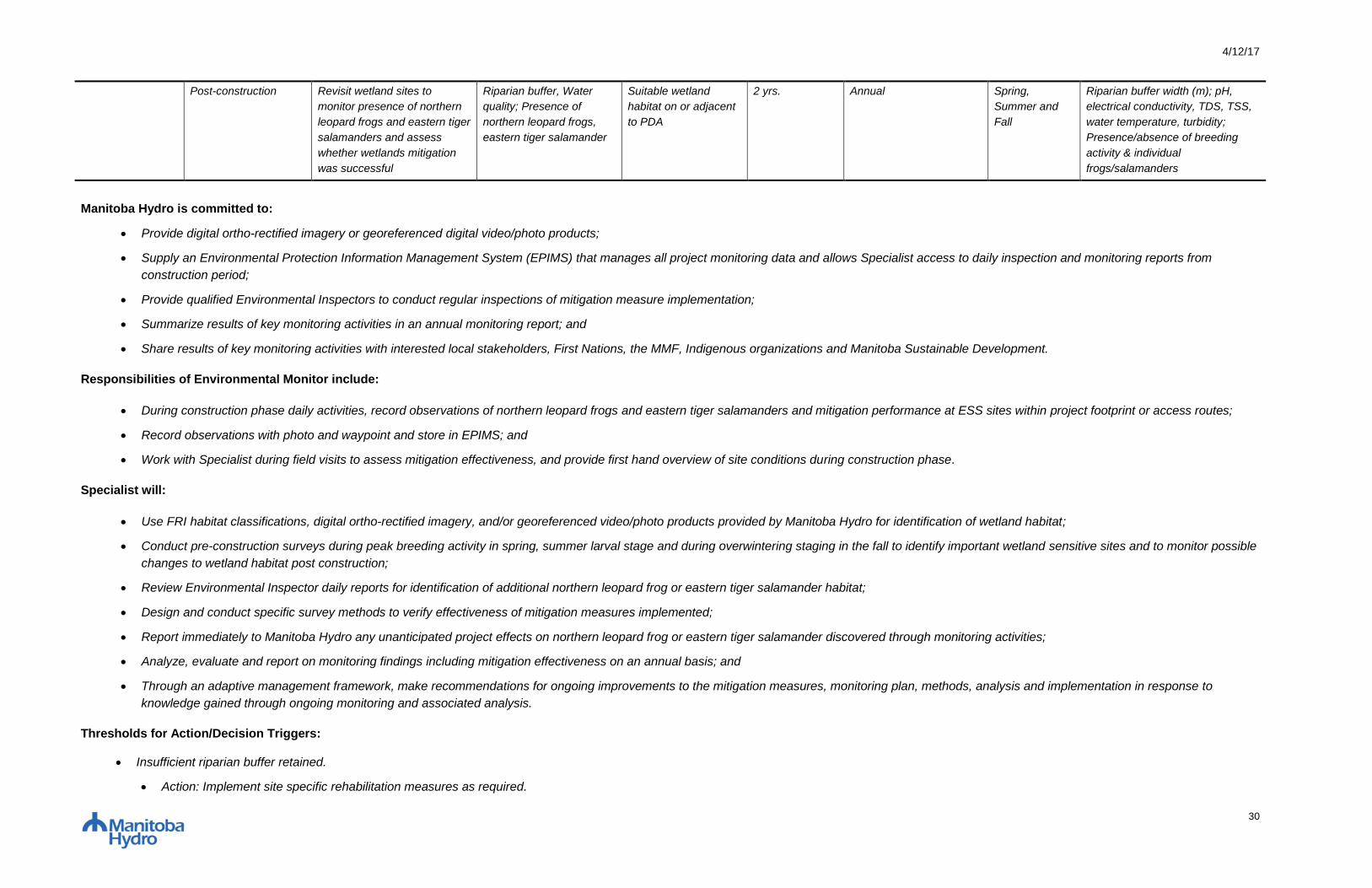
4/12/17
30
Post-construction Revisit wetland sites to
monitor presence of northern
leopard frogs and eastern tiger
salamanders and assess
whether wetlands mitigation
was successful
Riparian buffer, Water
quality; Presence of
northern leopard frogs,
eastern tiger salamander
Suitable wetland
habitat on or adjacent
to PDA
2 yrs. Annual Spring,
Summer and
Fall
Riparian buffer width (m); pH,
electrical conductivity, TDS, TSS,
water temperature, turbidity;
Presence/absence of breeding
activity & individual
frogs/salamanders
Manitoba Hydro is committed to:
Provide digital ortho-rectified imagery or georeferenced digital video/photo products;
Supply an Environmental Protection Information Management System (EPIMS) that manages all project monitoring data and allows Specialist access to daily inspection and monitoring reports from
construction period;
Provide qualified Environmental Inspectors to conduct regular inspections of mitigation measure implementation;
Summarize results of key monitoring activities in an annual monitoring report; and
Share results of key monitoring activities with interested local stakeholders, First Nations, the MMF, Indigenous organizations and Manitoba Sustainable Development.
Responsibilities of Environmental Monitor include:
During construction phase daily activities, record observations of northern leopard frogs and eastern tiger salamanders and mitigation performance at ESS sites within project footprint or access routes;
Record observations with photo and waypoint and store in EPIMS; and
Work with Specialist during field visits to assess mitigation effectiveness, and provide first hand overview of site conditions during construction phase.
Specialist will:
Use FRI habitat classifications, digital ortho-rectified imagery, and/or georeferenced video/photo products provided by Manitoba Hydro for identification of wetland habitat;
Conduct pre-construction surveys during peak breeding activity in spring, summer larval stage and during overwintering staging in the fall to identify important wetland sensitive sites and to monitor possible
changes to wetland habitat post construction;
Review Environmental Inspector daily reports for identification of additional northern leopard frog or eastern tiger salamander habitat;
Design and conduct specific survey methods to verify effectiveness of mitigation measures implemented;
Report immediately to Manitoba Hydro any unanticipated project effects on northern leopard frog or eastern tiger salamander discovered through monitoring activities;
Analyze, evaluate and report on monitoring findings including mitigation effectiveness on an annual basis; and
Through an adaptive management framework, make recommendations for ongoing improvements to the mitigation measures, monitoring plan, methods, analysis and implementation in response to
knowledge gained through ongoing monitoring and associated analysis.
Thresholds for Action/Decision Triggers:
Insufficient riparian buffer retained.
Action: Implement site specific rehabilitation measures as required.
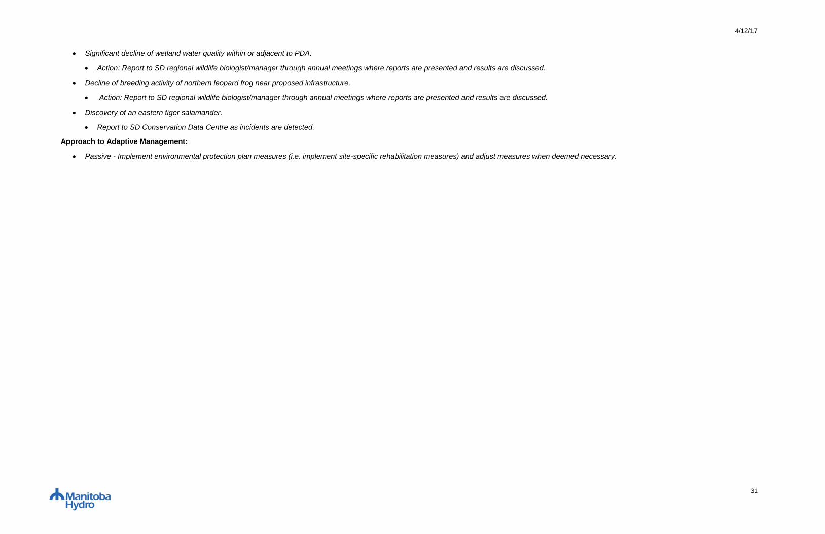
4/12/17
31
Significant decline of wetland water quality within or adjacent to PDA.
Action: Report to SD regional wildlife biologist/manager through annual meetings where reports are presented and results are discussed.
Decline of breeding activity of northern leopard frog near proposed infrastructure.
Action: Report to SD regional wildlife biologist/manager through annual meetings where reports are presented and results are discussed.
Discovery of an eastern tiger salamander.
Report to SD Conservation Data Centre as incidents are detected.
Approach to Adaptive Management:
Passive - Implement environmental protection plan measures (i.e. implement site-specific rehabilitation measures) and adjust measures when deemed necessary.
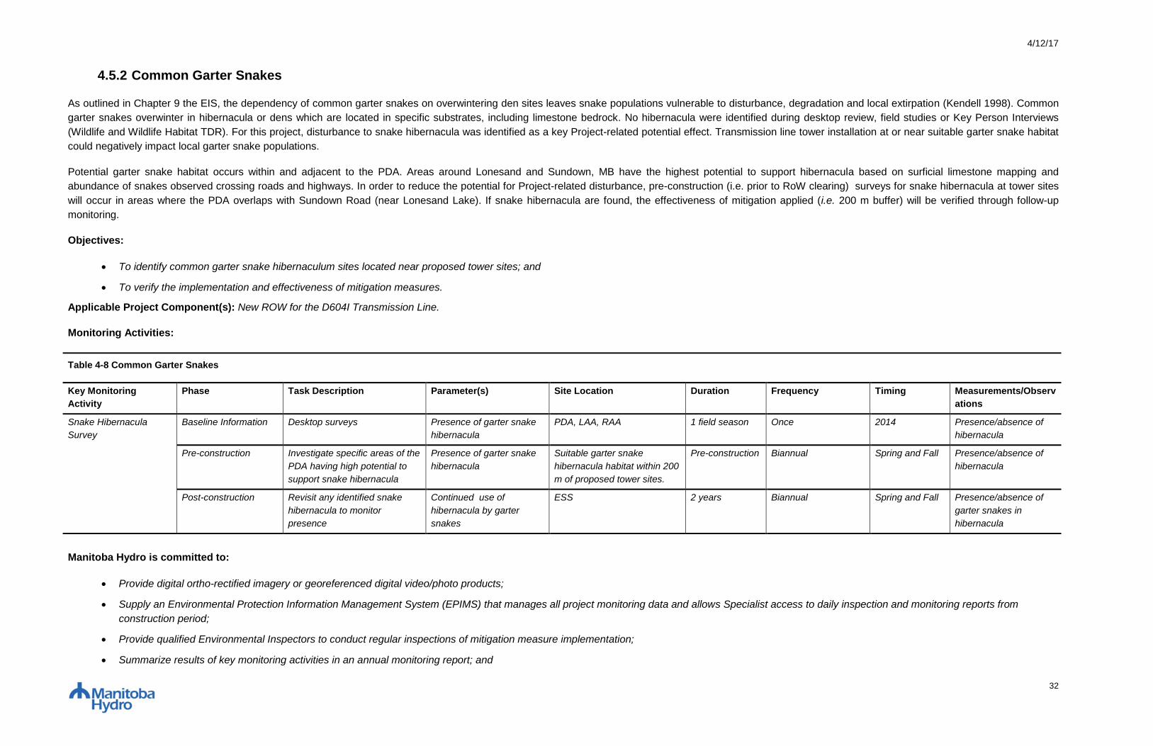
4/12/17
32
4.5.2 Common Garter Snakes
As outlined in Chapter 9 the EIS, the dependency of common garter snakes on overwintering den sites leaves snake populations vulnerable to disturbance, degradation and local extirpation (Kendell 1998). Common
garter snakes overwinter in hibernacula or dens which are located in specific substrates, including limestone bedrock. No hibernacula were identified during desktop review, field studies or Key Person Interviews
(Wildlife and Wildlife Habitat TDR). For this project, disturbance to snake hibernacula was identified as a key Project-related potential effect. Transmission line tower installation at or near suitable garter snake habitat
could negatively impact local garter snake populations.
Potential garter snake habitat occurs within and adjacent to the PDA. Areas around Lonesand and Sundown, MB have the highest potential to support hibernacula based on surficial limestone mapping and
abundance of snakes observed crossing roads and highways. In order to reduce the potential for Project-related disturbance, pre-construction (i.e. prior to RoW clearing) surveys for snake hibernacula at tower sites
will occur in areas where the PDA overlaps with Sundown Road (near Lonesand Lake). If snake hibernacula are found, the effectiveness of mitigation applied (i.e. 200 m buffer) will be verified through follow-up
monitoring.
Objectives:
To identify common garter snake hibernaculum sites located near proposed tower sites; and
To verify the implementation and effectiveness of mitigation measures.
Applicable Project Component(s): New ROW for the D604I Transmission Line.
Monitoring Activities:
Table 4-8 Common Garter Snakes
Key Monitoring
Activity
Phase Task Description Parameter(s) Site Location Duration Frequency Timing Measurements/Observ
ations
Snake Hibernacula
Survey
Baseline Information Desktop surveys Presence of garter snake
hibernacula
PDA, LAA, RAA 1 field season Once 2014 Presence/absence of
hibernacula
Pre-construction Investigate specific areas of the
PDA having high potential to
support snake hibernacula
Presence of garter snake
hibernacula
Suitable garter snake
hibernacula habitat within 200
m of proposed tower sites.
Pre-construction Biannual Spring and Fall Presence/absence of
hibernacula
Post-construction Revisit any identified snake
hibernacula to monitor
presence
Continued use of
hibernacula by garter
snakes
ESS 2 years Biannual Spring and Fall Presence/absence of
garter snakes in
hibernacula
Manitoba Hydro is committed to:
Provide digital ortho-rectified imagery or georeferenced digital video/photo products;
Supply an Environmental Protection Information Management System (EPIMS) that manages all project monitoring data and allows Specialist access to daily inspection and monitoring reports from
construction period;
Provide qualified Environmental Inspectors to conduct regular inspections of mitigation measure implementation;
Summarize results of key monitoring activities in an annual monitoring report; and

4/12/17
33
Share results of key monitoring activities with interested local stakeholders, First Nations, the MMF, Indigenous organizations and Manitoba Sustainable Development.
Responsibilities of Environmental Monitor include:
During construction phase daily activities, record observations of potential snake hibernacula and mitigation performance at ESS sites within project footprint or access routes;
Record observations with photo and waypoint and store in EPIMS; and
Work with Specialist during field visits to assess mitigation effectiveness, and provide first hand overview of site conditions during construction phase.
Specialist will:
Use FRI habitat classifications, digital ortho-rectified imagery, and/or georeferenced video/photo products provided by Manitoba Hydro for identification of garter snake sampling sites and assessment of
ROW effects;
Where suitable garter snake habitat occurs, conduct pre-construction surveys for garter snake hibernacula during peak breeding activity in spring and/or possible movements back to hibernacula in the fall;
Based on pre-construction survey results, provide recommendations for tower placement adjustments and/or mitigation measures to limit or avoid disturbance to hibernacula;
Review Environmental Inspector and Monitor daily reports for identification of additional garter snake sampling sites;
If suitable hibernacula habitat is identified, design and conduct specific survey methods that sample garter snake presence/absence to verify effectiveness of mitigation measures implemented;
Report immediately to Manitoba Hydro any unanticipated project effects on common garter snake discovered through monitoring activities;
Analyze, evaluate and report on monitoring findings including mitigation effectiveness on an annual basis; and
Through an adaptive management framework, make recommendations for ongoing improvements to the mitigation measures, monitoring plan, methods, analysis and implementation in response to
knowledge gained through ongoing monitoring and associated analysis.
Thresholds for Action/Decision Triggers:
Presence of hibernacula within 200 m of tower sitting foundation.
Action: Report the site to SD regional wildlife biologist/manager through annual meetings where reports are presented and results are discussed. Develop and maintain an appropriate sized construction
buffer around the hibernacula site.
Hibernacula located within tower sitting foundation.
Action: Discuss tower design and location with Manitoba Hydro engineers.
Approach to Adaptive Management:
Passive – Re-evaluate tower sitting if proposed on a hibernacula, apply environmental protection measures (i.e. construction buffer around the hibernacula site), and adjust when deemed necessary.
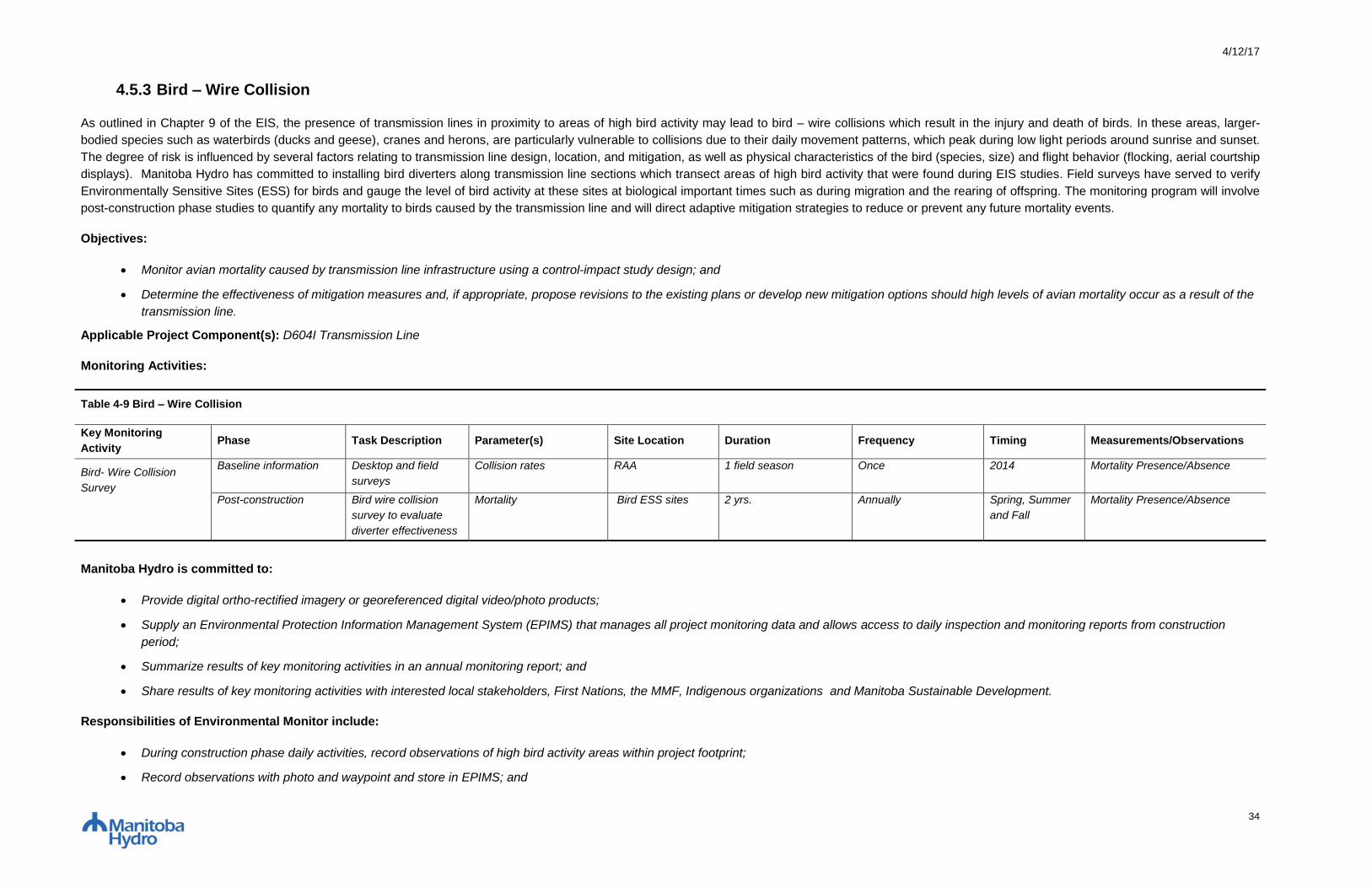
4/12/17
34
4.5.3 Bird – Wire Collision
As outlined in Chapter 9 of the EIS, the presence of transmission lines in proximity to areas of high bird activity may lead to bird – wire collisions which result in the injury and death of birds. In these areas, larger-
bodied species such as waterbirds (ducks and geese), cranes and herons, are particularly vulnerable to collisions due to their daily movement patterns, which peak during low light periods around sunrise and sunset.
The degree of risk is influenced by several factors relating to transmission line design, location, and mitigation, as well as physical characteristics of the bird (species, size) and flight behavior (flocking, aerial courtship
displays). Manitoba Hydro has committed to installing bird diverters along transmission line sections which transect areas of high bird activity that were found during EIS studies. Field surveys have served to verify
Environmentally Sensitive Sites (ESS) for birds and gauge the level of bird activity at these sites at biological important times such as during migration and the rearing of offspring. The monitoring program will involve
post-construction phase studies to quantify any mortality to birds caused by the transmission line and will direct adaptive mitigation strategies to reduce or prevent any future mortality events.
Objectives:
Monitor avian mortality caused by transmission line infrastructure using a control-impact study design; and
Determine the effectiveness of mitigation measures and, if appropriate, propose revisions to the existing plans or develop new mitigation options should high levels of avian mortality occur as a result of the
transmission line.
Applicable Project Component(s): D604I Transmission Line
Monitoring Activities:
Table 4-9 Bird – Wire Collision
Key Monitoring
Activity Phase Task Description Parameter(s) Site Location Duration Frequency Timing Measurements/Observations
Bird- Wire Collision
Survey
Baseline information Desktop and field
surveys
Collision rates RAA 1 field season Once 2014 Mortality Presence/Absence
Post-construction Bird wire collision
survey to evaluate
diverter effectiveness
Mortality Bird ESS sites 2 yrs. Annually Spring, Summer
and Fall
Mortality Presence/Absence
Manitoba Hydro is committed to:
Provide digital ortho-rectified imagery or georeferenced digital video/photo products;
Supply an Environmental Protection Information Management System (EPIMS) that manages all project monitoring data and allows access to daily inspection and monitoring reports from construction
period;
Summarize results of key monitoring activities in an annual monitoring report; and
Share results of key monitoring activities with interested local stakeholders, First Nations, the MMF, Indigenous organizations and Manitoba Sustainable Development.
Responsibilities of Environmental Monitor include:
During construction phase daily activities, record observations of high bird activity areas within project footprint;
Record observations with photo and waypoint and store in EPIMS; and

4/12/17
35
Work with Specialist during field visits to assess mitigation effectiveness, and provide first hand overview of site conditions during construction phase.
Specialist will:
Review Environmental Inspector and Monitor daily reports for identification of bird-wire collision sampling sites;
Design and conduct specific survey methods that sample bird presence/absence, abundance, mortality and flight paths to verify accuracy of EIS predictions and effectiveness of mitigation measures
implemented;
Report immediately to Manitoba Hydro any unanticipated project effects on birds discovered through monitoring activities;
Analyze, evaluate and report on monitoring findings including mitigation effectiveness on an annual basis; and
Through an adaptive management framework, make recommendations for ongoing improvements to the mitigation measures, monitoring plan, methods, analysis and implementation in response to
knowledge gained through ongoing monitoring and associated analysis.
Thresholds for Action/Decision Triggers:
Bird mortality statistics are above expected based on baseline abundance/flightpath surveys.
Action: Report to SD regional wildlife biologist/manager through annual meetings where reports are presented and results are discussed, and if required, adjust mitigation measures.
Approach to Adaptive Management:
Active – Test the hypothesis that bird diverters are sufficient in reducing mortality of birds due to collisions with the transmission line to a level that is negligible in areas determined to have a high risk of
collision. Discuss monitoring results with the SD and if required, adjust mitigation measures.

4/12/17
36
4.5.4 Sharp-tailed Grouse Lekking Sites
As identified in the EIS, grassland birds have experienced widespread habitat loss through most of the prairies, including Sharp-tailed Grouse (Tympanuchus phasianellus). Three active sharp-tailed grouse leks
supporting approximately 25 sharp-tailed grouse were identified in the Regional Assessment Area (RAA) during the 2014 surveys. All three leks occur adjacent to the New ROW in areas southwest of Ste. Genevieve,
MB and north and south of La Broquerie, MB. Sharp-tailed grouse may be affected by the temporary loss of some habitat at tower sites and the compaction of vegetative concealment cover along the New ROW.
Sharp-tailed Grouse are particularly vulnerable to increased rates of predation if birds of prey (raptors) use transmission line towers as perches when hunting or nesting, near lek sites. This monitoring program will
validate EIS predictions and work to determine any project-related effects to sharp-tail grouse (pre- versus post-construction).
Objectives:
Identify the presence of leks along the transmission line;
Monitor reaction behaviours of sharp-tailed grouse on leks in proximity to the transmission line compared to that at control sites;
Identify an association between raptor and ground predators, sharp-tailed grouse and transmission lines; and
Determine the effectiveness of mitigation measures and, if appropriate, propose revisions to the existing plans or develop new mitigation options should unexpected impacts to sharp-tailed grouse occur as
a result of the transmission line.
Applicable Project Component(s): New ROW for the D604I Transmission Line
Monitoring Activities:
Table 4-10 Sharp-tailed Grouse Lekking Sites
Key Monitoring
Activity
Phase Task Description Parameter(s) Site Location Duration Frequency Timing Measurements/Observ
ations
Sharp-tailed Grouse
Lek Survey
Baseline information Desktop and field
surveys
Lek location, number
of grouse
RAA 1 field season Once 2014 Presence/Absence,
Abundance
Pre-construction Lek site identification,
flush count and
camera trap survey
Lek abundance,
number of males and
behavioural changes
Where suitable breeding habitat overlaps
with Project components (e.g., towers) and
at Control sites.
Pre-construction Once April 1 –
May 31
Presence/Absence
Abundance, Time
budget behaviour,
Number of raptor nests,
Ground predator
abundance
Construction Flush count and
camera trap survey
Lek abundance,
number of males and
behavioural changes
Leks found within 1500 m of right-of-way
(ROW) where construction activities overlap
lekking activity and at Control sites.
During construction Annual April 1 -
May 31
Presence/Absence
Abundance, Time
budget behaviour,
Number of raptor nests,
Ground predator
abundance

4/12/17
37
Post-construction Flush count and
camera trap survey
Lek abundance,
number of males and
behavioural changes
Leks found within 1500 m of ROW where
operation activities overlap lekking activity
Up to 10 yrs. Annual April 1 -
May 31
Presence/Absence
Abundance, Time
budget behaviour,
Number of raptor nests,
Ground predator
abundance
Manitoba Hydro is committed to:
Provide digital ortho-rectified imagery or georeferenced digital video/photo products;
Supply an Environmental Protection Information Management System (EPIMS) that manages all project monitoring data and allows access to daily inspection and monitoring reports from construction
period;
Summarize results of key monitoring activities in an annual monitoring report;
Share results of key monitoring activities with interested local stakeholders, First Nations, the MMF, Indigenous organizations; and
Participate as a stakeholder in committees or working groups whose purpose is for the ongoing conservation of wildlife.
Responsibilities of Environmental Monitor include:
During construction phase daily activities, record observations of lekking sites and mitigation performance at ESS sites within project footprint;
Record observations with photo and waypoint and store in EPIMS; and
Work with Specialist during field visits to assess mitigation effectiveness, and provide first hand overview of site conditions during construction phase.
Specialist will:
Use the digital ortho-rectified imagery and/or georeferenced video/photo products provided by Manitoba Hydro for identification of potential lekking sites;
Conduct pre-construction surveys for lekking sites within 1500m of ROW;
Review Environmental Inspector and Monitor daily reports for identification of lekking sites;
Review Manitoba Hydro ungulate aerial survey data for sharp-tailed grouse sightings;
Design and conduct specific survey methods that sample bird presence/absence, abundance, mortality and behaviour to verify accuracy of EIS predictions and effectiveness of mitigation measures
implemented;
Report immediately to Manitoba Hydro any unanticipated project effects on lekking sites discovered through monitoring activities;
Analyze, evaluate and report on monitoring findings including mitigation effectiveness on an annual basis; and
Through an adaptive management framework, make recommendations for ongoing improvements to the mitigation measures, monitoring plan, methods, analysis and implementation in response to
knowledge gained through ongoing monitoring and associated analysis.
Manitoba Sustainable Development will:
Provide guidance regarding mitigation strategies should unanticipated effects occur as a result of the project.

4/12/17
38
Thresholds for Action/Decision Triggers:
Leks discovered near project footprint.
Action: Report to SD regional wildlife biologist/manager through annual meetings where reports are presented and results are discussed.
Leks are disturbed by construction activities.
Action: Report to SD regional wildlife biologist/manager through annual meetings where reports are presented and results are discussed. Develop and maintain an appropriate sized construction buffer
around the lek site until the breeding season is over.
Leks near project footprint have significant reduction in male grouse abundance, or alert behavior, compared to pre-construction baseline and control lekking sites away from the project.
Action: Report to SD regional wildlife biologist/manager through annual meetings where reports are presented and results are discussed. If required implement site specific vegetation management, and
or install raptor perch deterrents.
Raptor nests or perching on transmission towers near leks.
Action: Report to SD regional wildlife biologist/manager through annual meetings where reports are presented and results are discussed. If required, implement site specific vegetation management,
and or install raptor perch deterrents.
Approach to Adaptive Management:
Active -Test the hypothesis the installation of the transmission line affects the abundance of male sharp-tailed grouse displaying at lekking sites, and 2) that the installation of the transmission line increases
the abundance of alert behaviours and decreases time spent on the lek due to predator flushes. Discuss monitoring results with the SD and if required, implement best management practices (i.e.
implement site specific vegetation management, install raptor perch deterrents).
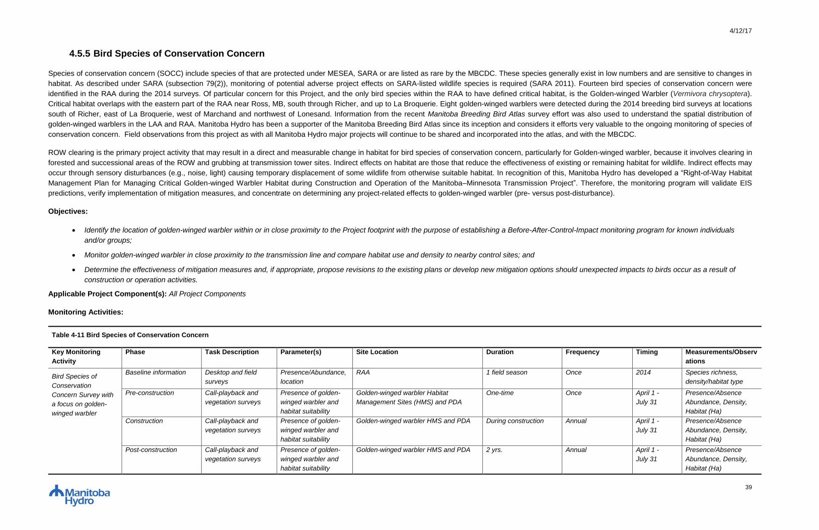
4/12/17
39
4.5.5 Bird Species of Conservation Concern
Species of conservation concern (SOCC) include species of that are protected under MESEA, SARA or are listed as rare by the MBCDC. These species generally exist in low numbers and are sensitive to changes in
habitat. As described under SARA (subsection 79(2)), monitoring of potential adverse project effects on SARA-listed wildlife species is required (SARA 2011). Fourteen bird species of conservation concern were
identified in the RAA during the 2014 surveys. Of particular concern for this Project, and the only bird species within the RAA to have defined critical habitat, is the Golden-winged Warbler (Vermivora chrysoptera).
Critical habitat overlaps with the eastern part of the RAA near Ross, MB, south through Richer, and up to La Broquerie. Eight golden-winged warblers were detected during the 2014 breeding bird surveys at locations
south of Richer, east of La Broquerie, west of Marchand and northwest of Lonesand. Information from the recent Manitoba Breeding Bird Atlas survey effort was also used to understand the spatial distribution of
golden-winged warblers in the LAA and RAA. Manitoba Hydro has been a supporter of the Manitoba Breeding Bird Atlas since its inception and considers it efforts very valuable to the ongoing monitoring of species of
conservation concern. Field observations from this project as with all Manitoba Hydro major projects will continue to be shared and incorporated into the atlas, and with the MBCDC.
ROW clearing is the primary project activity that may result in a direct and measurable change in habitat for bird species of conservation concern, particularly for Golden-winged warbler, because it involves clearing in
forested and successional areas of the ROW and grubbing at transmission tower sites. Indirect effects on habitat are those that reduce the effectiveness of existing or remaining habitat for wildlife. Indirect effects may
occur through sensory disturbances (e.g., noise, light) causing temporary displacement of some wildlife from otherwise suitable habitat. In recognition of this, Manitoba Hydro has developed a “Right-of-Way Habitat
Management Plan for Managing Critical Golden-winged Warbler Habitat during Construction and Operation of the Manitoba–Minnesota Transmission Project”. Therefore, the monitoring program will validate EIS
predictions, verify implementation of mitigation measures, and concentrate on determining any project-related effects to golden-winged warbler (pre- versus post-disturbance).
Objectives:
Identify the location of golden-winged warbler within or in close proximity to the Project footprint with the purpose of establishing a Before-After-Control-Impact monitoring program for known individuals
and/or groups;
Monitor golden-winged warbler in close proximity to the transmission line and compare habitat use and density to nearby control sites; and
Determine the effectiveness of mitigation measures and, if appropriate, propose revisions to the existing plans or develop new mitigation options should unexpected impacts to birds occur as a result of
construction or operation activities.
Applicable Project Component(s): All Project Components
Monitoring Activities:
Table 4-11 Bird Species of Conservation Concern
Key Monitoring
Activity
Phase Task Description Parameter(s) Site Location Duration Frequency Timing Measurements/Observ
ations
Bird Species of
Conservation
Concern Survey with
a focus on golden-
winged warbler
Baseline information Desktop and field
surveys
Presence/Abundance,
location
RAA 1 field season Once 2014 Species richness,
density/habitat type
Pre-construction Call-playback and
vegetation surveys
Presence of golden-
winged warbler and
habitat suitability
Golden-winged warbler Habitat
Management Sites (HMS) and PDA
One-time Once April 1 -
July 31
Presence/Absence
Abundance, Density,
Habitat (Ha)
Construction Call-playback and
vegetation surveys
Presence of golden-
winged warbler and
habitat suitability
Golden-winged warbler HMS and PDA During construction Annual April 1 -
July 31
Presence/Absence
Abundance, Density,
Habitat (Ha)
Post-construction Call-playback and
vegetation surveys
Presence of golden-
winged warbler and
habitat suitability
Golden-winged warbler HMS and PDA 2 yrs. Annual April 1 -
July 31
Presence/Absence
Abundance, Density,
Habitat (Ha)
4/12/17
40
Manitoba Hydro is committed to:
Provide digital ortho-rectified imagery or georeferenced digital video/photo products;
Supply an Environmental Protection Information Management System (EPIMS) that manages all project monitoring data and allows access to daily inspection and monitoring reports from construction
period;
Summarize results of key monitoring activities in an annual monitoring report;
Share results of key monitoring activities with interested local stakeholders, First Nations the MMF, Indigenous organizations; and
Participate as a stakeholder in committees or working groups whose purpose is for the ongoing conservation of wildlife.
Responsibilities of Environmental Monitor include:
During construction phase daily activities, record observations of bird species of concern and mitigation performance at ESS sites within project footprint;
Record observations with photo and waypoint and store in EPIMS; and
Work with Specialist during field visits to assess mitigation effectiveness, and provide first hand overview of site conditions during construction phase.
Specialist will:
Use the digital ortho-rectified imagery and/or georeferenced video/photo products provided by Manitoba Hydro for identification of potential species of concern habitat;
Review Environmental Inspector and Monitor daily reports for identification of bird species of concern, with a focus on golden-winged warbler;
Design and conduct specific survey methods that sample habitat use and density;
Report immediately to Manitoba Hydro any unanticipated project effects on species of concern discovered through monitoring activities;
Analyze, evaluate and report on monitoring findings including mitigation effectiveness on an annual basis; and
Through an adaptive management framework, make recommendations for ongoing improvements to the mitigation measures, monitoring plan, methods, analysis and implementation in response to
knowledge gained through ongoing monitoring and associated analysis.
Manitoba Sustainable Development will:
Provide updated data of species of concern populations with a focus on golden-winged warbler to inform ongoing analyses related to biophysical monitoring (e.g. population survey data, observations,
reports); and
Provide guidance regarding mitigation strategies should unanticipated effects occur as a result of the project.
Thresholds for Action/Decision Triggers:
Species of concern are observed within the project footprint and at control locations.
Action: Report to SD regional wildlife biologist/manager through annual meetings where reports are presented and results are discussed.
Habitat Management Sites (HMS’s) within project footprint have significant reduction in density compared to pre-construction baseline and control point counts away from the project.
Action: Report to SD regional wildlife biologist/manager through annual meetings where reports are presented and results are discussed.

4/12/17
41
Approach to Adaptive Management:
Active - Implement site-specific clearing measures and habitat management plans that are outlined in “Right-of-Way Habitat Management Plan for Managing Critical Golden-winged Warbler Habitat during
Construction and Operation of the Manitoba–Minnesota Transmission Project, testing the hypothesis that clearing measures can promote the creation of suitable habitat and minimize the adverse affects of
transmission line clearing on habitat quality and density of golden-winged warbler. Discussing monitoring results with SD to help determine the success of site specific clearing and vegetation management
schedules or prescriptions.

4/12/17
42
4.5.6 Golden-Winged Warbler Habitat
The Golden-winged warbler (Vermivora chrysoptera) is a species of conservation concern listed as Threatened by The Endangered Species and Ecosystems Act (MESEA) in Manitoba, the federal Species at Risk Act
(SARA), and the Committee on the Status of Endangered Wildlife in Canada (COSEWIC). In Manitoba, the golden-winged warbler is ranked as uncommon throughout its range or in the province, with breeding status
(S3B), by the Manitoba Conservation Data Centre (MBCDC). The golden-winged warbler is a ground-nesting songbird that breeds in shrubby habitats adjacent to mature stands of deciduous and mixedwood forest. It
uses forest edge habitat and openings containing shrubs and grasses. Habitat is often regenerated by natural and human disturbances, including hydroelectric utility corridors, which can be preferred habitat for this
species if corridors are maintained in a manner that retains shrubs and herbs along forest edges.
Golden-winged warblers were identified as a species requiring careful consideration due to their Threatened designation, and the identification of critical habitat along a portion of the Project area. As outlined in the
environmental assessment, Manitoba Hydro carried out detailed studies on the breeding locations, habitat preferences, and species biology in preparing the Construction Environmental Protection Plan and
Environmental Monitoring Plan. As part of Manitoba Hydro’s Research and Development program, Manitoba Hydro was a major sponsor of Bird Studies Canada - Manitoba Breeding Bird Atlas. This project has
helped identify the breeding range of all birds in Manitoba, including the golden-winged warbler.
Clearing of the ROW is the primary project activity that may result in a change in habitat for the golden-winged warbler. In recognition of this, Manitoba Hydro has developed a “Right-of-Way Habitat Management Plan
for Managing Critical Golden-winged Warbler Habitat during Construction and Operation of the Manitoba–Minnesota Transmission Project”. To validate EIS predictions, verify implementation of mitigation measures,
and to allow for adaptive management, pre-construction, construction and post-construction monitoring will identify changes to golden-winged warbler habitat.
Objectives
Analyze pre-construction imagery for golden-winged warbler habitat to confirm location and collect baseline vegetation information;
Monitoring to document the composition and abundance of vegetation in golden-winged warbler habitat at selected sites; and
Verify the implementation of the Golden-winged Warbler Habitat Management Plan, with respect to vegetation.
Applicable Project Component(s): New RoW for the D604I Transmission Line
Monitoring Activities:
Table 4-7 Golden-Winged Warbler Habitat
Key Monitoring
Activity
Phase Task Description Parameter(s) Site Location Duration Frequency Timing Measurable Parameter(s)
Golden-Winged
Warbler Habitat
Surveys
Baseline Information Desktop and field
surveys
Habitat location Identified in PDA,
LAA, RAA
1 field season Once 2014 Habitat composition;
auditory or visual detection
Pre-construction Analyse imagery to
confirm location and
record baseline
vegetation information
Vegetation cover PDA Pre-construction Once Summer Species composition and
abundance
Construction Ground surveys to
identify vegetation
changes not discernible
from habitat mapping
Vegetation cover PDA During construction Annual Summer Species composition and
abundance

4/12/17
43
Post-clearing Ground surveys to
identify vegetation
changes not discernible
from habitat mapping
Vegetation cover PDA 2yr. Annual Summer Species composition and
abundance
Manitoba Hydro is committed to:
Provide digital ortho-rectified imagery or georeferenced digital video/photo products;
Supply an Environmental Protection Information Management System (EPIMS) that manages all project monitoring data and allows Specialist access to daily inspection and monitoring reports from
construction period;
Provide qualified Environmental Inspectors to conduct regular inspections of mitigation measure implementation;
Map golden-winged warbler habitat on project footprint;
Summarize results of key monitoring activities in an annual monitoring report; and
Share results of key monitoring activities with interested local stakeholders, First Nations, the MMF, Indigenous organizations and Manitoba Sustainable Development.
Responsibilities of Environmental Monitor include:
During construction phase daily activities, record observations of mitigation performance within project footprint;
Record observations with photo and waypoint and store in EPIMS; and
Work with Specialist during field visits to assess mitigation effectiveness, and provide first hand overview of site conditions during construction phase.
Specialist will:
Use the digital ortho-rectified imagery and/or georeferenced video/photo products provided by Manitoba Hydro for identification of golden-winged warbler habitat sampling sites;
Analyze imagery to confirm location of habitat and record baseline vegetation information;
Review Environmental Inspector and Monitor daily reports for identification of other potential golden-winged warbler habitat sampling sites;
Design and conduct specific survey methods that sample vegetation for composition and abundance of golden-winged warbler habitat;
Adhere to Manitoba’s Hydro’s Biosecurity procedures;
Report immediately to Manitoba Hydro any unanticipated project effects on golden-winged warbler habitat discovered through monitoring activities;
Analyze, evaluate and report on monitoring findings on an annual basis; and
Through an adaptive management framework, make recommendations for ongoing improvements to the monitoring plan, methods, analysis and implementation in response to knowledge gained through
ongoing monitoring and associated analysis.
Decision Trigger(s)/Threshold(s) for Action:
Golden-winged warbler habitat has been disturbed by construction activities, where prescriptions outlined in the Habitat Management Plan were not implemented.
Action: Implement site specific rehabilitation measures as required.

4/12/17
44
Action: Report to SD regional wildlife biologist/manager through annual meetings where reports are presented and results are discussed.
Approach to Adaptive Management:
Active - Implement site-specific clearing measures and habitat management measures that are outlined in “Right-of-Way Habitat Management Plan for Managing Critical Golden-winged Warbler Habitat
during Construction and Operation of the Manitoba–Minnesota Transmission Project, testing the hypothesis that clearing measures can promote the creation of suitable habitat and minimize the adverse
affects of transmission line clearing on habitat quality and density of golden-winged warbler. Discussing monitoring results with SD to help determine the success of site specific clearing and vegetation
management schedules or prescriptions.

4/12/17
45
4.5.7 Birds of Prey
As described in Chapter 9 of the EIS, raptor nests are considered important habitat features as they can be used year after year by different species. While land clearing of the ROW has the potential to destroy raptor
nests, the resulting transmission towers have shown to provide suitable nesting habitat where electrical safety concerns are not an issue. Only one raptor nest (unknown species) was identified near, but outside of the
ROW during the 2014 aerial surveys (northwest of Ste-Genevieve, approximately 140 m west of the FPR); however, the absence of evidence of nests within the ROW does not preclude the possibility that a nest was
overlooked or that a new nest has not appeared prior to clearing of the ROW. As such, ongoing ROW surveys for raptor nests are proposed for the purpose of determining removal or relocation once nest has been
abandoned.
Objectives:
Identify raptor nests in Project footprint that require removal or relocation
Applicable Project Component(s): D604I Transmission Line and Glenboro South Station Transmission Line Modifications
Monitoring Activities:
Table 4-12 Birds of Prey
Key Monitoring
Activity
Phase Task Description Parameter(s) Site Location Duration Frequency Timing Measurable Parameter(s)
Raptor Nest Survey Baseline information Field survey Location RAA 1 field season Once 2014 Presence/Absence
Pre-construction Raptor Nest Search Nest site locations PDA Pre-construction Once Fall Presence/Absence of nests,
Number of nests requiring
removal or relocation
Manitoba Hydro is committed to:
Supply nest site locations, nest removal or relocation activities and any mortality locations observed to SD; and
Supply an Environmental Protection Information Management System (EPIMS) that manages project monitoring data and allows access to daily inspection and monitoring reports from construction period
and a Transmission Line Maintenance System that records raptor nest observations and nest relocations during operation period.
Responsibilities of Environmental Monitor include:
During construction phase daily activities, record observations of raptor nests, mortality and mitigation performance at ESS sites within project footprint;
Work with Specialist, and based on pre-clearing survey results, flag buffer zones around bird nests;
Record observations with photo and waypoint and store in EPIMS; and
Work with Specialist during field visits to assess mitigation effectiveness, and provide first hand overview of site conditions during construction phase.
Specialist will:
Conduct pre-clearing non-invasive nest surveys;
Supply nest site locations to the Environmental Monitor and support for buffer zone selection;
4/12/17
46
Review Environmental Inspector and monitor daily reports for identification of raptor nests;
Report immediately to Manitoba Hydro any unanticipated project effects on raptors discovered through monitoring activities;
Analyze, evaluate and report on monitoring findings including mitigation effectiveness on an annual basis; and
Through an adaptive management framework, make recommendations for ongoing improvements to the mitigation measures, monitoring plan, methods, analysis and implementation in response to
knowledge gained through ongoing monitoring and associated analysis.
Manitoba Sustainable Development may be requested to:
Provide guidance regarding mitigation strategies should unanticipated effects occur as a result of the project.
Thresholds for Action/Decision Triggers:
Active nest site identified in pre-construction survey.
Action: Develop and maintain an appropriate sized construction buffer around the nest site until the nest is no longer active. If nest removal required, consult with SD biologist/manager and consider
relocating near ROW.
Approach to Adaptive Management:
Passive - Implement environmental protection plan measures and apply experience from previous transmission development projects (i.e. relocate nest or erect replacement nest tower).
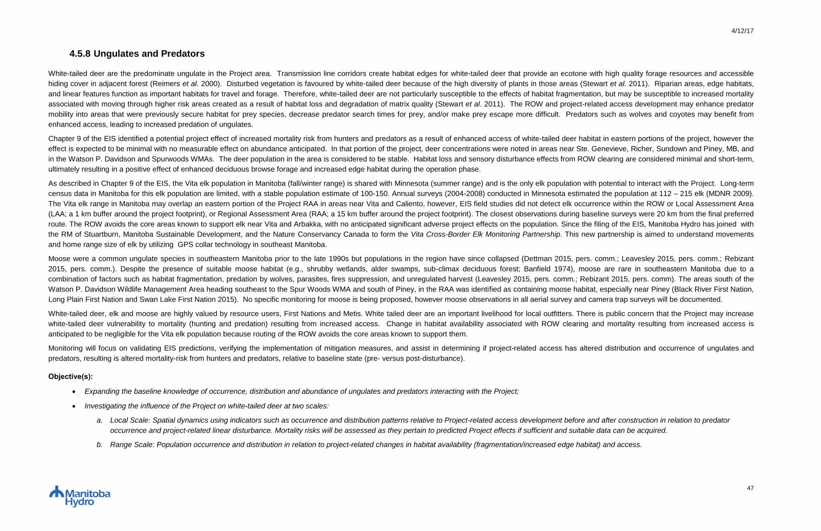
4/12/17
47
4.5.8 Ungulates and Predators
White-tailed deer are the predominate ungulate in the Project area. Transmission line corridors create habitat edges for white-tailed deer that provide an ecotone with high quality forage resources and accessible
hiding cover in adjacent forest (Reimers et al. 2000). Disturbed vegetation is favoured by white-tailed deer because of the high diversity of plants in those areas (Stewart et al. 2011). Riparian areas, edge habitats,
and linear features function as important habitats for travel and forage. Therefore, white-tailed deer are not particularly susceptible to the effects of habitat fragmentation, but may be susceptible to increased mortality
associated with moving through higher risk areas created as a result of habitat loss and degradation of matrix quality (Stewart et al. 2011). The ROW and project-related access development may enhance predator
mobility into areas that were previously secure habitat for prey species, decrease predator search times for prey, and/or make prey escape more difficult. Predators such as wolves and coyotes may benefit from
enhanced access, leading to increased predation of ungulates.
Chapter 9 of the EIS identified a potential project effect of increased mortality risk from hunters and predators as a result of enhanced access of white-tailed deer habitat in eastern portions of the project, however the
effect is expected to be minimal with no measurable effect on abundance anticipated. In that portion of the project, deer concentrations were noted in areas near Ste. Genevieve, Richer, Sundown and Piney, MB, and
in the Watson P. Davidson and Spurwoods WMAs. The deer population in the area is considered to be stable. Habitat loss and sensory disturbance effects from ROW clearing are considered minimal and short-term,
ultimately resulting in a positive effect of enhanced deciduous browse forage and increased edge habitat during the operation phase.
As described in Chapter 9 of the EIS, the Vita elk population in Manitoba (fall/winter range) is shared with Minnesota (summer range) and is the only elk population with potential to interact with the Project. Long-term
census data in Manitoba for this elk population are limited, with a stable population estimate of 100-150. Annual surveys (2004-2008) conducted in Minnesota estimated the population at 112 – 215 elk (MDNR 2009).
The Vita elk range in Manitoba may overlap an eastern portion of the Project RAA in areas near Vita and Caliento, however, EIS field studies did not detect elk occurrence within the ROW or Local Assessment Area
(LAA; a 1 km buffer around the project footprint), or Regional Assessment Area (RAA; a 15 km buffer around the project footprint). The closest observations during baseline surveys were 20 km from the final preferred
route. The ROW avoids the core areas known to support elk near Vita and Arbakka, with no anticipated significant adverse project effects on the population. Since the filing of the EIS, Manitoba Hydro has joined with
the RM of Stuartburn, Manitoba Sustainable Development, and the Nature Conservancy Canada to form the Vita Cross-Border Elk Monitoring Partnership. This new partnership is aimed to understand movements
and home range size of elk by utilizing GPS collar technology in southeast Manitoba.
Moose were a common ungulate species in southeastern Manitoba prior to the late 1990s but populations in the region have since collapsed (Dettman 2015, pers. comm.; Leavesley 2015, pers. comm.; Rebizant
2015, pers. comm.). Despite the presence of suitable moose habitat (e.g., shrubby wetlands, alder swamps, sub-climax deciduous forest; Banfield 1974), moose are rare in southeastern Manitoba due to a
combination of factors such as habitat fragmentation, predation by wolves, parasites, fires suppression, and unregulated harvest (Leavesley 2015, pers. comm.; Rebizant 2015, pers. comm). The areas south of the
Watson P. Davidson Wildlife Management Area heading southeast to the Spur Woods WMA and south of Piney, in the RAA was identified as containing moose habitat, especially near Piney (Black River First Nation,
Long Plain First Nation and Swan Lake First Nation 2015). No specific monitoring for moose is being proposed, however moose observations in all aerial survey and camera trap surveys will be documented.
White-tailed deer, elk and moose are highly valued by resource users, First Nations and Metis. White tailed deer are an important livelihood for local outfitters. There is public concern that the Project may increase
white-tailed deer vulnerability to mortality (hunting and predation) resulting from increased access. Change in habitat availability associated with ROW clearing and mortality resulting from increased access is
anticipated to be negligible for the Vita elk population because routing of the ROW avoids the core areas known to support them.
Monitoring will focus on validating EIS predictions, verifying the implementation of mitigation measures, and assist in determining if project-related access has altered distribution and occurrence of ungulates and
predators, resulting is altered mortality-risk from hunters and predators, relative to baseline state (pre- versus post-disturbance).
Objective(s):
Expanding the baseline knowledge of occurrence, distribution and abundance of ungulates and predators interacting with the Project;
Investigating the influence of the Project on white-tailed deer at two scales:
a. Local Scale: Spatial dynamics using indicators such as occurrence and distribution patterns relative to Project-related access development before and after construction in relation to predator
occurrence and project-related linear disturbance. Mortality risks will be assessed as they pertain to predicted Project effects if sufficient and suitable data can be acquired.
b. Range Scale: Population occurrence and distribution in relation to project-related changes in habitat availability (fragmentation/increased edge habitat) and access.
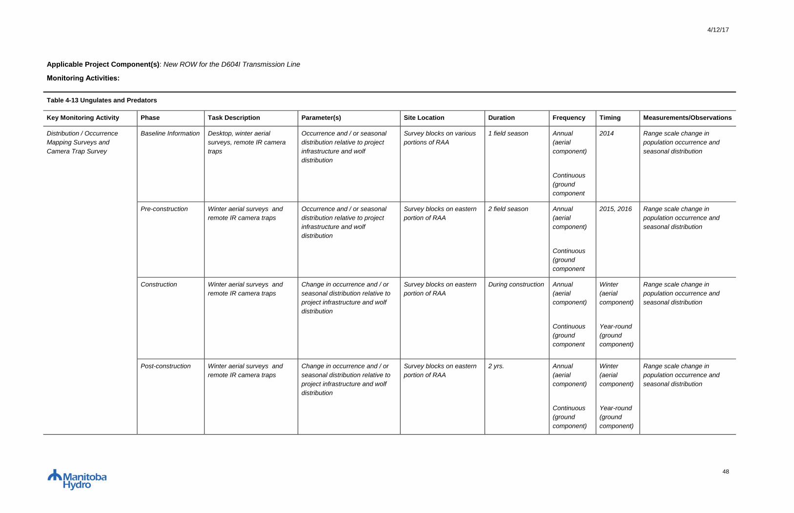
4/12/17
48
Applicable Project Component(s): New ROW for the D604I Transmission Line
Monitoring Activities:
Table 4-13 Ungulates and Predators
Key Monitoring Activity Phase Task Description Parameter(s) Site Location Duration Frequency Timing Measurements/Observations
Distribution / Occurrence
Mapping Surveys and
Camera Trap Survey
Baseline Information Desktop, winter aerial
surveys, remote IR camera
traps
Occurrence and / or seasonal
distribution relative to project
infrastructure and wolf
distribution
Survey blocks on various
portions of RAA
1 field season Annual
(aerial
component)
Continuous
(ground
component
2014 Range scale change in
population occurrence and
seasonal distribution
Pre-construction Winter aerial surveys and
remote IR camera traps
Occurrence and / or seasonal
distribution relative to project
infrastructure and wolf
distribution
Survey blocks on eastern
portion of RAA
2 field season Annual
(aerial
component)
Continuous
(ground
component
2015, 2016 Range scale change in
population occurrence and
seasonal distribution
Construction
Winter aerial surveys and
remote IR camera traps
Change in occurrence and / or
seasonal distribution relative to
project infrastructure and wolf
distribution
Survey blocks on eastern
portion of RAA
During construction Annual
(aerial
component)
Continuous
(ground
component
Winter
(aerial
component)
Year-round
(ground
component)
Range scale change in
population occurrence and
seasonal distribution
Post-construction Winter aerial surveys and
remote IR camera traps
Change in occurrence and / or
seasonal distribution relative to
project infrastructure and wolf
distribution
Survey blocks on eastern
portion of RAA
2 yrs. Annual
(aerial
component)
Continuous
(ground
component)
Winter
(aerial
component)
Year-round
(ground
component)
Range scale change in
population occurrence and
seasonal distribution

4/12/17
49
Vehicle Collision Statistic
Gathering
Construction
Gather statistics on project-
related vehicle collisions
White-tailed Deer/Moose vehicle
collisions
RAA During construction Continuous Year-round Number of project related
deer/moose vehicle collisions
Mineral Lick Survey Baseline Information Desktop and Field surveys Location of mineral licks RAA 1 field season Annual 2014 Location of mineral licks
Pre-construction Field survey Location of mineral licks LAA Pre-construction Annual 2015, 2016 Location of mineral licks
Support the “Vita Cross-
Border Elk Monitoring
Partnership” (RM of
Stuartburn, Nature
Conservancy Canada,
Manitoba Sustainable
Development)
Pre-construction,
Construction
Work with partners to study
regional elk movements and
home range.
Change in movement of elk into
project study area
Adjacent to the RAA Pre-construction
tthough
construction
Annual Year-round Movement of collared elk into
the RAA, LAA, and PDA
Support a Memorial
University PhD project titled
“Testing the Effects of
Hydropower Transmission
Line Right-of-Ways on
Wildlife Movements and
Predator-Prey Dynamics”
Pre-construction,
Construction
Work with a PhD student to
study wolf and prey
movements in southeastern
Manitoba in relation to linear
features.
Rate of wildlife movement on
hydropower transmission line
right-of-ways
Southeast Manitoba Pre-construction
through
construction
Annual Year-round Change in population
occurrence and distribution
Manitoba Hydro is committed to:
Provide digital ortho-rectified imagery or georeferenced digital video/photo products;
Supply an Environmental Protection Information Management System (EPIMS) that manages all project monitoring data and allows Specialist access to daily inspection and monitoring reports from
construction period;
Provide qualified Environmental Inspectors to conduct regular inspections of mitigation measure implementation;
Summarize results of key monitoring activities in an annual monitoring report;
Share results of key monitoring activities with interested local stakeholders , First Nations and Metis; and
Participate as a stakeholder in relevant committees or working groups whose purpose is for the ongoing conservation of wildlife.
Support the Vita Cross-Border Elk Monitoring Partnership, and the Memorial University PhD student “Testing the Effects of Hydropower Transmission Line Right-of-Ways on Wildlife Movements and
Predator-Prey Dynamics”
Responsibilities of Environmental Monitor include:

4/12/17
50
During construction phase daily activities, record observations of deer/moose and tracks, mineral licks, human access, and mortality sites within project footprint or access routes;
Record observations with photo and waypoint and store in EPIMS; and
Work with Specialist during field visits to assess mitigation effectiveness, and provide first hand overview of site conditions during construction phase.
Specialist will:
Use existing habitat suitability model to predict suitable ungulate habitat and to assess project footprint effects on habitat suitability and occurrence (pre-disturbance vs. post disturbance)
Design and conduct specific survey methods to collect ungulate occurrence and distribution data during the disturbance and post-disturbance project phases, in relation to project linear disturbance and
predator occurrence
Collect and analyze ungulate and predator data to assess if there are project-related effects at the local (LAA) or landscape (RAA) scale on occurrence or seasonal distribution.
Report on monitoring efforts, including identification to Manitoba Hydro of any unanticipated effects on ungulates discovered through monitoring activities
Through an adaptive management process, make recommendations for ongoing improvements to the monitoring plan, methods, analysis and implementation in response to knowledge gained through
ongoing monitoring and associated analyses
Manitoba Sustainable Development may be requested to:
Provide guidance regarding mitigation strategies should unexpected impacts occur as a result of the transmission line
Decision Trigger(s)/Threshold(s) for Action
More than five ungulate project related vehicle collisions per year.
Action: Provide SD Conservation Officer with GPS location and circumstances as incidents are detected.
Elk observed within the LAA during aerial, camera trap surveys, or as a result of Vita Cross Border Elk Monitoring Partnership.
Action: Provide SD regional wildlife biologist/manager with GPS location and circumstances as incidents are detected. Consider altering, changing or removing human access points, adjusting
vegetation management schedules or prescriptions, adjusting transmission line inspection and maintenance schedules and adjustments to elk monitoring activities.
Identification of mineral lick within LAA.
Action: Provide SD regional wildlife biologist/manager with GPS location and proposed contingency action.
Significant change in ungulate or predator occurrence or, distribution relative to baseline data.
Action: Report to SD regional wildlife biologist/manager through annual meetings where reports are presented and results are discussed. Consider altering, changing or removing human access points,
adjusting vegetation management schedules or prescriptions, adjusting transmission line inspection and maintenance schedule.
Approach to Adaptive Management:
Active - Monitor elk movements into project area. Discuss results with SD and consider altering, changing or removing human access points, adjusting vegetation management schedules or prescriptions,
adjusting transmission line inspection and maintenance schedules and adjustments to elk monitoring activities.
Active - Test hypotheses related to the project adversely affecting distribution and mortality of white-tailed deer, wolves, or coyotes. Discuss results with SD and consider altering, changing or removing
human access points, adjusting vegetation management schedules or prescriptions, adjusting transmission line inspection and maintenance schedules.
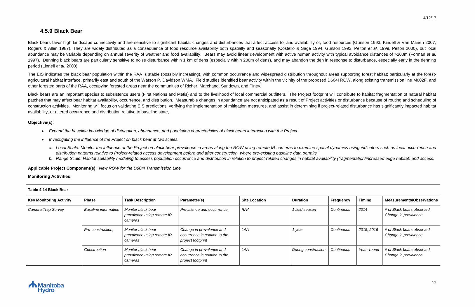
4/12/17
51
4.5.9 Black Bear
Black bears favor high landscape connectivity and are sensitive to significant habitat changes and disturbances that affect access to, and availability of, food resources (Gunson 1993, Kindell & Van Manen 2007,
Rogers & Allen 1987). They are widely distributed as a consequence of food resource availability both spatially and seasonally (Costello & Sage 1994, Gunson 1993, Pelton et al. 1999, Pelton 2000), but local
abundance may be variable depending on annual severity of weather and food availability. Bears may avoid linear development with active human activity with typical avoidance distances of >200m (Forman et al.
1997). Denning black bears are particularly sensitive to noise disturbance within 1 km of dens (especially within 200m of dens), and may abandon the den in response to disturbance, especially early in the denning
period (Linnell et al. 2000).
The EIS indicates the black bear population within the RAA is stable (possibly increasing), with common occurrence and widespread distribution throughout areas supporting forest habitat; particularly at the forest-
agricultural habitat interface, primarily east and south of the Watson P. Davidson WMA. Field studies identified bear activity within the vicinity of the proposed D604I ROW, along existing transmission line M602F, and
other forested parts of the RAA, occupying forested areas near the communities of Richer, Marchand, Sundown, and Piney.
Black bears are an important species to subsistence users (First Nations and Metis) and to the livelihood of local commercial outfitters. The Project footprint will contribute to habitat fragmentation of natural habitat
patches that may affect bear habitat availability, occurrence, and distribution. Measurable changes in abundance are not anticipated as a result of Project activities or disturbance because of routing and scheduling of
construction activities. Monitoring will focus on validating EIS predictions, verifying the implementation of mitigation measures, and assist in determining if project-related disturbance has significantly impacted habitat
availability, or altered occurrence and distribution relative to baseline state,
Objective(s):
Expand the baseline knowledge of distribution, abundance, and population characteristics of black bears interacting with the Project
Investigating the influence of the Project on black bear at two scales:
a. Local Scale: Monitor the influence of the Project on black bear prevalence in areas along the ROW using remote IR cameras to examine spatial dynamics using indicators such as local occurrence and
distribution patterns relative to Project-related access development before and after construction, where pre-existing baseline data permits.
b. Range Scale: Habitat suitability modeling to assess population occurrence and distribution in relation to project-related changes in habitat availability (fragmentation/increased edge habitat) and access.
Applicable Project Component(s): New ROW for the D604I Transmission Line
Monitoring Activities:
Table 4-14 Black Bear
Key Monitoring Activity Phase Task Description Parameter(s) Site Location Duration Frequency Timing Measurements/Observations
Camera Trap Survey Baseline information Monitor black bear
prevalence using remote IR
cameras
Prevalence and occurrence RAA 1 field season Continuous 2014 # of Black bears observed,
Change in prevalence
Pre-construction,
Monitor black bear
prevalence using remote IR
cameras
Change in prevalence and
occurrence in relation to the
project footprint
LAA 1 year Continuous 2015, 2016 # of Black bears observed,
Change in prevalence
Construction
Monitor black bear
prevalence using remote IR
cameras
Change in prevalence and
occurrence in relation to the
project footprint
LAA During construction Continuous Year- round # of Black bears observed,
Change in prevalence

4/12/17
52
Table 4-14 Black Bear
Key Monitoring Activity Phase Task Description Parameter(s) Site Location Duration Frequency Timing Measurements/Observations
Post-construction
Monitor black bear
prevalence using remote IR
cameras
Change in prevalence and
occurrence in relation to the
project footprint
LAA 2 yrs. Continuous Year- round # of Black bears observed,
Change in prevalence
Manitoba Hydro is committed to:
Provide camera trap equipment;
Supply an Environmental Protection Information Management System (EPIMS) that manages all project monitoring data and allows Specialist access to daily inspection and monitoring reports from
construction period;
Provide qualified Environmental Inspectors to conduct regular inspections of mitigation measure implementation;
Summarize results of key monitoring activities in an annual monitoring report;
Share results of key monitoring activities with interested local stakeholders, First Nations, the MMF, Indigenous organizations; and
Responsibilities of Environmental Monitor include:
During construction phase daily activities, record observations of bear, dens and tracks, ungulate mortality sites within project footprint or access routes;
Record observations with photo and waypoint and store in EPIMS; and
Work with Specialist during field visits to assess mitigation effectiveness, and provide first hand overview of site conditions during construction phase.
Specialist will:
Use digital ortho-rectified imagery and geospatial datasets provided by Manitoba Hydro to develop a habitat suitability model to predict suitable black bear habitat, to predict project footprint effects on black
bear habitat suitability and occurrence (pre-disturbance vs. post disturbance), and to inform survey design
Design and conduct camera trap survey to collect black bear occurrence and distribution data
Collect and analyze black bear data to assess if there are project-related effects at the local or regional scale on occurrence and distribution.
Report on monitoring efforts, including identification to Manitoba Hydro of any unanticipated effects on black bear discovered through monitoring activities
Through an adaptive management process, make recommendations for ongoing improvements to the monitoring plan, methods, analysis and implementation in response to knowledge gained through
ongoing monitoring and associated analyses
Manitoba Sustainable Development may be requested to:
Provide guidance regarding mitigation strategies should unexpected impacts occur as a result of the transmission line

4/12/17
53
Decision Trigger(s)/Threshold(s) for Action
Bear den location is detected within LAA by project staff.
Action: Provide Conservation Officer with GPS location and circumstances as incidents are detected. Develop and maintain an appropriate sized construction buffer around the black bear den site until
the den is not longer active.
Significant project-related change in black bear occurrence.
Action: Report to SD regional wildlife biologist/manager through annual meetings where reports are presented and results are discussed.
Approach to Adaptive Management:
Passive - Implement environmental protection plan measures and apply experience from previous transmission development projects (i.e. apply construction buffer, implement site-specific rehabilitation
measures).

4/12/17
54
4.6 SOCIO-ECONOMIC AND RESOURCE USE
4.6.1 Employment and Economy
The economic monitoring activities that will occur during construction include employment, income and business outcomes associated with the project. The estimates of the economic impact of the project are
documented in the EIS, and the intent is to compare predictions made in the EIS to actuals.
The EIS estimated the workforce for all project components. Estimates vary by project component and year depending on the activity. The majority of employment opportunities will occur during the construction
phase of the project with fewer opportunities during the operations phase of the project. Due to seasonality constraints for some aspects of the work certain project components will have activities concentrated at
specific times of the year, while other project construction components will occur throughout the entire year. Monitoring employment results will provide data on actuals incurred on the project and will provide an
indication of the overall economic impact of the project.
Construction of the project will result in business opportunities locally, regionally and throughout the province and Canada. Manitoba Hydro has policies in place to promote local businesses on its projects. The goal
is to enhance business relationships with the communities and to assist them in building capacity and competitiveness of their businesses through involvement in Manitoba Hydro contracts. Monitoring both direct and
indirect business effects will provide data on the success and effectiveness of efforts to enhance local business participation, as well as an indication of the general economic impact of the project in communities in
the vicinity of the Project.
Labour income is an important indicator of direct economic impact of a project. Income levels also affect the general standard of living of individuals and families by influencing the acquisition of basic human needs
including housing, food and clothing. Consequently, monitoring income levels can provide a general indication of a project’s contribution to the overall standard of living. The estimate of labour income reflects the
direct income of wages and salaries associated with direct person-years employment. Regarding taxation, direct taxes paid reflect incremental revenue sources generated for governments as a result of the project.
The incremental revenues, in turn, contribute to societal programs and general well-being.
Objective(s)
The objective of economic monitoring it to gather project information relating to economic parameters and compare to predictions made in the EIS regarding employment and workforce, business
opportunities, labour income and tax revenue.
Applicable Project Component(s): All Project Components
Monitoring Activities:
Table 4-15 Employment and Economy
Key Monitoring Activity Phase Task Description Parameter(s) Site Location Duration Frequency Timing Measurements/Observations
Project Employment
Reporting
Construction Determine project
employment associated with
the project
Collect and report
using Construction
Employment
Database.
All project
components
During construction Annual April Total person years of
employment for each project
component,
Total number of hire,
Total number of employees,
Type (job classifications) of
work available.

4/12/17
55
Direct/Indirect Business
Opportunities Reporting
Construction Determine direct/indirect
business opportunities
Collect and report
using Manitoba
Hydro's existing
accounting and
tracking system and
purchasing reports.
All project
components
During construction Annual April To determine the extent of
direct/indirect business
effects associated with the
project.
Direct Labor Income and
Taxes Reporting
Construction Determine direct labor
income and taxes generated
by the project.
Manitoba Hydro's
existing accounting
and tracking system
and labour reports.
All project
components
During construction Annual April To determine direct labor
income and contribution of
the project to tax revenue.
Manitoba Hydro is committed to:
Summarize results of key monitoring activities in an annual monitoring report; and
Share results of key monitoring activities with interested local stakeholders, First Nations, the MMF, Indigenous organizations and Manitoba Sustainable Development.
Approach to Adaptive Management:
Passive - Report results to local stakeholders, First Nations, the MMF, Indigenous organizations, and Manitoba Sustainable Development providing an opportunity for feedback and recommendations for
improvement.
4/12/17
56
4.6.2 Infrastructure and Services
4.6.2.1 Transportation
The construction of each major component will have distinct effects on the existing road network. The road network consists of provincial highways and municipal roads in southeast Manitoba. Each Project
component has unique traffic generation, vehicle mix, travel patterns and mode choices, which are variable throughout the life of the Project. Traffic accidents will be obtained through Manitoba Hydro reporting to
the extent possible. This data will be used to potentially link project related incidents to certain conditions, whether it be related to the traffic volume, truck load size, time of collision, weather or road conditions.
Objective(s)
The objective of traffic monitoring is to track the number of accidents/potential near misses associated with the project and to track traffic volumes at key locations and to compare to baseline volumes
Applicable Project Component(s): All Project Components
Monitoring Activities:
Table 4-16 Transportation
Key Monitoring Activity Phase Task Description Parameter(s) Site Location Duration Frequency Timing Measurements/Observations
Traffic Monitoring Survey Baseline
Information
Determine traffic volumes Traffic volumes RAA 1 year Annual Continuous Number of vehicles
Construction Determine the increase in
traffic volumes, near misses
and accidents on key
roadways potentially as a
result of the project.
Increase in traffic
volumes, near
misses and
accidents on key
roadways.
All project
components
During construction Annual Continuous Traffic volumes – compare
actual traffic volumes from
estimates in the EIS on key
roadways.
Traffic accidents and near
misses in the project area on
key roadways through
Manitoba Hydro incident
reports as available.
Manitoba Hydro is committed to:
Implementing recommendations to minimize traffic accidents and near misses;
Summarize results of key monitoring activities in an annual monitoring report;
Share results of key monitoring activities with interested local stakeholders, First Nations, the MMF, Indigenous organizations; and
Specialist will:
Design and conduct traffic monitoring survey to collect traffic volume, near misses and accidents as a result of the Project
Report on monitoring efforts, including identification of any unanticipated effects on traffic volumes and accidents discovered through monitoring activities

4/12/17
57
Through an adaptive management process, make recommendations for ongoing improvements to the monitoring plan, methods, analysis and implementation in response to knowledge gained through
ongoing monitoring and associated analyses.
Approach to Adaptive Management:
Passive - Apply best management practices and experience from previous transmission development projects (i.e. carefully select traffic and turning points to minimize traffic accidents and near misses).

4/12/17
58
4.6.3 Outfitting and Falconry
4.6.3.1 Outfitter Resource Use
Manitoba Hydro is planning to continue its work with the local black bear outfitter in the project area to further understand development effects on their operations. In 2014, camera traps were established at bait sites
within the Project Development Area and in control areas to understand baseline conditions of bear occurrence and prevalence. As some bait sites are in close proximity to the Final Preferred Route, it is possible that
their continued use may be affected by the Project. Manitoba Hydro is proposing to work with the outfitter to establish new bear bait sites prior to construction and include them in a continued camera trap survey
along with the baseline locations. Bear occurrence and prevalence is measured by number of trail camera trigger events occurring at minimum 30 minute intervals.
Objective(s)
The objective of the Black Bear Bait Site Camera Trap Survey is to analyse bear occurrence and prevalence at bait site locations prior to, during and post construction of the Project
Applicable Project Component(s): New ROW for the D604I Transmission Line
Monitoring Activities
Table 4-17 Outfitter Resource Use
Key Monitoring Activity Phase Task Description Parameter(s) Site Location Duration Frequency Timing Measurements/Observations
Black Bear Bait Site Camera
Trap Survey
Pre-construction Camera Trap survey to
measure use of bear bait
sites prior to development
Number of black
bears frequenting
bait sites
Bear Bait Sites Pre-construction Biannual 2014 Occurrence and Prevalence
Construction Camera Trap survey to
measure use of bear bait
sites during to development
Number of black
bears frequenting
bait sites
Bear Bait Sites During construction Biannual 2015, 2016 Occurrence and Prevalence
Post-construction Camera Trap survey to
measure use of bear bait
sites post development
Number of black
bears frequenting
bait sites
Bear Bait Sites 2 yrs Biannual Spring and Fall Occurrence and Prevalence
Manitoba Hydro is committed to:
Provide camera trap equipment;
Supply an Environmental Protection Information Management System (EPIMS) that manages all project monitoring data and allows Specialist access to daily inspection and monitoring reports from
construction period;
Summarize results of key monitoring activities in an annual monitoring report; and
Share results of key monitoring activities with interested local stakeholders, First Nations, the MMF, Indigenous organizations and Manitoba Sustainable Development.
Responsibilities of Environmental Monitor include:
During construction phase daily activities, record observations of bear, dens and tracks, ungulate mortality sites near bait sites within project footprint or access routes;
Record observations with photo and waypoint and store in EPIMS.
4/12/17
59
Specialist will:
Work with local outfitter to conduct camera trap survey to collect black bear occurrence and prevalence data
Collect and analyze black bear data to assess if there are project-related effects on outfitter operations.
Report on monitoring efforts, including identification to Manitoba Hydro of any unanticipated effects on black bear bait sites discovered through monitoring activities
Through an adaptive management process, make recommendations for ongoing improvements to the monitoring plan, methods, analysis and implementation in response to knowledge gained through
ongoing monitoring and associated analyses
Decision Trigger(s)/Threshold(s) for Action
Trail camera trigger events at bait site locations near the PDA decline significantly relative to bait site locations distant from the PDA.
Action: Report results to the local outfitter and discuss findings.
Approach to Adaptive Management:
Active - Test hypotheses related to the project adversely affecting black bear observations at bait sites near project area. Report results to the local outfitter and discuss findings.

4/12/17
60
4.6.3.2 Peregrine Falcon Conservation Centre
Manitoba Hydro is planning to continue its work with a local peregrine falcon conservation centre in the project area to further understand potential development effects on their operations. In 2016, Manitoba Hydro
provided GPS radio transmitters and supporting equipment to Parkland Mews to help them understand and record movements and flight patterns of peregrine falcons bred at the conservation centre. This flight
information is digitally recorded and provides baseline information of peregrine falcon movements in local region, including any potential interactions the proposed project right-of-way that is located approximately 2.5
km north of the conservation centre.
Objective(s)
The objective of the peregrine falcon flight recordings is to measure peregrine falcon movements around the conservation center and proposed project right of way prior to, during and post construction of
the Project
Applicable Project Component(s): South Loop
Monitoring Activities
Table 4-18 Peregrine Falcon Conservation Centre
Key Monitoring Activity Phase Task Description Parameter(s) Site Location Duration Frequency Timing Measurements/Observations
Peregrine Falcon Flight
Recordings
Pre-construction Track movements of
peregrine falcons
Perch sites and
distance flown
Parkland Mews Pre-construction At the peregrine falcon
handlers discretion.
2016 # and location of perch sites,
total distance flown from mew.
Construction Track movements of
peregrine falcons
Perch sites and
distance flown
Parkland Mews During construction At the peregrine falcon
handlers discretion.
Spring, Summer, and
Fall
# and location of perch sites,
total distance flown from mew.
Post-construction Track movements of
peregrine falcons
Perch sites and
distance flown
Parkland Mews 1 year At the peregrine falcon
handlers discretion.
Spring, Summer, and
Fall
# and location of perch sites,
total distance flown from mew.
Manitoba Hydro is committed to:
Provide GPS tracking equipment;
Provide technical support and training in the operations of the technology.
Summarize results of key monitoring activities in an annual monitoring report; and
Share results of key monitoring activities with interested local stakeholders, First Nations, the MMF, Indigenous organizations and Manitoba Sustainable Development.
Decision Trigger(s)/Threshold(s) for Action
Peregrine falcons are identified to be extensively utilizing the project ROW.
Action: Report results with Parkland Mews and discuss findings including the potential implementation of mitigation measures such as bird diverters or perch deterrents.
Approach to Adaptive Management:
Active – Test the hypotheses that the Project does not affect the traversing or perching of peregrine falcons near the project area. Report results to the conservation centre and discuss findings.
Draft 4/12/17
61
5.0 ADAPTIVE MANAGEMENT
The Canadian Environmental Assessment Agency (CEAA) defines adaptive management as
“the implementation of new or modified processes, procedures and or mitigation measures over
the construction and operation phases of a project to address unanticipated environmental
effects” (CEAA, 2015). Adaptive management is considered a planned and systematic process
used to continuously improve environmental management practices by learning about their
outcomes. The use of an adaptive management process allows for the flexibility to identify and
implement new mitigation measures or to modify existing ones during the life of a project
(CEAA, 2015). Although definitions of adaptive management vary depending on the source,
there are fundamental concepts of adaptive management that are universal and fundamental
(British Columbia Ministry for Forests and Range, 2015) which include the following:
Learning and reducing key uncertainties
Using what is learned to change policy and practice
Focus is on improving management
Adaptive management is formal, structured and systematic
Manitoba Hydro has accumulated information and lessons learned from previous monitoring
programs. The successes of those programs have been reviewed and considered in the
development of this plan. Previous weaknesses have been adapted and improved upon to
further enhance this plan’s approach, methods and key environmental monitoring activities.
The Environmental Protection Program, of which the Manitoba-Minnesota Transmission Project
Environmental Monitoring Plan is part of, and has been designed to be adaptive and responsive
throughout the Project lifecycle. The management of any low to moderate levels of uncertainty
can be achieved for the proposed project by the implementation of a passive adaptive
management process which will help to facilitate actions if any unforeseen effects occur and will
result in the identification of new or modified mitigation (British Columbia Environmental
Assessment Office, 2013). Active adaptive management measures will be employed to manage
areas of high (and some moderate) levels of uncertainty and further develop mitigation
measures and environmental protection activities.
Program documents, processes, procedures and mitigation measures will be continuously
evaluated by inspection, monitoring and communication programs. Audits and reviews will be
conducted to facilitate updates to the program through an adaptive management process
(Manitoba Hydro, 2013). Within the Environmental Protection Program, adaptive management
will take place in two primary areas: at the management level, involving changes with the
program structure itself; and at the implementation level, which will involve individual mitigation
measures as management and implementation teams evaluate the on-site effectiveness of
mitigation strategies or the program as a whole. Scheduled update meetings between

4/12/17
62
departments, annual reviews of the program and its effectiveness will take place to foster the
adaptive management process.
Annual reviews will be conducted by Licensing and Environmental Assessment in consultation
with Transmission Line and Civil Construction, the contractor, regulators and stakeholders. The
results of each annual season review will be summarized in a report that documents the issues
addressed and provides recommended updates to applicable components of the Environmental
Protection Program.

Draft 4/12/17
63
6.0 REPORTING
Reports will be generated annually, and provided to Manitoba Sustainable Development and the
National Energy Board. Notifications of new reports on the website will be communicated to
relevant federal and provincial regulatory agencies.
In addition to annual reports summarizing activities and general findings, technical reports will
be prepared at appropriate intervals during the construction and post construction phases of the
Project. These reports will on a cumulative basis compile and analyze monitoring results during
the relevant period, and based on those results, make recommendations concerning the need
for any changes to the mitigation or monitoring approach. Manitoba Hydro will present and
discuss monitoring results with the NEB, SD, First Nations, the MMF and Indigenous
organizations on request as the project proceeds.
Any significant unanticipated project effects discovered through monitoring activities or where
regulations dictate will be reported immediately to SD and/or the NEB.
4/12/17
64
7.0 MONITORING METHODS
This section provides detailed information on the methods to be used to monitor the Valued
Components and environmental indicators identified in Section 4.0.
7.1 FISH AND FISH HABITAT
7.1.1 Stream Crossing Assessments
Stream crossing sites will be evaluated for adherence to prescribed mitigation and effectiveness
of mitigation.
Field studies will be undertaken at all stream crossings assessed as fish bearing during active
construction and in the first spring following construction. Riparian buffers will be evaluated by
measuring their width from the stream or floodplain and comparing to the width prescribed, as
well as evaluating the amount of vegetation left in the buffer and the clearing method used.
Stability of stream banks and floodplain will be evaluated visually and rutting, slumping, or other
damage to the ground noted. The presence of slash or disturbed sediment within the buffer will
be recorded, as well as any evidence of erosion. Trail crossings will be evaluated for
appropriate grade and angle across the stream, and the presence of any organic debris
remaining from a temporary snow bridge. If any erosion control measures were in place
(blankets, silt fences) their effectiveness will be evaluated. Tower locations will be assessed to
determine if they adhered to prescribed mitigation. Any further erosion control measures and
reclamation needed to meet the prescribed mitigation will be recommended.
7.2 VEGETATION AND WETLANDS
Information collected and prepared for the Project that will assist with vegetation and wetland
monitoring.
To select monitoring sites for the Project, the Environmental Protection Information
Management System (EPIMS) map viewer will be used to view recent project footprint imagery
(pre-clearing digital ortho-rectified imagery). Previous sampled sites and environmentally
sensitive sites, identified from the Project EIS, will be considered for potential sampling
locations. Suitable sites will also be selected based on vegetation type, accessibility,
disturbance, landowner permission, and whether invasive and non-native species may establish
and proliferate. Sites selected on private lands will be used to determine property ownership
and contact information.

4/12/17
65
7.2.1 Wetlands
Wetland vegetation will be sampled, and the accuracy of EIS predictions and effectiveness of
mitigation measures implemented will be verified. Digital ortho-rectified imagery will be used for
identification of wetlands and potential sampling sites for assessment of RoW effects. Pre-
construction surveys will involve quantitative native vegetation surveys in selected wetlands
along the transmission line RoW.
Sites selected for native vegetation surveys will have plots established for future vegetation
monitoring. The native vegetation survey will consist of establishing sample plots on sites with
relatively homogenous vegetation. Vegetation will be sampled for composition, abundance and
structure. Sampling of selected sites will follow methods outlined by Redburn and Strong (2008)
and involve the establishment of five 2.5 m by 2.5 m quadrats with a 1 m by 1 m nested quadrat
spaced at 5 m increments along a 30 m transect for wetland shrubs 1 - 2.5 m tall and herbs and
low shrubs ≤1 m tall, respectively. Transects will be located on sites considered representative
of the stand being sampled. The first quadrat will be placed at the 5 m mark. The composition of
wetland tree cover >2.5 m tall will be estimated using a 20 m by 30 m plot centered on each
transect. Transects will be permanently located along the transmission line RoW, longitudinally,
and approximately in the centre of the RoW, but off the equipment path. Plant cover will be
estimated to the nearest 1% for species <15% cover and nearest 5% for those with higher
cover. Other incidentally observed species will be recorded. GPS coordinates and photographs
will be taken at each sampling site. Wetlands will be classified according to the Canadian
Wetland Classification System (National Wetlands Working Group 1997).
Environmental monitoring of wetlands will occur on cleared portions of the RoW. Environmental
monitoring will involve vegetation monitoring using the identical quantitative methods described
above (native vegetation survey). Wetlands will be sampled for herbaceous and shrub cover
along the RoW to assess the vegetation. Incidental species observations will be recorded. All
sites will be photographed.
Permanently located sampling areas will be used to record the change in vegetation that can be
systematically monitored through time. The collection of wetland vegetation information will
occur at a similar time during the growing season to maximize the comparability of data. After
field sampling, the data will be digitized and mean values for vegetation cover will be calculated.
Total species cover, species richness and diversity measures will be calculated for each plot.
Statistical testing may be used to determine if differences occur between baseline samples and
post-clearing.
4/12/17
66
7.2.2 Plant Species of Conservation Concern
Surveys for species of conservation concern, and the accuracy of EIS predictions and
effectiveness of mitigation measures implemented will be verified. Pre-construction surveys for
species of conservation concern will be conducted in portions of the project footprint that were
not previously surveyed and have the greatest potential for supporting these plants along the
transmission line RoW. Digital ortho-rectified imagery will be used for the identification of
potential survey sites and assessment of RoW effects.
Rare plant surveys initially will involve the review of species observed previously along the
transmission line RoW, as well as the database compiled by the Manitoba Conservation Data
Centre for species of conservation concern, which includes species that are rare, disjunct, or at
risk throughout their range or in Manitoba. Species of conservation concern encompasses
plants ranked very rare to uncommon by the Manitoba Conservation Data Centre, and those
listed under the provincial Endangered Species and Ecosystems Act, the federal Species at
Risk Act, or listed by the Committee on the Status of Endangered Wildlife in Canada. Flowering
times and preferred habitat for species of conservation concern known to occur in the Project
area will be reviewed.
In the field, a combination of meander and transect searches will be used. Parallel transects are
favoured in more open and homogenous landscapes, while meander searches are conducted in
areas of difficult terrain, unique habitats, and where unusual landscape features occur. Rare
plant locations will be recorded using a GPS receiver. Rare plant individuals will be counted,
phenology will be recorded and population extent will be estimated. Additional information
collected will include associated plants observed. Photographs will be captured in the field.
Environmental monitoring for species of conservation concern will occur after clearing of the
RoW. Monitoring for species of conservation concern will involve the review of species
previously observed during pre-construction surveys. Monitoring will occur at selected sites
along the RoW to investigate the presence/absence of the plants which were observed prior to
clearing and construction. Species of concern observed in the field will have the following
information recorded: GPS coordinates verification, individuals counted, population extent
estimated, phenology recorded, and associated plants recorded. Photographs will be captured
in the field.
7.2.3 Invasive Plant Species
Sampling will occur for invasive plant species introduction, and the accuracy of EIS predictions
and effectiveness of mitigation measures implemented will be verified. Initially, digital ortho-
rectified imagery will be used for identification of potential sampling sites and assessment of
RoW effects. Pre-construction surveys will involve quantitative vegetation surveys at selected

4/12/17
67
sites along the transmission line RoW. Other locations will involve roadside assessments for
invasive and non-native species, where detailed surveys are unable to be conducted.
Sites selected for vegetation surveys will have plots established for future vegetation monitoring.
The vegetation survey will consist of establishing sample plots on sites near roads, rail lines,
rivers or disturbances, which may provide pathways for these species. Vegetation will be
sampled for composition, abundance and structure. Sampling of selected sites will involve the
establishment of five 2.5 m by 2.5 m quadrats with a 1 m by 1 m nested quadrat spaced at 5 m
increments along a 30 m transect for shrubs 1 - 2.5 m tall and herbs and low shrubs ≤1 m tall,
respectively. The first quadrat will be placed at the 5 m mark. The composition of tree cover
>2.5 m tall will be estimated using a 20 m by 30 m plot centered on each transect. Transects
will be permanently located along the transmission line RoW, longitudinally, and approximately
in the centre of the RoW, but off the equipment path. Plant cover will be estimated to the
nearest 1% for species <15% cover and nearest 5% for those with higher cover. Other
incidentally observed species will be recorded. Ground cover estimates (%) will be recorded and
include exposed soil, litter, rock, water and wood. Site condition measurements will include
slope and aspect. GPS coordinates and photographs will be taken at each sampling site.
Environmental monitoring will occur after clearing, and along the RoW. Environmental
monitoring will involve vegetation monitoring using the identical quantitative methods described
above (vegetation survey). Vegetation will be sampled for herbaceous and shrub cover along
the RoW. Incidental species observations will be recorded. All sites will be photographed.
Permanently located sampling areas will be used to record the change in vegetation species
that can be systematically monitored through time. The collection of vegetation information will
occur at a similar time during the growing season to maximize the comparability of data. After
field sampling, the data will be digitized and mean values for vegetation cover will be calculated.
For each plot, species measures will be determined (e.g., total species cover, richness,
diversity). Statistical testing may be used to determine if differences occur between baseline
sampling and post-clearing.
7.2.4 Traditional Use Plant Species
Vegetation will be sampled for traditional use plant species important to First Nations and Metis
based on information provided through the ongoing First Nation and Metis engagement process.
The accuracy of EIS predictions and effectiveness of mitigation measures implemented will be
verified. Digital ortho-rectified imagery will be used for identification of potential sampling sites
for assessment of RoW effects. Pre-construction surveys will involve native vegetation surveys
at selected sites along the transmission line RoW, at known traditional use sites.

4/12/17
68
Sites selected for surveys will have plots established for future vegetation monitoring.
Vegetation will be sampled for composition, abundance and structure. Sampling of selected
sites will involve the establishment of quadrats spaced at 5 m increments along a 30 m transect
for shrubs and herbs. The composition of tree cover will be estimated using a plot centered on
each transect. Transects will be permanently located along the transmission line RoW,
longitudinally, and approximately in the centre of the RoW, but off the equipment path. Plant
cover will be estimated to the nearest 1% for species <15% cover and nearest 5% for those with
higher cover. Other incidentally observed species will be recorded. Ground cover estimates (%)
will be recorded and include exposed soil, litter, rock, water and wood. Site condition
measurements will include slope and aspect. GPS coordinates and photographs will be taken at
each sampling site.
Environmental monitoring will occur after clearing, and along the RoW. Environmental
monitoring will involve vegetation monitoring using the identical methods described above.
Vegetation will be sampled for herbaceous and shrub cover along the ROW. Incidental species
observations will be recorded. All sites will be photographed.
Permanently located sampling areas will be used to record the change in vegetation that can be
systematically monitored through time. The collection of vegetation information will occur at a
similar time during the growing season to maximize the comparability of data. The data will be
digitized and mean plant values will be calculated, after sampling. Species measures will be
determined and assessed for each plot.
7.3 WILDLIFE AND WILDLIFE HABITAT
Monitoring wildlife and wildlife habitat will aim to track vital measures of populations (e.g.,
presence, distribution, relative abundance, and movement) that are associated with (i.e., linked)
potential Project effects. In some cases, changes in habitat quality will be used to help
determine the potential response. Determining the basis of causality in complex biological
systems can be difficult. When analysing the results of hypothesis testing, considerations will be
given for the most influential factors which drive wildlife populations (e.g., habitat, predators,
disease, winter severity) and other lesser factors (e.g., accidents). As with most complex
biological systems, some assumptions regarding the response will have to be made through but
will be supported with peer-reviewed literature and professional opinion to provide the most
accurate explanation possible in annual reporting.
7.3.1 Herptiles
7.3.1.1 Amphibians
To further characterize wetland condition prior to construction, wetland surveys will be
conducted at wetlands supporting northern leopard frogs. Pre-construction wetland surveys will

4/12/17
69
include water quality measurements and amphibian surveys in the spring, summer and fall, at
wetlands that are within or are adjacent to the Project Development Area (PDA). Spring surveys
(late-April through mid-May) will overlap the northern leopard frog breeding period; summer
surveys (early to mid-July) will target eastern tiger salamander larval stage and leopard frog
juvenile stage; fall surveys (late-August to late-September) will overlap their overwintering
congregation period. Any additional sites within or adjacent to the PDA not previously examined
during baseline environmental surveys will be identified through land cover mapping and ortho-
photo interpretation and will be included in the wetland surveys. Eastern tiger salamander
surveys will focus on summer larval surveys but observation of salamanders will be made
throughout the northern leopard frog surveys.
Water quality data to be collected will include: pH, specific conductance, total dissolved solids,
total suspended solids, temperature, and turbidity. Measurements will be taken at three
locations in the shallow water zone at the edge of each wetland at approximately 30-50 cm
depth and 2-5 m from the shoreline. Measurements from the three locations will be averaged to
estimate site composite values at each wetland. Other than total suspended solids,
measurements will be taken in situ with a handheld water quality meter. Measurement of total
suspended solids requires laboratory analysis and water samples will be collected at the in situ
sites and sent to an accredited laboratory for analysis. Additional site characteristics will be
recorded, including vegetation community (e.g., dominant plant species, presence of emergent
and submergent vegetation) and weather conditions (e.g., temperature, wind direction and
speed, cloud cover and precipitation).
Amphibian surveys during the spring survey period will include daytime call surveys during
water quality monitoring, nocturnal call surveys, visual encounter surveys (VES), and incidental
detections. Summer surveys will include larval salamander surveys using funnel-trap sampling
(i.e., minnow traps) and VES for northern leopard frog. Fall surveys will include (VES) and
incidental detections of both northern leopard frogs and salamanders.
Call surveys consist of a 5 minute listening period following a 2 minute waiting period to allow
disturbance associated with observer access to subside. Relative abundance and call rank will
be recorded, based on the widely accepted protocol by Mossman et al. (1998) and
Saskatchewan Ministry of Environment (2014a, 2014b). In the case of nocturnal call surveys,
surveys will be conducted between 0.5 hrs after sunset and 0100h and in weather conditions
with winds <20km/hr, ambient temperature ≥5°C, water temperature ≥10°C, and/or rain no
heavier than a drizzle (Kendell 2002; USGS 2012). Visual encounter surveys will consist of two
biologists walking side by side 5 m apart along wetland margins or stream banks while
documenting any amphibians observed within the waterbody 1 m from shore, in a 1 m strip of
the shoreline, and within 3 m upland from the shoreline/water’s edge. The VES will be
conducted for a prescribed amount of time (20 minutes) and under seasonal air temperatures.
Surveys will be suspended if precipitation exceeds a light rain or ambient air temperatures drop

4/12/17
70
below 15°C. Incidental observational data will be collected opportunistically throughout the
survey periods.
In wetland ponds that may be suitable for salamanders (i.e. no fish, not marshy), funnel-traps
will be used to sample for eastern tiger salamander larvae. Funnel-traps will be set in the
evening and checked the following morning with traps set in approximately 15-25 cm deep
water (Bennett et al 2012). Snout-length and total length will be recorded for all larval tiger
salamanders captured and a tissue sample (tail tip) will be collected and submitted to the
Manitoba Conservation Data Centre (MBCDC) for DNA analysis. Tissue sample collection and
storage will adhere to the MBCDC protocol. All amphibian larvae captured will be identified to
species and released. The appropriate scientific permit will be sought from Manitoba
Sustainable Development prior to the initiation of the field program.
Construction phase wetland monitoring will take place during the amphibian breeding and
overwintering congregation periods immediately following construction activity. Water quality
readings will be taken at similar times of day to pre-construction readings. Construction phase
monitoring would only take place within wetlands where Project activity had occurred.
7.3.1.2 Common Garter Snakes
Pedestrian surveys will occur within 200 m of select portions of the New ROW tower locations
prior to ROW clearing where potential suitable habitat or hibernacula is identified. The
pedestrian survey will be conducted by two biologists, and will include a grid-like walk of the
area while 10 m apart. Where suitable habitat or hibernacula are identified (i.e. rock piles, rock
outcrops, or pits), the effectiveness of applied mitigation (i.e., setback distances) will be verified
through follow-up monitoring. Monitoring will consist of a walk-through of the known suitable
habitat or hibernacula area immediately following construction to determine compliance with
mitigation measures.
7.3.2 Birds
7.3.2.1 Bird – Wire Collisions
Baseline data for bird-wire collisions were gathered in fall 2014 using methods described in
Chapter 9 of the EIS. Methods included carcass searches, scavenger removal trials and
searcher efficiency trials. Sixteen sites were sampled in agriculture, grassland and forest
habitats with low to high bird-wire collision risk.
Bird diverter monitoring will test the hypothesis that bird diverters are sufficient in reducing
mortality of birds due to collisions with the transmission line to a level that is negligible in areas
determined to have a high risk of collision. As such, the null and alternate hypotheses state:
4/12/17
71
H0 (null): The mortality of birds at high-risk areas with bird diverters will not be different
than the mortality of birds at low-risk areas without bird diverters.
H1 (alternate): The mortality of birds at high-risk areas with bird diverters will be greater
than the mortality of birds at low-risk areas without bird diverters.
To test this hypothesis, a Control-Impact study design will be implemented. The Before-After
Control-Impact design study cannot be implemented for this study as mortality of birds is not
expected prior to the installation of the transmission lines. For the purpose of this study, control
sites will consist of ESS’s considered to be ‘low-risk’ and impact sites will consist of ESS’s
considered to be ‘high-risk’, as identified in the EIS.
If transmission lines containing diverters yield negligible avian mortality, then the mortality of
birds relative to the number of bird passes at high-risk transmission lines with diverters should
be comparable or lower than those at low-risk transmission lines with no diverters. Using the
ratio of mortality to number of bird passes instead of simply the numbers of avian mortality
allows correction for differences in bird activity between ‘high-risk‘ and ‘low-risk‘ sites.
Statistical analysis will be conducted using Generalized Linear Models to compare estimated
mortality rates at high-risk versus low-risk sites. Assumptions of parametric testing will be
determined and data transformations applied where necessary and/or appropriate. Non-
parametric testing will be applied where assumptions were violated and/or data could not be
transformed. Analyses will be conducted separately for each season and then with data from all
seasons pooled. If no significant difference is observed between high-risk versus low-risk sites,
then mitigation measures (placement of diverters) will be considered effective in maintaining low
avian mortalities due to collisions with wires. Additionally, mortality studies may allow for the
determination of the biological, environmental and engineering factors important in influencing
collisions as well as the circumstances (e.g., weather, time of day, season) under which birds
are most likely to collide with the wires.
Flight Activity Surveys
Before every mortality survey, biologists will monitor flight activity of birds across the
transmission line right-of-way (ROW) section being searched that day. Biologists will count
the number of birds that fly across the ROW within each of the paired spans within a period of
three hours (three one-hour intervals). Mortality searches will be conducted directly after these
visual flight surveys. All birds will be recorded to allow for collision rate estimates (CRE). CRE
will be calculated as the estimate of total collisions (based on carcass surveys and correction
factors described below) divided by the estimated number of possible bird-wire interactions per
day.
Carcass Searches
4/12/17
72
To estimate the mortality of birds along the transmission line per year at the Project site and test
the adequacy of diverters, carcass searches will be conducted at select ESS’s. Due to the many
confounding variables involved in monitoring avian mortality at transmission lines, no
standardized protocols have been developed for post-construction mortality searches for
transmission lines. The Avian Power Line Interaction Committee (APLIC,2012) and
methodology proposed by De la Zerda and Rosselli (2002) and by Barrientos et al. (2011)
provide valuable guidance and considerations for designing mortality studies and these will be
included in this proposed monitoring plan. Other insights for the study design will reflect those
protocols recommended for carcass searches at wind turbines (Canadian Wildlife Service
2007). The appropriate scientific permit will be sought from Environment Canada prior to the
initiation of the field program.
Searches for dead or injured birds will be performed at high-risk sites identified in the EIS,
a t an equivalent number of low-risk sites, and at known sharp-tailed grouse leks that are
located within 1,000 m of the Project footprint. Each of the mortality monitoring sites will
consist of the area under one span of transmission conductors. A span is defined as the
length of ROW between two transmission towers. The spans closest to the location where
monitoring is desired will be surveyed. Surveys will be focused during peak activity seasons
which will include spring migration and mid-breeding season for Sharp-tailed grouse (April and
early May), late breeding season when adults will be feeding chicks (mid- June and July) and
fall migration (late August to late September). During each of the three survey seasons, four
rounds of carcass searches will be conducted at each ESS.
Carcass searches will be conducted by trained searchers. Every morning, searchers will
conduct both mortality searches and bird passage monitoring. Teams will note environmental
conditions at the start and end of each survey day including notable weather events during the
previous seven days (high winds, storms, fog) based on Environment Canada historical data,
where available. Surveyors will position themselves at the start of a linear transect running from
one of the transmission towers to the other. During each visit, the searchers will walk
parallel survey lines within 5 to 10 m of each other to assure that complete coverage of
the ground occurs. This procedure will be repeated until the entire width of the ROW under
each span is covered. While conducting searches, searchers will search for any dead birds
within a 5 m field of view. Upon finding an avian carcass, the following data will be recorded as
possible:
GPS position of the carcass;
Location of the carcass with respect to the transmission line;
Species;
Sex;
Age;
Date or approximate time of death;

4/12/17
73
Physical injuries and general body condition;
Probably cause of death; and
Evidence of scavenging.
Sampling Biases
Several factors affect the accuracy of mortality estimates recorded in the field. Four sampling
biases are of particular importance in estimating the number of birds killed by a section of
transmission line:
Searcher efficiency;
Scavenger removal;
Habitat differences; and
Crippling loss.
Searcher Efficiency Trials
Searchers conducting mortality searches within the ROW may not find all of the carcasses
present. Carcasses may be overlooked depending on a number of factors including the density
and height of vegetation in the ROW, the route walked by the searcher, the state of the carcass,
etc. As such, searcher efficiency trials aid in correcting this bias. During the course of the
mortality search studies, a known number of carcasses will be placed by a tester at locations
within the search area unknown to searchers being tested. The proportion of purposefully
placed carcasses found by searchers will represent their searcher efficiency and will be used to
correct for this bias when estimating avian mortality at the Project site. To account for
differences in searcher efficiency between different sized birds, if feasible, birds of all major size
categories will be represented in searcher efficiency trials.
Scavenger Removal Trials
Scavenger removal trials are used to estimate the rate at which carcasses are removed from
the ROW by other wildlife. Scavenger removal trials will consist of placing carcasses at known
locations within the ROW and checking these locations periodically to determine if and when
they are removed. Trials will continue until all carcasses are removed or have completely
decomposed. Scavenger removal trials may be conducted concurrently with mortality searches.
To account for differences in scavenging rates between different sized birds, birds of all major
size categories will be represented in the scavenger removal trials.
Habitat Differences
Due to a variety of factors, some portions of a PDA may not be searchable. Most of the
unsearchable habitats will be avoided to the extent possible during the initial selection of ESS’s.

4/12/17
74
For sites where this is not possible, the total area searched at those sites will be calculated and
search area will be corrected in the calculated mortality estimates.
Crippling Loss
Crippling loss is the percentage of birds killed or injured by striking a component of a
transmission line, yet may fall or move beyond the Study Area. Crippling loss may be studied by
monitoring the number and behaviour of birds flying past a section of transmission line or may
be implied from other studies.
Estimating the number of birds that collide with structures but fall out of the search area, or
injured birds that move out of the search area before succumbing to their injuries, is extremely
difficult to quantify (Bevanger 1999, APLIC 2012) and rarely incorporated into estimates (Rioux
et al. 2013). Estimating crippling loss bias requires a great deal of time and effort to monitor
flights near hazards, record collisions, locate injured or dead birds (CEC 2003, APLIC 2012),
and importantly, results in small sample sizes (Paddington 1993, Savereno et al 1996, Crowder
2000). Some studies suggest that to provide more accurate estimates, it may be reasonable to
apply crippling loss bias estimates from other studies (Beaulaurier 1981, Bevanger 1995, Janns
and Ferrer 2000, CEC 2003, Sundar and Choudhury 2005). However, the application of
estimates from other studies is inappropriate and very misleading due to the effects of bird size
and weight on crippling loss bias (APLIC 2012, Rioux et al. 2013).
7.3.2.2 Sharp-tailed Grouse Lekking Sites
Baseline data for sharp-tailed grouse were gathered in spring 2014 using field methods
described in Chapter 9 of the EIS. Location data for sharp-tailed grouse leks were mapped
within the RAA from field surveys and from data provided by Manitoba Sustainable
Development. Sharp-tailed grouse have a reproductive system known as lekking, where
males form large groups and vocalize and display at the same time in attempts to attract
females. Leks are generally elevated sites associates with sparse or disturbed vegetation and
are typically used for many years. Sharp-tailed grouse nesting usually occurs in shrub habitat
located close to the lek.
The construction and installation of the transmission line has the potential to adversely affect the
abundance of sharp-tailed grouse at lekking sites by way of habitat loss or disturbance during
construction. It also has the potential to increase rates of predation if birds of prey (raptors) nest
on nearby transmission line towers. Conversely, male lek displays may reduce nest-related
predation by decoying predators away from nests and alerting incubating females when a
predator is approaching. The sentinel/decoy model predicts a region of decreased predator
density just inside the maximum range at which predators are attracted by displaying males.
The expected ring of successful nests is evident in data from three species of North American
prairie grouse (Phillips 1990). As such, sharp-tailed grouse lek monitoring will test two

4/12/17
75
hypotheses:
Hypothesis 1:
H0 (null): The installation of the transmission line does not affect the abundance of male
sharp-tailed grouse at lekking sites.
H1 (alternate): The installation of the transmission line does affect the abundance of
male sharp-tailed grouse at lekking sites.
Hypothesis 2:
H0 (null): The installation of the transmission line does not increase sharp-tailed
grouse alert behaviour or decrease time spent on the lek.
H1 (alternate 1): The installation of the transmission line does increase sharp-tailed
grouse alert behaviours.
H2 (alternate 2): The installation of the transmission line does decrease time spent on
the lek by male sharp-tailed grouse.
To test these hypotheses, a Before-After Control-Impact design study will be implemented.
Monitoring for Sharp-tailed grouse will require conducting searches for leks in the vicinity of
Sharp-tailed grouse habitat and grouse observations as presented in the EIS. Manitoba Hydro
will collaborate with Manitoba Sustainable Development to determine the status and distribution
of leks in the RAA. In addition, due to the large area of habitat for this species along the
proposed transmission line route, an aerial survey for groups of Sharp-tailed grouse will be
undertaken in conjunction with ungulate and predator surveys (Section 7.3.3) in winter to scope
for potential lekking locations. Sharp-tailed grouse stay close to breeding sites all year-round,
meaning baseline observations may indicate the nearby presence of a lekking site. The location
and number of flushed grouse will be recorded on a GPS and the lek will be subsequently
surveyed from the ground. Impact and reference sites will be selected in areas within and
beyond the predicted zone of impact, respectively.
Once leks are identified, ground surveys will consist of scanning candidate lekking sites with
binoculars and a spotting scope and listening for sounds of displaying grouse. Surveys will be
conducted on foot or by driving along roads and stopping near candidate sites. When a lek is
located, it will be monitored two times using the Sharp-tailed Grouse Survey Protocol (WDNR,
2013) and Sensitive Species Inventory Guidelines (Government of Alberta, 2010), using a
flush count. Following the WDNR (2013) protocol, surveys will begin 45 minutes before sunrise
and will end 3 hours after sunrise. All lekking activities will be recorded as well as the number of
birds present. Weather conditions will be recorded and surveys will only be conducted on
clear, calm mornings with winds less than 15 km/hr. Other environmental conditions such as
anthropogenic noise, nearby infrastructure or the presence of other wildlife (particularly nesting
4/12/17
76
or perching raptors) will also be recorded. All efforts will be made by surveyors to minimize
disturbance to all birds present at the lekking sites.
Confounding factors that could affect the results include raptor nest density, abundance of
ground predators and habitat quality. Data collected from the Birds of Prey Study (Section
7.3.2.3) to map raptor nests, and data from the remote infrared camera trap arrays situated
along the ROW and adjacent suitable habitat, which monitor ungulates and ground predators
(Section 7.3.3) will be used to evaluate changes in predator activity. Modelled habitat quality will
be mapped within 2 km of a lek to control for the level of fragmentation (i.e., the density of linear
features on the landscape) surrounding each lek and the availability of grassland, shrubland and
forest required by sharp-tailed grouse for survival. Accidental mortality will be reported in
Section 7.3.2.1, Bird-Wire Collisions. If available, these data will be used to corroborate the
potential effects of depredation during operation of the new transmission line.
Statistical analysis will be conducted using Generalized Linear Models and/or non-parametric
techniques to evaluate the effects of the Project on the abundance and behaviour of Sharp-
tailed grouse on the lek. Time budget analysis will be used to calculate the proportions of males
eliciting behaviours, with an focus on predator alert frequency and time spent on versus off the
lek.
7.3.2.3 Birds of Species of Conservation Concern
Species of conservation concern, which includes SAR and provincially rare species, have the
potential to be adversely affected by the construction of the transmission line. In particular, the
Golden-winged Warbler (Vermivora chrysoptera) is considered “threatened” under Schedule 1
of the Species at Risk Act, and is the only species in the RAA to have defined critical habitat
(Environment Canada 2014). Baseline data for golden-winged warbler and other SAR were
gathered in spring 2014 using field methods described in Chapter 9 of the EIS. Location data for
eight golden-winged warbler were mapped within the RAA during field surveys, another 48
records exist in the LAA, indicating a concentration of golden-winged warbler in the areas
surrounding St-Genevieve, Ross and Richer.
Potential adverse effects to golden-winged warbler during construction may include
displacement of birds and/or decreased nesting success due to habitat disturbance, and long-
term loss of habitat during operations. Bird species of conservation concern monitoring will test
the hypothesis that the development of the transmission line adversely affects the habitat
quality and density of golden-winged warbler. During construction and maintenance,
vegetation management is expected to reduce adverse impacts and increase the long-term
benefits to the local golden-winged warbler population and habitat.
Hypothesis 1:
4/12/17
77
H0 (null): The construction and installation of the transmission line does not affect the
habitat quality or density of golden-winged warbler.
H1 (alternate): The construction and installation of the transmission line does affect the
habitat quality or density of golden-winged warbler.
To test these hypotheses, a BACI study design will be implemented to evaluate Project-related
effects on golden-winged warblers, Permanent monitoring plots will be developed within the
transmission line ROW and areas that are predicted to not be affected by the Project (control
areas). Golden-winged warbler monitoring sites will be established within the areas of the ROW
that intersect five critical habitat squares delineated in the Recovery Strategy for the Golden-
winged Warbler in Canada (Environment Canada 2014). This area is referred to as the golden-
winged warbler ROW Habitat Management Sites (HMS).
The amount of golden-winged warbler habitat presented in the EIS will be verified using a
combination of baseline and post-construction vegetation surveys (see Section 7.3.2.4 Golden-
winged Warbler Habitat) and remotely-sensed data, including LiDAR (light detection and
ranging) and high-resolution imagery. Survey points will then be selected in Habitat
Management Sites (HMS), which are 10 ha areas in the ROW that are equivalent to the area
between three transmission towers (two spans). Using a stratified random design based on
habitat characteristics, HMSs will be selected for golden-winged warbler surveys. Within
selected HMSs, two survey points, spaced a minimum of 400 m apart. Control survey points
that are within the five critical habitat squares will be selected using the same procedure and will
be as similar as possible to ROW survey points. Surveys for golden-winged warbler will occur
early in the breeding season from May 27 to June 15, depending on local climatic conditions.
Qualified biologists will map the occurrences of golden-winged warbler. Hand-held recorders
may be used for verification purposes. A call-playback method will be used to increase the
probability of detecting golden-winged warblers. At each stop, the survey protocol will consist of
three minutes of passive listening, five minutes of call-playback, and two minutes of passive
listening. The 5-minute recording will consist of 16 bouts of type one golden-winged warbler
song each separated by 17 seconds of silence. This protocol was selected based on
unpublished work conducted on golden-winged warblers in Manitoba by Bird Studies Canada in
2008 and 2009 (C. Artuso, Unpubl.Report). If a golden-winged warbler is heard or observed,
observers will note if it occurs within or outside of the transmission line ROW. The appropriate
scientific permit will be sought from Manitoba Sustainable Development prior to the initiation of
the field program.
The first year of the study will provide baseline data of golden-winged warblers in the proposed
ROW and control areas. During construction and operation, a statistical comparison of golden-
winged warbler density between survey points within HMSs and in control areas can be
conducted to determine the effects of these activities and the proposed vegetation management
4/12/17
78
using Generalized Linear Models and/or non-parametric techniques.
7.3.2.4 Golden-winged Warbler Habitat
Golden-winged warbler habitat will be sampled, and the implementation of the golden-winged
warbler management plan will be verified. A primary objective will be to validate the amount of
potential golden-winged warbler habitat present within the proposed ROW. A combination of
remotely-sensed data and high-resolution imagery will be used to determine potential habitat.
Mapped information is anticipated to include tree and shrub species and heights, and open
patches.
Habitat Management Sites (HMS) will be approximately 10ha (roughly equivalent to the ROW
area between three transmission towers), which is derived from recommendation by Roth et al.
(2012). Both habitat mapping and ground surveys will inform the selection of HMS. Habitat
preferences for the golden-winged warbler are generally described as shrub cover interspersed
with herbaceous openings, adjacent to mature forest.
Digital imagery and habitat mapping will assist in the ground clearing activities and low impact
cutting in golden-winged warbler critical habitat. Within each HMS, clearing will occur in two
separate zones, which is detailed in the Habitat Management Plan for this species. Zone 1 is
approximately the equipment path (0-12m) on either side of the centreline and includes the
tower foundations. All trees and shrubs will be removed in this zone. Zone 2 is 12-50m on either
side of the centreline of the ROW between tower footprints, and will involve all trees to be
removed while retaining shrub and herb cover to the extent possible. This vegetation clearing
prescription applies to forest stands, to retain existing golden-winged warbler habitat. New
habitat may result from woody vegetation regeneration along the ROW, adjacent to mature
forest.
Environmental monitoring of golden-winged warbler habitat (after construction) will to assess the
change in vegetation. Environmental monitoring will involve quantitative native vegetation
surveys, along the transmission line RoW. Sites selected for surveys will have plots established
for future vegetation monitoring. Vegetation will be sampled for composition, abundance and
structure. Sampling of selected sites will follow methods outlined by Redburn and Strong (2008)
and involve the establishment of five 2.5 m by 2.5 m quadrats with a 1 m by 1 m nested quadrat
spaced at 5 m increments along a 30 m transect for shrubs 1 - 2.5 m tall and herbs and low
shrubs ≤1 m tall, respectively. Transects will be located on sites considered representative of
the stand being sampled. The first quadrat will be placed at the 5 m mark. The composition of
tree cover >2.5 m tall will be estimated using a 20 m by 30 m plot centered on each transect.
Transects will be permanently located along the transmission line RoW, longitudinally, and
approximately in the centre of the RoW, but off the equipment path. Plant cover will be

4/12/17
79
estimated to the nearest 1% for species <15% cover and nearest 5% for those with higher
cover. GPS coordinates and photographs will be taken at each sampling site.
Permanently located sampling areas will be used to record the change in vegetation and
measure the success in retaining golden-winged warbler habitat, that can be systematically
monitored through time. The collection of vegetation information will occur at a similar time
during the growing season to maximize the comparability of data. After field sampling, the data
will be digitized and mean values for vegetation cover will be calculated. Total species cover,
species richness and diversity measures will be calculated for each plot. Statistical testing may
be used to determine if differences occur between baseline samples and post-clearing.
7.3.2.5 Birds of Prey
Baseline data for raptors were gathered in spring and fall 2014 using methods described in
Chapter 9 of the EIS. Because raptor nests change over time, a follow-up aerial survey for
raptor and other large stick nests will be conducted prior to construction to locate any raptor
stick nests within the PDA, or within 500 m of the proposed footprint
Surveys will occur on calm, clear days with good viewing conditions and will be flown at an
altitude of 150 feet and at a speed of 100 km/hr. One observer skilled in identifying raptor
species and their nests will be positioned on both sides of the helicopter.
During construction, environmental inspectors will be given instructions on how to look for large
raptor stick nests while clearing vegetation for the ROW and other project components, in order
to prevent destroying these nests.
Post-construction, incidental surveys for raptor nests will be conducted by maintenance staff
during asset inspection surveys.
7.3.3 Ungulates and Predators
7.3.3.1 Elk
Baseline data for elk were gathered using a combination of methods described in Chapter 9 of
the EIS: large mammal survey using camera trap arrays, aerial winter track surveys, and elk
breeding survey using call broadcasts.
The camera trap program consisted of 56 cameras, 18 of which were located in a paired
configuration along the final preferred route, 18 in a paired configuration along an alternate
route, and 20 non-paired cameras along the existing M602F 500 kv transmission line (EIS Map
7-1). In the paired configurations, one camera was located on a proposed transmission line
route and the other in comparable habitat located approximately 500-800 meters from the route

4/12/17
80
(i.e., in control sites). Control cameras were located at distances greater than the zone of
reported linear disturbance effects on elk (Storlie 2006; Morgantini [1996] in Jalkotzy 2005). The
cameras recorded mammal data between April and October, 2014. In 2015 and 2016, they were
redeployed along the final preferred route (FPR) and select locations along M602F from April to
October.
Systematic aerial winter track surveys were conducted in five 20 x 20 km survey blocks in
February 2014 (EIS Map 7-2), in four 20 x 20 km survey blocks in January 2015 (EIS Map 7-3),
and in two 20 x 20 km survey blocks in March 2016 (EIS Map 7-4). Survey design was modified
each year as route options were refined. In 2016, surveys focused on the southernmost survey
blocks (EIS Map 7-4) having the greatest potential to support elk. The area between these
survey blocks was also surveyed to increase coverage of the entire southern portion of the
preferred route (EIS Map 7-4).
Elk breeding surveys were conducted along five road-based transects during the elk breeding
period (September 2014) (EIS Map 7-5). Surveys were repeated throughout the month to
improve the potential of detecting elk if elk were present in the area.
As described in the EIS, a change in habitat availability associated with ROW clearing is
anticipated to be negligible for the Vita elk herd because routing of the New ROW avoids the
core areas known to support the elk (i.e., near Vita and Arbakka, MB). As such, elk monitoring
will test the following null and alternate hypotheses:
Hypothesis 1:
H0 (null): The construction and operation of the transmission line does not affect the
distribution of the Vita elk population.
H1 (alternate): The construction and operation of the transmission line does affect the
distribution of the Vita elk population.
To test this hypothesis, a Before-After-Control-Impact (BACI) study will be implemented using
methods applied during baseline mammal surveys. The distribution and occurrence of the Vita
elk population will be mapped using data gathered from systematic aerial track surveys,
incidental observations (by project staff, and reported by other sources), and remote infrared
(IR) camera trap arrays (Kays et al. 2009) situated along the ROW and adjacent suitable habitat
where the RAA and the Vita elk range overlap. In Manitoba, the Vita elk range is considered to
be fall/winter range, therefore monitoring effort will largely be concentrated during the fall and
winter period, during the construction and initial operation stages of the Project. Annual spring
pellet group transects (Kie 1988) will be considered as a supplemental or alternative method (if
needed based on the initial year of data collection using other methods) to monitor occurrence
and distribution during construction and operation phases. Elk-crop damage reports from

4/12/17
81
Manitoba Sustainable and Manitoba Agriculture will be compiled and reviewed for evidence that
would suggest elk use of the LAA is changing.
A change in mortality-risk will be measured by monitoring incidents of elk-vehicle collisions
(construction phase) related to project access and activities. Change in available access, and
elk occurrence in relation to project-related access will be used to help measures change in
hunter and predator accessibility to suitable elk habitat. Occurrence of predators (i.e. wolves
utilizing project disturbance) will be compared to elk location data to qualitatively assess overlap
and potential predation-risk to elk from pre-disturbance state.
Large Mammal Camera Trap Study
Large mammals, particularly white-tailed deer and black bear, are the primary targets of the
camera trap study, but incidental observations of other species and human activity will also be
collected. In this study, IR camera trap arrays are used to monitor mammal activity along the
FPR (i.e., potentially affected sites) and adjacent control areas (>500 m from the FPR).
Survey efforts will focus on large, contiguous patches of intact forested habitats between
Provincial Highway 12 and the Canada-U.S. border that are most likely to be affected by habitat
fragmentation. The LAA in this extent includes softwood forest (36% total area), hardwood
forest (18%), and mixedwood forest (4%) (MCWS 2001). Site selection aimed to sample each
forested habitat equally in both potentially affected sites and control sites; however, the lack of
mixedwood forest within the LAA limited its inclusion.
A total of 24 camera trap arrays will be used in the camera trap study, with 12 cameras located
in potentially affects areas along the FPR and 12 cameras located in reference or control areas.
To maintain the Before-After-Control-Impacted (BACI) survey design implemented during the
baseline data collection and to adjust for alignment of the FPR, 11 sites (six potentially affected
sites and five control sites) that were surveyed in either 2014, 2015, or 2016 will continue to be
surveyed during pre-construction, construction and operation monitoring phases. Thirteen new
sites (six potentially affected sites and seven control sites) will also be monitored throughout the
pre-construction, construction and operation phases.
IR camera traps will be deployed from early May to late October (approx. 6 months) to capture
late spring, summer, and fall wildlife activity. Twenty-four camera traps have the potential to
contribute 4,320 camera-days of wildlife monitoring data between Provincial Highway 12 and
the Canada-US border (along approximately 50 km of the FPR). This level of effort will cover
approximately 67% of accessible crown lands traversed by the FPR, and will exceed standards
for minimum camera-days required in wildlife studies as outlined in Rovero et al. (2013).
The six new potentially affected survey sites were randomly selected within a series of 1x1 km
grid cells overlying the center of the FPR. These grid cells are considered potentially affected

4/12/17
82
due to their proximity to the FPR. In these areas, IR camera traps will be located along the FPR
and within the dominant habitat type found within the selected grid cell. The seven new control
sites are located ≥500 m from potentially affected sites to maintain independence and increase
efficiency of IR camera trap deployment and maintenance. Randomly selected survey sites that
could not be reasonably accessed by foot were excluded (e.g., require helicopter access or >1.5
km from the nearest trail) as were sites not located on crown lands.
An annual relative abundance index (RAI; number of photo events / camera-days) will be
calculated for key species (e.g., white-tailed deer and black bear) at each of the 24 IR camera
trap sites. Box and whisker plots of annual RAIs will be used to visualize differences between IR
camera trap treatments (i.e., potentially affected sites vs. control sites). Analysis of variance
(ANOVA) can be used to test for statistical differences between treatments and time periods.
Aerial Winter Track Survey
Aerial winter track surveys will be conducted in 2- 20 x 20 km survey blocks located along the
FPR. In 2016, the area between these two blocks (a 10 km buffer of the FPR; EIS Map 7-4) was
added to enhance coverage of the section of the FPR with the greatest potential for improved
local hunter and predator access. This area will also be monitored during construction and
operation.
Surveys are conducted along 400-m-wide, east-west transects spaced 1 km apart using a Bell
206 Jet Ranger helicopter and three observers: the front-left and rear-right observers act as
primary observers on their respective sides while the data recorder in the rear-left acts as a
secondary observer. Surveys are conducted at approximately 120 m above ground level at
speeds between 90-110 km/hr during periods of good environmental conditions:
wind <30 km/h;
cloud ceiling >150 m;
precipitation not exceeding a light, intermittent snowfall;
absence of fog;
during periods of adequate daylight (from one half hour after sunrise to one half hour before sunset); and
with a snow base of ≥25 cm (MCWS 2015, unpublished).
To identify mammal tracks in the snow during aerial surveys, surveys are typically undertaken
within two to three days after a snowfall event (5-10 cm; BC RIC 1998).
A handheld GPS will be used to collect a track log that recorded coordinates at one-second
intervals. Upon observation of a mammal track or individual, the data recorder will record the
species, number of tracks, and number of individuals, along with the associated time
(hh:mm:ss) which will be used to extract a matching coordinate from the GPS track log. The
georeferenced data will be summarized and mapped using ArcGIS® (ESRI 2012).

4/12/17
83
Logistic regression will be used to relate track and individual densities to the FPR and reference
areas while accounting for variation in underlying habitat data.
7.3.3.2 White-tailed Deer
Baseline data for white-tailed deer were gathered using a combination of methods described in
Chapter 9 of the EIS: large mammal survey using camera trap arrays and aerial winter track
surveys. Both of these survey programs, summarized under Section 7.3.3.1, also yielded data
on white-tailed deer.
As described in the EIS, clearing of the new ROW during construction may cause temporary
avoidance by white-tailed deer due to sensory disturbance. However, as vegetation re-
establishes along the ROW during operation, deer may be attracted to the edge habitat that
forms along parts of the ROW, particularly in areas previously forested. The use of the ROW by
deer and the access it creates for predators (e.g., wolves and coyotes) and hunters may elevate
mortality risk to deer during operation. As such, white-tailed deer monitoring will test the following
null and alternate hypotheses:
Hypothesis 1:
H0 (null): The construction of the transmission line does not affect the distribution of
white-tailed deer.
H1 (alternate): The construction of the transmission line does affect the distribution of
white-tailed deer.
Hypothesis 2:
H0 (null): The operation of the transmission line does not affect the distribution of
white-tailed deer.
H1 (alternate): The operation of the transmission line does affect the distribution of
white-tailed deer.
Hypothesis 3:
H0 (null): The operation of the transmission line does not change the mortality risk for
white-tailed deer.
H1 (alternate): The operation of the transmission line does affect the mortality risk for
white-tailed deer.
To test these hypotheses, a Before-After-Control-Impact (BACI) study will be implemented
using methods applied during baseline mammal surveys. Distribution mapping of white-tailed
deer will involve systematic winter aerial surveys of monitoring blocks along the project ROW to
4/12/17
84
assess change in seasonal distribution relative to project infrastructure and predator (e.g., wolf
and coyote) distribution. Monitoring will focus on suitable habitat on the eastern portion of the
RAA. The survey blocks will be consistent with those used in 2015 and 2016 so that direct
comparisons can be made between baseline state and project disturbance states (construction
and initial operation phases) (pre- versus post-disturbance). More information on how baseline
data was collected can be found in the Wildlife and Wildlife Habitat technical data report. Annual
spring pellet group transects (Kie 1988) may be considered as a supplemental or alternative
method (if needed based on the initial year of data collection using other methods) to monitor
occurrence and distribution during the construction and initial operation phases.
Mortality-risk will primarily be assessed by monitoring incidents of deer-vehicle collisions
(construction phase) related to project access and activities. Change in hunter and predator
accessibility to suitable deer habitat will be assessed by comparing winter deer occurrence (pre-
versus post-disturbance) relative to project-related access. Occurrence of predators
(wolves/coyotes) utilizing project disturbance will be compared to deer location data to assess
overlap and potential predation-risk to white-tailed deer.
A change in mortality-risk will be measured by monitoring incidents of deer-vehicle collisions
(construction phase) related to project access and activities. Change in available access, and
deer occurrence in relation to project-related access will be used to help measures change in
hunter and predator accessibility to suitable deer habitat. Occurrence of predators (i.e. wolves
utilizing project disturbance) will be compared to deer location data to qualitatively assess
overlap and potential predation-risk to elk from pre-disturbance state.
Large Mammal Camera Trap Study
The large mammal study data analysis for white-tailed deer will be carried out in the same
manner as described previously for elk (See Section 7.3.3.1).
Aerial Winter Track Surveys
Aerial winter track surveys data analysis for white-tailed deer will be carried out in the same
manner as described previously for elk (See Section 7.3.3.1).
7.3.3.3 Black Bear
Baseline data for black bear were gathered during the Large Mammal Study using camera trap
arrays as described for elk in Section 7.3.3.1.
As described in the EIS, movement patterns of mammalian predators including black bear, may
change in response to the cleared ROW. In areas of contiguous forest, use of the ROW by
predators may increase during Project operations due to the ease of mobility. The use of the
4/12/17
85
ROW by hunters may increase the mortality risk to black bears using the transmission line ROW
As such, black bear monitoring will test the following null and alternate hypotheses:
Hypothesis 1:
H0 (null): The construction and operation of the transmission line does not affect the
distribution of black bear.
H1 (alternate): The construction and operation of the transmission line does affect the
distribution of black bear.
To test this hypothesis, a Before-After-Control-Impact (BACI) study will be implemented using
methods applied during baseline mammal surveys. Distribution of black bear will be mapped
relative to the project ROW using data collected by remote IR camera trap arrays (Kays et al.
2009). Use of cameras is a non-invasive and effective method to collect distribution data.
During the construction phase Project workers will also record incidental sightings of black bear.
7.3.3.4 Wolves and Coyotes
Baseline data for wolves and coyotes were gathered using a combination of methods described
in Chapter 9 of the EIS: large mammal survey using camera trap arrays and aerial winter track
surveys. Both of these survey programs, summarized under Section 7.3.3.1, also yielded data
on wolves and coyotes.
As described in the EIS, movement patterns of mammalian predators, including wolves and
coyotes, may change in response to the cleared ROW. In areas of contiguous forest, use of the
ROW by predators may increase during Project operations due to the ease of mobility. Use of
the ROW by predators may increase the mortality risk to prey species such as white-tailed deer.
As such, predator monitoring will test the following null and alternate hypotheses:
Hypothesis 1:
H0 (null): The construction and operation of the transmission line does not affect the
distribution and occurrence of wolves and coyotes.
H1 (alternate): The construction and operation of the transmission line does affect the
distribution and occurrence of wolves and coyotes.
To test this hypothesis, a Before-After-Control-Impact (BACI) study will be implemented using
data gathered during mammal baseline and monitoring surveys. Distribution of wolves and
coyotes will be mapped relative to the project ROW using data collected during aerial surveys
and by remote IR camera trap arrays (Kays et al. 2009). Use of cameras is a non-invasive and
effective method to collect occurrence and distribution data. During the construction phase
Project workers will also record incidental sightings of wolves and coyotes.

4/12/17
86
Large Mammal Camera Trap Study
The large mammal study and data analysis for wolf and coyote will be carried out in the same
manner as described previously for elk (See Section 7.3.3.1).
Aerial Winter Track Surveys
Aerial winter track surveys and data analysis for wolf and coyote will be carried out in the same
manner as described previously for elk (See Section 7.3.3.1).
7.4 EMPLOYMENT AND ECONOMY
7.4.1 Project Employment
The EIS estimated the workforce for all project components. Estimates vary by project
component and year depending on the activity. The majority of employment opportunities will
occur during the construction phase of the project with fewer opportunities during the
operations phase of the project. Monitoring parameters for employment/workforce include
employment data to be collected for all project components during the construction phase
could include:
Total person years of employment for each project component – Person years of
employment are defined as the amount of work that one worker could complete
during twelve months of full-time employment;
Total number of hires – Refers to the number of people hired on the project
site for any duration;
Total number of employees – Refers to the number of individuals hired. The
variance between hires and employees can be attributed to an individual being
hired to the project more than once;
Employment duration; and
Type (job classification) of work available
Employment data will be collected on-site by contractors through an employee self-declaration
form designed for the project. All completed forms will be provided by on-site contractors to
Manitoba Hydro and stored in a central database. Analysis of data will occur on an annual
basis and reported in the annual report.
7.4.2 Business Opportunities
Monitoring of direct business effects will provide data on the success and effectiveness of
efforts to enhance local business participation The following parameters will be monitored in
conjunction with the project:

4/12/17
87
Direct project expenditures;
Purchasing data of supplies and services will be collected through Manitoba Hydro’s existing
accounting and tracking systems. Data will be collected on the total number and value of
purchases made.
7.4.3 Labour Income and Tax Revenue
Labour income is an important indicator of direct economic impact of a project. Income levels
also affect the general standard of living of individuals and families by influencing the
acquisition of basic human needs including housing, food and clothing. The following
parameters will be monitored during the construction phase:
Labour income – direct income earned by workers from employment on the project
Taxes paid:
o Provincial sales tax
o Payroll tax
o Corporate capital tax
o Fuel tax
Labour income that will be calculated using aggregate information on wages paid to
employees based on information provided by contractors and Manitoba Hydro. Taxes paid
will reflect Manitoba Hydro’s actual payments to government associated with the project -
examples include sales tax, payroll tax, corporate capital tax and fuel tax.
7.5 INFRASTRUCTURE AND SERVICES
7.5.1 Transportation
The construction of each major component will have distinct effects on the existing road
network. The road network consists of provincial highways and municipal roads in southeast
Manitoba. Each Project component has unique traffic generation, vehicle mix, travel patterns
and mode choices, which are variable throughout the life of the Project.
Parameters to be monitored during the construction phase will include:
Traffic volumes – compare actual traffic volumes from estimates in the EIS at key
locations in the Manitoba – Minnesota Transmission Project area;
Traffic accidents and near misses on key roadways through Manitoba Hydro
reporting processes.
Existing Manitoba Infrastructure and Transportation traffic counters or other methods will be
used to acquire monitoring information relating to traffic.

4/12/17
88
Traffic accidents and near misses will be obtained through Manitoba Hydro reporting
processes.
7.6 OUTFITTING AND FALCONRY
7.6.1 Outfitter Resource Use
The objective of the black bear bait site camera trap survey is to analyse bear occurrence and
prevalence at bait site locations prior to, during and post construction of the Project.
Manitoba Hydro is planning to continue its work with a local black bear outfitter in the project
area to further understand potential construction effects. Camera traps were established at bait
sites within the Project Development Area and in control areas to understand baseline
conditions of bear occurrence and prevalence. As some bait sites are in close proximity to the
Final Preferred Route, it is possible that their use may be affected by the Project. Manitoba
Hydro will be analyzing bear observations at bait sites as a function of distance to project and
lbs of bait, before and during construction.
7.6.2 Peregrine Falcon Conservation Center
The objective of the peregrine falcon flight recordings is to measure peregrine falcon
movements around the conservation center and proposed project right of way prior to, during
and post construction of the Project
Manitoba Hydro is planning to continue its work with a local peregrine falcon conservation
centre in the project area to further understand potential development effects on their
operations. In 2016, Manitoba Hydro provided a Marshall GPS System radio transmitter and a
supporting Ipad device to Parkland Mews to help them understand and record movements and
flight patterns of peregrine falcons bred at the conservation centre. This flight information is
digitally recorded and will baseline information of peregrine falcon movements in the local
region. Data collected will include total distance travelled from the conservation centre, location
of preferred perch sites, number of times a bird traverses or parallels the project ROW. As such,
peregrine conservation center monitoring will test the following null and alternate hypotheses:
Hypothesis:
H0 (null): The operation of the transmission line does not affect the traversing or
perching of peregrine falcons.
H1 (alternate): The operation of the transmission line does affect the traversing or
perching of peregrine falcons.
To test this hypothesis, a Control-Impact study design will be implemented. The Before-After
Control-Impact design study cannot be implemented for this study as any effects are not

4/12/17
89
expected prior to the installation of the transmission lines.

4/12/17
90
8.0 REFERENCES
Section 4.0
Canadian Environmental Assessment Act, 2012, S.C. 2012, c. 19, s. 52
Canadian Environmental Assessment Agency. 2012. Operational Policy Statement. Follow-up
Programs under the Canada Environmental Assessment Act.
National Energy Board. 2015. NEB’s Regulatory Framework. Available online at
http://www.neb-one.gc.ca/sftnvrnmnt/prtctng/index-eng.html
Aboriginal Traditional Knowledge
Black River First Nation, Long Plain First Nation and Swan Lake First Nation. 2015. Preliminary
Aboriginal Traditional Knowledge Study Community Report submitted by Black River
First Nation, Long Plain First Nation and Swan Lake First Nation. 72 pp.
Dakota Plains Wahpeton Nation Traditional Knowledge Study. 2016. Manitoba-Minniesota
Transmission Project. 30 pp.
Manitoba Metis Federation. 2017. The Manitoba Metis Federation Metis Land Use and
Occupancy Study - Assessment of Potential Effects Prior to Mitigation. Manitoba-
Minniesota Transmission Project. 413 pp.
Peguis First Nation. 2015. Report to Peguis First Nation and Manitoba Hydro - Peguis First
Nation Draft Land Use and Occupancy Interview Project for the Manitoba-Minnesota
Transmission Project. 32 pp.
Roseau River Anishinabe First Nation. 2015a. Oral History Interview – Bishew (Lynx). Recorded
and Transcribed by June Thomas, Community Project Coordinator. May 13, 2015. 3 pp.
Roseau River Anishinabe First Nation. 2015b. Oral History Interview – Eagle Songs. Recorded
and Transcribed by June Thomas, Community Project Coordinator. May 19, 2015. 3 pp.
Roseau River Anishinabe First Nation. 2015c. Roseau River Anishinabe First Nation Aboriginal
Traditional Knowledge Report. 8 pp.
Sagkeeng O-Pimatiziiwin 2. 2015. Traditional Knowledge Study. Manitoba Minnesota
Transmission Project. 32 pp.

4/12/17
91
Vegetation and Wetlands
Black River First Nation, Long Plain First Nation and Swan Lake First Nation. May 2015.
Aboriginal Traditional Knowledge Study Community Report. Prepared for the Manitoba
Minnesota Transmission Line Project.
Government of Canada. 2015. Canadian Wildlife Species at Risk. Committee on the Status of
Endangered Wildlife in Canada (COSEWIC), Canadian Wildlife Service, Environment
Canada, Gatineau, QC. Available at: http://www.cosewic.gc.ca/eng/sct5/index_e.cfm.
Government of Canada. 2015. Species at Risk Act (SARA). Available at: http://laws-
lois.justice.gc.ca/eng/acts/S-15.3/.
Government of Canada. 1991. The Federal Policy on Wetland Conservation. Director General,
Canadian Wildlife Service, Ottawa, Ontario. Available at:
http://publications.gc.ca/collections/Collection/CW66-116-1991E.pdf.
Government of Manitoba. 2015. Endangered Species and Ecosystems Act (MESEA). Available
at: http://web2.gov.mb.ca/laws/statutes/ccsm/e111e.php.
Government of Manitoba. 2015. MBCDC Species of Conservation Concern: Conservation Data
Centre Ranks (Global and Provincial). Available at:
http://www.gov.mb.ca/conservation/cdc/consranks.html. Accessed May 2015.
Hanson, A., L.Swanson, D. Ewing, G. Grabas, S. Meyer, L. Ross, M. Watmough, and J. Kirkby.
2008. Wetland Ecological Functions: Assessment: An Overview of Approaches.
Canadian Wildlife Service: Technical Report Series Number 497. Atlantic Region. 56 pp.
Halsey, L.A., D.H. Vitt and S.C. Zoltai. 1997. Climate and physiographic controls on wetland
type and distribution in Manitoba, Canada. Wetlands, 17(2): 243-262.
National Wetlands Working Group. 1997. Canadian Wetland Classification System. Eds B.G.
Warner and C.D.A. Rubec. Wetlands Research Center, University of Waterloo, Ontario
Canada.
Redburn, M.J. and W.L Strong. 2008. Successional development of silviculturally treated and
untreated high-latitude Populus tremuloides clearcuts in northern Alberta, Canada.
Forest Ecology and Management, 255: 2937-2949.
Roth, A.M., Rohrbaugh, R.W., Aldinger, K., Bakermans, M.H., Barker Swarthout, S., Buehler,
D.A., Confer, J.L., Crawford, D., Friis, C., Fowlds, R.M., Larkin, J.L., Loegering, L.J.,
Lowe, J.D., Piokowski, M., Rosenberg, K.V., Smalling, C., Terhune, T.M., Vallender, R.,
Will, T., and Wood, P.B. 2012. Golden-winged warbler breeding season conservation
plan. In Roth, A.M. Roohrbaugh, R.W., Will, T., Beuhler, D.A. editors. Golden-winged
warbler status review and Conservation Plan. Available fro.

4/12/17
92
Wildlife and Wildlife Habitat - Amphibians and Reptiles
Bennett, S.H., J.L. Waldron and S.M. Welch. 2012. Light bait improves capture success of
aquatic funnel-trap sampling for larval amphibians. Southeastern Naturalist, 11(1):49-
58.
Environment Canada. 2009. Petroleum Industry Activity Guidelines for Wildlife Species at Risk
in the Prairie and Northern Region. Canadian Wildlife Service, Environment Canada,
Prairie and Northern Region, Edmonton Alberta. 64p.
Kendell, K. 1998. Red-sided garter snake (Thamnophis sirtalis parietalis) literature review.
Submitted to Alberta Environmental Protection, Natural Resources Service, Fisheries
and Wildlife Management Division. 38 pp.
Kendell, K. 2002. Survey Protocol for the Northern Leopard Frog. Alberta Species at Risk
Report No. 43. Available at: http://esrd.alberta.ca/fish-wildlife/species-at-risk/species-at-
risk-publications-web-resources/amphibians/documents/SAR43-SurveyProtocol-
NorthernLeopardFrog-Feb2002.pdf.
Mossman, M.J., L.M. Hartman, R. H. Hay, J. R. Sauer and B. J. Dhuey. 1998. Monitoring long-
term trends in Wisconsin frog and toad populations. Pp. 169-198 In M. J. Lannoo (Ed.).
Status and Conservation of Midwestern Amphibians. University of Iowa Press, Iowa City,
Iowa.
Saskatchewan Ministry of Environment. 2014a. Amphibian auditory survey protocol. Fish and
Wildlife Branch Technical Report No. 2014-1.0. 3211 Albert Street, Regina,
Saskatchewan. 11pp.
Saskatchewan Ministry of Environment. 2014b. Amphibian visual survey protocol, Fish and
Wildlife Branch Technical Report No. 2014-2.0. 3211 Albert Street, Regina,
Saskatchewan. 9pp.
United States Geological Service (USGS). 2012. North American amphibian monitoring program
NAAMP. United States Geological Service. Available online at
https://www.pwrc.usgs.gov/naamp/naamp_protocol.pdf. Accessed January 8, 2015.
Wildlife and Wildlife Habitat - Birds
Artuso, C. 2009. Golden-winged warbler in Manitoba. Unpublished report (13 October 2009) by
Bird Studies Canada. 18pp
Avian Power Line Interaction Committee (APLIC). 2012. Reducing Avian Collisions with Power
Lines: The State of the Art in 2012. Edison Electric Institute and APLIC. Washington,
D.C.

4/12/17
93
Balderson, K., D. Eslinger and J. Nicholson. 2013. Greater sage-grouse (Centrocerus
urophhasianus) monitoring in southeast Alberta: 1968-2012. Alberta Species at Risk
Report No. 147, Alberta Environment and Sustainable Resource Development. 28pp.
Barrientos, R., J.C. Alonso, C. Ponce and C. Palacín. 2011. Meta-analysis of the Effectiveness
of Marked Wire in Reducing Avian Collisions with Power Lines. Conservation. Biology,
25: 893–903.
Canadian Wildlife Service. 2007. Recommended Protocols for Monitoring Impacts of Wind
Turbines on Birds. Prepared by Canadian Wildlife Service/Environment Canada.
Available at: http://www.ec.gc.ca/Publications/C8CE090E-9F69-4080-8D47-
0622E115A4FF/CWSWindTurbineAndBirdsMonitoringGuide2007.pdf
De la Zerda, S. and L. Rosselli. 2002. Mitigating Collisions of Birds against Transmission Lines
in Wetland Areas in Colombia by Marking the Ground Wire with Bird Flight Diverters
(BFD), In Proceedings of the Seventh International Symposium on Environmental
Concerns in Rights-of-Way Management (Eds.: J.W. Goodrich-Mahoney, D. Mutrie and
C. Guild). Elsevier Science Ltd. Pages 395-402.
Environment Canada. 2014. Recovery Strategy for the Golden-winged Warbler (Vermivora
chrysoptera) in Canada [Proposed]. Species at Risk Act Recovery Strategy Series.
Environment Canada, Ottawa. vi + 57 pp.
Gibson, D., E.J. Blomberg, G.L. Patricelli, A.H. Krakauer, M.T. Atamian and J. S. Sedinger.
2013. Effects of radio collars on survival and lekking behavior of male Greater Sage-
Grouse. The Condor 115(4):769–776Government of Alberta. 2013. Sensitive Species
Inventory Guidelines. Accessed January 2017 from http://esrd.alberta.ca/fish-
wildlife/wildlife-management/documents/.
Morkill, A.E. and S.H. Anderson. 1991. Effectiveness of Marking Powerlines to Reduce Sandhill
Crane Collisions. Wildlife Society Bulletin, 19:442-449.
Phillips, J.B. 1990. Lek behaviour in birds: do displaying males reduce nest predation? Animal
Behaviour (39): 555-565.
Wisconsin Department of Natural Resources (WDNR). 2013. Sharp-tailed Grouse Survey
Protocol.
Wildlife and Wildlife Habitat - Mammals
Anderson, D.R., and K.P. Burnham. "Avoiding pitfalls when using information-theoretic methods." The Journal of Wildlife Management (2002): 912-918.
Jalkotzy, M.G. Selected Ecological Resources of Alberta's Castle Carbondale: A Sypnosis of
Current Knowledge. Arc Wildlife Services, 2005.
4/12/17
94
Kays, R., P.A. Jansen, C. Carbone & M. Rowcliffe. 2009. Camera traps as sensor networks for
monitoring animal communities. International J. of Research and Reviews in Wireless
Sensor Networks (IJRRWSN) 1(2): 19-29.
Kie, J.G. 1988. Performance in wild ungulates: measuring population density and condition of
individuals. USDA. Forest Service. General Tech. Rep. PSW-106. 21 pp.
Kie, J.G., R.T. Bowyer, M.C. Nicholson, B.B. Boroski & E.R. Loft. 2002. Landscape
heterogeneity at differing scales: effects on spatial distribution of mule deer. Ecology
83:530-544.
Kie, J.G., R.T. Bowyer & K.M. Stewart. 2003. Ungulates in western forests: habitat
requirements, population dynamics, and ecosystem processes. Pp 296-340 in Mammal
Community Dynamics: Management and Conservation in the Coniferous Forests of
Western North America. C.J. Zabel & R.G. Anthony (eds). Cambridge University. New
York.
Leavesley, Kelly. 2015. Regional Wildlife Manager, Manitoba Conservation and Water
Stewardship, Lac Du Bonnet, MB. Correspondence with Mike Sweet, Stantec Consulting
Ltd., Winnipeg, MB, March 30, 2015.
Linnell, J. D., Swenson, J.E, Andersen, R., and B. Barnes. 2000. How vulnerable are denning
bears to disturbance? Wildl. Soc. Bull. 28: 400-413.
Minnesota Department of Natural Resources. 2009. Strategic management plan for elk.
Minnesota Dept. Nat. Resour. 35 pp. On-line at:
http://files.dnr.state.mn.us/recreation/hunting/elk/elk_mgt_plan.pdf.
Pelton, M. R., A. B. Coley, T. H. Eason, D. L. Doan Martinez, J. A. Pederson, F. T. van Manen,
& K. M. Weaver. 1999. American black bear conservation action plan. In: C. Servheen,
S. Herrero, and B. Peyton (eds). Bears. Status survey and conservation action plan. pp:
144-146. IUCN/SSC Bear and Polar Bear Specialist Groups. IUCN, Gland, Switzerland
and Cambridge, UK.
Pelton, M.R. 2000. Black Bear. In: Demarais, S. and P.R. Krausman (eds). Ecology and
Management of Large Mammals in North America. Prentice-Hall Inc., Upper Saddle
River, New Jersey. pp 389-408.
Storlie, J.T. Movements and habitat use of female Roosevelt elk in relation to human
disturbance on the Hoko and Dickey Game Management Units, Washington. Diss.
Humboldt State University, 2006.
4/12/17
95
Rebizant, Ken. 2015. Big Game Manager, Manitoba Conservation and Water Stewardship,
Winnipeg, MB. Interview with Mike Sweet, Stantec Consulting Ltd., Winnipeg, MB,
March 9, 2015.
Reimers, E., K. Flydal & R. Stenseth. 2000. High voltage transmission lines and their effect on
reindeer: a research program in progress. Polar Research 19(1): 75-82.
Rogers, L.L. & A.W. Allen. 1987. Habitat suitability index models: black bear, Upper Great
Lakes Region. US Dept. of Interior. Fish and Wildlife Serv. Washington. 54 pp.
Section 5.0
Canadian Environmental Assessment Agency. 2015. Practitioners Glossary for the
Environmental Assessment of Designated Projects under the Canadian Environmental
Assessment Act, 2012. Available online at https://www.ceaa-acee.gc.ca.
British Columbia Ministry of Forests and Range. 2015. Defining Adaptive Management.
Accessed online at https://www.for.gov.bc.ca in June 2015.
British Columbia Environmental Assessment Office. 2013. Guideline for the Selection Valued
Components and Assessment of Potential Effects. Available online at
http://www.eao.gov.bc.ca/pdf/EAO_Valued_Components_Guideline_2013_09_09.pdf.
Manitoba Hydro. 2013. Bipole III Environmental Protection Plan. Available online at
https://www.hydro.mb.ca/projects/bipoleIII/pdfs/environmental_protection/bipoleIII_enviro
nnmental_protection_plan.pdf

Manitoba-Minnesota Transmission Project Source CEC Round 2 Question # CAC-IR-021
April 12, 2017 Page 1 of 3
SUBJECT AREA: Monitoring – Environmental Monitors – Monitoring Program –Organizational Structure – Roles and Responsibilities – Learning
REFERENCE: CAC-IR-004; CEC-IR-79; Chapter 22 Environmental Protection, Follow-up and Monitoring (Section 22.1.3 and Figure 22-2); and Bipole III Transmission Project Chapter 11.0 Environmental Protection, Follow-up and Monitoring, section 11.2.3.
QUESTION:
CAC IR-004 probed the role of Environmental Monitors, and Environmental Officers/ Inspectors
in the design of the MMTP. As noted in the original preamble,
“In the “Lessons Learned” section of the MMTLP, it was noted that ‘Environmental Inspectors
and monitors that were on the ground during construction participate in the summer
monitoring by discipline specialists (i.e. aquatics and heritage). This closed the feedback loop,
fostering improvement and seeing results from Winter Construction.’
In the response to this set of questions, Manitoba Hydro notes that “the position of
Environmental Monitor, as described in the Bipole III Project is something that while under
consideration for the MMTP has not been determined […].”
In responding to the inquiry related to Environmental Inspectors, we are directed to CEC- IR-
079 for additional information. However, there is no reference to Environmental Inspectors in
CEC-IR-079.
MB Hydro has not responded to all the information requested on Environmental Inspectors in
sub-bullets (a) and (b) to question 1.
QUESTIONS
a) Please indicate whether or not Manitoba Hydro plans to employ environmental monitors. If
so, please provide a detailed description of the anticipated role of the environmental monitors.
If not, please explain why not. If the decision is still under consideration, please outline the
factors Manitoba Hydro is considering in determining whether or not to use environmental
monitors.
b) Please identify the difference(s) between environmental monitors and inspectors. Please

Manitoba-Minnesota Transmission Project Source CEC Round 2 Question # CAC-IR-021
April 12, 2017 Page 2 of 3
explain why Manitoba Hydro has endorsed the use of environmental inspectors but not
monitors.
c) Please explain what provisions are in place to ensure that the learning outcomes identified
and associated with Environmental Officers/Inspectors (highlighted in the lessons learned) are
captured in this monitoring program.
RESPONSE:
a) Manitoba Hydro plans to have a role of Environmental Monitors on MMTP as outlined in 1
the Environmental Monitoring Plan. The responsibilities are outlined within each2
section of the Valued Component Monitoring Tables starting in Section 4.3. What3
Manitoba Hydro has not determined at this time is who will fulfill the position of4
Environmental Monitor. The options include Manitoba Hydro staff, a Manitoba Hydro5
retained consultant, an Indigenous community member selected through the6
Indigenous Community Monitoring Working Group, or a University student pursuing7
bachelors or masters degree.8
b) An Environmental inspector (EI) is a Manitoba Hydro employee that has the key9
responsibilities as described in Section 1.3 of the Construction Environmental Protection10
Plan. The EI is a key component to the Inspection Program described in Section 22.3.211
of Chapter 22 of the EIS. An Environmental Monitor (EM) is not necessarily a Manitoba12
Hydro employee and has the responsibilities as described in a) above. The EM is a key13
component of the Monitoring Program as described in Section 22.3.3 of Chapter 22 of14
the EIS. Manitoba Hydro considers both roles valuable and essential to its15
Environmental Protection Program.16
c) There are regular conference calls that occur between the Environmental Protection17
Management Team and the Environmental Protection Implementation Team (see18
Chapter 22 Section 22.2.2) which provide an opportunity for direct communication and19
relaying information during construction. Annually after each construction season20
concludes, each Environmental Inspector is required to submit an end of season review21
report. The intent of this report is to identify things that worked and what didn’t, as well22

Manitoba-Minnesota Transmission Project Source CEC Round 2 Question # CAC-IR-021
April 12, 2017 Page 3 of 3
as providing suggestions for improvement in environmental protection during 23
construction. This material is submitted to the Environmental Protection Management 24
Team who reviews and develops action plans to address report findings. Prior to the 25
following construction season, the Environmental Management and Implementation 26
Teams meet to review the resulting changes to the Environmental Protection Program. 27
Manitoba-Minnesota Transmission Project Source CEC Round 2 Question # CAC-IR-022
April 12, 2017 Page 1 of 2
SUBJECT AREA: Resources – Follow-Up and Monitoring Program, Including Audits
REFERENCE: CAC-IR-005; CAC-IR-010; CAC-IR-001; Chapter 22 Environmental Protection, Follow-up and Monitoring (Sections 22.1.3 and 22.2.3); Bipole III Transmission Project Chapter 11.0; Environmental Protection, Follow-up and Monitoring, section 11.2.4; “Manitoba Hydro to cut 900 positions” Katie Dangerfield, Global TV http://globalnews.ca/news/3226126/manitobahydro-to-cut-900-positions/; and “Manitoba Hydro cutting 900 jobs in ‘necessary first step’” Nick Martin, Winnipeg Free Press http://www.winnipegfreepress.com/local/manitoba-hydroto-cut-900-jobs-412706783.html.
QUESTION:
The focus of this inquiry, as indicated by the original subject matter “resources [...]” was
designed to better understand decisions related to resource allocations for program delivery,
should the project proceed. Manitoba Hydro’s responses fail to provide assurances that there
will be sufficient resources to ensure that the monitoring commitments are implemented,
including that there will sufficient inspectors with sufficient supports.
This is concerning especially given recent media alleging significant financial issues for the
corporation and outlining significant cuts in staffing (see examples of recent media coverage,
cited above).
Based on our understanding of best practice for adaptive management and the Standard
Practices in the ISO 14001, monitoring follows the following cycle: plan (and hypothesize), do
(and monitor), evaluate (and learn), and adjust (as needed or desired). This cycle is standard
practice in ISO 14001 certified Environmental Monitoring Systems (e.g., CAC-IR-001, CAC-IR-
010).
A critical component of each phase is to ensure there is adequate financial capacity (or
resources) associated with the monitoring program.
QUESTIONS
a) What funds have been allocated to implement the monitoring plans?
b) What level of funding is associated with each phase of the plan (pre-construction,
construction, initial operation and long-term operation)?

Manitoba-Minnesota Transmission Project Source CEC Round 2 Question # CAC-IR-022
April 12, 2017 Page 2 of 2
c) What is the process for increasing funding (which is important given that it is anticipated that
monitoring will be reduced during long-term operations)?
d) Please outline the criteria that will be employed in determining whether there are sufficient
environmental inspectors and supports.
e) Please explain how Manitoba Hydro will ensure that there will be sufficient inspectors and
supports throughout the project lifecycle.
RESPONSE:
a) The monitoring plans as part of the filing of the EIS are considered a commitment from 1
Manitoba Hydro and enforceable under the licence for the Project – should it be 2
approved. Should Manitoba Hydro receive approval for the Project, the associated 3
conditions may have a direct influence on the funds needed for the Monitoring 4
Program. Manitoba Hydro is bound to meet all monitoring commitments, either as part 5
of the existing filing or as per subsequent conditions and as such will make the 6
necessary funds available. 7
b) Decisions have not yet been made on the level of funding associated with each phase of 8
the plan. 9
c) Should additional funds be needed in order to meet Manitoba Hydro’s monitoring 10
commitments, approval will be sought from Manitoba Hydro Executive. 11
d) and e) 12
Manitoba Hydro will ensure a sufficient number of Environmental Inspectors are in place to 13
allow it to fulfill the commitments of its Environmental Management Policy and any 14
associated licence conditions associated with the Project, should it be approved. The 15
resources and criteria to be used will be determined by a variety of factors including 16
construction schedules, number of contractors, division of construction segments, phase of 17
construction, and the nature of the licence conditions. 18
Manitoba-Minnesota Transmission Project Source CEC Round 2 Question # CAC-IR-023
April 12, 2017 Page 1 of 2
SUBJECT AREA: Communication and Reporting
REFERENCE: CAC-IR-007; CAC-IR-008; CAC IR-009; Chapter 22 Environmental Protection, Follow-up and Monitoring (section 22.2.4); and CEC Bipole III Transmission Project: Report on Public Hearing (2013).
QUESTION:
In CAC-IR-007 we sought information on the project website. In response, we learned that:
1. The length of time that the project website will be maintained will be based on public
interest, need and technology; and
2. It is Manitoba Hydro's intention to include the relevant information related to monitoring
and assessing environmental mitigation and management.
In CAC-IR-008, we sought clarity about the timing of updates to the project website, and
consistency between sources of information such as that provided by the provincial registry,
and/or the National Energy Board.
QUESTIONS
a) Given the size of the MMTP project compared to that of Bipole III, please comment on the
merits of maintaining the MMTP in perpetuity.
b) If Manitoba Hydro is in the opinion that there is no need for the MMTP website to be
maintained in perpetuity, please comment on what Manitoba Hydro considers a reasonable
period post project to maintain the website. Please provide the rationale for this perspective.
c) Does Manitoba Hydro consider it desirable for the public to have a “one-window” approach
to information available electronically about the project? Why or why not?
d) If Manitoba Hydro considers it desirable for the public to have a one-window approach to
the project, where should that window be located?
RESPONSE:
a) The scale of MMTP in relation to the Bipole III Transmission Project on almost all 1
aspects, from length to potential project effects, is much less. Manitoba Hydro does not 2

Manitoba-Minnesota Transmission Project Source CEC Round 2 Question # CAC-IR-023
April 12, 2017 Page 2 of 2
believe the interest in the project over the long term will warrant the requirement for a 3
project website in perpetuity. While there has been an expression of interest on 4
operational activities with respect to vegetation management associated with MMTP, 5
those interests apply to many transmission facilities. As such, Manitoba Hydro is 6
investigating communication mechanisms to communicate these operational activities 7
in an effective manner. 8
b) Based on the new information expected to be generated through current planned 9
monitoring programs, current unique visits to the Bipole III project website, and rapid 10
evolution of communication media, it is anticipated that the level of public interest in a 11
Project specific website for a project the size of MMTP would diminish (or 12
communication technology would change) within 5 years, rendering it of limited value. 13
c) Manitoba Hydro does consider a one-window approach to the information for its 14
projects an important tool in implementing its engagement activities. This is 15
demonstrated by the extent and depth of information on its project websites. It is not 16
practical, or in some instances allowed for by regulation or legislation, for Manitoba 17
Hydro to house all regulatory correspondence with respect to its projects. Regulators 18
are sometimes obligated by regulation or policy to share their decisions with the public 19
and are not prepared to rely on proponents to maintain the public record. However, 20
where appropriate, there are links provided to such information. 21
d) While Manitoba Hydro does consider it desirable for a one-window approach for 22
disseminating its project information, it also considers it desirable and in the public 23
interest for a separate one-window approach to maintaining a public record of 24
regulatory decisions (i.e. Manitoba Sustainable Development Public Registry). 25
Manitoba-Minnesota Transmission Project Source CEC Round 2 Question # CAC-IR-024
April 12, 2017 Page 1 of 6
SUBJECT AREA: Monitoring, Stream Crossing Assessment, Mitigation and Monitoring
REFERENCE: CAC-IR-012; CAC-IR-001; CAC-IR-004; Chapter 22 Environmental Protection, Follow-up and Monitoring (section 22.1.3 and Appendix C (as updated
9/23/16); and Bipole III Transmission Project 2015 Biophysical Monitoring and Mitigation Report (Submitted December 2016).
QUESTION:
As noted in the preamble to CAC-IR-012, “the EIS makes a commitment to learning from
previous transmission projects.” In the original question, we sought more specific information
about the lessons learned from Bipole III Transmission project, using stream crossings as
illustrative of how learning from that transmission project were included in the design of the
monitoring program for the MMTP. Specifically, we asked about the instances and impacts of
non-compliance, related directly to stream crossing (sub-question 1), other areas of
noncompliance and unexpected results identified in the Bipole III monitoring program (sub-
question 2) and measures planned for this project to minimize instances of non-compliance.
In response, the proponent wrote about ISO certification. As noted in our follow-up to CAC-IR-
001, the audit submitted in response to that question identifies deficiencies in Hazardous
Material Management, which is a theme that overlaps with the 2015 monitoring results from
Bipole III.
In addition, the response note that non-compliance related to stream crossings were “identified
through a combination of daily environmental inspector reports and annual monitoring
conducted by a qualified environmental inspector”. However given the response to CAC-IR-004,
we do not yet know if there will be environmental monitors for the MMTP.
More information is needed as to how the lessons learned from past projects are incorporated
into the MMTP monitoring plans. Questions (a) through (d) focus on stream crossings. The
remaining questions were derived from reviewing the 2015 Bipole III Monitoring Report to
determine “area of non-compliance and unexpected results” as requested in the original sub-
question 2.

Manitoba-Minnesota Transmission Project Source CEC Round 2 Question # CAC-IR-024
April 12, 2017 Page 2 of 6
QUESTIONS
a) Please explain whether Manitoba Hydro acknowledge that 16% non-compliance on stream
crossings is material and of environmental concern.
b) What were the factors and main issues that led to the high level of non-compliance in 2014?
c) What were the levels of non-compliance in 2015 and 2016 with respect to stream crossings?
d) Does Manitoba Hydro consider these levels of noncompliance to be material or not? Why or
why not?
e) With respect to wildlife interactions, Manitoba Hydro noted it implemented “additional
measures with respect to food and waste handling” (p. 19) to reduce wildlife interactions. What
specifically, additional measures were implemented? Is this now part of standard practice,
adopted for MMTP-related facilities?
f) With respect to terrestrial life (p. 20): One species was not found again in the follow-up
studies. Which species? Is it present in the MMTP footprint? If so, what additional protection
measures are in place for this project?
g) With respect to invasive species: what measures are in place to reduce the introduction of
invasive species in the project footprint? What measure are in place to limit interaction
between MMTP and the introduction of sweet clover (p. 23).
h) Vegetative cover: in 2015 report, Manitoba Hydro found that there was an “increase of
cover area greater than 30% over one growing season” (p. 22) at some sites. Is this a
positive/negative effect? Was it predicted? If it is a positive effect – what will be done to
encourage similar outcomes? If it is a negative effect, what will be done to minimize this
outcome?
i) What research has Manitoba Hydro funded, or carried out, related to its Transmission
Monitoring Programs (including both Bipole III and the anticipated MMTP).
RESPONSE:
a) With the follow-up remediation and/or monitoring being implemented, Manitoba Hydro 1
does not consider these non-compliances to be material or of environmental concern. 2
Manitoba Hydro does consider that non-compliance in any aspect of environmental 3
Manitoba-Minnesota Transmission Project Source CEC Round 2 Question # CAC-IR-024
April 12, 2017 Page 2 of 6
protection warrants a review by the Environmental Management Team to determine 4
root cause and modification to mitigation measures or construction practices, if 5
required. Manitoba Hydro endeavors to learn from previous instances of non-6
compliance and, through adaptive management, improve future environmental 7
performance. 8
b) The most common deviations from the prescribed mitigation for stream crossings in 9
2014 were slash present below the tree line and minor rutting and stream bank damage. 10
There was also an inability to maintain the full 30 meter prescribed riparian vegetation 11
buffer at four sites due to tower spotting requirements in floodplains. These sites were 12
discussed with Manitoba Sustainable Development prior to installation and special 13
mitigation measures were incorporated to minimize disturbance to riparian area. 14
c) In the 2015 Biophysical Monitoring and Mitigation Report, of the 324 sites inspected, 37 15
sites were determined to be non-compliant. The 2016 Biophysical Monitoring Report 16
has not yet been completed; however an early draft indicates that of the 397 sites 17
inspected, 17 sites were non-compliant. Any comparisons of compliance measures 18
between construction years must be made cautiously as they may not account for the 19
stage of construction, location of works, type of construction activity, and nature of the 20
surrounding vegetation. 21
d) With the follow-up remediation and/or monitoring being implemented, Manitoba Hydro 22
does not consider these non-compliances to be material or of environmental concern. 23
As stated above, Manitoba Hydro does consider that non-compliance in any aspect of 24
environmental protection warrants a review by the Environmental Management Team 25
to determine root cause and modification to mitigation measures or construction 26
practices if required. 27
e) Additional mitigation measures included the installation of more bear proof garbage 28
containers. It also included reminders to all site personnel to not have any non-bear 29
proof garbage cans outside around contractor trailers, not to leave any loose garbage, 30
garbage bags, or food items outside where wildlife might find them, and to make sure 31

Manitoba-Minnesota Transmission Project Source CEC Round 2 Question # CAC-IR-024
April 12, 2017 Page 3 of 6
that doors to buildings, especially those with food present, remained closed at all times. 32
The information obtained through these experiences will be applied to MMTP. 33
f) All species of conservation concern monitored within the ROWs were observed again in 34
2015, except northern slender ladies’-tresses (Spiranthes lacera), at one site in the C1 35
segment. After initial clearing, some plants may require time to respond to the change 36
in site conditions. This plant species is ranked uncommon to widespread (S3S4) across 37
much of southern Manitoba according to the Manitoba Conservation Data Centre. 38
Manitoba Hydro applies specific mitigation for sites that support very rare (S1), or rare 39
(S2) plants. 40
g) Mitigation for the change in invasive plant species, including sweet clover, is described 41
in Section 10.5.5.2 of the EIS. Additional information on environmental protection, 42
follow-up and monitoring can be found in Chapter 22, which outlines Environmental 43
Protection Plans for Construction (22.2.5.1). 44
h) This is a positive response. Data analysis of terrestrial vegetation showed total species 45
cover increased in some sample sites by 30% when comparing 2014 to 2015 data. An 46
initial loss of vegetation was predicted. Actual predicted effects of clearing in these sites 47
included i) the loss of native forest vegetation and, ii) vegetation diversity will be 48
temporarily reduced on the project site. To encourage similar outcomes, Manitoba 49
Hydro is proposing to implement key mitigation measures to reduce the potential 50
project effects on native vegetation cover, as outlined in Section 10.5.3.2 of Chapter 10. 51
i) Manitoba Hydro invests in research and development as a component of its monitoring 52
programs to further its understanding of the environment in which it operates. For 53
many decades, Manitoba Hydro has recognized the value in supporting research that 54
better informs and mitigates the Corporation’s effects on the environment. The 55
following is a list of recent environmental research and monitoring projects supported 56
by Manitoba Hydro, that relate to Bipole III, MMTP and others. 57
• Comparative effectiveness of Longworth line-trap ‘Transect’ vs. a Museum 58
Special removal-trap ‘Grid’ for sampling small mammal community abundance in 59

Manitoba-Minnesota Transmission Project Source CEC Round 2 Question # CAC-IR-024
April 12, 2017 Page 4 of 6
mature black spruce forest and a transmission right-of-way in mid-central 60
Manitoba 61
• Dispersal and Recovery of the Peregrine Falcon (Falco peregrines) in Human 62
Altered Landscapes of Manitoba 63
• Effects of Anthropogenic Disturbance on Boreal Woodland Caribou (Rangifer 64
tarandus) populations in northwestern Manitoba 65
• Gray Wolves (Canis lupus) movement patterns in Manitoba: implications for wolf 66
management plans 67
• Home Range and Seasonal Movements of the Caribou-Vita Cross Border 68
(Manitoba-Minnesota) Elk (Cervus canadensis) Herd 69
• Movements of Boreal Woodland Caribou (Rangifer tarandus) in northern 70
Manitoba (shared with Environment and Climate Change Canada for recovery 71
planning) 72
• Occurrence of Common nighthawk (Chordeiles minor) and eastern whip-poor-73
will (Caprimulgus vociferus, also Antrostomus vociferous) in the Lake Winnipeg 74
East System Improvement Project Study Area (shared with Environment and 75
Climate Change Canada for recovery planning) 76
• Outfitter Black Bear (Ursus americanus) Camera Trap Monitoring Project 77
• Parkland Mews Peregrine Falcon (Falco peregrines) Conservation Project 78
• Reconstructing the Summer Diet of Wolves (Canis lupus) in a Complex Multi-79
Ungulate System in Northern Manitoba, Canada 80
• Testing the Effects of Hydropower Transmission Line Right-of Ways on Wolf 81
(Canis lupus) Space Use in Manitoba 82
• The Manitoba Breeding Bird Atlas 83
• Transmission Lines as Tall-grass Prairie Habitats: Local Mowing, Spraying, and 84
Surrounding Urbanization as Determinants of Wildlife Richness and Abundance 85
• Understanding White-Tailed Deer (Odocoileus virginianus) Use of Hydro 86
Corridors within Greater Winnipeg 87

Manitoba-Minnesota Transmission Project Source CEC Round 2 Question # CAC-IR-024
April 12, 2017 Page 5 of 6
Researchers interested in collaborating with Manitoba Hydro on research and development 88
projects are also encouraged to contact us by visiting www.hydro.mb.ca. 89

Manitoba-Minnesota Transmission Project Source CEC Round 2 Question # CAC-IR-025
April 12, 2017 Page 1 of 2
SUBJECT AREA: Environmental Management, Adaptive Management
REFERENCE: CAC-IR-013; Chapter 22, Appendix C (as updated 9/23/16); and
Keeyask Generation Project Preliminary Draft Terrestrial Monitoring Plan.
QUESTION:
As noted in the response to CAC-IR-013,
“Determining the basis of causality in complex biological systems can be difficult. Monitoring
wildlife before, during and after construction will aim to track vital measure of population (e.g.,
distribution, relative abundance and movement) that are associated with (i.e. linked) potential
project effects.”
The response then describes a variety of elements which “should be considered and
incorporated into the monitoring design.”
In the impact statement submitted for the Keeyask Generation Project, Manitoba had
submitted more detailed information about its monitoring methodologies (in draft from) for
the identified VECs. This information shed more light on the program design, parameters,
sampling schedule (e.g., late summer, early summer, etc), methods and reporting. The
information assisted the public in understanding the aspects that Manitoba Hydro considers
important when evaluating causality during the follow-up and monitoring stages.
QUESTION
a) Please provide more details on specific monitoring methodologies for the Valued
Components (section 4.1.2) to illustrate that the planned activities can achieved outlined
experiments, and/or the objectives set out for each component.
RESPONSE:
Please refer to the attachment to response CAC-IR-020 for an updated draft of the Manitoba-1
Minnesota Transmission Project Environmental Monitoring Plan (Appendix 22C). 2
Manitoba-Minnesota Transmission Project Source CEC Round 2 Question # CAC-IR-025
April 12, 2017 Page 2 of 2
Section 4 of the draft Environmental Monitoring Program provides details on the monitoring 3
proposed for each valued component, including; an overview, objectives, activities, project 4
phase, task description, parameters, site location, duration, frequency, timing, 5
measurement/observations, Manitoba Hydro commitments, Manitoba Hydro responsibilities, 6
specialists responsibilities, thresholds for action/decision triggers, and approach to adaptive 7
management. 8
Section 7 of the draft Environmental Monitoring Program provides details on monitoring 9
methods such as; techniques to be employed, protocols, references to scientific literature, 10
timing, and if planned, a description of the experimental design, including hypotheses to be 11
tested. 12
Specific monitoring methodologies for the Valued Components are outlined in Section 7.0 of 13
the draft Environmental Monitoring Program. 14

Manitoba-Minnesota Transmission Project Source CEC Round 2 Question # CAC-IR-026
April 12, 2017 Page 1 of 3
SUBJECT AREA: Monitoring of Fish and fish habitat
REFERENCE: MMWL-IR-002; NEB IR-1.4 Fish and Fish Habitat- Candidate Assiniboine River Clam Ecological Reserve; NEB IR-1.5 Fish and Fish Habitat- Effects of Proposed Boat Use on Mussels; NEB IR-1.6 Fish and Fish Habitat- Project Effects on Mussel Species at Risk; Chapter 8 of EIS; Wendell R Haag, North American Freshwater Mussels: Natural History, Ecology, and Conservation, 2012 (Cambridge University Press: New York), p 42-43; Committee on the Status of Endangered Wildlife in Canada, COSEWIC assessment and status report on the Mapleleaf Mussel Quadrula (Saskatchewan-Nelson population and Great Lakes-Western St. Lawrence population) in Canada. 2006; Eric Biber, “The application of the Endangered Species Act to the protection of freshwater mussels: a case study” Environmental Law, Wntr, 2002, Vol.32(1), 97-113; Debbie Moroski, Luke J. James and Douglas R. Hunter, “Freshwater mussels in the Clinton River, southeastern Michigan: an assessment of community status” 2009 Michigan Academician, Fall, Vol.39(3); and Heather Galbraith and Caryn Vaughn, “Temperature and food interact to influence gamete development in freshwater mussels” 2009 Hydrobiologia, Dec, Vol.636(1). QUESTION:
According to Haag (2012), mussels are “keystone species and ecosystem engineers that have a
large impact on other organisms, and they provide tangible benefits to humans as well. Mussels
serve several important functions in aquatic ecosystems.”
Biber (2002), Moroski et al (2009), and Galbraith et al (2009) indicate that threats to MapleLeaf
Mussels include but are not limited to direct habitat destruction, indirect human impacts
through habitat alteration and invasion of exotic species.
In its answer to NEB-IR-1.5, Manitoba Hydro states that:
There is potential for mussel habitat at all crossings mentioned above. Critical habitat for the
Mapleleaf Mussel may exist along stretches of the Red River and Assiniboine River but has not
been identified in a Recovery Strategy or Action Plan for this population of Mapleleaf Mussel.
In answering MWL-IR-002, Manitoba Hydro indicated that:
Given that the watercourses were ranked with the highest sensitivity and that site specific
mitigation measures will be implemented to reduce the likelihood of effects on SOCC and CRA
fisheries (e.g., in watercourses where mussel SOCC occur, construction of watercourse crossings

Manitoba-Minnesota Transmission Project Source CEC Round 2 Question # CAC-IR-026
April 12, 2017 Page 2 of 3
may be by boat or barge, or during winter [i.e. under frozen conditions]), it was determined
that additional field studies were not required.
Mitigation measures will be applied at all watercourse crossings that support fish and fish
habitat. No residual effects are anticipated to fish and fish habitat, including watercourses that
support or have the potential to support SOCC and CRA fisheries.
QUESTIONS
a) Does Manitoba Hydro acknowledge the importance of Mapleleaf Mussels to the aquatic
ecosystem. If so, please provide additional information on any and all potential negative
impacts on the aquatic ecosystem should the MMTP have effects to Mapleleaf Mussels.
b) Please explain why Manitoba Hydro has not identified a Recovery Strategy or Action Plan for
the Mapleleaf Mussels.
c) Please provide additional information on the watercourse crossings where Mapleleaf
Mussels are known to occur.
d) Please confirm whether or not Manitoba Hydro will conduct any follow-up monitoring or
surveys of the Mapleleaf Mussel population at these locations to identify potential impacts. If
Manitoba Hydro does not anticipate conducting any follow-up monitoring or surveys, please
provide a justification for this decision.
RESPONSE:
a) Yes, Manitoba Hydro acknowledges the importance of Mapleleaf Mussels to the aquatic 1
ecosystem. In acknowledgement of this importance, Manitoba Hydro has taken a 2
precautionary approach and assumed that they may be present at the Red and 3
Assiniboine River crossing locations and implemented site-specific mitigation measures 4
to address potential adverse effects of conductor stringing activity. As this will avoid 5
any negative effects to mussels or the aquatic ecosystem, there are no additional 6
potential negative impacts on the aquatic ecosystem not already covered in the 7
Environmental Impact Statement. 8
b) Recovery Strategies and/or Action Plans for aquatic SOCC are the responsibility of the 9
Federal Department of Fisheries and Oceans. 10

Manitoba-Minnesota Transmission Project Source CEC Round 2 Question # CAC-IR-026
April 12, 2017 Page 2 of 3
c) Based on the known distribution of Mapleleaf in Manitoba (COSEWIC 2006), there is 11
potential for Mapleleaf at the Assiniboine and Red River crossings. Details on these 12
crossings can be found in the Fish and Fish Habitat Technical Data Report, Section 3.7.4 13
and 3.7.6 respectively. 14
d) As all waterways will be spanned by MMTP, with the closest tower anticipated to be no 15
closer than 30 metres from the high water mark, there is no net change in fish habitat, 16
survival or health anticipated for the Project (Chapter 8, Section 8.10, page 8-75). With 17
no change in fish habitat, survival or health anticipated, there is no monitoring specific 18
to mussels planned. Specific to mussels, there will be: 19
• no direct habitat destruction as there are no planned permanent or temporary in 20
water works; 21
• there will be selective removal of trees in the riparian area of 14 stream 22
crossings and, as mitigation measures will be in place, this work should not lead 23
to any measurable change in habitat parameters (no increase in water 24
temperatures due to a decrease in shade; no increase in turbidity due to 25
decreased bank stability or increased erosion); and 26
• no increase in exotic species. 27

Manitoba-Minnesota Transmission Project Source CEC Round 2 Question # CAC-IR-027
April 12, 2017 Page 1 of 2
SUBJECT AREA: Cumulative effects on VCs
REFERENCE: MMWL-IR-014
QUESTION:
Manitoba Hydro's response to MWL-IR-014 indicates that the:
“[a]uthors of the MMTP Environmental Impacts Assessment (EIS) sought to understand
cumulative effects through review of past Manitoba Hydro projects, Key Person interviews with
technical experts, and from Aboriginal Traditional Knowledge.”
QUESTIONS
a) Please identify how the information provided in the response to MMWL-IR-014 informs
Manitoba Hydro's cumulative effects pathways for change in mortality risk. What methodology
was used to integrate these data into the assessment?
b) Please provide additional information on how, if at all, cumulative effects of past Manitoba
Hydro projects were considered for each of the VCs.
c) What methodology does Manitoba Hydro apply to carry the outcomes from environmental
assessments, monitoring, and studies conducted on previously constructed transmission lines–
to inform planning for any new transmission project, including the MMTP.
RESPONSE:
a) MWL-IR-014 did not refer specifically to change in mortality risk. The cumulative 1
effects pathways for change in mortality risk are the ways in which wildlife survival 2
could be jeopardized, i.e., loss of occupied habitat features such as dens or hibernacula 3
through ROW clearing, and greater collision risk from construction traffic and the 4
addition of more overhead wires (EIS Section 9.6.3.1). These are common pathways for 5
many projects, and as such they were not directly informed by Manitoba Hydro’s 6
experience with previous transmission lines. 7
Manitoba-Minnesota Transmission Project Source CEC Round 2 Question # CAC-IR-027
April 12, 2017 Page 2 of 2
b) Manitoba Hydro’s methodology regarding cumulative effects is presented in Section 8
7.3.5 of the Environmental Impact Statement (EIS): Step 5: Assessment of Cumulative 9
Effects. Among other general practice documents, the cumulative effects methodology 10
for the MMTP EIS was taken from “Technical Guidance for Assessing Cumulative 11
Environmental Effects under the Canadian Environmental Assessment Act, 2012.” 12
c) Cumulative effects of past Manitoba Hydro projects in the regional assessment areas in 13
the EIS were included in the description of existing conditions for each VC, as the effects 14
of past projects play a part in determining existing conditions. The cumulative effects of 15
past Manitoba Hydro projects are also considered in the assessment of cumulative 16
effects on the VCs, which include effects from existing linear developments. 17
d) Manitoba Hydro considers ‘lessons learned’ from past and present projects. Manitoba 18
Hydro has endeavored to include these lessons within the MMTP EIS. In each VC 19
chapter a section is included that describes how learnings from past assessments or 20
projects have informed the MMTP. 21
Manitoba-Minnesota Transmission Project Source CEC Round 2 Question # CAC-IR-028
April 12, 2017 Page 1 of 2
SUBJECT AREA: Indigenous Engagement
REFERENCE: CAC-IR-015; CEC-IR-079; PFN-IR-011; and Keeyask EIS Executive Summary Part 1 at p 13.
QUESTION:
In its response to CAC-IR-015, Manitoba Hydro has stated that it has "made use of multiple
system models offered by the different groups participating in the processes." Manitoba
Hydro's response refers CAC Manitoba to CEC-IR-15 which indicates that "Manitoba Hydro has
been holding Environmental Protection Program meetings with communities [...].
In responding to PFN-IR-011, Manitoba Hydro said the following:
"When developing the approach to the MMTP EIS, Manitoba Hydro worked with the
assessment professionals to develop a template that met the needs of the scoping document,
including how engagement understandings and ATK would be incorporated into the
assessment."
In the Keeyask EIS, Manitoba Hydro acknowledged the differences in the Indigenous and
Western worldviews. The Cree Nations Partners provided their own independent
environmental evaluation reports. At p. 13 of the Keeyask EIS Executive Summary, it states that
"the Cree worldview brings an important perspective to Project environmental evaluation."
QUESTIONS
a) Please provide additional information and specific examples about how the template for
engagement developed by the “assessment professionals” included Indigenous worldviews and
ATK both in the process for information sharing and receiving as well as in the content of the
information shared.
b) Please explain whether any Indigenous protocols (such as the offering of tobacco) were
followed in engaging with Elders and Knowledge Holders. If not, please provide a justification.

Manitoba-Minnesota Transmission Project Source CEC Round 2 Question # CAC-IR-028
April 12, 2017 Page 2 of 2
RESPONSE:
a) One of the principles that guided the First Nation and Metis Engagement Process 1
(FNMEP) was that the diversity of First Nation and Metis cultures and worldviews should 2
be understood and appreciated. This project involved communities and organizations 3
that include Anishinabe, Cree, Metis and Dakota worldviews. Manitoba Hydro proposed 4
the overall method of engagement to communities and organizations. Indigenous 5
communities and organizations were able to develop engagement methods based on 6
how they wished to participate. Local knowledge shared during FNMEP also informed 7
preferences for how project information should be shared by Manitoba Hydro. This 8
influenced when and how materials were shared during community events and the 9
format of the materials shared (i.e., preferences for videos, plain language documents 10
and field tours). Some communities preferred field visits and site tours, rather than in-11
community meetings. Field visits and site tours were included in response to this 12
preference. Some communities conducted self-directed ATK or land use occupancy 13
studies, which were included as Appendix A of the Environmental Impact Statement 14
(EIS). Manitoba Hydro respected differing approaches for engagement and provided 15
opportunities during the FNMEP for participants to review how their information 16
informed the Project. 17
b) Manitoba Hydro follows the direction of communities in regards to Indigenous 18
protocols; protocols such as providing tobacco were followed where communities 19
indicated that was appropriate. 20