SUBDIVISION DESIGN STANDARDS & PLATTING PROCEDURES …
33
SUBDIVISION DESIGN STANDARDS & PLATTING PROCEDURES MANUAL Effective July 25, 2016
Transcript of SUBDIVISION DESIGN STANDARDS & PLATTING PROCEDURES …

SUBDIVISION DESIGN
STANDARDS & PLATTING
PROCEDURES MANUAL
Effective July 25, 2016

Last Updated: 7/25/2016
CONTENTS
INTRODUCTION ............................................................................................................................................................................1
DEFINITIONS ..................................................................................................................................................................................2
MINIMUM SUBDIVISION STANDARDS ..............................................................................................................................8
General Requirements ..........................................................................................................................................................8
Blocks .............................................................................................................................................................................................9
Sidewalks .....................................................................................................................................................................................9
Streets ......................................................................................................................................................................................... 10
Lots ............................................................................................................................................................................................... 11
Driveways ................................................................................................................................................................................. 11
Utilities ....................................................................................................................................................................................... 12
Roadway Design Standards ............................................................................................................................................. 14
Mobility Management System ........................................................................................................................................ 17
Stormwater System Design Standards ...................................................................................................................... 17
Sedimentation and Erosion Control Standards .................................................................................................... 18
Fire department standards .............................................................................................................................................. 18
ENVIRONMENTAL DESIGN .................................................................................................................................................. 19
Stormwater .............................................................................................................................................................................. 19
Erosion and Sedimentation Control............................................................................................................................ 19
Wetlands ................................................................................................................................................................................... 19
SMALL DEVELOPMENTS ....................................................................................................................................................... 20
EASEMENTS ................................................................................................................................................................................. 21
Drainage Easements ............................................................................................................................................................ 21
Conservation Easements .................................................................................................................................................. 21
Utility Easements .................................................................................................................................................................. 22
Ingress/Egress Easements .............................................................................................................................................. 22
Electric Transmission Easement Restrictions ....................................................................................................... 22
PLATTING ...................................................................................................................................................................................... 23
Preliminary Plat .................................................................................................................................................................... 23
Final Plat.................................................................................................................................................................................... 23
RIGHT OF WAY PERMITS ...................................................................................................................................................... 25
BUILDING PERMIT REQUIREMENTS .............................................................................................................................. 26
REFERENCES ............................................................................................................................................................................... 28

1
Last Updated: 7/25/2016
INTRODUCTION
The purpose of these Subdivision Design Standards is to provide ready access to the City of Clearwater’s engineering design requirements for citizens, developers and designers. These standards are provided as a general guide for development and do not purport to provide all information which may be required to develop any particular parcel of property within the City. Updates to this document will be made as changes are necessary for good engineering practice, as development requirements may change and as new engineering materials may become available. The Engineering Department staff is ready to assist with any necessary additional information and any particular development problems which may arise. Please contact the Engineering Department at 727-562-4750 for assistance.

2
Last Updated: 7/25/2016
DEFINITIONS
Americans with Disabilities Act (ADA)
A civil rights law that prohibits discrimination against individuals with disabilities in all areas of public life, including jobs, schools, transportation, and all public and private places that are open to the general public.
Arterial street Principal – a street that serves the major centers of activity, and having the highest traffic volumes among classified streets. Principal arterials include access controls, channelized intersections, restricted parking and collect and distribute traffic to and from lesser classified streets. State roads are typically principal arterial streets. Minor – a street that interconnects with and augments the principal collector system and having the second highest traffic volumes among classified streets. Minor arterials collect and distribute traffic to and from local and collector streets. County roads are typically minor arterial streets.
Base flood The flood having a one percent chance of being equaled or exceeded in any given year. The base flood is the elevation of flood waters after the 100-year storm.
Base flood elevation The elevation above mean sea level as shown in the Flood Insurance Study.
Block length The length between centerlines of intersecting streets.
City Engineer The City Engineer of the City of Clearwater.
Code of Ordinances The Code of Ordinances of the City of Clearwater.
Collector street A street that collects traffic from local streets and connects with minor and major arterials.
Community Development Code
The Community Development Code of the City of Clearwater.
Deficient Road Corridor A road operating at peak hour level of service E or F, and/or a volume-to-capacity (v/c) ratio of 0.9 or higher with no mitigating improvements scheduled within three years.
3
Last Updated: 7/25/2016
Detention The temporary storage of stormwater runoff to limit the rate of
discharge into receiving water bodies.
Developer The owner, his agent, or employee engaged in the process of development.
Development 1The subdivision of a parcel of land; 2the construction, reconstruction, conversion, structural alteration, relocation, enlargement, or demolition of a structure; 3the mining, excavation, landfill, drilling, grading, deposition of refuse, solid or liquid waste, or fill on a parcel of land; 4the alteration of the shore or bank of a pond, lake, river, or other waterway; or 5any use or changes in use or intensity of use of any structure or use of land and includes redevelopment.
Driveway A private travel way providing access from a public or private street to required parking spaces.
Easement A grant of one or more property rights by a property owner to or for use by the public, or another person or entity.
Elevation The vertical distance of a point above the established 1929 National Geodetic Vertical Datum (NGVD) or North American Vertical Datum of 1988 (NAVD88) expressed in feet above Mean Sea Level (MSL).
Engineer of Record A Florida Professional Engineer who is in responsible charge for the preparation, signing, dating, sealing and issuing of any engineering document(s) for any engineering service or creative work.
Erosion The process by which the land surface is worn away by the action of natural forces such as wind, water, and gravity. It is caused when sediments are detached from the soil mass, transported by flowing water or wind, and eventually deposited as sediment.
Erosion and Sedimentation Control
A practice or device designed to keep non-vegetated soil on a construction site, so that it is not transported by wind or water and does not cause water pollution in nearby water bodies. These controls are designed to be temporary measures used during construction.

4
Last Updated: 7/25/2016
Federal Emergency Management Agency (FEMA)
A federal agency which provides disaster relief and emergency recovery to communities in response to natural disasters. FEMA works to ensure affordable flood insurance is available to homeowners in flood plains, through the National Flood Insurance Program, and also works to enforce no-build zones in known flood plains and relocate or elevate some at-risk structures. The agency has major analysis programs for floods, hurricanes, dams, and earthquakes.
File of record A permanent file which contains all pertinent data, correspondence, calculations, drawings, plats, etc. used to review site plans and/or plats of submitted developments. This file when submitted is a part of public record and is subject to Chapter 119 of Florida State Statutes.
Flood Insurance Rate Map (FIRM)
An official map of the city on which the Federal Emergency Management Agency has delineated both the area of special flood hazard and the applicable risk premium zones.
Flood Insurance Study The official report provided by the Federal Emergency Management Agency which contains profiles, the flood boundary floodway map and the water surface elevation of the base flood.
Floodplain The lateral extent of inundation by an event of a storm of a given statistical frequency, such as the “100-year floodplain”.
Floodway The channel of a watercourse and the adjacent land areas that must be reserved in order to discharge 100-year flood (base flood), as stipulated, without cumulatively increasing the water surface elevation.
Florida Department of Transportation (FDOT)
A decentralized agency charged with the establishment, maintenance, and regulation of public transportation in the state of Florida.
Impervious Surface which has been compacted or covered with a layer of material so that it is highly resistant to infiltration by water, including surfaces such as compacted sand, lime rock, shell or clay, as well as most conventionally surfaced streets, roofs, sidewalks, parking lots and other similar structures.
Invasive exotic plant A plant that has been introduced to an area from outside its native range, can sustain itself outside of cultivation, and is expanding into natural areas, disrupting naturally occurring plant communities.
5
Last Updated: 7/25/2016
Local street A street designed to provide vehicular access to abutting
property and to discourage through traffic.
Lowest Floor The lowest floor of the lowest enclosed area (including a basement). An unfinished or flood resistant enclosure, usable solely for parking of vehicles, building access or storage in an area other than a basement area is not considered a building's lowest floor, provided that such enclosure is not built so as to render the structure in violation of the applicable non-elevation design requirements.
Major Drainage System A system of natural or man-made drainage ways such as streams,
ditches, or canals that collect stormwater runoff from watersheds. Drainage systems may be open or closed systems and may change in character from one end of the watershed to the other.
Mobility Management System
The process utilized by Pinellas County to implement the Pinellas County Mobility Plan. This includes the process of managing the transportation impacts of development projects and the assessment, collection, and expenditure of multi- modal impact fees.
National Fire Protection Association (NFPA)
A global, nonprofit organization devoted to eliminating death, injury, property and economic loss due to fire, electrical and related hazards.
Natural Drainage Ways Those watercourses that are either natural or have not been substantially excavated, graded or otherwise altered or improved by anthropogenic means.
Neighborhood Street See local street.
New Peak Hour Trips A vehicle trip added to the major road network from and to a developed parcel of land during the weekday peak hour. This excludes “passer-by” or “diverted” trips, whereby the site is accessed as a secondary trip.
Pinellas County Mobility Plan
A countywide approach to managing the transportation impacts of development projects and increasing mobility for pedestrians, bicyclists, transit users, and motor vehicles utilizing the multi-modal impact fee ordinance and local site plan review processes.

6
Last Updated: 7/25/2016
Plat A map or delineated representation of the subdivision of lands,
being a complete exact representation of the subdivision and other information in compliance with the requirement of all applicable sections of this part and of any local ordinances. Each plat should comply with Part I of Florida State Statutes Chapter 177.
Professional Engineer A person who is licensed to engage in the practice of engineering in the State of Florida as defined by Ch. 471 Florida Statutes.
Professional Surveyor & Mapper
A person who is registered to engage in the practice of surveying and mapping in the State of Florida as defined by Ch. 472, Florida Statutes.
Receiving Water Bodies
Those water bodies and drainage ways, either natural or constructed, that lie downstream of the site in question and which are susceptible to degradation of water quality due to activity at the upstream site.
Retention Pond An excavated stormwater holding area which typically has a
designated discharge point.
Right of Way A strip of land reserved, used or intended to be used for vehicular or pedestrian travel, including highways, streets, alleys, walkways, drainage facilities or other public purposes. Right of way may be public or private.
Seasonal High Water Level
The elevation to which the ground or surface water can be expected to rise due to a normal wet season.
Sedimentation The settling out of soil particles transported by water and wind. It occurs when the velocity of water in which particles are suspended is slowed for a sufficient period to allow particles to settle out of suspension.
Subdivision Any division or re-division of land into three or more lots, tracts, sites or parcels for the purpose of transfer of ownership or building development. The term subdivision shall also include any change of a property line of a lot, tract, site or parcel.
Swale
A man-made trench that contains contiguous areas of standing or flowing water only following a rainfall event.

7
Last Updated: 7/25/2016
Toe of Slope The lowest part of an embankment slope. It is the point at which the front of a slope intersects with natural ground line.
Top of Bank The point on a slope at which the side slope becomes flatter than one-foot vertical to four-feet horizontal.
Traffic Impact Study A study which describes the impacts of expected vehicle trips generated from proposed land uses on traffic safety and operation within a designated area and provides recommended solutions to mitigate proposed impacts.
Transportation Management Plan
A plan developed by an applicant representing a proposed development, which is submitted in conjunction with individual site plans seeking to utilize transportation management strategies to address their development impacts, improve the efficiency and safety of the transportation system, and increase the mobility for all users.
Trip end The origin or destination of a trip. Trip end refers to a two-direction vehicle movement at the origin or destination of a trip.
Vegetative buffer Wetland
Land within 25-feet of any property designated on the Zoning Atlas as preservation (P) or any property determined to be wetlands under the jurisdiction of the State of Florida (“jurisdictional wetlands”); and all lands within 15-feet of the top of bank of any creeks, channels or related waterways which contain jurisdictional wetlands. Those areas that are inundated or saturated by surface or ground water at a frequency and duration sufficient to support, and that under normal circumstances do support a prevalence of vegetation typically adapted for life in saturated soil conditions. Wetlands generally include swamps, marshes, bogs, and similar areas.

8
Last Updated: 7/25/2016
MINIMUM SUBDIVISION STANDARDS
GENERAL REQUIREMENTS
I. A complete street and lot plan shall be provided.
II. Proposed streets shall recognize and extend the plan and profile of suitable existing streets, and shall make possible the future extension of streets into adjacent undeveloped land where feasible. The proposed street system shall be so designed that the minimum floor elevation of all structures within the area of special flood hazards shall be above the level of the 100 year flood, as indicated on the official FEMA Flood Hazard Boundary Map. Where no FEMA flood elevation has been established, the Engineer of Record shall establish a 100-year flood elevation and set finish floor elevations accordingly. All calculations used to establish a 100-year elevation must be signed and sealed by a Professional Engineer qualified to provide such analysis and shall become part of the File of Record.
III. The minimum floor elevation for new building(s) or additions shall be according to the Community Development Code, Section 47.005:
A. One foot above the crown of the pavement abutting the building site for the lowest floor and six inches for all floors not considered the lowest floor as defined by Section 51.03, City Code of Ordinances.
B. Set by the City Engineer or their designee for new development or unusual building sites; or
C. Set by the flood insurance rate maps.
IV. The location and width of all streets shall conform to the City of Clearwater Comprehensive Plan and Community Development Code. New subdivision streets shall not be allowed adjacent to the rear of existing lots of record unless no other practical alternative exists (Community Development Code 3-1904).
V. Private Streets will be designed to the same standards as streets that will be dedicated to the City of Clearwater (Community Development Code 3-1904).
VI All work in Right of Way shall comply with City technical specifications and construction standards1
1 http://www.myclearwater.com/gov/depts/pwa/engin/Documents.asp

9
Last Updated: 7/25/2016
BLOCKS
I. Block lengths shall not be less than 500-feet and not more than 1200-feet (Section 3-1902, Community Development Code).
II. Dead-end streets shall not exceed 600-feet in length, measured to the center of the cul de sac (Section 3-1906, Community Development Code).
III. Where offset streets, on opposite sides of a common street, intersect the common street the minimum distance between centerline of the offset streets shall be 100 feet measured along the centerline of the common street, except where the common street is arterial in which case offsets will not be permitted (Section 3-1905, Community Development Code).
SIDEWALKS
I. Sidewalks shall be required along both sides of all arterial, collector, local and neighborhood streets. All sidewalks shall be located so that the back of the sidewalk is one foot off the right of way line and/or future right of way line where applicable. Sidewalk widths shall be a minimum of four feet for local and neighborhood streets and five feet for arterial and collector streets and be clear of obstructions (City Index 109 and Section 3-1907, Community Development Code).
II. All corner lot sidewalk construction shall comply with FDOT Index No. 304. A level recovery area (a minimum of two (2) feet wide) will be provided adjacent to sidewalks. Where special circumstances warrant, the City Engineer may vary these requirements. If the variation involves constructing sidewalk at the back-of-curb, one additional foot of clearance shall be added to the width of the sidewalk with ADA compliant slopes, clear space, and landings.
III. Driveway aprons shall accommodate the appropriate ADA compliant cross-slope for the projected sidewalk path.
IV. Sidewalk Construction:
A. Sidewalks shall be constructed of 3,000 psi fiber mesh reinforced concrete at least four feet wide along local and neighborhood streets, five feet wide on arterial and collector streets, and four inches thick except at driveways. All concrete driveways and aprons shall be six inches thick 3,000 psi fiber mesh reinforced concrete and also include six inch by six inch #10 wire mesh reinforcement and shall extend from back of curb to property line.
B. Subgrades for sidewalks shall be of good, clean, acceptable material compacted to 98% of maximum density as determined by AASHTO T-180.
10
Last Updated: 7/25/2016
C. When sidewalks are planned near existing mature trees, construction methods for sidewalks shall follow City Index 109 (Community Development Code Section 3-1914).
STREETS
I. Right of way requirements shall be as follows:
A. Streets shall meet the requirements for right of way widths as established by the Comprehensive Plan, Community Development Code or City Engineer. Collector streets shall be located as shown in the Comprehensive Plan. Collector roads shall have a minimum right of way width of 80 feet (Section 3-1904, Community Development Code).
B. Local and neighborhood streets shall have a minimum of 60 foot right of way width (Section 3-1904, Community Development Code).
C. Culs de sac shall have a 60 foot of right of way approach to a 140-foot diameter right of way for a circle with an outside pavement diameter of 100- feet to provide a turnaround for fire equipment. Hammerhead turnarounds shall have 48 foot lengths on both sides of the road terminus (City Index 106).
II. Subdivision Streets:
A. Subdivision streets, whether public or private, shall be classified as collector, local or neighborhood streets (Section 3-1904, Community Development Code).
B. Subdivision streets shall be planned so that residential lots will not have driveways entering directly onto arterial streets. Residential lot arrangements shall also be planned to have the least possible residential lot driveway connections to collector streets (Section 3-1904, Community Development Code).
C. Collector and arterial streets shall have a minimum design speed as indicated in the Florida Department of Transportation Manual of Uniform Minimum Standards for Design, Construction and Maintenance for Streets and Highways.
D. Back of curb radius shall be a minimum of 30-feet at all intersections (City Index 107).
E. Intersections shall be substantially at right angles on all streets and meet all FDOT sight distance requirements (Community Development Code 3-1905).

11
Last Updated: 7/25/2016
F. All streets shall be designed to meet City of Clearwater requirements. Whenever a subdivision abuts or includes an arterial road, intersecting streets may be required to be designed with deceleration lanes. When divided roadways exist or are proposed, median openings should conform to FDOT Standards. Deceleration lanes may be required on collector roads. Plans for such intersections shall be approved by the City Engineer (Community Development Code 3-1905).
G. At the intersection of any arterial road or collector road and another street, additional right of way in the form of a triangle 15 feet long on each leg, shall be provided on all corners (Community Development Code Section 3-1905).
H. No trees are to be planted within the required clear zone from the edge of pavement. For clear zone criteria see current FDOT standards and Community Development Code 3-904.
I. No gatehouses are permitted on any public road. Entrance sign locations require City right of way use permits and shall meet criteria for sight triangles.
J. The minimum width for a neighborhood road shall be 24-feet (excluding curb and gutter) (Community Development Code 3-1904).
LOTS
I. In addition to the following Minimum Design Criteria, all lot requirements of the City of Clearwater Zoning Code shall be followed (Community Development Code 3- 1903).
II. Corner lots may require additional area to meet the required zoning regulations.
III. Side lot lines shall be substantially at right angles or radial to street lines (Community Development Code 3-1903).
DRIVEWAYS
I. Paved driveways shall be installed to provide access from a public or private street to the private lots as per City Index 103.
II. For single family homes or townhomes, the driveway shall be a minimum of ten-feet wide and of sufficient length to provide adequate sight distance for vehicles backing into the street (Community Development Code 3-1904).
III. All driveways shall be a minimum of twenty-feet in length from the structure to the right of way or back of sidewalk, whichever is closer, unless otherwise approved by

12
Last Updated: 7/25/2016
the City Engineer or their authorized representative (Code of Ordinances, Section 30.041, Streets and alleys, Obstruction of driveway or sidewalk).
IV. No direct access shall be permitted to any perimeter arterial or collector streets lying outside of the subdivision. (Community Development Code 3-1904)
V. Driveways shall be a maximum of the 30 feet in width, unless otherwise approved by the City Engineer.
VI. Driveway additions shall extend to existing curb or edge of pavement unless otherwise approved by the City Engineer or their authorized representative.
UTILITIES
I. If the proposed project necessitates infrastructure modifications to satisfy site- specific water capacity and pressure requirements and/or wastewater capacity requirements, the modifications shall be completed by the applicant and at their expense (City Ordinance 7573-06). If underground water mains and fire hydrants are to be installed, the installation shall be completed and in service prior to vertical construction in accordance with Fire Department requirements.
II. Utility easements shall be provided over existing or proposed utilities (Community Development Code 3-1909A).
III. No permanent private structures including sheds, pools, pool decks and masonry or concrete block fences are to be located within easements (Community Development Code 3-1909D).
IV. The City may require that existing aboveground utility facilities in the public rights of way be relocated and/or placed underground when the property that the utilities serve is developed or redeveloped (Community Development Code 3-1908).
V. All utilities constructed in an easement and/or right of way shall be constructed in accordance with City standards. Private utilities associated with development constructed in the right of way shall be recorded as an official record with Pinellas County prior to Certificate of Occupancy or permit close out.
VI. Utilities shall be designed to preserve or minimize the impacts to existing trees (Community Development Code 3-1914).
VII. Water mains, service lines to the meter, pipelines to fire hydrants and fire lines to the backflow preventer shall be part of the City water system and, at a minimum, shall conform to City technical specifications and standards as well as the following:
A. Water mains shall be four-inch diameter or larger and shall be installed a minimum of 30-inches and a maximum of 42-inches below finished grade.

13
Last Updated: 7/25/2016
B. Individual taps and meters shall be provided for each consumer, except that in some instances a master meter may be used for condominium and or
apartment units. The meters shall be field located by the City in unpaved areas.
C. If buildings are to be sprinkled, a double detector check valve assembly shall be installed on the fire line.
D. Pipelines to fire hydrant assemblies shall not be restricted by any type of backflow prevention device.
E. Fire hydrant assemblies (FHA) and fire department connections (FDC) shall be located a minimum of fifteen-feet from any structure.
F. Dock standpipes shall be installed on the service side of a backflow preventer.
G. Fire hydrant runouts shall meet criteria outlined in the City Index 400 series.
H. Unless otherwise approved by the City Engineer, all water systems shall be looped. If dead end segments are allowed, permanent blow-offs shall be provided.
I. All water lines shall be installed perpendicular beneath streets or drive aisles unless otherwise approved by the City Engineer.
J. Thrust restraints shall meet current City details (Index 403), or be calculated by a Professional Engineering and approved by the City Engineer.
K. Prior to issuance of a building permit by the City for the potable water and fire water system, the applicant shall obtain a permit from FDEP.
VIII. Water meters shall not be placed within any impervious areas and can be removed at the owner’s expense.
IX. Sanitary systems shall be private unless otherwise approved by the City Engineer and, at a minimum, shall conform to the following:
A. The minimum pipe size for any gravity line shall be 8 inches, meet city requirements and shall meet FDEP minimum guidelines.
B. Individual laterals shall be a minimum size of six-inches, shall be provided for each consumer and shall be equipped with a double-sweep cleanout located one foot from back of right of way or three feet from the main in an easement as per appropriate City detail (City Index 300 series).

14
Last Updated: 7/25/2016
C. If a system connects into an existing manhole, the manhole shall be cored and the invert elevation for the connection shall be specified.
D. Prior to any construction, the vertical and horizontal location of the proposed sanitary discharge shall be field located to verify compatibility with the existing City system.
E. Prior to installation of the sanitary sewer system, the applicant shall obtain a permit from FDEP.
F. The base compaction reports in the vicinity of each manhole (signed and sealed by a Professional Engineer) shall be provided for review.
X. If reclaimed water is available, use of potable water for irrigation is prohibited. No person shall use potable water for irrigation through a new or existing lawn meter on property where reclaimed water distribution facilities are available (Code of Ordinances, Section 32.376).
A. Reclaimed water systems constructed to City specifications shall be provided by the developer if reclaimed water mains are already available or will be available within seven years of the issuance of the development order.
ROADWAY DESIGN STANDARDS
I. The most recent versions of the manual of Uniform Minimum Standards for Design, Construction and Maintenance for Streets and Highway (Green Book), Roadway and Traffic Design Standards and the Standard Specifications for Road and Bridge Construction, each prepared by the Florida Department of Transportation, are by reference incorporated into this document except where modified by this document. In case of conflict the more stringent standards shall apply.
II. Geometric Design Criteria: All features of the geometric design of residential streets that are not specified below shall be designed for a design speed of 25 miles per hour:
A. Minimum grade: 1%
B. Maximum grade without using vertical curve:10%
C. Stopping sight distance: 175 feet minimum
D. Maximum grade within 50 feet of intersection: 1%
III. General Paving Criteria
A. Minimum pavement width excluding curb and gutter (Community Development Code Section 3-1904.B.):

15
Last Updated: 7/25/2016
1. Neighborhood street (15 or less homes) – two 12-foot lanes
2. Local street - two 13-foot lanes
3. Collector street – three lanes with center lane for left turn storage with 12-foot through lanes and a 13-foot center lane. Collector streets shall include four-foot wide bicycle lanes on both sides.
4. Arterial – see Community Development Code Section 3-1904.B. Streets-Generally for options.
5. If a two-way street is split into two one-way segments by a median, each one-way segment shall be 20-feet wide in accordance with City of Clearwater Fire Department requirements and the appropriate NFPA requirements.
6. If a dead-end street segment is more than 150-feet in length, a turnaround shall be installed in accordance with City of Clearwater Fire Department requirements and the appropriate NFPA requirements.
7. A minimum vertical clearance of 16 feet shall be provided over neighborhood streets. (NFPA requirements)
8. Streets shall be designed with the capability of supporting 80,000 pound Fire Department vehicles.
B. Pavement cross-slope shall be 0.25 inches per foot or greater with no inverted crowns permitted except as noted under Small Developments Section of this document. Finish pavement elevations shall be 0.25 inches higher than the lip of any concrete gutter.
IV. Flexible Pavement Standards:
A. Subgrade shall be of good, clean, acceptable material with a Limerock Bearing Ratio (LBR) of no less than 40, compacted to 98% of the maximum density determined by AASHTO T-180. The subgrade must extend six inches beyond the back-of-curb, or, for rural road sections, six inches beyond the base. If utilities cuts are made after subgrade stabilization, the trenches shall be backfilled in twelve-inch lifts, full depth, with base material compacted to 98% maximum density (Engineering Construction Specifications, 700 Series).
B. Where subgrades are used under curb and gutter only, the subgrade shall still meet the requirements for Engineering Construction Specifications, 700 Series and Section 160 and 914 of FDOT’s Standard Specifications.

16
Last Updated: 7/25/2016
C. Minimum compacted thickness of subgrades for streets shall be twelve (12) inches with a minimum Limerock Bearing Ratio (LBR) of 40 (Engineering Construction Specifications, 700 Series).
D. Bases may be constructed of limerock, shell, crushed concrete, superpave asphalt base, and reclaimed asphalt pavement base. Other materials may be proposed by the developer for approval by the City Engineer, subject to the following standards:
1. Bases of limerock or shell shall be constructed in accordance with Sections 200 and 911 of FDOT’s Standard Specifications (latest edition). The limerock shall be from a FDOT approved certified pit.
2. Asphaltic concrete base courses shall be mixed, placed, and compacted in accordance with City of Clearwater, Contract Specifications and Standards, 700 Series. Roadway Base and Subgrade.
3. Reclaimed asphalt pavement base shall be constructed as per FDOT Specification 234-8.
4. Minimum thickness of finished base shall be 8 inches (City of Clearwater Contract Specifications and Standards, Section IV, 702).
E. Asphaltic concrete surface courses shall be mixed, placed, and compacted in accordance with City of Clearwater Contract Specifications and Standards, Section IV, 703. Asphaltic Concrete Materials.
1. Minimum thickness and types of asphaltic concrete surface courses shall be:
a. Type SP per FDOT Specification 334-1
b. Type FC per FDOT Specification 337-8
F. The pavement section elements specified herein are minimums. In some areas, due to soil conditions and/or traffic density, it may be required that the pavement structural section be designed in accordance with the latest edition of the FDOT Flexible Pavement Design Manual.
G. Asphaltic concrete mixes may contain up to 25-percent reclaimed asphalt pavement (RAP) by weight.
H. Rigid (portland cement concrete) pavement designs will be reviewed for approval by the City Engineer or their designee on a case-by-case basis.

17
Last Updated: 7/25/2016
I. All backfill over any pipe (storm sewer, water line, and sanitary sewer) that is to be installed under roadways or within the embankment, etc. of the roadway is to be compacted per FDOT specifications, Section 125.8.3, (latest edition). The Acceptance Criteria shall follow Section 125-9 FDOT requirements for Acceptance Criteria for Backfilling. This particular section specifies compaction to at least 95% of maximum density as determined by AASHTO T-99, Method “C” or the requirements of FDOT 125-8.3.31 when applicable. This must be indicated on the plans.
J. Street signs shall be placed at each intersection. Street signs shall be fabricated and installed in accordance with the Manual of Uniform Traffic Control Devices, latest edition, and the specifications of the Traffic Operations Division of the Engineering Department.
MOBILITY MANAGEMENT SYSTEM
I. The Pinellas County Mobility Management System has been adopted by the City of Clearwater (Ordinance 8806-16) and it requires a multi-modal impact fee for new peak hour trips on both deficient and non-deficient road corridors.
II. Depending on the number of new peak hour trips and the deficiency status of the road corridor, the Pinellas County Mobility Management System requires a multi- modal impact fee, Transportation Management Plan, and/or a Traffic Impact Study.
A. A Traffic Impact Study may also be required by the City of Clearwater if:
1. The anticipated new trip generation degrades the acceptable level of service for any roadway leg and any turning movement at intersections as adopted in the City’s Comprehensive Plan (Community Development Code, Section 4-803).
2. The Traffic Operations Manager deems it necessary.
B. If it is determined that a Traffic Impact Study must be performed, a scoping meeting shall be scheduled with Traffic Operations (727-562-4750) prior to commencement of the study.
STORMWATER SYSTEM DESIGN STANDARDS
I. A comprehensive stormwater system shall be provided for the subdivision in accordance with the City’s Stormwater Drainage Design Criteria Manual2.
2http://myclearwater.com/gov/depts/pwa/engin/publications/pdf/StormDrainageDesignCriteria.pdf
18
Last Updated: 7/25/2016
II. All lots shall be graded in accordance with drainage plans with fill of good clean acceptable material. No clay, muck, or other such materials shall be used for fill except in areas where construction is prohibited. Temporary ground cover, sod or seed and mulch, will be planted and maintained on all disturbed areas within the time allotted in the City’s Sedimentation and Erosion Control Manual3.
III. A lot grading plan is to be provided at the time of construction plan review. The construction plans are to include a submittal depicting existing and proposed lot grading and finished floor slab elevations which are to be a minimum of one foot above the crown of road. Each lot is to depict lot grading. The use of rear lot drainage for more than two lots shall be discouraged unless unique circumstances exist.
SEDIMENTATION AND EROSION CONTROL STANDARDS
I. A comprehensive sedimentation and erosion control plan shall be provided for the subdivision in accordance with the City’s Sedimentation and Erosion Control Manual.
FIRE DEPARTMENT STANDARDS
I. All standards of the Florida Fire Prevention Code (most current addition) shall be met as determined by the City’s Fire Marshall.
3http://myclearwater.com/gov/depts/pwa/engin/publications/pdf/Erosion_Manual_2016January.pdf

19
Last Updated: 7/25/2016
ENVIRONMENTAL DESIGN
STORMWATER
I. An adequate stormwater drainage system shall be designed by a Professional Engineer in accordance with the requirements of the Community Development Code 3-1912 and the current edition of the City of Clearwater Storm Drainage Design Criteria Manual.
II. Drainage shall be designed so that stormwater is discharged in a manner that does not adversely affect adjacent lots and/or other downstream or upstream properties and shall follow historic flow paths within the watershed. The design storm used varies with outfall location and shall be consistent with the City of Clearwater Storm Drainage Design Criteria Manual.
III. Stormwater retention basins or other appropriate stormwater facilities shall be included within the boundaries of adjoining lots and shall not be lots unto themselves, if possible.
IV. Evidence of a Southwest Florida Water Management District (SWFWMD) permit or permit exemption will be required prior to Certificate of Occupancy or project close- out.
EROSION AND SEDIMENTATION CONTROL
I. All development site work shall be completed in accordance with the current edition of the City of Clearwater Erosion and Sedimentation Control Policy Manual.
WETLANDS
I. A vegetative buffer shall be provided on all lands within 25-feet of any property designated on the Zoning Atlas as preservation (P), or any property determined to be wetlands under the jurisdiction of the State of Florida (“jurisdictional wetlands”); and all lands within 15-feet of the top of bank of any creeks, channels or related waterways which contain jurisdictional wetlands. “Top of bank” is that point on the slope at which the side slope becomes flatter than one-foot vertical to four-foot horizontal (Section 3-907 Community Development Code).
A. NOTE: Further permits may be required through Southwest Florida Water Management District and the US Army Corps of Engineers.
II. Within the vegetative buffer, any native vegetation shall be protected so that the buffer will retain the character of the immediately adjacent vegetation. All invasive exotic vegetation existing within the buffer shall be removed by the landowner and shall be prevented from re-emergence.

20
Last Updated: 7/25/2016
SMALL DEVELOPMENTS
I. The City of Clearwater is committed to helping with the improvement of small parcels of property that are surrounded by existing platted developments. The Engineering Department may permit special exceptions to standard subdivision criteria when the developer can demonstrate that it is in the best interest of the community to do so. Typical hardships, besides the size of a parcel, may include the widths of roads and rights of way and type and location of adjacent developments. Each site will be analyzed on an individual basis and special circumstances will dictate the best engineering design for the existing constraints.
II. Engineering standards that involve health, safety and welfare will not be considered for any special exception. These standards would include the fire hydrant type and location, Fire Department access requirements, water lines and appurtenances, sanitary sewer criteria, stormwater criteria, and solid waste access for refuse pick up. Solid Waste trucks will not be permitted to reverse into existing City streets. Engineering standards that require compliance with state and national standards may not receive special exception.
III. In subdivisions where homes are designed with back-out parking, the minimum paved street width (excluding curb and gutter) is to be 24 feet wide with on-street parking allowed on the house side of the street. If there are houses on both sides of the street, no on-street parking is permitted. The minimum radius on any street corner is 30-feet.
IV. An adequate stormwater drainage system shall be designed in accordance with the City of Clearwater Storm Drainage Criteria Manual. If approved by the City Engineer, inverted crown roadways may be used for small developments.
V. The developer is to contact the City of Clearwater Engineering Department for a preliminary meeting. The Engineering Department representative will contact the necessary City representatives for the preliminary meeting. At this meeting the developer is to provide a scaled conceptual drawing of the footprint of the proposed residences, roadways and stormwater facilities.

21
Last Updated: 7/25/2016
EASEMENTS
There shall be a dedication to the City of easements necessary to the perpetual function of the subdivision and adjacent City infrastructure. Easements shall be provided for City drainage and utility facilities when needed. Conservation easements shall be provided when preservation areas are involved. When necessary, there shall be dedication of ingress/egress easements for a subdivision. No permanent private structures including sheds, pools, pool accessories, and masonry or concrete block fences are to be located within easements.
DRAINAGE EASEMENTS
I. Easements for structures shall be large enough to permit access, maintenance, and protection. A minimum easement of 10 feet in width shall be provided over all culvert pipes that are not placed within street rights of way. Appropriate easement size will be determined based on size and depth of pipe. Said easement shall be along the nearest lot lines from the structure to the street rights of way.
II. Where an easement is to be used for two or more uses such as storm sewer and water lines, the minimum width shall be 10 feet. The City Engineer may require wider easements due to depth or size of structure.
III. Where lakes or detention ponds that accept offsite drainage and will be maintained by the City are included as a part of the drainage system of the development, a drainage easement covering the entire lake area and extending 25 feet beyond the top of the bank of all sides shall be dedicated to the City. One twenty (20) foot drainage easement in and one twenty (20) foot drainage easement out shall be provided for maintenance access.
IV. Stormwater infrastructure required for the private development shall be constructed in an existing or proposed drainage easement. Neighborhood conveyance systems shall consist of piped systems not swales.
CONSERVATION EASEMENTS
I. Areas shown on plats as preservation areas which are to remain in their natural state are to be shown as a conservation easement (Ch. 704.06, Florida Statutes) and shall be dedicated to the City.
II. Areas shown on plats as preservation areas which are a portion of the drainage system are to be shown as drainage easements and shall be dedicated to the City.

22
Last Updated: 7/25/2016
UTILITY EASEMENTS
I. Ten foot wide easements (at a minimum) adjacent to street rights of way shall be provided for utilities, both private and municipal. Where topographical conditions or other conflicts make this situation impractical, perpetual unobstructed easements at least 15 feet in overall width shall be provided over rear lot lines and side lot lines to provide satisfactory access to the road or rear lot lines as is determined appropriate by the City Engineer.
INGRESS/EGRESS EASEMENTS
I. Ingress/egress easements shall be required when private dwellings do not directly abut the neighborhood streets.
ELECTRIC TRANSMISSION EASEMENT RESTRICTIONS
I. The City of Clearwater has no authority over electric transmission easements. However, the electric company has limitations on electric transmission easements that may create changes to an intended subdivision design. The designer should contact the electric company and discuss their design concerns with them. The following list of electric transmission easement restrictions is subject to change at any time and without notice:
A. Structures are not allowed within easement limits.
B. Fences and gates shall be installed at a height and distances away from electric poles as deemed necessary by the electric company.
C. Grading shall be a minimum of 25 feet away from electric facilities.
D. Streets, roads, driveways, sewer/water lines, other utility lines or any other underground facilities may cross the easement at any angle not less than 30 degrees with the centerline. Roundabouts, cul-de-sacs and intersections are not permitted.
E. Any drainage feature that allows water to pond, causes erosion, directs stormwater toward the easement or limits access to electric infrastructure is prohibited.
F. Construction of lakes, ponds, and retention or detention facilities is prohibited.
G. Parking may be provided based on grading, vehicular impact barriers, access, lighting, and wire zone limitations.
H. Trees and landscape planting requires prior approval.

23
Last Updated: 7/25/2016
PLATTING
PRELIMINARY PLAT
I. A preliminary plat shall be submitted for approval prior to the submission of a final plat application. A preliminary plat and application shall be submitted to the City of Clearwater Planning Department with a Flexible Standard (FLS) or Flexible Development (FLD) application. The Preliminary Plat shall be prepared in accordance with Section 4-703 of the Community Development Code at a scale not smaller than one inch equals one hundred feet and shall include the following information:
A. Title;
B. Name, address and telephone number of the applicant, property owner if other than the applicant and the person preparing the plat;
C. Identification that the drawing is a Preliminary Plat;
D. Legal description of the property;
E. Existing and proposed rights of way and easements;
F. Proposed street names;
G. Names of adjoining plats;
H. Dimensions and areas of:
1. The overall plat;
2. Each lot;
3. Street rights of way, including radii of cul-de-sacs;
4. Common open space or other land to be dedicated for a public purpose;
5. North arrow, graphic scale and date.
II. The plat fee for a preliminary plat is set in Community Development Code Appendix A - Schedule of Fees, Rates, and Charges, Section VIII.
FINAL PLAT
I. Upon approval of the Preliminary Plat, the applicant shall complete a City of Clearwater Final Plat Application. The plat fee for the final plat is set in Community

24
Last Updated: 7/25/2016
Development Code Appendix A - Schedule of Fees, Rates, and Charges, Section VIII. The plat fee shall be paid prior to review by the Engineering Department.
II. All required forms may be obtained from the City of Clearwater Engineering Department. In accordance with Development Code Section 4-703, the final plat shall be suitable for recording at the office of the Clerk of the Circuit Court. It shall be prepared, signed and sealed by a Professional Surveyor and Mapper and shall conform with the requirements of any local or City ordinances as well as Chapter 177 of Florida Statutes.
III. The Developer should notify the City Surveyor of the intent to provide the final plat to ensure that their packet will be complete.
IV. The Title Certification or Owner Encumbrance in the Owner’s name shall accompany the plat. In addition, a document entitled Consent to Platting of Lands and Partial Release of Mortgage shall be filed together with the final plat for each person or corporation holding a mortgage on all land included on the plat, where such person has not signed the final plat Easements shall be shown and dedicated to the City on the plat as per the latest edition of Chapter 177 of Florida Statutes.
V. Any existing or proposed private restrictions and trusteeships and their periods of existence shall be filed as a separate instrument and reference to such instrument shall be noted on the final plat.
VI. Underlying rights of way changed by the new plat must be vacated by separate action of the governing entity.
Phase Submittal Date Submitted With a Flexible Standard (FLS) or Flexible Development (FLD) application that Divides Property
Provide City staff a Preliminary Plat and Application.
Prior to Construction of a Building.
Provide City staff a Final Plat and Application. The plat shall be recorded with Pinellas County before a second building can be constructed.
25
Last Updated: 7/25/2016
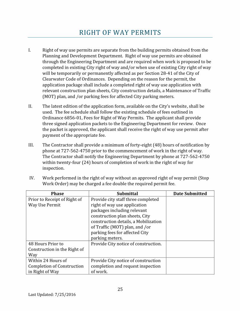
RIGHT OF WAY PERMITS
I. Right of way use permits are separate from the building permits obtained from the Planning and Development Department. Right of way use permits are obtained through the Engineering Department and are required when work is proposed to be completed in existing City right of way and/or when use of existing City right of way will be temporarily or permanently affected as per Section 28-41 of the City of Clearwater Code of Ordinances. Depending on the reason for the permit, the application package shall include a completed right of way use application with relevant construction plan sheets, City construction details, a Maintenance of Traffic (MOT) plan, and /or parking fees for affected City parking meters.
II. The latest edition of the application form, available on the City’s website, shall be used. The fee schedule shall follow the existing schedule of fees outlined in Ordinance 6856-01, Fees for Right of Way Permits. The applicant shall provide three signed application packets to the Engineering Department for review. Once the packet is approved, the applicant shall receive the right of way use permit after payment of the appropriate fee.
III. The Contractor shall provide a minimum of forty-eight (48) hours of notification by phone at 727-562-4750 prior to the commencement of work in the right of way. The Contractor shall notify the Engineering Department by phone at 727-562-4750 within twenty-four (24) hours of completion of work in the right of way for inspection.
IV. Work performed in the right of way without an approved right of way permit (Stop Work Order) may be charged a fee double the required permit fee.
Phase Submittal Date Submitted Prior to Receipt of Right of Way Use Permit
Provide city staff three completed right of way use application packages including relevant construction plan sheets, City construction details, a Mobilization of Traffic (MOT) plan, and /or parking fees for affected City parking meters.
48 Hours Prior to Construction in the Right of Way
Provide City notice of construction.
Within 24 Hours of Completion of Construction in Right of Way
Provide City notice of construction completion and request inspection of work.
26
Last Updated: 7/25/2016
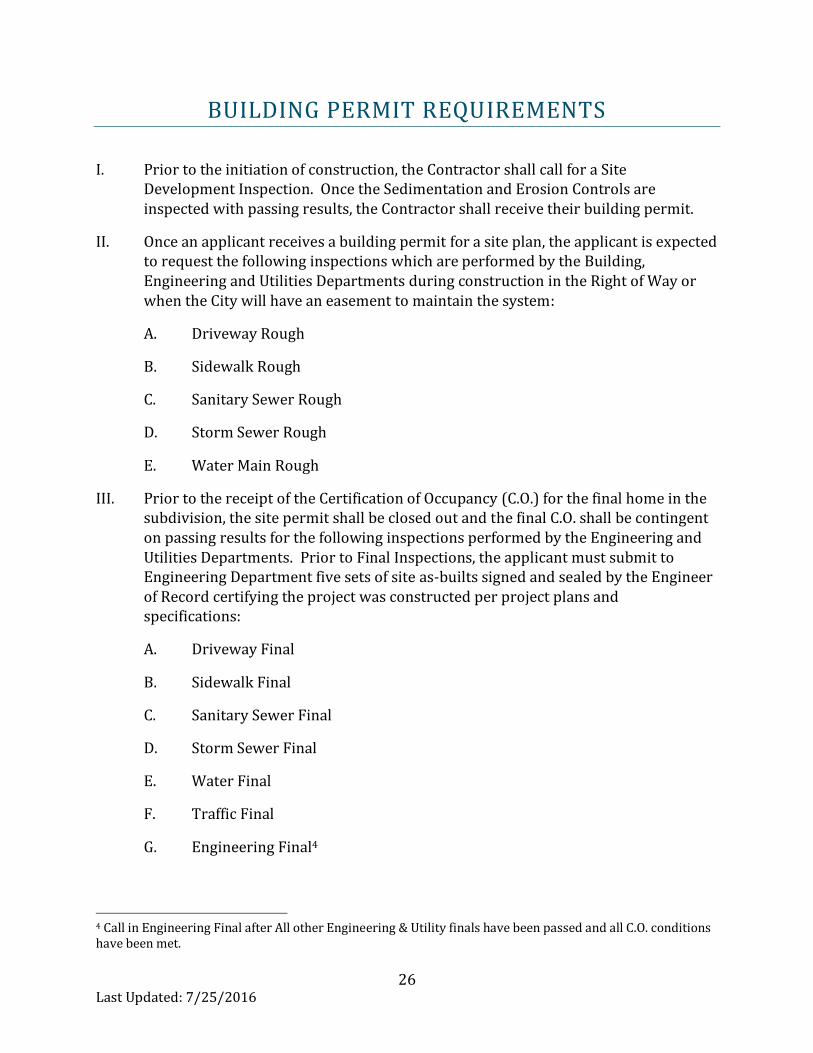
BUILDING PERMIT REQUIREMENTS
I. Prior to the initiation of construction, the Contractor shall call for a Site Development Inspection. Once the Sedimentation and Erosion Controls are inspected with passing results, the Contractor shall receive their building permit.
II. Once an applicant receives a building permit for a site plan, the applicant is expected to request the following inspections which are performed by the Building, Engineering and Utilities Departments during construction in the Right of Way or when the City will have an easement to maintain the system:
A. Driveway Rough
B. Sidewalk Rough
C. Sanitary Sewer Rough
D. Storm Sewer Rough
E. Water Main Rough
III. Prior to the receipt of the Certification of Occupancy (C.O.) for the final home in the subdivision, the site permit shall be closed out and the final C.O. shall be contingent on passing results for the following inspections performed by the Engineering and Utilities Departments. Prior to Final Inspections, the applicant must submit to Engineering Department five sets of site as-builts signed and sealed by the Engineer of Record certifying the project was constructed per project plans and specifications:
A. Driveway Final
B. Sidewalk Final
C. Sanitary Sewer Final
D. Storm Sewer Final
E. Water Final
F. Traffic Final
G. Engineering Final4
4 Call in Engineering Final after All other Engineering & Utility finals have been passed and all C.O. conditions have been met.

27
Last Updated: 7/25/2016
IV. Site plans may also have other C.O. criteria placed on the site plan at the time of building permit approval. The Contractor shall check their permit through the City’s online permit system for all outstanding issues. Right of way use criteria may be tied to the C.O. conditions. Contractors are welcome to request a meeting with the Planning, Engineering and Utilities Departments prior to C.O. in order to establish schedules and finalize details.

28
Last Updated: 7/25/2016
REFERENCES
City of Clearwater Code of Ordinances, April 8, 2016, https://www2.municode.com/library/fl/clearwater.
City of Clearwater Community Development Code, September 30, 2015, https://www2.municode.com/library/fl/clearwater.
City of Clearwater Contract Specifications, http://myclearwater.com/gov/depts/pwa/engin/publications/stdspecs/index.asp.
City of Clearwater Engineering Department, Construction Standards, April 2016, http://myclearwater.com/gov/depts/pwa/engin/publications/stddet/index.asp.
City of Clearwater Erosion and Sedimentation Control Policy Manual, January 2016, http://myclearwater.com/gov/depts/pwa/engin/publications/pdf/Erosion_Manual_2016January.pdf.
City of Clearwater Stormwater Drainage Criteria Manual, http://myclearwater.com/gov/depts/pwa/engin/publications/pdf/StormDrainageDesignCriteria.pdf.
Duke Energy, Transmission Right-of-Way Restrictions, December 2015, https://www.duke-energy.com/safety/right-of-way-management/transmission-restrictions.asp.
Florida Fire Prevention Code, Fifth Edition, December 31, 2014. http://www.nfpa.org/codes-and-standards/all-codes-and-standards/list-of-codes-and-standards/free-access?mode=view

29
Last Updated: 7/25/2016
Florida Statutes 119, 177, 334, 373, 471, and 472. http://www.leg.state.fl.us/statutes/ Florida Department of Environmental Protection, Florida Stormwater Erosion and Sedimentation Control Inspector’s Manual, July 2008, http://www.dep.state.fl.us/water/nonpoint/docs/erosion/erosion-inspectors-manual.pdf.
Florida Department of Transportation, Design Geometrics and Criteria, Plans Preparation Manual, Volume 1 – English, Revised – January 1, 2012, http://www.dot.state.fl.us/rddesign/PPMManual/2014/Volume1/2014Volume1.pdf.
Florida Department of Transportation, Manual of Uniform Minimum Standards for Design, Construction and Maintenance for Streets and Highways, “Florida Greenbook”, May 2013, http://www.dot.state.fl.us/rddesign/FloridaGreenbook/FGB.shtm.
Florida Department of Transportation Standard Specifications for Road and Bridge Construction, January 2015, http://www.dot.state.fl.us/programmanagement/Implemented/SpecBooks/default.shtm.
National Fire Protection Association (NFPA), Chapter 1, Fire Code, February 2016, http://www.nfpa.org/codes-and-standards/document-information-pages.
National Flood Insurance Program (NFIP), Floodplain Management Requirements, A Study Guide and Desk Reference for Local Officials, FEMA 480, February 2005, http://www.floods.org/ace-files/documentlibrary/CFM-Exam/NFIP_SG_Table_of_Contents.pdf.
Pinellas County Metropolitan Planning Organization (MPO), Mobility Management System, 2016. http://www.pinellascounty.org/mpo/mobilityplan/Chapter%20150_Ordinance_TrackChanges_123115.pdf

30
Last Updated: 7/25/2016
Southwest Florida Water Management District, Environmental Resource Permit Applicant’s Handbook Volume II, Design Requirements for Stormwater Treatment and Management Systems Water Quality and Water Quantity, October 1, 2013. https://www.swfwmd.state.fl.us/files/database/site_file_sets/2479/Applicants_Handbook_II_-_Revised.pdf.