
SUBDIVISION AND LAND DEVELOPMENT REGULATIONS€¦ · subdivision and land development regulations...
70
SUBDIVISION AND LAND DEVELOPMENT REGULATIONS Elmore County, Alabama March 26, 2007 Amendments as Adopted March 10, 2008 Amendments as Adopted April 24, 2008 Amendments as Adopted October 9, 2008
Transcript of SUBDIVISION AND LAND DEVELOPMENT REGULATIONS€¦ · subdivision and land development regulations...
SUBDIVISION AND LAND
DEVELOPMENT REGULATIONS
Elmore County, Alabama
March 26, 2007
Amendments as Adopted March 10, 2008 Amendments as Adopted April 24, 2008
Amendments as Adopted October 9, 2008
1
FOREWORD
A subdivision is defined as the development and division of a lot, tract, or parcel of land into two (2) or more lots, plats, sites, or otherwise for the purpose of establishing or creating a subdivision through the sale, lease, or building development of the lot or lots. Further explanation of the definition and any exemptions from these subdivision regulations can be found in Section 2-1-58 of these regulations.
Any individual who plans to develop and/ or divide a parcel of land in the County should consult with the County Engineer early in the planning phase of the development to assure compliance with these regulations.
2
TABLE OF CONTENTS
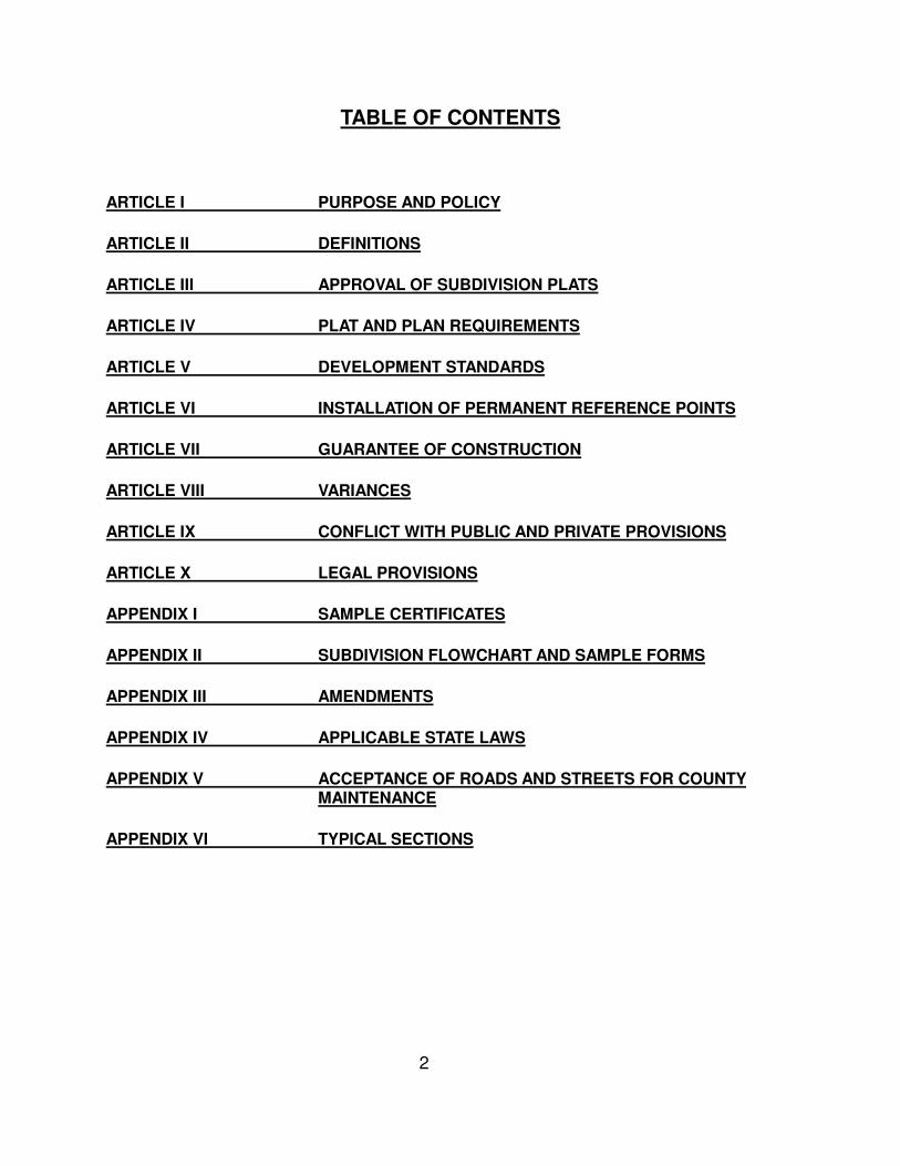
ARTICLE I PURPOSE AND POLICY
ARTICLE II DEFINITIONS
ARTICLE III APPROVAL OF SUBDIVISION PLATS
ARTICLE IV PLAT AND PLAN REQUIREMENTS
ARTICLE V DEVELOPMENT STANDARDS
ARTICLE VI INSTALLATION OF PERMANENT REFERENCE POINTS
ARTICLE VII GUARANTEE OF CONSTRUCTION
ARTICLE VIII VARIANCES
ARTICLE IX CONFLICT WITH PUBLIC AND PRIVATE PROVISIONS
ARTICLE X LEGAL PROVISIONS
APPENDIX I SAMPLE CERTIFICATES
APPENDIX II SUBDIVISION FLOWCHART AND SAMPLE FORMS
APPENDIX III AMENDMENTS
APPENDIX IV APPLICABLE STATE LAWS
APPENDIX V ACCEPTANCE OF ROADS AND STREETS FOR COUNTY MAINTENANCE
APPENDIX VI TYPICAL SECTIONS
3
ARTICLE I
PURPOSE AND POLICY
1-1 PURPOSE AND POLICY 1-2 TITLE 1-3 FEES 1-4 ENFORCEMENT AND VIOLATIONS 1-5 AMENDMENTS
SECTION 1-1 PURPOSE AND POLICY
The subdivision regulations set out herein have been adopted pursuant to authority granted by Code of Alabama 1975, § 11-24-1(b) to establish procedures and standards for the design and development of proposed subdivisions or additions to existing subdivisions within the subdivision jurisdiction of Elmore County, Alabama. These regulations shall be applicable to the development of any subdivision within the county’s subdivision jurisdiction, and shall include, at a minimum, the minimum size of lots, the planning and construction of all public streets and roads, drainage structures, and proper placement of public utilities to be located in a subdivision. Additionally, unless waived by the Elmore County Commission, these regulations shall also apply to the county’s plat approval for developments within the territorial jurisdiction of a municipal planning commission; provided, however, that in such instance, the County’s approval shall be limited to the approval required in Code of Alabama 1975, § 11-52-30(b) regarding approval of plats, and shall not include enforcement. By resolution of the Elmore County Commission adopted on the __26th___ day of _March_, 2007__, and pursuant to the powers and jurisdiction granted by Code of Alabama 1975, § 11-24-1 et seq., the Elmore County Commission does hereby set a policy to exercise the power and authority to review, approve, and disapprove plats for all subdivisions within the subdivision jurisdiction of Elmore County, Alabama. The Elmore County Commission further does hereby exercise the authority to inspect any development within its subdivision jurisdiction to ensure that there are no violations of its rules and regulations, to charge fees for said inspection as set out in Section 1-3 of these regulations and authorized under Code of Alabama 1975, § 11-24-3, and to enforce these regulations as provided in Section 1-4 and authorized in Code of Alabama 1975, § 11-24-3. The regulations set out herein shall be in force and applicable to the development of all subdivisions in the subdivision jurisdiction of the Elmore County Commission from and after the date of adoption by resolution. Subdivision regulations previously in place in Elmore County are hereby repealed and rescinded. These regulations shall be in effect and shall apply to the development of any subdivision within
4
the subdivision jurisdiction of Elmore County as defined in Section 2-1-59 from and after thirty (30) days from the date of the County’s filing a certified copy of these regulations with the Probate Judge. No street or road shall be accepted and maintained by the County, nor shall any utilities or county services be extended to the subdivision, unless and until the requirements set forth in these regulations have been complied with and the subdivision has been given final approval by Elmore County. It is not the purpose of these regulations to govern the acceptance of roads or streets for maintenance by the County Commission. The current policy for acceptance of roads and bridges by the Elmore County Commission is located in Appendix V.
SECTION 1-2 TITLE
The regulations shall hereafter be known, cited and referred to as the Subdivision and Land Development Regulations of Elmore County, Alabama.
SECTION 1-3 FEES
Elmore County has established the following schedule of fees, as authorized under Code of Alabama 1975 Section 11-24-3, to cover costs associated with the inspection and review of subdivision developments. The total fee is dependent on the size and type of subdivision. The schedule below is a guide to the charges that will be incurred by the developer at a minimum. The developer is responsible for all charges, including inspection and testing, incurred by the county during the subdivision approval process. The fee schedule is as follows:
Proposed Plat Review Fee $500 per submission of proposed plat
Lot Fee $25 per lot, site, or unit
Road Fee $0.75 per linear foot of road to be constructed and inspected
SECTION 1-4 ENFORCEMENT AND VIOLATIONS Pursuant to authority granted under Code of Alabama 1975, § 11-24-3(d), the Elmore County Commission shall enforce the provisions of these regulations by the issuance of citations issued by a county license inspector appointed by the Elmore County Commission to enforce these regulations. Acting under authority granted in Code of Alabama 1975, § 11-24-3(d) and § 40-12-10, the county license inspector may issue a citation for the failure to properly obtain the permit to develop required under Section 3-6 and/or for any other violations of these regulations or of Code of Alabama 1975, § 11-24-1 et seq. As authorized by Code of Alabama 1975, § 11-24-3(a), the fine for noncompliance of any
5
provisions of these regulations shall be $1000 per lot that has been sold, offered for sale, transferred, or leased. A separate citation shall be issued for each violation. All fines shall be paid to the office of the judge of probate within thirty (30) days of the issuance of a citation by the county license inspector, and all fines shall be doubled upon the failure to remit the fine within thirty (30) days of the issuance of the citation. In addition to the issuance of citations for violation of these regulations, the Elmore County Commission retains the right to seek an injunction against any developer or owner who fails to comply with these regulations as provided in Code of Alabama 1975, § 11-24-3(b), and may bring action against a developer or owner to compel compliance with these regulations in the event that work on the subdivision has been completed in violation of these regulations and the requirements of Code of Alabama 1975, § 11-24-1 et seq.
SECTION 1-5 AMENDMENTS
The Elmore County Commission may adopt amendments to these regulations. Procedures to adopt amendments are detailed in Section 10-4.
6
ARTICLE II
DEFINITIONS
2-1 DEFINITION OF TERMS SECTION 2- 1 DEFINITION OF TERMS
2-1-1 ACCESS: Deeded portion of property or lot that provides travel way to a city, county, or
state road. All access must have sixty (60) foot minimum width from the city, county, or state road to the building site. {Exclusions to this requirement can be found in section 5-6.}
2-1-2 ADMINISTRATIVE SUBDIVISION: A division of one lot from a larger parcel where both
parcels meet the requirement for frontage on an existing city, county or state road. The developer shall be required to submit a survey detailing the proposed division along with a vesting deed to the County Engineer for his approval prior to filing of such deed or survey. This type of development shall be exempt from the approval process required in Article III of these regulations. The submitted survey shall meet the Current Standards of Practice for the State of Alabama and include a certification as shown in Appendix I for Administrative Subdivisions. The development shall be subject to all guidelines in these regulations and policies referenced herein such as the County’s Access Management Policy and Flood Damage Prevention Ordinance. An administrative subdivision shall also include any replat of lot lines that does not affect the integrity of a approved development. Replats shall be submitted to the County Engineer and follow the same guidelines as provided for a single lot division. A letter of concurrence from the affected landowners shall accompany the request for consideration. An administrative subdivision shall be exempt from the normal subdivision fee schedule and shall be subject to a $100 fee per occurrence.
2-1-3 ADT (AVERAGE DAILY TRAFFIC): total volume of vehicles during a given time period, in
whole days, as measured during a non-holiday weekday. 2-1-4 APPLICANT: The owner of land proposed to be subdivided or a person designated in
writing by the legal owner as his or her representative. 2-1-5 APPLICATION ASSEMBLY: The packet of materials that the developer is required to
submit with his or her application for proposed plat approval. 2-1-6 ARTERIAL: A term used to describe a road or street whose primary purpose is to connect
areas that produce a large amount of trip generation. These routes have a dual function to move traffic and to provide access to land uses, particularly the high trip-generating commercial activities.
7
2-1-7 BLOCK: A tract of land bounded by streets, or by a combination of streets and public parks, cemeteries, railroad right-of-way, shorelines of waterways or other boundary lines.
2-1-8 BUILDING: Any structure built for the support, shelter, or enclosure of persons, animals,
chattels, or movable property of any kind, and includes any structure. 2-1-9 BUILDING SETBACK LINE: A line parallel to the property over which no structure may be
erected. 2-1-10 COLLECTOR: A route whose primary function is to collect traffic from an area and move
it to the arterial street system while also providing substantial service to abutting land use, and which typically does not have extensive continuity.
2-1-11 CONSTRUCTION PLANS: Plans detailing the design and requirements for the
construction of public improvements. These plans shall detail such items as the location of all existing and proposed roads, plan and profiles of all roads, curve data, hydraulic data, etc. (See Section 4-2 for complete list of items required.)
2-1-12 CORNER LOT: A lot which occupies the interior angle at the intersection of street lines. 2-1-13 COUNTY: The County of Elmore, Alabama. 2-1-14 COUNTY ADMINISTRATOR: The duly designated Administrator or Clerk of Elmore
County, Alabama. 2-1-15 COUNTY COMMISSION: The County Commission of the County of Elmore, Alabama. 2-1-16 COUNTY ENGINEER: The duly designated Engineer of the County of Elmore, Alabama. 2-1-17 COUNTY SPECIFICATIONS: All construction specifications which are included in these
regulations and any special specifications required by the County Engineer or other state or local entity based upon the particular development.
2-1-18 CUL-DE-SAC: A minor street with only one outlet and having an appropriate terminal for
the safe and convenient reversal of traffic movement. 2-1-19 DAY: A calendar day. 2-1-20 DEDICATION: The transfer of property from private to public ownership. 2-1-21 DEVELOPER: The owner of land proposed to be subdivided or a person designated in writing by the legal owner as his or her representative. 2-1-22 DEVELOPMENT: The design work of lot layout, the construction of drainage structures,
the construction of buildings or public use areas, the planning and construction of public streets and public roads, and the placement of utilities, and any other applicable
8
construction or improvement required or included in a certain subdivision project. 2-1-23 DEPTH OF LOT: The mean horizontal distance between the front and rear lot lines. 2-1-24 DOUBLE FRONT LOT: A lot having frontage on two (2) non-intersecting streets as
distinguished from a corner lot. 2-1-25 EASEMENT: A grant by the property owner of use, by the public, a corporation, or
person(s) of a strip of land for specified purposes or as created by operation of law. 2-1-26 EXPRESSWAY OR FREEWAY: Facilities that accommodate a high volume of traffic
through the prohibiting of ingress and egress except at controlled intervals. Freeways involve complete control of access while expressways permit at grade intersections at infrequent intervals. The expressway or freeway has only one function - to carry traffic.
2-1-27 ENGINEERING PLAN: A post construction record giving details of construction and
locations of improvements as they were built or installed. 2-1-28 FINAL PLAT: A plat of a tract of land which meets the requirements of these regulations
and is in form for recording in the Office of the Probate Judge of Elmore County, Alabama.
2-1-29 FLOODPROOFING: Any combination of structural or nonstructural additions, changes, or
adjustments which reduce or eliminate flood damage to real property, or improved real property, water supply and sanitary sewer facilities, electrical systems, and structures and their contents.
2-1-30 FLOODWAY: The stream channel and the portion of the adjacent floodplain which must
be reserved solely for the passage of flood-waters in order to prevent an increase in upstream flood heights of more than one (1) foot above the predevelopment conditions. For the purpose of these regulations, floodways shall be defined and governed by the County’s Flood Damage Prevention Ordinance.
2-1-31 LAND SUBJECT TO FLOODING: For the purpose of these regulations, land subject to flooding shall be defined in the County’s Flood Damage Prevention Ordinance. 2-1-32 FLOOD, ONE HUNDRED (100) YEAR: A flood that has, on the average, a one (1) percent chance of being equaled or exceeded in any given year. 2-1-33 FLOOD, TEN (10) YEAR: A flood that has, on average, been equaled or exceeded at a frequency of once every ten (10) years. 2-1-34 FLOOD, TWENTY-FIVE YEAR: A flood that has on average been equaled or exceeded
at a frequency of once every twenty-five (25) years. 2-1-35 GROUP DEVELOPMENT: A subdivision of land consisting of two or more buildings, sites,
9
or units which is not subdivided into customary lots, blocks or streets and thus is contained on one common parcel. This type of development shall not only be on a common parcel but shall also have a common owner who shall be responsible for all infrastructure and drainage within the development. A building footprint shall be the maximum boundary allowed to be transferred, sold or leased in this type of development.
2-1-36 HARDSHIP: An unusual situation on the part of an individual property owner which will
not permit the full utilization of property. A hardship exists only when it is not self-created. 2-1-37 HEALTH DEPARTMENT: Alabama State Department of Public Health or Elmore County
Health Department. 2-1-38 IMMEDIATE FAMILY MEMBER: As defined in Black’s Law Dictionary, a person’s parents,
spouse, children, and siblings. As it pertains to the Elmore County Subdivision and Land Development Regulations, it shall also include a person’s grandparents, great-grand parents, grandchildren, great-grand children, niece, nephew, and any step or adopted variations of any of the above mentioned family members.
2-1-39 LICENSED ENGINEER: An engineer properly licensed and registered in the State of
Alabama in good standing with the Alabama State Board of Licensure for Professional Engineers and Land Surveyors.
2-1-40 LICENSE INSPECTOR: The person or persons appointed by the County Commission to
enforce the county’s subdivision regulations pursuant to Code of Alabama 1975, § 11-24-3, utilizing the authority granted to a license inspector under Code of Alabama 1975, § 40-12-10.
2-1-41 LICENSED LAND SURVEYOR: A land surveyor properly licensed and registered in the
State of Alabama in good standing with the Alabama State Board of Licensure for Professional Engineers and Land Surveyors.
2-1-42 LOT: A tract, plot, or portion of a subdivision or other parcel of land intended as a unit for
the purpose, whether immediate or future, of transfer of ownership, lease or rental, or for building development.
2-1-43 MARGINAL ACCESS: A service road or other treatment used to provide adequate
protection of properties in cases where an arterial runs through or near a subdivided area.
2-1-44 MINOR ROAD OR STREET: A route used to connect collector roads in a road system
and service only the residents of that road. 2-1-45 MONUMENT: A permanent object serving to indicate a limit or to mark a boundary. 2-1-46 OWNER: Any person, group of persons, firm or firms, corporation or corporations, or any
other legal entity having legal title to or sufficient proprietary interest in the land sought to
10
be subdivided under these regulations. 2-1-47 OWNER’S ENGINEER: The licensed engineer who is the agent of the owner or
developer of land which is proposed to be subdivided or which is in the process of being subdivided.
2-1-48 PERMANENT REFERENCE POINTS: As defined by the Current Standards of Practice
set out and required by the Alabama Society of Professional Land Surveyors. 2-1-49 PERMIT TO DEVELOP: An instrument issued by the County Engineer following the
approval of a proposed plat by the County Commission and which authorizes the developer to proceed with the development of the subdivision.
2-1-50 PROPOSED PLAT: A plan for a subdivision of land which is submitted for approval to
develop the subdivision as required in Article III of these subdivision regulations and Code of Alabama 1975,§ 11-24-2.
2-1-51 PROBATE JUDGE: The Judge of Probate of Elmore County, Alabama. 2-1-52 RESUBDIVISION: A change in a map of an approved or recorded subdivision plat if such
change affects any street layout on such map or area reserved thereon for public use, or any lot line; or if it affects any map or plan legally recorded prior to the adoption of any regulations controlling subdivisions. Lot line changes may be addressed through the administrative subdivision process.
2-1-53 ROAD OR STREET: A right-of-way for vehicular traffic that affords the principal means of
access to abutting property. 1. CITY ROAD: Public road maintained by the city. 2. COUNTY ROAD: Public road which has been accepted into the county road system
through construction by the county, dedication and formal acceptance by the county commission, or prescription and is maintained by the county. A road which has been dedicated to the public and is used by the public is not a county road, unless it has been accepted into the county road system through construction, acceptance or prescription as set out herein.
3. PUBLIC ROAD: A street or road that has been constructed for public use, established
by statutory proceedings, or dedicated for public use. A public road may or may not be a county road.
4. PRIVATE ROAD: Road which has not been dedicated to the public and is not owned
or maintained by the city, county, or state whether or not it has public access. 5. STATE ROAD: Public road owned or maintained by the state of Alabama.
11
2-1-54 SETBACKS: A setback is synonymous to “building setback line”. See Section 2-1-9. 2-1-55 SINGLE TIER LOT: A lot which backs upon a street, a railroad, a physical barrier, or a
residential or non-residential use, and to which access from the rear of the lot is usually prohibited.
2-1-56 SKETCH PLAN: Drawing submitted prior to the preparation of the Proposed Plat to
enable the applicant to save time and expense in reaching general agreement with the County Engineer as to the form of the plat and the objectives of these regulations.
2-1-57 SUBDIVIDER: Any person who (1) having an interest in land, causes it, directly or
indirectly, to be divided into a subdivision or who (2), directly or indirectly, sells, leases, or develops, or offers to sell, lease, or develop, or advertises for sale, lease, or development, any interest, lot, parcel, site, unit, or plat in a subdivision, or who (3) is employed by or directly or indirectly controlled by, or under direct, or indirect common control with any of the foregoing.
2-1-58 SUBDIVISION: As defined in Code of Alabama 1975, § 11-24-1(a)(4), the development and division of a lot, tract, or parcel of land into two (2) or more lots, plats, sites, or otherwise for the purpose of establishing or creating a subdivision through the sale, lease, or building development of the lot or lots.
EXCLUSIONS: A subdivision shall not include any of the following: a. The construction or development of roads or buildings on private property to be
used for agricultural purposes. See, Code of Alabama 1975, § 11-24-1(a) (4); b. The public acquisition by purchase or donation of strips of land for the widening
or opening of streets: c. Property legitimately divided between immediate family members as provided
in Code of Alabama 1975, § 11-24-2(d) and as defined in these regulations provided the intent of the division is not to circumvent the spirit of these regulations;
d. The division of land into parcels greater than five (5) acres wherein all of the
following criteria are met and shown on a plat to be filed in the judge of probate with a certificate on the plat stating that all criteria are met:
(i) frontage on existing city, county, or state roads of each parcel is at least 60
feet, (ii) the extension of public utilities is not required , and (iii) in the opinion of the developer’s licensed engineer, there will be no
additional storm water runoff created.
12
(iv) Parcels which qualify for exemptions from subdivision criteria and rules
and regulations imposed by the State Board of Health pursuant to Code of Alabama 1975, § 22-26-7 provided they also meet all of the criteria set out in (d)(i), (ii), and (iii) above;
e. Administrative Subdivision as defined in Section 2-1-2 f. The one-time division of land into two lots, tracts, or parcels in which only one of
the two lot is to be offered for sale, lease or building development and where the intent of the landowner subdividing his property is to retain ownership of one of the two resultant parcels. However, any further division of the resultant lot, parcel or tract retained by the landowner shall be subject to these regulations. Lots created under this exclusion shall be required to be in compliance with the Elmore County Access Management Policy.
2-1-59 SUBDIVISION JURISDICTION: All areas outside the corporate limits of any municipality
in Elmore County, except areas within the territorial jurisdiction of a municipal planning commission presently organized and functional or which shall become organized and functional within six months of the date Elmore County first assumes such jurisdiction by publishing and adopting notice of these regulations.
2-1-60 SURETY: Any bond, certificate of deposit, irrevocable letter of credit, cashier check, or
other acceptable guarantee as approved by the Elmore County Commission or their authorized agent.
2-1-61 TERRITORIAL JURISDICTION OF MUNICIPAL PLANNING COMMISSION: As provided
in Code of Alabama 1975, § 11-52-30(a), all land located in the municipality and all land lying within five miles of the corporate limits of the municipality and not located in any other municipality. In the case of any such nonmunicipal land lying within five miles of more than one municipality having a planning commission, the jurisdiction shall terminate at a boundary line equidistant from the respective corporate limits of such municipalities.
2-1-62 VARIANCE: Permission to depart from the literal requirements of these subdivision
regulations by virtue of unique hardship due to special circumstances regarding property to be developed. A waiver of the strictest letter of the regulations upon substantial compliance without sacrificing the spirit and purpose of the regulations.
2-1-63 WATERCOURSE: Any depression serving to give direction to a flow of water, having a
bed and defined banks. The definition shall also include other generally or specifically designated areas where flooding may occur. The flow of water need not be on a continuous basis, but may be intermittent resulting from the surface runoff of precipitation.
2-1-64 WIDTH OF LOT: The mean horizontal distance between the two side lot lines.
13
ARTICLE III
APPROVAL OF SUBDIVISION PLATS
3-1 APPROVAL OF SUBDIVISION PLATS 3-2 SKETCH PLAN 3-3 PROPOSED PLAT SUBMISSION 3-4 REVIEW BY COUNTY ENGINEER 3-5 COUNTY COMMISSION APPROVAL OF PLAT 3-6 PERMIT TO DEVELOP 3-7 CONSTRUCTION OF PROPOSED SUBDIVISION 3-8 FINAL PLAT APPROVAL
SECTION 3-1 APPROVAL OF SUBDIVISION PLATS
This section details the general steps necessary to achieve approval of a subdivision in Elmore County. A flow chart is included in Appendix II further outlining this process.
SECTION 3-2 SKETCH PLAN
Whenever the subdivision of a tract of land is proposed within the jurisdiction of these regulations, the developer, or subdivider, is urged to consult early and informally with the County Engineer. The subdivider may submit sketch plans and data showing existing conditions within the site and in its vicinity along with the proposed layout and development of the subdivision. The purpose of this sketch plan review is to afford the subdivider an opportunity to avail himself of the advice and assistance of the County Engineer in order to facilitate the subsequent preparations and approval of plans.
SECTION 3-3 PROPOSED PLAT SUBMISSION Following sketch plan review or in the event the subdivider does not submit a sketch plan for review, the subdivider shall submit a complete Application Assembly to the County Engineer for review of the proposed plat. The application shall be submitted at least _30_ days prior to any consideration for proposed plat approval by the County Commission. The Proposed Plat Application Assembly shall include each of the following: (1) A letter stating that the proposed plat is being submitted for review. This letter shall
state the developer’s intent as to the final ownership of any new roads included on the proposed plat, if applicable. (The developer is reminded to refer to Appendix V
14
for the County’s Road Acceptance Policy); (2) Application for Proposed Plat Review (Appendix II); (3) At least two (2) copies of the proposed plat prepared in accordance with the
requirements detailed in Section 4-1 of these regulations; (4) One set of Construction Plans for all required improvements prepared in
accordance with the requirements detailed in Section 4-2 of these regulations;
(5) A copy of the Health Department application requesting field review for the general lot layout;
(6) Any variances requested accompanied by detailed supporting documentation; (7) The names and addresses of each adjoining landowner and utility entitled to notice
pursuant to Code of Alabama 1975, §11-24-2(b);
(8) Proposed plat review fee - $500 (nonrefundable);
(9) Most recent vesting deed or deeds accompanied by a Certificate of Title prepared and submitted by a licensed Alabama attorney which certifies the status of the title.
Failure to submit a complete Proposed Plat Application Assembly initially shall delay the consideration of such plat for approval by the County Engineer and the County Commission.
SECTION 3-4 REVIEW BY COUNTY ENGINEER The County Engineer shall use the minimum thirty (30) day period to review the submitted Application Assembly and ensure its compliance with these regulations. In the event the Application Assembly does not meet these regulations, the County Engineer shall notify the developer that it is deficient. No further action will be taken by the County Commission or County Engineer until and unless the developer shall correct the deficiencies and resubmit the corrections to the County Engineer for his approval. If upon completion of the review the County Engineer determines that the Application Assembly complies with these regulations, he or she shall notify the developer in writing to that effect. The County Engineer shall send proper notice of his/her recommendation for approval, as required in Code of Alabama 1975, § 11-24-2(b), to each of the adjoining landowners and the affected utilities submitted by the developer. At this point the developer will be notified as to the date of the meeting at which the County Commission shall take action on the proposed plat.
15
SECTION 3-5 COUNTY COMMISSION APPROVAL OF PROPOSED PLAT Once the County Engineer verifies that the Application Assembly meets the County Regulations, the Proposed Plat shall be submitted to the County Commission for their approval at the next regularly scheduled County Commission meeting. Pursuant to Code of Alabama 1975, § 11-24-2(b), the County Commission shall approve the proposed plat in the event that the County Engineer has determined that the proposed plat meets these regulations.
SECTION 3-6 PERMIT TO DEVELOP Following the approval of the Proposed Plat by the County Commission, the County Engineer shall issue a Permit to Develop for the Proposed Plat. The Permit to Develop allows the developer to proceed with construction of the development in compliance with these regulations. Additionally, the developer may offer lots in the proposed subdivision for sale, transfer, or lease ; provided, however, that no sale, transfer, or lease may be completed or recorded until after the final plat has been recorded in office of the Probate Judge pursuant to the requirements of Code of Alabama 1975, § 11-24-2(c).
SECTION 3-7 CONSTRUCTION OF PROPOSED SUBDIVISION Once the permit to develop has been issued, the developer may proceed with construction of the proposed subdivision in accordance with these regulations. The developer shall have one (1) year from the date of issuance of the permit to develop to begin substantial work on the proposed development. If work does not begin within the one (1) year time frame, the proposed plat must be resubmitted to the County Engineer and County Commission for approval as if the plat had never been submitted. If any changes in the development plans of the approved proposed plat are required for any reason, the developer shall submit the proposed changes to the County Engineer prior to construction or implementation of the proposed changes. Approval of the County Engineer shall be required before any changes are constructed. Any changes or deviations from the approved proposed plans prior to the County Engineer’s approval shall be in violation of these regulations and shall be subject to removal or correction at the expense of the developer. Changes to the proposed subdivision construction plans that do not change the overall layout of the subdivision may be reviewed and approved by the County Engineer without the requirement of the proposed plat having to be resubmitted for approval by the County Commission. Any changes that do change the overall layout (i.e. addition of lots and/or addition of roads) of the subdivision shall require the proposed plat to be resubmitted for approval by the County Commission.
16
SECTION 3-8 FINAL PLAT APPROVAL A final plat shall be submitted to the County Engineer for approval of the proposed subdivision after:
(1) All infrastructure construction or required improvements are complete for a subdivision ;
(2) An acceptable surety is provided to the county as detailed in Article VII to cover the expense of the required infrastructure / improvements. The amount of the surety shall be as detailed herein for roads seeking county acceptance.
At the point that the final plat is submitted for approval, the developer shall remit and submit each of the following:
(1) All testing and inspection charges required under Section1-3 of these regulations as authorized in Code of Alabama 1975, § 11-24-3;
(2) A final as-built set of plans or certification from the owner’s engineer that there were no
changes to the approved construction plans; (3) One (1) copy of the Final Plat as approved by the County Engineer prepared on a
suitable permanent reproducible mylar; to include all necessary signatures except the County Engineer, County Commission Chairman, and Probate Judge;
(4) A letter from the Health Department detailing field review for the general lot layout has
been completed;
(5) A digital copy of the plat in an acceptable format as deemed by the Elmore County Revenue Commissioner.
Final plat approval does not include the acceptance of roads. If the developer desires to have the roads accepted into the county road system by the county commission, he or she shall comply with the procedures for road acceptance set out in Appendix V. Subdivisions seeking county acceptance for infrastructure shall be required at this point to submit an acceptable performance bond or surety in the amount of 150% of the cost of any improvements not in place at the time of final plat application and an acceptable surety in the amount of 5% of the total construction costs to serve as a maintenance bond. Estimates for bond calculation shall be submitted and approved by the County Engineer prior to bond submittal. Once the final plat has been signed and recorded pursuant to these regulations and Code of Alabama 1975, § 11-24-2(c), the developer may proceed with the actual sale, transfer, or lease of any lots, sites, etc. No building development shall take place until the final plat has been recorded in the office of the Judge of Probate pursuant to these regulations and Code of Alabama 1975, § 11-24-2(c).
17
ARTICLE IV
PLAT AND PLAN REQUIREMENTS
4-1 PROPOSED PLAT REQUIREMENTS 4-2 CONSTRUCTION PLAN REQUIREMENTS 4-3 FINAL PLAT REQUIREMENTS
SECTION 4-1 PROPOSED PLAT REQUIREMENTS The Proposed Plat shall be prepared by a licensed land surveyor and shall be clearly and legibly drawn at a convenient scale of not less than one (1) inch equals one hundred (100) feet, and the sheets shall be numbered in sequence if more than one (1) sheet is used. The sheet size shall be of such size as is acceptable for filing in the Office of the Probate Judge. The Proposed Plat shall include the following:
(1) Name and addresses of owners of record; (2) Proposed name of subdivision, date, north point, scale and location; (3) Name and seal of licensed land surveyor; (4) Vicinity map showing location of the subdivision;
(5) Exact boundaries of the tract of land being subdivided, shown with bearings and distances;
(6) Sufficient data to determine readily and reproduce on the ground the location,
bearing, and length of every street line, lot line, boundary line, and block line, whether straight or curved, including the radius, central angle, point of tangency, tangent distance, and arcs and chords; the relation of the land so platted to the Government Survey of Elmore County; and “Point of beginning” as referred to in the written description;
(7) Names and addresses of the owners of land immediately adjoining the tract of land
being subdivided, as the names appear on the plats in the County Tax Assessor or Revenue Commissioner’s office;
(8) Wetlands or any other conditions affecting the site; (9) The location of existing streets, buildings, water courses, railroads, transmission
lines, drainage structures, public utilities, jurisdiction lines, and any public utility easements on and adjacent to the tract being subdivided;
18
(10) The names and locations of adjoining subdivisions and streets, with reference to recorded plats by record name;
(11) Proposed rights-of-way or easements including locations, widths, purposes, and
street numbers;
(12) Proposed lot lines with bearings and distances and lot and block numbers; (13) Proposed minimum building setback lines; (14) Proposed parks, school sites, or other public open spaces, if any; (15) Size of required drains for each lot and location (if limited by site conditions or the Elmore County Access Management Policy); (16) Site data, which includes:
a. Acreage in total tract; b. Smallest lot size; c. Total number of lots; d. Linear feet in streets; e. Applicable flood zone for land proposed in subdivision with FIRM reference.
(17) Any area within or adjacent to the proposed subdivision subject to inundation by the 100-year flood projections as defined by the County Flood Damage Prevention
Ordinance.
(18) All drainage easements, spillage easements and detention ponds as shown on a plat are to be maintained by the owner of the lot or land upon which is located such drainage easement, spillage easement and / or detention pond. Elmore County shall not be responsible for maintaining such easements. The following note shall be placed on all plats:
All drainage easements, spillage easements and detention ponds as shown on this
plat are to be maintained by the owner of the lot or land upon which is located such drainage easement, spillage easement and / or detention pond. Failure to maintain area as constructed and intended, may result in upstream and downstream flooding and could result in a civil liability.
(19) The following note shall be placed on all plats:
Without relieving any other legally responsible parties, each lot owner is responsible
for instituting erosion control measures during the construction of any improvements on said lot.
(20) The following endorsements and certificates shall be submitted with and placed on
19
the Proposed Plat (see Appendix I for sample certificates):
a. Licensed Engineer’s Certificate of Engineering Design and Construction; b. Licensed Land Surveyor’s Certificate and Description of Land Platted; c. Dedication by owner; d. A notary’s Acknowledgment of the Dedication Certificate referred to in “c”; e. A Certificate of Approval by the appropriate electric utility distributor; f. A Certificate of Approval by the appropriate water and sewer utility; g. A Certificate of Approval by the County Engineer of Elmore County; h. Certificate of Approval by the Elmore County Commission;
i. A Certificate of Approval by the Elmore County Health Department (if septic
tanks and/or wells are necessary).
j. A certificate of Approval by the Elmore County E-911 Board.
SECTION 4-2 CONSTRUCTION PLAN REQUIREMENTS At the time of submission of a Proposed Plat, the applicant shall also submit Construction Plans for all required improvements as part of the Proposed Plat Application Assembly required under Section 3-3. All plans shall meet the minimum standards of design and general requirements for the construction of public improvements as set forth in these regulations. Construction Plans shall be drawn at a scale of not less than one (1) inch equals one hundred (100) feet, and map sheets shall be of the same size as the Proposed Plat. Construction Plans shall be prepared by a licensed engineer. The following construction plans shall be included: (1) Street plan containing all of the following information: a. Location of all proposed and existing streets or rights-of-way in or adjacent to
the subdivision; b. Width of existing and proposed rights-of-way and easements; c. Road numbers/names; d. Plan and profile of all proposed streets, showing natural and finished grades
drawn to a scale of not less than one (1) inch equals one hundred (100) feet horizontal and one (1) inch equals ten (10) feet vertical;
20
e. Cross sections of proposed streets at a minimum of 50’ stations or as
required by the County Engineer; f. Curve data for the centerline of each street: Delta, Tangent, and Radius; g. Location of all required sidewalks and crosswalks; h. Location of all proposed utilities.
i. Size and location of side drains required for each lot (if limited by site conditions or the Elmore County Access Management Policy);
(2) Storm Drainage Plan containing all of the following information: a. Location of proposed drainage ways, streams, and ponds in the subdivision; b. Topography at suitable contour intervals, as approved by the County
Engineer, to show proposed drainage; c. Location, size, and invert elevations of proposed drainage structures
including culverts, bridges, pipes, drop inlets, and top elevations of head walls, etc., showing details on Drainage Plan, including conduit schedule;
d. Construction details of typical manholes, connections, and other drainage
structures proposed; e. Area of land contributing run-off to each drainage structure along with run-off
calculations and applicable coefficients depending on method used [i.e. Rational method: runoff coefficient (C), rainfall intensity (I), catchment area (A), and the discharge at the structure (Q)].
f. Location of easements and rights-of-way for drainage ways and maintenance
access thereof; g. Typical cross-sections of each drainage way; h. Direction of water flow throughout subdivision and compatibility with existing
drainage.
(3) Sanitary Sewer Plan, if applicable, containing the location of all existing and proposed sewers, location of sewer laterals, location of each manhole and other sewage system appurtenances including lift stations, oxidation ponds, and treatment plants, and the plan and profile of the sewage system. Construction details of typical manholes, connections, and other proposed sewage structures should also be shown.
21
(4) Water Distribution Plan containing the location and size of water distribution
system including pipes, valves, fittings, hydrants, high-pressure pumping equipment, etc.
(5) Electric Distribution Plan containing the location of all poles or subsurface facilities
as necessary to serve each lot or parcel of land the subdivision. If this plan is not available at the time of proposed plat submission, it shall be so noted in the application assembly and be required to be submitted to the County Engineer for approval prior to any work related to this plan commencing in the new development;
(6) Gas Distribution Plan, if applicable, containing the location of all above ground and
subsurface facilities as necessary to serve each lot or parcel of land in the subdivision. If this plan is not available at the time of proposed plat submission, it shall be so noted in the application assembly and be required to be submitted to the County Engineer for approval prior to any work related to this plan commencing in the new development;
(7) Traffic Control Plan (for construction activities);
(8) Signage Plan detailed in Section 5-4-4 (14);
(9) Landscaping and Lighting Plan if proposed;
SECTION 4-3 FINAL PLAT REQUIREMENTS The final plat shall contain the same information as required on the proposed plat.
22
ARTICLE V
DEVELOPMENT STANDARDS
5-1 MINIMUM STANDARDS 5-2 GENERAL REQUIREMENTS 5-3 ROAD OR STREET PLAN 5-4 DESIGN STANDARDS 5-5 BLOCKS 5-6 LOTS
SECTION 5-1 MINIMUM STANDARDS
In addition to the requirements established herein, the following minimum requirements are established for all subdivision plats: (1) All applicable statutory provisions; (2) The special requirements and rules of the Health Department and/or appropriate state
agencies; (3) The rules and standards of the Alabama Department of Transportation if the
subdivision or any lot contained therein abuts a state highway; (4) The rules and standards of the Alabama Department of Environmental Management
(ADEM) and any other appropriate state or federal agencies; (5) The standards and regulations adopted by all boards, commissions, agencies, and
officials of Elmore County; (6) The standards, specifications and rules of appropriate utility companies. Plat approval may be withheld if the subdivision is not in conformity with the above guidelines or the policy and purpose of these regulations as established in Article I of these regulations.
SECTION 5-2 GENERAL REQUIREMENTS
5-2-1 CHARACTER OF THE LAND Development of any land within the floodplain shall be governed by the Elmore County Flood Damage Prevention Ordinance. This ordinance shall supplement these regulations to govern
23
floodplain/ floodway issues.
5-2-2 SUBDIVISION NAME The proposed name of the subdivision shall not duplicate, or too closely approximate phonetically, the name of any other subdivision in the area covered by these regulations. The County Engineer shall have final authority to reject the name of the subdivision. Such rejection shall be made at the Proposed Plat Review stage.
5-2-3 WATERBODIES AND WATERCOURSES If a tract being subdivided contains a water body, or portion thereof, lot lines shall be so drawn as to distribute the entire ownership of the water body among adjacent lots. The County Engineer may approve an alternative plan provided the ownership of and responsibility for safe maintenance of the water body is so placed that it will not become a County responsibility. No public roadways will be approved which provide access across dams nor will any part of a lake dam be allowed on the public road right-of-way, unless suitable safety measures are provided.
SECTION 5-3 ROAD OR STREET PLAN
The arrangement, character, extent, location, and grade of all roads shall be laid out according to good land planning principles and shall be integrated with all existing and planned roads. Consideration for the planning of new roads shall include topographical conditions, orientating to vistas, public convenience and safety, and the proposed uses of land to be served by them. All lots must have access to a city, county, or state road as defined in Section 2-1-1.
5-3-1 CONTINUATION OF ADJOINING ROAD SYSTEM Proposed new roads shall extend existing roads or their projections at the same or greater width, but in no case less than the minimum required width, unless for reasons of topography or design, the County Engineer deems variations necessary.
5-3-2 MARGINAL ACCESS ROADS Where, in the opinion of the County Engineer, development which abuts or has included within the proposed subdivided area any arterial, the County Engineer may require a marginal access road or other treatment which may be necessary to provide for the adequate protection of properties, and to afford separation of through and local traffic.
5-3-3 ADDITIONAL WIDTH ON EXISTING ROADS: Subdivisions that adjoin existing streets with inadequate right-of-way shall dedicate additional right-of-way to meet the minimum street width requirements:
24
(1) The entire right-of-way shall be provided where any part of the subdivision is on both sides of the existing street;
(2) When the subdivision is located on only one side of an existing street, a minimum
of one-half (1/2) of the required right-of-way, measured from the centerline of the existing street, shall be provided.
5-3-4 ROAD NUMBERS/ NAMES Proposed roads, which are obviously in alignment with others existing and named, shall bear the assigned name of the existing roads. The County Engineer and the Elmore County 911 Board shall approve road names.
5-3-5 VACATING A ROAD OR EASEMENT Vacation of a road or easement shall be in accordance with the procedures set out in Code of Alabama 1975, § 23-4-1 et seq., if by the county, and Code of Alabama 1975, § 23-4-20 et seq., if by abutting land owners.
5-3-6 FRONTAGE ON IMPROVED ROADS No subdivision shall be approved unless the area to be subdivided shall have frontage on, and access from an existing state, county or city road.
Any such street or highway may be required to be improved at the developer’s expense to meet requirements as set out in these regulations.
5-3-7 TOPOGRAPHY AND ARRANGEMENT
(1) All proposed roads shall be properly integrated with the existing system of roads. (2) All arterials shall be properly related to special traffic generators such as industries,
business districts, schools, churches, and shopping centers; to population densities, and to the pattern of existing and proposed land uses.
(3) Minor roads as defined in Section 2-1-44 shall be laid out to conform as much as possible to the topography, to discourage use by through traffic, to permit efficient drainage and utility systems, and to require the minimum number of streets necessary to provide convenient and safe access to property.
(4) The rigid rectangular gridiron street pattern need not necessarily be adhered to, and
the use of curvilinear streets, cul-de-sacs, or U-shaped roads shall be encouraged where such use will result in a more desirable layout.
(5) Proposed roads shall be extended to the boundary lines of the tract to be subdivided,
25
unless prevented by topography or other physical conditions, or unless in the opinion of the County Engineer, such extension is not necessary or desirable for the coordination of the layout of the subdivision or with the existing layout of the most advantageous future development of adjacent tracts.
(6) In business and industrial developments, the roads and other access ways shall be
planned in connection with the grouping of buildings, location of rail and port facilities, and the provision of alleys, truck loading and maneuvering area, and walks and parking areas so as to minimize conflict of movement among the various types of traffic, including pedestrian.
5-3-8 ACCESS TO COUNTY ROADS The Elmore County Commission has established access requirements for various types of highway facilities. These requirements may be found in the Elmore County Access Management Policy. If there is a conflict between these regulations and the Elmore County Access Management Policy, the County Engineer shall determine which requirement shall be enforced.
5-3-9 EXCESS RIGHT-OF-WAY OR EASEMENTS Right-of-way or easement widths in excess of the standards designated in these regulations shall be required whenever, due to topography, additional width is necessary to provide adequate earth slopes. Such slopes shall not be in excess of three horizontal to one vertical. In lieu of additional right-of-way requirements, countermeasures may be submitted in the Proposed Plat Application Assembly to the County Engineer for his consideration. Appropriate engineering data shall accompany the submittal to justify any request to minimize additional right-of-way.
5-3-10 RAILROADS, ARTERIALS, AND MAJOR THOROUGHFARES Railroad rights-of-way, arterials, and expressways where so located as to affect the subdivision of adjoining lands shall be treated as follows:
(1) In residential districts, a buffer strip at least _20__ feet in depth in addition to the normal depth of the lot required in the district shall be provided adjacent to the railroad right-of-way, arterial, or expressway. This strip shall be part of the platted lots and shall be designated on the plat with the statement, “This strip is reserved for screening. The placement of structures hereon is prohibited”;
(2) In areas proposed for business, commercial, or industrial uses, the nearest road
extending parallel or approximately parallel to the railroad shall, wherever practical, be at a sufficient distance therefrom to ensure suitable depth for commercial or industrial sites;
(3) Roads parallel to the railroad when intersecting a road that crosses the railroad at
grade shall, to the extent practical, be at a distance of at least 150 feet from the
26
railroad right-of-way. Such distance shall be determined with due consideration of the minimum distance required for future separation of grades by means of appropriate approach gradients.
5-3-11 CUL-DE-SACS
Permanent dead end streets shall be provided with a turnaround having a roadway radius of at least forty (40) feet to back of curb and a right-of-way radius of at least fifty (50) feet. Temporary dead end streets shall be provided with a turnaround having a fifty (50) foot radius. Cul-de-sacs should not be used to avoid connection with an existing street or to avoid the extension of a major street. Landscaped islands within a cul-de-sac may require increased radii.
5-3-12 INTERSECTIONS Road intersections shall be laid out as follows: (1) Adequate sight distance shall be provided at all intersections. For Average Daily
Traffic (ADT) less than 2500, the Alabama Department of Transportation’s (hereinafter “ALDOT”) “County Road Design Policy” shall be used. For roads with ADT over 2500, the American Association of State Highway and Transportation Officials (AASHTO) “A Policy on Geometric Design of Highways and Streets” shall be used.
(2) Roads shall be laid out so as to intersect as nearly as possible at right angles. A
proposed intersection of two (2) new roads at an angle of less than seventy-five (75) degrees shall not be acceptable. An oblique road should be curved approaching an intersection and should be approximately at right angles for at least one hundred (100) feet therefrom. Not more than two (2) roads shall intersect at any one point unless specifically approved by the County Engineer;
(3) Proposed new intersections along one side of an existing road shall, wherever
practical, coincide with any existing intersections on the opposite side of such street. Road jogs with centerline offsets of less than 125 feet shall not be permitted except where the intersected road has separated dual drives without median breaks at either intersection. Where minor roads intersect collectors or arterials, their alignment shall be continuous. Intersections of arterials shall be at least eight hundred (800) feet apart. Where a road intersects a state highway, the design standards of the Alabama Department of Transportation shall apply;
(4) Minimum curb radius at the intersection of two (2) minor roads shall be at least thirty
(30) feet; and minimum curb radius at an intersection involving a collector road shall be at least thirty-five (35) feet;
(5) Intersections shall be designed with a flat grade wherever practical. In hilly or rolling
areas, at the approach to an intersection where a stop condition is required, a leveling area shall be provided having not greater than a five percent (5%) grade at a distance of fifty (50) feet, measured from the nearest edge line of pavement of the intersecting
27
road. ; (6) The cross-slopes on all roads, including intersections, shall be five percent (5%) or
less;
(7) Property lines at road intersections shall be rounded with a minimum radius of thirty (30) feet or a right-of-way miter of twenty-five (25) feet back from right-of-way intersections.
SECTION 5-4 DESIGN STANDARDS
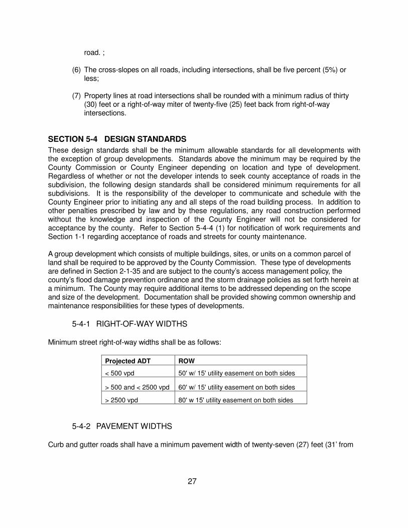
These design standards shall be the minimum allowable standards for all developments with the exception of group developments. Standards above the minimum may be required by the County Commission or County Engineer depending on location and type of development. Regardless of whether or not the developer intends to seek county acceptance of roads in the subdivision, the following design standards shall be considered minimum requirements for all subdivisions. It is the responsibility of the developer to communicate and schedule with the County Engineer prior to initiating any and all steps of the road building process. In addition to other penalties prescribed by law and by these regulations, any road construction performed without the knowledge and inspection of the County Engineer will not be considered for acceptance by the county. Refer to Section 5-4-4 (1) for notification of work requirements and Section 1-1 regarding acceptance of roads and streets for county maintenance. A group development which consists of multiple buildings, sites, or units on a common parcel of land shall be required to be approved by the County Commission. These type of developments are defined in Section 2-1-35 and are subject to the county’s access management policy, the county’s flood damage prevention ordinance and the storm drainage policies as set forth herein at a minimum. The County may require additional items to be addressed depending on the scope and size of the development. Documentation shall be provided showing common ownership and maintenance responsibilities for these types of developments. 5-4-1 RIGHT-OF-WAY WIDTHS Minimum street right-of-way widths shall be as follows:
Projected ADT ROW
< 500 vpd 50' w/ 15' utility easement on both sides
> 500 and < 2500 vpd 60' w/ 15' utility easement on both sides
> 2500 vpd 80' w 15' utility easement on both sides
5-4-2 PAVEMENT WIDTHS Curb and gutter roads shall have a minimum pavement width of twenty-seven (27) feet (31’ from
28
back of curb to back of curb) with a minimum shoulder width of two (2) feet back of curb. Allowable ditch section roads as specified in section 5-6 (7) shall have a minimum pavement width of twenty (20) feet with a minimum shoulder width of four (4) feet.
5-4-3 GEOMETRIC DESIGN (1) TYPICAL SECTIONS Curb Section - See Appendix VI Ditch Section- See Appendix VI (2) ROADS WITH LESS THAN 2500 ADT
All streets shall be designed to conform to the Alabama Department of Transportation “County Road Design Policy, Design Criteria for New and Reconstructed Roadways and Bridges with less than 2,500 ADT”. Minimum design speed 20 mph unless otherwise approved by the County Engineer.
(3) ROADS WITH GREATER THAN OR EQUAL TO 2500 ADT
All streets shall be designed to conform to AASHTO’s “A Policy on Geometric Design of Highways and Streets”. Minimum design speed 45 mph unless otherwise approved by the County Engineer.
(4) STREET GRADES Maximum street grades shall not exceed the following:
Projected ADT Maximum Grade allowed
< 2500 vpd
Refer to the Alabama Department of Transportation “County Road Design Policy, Design Criteria for New and Reconstructed Roadways and Bridges with less than 2,500 ADT
> 2500 vpd 12%
Any specifications for geometric design not covered by these regulations shall be governed by the applicable publication listed above.
5-4-4 ROAD CONSTRUCTION REQUIREMENTS
Construction of all roads shall meet the following minimum requirements and conform to the Alabama Department of Transportation’s “Standard Specifications for Highway Construction”. Best Management Practices for erosion control shall be used throughout construction and development. The developer shall be responsible for all erosion control in accordance with ADEM regulations and for securing any permits required by ADEM.
(1) Notification of Work: It shall be the duty and responsibility of the developer or his
29
designee to give written notice to the County Engineer or his authorized agent, one working day prior to starting any phase of construction. The developer or contractor shall notify the County Engineer or his authorized agent in writing the day work is resumed after a delay of more than five (5) working days. This includes all phases of construction, clearing, grading, drainage, gutters, inlets, base, surfacing and any work that pertains to the street, road or development. FAILURE TO NOTIFY AS SPECIFIED SHALL BE GROUNDS FOR NONACCEPTANCE.
(2) Testing: The County Engineer shall determine which tests shall be scheduled and performed. The tests normally consist of, but are not limited to: gradation; moisture; compaction; and asphalt analysis of road building materials. The developer, or his designee, shall notify the County Engineer, or his designee, twenty-four hours prior to any required tests. The County Engineer shall select a testing firm to complete all necessary tests. The developer may employ its own testing company, but all testing costs performed on behalf of the county shall govern acceptance and shall be reimbursed to the county before final plat approval is given or considered.
(3) All testing shall be conducted by an independent testing laboratory selected and employed by the County Engineer and Elmore County. Copies of all test reports are to be provided to the County Engineer before additional construction occurs. In the event problems exist that require remedial actions or design, the developer shall be required to submit appropriate engineering plans to the County Engineer before construction will be allowed to proceed.
(4) Clearing and Grubbing: All roads shall be cleared and grubbed to their full right-of-
way width. All areas shall be cleared of all vegetation, trees, stumps, large rocks and other objectionable or unsuitable material prior to grading or filling unless otherwise approved, in writing, by the County Engineer;
(5) Slope Paving: Slope paving shall be required in ditches as determined necessary
by the County Engineer. At a minimum, all ditches with slopes less than one (1) percent or greater than six (6) percent shall include slope paving. Other alternatives may be approved by the County Engineer;
(6) Embankment Sections: The County Engineer will have the right to approve all
borrow sources, however this does not relieve the developer from full responsibility for the quality of material used. Roadway fill or embankment of earth material shall be placed in uniform layers, full width, and not exceeding eight inch thickness (loose measurement). Each layer shall be compacted so that a uniform specified density is obtained. Compaction tests shall be run at the frequency and location as directed by the County Engineer. Additional layers of fill shall not be added until directed by the County engineer. For all density requirements refer to Section 210 and Section 306 of the "Alabama Department of Transportation Standard Specifications for Highway Construction";
30
(7) Subgrade: The subgrade shall be compacted and properly shaped prior to the placing of base materials. Developer shall submit a profile or verify the subgrade elevations before approval will be considered for placing any base materials. The top six (6) inches of the roadbed shall be modified, with the work being performed under Section 230 Roadbed Processing, of the “Alabama Department of Transportation Standard Specifications for Highway Construction”. It shall be full width of regular section and extend eighteen (18) inches outside of curb and gutter and/or valley gutter sections. The embankment or subgrade shall be inspected by proofrolling, under the supervision of the County Engineer or his/her designee, with a fully loaded tandem axle dump truck to check for soft or yielding areas. Any unsuitable materials shall be removed and replaced with a suitable material compacted to density requirements in accordance with Section 5-4-4(6) of these regulations. Suitable material shall be determined by the County Engineer.
(8) Base: Base course shall meet the requirements for crushed aggregate as set
forth in section 301 Type 825 A or B, plant mixed with water, according to the Alabama Department of Transportation Standard Specifications for Highway Construction. Base course shall have a minimum thickness of six (6) inches compacted thickness, full width of regular section and shall extend eighteen (18) inches outside of curb sections. The density requirements for compaction shall be in accordance with Section 306 of the Alabama Department of Transportation Standard Specifications for Highway Construction. Developer/Engineer may submit an alternate base design method for approval by the County Engineer. Design should be based on a proven and accepted engineering test or method.
(9) Roadway Pavement: All roads and/or streets shall be paved and comply with the
following:
a. Prior to the placement of pavement, a bituminous treatment A (prime) shall be placed and approved by the County Engineer.
b. The minimum pavement width shall be not less than twenty (20) feet on
standard sections and twenty-seven (27) feet for curb sections. Type of curb to be used shall be approved by the County Engineer. Valley or standard curb section shall be used unless otherwise approved.
c. Bituminous pavement requirements shall be two hundred twenty five pounds
per square yard (225 LBS/SY) of bituminous concrete plant mix, binder, 429, or 424, and one hundred pounds per square yard (100 LBS/SY) of bituminous concrete plant mix, wearing surface, type 429, 424 or a double bituminous surface treatment of AKG or AJG as covered in Section 401 of the ALDOT Standard Specifications for Highway Construction; or one hundred and sixty-five pounds per square yard (165 lbs/sy) of Bituminous Concrete Plant Mix, Wearing Surface either type 429 or 424. The mix shall be approved by the County Engineer and be covered in the latest memorandum recommendation from the office of the ALDOT County
31
Transportation Engineer or as specified by the ALDOT Standard Specifications for Highway Construction, latest edition. The placement of this bituminous pavement does not relieve the developer of meeting the current policy for acceptance of roads and streets by the Elmore County Commission. As covered in Section 1-1, the current policy for acceptance of roads and streets is located in Appendix V of these Regulations. Any amendments to these regulations will be on file at the Elmore County Engineer’s Office.
(10) Roadbed Width: The minimum roadbed width for curb sections shall be thirty-
four (34) feet and shall be twenty-eight (28) feet for standard sections. (11) Drainage Easements: Where a subdivision is traversed by a watercourse,
drainage way, channel, or stream, there shall be provided a storm water easement or drainage right-of-way conforming substantially to the lines of such watercourse, and of such width and construction as will be adequate for the purpose.
(12) Storm Drainage: An adequate storm drainage system based on a minimum
twenty-five (25) year design storm including curb, pipes, culverts, headwalls, and ditches shall be provided for the drainage of surface water. All crossdrains shall have sufficient length for required typical section and shall be installed according to ALDOT specifications. Minimum diameter of all drainage structures shall be eighteen (18) inches. All drainage structures shall be a minimum Class III, wire reinforced, concrete pipe and shall meet or exceed the current ALDOT specifications. Pipe grades should be designed to be self-cleansing at a minimum. Exit velocities of pipes/ storm drains shall not exceed ten (10) feet per second( fps). Dependent upon the storm water requirements in the area of the proposed subdivision, storm water detention shall be required unless otherwise approved by the County Engineer. The storm water detention system must assure that post-development discharge rates do not exceed pre-development runoff rates.
(13) Installation of Utilities: After grading is completed and approved by the County Engineer and before any roadbed processing of the subgrade is performed all of the underground utilities within the roadway prism shall be installed completely and approved by the County Engineer throughout the length of the street and across the section. Once pavement is placed, it shall not be open cut except with written permission of the County Engineer. Any utility desiring to cross the road shall go over the road or dry bore under the road. All water lines located under pavement shall be encased. Backfill placed in utility trenches shall be as covered in Section 5-4-4 (6) of these regulations. All utilities shall be placed in the provided utility easements.
32
(14) Signage of Subdivision: Proper signage in accordance with the “Manual of Uniform Traffic Control Devices” (MUTCD) shall be required and maintained in all subdivisions. Sign type and materials shall be approved by the County Engineer.
(15) Topsoil and Grassing: When all construction is completed, all slopes and shoulders
shall be covered with a sufficient amount of topsoil and shall have a stand of permanent grass to prevent undue erosion, either by sprigging, seeding, mulching, or sodding. The developer shall implement Best Management Practices to prevent erosion.
(16) Driveways: Where a drainage ditch construction is allowed, the developer should refer to the geometric design in Section 5-4-3. Developers shall install all driveways prior to final plat approval at locations and sizes as submitted to and approved by the County Engineer (A surety may be provided in lieu of installation of driveways provided the surety meets the requirements found in Section 3-8). Driveway side drains shall be a minimum of twenty (20) feet long and a maximum of forty (40) feet long. No more than two (2) driveways will be allowed per lot. Where a lot has two (2) driveways, they must be separated by at least thirty (30) feet unless approved by the County Engineer. All driveway pipes shall be Class III wire reinforced concrete pipe or corrugated metal pipe and shall meet or exceed the current ALDOT specifications.
SECTION 5-5 BLOCKS
(1) Blocks shall have sufficient width to provide for two (2) tiers of lots of appropriate depths. Exceptions to this prescribed block width shall be permitted in blocks adjacent to expressways, arterials, railroads, or waterways where single-tier lots are required to separate residential development from through vehicular traffic or non-residential uses;
(2) Blocks shall not exceed fifteen hundred (1500) feet nor be less than five hundred
(500) feet in length except as approved by the County Engineer
(3) In long blocks, the County Engineer may require the reservation of an easement
through the block to accommodate utilities, drainage facilities, or pedestrian traffic.
(4) Pedestrian ways or crosswalks, not less than ten (10) feet wide, may be required by the County Engineer through the center of blocks more than eight hundred (800) feet long where deemed essential to provide circulation or access to schools, playgrounds, shopping centers, transportation, or other community facilities.
(5) Blocks designed for industrial uses shall be of such length and width as may be
33
determined suitable by the County Engineer for prospective use.
SECTION 5-6. LOTS
Lots shall comply with the following requirements: (1) The minimum lot size shall be determined by the regulations of the Health
Department. (2) The subdivision plat shall provide each lot with satisfactory access as defined in
Section 2-1-1. Subdivisions which are developed under these regulations but do not meet the county acceptance policy shall be allowed to have access off the dedicated right-of-way which is required herein;
(3) Where land is subdivided into larger parcels than ordinary building lots, such
parcels shall be arranged so as to allow for the opening of future roads and logical further resubdivision;
(4) Depth and width of properties reserved for commercial and industrial purposes
shall be adequate to provide for off-road parking and loading for the use contemplated;
(5) Double frontage lots shall be avoided, except where essential to provide separation
of residential development from traffic arteries, or to overcome specific disadvantages to topography and orientation;
(6) Each lot in a subdivision shall contain a flood-free building site as defined in the
Elmore County Flood Damage Prevention Ordinance.
(7) Where all lots have a minimum road frontage of one hundred and twenty-five (125) feet, the developer shall not be required to construct curb and gutter. However, a wider right-of-way shall be required to accommodate the open ditch drainage system. The minimum right-of-way for this type of development shall be 60’.
(8) Lots which are located within a cul-de-sac shall be exempt from the 60’ access
requirement. A minimum access for these type lots shall be 30’ provided the proposed lot cannot be further subdivided for the purpose of providing an additional building site. A note shall be required on the plat restricting the further subdivision of lots meeting this exemption.
(9) A flag lot shall be exempt from the 60’ access requirement provided the proposed
lot shall meet a minimum 30’ access width, the flag lot cannot be further subdivided to provide an additional building site, and the minimum distance between flag lots shall be the Stopping Sight Distance for the road which the flag lot fronts or 250’ whichever is greater. This exemption shall not relieve the developer or engineer

34
from meeting the county’s or state’s access management policy for entrance onto a county or state maintained road.
35
ARTICLE VI
INSTALLATION OF PERMANENT REFERENCE POINTS
6-1 PERMANENT REFERENCE POINTS
SECTION 6-1 PERMANENT REFERENCE POINTS
Prior to the signing of the Final Plat, permanent reference points shall have been placed in accordance with the following requirements and the Current Standards of Practice for Land Surveying in the State of Alabama:
6-1-1 SUBDIVISION CORNER TIE
At least one corner of the subdivision shall be designated by course and distance (tie) from an accepted corner of the Government Survey of Elmore County. The subdivision corner shall be marked with a monument and shall appear on the map with a description of bearings and distances from the Government Survey corner.
6-1-2 MONUMENTS
Concrete monuments four (4) inches in diameter or four (4) inches square and two (2) feet long with a flat top shall be set at all exterior corners of the subdivision and on the right of way lines at the point of curvature (PC) and point of tangency (PT). The top of the monument shall have identifying cap of surveyor. Alternate monuments may be approved by the County Engineer.
6-1-3 PROPERTY MARKERS
All lot corners not marked with a monument shall be marked with an iron pin not less than one-half (1/2) inch in diameter or in width, and eighteen (18) inches long, and driven so as to be flush with the finished grade. The top of the marker shall have identifying cap of surveyor.
36
ARTICLE VII
GUARANTEE OF CONSTRUCTION
7-1 SURETY 7-2 CONSTRUCTION, INSPECTION AND CERTIFICATION 7-3 RELEASE OF GUARANTEE
SECTION 7-1 SURETY
The developer or subdivider shall be responsible for all required infrastructure construction related to the subdivision. The developer shall be required to complete the full installation of all required infrastructure prior to the signing of the Final Plat along with providing financial guarantee of performance under conditions set out in these regulations prior to approval of the Proposed Plat.
The guarantee of performance by the subdivider shall be a surety in a form approved by the County Engineer and in the amount detailed in Section 3-8 of these regulations. If within twelve (12) months after filing said surety, the subdivider has not completed all necessary construction or if, in the opinion of the County Engineer, said construction have not been satisfactorily installed, the County may take such steps as may be necessary to require performance under the bond. Extension of this time frame may be approved by the County Engineer upon request and for valid cause.
SECTION 7-2 CONSTRUCTION, INSPECTION AND CERTIFICATION
The County Engineer or his designee shall monitor and periodically inspect for defects in the construction of the required improvements. The developer shall pay to the County the inspection fee as set out in Section 1-3 and authorized by Code of Alabama 1975, § 11-24-3, and the County Engineer shall not sign the final plat unless such fees have been paid at the time of application for final plat approval. If the County Engineer finds upon inspection that any of the required improvements have not been constructed in accordance with the County’s adopted construction standards and specifications, the developer shall be responsible for correcting any deficiencies prior to final plat approval. Wherever the cost of improvements is covered by a surety, the developer and the Surety Company shall be severally and jointly liable for completing or paying the cost of the improvements according to specifications. Upon completion of the improvements, the applicant shall file with the County Engineer a statement stipulating the following:
(1) That all required infrastructure construction is complete; (2) That these improvements are in compliance with the minimum standards specified by
the County and the County Engineer for their construction;
37
(3) That the developer knows of no defects in these improvements; and
(4) That these improvements are free and clear of any encumbrances or liens.
SECTION 7-3 RELEASE OF GUARANTEE Upon satisfactory completion of all improvements and approval by the County Engineer, the County Commission shall authorize the release of the improvement surety bond.
38
ARTICLE VIII
VARIANCES
8-1 GENERAL 8-2 CONDITIONS 8-3 EXPERIMENTAL SUBDIVISIONS
SECTION 8-1 GENERAL
A variance may be granted in circumstances where the developer demonstrates that extraordinary hardships or practical difficulties, such as commercial development, may result from strict compliance with these regulations. The initial application for variance shall be made to the county engineer as part of the application for proposed plat approval. The County Engineer shall review the application and the circumstances, and make a recommendation in writing to the County Commission, with a copy provided to the developer, as to whether or not the variance should be granted. The engineer’s report shall set out in detail the basis for the recommendation. If the County Engineer recommends that the variance be granted, he or she may recommend that it be conditioned upon the developer complying with special requirements as set out in the variance approval. Where the County Engineer has recommended granting the variance, the County Commission shall vote on the proposed plat approval. If the County Engineer recommends that the request for variance be denied, the developer may appeal that recommendation to the County Commission, which shall consider the issue at the next regularly scheduled County Commission meeting following notice of the recommendation. The County Engineer or his or her designee shall be present at the County Commission meeting and shall present his or her reasons for recommending that the variance not be granted. The developer shall also be given an opportunity to be heard. A decision to grant the variance shall be made by recorded vote and shall require a majority of the membership of the County Commission. In determining whether to grant the variance, the County Engineer and the County Commission shall make findings based upon the evidence presented to it in each specific case that:
(a) The granting of the variance will not be detrimental to the public safety, health, or welfare or injurious to other property;
(b) The conditions for which the request for a variance is based are unique to the
property for which the variance is sought and are not applicable generally to other property;
(c) Because of the particular physical surroundings, shape, or topographical conditions
of the specific property involved, a particular hardship to the owner, as distinguished
39
from a mere inconvenience, would result if the strict letter of these regulations are carried out;
(d) The variance will not in any manner vary the provisions of other adopted policies and
regulations of Elmore County.
SECTION 8-2 CONDITIONS
In approving variances, the County Commission may require such conditions as will, in its judgment, secure substantially the objectives, standards or requirements of these regulations. The County Commission shall not grant any variance within the floodway unless the developer submits a study prepared by a registered professional engineer certifying that no increase in the 100-year flood level would result from the proposed development.
SECTION 8-3 EXPERIMENTAL SUBDIVISIONS
The County Commission may waive, vary or modify the standards and requirements of these regulations, upon recommendation by the County Engineer, for a development which is termed an experimental subdivision. An experimental subdivision shall contain characteristics which prove to be of merit or benefit to the County. This may include use of unusual materials or new and unusual design concepts. For a development to be considered as an experimental subdivision, the following criteria must be met at a minimum:
(1) A detailed written and oral presentation shall be made to the County Engineer and County Commission. A sketch plan and written documentation shall be required to be submitted to the County Engineer prior to the presentation to the County Commission. The written documentation and oral presentation shall outline the benefits and nature of the experimental subdivision;
(2) The developer shall submit documentation detailing the method that the
infrastructure to be placed in the experimental subdivision shall be maintained. Homeowner Associations shall be discouraged as the mechanism for maintenance versus quasi-governmental boards such as development or improvement districts. Maintenance of these type developments shall not fall under the County Commission as these developments do not meet the County Acceptance Policy; and
(3) The developer shall detail past developments in the County. The quality and
quantity of past developments shall be a factor in the approval of such a development.
The County Commission may grant permission to proceed with the development upon completion

40
of these minimum criteria and the recommendation by the County Engineer. Once permission to proceed is granted, the developer shall complete all required steps as detailed in these regulations to receive proposed and final plat approval.
41
ARTICLE IX
CONFLICT WITH PUBLIC AND PRIVATE PROVISIONS
9-1 PUBLIC PROVISIONS 9-2 PRIVATE PROVISIONS
SECTION 9-1 PUBLIC PROVISIONS
These regulations are not intended to interfere with, abrogate, or annul any other ordinance, rule, regulation, statute, or other provision of law. Where any provision of these regulations imposes restrictions different from those imposed by any other ordinance, rule, regulation, or other provision of law, the provisions of which are more restrictive or impose higher standards shall control.
SECTION 9-2 PRIVATE PROVISIONS
These regulations are not intended to abrogate any easement, covenant or any other private agreement or restriction; provided, however, that where the provision of these regulations are more restrictive or impose higher standards or regulations than such easement, covenant, or other private agreement or restriction, the requirements of these regulations shall govern. To the extent that any easement, covenant, or private agreement is not inconsistent with these regulations or any determinations made by the County Commission in approving a subdivision or in enforcing these regulations, such private provisions shall be operative and supplemental to these regulations; provided, however, that neither the County Commission nor the County Engineer shall be responsible for enforcing, regulating, or ensuring compliance with any such easement, covenant, or other private agreement or restriction.
42
ARTICLE X
LEGAL PROVISIONS
10-1 SEVERABILITY 10-2 SAVINGS PROVISION 10-3 INCORPORATION BY REFERENCE 10-4 AMENDMENT PROCEDURE FOR COMMISSION
SECTION 10-1 SEVERABILITY
If any part or provision of these regulations is judged invalid by any court of competent jurisdiction, such judgment shall be confined to its terms and shall not affect or impair the validity of the remainder of these regulations or their application to other persons or circumstances.
SECTION 10-2 SAVINGS PROVISION
Except as expressly provided in these regulations, these regulations shall have prospective application only and shall not be construed as abating, modifying, or altering any action, including any penalty, pending under any subdivision regulations in existence on the effective date of these regulations. These regulations shall not affect the rights or liability of any person, firm, or corporation, nor operate as a waiver of any right of the County under any section or provision existing at the time of adoption of these regulations. Notwithstanding the foregoing, any application for plat approval made after the County Commission’s adoption of these regulations which is pending on the effective date of these regulations shall be reviewed, approved, or disapproved in accordance with these regulations, provided that the owner or developer was given written notice at the time of application that these regulations would be utilized in the approval of the subdivision’s design and development.
SECTION 10-3 INCORPORATION BY REFERENCE
Code of Alabama 1975, § 11-24-1 et seq., Code of Alabama 1975, § 11-52-30, and Code of Alabama 1975, § 40-12-10 are attached hereto as Appendix IV, and are hereby specifically incorporated by reference and made a part of these regulations.
SECTION 10-4 AMENDMENT PROCEDURE FOR COMMISSION The County Commission may adopt amendments to these regulations at a regularly scheduled meeting of the County Commission. In addition, the amendments shall not take effect for thirty (30) days after the action of the County Commission. Amendments adopted by the County Commission shall not apply to any plat submitted prior to the date that the amendments take effect.

43
APPENDIX I
SAMPLE CERTIFICATES
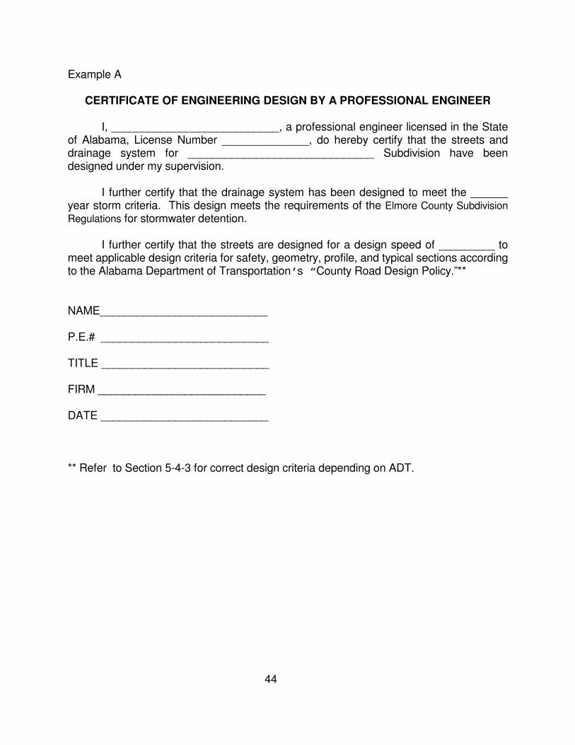
44
Example A
CERTIFICATE OF ENGINEERING DESIGN BY A PROFESSIONAL ENGINEER I, ___________________________, a professional engineer licensed in the State of Alabama, License Number ______________, do hereby certify that the streets and drainage system for ______________________________ Subdivision have been designed under my supervision. I further certify that the drainage system has been designed to meet the ______ year storm criteria. This design meets the requirements of the Elmore County Subdivision
Regulations for stormwater detention. I further certify that the streets are designed for a design speed of _________ to meet applicable design criteria for safety, geometry, profile, and typical sections according to the Alabama Department of Transportation’s “County Road Design Policy.”** NAME___________________________ P.E.# ___________________________ TITLE ___________________________ FIRM ___________________________ DATE ___________________________ ** Refer to Section 5-4-3 for correct design criteria depending on ADT.
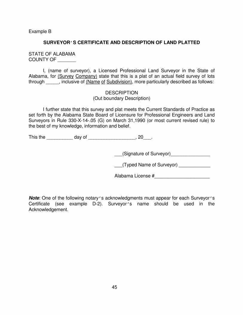
45
Example B
SURVEYOR’S CERTIFICATE AND DESCRIPTION OF LAND PLATTED
STATE OF ALABAMA COUNTY OF _______ I, (name of surveyor), a Licensed Professional Land Surveyor in the State of Alabama, for (Survey Company) state that this is a plat of an actual field survey of lots through _____, inclusive of (Name of Subdivision), more particularly described as follows:
DESCRIPTION (Out boundary Description)
I further state that this survey and plat meets the Current Standards of Practice as set forth by the Alabama State Board of Licensure for Professional Engineers and Land Surveyors in Rule 330-X-14-.05 (G) on March 31,1990 (or most current revised rule) to the best of my knowledge, information and belief. This the __________ day of __________________, 20___. ___(Signature of Surveyor)_______________ ___(Typed Name of Surveyor) ____________ Alabama License #_____________________ Note: One of the following notary’s acknowledgments must appear for each Surveyor’s Certificate (see example D-2). Surveyor’s name should be used in the Acknowledgement.
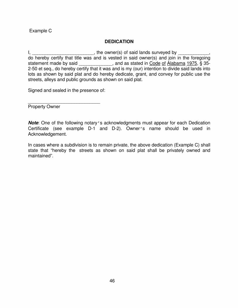
46
Example C
DEDICATION I, ________________________, the owner(s) of said lands surveyed by ____________, do hereby certify that title was and is vested in said owner(s) and join in the foregoing statement made by said _____________, and as stated in Code of Alabama 1975, § 35-2-50 et seq., do hereby certify that it was and is my (our) intention to divide said lands into lots as shown by said plat and do hereby dedicate, grant, and convey for public use the streets, alleys and public grounds as shown on said plat. Signed and sealed in the presence of: ____________________________ Property Owner Note: One of the following notary’s acknowledgments must appear for each Dedication Certificate (see example D-1 and D-2). Owner’s name should be used in Acknowledgement. In cases where a subdivision is to remain private, the above dedication (Example C) shall state that “hereby the streets as shown on said plat shall be privately owned and maintained”.
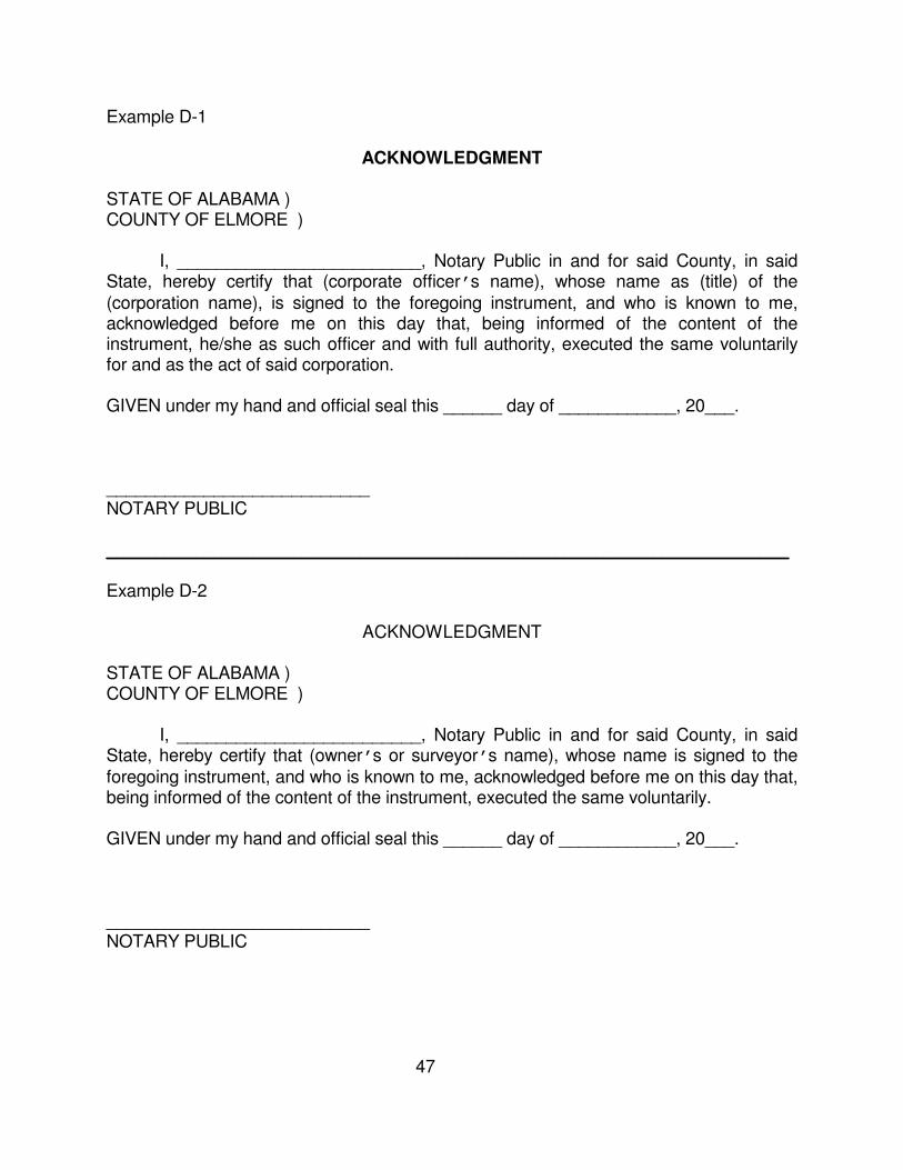
47
Example D-1
ACKNOWLEDGMENT STATE OF ALABAMA ) COUNTY OF ELMORE ) I, _________________________, Notary Public in and for said County, in said State, hereby certify that (corporate officer’s name), whose name as (title) of the (corporation name), is signed to the foregoing instrument, and who is known to me, acknowledged before me on this day that, being informed of the content of the instrument, he/she as such officer and with full authority, executed the same voluntarily for and as the act of said corporation. GIVEN under my hand and official seal this ______ day of ____________, 20___. ___________________________ NOTARY PUBLIC ______________________________________________________________________ Example D-2
ACKNOWLEDGMENT STATE OF ALABAMA ) COUNTY OF ELMORE ) I, _________________________, Notary Public in and for said County, in said State, hereby certify that (owner’s or surveyor’s name), whose name is signed to the foregoing instrument, and who is known to me, acknowledged before me on this day that, being informed of the content of the instrument, executed the same voluntarily. GIVEN under my hand and official seal this ______ day of ____________, 20___. ___________________________ NOTARY PUBLIC
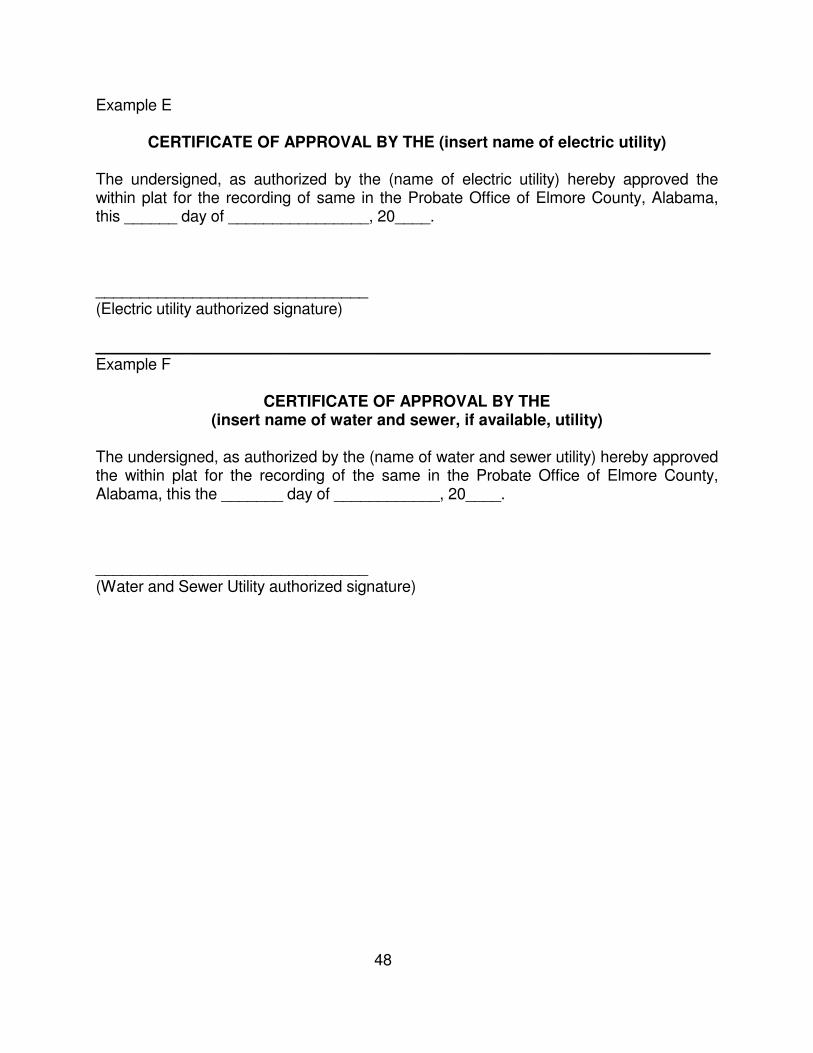
48
Example E
CERTIFICATE OF APPROVAL BY THE (insert name of electric utility) The undersigned, as authorized by the (name of electric utility) hereby approved the within plat for the recording of same in the Probate Office of Elmore County, Alabama, this ______ day of ________________, 20____. _______________________________ (Electric utility authorized signature) ______________________________________________________________________ Example F
CERTIFICATE OF APPROVAL BY THE
(insert name of water and sewer, if available, utility) The undersigned, as authorized by the (name of water and sewer utility) hereby approved the within plat for the recording of the same in the Probate Office of Elmore County, Alabama, this the _______ day of ____________, 20____. _______________________________ (Water and Sewer Utility authorized signature)
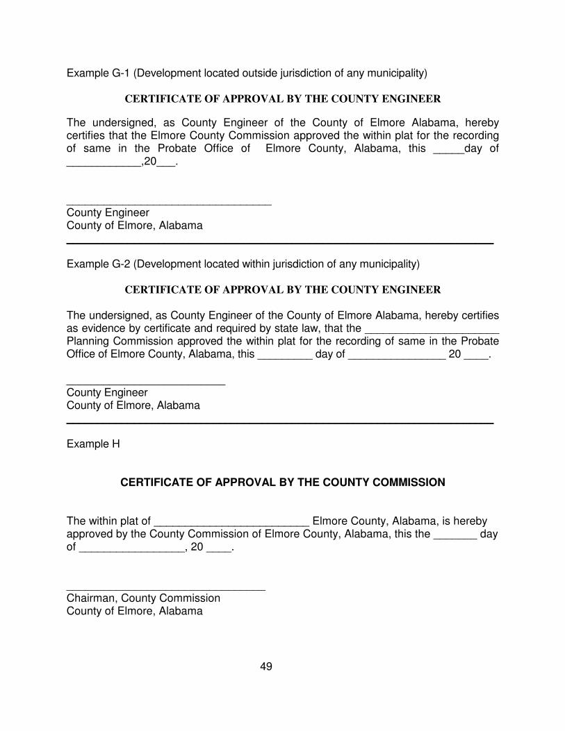
49
Example G-1 (Development located outside jurisdiction of any municipality)
CERTIFICATE OF APPROVAL BY THE COUNTY ENGINEER
The undersigned, as County Engineer of the County of Elmore Alabama, hereby certifies that the Elmore County Commission approved the within plat for the recording of same in the Probate Office of Elmore County, Alabama, this _____day of ____________,20___. _________________________________ County Engineer County of Elmore, Alabama ______________________________________________________________________ Example G-2 (Development located within jurisdiction of any municipality)
CERTIFICATE OF APPROVAL BY THE COUNTY ENGINEER
The undersigned, as County Engineer of the County of Elmore Alabama, hereby certifies as evidence by certificate and required by state law, that the ______________________ Planning Commission approved the within plat for the recording of same in the Probate Office of Elmore County, Alabama, this _________ day of ________________ 20 ____. __________________________ County Engineer County of Elmore, Alabama ______________________________________________________________________ Example H
CERTIFICATE OF APPROVAL BY THE COUNTY COMMISSION The within plat of _________________________ Elmore County, Alabama, is hereby approved by the County Commission of Elmore County, Alabama, this the _______ day of _________________, 20 ____. ________________________________ Chairman, County Commission County of Elmore, Alabama
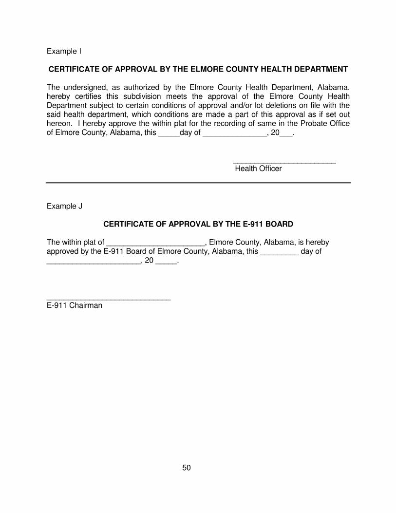
50
Example I
CERTIFICATE OF APPROVAL BY THE ELMORE COUNTY HEALTH DEPARTMENT The undersigned, as authorized by the Elmore County Health Department, Alabama. hereby certifies this subdivision meets the approval of the Elmore County Health Department subject to certain conditions of approval and/or lot deletions on file with the said health department, which conditions are made a part of this approval as if set out hereon. I hereby approve the within plat for the recording of same in the Probate Office of Elmore County, Alabama, this _____day of _______________, 20___. ________________________ Health Officer
Example J
CERTIFICATE OF APPROVAL BY THE E-911 BOARD
The within plat of _______________________, Elmore County, Alabama, is hereby approved by the E-911 Board of Elmore County, Alabama, this _________ day of ______________________, 20 _____. _____________________________ E-911 Chairman
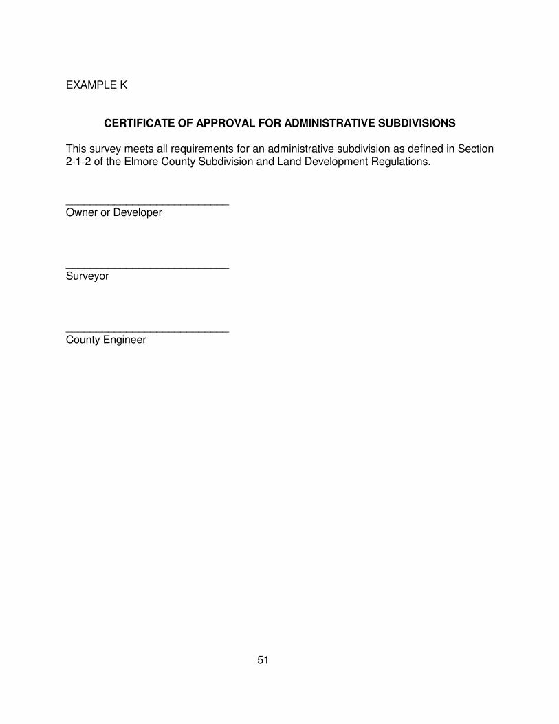
51
EXAMPLE K
CERTIFICATE OF APPROVAL FOR ADMINISTRATIVE SUBDIVISIONS This survey meets all requirements for an administrative subdivision as defined in Section 2-1-2 of the Elmore County Subdivision and Land Development Regulations. ___________________________ Owner or Developer ___________________________ Surveyor ___________________________ County Engineer

52
APPENDIX II
SUBDIVISION FLOWCHART
SAMPLE FORMS
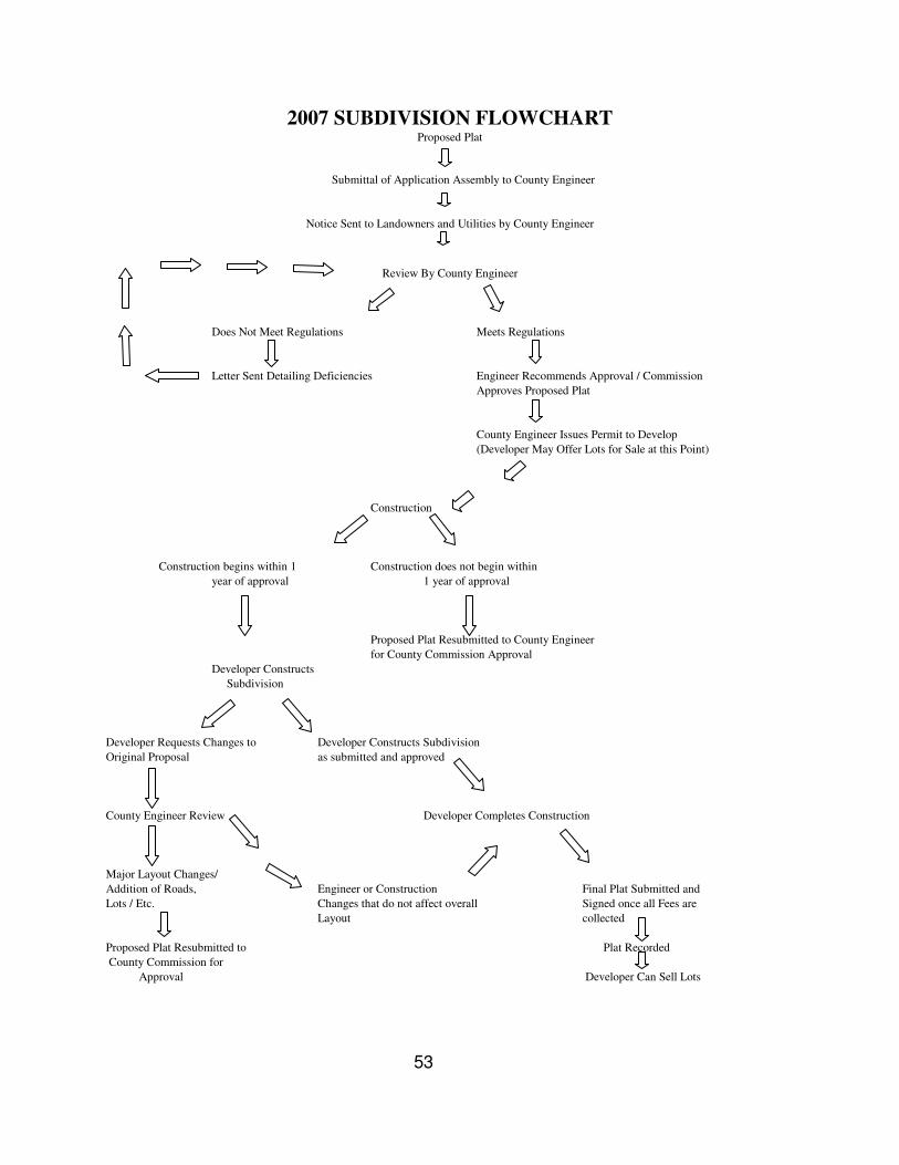
53
2007 SUBDIVISION FLOWCHART Proposed Plat
Submittal of Application Assembly to County Engineer
Notice Sent to Landowners and Utilities by County Engineer
Review By County Engineer
Does Not Meet Regulations Meets Regulations
Letter Sent Detailing Deficiencies Engineer Recommends Approval / Commission
Approves Proposed Plat
County Engineer Issues Permit to Develop
(Developer May Offer Lots for Sale at this Point)
Construction
Construction begins within 1 Construction does not begin within
year of approval 1 year of approval
Proposed Plat Resubmitted to County Engineer
for County Commission Approval
Developer Constructs
Subdivision
Developer Requests Changes to Developer Constructs Subdivision
Original Proposal as submitted and approved
County Engineer Review Developer Completes Construction
Major Layout Changes/
Addition of Roads, Engineer or Construction Final Plat Submitted and
Lots / Etc. Changes that do not affect overall Signed once all Fees are
Layout collected
Proposed Plat Resubmitted to Plat Recorded
County Commission for
Approval Developer Can Sell Lots
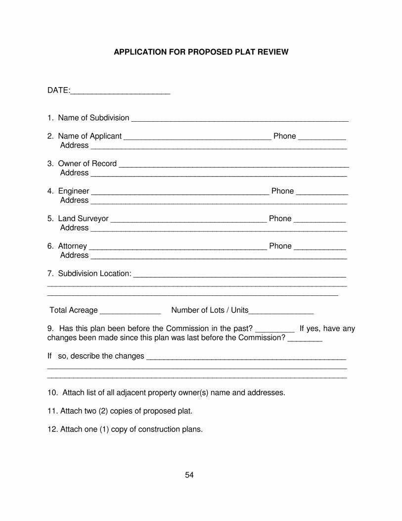
54
APPLICATION FOR PROPOSED PLAT REVIEW
DATE:_______________________ 1. Name of Subdivision __________________________________________________ 2. Name of Applicant __________________________________ Phone ___________ Address ___________________________________________________________ 3. Owner of Record _____________________________________________________ Address ___________________________________________________________ 4. Engineer _________________________________________ Phone ____________ Address ___________________________________________________________ 5. Land Surveyor ____________________________________ Phone ____________ Address ___________________________________________________________ 6. Attorney _________________________________________ Phone ____________ Address ___________________________________________________________ 7. Subdivision Location: _________________________________________________ _____________________________________________________________________ ___________________________________________________________________ Total Acreage ______________ Number of Lots / Units_______________ 9. Has this plan been before the Commission in the past? _________ If yes, have any changes been made since this plan was last before the Commission? ________ If so, describe the changes ______________________________________________ _____________________________________________________________________ _____________________________________________________________________ 10. Attach list of all adjacent property owner(s) name and addresses. 11. Attach two (2) copies of proposed plat. 12. Attach one (1) copy of construction plans.

55
APPENDIX III
AMENDMENTS
56
APPENDIX IV
APPLICABLE STATE LAWS
57
COUNTY SUBDIVISION REGULATIONS LAW § 11-24-1 -- Definitions; regulation of lots, streets, drainage, utilities, etc.; developer to reimburse utility for uneconomical placement.
When used in this chapter, the following words shall have the following meanings:
(1) COUNTY. A political subdivision of the state created by statute to aid in the administration of government.
(2) COUNTY COMMISSION. The chief administrative or legislative body of the county.
(3) STREETS. Streets, avenues, boulevards, roads, lanes, alleys, viaducts, and other roads.
(4) SUBDIVISION. The development and division of a lot, tract, or parcel of land into two or more lots, plats, sites, or otherwise for the purpose of establishing or creating a subdivision through the sale, lease, or building development. Development includes, but is not limited to, the design work of lot layout, the construction of drainage structures, the construction of buildings or public use areas, the planning and construction of public streets and public roads, and the placement of public utilities. A subdivision does not include the construction or development of roads or buildings on private property to be used for agricultural purposes.
(b) The county commission or like governing body of each county in the state shall be authorized to regulate the minimum size of lots, the planning and construction of all public streets, public roads, and drainage structures and require proper placement of public utilities to be located in proposed subdivisions of land or in proposed additions to subdivisions of land existing at the time of the enactment of this chapter where the subdivisions are situated outside the corporate limits of any municipality in the county. The placement of public utilities shall not be inconsistent with the requirements of the Southern Standard Building Code, state and federal laws, and regulations of state and federal regulatory agencies. If the county commission or like governing body of any county shall require the placement of public utility facilities in any subdivision or addition thereto in a manner which is other than the most economical method available from an engineering standpoint, then the developer of the subdivision or addition shall reimburse the utility for the difference in cost between the method so required by the county governing body and the most economical method available.
(c) The county commission or like governing body of each county in the state may establish a board of developers to make suggestions to the commission regarding the development and division of subdivisions. The board may advise the commission on the contents of the regulations, revisions that need to be made to the regulations, and assist in resolving disputes between the commission and developers.
(1)§ 11-24-2 -- Developer to conform with chapter, post bond, submit plat for approval, etc.; county engineer and utility to review plat before approval. (a) It shall be the duty of the owner and developer of each subdivision to have all construction completed in conformity with this chapter and, prior to beginning any construction or development, to submit the proposed plat to the county commission for approval and obtain a
58
permit to develop as required in this section. The permit to develop shall be obtained before the actual sale, offering for sale, transfer, or lease of any lots from the subdivision or addition to the public, it must include a plan to deliver utilities including water, and shall only be issued upon approval of the proposed plat by the county commission. As a condition for the issuance of a permit, the county commission may require any of the following for approval of the proposed plat: (1) The filing and posting of a reasonable surety bond with the county commission by the developers of the proposed subdivisions or proposed additions to guarantee the actual construction and installation are in accordance with approved plans for public streets, public roads, drainage structures, and public utilities.
(2) The names and addresses of each adjoining landowner and utility subject to the notice as provided in subsection (b).
(3) A permit fee, which shall not exceed twenty-five dollars ($25).
(b) No proposed plat shall be approved or 18 disapproved by the county commission without first being reviewed by the county engineer or his or her designee. Following the review, the county engineer or his or her designee shall certify to the commission whether the proposed plat meets the county's regulations. If the proposed plat meets the regulations, it shall be approved by the commission. Should the proposed plat be determined by the county engineer to be deficient in any regard, the county engineer shall detail the deficiency to the county commission along with a recommendation that it be disapproved. Notice of the recommendation of the engineer shall be sent to the owner or developer whose name and address appears on the submitted proposed plat by registered or certified mail at least 10 days before the recommendation shall be presented to the county commission for action. A similar notice shall be mailed to the owners of land immediately adjoining the platted land as their names appear upon the plats in the office of the county tax assessor and their addresses appear in the directory of the county or on the tax records of the county and to each utility affected thereby. Each utility notified in writing by the commission shall be given at least 10 days to review the proposed plat and submit a written report to the commission as to whether all provisions affecting the service to be provided by the utility are reasonable and adequate. If any utility affected by the proposed plat is not properly notified then the approval or disapproval by the county commission shall not be valid until the affected utility has been given at least ten days' notice prior to such approval or disapproval as provided by this subsection. (c) In addition to the foregoing, once the owner or developer of all proposed subdivisions or proposed additions to existing subdivisions of land situated outside the corporate limits of any municipality in the county has met all requirements of the county's regulations, he or she shall submit the final plat of the developed subdivision or addition to existing subdivision to the county engineer for signature verifying that the subdivision or additions to existing subdivision meets the county's regulations. After the final plat has been signed by the county engineer, it shall
59
be filed for record or received for filing in the office of the judge of probate. Subject to the penalties set out in Section 11-24-3, it shall be a violation of this chapter for the developer to file or to have filed any plat, deed, property description, or document of property transfer without full compliance with this section. (d) Notwithstanding the provisions of subsections (a), (b), and (c), this section shall not apply to the sale, deed, or transfer of land by the owner to an immediate family member, except that, in the event that there is any sale, deed, or transfer of land by the owner or an immediate family member to someone other than an immediate family member, this chapter shall then apply to any subdivision of property as defined in subdivision (4) of Section 11-24-1. (2)§ 11-24-3 -- Fines; county to enjoin action, employ inspectors/charge inspection fees. (a) Any owner or developer failing to comply with the permitting requirement or otherwise violating this chapter or any rule or regulation made pursuant to this chapter shall be fined one thousand dollars ($1,000) per lot that has been sold, offered for sale, transferred, or leased to the public.
(b) In the event that the developer or owner fails to comply with this chapter, the county commission shall have the right to enjoin action of the developer or owner by a civil action for the injunction brought in any court of competent jurisdiction or, in the event that work on the subdivision has been completed, to bring action to compel the developer or owner to comply with this chapter. In addition to injunction, the county commission may recover the penalty as provided by this section in any court of competent jurisdiction. (c) The county commission may employ inspectors and may request the county license inspector to see that its rules and regulations are not violated and that the plans and specifications for the minimum size of lots, the planning and construction of public streets, public roads, and drainage structures, and the placement of public utilities are not in conflict with the rules and regulations of the county. The county commission may charge inspection fees, not to exceed actual costs, to be paid by the owners of the property inspected. (d) This chapter may be enforced by the county license inspector under Section 40-12-10, including issuing citations as provided in subsection (j) of Section 40-12-10 for failure to properly obtain the permit to develop required pursuant to subsection (a) of Section 11-24-2. The license inspector may issue subsequent citations for failure to properly obtain a permit to develop if, after 30 days following the issuance of the previous citation for the same violation, the owner or developer of the subdivision has not made proper application for a permit pursuant to the requirements of this chapter. The applicable fines set out in subsection (a) shall be doubled and separately assessed against the owner or developer of the subdivision for each subsequent citation issued by the license inspector as provided herein."
(d)
(3)§ 11-24-4 Chapter not to impair utilities right of eminent domain, etc.
This chapter shall not be construed to impair the right of eminent domain granted heretofore or hereafter by the laws of this state to utilities, whether public or private, or their right to exercise
60
authority conferred by statutes, franchises, certificates of convenience and necessity, licenses or easements.
(4)§ 11-24-5 -- No jurisdiction within organized municipal planning commission.
No county shall exercise jurisdiction under provisions of this chapter within the jurisdiction of any municipal planning commission presently organized and functional or which shall become organized and functional within six months of the date the county assumes such jurisdiction by publishing and adopting notice thereof.
(5)§ 11-24-6 -- County and municipality agreement as to exercise of jurisdiction.
It is the intent of the legislature that all proposed subdivisions be subject to regulation, and counties and municipalities affected by provisions of this chapter shall have authority to reach and publish agreement as to exercise of jurisdictional authority over proposed subdivisions, which agreement shall be published once a week for two consecutive weeks in a newspaper of general circulation in the county and affected municipality and such agreement shall thereafter have the force and effect of law.
(6)§ 11-24-7 -- Chapter cumulative; not to repeal any local laws.
The provisions of this chapter are cumulative and shall not repeal any local law or general law of local application granting similar or additional duties and authority to any county commission.
61
TERRITORIAL JURISDICTION OF MUNICIPAL PLANNING
COMMISSION
(7)§ 11-52-30 -- Territorial jurisdiction of municipal/county planning commissions and county commissions as to subdivisions; approval of maps or plats of subdivisions.
(a) The territorial jurisdiction of any municipal planning commission over the subdivision of land shall include all land located in the municipality and all land lying within five miles of the corporate limits of the municipality and not located in any other municipality; except that, in the case of any such nonmunicipal land lying within five miles of more than one municipality having a planning commission, the jurisdiction of each such municipal planning commission shall terminate at a boundary line equidistant from the respective corporate limits of such municipalities; provided further, that in all counties having a population of 600,000 or more according to the 1950 federal census or any succeeding decennial federal census, the county planning and zoning commission shall be invested with such authority, except and unless the municipality or municipalities in question is/are actively exercising zoning jurisdiction and control within said police and/or five mile jurisdiction or, in the case of a municipality subsequently incorporated, within 180 days from the date of its incorporation; provided, further, that in all counties having a population of 600,000 or more inhabitants according to the 1950 federal census or any succeeding decennial federal census, the county commission of such county shall have the right and power to establish minimum specifications and regulations governing the lay-out, grading and paving of all streets, avenues and alleys and the construction or installation of all water, sewer or drainage pipes or lines in any subdivision lying wholly or partly in areas outside the corporate limits of any municipality in such counties and relating to subdivisions lying within the corporate limits of any municipality in such counties which has declined or failed to exercise zoning jurisdiction and control as provided in this section.
(b) No map or plat of any subdivision shall be recorded, and no property shall be sold referenced to such map or plat, until and unless it has been first submitted to and approved by the county engineer or, in his absence, by the acting county engineer of such county, who shall examine same for compliance with the specifications and regulations of the county commission of such county and, if it is in compliance, shall note his approval on such map or plat by noting thereon "approved," giving the date of such approval and signing same in his official capacity.
Where any subdivision lies within the extraterritorial planning jurisdiction of any municipality having exercised said extraterritorial jurisdiction, the requirement for approval of improvements in said subdivision by the county engineer shall in no way diminish, waive or otherwise lessen the requirements of such municipality. The more strict requirements, whether of the municipality or of the county, must be complied with by the developer. Approval by the county engineer shall in no way constitute approval in lieu of or on behalf of any municipality with respect to subdivisions lying within its extraterritorial planning jurisdiction. All such maps or plats must be first submitted to and approved by the municipal planning commission or other appropriate municipal agency exercising jurisdiction over any subdivision lying within the extraterritorial

62
planning jurisdiction and, following such approval by such municipal planning commission, must then be approved by the county engineer or, in his absence, by the acting county engineer.
63
VACATION OF ROADS
(8)§ 23-4-1 -- Application.
Streets, alleys and other highways, or portions thereof, may be closed and vacated upon the application of the municipality in which they are situated and, where not situated in a municipality, upon the application of the county in which they are situated in the manner provided for in this article.
(9)§ 23-4-2 -- Procedure.
(a) Whenever the governing body of a municipality or county proposes to vacate a public street, alley, or highway, or portion thereof, the governing body shall schedule a public hearing prior to taking final action and shall publish notice of the proposed hearing on the vacation in a newspaper of general circulation in the portion of the county where the street, alley, or highway lies once a week for four consecutive weeks in the county prior to deciding the issue at a regularly scheduled meeting of the governing body. A copy of the notice shall be posted on a bulletin board at the county courthouse and shall also be served by U.S. mail at least 30 days prior to the scheduled meeting on any abutting owner and on any entity known to have facilities or equipment such as utility lines, both aerial or buried, within the public right-of-way of the street, alley, or highway to be vacated. The notice shall describe the street, alley, highway, or portion thereof proposed to be vacated and also give the date, time, and location of the meeting of the governing body at which the proposed vacation is scheduled to be addressed. Any citizen alleging to be affected by the proposed vacation may submit a written objection to the governing body or may request an opportunity to be heard at the public hearing held as required herein.
(b) If the governing body elects to vacate, it shall adopt a resolution which shall describe with accuracy the street, alley, or highway, or portion thereof, to be vacated and shall give the names of the owner or owners of the abutting lots or parcels of land and also the owner or owners of such other lots or parcels of land, if any, which will be cut off from access thereby over some other reasonable and convenient way. The resolution shall further set forth that it is in the interest of the public that such street, alley, or highway, or portion thereof, be vacated and shall be filed in the probate court of the county. In counties which elect the members of the county commission by single-member districts, the motion to approve the vacation shall be made by the commissioner in whose district the portion of the public street, alley, or highway to be vacated is located. The vacation shall not deprive other property owners of any right they may have to convenient and reasonable means of ingress and egress to and from their property, and if that right is not afforded by the remaining streets and alleys, another street or alley affording that right must be dedicated. The filing of the resolution as required herein shall operate as a declaration of the governing body's vacation and shall divest all public rights and liabilities, including any rights which may have been acquired by prescription, in that part of the public street, alley, or highway vacated. Title and all public rights, including the right to close the street, alley, or highway vacated, shall vest in the abutting landowners. Entities with utility lines, equipment, or facilities in place at the time of vacation, shall have the right to continue to maintain, extend, and enlarge their lines, equipment, and facilities to the same extent as if the vacation had not
64
occurred. Notice of the governing body's action shall be published once in a newspaper in the county no later than 14 days after its adoption.
(10)§ 23-4-5 -- Appeals.
Any party affected by the vacation of a street, alley, or highway pursuant to this chapter may appeal within 30 days of the decision of the governing body vacating the street to the circuit court of the county in which the lands are situated, and upon such appeal, the proceeding shall be tried de novo, either party having the right to demand trial by jury when and as demand is authorized in civil actions. The appeal shall not suspend the effect of the decision of the governing body unless the appealing party shall give bond, with sureties, in an amount to be determined by the circuit judge. From the judgment of the circuit court, an appeal may be taken within 42 days by either party to the Court of Civil Appeals or the Supreme Court in accordance with the Alabama Rules of Appellate Procedure.
(11)§ 23-4-6 -- Article deemed cumulative.
The provisions of this article shall not be held to repeal any existing statute relating to the closing, changing or vacating of streets and highways, but shall be cumulative.
(12)§ 23-4-20 -- Vacation of street or alley.
(a) Subject to the conditions set out in this subsection, any street or alley may be vacated, in whole or in part, by the owner or owners of the land abutting the street or alley or abutting that portion of the street or alley desired to be vacated by following the procedures set out herein. The owner or owners of the land abutting the street or alley to be vacated shall join in a written petition requesting that the street or alley be vacated and shall file the petition with the governing body with jurisdiction over the street or alley, or portion thereof, requesting the governing body's approval of the vacation. Following receipt of the written request for assent, the governing body shall act upon the request applying the same notice, hearing, voting, and appeal procedures as set forth in Sections 23-4-2 and 23-4-5, and if the governing body approves the vacation, it shall have the same effect as provided therein, including that the vacation shall not deprive other property owners of any right they may have to convenient and reasonable means of ingress and egress to and from their property, and if that right is not afforded by the remaining streets and alleys, another street or alley affording that right must be dedicated.
(b) The provisions of this section shall not be held to repeal any existing statute relating to the vacation of roads, streets, or alleys, or parts thereof, and shall not be held to limit or expand any civil causes of action available under the law.

65
(13)COUNTY LICENSE INSPECTOR § 40-12-10 -- License inspectors generally; when taxes due and payable; collection and
distribution of penalties and citation fees on delinquent licenses.
(a) The county commission of each county is hereby authorized and empowered to appoint a license inspector.
(b) It shall be the duty of the license inspector to scrutinize the records and stubs kept in the office of the probate judge and also to examine the license records of each city or town located in the county or counties of which he has been appointed license inspector; and, if it shall be reported to any license inspector or come to his knowledge that any person, persons, firms, or corporations have failed or refused to take out a license for a business or occupation for which a license is required by the state or have failed or refused to take out a license for operating any motor vehicle or trailer for which a license is required by law, the license inspector shall thereupon cite such delinquent to appear before the license inspector at the courthouse of the county in which such citation is issued and to show cause why the license or privilege tax required by law has not been paid and, at the same time, shall file with the probate judge of the county a copy of such citation showing service on the delinquent.
(c) If the license inspector shall discover any motor vehicle being operated without a proper or legal license, he shall cite the operator of the motor vehicle; and, in filing copy of such citation with the probate judge, he shall show on such citation the particular motor vehicle operated without legal license, as well as the operator thereof.
(d) The probate judge must in all cases, in addition to the other penalties required to be collected by him, collect the citation fee, if any, before issuing any license; and, in case of a motor vehicle where a license is taken out in the name of person not cited, the citation fee shall be collected if the citation filed shows the motor number of such vehicle. When any license is due the license inspector shall cause the delinquent to appear before the probate judge of the county and take out the same, but such probate judge shall not have the authority to determine the liability of such delinquent for such license and shall in each case issue a license to the applicant upon the payment by him of the amount or amounts prescribed by this title. If such delinquent shall fail or refuse to take out a license, the license inspector shall institute or cause to be instituted criminal proceedings against such delinquent before any court having jurisdiction of such offense. In case of emergency the license inspector must commence the criminal proceedings in the first place.
(e) All license taxes levied by this title, except as otherwise provided, shall be due and payable as of October 1 of each year and shall be delinquent November 1 thereafter. Where any license issuable by the probate judge or commissioner of licenses shall be delinquent, the same shall be subject to a penalty of 15 percent of the amount of the license, which penalty must be collected by the probate judge or commissioner of licenses when the license is taken out together with interest at six percent from the date of delinquency; provided, that the penalty for delinquency in payment of motor vehicle licenses shall in no case be less than $1.50.
66
(f) It shall be unlawful for any probate judge or other officer to fail to collect such penalties when issuing such license.
(g) The probate judge, in remitting such penalties, shall file report with the county commission, Comptroller, and with the Department of Revenue showing the amount of such penalties collected, from whom, and for what collected, and he shall remit to the county general fund all penalties collected. The probate judge shall remit to the county general fund all citation fees collected where the citation was served by the license inspector or his deputy.
(h) If a criminal prosecution shall be commenced either by affidavit and warrant, or information or indictment, 44 percent of the fine or penalty thereafter imposed in the case shall be paid to the county general fund. The remainder shall be paid to the Treasury of the state.
(i) The county commission may appoint deputy license inspectors, and the acts of such deputies shall be recognized as the acts of the license inspector.
(j) All citations to delinquents shall be served by any lawful officer or by the license inspector or his deputy for which a fee of $1.50 for each citation served shall be taxed against the delinquent.
(k) License inspectors shall have the same power to arrest persons violating the revenue laws of the state as is now vested in the sheriffs of the state and shall receive the same fees for such service.
(l) The Department of Revenue shall keep a record by counties in which, each month, shall be entered the number of licenses issued by the probate judge for each and every business or occupation for which a state license tax is required, and such record may be compared each month with the number of licenses issued by cities and towns for the same business or occupation.
(m) The license inspector shall be required to report to the Department of Revenue the reason for the failure to collect any licenses due the state which may be evidenced by the comparison of the report of the probate judge and the report made of licenses issued by cities or towns.
(n) It shall be the duty of the county commissions of the several counties to supply the license inspector with necessary citation blanks and other necessary forms to be paid for by the county.
(o) The county commission shall fix and pay the salary of the license inspector and his deputies and the expenses of his office.
(p) The provisions of this section shall not repeal, modify, or prohibit any presently existing or future local act or general act of local application affecting the office of license inspector or which establishes any office or position which encompasses the duties of license inspector in any county.

67
APPENDIX V
ACCEPTANCE OF ROADS AND STREETS FOR COUNTY MAINTENANCE
68
APPENDIX V
ACCEPTANCE OF ROADS AND STREETS FOR COUNTY MAINTENANCE
As stated in Section 1-1, the purpose of these regulations is not to provide acceptance of roads into the county maintenance system, but rather to provide approval of the design and layout of a proposed subdivision as required by Code of Alabama 1975,, 11-24-1.
The Elmore County Commission, by adoption of these regulations, has adopted the road design standards of these Subdivision Regulations as part of their acceptance policy for roads and streets.
In addition, the roadway pavement layer shall be two hundred and twenty-five pounds per square yard (225 LBS/SY) of bituminous concrete plant mix, binder, type 429 or 424 and one hundred pounds per square yard (100 LBS/SY) of bituminous concrete plant mix, wearing surface, type 429 or 424. Wearing surface shall be placed at the end of the maintenance period.
After the Subdivision receives Final Plat Approval, all construction is complete, and the roadway pavement meets these acceptance requirements, the developer or owner may request, in writing, to the County Engineer for the start of a maintenance period (Submission of the required surety shall be deemed a request by the developer). After Final Plat Approval, the developer shall maintain this road(s) for the maintenance period. The maintenance period shall be defined as a period of two (2) years or shall be the period of time that seventy (70) percent of home construction is complete in the subdivision, whichever is greater. If 70% of home construction is not complete after two (2) years, the maintenance period shall be extended for a maximum of one year. At the end of this maintenance period, the County Engineer shall conduct an inspection of the roadway and any deficiencies shall be corrected by the developer. After deficiencies have been corrected to the satisfaction of the County Engineer, the developer shall be required to place one hundred pounds per square yard (100lb/sy) wearing surface.
Subdivisions seeking county acceptance for infrastructure shall be required to submit an acceptable performance bond or surety in the amount of one hundred and fifty percent (150%) of the cost of any improvements not in place at the time of final plat application and an acceptable surety in the amount of five percent (5%) of the total construction costs to serve as a maintenance bond. Estimates for bond calculation shall be submitted and approved by the County Engineer prior to bond submittal.
By adoption of this policy, the County Engineer shall determine when the subdivision roads meet the County’s acceptance policy and qualify for county maintenance.

69
APPENDIX VI
TYPICAL SECTIONS