Sturgeon Research Update: Confirmed Pallid Sturgeon ... · Sturgeon Research Update: Confirmed...
4
U.S. Department of the Interior U.S. Geological Survey USGS Fact Sheet 2007–3053 July 2007 Sturgeon Research Update: Confirmed Pallid Sturgeon Spawning in the Missouri River in 2007 The U.S. Geological Survey (USGS) in partnership with the Nebraska Game and Parks Commission (NGPC) and the U.S. Army Corps of Engineers have confirmed spawning of two female pal- lid sturgeon in the upstream reaches of the lower Missouri River in May 2007. Combined with supporting research in reproductive physiology, identification of spawning habitat, and early life history this result provides new understanding of environmental factors (for example, photoperiod, temperature, water quality, and flow regime) that might affect repro- duction of this endangered species. The purpose of this fact sheet is to provide stakeholders, scientists, and managers with some of the preliminary results from the 2007 field assessment of sturgeon reproduction in the lower Missouri River. Background on Sturgeon Research The USGS and NGPC are involved in a multi-year, collaborative research study to determine factors leading to spawning and survival of the endangered pallid sturgeon and the closely related shovelnose sturgeon. During spring 2007 researchers tracked the movements of 195 sturgeon between Omaha, Nebraska, and Gavins Point Dam, South Dakota (fig. 1). The purpose of the study is to determine how sturgeon reproduction is affected by river flow and habitat availability. The research is set up as a series of field experiments in which sturgeon are tagged with combined acoustic and radio transmitters (CART) that allow scientists to follow their move- ments along the river. Physiological measurements were used to determine the spawning potential of each fish. Habitats used by the fish are to be related to available habitats to predict areas selected for spawning. 2007 Field Experiment The 2007 sturgeon field assess- ment was intended to document sturgeon reproductive behavior and habitat availability under conditions of no flow modification from Gavins Point Dam. Results from this assess- ment will be compared to those of the limited pulse-flow modification (“spring rise”) of 2006. Results from subsequent years with and without flow modification will be needed for validation. Discharges from Gavins Point Dam were maintained at low levels during March to mid-May 2007 because of continuing drought in the upper basin, spring flooding downstream in Iowa and Missouri, and lack of navigation traffic to Sioux City, Iowa. Cycling flows were initiated by the U.S. Army Corps of Engineers on May 18, 2007, to control elevations at which interior least terns and piping plovers nest on sandbars in the unchannel- ized segment of the river. Flows were stabilized at 18,000 cubic feet per second on June 3, 2007. Although releases from Gavins Point Dam were relatively low from March through mid-May, runoff from the James, Ver- million, and Big Sioux River Basins provided a series of unplanned flow Printed on recycled paper Figure 1. Study area for 2007 field assessment of sturgeon reproduction, Lower Missouri River. " ) " ) " ) Û n p ! . ! . ! . ! . ! . ! . ! . # # # # ! ( ! ( ! ( ^ _ ^ _ ^ _ Nebraska Nebraska South Dakota South Dakota Iowa Iowa Omaha Yankton Sioux City J a m e s R i v e r River V e r m i l l i o n B i g S i o u x R i v e r Floyd River L i t t l e S i o u x R i v e r Soldier Boyer River Platte R i v e r River Gavins Point Dam 650 850 550 600 700 750 800 96° 97° 98° 43° 42° 41° Study area ² # Ponca State Park EXPLANATION Pallid Sturgeon 541 Pallid Sturgeon 561 River Segments Gavins Point to Ponca Ponca to Sioux City Channelized downstream from Sioux City ^ _ Initial capture ^ _ Apex ^ _ Recapture ! ( Initial capture ! ( Apex ! ( Recapture # U.S. Geological Survey streamflow-gaging station ! . River mile 0 0 10 10 20 20 MILES 40 KILOMETERS
Transcript of Sturgeon Research Update: Confirmed Pallid Sturgeon ... · Sturgeon Research Update: Confirmed...
U.S. Department of the InteriorU.S. Geological Survey
USGS Fact Sheet 2007–3053July 2007
Sturgeon Research Update: Confirmed Pallid Sturgeon Spawning in the Missouri River in 2007
The U.S. Geological Survey (USGS) in partnership with the Nebraska Game and Parks Commission (NGPC) and the U.S. Army Corps of Engineers have confirmed spawning of two female pal-lid sturgeon in the upstream reaches of the lower Missouri River in May 2007. Combined with supporting research in reproductive physiology, identification of spawning habitat, and early life history this result provides new understanding of environmental factors (for example, photoperiod, temperature, water quality, and flow regime) that might affect repro-duction of this endangered species. The purpose of this fact sheet is to provide
stakeholders, scientists, and managers with some of the preliminary results from the 2007 field assessment of sturgeon reproduction in the lower Missouri River.
Background on Sturgeon ResearchThe USGS and NGPC are involved
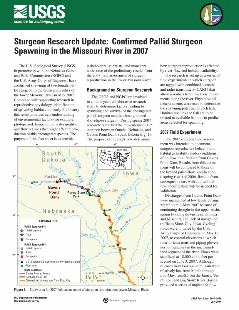
in a multi-year, collaborative research study to determine factors leading to spawning and survival of the endangered pallid sturgeon and the closely related shovelnose sturgeon. During spring 2007 researchers tracked the movements of 195 sturgeon between Omaha, Nebraska, and Gavins Point Dam, South Dakota (fig. 1). The purpose of the study is to determine
how sturgeon reproduction is affected by river flow and habitat availability.
The research is set up as a series of field experiments in which sturgeon are tagged with combined acoustic and radio transmitters (CART) that allow scientists to follow their move-ments along the river. Physiological measurements were used to determine the spawning potential of each fish. Habitats used by the fish are to be related to available habitats to predict areas selected for spawning.
2007 Field ExperimentThe 2007 sturgeon field assess-
ment was intended to document sturgeon reproductive behavior and habitat availability under conditions of no flow modification from Gavins Point Dam. Results from this assess-ment will be compared to those of the limited pulse-flow modification (“spring rise”) of 2006. Results from subsequent years with and without flow modification will be needed for validation.
Discharges from Gavins Point Dam were maintained at low levels during March to mid-May 2007 because of continuing drought in the upper basin, spring flooding downstream in Iowa and Missouri, and lack of navigation traffic to Sioux City, Iowa. Cycling flows were initiated by the U.S. Army Corps of Engineers on May 18, 2007, to control elevations at which interior least terns and piping plovers nest on sandbars in the unchannel-ized segment of the river. Flows were stabilized at 18,000 cubic feet per second on June 3, 2007. Although releases from Gavins Point Dam were relatively low from March through mid-May, runoff from the James, Ver-million, and Big Sioux River Basins provided a series of unplanned flow
Printed on recycled paper
Figure 1. Study area for 2007 field assessment of sturgeon reproduction, Lower Missouri River.
")
")
")
Û
np
!.
!.
!.
!.
!.
!.
!.
#
#
#
#
!(
!(
!(
_̂_̂
_̂
N e b r a s k aN e b r a s k a
S o u t hD a k o t aS o u t hD a k o t a
I o w aI o w a
Omaha
Yankton
Sioux City
James River River
Vermillion
Big
Siou
xR
iver
Floyd
Rive
rLi
ttle
Siou
x River
Soldi
er
Boyer
Riv
er
Platte River
Rive
r
GavinsPointDam
650
850
550
600
700
750
800
96°97°98°
43°
42°
41°
Study area
²
#Ponca State
Park
EXPLANATION
Pallid Sturgeon 541
Pallid Sturgeon 561
River SegmentsGavins Point to PoncaPonca to Sioux CityChannelized downstream from Sioux City
_̂ Initial capture
_̂ Apex
_̂ Recapture
!( Initial capture
!( Apex
!( Recapture
# U.S. Geological Survey streamflow-gaging station
!. River mile
0
0 10
10
20
20 MILES
40 KILOMETERS
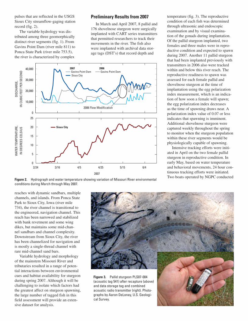
pulses that are reflected in the USGS Sioux City streamflow-gaging station record (fig. 2).
The variable hydrology was dis-tributed among three geomorphically distinct river segments (fig. 1). From Gavins Point Dam (river mile 811) to Ponca State Park (river mile 753.5), the river is characterized by complex
reaches with dynamic sandbars, multiple channels, and islands. From Ponca State Park to Sioux City, Iowa (river mile 734), the river channel is transitional to the engineered, navigation channel. This reach has been narrowed and stabilized with bank revetment and some wing dikes, but maintains some mid-chan-nel sandbars and channel complexity. Downstream from Sioux City, the river has been channelized for navigation and is mostly a single-thread channel with rare mid-channel sand bars.
Variable hydrology and morphology of the mainstem Missouri River and tributaries resulted in a range of poten-tial interactions between environmental cues and habitat availability for sturgeon during spring 2007. Although it will be challenging to isolate which factors had the greatest affect on sturgeon spawning, the large number of tagged fish in this field assessment will provide an exten-sive dataset for analysis.
Preliminary Results from 2007In March and April 2007, 8 pallid and
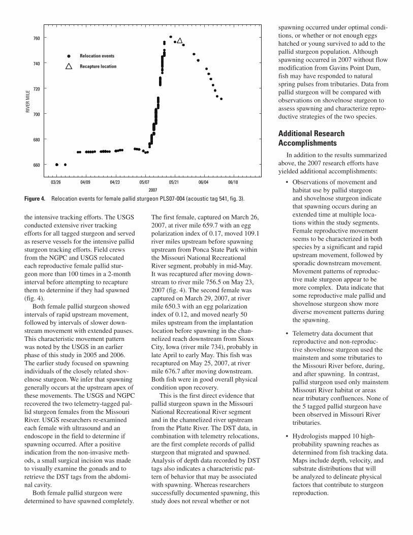
176 shovelnose sturgeon were surgically implanted with CART series transmitters that permitted researchers to track their movements in the river. The fish also were implanted with archival data stor-age tags (DST’s) that record depth and
temperature (fig. 3). The reproductive condition of each fish was determined through ultrasonic and endoscopic examination and by visual examina-tion of the gonads during implantation. Of the pallid sturgeon implanted, two females and three males were in repro-ductive condition and expected to spawn during 2007. Another 11 pallid sturgeon that had been implanted previously with transmitters in 2006 also were tracked within and below this river reach. The reproductive readiness to spawn was assessed for each female pallid and shovelnose sturgeon at the time of implantation using the egg polarization index measurement, which is an indica-tion of how soon a female will spawn; the egg polarization index decreases as the time of spawning draws near. A polarization index value of 0.07 or less indicates that spawning is imminent. Additional shovelnose sturgeon were captured weekly throughout the spring to monitor when the sturgeon population within these river segments would be physiologically capable of spawning.
Intensive tracking efforts were initi-ated in April on the two female pallid sturgeon in reproductive condition. In early May, based on water temperature and behavioral movements, 24 hour con-tinuous tracking efforts were initiated. Two boats operated by NGPC conducted
40,000
30,000
20,000
10,000
0
2/24
DISC
HARG
E,IN
CUB
IC F
EET
PER
SECO
ND
WAT
ER T
EMPE
RATU
RE,
IN D
EGRE
ES C
ELSI
US
3/16 4/5 4/25 5/15 6/4
2007 Gavins Point Dam
Sioux City
2006 Gavins Point Dam
25
20
15
10
5
0
2006 Flow Modification
2007
Sioux City
Figure 2. Hydrograph and water temperature showing variation of Missouri River environmental conditions during March through May 2007.
Figure 3. Pallid sturgeon PLS07-004 (acoustic tag 541) after recapture (above) and data storage tag and combined acoustic radio transmitter (right). Photo-graphs by Aaron DeLonay, U.S. Geologi-cal Survey.
the intensive tracking efforts. The USGS conducted extensive river tracking efforts for all tagged sturgeon and served as reserve vessels for the intensive pallid sturgeon tracking efforts. Field crews from the NGPC and USGS relocated each reproductive female pallid stur-geon more than 100 times in a 2-month interval before attempting to recapture them to determine if they had spawned (fig. 4).
Both female pallid sturgeon showed intervals of rapid upstream movement, followed by intervals of slower down-stream movement with extended pauses. This characteristic movement pattern was noted by the USGS in an earlier phase of this study in 2005 and 2006. The earlier study focused on spawning individuals of the closely related shov-elnose sturgeon. We infer that spawning generally occurs at the upstream apex of these movements. The USGS and NGPC recovered the two telemetry-tagged pal-lid sturgeon females from the Missouri River. USGS researchers re-examined each female with ultrasound and an endoscope in the field to determine if spawning occurred. After a positive indication from the non-invasive meth-ods, a small surgical incision was made to visually examine the gonads and to retrieve the DST tags from the abdomi-nal cavity.
Both female pallid sturgeon were determined to have spawned completely.
The first female, captured on March 26, 2007, at river mile 659.7 with an egg polarization index of 0.17, moved 109.1 river miles upstream before spawning upstream from Ponca State Park within the Missouri National Recreational River segment, probably in mid-May. It was recaptured after moving down-stream to river mile 756.5 on May 23, 2007 (fig. 4). The second female was captured on March 29, 2007, at river mile 650.3 with an egg polarization index of 0.12, and moved nearly 50 miles upstream from the implantation location before spawning in the chan-nelized reach downstream from Sioux City, Iowa (river mile 734), probably in late April to early May. This fish was recaptured on May 25, 2007, at river mile 676.7 after moving downstream. Both fish were in good overall physical condition upon recovery.
This is the first direct evidence that pallid sturgeon spawn in the Missouri National Recreational River segment and in the channelized river upstream from the Platte River. The DST data, in combination with telemetry relocations, are the first complete records of pallid sturgeon that migrated and spawned. Analysis of depth data recorded by DST tags also indicates a characteristic pat-tern of behavior that may be associated with spawning. Whereas researchers successfully documented spawning, this study does not reveal whether or not
spawning occurred under optimal condi-tions, or whether or not enough eggs hatched or young survived to add to the pallid sturgeon population. Although spawning occurred in 2007 without flow modification from Gavins Point Dam, fish may have responded to natural spring pulses from tributaries. Data from pallid sturgeon will be compared with observations on shovelnose sturgeon to assess spawning and characterize repro-ductive strategies of the two species.
Additional Research Accomplishments
In addition to the results summarized above, the 2007 research efforts have yielded additional accomplishments:
• Observations of movement and habitat use by pallid sturgeon and shovelnose sturgeon indicate that spawning occurs during an extended time at multiple loca-tions within the study segments. Female reproductive movement seems to be characterized in both species by a significant and rapid upstream movement, followed by sporadic downstream movement. Movement patterns of reproduc-tive male sturgeon appear to be more complex. Data indicate that some reproductive male pallid and shovelnose sturgeon show more diverse movement patterns during the spawning.
• Telemetry data document that reproductive and non-reproduc-tive shovelnose sturgeon used the mainstem and some tributaries to the Missouri River before, during, and after spawning. In contrast, pallid sturgeon used only mainstem Missouri River habitat or areas near tributary confluences. None of the 5 tagged pallid sturgeon have been observed in Missouri River tributaries.
• Hydrologists mapped 10 high-probability spawning reaches as determined from fish tracking data. Maps include depth, velocity, and substrate distributions that will be analyzed to delineate physical factors that contribute to sturgeon reproduction.
Figure 4. Relocation events for female pallid sturgeon PLS07-004 (acoustic tag 541, fig. 3).2007
03/26 04/09 04/23 05/07 05/21 06/04 06/18
660
680
700
720
740
760
Relocation events
Recapture location
RIVE
R M
ILE
• Water-quality monitors at multiple USGS streamflow-gaging stations along the river recorded changes in temperature, pH, turbidity, and dis-solved oxygen as they varied with discharge. These water-quality changes will be analyzed to assess their roles as cues in spawning behavior.
• Research biologists with the USGS and the South Dakota Game, Fish, and Parks have been sampling the Missouri River area below Gavins Point Dam for eggs and larval sturgeon using fine meshed nets. Once these samples are analyzed, additional verification may be obtained that sturgeon spawned and eggs hatched in that area.
Michael Mac, Director U.S. Geological Survey Columbia Environmental Research Center 4200 New Haven Road Columbia, Missouri 65201 Phone: 573-876-1900 Email: [email protected]
Gerald Mestl Nebraska Game and Parks Commission2200 North 33rd StreetLincoln, Nebraska 68503Phone: 402-471-1512Email: [email protected]
For more information contact:
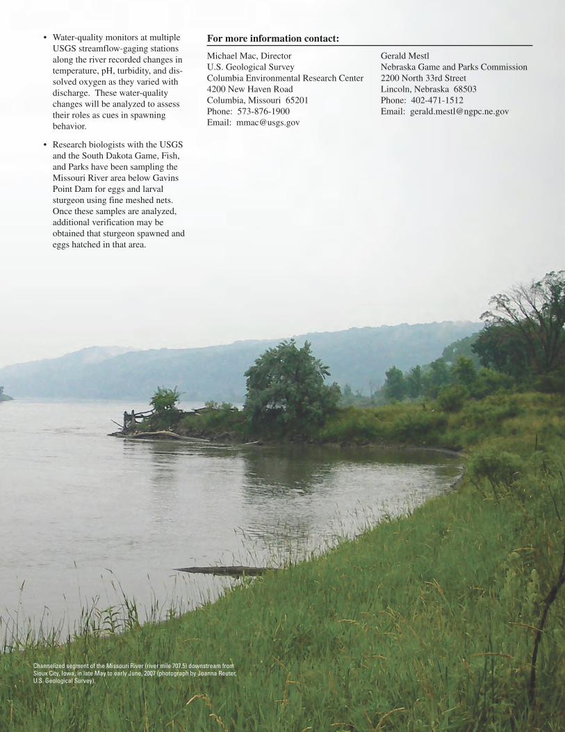
Channelized segment of the Missouri River (river mile 707.5) downstream from Sioux City, Iowa, in late May to early June, 2007 (photograph by Joanna Reuter,U.S. Geological Survey).