Study of blind thrust faults underlying Tokyo and Osaka ...
16
Key words blind thrust – fault-related fold – flexure – high-resolution seismic reflection profiling – continuous coring Study of blind thrust faults underlying Tokyo and Osaka urban areas using a combination of high-resolution seismic reflection profiling and continuous coring Yuichi Sugiyama ( 1 ), Kiyohide Mizuno ( 2 ), Futoshi Nanayama ( 1 ), Toshihiko Sugai ( 3 ), Hiroshi Yokota ( 4 ), Takashi Hosoya ( 5 ), Kenichiro Miura ( 6 ), Keiji Takemura ( 7 ) and Naoko Kitada ( 8 ) ( 1 ) Active Fault Research Center, Geological Survey of Japan, National Institute of Advanced Industrial Science and Technology, Tsukuba, Japan ( 2 ) Active Fault Research Center, Geological Survey of Japan, National Institute of Advanced Industrial Science and Technology, Osaka, Japan ( 3 ) Department of Natural Environmental Studies, University of Tokyo, Japan ( 4 ) Hanshin Consultants Co. Ltd., Osaka, Japan ( 5 ) Chuo Kaihatsu Corporation, Tokyo, Japan ( 6 ) Kiso-jiban Consultants Co. Ltd., Chiba, Japan ( 7 ) Institute for Geothermal Sciences, Kyoto University, Beppu, Japan ( 8 ) Geo-Research Institute, Osaka, Japan Abstract We acquired high-resolution seismic reflection profiles and continuously cored boreholes to evaluate active flex- ures produced by major blind thrust fault systems within two densely populated Neogene-Quaternary sedimen- tary basins in Japan: the Fukaya Fault System near Tokyo in the Kanto Basin and the Uemachi Fault System in the Osaka Basin. The high-resolution seismic reflection survey made clear the length, geometry and growth his- tory of fault-related folds, or flexures formed above the two blind thrusts. Continuously cored boreholes linked with high-resolution seismic profiles enabled us to estimate the uplift rate as defined by shallow stratigraphic horizons and constrain the age of the most recent growth of the flexures during earthquakes on the Fukaya and Uemachi fault systems. Even with the high quality of the data we collected, it is still not possible to exactly con- strain the age of the most recent blind thrust earthquake recorded by flexure of these fault-related folds. Data presented in this paper form the basis for future efforts aimed at mechanical and kinematic models for fault growth to evaluate the activity of blind thrusts underlying urban areas. 1. Introduction In Japan several Neogene-Quaternary sedi- mentary basins have developed in close associ- ation with active faults along their margins. As the basins are composed of Plio-Pleistocene de- posits more than one thousand meters thick, some of the active faults do not appear at the surface, but are expressed at the surface as a flex- 1071 ANNALS OF GEOPHYSICS, VOL. 46, N. 5, October 2003 Mailing address: Dr. Yuichi Sugiyama, Active Fault Research Center, Geological Survey of Japan, National Institute of Advanced Industrial Science and Techno- logy, Higashi 1-1-1, Tsukuba, 305-8567, Japan; e-mail: [email protected]
Transcript of Study of blind thrust faults underlying Tokyo and Osaka ...

Key words blind thrust – fault-related fold – flexure –high-resolution seismic reflection profiling – continuouscoring
Study of blind thrust faults underlying Tokyo and Osaka urban areas using
a combination of high-resolution seismicreflection profiling and continuous coring
Yuichi Sugiyama (1), Kiyohide Mizuno (2), Futoshi Nanayama (1),Toshihiko Sugai (3), Hiroshi Yokota (4), Takashi Hosoya (5), Kenichiro Miura (6),
Keiji Takemura (7) and Naoko Kitada (8)(1) Active Fault Research Center, Geological Survey of Japan, National Institute of Advanced Industrial
Science and Technology, Tsukuba, Japan(2) Active Fault Research Center, Geological Survey of Japan, National Institute of Advanced Industrial
Science and Technology, Osaka, Japan(3) Department of Natural Environmental Studies, University of Tokyo, Japan
(4) Hanshin Consultants Co. Ltd., Osaka, Japan(5) Chuo Kaihatsu Corporation, Tokyo, Japan
(6) Kiso-jiban Consultants Co. Ltd., Chiba, Japan(7) Institute for Geothermal Sciences, Kyoto University, Beppu, Japan
(8) Geo-Research Institute, Osaka, Japan
AbstractWe acquired high-resolution seismic reflection profiles and continuously cored boreholes to evaluate active flex-ures produced by major blind thrust fault systems within two densely populated Neogene-Quaternary sedimen-tary basins in Japan: the Fukaya Fault System near Tokyo in the Kanto Basin and the Uemachi Fault System inthe Osaka Basin. The high-resolution seismic reflection survey made clear the length, geometry and growth his-tory of fault-related folds, or flexures formed above the two blind thrusts. Continuously cored boreholes linkedwith high-resolution seismic profiles enabled us to estimate the uplift rate as defined by shallow stratigraphichorizons and constrain the age of the most recent growth of the flexures during earthquakes on the Fukaya andUemachi fault systems. Even with the high quality of the data we collected, it is still not possible to exactly con-strain the age of the most recent blind thrust earthquake recorded by flexure of these fault-related folds. Datapresented in this paper form the basis for future efforts aimed at mechanical and kinematic models for faultgrowth to evaluate the activity of blind thrusts underlying urban areas.
1. Introduction
In Japan several Neogene-Quaternary sedi-mentary basins have developed in close associ-ation with active faults along their margins. Asthe basins are composed of Plio-Pleistocene de-posits more than one thousand meters thick,some of the active faults do not appear at thesurface, but are expressed at the surface as a flex-
1071
ANNALS OF GEOPHYSICS, VOL. 46, N. 5, October 2003
Mailing address: Dr. Yuichi Sugiyama, Active FaultResearch Center, Geological Survey of Japan, National Institute of Advanced Industrial Science and Techno-logy, Higashi 1-1-1, Tsukuba, 305-8567, Japan; e-mail:[email protected]
ure or monocline usually one to several hundredmeters wide. These flexures are commonly con-cealed beneath young Holocene deposits and showno geomorphic expression. High-resolution sei-smic reflection profiling is useful for studying thistype of active blind fault with no topographic ex-pression but with a wide subsurface deformationzone.
Continuously cored boreholes coupled withhigh-resolution seismic reflection profiles areespecially useful for obtaining data on fault acti-vity such as uplift rate. We applied this combina-tion of methods to flexures that have grown inresponse to repeated earthquakes of two majorblind thrust fault systems in the densely popula-ted Kanto and Osaka basins, Japan.
2. Fukaya Fault System in the Kanto Basin
2.1. Kanto Basin
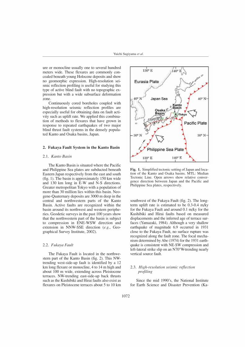
The Kanto Basin is situated where the Pacificand Philippine Sea plates are subducted beneathEastern Japan respectively from the east and south(fig. 1). The basin is approximately 150 km wideand 130 km long in E-W and N-S directions.Greater metropolitan Tokyo with a population ofmore than 30 million lies within this basin. Neo-gene-Quaternary deposits are 3000 m deep in thecentral and northwestern parts of the KantoBasin. Active faults are recognized within thebasin around its northwest and western periphe-ries. Geodetic surveys in the past 100 years showthat the northwestern part of the basin is subjectto compression in ENE-WSW direction andextension in NNW-SSE direction (e.g., Geo-graphical Survey Institute, 2002).
2.2. Fukaya Fault
The Fukaya Fault is located in the northwe-stern part of the Kanto Basin (fig. 2). This NW-trending west-side-up fault is identified by a 12km long flexure or monocline, 4 to 14 m high andabout 100 m wide, extending across Pleistoceneterraces. NW-trending east-side-up back thrustssuch as the Kushibiki and Hirai faults also exist asflexures on Pleistocene terraces about 5 to 10 km
southwest of the Fukaya Fault (fig. 2). The long-term uplift rate is estimated to be 0.3-0.4 m/ky for the Fukaya Fault and around 0.1 m/ky for theKushibiki and Hirai faults based on measured displacements and the inferred age of terrace sur-faces (Yamazaki, 1984). Although a very shallowearthquake of magnitude 6.9 occurred in 1931close to the Fukaya Fault, no surface rupture wasrecognized along the fault zone. The focal mecha-nism determined by Abe (1974) for the 1931 earth-quake is consistent with NE-SW compression andleft-lateral strike slip on an N70°W-trending nearlyvertical source fault.
2.3. High-resolution seismic reflection profiling
Since the mid 1990’s, the National Institutefor Earth Science and Disaster Prevention (Ka-
1072
Yuichi Sugiyama et al.
Fig. 1. Simplified tectonic setting of Japan and loca-tion of the Kanto and Osaka basins. MTL: MedianTectonic Line. Open arrows show relative conver-gence direction between Japan and the Pacific andPhilippine Sea plates, respectively.

sahara et al., 1993; Kasahara, 1996) and theGeological Survey of Japan (Yamaguchi et al.,1996, 1998, 2000) have carried out comprehensi-ve seismic reflection surveys to reveal the sub-surface structure of the Kanto Basin (fig. 2). Sai-tama Prefecture (1996, 1999) also undertookacquisition of seismic reflection profiles to evalua-
te the Fukaya Fault and its southeastern extensionin the Omiya terraces (fig. 2). These studies revea-led that the Fukaya Fault extends for about 35 kmsoutheastwards as a blind thrust and is expressed in the shallow subsurface as a fault-related fold. No clear evidence was obtained, however, for itsextension towards the northwest except for indi-
1073
Study of blind thrust faults underlying Tokyo and Osaka urban areas
Fig. 2. Simplified geologic map of the central to northwestern part of the Kanto Basin. Simplified from Su-giyama et al. (1997). The basin is bounded by the Kanto and Ashio mountains on the west and north, respecti-vely. Seismic reflection surveys shown by numbered survey lines were conducted by the following authors:1 - Saitama Prefecture (1999); 2 - Yamaguchi et al. (1996); 3 - Yamaguchi et al. (2000); 4 - Ikawa et al. (1998);5 - Inazaki et al. (1988); 6 - Yamaguchi et al. (1998); 7 - Kasahara (1996); 8 - Saitama Prefecture (1996); 9 - Kasahara et al. (1993).

rect geomorphic evidence such as lineamentsalong the mountain foots.
We conducted high-resolution P-wave seis-mic reflection surveys in the suburbs of Taka-saki (fig. 2) to confirm whether the FukayaFault extended to the northwest. We acquired P-wave seismic profiles on 3 lines shown in fig. 2:Kaburagawa line (1700 m long), Negoya line(800 m long), and Satomi line (2150 m long).An oil hydraulic impactor was used as a seismicsource, and both the shot points and receivingpoints were set at 5 m intervals for all the threelines. Main parameters for the seismic reflec-tion survey are shown in table I.
Figures 3, 4 and 5 show depth-converted sei-smic reflection profiles of each survey line. Aflexure or fault-related fold is clearly imaged oneach profile. A concealed flexure in the Kabu-ragawa profile illustrates detailed stratigraphic
1074
Yuichi Sugiyama et al.
Table I. Main parameters for the seismic reflection sur-vey of the Fukaya Fault System.
Seismic Source Impactor (JMI-200)Shot point interval 5 mStandard times of shot at each shot point 10Receiver 6-geophone arrayNatural frequency 30 HzReceiving point interval 5 mStandard receiving channels 120Spread End-onMaximum offest 600 mStandard CMP fold 60CMP interval 2.5 mRecording system G DAPS-4Record lenght 2 sSampling interval 1 ms
Fig. 3. Depth-converted seismic reflection profile for the Kaburagawa line to the south of Takasaki (verticalexaggeration × 2). See fig. 2 for the location of the survey line.

growth architecture and cumulative deforma-tion of the reflectors (fig. 3). The Negoya profi-le (fig. 4) is characterized by a kink fold with ahinge line dipping 50 to 60 degrees to the south-west. An angular unconformity is also clearlyimaged in shallow strata (around 30 to 50 mbelow sea level) in the northeastern half of theprofile. Although the Satomi profile (fig. 5) israther low in resolution due to high traffic noiselevel in the study area, it extends across the enti-re monocline, which is around 600 m in width.
These results show that the Fukaya Fault ex-tends for about 80 km in an N60°W direction,and forms a fault system, the Fukaya Fault Sys-tem, which is composed of several left-steppingen échelon faults.
2.4. Continuously cored boring
2.4.1. 145 m long boring
We collected a 145 m long core (GS-TK1)from the downthrown side of the FukayaFault System in the Takasaki area. The bore-hole was located close to the CMP (CommonMid Point) number 65 of the Negoya seismicline (fig. 4). We identified two tephras namedTE 5 (ca. 400 ka) and Ks 5 (ca. 450 ka),which are widespread in Central and WesternJapan, at a depth of 70 m (+ 7.5 m in altitude)and 103 m (– 25.5 m in altitude), respectively(Sugai et al., 2000). The TE 5 tephra alsocrops out on the hillside at about 90 to 96 m
1075
Study of blind thrust faults underlying Tokyo and Osaka urban areas
Fig. 4. Depth-converted seismic reflection profile for the Negoya line in Takasaki city (no vertical exaggera-tion). Both the location of borehole array and tephras recognized by 145 m deep boring and field survey are alsoprojected. See fig. 2 for the location of the survey line.
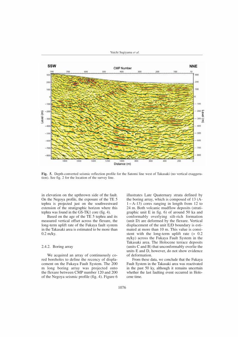
in elevation on the upthrown side of the fault.On the Negoya profile, the exposure of the TE 5tephra is projected just on the southwestwardextension of the stratigraphic horizon where thistephra was found in the GS-TK1 core (fig. 4).
Based on the age of the TE 5 tephra and its measured vertical offset across the flexure, thelong-term uplift rate of the Fukaya fault systemin the Takasaki area is estimated to be more than0.2 m/ky.
2.4.2. Boring array
We acquired an array of continuously co-red boreholes to define the recency of displa-cement on the Fukaya Fault System. The 200m long boring array was projected onto the flexure between CMP number 120 and 200of the Negoya seismic profile (fig. 4). Figure 6
illustrates Late Quaternary strata defined bythe boring array, which is composed of 13 (A-1. .A-13) cores ranging in length from 12 to24 m. Both volcanic mudflow deposits (strati-graphic unit E in fig. 6) of around 50 ka andconformably overlying silt-rich formation(unit D) are deformed by the flexure. Verticaldisplacement of the unit E/D boundary is esti-mated at more than 10 m. This value is consi-stent with the long-term uplift rate (> 0.2m/ky) across the Fukaya Fault System in theTakasaki area. The Holocene terrace deposits(units C and B) that unconformably overlie theunits E and D, however, do not show evidenceof deformation.
From these data, we conclude that the FukayaFault System in the Takasaki area was reactivatedin the past 50 ky, although it remains uncertainwhether the last faulting event occurred in Holo-cene time.
1076
Yuichi Sugiyama et al.
Fig. 5. Depth-converted seismic reflection profile for the Satomi line west of Takasaki (no vertical exaggera-tion). See fig. 2 for the location of the survey line.

3. Uemachi Fault System in the Osaka Basin
3.1. Osaka Basin
The Osaka Basin is situated in the eastern-most part of the Seto Inland Sea immediate northof the E-W-striking Median Tectonic Line (MTL),which is here an active right-lateral fault system(figs. 1 and 7). The central and western parts ofthe basin are occupied by Osaka Bay (fig. 7).The northwestern margin of Osaka Bay is boun-ded by active faults extending from Awaji Islandto the foot of the Rokko Mountains on the islandof Honshu. The 1995 Kobe earthquake with over
6000 fatalities occurred on NE-striking faults inthis region. The eastern onshore region of thebasin is divided into the Kawachi Plain andcoastal lowland by the N-S-trending UemachiFault System and adjoining Pleistocene Uema-chi terrace. The Osaka metropolitan area with apopulation of more than 10 million is containedin the Eastern Osaka Basin. The basin is infilledwith over 1000 m of Plio-Pleistocene deposits.Earthquake focal mechanisms, the strike ofcompressive folds and results of geodetic sur-veys indicate that the Osaka Basin is being acti-vely shortened in an E-W to WNW-ESE direc-tion.
1077
Fig. 6. Correlation of continuously cored boreholes within the flexure zone of the Fukaya Fault System in theTakasaki area. See fig. 4 for the projected location of the survey area. 5 stratigraphic units A-E are recognized,and each unit except for the unit E is divided into several subunits. After Mizuno et al. (2001).
Study of blind thrust faults underlying Tokyo and Osaka urban areas
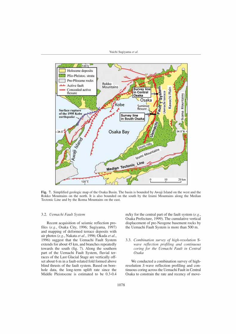
3.2. Uemachi Fault System
Recent acquisition of seismic reflection pro-files (e.g., Osaka City, 1996; Sugiyama, 1997)and mapping of deformed terrace deposits withair photos (e.g., Nakata et al., 1996; Okada et al.,1996) suggest that the Uemachi Fault Systemextends for about 45 km, and branches repeatedlytowards the south (fig. 7). Along the southernpart of the Uemachi Fault System, fluvial ter-races of the Last Glacial Stage are vertically off-set about 6 m in a fault-related fold formed aboveblind thrusts of the fault system. Based on bore-hole data, the long-term uplift rate since theMiddle Pleistocene is estimated to be 0.3-0.4
m/ky for the central part of the fault system (e.g.,Osaka Prefecture, 1999). The cumulative verticaldisplacement of pre-Neogene basement rocks bythe Uemachi Fault System is more than 500 m.
3.3. Combination survey of high-resolution S-wave reflection profiling and continuouscoring for the Uemachi Fault in CentralOsaka
We conducted a combination survey of high-resolution S-wave reflection profiling and con-tinuous coring across the Uemachi Fault in CentralOsaka to constrain the rate and recency of move-
1078
Yuichi Sugiyama et al.
Fig. 7. Simplified geologic map of the Osaka Basin. The basin is bounded by Awaji Island on the west and theRokko Mountains on the north. It is also bounded on the south by the Izumi Mountains along the MedianTectonic Line and by the Ikoma Mountains on the east.

Table II. Main parameters for the seismic reflection surveys of the Uemachi Fault System.
Survey area Central Osaka South Osaka South OsakaSurvey line length 790 m 4300 m 310 mApplied seismic wave S-wave P-wave S-waveSeismic source Plate hitter Mini vibrator Plate hitterShot point interval 1 m 10 m 1 mStandard times of shot at each shot point 15 20 10 15 40 60Receiver 3-geophone array 9-geophone array 3-geophone array Natural frequency 30 Hz 27 Hz 30 HzReceiving point interval 1 m 10 m 1 mStandard receiving channels 120 70 100Spread End-on Off-end End-onMaximum offset 120 m 730 m 100 mStandard CMP fold 60 35 50CMP interval 0.5 m 5 m 0.5 mRecording system G DAPS-4 Strata view 60 G DAPS-4Record length 2 s 2 s 1.5 sSampling interval 1 ms 1 ms 1 ms
Fig. 8. Depth-converted S-wave reflection profile of the Uemachi Fault in Central Osaka (vertical exaggeration × 3).See fig. 7 for the location of the survey line. Reflection surfaces X and X are correlative to the base of the HoloceneNanba Formation on the upthrown and downthrown sides of the fault, respectively. Reflection surface Y is probablycorrelated to the base of the Tenma Formation on the upthrown side, and Y is supposed to be the equivalent horizonon the downthrown side. Locations of three continuously cored boreholes are also shown on the profile.
Study of blind thrust faults underlying Tokyo and Osaka urban areas
1079

ment along it in Holocene time. A 790 m long sur-vey line was located along the north bank of theShin-Yodo River, where the Uemachi Fault hadbeen previously identified by a P-wave seismicreflection profile (Yamamoto et al., 1992). Acqui-
sition and processing parameters for the S-wavereflection survey are shown in table II.
The Uemachi Fault is clearly imaged as a flex-ure, or fault-related fault (fig. 8). A sharp angularunconformity shown by reflection surface Y was
1080
Yuichi Sugiyama et al.
Fig. 9. Summarized stratigraphic correlation between boreholes 1, 2 and 3. The elevation of the three boreho-le sites is 2.5 m above the sea level. See fig. 8 for the location of each boring site. A clay bed intercalated at thedepth of 33 m of borehole 3 is correlated to the Tenma Formation because it yields a pollen assemblage of thefirst half of the Last Glacial Stage. After Miura et al. (2002).

1081
Study of blind thrust faults underlying Tokyo and Osaka urban areas
Fig. 10. Depth-converted P-wave seismic reflection profile across the Suminoe and Oriono flexures in southOsaka (vertical exaggeration × 2). See fig. 7 for the location of the survey line. Locations of S-wave reflectionsurvey line and six boring sites are also shown on the profile.
horizons in the three boreholes is of sedimentary o-rigin, and that unit Sy-3 is not deformed by the fle-xure. Correlative horizons in units Sy-4 and Sy-5were identified at nearly the same level betweenboreholes 1 and 2, while they show gradual upwarddecrease in height difference between boreholes 2and 3 across the flexure. This gradual upward de-crease in height difference across the flexureimplies burial of a flexure scarp formed by a faul-ting event. Therefore we can point out a possibilitythat the latest faulting event occurred either aroundhorizon C, or during the deposition of the underlying lower part of subunit Sy-5, although the exact stratigraphic horizon of the latest event is notknown because of the lack of correlative horizonswithin this subunit.
Based on the above seismic and boring surveyresults, we conclude that the most recent displace-ment of the blind Uemachi Fault occurred betweenabout 9.5 ka and 25 ka, after deposition of theTenma Formation, and before deposition of thestratigraphic unit Sy-4. The vertical surface displa-cement associated with the last faulting eventmight attain 3 m, assuming that the height diffe-
imaged in the eastern (right) part of the profile.Based on boring data, this unconformity is correla-ted with the boundary between the Uemachi For-mation of the Last Interglacial Stage and the over-lying Tenma Formation dated as ca. 50 to 25 ka.Although the flexure deformation is interpreted toreach the lower part of Holocene deposits (NanbaFormation), it is difficult to constrain the timing ofthe last faulting event only by the seismic reflectionresults.
We therefore acquired three continuous cores,all about 40 m long, from the downthrown side,the flexure foot, and the upthrown side (fig. 8).More than 15 correlative horizons were recogni-zed in these cores by detailed analysis of sedi-mentary facies, pollen and volcanic ash as well asmeasurement of physical properties such as elec-tric conductivity, pH, and magnetic susceptibility.
Correlation of shallow deposits (fig. 9) showsthat the vertical separation of correlative horizonsin the stratigraphic unit Sy-3 between boreholes 1and 2 is nearly the same as that between boreholes2 and 3 across the flexure. This result suggests thatthe difference in height between these correlative

Yuichi Sugiyama et al.
rence of horizon C between boreholes 2 and 3directly reflects the flexure deformation during thelast faulting event. From the minimum elapsedtime of 9.5 ky since the last faulting event andlong-term uplift rate of 0.3 - 0.4 m/ky, about 3 m ormore vertical surface displacement is expected forthe next faulting event. This value is comparable tothe above-discussed vertical displacement duringthe last event.
3.4. Combination survey of high-resolution seis-mic reflection profiling and continuously cor-ed borehole array for the Suminoe flexure in South Osaka
We also studied the Suminoe flexure, a ma-jor component of the southern part of the Uema-chi Fault System, using a combination of seismicreflection profiling (table II) and an array of con-
1082
Fig. 11. Correlation of continuously cored boreholes across the Suminoe flexure in South Osaka. See fig. 10for the location of each boring site. Modified from Nanayama et al. (2000a).

tinuously cored boreholes. We first acquired a4300 m long P-wave seismic reflection profile(fig. 10) across both the locally named Orionoflexure along the western hillside of the Ue-machi terrace and the Suminoe flexure, which is completely concealed beneath Holocene depo-sits in the coastal plain. The profile clearly ima-ged both the Oriono and Suminoe flexures astypical fault-propagation folds with compressivegrowth architecture (e.g., Suppe et al., 1992;Allmendinger, 1998). On the basis of the seismicprofile and existing borehole data, the long-termuplift rates of the Oriono and Suminoe flexureswere estimated to be 0.25 m/ky and 0.15 m/ky,respectively. In addition, Holocene depositsaround the Suminoe flexure were inferred to bemore than 15 m in thickness from existing bore-
hole data. Consequently we chose the Suminoeflexure as the target fault for clarifying the recentactivity by high-resolution S-wave seismicreflection profiling coupled with an array of con-tinuously cored boreholes.
We acquired a 310 m long S-wave reflectionprofile across the Suminoe flexure and obtainedsix continuous cores ranging in length from 21to 55 m. Correlation of Late Quaternary depo-sits among the six cores (fig. 11) is quite consi-stent with the P-wave and S-wave reflectionprofiles. The S-wave profile, coupled with thestratigraphy defined in the cores (fig. 12),shows that the stratigraphic unit Sm-4 uncon-formably overlies the tilted unit Sm-5, and on-laps the flexure scarp made up of the older unitSm-6. It is also clearly shown that unit Sm-4
1083
Study of blind thrust faults underlying Tokyo and Osaka urban areas
Fig. 12. Depth-converted S-wave seismic reflection profile across the Suminoe flexure combined with the boringsurvey result (vertical exaggeration × 4). See fig. 10 for the location of the survey line.

and overlying units are not involved in the de-formation.
Based on our interpretation of the S-waveprofile linked with the borehole array, we con-clude that the most recent activity of the Sumi-noe flexure occurred after deposition of unitSm-5 whose age is estimated at 70-50 ka basedon its pollen assemblage (Nanayama et al.,2001a), and before deposition of unit Sm-4dated as 15-10 ka. Nanayama et al. (2001b)estimated an average uplift rate of 0.2 m/ky forthe last 130 ky based on the assumption that the original depositional dip of the base of unitSm-7 is the same as that of the base of unit Sm-3. This uplift rate, together with the mini-mum elapsed time of 15 ky since the last faul-ting event, implies that 3 m of vertical displace-ment has been stored on the Suminoe flexure.
4. Concluding remarks – problemsand future research
Our work in the Kanto and Osaka basins hasdemonstrated the effectiveness of combiningacquisition and analysis of high-resolution sei-smic profiles and continuously cored boreholes toassess the paleoseismic record of blind thrustsunderlying densely populated and urbanizedareas. It is, however, still difficult to constrain theexact timing of the most recent faulting event onblind thrusts because they are expressed at thesurface as a wide deformation zone of flexure.This mainly stems from a difficulty in detectingdifferences between deformed layers and non-deformed beds, or differences between subtle tec-tonic tilting and primary depositional dip. Use ofa newly developed device termed a Geoslicer(Nakata and Shimazaki, 1997; Atwater et al.,2001) may improve paleoseismic records on blindthrusts by defining and dating liquefaction or sub-aqueous slides produced by paleoearthquakes.
We have focused on the slip rate as a targetfault parameter in our blind fault study. It pro-vides a basis for estimating moment releaserates and constraining future earthquakes onblind faults (e.g., Oskin et al., 2000). It also canbe coupled with structural models of fault-rela-ted fold growth (e.g., Schneider et al., 1996;
Cannon et al., 2001). Our estimates of slip ratesfor the Fukaya and Uemachi fault systems, how-ever, are based only upon data obtained fromthe subsurface several tens to several hundredsmeters deep. The slip rates in such a shallowpart might be smaller than those at depthswhere seismic energy is substantially released(e.g., Stein and King, 1984). The effect of com-paction on thickness of deposits also must betaken into consideration for estimating sliprates (e.g., Schneider et al., 1996). We need tomake further efforts to clarify the slip rate of thedeeper part of these fault systems for acquiringmore plausible earthquake scenarios for Tokyoand Osaka.
Acknowledgments
We thank Robert S. Yeats and Karl Muellerfor their helpful and constructive comments bywhich this paper was significantly improved.
REFERENCES
ABE, K. (1974): Seismic displacement and ground motion neara fault: the Saitama earthquake of September 21, 1931, J.Geophys. Res., 79, 4393-4399.
ALLMENDINGER, R.W. (1998): Inverse and forward numericalmodeling of trishear fault-propagation folds, Tectonics, 17,640-656.
ATWATER, B., D. BAKER, W. BARNHARDT, K. BURRELL, T. HARA-GUCHI, B. HIGMAN, R. KAYEN, D. MINASIAN, T. NAKATA,K. SATAKE, K. SHIMOKAWA, K. TAKADA and M. CISTER-NAS V. (2001): Grouted sediment slices show signs ofearthquake shaking, Eos, 82, 603-608.
CANNON, E., K. MUELLER, Y. SUGIYAMA and N. KITADA (2001):Coseismic growth of active fault-propagation folds byheterogeneous shear, Kansai Region, Japan, in Abstractsfor the AGU 2001 Fall Meeting (Supplement to Eos, 82, n.47), F1230.
GEOGRAPHICAL SURVEY INSTITUTE (2002): Information on Crus-tal Deformation in the Recent 10 and 100 Years, availablefrom http://cais.gsi.go.jp/HIZUMI/hizumi.html (in Japa-nese).
IKAWA, T., T. KAWANAKA, T. KOZAWA, T. ITOH, K. KASAHARA
and H. SATO (1998): Subsurface structure derived from theseismic reflection survey at northwestern part of KantoPlain, in Abstracts for the 1998 Japan Earth and PlanetaryScience Joint Meeting, SL-p013 (in Japanese).
INAZAKI, T., S. JIMBO, M. NAGASAWA, M. ABE, K. IKEDA and Y.SUGIMOTO (1988): Seismic reflection in the West Kuma-gaya, Saitama Prefecture, in Proceedings of the 78th Societyof Exploration Geophysicists of Japan Conference, 110-113(in Japanese with English abstract, table and figures).
1084
Yuichi Sugiyama et al.

KASAHARA, K. (1996): Vibroseis reflection survey, in Report onComprehensive Research on Enhancing Forecast Tech-niques for Earthquakes directly under the Tokyo Metro-politan Area (2nd stage), Science and Technology Agency,66-78 (in Japanese).
KASAHARA, K., F. YAMAMIZU, T. IKAWA and I. ADACHI (1993):Seismic reflection profiles across the Kanto Plain, in Ab-stracts for the 1993 Fall Meeting of the SeismologicalSociety of Japan, 262 (C86) (in Japanese).
MIURA, K., F. NANAYAMA, M. UCHIUMI, Y. SUGIYAMA, M.YASUHARA, Y. YOKOYAMA, N. KITADA and K. TAKEMURA
(2002): Holocene activity of the Uemachi Fault in theOsaka Plain evaluated by high-resolution analysis of theShin-Yodo-gawa array boring cores, Annual Report onActive Fault and Paleoearthquake Researches, 2, 109-123,Geological Survey of Japan (in Japanese with English ab-stract and figure captions).
MIZUNO, K., T. SUGAI, Y. SUGIYAMA, T. HOSOYA, H. KUROSAWA
and H. YOSHIDA (2001): Late Pleistocene to Holoceneactivity of the Fukaya Fault System in Gunma Prefecture,Tokyo megalopolis, revealed by arrayed boring, AnnualReport on Active Fault and Paleoearthquake Researches,1, 77-86, Geological Survey of Japan (in Japanese withEnglish abstract and figures).
NAKATA, T. and K. SHIMAZAKI (1997): Geo-slicer, a newlyinvented soil sample, for high-resolution active fault stu-dies, J. Geogr., 106, 59-69 (in Japanese with English ab-stract and captions for figures and photos).
NAKATA, T., A. OKADA, Y. SUZUKI, M. WATANABE AND Y. IKEDA
(1996): Osaka Seinanbu, Active Fault Map in UrbanArea, scale 1:25.000, Geographical Survey Institute (inJapanese).
NANAYAMA, F., Y. DOI, N. KITADA and K. TAKEMURA (2001a):Stratigraphic, sequence stratigraphic and sedimentary envi-ronment analyses on the Late Pleistocene-Holocene sedi-ments of the eastern side of Osaka Bay, Central Japan since130 ka, J. Geol. Soc. Japan, 107, 179-197 (in Japanesewith an English abstract).
NANAYAMA, F., Y. DOI, N. KITADA, K. TAKEMURA and Y.SUGIYAMA (2001b): Activity study of the Suminoe flexure,a branch of the Uemachi Fault System and estimated sealevel change during the past 10.000 years, in the WesternOsaka Plain, Central Japan, J. Geol. Soc. Japan, 107, 215-221 (in Japanese with an English abstract).
OKADA, A., N. CHIDA and T. NAKATA (1996): Kishiwada, ActiveFault Map in Urban Area, scale 1: 25.000, GeographicalSurvey Institute (in Japanese).
OSAKA CITY (1996): Study of the Uemachi Fault, in Abstractsfor the Conference on Nationally-Funded Active FaultStudy in 1995 and 1996 Fiscal Years, Science and Tech-nology Agency, 90-94 (in Japanese).
OSAKA PREFECTURE (1999): Report on the Study of the UemachiFault Zone (excerpts), pp. 39 (in Japanese).
OSKIN, M., K. SIEH, T. ROCKWELL, G. MILLER, P. GUPTILL, M.CURTIS, S. MCARDLE and P. ELLIOT (2000): Active parasit-ic folds on the Elysian Park anticline: implications for seis-
mic hazard in Central Los Angeles, California, GSA Bull.,112, 693-707.
SAITAMA PREFECTURE (1996): Report on the Study of the Ayase-gawa Fault, pp. 200 (in Japanese).
SAITAMA PREFECTURE (1999): Report on the Study of the FukayaFault, pp. 83 (in Japanese).
SCHNEIDER, C.L., C. HUMMON, R.S. YEATS and G.L. HUFTILE
(1996): Structural evolution of the Northern Los Angelesbasin, California, based on growth strata, Tectonics, 15,341-355.
STEIN, R.S. and G.C.P. KING (1984): Seismic potential revealedby surface folding: 1983 Coalinga, California, earthquake,Science, 224, 869-872.
SUGAI, T., K. MIZUNO and Y. SUGIYAMA (2000): Long-term acti-vity of the Fukaya Fault System at Takasaki, Gunma Pre-fecture, revealed by 145 m-deep core (GS-TK1) analysis,Interim Report on Active Fault and PaleoearthquakeResearches in the 1999 Fiscal Year, Geological Survey ofJapan , 61-76 (in Japanese with English abstract, tables andfigures).
SUGIYAMA, Y. (1997): Seismic reflection survey of the UemachiFault System, Geological Survey of Japan Open-fileReport, 303, 105-113 (in Japanese with English figures).
SUGIYAMA, Y., T. SUGAI, R. IMURA, K. MIZUNO, H. ENDO, K.SHIMOKAWA and H. YAMAZAKI (1997): Neotectonic MapTokyo (2nd edition), scale 1: 500.000, Geological Survey ofJapan (in Japanese with an English abstract).
SUPPE, J., G.T. CHOU and S.C. HOOK (1992): Rates of foldingand faulting determined from growth strata, in ThrustTectonics, edited by K.R. MCCLAY (Chapman & Hall,London), 105-121.
YAMAGUCHI, K., N. KANO, T. YOKOTA, T. YOKOKURA and T.KIGUCHI (1996): Seismic reflection survey in Kushibikiarea, Saitama Prefecture, Central Japan, Zisin (2nd ser.),49, 327-335 (in Japanese with English abstract, table andfigures).
YAMAGUCHI, K., T. YOKOKURA, N. KANO, T. KIGUCHI, Y.NAKASHIMA, T. OHTAKI and H. SATO (1998): Seismicreflection survey near the Yoshimi hill, Saitama Prefecturein Abstracts for the 1998 Fall Meeting of the SeismologicalSociety of Japan, A49 (in Japanese).
YAMAGUCHI, K., N. KANO, T. YOKOKURA, T. KIGUCHI, T.YOKOTA, A. TANAKA and H. SATO (2000): Seismic reflec-tion survey around the Fukaya fault - subsurface structurebetween the Konan terrace and the Menuma lowland-,Zisin (2nd ser.), 53, 115-125 (in Japanese with Englishabstract, tables and figures).
YAMAMOTO, E., K. NAKAGAWA, M. MITAMURA, S. TODA, T.NISHIDA, Y. TERADA, H. UDA and H. YOKOTA (1992):Seismic reflection method at the Central Osaka plain -Yodo River (Juso Kunijima) line-, in Proceedings for the1992 Meeting of the Japan Society of EngineeringGeology, 185-188 (in Japanese).
YAMAZAKI, H. (1984): On the relationship between active faultsand basin-forming movement, Geogr. Rept. TokyoMetropolitan Univ., 19, 67-78.
1085
Study of blind thrust faults underlying Tokyo and Osaka urban areas

l l l l l l


![KYOTO-OSAKA KYOTO KYOTO-OSAKA SIGHTSEEING PASS … · KYOTO-OSAKA SIGHTSEEING PASS < 1day > KYOTO-OSAKA SIGHTSEEING PASS [for Hirakata Park] KYOTO SIGHTSEEING PASS KYOTO-OSAKA](https://static.fdocuments.us/doc/165x107/5ed0f3d62a742537f26ea1f1/kyoto-osaka-kyoto-kyoto-osaka-sightseeing-pass-kyoto-osaka-sightseeing-pass-.jpg)