STUDENT INFORMATION RETRIEVAL USING GEOGRAPHICAL ...
24
STUDENT INFORMATION RETRIEVAL USING GEOGRAPHICAL INFORMATION SYSTEM: KUKTEM HOSTEL ROZIYAII BINTI ABDUL RAZAK A report submitted in partial fulfilment of the requirements for the award of the degree of Bachelor of Computer Science (Software Engineering) Faculty of Computer Science & Software Engineering University College of Engineering & Technology Malaysia NOVEMBER, 2006 PERPUSTAKMN KOLEJ UMVERSIT KEJURUTERAAN a TEKNOLOOJ MALAYSIA No, Pero!ehar, No. Panggn 21228 - ankh 31 JAN 2007
Transcript of STUDENT INFORMATION RETRIEVAL USING GEOGRAPHICAL ...

STUDENT INFORMATION RETRIEVAL USING GEOGRAPHICAL
INFORMATION SYSTEM: KUKTEM HOSTEL
ROZIYAII BINTI ABDUL RAZAK
A report submitted in partial fulfilment of the
requirements for the award of the degree of
Bachelor of Computer Science (Software Engineering)
Faculty of Computer Science & Software Engineering
University College of Engineering & Technology Malaysia
NOVEMBER, 2006
PERPUSTAKMN KOLEJ UMVERSIT
KEJURUTERAAN a TEKNOLOOJ MALAYSIA No, Pero!ehar, No. Panggn 21228 -
ankh
31 JAN 2007

ABSTRACT
An effective and faster data retrieval technique is important when dealing
among systems with large database. The existing Hostel Management System in
Students Affairs Department (HEP) of University College of Engineering and
Technology Malaysia (KUKTEM) involves thousands of student data. As a result,
the processing time of data retrieval becoming lengthy. This system also restricted
the administrator to detect student's location visually. In order to solve these flaws,
Student Information Retrieval using Geographical Information System (GIS) is
developed. This system focused on discovering student information based on their
ttident identification number and name by applying geographical location / map
Oncept. This new system provide functions zoom in, zoom out, panning, identify
and query builder in order to simplify the data manipulation by the administrator. By
applying the data visualization technique using GIS, the administrator can retrieve
data faster and in an interactive way.
iv
ABSTRAK
Pencarian makiumat yang cepat dan efektif adalah penting bagi system yang
melibatkan data yang besar. Sistem pegurusan asrama di Hal Ehwal Pelajar (HEP),
Kolej Universiti Kejuruteraan dan Teknologi Malaysia (KUKTEM) melibatkan
beribu data pelajar. Sistem mi mengambil masa yang lama bagi proses mendapatkan
makiumat pelajar di sebabkan data yang terlalu banyak. Sistem iiii juga tidak
mambenarkan pihak pengurusan untuk mendapatkan lokasi pelajar secara visual.
Bagi mengatasi masalah mi sistem Pencarian Makiumat Pelajar menggunakan Sistem
Makiumat Geografi (GIS) telah di bangunkan. Sistem mi memfokuskan kepada
pencarian maldumat pelajar menggunakan kedudukan geografi / peta berdasarkan
nombor pelajar. Sistem baru mi juga menyediakan fungsi - fungsi membesarkan dan
mengecilkan peta, panning, pengenalpastian data, query builder bagi memudahkan
pihak pengurusan memanipulasikan data yang ada. Penggunaan pemaparan data
secara Sistem Maldumat Geografi (GIS) dapat membantu pihak pengurusan
mendapatkan data dengan cepat dan lebih interaktif.
TABLES OF CONTENTS
CHAPTER
TITLE PAGE
DECLARATION
DEDICATION
ACKNOWLEDGEMENT
ABSTRACT iv
ABSRAK
TABLES OF CONTENTS vi
LIST OF TABLES x
LIST OF FIGURES xi
LIST OF ABBREVIATIONS xiii
LIST OF APPENDICES xiv
1
INTRODUCTION 1
1.1 Introduction 1
1.2 Problem Statement 2
1.3 Objectives of the System 3
1.4 Scope 3
2 LITERATURE REVIEW
2.1 Introduction 4
2.2 Geographical Information System (GIS) 4
2.2.1 Components of GIS 6
2.2.2 GIS Data Types 8
2.22.1 Vector Data 9
2.2.2.2 Raster Data 11
vi

vii
2.3 Advantages of GIS 13
2.4 GIS Applications 13
2.5 The Current System of Student Information Retrieval 15
2.6 Case Study of GIS Application 16
2.6.1 GIS Database of the Environmental Information 16
2.6.2 The Management System Development of Campus
Facility Information using Web-based GIS 17
2.7 GIS Software/Tools 19
2.7.1 ArcView3.1 20
2.7.2 Avenue Scripts 21
2.8 Hardware Requirements 22
2.9 Database Requirements 22
3 METHODOLOGY 23
3.1 Introduction 23
3.2 Planning Phase 23
3.3 Requirements Analysis Phase 24
3.4 Design Phase 24
3.4.1 Components of Student Information Retreival 25'
3.4.2 Database Design 26
3.4.2.1 Data Dictionary 26
3.4.3 Interface Design 30
3.5 Implementation Phase 31
3.5.1 Pre-Processing 33
3.5.2 Database Development 33
3.5.3 Interface Development 34
3.5.3.1 Find 36
3.5.3.2 Query Builder 37
3.5.3.3 Identify 38
3.5.3.4 HotLink 39
3.5.3.5 Zoom 40
3.5.3.6 Pan 42

viii
3.5.3.7 Clear Selected Features
42
3.6 Testing Phase
43
3.7 Maintenance Phase
43
3.8 Hardware and Software
44
3.8.1 Hardware Specification
44
3.8.2 Software Specification
45
4
RESULT AND DISCUSSION
46
4.1 Introduction
46
4.2 Testing Environment
46
4.3 Results for Student Information Retrieval using GIS
47
4.3.1 Hot Link Button
48
4.3.2 Find Button
49
4.3.3 Query Builder Button
51
4.3.4 Identify Button
52
4.3.5 Zoom Functionality
53
4.3.6 Pan Button
57
4.3.7 Clear Selected Features Button
59
4.4 Discussion
59
4.5 Weaknesses of the Student Information Retrieval
63
4.6 Advantages of Student Information Retrieval using GIS
63
4.7 Constraints 64
4.8 Lesson Learnt
65
4.8.1 Working under Pressure 65
4.8.2 Project Planning and Time Management
65
4.9 Assumption and Further Research
66
5
CONCLUSION
67
5.1 Conclusion 67
REFERENCES 69

ix
Appendix A
70
Appendix B
71
Appendix C
72
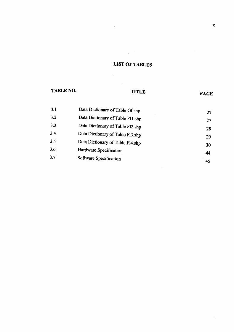
LIST OF TABLES
TABLE NO. TITLE PAGE
3.1 Data Dictionary of Table Gf.shp27
3.2 Data Dictionary of Table Fl1.shp27
3.3 Data Dictionary of Table F12.shp28
3.4 Data Dictionary of Table F13.shp 29 3.5 Data Dictionary of Table F14.shp
30 3.6 Hardware Specification
3.7 Software Specification45
x

LIST OF FIGURES
FIGURE NO. TITLE PAGE
2.1 GIS Components7
2.2 Vector data versus Raster data9
2.3 GIS Points10
2.4 GIS Lines10
2.5 GIS Polygons10
2.6 Cell - based raster data12
2.7 Imaged - based raster data12
2.8 Interface of the current system
2.9 The list of facility information15
19 2.10 The view of facility information
19 3.1 The three components Student Information Retrieval 25 3.2 Flow of the system implementation
32 3.3 The Interface for Geodatabase 3.4 The Find interface
34
3.5 The Algorithms of searching36
3.6 The Query Builder interface36
3.7 TheAlgorithin of quering data37
3.8The Algorithms of identity the place
37
3.9 The Picture Viewer of sub - interface38
3.10The Algorithms of viewing pictures
39
3.11 The Algorithms of Zoom In40
3.12The Algorithms of Zoom Out
40
3.13The Algorithms of Zoom to Full Extent
41
3.14The Algorithms of Zoom to Active Theme
41
3.15The Algorithms of Pan
41
42
xi
xli
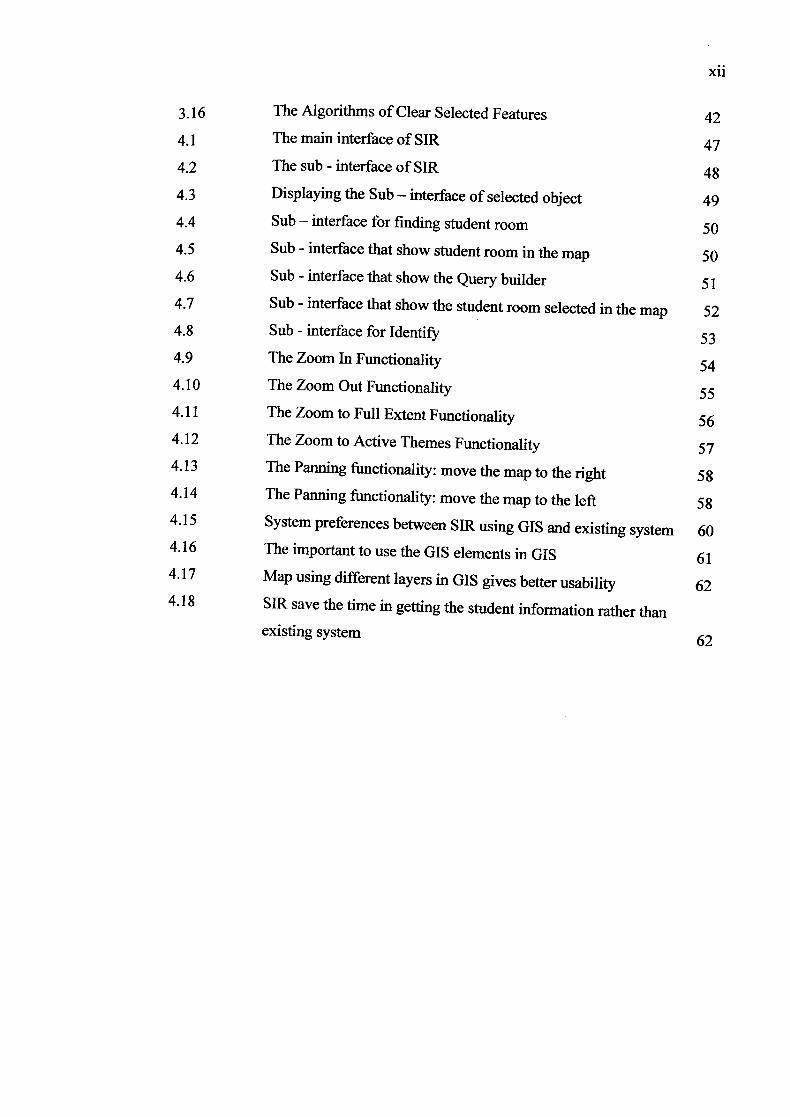
3.16 The Algorithms of Clear Selected Features 42
4.1 The main interface of SIR 47
4.2 The sub - interface of SIR 48 43 Displaying the Sub - interface of selected object 49
4.4 Sub - interface for finding student room 50 4.5 Sub - interface that show student room in the map 50 4.6 Sub - interface that show the Query builder 51 4.7 Sub - interface that show the student room selected in the map 52 4.8 Sub - interface for Identify 53 4.9 The Zoom In Functionality 54 4.10 The Zoom Out Functionality 55 4.11 The Zoom to Full Extent Functionality 56 4.12 The Zoom to Active Themes Functionality 57 4.13 The Panning functionality: move the map to the right 58 4.14 The Panning functionality: move the map to the left 58 4.15 System preferences between SIR using GIS and existing system 60 4.16 The important to use the GIS elements in GIS 61 4.17 Map using different layers in GIS gives better usability 62 4.18 SIR save the time in getting the student information rather than
existing system62
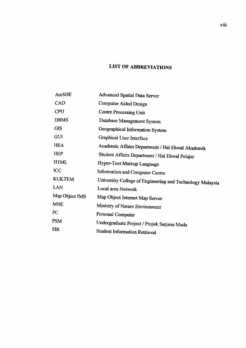
LIST OF ABBREVIATIONS
ArcSDE Advanced Spatial Data Server
CAD Computer Aided Design
CPU Centre Processing Unit
DBMS Database Management System
GIS Geographical Information System
GUI Graphical User Interface
flEA Academic Affairs Department / Hal Ehwal Akademik HEP Student Affairs Department / Hal Ehwal Pelajar HTML Hyper-Text Markup Language
ICC Information and Computer Centre KUKTEM University College of Engineering and Technology Malaysia LAN Local area Network
Map Object IMS Map Object Internet Map Server MNE Ministry of Nature Environment PC Personal Computer PSM
Undergraduate Project / Projek Sarjana Muda SIR Student Information Retrieval
xlii
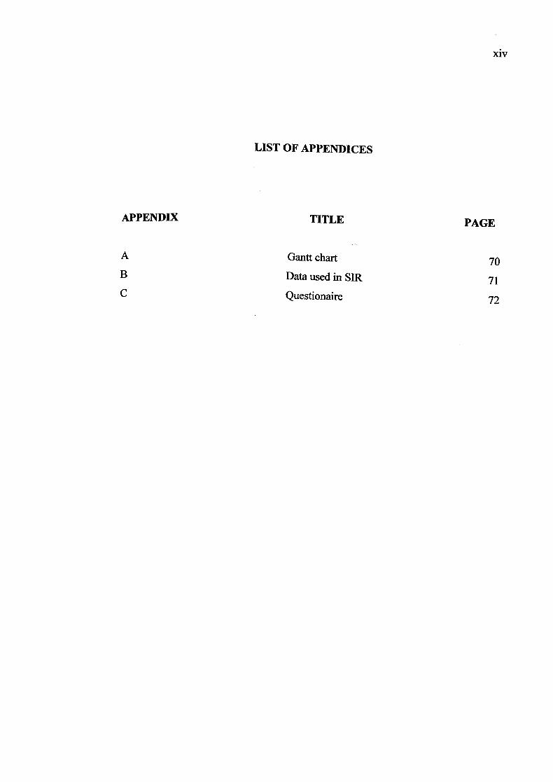
LIST OF APPENDICES
APPENDIX TITLE PAGE
A
Gantt chart 70 B
Data used in SIR 71 C Questionaire 72
xiv

CHAPTER 1
INTRODUCTION
This chapter is focusing on introduction of the system, problem statement of
the existing system, objectives and scope of the system.
1.1 Introduction
The management in hostel is very important because they have to manage
lots of data such as the student data and information. So they should have to manage
the data systematically. Therefore Student Affairs Department (HEP) has applied the
computerized system to help them in hostel management. Without the computerized
system, they have a lot of problem in manage the student data and also the data that
related to the hostel management Although the computerized system is known can
reduce human energy, paperless and also help the staff in managing time more
wisely, it still has the problem in providing the systematic management especially in
getting the student information To solve this problem, Student Information
Retrieval using Geographical Information System (GIS) has been develop to improve
the existing system further to assist users in finding student's room and to retrieve student's data by clicking on the map. Besides, user will know the number of
Students in the hostel and also the number of the student in the room. Therefore this
System will not waste their time because they only need to click at the place that they
Want to know by click at the maps.
2
Student Information Retrieval helps the Student Affairs Department (HEP) to
retrieve student's data easily and faster. This system focusing on how to improve the
retrieving of student's data beside others additional function. So user can know the
student data faster and easily such as to know the student's room, and others
information about the student. Users also are allowed to search student's room by
student id. This system eases to the user to get any information anytime when they
needed.
1.2 Problem Statement
According to the existing system used by Student Affairs Department (HEP),
it is found that the system does not really helps in retrieving student's information
wisely. Sometimes human power still needed to configure it manually. Below are
some of the problems faced by the current system.
The current system that used by Student Affairs Department (REP) at
KUKTEM has face the problem on getting the student information in short time.
Based on the current system, the user should search the student by metric number
before they can get the information about that student. The system does not provide
searching by room. So that they do not know who's student there and also the
number of the student in that room.
To solve these problems, the system provides a student information retrieval
using Geographical Information System. This system based on University College
of Engineering and Technology Malaysia (KUKTEM) hostel map. The user will get
the student's information in KUKTEM hostel through the visualization of hostel
map. They also can get the student information by searching the student id and flame.
3
1.3 Objectives of the System
The main objectives of the system are:
i. To develop the Student Information Retrieval Using Geographical
Information System.
ii. To search the student location.
iii. To manipulate the map by zooming and searching.
1.4 Scope
The scope of this system is to develop the Student Information Retrieval only
for University College of engineering and Technology Malaysia (KUKTEM) hostel.
i. This system is using Geographical Information System (GIS).
ii. Searching based on the student identification number and name. iii. This program is developed using Arc View 3.1 and Avenue
scripting as an application language.
iv. This system uses the vector data type.
V. The information of the student for Student Information Retrieval
involves students in blocks C and C2.

CHAPTER 2
LITERATURE REVIEW
2.1 Introduction
Literature review is the ways to increase knowledge and understanding about
the topic that is proceed by finding out all information before developing the system.
This chapter is finding out the researches that related to this system and make the
specific analysis.
2.2 Geographical Information System (GIS)
GIS is acronym for Geographical Information System. Geographical is refers
to a specific location in space. This term is used because GIS tend to deal primarily
with geographic or spatial features. Information is refers to a large volumes of data
which are usually handled within a GIS. Every object has their own particular set of characteristics or descriptive attributes. System is the term used to represent the
system approach taken by GIS. Most of the information systems now are computers based. Geographical Information System (GIS) refers to a computer-based system
for Storing, analyzing, and reporting map and spatial database, providing environmental, social economic and geographic information. GIS is a collection of cOn'Puter hardware software, and geographic data for capturing, managing, ana
lyzing, and displaying all forms of geographically referenced information [1].

5
Geographical Information System (GIS) is an integrating technology by
linking a number of discrete technologies into a whole that is greater than the sum of
its parts. GIS have emerged as very powerful technologies because they allow
geographers to integrate their data and methods in ways that support traditional
forms of geographical analysis as well as new types of analysis and modeling [2].
A regular map shows only spatial data such as cities, rivers, roads, and
forests. A geographic information system contains further information by linking
attribute data to spatial data. For example, population and unemployment rate can be
linked to specific city areas. This link creates intelligent map features and provides
the ability of retrieving the data for fact-finding, querying the data with criteria,
spatial analysis and modeling, topological operating, and network analysis [2].
A Geographical Information System (GIS) is a tool that uses the power of the
computer to pose and answer geographical question. The user guides the program to
arrange and display data about places on the planet in a variety of ways including
maps, charts, and tables. The hardware and software allows the users to see and
interact with data in new ways by blending electronic maps and database to generate
color coded display. User can zoom in and out of maps freely, add layers of new
data, and study detail and relationships [3].
Actually GIS is differs from Computer Aided design (CAD) and other
graphical computer applications. It is because all spatial data that using GIS is geog
raphically referenced to a map projection in the earth coordinate system. A GIS
supports several views for working with geographic information. Three views of
GIS used for working with elements of geographic knowledge which is geodatabase, geovisualjj0 and geoprocessing.
These three (3) elements are [4]:
i. Geodatabase View - A GIS is a unique kind of database of the world and known as a geographic database (geodatabase). It is an information system for g
eography. Basically, a GIS is based on a structured database that
describes the world in geographic terms. It is also containing data sets that
represent geographic information in terms of a generic GIS data model
(features, rasters, topologies, networks, and so forth).
ii. GeovisualiZatiOn View - A GIS is a set of intelligent maps and other views
that shows features and feature relationships on the earth's surface. Various
map views of the underlying geographic information can be constructed and
used to support queries, analysis, and editing of the information.
iii. Geoprocessing View - A GIS is a set of information transformation tools that
derives new geographic data sets from existing data sets. These
geoprocessing functions take information from existing data sets, apply
analytic functions, and write results into new derived data sets.
These three (3) GIS views are represented in ArcGIS by the catalog (a GIS is
a collection of geographic data sets), the map (a GIS is an intelligent map view), and
the toolbox (a GIS is a set of geoprocessing tools). All three are critical parts of an
intelligent GIS and are used at varying levels in all GIS applications.
2.2.1 Components of GIS
A working GIS integrates five (5) key components which is hardware,
software, data, methods, and people {5}. All of these components need to be in
balance for the system to be successful. Figure 2.1 shows the GIS components.

7
Hardware - V
Software
GIS
People
i
Data
Methods
Figure 2.1 GIS Components
i. Hardware is a computer system on which a GIS operates. Today, GIS
software runs on a wide range of hardware types, from centralized computer
servers to desktop computers used in stand-alone or networked
configurations. Hardware consists of the technical equipment needed to run a
GIS including a computer system with enough power to run the software,
enough memory to store large amounts of data, and input and output devices
such as scanners, digitizers, GPS data loggers, media disks, and printers.
ii. Software is defined as the group of instructions which enable the execution of
a certain procedure by a computer. GIS software provides the functions and
tools needed to store, analyze, and display geographic information. Keg'
Software components are:
(a) A database management system (DBMS)
(b) Tools for the input and manipulation of geographic information
(c) Tools that support geographic query, analysis, and visualization (d) A graphical user interface (GUI) for easy access to tools
8
ii. Data is the most important component of a GIS. Geographic data and related
tabular data can be collected in-house or bought from a commercial data
provider. Most GISs employ a DBMS to create and maintain a database to
help organize and manage data.
iv. Method is a process in develop the GIS system. The successful of the GIS
system is depend on the type of the methodology that applied, well-designed
plan and business rules, which are the models and operating practices unique
to each organization.
v. People is refers to system users who manage the system and develop plans for
applying it. They are also need to be educated to make decisions on what
type of system to use. People who associated with a GIS can be categorized
into viewers, general users, and GIS specialists.
2.2.2 GIS Data Types
GIS organizes geographic data into series thematic layers and tables. It is
because data in a GIS are referenced to geography. GIS links the location to each
layer such as people to addresses, buildings to parcels, or streets within a network to
give a better understanding of how the features interrelate.
In a GIS, collections of geographic features are organized into data sets, such
as land parcels, fire locations, buildings, orthophoto imagery, and raster-based digital
elevation models in particular defined geographic data sets are critical for useful geographic information systems, and the layer-based concept of thematic collections of information is critical for (uS data sets. There are two (2) basic of spatial data
types used in GIS work which are raster and vector [6]. Figure 2.2 shows the
differences between vector data and raster data.

Vector Raster Point j
Line __________________ i-i--i-i-•i- 1 Polygon
1 1tiiFigure 2.2 Vector data versus Raster data
2.2.2.1 Vector Data
The vector data model represents each feature as a row in a table, and feature
shapes are defined by x,y locations in space. For examples lines on the road map, the
points that indicate cities and the polygons that encloses a state which is based on
points, lines and polygons. Much vector data is stored in GIS formats, such as those
of ArcView SHP or Mapinfo formats. Vector data is composed of discrete
coordinates that can be used as points or connected to create lines and polygons.
Points is refers to discrete location on the surface of the planet, represented
by an x-y coordinate pair. Each point on the map is created by latitude and longitude
coordinates, and is stored as an individual record in the database.
Lines are formed by connecting two (2) data points. The computer reads this
line as straight, and renders the line as a vector connecting two x-y coordinates (X
longitude, Y = latitude). The more points used to create the line, the greater the
detail. For lines, this means that the system stores one end of the line as the starting
Point and the other as the end point, giving the line direction.
Polygons is refers to an area that fully encompassed by a series of connected
lines. Because lines have direction, the system can determine the area that falls Within the lines comprising the polygon. Polygons are often an irregular shape.
Each polygon Contains one type of data such as vegetation, streets, and dispatch lo
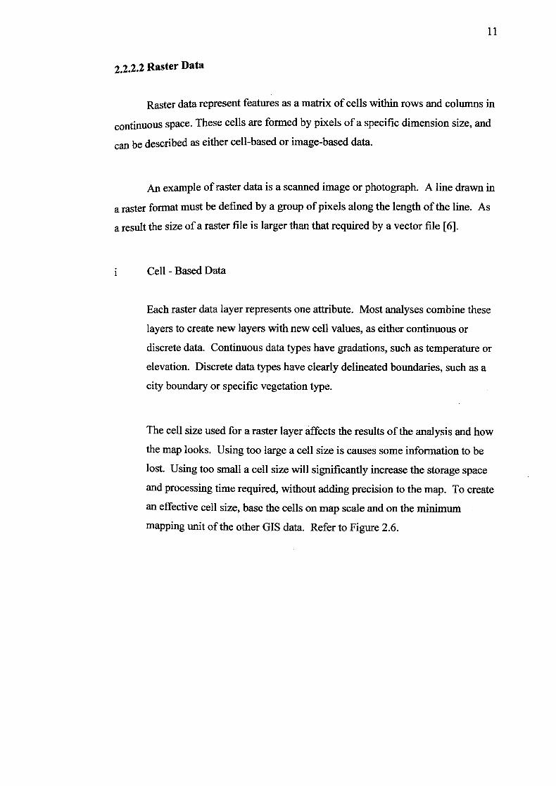
cations would be different polygons. All of the data points that form the perimeter
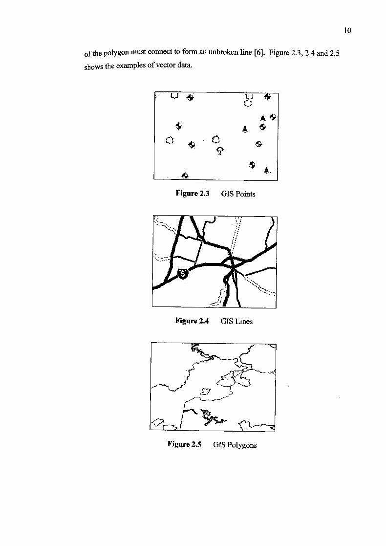
of the polygon must connect to form an unbroken line [6]. Figure 2.3, 2.4 and 2.5
shows the examples of vector data.
LJ
$
Figure 2.3 GIS Points
Figure 2.4 GIS Lines
ZY
Figure 2.5 GIS Polygons
10
11
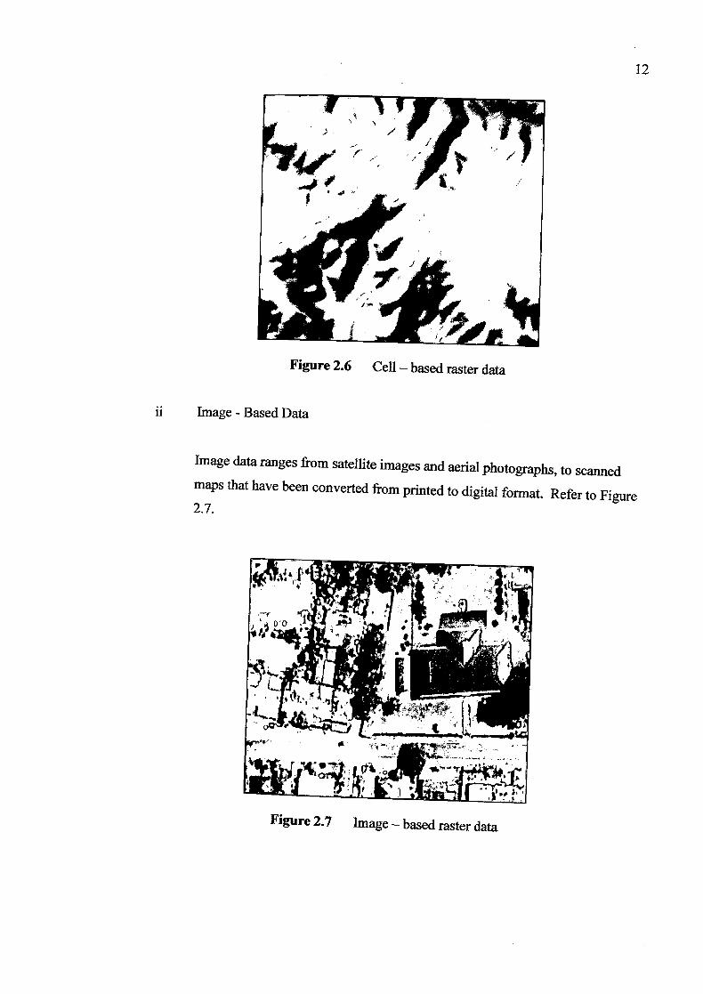
2.2.2.2 Raster Data
Raster data represent features as a matrix of cells within rows and columns in
COntU1UOUS space. These cells are formed by pixels of a specific dimension size, and
can be described as either cell-based or image-based data.
An example of raster data is a scanned image or photograph. A line drawn in
a raster format must be defined by a group of pixels along the length of the line. As
a result the size of a raster file is larger than that required by a vector file [6].
Cell - Based Data
Each raster data layer represents one attribute. Most analyses combine these
layers to create new layers with new cell values, as either continuous or
discrete data. Continuous data types have gradations, such as temperature or
elevation. Discrete data types have clearly delineated boundaries, such as a
city boundary or specific vegetation type.
The cell size used for a raster layer affects the results of the analysis and how
the map looks. Using too large a cell size is causes some information to be
lost. Using too small a cell size will significantly increase the storage space
and processing time required, without adding precision to the map. To create
an effective cell size, base the cells on map scale and on the minimum
mapping unit of the other GIS data. Refer to Figure 2.6.
12
Figure 2.6 Cell - based raster data
ii Image - Based Data
Image data ranges from satellite images and aerial photographs, to scanned
maps that have been converted from printed to digital format. Refer to Figure 2.7.
Figure 2.7 Image - based raster data