Structural controls on the evolution of the Kutai Basin ...searg.rhul.ac.uk/pubs/cloke_1999...
20
Structural controls on the evolution of the Kutai Basin, East Kalimantan I.R. Cloke a, c , S.J. Moss a, d , J. Craig b a University of London SE Asia Research Group, Department of Geology, Royal Holloway, Egham Hill, Egham, Surrey, TW20 0EX, U.K. b LASMO PLC, 101 Bishopsgate, London, U.K. c Mobil North Sea Limited, Mobil Court, 3 Clements Inn, London, WC2A 2EB, E-mail:[email protected] d Robertson Research Australia Pty Ltd, 69 Outram Street, West Perth, WA 6005, Australia Received 10 January 1998; accepted 27 June 1998 Abstract The Kutai Basin formed in the middle Eocene as a result of extension linked to the opening of the Makassar Straits and Philippine Sea. Seismic profiles across the northern margin of the Kutai Basin show inverted middle Eocene half-graben oriented NNE–SSW and N–S. Field observations, geophysical data and computer modelling elucidate the evolution of one such inversion fold. NW–SE and NE–SW trending fractures and vein sets in the Cretaceous basement have been reactivated during the Tertiary. Oset of middle Eocene carbonate horizons and rapid syn-tectonic thickening of Upper Oligocene sediments on seismic sections indicate Late Oligocene extension on NW–SE trending en-echelon extensional faults. Early middle Miocene (N7–N8) inversion was concentrated on east-facing half-graben and asymmetric inversion anticlines are found on both northern and southern margins of the basin. Slicken-fibre measurements indicate a shortening direction oriented 2908–3108. NE–SW faults were reactivated with a dominantly dextral transpressional sense of displacement. Faults oriented NW–SE were reactivated with both sinistral and dextral senses of movement, leading to the oset of fold axes above basement faults. The presence of dominantly WNW vergent thrusts indicates likely compression from the ESE. Initial extension during the middle Eocene was accommodated on NNE–SSW, N–S and NE–SW trending faults. Renewed extension on NW–SE trending faults during the late Oligocene occurred under a dierent kinematic regime, indicating a rotation of the extension direction by between 458 and 908. Miocene collisions with the margins of northern and eastern Sundaland triggered the punctuated inversion of the basin. Inversion was concentrated in the weak continental crust underlying both the Kutai Basin and various Tertiary basins in Sulawesi whereas the stronger oceanic crust, or attenuated continental crust, underlying the Makassar Straits, acted as a passive conduit for compressional stresses. # 1999 Elsevier Science Ltd. All rights reserved. Keywords: Kutai Basin; Oblique extension; Inversion; Reactivation 1. Introduction The 60,000 km 2 Kutai Basin of East Kalimantan (Figs. 1–3) is the largest and the deepest (15 km) basin in Indonesia (Rose and Hartono, 1978). In the Samarinda region the Neogene section alone reaches a thickness of up to 9 km. Tertiary sedimentation in the basin has been fairly continuous since its inception in the middle Eocene, although the axis of deposition has moved eastwards with time and is now focused at the mouth of the Mahakam Delta. The Mahakam Delta and the eastern side of the Kutai Basin have been most frequently targeted for hydrocarbon exploration. Production began at the Sanga-Sanga field in 1898 (Fig. 1) and the currently proven in-place resources in the Kutai Basin are 15.81 billion of barrels of oil equivalent with potential for greater than 0.74 billion of barrels of oil equivalent resources in the Palaeocene (Courteney, 1995) (Fig. 2 and 3). To date, exploration has mainly focused on the Neogene sediments, but the recognition of working petroleum systems within the Paleogene succession has Journal of Asian Earth Sciences 17 (1999) 137–156 1367-9120/99 $ - see front matter # 1999 Elsevier Science Ltd. All rights reserved. PII: S0743-9547(98)00036-1 PERGAMON
Transcript of Structural controls on the evolution of the Kutai Basin ...searg.rhul.ac.uk/pubs/cloke_1999...
Structural controls on the evolution of the Kutai Basin, EastKalimantan
I.R. Clokea, c, S.J. Moss a, d, J. Craigb
aUniversity of London SE Asia Research Group, Department of Geology, Royal Holloway, Egham Hill, Egham, Surrey, TW20 0EX, U.K.bLASMO PLC, 101 Bishopsgate, London, U.K.
cMobil North Sea Limited, Mobil Court, 3 Clements Inn, London, WC2A 2EB, E-mail:[email protected] Research Australia Pty Ltd, 69 Outram Street, West Perth, WA 6005, Australia
Received 10 January 1998; accepted 27 June 1998
Abstract
The Kutai Basin formed in the middle Eocene as a result of extension linked to the opening of the Makassar Straits andPhilippine Sea. Seismic pro®les across the northern margin of the Kutai Basin show inverted middle Eocene half-graben orientedNNE±SSW and N±S. Field observations, geophysical data and computer modelling elucidate the evolution of one such
inversion fold. NW±SE and NE±SW trending fractures and vein sets in the Cretaceous basement have been reactivated duringthe Tertiary. O�set of middle Eocene carbonate horizons and rapid syn-tectonic thickening of Upper Oligocene sediments onseismic sections indicate Late Oligocene extension on NW±SE trending en-echelon extensional faults. Early middle Miocene
(N7±N8) inversion was concentrated on east-facing half-graben and asymmetric inversion anticlines are found on both northernand southern margins of the basin. Slicken-®bre measurements indicate a shortening direction oriented 2908±3108. NE±SWfaults were reactivated with a dominantly dextral transpressional sense of displacement. Faults oriented NW±SE werereactivated with both sinistral and dextral senses of movement, leading to the o�set of fold axes above basement faults. The
presence of dominantly WNW vergent thrusts indicates likely compression from the ESE. Initial extension during the middleEocene was accommodated on NNE±SSW, N±S and NE±SW trending faults. Renewed extension on NW±SE trending faultsduring the late Oligocene occurred under a di�erent kinematic regime, indicating a rotation of the extension direction by
between 458 and 908. Miocene collisions with the margins of northern and eastern Sundaland triggered the punctuated inversionof the basin. Inversion was concentrated in the weak continental crust underlying both the Kutai Basin and various Tertiarybasins in Sulawesi whereas the stronger oceanic crust, or attenuated continental crust, underlying the Makassar Straits, acted as
a passive conduit for compressional stresses. # 1999 Elsevier Science Ltd. All rights reserved.
Keywords: Kutai Basin; Oblique extension; Inversion; Reactivation
1. Introduction
The 60,000 km2 Kutai Basin of East Kalimantan
(Figs. 1±3) is the largest and the deepest (15 km) basin
in Indonesia (Rose and Hartono, 1978). In the
Samarinda region the Neogene section alone reaches a
thickness of up to 9 km. Tertiary sedimentation in the
basin has been fairly continuous since its inception in
the middle Eocene, although the axis of deposition has
moved eastwards with time and is now focused at the
mouth of the Mahakam Delta.
The Mahakam Delta and the eastern side of the
Kutai Basin have been most frequently targeted for
hydrocarbon exploration. Production began at the
Sanga-Sanga ®eld in 1898 (Fig. 1) and the currently
proven in-place resources in the Kutai Basin are 15.81
billion of barrels of oil equivalent with potential for
greater than 0.74 billion of barrels of oil equivalent
resources in the Palaeocene (Courteney, 1995) (Fig. 2
and 3). To date, exploration has mainly focused on the
Neogene sediments, but the recognition of working
petroleum systems within the Paleogene succession has
Journal of Asian Earth Sciences 17 (1999) 137±156
1367-9120/99 $ - see front matter # 1999 Elsevier Science Ltd. All rights reserved.
PII: S0743-9547(98 )00036 -1
PERGAMON
Fig.1.GeologicalMapoftheKutaiBasinandsurroundingmargins,showingdi�eringbasementgeologyandstructures.Locationshowninset(M
odi®ed
from
Moss
etal.,1997).
I.R. Cloke et al. / Journal of Asian Earth Sciences 17 (1999) 137±156138
Fig. 2. Synthetic Aperture Radar (SAR) image of part of the northern margin of the Kutai Basin showing basement structures and inversion
structures within Tertiary cover. Interpretation shown below; for location see Fig. 1.
I.R. Cloke et al. / Journal of Asian Earth Sciences 17 (1999) 137±156 139
Fig. 3. En-echelon vein sets overprinting a crenulation cleavage, demonstrating two phases of tectonism in basement: (a) Interpretation of ®eld
outcrop, demonstrating orient orientation of shear couple and conjugate nature; (b) Photograph showing orientation of veinsets, pencil shown
centre right points north and is 10 cm in length. Also shows location of Fig. 3a; (c) Equal area stereonet projection summarises structural obser-
vations, key is shown right.
I.R. Cloke et al. / Journal of Asian Earth Sciences 17 (1999) 137±156140
resulted in a renewed interest in the onshore section ofthe Kutai Basin (Fig. 2).
This paper analyses the Paleogene and Neogeneevolution of the Kutai Basin using a combination ofgeophysical and ®eld data to document the structuralcontrols on the evolution of the basin and the conse-quent implications for the regional stress regime.Synthetic Aperture Radar data were used to interpretthe basement fabric orientations and to interpret thestructures identi®ed in middle Eocene and youngerbasin-®ll. Interpretations were then extended to thesub-surface using gravity and seismic data. Isochronmaps generated from the interpretation of regionalseismic lines recorded across the northern margin ofthe Kutai Basin were used to demonstrate spatialchanges in the location of middle Eocene and lateOligocene depocentres. Section reconstructions of geo-seismic lines were used to demonstrate the middleEocene basin geometries. Field data gathered fromboth basement and Tertiary rocks is used to re®ne in-terpretations made from the geophysical data. The®nal part of this paper integrates the basin history intothe regional plate framework and discusses impli-cations for the evolution of the eastern margin ofSundaland.
2. Basement geology and structure
Tertiary rocks of the Kutai Basin rest with angularunconformity upon a basement of Mesozoic and olderstrata. The Basement of Kalimantan is classi®ed asany strata older than the middle Eocene, and makesup predominantly the highlands of interiorKalimantan with a few isolated inliers (Fig. 1). Apartfrom the regional geological reviews by Van Bemmelen(1949), Cartier and Yeats (1973), Hutchinson (1989)and more lately by Moss et al. (1997), the greater partof detailed work has been focused on small isolatedareas (Rose and Hartono, 1978; Pieters et al., 1987;Doutch, 1992; Lumadyo et al., 1993), particularlyareas of oil company interest (Gruneisen et al., 1983;Gardner et al., 1983; van de Weerd et al., 1987; Wainand Kardin, 1987; Wain and Berod, 1989) and of min-eral interest (Bergman et al., 1988; Simmons andBrowne, 1990; van Leeuwen et al., 1990; Felderho�et al., 1996). These reports give di�erent names forsimilar sedimentary and igneous formations and high-light the di�culty of correlation of formations due totheir highly faulted and dismembered nature (Mossand Chambers, 1998).
Basement consists of a number of rock types ofdi�erent ages exposed on the northern, western andsouthern margins of the Kutai Basin (Fig. 1). To thenorth and west the basement consists of both forearcand remnant ocean basin ®ll and the continental base-
ment of ``Sundaland'' (the Schwaner Mountains)(Moss, 1998). The continental basement consists ofmetamorphic, sedimentary, and granitic to gabbroicrocks of Permo-Carboniferous to Cretaceous age (vanBemmelen, 1949; van de Weerd et al., 1987; Pieters etal., 1987). Oceanic rocks range from chert and associ-ated basinal sediments of Cretaceous to middle Eoceneage (Pieters et al., 1987) to deformed basalts and tecto-nized harzburgites representing a range of di�ering en-vironments of formation (ocean ¯oor to remnantocean basin). Possible ophiolites have been identi®edthroughout Kalimantan (e.g. van de Weerd andArmin, 1992), but outcrop studies show these are typi-cally highly deformed and none contain a full ophioli-tic sequence.
Brittle-ductile shear zones are common on the north-ern margin, with dominant orientations NW±SE andNE±SW. Many shear zones show several phases ofmovement evidenced by overprinting of quartz veins,and reactivation and breaching of shear bands. Theaxes of chevron folded cherts are oriented NE±SW.NW±SE aligned lineaments have previously beenidenti®ed throughout Borneo, using remote sensingdata, and have been used as evidence for a through-going Trans-Kalimantan shear zone, connected to anyone of a number of major strike±slip faults (Wood,1985; Hutchinson, 1989; Daly et al., 1991; Tate, 1992).The connection of these structures to other regionalfeatures and extension of Asian crustal blocks havebeen disputed more recently by Cloke et al. (1997) andMoss et al. (1997) who have shown that NW±SE linea-ments are in fact an inherited basement fabric and notsimply the result of Tertiary ``extrusion tectonics'' asenvisaged by Tapponnier et al. (1982) and Daines(1985).
The southern margin of the basin consists of theNNE±SSW oriented Meratus Ophiolite Complex(Sikumbang, 1990), which has also previously beenclassi®ed as melange (Hamilton, 1979; Hutchinson,1989). The ophiolite has been proposed to be derivedfrom a back-arc basin obducted onto the eastern mar-gin of Sundaland during the early Cretaceous(Sikumbang, 1986) and subsequently uplifted in thelate Miocene (Rose and Hartano, 1978, van de Weerdet al., 1987; Hutchinson, 1989) or Plio-Pleistocene (vanBemmelen, 1949). This complex on the southern mar-gin of the basin is laterally o�set along strike±slipfaults oriented NW±SE. This results in the juxtaposi-tion of Aptian to Turonian age sedimentary rocksagainst island arc volcanics. Outcrops of gabbroic andultrabasic rocks on the northern margin of the KutaiBasin have led some authors to postulate that theMeratus Complex extends north beneath the KutaiBasin (Albrecht, 1946; Sikumbang, 1990). The simi-larity between the basement units of the northern mar-gin of the Kutai basin (e.g. Sungai Selec and Belayan
I.R. Cloke et al. / Journal of Asian Earth Sciences 17 (1999) 137±156 141
(Fig. 1) Cloke, 1997) and the Pre-Tertiary forming ofthe Meratus Complex suggests that this is essentiallycontinuous with the northern margin and was sub-sequently uplifted during middle Miocene inversion.
3. Basement orientations identi®ed using syntheticairborne radar (SAR) and from ®eld data
The presence of a basement fabric inherited fromprevious episodes of tectonism can exert considerablecontrol on subsequent deformation. One method ofrecognising this is by the use of remote sensing data.Interpretations of the fracture orientation are thenintegrated with other data, for instance gravity andmagnetics, to distinguish between near surface anddeep-seated structural features.
Basement in Borneo is distinguished on remote sen-sing data by its coarse re¯ective nature. It forms varie-gated highland areas with aligned valleys and hillcrests (Fig. 2). Lineaments identi®ed in pre-rift base-ment and post-rift sedimentary sequences show di�er-ing orientations and abundances. Basement lineamentsare predominantly oriented NW±SE and NE±SW witha more weakly developed NNE±SSW fabric (Fig. 2).NW±SE lineaments consist of predominantly shortfractures cutting through basement strata. Our ®eldstudies have identi®ed dominant fractures, duplexshear bands and S-C fabrics, with multiples phases ofreactivation, oriented NW±SE which agrees with ear-lier work by Wain and Berod (1989).
NE±SW lineaments crosscut the NW±SE direction,but a lack of identi®able o�set features makes it im-possible to establish sense and age of displacement.The NE±SW orientation has previously been identi®edin Sarawak by Tate (1992). Locally this trend re¯ectsthe faulted boundary between basement and Tertiarycover (Sabins, 1983; Felderho� et al., 1996). Fracturesand tight chevron folds within basement cherts on thenorthern margin of the basin parallel this structuralgrain. An additional trend oriented NNE±SSW isweakly developed within the basement and forms con-tinuous lineaments cross-cutting early structures. It ismost clearly developed within the volcanic plateaux ofthe Plio-Pleistocene Metulang volcanics suggesting it isa late formed trend (Pieters et al., 1987). LateCretaceous granitic dykes encountered on the SungaiTabang (Fig. 1) trending NW±SE, cross-cut highlysheared basaltic rocks and are o�set by cm-scale exten-sional faults aligned NNE±SSW (Moss et al., 1997).The paucity of features related to the NNE±SSW fab-ric within the basement suggests this fabric may be theresult of later tectonic activity.
Field investigations have identi®ed numerous brittle-ductile shear zones in the basement rocks on thenorthern margin of the Kutai Basin, with dominant
orientations NW±SE and NE±SW (Cloke et al., 1997).Analysis of structures identi®ed on the northern mar-gin is used here to demonstrate multiple deformationalepisodes (Fig. 3a and b). Two orientations of cleavagecut folded and foliated phyllites. In addition, semi-brittle shear zones with accompanying quartz veinsand centimetre scale dextral o�set faulting overprintboth sets of cleavage. S1 axial planar cleavage is as-sociated with fold axes oriented 1708 and plunging 298towards 1608±1708 (Fig. 3c). S2 cleavage, associatedwith the en-echelon conjugate sigmoidal quartz veins,is oriented 0948/428 and approximately bisects theshear couple that generated the vein sets. One set ofconjugate semi-brittle shear zones is aligned 1218 andindicates a dextral sense of movement (Fig. 3a); theother set is aligned 0088 and indicates a sinistral senseof movement. The sense of movement on the shearzones suggests that they are unrelated to and post-datethe folds. Late stage overprinting of the en-echelonvein system is indicated by dextral movement on verti-cal fault zones oriented 0628 (Fig. 3).
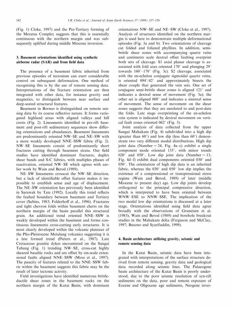
Joint analysis of data collected from the upperSungai Mahakam (Fig. 4) subdivided into a high dip(greater than 608) and low dip (less than 608) demon-strate two very di�erent modal distributions. High dipjoint data (Number=24, Fig. 4a±c) exhibit a singlecomponent mode oriented 1358, with minor trends0208 and 0508. Low dip joint data (Number=13,Fig. 4d±f) exhibit dual components oriented 0308 and0508. The orientation of high dip data is an inheritedfabric, whereas the 0308 and 0508 low dip implies theexistence of a compressional or transpressional stressregime (Wain and Berod, 1989) of later (middleMiocene to present day) age. Low dip joints developorthogonal to the principal compressive direction,which is interpreted to have been oriented betweenWNW±ESE to NNW±SSE. The implication of thetwo modal low dip orientations is discussed at a laterstage. Orientations identi®ed using ®eld data agreebroadly with the observations of Gruneisen et al.(1983), Wain and Berod (1989) and borehole breakoutstudies in the Mahakam delta (Ferguson and McClay,1997; Busono and Syarifuddin, 1999).
4. Basin architecture utilising gravity, seismic andremote sensing data
In the Kutai Basin, seismic data have been inte-grated with interpretations of the surface structure de-rived from remote sensing, gravity data and geologicaldata recorded along seismic lines. The Palaeogenebasin architecture of the Kutai Basin is poorly under-stood, due to the poor seismic resolution of syn-riftsediments on the data, poor and remote exposure ofEocene and Oligocene age sediments, Neogene inver-
I.R. Cloke et al. / Journal of Asian Earth Sciences 17 (1999) 137±156142
Fig. 4. Fracture orientations within basement, gathered from ®eldwork on the Upper Sungai Mahakam. (a) Great circles to high angle (>608)joints; (b) Kamb contour plot of high angle (>608) joints; (c) Rose plot of high angle (>608) joints; (d) Great circles to low angle (<608) joints;Kamb contour plot of low angle (<608) joints; (e) Rose plot of low angle (<608) joints.
I.R. Cloke et al. / Journal of Asian Earth Sciences 17 (1999) 137±156 143

sion and a lack of borehole data. This poor under-standing of the extensional basin architecture has ledto a number of models for basin evolution, such as atrans-tensional origin (Daines, 1985; Biantoro et al.,1992) or a ¯exural origin (van de Weerd and Armin,1992; Bergman et al., 1996) that are not supported bydirect data. In order to understand the basin evolutionit is necessary to focus on the northern and southernmargins of the basin where Palaeogene sediments(Fig. 1) are exposed.
5. Gravity data
Density models were used to constrain seismic in-terpretations of the structure of the northern marginof the basin in areas of reduced seismic clarity andalso to construct gravity maps for parts of the region.The data o�er the opportunity to interpret the struc-ture of the basin in three dimensions. Bouguer gravitydata across the Kutai Basin have previously been usedto show density models of structural pro®les across thebasin and to postulate the location of structures withinthe basin (Sunaryo et al., 1988; Wain and Berod, 1989;Chambers and Daley, 1995; Cloke, 1997). In addition,the regional gravity signature has been used to demon-strate that the Kutai Basin has an extensional ratherthan a foreland origin (Moss et al., 1997). Gravitymodels of seismic sections that intersect the MakassarStraits suggest the presence of attenuated continentalcrust and possible oceanic crust (Guntoro, 1995;Cloke, 1997).
The Bouguer gravity values of the basin are allslightly to moderately positive, with the exception ofthe prominent highs described below, which arestrongly positive. Three positive gravity highs, orientedNNE±SSW, are apparent in the regional BouguerGravity for part of East Kalimantan (Fig. 5). Themost prominent of these highs is the Kutai LakesGravity High (KLGH) with an amplitude of about 40mGal (Fig. 5). The Kedang Kepala High has abroader anomaly of approximately 54 mGal and issituated to the north±northeast of the KLGH, o�setby about 10 km in a right lateral sense by a NW±SEoriented gravity low identi®ed as the Belayan Axis(Fig. 5). To the north, the Kedang Kapala High is o�-set from another positive anomaly by another lineargravity zone named the Kedang±Kepala Axis(Sunaryo et al., 1988). The two main lows range invalue from 0.43 to 21.02 mGal. Magnetic data cover-ing the region also indicates an increase in depth tomagnetic basement from north to south across theKedang±Kepala Axis (Sunaryo et al., 1988). This grav-ity and magnetic anomaly corresponds with theBengalon lineament (Moss and Chambers, 1998) vis-ible on SAR data and also a linked en-echelon fault
zone of late Oligocene age identi®ed on seismic data inthe sub-surface. This fault zone is orthogonal to theEocene fabric and has importance for the stress regimeduring this period. Residual Bouguer Gravity data canbe used to show structures within the Tertiary cara-pace and, although not shown on Fig. 5 for brevity,con®rms the presence of the KLGH as well as narrowlinear zones of both NW±SE and NNE±SSW orien-tations within the sedimentary cover. Positive Gravityanomalies observed on the northern margin of theKutai Basin (Fig. 5) correlate with asymmetrical sur-face anticlines, established to be a result of Neogeneinversion of middle Eocene half-graben. These positivegravity anomalies are a combination of uplifted highdensity syn-rift sediments and shallow basement rocks(Cloke, 1997).
A regional density model created for a 2D cross-sec-tion crossing from west of the KLGH (Fig. 5) acrossthe Mahakam Delta to the thrust belt of WestSulawesi demonstrates that the KLGH can be success-fully modelled as folded high density (+2.57 mGal)Palaeogene strata (Chambers and Daley, 1995; Cloke,1997). This fold developed as the result of inversion ofa deeply buried Palaeogene half-graben. The narrow-ness of the high is accentuated by the presence of lowdensity (+2.15 mGal) syn-inversion synclines presentto the east and west of the high.
6. Remote sensing data
Landsat (1993) TM scenes using bands 1, 4 and 7(courtesy of LASMO PLC) have been processed toimage the regional structure, and high resolution SARimages (courtesy of LASMO PLC) have been used tointerpret the Tertiary basin ®ll of this section of theKutai Basin (Fig. 2). The remote sensing data enable aregional interpretation of the Gongynyay and Gergajifold belt (Fig. 2) to be made. The importance of this isto reconstruct the Paleogene basin architecture andunderstand the interaction between the various base-ment fabric orientations and the extension direction.We use a portion of processed ERS-1 data across thenorthern margin to demonstrate a number of struc-tural features (Fig. 2).
The eastern portion of the data shows two west ver-gent asymmetric anticlines (Fig. 2) each of approxi-mately 70 km length, which form a prominent series ofhills trending 0258 (Fig. 2). Both folds are dissimilar tothose encountered in the Neogene section of the LowerKutai Basin (detachment foldsÐChambers and Daley,1995, or diapiric folds) in that they are not laterallycontinuous, tight in geometry, or separated by broadsynclines. In addition the anticlines shown in Fig. 2are doubly plunging (closing to NNE and SSW), re-semble a whaleback morphology and have linear wes-
I.R. Cloke et al. / Journal of Asian Earth Sciences 17 (1999) 137±156144
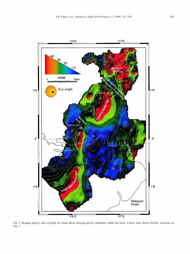
Fig. 5. Bouguer gravity data covering the Kutai Basin showing gravity anomalies within the basin. Colour scale shown bottom. Location on
Fig. 1.
I.R. Cloke et al. / Journal of Asian Earth Sciences 17 (1999) 137±156 145
tern sides suggestive of fault control. Instead, thestructures are considered to resemble inverted half-gra-ben, and initial stratigraphic interpretations predictthat the axes of these folds contain middle Eocene syn-rift sediments. Subsequent ®eldwork, although showingthe Gongnyay and Gergaji fold belt (Fig. 2) to bestructurally complex, proved this analysis to be essen-tially correct. The fold axes and thrust fronts are sinis-trally and dextrally o�set on a number of NW±SEtrending linear fractures parallel to those observedwithin adjacent basement (shown in Fig. 2(b)). Foldmorphology changes across the fractures, from anasymmetrical west-vergent anticline to a monocline(Fig. 2). Igneous intrusions of possible late Oligoceneage lie on trend with the fractures. Similar o�sets offold axes have been observed in the SamarindaAnticlinorum (A. Ferguson, personal communication,1996). The o�sets may be partly controlled by base-ment fabrics.
An asymmetrical anticline is observed to the west ofthe village of Muara Wahau (Fig. 1) and this may betraced closing towards the north. Its eastern margincoincides with a lineament that penetrates basement.This fold is east-vergent and although not as promi-nent as those previously described, is cored by lateEocene sediments, indicating it may also be aninverted half-graben.
In addition to the folds described above, another im-portant observation is the presence of rhyolite dykestentatively assumed to be of middle Eocene age(S.J.M. ®eld observations) (Fig. 2) trending NNE±SSW. The dykes are parallel to the major faults form-ing the boundary to the Gongnyay and Gergaji half-graben.
7. Seismic data
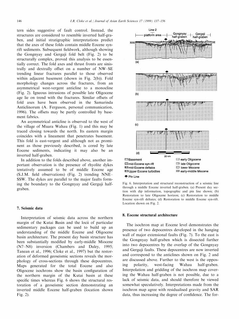
Interpretation of seismic data across the northernmargin of the Kutai Basin and the locii of particularsedimentary packages can be used to build up anunderstanding of the middle Eocene and Oligocenebasin architecture. The present day basin structure hasbeen substantially modi®ed by early-middle Miocene(N7±N8) inversion (Chambers and Daley, 1995;Tanean et al., 1996; Cloke et al., 1997) but the restor-ation of deformed geoseismic sections reveals the mor-phology of cross-sections through these depocentres.Maps generated for the total Eocene and alsoOligocene isochrons show the basin con®guration ofthe northern margin of the Kutai basin at thesespeci®c times whereas Fig. 6 shows the structural res-toration of a geoseismic section demonstrating aninverted middle Eocene half-graben (location shownFig. 2).
8. Eocene structural architecture
The isochron map at Eocene level demonstrates the
presence of two depocentres developed in the hanging
wall of major extensional faults (Fig. 7). To the east is
the Gongnyay half-graben which is dissected further
into two depocentres by the overlap of the Gongnyay
and Gergaji faults. These depocentres are now inverted
and correspond to the anticlines shown on Fig. 2 and
are discussed above. Further to the west is the oppos-
ing polarity, west-facing Wahau half-graben.
Interpolation and gridding of the isochron map cover-
ing the Wahau half-graben is not possible, due to a
lack of seismic data, and should therefore be viewed
somewhat speculatively. Interpretations made from the
isochron map agree with residualised gravity and SAR
data, thus increasing the degree of con®dence. The for-
Fig. 6. Interpretation and structural reconstruction of a seismic line
through a middle Eocene inverted half-graben. (a) Present day sec-
tion with dip information, topographic and pin line shown; (b)
Restoration to late Oligocene horizon; (c) Restoration to middle
Eocene syn-rift deltaics; (d) Restoration to middle Eocene syn-rift.
Location shown on Fig. 2.
I.R. Cloke et al. / Journal of Asian Earth Sciences 17 (1999) 137±156146
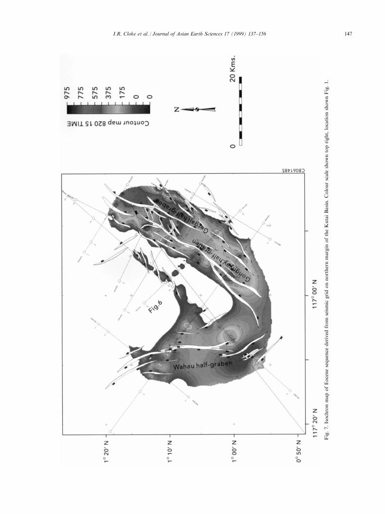
Fig.7.IsochronmapofEocenesequence
derived
from
seismic
gridonnorthernmargin
oftheKutaiBasin.Colourscale
showntopright,locationshownFig.1.
I.R. Cloke et al. / Journal of Asian Earth Sciences 17 (1999) 137±156 147

mer depocentres trend NNE±SSW and the latter almostN±S.
The fault map for the Eocene was derived fromchanges in isochron thickness. The orientations of faultswere then integrated with other observations (e.g. trendof middle Eocene rhyolite dykes) to interpret the exten-sion vector for the middle Eocene rifting on this marginof the Kutai Basin. High angle reverse faults identi®edon seismic sections and in remote sensing data wereassumed to be reactivated extensional faults. Thisassumption has been shown to be valid for similar tec-tonic con®gurations identi®ed throughout the Sundashelf (Letouzey et al., 1990). The overlap zone betweenthe Gongnyay and Gergaji half-graben is deformed by aseries of NE±SW trending faults that are interpreted tobe the result of the progressive rotation of the relayramp between the two major faults (Peacock andSanderson, 1994). The ¯exural shoulder that forms theeastern margin of the graben is cut by a number ofsmall scale faults, oriented NNE±SSW and arranged ina right-stepping en-echelon manner.
The line interpretation (Fig. 8) shows two anticlinesthat are interpreted to lie above middle Eocene depo-centres identi®ed on the northern margin (locationshown Fig. 2). Both west-vergent anticlines are boundedby steep reverse faults. The footwall of the fault bound-ing the Gongnyay half-graben forms a complex series ofextensional faults (now reverse faults). Although the ob-servations are limited to this inversion fold they can beapplied to other middle Eocene depocentres identi®edthroughout the Kutai Basin.
Restoration of the line interpretation shown in Fig. 8bto the late Oligocene horizon shows the pre-inversionstructural architecture. Estimates for the amount oferoded section and therefore the maximum depth ofburial were derived from Apatite Fission track (AFT)results (peak temperature of 908 reached at 03 kmdepth prior to rapid denudation) and therefore uplift(A. Carter, personal communication, 1997) at 23 Ma(Moss et al., 1998), vitrinite re¯ectance of middleEocene coal (%R0=1.1) layers and the measured dipof outcrops. The restoration demonstrates signi®cantthickening of middle Eocene syn-rift sediments acrossmajor extensional faults and changes in Oligocene thick-ness across smaller faults. Similar changes in Eocenethickness across extensional faults have been observedby Satyana and Biantoro (1995), further to the east ofthe area of study, and have also been interpreted onproprietary seismic data across the Teweh High (Fig. 1)(now recognised as an inverted half-graben).
Restoration to the middle Eocene deltaics (equivalentto the rift climax phase of Phillips et al., 1997) demon-strates that the rift consists of two asymmetrical syn-thetic half-graben formed in the hanging-wall of theGongnyay and Gergaji faults (Fig. 6c). The middle
Eocene deltaic sequence is restricted to the axis of theGongnyay and Gergaji half-graben and abrupt thinningtakes place at the basin bounding faults to the west andmore gradually to the east on to a ¯exural shoulder.This asymmetrical style of sedimentary thickness vari-ation is a common feature of the syn-rift in®ll of exten-sional half-graben in the East African rift (Rosendahl etal., 1986) or West Natuna Basin (Ginger et al., 1993).
Further restoration to the syn-rift ®ll (rift initiationphase of Phillips et al., 1997) demonstrates a singleasymmetrical half-graben formed in the hanging-wall ofthe Gongnyay fault (Fig. 8d). Abrupt thinning of thesyn-rift sequence takes place to the west at the basinbounding fault and more gradually at the eastern ¯ex-ural margin.
The fault pattern in the western portion of the data isconstrained by only two seismic lines, but by combininggravity (Fig. 5) and SAR data (Fig. 2) the pattern wasexpanded away from this data. Seismic data show ananticline that lies above the thickest depocentre. Thisanticline is observed at the surface and closes to thenorth and south of the line (Fig. 2). The eastern bound-ary of the anticline lies above the shoulder of the half-graben. In plan view the half-graben is bounded by aseries of left-stepping en-echelon faults that downthrowto the west. The en-echelon nature of the fault segmentsis interpreted from the gravity data (Fig. 5). These showa series of segmented en-echelon gravity highs. Thehalf-graben bounding fault is interpreted to extend upto and penetrate the basement lying to the north(Fig. 2). Previous interpretations, made without thebene®t of seismic data have interpreted this structure asa strike-slip fault of unknown age with approximately20 km of dextral o�set (Moriya and Nishidai, 1996).
9. Late Oligocene basin architecture
The period from the late Oligocene to the end of theLower Miocene is an important but poorly understoodstage in the history of the basin, and indeed of theregion as a whole. In this area of Kutai Basin, changesin basin architecture are related to late Oligocene exten-sion on a set of faults orthogonal to those active duringthe middle Eocene (Moss and Chambers, 1998; Cloke1997). In other sections of the basin the `late-Oligoceneunconformity' is related to renewed uplift of the basinmargin (Satyana and Biantoro, 1995; Moss et al., 1998)and compression and folding (van de Weerd et al.,1987; Wain and Berod, 1989; van de Weerd and Armin,1992).
Interpretation of seismic sections and the location ofparticular sequences were used to build up an under-standing of the late Oligocene basin architecture on thenorthern margin of the Kutai Basin. Changes in iso-
I.R. Cloke et al. / Journal of Asian Earth Sciences 17 (1999) 137±156148
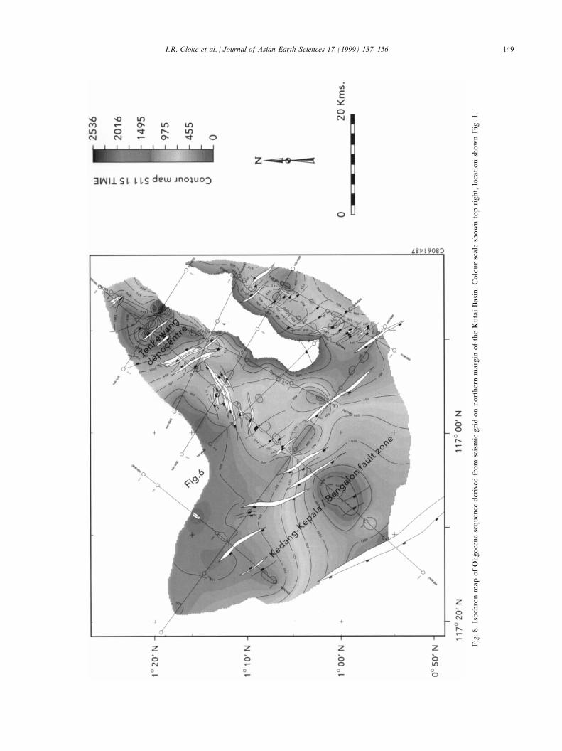
Fig.8.IsochronmapofOligocenesequence
derived
from
seismic
gridonnorthernmargin
oftheKutaiBasin.Colourscale
showntopright,locationshownFig.1.
I.R. Cloke et al. / Journal of Asian Earth Sciences 17 (1999) 137±156 149
chron thickness were also used to interpret the positionof late Oligocene faults, the majority of which have notbeen re-utilised as reverse faults during inversion,suggesting a directional control on inversion of faults(Fig. 8). In addition, the orientations of faults, integratedwith other observations (e.g. mineralised veins and dykeorientations) were used to predict the rift kinematics forthis period of minor extension on the northern margin ofthe Kutai Basin.
The isochron map (Fig. 8) shows the NW±SE align-ment of the Oligocene depocentres. In the northern partof the map, a series of NW±SE trending en-echelonextensional faults, down-throwing to the north, formthe southern margin of a late Oligocene basin. In thesouthern part of the map a similar set of parallel en-echelon faults, in this case down-throwing to the south,form the northern margin to a similar aged basin.LANDSAT TM data shows a distinct surface lithologi-cal boundary along the southern fault zone betweenkarsti®ed carbonates and shales (Moriya and Nishidai,1996) of late Oligocene±early Miocene (Moss andChambers, 1998; Wilson et al., 1999) age, suggestingsome degree of fault control on deposition. A thicken-ing of the Oligocene sequence is also documented acrossthe Bengalon lineament (Moss and Chambers, 1998).Further to the east, an increase in depth to magneticbasement southwards across the fault zone has alsobeen observed (Sunaryo et al., 1988). Seismic data showno evidence for displacement on a single master fault,and in the southern section of the map faulting isspread over a wider zone, as a more complex system ofinterconnecting en-echelon faults. Crustal ¯exure alsoappears to play a role in the increasing depth to base-ment to the south. Gravity data show a Bouguer gravityminimum of 15 mGal (Fig. 5) aligned NW±SE associ-ated with this fault zone, whilst magnetic data shows anincrease in the depth to magnetic basement across thefault zone (Sunaryo et al., 1988). The Adang FaultZone bounding the Kutai Basin to the south (Fig. 1) isinterpreted to have been active from this periodonwards. Free-air gravity data (Cloke, 1997) suggestthat the fault zone consists of a number of en-echelonsegments, rather than a linear fault zone as convention-ally interpreted.
10. Middle Miocene to present day
The present day structural architecture of the basin isthe result of substantial modi®cation of the combinedEocene and Oligocene basin architecture by compressiveforces from the Lower Miocene to the present day. Theprecise orientation of this stress regime is still disputedand will be discussed later.
Both the southern (Teweh half-graben; Fig. 1) andnorthern margins (Fig. 2) display evidence of `basin
inversion': i.e. the expulsion of the syn-rift sedimentsfrom the axis of the half-graben by the reverse reactiva-tion of the major `Eocene trending' extensional faults.The dating of the earliest inversion event is poorly con-trolled, with a number of timings proposed (N7±N8Cloke et al., 1997; 15.5±14.5 Ma Tanean et al., 1996;11.8 Ma van de Weerd and Armin, 1992). The tran-sition from a carbonate-dominated environment to acoal-dominated deltaic environment during the earlymiddle Miocene (N7±N8) has been used by Cloke et al.(1997) to constrain the timing of inversion on the north-ern margin of the Kutai Basin. Further periods ofrenewed inversion at 7.5, 5.5, and 3 Ma have been inter-preted from the increase in volcanic fragments in sand-stones forming the reservoirs to a number of oil ®elds(Tanean et al., 1996) and freshwater ¯ushing of reser-voir rocks (Duval et al., 1992). Given the diachroneityof inversion observed in other sedimentary basins it islikely that the inversion has been caused by a numberof punctuated compressive episodes rather than a singleevent (Chambers and Daley, 1995).
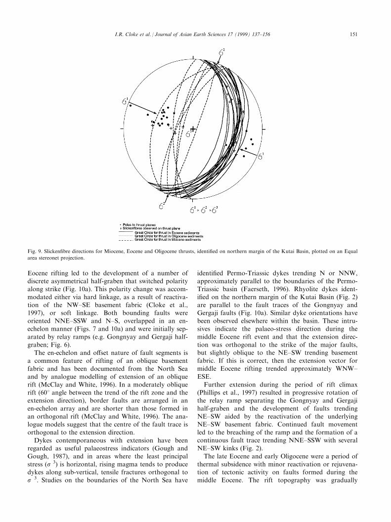
Field measurements of movement indicators (2908±3108) in the northern section of the basin (Fig. 9) indi-cate compression tangential to the main Eocene NW±SE trending faults, but oblique to the re-activated NE±SW and NW±SE basement faults (Cloke et al., 1997)(Fig. 9). This agrees approximately with boreholebreakout studies in the onshore section of theMahakam Delta which suggest a present day stressregime oriented NNW±SSE (Ferguson and McClay,1997; Busono and Syarifuddin, 1999). Seismic sectionsacross this northern margin (Fig. 6) show large anticli-nes which have been heavily reverse faulted. These areasymmetric, with heavily faulted western limbs, steeperthan eastern limbs, indicating western vergence of thefolds. Analogue modelling has shown the complicationsthat develop with inversion of an existing extensionalhalf-graben (McClay, 1989; McClay and Buchanan,1991; Eisenstadt and Withjack, 1995).
Syn-inversion sedimentation shows a number ofcharacteristic features. In this section of the basin it isrecognised by a change from Lower Miocene deepwater clastic turbidites, with carbonate deposition onhighs, to a terrestrial-dominated marginal marine deltaicenvironment (Carter, 1994) which may be identi®ed onseismic sections onlapping onto the underlying structure(Cloke, 1997). Recognition of the early-middle Miocene(N7±N8) deltaic sequence (Fig. 6) as a syn-inversionsequence provides evidence for the earliest event.
11. Reconstruction of the basin history and theimportance of structural controls
Reconstruction of the pre-inversion structural archi-tecture of the Kutai Basin demonstrates that middle
I.R. Cloke et al. / Journal of Asian Earth Sciences 17 (1999) 137±156150
Eocene rifting led to the development of a number ofdiscrete asymmetrical half-graben that switched polarityalong strike (Fig. 10a). This polarity change was accom-modated either via hard linkage, as a result of reactiva-tion of the NW±SE basement fabric (Cloke et al.,1997), or soft linkage. Both bounding faults wereoriented NNE±SSW and N±S, overlapped in an en-echelon manner (Figs. 7 and 10a) and were initially sep-arated by relay ramps (e.g. Gongnyay and Gergaji half-graben; Fig. 6).
The en-echelon and o�set nature of fault segments isa common feature of rifting of an oblique basementfabric and has been documented from the North Seaand by analogue modelling of extension of an obliquerift (McClay and White, 1996). In a moderately obliquerift (608 angle between the trend of the rift zone and theextension direction), border faults are arranged in anen-echelon array and are shorter than those formed inan orthogonal rift (McClay and White, 1996). The ana-logue models suggest that the centre of the fault trace isorthogonal to the extension direction.
Dykes contemporaneous with extension have beenregarded as useful palaeostress indicators (Gough andGough, 1987), and in areas where the least principalstress (s 3) is horizontal, rising magma tends to producedykes along sub-vertical, tensile fractures orthogonal tos 3. Studies on the boundaries of the North Sea have
identi®ed Permo-Triassic dykes trending N or NNW,approximately parallel to the boundaries of the Permo-Triassic basin (Faerseth, 1996). Rhyolite dykes ident-i®ed on the northern margin of the Kutai Basin (Fig. 2)are parallel to the fault traces of the Gongnyay andGergaji faults (Fig. 10a). Similar dyke orientations havebeen observed elsewhere within the basin. These intru-sives indicate the palaeo-stress direction during themiddle Eocene rift event and that the extension direc-tion was orthogonal to the strike of the major faults,but slightly oblique to the NE±SW trending basementfabric. If this is correct, then the extension vector formiddle Eocene rifting trended approximately WNW±ESE.
Further extension during the period of rift climax(Phillips et al., 1997) resulted in progressive rotation ofthe relay ramp separating the Gongnyay and Gergajihalf-graben and the development of faults trendingNE±SW aided by the reactivation of the underlyingNE±SW basement fabric. Continued fault movementled to the breaching of the ramp and the formation of acontinuous fault trace trending NNE±SSW with severalNE±SW kinks (Fig. 2).
The late Eocene and early Oligocene were a period ofthermal subsidence with minor reactivation or rejuvena-tion of tectonic activity on faults formed during themiddle Eocene. The rift topography was gradually
Fig. 9. Slicken®bre directions for Miocene, Eocene and Oligocene thrusts, identi®ed on northern margin of the Kutai Basin, plotted on an Equal
area stereonet projection.
I.R. Cloke et al. / Journal of Asian Earth Sciences 17 (1999) 137±156 151

Fig. 10. Block diagrams illustrating relationship of basement fracture patterns to (a) middle Eocene (b) late Oligocene and (c) middle Miocene
basin architecture and illustrating relevant stress orientations. BRRÐBreached relay rampsÐactive in extension; NFÐNormal faultsÐactive in
extension and inversion; TFÐTransfer faultsÐactive in extension and inversion; HLÐHard linked fault system; SLÐSoft linked fault system;
DÐmiddle Eocene rhyolite dykes; VSÐVein system of late Oligocene age; EN-FÐ`en-echelon' fault system; RFÐReverse fault; IHGÐInverted
half-graben; SFÐSinistral strike±slip fault; DEFÐDextral `escape' fault; SDÐSemi-ductile shear bandsÐseveral movement phases; JLÐ
JointsÐlow angle (compressional), high angle (tensional); FAÐFold axis oriented NE±SW.

in®lled and covered by sedimentation. During the lateOligocene the middle Eocene basin architecture wasmodi®ed by a renewed period of extension on thenorthern margin of the Kutai basin. AFT results dataindicate tectonic uplift from 23 Ma onwards (Moss etal., 1998). Extension occurred on a set of faults orthog-onal to those active during the middle Eocene (Fig. 9b).In other sections of the basin the `late-Oligocene uncon-formity' is related to renewed uplift of the basin margin(Satayana and Biantoro, 1995; Moss et al., 1998) andcompression and folding (van de Weerd et al., 1987;Wain and Berod, 1989; van de Weerd and Armin,1992).
The style of the en-echelon faults and the segmentednature of the fault segments observed in the faulting ofthe late Oligocene sequence is similar to that observedwithin the Eocene sequence, and oblique extension ofthe underlying NW±SE basement fabric (Fig. 2) mayprovide an explanation (Fig. 9b). Pervasive mineralisedveins, between 1 and 20 m across, host the Mt Murogold deposit on the southern margin of the basin andtrend NNW±SSE. Simmons and Browne (1990)suggested that this orientation was orthogonal to theleast kinematic stress indicator for extension in thebasin at this time. It is suggested here that the transitionfrom the middle Eocene fault population to the lateOligocene one may represent a change from slightlyoblique WNW±ESE trending rifting (half-graben for-mation) to more oblique extension trending ENE±WSW on NW±SE en-echelon faults (Cloke, 1997). Thischange in kinematic regime is inferred to be the resultof an anti- clockwise rotation in the extension directionby between 458 and 908 (Fig. 10b).
Conclusive evidence for compression and basin inver-sion is shown by late Miocene age growth synclines,and the thinning of strata onto anticlines within theLower Kutai Basin (Chambers and Daley, 1995).Inversion seems to have occurred in a series of pulsesthroughout the Late Oligocene to Pliocene (Chambersand Daley, 1995), and the locus of inversion appears tohave migrated from west to east during this time period(Moss et al., 1997, 1998). The presence of a thick post-rift sequence and overpressured shale in the LowerKutai Basin obscures observation of inversion geome-tries along the Neogene basin axis and has resulted inseveral proposed explanations for the compressionalstructures (Ott, 1987; van de Weerd et al., 1992;Biantoro et al., 1992; Chambers and Daley, 1995; Mosset al., 1997; Ferguson and McClay, 1997).
Shortening directions resolved from slicken®bres as-sociate with Neogene age compressional features indi-cate a predominantly 2908±3108 (Fig. 9) orientation,which agrees with borehole breakout studies in theonshore Mahakam Delta (Ferguson and McClay, 1997;Busono and Syarifuddin, 1999). The cause of inversion
is enigmatic. Possible interpretations include the col-lision of continental fragments in the South China Seaagainst north-western Borneo (van de Weerd andArmin, 1992) and of the Banggai-Sula block with eastSulawesi (Daly et al., 1991), as well as the reversal ofmovement on a pair of overlapping strike±slip faults(Biantoro et al., 1992) and these are all reviewed inMoss et al. (1997). A combination of early collision tothe north and later collision in the east may provide anexplanation for the series of punctuated inversionevents.
The degree of reactivation of previous extensionalfault systems is dependent on the dip and direction ofdip of the basin bounding fault. It is apparent that east-facing, NNE±SSW faults perpendicular, or at a highangle to the compression direction, are more stronglyinverted than west facing faults (Figs. 2 and 10c) andthis is also observed for detached inversion structures inthe Lower Kutai Basin (Ferguson and McClay, 1997).Both low angle (258±408) and high angle reverse faultsare seen in the ®eld, but high angle faults are compara-tively rare. This results from reverse movement atdepth, reactivating lower angle faults, but at higherstructural levels the presence of an incompetent syn-rift®ll leads to the propagation of new reverse faults, that¯atten out at shallower levels, and folding of the syn-rift ®ll.
Inversion is also accompanied by reactivation of thebasement heterogeneities. NE±SW oriented, breached,relay ramps, developed during extension, were reacti-vated with an oblique sense of slip (Figs. 2 and 10c).Faults trending NE±SW developed as high angle trans-pressive features with right-lateral displacement.Reverse faults are o�set along zones trending NW±SE(Figs. 2 and 10c) as a result of reactivation of NW±SEfractures.
In summary, interpretation of the remote sensingdata and ®eld measurements has demonstrated the pre-sence of asymmetrical anticlines. Seismic sections showthese to be developed above inverted half-graben. Thesehave a di�erent mode of origin to the folds observed inthe Neogene sediments of the Lower Kutai Basin,although they both share the same fundamental control.The formation of inversion folds on the northern andsouthern margins of the Kutai Basin is directly relatedto basement movements and the reactivation of pre-vious extensional faults; in contrast, fold formation inthe Lower Kutai Basin is detached from any basementblock movements by the presence of a thick overpres-sured shale sequence (Chambers and Daley, 1995;Ferguson and McClay, 1997). Inversion of a previousnormal fault system is still postulated to have occurredat depth (Ferguson and McClay, 1997).
One explanation for the lack of compressional struc-tures within the Central Makassar Straits Basin (seismic
I.R. Cloke et al. / Journal of Asian Earth Sciences 17 (1999) 137±156 153
line CGG-104) is that the crust is oceanic in origin;however, the exact composition of the crust beneath thebasin is still disputed (cf. Bergman et al., 1996).Flexural modelling of free-air gravity pro®les over sedi-mentary loads, such as deltas, are one method that maybe used to constrain crustal type (Watts, 1978).Bergman et al. (1996) have suggested that the presentday con®guration of the Makassar Straits was the resultof loading of stretched continental crust, but the resultsof ¯exural modelling of free-air gravity pro®les, calcu-lated for values of elastic thicknesses appropriate forattenuated continental crust (Te=5, 10), are unable togenerate the observed free-air gravity anomaly recordedacross the Mahakam Delta (Cloke, 1997). In contrast,¯exural modelling of the sedimentary load of theNeogene ®ll of the Mahakam Delta suggests that sedi-ments 20 km landward of the present day shelf-breakhave loaded lithosphere with a high elastic thickness(Te) corresponding to oceanic lithosphere of 47 Ma(Cloke, 1997). Landward of this point, the elastic thick-ness appears to be less (Te=5), suggesting stretchedcontinental crust. We therefore propose that the CentralMakassar Straits is underlain by oceanic crust of middleEocene age. Stretched continental crust is considerablyweaker than oceanic crust and would deform morereadily (basin inversion in the Kutai Basin of EastKalimantan and the Lariang Basin of West Sulawest).Compressional stresses from the eastern margin ofSundaland would also be transmitted through theCentral Makassar Straits as it acted as a `passive con-duit' to the Kutai Basin (Cloke, 1997).
12. Conclusions
Interpretation of remote sensing data has shown pro-minent fractures/lineaments oriented both NW±SE andNE±SW (Figs. 2±4) within basement rocks located onthe margins of the Kutai Basin. These are an inheritedbasement fabric and not the result of Tertiary defor-mation, although they were reactivated at various stagesthroughout the Tertiary. Integration with regionalBouguer gravity data has extended these interpretationsof the basement heterogeneities to the sub-surface andto the basin centre. Gravity data have identi®ed a seriesof linear NNE±SSW trending positive anomalies o�setby NW±SE trending linear zones of low to negativegravity anomalies (Fig. 5). These represent prominentbasement structures that have experienced a number ofphases of tectonic activity, both extension and inver-sion.
Asymmetrical fold structures within Tertiary coverare oriented NNE±SSW an N±S, with kinks orientedNE±SW (Fig. 3). O�set of fold axes occurs along faultzones oriented NW±SE (Fig. 2). Seismic lines perpen-
dicular to the thrust front show that inversion of a pre-existing Mid-Eocene extensional basin architecture gen-erated the present-day structures (Fig. 6). Restorationof the extensional architecture shows that a complexseries of half-graben existed prior to inversion, withhalf-graben oriented NNE±SSW and N±S (Fig. 6).Opposing polarity half-graben may have been joined bytransfer faults oriented NW±SE (Fig. 10a). Half-grabenwith a synthetic polarity overlapped in an en-echelonmanner and NE±SW fault kinks probably developed asthe result of a partitioning of strain within the overlap-ping fault zones and the development of a breachedrelay ramp (Fig. 7). The NNE±SSW faults are parallelto contemporaneous rhyolite dykes, which are indicativeof the palaeo-stress directions during this period (Figs. 2and 10a). Extension of an oblique basement fabric(NE±SW) is one mechanical method of generating thestructural architecture observed and this would indicatean extension direction WNW±ESE orthogonal to therhyolite dykes.
A further phase of tectonic activity occurred duringthe late Oligocene, resulting in extension on a numberof segmented fault systems on the northern margin ofthe Kutai Basin. These are inferred to have reactivateda basement fabric trending NW±SE (Figs. 8 and 10b).The en-echelon nature of the faults and the presence ofcontemporaneous dykes oriented NNW±SSE, identi®edon the southern margin of the Kutai Basin (Simmonsand Browne, 1990), suggest that the extension directionwas again oblique to a basement fabric trending NW±SE. This implies that the extension direction hadrotated anticlockwise by between 458 and 908 betweenthe middle Eocene and late Oligocene, and was there-fore aligned approximately ENE±WSW.
Collisions with the northern and eastern margins ofSundaland from the early-middle Miocene (N7±N8) ledto the inversion of favourably aligned middle Eocenehalf-graben (Fig. 10c). The rigid oceanic crust under-lying the Makassar Strait acted as a `passive conduit'for compressional forces from West Sulawesi. Inversionwas focused in areas of low strength (and thereforeweak) continental crust beneath the Kutai Basin andvarious basins in West Sulawesi. Contractional stresseswere oriented WNW±ESE, as shown by the movementindicators (Fig. 9) and by borehole breakout studies(Busono and Syarifuddin, 1999). NNE±SSW basin-bounding faults were reactivated in a pure reverse sense(Fig. 4). NW±SE transfer faults and late Oligocene en-echelon faults were reactivated as strike-slip/transpres-sional features, o�setting reverse faults and fold axes(Fig. 2). En-echelon folds formed in the cover abovereactivated NW±SE trending basement faults. NE±SWbreached relay ramps were reactivated in an oblique-slipmanner and allowed ``escape'' of the basin ®ll (Fig. 10c).Transpressional right-lateral faults oriented NE±SW
I.R. Cloke et al. / Journal of Asian Earth Sciences 17 (1999) 137±156154

formed as a result of reactivation of NE±SW trendingbasement fractures (Fig. 2).
The con®guration of the Kutai Basin at the presentday is the result of a series of tectonic episodes. In com-mon with other basins in Southeast Asia the basin wasformed by middle Eocene rifting (Fig. 10a). Unlikeother basins this was followed by the rotation of theextension direction and the formation of a separatepopulation of faults during a second minor extensionalepisode in the late Oligocene (Fig. 10b). Structuresformed during both phases are explained most simplyby invoking oblique extension of a pre-existing base-ment fabric. Contractional forces from the early-middleMiocene to the present day reactivated favourablyaligned half-graben, all of which formed during the ®rstphase of extension. Late Oligocene faults remained innet-extension or underwent transpression (Fig. 10c).The Kutai Basin is an excellent example of the inter-action between pervasive basement fabrics and exten-sional and inversional deformation.
Acknowledgements
This work forms part of NERC studentship GT4/94/370/G to I.R.C. Fieldwork was assisted by LASMORuntu Ltd and the Richard C. Hasson and EnergyMinerals A.A.P.G. grant to I.R.C. Remote sensing,gravity and seismic data was provided courtesy ofLASMO PLC. The SE Asia Consortium of oil compa-nies, ARCO Indonesia, LASMO Indonesia Ltd,MOBIL Oil Indonesia, EXXON Inc., Can OxyIndonesia, Union Texas Petroleum and UNOCALIndonesia are all gratefully acknowledged. Dr IrwanBahar, the Director of GRDC and LASMO Runtu Ltdare acknowledged for assistance in arranging the ®eld-work. Constructive reviews by A. Ferguson and J.Granath improved the quality of the original draft.
References
Albrecht, J.C.H., 1946. Contributions to the Geology of the region
between Soengai Klindjau and Soengai Belajan, Northern Koetai,
Borneo. Ph.D. Thesis, University of Utrecht, Kemink En. Zoon N.V.
Bergman, S.C., Dunn, D.P., Krol, L.G., 1988. Rock and mineral chem-
istry of the Linhaisai minette, Central Kalimantan, Indonesia and the
origin of the Borneo diamonds. Journal of Canadian Mineralogists
26, 23±43.
Bergman, S.C., Co�eld, D.Q., Trant, J.P., Garrard, R.A., 1996.
Tectonic and magmatic evolution of western Sulawesi and the
Makassar Straits, Indonesia: evidence for a Miocene continent±con-
tinent collision. In: Hall, R., Blundell, D.J. (Eds.), Tectonic
Evolution of Southeast Asia, 106. Geological Society of London
Special Publication, pp. 391±429.
Biantoro, E., Muritno, B.P., Mamuaya, J.M.B., 1992. Inversion faults
as the major structural control in the northern part of the Kutai
Basin, East Kalimantan. Indonesian Petroleum Association,
Proceedings 21st Annual Convention, Jakarta 1, 45±59.
Busono, I., Syarifuddin, N., 1999. Regional stress alignments in Kutai
Basin, East Kalimantan, Indonesia: A contribution from borehole
breakout study. Journal of Asian Earth Sciences 17, 123±135.
Carter, I., 1994. The hydrocarbon prospectivity of the northern part of
the Runto Block, East Kalimantan. Unpublished LASMO Runtu
Internal Report, p. 25.
Cartier, E.G., Yeats, A.K., 1973. The Lower Tertiary in KALTIM Shell
Contract Area, East Kalimantan. Results of the late 1972±1973 Field
Surveys. KALTIM Shell, Balikpapan, Unpublished Report.
Chambers, J.L.C., Daley, T., 1995. A tectonic model for the onshore
Kutai Basin, East Kalimantan, based on an integrated geological
and geophysical interpretation. Indonesian Petroleum Association,
Proceedings 24th Annual Convention, Jakarta 1, 111±130.
Cloke, I.R., 1997. Structural controls on the basin evolution of the
Kutai Basin and Makassar Straits. Unpublished PhD. Thesis,
University of London.
Cloke, I.R., Moss, S.J., Craig, J., 1997. The in¯uence of basement reac-
tivation on the extensional and inversional history of the Kutai Basin,
Eastern Kalimantan. Journal of Geological Society, London 154,
157±161.
Courteney, S., 1995. The future hydrocarbon potential of Western
Indonesia. In: Caughey, C.A., Carter, D., Clure, J., Gresko, M.J.,
Lowry, P., Park, R.K., Wonders, A. (Eds.), Proceedings of the
International Symposium on Sequence Stratigraphy in SE Asia.
Indonesian Petroleum Association, Jakarta, Indonesia,
pp. 157±415.
Daines, S.R., 1985. Structural history of the West Natuna Basin and the
tectonic evolution of the Sunda Region. Indonesian Petroleum
Association, Proceedings 14th Annual Convention, Jakarta 1, 39±62.
Daly, M.C., Cooper, M.A., Wilson, I., Smith, D.G., Hooper, B.G.D.,
1991. Cainozoic plate tectonics and basin evolution in Indonesia.
Marine and Petroleum Geology (Special issue: South-east Asia) 8
(1), 2±21.
Doutch, H.F., 1992. Aspects of the structural histories of the Tertiary
sedimentary basins of East, Central and West Kalimantan and their
margins. Journal of Australian Geology and Geophysics 13, 237±250.
Duval, B.C., de Janvry, C., Loiret, B., 1992. Detailed geoscience rein-
terpretation of Indonesia's Mahakam Delta scores. Oil and Gas
Journal, 67±72.
Eisenstadt, G., Withjack, M.J., 1995. Estimating inversion: results from
clay models. In: Buchanan, J.G., Buchanan, P.G. (Eds.), Basin
Inversion, 88. Geological Society of London Special Publication,
pp. 119±136.
Faerseth, R.B., 1996. Interaction of Permo-Triassic and Jurassic exten-
sional fault blocks during the development of the Northern North
Sea. Journal of Geological Society, London 153, 931±945.
Felderho�, J.B., De Guzman, M.T., Puspos, C.M., Nassey, J.M., 1996.
Mineralization in a maar diatreme-dome complex: Busang gold
deposit, East Kalimantam, Indonesia. Unpublished Internal Report,
Bre-X Materials.
Ferguson, A., McClay, K., 1997. Structural modelling within the Sanga-
Sanga PSC, Kutai Basin, Kalimantan: Its application to palaeochan-
nel orientation studies and timing of hydrocarbon entrapment. In:
Howes, J.V.C., Noble, R.A. (Eds.), Proceedings of the Petroleum
Systems of SE Asia and Australasia Conference. Indonesian
Petroleum Association, Jakarta, pp. 727±743.
Gardner, W.C., Avianto, R., Djamil, A.H., 1983. Synthetic Aperture
Radar (SAR) Geological interpretation Semayang/Ritan/Maruwai
Blocks, Kutai Basin. Internal Report, Mobil Oil Indonesia.
Ginger, D.C., Ardjakusumah, W.O., Hedley, R.J., Pothecary, J., 1993.
Inversion history of the West Natuna Basin: Examples from the
Cumi-Cumi PSC. Indonesian Petroleum Association, Proceedings
22nd Annual Convention Jakarta 1, 635±658.
Gough, D.I., Gough, W.I., 1987. Stress near the surface of the earth.
Annual Review, Earth and Planetary Science and Letters 15, 545±566.
Gruneisen, P., Haller, D., Sellato, B., 1983. Geological Synthesis of
Ritan and Maruwai Blocks, Kalimantan, Indonesia. SAR morpho-
I.R. Cloke et al. / Journal of Asian Earth Sciences 17 (1999) 137±156 155
structural and structural ®eld survey report, Vol II. Internal Report,
Elf Aquitaine Indonesie.
Guntoro, A. 1995. Tectonic Evolution and Crustal Structure of the
Central Indonesian Region from Geology, Gravity and other
Geophysical data. Ph.D. thesis. University College London,
University of London.
Hamilton, W., 1979. Tectonics of the Indonesian region. U.S.G.S. Prof.
Paper 1078.
Hutchinson, C.S., 1989. Geological evolution of South-East Asia.
Oxford Monograph on Geology and Geophysics 13.
van Leeuwen, T.M., Leach, T., Hawke, A.A., Hawke, M.M., 1990. The
Kelian disseminated gold deposit, East Kalimantan, Indonesia.
Journal of Geochemical Exploration 35, 1±61.
Letouzey, J., Werner, P., Marty, A., 1990. Fault reactivation and struc-
tural inversion; backarc and intraplate compressive deformations;
example of the eastern Sunda Shelf (Indonesia). Tectonophysics
183, 341±362.
Lumadyo, E., McCabe, R., Harder, S., Lee, T., 1993. Borneo: A stable
portion of the Eurasian margin since the Eocene. Journal of Southeast
Asian Earth Sciences 8, 225±231.
McClay, K.R., 1989. Analogue models of inversion tectonics. In:
Cooper, M.A., Williams, G.D. (Eds.), Inversion Tectonics, 44.
Geological Society of London Special Publication, pp. 41±63.
McClay, K.R., Buchanan, P.G., 1991. Thrust faults in inverted exten-
sional basins. In: McClay, K.R. (Ed.), Thrust Tectonics. Chapman
& Hall, London, pp. 93±104.
McClay, K.R., White, M., 1995. Analogue modelling of orthogonal and
oblique rifting. Marine and Petroleum Geology 12, 137±151.
Moriya, S., Nishidai, T., 1996. Application of remote sensing data to
structural analysis of East Kalimantan, Indonesia, 11th Thematic
Conference and Workshops on Applied Remote Sensing. Las Vegas,
Nevada.
Moss, S.J., 1998. Embaluh Group turbidites in KalimantanÐevolution
of a remnant oceanic basin in Borneo during the Late Cretaceous to
Paleogene?. Journal of the Geological Society, London 155, 509±524.
Moss, S.J., Chambers, J.L.C., 1999. Tertiary facies architecture in the
Kutai Basin, Kalimantan, Indonesia. Journal of Asian Earth
Sciences 17, 157±181.
Moss, S.J., Chambers, J.L.C., Cloke, I.R., Satria, D., Ali, J., Milsom, J.,
Carter, A., Baker, S., 1997. New observations on the sedimentary and
tectonic evolution of the Tertiary Kutai Basin, East Kalimantan. In:
Fraser, A., Matthews, S. (Eds.), Petroleum Geology of Southeast
Asia, 126. Geological Society of London Special Publication, pp.
395±417.
Moss, S.J., Carter, A., Hurford, A., Baker, S., 1998. Late Oligocene
uplift and volcanism on the northern margins of the Kutai Basin,
East Kalimantan: implications for tectonics and sedimentation in
Borneo. Journal of the Geological Society, London 155, 509±524.
Ott, H.L., 1987. The Kutei BasinÐa unique structural history.
Indonesian Petroleum Association, Proceedings 16th Annual
Convention, Jakarta 1, 307±317.
Peacock, D.C.P., Sanderson, D.J., 1994. Geometry and development of
relay ramps in normal fault zones. American Association of
Petroleum Geologists Bulletin 78 (2), 147±165.
Phillips, S., Little, L., Michael, E., Odell, V., 1997. Sequence stratigra-
phy of Tertiary petroleum systems in the West Natuna Basin,
Indonesia. In: Howes, J.V.C., Noble, R.A. (Eds.), Proceedings of
the Petroleum Systems of SE Asia and Australasia Conference.
Indonesian Petroleum Association, pp. 381±389.
Pieters, P.E., Trail, D.S., Supriatna, S., 1987. Correlation of Early
Tertiary rocks across Kalimantan. Indonesian Petroleum Associ-
Association, Proceedings 16thAnnualConvention, Jakarta 1, 291±306.
Rose, R., Hartono, P., 1978. Geological evolution of the Tertiary Kutai-
Melawi Basin, Kalimantan, Indonesia. Indonesian Petroleum
Association, Proceedings 7th Annual Convention, Jakarta 1, 225±252.
Rosendahl, B.R., Reynolds, D.J., Lorber, D.M., Burgess, C.F., Megill,
J., Scott, D., Lambiase, J.J., Derksen, S.J., 1986. Structural ex-
pressions of rifting: lessons from Lake Tanganiyika, Africa. In:
Frostick, L.E., Renaut, R.W., Reid, I., Tiercelin, J.-J. (Eds.).
Sedimentation in the African Rifts, 25. Geological Society of
London Special Publication, pp. 29±43.
Sabins, F.F., 1983. Geologic Interpretation of Space Shuttle Radar
Images of Indonesia. Bulletin of the American Association of
Petroleum Geologists 67, 2076±2099.
Satyana, A.H., Biantoro, E., 1995. Seismic stratigraphy of Eocene
Beriun sands of West Bungalun, East Kalimantan, Indonesia: A con-
tribution to the Palaeogene stratigraphical knowledge of the Kutai
Basin. In: Caughey, C.A. et al. (Eds.), Proceedings of the
International Symposium on Sequence Stratigraphy in SE Asia,
May, 1995. Indonesian Petroleum Association, pp. 383±393.
Sikumbang, N. 1986. Geology and Tectonics of Pre-Tertiary rocks in the
Meratus Mountains, South-East Kalimantan, Indonesia.
Unpublished Ph.D. Thesis. University of London.
Sikumbang, N., 1990. The geology and tectonics of the Meratus moun-
tains, South Kalimantan, Indonesia. Geologi Indonesia (Journal of
the Indonesian Association of Geologists) 13 (2), 1±31.
Simmons, S.S., Browne, P.R.L., 1990. Mineralogic, alteration and ¯uid-
inclusion studies of epithermal gold-bearing veins at the Mt. Muro
Prospect, Central Kalimantan (Borneo), Indonesia. Journal of
Geochemical Exploration 35, 63±103.
Sunaryo, R., Martodjojo, S., Wahab, A., 1988. Detailed geological
evaluation of the hydrocarbon prospects in the Bungalun area, East
Kalimantan. Indonesian Petroleum Association, Proceedings 17th
Annual Conference, Jakarta 1, 423±446.
Tanean, H., Paterson, D., Endharto, M., 1996. Source provenance
interpretations of Kutai basin sandstones and the implications for
the tectono-stratigraphic evolution of Kalimantan. Indonesian
Petroleum Association, Proceedings 25th Annual Convention,
Jakarta , 333±345.
Tate, R., 1992. The Mulu shear zoneÐa major structural feature of NW
Borneo. Bulletin of the Geological Society of Malaysia 31, 51±65.
Tapponnier, P., Peltzer, G., Le Dain, A.Y., Armijo, R., Cobbold, P.,
1982. Propagating extrusion tectonics in Asia: new insights from
simple experiments with plasticine. Geology 10, 611±616.
Van Bemmelen, R.W., 1949. The Geology of Indonesia. Vol 1a: General
Geology of Indonesia and Adjacent Archipelagos. Vol. 1b: Portfolio
(maps, charts, indexes and references). Vol 2: Economic Geology,
(2nd edition, 1970), 3 Vols. Government Printing O�ce, Nijho�,
The Hague.
Wain, T., Berod, B., 1989. The tectonic framework and paleogeographic
evolution of the Upper Kutei Basin. Indonesian Petroleum
Association, Proceedings 18th Annual Convention, Jakarta 1, 55±78.
Wain, T., Kardin, T., 1987. Ritan Block, Kalimantan, Geological
Campaign, Nov. 1987±Senyiur-Kayu Lapis-Mendung Report.
Internal Report, Elf Aquitaine Indonesie.
Watts, A.B., 1978. An analysis of isostasy in the world's oceans: 1.
Hawaiian-Emperor Seamount Chain. Journal of Geophysical
Research 83, 5989±6004.
van de Weerd, A., Armin, R.A., Mahadi, S., Ware, P.L.B., 1987.
Geologic setting of the Kerendan gas and condensate discovery.
Tertiary sedimentary geology and palaeogeography of the northwes-
tern part of the Kutai Basin, Kalimantan, Indonesia. Indonesian
Petroleum Association, Proceedings 16th Annual Convention,
Jakarta 1, 317±338.
van de Weerd, A., Armin, R.A., 1992. Origin and Evolution of the
Tertiary hydrocarbon bearing basins in Kalimantan (Borneo),
Indonesia. American Association of Petroleum Geologists Bulletin
76 (11), 1778±1803.
Wilson, M.E.J., Chambers, J.L.C., Evans, M.J., Moss, S.J., Nas, D.S.,
1999. Cenozoic carbonates in Borneo: case studies from northeast
Kalimantan. Journal of Asian Earth Sciences.
Wood, B.G.M., 1985. The mechanics of progressive deformation in
crustal platesÐa working model for SouthEast Asia. Geological
Society of Malaysia Bulletin 18, 15±22.
I.R. Cloke et al. / Journal of Asian Earth Sciences 17 (1999) 137±156156