Stream Temperature Database and NorWeST Scenarios · PDF fileStream Temperature Database and...
23
Stream Temperature Database and NorWeST Scenarios – NPLCC Proposal 1 Project Title: Developing a comprehensive interagency stream temperature database and high- resolution NorWeST climate scenarios for the North Pacific LCC Funding Announcement #1 Project Coordinator: Daniel J. Isaak ([email protected]), 208.373.4385; U.S. Forest Service, Air, Water, and Aquatics Program, Rocky Mountain Research Station, Boise, ID. DUNS#: 929332484; SAMS registration: current Project PI(s): Daniel J. Isaak, Seth J. Wenger ([email protected]) 1 , Erin E. Peterson ([email protected]) 2 , Jay Ver Hoef ([email protected]) 3 , Jason B. Dunham ([email protected]) 4 , Steve Hostetler ([email protected]) 5 , Charles H. Luce ([email protected]), Jeff Kershner ([email protected]) 6 , Brett B. Roper ([email protected]) 7 , and Dave Nagel U.S. Forest Service, Air, Water, and Aquatics Program, Rocky Mountain Research Station, Boise, ID. 1 Trout Unlimited, Boise, ID. 2 CSIRO Division of Mathematics, Informatics, and Statistics, Dutton Park, Queensland, Australia. 3 NOAA National Marine Mammal Laboratory, University of Alaska Fairbanks, Fairbanks, AK. 4 U.S. Geological Survey Forest and Rangeland Ecosystem Science Center, Corvallis, OR. 5 U.S. Geological Survey, NRP, Water Resources Center, Corvallis, OR. 6 U.S. Geological Survey, Northern Rocky Mountain Science Center, Bozeman, MT. 7 U.S. Forest Service, Fish and Aquatic Ecology Unit, Logan, UT. Partial List of Supporting Partners*: Quinault Indian Nation 1,2 , Confederated Tribes Warm Springs 1,2 , Quileute Tribe 1 , Washington Department of Ecology 1,2 , Oregon Department of Environmental Quality 1 , Oregon Department of Fish and Wildlife 1 , Hood River Watershed Group 1,2 , PacifiCorp 1,2 , Pierce County, WA 1,2 , Skagit County,WA 1,2 , Snohomish County, WA 1,2 , King County, WA 1,2 , Columbia Riverkeepers 1,2 , U.S. Bureau of Land Management (Roseburg and Medford offices) 1,2 , U.S. Forest Service (Regions 5 and 6, AREMP monitoring program) 1,2 , U.S. Geological Survey (NWIS, FRESC) 1,2 , U.S. Fish and Wildlife Service 1,2 , The Wilderness Society 2 , Trout Unlimited 2 , NOAA Fisheries 1 , U.S. Bureau of Reclamation 1 , National Park Service 1 , EPA (Region 10) 1,2 *Support consists of either: 1 a contribution of temperature data to this project or 2 verbal confirmation by an agency representative that the database and research products from this project will be used. A list of agency representatives is available upon request and several formal letters of support are also included with this proposal. Project Summary: Stream temperature data will be compiled from all tribal, federal, state, and private sources to develop a comprehensive database for those portions of the NPLCC within Oregon, Washington, and California. Spatial statistical models for river networks will be used with these data to develop a consistent set of high-resolution climate scenarios for all streams and reaches within streams. This proposal would extend the geographic domain of the NorWeST regional temperature project currently funded by the Great Northern LCC to the NPLCC. The temperature database and climate scenarios will be distributed as ArcMap geospatial products through the NorWeST project website (http://www.fs.fed.us/rm/boise/AWAE/projects/NorWeST.html) to facilitate planning and vulnerability assessments for all aquatic species.
Transcript of Stream Temperature Database and NorWeST Scenarios · PDF fileStream Temperature Database and...
Stream Temperature Database and NorWeST Scenarios – NPLCC Proposal
1
Project Title: Developing a comprehensive interagency stream temperature database and high-
resolution NorWeST climate scenarios for the North Pacific LCC
Funding Announcement #1
Project Coordinator: Daniel J. Isaak ([email protected]), 208.373.4385; U.S. Forest Service, Air,
Water, and Aquatics Program, Rocky Mountain Research Station, Boise, ID.
DUNS#: 929332484; SAMS registration: current
Project PI(s): Daniel J. Isaak, Seth J. Wenger ([email protected])1, Erin E. Peterson
([email protected])2, Jay Ver Hoef ([email protected])
3, Jason B. Dunham
([email protected])4, Steve Hostetler ([email protected])
5, Charles H. Luce ([email protected]),
Jeff Kershner ([email protected])6, Brett B. Roper ([email protected])
7, and Dave Nagel
U.S. Forest Service, Air, Water, and Aquatics Program, Rocky Mountain Research Station, Boise, ID. 1Trout Unlimited, Boise, ID.
2CSIRO Division of Mathematics, Informatics, and Statistics, Dutton Park, Queensland, Australia.
3NOAA National Marine Mammal Laboratory, University of Alaska Fairbanks, Fairbanks, AK.
4U.S. Geological Survey Forest and Rangeland Ecosystem Science Center, Corvallis, OR.
5U.S. Geological Survey, NRP, Water Resources Center, Corvallis, OR.
6U.S. Geological Survey, Northern Rocky Mountain Science Center, Bozeman, MT.
7U.S. Forest Service, Fish and Aquatic Ecology Unit, Logan, UT.
Partial List of Supporting Partners*: Quinault Indian Nation
1,2, Confederated Tribes Warm Springs
1,2, Quileute Tribe
1, Washington
Department of Ecology1,2
, Oregon Department of Environmental Quality1, Oregon Department of Fish
and Wildlife1, Hood River Watershed Group
1,2, PacifiCorp
1,2, Pierce County, WA
1,2, Skagit
County,WA1,2
, Snohomish County, WA1,2
, King County, WA1,2
, Columbia Riverkeepers1,2
, U.S. Bureau
of Land Management (Roseburg and Medford offices)1,2
, U.S. Forest Service (Regions 5 and 6, AREMP
monitoring program)1,2
, U.S. Geological Survey (NWIS, FRESC)1,2
, U.S. Fish and Wildlife Service1,2
,
The Wilderness Society2, Trout Unlimited
2, NOAA Fisheries
1, U.S. Bureau of Reclamation
1, National
Park Service1, EPA (Region 10)
1,2
*Support consists of either: 1a contribution of temperature data to this project or
2verbal confirmation by an agency
representative that the database and research products from this project will be used. A list of agency representatives is
available upon request and several formal letters of support are also included with this proposal.
Project Summary: Stream temperature data will be compiled from all tribal, federal, state, and private
sources to develop a comprehensive database for those portions of the NPLCC within Oregon,
Washington, and California. Spatial statistical models for river networks will be used with these data to
develop a consistent set of high-resolution climate scenarios for all streams and reaches within streams.
This proposal would extend the geographic domain of the NorWeST regional temperature project
currently funded by the Great Northern LCC to the NPLCC. The temperature database and climate
scenarios will be distributed as ArcMap geospatial products through the NorWeST project website
(http://www.fs.fed.us/rm/boise/AWAE/projects/NorWeST.html) to facilitate planning and vulnerability
assessments for all aquatic species.

Stream Temperature Database and NorWeST Scenarios – NPLCC Proposal
2
Need: Stream temperature is a primary control on the distribution and abundance of aquatic organisms
because most are ectothermic (i.e., cold-blooded; Pörtner and Farrell 2008) and many sensitive
coldwater species and fisheries in the northwest U.S. are already significantly fragmented by warm
temperatures (Rieman et al. 2007; Williams et al. 2009; Wenger et al. 2011a). Moreover, evidence exists
that environmental trends associated with climate change have been warming streams in the region for
several decades and future projections suggest that warming will continue for the foreseeable future
(Peterson and Kitchell 2001; Isaak et al. 2010; Mantua et al. 2010; Isaak et al. 2012). Managers of
aquatic ecosystems throughout the NPLCC need to consider the effects of climate change in addition to
traditional stressors, but broad-scale planning efforts are, at present, only possible by using crude
climate surrogates like air temperature or elevation (e.g., Rieman et al. 2007; Williams et al. 2009; Haak
et al. 2010; Wenger et al. 2011a; Wenger et al. 2011b). These surrogates are often weakly correlated
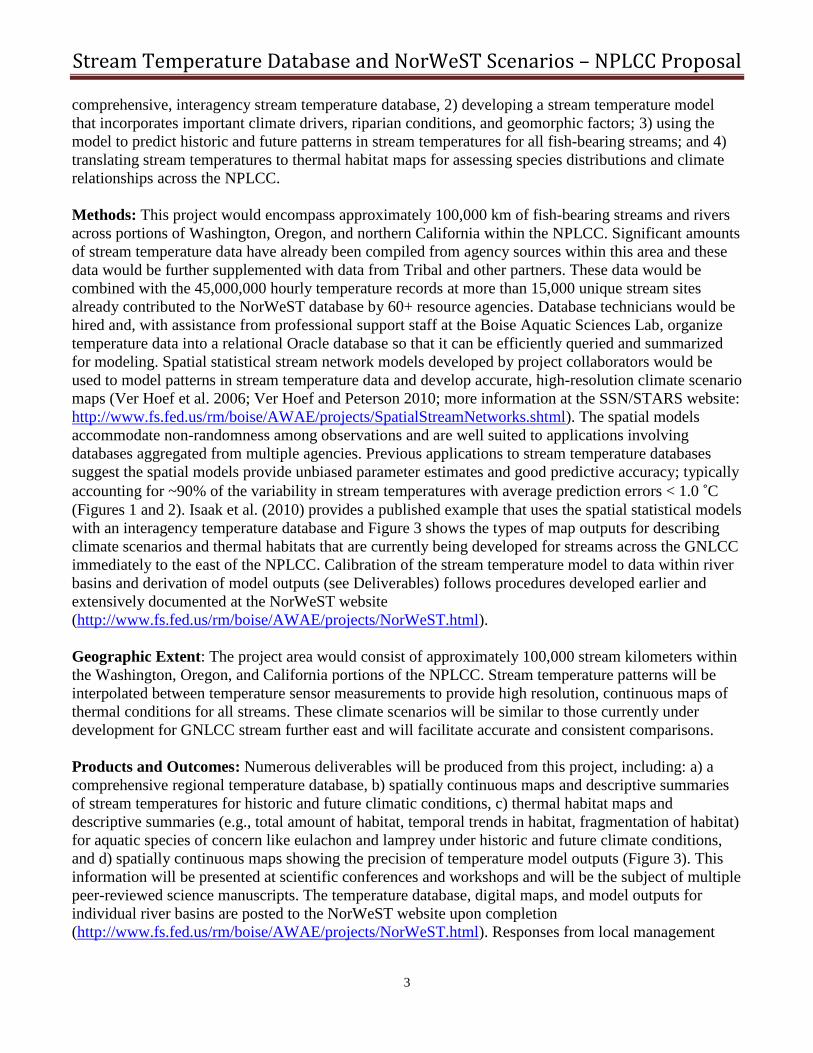
with stream temperatures and introduce considerable uncertainty to vulnerability assessments (Figure 1).
Discussions originating from several climate-related planning groups and workshops, as well as
interactions with regional biologists and hydrologists, have identified a clear need and broad support for
a regional stream temperature database and model to provide an accurate and consistent means of
downscaling climate effects to all streams. The temperature modeling infrastructure developed in this
proposal provides a science-based tool for enhancing coordinated stakeholder management of aquatic
resources. Moreover, this tool is built by integrating data from numerous existing agency temperature
monitoring efforts across the NPLCC to provide a common modeling framework and set of reference
scenarios that would overcome inconsistencies otherwise arising from basin-by-basin approaches.
Corollary outcomes will include: 1) reduced and quantified uncertainty when planning for climate
change and 2) easier communication with the public and among agencies about climate change because
of the availability of credible scientific information at spatial scales and resolutions relevant for
planning. Spatially continuous maps of stream temperature derived from a regional temperature model
significantly reduce the amount of uncertainty associated with climate change effects on stream
ecosystems by quantifying the total amount and locations of thermally suitable habitat for different
species under different climate scenarios. This information can be used to accurately describe current
and future distributions of thermally suitable habitats for non-salmonid anadromous fishes like eulachon
or lamprey, as well as salmon, bull trout, cutthroat trout, and other species of concern across the
NPLCC. In parts of Idaho and Montana where similar stream temperature climate scenarios have been
developed from the NorWeST project funded by the Great Northern LCC, the scenarios are being used
to facilitate a regional climate vulnerability assessment for bull trout (J. Dunham, USGS), to develop
decision support tools (e.g., Peterson et al. 2013), and enable a suite of applications related to traditional
assessments of thermal conditions and monitoring efforts in streams (e.g., cumulative effects, TMDL
regulatory standards). The accuracy of the NorWeST stream temperature climate scenarios (r2 ~ 90%;
average prediction errors < 1.0 ˚C), their ease of use within a GIS environment, and development from
data collected by those working within the local landscape translates to rapid adoption and use in
decision making.
Objective: The primary objective of this project is an accurate assessment and description of historical
and future stream temperatures and thermal habitat distributions for sensitive aquatic species like
eulachon or lamprey so that planning efforts can be undertaken more efficiently and with greater
confidence across the NPLCC. The objective is not to make recommendations regarding specific
management activities in different locales, only to provide accurate information that is fundamental to
an informed discussion about prioritizing those activities. Specific tasks include: 1) developing a
Stream Temperature Database and NorWeST Scenarios – NPLCC Proposal
3
comprehensive, interagency stream temperature database, 2) developing a stream temperature model
that incorporates important climate drivers, riparian conditions, and geomorphic factors; 3) using the
model to predict historic and future patterns in stream temperatures for all fish-bearing streams; and 4)
translating stream temperatures to thermal habitat maps for assessing species distributions and climate
relationships across the NPLCC.
Methods: This project would encompass approximately 100,000 km of fish-bearing streams and rivers
across portions of Washington, Oregon, and northern California within the NPLCC. Significant amounts
of stream temperature data have already been compiled from agency sources within this area and these
data would be further supplemented with data from Tribal and other partners. These data would be
combined with the 45,000,000 hourly temperature records at more than 15,000 unique stream sites
already contributed to the NorWeST database by 60+ resource agencies. Database technicians would be
hired and, with assistance from professional support staff at the Boise Aquatic Sciences Lab, organize
temperature data into a relational Oracle database so that it can be efficiently queried and summarized
for modeling. Spatial statistical stream network models developed by project collaborators would be
used to model patterns in stream temperature data and develop accurate, high-resolution climate scenario
maps (Ver Hoef et al. 2006; Ver Hoef and Peterson 2010; more information at the SSN/STARS website:
http://www.fs.fed.us/rm/boise/AWAE/projects/SpatialStreamNetworks.shtml). The spatial models
accommodate non-randomness among observations and are well suited to applications involving
databases aggregated from multiple agencies. Previous applications to stream temperature databases
suggest the spatial models provide unbiased parameter estimates and good predictive accuracy; typically
accounting for ~90% of the variability in stream temperatures with average prediction errors < 1.0 ˚C
(Figures 1 and 2). Isaak et al. (2010) provides a published example that uses the spatial statistical models
with an interagency temperature database and Figure 3 shows the types of map outputs for describing
climate scenarios and thermal habitats that are currently being developed for streams across the GNLCC
immediately to the east of the NPLCC. Calibration of the stream temperature model to data within river
basins and derivation of model outputs (see Deliverables) follows procedures developed earlier and
extensively documented at the NorWeST website
(http://www.fs.fed.us/rm/boise/AWAE/projects/NorWeST.html).
Geographic Extent: The project area would consist of approximately 100,000 stream kilometers within
the Washington, Oregon, and California portions of the NPLCC. Stream temperature patterns will be
interpolated between temperature sensor measurements to provide high resolution, continuous maps of
thermal conditions for all streams. These climate scenarios will be similar to those currently under
development for GNLCC stream further east and will facilitate accurate and consistent comparisons.
Products and Outcomes: Numerous deliverables will be produced from this project, including: a) a
comprehensive regional temperature database, b) spatially continuous maps and descriptive summaries
of stream temperatures for historic and future climatic conditions, c) thermal habitat maps and
descriptive summaries (e.g., total amount of habitat, temporal trends in habitat, fragmentation of habitat)
for aquatic species of concern like eulachon and lamprey under historic and future climate conditions,
and d) spatially continuous maps showing the precision of temperature model outputs (Figure 3). This
information will be presented at scientific conferences and workshops and will be the subject of multiple
peer-reviewed science manuscripts. The temperature database, digital maps, and model outputs for
individual river basins are posted to the NorWeST website upon completion
(http://www.fs.fed.us/rm/boise/AWAE/projects/NorWeST.html). Responses from local management

Stream Temperature Database and NorWeST Scenarios – NPLCC Proposal
4
communities in Idaho and Montana where NorWeST outputs have been developed are overwhelmingly
positive and the temperature products and climate scenarios are rapidly adopted in planning efforts for
many species.
Timeline Schedule: Full project completion will require one year but deliverables are posted to the
NorWeST website as they are completed for individual river basins. See table for additional details.
Task*
End
2013
Mid
2014
End
2014
1. Stream temperature data assembled X
2. Data checked for errors, summarized, and georeferenced to
stream hydrography layer
X X
3. Models fit to temperature data and scenarios generated X X
4. Periodic status assessments via oral presentations at NPLCC or
other regional meetings of relevance
X X
5. Project reports in the form of multiple peer-reviewed science
manuscripts and reports
X X
6. Final digital maps (GIS layers), stream temperature data, and
metadata distributed through NorWeST website
X X
Data sharing disclaimer: The final stream temperature database that is distributed through the
NorWeST website is filtered to withhold data that project contributors do not want distributed. Past
experience in Idaho and Montana suggests that the large majority of contributors will give permission to
distribute their data (~95% of data contributed to NorWeST are ultimately shared). Stream temperature
model scenarios and associated geospatial information derived from the data will all be distributed
through the website with no restrictions.
Key references for related projects previously undertaken by PIs (others available upon request)
Isaak, D.J., C. Luce, B.E. Rieman, D. Nagel, E. Peterson, D. Horan, S. Parkes, and G. Chandler. 2010.
Effects of climate change and recent wildfires on stream temperature and thermal habitats for two
salmonids in a mountain river network. Ecological Applications 20:1350-1371.
Isaak, D.J., S. Wollrab, D.L. Horan, and G. Chandler. 2012. Climate change effects on stream and river
temperatures across the Northwest U.S. from 1980 – 2009 and implications for salmonid fishes.
Climatic Change 113:499-524.
Peterson, D., S. Wenger, B. Rieman, and D. Isaak. 2013. Linking climate change and fish conservation
efforts using spatially explicit decision support models. Fisheries 38:112-127.
Rieman, B. E., D. Isaak, S. Adams, D. Horan, D., Nagel, and C. Luce. 2007. Anticipated climate
warming effects on bull trout habitats and populations across the Interior Columbia River basin.
Transactions of the American Fisheries Society 136:1552-1565.
Ver Hoef, J.M., and E.E. Peterson. 2010. A moving average approach for spatial statistical models of
stream networks. J. American Statistical Association 105:6-18.
Ver Hoef, J.M., E.E. Peterson, and D. Theobald. 2006. Spatial statistical models that use flow and
stream distance. Environmental and Ecological Statistics 13:449-464.
Wenger, S.J., D. J. Isaak, C.H. Luce, H.M. Neville, K.D. Fausch, J.D. Dunham, D.C. Dauwalter, M.K.
Young, M.M. Elsner, B.E. Rieman, A.F. Hamlet, and J.E. Williams. 2011b. Flow regime,
temperature, and biotic interactions drive differential declines of trout species under climate change.
Proceedings National Academy Science 108:14175-14180.
Stream Temperature Database and NorWeST Scenarios – NPLCC Proposal
5
Figure 1. Scatterplot showing the relationship between air temperature and stream temperature in the northwest
U.S. (panel a). Air temperatures are often used as a surrogate for stream temperatures in bioclimatic assessments
for coldwater fish but this creates significant uncertainties. Lower panel (b) shows the results of a spatial
statistical model applied to a stream temperature database (n = 780) in the Boise River (from Isaak et al. 2010).
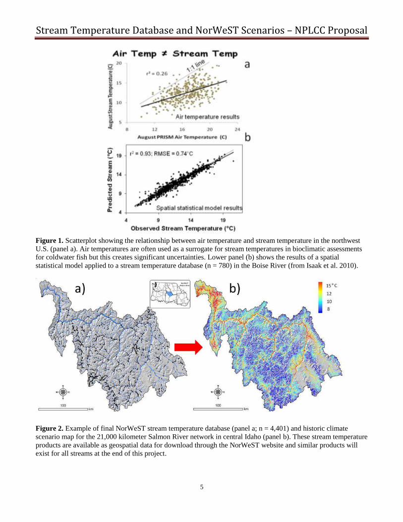
Figure 2. Example of final NorWeST stream temperature database (panel a; n = 4,401) and historic climate
scenario map for the 21,000 kilometer Salmon River network in central Idaho (panel b). These stream temperature
products are available as geospatial data for download through the NorWeST website and similar products will
exist for all streams at the end of this project.
Stream Temperature Database and NorWeST Scenarios – NPLCC Proposal
6
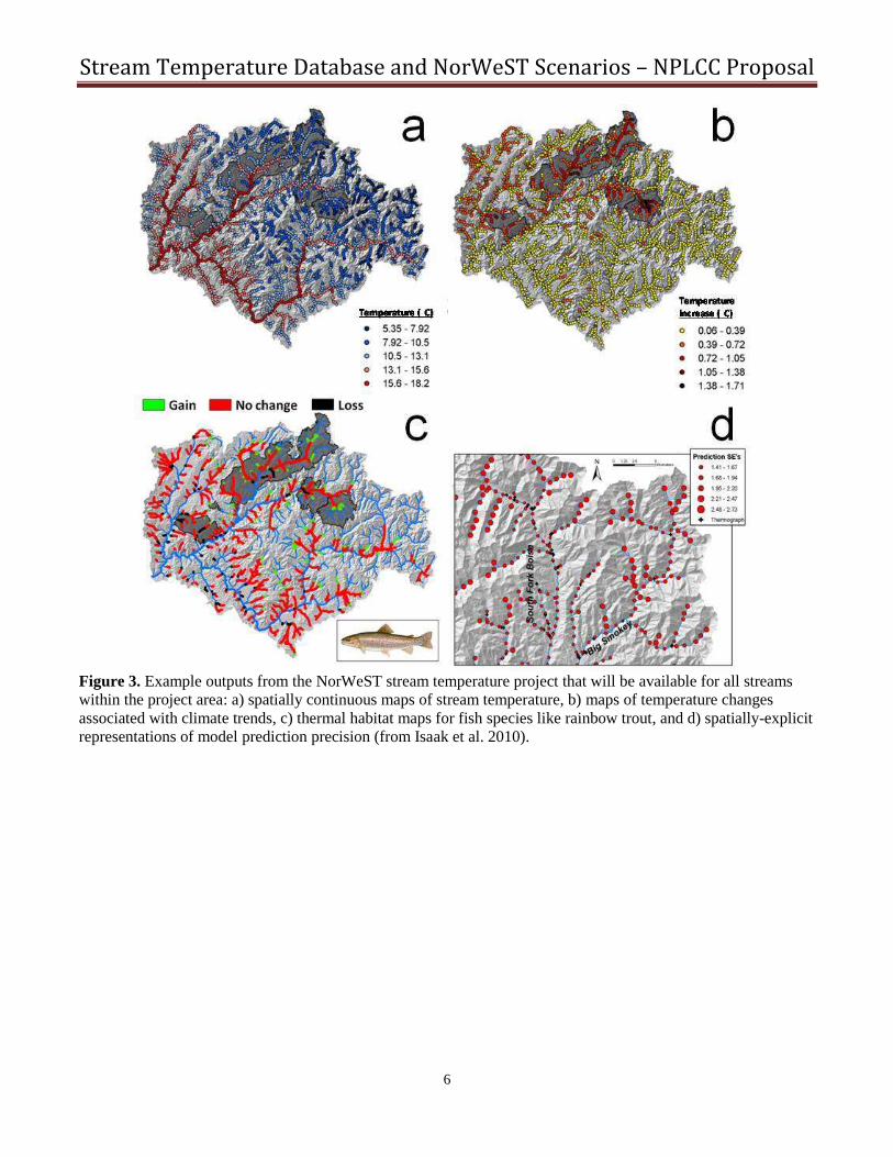
Figure 3. Example outputs from the NorWeST stream temperature project that will be available for all streams
within the project area: a) spatially continuous maps of stream temperature, b) maps of temperature changes
associated with climate trends, c) thermal habitat maps for fish species like rainbow trout, and d) spatially-explicit
representations of model prediction precision (from Isaak et al. 2010).

Stream Temperature Database and NorWeST Scenarios – NPLCC Proposal
7
Budget to develop stream temperature database and NorWeST climate scenarios for the North Pacific LCC.
Budget Category 2013 2014 Comments
Salary Database technician I $15,700 $15,700 Hired for 12 months (6 months each year) at GS-5
Fringe (30%) $4,710 $4,710
$14,000 Hired for 6 months at GS-4
$4,200
Travel Dan Isaak
$4,000 Presentations at regional meetings to provide updates and
technology transfer for NorWeST scenarios within NPLCC
Equipment Workstation computer $3200
GIS/database software $400
Backup hard-drives $400
Total: $42,610 $24,410
USFS overhead rate (7%) $2,983 $1,709
Yearly total: $45,593 $26,119
Project total request:
$71,712
Match/In-kind
Office space $9,000 $4,500 Technician space at USFS Aquatic Sciences Lab
GIS/database support $22,500 $22,500 Fifteen payperiods among 5 research lab personnel
Project administration $7,500 $7,500 Three payperiods for Dan Isaak
Scientific writing $20,000 $20,000 One payperiod from each PI
Temperature data $1,500,000 Assumes 15,000 summer temperature observations are compiled
Yearly in-kind $1,559,000 $54,500 &each observation costs $100 (conservative estimate)
Total in-kind
$1,613,500

Stream Temperature Database and NorWeST Scenarios – NPLCC Proposal
8
Letters of Support
United States
Department of
Agriculture
Forest
Service
Pacific
Northwest
Region
333 SW First Avenue (97204)
PO Box 3623
Portland, OR 97208-3623
503-808-2468
Caring for the Land and Serving People Printed on Recycled Paper
File Code: 2020
Date: May 7, 2013
North Pacific Landscape Conservation Cooperative
c/o Dan Isaak - Fisheries Research Scientist
U.S. Forest Service, Rocky Mountain Research Station
322 E. Front Street, Suite 401
Boise, ID 83702
Dear Sir or Madam:
I am writing to express my strong support for the proposal to the North Pacific Landscape Conservation
Cooperative (NPLCC) entitled, “Developing a comprehensive interagency stream temperature database
and high-resolution NorWeST climate scenarios for the North Pacific LCC.” This project would yield
significant benefits to our agency by providing a standardized and consistent temperature database across
all state, federal, tribal, and private organizations. It would significantly reduce the redundancies in
monitoring efforts within, and among, agencies and enable efficient coordination of future temperature
monitoring. The stream temperature model and climate scenarios developed from these data are also
valuable assets because they provide valid interpolations of information between monitoring locations to
show the status of stream temperatures at high-resolution across full river networks. Having these scenario
maps would be valuable for better understanding the current distribution of thermal conditions across the
states of Oregon and Washington and as a planning tool when addressing climate change.
Previous work by this research team demonstrates their capacity to execute the components of this project,
as they have already compiled stream temperature data from thousands of sites and dozens of agencies
across the interior Northwest and developed climate scenarios for streams across the states of Idaho and
Montana. The Forest Service strongly supports continuation and extension of this work to the NPLCC, so
that western Oregon and Washington streams will have consistent temperature information with those in
other parts of the state and region. Our support is evidenced by the fact that, in the past several years, we
have made substantial investments in improving the quantity, quality, and accessibility of our significant
stream temperature dataset (10,000s of surveys from several 1,000 sites) to support this and related efforts.
If you have any questions or comments, please contact Brian Staab, Regional Hydrologist at
(503) 808-2694 or Becky Gravenmeier, Regional Climate Change Coordinator at (503) 808-2851.
Sincerely,
/s/ Jeff Walter (for):
KENT P. CONNAUGHTON
Regional Forester
cc: Brian Staab, Becky Gravenmier, Tracy B Beck


Stream Temperature Database and NorWeST Scenarios – NPLCC Proposal
10
Principle Investigators

Stream Temperature Database and NorWeST Scenarios – NPLCC Proposal
11
Curriculum Vitae
Daniel J. Isaak ([email protected]; 208.373.4385)
Dan Isaak is a Fisheries Research Scientist with the U.S. Forest Service, Rocky Mountain Research Station Boise
Aquatic Sciences Laboratory in Boise, Idaho. He holds a B.S. from South Dakota State University, a M.S. from
the University of Idaho, and a Ph.D. from the University of Wyoming. He has worked in native fish conservation
and fisheries management and research in the western United States for the past 20 years. His primary research
interests include understanding the effects of climate change on stream habitats and fish communities, stream
temperature monitoring and modeling, spatiotemporal variation in the distribution and abundance of stream fishes
relative to environmental gradients and disturbance, development and application of spatial statistical models for
stream networks, and use of digital and social media to connect people, information, and landscapes. Additional
details are at the scientist’s website (http://www.fs.fed.us/rm/boise/AWAE/scientists/profiles/AWAIsaak.shtml).
Education:
Ph.D., Zoology and Physiology, University of Wyoming, 2001.
M.S., Fisheries Resources, University of Idaho, 1994.
B.S., Wildlife and Fisheries Sciences, South Dakota State University, 1991.
Selected Publications:
Isaak, D.J., and B.E. Rieman. 2013. Stream isotherm shifts from climate change and implications for distributions
of ectothermic organisms. Global Change Biology 19:742-751.
Isaak, D.J., C.C. Muhlfeld, A.S. Todd, R. Al-Chokhachy, J. Roberts, J.L. Kershner, K.D. Fausch, S.W. Hostetler.
2012. The past as prelude to the future for understanding 21st-Century climate effects on Rocky Mountain
trout. Fisheries 37:542-556.
Isaak, D.J., S. Wollrab, D. Horan, and G. Chandler. 2012. Climate change effects on stream and river
temperatures across the Northwest U.S. from 1980 – 2009 and implications for salmonid fishes. Climatic
Change 113:499-524.
Isaak, D.J., C. Luce, B.E. Rieman, D. Nagel, E. Peterson, D. Horan, S. Parkes, and G. Chandler. 2010. Effects of
climate change and wildfire on stream temperatures and salmonid thermal habitat in a mountain river
network. Ecological Applications 20:1350-1371.
Peterson, D.P., S.J. Wenger, B.E. Rieman, and D.J. Isaak. 2013. Linking climate change and fish conservation
efforts using spatially explicit decision support models. Fisheries 38:111-125
Rieman, B.E., D.J. Isaak, S. Adams, D. Horan, D. Nagel, C. Luce, and D. Myers. 2007. Spatial variation in
anticipated climate change effects on bull trout habitats across the interior Columbia River Basin.
Transactions of the American Fisheries Society 136:1552-1565.
Wenger, S.J., D.J. Isaak, C.H. Luce, H.M. Neville, K.D. Fausch, J.B. Dunham, D.C. Dauwalter, M.K. Young,
M.M. Elsner, B.E. Rieman, A.F. Hamlet, and J.E. Williams. 2011. Flow regime, temperature, and biotic
interactions drive differential declines of trout species under climate change. Proceedings of the National
Academy of Sciences doi:10.1073/1103097108.
Wenger, S.J. D.J. Isaak, J.B. Dunham, K.D. Fausch, C.H. Luce, H.M. Neville, B.E. Rieman, M.K. Young, D.E.
Nagel, D.L. Horan, G.L. Chandler. 2011. Role of climate and invasive species in structuring trout
distributions in the Interior Columbia Basin. Canadian Journal of Fisheries and Aquatic Sciences. 68:988-
1008.
Selected Websites:
Stream Temperature Modeling and Monitoring Website
(http://www.fs.fed.us/rm/boise/AWAE/projects/stream_temperature.shtml).
SSN/STARS: Tools for Spatial Statistical Modeling on Stream Networks website
(http://www.fs.fed.us/rm/boise/AWAE/projects/SpatialStreamNetworks.shtml).
NorWeST website (http://www.fs.fed.us/rm/boise/AWAE/projects/NorWeST.html)

Stream Temperature Database and NorWeST Scenarios – NPLCC Proposal
12
Erin E. Peterson, Ph.D.
CSIRO Division of Mathematics, Informatics and Statistics 41 Boggo Road, Dutton Park, QLD, Australia 4102
[email protected] +61 7 3833 5536
http://www.csiro.au/en/Organisation-Structure/Divisions/Mathematics-Informatics-and-Statistics/ ErinPeterson.aspx
Background
Erin Peterson is a research scientist with the CSIRO Division of Mathematics, Informatics, and Statistics in Brisbane, Australia. Her background and experience allow her to work at the interface of geographic information science, aquatic ecology, landscape ecology, and environmental statistics. This research area provides a rich set of modelling and analysis challenges to work on, related to capturing and quantifying spatio-temporal heterogeneity at multiple scales within a statistical modelling framework. Dr Peterson is also committed to software tool development, which helps to ensure that the methodologies she develops are made accessible to ecologists and natural resource managers. This allows users to implement, modify, and improve on her methods to derive additional information about pattern and process in aquatic and terrestrial landscapes.
Education
Ph.D. Earth Resources, Geosciences Department, Colorado State University, 2005
M.S. Forest Sciences, GIS/Remote Sensing Program, Colorado State University, 2001
B.S. Forest Conservation, Michigan State University, 1995
Relevant Publications
Peterson E.E., Ver Hoef J.M., Isaak D.J., Falke J.A., Fortin M-J, Jordan C.E., McNyset K., Monestiez P., Ruesch A.S., Sengupta A., Som N., Steel A., Theobald D.M., Torgersen C.E. & Wenger S.J. (2013) Modeling dendritic ecological networks in space: An integrated network perspective. Ecology Letters, 16(5): 707-719.
Ruesch A., Torgersen C., Lawler J., Olden J., Peterson E.E., Volk C., and Lawrence D. (2012) Projected climate-induced habitat loss for salmonids based on a network model of stream temperature. Conservation Biology, 26(5): 873-882.
Isaak D.J., Luce C.H., Rieman B.E., Nagel D.E., Peterson E.E., Horan D.L., Parkes S., and Chandler G.L. (2010) Effects of recent climate and fire on thermal habitats within a mountain stream network: An example with a native Char species, Ecological Applications, 20(5):1350-1371.
Peterson E.E. and Ver Hoef J.M. (2010) Capturing multiple patterns in stream ecosystems: A moving-average approach to geostatistical modelling. Ecology, 91(3): 644-651.
Ver Hoef J.M. and Peterson E.E. (2010) A moving average approach to spatial statistical models of stream networks, Discussion Paper with Rejoinder, Journal of the American Statistical Association, 489: 6-18.
Peterson E.E., Theobald D.M., and Ver Hoef J.M. (2007) Support for geostatistical modelling on stream networks: Developing valid covariance matrices based on hydrologic distance and stream flow. Freshwater Biology. 52, 267-279.
Peterson E.E., Merton A.A., Theobald D.M., and Urquhart N.S. (2006) Patterns of spatial autocorrelation in stream water chemistry. Environmental Monitoring and Assessment. 121, 569-594.
Peterson E.E. and Urquhart N.S. (2006) Predicting water quality impaired stream segments using landscape-scale data and a regional geostatistical model: A case study in Maryland, Environmental Monitoring and Assessment. 121, 613-636.
Ver Hoef J.M., Peterson, E.E., and Theobald, D.M. (2006) Spatial Statistical Models that Use Flow and Stream Distance, Environmental and Ecological Statistics, 13, 449-464.
Stream Temperature Database and NorWeST Scenarios – NPLCC Proposal
13
Curriculum Vitae
Jay M. Ver Hoef ([email protected])
Jay Ver Hoef is a statistician for a U.S. Government research lab in marine mammals and fisheries
(http://sites.google.com/site/jayverhoef/Home/cv). He develops statistical methods and consults on a wide
variety of topics related to ecological data in general, and marine mammals in particular. His research
interests are in spatial statistics and Bayesian statistics, especially as applied to ecological data. He is a
fellow of the American Statistical Association, and an adjunct professor of Statistics with the Mathematics
and Statistics Department of the University of Alaska, Fairbanks.
Education:
Ph.D., co-major in Statistics and EEB (Ecology and Evolutionary Biology), Iowa State University, 1985 –
1991.
M.S., Botany, University of Alaska, Fairbanks, 1983 – 1985.
B.S., Botany, Colorado State University, 1976 – 1979.
Employment
2005 – present: Statistician for the National Marine Mammal Lab of the National Oceanic and Atmospheric
Association (NOAA), U.S. Dept. of Commerce.
1991 – 2005: Biometrician for the Wildlife Conservation Division of the Alaska Department of Fish and
Game.
Selected Publications:
Ver Hoef, J.M. 2012. Who invented the delta method? The American Statistician 66: 124 – 127.
Ver Hoef, J.M. and Peterson, E.E. 2010. A moving average approach for spatial statistical models of stream
networks (with discussion). Journal of the American Statistical Association 105: 6 – 18. DOI:
10.1198/jasa.2009.ap08248. Rejoinder pgs. 22 – 24.
Ver Hoef, J.M., London, J.M., and Boveng, P.L. 2010. Fast computing of some generalized linear mixed
pseudo-models with temporal autocorrelation. Computational Statistics 25(1): 39 – 55. DOI
10.1007/s00180-009-0160-1.
Cressie, N., Calder, K.A., Clark, J.S., Ver Hoef, J.M., and Wikle, C.K. 2009. Accounting for Uncertainty in
Ecological Analysis: The Strengths and Limitations of Hierarchical Statistical Modeling. Ecological
Applications 19: 553 – 570.
Garreta, V., Monestiez, P. and Ver Hoef, J.M. 2009. Spatial modeling and prediction on river networks: Up
model, down model or both? Environmetrics. DOI: 10.1002/env.995
Ver Hoef, J.M. 2008. Spatial methods for plot-based sampling of wildlife populations. Environmental and
Ecological Statistics 15: 3 – 13.
Ver Hoef, J.M. and Jansen, J.K. 2007. Space-time zero-inflated count models of harbor seals. Environmetrics
18: 697 – 712.
Ver Hoef, J.M. and Boveng, P.L. 2007. Quassi-Poisson vs. negative binomial regression: How should we
model overdispersed count data? Ecology 88: 2766 – 2772.
Ver Hoef, J.M., Peterson, E., and Theobald, D. 2006. Spatial statistical models that use flow and stream
distance. Environmental and Ecological Statistics 13: 449 – 464.
Ver Hoef, J.M., N. Cressie, and R.P. Barry. 2004. Flexible Spatial Models for kriging and cokriging using
moving averages and the Fast Fourier Transform (FFT). Journal of Computational and Graphical
Statistics 13: 265 – 282.

Stream Temperature Database and NorWeST Scenarios – NPLCC Proposal
14
SETH J. WENGER - CURRICULUM VITAE
Trout Unlimited phone: 208-373-4386
322 E. Front St., Suite 401 cell: 208-340-7046
Boise, ID 83702 USA fax: 208-373-4391
EDUCATION
PhD Degree in Ecology 2006
University of Georgia, Athens, GA
MS Degree in Conservation Ecology and Sustainable Development 1999
University of Georgia, Athens, GA
BS Degree in Environmental Science & BA Degree in English 1994
Lebanon Valley College, Annville, PA
RECENT PROFESSIONAL EXPERIENCE
Staff Scientist, Trout Unlimited 2010- Present
Post-Doctoral Associate, Trout Unlimited / US Forest Service 2008-2009
Associate Director, University of Georgia River Basin Center 2007-2008
Conservation Ecologist & Policy Analyst, University of Georgia 2005-2007
SELECTED RECENT PUBLICATIONS
Peterson, D.P, S.J. Wenger, B.E. Reiman and D.J. Isaak. 2013. Linking Climate Change and Fish Conservation
Efforts Using Spatially Explicit Decision Support Tools. Fisheries 38:112-127.
Wenger, S.J. and J.D. Olden. 2012. Assessing transferability of ecological models: an underappreciated aspect of
statistical validation. Methods in Ecology and Evolution 3: 260-267.
Wenger, S.J., D.J. Isaak, C.H. Luce, H.M. Neville, K.D. Fausch, J.B. Dunham, D.C. Dauwalter, M.K. Young,
M.M. Elsner, B.E. Rieman, A.F. Hamlet and J.E. Williams. 2011. Flow regime, temperature and biotic
interactions drive differential declines of trout species under climate change. Proceedings of the National
Academy of Sciences 108(34): 14175-14180.
Wenger, S.J., D.J. Isaak, B.E. Rieman, J.B. Dunham, M.K. Young, K.D. Fausch, C.H. Luce, H.M. Neville, D.E.
Nagel, G.L. Chandler and D.L. Horan. 2011. Role of climate and invasive species in structuring trout
distributions in the Interior Columbia Basin. Canadian Journal of Fisheries and Aquatic Resources 68:
988-1008.
Dauwalter, D.C., S.J. Wenger, K.R. Gelwicks and K. Fesenmyer. 2011. Land use associations with roundtail
chub, flannelmouth sucker and bluehead sucker occurrence in the Upper Colorado River Basin.
Transactions of the American Fisheries Society 140(3): 646-658.
Wenger, S.J., C.H. Luce, A.F. Hamlet, D.J. Isaak and H.M. Neville. 2010. Macroscale hydrologic modeling of
ecologically relevant flow metrics in small streams. Water Resources Research 46, W09513, doi:
10.1029/2009WR008839.
Wenger, S.J., and 20 others. 2009. Twenty-six key research questions in urban stream ecology: an assessment of
the state of the science. Journal of the North American Benthological Society 28: 1080-1098.

Stream Temperature Database and NorWeST Scenarios – NPLCC Proposal
15
Jeffrey L. Kershner Address: USGS Northern Rocky Mountain Science Center
2327 University Way, Suite 2 Bozeman, MT. 59715 Phone: (406) 994-5304 Mobile: 406-599-5001 Email: [email protected] Education:
B.S. Humboldt State University 1976 - Fisheries M.S. Humboldt State University 1983 - Natural Resources PhD University of California, Davis 1991 - Ecology
Employment:
2005-Present USGS - Northern Rocky Mountain Science Center Position - Director
Affiliate Faculty - Ecology Department, Montana State University 1988-2005 U.S. Forest Service, Washington Office
Position - National Aquatic Ecologist 1991-2005 Research Faculty - Utah State University/Watershed Science Department
Rank - Full Professor 1985-1987 U.S. Forest Service, Eldorado/Tahoe National Forest
Position - Zone fisheries biologist 1979-1985 U.S. Forest Service, Eldorado National Forest
Position - Hydrologist, Fisheries biologist Professional Societies:
American Fisheries Society – Certified Professional Fisheries Biologist Courses taught - college level: Humboldt State University Introduction to flyfishing - Co-instructor with Bob Kelley (former director of Fenwick schools) 1977-1979 Cosumnes River Junior College
General ecology (1987) Introduction to flyfishing (1985-86) Utah State University
Fish/habitat relationships – senior/graduate level Watershed analysis - graduate level
Graduate seminars - Cumulative effects in watersheds Adaptation and environment Ecology and management of regulated rivers Restoration ecology
Publications: Jeff has published over 75 scientific articles, book chapters and technical reports on a variety of topics including trout biology, fish habitat, restoration and land use impacts on streams, with students and other colleagues. Presentations: Jeff has given over a hundred presentations to professional organizations and public groups.
Stream Temperature Database and NorWeST Scenarios – NPLCC Proposal
16
Co-Investigator: Charles H. Luce USDA Forest Service Rocky Mountain Research Station, 322 E Front St., Ste. 401, Boise, ID 83702 208-373-4382, [email protected], www.fs.fed.us/rm/boise/AWAE/scientists/profiles/AWALuce.shtml
Education Ph.D. Civil Engineering Utah State University 2000 M.S. Hydrology University of Washington 1990 B.S. Forest Management University of Washington 1986, Magna Cum Laude
Professional Experience 1998-Present: Research Hydrologist, Rocky Mountain Research Station, Boise, Idaho. 1991-1998: Research Hydrologist, Intermountain Research Station, Moscow, Idaho.
Awards and Honors USDA Forest Service Rocky Mountain Research Station, Best Scientific Publication 2009 Water Resources Research Editors' Citation for Excellence in Refereeing, 2003 Certificate of Merit, USDA Forest Service, for Rapid Development of a Model, 1991
Patents Magnetostrictive Precipitation Gage, Patent No.: US 6,490,917 B1, December 10, 2002 Method for Sensing Evaporation of a Liquid, Pat. No.: US 6,789,417 B2, September 14, 2004.
Refereed Journal Articles Luce, C. H., D. Tonina, F. P. Gariglio, and R. Applebee, 2013, Solutions for the diurnally forced advection-diffusion equation
to estimate bulk fluid velocity and diffusivity in streambeds from temperature time series, Water Resour. Res., 49, 488-506, doi:10.1029/2012WR012380.
Adams, H.D., C.H. Luce, D.D. Breshears, M. Weiler, V.C. Hale, C.D. Allen, A.M.S. Smith, T.E. Huxman, 2012. Ecohydrological consequences of drought- and infestation- triggered tree die-off: insights and hypotheses. Ecohydrology, 5: 145-159.. doi: 10.1002/eco.233.
Goode, J. R., C. H. Luce, and J. M. Buffington. 2012. Enhanced sediment delivery in a changing climate in semi-arid mountain basins: Implications for water resource management and aquatic habitat in the northern Rocky Mountains. Geomorphology 139-140: 1-15.
Wenger, S.J.; Isaak, D.J.; Luce, C.H.; Neville, H.M.; Fausch, K.D.; Dunham, J.B.; Dauwalter, D.C.; Young, M.K.; Elsner, M.M.; Rieman, B.E.; Hamlet, A.F.; Williams, J.E. 2011. Flow regime, temperture, and biotic interactions drive differential declines of trout species under climate change. Proceedings of the National Academy of Science (PNAS). 108(34): 14175-14180.
Holden, Z.A., C.H. Luce, M. Crimmins, and P. Morgan, 2012, Wildfire Extent and severity correlated with annual streamflow distribution and timing in the Pacific Northwest, USA (1984-2005), Ecohydrology, 5(5), 677-684 DOI: 10.1002/eco.257
Wenger, S. J., C. H. Luce, A. F. Hamlet, D. J. Isaak, and H. M. Neville, 2010, Macroscale hydrologic modeling of ecologically relevant flow metrics, Water Resour. Res., 46, W09513, doi:10.1029/2009WR008839.
Luce, C.H. and D.G. Tarboton. 2010. Evaluation of alternative formulae for calculation of surface temperature in snowmelt models using frequency analysis of temperature observations. Hydrology and Earth System Sciences, 14(3):535-543
Luce, C. H., and Z. A. Holden 2009, Declining annual streamflow distributions in the Pacific Northwest United States, 1948–2006, Geophys. Res. Lett., 36, L16401, doi:10.1029/2009GL039407.
Tonina, D., Luce, C.H., Clayton, S., Alì, M.D., Barry, J.J., Rieman, B.E., Goodwin, P., Buffington, J.M., Berenbrock, C., 2008, Hydrological Response to Timber Harvest in Northern Idaho: Implications for Channel Scour and Persistence of Salmonids, Hydrological Processes, 22(17):3223-3235.
Stream Temperature Database and NorWeST Scenarios – NPLCC Proposal
17
Biosketch for Jason B. Dunham, Ph.D. April 2013
Professional Preparation
Oregon State University, BS, Zoology, 1987; Arizona State University, MS, Zoology, 1995; University of Nevada-
Reno, Ecology, Evolution and Conservation Biology, Ph.D., 1997
Recent appointments
U.S. Geological Survey, Supervisory Research Aquatic Ecologist (GS-14): 2005 – date; Oregon State University
Department of Fisheries and Wildlife, Courtesy Graduate Faculty: 2005 – date; Guest Instructor, Willamette
University, 2013; College of Idaho, Adjunct Faculty, 2004; University of Idaho, Lecturer, Ecohydraulics Research
Group: 2003-2005; Boise State University, Adjunct Faculty, Department of Biology: 2003-2005; U.S. Forest
Service, Research Fishery Biologist (GS-13): 2000-2005
Selected recent publications (go here for a complete list of >60 available)
Arismendi, I., Johnson, S.L., Dunham, J.B., Haggerty, R., 2013, Descriptors of natural thermal regimes in streams
and their responsiveness to change in the Pacific Northwest of North America. DOI- 10.1111/fwb.12094:
Freshwater Biology, p. online.
Arismendi, I., Johnson, S.L., Dunham, J.B., Haggerty, R., Hockman-Wert, D.P., 2012, The paradox of cooling
streams in a warming world- Regional climate trends do not parallel variable local trends in stream temperature in
the Pacific continental United States: Geophysical Research Letters, v. 39, p. L10401.
Arismendi, I., Safeeq, M., Johnson, S.L., Dunham, J.B., Haggerty, R., 2012, Increasing synchrony of high
temperature and low flow in western North American streams- double trouble for coldwater biota? DOI-
10.1007/s10750-012-1327-2: Hydrobiologia, p. online.
Hoffman, Jr., R., Dunham, J.B., Hansen, B.P., 2012, Aquatic Organism Passage at Road Stream Crossings -
Synthesis and Guidelines for Effectiveness Monitoring: U.S. Geological Survey Open-File Report 2012-1090, p. 64.
Kitanishi, S., Yamamoto, T., Koizumi, I., Dunham, J.B., Higashi, S., 2012, Fine-scale relationships between sex, life
history, and dispersal of masu salmon: Ecology and Evolution, v. 2, no. 5, p. 920-929.
McMillan, J.R., Dunham, J.B., Reeves, G.H., Mills, J.S., Jordan, C.E., 2012, Individual condition and stream
temperature influence early maturation of rainbow and steelhead trout, Oncorhynchus mykiss: Environmental
Biology of Fishes, v. 93, no. 3, p. 343-355.

Stream Temperature Database and NorWeST Scenarios – NPLCC Proposal
18
David E. Nagel Physical Scientist/GIS Analyst
Primary expertise includes spatial analysis, modeling, and remote sensing for hydrologic, geomorphic, and
aquatics applications. Specialties include stream temperature modeling, automated valley confinement mapping,
and landslide potential modeling.
EDUCATION
M.S. Environmental Monitoring, University of Wisconsin – Madison, Institute of Environmental
Studies, 1995.
B.S., Resource Development, Michigan State University, College of Agriculture and Natural Resources,
1986.
PROFESSIONAL EXPERIENCE
Physical Scientist/GIS Analyst, USDA Forest Service, Rocky Mountain Research Station, Boise
Aquatic Sciences Lab, FERA Team. Boise, ID. 2/02 - present.
GIS and Remote Sensing Analyst, USDA Forest Service, PNW Research Station, Seattle Forestry
Sciences Lab, FERA Team. Seattle, WA. 8/99 - 2/02.
Senior Analyst, Remote Sensing and GIS, Earth Information Systems Corporation (EISYS, Inc.). Fort
Collins, CO. 6/97 to 8/99.
Image Processing and GIS Analyst, Wisconsin Department of Natural Resources, Madison, WI. 1/94
to 6/97.
Research Assistant, Environmental Remote Sensing Center, University of Wisconsin-Madison.
Madison, WI. 9/91 to 5/94.
GIS and Remote Sensing Project Manager, Earth Resources Data Analysis Systems (ERDAS, Inc.).
Atlanta, GA. 10/86 to 8/91.
RECENT PRESENTATIONS
Nagel, D., D. Isaak, D. Horan, G. Chandler, S. Parkes, S. Wenger, S. Wollrab, J. Dunham and D. Hockman-Wert.
2013. High Resolution Geospatial Stream Temperature Data for the Northwest U.S., A User’s Guide for
the NorWeST Regional Database and Model. Western Division American Fisheries Society Conference,
April 15-18.
Nagel, D., Buffington, J.M., Luce, C., 2011. A Simple Drainage Enforcement Procedure for Estimating
Catchment Area Using DEM Data. NW GIS User Conference, Oct. 17-21, Boise, ID.
Nagel, D., Buffington, J.M., Isaak, D., 2010. Estimating Stream Gradient Using NHD Stream Lines and DEM
Data. ESRI International User Conference, July 12-16, San Diego, CA.
Nagel, D., D. Isaak, B. E. Rieman, S. Adams, D. Horan, and C. Luce, 2010. A Map of Thermally Suitable Bull
Trout Habitat: Current and Projected Climate Conditions Across the Interior Columbia Basin. ESRI
International User Conference, July 12-16, San Diego, CA.
Nagel, D., C. Luce., D. Isaak, and B. Rieman, 2008. Stream Temperature and Thermal Networks, A GIS and
Remote Sensing Approach to Assess Aquatic Habitat. The Twelfth Biennial USDA Forest Service
Remote Sensing Applications Conference, 2008. April 15-17, Salt Lake City, UT.
Nagel, D., C. Luce., D. Isaak, and B. Rieman, 2007. Toward Stream Temperature Prediction at the Drainage
Basin Scale, A GIS and Remote Sensing Approach. The 22nd Annual Northwest GIS Users’ Conference
and Training, September 10-14, Tacoma, WA.