Strategies to Integrate Communities and Geo Spatial ... · PDF fileSymbiosis Centre for ......
14
Annual Research Journal of SCMS, Pune Vol. 5, March 2017 ISSN 2348–0661 Print © 2016 Symbiosis Centre for Management Studies, Pune Annual Research Journal of Symbiosis Centre for Management Studies, Pune Vol. 5, March 2017 136 Strategies to Integrate Communities and Geo Spatial Technologies for Sustainable Development along Tarkarli - Devbag Coast, Maharashtra (India) Dr. Yogesh Pisolkar Symbiosis Centre for Management Studies, Symbiosis International University Viman Nagar, Pune 411014, [email protected] Dr. Navendu Chaudhary Symbiosis Institute of Geoinformatics, Symbiosis International University Model Colony, Pune 411016, [email protected] Abstract Maharashtra coast is popularly known as ‘Konkan’. The Konkan with an approximately 720 km long coastline and a narrow coastal plain stretching from north to south is a distinct physiographic region of Maharashtra (India). The coast lies to the west. On the east, the Konkan is separated from upland Maharashtra by the west facing escarpment of the Sahayadri mountain range. Plateaus and hills dominate the landscape in the narrow stretch of land between the coastal plain on the east and the Sahyadri on the west. Towards the southern end of Maharashtra’s coastline lies the Sindhudurg coastal district. This region along the Sahyadri Range on India’s west coast is internationally acclaimed for its sun and sand. Apart from the beautiful beaches and island forts, the coast is also well known for fruits — mangoes, cashew nuts and kokum—which in turn attracts a lot of tourists and traders, making this a busy stretch all through the year. The area is also notable for its unique coastal and marine biodiversity (UNDP 2011). The Arabian Sea is slowly eroding some of the seashores in Sindhudurg district. Frequency and intensity of beach and creek erosion events has increased along the Sindhudurg coast in
-
Upload
trinhtuong -
Category
Documents
-
view
213 -
download
1
Transcript of Strategies to Integrate Communities and Geo Spatial ... · PDF fileSymbiosis Centre for ......

Annual Research Journal of SCMS, Pune Vol. 5, March 2017
ISSN 2348–0661 Print
© 2016 Symbiosis Centre for Management Studies, Pune Annual Research Journal of Symbiosis Centre for Management Studies, Pune Vol. 5, March 2017 136
Strategies to Integrate Communities and Geo Spatial Technologies for
Sustainable Development along Tarkarli - Devbag Coast, Maharashtra
(India)
Dr. Yogesh Pisolkar
Symbiosis Centre for Management Studies, Symbiosis International University
Viman Nagar, Pune 411014, [email protected]
Dr. Navendu Chaudhary
Symbiosis Institute of Geoinformatics, Symbiosis International University
Model Colony, Pune 411016, [email protected]
Abstract
Maharashtra coast is popularly known as ‘Konkan’. The Konkan with an approximately 720
km long coastline and a narrow coastal plain stretching from north to south is a distinct
physiographic region of Maharashtra (India). The coast lies to the west. On the east, the
Konkan is separated from upland Maharashtra by the west facing escarpment of the
Sahayadri mountain range. Plateaus and hills dominate the landscape in the narrow stretch of
land between the coastal plain on the east and the Sahyadri on the west.
Towards the southern end of Maharashtra’s coastline lies the Sindhudurg coastal district.
This region along the Sahyadri Range on India’s west coast is internationally acclaimed for
its sun and sand. Apart from the beautiful beaches and island forts, the coast is also well
known for fruits — mangoes, cashew nuts and kokum—which in turn attracts a lot of tourists
and traders, making this a busy stretch all through the year. The area is also notable for its
unique coastal and marine biodiversity (UNDP 2011).
The Arabian Sea is slowly eroding some of the seashores in Sindhudurg district. Frequency
and intensity of beach and creek erosion events has increased along the Sindhudurg coast in

Annual Research Journal of SCMS, Pune Vol. 5, March 2017
ISSN 2348–0661 Print
© 2016 Symbiosis Centre for Management Studies, Pune Annual Research Journal of Symbiosis Centre for Management Studies, Pune Vol. 5, March 2017 137
general and along Tarkarli-Devbag spit in particular. Tarkarli-Devbag Spit (15o57' N to
16o1'N latitude) and (73
o29' E to 73
o31' E longitude) is a 6 km. long sand spit about 16 km.
South of Malvan on Maharashtra coast. The spit bar is connected to main land near Tarkarli.
Southern end of the bar abruptly ends in sea near Mobarwadi. The eastern edge of the spit is
bordered by tidal stretch of river Karli. The western margin faces Arbian Sea. Rapidly
growing .tourism activities on Tarkali-Devbag spit are creating additional stress on
ecosystem services. Deteriorating ground water quality is another major threat. Community
people are not realizing the importance of ecosystems services for sustainable development
An attempt is made here to study the spatio-temporal changes in the study area and create a
matrix of issues and potential strategies for sustainable development of Tarkarli-Devbag.
Key Words - Erosion, Geospatial Technologies, Tourism, Sustainable Development (SD)
JEL classification code: Z32 (Tourism and Development)
Introduction
Coastal communities world-wide are faced with difficult problems of shoreline erosion
control because of the high land values inherent in the shore zones. Chronic erosion as well
as storm erosion can be viewed as important management problems (Pilarczyk, 1990).
Beaches and dunes have very important recreational value. Beaches are generally not
affected by coastal erosion. In principle coastal erosion only causes beach problems if a fixed
structure such as sea wall lies behind the beach. In the dune areas there are recreational
facilities such as camp grounds, structures such as hotels and restaurants in the first dune-row
area, of course, endangered by erosion (Cess, 1990).Tarkarli-Devbag sand spit is a 6 km long
detached type of beach about 16 km South of Malvan on Maharashtra coast. The spit bar is
connected to main land near Tarkarli. The southern end of the bar abruptly ends in the sea
near Mobarwadi. The eastern edge of the spit is bordered by a tidal stretch of river Karli. The
western margin faces the Arabian Sea. (Pisolkar, 2008, Fig1A, B).

Annual Research Journal of SCMS, Pune Vol. 5, March 2017
ISSN 2348–0661 Print
© 2016 Symbiosis Centre for Management Studies, Pune Annual Research Journal of Symbiosis Centre for Management Studies, Pune Vol. 5, March 2017 138
Fig 1A Trakarli Devbag Administrative Fig1B Tarkarli – Devbag Spit
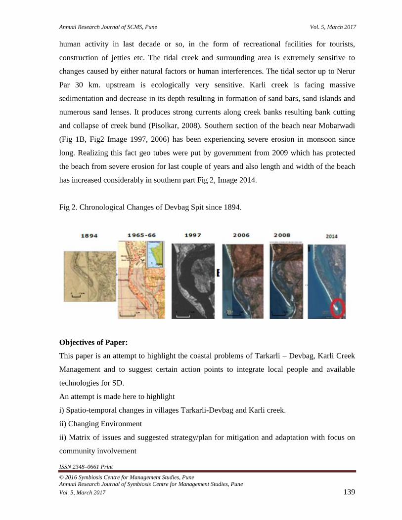
The area is showing a tendency of severe breaching and erosion of shorefront since last
century Fig (2). Field visits (for last 20 years) show that encroachment and erosion by sea
have accelerated after December 2004. The tendency of creek infill is a recent phenomenon
as reported by the locals and supported by satellite images & the Naval Hydrographic Chart
of the Karli Creek of last few years. The constructional work, along the banks of the
upstream sector of river has definitely enhanced the rate of fluvial sediment supply from the
catchment. In addition to this factor, the relative balance of wave, fluvial and tidal influence
as well as ecological changes and overall development are also reported from other places by
many authors. (Roy, 1984). The islands, plumes and shoals at the entrance of Karli creek are
shaped by waves. Sand moves into the inlet by flood tide forming an extensive flood tide
delta which infills most of the lower part of creek. The shoals developed some more distance
inland into the creek are the results of low tide excursion of water and supply of fluvial
sediments to the creek Fig 2.
The complexity of the infill has increased in last two decades leading to shallowing of creek
and channelisation of the flow through narrow, elongated shoals. Water level fluctuations
within the creek especially in monsoons are determined by tidal prism and fluvial discharge.
The fluctuations are responsible for the creek bank cutting and retreat of spit bar from creek
side.The lower part of the creek especially between Tarkarli and Mobar is subject to intense
Annual Research Journal of SCMS, Pune Vol. 5, March 2017
ISSN 2348–0661 Print
© 2016 Symbiosis Centre for Management Studies, Pune Annual Research Journal of Symbiosis Centre for Management Studies, Pune Vol. 5, March 2017 139
human activity in last decade or so, in the form of recreational facilities for tourists,
construction of jetties etc. The tidal creek and surrounding area is extremely sensitive to
changes caused by either natural factors or human interferences. The tidal sector up to Nerur
Par 30 km. upstream is ecologically very sensitive. Karli creek is facing massive
sedimentation and decrease in its depth resulting in formation of sand bars, sand islands and
numerous sand lenses. It produces strong currents along creek banks resulting bank cutting
and collapse of creek bund (Pisolkar, 2008). Southern section of the beach near Mobarwadi
(Fig 1B, Fig2 Image 1997, 2006) has been experiencing severe erosion in monsoon since
long. Realizing this fact geo tubes were put by government from 2009 which has protected
the beach from severe erosion for last couple of years and also length and width of the beach
has increased considerably in southern part Fig 2, Image 2014.
Fig 2. Chronological Changes of Devbag Spit since 1894.
Objectives of Paper:
This paper is an attempt to highlight the coastal problems of Tarkarli – Devbag, Karli Creek
Management and to suggest certain action points to integrate local people and available
technologies for SD.
An attempt is made here to highlight
i) Spatio-temporal changes in villages Tarkarli-Devbag and Karli creek.
ii) Changing Environment
ii) Matrix of issues and suggested strategy/plan for mitigation and adaptation with focus on
community involvement

Annual Research Journal of SCMS, Pune Vol. 5, March 2017
ISSN 2348–0661 Print
© 2016 Symbiosis Centre for Management Studies, Pune Annual Research Journal of Symbiosis Centre for Management Studies, Pune Vol. 5, March 2017 140
However, the authors would like to mention the limitations like data (which can be provided
in given limits) while drawing readers’ attention to the issue. The paper is based on the
Beach and Creek Erosion problem of Devbag beach and Karli creek, a doctoral research of
Dr. Yogesh Pisolkar (author), recent field surveys, interactions with communities and Gram
Panchayat staff with ongoing research work, literature review and previous works. However,
we have included detailed studies of each component before arriving at a final conclusion.
While suggesting these approaches authors clearly want to state & emphasize on what should
be implemented without adversely affecting livelihood of the people, ignoring flip sides of
manner in which development has occurred in village Devbag.
Literature Review and Previous works –
Tarkarli- Devbag coast is facing coastal erosion problem for last five to six decades. There is
urgency to mitigate this problem with coastal protection (Pisolkar, 2008). Coastal tourism
picked up on Tarkarli–Devabag spit in last two decades (Pisolkar et
al.,2013,2014,16).Coastal communities all over the world are getting affected by shoreline
erosion problem. Management of these natural disasters is necessary (Pilarczyk,K 1990).
There is need to develop new strategies to meet the future challenges. It is not just one factor
but a host of factors in combination that need to be addressed to make our coast safe,
Planning which takes care of the socio-economic and environmental issues, increasing
peoples participation, capacity building are some of the measures to move from a culture of
reaction to one of prevention (CEE,2009). A collaborative research project - 'Measuring,
monitoring and managing sustainability the coastal dimension' - that set out to understand
how societal driving forces impact ecosystems. The research was interdisciplinary,
combining the social with the natural sciences. The objective was to integrate across
disciplines, examines the environment-development interface, and bridges the divide
between the natural and social sciences, building on the strengths and constraints of both.
This Indo-European collaboration was able to initiate dialogues on many fronts, across
cultures, disciplines, and stakeholders (Noronha et. al. 2003).Realizing the importance of the
Sindhudurg Coastal and Marine Ecosystem (SCME), UNDP-GEF with implementing partner
Ministry of Environment and Forest (MoEF) has worked on improving the conservation
Annual Research Journal of SCMS, Pune Vol. 5, March 2017
ISSN 2348–0661 Print
© 2016 Symbiosis Centre for Management Studies, Pune Annual Research Journal of Symbiosis Centre for Management Studies, Pune Vol. 5, March 2017 141
prospects and sustainable community livelihoods from 2011-16 with local peoples
participation (UNDP, 2011)
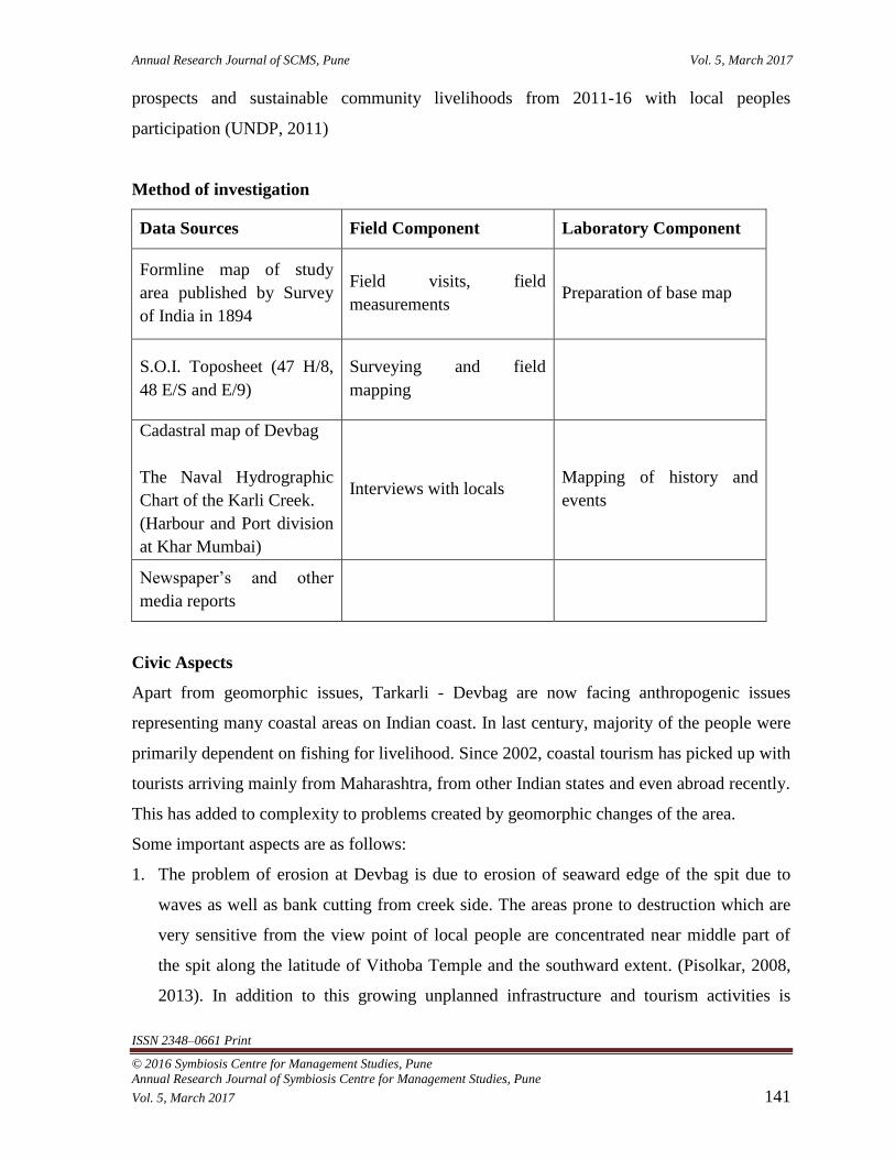
Method of investigation
Data Sources Field Component Laboratory Component
Formline map of study
area published by Survey
of India in 1894
Field visits, field
measurements Preparation of base map
S.O.I. Toposheet (47 H/8,
48 E/S and E/9)
Surveying and field
mapping
Cadastral map of Devbag
The Naval Hydrographic
Chart of the Karli Creek.
(Harbour and Port division
at Khar Mumbai)
Interviews with locals Mapping of history and
events
Newspaper’s and other
media reports
Civic Aspects
Apart from geomorphic issues, Tarkarli - Devbag are now facing anthropogenic issues
representing many coastal areas on Indian coast. In last century, majority of the people were
primarily dependent on fishing for livelihood. Since 2002, coastal tourism has picked up with
tourists arriving mainly from Maharashtra, from other Indian states and even abroad recently.
This has added to complexity to problems created by geomorphic changes of the area.
Some important aspects are as follows:
1. The problem of erosion at Devbag is due to erosion of seaward edge of the spit due to
waves as well as bank cutting from creek side. The areas prone to destruction which are
very sensitive from the view point of local people are concentrated near middle part of
the spit along the latitude of Vithoba Temple and the southward extent. (Pisolkar, 2008,
2013). In addition to this growing unplanned infrastructure and tourism activities is

Annual Research Journal of SCMS, Pune Vol. 5, March 2017
ISSN 2348–0661 Print
© 2016 Symbiosis Centre for Management Studies, Pune Annual Research Journal of Symbiosis Centre for Management Studies, Pune Vol. 5, March 2017 142
adding fuel to already prevalent problem and is measure threat for coastal protection.
Karli Creek is now extensively used for tourism activity. There are about 100 people in
Mobareshwar sangh and Mahapurush Sangh engaged in boating for tourist. In addition to
this private speed boat operators use Karli creek for adventure tourism activities.
Collapsing of creek bunds due to waves created by speed boats is a great concern for the
people along the banks.
2. Change in land use pattern infesting in increasing constructions and decreasing natural
habitats (Photo Plate 1). Construction of more and more hotels closer to sea to encourage
beach tourism in spite of coastal disasters (Photo Plate 2).
3. Discussions with local people suggest that more and more bore wells are dug to cater the
domestic as well as tourist needs in last 3-4 years. According to local people previously
salinity used to be very high from May but now it is very high from the month of March.
Deteriorating water quality trend due to increasing demand of water for tourism will
increase the competition for water. Already some people in Devbag (near Vithoba
Temple and Mobar) and Tarkarli are in search for new water sources for drinking water.
There is general awareness regarding ecosystem services but extent of knowledge base
needs to be investigated.
4. Local people of Devbag, Tarkarli are shifting their livelihood from traditional trades to
service sector. Majority of the community people working in the tourism especially
tourist accommodation sector is not professionally trained and hence lack in providing
quality services required in modern day.
5. Lack of synergy to integrate resources (both natural and human) for sustainable
development.
Interrelation between geomorphic and anthropogenic aspects mentioned above have raised
question mark over sustainability of fast developing tourism industry and its long term and
short term impacts over local communities as well as ecosystem.
Photo Plate 1: Land Use Land Cover (LULC) is showing increasing trend infesting more and
more constructions of hotels.

Annual Research Journal of SCMS, Pune Vol. 5, March 2017
ISSN 2348–0661 Print
© 2016 Symbiosis Centre for Management Studies, Pune Annual Research Journal of Symbiosis Centre for Management Studies, Pune Vol. 5, March 2017 143
Photo Plate 2: Sea Facing Luxury(A,B), Budget(C) and Undercostruction(D) hotels on Sand
dune system on Devbag Spit.
The above context leads to some conclusions like:
Localized human activities may be accelerating coastal erosion but this needs to be
investigated,
Coastal erosion and unplanned tourism may adversely impact the local economy and the
tourism industry in near future due to competition for resources (especially quality of water).

Annual Research Journal of SCMS, Pune Vol. 5, March 2017
ISSN 2348–0661 Print
© 2016 Symbiosis Centre for Management Studies, Pune Annual Research Journal of Symbiosis Centre for Management Studies, Pune Vol. 5, March 2017 144
All human activities anyway need to be planned keeping in mind their actual and potential
adverse impacts on communities and ecosystems. Hence, for the sustainable development
there is urgent need for training, capacity building, education and awareness among various
stake holders in villages Tarkarli and Devbag.
Efforts so Far
Villages have noticed threats due to coastal erosion and due to loss of property. People in
Devabag have raised concerns as and when it was required for at least 30 years. People have
been consistently passing resolutions in Gram Panchayat and following up with Government
Departments like Harbour and Port Division (Pattan Vibhag), Central Water and Power
Research Station (CWPRS), for construction of anti-erosion wall and creek bund along
different sections of the beach. Subsequently Maharashtra Government built an anti-erosion
wall and creek bund in certain sections. However, anti erosion wall subsides in some parts of
beach owing to strong wave action during rough weather. Creek bund is also vulnerable.
Dredging of Karli creek for last few years has not yielded much.
Here is a suggested matrix of issues and participatory strategy. Brief description of the
strategy components is given below. However, authors would like to clearly mention that
each of the components in table needs thorough research for adequate database towards
implementation.
Problems and aspects to be
examined Suggested strategies
A Nature and extent of beach
erosion and its impact Hazard Assessment Matrix (HAM)
B
Allotment of resources during
mitigation and adaptation -
Prioritize response to various
events
Vulnerability Assessment
Strict implementation of Environment Impact
Assessment (EIA) through independent expert
agencies. Research on appropriate options
including required modifications in structure and
placement.
C Ecosystem Services – Taken for Identify types of ecosystems and their services to

Annual Research Journal of SCMS, Pune Vol. 5, March 2017
ISSN 2348–0661 Print
© 2016 Symbiosis Centre for Management Studies, Pune Annual Research Journal of Symbiosis Centre for Management Studies, Pune Vol. 5, March 2017 145
granted leading to unplanned
exploitation
communities
D
Inadequate knowledge of local
communities and their
dependence on Government
mechanisms
Need for Environment Education
(EE), Capacity Building,
Training, Awareness
Awareness campaign related to environmental and
socio-economic issues
Decentralization of Governance
E
Inadequate synergy among Govt
departments, academic institutes,
Non Government Organizations-
Community Based Organizations
and communities
Strengthen Maharashtra Coastal Zone Management
Authority (MCZMA)
Evolve Regional Centre of Expertise (RCE) for
sustainable coastal development
A. Hazard Assessment Matrix (HAM)
Hazards can become extreme events which could turn into disasters when population/system
does not possess adequate capacity to cope up. A technique to keep track of past and present
hazards in order to build up resilience is termed as HAM (CEE, 2009). There is urgency to
keep records of the past events (especially destruction due to storm surges and creek bank
erosion) in case of Tarkarli - Devbag coast to address the local needs of vulnerable
communities and to develop Community Based Disaster Risk Reduction (CBDRR).
Hazar
d type
Origi
n/
Cause
Warning
signs
Spee
d
of
onset
Intens
ity
Freque
ncy
Durat
ion
Geograp
hical
extent
Magnitu
de
of
damage
Sea
son
Recent
Trend
(Source CEE, 2009)
B. Vulnerability Assessment

Annual Research Journal of SCMS, Pune Vol. 5, March 2017
ISSN 2348–0661 Print
© 2016 Symbiosis Centre for Management Studies, Pune Annual Research Journal of Symbiosis Centre for Management Studies, Pune Vol. 5, March 2017 146
Vulnerability assessment is the process where we identify the problem, quantify it, and assess
the risk rate in formulating development strategies to reduce the risk and vulnerabilities.
Proper planning and protection strategies for Indian coast must be taken swiftly by the
coastal management and policy makers to safeguard coastal ecosystem and livelihoods. In
recent years, there has been much focus on coastal vulnerability assessments using various
kinds of data. Most of the reported studies over Indian coast are based on remote sensing and
GIS methods (Sudha R etc al., 2015). Indigenous people have been living in the same
villages and have observed environmental changes for generations. In case of villages
Tarkarli - Devbag people’s knowledge should be incorporated with modern remote sensing
and geospatial technologies to build the resilience especially regarding ecosystem services.
Dredging of Karli Creek needs strict implementation of Environment Impact Assessment
(EIA) through independent expert agencies. Public participation and hearing is necessary
considering Karli Creek is now used for tourism activities. EIA has three core values –
Integrity, Utility, and Sustainability. Hence, management of Karli creek for fishing and
tourism needs proper planning and protection strategies. Remote sensing data, GIS
technologies and The Naval Hydrographic Charts of the Karli Creek for last two decades can
be used meaningfully with expert guidance of EIA team and local people’s participation.
Coastal protection measures and their present condition needs through investigation. Feeding
observations to District Level Coastal Committees (DLCCs) and strengthening DLCCs &
MCZMA will be first step towards improving coastal defense measures.
C. Ecosystem Services
The region benefits from its environment in various ways. According to Millennium
Ecosystem Assessment (2000), the ecosystem services are grouped in four major categories,
namely; Provisioning, Regulating, Supporting and Cultural. These ecosystem services are
integral to the sustainability of the region especially in area such as Devbag which is still
supported by traditional way of life. The following table illustrates these services in brief.
Ecosystem Services
1 Provisional
Food- Fishery, Mad Bagayat.
Raw material- Stones and wood for building, manure as fertilizer
Energy - biomass fuels

Annual Research Journal of SCMS, Pune Vol. 5, March 2017
ISSN 2348–0661 Print
© 2016 Symbiosis Centre for Management Studies, Pune Annual Research Journal of Symbiosis Centre for Management Studies, Pune Vol. 5, March 2017 147
2 Regulating Waste disposal and drinking water purification, pest and disease control.
3 Supporting Nutrient recycling, Ecosystem sustenance and primary production
4 Cultural
Intangible assets of cultural diversity, folk arts, spiritual and recreational aspects
The traditional profession that sustained Devbag and Tarkarli coast is fishery and Mad
Bagayat (Horticulture). People depend on firewood for fuel source and waste disposal and
water purification is nonexistent. Intangible assets such as Dashavatari plays, Koli dance and
local cuisine and specialties are neither marketed nor perceived as valuable. Considerable
efforts are required to assign economic value to these services in order to sustain the
development in the region.
D. Education and Awareness
The region is rapidly undergoing socio-economic change. The people are not adequately
educated or trained to survive or benefit from this change. Various issues regarding public
health and environmental degradation must be communicated and discussed freely in the
society in order to facilitate participation from all the stake holders. Various governmental
and non governmental agencies provide support for programs related to public health and
sanitation or waste disposal etc. Local NGOs Kille Sindhudurg Prenotsav Samiti, Malvan.,
Tarkarli Development Sanstha (TDS) are already working on the same with the support of
UNDP, MTDC and Government of Maharashtra. People must be made aware of these
programs and capacity building in terms of infrastructure and personnel should be undertaken
at Gram panchayat in order to get benefits from these programs. People should be sensitized
towards their local culture through promotional activities.
E. Synergistic Governance
Governance at village level is a challenge in itself. But under the onslaught of new
development, constant regulatory changes and opaque policy decisions makes it even more
so. Both local and state government should formulate and communicate policies that directly
affect livelihood and sustainability of local population. The long winding regulatory process
Annual Research Journal of SCMS, Pune Vol. 5, March 2017
ISSN 2348–0661 Print
© 2016 Symbiosis Centre for Management Studies, Pune Annual Research Journal of Symbiosis Centre for Management Studies, Pune Vol. 5, March 2017 148
is very daunting for villagers. These villagers lack both intellectual and financial support to
navigate through the regulatory system and often gets short end of the developmental
benefits that are grabbed by few powerful elements of the society. Strengthening of
enforcement agencies such as strengthening Maharashtra Coastal Zone Management
Authority (MCZMA) can produce desired effect. Evolving Regional Centre of Expertise
(RCE) for sustainable coastal development can integrate the local development with the
overall coastal development of the state and can benefit from increase in knowledge
exchange and building expertise.
Many coastal villages along the Konkan face similar problems where coastal tourism is
flourishing. Hence it is the need of the hour to design site specific strategies which will
integrate local stake holders and modern remote sensing and GIS technologies keeping in
mind sustainable development. We believe that present study report gaps between previous
studies considering the strong potential of Integrated Coastal Zone Management (ICZM) for
collective growth of communities along Tarkarli- Devbag coast. Careful implementation by
policy makers and administrators integrating local stake holders will strengthen the
development of the region in a more meaningful way.
References:
Cees,L., (1990).General Strategy on coastline protection – The Dutch case in Coastal
protection, A.A. Balkema Publisher., Brookfield VT 05036, U.S.A., Pp 19.
CEE., (2009). Towards safe coasts, a hand book for coastal managers by Centre for
Environment Education, 2009 pp 17
Noronha L, Lourenco N,Lobo-Ferreira J.P.,Feoli E, Lleopart A, Sawkar K, and Chawadi
A.G.,(2003). Coastal Tourism, environment and sustainable local development published by
The Energy and Resources Institute (TERI)
Pilarczyk, K., (1990). Introduction to coastal Protection in Coastal protection, A.A. Balkema
Publisher., Brookfield VT 05036,U.S.A., Pp 1.
Pisolkar Y.M.,(2008). A Geomorphic Study of Beach and Creek Erosion at Devbag, coastal
Maharashtra, unpublished Ph.D. thesis, University of Pune.
Pisolkar, Y., Rawat, A., Mahankale,N., Arora,R. (2013). Growing Tourism on Tarkarli –
Devbag Spit, its Consequences and Suggested Strategy for Sustainable Tourism, Coastal

Annual Research Journal of SCMS, Pune Vol. 5, March 2017
ISSN 2348–0661 Print
© 2016 Symbiosis Centre for Management Studies, Pune Annual Research Journal of Symbiosis Centre for Management Studies, Pune Vol. 5, March 2017 149
Maharashtra, India, Report ‘Minor Research Project’ Symbiosis Centre for Management
studies (SCMS), PUNE.pp22
Roy, P.S., (1984). New South Wales estuaries, their origin and evolution, in B.G. Thom
(Editor), Coastal geomorphology in Australia, Academic Press, Sydney PP - 99-121.
Sudha, Rani., N.N.V., Satyanarayana, A.N.V., & Bhaskaran, Nat. P.K., Hazards (2015).
Coastal vulnerability assessment studies over India: a review in Natural Hazards
Journal of the International Society for the Prevention and Mitigation of Natural Hazards,
Volume 77: Pp405. doi: 10.1007/s11069-015-1597.
UNDP., (2011). Project Document – Mainstreaming Coastal and Marine Biodiversity
Conservation into Production Sectors in Sindhudurg Coast, Maharashtra, India.
UNEP., (2000). Ecosystems and Human Well-being - A Report of the Millennium
Ecosystem Assessment. Pp vi