Strategic Plan Study on Commercial Urban Agriculture in the City of ...

Japan International Cooperation Agency (JICA) Yangon City Development Committee (YCDC)
January 2014 Nippon Koei Co., Ltd.
NJS Consultants Co., Ltd.
YACHIYO Engineering Co., Ltd.
International Development Center of Japan Inc.
Asia Air Survey Co., Ltd.
ALMEC Corporation
The Republic of the Union of Myanmar A Strategic Urban Development Plan of Greater Yangon The Project for the Strategic Urban Development Plan of the Greater Yangon
FINAL REPORT II < SUMMARY >
EI
JR
14-046
A Strategic Urban D
evelopment Plan of G
reater Yangon
FINA
L RE
PO
RT II <S
UM
MA
RY>
January 2014 JIC
A
Japan International Cooperation Agency (JICA) Yangon City Development Committee (YCDC)
January 2014 Nippon Koei Co., Ltd.
NJS Consultants Co., Ltd.
YACHIYO Engineering Co., Ltd.
International Development Center of Japan Inc.
Asia Air Survey Co., Ltd.
ALMEC Corporation
The Republic of the Union of Myanmar A Strategic Urban Development Plan of Greater Yangon The Project for the Strategic Urban Development Plan of the Greater Yangon
FINAL REPORT II < SUMMARY >
A Strategic Urban D
evelopment Plan of G
reater Yangon
FINA
L RE
PO
RT II <S
UM
MA
RY>
January 2014 JIC
A

The Project for the Strategic Urban Development Plan of the Greater Yangon Final Report for Phase II <Summary>
NIPPON KOEI CO., LTD., NJS CONSULTANTS CO., LTD.
YACHIYO ENGINEERING CO., LTD., INTERNATIONAL DEVELOPMENT CENTER OF JAPAN,
ASIA AIR SURVEY CO., LTD., and ALMEC CORPORATION
i
The Project for
The Strategic Urban Development Plan of the Greater Yangon
Final Report II < Summary >
TABLE OF CONTENTS
Page CHAPTER 1: Introduction ...................................................................................................... 1-1 CHAPTER 2: Phase II Works – Case Studies and Techinical Transfer -
1 CBD(Central Business District) Development ......................................................... 2-1 2 North-East Region Development ............................................................................ 2-12 3 Transit Oriented Development “TOD” ................................................................... 2-18 4 Capacity Development Plan .................................................................................... 2-24 5 Strategic Environmental Assessment “SEA” .......................................................... 2-27
CHAPER 3: Conculsion and Recommendation ...................................................................... 3-1

Subsequent Works (Phase II) of the Strategic Urban Development Plan of Grater Yangon
JICA Study Team 1-1
Yangon, the largest economic center of Myanmar, has about 5.14 million population and is experiencing rapid urbanization and accelerated development as the nation moves toward democracy. The current rapid urbanization is putting more pressure on the existing old infrastructures. Yangon Regional Government and JICA agreed to start the Study to prepare a well‐thought future vision and strategic urban development plan. Accordingly, it will achieve balanced, inclusive, and sustainable growth, and cater to a better supply of urban infrastructure and services for the urban inhabitants of Greater Yangon. Since August 2012, the Study namely “The Project for the Strategic Urban Development Plan of the Greater Yangon” has commenced firstly as Phase I to formulate the master plan. With holding the Seminar of Japan in March 2013, the Seminars of Myanmar in June 2013, the work of Phase I has completed and subsequent works was launched to implement the plan as Phase II. The planning work of Phase II intends to exchange opinions among concerned organizations carefully, but not to be officially approved by Myanmar side.
Table1: Phased Work Plan Phase Study Period Main Contents
Phase I (Final Report I)
August 2012 – March 2013
Making Urban Basic Information Data Formulation of Development Visions and a Structure Plan Formulation of Social Infrastructure Development Strategy Formulation of an Urban Development Master Plan
Phase II (Final Report II)
April 2013 – December 2013 Conducting a Case Study and Formulation of Capacity Development Plan
Source: JICA Study Team
Source: JICA Study Team
Figure1: The Structure of Strategic Urban Development Plan and the Position of Phase II Work
The subsequent works of the strategic urban development plan of the Greater Yangon consist mainly of five (5) components as followings. To conduct the case studies, the JICA Study Team organized working groups consisting of the technical staffs from not only Urban Planning Division of YCDC but also other department of YCDC, townships, DHSHD/MOC, Yangon Heritage Trust.
Table2: Phased Work Plan
Title Contents
CBD (Central Business District) Development
Interactive planning process for Improvement, Development, & Conservation In order to take countermeasures against existing problems such as traffic jam, environmental pollution, rising land values, deterioration or damage to cultural heritage, and others, detailed CBD development plans should be carried out.
North‐East Region Development
New Urban Development planning in suburban area as models for suburban development This works is to formulate a detailed development plan for the “North‐East Region” in which new urban development will be taken to realize the proposed strategic urban development plan of Greater Yangon. The land use plans should be linked with the master plan made by the townships.
Transit Oriented Development (TOD)
Urban Development and Public Transportation in harmony The policy of TOD is “Achieve urbanization based on public transportation that intends high economical efficiency, and environmental friendliness, and traveler friendliness”. For introduce TOD concept development, the study of Yangon Circular Railway was conducted in the project.
Capacity Development Plan
Improving and Developing the Capacity for the sustainable Urban development The Strategic Urban Development Plan is for future development in the Greater Yangon area. In order to realize the plan, it is necessary to establish an urban planning system for larger regions and a detailed plan for smaller area.
Strategic Environmental Assessment (SEA)
Strategic Environment Assessment in application for the Master Plan Formulation In the Phase II of the Study, the workshop on environmental and social considerations which is necessary for future development programs in Yangon was conducted by the JICA Study Team in the course of technical transfer for the implementation of case studies.
Source: JICA Study Team
Yangon 2040City of Green and Gold - Peaceful and Beloved city
International Hub City Comfortable City Well-Managed Infrastructure Good Governance
A Multi-core city with sub-centers with green islesUrban centers:CBD, and Sub-Centers
Industry:Thirawa SEZ and IZ along outer ring road
Greenery:North – South Green axis
Road:Outer ring road and radial/grid roads
Rail:Improvement of existing lines and 5 MRT lines
Logistics:New and existing airports and seaports
Development Vision
Structure Plan
Urban Strategies Urban dev. & managementSocial services
Living environment Urban landscape & heritage
Public parks & greeneryTransport
Infrastructure Strategies
Urban Dev. Management Program
Urban transportRoad
Rail Port/logist.
WaterWater supplySewerage/ drainage
Power
SWM
Telecom土地利用計画
Land use zoning schemeLand Use
都市開発・管理 :27プログラム社会基盤インフラ:53プログラム
(1)Coordination (2)Survey /Research (3)Planning(4)Legal f ramework (5)Regulation (6)Implementation
Capacity Development ProgramUrban Dev. & Management:27 programsSocial infrastructure: 53 programs
Priority Program
Land Use Plan
Utility
1 Introduction 2 Case Studies of Detailed Planning

1 CBD (Central Business District) Development
JICA Study Team 2-1
1 Traffic Condition
Roads in a grid‐pattern generally cover the whole area of CBD. In the current traffic situation with the inflow of a number of vehicles to CBD, main gateways are limited in the north and west sides of CBD due to its topographic condition. The circular railway runs through northeast‐northwest of CBD with four stations. The Pansodan Ferry jetty along the Yangon River is located in the southern center point of CBD.
2 Main Facilities and Land Ownership Condition
Large‐scale public buildings such as hospitals, schools, and religious facilities are mostly located in the north‐west area of CBD, and this situation makes the area to be more calm and green than other areas, although it should be noted that there is only one public park in CBD. Currently, citizens are unable to enjoy much of the riverside spaces along the Yangon River because the Yangon Main Port occupies these spaces. The southeastern tip of CBD, namely, “Monkey Point” and its surrounding areas are owned by the navy.
2) Main Outputs
1. Formulation of CBD Conceptual Development Plan
2. Formulation of CBD Land Use Zoning Scheme
3. Formulation of CBD Historic and Cultural Heritage Conservation Plan
Yangon Central Station Pansodan Ferry Jetty Maha Bandoola Park Yangon Port Facility
1) Background and Objectives
Currently, the urban central function including administration, banking, business, and commerce are located mainly in CBD. The importance of CBD in Yangon and consequently, in Myanmar, shall remain unchanged in the future, even if the proposed decentralization by construction of sub‐centers would be realized successfully. In order to take countermeasures against existing problems such as traffic jam, environmental pollution, rising land values, deterioration or damage to cultural heritage, and others, detailed CBD development plans should be carried out as mentioned in the followings.
1.1 Introduction 1.2 Overall Current Conditions
3) Review of Proposed Strategic Urban Development Plan in the Phase I
In the strategic urban development plan, development policies in CBD were proposed as follows:
(1) Development of Disaster‐Resistant CBD
A city resilient to earthquakes
A city responsive to fires
A city prepared for flooding
(2) Functional Traffic System in CBD
Improvement of parking lots
Limitation of vehicular traffic in CBD
Development of a new public transport system
(3) Formation of an Attractive Urban Space
Conservation and re‐use of heritage buildings
Promotion of tourism
Development of waterfront
(4) Implementation Method for Urban Regeneration
Implementation of urban redevelopment
District planning for city
Transfer of Development Rights (TDR) and funding
Source: JICA Study Team Figure 1.1: Target Area
Source: JICA Study Team Figure 1.2: Traffic Condition
Source: JICA Study Team Figure 1.3: Main Facilities Condition

1 CBD (Central Business District) Development
JICA Study Team 2-2
3 Heritage Condition
Setting subdivided heritage zones in CBD is proposed by the Myanmar side, although the zones have not yet been defined by any law or regulation. There are 189 designated heritage buildings in Yangon, approximately 40% of which are located in CBD. Such buildings do not seem to be in good condition.
4 Building Density Condition
In the British colonial period, the road network in a grid pattern was planned and formed as seen at present. The block units of the grid are occupied mainly by six‐ up to eight‐story residential buildings in high density. On the other hand, in the northwest and southeast areas of CBD, lands are relatively used for large‐scale land uses.
5 Proposed Development Projects
1.2 Overall Current Conditions
1.3 CBD Conceptual Development Plan <Proposal>
Improvements for a sophisticated and attractive urban center leading the business and commerce of Myanmar
In order to solve or mitigate these outstanding problems, improvements and/or renovation of CBD must be considered in addition to the proposed decentralization by the construction of sub‐centers for a better CBD.
Sophisticated and attractive urban management should be carried out sustainably to continue and develop an urban center strongly leading the business and commercial functions of Myanmar, moreover, as a main gateway of international business and tourism. Conservation of historical and cultural heritage and formulation of green and water network would be essential as well.
To realize the abovementioned plans several measures must be brought forward such as improvement of the public transportation system, control in the number of car inflow and parking vehicles, conservation and sustainable use of heritage buildings with protective care, provision of riverside spaces, construction of new parks, and development of attractive tourism destinations. CBD Overview Grid‐pattern Road Heritage Buildings
Note: Some of the new development projects are proposed in CBD, but seemingly little consideration has been made to harmonize them with the condition of Yangon’s heritage.
Source: JICA Study Team Figure 1.4: Heritage Condition
Source: JICA Study Team Figure 1.5: Building Density Condition
Source: JICA Study Team Figure 1.6: Proposed Development Projects

1 CBD (Central Business District) Development
JICA Study Team 2-3
1.3 CBD Conceptual Development Plan <Proposal>
Source: JICA Study Team Figure 1.7: Zoning and Building Height
Source: JICA Study Team Figure 1.8: Green & Water Network
Source: JICA Study Team Figure 1.9: Transportation Network
Source: JICA Study Team Figure 1.10: Comprehensive Conceptual
Development Plan of CBD

1 CBD (Central Business District) Development
JICA Study Team 2-4
1.4 CBD Conceptual Development Plan < Future Images of Bird View>
Source: JICA Study Team Figure 1.11: A Future Image of Bird View
(from south‐east to north‐west)
Source: JICA Study Team Figure 1.12: A Future Image of Bird View (from central‐south to central‐north)
Source: JICA Study Team Figure 1.13: A Future Image of Bird View
(from south‐west to north‐east)

1 CBD (Central Business District) Development
JICA Study Team 2-5
Works and discussions records are followed.
Necessity and Objectives
For the balanced development of Yangon City, innovative land use regulations for better urban planning would be essential. Looking at the recent trend of development proposals, a number of plans intend to introduce high density high‐rise buildings. If such plan would be constructed in the central part of CBD, the said development may induce concentration of traffic and demand for car parking to the already crowded CBD area. Consequently, such development is not desirable in the central part of CBD but rather at sub‐center areas or at the western or eastern fringes of the CBD area. In the JICA report entitled "Strategic Urban Development Plan of Greater Yangon”, the central part of CBD, where many of heritage buildings are located, would be restraint and controlled under land use regulations (e.g., coverage ratio and floor volume ratio). There is a discussion that limiting the height of new buildings around Sule Pagoda similar to that of the areas around Shewe Dagon Pagoda would be considered.
1.4 Land Use Zoning Scheme
1.4.1 Outline 1.4.2 Works and Discussions
Methodology
For the CBD area, the JICA Study Team conducted a building investigation survey in which the current situation of the building coverage and floor volume ratio in the CBD area were studied completely. Based on the survey results, the JICA Study Team prepared a draft of the applicable land use regulation scheme in consideration of the present condition of the buildings in the area. In addition, a simulation analysis of the landscape view of Sule Pagoda Street was carried out with changing building height limit. Such results will be used in establishing a comprehensive land use zoning scheme for CBD and other areas.
What is a “Land Use Zoning Scheme”?
In land use zoning, the ratio of the building’s site area (coverage ratio) and the ratio of the total floor area to the plot area (floor volume ratio) would be used. Building Coverage Ratio (BCR) is term of the ratio of a building coverage area on ground floor to the size of the site. In the case of building coverage area of 0.5ha (a) in site area of 1ha (A), the BCR is 50% (or 0.5). Floor Area Ratio (FAR) is term of the ratio of a building's total floor area to the size of the piece of land upon which it is built. In the case of building coverage area of 0.5ha (b) with 4 stories in site area of 1ha (B), the FAR is 200% (or 2).
The rule of limiting building heights will work well to achieve the integrity of a comfortable environment and also by restricting traffic volume, prevention against fire, noise, sunshine, lighting, and ventilation.
If the land use regulation is carried out, the whole area of Yangon City as the future image of Yangon could be managed in line with the land use plan proposed in the Strategic Urban Development Plan of Greater Yangon.
Table1.1: Meeting Record
No Date Meeting Theme
1 10 April 2013
Yangon Land Use Comprehensive Plan (YLUCP) (1)
2 18 May 2013
Yangon Land Use Comprehensive Plan (YLUCP) (2)
3 25 May 2013
About land use comprehensive plan (YLUCP) (3)
4 27 May 2013
Explanation of YLUCP to the Mayor and Executive Managers (1)
5 4 June 2013
Yangon Land Use Comprehensive Plan (YLUCP) (4)
6 30 June 2013
About land use comprehensive plan (YLUCP) (5)
7 14 July 2013
About and use comprehensive plan (YLUCP) (6)
8 3 Aug 2013
Yangon Land Use Comprehensive Plan (YLUCP) (7)
9 8 Aug 2013
Yangon Land Use Comprehensive Plan (YLUCP) (8)
10 23 Sept 2013
Explanation of YLUCP to the Executive Managers (2)
Source: JICA Study Team
Source: JICA Study Team Figure 1.14: Concept of Building Coverage
Ratio and Floor Area Ration
Building Coverage Ratio = a/A
A
a
Floor Area Ratio =b/B*4
B1 2 3 4 b

1 CBD (Central Business District) Development
JICA Study Team 2-6
1.4 Land Use Zoning Scheme
Building Use
The CBD is the central area of Yangon built during the British rule, formed by the grid‐like street from east to west around the Sule Pagoda Street. For the survey on the present uses of buildings, the buildings in CBD were examined according to 13 kinds of uses.
According to the results, the central part of CBD has intensive use for commercial and business purposes along Sule Pagoda Street. Commercial and business land uses are also predominant in the roadside of Strand and Kon Zay Dan streets.
The buildings in the central part of CBD follows a pattern where the lower floors of a building are for commercial and business uses, while the middle and higher floors are for residential use. However, as one moves away from Sule Pagoda Street to the east or west, the ratio of apartment buildings (no commercial use on the lower floors) becomes higher.
Building Height
In the by‐laws of the Yangon City Development Committee (YCDC), the height of buildings within the CBD is regulated.
According to the findings of the building survey on the number of stories in CBD, even the high‐rise buildings along the arterial roads, the building height is restricted to be less than twice on the front road width. The height ratio of the buildings to the front road within the inner blocks is regulated with a higher height limit of 2.5 times as that of the front road.
1.4.3 Current Conditions
Sule Pagoda Street
Strand Street Source: JICA Study Team Figure 1.15: Current Condition of Building Use
Source: JICA Study Team Figure 1.15: Current Condition of Building Height

1 CBD (Central Business District) Development
JICA Study Team 2-7
1.4 Land Use Zoning Scheme
1.4.4 Proposed Zoning Scheme
Basic Policy of the Zoning Scheme
The basic idea of the building regulation in CBD is to control the quick increase in the total floor volume in order to avoid damage to the heritage buildings and aggravation of urban problems such as traffic congestion. Subsequently, the standard regulation form is proposed to be changed from the present scheme of limiting the ratio of the buildings to the width of the front road to the floor volume ratio and building coverage.
However, in the western and eastern ends of CBD where a number of old and deteriorated buildings are located, the high‐rise buildings which height were based on the existing regulation (twice of the front road width) will be permitted to a certain extent if the conditions of the parking area and green space are met. These areas could provide new residential areas. The aim of this plan is to form a new city center which is integrated with public transport.
Block development allowed with road building ratio < 1:2 for individual development / Coverage: 80% Floor Volume Ratio: 1100% Block development allowed/ Coverage:
60% Floor Volume Ratio: 800%
Incentive for Planned Unit Development
Source: JICA Study Team Figure 1.17: Development Policy by Zone
Source: Yangon City Comprehensive Land Use, Zoning and Urban Design Review Working Committee Note: This regulation has been not enforced yet, and it shall be further refined and modified through public consultations by the committee without JICA Study Team after completion of this Study.
Figure 1.18: Land Use Regulation of CBD 【A Proposal of Myanmar Side】
1 CBD (Central Business District) Development
JICA Study Team 2-8
Table1‐2: Meeting Record No
. DATE Meeting Theme
1 January 2013
About Zone 2 (around the Ministry of Home Affairs building) regulations
2 4 March 2013
About Zone 1 (Central district of CBD) regulations
3 25 May 2013
About land use regulations in the heritage zone (1)
4 4 June 2013
About land use regulations in the heritage zone (2)
5 14 July 2013
About land use regulations in the heritage zones (3)
6 3 Aug 2013
About the landscape of Shwedagon Pagoda from some arterial roads.
Source: JICA Study Team
Works and discussions records are followed.
Necessity and Objectives
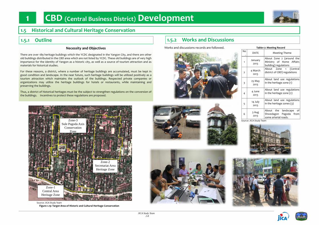
There are over 189 heritage buildings which the YCDC designated in the Yangon City, and there are other old buildings distributed in the CBD area which are not listed by YCDC. These old buildings are of very high importance for the identity of Yangon as a historic city, as well as a source of tourism attraction and as materials for historical studies.
For these reasons, a district, where a number of heritage buildings are accumulated, must be kept in good condition and landscape. In the near future, such heritage buildings will be utilized positively as a tourism attraction which maintains the outlook of the buildings. Respected private companies or organizations may utilize the heritage buildings for hotels or restaurants, while maintaining and preserving the buildings.
Thus, a district of historical heritages must be the subject to strengthen regulations on the conversion of the buildings. Incentives to protect these regulations are proposed.
1.5 Historical and Cultural Heritage Conservation
1.5.1 Outline 1.5.2 Works and Discussions
Zone-1 Central Area
Heritage Zone
Zone-2 Secretariat Area Heritage Zone
Zone-3 Sule Pagoda Axis
Conservation Zone
Source: JICA Study Team Figure 1.19: Target Area of Historic and Cultural Heritage Conservation

1 CBD (Central Business District) Development
JICA Study Team 2-9
1 Central Area Heritage Zone
In the Central Area Conservation Zone (tentative name), there are 34 heritage buildings concentrated in the center area around the Sule Pagoda. Most heritage buildings are used for office or commercial purposes, e.g., No.2 building is used as YCDC’s office. However, in some of the old buildings, only the ground floors are used. Some of the old buildings have become decrepit to a level of being dangerous. When a conservation plan is made for this zone, an activity plan for the old buildings for more positive uses and their conservation would be prepared at the same time.
2 Secretariat Area Heritage Zone
The Secretariat Area Conservation Zone (tentative name) is located east of the Central Area Conservation Zone. This area is composed of the secretariat building and other buildings around it. In addition to the secretariat building are the cathedral, schools, the Department of Human Settlements and Housing Development (DHSHD) building, and the Printing and Publishing Enterprise building.
1.5 Historical and Cultural Heritage Conservation
1.5.3 Existing Situation of Heritage Zones
11 10
4
5
2
Section of A Section of B
B
A Source: JICA Study Team
Figure 1.20: Current Conditions of Central Area Heritage Zone
Source: JICA Study Team Figure 1.21: Current Conditions of Secretariat
Area Heritage Zone

1 CBD (Central Business District) Development
JICA Study Team 2-10
3 Sule Pagoda Axis Conservation
The Sule Pagoda Street, which is located in the center of CBD, passes through north to south, has a width of over 60 m. The Trader’s Hotel and Sakura Tower are located on the roadside of this street. While the Sule Pagoda Street is a symbol of Yangon urban areas, there are plans for the construction of proposed high‐rise buildings along this street as well.
While a new and secondary CBD would be arranged in the suburbs of Yangon City, some urban functions (i.e., office, commercial, and convention) will be relocated from the CBD area. Such urban structure would be effective for the realization of smooth vehicular traffic and implementation of a balanced water demand. Moreover, some new standards for the design of new buildings are considered to be introduced.
Source: JICA Study Team
Figure 1.22: Current Landscape Section of Sule Pagoda Street
1 Conservation of the Central Area / Conservation of the Secretariat Are
The YCDC, Ministry of Construction (MOC), YHT, MAA, and JICA Study Team (also known as the Yangon City Comprehensive Land Use, Zoning, and Urban Design Review Working Committee (ZUDRWC)) has discussed and proposed the plan for the conservation of heritage zones. The plan is as follows:
(1) Strengthening the policy on limiting the floor area ratio and building coverage in heritage zones
The average number of floors of the heritage buildings in the Central Area and Secretariat Area Heritage Zones is about five stories. If high‐rise buildings will be constructed, these will inevitably impair the continuity and integrity of the roadside landscape of Pansodan and Strand streets. For this reason, ZUDRWC has discussed and proposed a plan to restrain the construction of high‐rise buildings in excess of the average height of the existing buildings.
(2) Unification of the floor height of buildings
The existing building regulation is a reference for the width of the front road. For this reason, there are some buildings with reduced floor height and increased number of floors. In such case, by constructing these high‐rise buildings problems occur in the formation of a continuous facade. For this reason, ZUDRWC has discussed the proposal to align the floor height of the buildings.
(3) Limit the installation of billboards
Some buildings are posting eye‐catching outdoor advertisements covering the facade of the buildings. Bright colored materials of outdoor advertisements may interrupt the continuity and integrity of the landscape of the arterial roadside. In addition, it will ruin the landscape of the city if bright colors of red or blue are used. For this reason, ZUDRWC has discussed and proposed restrictions in the posting of outdoor advertisements that cover the buildings.
(4) Prohibition of a monotonous facade design and design considerations for the building side
Many of the heritage buildings are three‐ to five‐stories high. Some high‐rise buildings have aligned its design from the ground level up to the height of the heritage buildings to ensure the continuity of the facade. In addition, buildings with front curtain walls are also seen around the CBD area. Such design impedes the continuity of the roadside landscape. For this reason, ZUDRWC has discussed and proposed that buildings be constructed considering the continuity of the facade design and height of the heritage buildings that are located next to it.
1.5 Historical and Cultural Heritage Conservation
1.5.3 Existing Situation of Heritage Zones 1.5.4 Proposed Plans
Source: JICA Study Team Figure 1.23: Floor Height of Buildings Figure 1.24: Installation of Billboards
Figure 1.25: Monotonous Façade Design

1 CBD (Central Business District) Development
JICA Study Team 2-11
(5) Establishment of the ‘Yangon Landscape Council’
Advice from a professional is needed for the review of building plans as mentioned in (1) to (4), as well as architectural design, color, etc. For this reason, the JICA Study Team proposed the organization of a landscape council that will be made up of YCDC, YHT, Association of Myanmar Architects (AMA) and other professionals with extensive knowledge and experience.
(6) Transfer of Development Rights (TDR) (proposed)
Most of the heritage buildings in CBD have been in existence well beyond 100 years or more, and the aging of these buildings is seriously imparing both the interior and exterior structures. If the heritage buildings are to be utilized for commercial or business purposes by private firms or organizations, they will need to consider first the seismic enhancement measures, refurbishing lifting equipment, air conditioning equipment, and building renovation. In addition, the heritage buildings often do not take full use of the floor volume ratio and coverage as specified in the future. For this reason, the heritage buildings have a surplus of floor volume rate.
The TDR would allow the surplus floor volume to be traded for money to other parties. For example, the owner of the heritage building who have agreed to restore the building and keep the landscape in good condition will be allowed to sell the surplus to a third party seeking to develop in suburban area. The owner of the heritage building would therefore obtain a fund that can be used to perform the restoration of the building. (For example, for the heritage building on the west side of Pansodan Street, if the regional government sets a 600% volume floor ratio, there will be 300% or more of the High Court building’s surplus. Trade the market price of this surplus and then make funds for the repair of the building.)
2 Conservation of Sule Pagoda Axis
ZUDRWC has discussed and proposed a landscape view of the future, when the height of the buildings located on the roadside of Sule Pagoda Street become taller. As Sule Pagoda is symbolic of the CBD, view of the Pagoda needs to be respected in the future skyline of Yangon CBD.
In front of SAKURA Tower see Sure Pagoda (Existing)
Same point (all buildings are 8 stories)
Same point (all buildings are 22 stories) Source: JICA Study Team
Figure 1.28: Sule Pagoda Axis Landscape Simulations
1.5.4 Proposed Plans
1.5 Historical and Cultural Heritage Conservation
Trade this surplus for the repair of the heritage building.
Source: JICA Study Team Figure 1.26: An Image of Yangon Landscape Council
Source: JICA Study Team Figure 1.27: Transferring of Development Right (TDR)

2 North‐East Region Development
JICA Study Team 2-12
1 Objectives
To formulate a detailed development plan for the “North‐East Region” in which new urban development will be taken to realize the proposed strategic urban development plan of Greater Yangon. The land use plans should be linked with the master plan made by the townships.
To carry out technical transfer through good experience in cooperative planning works with Yangon City Development Committee (YCDC), townships, and the JICA Study Team.
2 Main Output
Map and Information Data on the Current Conditions
Map and Information Data of Future Development Plan (Long‐term target 2040)
3 Work Schedule
Step 1: May‐June 2013 Works for Reviewing the Current Conditions
Step 2: July‐August 2013 Works for Planning the Land Use and Infrastructure
2.1 Introduction
4 Main Players of the Planning Work
General Administration Department, Township
Urban Planning Division, Engineering Department (Building, Water and Sanitation, Road and Bridge), and Parks and Playground Department of YCDC
Urban and Regional Planning Division, Department of Human Settlements and Housing Development (DHSHD) of the Ministry of Construction (MOC)
JICA Study Team
5 Target Area
The target area of this work is the North‐East Region of Greater Yangon in which new urban development will take place in short term. The target area consists of a total of five townships as follows:
North Dagon Township
South Dagon Township
East Dagon Township
Dagon Seikkan Township
Hlegu Township
Note: The works and discussions with the townships and YCDC were done in East Dagon, Dagon Seikkan, and Hlegu townships only, but not in North Dagon and South Dagon townships, due to limited manpower and time.
6 Dagon Seikkan Project by DHSHD/MOC
Currently, the DHSHD and MOC, has been conducting a huge housing project, namely, “Ayeyarwun‐Yadanar High‐rise Building” in Dagon Seikkan Township. The profile of the project is shown as follows:
‐ Area: 89 ha (220 acre)
‐ Total Room Unit: 19,600 units
‐ Future Population: approximately 100,000 persons
Road No.2 (radial road) Dagon Seikkan Project (see above) Yangon‐Mandalay line (railway) Low lying flooded areas Road No.7 (ring road) Suburban areas for farming
Source: JICA Study Team Figure 2.1: Target Area
Source: DHSHD, Ministry of Construction Figure 2.2: An Image of the Project
Target Area (5 townships)

2 North‐East Region Development
JICA Study Team 2-13
1 Development Framework for 2040
Currently, the North‐East Region has a population of 908,000 in 2011 and an area of approximately 37,600ha (376km2). According to the Strategic Urban Development Plan of Greater Yangon, the future population in 2040 is forecasted as 2,953,979 persons in the same area, which means 325% growth from the current population.
Table2.1: Development Framework for 2040 in the North‐East Region
Township Area (ha)
Current Status (2011) Future Forecast (2040)
Population Population Density
(person/ha) Growth Rate Population Housing Units
North Dagon 2,400 221,200 92 6.16%/year 287,188 (130%) +13,000
South Dagon 3,800 370,403 97 7.75%/year 550,371 (149%) +36,000
East Dagon 17,100 145,505 9 7.74%/year 1,183,320 (813%) +208,000
Dagon Seikkan 4,200 120,161 29 15.59%/year 399,111 (332%) +56,000
Hlegu (a part) 10,100 50,793 5 (no data) 533,707 (1,051%) +97,000
Total 37,600 908,062 24 persons/ha ‐ 2,953,697 (325%) +410,000
Source: JICA Study Team
2 Photos from the Meetings
16 May 2013 (East Dagon) 17 May 2013 (Hlegu)
23 May 2013 (Dagon Seikkan) 30 May 2013 (Hlegu)
27 Jun 2013 (East Dagon) 30 July 2013 (Dagon Seikkan)
1 Aug 2013 (Hlegu) 15 Aug 2013 (East Dagon)
2.2 Future Goals and Strategies (Giving Conditions)
2 Urban and Infrastructure Development Strategies
The main urban and infrastructure development in the North‐East Region are expected not only in the short term but also in mid and long term as follows:
Construction of two sub‐centers, namely “Dagon Myothit” and “Bago Riverside”;
Construction of two or three new industrial zones along the outer ring road;
A large number of housing projects;
Construction of an outer ring road using the existing Road No.7;
Improvement of Road No. 2;
Construction of a new bridge across the Bago River;
Upgrade the existing Mandalay Railway line;
Construction of the three new Urban Mass Rapid Transit (UMRT) lines;
Construction of the expressway and railway connecting to the new international airport.
2.3 Works and Discussions
1 Meetings with Township
Meetings with townships to understand the current land use, public facility, housing situation, and infrastructure issues have been held from the middle of May until the end of August. The JICA Study Team, consequently, proposed a concept map of the future land use plan through the meetings. The meeting record is as follows:
Source: JICA Study Team Figure 2.3: Future Development Strategy
Table2.2: Meeting Record
No. Date Place Meeting Theme
1
16 May 2013 East Dagon
Dagon Seikkan 17 May 2013
Hlegu
・To introduce land use planning. ・ To ask for basic information.
2
23 May 2013 East Dagon
Dagon Seikkan Hlegu
28 May 2013 East Dagon 30 May 2013
Hlegu 31 May 2013 Dagon Seikkan
・ To get general information about current conditions. ・To confirm current conditions on the map.
3
21 June 2013 Dagon Seikkan 27 June 2013 East Dagon 2 July 2013
Hlegu
・To confirm current conditions about public facilities and housing situation.
4 12 July 2013 Dagon Seikkan
・ To confirm about specific lots on the map.
5
30 July 2013 East Dagon
Dagon Seikkan 1 August 2013
Hlegu
・ To confirm about future land use and road network. ・ To discuss about future road construction and urban development.
6 12 August 2013 YCDC
・ To explain and discuss about future land use concept map of three townships.
7
15 August 2013 East Dagon
Dagon Seikkan 20 August 2013
Hlegu
・ To explain and discuss about future land use concept map.
Source: JICA Study Team

2 North‐East Region Development
JICA Study Team 2-14
Source: JICA Study Team and the Working Group (YCDC and Townships)
Figure 2.4: Current Conditions of Land Use
Urbanization in South Dagon and North Dagon townships adjacent to Yangon central part has been progressing rapidly, and the population density is more than 90 persons/ha. On the other hand, urbanization in East Dagon, Dagon Seikkan, and Hlegu townships does not grow faster, and the current land use is mainly paddy field, farm village, and industrial park.
2.4 Current Conditions
2.4.1 Overview 2.4.2 Land Use
1 Land Use
In North Dagon and South Dagon townships, the land use as residential area has been progressing rapidly, and the land use as farmland is scarcely seen.
In East Dagon Township, farmland is a main land use. The main residential area exists around the township’s central part, and development of a new residential area is expanding to the south side. An industrial park is in operation along Road No.2.
In Dagon Seikkan Township, the main residential area is located in the neighborhood of Bago River Road, and a number of residential areas are under development. An industrial park is in operation along the Bago River. (Existing typical housing development: Yuzana Garden City)
In Hlegu Township, most of the areas in the southern part are covered by prime agricultural lands with well‐developed irrigation system including paddy fields and orchid gardens. Others are used for fishponds.
2 Road, Transportation & Urban Infrastructure
Current major roads are Road No.2 and No.7 only, and the arterial road network is in undeveloped condition. All roads are in very poor surface condition.
Current railways are only Yangon‐Mandalay line and Thilawa line and there are a small number of passengers.
Due to undeveloped drainage facilities in the whole region, floods happen frequently in lowlands during rainy season.
3 Social Service and Urban Utility
Public facilities such as school, hospital, and pagoda exist mostly in the city area.
The Dagon University and Institute of Economics as main educational facilities are located in the city.
Supply of electricity and water are limited to some areas in the city.
Although there is no prominent natural area to be protected strictly in this region, there are good natures, such as eco‐tone area along the rivers, which has multi‐function of flood control, water purification, and biodiversity.
Hlegu Township
Dagon Seikkan Township
East Dagon Township
North Dagon Township
South Dagon Township

2 North‐East Region Development
JICA Study Team 2-15
Source: JICA Study Team and the Working Group (YCDC and Townships)
Figure 2.5: Current Conditions of Road, Transportation and Urban Infrastructure
Source: JICA Study Team and the Working Group (YCDC and Townships)
Figure 2.6: Current Conditions of Social Service and Urban Utility
2.4 Current Conditions
2.4.3 Road, Transportation & Infrastructure 2.4.4 Social Service & Urban Utility
Hlegu Township
Dagon Seikkan Township
East Dagon Township
North Dagon Township
South Dagon Township
Hlegu Township
Dagon Seikkan Township
East Dagon Township
North Dagon Township
South DagonTownship

2 North‐East Region Development
JICA Study Team 2-16
Source: JICA Study Team and the Working Group (YCDC and Townships) Figure 2.8: Future Detailed Development Plan of North‐East Region
2.5 Future Development Plan
2.5.1 Development Policy 2.5.2 Development Plan
2 Concept of Supplying Urban Utilities and Social Services
In order to secure a better living environment, it is necessary to provide urban utilities and social services such as public parks, schools, hospitals, community facilities, and others for new urban development areas with satisfaction of the standard supply level which will be defined. The JICA Study Team proposed the standard supply level in each neighborhood unit (hereinafter referred to as “one unit”) which has an area of 1.0 km2 to 4.0 km2.
Public parks: One “District Park (2 ha)” per one unit;
Elementary schools: One school (1 ha) per one unit;
Large‐scale hospitals : One hospital with 50 beds per one unit;
Community areas (library, community building, post office, and hospital): One area per one unit. Source: JICA Study Team
Figure 2.7: Concept of Neighborhood Unit Development
Development of Sub-center
Development of Sub-center
Construction of Outer Ring Road
Upgrading Road No.2
Upgrading existing railway line
Upgrading existing railway line
Development of Logistics Core Area
Development of new industrial park
Maintenance of high-value agricultural land “Realization of an eco‐friendly new town development with complex urban
function”
Infrastructure development taking advantage of good access to CBD and Thilawa SEZ and gateway function in northern Yangon. ‐ Formulation of an arterial road network corresponding to the increase of vehicle traffic; ‐ Railway development for traffic congestion resolution and suburban development; and ‐ Center development with integrated residential, commercial, and industrial functions in the
traffic nodal points.
Housing development for low and middle income pe0ple near the industrial park and commercial business area. ‐ Acceleration of new industrial and commercial business development; ‐ Creation of a housing environment where residences are in close proximity to offices; and ‐ Allocation of population from CBD.
Development and conservation for sustainable urban environment. ‐ Development of the drainage system for flood control; ‐ Development of parks and greens for environmental symbiosis; ‐ Conservation of superior agricultural lands with well‐developed irrigation system; and ‐ Conservation of the natural green area for flood control.
Sustainable urban development with mitigation of environmental and social negative impacts by means such as SEA concept ‐ Conservation of natural environment, such as riverside area, which contributes on multi function
such as flood control, water purification, biodiversity. ‐ Consideration of slums and squatters and provision of low income houses

2 North‐East Region Development
JICA Study Team 2-17
Source: JICA Study Team
Figure 2.9: A Bird View Image looking from South side toward North
Source: JICA Study Team
Figure 2.10: A Bird View Image looking from West side toward East
1 Development Plan
Formulation of an Arterial Road Network ‐ Upgrading of Road No.7 to a “major arterial road” with a function of an outer ring road; ‐ Upgrading of the Min Ye Kyaw Sawar and Aye Yarwon roads to “sub‐arterial roads” with a function of a bypass for Road No.2; and ‐ Development of the east‐west arterial roads running through the center of the area.
Formulation of the Railway Network ‐ Upgrading of the existing railways, namely, Yangon‐Mandalay Line and Thilawa Line; and ‐ Development of UMRT.
Development of the Regional Center, Township Center, and Town Core in the Nodal Point of Transport Infrastructure. ‐ Urban development with mixed land use of residential, commercial, and business (Regional Center: Dagon Myothit, Township Center: Dagon Seikkan); ‐ Development of logistics and industrial parks with superior traffic convenience (Regional Core: Northern part of East Dagon); and
‐ Development of the town core as medium‐high density residential area with traffic convenience of the UMRT Station
(Town Core: Strategic positioning of each township). Integrated Development of Industrial Parks and Residences for Laborers along Arterial Roads
‐ Along the Outer Ring Road, Road No.2, Bago River Road, and New East‐West Arterial Road; and ‐ Development of medium‐density residences for laborers.
Conservation of Useful Current Land Use such as Superior Agricultural Lands and Natural Areas. ‐ Paddy field, orchid garden, and river‐swamp zone in Hlegu Township.
2.5 Future Development Plan
2.5.2 Development Plan 2.5.3 Future Images
2 Future Development Indicators
Table 2.3: Future Area Allocation by Land Use Table 2.4: Future Length of Road
Greater Yangon East regionResidential Area 27,179.6 7,328.4Public Facility Area 10,918.9 1,160.4Commercial Area 807.0 37.1Industrial Area 5,522.8 1,571.6Agricultural Area 83,567.9 20,132.3Under Developing Area 5,164.8 3,871.0Green and Open Area 11,162.1 1,961.9Waterbody 16,021.8 2,689.1Total 160,344.7 38,751.7
CategoryArea (ha)
Greater Yangon East RegionHighway 18.9 0.7Primary Arterial Road 380.3 49.9Secondary Arterial Road 294.4 61.6Other Road 9,096.8 2,981.1Bridge 28.1 2.5
Length (km)Road Category
Source: JICA Study Team
Source: JICA Study Team
3 Transit Oriented Development “TOD”
JICA Study Team 2-18
Table 3.1: TOD Examples (Station and Distination Area Development) Docklands London, England Tama New Town, Japan
Picture
Type Sub Center Residential Town
Scale 56 ha 2,884 ha
Population 90,000 (2005) 216,400 (2010)
Public Transport
• Docklands Light Rail • London Metro Jubilee Line Extension
• Tama Monorail • 3 Urban Railway line (Keio, Odakyu, JR)
Urban Function
• Business District • Commercial Center
• Satellite City • Residential Town with Commercial Facility
Source: http://www.ur‐net.go.jp/syutoken/nt/housing.html
Increased Ridership
Station Activated
Station Area Developing
Revenue Increasing
InvestmentIncreasing
Integrated Multi-ModalTransportPoor
Intermodal Connections
Low Ridership
Station Inactivated
Station AreaUnder-
Developed
Low Revenue
Lack of Funds for
investment
Coordination Lack of Public Transportation
Traffic Congestion
Lack of Effective Marketing
Efforts for TOD
Traffic Congestion Mitigated
Efforts for TOD
Typical Vicious Cycle of Case without TOD Future Cycle of Case with TOD
1 Policy of TOD
TOD is abbreviation of Transit Oriented Development, which intends to achieve urbanization based on public transportation systems.
In recent years, it has been demonstrated or verified beyond doubt that disordered increasing of private vehicles causes serious traffic problem, which results in huge economic loss and environmental degradation. Thus, appropriate TOD implementation is a key for sound urban growth
The policy of TOD is “Achieve urbanization based on public transportation that intends high economical efficiency, and environmental friendliness, and traveler friendliness”.
Major purposes of TOD are classified in the following;
A) Develop urban cores at railway station area
B) Connect residential areas to urban core with public transportation network
C) Strength in‐area accessibility by light public transportation system
3.1 Introduction – Basic Information of Transit Oriented Development “TOD”‐
3.1.1 What is TOD?
3.1.2 TOD Examples in the World
2 Strength and Benefit of TOD
TOD has three major strategies, station area development, multi‐modal facility integration, and role division of each station area. These strategies will bring benefit on not only urban economical efficiency and social public services, but also railway operator management with additional demand projection. Without TOD, railway operator would face the difficulty against sustainable operation.
Source: JICA Study Team Figure 3.1: TOD Image of Station Area Development
Source: JICA Study Team Figure 3.2: Vicious Cycle without TOD (left) and with TOD (right)

3 Transit Oriented Development “TOD”
JICA Study Team 2-19
1 Station Area Development
Railway station area is developed as urban core where urban functions are aggregated including business, commercial, and public administrations. The aggregation area should be set walkable, 500‐600m as desirable.
2 Multi‐modal Facility Integration
Integration among each transport mode would be a key of TOD because the non‐Integration causes time‐loss and uncomfortable transfer for passengers, and results in less‐use of public transportation. The integration should be designed by combination of horizontal movement and vertical movement for passenger smooth transfer.
Railway Station
500-600m
:Business office:Commercial:Residence
Railway
Building density
BusTaxi, Car
Multi-Modal Integration
Separated Terminal among Each Mode
BusBus
Separate
Integrate
Passenger cannot transfer smoothly among each mode
Passenger can transfer smoothly by multi‐layerization
Taxi, Car
3.1.3 TOD Strategy
Following table shows the urban public transportation system which can be applied TOD.
Table 3.2: Urban Public Transportation System
System MRT LRT / Monorail / AGT BRT
Image
Traffic Capacity (passengers /
hour) 30,000 ‐ 85,000 10,000 ‐ 30,000 ‐25,000
Scheduled Speed (km/hour) 25 – 55 20 ‐ 35 15 ‐ 30
Initial Cost (USD million/km)
50‐320 (Underground) 50‐100 (Viaduct) 10‐50 0.5‐15
Advantage • Large‐scale impact on
decongestion • High energy efficiency
• Balanced development • Passenger Friendliness
• Low initial cost • Flexible development
Disadvantage • High cost • Long time project
implementation
• Integration problem • Many crossings with road
• Interference on road traffic
• Low Capacity limit Source: JICA Study Team
3 Role Division and Distribution of Each Station Area
Uniform development on every station area does not bring sufficient effect. Dividing roles and distributing each function along the railway line would produce further passenger demand with activating every station area.
CBD Station
Sub-Urban Station
Residential Area
WeekdayBusinessman Student
WeekendShopping, Dining Leisure activity
Office
Amusement Park
University,Institute
Department Store
3.1.4 Urban Public Transportation System for TOD Source: JICA Study Team Figure 3.3: Station Area Development
Source: JICA Study Team Figure 3.4: Multi‐modal Facility Integration
Source: JICA Study Team Figure 3.5: Role Division and Distribution of each Station Area

3 Transit Oriented Development “TOD”
JICA Study Team 2-20
Source: JICA Study Team
Figure 3.7: Preliminary Target Area for YCR TOD
1 Existing Condition of YCR
Yangon Circular Railway (YCR) has around 47.5km length and carries one hundred thousand passengers per day. The number of daily operation train becomes 200 including suburban section lines. Although it has many things to improve, has large potential for TOD.
2 Basic Strategy
As referred in 3.1.1.2, TOD has benefit for railway operator with demand projection. The demand rising will bring both fare revenue increase and investment capability expansion by rising of value in station area. Thus, MR will gain large funds with TOD scenario and could make full use of it for other investments in railway such as operation system upgrades, track maintenance, rolling stock renewal, and electrification in the future.
Source: JICA Study Team Figure 3.6: Role Division and Distribution of each Station Area
The issue for this strategy is how to reflow the benefits from TOD towards railway upgrades and further developments. The fund is brought by urban development, and one of the investments is public transportation development. Thus, it is essential to prepare proper scheme to implement TOD under laws and regulations. The scheme should include PPP (Public Private Partnership) that attract private finance and know‐how for the developments. Especially, stations in CBD area have substantial potential to develop. The development plan in each station should carefully consider the future land value increase.
3 Scope of Preliminaly Development
Station area development projects are implemented in parallel with railway upgrades for collaborating with LoS (level of Service) improving.Firstly, YCR TOD implementation focuses on station developments in west half of YCR where population aggregated. Specifically, Preliminary development should be focused on the four station areas where MoR has land and doesn’t need to purchase for development: Yangon Central, Insein, Malwagone, and Kyeemyindaing.
Profit on land sale or lease
Track rehabilitation
SignalupgradeRolling stock renewal
Removal and renewal of depot
Railway Upgrade
Fare revenue increase
Fund
Benefit
Railway Station
TOD
Benefit
InvestInvest
3.2 TOD on Yangon Circular Railway (YCR)
3.2.1 Strategy of YCR TOD <Proposal>
JICA Study Team 2-20

3 Transit Oriented Development “TOD”
JICA Study Team 2-21
Present Land owned by MRStation
Renewed Station
Commercial
Entertainment
Land owned by MR
After
Customer, visitor, spectator, etc
Railway Commuter
MR StationCommercial develop 1
Commercial develop 2,3….,
Special purpose company or YCDC (if dedicated) for O&M of public area/P&R
Contribution of a certain amount to SPC
People consume for their purpose
Railway revenue
Development Company of Lot 1(and/or 2‐7)
International Investor
Local Investor Financier
Myanmar Railway Revenue from sale to be allotted to own investment
Relevant Authority
Operation & Maintenance
Design & Construction
Land Purchase
Approval and certification
Investment
3.2.2 Business Structure <Proposal>
2 Issues on Financial Arrangement
< MORT/Myanmar Railway Finance Initiative >
Uncertainty for the availability of fiscal budget in amount and timing
Uncertainty for the financial contribution by sales of depots and factories in amount and timing.
< Developer Finance Initiative >
Valuation for the land value at present situation may be physically hard in the absence of rules and regulations for land use/building code/any incentives/etc, future market focus, and so on.
Advanced Payment to MR for acquisition of Depots/Factories by several years will be sever burden.
1 Rule and Regulation to be clarified
Whether exist in Myanmar at present or not, the following items, but not limited to, shall be addressed to clarify.
Process of Urban Planning is not established
Restriction of land use in YCDC and concerned township
Rule and regulations for sales of Air Right
Restriction on Land Transaction for particular city planning
Land Readjustment Project Law
Integrating railway development and land readjustment Law
Urban Redevelopment Project Law
a) Commercial Development of Station Classification of duty between public and private
1. MR enter the PPP Contract (30‐50 yrs.) with Concessionaire under Foreign Investment Law. The Concessionaire shall develop the Station based on the Universal Design.
2. The scope of Concessionaire is construction of new station and TOD development.
3. Newly constructed station shall be dedicated to MR who shall operate and maintain the station.
4. Any privilege under Foreign Investment Law shall be granted to the Concessionaire.
Source: JICA Study Team Figure 3.10: Project Scheme for Comprehensive
Development Initiative at Station Area
Source: JICA Study Team Figure 3.11: Project Scheme for Incremental
Development Initiative at Station Area
1. Land lease Agreement withsatisfiedDeveloper(s)
2. DevelopmentWork3. Developer business (lease,
lent,own business, etc)4. Royaltypayment toMR
1. Establishment of GovernmentPolicy
2. Feasibility Study includingTOD3. FS and DD for the Yangon
CircularRailway4. Allocation of budget for the
MORT includingODA
1. Improvement for YCR2. Acquisition of new land for
depot removal3. Construction and installation
of Plant. Equipment and allFacilities including necessaryutilities
4. Relocation of existing Depotand Factories
5. Bid call for TOD Developer
Ex. YCRConst./renewal YCR
Construction new Depot
operation/maintenance
・F/S cost・YCR cost・Depot land cost
・Depot cost・O&M cost
Operation revenue
Lease of Land/Royalty
[Developer]
[MORT and MR]
Payment of Land Lease/ Royalty
Payment of Royalty
Construction of development facilities on TOD
O&M
(1) Conprehensive Development (2) Incremental Development
In the scheme of comprehensive development initiative, MR issues the Request for Proposal (RFP) for the development of the depot and/or workshop adjacent to the station. The proposal shall comply with development plan, and/or any relevant rules and regulations.
Developer shall submit master plan including all necessary infrastructure and zoning of area. The developer who submitted the RFP, shall be responsible of undertaking all necessary finance to the land utilization fee of the depot area and to design, construct and operate, maintain the facilities and premises.
In the scheme of incremental development initiative, Association of Land Readjustment (Association) shall be established to undertake the initiative of the development of depot and factories adjacent to the station. Association will be the composition of MR, YCDC, Yangon Regional Government and any concerned Ministry of Central Government.
Association shall produce the master plan of development of depot/factories including zoning. All responsible member of Association shall acquire the necessary land for their infrastructure as shown on zoning plan.
Source: JICA Study Team Figure 3.8: Project Implementation Structure for YCR TOD
Source: JICA Study Team Figure 3.9: Project Scheme for the Station

3 Transit Oriented Development “TOD”
JICA Study Team 2-22
Table 3.3: Major Issues for TOD Implementation Category
Issue Assumed Action Plan Field Group
Urban Planning
Urban structure
a) The budget for new road is not secured. There is only the budget for road maintenance. The beneficiary develop new road by himself.
a)‐1: Preparing funds for road developments as public investment by incremental budget in Yangon development Plan for 20 years. a)‐2: Establishing special tax for road developments like revenue source set aside for road construction. a)‐3: Establishing subsidization scheme for diverting funds from development profit by private to public infrastructure investment.
b) The demarcation and cost share ratio among public sectors and private sectors is not clearly prescribed for high‐publicness urban development projects.
b)‐1: Clarifying the demarcation and cost share ratio in investments for railway station access road and station plaza. b)‐2: Clarifying the demarcation and cost share ratio in investments for station free passage and park / green area.
c) The processes for planning urban railway, roads, and station plaza are not confirmed.
c)‐1: Establishing process of urban planning and decision making concerning urban railway, road, and station plaza, which is composed of policy making, feasibility study (including traffic demand forecast, cost‐benefit analysis), fundamental drawing, and conceptual designing.
d) There are no building restrictions concerning road alignment, railway alignment, and station plaza planning line.
d)‐1: Installing regulations to control constructions, street stall, and squatters in future road space. d)‐2: Establishing rules of land acquisition for road development and improvement
e) The regulation for setting parking with building is not clearly prescribed
e)‐1: Installing regulations to obligate setting enough space parking with residential buildings and submitting building‐use declaration at the time of application.
e)‐2: Installing development charge system to prepare investment funds for public works in township and wards like water supply and sewerage works, school buildings.
f) There are no prescriptions securing space for parks and green lands. f)‐1: Installing regulations to control green ratio for a development land above a certain squares.
Land use
g) There are no land use restrictions about building use, building‐to‐land ratio, and floor space ratio. There is only a restriction to regulate building heights by its front road.
g)‐1: Implementing land use control for whole Yangon city area. g)‐2: Installing “Floor area ratio trading system” (ex.)
h) In Yangon rural area, bus terminal has become a commercial hub. There are no cases that railway station area has become an efficient utilization district.
h)‐1: Establishing integrated transportation system plan, which intends smoothing traffic of all transportation modes. It includes reorganizing feeder bus networks for promoting railway use, and flow line installation for smooth transfer between bus and railway.
h)‐2: Revising fare system for promoting railway use such as fare reduction for transferring passengers. h)‐3: Payproviding commutation ticket and school seasonal ticket in collaboration with private corporations
i) There are few commuters to use railway stations. i)‐1: Improving flow line between railway station and commercial presence for higher ability to attract customers. i)‐2: Developing commercial aggregation facilities like shopping mall at station area.
Regional planning j)
Building redevelopment projects base on purchase and sale of entitled floor. There are no methods for cooperative development by collaboration among small land owners and investors
j)‐1: Establishing comprehensive system concerned with land arranging in order, land and building sharing, and site owning j)‐2: Promoting institutionalization of land‐based participation onto development project
Redevelopment
Promotion area
k) There are no legislative systems to assign an efficient utilization district on major railway station and the second CBD.
k)‐1: Establishing section assignment system in re‐development area with tax break incentive for efficient utilization districts k)‐2: Installing regulation setting deck and vacant space at an efficient utilization district
l) There are no rules to deregulate building‐to‐land ratio, and floor space ratio. l‐1): Promoting institutionalization concerned with efficient utilization districts
Land Price m) Land price is valued by the purchase and sale records at surrounding area, which is not consistent with theoretical land price.
m‐1): Installing the concept of theoretical land price into business planning.
Source: JICA Study Team
3.2.3 Major Issues for TOD Implementation <Proposal>

3 Transit Oriented Development “TOD”
JICA Study Team 2-23
3.2.4 Case Study at Insein Station Area <Proposal>
1 Development Policy
Utilize workshop area for development
Develop following facilities; business offices, commercial facilities residential apartments park & ride facility
Integrate Inter‐modal facilities (Railway, BRT, Feeder Bus, Taxi, Car), separate pedestrian flow and vehicle traffic, connect buildings by pedestrian deck, and connect transportation at station area with north highway
Introduce enough green space inside development area
Note: This case study is just one of the desired future images through the technical transferring works, therefore, it is necessary to further discussion and coordination by Myanmar side, EIA procedures in environmental and social consideration and other required matters to make it realize.
Existing Condition of Insein Station Source: JICA Study Team
Figure 3.12: Present of Insein Station
Source: JICA Study Team Figure 3.13: Short‐term Plan
<A Future Image in the Case Study Work>
Source: JICA Study Team Figure 3.14: Long‐term Plan of Facility Layout at Insein Station
<A Future Image in the Case Study Work>
Source: JICA Study Team Figure 3.16: Long‐term Plan of Pulic Transport Facility Layout at Insein Station
<A Future Image in the Case Study Work>
Source: JICA Study Team Figure 3.15: Long term plan of station section sketch at Insein station TOD
<A Future Image in the Case Study Work>
Railway (YCR)
Railway (Suburban line)
Pedestrian Deck⇒Separation between
walk and vehicle Ticket Gate, Concourse,
and BRT Terminal
West Side Area East Side Area
Feeder BusFeeder Bus

4 Capacity Development Plan
JICA Study Team 2-24
Table4.1: Current Administrative Works for Urban Planning Works and Development Categories Working Details for Urban Planning
1.Coordination Coordinating with related ministries.
Conducting PIC discussion. Having discussion
with developers 2. Survey/ Research Possessing basic social information.
Conducting basic urban planning and social surveys. 3. Planning Formulating national and regional plans.
Formulating development policies and subprojects. Formulating the “Urban Development Master Plan” (with the JICA Study Team).
4. Establishing a Legal System
Formulating the “National Building Code”. Studying the land use control system.
5. Controlling Examining application for building construction. Providing recommendation letter for building construction.
6. Realization (No specific urban project except small-scale individual construction works) Legend: Union Ministry Regional Ministry District Township YCDC
Table4.2: Proposal of Administrative Works for Urban Planning Works and Development Working categories Working details for urban planning 1.Coordination Coordinating with related ministries. Arranging the necessary budget.
Conducting planning discussions with related stakeholders. Giving technical assistance to planning discussions.
2. Survey/ Research Formulating the survey/research format. Conducting urban planning survey and monitoring.
3. Planning Formulating the implementation plan with subprojects. Giving consultancy services and technical advices for planning.
4. Establishing a Legal System
Formulating the necessary laws, regulations including regional regulations.
Formulating detailed plans for land use control. 5. Controlling Assessing and providing permits for development activities.
Assisting the technical examination. Giving consultancy services. 6. Realization Advancement of urban projects for public welfare.
Supporting public-oriented development / spatial improvement projects.
Source: JICA Study Team (both of Table 4.1 and Table 4.2)
(1) Survey and Research
The following survey and research matters are expected to be conducted by the Urban Planning Division of YCDC, collaborating with the district and township offices:
Basic survey for city planning;
Specific urban planning survey (e.g., survey of the condition of infrastructural facilities);
Environmental survey; and
Monitoring the progress of urban planning matters.
(2) Planning
The Urban Planning Division of YCDC is expected to assist in the planning works which are conducted by the regional government, district offices, and township offices.
Updating and revision of the urban master plan;
Technical support for detailed spatial plan;
Technical support for the formulation of regulatory land use plan; and
Technical support for planning development for public purposes.
(3) Control and Realization of Projects
The Urban Planning Division of YCDC is expected to execute control and realization of planning works for urban development projects which are conducted by the regional government, district offices, township offices, and other departments of YCDC that are related to urban planning matters.
Technical assessment of large-scale development for approval;
Advise on infrastructure implementation planning;
Advise on project implementation; and
Assistance in the acceleration of development and spatial improvements for public purposes.
According to the current duties in urban planning works and their future prospects, the main works of the Urban Planning Unit of Yangon City Development Committee (YCDC) are summarized in the following three categories:
(1) Survey and Research
(2) Planning
(3) Controlling and Realization of Projects
YCDC
TS Dis. RM
YCDC
RM UM
TS Dis. RM
RM UM
YCDC
TS Dis. RM
YCDC
RM UM
YCDC
TS Dis.
RM UM
(2) Future proposal of administrative works for urban planning works and development
YCDCTS Dis. RM UM
TS
YCDC RM UM
YCDUM
UM
YCDC
TS Dis. RM
UM
YCDC
TS Dis.
YCDC
TS Dis.
RM UM
(1) Current situation of the administrative works for urban planning works and development
4. 1.1 Related Organizations 4.1.2 Matters to be considered for urban planning system
4. 1 Administrative Roles and Duties for Urban Planning
4 Capacity Development Plan
JICA Study Team 2-25
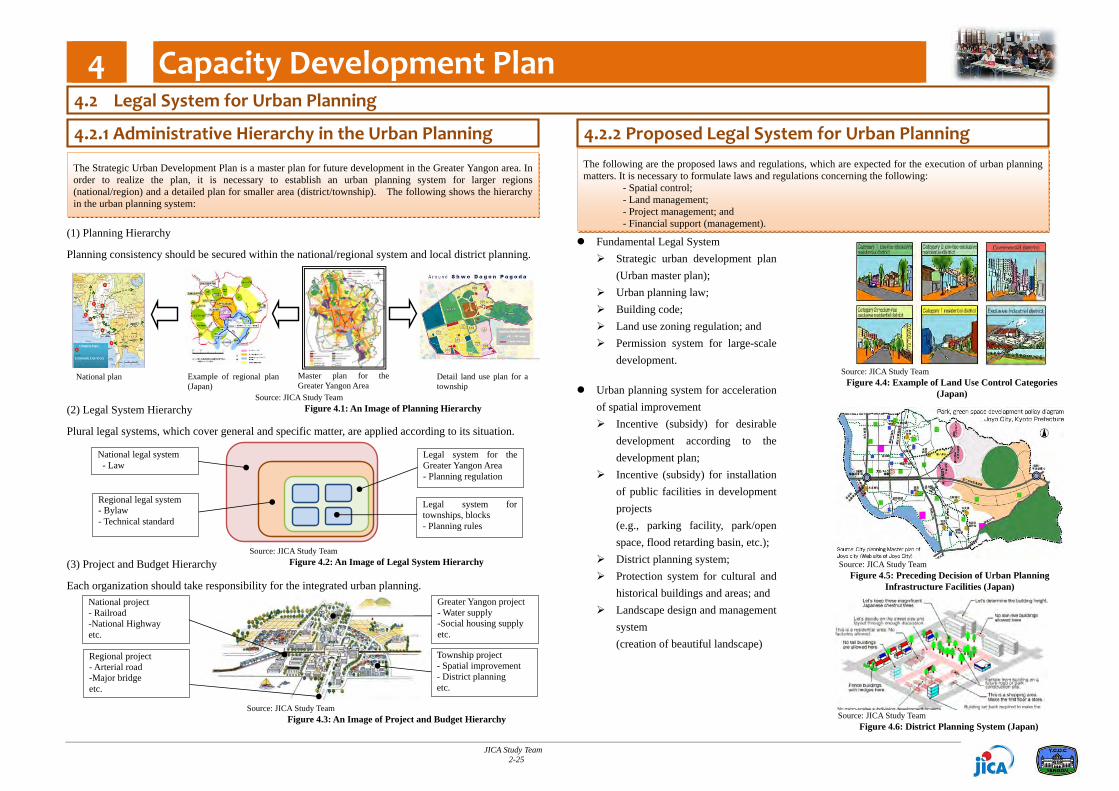
(1) Planning Hierarchy
Planning consistency should be secured within the national/regional system and local district planning.
(2) Legal System Hierarchy
Plural legal systems, which cover general and specific matter, are applied according to its situation.
(3) Project and Budget Hierarchy
Each organization should take responsibility for the integrated urban planning.
Fundamental Legal System Strategic urban development plan
(Urban master plan); Urban planning law; Building code; Land use zoning regulation; and Permission system for large-scale
development. Urban planning system for acceleration
of spatial improvement Incentive (subsidy) for desirable
development according to the development plan;
Incentive (subsidy) for installation of public facilities in development projects (e.g., parking facility, park/open space, flood retarding basin, etc.);
District planning system; Protection system for cultural and
historical buildings and areas; and Landscape design and management
system (creation of beautiful landscape)
The following are the proposed laws and regulations, which are expected for the execution of urban planning matters. It is necessary to formulate laws and regulations concerning the following: - Spatial control; - Land management; - Project management; and - Financial support (management).
National project - Railroad -National Highway etc.
Regional project - Arterial road -Major bridge etc.
Greater Yangon project - Water supply -Social housing supply etc.
Township project - Spatial improvement - District planning etc.
National legal system - Law
Regional legal system - Bylaw - Technical standard
Legal system for the Greater Yangon Area - Planning regulation
Legal system for townships, blocks - Planning rules
The Strategic Urban Development Plan is a master plan for future development in the Greater Yangon area. In order to realize the plan, it is necessary to establish an urban planning system for larger regions (national/region) and a detailed plan for smaller area (district/township). The following shows the hierarchy in the urban planning system:
4.2.2 Proposed Legal System for Urban Planning 4.2.1 Administrative Hierarchy in the Urban Planning
Master plan for the Greater Yangon Area
Detail land use plan for a township
Example of regional plan (Japan)
National plan
4.2 Legal System for Urban Planning
Source: JICA Study Team Figure 4.4: Example of Land Use Control Categories
(Japan)
Source: JICA Study Team Figure 4.5: Preceding Decision of Urban Planning
Infrastructure Facilities (Japan)
Source: JICA Study Team Figure 4.1: An Image of Planning Hierarchy
Source: JICA Study Team Figure 4.2: An Image of Legal System Hierarchy
Source: JICA Study Team Figure 4.3: An Image of Project and Budget Hierarchy Source: JICA Study Team
Figure 4.6: District Planning System (Japan)

4 Capacity Development Plan
JICA Study Team 2-26
Understanding roles in urban planning. Strongly aware: Implementation of development
Making plans Aware: Survey and research Lack of awareness: Coordination
Business program Control/guidance
Necessary capacity development subjects. Understanding the general urban planning system. Specific technical knowledge corresponding to sectors. Technical knowledge transfer based on job training.
Forming a general scheme of urban planning system in Myanmar. Deciding roles and duties of related organizations. Among union government, regional government, district/township offices, and development
committee. Among related departments (sectors) in each organization.
Formulating the legal systems related to urban planning. Establishing a cooperation system among related administrative organizations. Among related organizations. Among related departments (sectors) in each organization.
Deciding on the priority projects.
Legend: Union Ministry Regional Ministry District Township YCDC YCDCTS Dis. RMUM
Establishing the Urban Planning System
Capacity Development Program (Proposal)
I. Fo
rmul
atin
g Sc
hem
e of
Bas
ic
Urb
an P
lann
ing
II. F
orm
ing
the
Bas
e of
Urb
an
Plan
nin g
III. E
stab
lishi
ng
the
Basi
c Fu
nctio
n of
Urb
an P
lann
ing
IV.
Inte
grat
ing
Cro
ss-s
ecto
ral
Urba
n Pl
anni
ng
Outline urban planning system
Decide duties of related organizations
Allocate necessary budget and personnel
Provide legal force for fundamental urban planning system
Establish urban planning information system based on basic urban planning survey
Coordinate with related organization for planning
Formulate urban development project for public welfare (e.g., social housing and improvement of urban space)
Implement public development projects
Assistance for: Basic understanding of
policy making, planning, and management (ongoing by EU support)
Understanding and establishment of general urban planning system
Assistance for: Establishment of the
fundamental legal system Conducting basic urban
planning survey Establishment of the
urban planning information database
Technical assistance for: Making spatial plan
Application of legal
systems Technical solution for
planning
Technical assistance for: Planning coordination Technical solution for
planning
Project management
YCDC
YCDC
YCDC
YCDC
YCDC
YCDC
YCDCYCDC
YCDC
YCDC
YCDC
YCDC
YCDC
YCDC
YCDC
TS
TS
TS
TSTS
TS
TS
TS
TS
TS
TS
TS
Dis.
Dis.
Dis.
Dis.Dis.
Dis.Dis.
Dis.
Dis.
Dis.
Dis.
RMRM
RMRM
RM
RM
RM
RM
RM
RMRM
RM
RM
RM
RM
RM
RM
UM
UM
UM
UM
UM
UM
UM
UM
UM
Below are the proposed capacity development programs classified into four phases.
According to the progress on the establishment of urban planning system in Myanmar (see left part of the figure), corresponding capacity development programs are proposed.
(2) Organizational System and Legal System to be Improved
Myanmar stands at the dawn of the urban planning system. It is necessary to prepare the legal and organizational system in order to execute an effective capacity development program and technical assistance.
The following are issues to be considered beforehand:
(1) Results of Personal Interview for Needs Assessment
In order to identify the issues for capacity development and level of understanding about urban planning matters, a personal interview survey was conducted on 62 staff of the Urban Planning Division, YCDC, from 16 to 29 July 2013. The following are notable results of the interview:
4.3.1 Issues to be Considered for Capacity Development 4.3.2 Proposed Capacity Development Program
4.3 Capacity Development Plan for Urban Planning
60%50%
21% 13%
3% 2%
Source: JICA Study Team Figure 4.7: The Result of Interview
Survey
Source: JICA Study Team Figure 4.8: Urban Planning Phased Capacity Development Plan in Myanmar

5 Strategic Environmental Assessment (SEA)
JICA Study Team 2-27
1 Definition
The SEA is an environmental impact assessment on the “three P’s”, namely “policy”, “plan”, and “program”.
The SEA is understood as a tool for integrating the appropriate environmental and social considerations based on sufficient environmental and social information into the development process of the PPPs.
“Policy” is considered as administrative policies of the government showing the basic principle of plans and/or projects in the whole policy system, which will not decide on the necessities and/or concrete contents of each project. Therefore, the policies are generally abstract not concrete.
“Plan and Program” show the scenario which explains methodologies and schedule to implement the project systematically, but the details of the project are not decided. In this sense, “Plan and Program” are more concrete than policy and more abstract than projects.
The Project for the Strategic Urban Development Plan of the Greater Yangon is considered under the category of “Plan and Program”.
2 Significance of SEA
In relation to the national development and environmental context, the SEA is said to have two important significances, given as follows:
(i) To integrate appropriate environmental and social considerations into the process of decision making; and
(ii) To supplement the limitation of conventional environmental impact assessment that will be carried out in the implementation stage.
3 Methodologies
At the moment, no single “best” SEA process has been established. Different techniques or methodologies have been applied in various stages and activities of SEA. The choice of techniques depends on a whole range of factors, including the purpose of SEA, the availability of data, local environmental assessment capacity, decision‐making structure and culture, and resource constraint.
The SEA for the project was carried out over the process of establishing development visions and structure plans for Greater Yangon.
The detailed methodologies for SEA are discussed in the next page.
As a rule, JICA requests the project proponents to pay appropriate environmental and social considerations when implementing an ODA project based on the JICA Guidelines for Environmental and Social Considerations (April 2010) (JICA Guidelines).
According to the JICA Guidelines, the Strategic Environmental Assessment (SEA) will be applied in conducting a master plan study to integrate appropriate environmental and social considerations in the early stage of the proposed project.
In this Study, the SEA was carried out during the examination of development vision and basic policy for development in the future. The result of SEA was reflected in the development of a master plan in the Greater Yangon area.
In the Phase II of the Study, the workshop on environmental and social considerations which is necessary for future development programs in Yangon was conducted by the JICA Study Team in the course of technical transfer for the implementation of case studies. The attendees of the workshop were the key persons in the planning department of YCDC.
It was expected that the attendees were not familiar with the environmental and social issues. Therefore, the JICA Study Team made efforts to conduct a plain presentation not only focusing on the technical matters in terms of environmental and social considerations but also the reasons why the considerations through the conduct of environmental impact assessment (EIA) and/or SEA are necessary for development projects.
The attendees in the workshop were key persons in the planning department of YCDC. It was expected that the attendees were not familiar with the environmental and social issues. Therefore, the JICA Study Team made an effort to conduct plain and straightforward presentation focusing not only on technical matters in terms of environmental and social considerations but also on the reason why these considerations are necessary in conducting environmental impact assessment (EIA) and/or SEA for the development projects.
Note that the workshop was carried out in a participatory manner. The time for questions and answers were allocated during the presentation. In the end of every session, attendees were requested to make comments on the presentation.
5.1 Introduction 5.3 What is Strategic Environmental Assessment?
5.2 Outline of Technical Transfer in the Phase II
Source: JICA Study Team Figure 5.1: Photos of Environmental Filed Survey (Image)

5 Strategic Environmental Assessment (SEA)
JICA Study Team 2-28
(1) Discussion on the Present Environmental Issues in Yangon City
The present environmental issues in Greater Yangon were discussed in the course of SEA study preparation. The target year of the master plan is 2040, therefore, it will be useful to discuss the present environmental issues in Greater Yangon considering the future environmental issues.
5.4 Work Flow for the SEA in the Phase I
(2) Review Process for the Preparation of Draft Structure Plans
Initially, three draft structure plans were reviewed carefully. In the review, confirmation was made on the contents of each structure plan as well as the process of establishing the development visions.
(3) Preliminary Stakeholders Meeting Through Interviews with Related Townships (TSPs)
It is essential in SEA to incorporate opinions of related stakeholders into the plan formulation as early as possible. Therefore, the interviews with all related 39 TSPs were carried out as a preliminary stakeholders meeting to ask their preferences on the proposed structure plans. At the same time, the opinions on various topics such as environmental concerns and socioeconomic issues were discussed between the chief of TSPs and the JICA Study Team.
As for the question of their preferences on the three alternatives, 29 persons preferred the plan of “Sub‐centers with Green Isle system”, eight (8) persons preferred “Sub‐center system” and 2 persons had no answer among the chiefs of 39 townships.
Regarding the environmental concerns and socioeconomic issues, 28 persons mentioned that the traffic jam is a serious problem of Yangon Region. The traffic accident is the second serious problem as mentioned by 22 persons. The traffic jams occur in the main road, at road junctions and at market places. Given that the illegal parking is one of the main reason for traffic jam, the shortage of parking space is a problem.
“Sub‐center System” “Sub‐center with Green‐Isle System
”Super CBD Single‐core System Source: JICA Study Team
Figure 5.4: Interviews to the Chief of Townships
Source: JICA Study Team Figure 5.2: Work Flow of SEA
Review the Process of the Preparation of Draft Structure Plans
Discussion on the Present Environmental Issues in Greater Yangon
Preliminary Stakeholders Meeting
Environmental Scoping
Evaluation of the Environmental Impact Items
Environmental Mitigation Plan
Source: JICA Study Team Figure 5.3: Three Alternatives of Draft Structure Plans

5 Strategic Environmental Assessment (SEA)
JICA Study Team 2-29
(4) Environmental Scoping
Anticipated actions necessary to realize the proposed four development visions were clarified first. Subsequently, the environmental impact items which should be considered in the realization of the development visions were selected using an environmental checklist. In the process, the results of discussion for the present environmental issues in Greater Yangon and opinions in the preliminary stakeholders meeting with related TSPs were considered.
(5) Evaluation of the Environmental Impact Items
Anticipated environmental impacts caused by each of the alternatives were evaluated using the matrix. The magnitude of environmental impact was considered in the three levels, namely A, B or C in the positive impact; and X,Y or Z in the negative impact, respectively.
“Sub‐center with Green‐spot System” was selected as an most recommendable structure plan for the” Master Plan for Yangon City” as shown in the below Table.
(6) Establishment of the Environmental Mitigation Plan
An environmental mitigation plan necessary in the implementation stage was prepared for the optimal alternative that was selected based on the evaluation of the environmental impact items.
Items “Sub‐center System”
“Sub‐center with Green‐Isle System
”Super CBD Single‐core System
Positiv
e Im
pact Social
Environment B A C
Natural Environment B A C
Pollution B A C
Neg
ative
Impa
ct Social
Environment Y Z X
Natural Environment Y X Z
Pollution Z Y Y
Comprehensive Evaluation Recommendable Most
Recommendable Not
Recommendable Source: JICA Study Team
(7) Stake holders Meeting (SHM)
The information disclosure and the transparency is one of the most essential factors in the process of SEA. Accordingly the results of the SEA were explained and discussed at the stakeholders meeting (SHM) for the purpose of information disclosure and transparency.
The presentations including explanations on the “Strategic Environmental Assessment (SEA) for Development Visions and the Structure Plans for Greater Yangon” were carried out by YCDC personnel appropriately. Accordingly the SHM was conducted successfully with the 169 attendants.
Although there were less number of questions and comments related to the SEA itself, the high interests of the attendants to the Master Plan were observed in the SHM.
Source: JICA Study Team Figure 5.5: Stakeholder Meeting
5.4 Work Flow for the SEA in the Phase I
Table 5.1: Evaluation Matrix of the Environmental Impacts

5 Strategic Environmental Assessment (SEA)
JICA Study Team 2-30
5.5 Result of the Technical Transfer Workshop in the Phase II
5.5.3 Photos from the Workshop 5.5.1 Contents of the Workshop
5.4.2 Conclusion
The 1st Workshop was held on 26th August Discussion in this workshop included summary of SEA conducted in the Study including explanation of the process in establishing development visions, preliminary stakeholders meeting through interviews with related townships, selection of environmental impact items, and evaluation using the matrix.
The 2nd Workshop was held on 2nd September, 2013. Discussion in this workshop included explanation on the experiences of environmental and social considerations in Myanmar by the local consulting company.
The 3rd Workshop was held on 9th September, 2013. Discussion in this workshop included explanation of EIA regulation by the local consulting company.
The 4th Workshop was held on 16th September, 2013. Discussion in this workshop included brainstorming on the environmental and social issues in Yangon among participants.
Table 5.2: The Contents of the Four Workshops Date Theme
26 August (Mon) 13:00‐14:30
Summary of SEA conducted in the Study including explanation of the process in establishing development visions, preliminary stakeholders meeting through interviews with related townships, selection of environmental impact items, and evaluation using the matrix.
2 September (Mon) 13:00‐14:30
Explanation on the experiences of environmental and social considerations in Myanmar by the local consulting company.
9 September (Mon) 13:00‐14:30
Explanation of EIA regulation by the local consulting company.
16 September (Mon) 13:00‐14:30
Brainstorming on the environmental and social issues in Yangon among participants.
Source: JICA Study Team
Discussion by participants
Presentation by YCDC
Presentation by YCDC
Comment from a participant
The workshop was conducted successfully with the participant’s high level of attention on the presentations done by the JICA Study Team. Although the participants have inadequate experiences and academic background, they showed keen interest on the presentation topics. The EIA regulations which were under the approving process at the parliament might be one of the reasons for their keen interests.
Presentation by the local consultants who have been conducting the EIA study in Myanmar contributed in helping the attendants to greatly understand them.
At the moment, the role of the Urban Planning Unit of YCDC in a development project is not clear. However, it is expected that the level of understanding on the environmental and social considerations among staff of the Urban Planning Unit would be increased as a result of the workshop.
Presentation by a JST Expert Presentation by a Local Consultant

Subsequent Works (Phase II) of the Strategic Urban Development Plan of Grater Yangon
JICA Study Team 3-1
This project has been carried out in two phases. Phase 1 was the main part of this project, in which the analysis of present conditions was made, and consequently the vision for the future of the Greater Yangon area, as well as the strategies for land use and urban infrastructure, among others, was presented. The conclusion and recommendation for Phase 1 were already presented in Phase 1 Final Report for the reference of this report. Phase II of the project focused on the capacity development to assist the implementation of the plans and strategies recommended in Phase I report. The capacity development focused on 5 fields of urban planning and other related field. The first theme was the CBD (Central Business District) development. This focus on actual formulation of detail land use plan in consultation with related organizations such as Department of Human Settlement and Housing Development (DHSHD) of MOC, Yangon Heritage Trust which carries out activities in relation to preserving heritage within the city, and the JICA Study Team. In order to take countermeasures against existing problems such as traffic jam, environmental pollution, rising land values, deterioration or damage to cultural heritage, and others, detailed CBD development plans were carried out. The second theme was North‐East Region development. This region is a fast growing suburb of Yangon. The planning was carried out in collaboration with Urban Planning Division of YCDC, JICA Study Team and relevant Township Offices. The third theme was an exercise towards what is called Transit‐Oriented Development, which essentially tries to harmonize urban development and public transport system. In this Project, commuter service on the existing railway line, such as the Circular Line, was proposed as one of the priority project for implementation. Case studies were carried out in some of the main stations along the Circular Railway Line in such a way as to provide smooth exchange from the railway to other transport modes such as busses and/or private cars. The fourth theme was the capacity development plan. The Strategic Urban Development Plan is for future development in the Greater Yangon area. In order to realize the plan, it is necessary to establish an urban planning system for larger regions and a detailed plan for smaller area. The fifth them was the Strategic Environmental Assessment. In the Phase II, the workshop on environmental and social considerations which is necessary for future development programs in Yangon was conducted by the JICA Study Team in the course of technical transfer for the implementation of case studies. By December 2013, all the activities in Myanmar have been completed on all the five themes mentioned above. This report, Final Report for Phase II of the Project describes the outcome of the activities mentioned above.
Through the course of the activities of Phase II, the Study Team worked with UPD of YCDC and other related organizations to complete the case studies on the five themes. The followings are the recommendations based on Phase II activities.
In CBD development, a draft zoning scheme was formulated in consultation with YCDC, JICA Study Team, MOC and YHT. In order for this draft plan to be effective, YCDC needs to carry out a series of public consultation to obtain feedbacks from the citizens of Yangon. Also a legal framework for the implementation of the zoning scheme will also have to be thought through, and consequently the notification to the public has to be made. These are the procedure necessary to make this draft zoning plan to be applied in effect to the control and management of development in the CBD zone of Yangon.
Besides the above, in order for the protection of historical heritages, the proposed two zones, i.e. Central Area Heritage Zone and Secretariat Area Heritage Zone, have to be designated by By‐Law of Yangon for conservation, together with stipulation of the prohibition and alteration of buildings and regulation of redevelopment.
In order to advise on the preservation of historical landscape in CBD, an organization named a landscape council is recommended to be formed made up of YCDC, YHT, Association of Myanmar Architects (AMA) and other professionals with extensive knowledge and experience.
For the planning of new development in the suburbs of Yangon, the duties and responsibility of YCDC needs to be clearly defined. Formerly, MOC has been initiating new development in the suburban area, but in the course of devolution, this function may as well be transferred to local entities. This matter has to be discussed thoroughly within the central government and if the function is transferred to local entities, the capacity development has to be done for the Region/State Government as well as three City Development Committees including YCDC. Budgetary allocation has to be also thought of in line with the transfer of function and responsibility.
Transit‐Oriented Development is an important concept for Yangon, as it will have to depend more on the public transport in future. For an effective implementation of TOD, cooperation with Myanmar Railway will be essential. To facilitate TOD, one successful example will be helpful for other cases to follow. YCDC needs to act as a focal point to coordinate relevant organizations to follow through a TOD model. A TOD model of Yangon Central Station and Insein Stations will be crucial.
YCDC needs to continue to carry out the capacity development for the sustainable control of urban development in Yangon. Currently, a few donor organizations are extending capacity development programs. YCDC shall need to coordinate the programs of various donors.
Strategic Environmental Assessment, or SEA, is an effective tool for urban growth management and planning, and YCDC should continue to train its staff as facilitators of SEA in various fields of planning and management. It should be noted that SEA is not only a method for environmental management, but also a tool for participatory planning involving the citizens for feedback.
1 Conclusion 2 Recommendation