Msunduzi Municipality Final Draft Strategic Environmental ...

Strategic Projects
GIS Department
Dubai Municipality
23/04/2012
Copyright, @ Dubai GIS Department, Dubai Municipality
Strategic Projects

Director General Message
– By 2009, about 500 services were automated and the process of development in the portal is still continuing as services do not stop and do not end. The world of Internet is a vast sea without any limit or stop.
– We have realized that the future stages will demand an interactive portal and this is why we launch a new portal for Dubai Municipality, which underwent a trial and developmental period that lasted for more than a year. We had a qualified Advisory Panel consisting, monitoring all stages of its construction and we have been satisfied with the fact that we have completed the first phase and are ready for launch. It is also capable for improvement and development, and we have set our eyes to do it when required.
– With the launch of the new portal we have endeavored to offer a new concept of official websites by designing it with a different concept based on packages that reflect the concept and elements of the Strategic Plan of Dubai Municipality, in a smooth, explanatory and supportive form with elements of attraction such as photos, carefully selected and suitable for the topics. We have used clear icons competently designed to help identify each services of the portal to make it an interactive and attractive web portal that displays the information that answers the questions of the public..
Copyright, @ Dubai GIS Department, Dubai Municipality
Strategic Projects

Dubai Municipality:
Our Vision
– Creating an excellent city that provides the essence of success and comfort of sustainable living.
Our Mission
– Working to plan, design, build and manage the municipal infrastructure, facilities and services through the appropriate investment in our human and other resources maintaining the sustainable development.
Our Values
– In the quest towards achieving our strategic vision and our grand mission at all levels; we act based upon the following core values:
– Employees: The real asset
– Stakeholders: Commitment to partnership and appreciation of their needs and expectations
– Transformation: Appreciation of change and strive for positive development
– Performance: Doing the right things right.
– Interdependence: Focus on teamwork through cooperation and sharing of ideas.
– Innovation: The adoption of initiatives and the recognition of innovators
Copyright, @ Dubai GIS Department, Dubai Municipality
Strategic Projects

Copyright, @ Dubai GIS Department, Dubai Municipality
Strategic Projects

The GIS Dept. is under Strategic Plan #1 Urban & Regional Planning & Supporting the infrastructure
Sector in the Emirate of Dubai. Objective #27 Geospatially Enabling the Services
Copyright, @ Dubai GIS Department, Dubai Municipality
Strategic Projects

GIS Department:
- Vision
Making spatial data a public utility
– Mission
To provide access to accurate and up-to-date
spatial data for government, business and
public, to facilitate real time mapping and
decision making
Copyright, @ Dubai GIS Department, Dubai Municipality
Strategic Projects
Strategic Projects
– Dubai Cadastral Program
– Dubai Base Map Project
– Dubai Utility Map Project (UMAS Program)
– Dubai Soil Map Project (UMAS Program) UMAS – Utility Management and Analysis Program
Copyright, @ Dubai GIS Department, Dubai Municipality
Strategic Projects

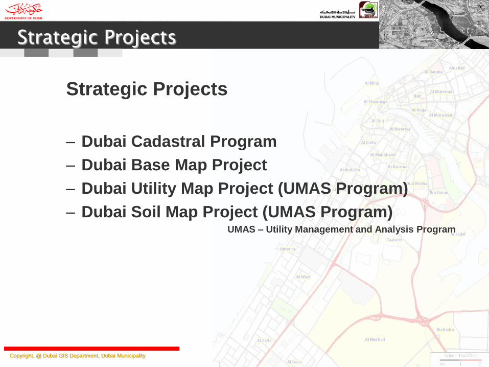
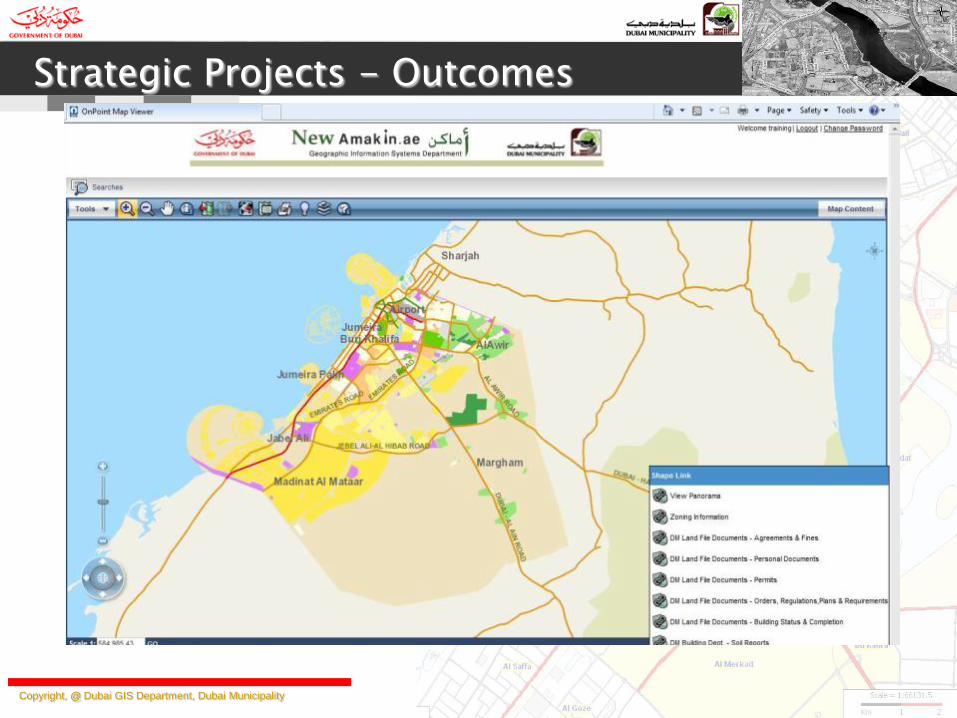
Dubai Cadastral Program
1. Web Enabled Publishing so that the cadastral data available all authenticated users for query
2. Authorized and easy access to all Geo-Spatial data with business information including
documents, reports, pictures etc, needed for municipal uses through a single window using
state-of-the art latest GIS technology
3. Integrating other departmental and organizational data into single geo spatial portal to be
aligned with Dubai e-Government policies
4. Better and faster decision making to improve Dubai Municipality’s customer satisfaction.
Copyright, @ Dubai GIS Department, Dubai Municipality
Strategic Projects - Objectives
Technology Used
Key GIS Technology : ESRI ArcGIS Server
Database : Oracle 11G and ArcSDE 10
Business Layer : ROLTA’s OnPoint
Implemented By : In House Project Team
Copyright, @ Dubai GIS Department, Dubai Municipality
Strategic Projects - Outcomes

Copyright, @ Dubai GIS Department, Dubai Municipality
Strategic Projects - Outcomes
Copyright, @ Dubai GIS Department, Dubai Municipality
Strategic Projects - Outcomes
Copyright, @ Dubai GIS Department, Dubai Municipality
Strategic Projects - Objectives
Dubai Base Map Project
1. Updating the Ground Control Points of Emirate of Dubai.
2. Digital Terrain Model and Contours
3. Digital TRUE Ortho-Photos with 15cm resolution in areas of high raised buildings
4. Digital regular Ortho-Photos with 15cm/45cm resolution
5. Ortho Photos in GeoTIFF format in tiles (15 cm: 1000 m * 1000 m and, 45 cm: 4500 m * 4500 m)
6. Digital collection of features that belong to various department of Dubai Municipality,
Government Departments, Semi-Government Departments, Ministries and various authorities.
7. Features are time stamped – analyze the temporal changes, as this project is executed on regular
bases.
8. Publishing the features as part of Cadastral program and access of the features to all the
authenticated stakeholders.
9. Standardizing the features as per ISO standards.
Copyright, @ Dubai GIS Department, Dubai Municipality
Strategic Projects - Objectives
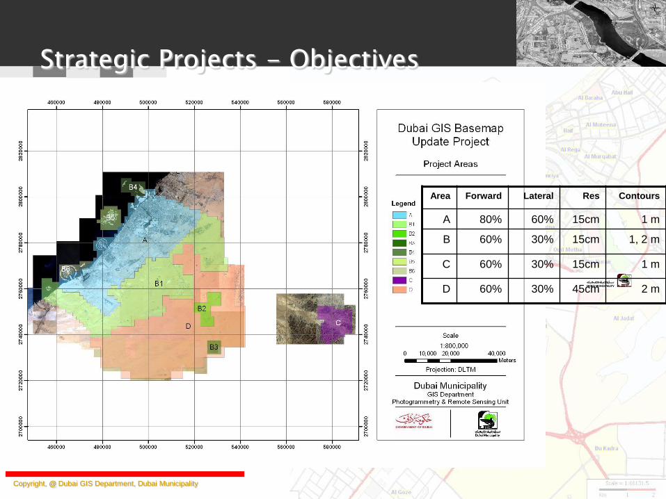
Contours Res Lateral Forward Area
1 m 15cm 60% 80% A
1, 2 m 15cm 30% 60% B
1 m 15cm 30% 60% C
2 m 45cm 30% 60% D

Technology: Digital Photogrammetric Camera
Vexcel UltraCam X
Flying Height between 8000 ft and 21000 ft
NZ Aerial Mapping
Executed by Genesys International Corporation Limited
Feature Collection SSK system
Publishing
Cadastral Program (OnPoint)
Copyright, @ Dubai GIS Department, Dubai Municipality
Strategic Projects - Technology

Copyright, @ Dubai GIS Department, Dubai Municipality
Strategic Projects - Outcome

Copyright, @ Dubai GIS Department, Dubai Municipality
Strategic Projects - Outcome
+ DEM + Contours

Copyright, @ Dubai GIS Department, Dubai Municipality
Dubai Utility Map – Objectives and Highlights
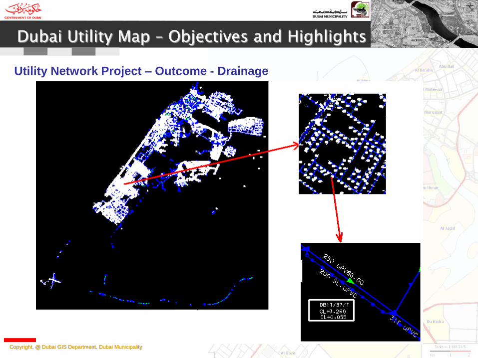
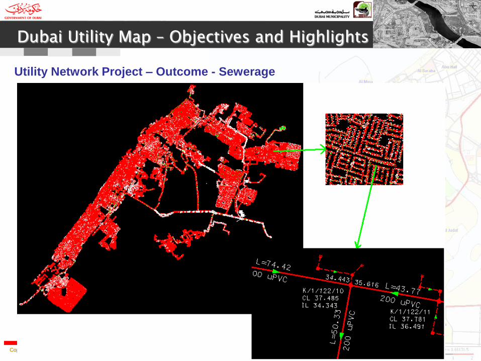
Dubai Utility Project - This has two major sub-projects
Utility Network Project 1. Correcting and standardizing Drainage, Sewerage and Irrigation data which presently exists in
more than 100,000 files with various formats.
2. Storing the utility data in Oracle Spatial, so that the data is accessible to all stakeholders
3. Automating to large extent the utility construction projects to integrate the new utility projects
data to the main and complete network.
4. The utility network data with rich attribute information. This is useful for network analysis and
planning.
5. Rule and Role based Construction Management System which manages utility construction
projects,
1. Defines responsibilities for all the project members within Dubai Municipality and contractor/consultants.
2. Automatic network checks for standards/topology/attributes etc.
3. Contractor/consultants need not visit Dubai Municipality. Deliver the drawing from home.
4. Intelligent system to take decisions on accept/reject of networks.
5. Project status tracking at department level and different authentication levels.
6. Maintain complete network of Emirate of Dubai.
7. Better and cost-effective project management. Reduces the efforts of Engineers.
8. Web based application and accessible from anywhere in the world.
9. Easy support of other utility projects like water, electricity, telecommunication etc.
Copyright, @ Dubai GIS Department, Dubai Municipality
Dubai Utility Map – Objectives and Highlights
Utility Network Project – Outcome - Drainage
Copyright, @ Dubai GIS Department, Dubai Municipality
Dubai Utility Map – Objectives and Highlights
Utility Network Project – Outcome - Sewerage

Copyright, @ Dubai GIS Department, Dubai Municipality
Dubai Utility Map – Objectives and Highlights
Utility Network Project – Outcome - Irrigation
Copyright, @ Dubai GIS Department, Dubai Municipality
Dubai Utility Map – Objectives and Highlights
Dubai Utility Project - This has two major sub-projects
Utility Corridor project
– Digital conversion of all utility corridors as per the standards.
– Storing the corridors for all utilities (including metro utilities) in Oracle Spatial, so
that the data is accessible to all stakeholders
– Corridors Management System to support the production of corridors.
– Easy “No Objection Certificate System” which uses Corridors and networks.

Copyright, @ Dubai GIS Department, Dubai Municipality
Dubai Utility Map – Objectives and Highlights
Utility Corridor Project – Outcome
Copyright, @ Dubai GIS Department, Dubai Municipality
Dubai Utility Map – Phases and budget
1. The Utility Program is organized in phase wise approach.
2. Phase 1 and 2: – Correcting and Standardizing the network and Corridor data. Migrating it to Oracle Spatial
– Construction Management System to automate the utility projects and make it available to contracts/consultants/engineers/draftsmen submit drawings and plans online.
– Publishing the utility networks and corridors in Cadastral program along with parcel and planning data.
– Utility Infrastructure map for analysis and planning the underground utilities.
– Management Level query system on utilities.
Budget: 8 Million AED
3. Phase 3: – Utility Corridor Management System to manage the corridors
– No Objection Certificate system for utility projects.
– Utility Network in 3D and integration with various systems.
– Network Analysis and Planning system
Budget: Under Planning
Copyright, @ Dubai GIS Department, Dubai Municipality
Dubai Utility Map – Technology
1. Research and design done in house at GIS Department.
2. Standards and procedures are derived in house expert team.
3. Data Models are designed in house expert team.
4. Workflows and Systems are designed and documented in house expert team.
5. Support and co-operation from various organizations of Dubai Municipality on
Domain knowledge.
6. Rolta Middle East is executing the projects.
Copyright, @ Dubai GIS Department, Dubai Municipality
Dubai Soil Map – Objectives and Highlights
Dubai Soil Map Project
1. Creating soil map of Emirate of Dubai.
2. Creating various thematic maps like water distribution, Sulphate distribution, chloride distribution, various strata distribution, cross-section maps etc.
3. 3D soil distribution models, 3D fence diagrams etc.
4. Borehole Entry system, where contractors and consultant can enter borehole content without submitting the report in hardcopy.
5. Various Analysis report generation for each borehole.
6. Land Use decision making system using the soil information.
7. System to generate area wise soil and thematic maps.

Copyright, @ Dubai GIS Department, Dubai Municipality
Dubai Soil Map – Present outcome
Blue points are the distribution of boreholes

Copyright, @ Dubai GIS Department, Dubai Municipality
Dubai Soil Map – Present outcome
For each borehole

Copyright, @ Dubai GIS Department, Dubai Municipality
Dubai Soil Map – Phases and budget
1. The Soil Map Program is organized in phase wise approach.
2. Phase 1 and 2: – Migrating 22,000 evenly distributed boreholes of Emirate of Dubai to digital form.
– Developing a system to enter borehole data. Providing access to this system to borehole contractors/consultants and departments.
– Various Analysis report generation for each borehole.
– Publish all the borehole locations in Cadastral program. All stakeholders can view the boreholes and can see various reports on each and multiple boreholes.
Budget: 1.4 Million AED
3. Phase 3: – Creating soil map of Emirate of Dubai.
– Creating various thematic maps like water distribution, Sulphate distribution, chloride distribution, various strata distribution, cross-section maps etc.
– 3D soil distribution models, 3D fence diagrams etc.
– Land Use decision making system using the soil information.
– System to generate area wise soil and thematic maps.
Budget: Under Planning
Copyright, @ Dubai GIS Department, Dubai Municipality
Dubai Soil Map – Technology
1. Research and design done in house at GIS Department.
2. Standards and procedures are derived in house expert team.
3. Data Models are designed in house expert team.
4. Workflows and Systems are designed and documented in house expert team.
5. Support and co-operation from various organizations of Dubai Municipality on
Domain knowledge.
6. Rolta Middle East is executing the projects.

Main Goals
– Single Window Systems
– Zero Visit Environment
– Single Repository data
– Automation in Day to Day workflows
– Synchronize departments and processes
– Follow ISO standards
Copyright, @ Dubai GIS Department, Dubai Municipality
In Conclusion

Copyright, @ Dubai GIS Department, Dubai Municipality
Burj Khalifa
Thank you
شكرا
Dank u