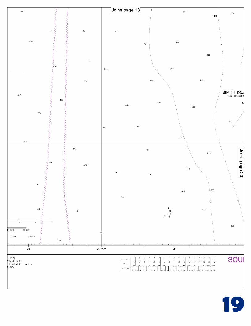
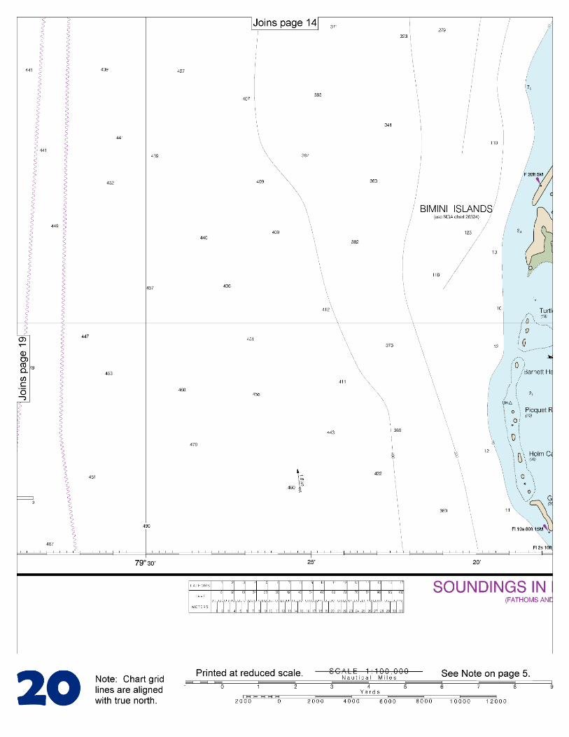
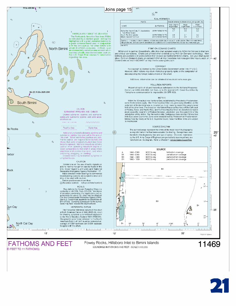
Straits of Florida Fowey Rocks, Hillsboro Inlet to Bimini ... · Straits of Florida Fowey Rocks,...
22
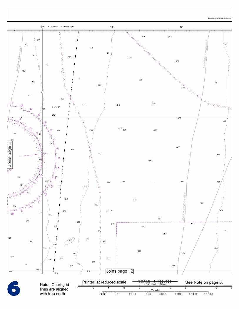
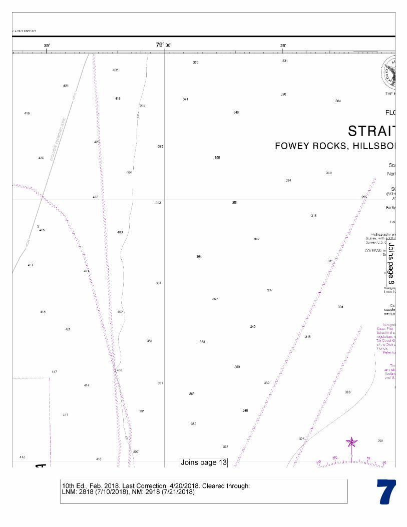
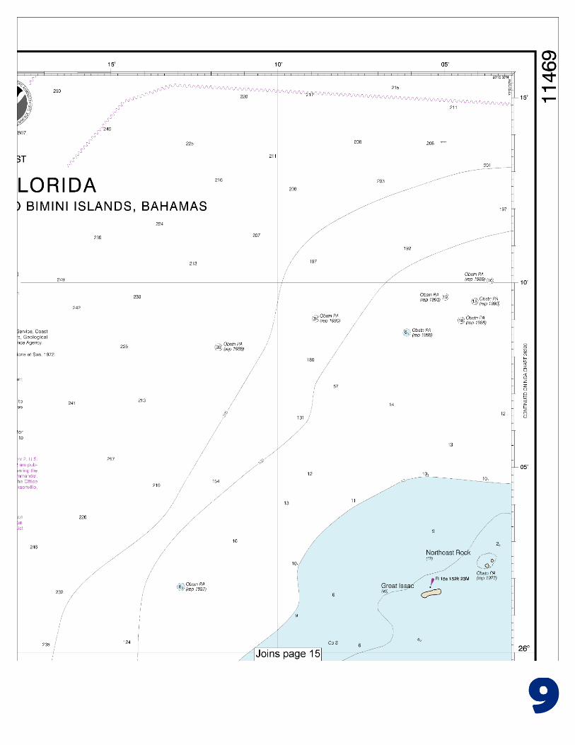
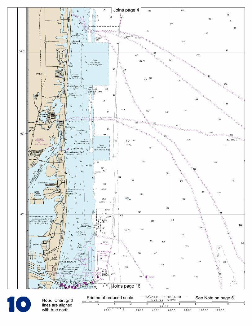
BookletChart ™ Straits of Florida – Fowey Rocks, Hillsboro Inlet to Bimini Islands NOAA Chart 11469 A reduced-scale NOAA nautical chart for small boaters When possible, use the full-size NOAA chart for navigation.
-
Upload
trinhtuyen -
Category
Documents
-
view
217 -
download
0
Transcript of Straits of Florida Fowey Rocks, Hillsboro Inlet to Bimini ... · Straits of Florida Fowey Rocks,...
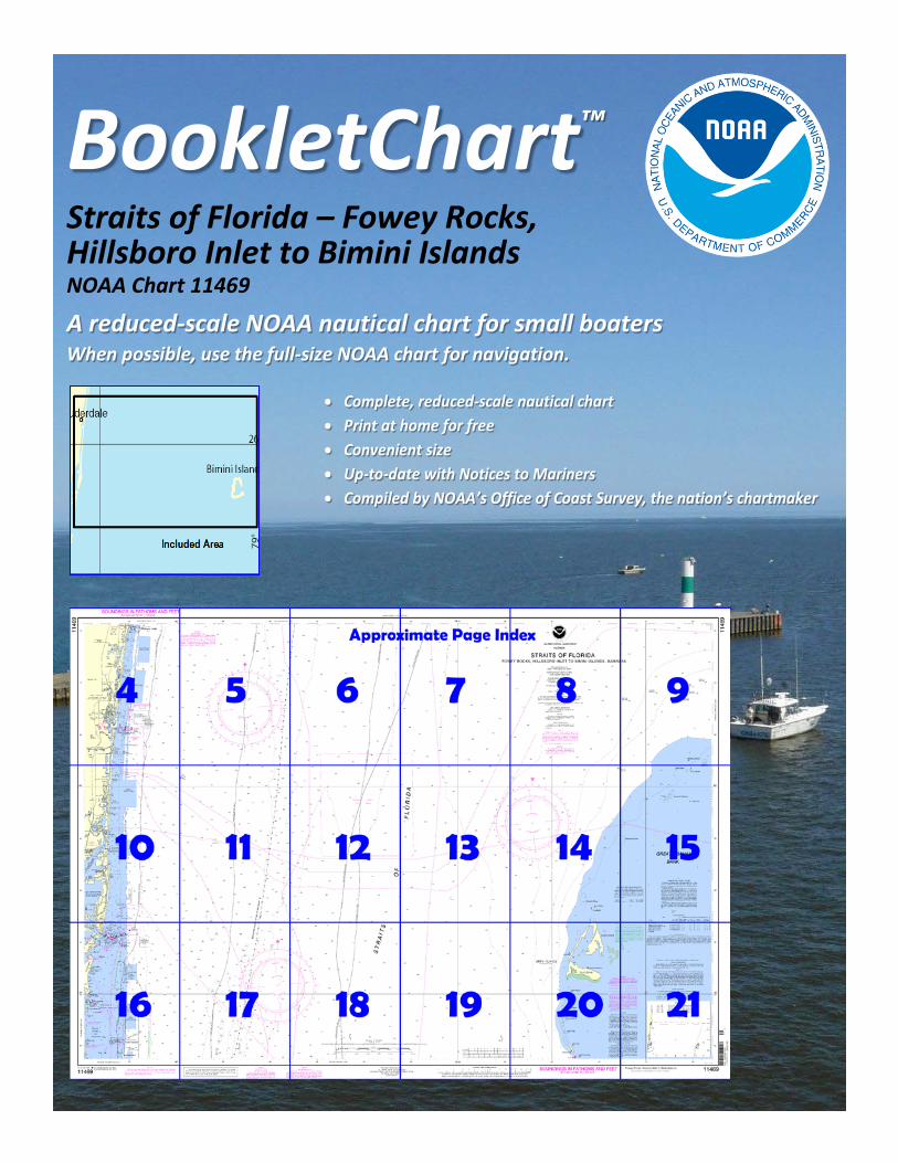
BookletChart™ Straits of Florida – Fowey Rocks, Hillsboro Inlet to Bimini Islands NOAA Chart 11469
A reduced-scale NOAA nautical chart for small boaters When possible, use the full-size NOAA chart for navigation.
2
Published by the National Oceanic and Atmospheric Administration
National Ocean Service Office of Coast Survey
www.NauticalCharts.NOAA.gov 888-990-NOAA
What are Nautical Charts?
Nautical charts are a fundamental tool of marine navigation. They show water depths, obstructions, buoys, other aids to navigation, and much more. The information is shown in a way that promotes safe and efficient navigation. Chart carriage is mandatory on the commercial ships that carry America’s commerce. They are also used on every Navy and Coast Guard ship, fishing and passenger vessels, and are widely carried by recreational boaters.
What is a BookletChart?
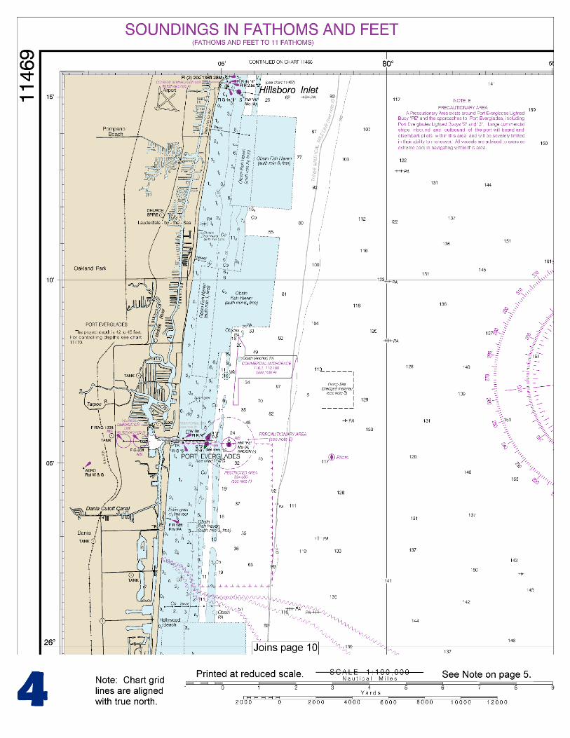
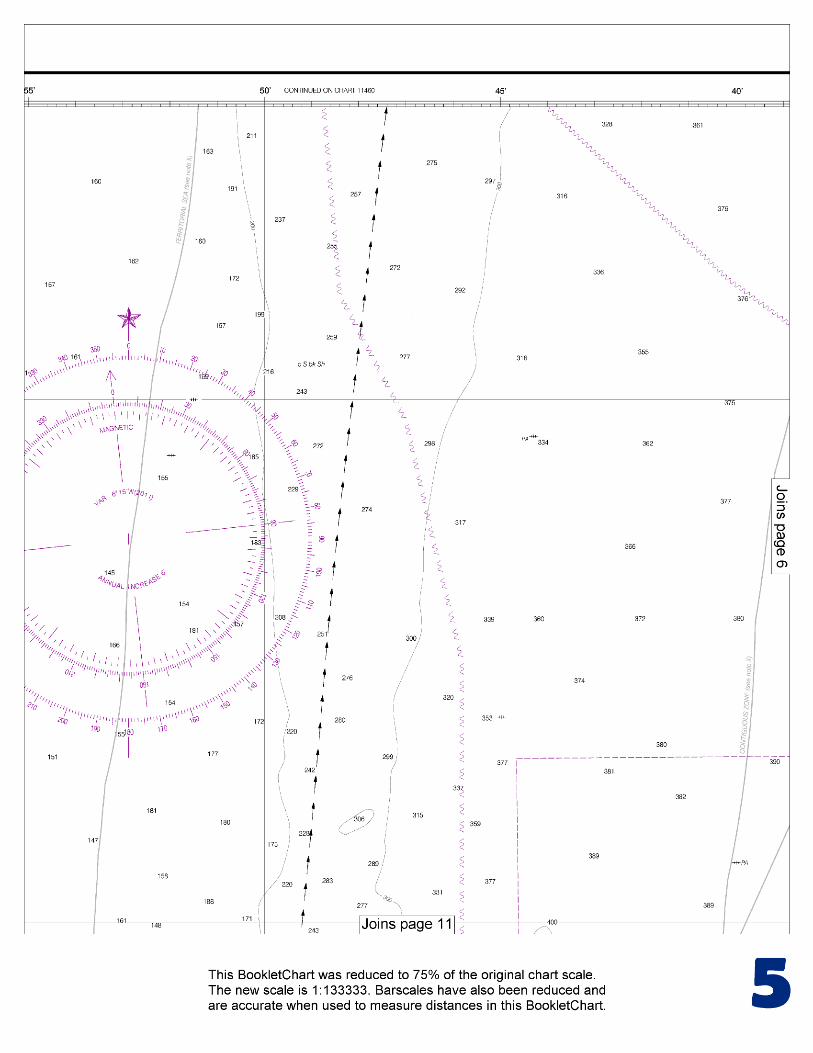
This BookletChart is made to help recreational boaters locate themselves on the water. It has been reduced in scale for convenience, but otherwise contains all the information of the full-scale nautical chart. The bar scales have also been reduced, and are accurate when used to measure distances in this BookletChart. See the Note at the bottom of page 5 for the reduction in scale applied to this chart.
Whenever possible, use the official, full scale NOAA nautical chart for navigation. Nautical chart sales agents are listed on the Internet at http://www.NauticalCharts.NOAA.gov.
This BookletChart does NOT fulfill chart carriage requirements for regulated commercial vessels under Titles 33 and 44 of the Code of Federal Regulations.
Notice to Mariners Correction Status
This BookletChart has been updated for chart corrections published in the U.S. Coast Guard Local Notice to Mariners, the National Geospatial Intelligence Agency Weekly Notice to Mariners, and, where applicable, the Canadian Coast Guard Notice to Mariners. Additional chart corrections have been made by NOAA in advance of their publication in a Notice to Mariners. The last Notices to Mariners applied to this chart are listed in the Note at the bottom of page 7. Coast Pilot excerpts are not being corrected.
For latest Coast Pilot excerpt visit the Office of Coast Survey website at http://www.nauticalcharts.noaa.gov/nsd/coastpilot_w.php?book=4.
(Selected Excerpts from Coast Pilot) Between Jupiter Inlet and Lake Worth Inlet, a distance of about 10.5 miles, the coast is clear of shoals with the 10-fathom curve about 1 mile offshore. A fishing pier extends about 340 yards seaward from about 26°53'37"N., 80°03'24"W. Lake Worth Inlet is a dredged cut through the barrier beach 11 miles south of Jupiter Inlet Light and 31 miles north of Hillsboro Inlet Entrance Light. The entrance is protected by two jetties and the cut by
revetments. Port of Palm Beach is a deepwater port development 1.1 miles west of the entrance to Lake Worth Inlet. The port borders the communities of Riviera Beach on the north and West Palm Beach on the south. It is 259
miles south of Jacksonville and 68 miles north of Miami. There is exten-sive barge traffic. An extensive roll-on/roll-off operation is conducted in the Bahama Island trade. All of the wharves and warehouses are owned by the Port of Palm Beach District. Coast Guard Station.–Lake Worth Inlet Coast Guard Station is inside the entrance about 0.7 mile north of Peanut Island on the west side of the Intracoastal Waterway. Anchorages.–Two offshore anchorage grounds are close north and south of the channel entrance. (See 110.1 and 110.185, chapter 2, for limits and regulations.) There is no deepwater anchorage in the harbor. Anchorage for craft drawing up to 8 feet is available in the vicinity of Palm Beach. Dangers.–A reef in the form of a ridge with scattered boulders extends for about 300 yards eastward of Peanut Island about 25 feet north of the improved channel. The reef, with a least depth of about 4 feet over it, is extremely dangerous. On the ebb, the current sets across the reef in a northeasterly direction. Two fish havens are 0.7 and 1.5 miles off the north side of the entrance and another is 1.5 miles off the south entrance. Pilotage, Port of Palm Beach.–Pilotage is compulsory for foreign vessels and for U.S. vessels under register in the foreign trade and drawing more than 7 feet of water. Pilotage is optional for U.S. coastwise vessels which have a pilot aboard licensed by the Federal Government. The Port of Palm Beach is served by Palm Beach Pilots Association, at Riviera Beach Marina, 200 E. 13th Street, Suite B, Riviera Beach, FL 33404; telephone 561-845-2628, fax 561-845-2644. The office/station monitors VHF-FM radiotelephone channel 16 and works on channel 14. Harbor regulations.–Copies of the Port Tariff may be obtained at the offices of the Port of Palm Beach District at the Maritime Office Building in Riviera Beach. The Port Operations Manager assigns berths and enforces the harbor regulations. The Port of Palm Beach is a public corporation created by the State Legislature. Port regulations state it shall be unlawful for any vessel, boat, barge, or other watercraft of any kind to anchor in the channel or turning basin, except in cases of actual emergency. The coast between Lake Worth Inlet and Port Everglades is fairly bold. The 20-fathom curve runs parallel to the beach and for a greater part of the distance is less than 2 miles from it. Several wrecks and obstructions are within 0.5 mile of the shore. Palm Beach, a resort on the narrow island between Lake Worth and the sea, is connected to West Palm Beach by highway bridges. The ocean pier here is used only for amusement purposes. Several other towns and cities are along the shores of Lake Worth. Bakers Haulover Inlet has been dredged through the barrier beach at the north end of Biscayne Bay, 11.6 miles south of Port Everglades, to provide circulation of water in the bay. The channel leads westward through the inlet, thence northward to a boat basin on the east side of the channel and connects with the Intracoastal Waterway north of the basin and through a cut opposite the basin. In 2008, the controlling depth was 10.9 feet through the inlet to the highway bridge, thence 10 feet in the basin and 8 feet in the channels leading to the Intracoastal Waterway. Route A1A highway bridge over the inlet has a fixed span with a clearance of 32 feet; an overhead power cable just east of the bridge has a clearance of 53 feet. The Florida Department of Natural Resources has established a slow-no wake speed zone in the Intracoastal Waterway where the channels converge in the vicinity of Bakers Haulover Inlet.
U.S. Coast Guard Rescue Coordination Center 24 hour Regional Contact for Emergencies
RCC Miami Commander 7th CG District (305) 415-6800 Miami, FL
G
NOAA’s navigation managers serve as ambassadors to the maritime community. They help identify navigational challenges facing professional and recreational mariners, and provide NOAA resources and information for safe navigation. For additional information, please visit nauticalcharts.noaa.gov/service/navmanagers
To make suggestions or ask questions online, go to nauticalcharts.noaa.gov/inquiry. To report a chart discrepancy, please use ocsdata.ncd.noaa.gov/idrs/discrepancy.aspx.
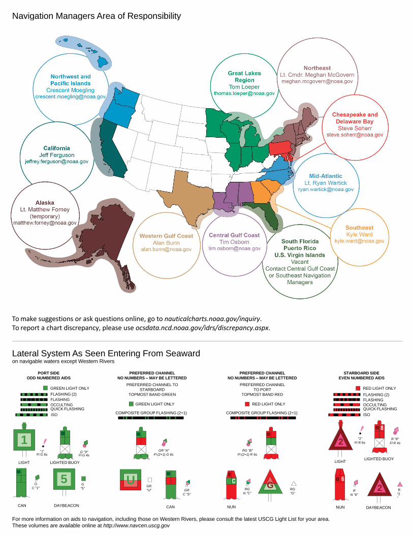
Lateral System As Seen Entering From Seaward on navigable waters except Western Rivers
PORT SIDE
ODD NUMBERED AIDS
GREEN LIGHT ONLY
FLASHING (2)
PREFERRED CHANNEL
NO NUMBERS – MAY BE LETTERED
PREFERRED CHANNEL TO
STARBOARD
TOPMOST BAND GREEN
PREFERRED CHANNEL
NO NUMBERS – MAY BE LETTERED
PREFERRED CHANNEL
TO PORT
TOPMOST BAND RED
STARBOARD SIDE
EVEN NUMBERED AIDS
RED LIGHT ONLY
FLASHING (2)
FLASHING FLASHING
OCCULTING GREEN LIGHT ONLY RED LIGHT ONLY OCCULTING QUICK FLASHING QUICK FLASHING
ISO COMPOSITE GROUP FLASHING (2+1) COMPOSITE GROUP FLASHING (2+1) ISO
"1"
Fl G 6s
G "9"
Fl G 4s
GR "A"
Fl (2+1) G 6s
RG "B"
Fl (2+1) R 6s
"2"
Fl R 6s
8
R "8"
Fl R 4s
LIGHT
G
C "1"
LIGHTED BUOY
G
"5"
GR
"U"
GR
C "S"
RG
N "C"
RG
"G"
LIGHT
6
R
N "6"
LIGHTED BUOY
R
"2
"
CAN DAYBEACON
CAN NUN NUN
DAYBEACON
For more information on aids to navigation, including those on Western Rivers, please consult the latest USCG Light List for your area.
These volumes are available online at http://www.navcen.uscg.gov
Navigation Managers Area of Responsibility
Northeast
Lt. Meghan McGovern
Northwest and
Pacific Islands
Crescent Moegling
Great Lakes Region
Tom Loeper
Chesapeake and
Delaware Bay
Steve Soherr
California
Jeff Ferguson
[email protected] Mid-Atlantic
Lt. Ryan Wartick
Alaska
Lt. Timothy M. Smith
Western Gulf Coast
Alan Bunn
Central Gulf Coast
Tim Osborn
[email protected] South Florida
Puerto Rico
U.S. Virgin Islands
Michael Henderson
Southeast
Kyle Ward
2
2 C U 5
1

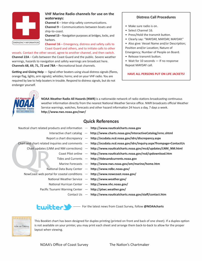
VHF Marine Radio channels for use on the waterways:Channel 6 – Inter-ship safety communications.Channel 9 – Communications between boats and ship-to-coast.Channel 13 – Navigation purposes at bridges, locks, and harbors.Channel 16 – Emergency, distress and safety calls to Coast Guard and others, and to initiate calls to other
vessels. Contact the other vessel, agree to another channel, and then switch.Channel 22A – Calls between the Coast Guard and the public. Severe weather warnings, hazards to navigation and safety warnings are broadcast here.Channels 68, 69, 71, 72 and 78A – Recreational boat channels.
Getting and Giving Help — Signal other boaters using visual distress signals (flares, orange flag, lights, arm signals); whistles; horns; and on your VHF radio. You are required by law to help boaters in trouble. Respond to distress signals, but do not endanger yourself.
EMERGENCY INFORMATION
Distress Call Procedures
• Make sure radio is on.• Select Channel 16.• Press/Hold the transmit button.• Clearly say: “MAYDAY, MAYDAY, MAYDAY.”• Also give: Vessel Name and/or Description;Position and/or Location; Nature of Emergency; Number of People on Board.• Release transmit button.• Wait for 10 seconds — If no responseRepeat MAYDAY call.
HAVE ALL PERSONS PUT ON LIFE JACKETS!
This Booklet chart has been designed for duplex printing (printed on front and back of one sheet). If a duplex option is not available on your printer, you may print each sheet and arrange them back-to-back to allow for the proper layout when viewing.
QR
Quick ReferencesNautical chart related products and information - http://www.nauticalcharts.noaa.gov
Interactive chart catalog - http://www.charts.noaa.gov/InteractiveCatalog/nrnc.shtmlReport a chart discrepancy - http://ocsdata.ncd.noaa.gov/idrs/discrepancy.aspx
Chart and chart related inquiries and comments - http://ocsdata.ncd.noaa.gov/idrs/inquiry.aspx?frompage=ContactUs
Chart updates (LNM and NM corrections) - http://www.nauticalcharts.noaa.gov/mcd/updates/LNM_NM.html
Coast Pilot online - http://www.nauticalcharts.noaa.gov/nsd/cpdownload.htm
Tides and Currents - http://tidesandcurrents.noaa.gov
Marine Forecasts - http://www.nws.noaa.gov/om/marine/home.htm
National Data Buoy Center - http://www.ndbc.noaa.gov/
NowCoast web portal for coastal conditions - http://www.nowcoast.noaa.gov/
National Weather Service - http://www.weather.gov/
National Hurrican Center - http://www.nhc.noaa.gov/
Pacific Tsunami Warning Center - http://ptwc.weather.gov/
Contact Us - http://www.nauticalcharts.noaa.gov/staff/contact.htm
NOAA’s Office of Coast Survey The Nation’s Chartmaker
For the latest news from Coast Survey, follow @NOAAcharts
NOAA Weather Radio All Hazards (NWR) is a nationwide network of radio stations broadcasting continuous weather information directly from the nearest National Weather Service office. NWR broadcasts official Weather Service warnings, watches, forecasts and other hazard information 24 hours a day, 7 days a week. http://www.nws.noaa.gov/nwr/