2015-2018 Approved Strafford MPO Transportation Improvement Program

tE
Strafford RegionalPlanning Commission
E
The Oyster RiverWatershed Management Plan
June 2001
SRPC
BARRINGTON' DOVER' DURHAM • FARMINGTON' LEE' MADBURY. MIDDLETON· MILTON' NEW DURHAM' NEWMARKETNORTHWOOD' NOTTINGHAM' ROCHESTER • ROLLINSFORD' SOMERSWORTH • STRAFFORD' WAKEFIELD

The Oyster RiverWatershed Management Plan
June 2001
DR FT
The Oyster River Watershed Management Plan
The Oyster River Watershed Management Plan
This document was funded by a grant from the New Hampshire Estuaries Program pursuant to anaward from the Federal Environmental Protection Agency
Bringing Our
EstuariesNew Life
-73-
"Iill N('I/Hampshlre~rr~~arieS Project

The Oyster River Watershed Management Plan
Acknowledgements
Many thanks to those who contributed to the Oyster River Watershed Management Plan:
Town of BarringtonGeorge Musler: Member, Barrington Board of Selectmen; New Hampshire State RepresentativeDenise Hart: Member, Barrington Conservation CommissionCarol Reilly: Barrington Town AdministratorKai Stapelfeldt: Barrington resident
Town of DurhamGeorge Reif: Former member, Durham Planning Board; Chair, Strafford Regional PlanningCommissionTheresa Walker: Chair, Durham Conservation Commission
Town of DoverDean Peschel: Town of Dover, Department of Community ServicesTom Fargo: Chair, Dover Conservation Commission
Town of LeeJoseph Ford: Member, Lee Board of SelectmenDick Weyrick: Chair. Lee Conservation Commission
Town of IVladburyGeorge Mattson: Member, Madbury Recreation CommissionJoanne Schreiber: Chair, Madbury Water Board
The University of New HampshireJohn Sanders: Director of FacilitiesBrian Gallagher: Water Treatment FacilityTom Kelly: Director, Office of Sustainability Programs
The Oyster River Watershed AssociationChuck Cox: Founding MemberLaurel Cox: Founding MemberTom Lee: Founding Member
Strafford County Conservation DistrictBambi Miller: District Manager
Strafford Regional Planning CommissionCynthia Copeland: Executive DirectorMatt Barrett: Senior GIS AnalystNancy Phillips: Water Resources Consultant
Special thanks are given to Bambi Miller of the Strafford County Conservation District for her
encouragement for the formation of the group in January 2000, Cynthia Copeland of the
Strafford Regional Planning Commission for administering and obtaining the two grants that
have helped us with the wonderful watershed maps, administrative suppott for the mailing of the
monthly minutes and announcements of activities, and to Nancy Phillips of the Strafford
Regional Planning Commission for helping us focus our thoughts on how to articulate a
management plan for the watershed.
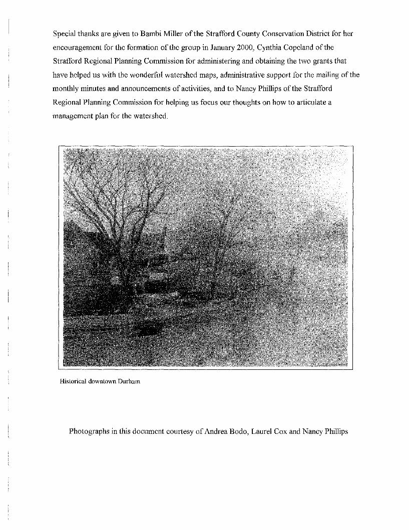
Historical downtown Durham
Photographs in this document courtesy of Andrea Bodo, Laurel Cox and Nancy Phillips

The Oyster River Watershed Management Plan
Table of Contents
Acknowledgements
An invitation
I. Introduction PageA. Development of the Oyster River Watershed Management Plan-Interactions Between the Oyster River Watershed Association and IndividualCommunities 1-2
II. The Oyster River WatershedA. Features of the Oyster River Watershed 3-9B. Existing Conditions Within the Oyster River Watershed 10-12
III. The History of the Oyster River Watershed AssociationA. Creating an Adaptive Watershed Management Plan 13-16B. The Watershed Plan Comes to Life; A Description of Activities to Date .17-25
IV. Growth of the Oyster River Watershed Management Plan-A Process for ChangeA. Understanding Community Values and Concerns to Develop Future Action for theWatershed , " , , , 26-29B. Summary of Qualities, Threats and Concerns and Recommended Actions 29-32C. Linking with Neighboring Watershed Efforts-A comparison with the Coastal Program,Great Bay, Exeter River, and the Lamprey River " 33
V. Developing Priorities for the Oyster River Watershed AssociationA. Developing Critical Questions 34-36B. Utilizing a Relative Risk Assessment as a Planning Tool '" 36-38C. Development of a Water Budget for the Oyster River Watershed 39-43D. Linking a Relative Risk Assessment with Environmental Indicators .44-45
VI. An Assessment of Tools and Techniques to Achieve ChangeA. Perceptions 46-60B. A Review of Municipal Ordinances 61-66
VII. The Oyster River Watershed Plan-June 2001 and Beyond
Appendix A: Specific Recommendations 69-73
Suggested References 74
The Oyster River Watershed Management Plan
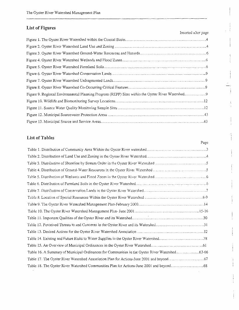
List of FiguresInserted after page
Figure 1. The Oyster River Watershed within the Coastal Basin .4
Figure 2. Oyster River Watershed Land Use and Zoning .4
Figure 3. Oyster River Watershed Ground-Water Resources and Hazards 6
Figure 4. Oyster River Watershed Wetlands and Flood Zones 6
Figure 5. Oyster River Watershed Farmland Soils 6
Figure 6. Oyster River Watershed Conservation Lands 9
Figure 7. Oyster River Watershed Unfragmented Lands 9
Figure 8. Oyster River Watershed Co-Occurring Critical Features 9
Figure 9. Regional Environmental Planning Program (REPP) Sites within the Oyster River Watershed 9
Figure 10. Wildlife and Biomonitoring Survey Locations 12
Figure 11. Source Water Quality Monitoring Sample Sites 12
Figure 12. Municipal Sourcewater Protection Areas .43
Figure 13. Municipal Source and Service Areas 43
List of TablesPage
Table I. Distribution of Community Area Within the Oyster River watershed 3
Table 2. Distribution of Land Use and Zoning in the Oyster River Watershed .4
Table 3. Distribution of Shoreline by Stream Order in the Oyster River Watershed 5
Table 4. Distribution of Ground-Water Resources in the Oyster River Watershed 5
Table 5. Distribution of Wetlands and Flood Zones in the Oyster River Watershed 6
Table 6. Distribution of Farmland Soils in the Oyster River Watershed 6
Table 7. Distribution of Conservation Lands in the Oyster River Watershed 7
Table 8. Location of Special Resources Within the Oyster River Watershed 8-9
Table 9. The Oyster River Watershed Management Plan-February 2000 14
Table 10. The Oyster River Watershed Management Plan- June 2001 15-16
Table 11. Important Qualities of the Oyster River and its Watershed 30
Table 12. Perceived Threats to and Concerns in the Oyster River and its Watershed 31
Table 13. Desired Actions for the Oyster River Watershed Association 32
Table 14. Existing and Future Risks to Water Supplies in the Oyster River Watershed 38
Table 15. An Overview of Municipal Ordinances in the Oyster River Watershed 61
Table 16. A Summary of Municipal Ordinances for Communities in the Oyster River Watershed 63-66
Table 17. The Oyster River Watershed Association Plan for Actions-June 2001 and beyond 67
Table 18. The Oyster River Watershed Communities Plan for Actions-June 2001 and beyond 68

The Oyster River Watershed Management Plan
An invitation
"Don't muddy the water around you. You may have to drink it SOOll."
"We have met the enemy, and they are us." Some wisdom from Pogo
We are all living together in this Oyster River watershed. What I do and what you do affects us both. I run a car and
have a septic system like everyone else. I have faith that people want to be good neighbors and to do what is right
and best for the good health of the neighborhood and the world around us.
Welcome to the Oyster River Watershed Association. I see this group as a way for neighbors within the watershed to
get together, to begin to understand the needs and desires of one another in relationship to learning how to appreciate
and maintain a healthy watershed. We can better understand the existing and potential problems through our
explorations of the maps, river walks, water sampling and testing, learning more of the hydrology, pollution, land
preservation techniques, and ecological interconnections. It is a universally agreed upon given that we are all
concerned that our water supply be ample and of high quality.
Our dialogue with one another, with our surrounding communities, and with members of other watersheds must take
place with openness and honesty. It must be inclusive of all elements that make up the community. We need to be
able to do as much careful listening as talking.
The process of the creation and implementation of the Oyster River Management Plan is integral to the plan itself. It
must involve each of the elements of the communities that are dependent upon the health of the river. Every part of
the community needs to be consulted and aware of the importance of the river and the ecosystem of the watershed.
from gas stations, shopping centers, and fast food franchises to the farms. university, the water treatment plant,
public schools, town sewage treatment plant, and the individual households of our citizens.
One of the most exciting aspects of the past year is the beginning of inter-town communication and cooperation. The
towns of Madbury, Lee, Barrington, Durham, and Dover, and the University of New Hampshire have just begun to
relate to one another on regional concerns, with the river as the vital link among them..
As we begin our second season with optimism and energy, I continue to believe in the strength and power of this
cooperative process of inclusion. We look forward to creating the future, as we work together to keep the river and
its watershed healthy and clean.
Chuck Cox, 30 June 200 I

I. Introduction
A view of Wheelwright Pond

The Oyster River Watershed Management Plan
I. Introduction
Development of the Oyster River Watershed Management Plan-Interactions Between the Oyster River Watershed Association and Individual Communities
The purpose of the Oyster River Watershed Management Plan is to create a platform for
conversations regarding the long-term protection and management of the natural resources within
the Oyster River watershed. The platform rests upon the strong desire to use collective
knowledge and wisdom to guide the decision making process as the Oyster River Watershed
Association and the communities move into the future. In moving forward, it is recognized that
change will occur, and a unique balance will be forged between the past, present and future
cultural and social characteristics of this area. The point of balance, the point of convergence will
always be found, as long as the conversations continue. The Management Plan creates a platform
for conversations.
The move to develop a comprehensi ve watershed management plan for the Oyster Ri vel'
watershed began with the Oyster River Watershed Association reaching out through a series of
focused interviews to gather an understanding of the communities and the citizens living within
them. The interviews evoked discussions that went much deeper than simply deciding on
management techniques. It brought forth thoughts about who we are as a society and how
technology has influenced our behaviors. It evoked thoughts about where and how we place
ourselves within the greater landscape and how to achieve a sustainable balance for the entire
community. There was little doubt that technology has brought about a change in our patterns of
living, such that services which were previously accessible within urban areas are now available
to those living in the rural countryside. As such, preconceived notions of our living and working
environment have changed. Development has spread, and the communities in the watershed are
in the pathway of a suburban pattern of growth. With this growth pattern has come an increased
demand for community services, infrastructure, and means of transportation. Amidst all of this,
there is an increasing awareness of the need to sustainably manage the natural resources. The
concept of conservation has taken hold in this watershed, such that individual and collective
-1-
The Oyster River Watershed Management Plan
community actions are considered paramount to maintaining the quality of life within this
regional landscape. The interdependence of community development, transportation and natural
resource management has become more apparent. The citizenry has become aware that to
effectively plan for and manage this triad, regional approaches will be necessary. Within the
Oyster River watershed, these changes in the way we live with the attendant changes in the
surrounding landscape brought to the forefront many environmental issues.
The watershed management planning project was perceived as an opportunity that occurred at a
time when it was needed the most. The concept of the management plan being used to protect
valuable resources as compared to a management or restoration effort was foremost in most
people's minds. There was consistency that participation and long-term commitment from the
greater watershed community would need to be forged to fully implement the watershed plan.
However, it was understood that embracing the concept of a greater watershed community may
require that community independence and individuality be lost to some degree. Private property
rights could inevitably be challenged andJor lessened. In order to manage lands to attain a desired
quality of life and to safely stay within natural carrying capacities, the watershed plan
accommodates for a degree of municipal oversight. However, this lessening of self-government
has to be strongly balanced with efforts to pursue education and the development of unique
community approaches to address common issues. The watershed management plan stri yes to
attain an extremely delicate balance between individual and community efforts whereby
community intentions and limitations are respected.
-2-
II. The Oyster River Watershed
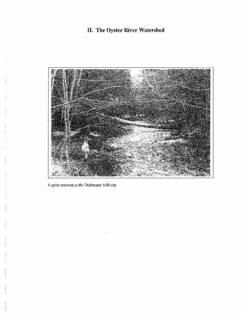
A quiet moment at the Dishwater Mill site
The Oyster River Watershed Management Plan
n. The Oyster River Watershed
A. Features of the Oyster River Watershed
A watershed is an area of land that drains to any water resource, such as a wetland, river, lake or
estuary. Watersheds can contain numerous tributaries and ponding areas. There are six
communities whose municipal boundaries lie within the Oyster River watershed, which is
contained within the larger New Hampshire Coastal Basin (Figure 1). The communities are
Barrington 31117 2876 15Dover 18587 1074 5Durham 15852 7517 38Lee 12927 4758 24Madburv 7799 3287 17
Nottinoham 30997 316 2
Total watershedacres 19828
Barrington, Dover, Durham,
Madbury, Nottingham and Lee.
The distribution of community
area is shown in Table 1. It can
be seen that Durham has the
greatest percentage of its land
area in the watershed (38%),
followed by Lee (24%),
Madbury (17%), Barrington
(15%), Dover (5%) and
Nottingham (2%).
The watershed is predominantly forested, with approximately 12,650 acres of forestlands. A
variety of other types of land uses exist within the watershed (Table 2), the most prevalent of
which are residential lands (2700 acres) and agricultural lands (2491 acres). The land use and
zoning map (Figure 2) for the watershed shows the distribution of the land cover and land uses
within this area. The relative amount of open space (agriculture, brush, forested, and surface
waters) within the communities shows that most communities have a high percentage of open
space ranging from 75% in Durham, 83% in Nottingham, 85% in Lee, 88% in Barrington and
89% in Lee. In Dover open space accounts for approximately 54% of the land area in the
watershed.
-3-

The Oyster River Watershed Management Plan
~;~~ll~!~'l(i);i,ik~~~ ;~~~~' 'A.~;~~;~'e , ~ommumty7", .l, 'I'"",V<
Barrington lResidential 268.9 Madbury Residential 228.8Commercial-Retail 1.2 Government 0.8Commercial-Services 1.2 nstitutional 1.4ndustrial 3.5 Educational 18.1
Mining-Sand/Gravel 30.8 ndoor-Cultural 0.0TransportationlUtilities 39.5 ndustrial 11.1Cemetery 1.1 Mining-Sand/Gravel 0.0Agriculture 45.1 TransportationlUtilities 86.0Brush-Transitional 5.0 WaterfWastewater Facilities 12.5Forested 2477.8 Outdoor-Other 14.7Surface Water 2.0 Agriculture 561.7Total 2876.3 Brush-Transitional 3.3
Forested 2336.1C"'>N~'i<{~1"rt':lyl~ T.vbIflK~"'·''';"'\'ti·':'···~·!I~A'~~'~!<'''(';;'~ft~q~~~ ~~~~§~ Surface Water 12.8ommUlll ,'<i,' e,of~Lana 'Used.>"'J.;t(t\~j<.!'kt~';;'ii,\~~
Durham Residential 1318.9 Total 3287.2Commercial-Retail 5.3
K:ommercial-Services 10.0 t~·r~(i;;~'~'!i~!l>}itYtq rt~p~'6fL'iiild'U;~"rsi;;:::~'V:~:;\"~'f Aicfes'ommum·}
KJovernment 7.2 lLee Residential 474.2nstitutional 1.9 Commercial-Retail 73.2
!Educational 370.4 Commercial-Services 16.9ndustrial 16.9 Government 1.3
rrransportationIUti1ities 131.2 nstitutional 1.2!WaterfWastewater Facilities 9.3 Educational 5.6
~olid Waste-Utilities 1.8 ndustrial 4.1
ndustriallCommercial Complex 7.5 Mining-Sand/Gravel 78.4
Mixed 15.5 rrransportationlUtilities 36.8Ioutdoor-Other 7.2 Solid Waste-Utilities 4.8
K:emetery 6.6 Cemetery 4.9[Agriculture 1183.9 Agriculture 526.6Brush-Transitional 88.7 Brush-Transitional 105.4'-'orested 3874.8 Forested 3306.1Surface Water 460.0 Surface Water 118.4
fotal 7517.1 Total 4758.0
52.422.1
240.1
315.5
Estimates obtained from Strafford Regional Planning Commission GISServices and New Hampshire GRANIT
-4-
aterfWastewater Facilities
riculture
rush-Transitional
orested
urface Water
otal
0.85.2
104.816.9
8.8
151.85.0
420.63.2
1074.1

Map produced by the Strafford Regional Planning Commission, May 2001. MSB
Figure 1::The Oyster RiverWatershed withinthe New HampshireCoastal Basin
~ewHampsh"e~~ariesProject
ntraffordRegionalPlanning
____ Commission
60,00030,000o
Oyster River Watershed
30,000 15,000
The Oyster River Watershed Management Plan
ur .It ., ;,\1~t:d~First 8417Second 10019Third 28498Fourth 57657
The Oyster Ri ver watershed is approximately 31 square miles or 19,828 acres in size. It is one of
the smallest watersheds located within the New Hampshire Coastal Basin. The drainage from the
Oyster River and its watershed empties into Great Bay, an
estuarine system, which then empties into the Gulf of Maine.
The Oyster River and all its tributaries in the towns of
Barrington, Durham, Lee and Madbury are designated as
Class A streams and are used as a water supply for the
University of New Hampshire and the Town of Durham. The
watershed has 64.87 miles of shoreline of rivers and streams.
The rivers and streams located within the Oyster River
watershed can all be classified as either first, second, third or
fourth order streams. (See Table 3).
Estimates obtained from Strafford RegionalPlanning Commission GIS Services and NewHampshire GRANIT
The Oyster River watershed is blessed with a variety of natural resources, which have provided
for some unique characteristics of the communities. For example, the watershed contains areas of
highly productive stratified drift aquifers (those areas with transmissivity greater than 2000),
commumty
AQuifer'transmissivity"
Barrington Dover" Durham Lee' Ma'dburv ' Nottingham Totals
0-500 30 607 6094 3487 1599 11 11828500-1000 324 101 22 293 75 8151000-2000 47 37 33 64 1812000-3000 37 24 20 46 1283000+ 82 15 6 36 140
Note: Area reported in acres.
Estimates obtained from Strafford Regional Planning Commission GIS Services and New Hampshire GRANIT
which supply the communities with a portion of their drinking water. The City of Dover contains
the largest acreage of these water-bearing areas within the watershed, followed closely by
Madbury (See Table 4). It should be no surprise that wellfields for public water supply wells are
clustered in the area of Dover and Madbury. The location of the aquifers within the watershed are
shown in Figure 3. Within the landscape of this watershed are also located the floodplains and
wetlands, which represent the dynamic stream profiles and the areas of surface water and
-5-

The Oyster River Watershed Management Plan
Palustrine Lacustrine Estuarine Unknown Type
Barrington 320 0 0 6 0Durham 367 22 438 0 972Dover 44 0 0 2 19
Lee 455 101 0 14 500Madbury 220 0 0 1 93
Nottingham 12 0 0 0 0Watershed Total: 1419 122 438 24 1584
Area reported in acres
Estimates obtained from Strafford Regional PlanningCommission GIS Services and New Hampshire GRANIT
groundwater interactions. The Town of Durham contains the greatest percentage of land area that
is designated as 100-year floodplain by the Federal Emergency Management Agency. (See Table
5). This abundance of floodplain speaks to the location of Durham within the landscape, as it is
the most downstream community along the Oyster River prior to the discharge over the Wiswall
dam into the tidal portion of Great Bay. Adjacent to much of the floodplain areas are the wetland
systems. It is recognized that there are three different types of wetlands throughout this
watershed, although the palustrine (freshwater) wetland type dominates (See Table 5). There are
estuarine (marine) wetland systems that are located exclusively in Durham. The location of the
wetlands and floodplains is shown in Figure 4.
The area has a variety of soil types, ranging from
marine sediments to rich farmland soils. There are 3550
acres of prime farmland soils and 690 acres of state
important farmland soils. This represents approximately
20% of the entire watershed area, and has led to the
agricultural community heritage in this area (See Table
6). The distribution of the farmland soils throughout the
watershed is shown in Figure 5.
-6-
Barrin ton 193 49 42Dover 323 279 19Durham 2010 1821 292Lee 1177 732 138Madbur 1199 670 200Nottin 'ham No data available
Totals 4901 3551 690
The Oyster River Watershed Management Plan
will be generated as priorities change over time.
Many of the areas within the watershed that are rich in natural resource value have been placed
into conservation over the years. Presently, the Town of Durham has over 2,000 acres of
conservation lands within its borders as shown in Table 7. Most of this land is currently owned
by the university. Other parcels of conservation land are also located throughout the watershed.
Both the Towns of Lee and Banington have active conservation programs that contribute to the
acreage currently being protected. The conservation lands in the watershed are shown in Figure 6.
There are still many large parcels of unfragmented lands that exist in the watershed (Figure 7),
which offer opportunities for future conservation efforts,
depending upon the priorities for conservation. A map of the
watershed was generated to show areas in the watershed where
several different valuable natural resources occurred, either
individually or simultaneously. This map is referred to as the
co-occurrence map for the Oyster River watershed and is
shown in Figure 8. The critical features (important natural
resources) that are part of this map include the location of
aquifers, wetlands and wetland soils, and farmland soils. It is
hoped that additional co-occurrence maps for the watershedEstimates obtained from Strafford RegionalPlanning Commission GIS Services andNew Hampshire GRAN IT
Barrington 250Dover 23Durham 2284Lee 317Madbury 192Nottingham 4Total 2873
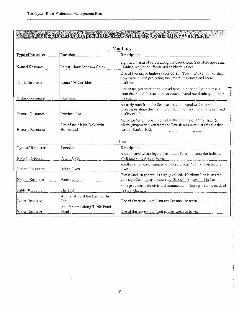
The area that includes the Oyster River watershed was the subject of a Regional Environmental
Planning Project conducted in 1998 by the Strafford Regional Planning Commission with
support from the New Hampshire Department of Environmental Services. The project highlights
the cultural and natural resources within the planning area. The Oyster River watershed as
depicted in Figure 9 supports a variety of these regionally important areas including agricultural
resources, habitat, historic mill sites, public resources, water resources, scenic resources,
recreational resources, historic resources and other natural resources (woodlands, slopes, caves,
and kettle holes). A summary of these regional important resources is contained in Table 8.
-7-
The Oyster River Watershed Management Plan
T e of Resource
Natural Resource
Public Resource
Historic Resource
Historic Resource
Historic Resource
T e of Resource
Natural Resource
Natural Resource
Natural Resource
Public Resource
Water Resource
Water Resource
Location
Forest Alon Johnson Creek
Route 108 Corridor
Mast Road
Province Road
Site of the Major DeMerrittHomestead
Location
Peter's Oven
Indian Oven
Forest Land
The Hill
Aquifer Area at the Lee TrafficCircle
Aquifer Area along Turtle PondRoad
MadburDescri tion
Significant area of forest along the Creek from Salt Hole upstream.Habitat, recreation, forest and aesthetic values.
One of two major highway corridors in Town. Prevention of stripdevelopment and protecting the natural resources and scenic
ualities.
One of the old roads used to haul trees to be used for ship mastsfrom the inland forests to the seacoast. Rural laesthetic qualities inthe corridor
An early road from the Seacoast inland. Rural and historiclandscapes along this road. Significant to the rural atmosphere and
ualit of life.
Major DeMerritt was involved in the capture of Ft. William &Mary- gunpower taken from the British was stored at this site thenused at Bunker Hill.
LeeDescri tion
A small cave where legend has it that Peter hid from the Indians.Well known feature in town.
Another small cave, similar to Peter's Oven. Well known feature intown.
Forest land, in general, is highly valued. Northern Lee is an areawith sianificant forest resources. Site of first saw mill in Lee.
Village center, with civic and commercial offerings, retains much ofits rural character.
One of the more sianificant a uifer areas in town.
uifer areas in town.
-8-

The Oyster River Watershed Management Plan
DurhamT e of ResourceNatural Resource
Historic Resource
Historic Resource
Public Resource
Historic Resource
Historic Resource
LocationBeech Hill
Train Station
The Outdoor Pool
Downtown
Historic District
The Landing
Descri tionHiohest oint in town.
Historic building with adaptive re-use (the UNH Dairy Bar). Soon toan active rail station aoain, contributino to intermodal travel.
Believed to be the only remaining WPA-built pool still in existence(and in use)
Traditional focal point of community. Town has worked hard toprevent commercial sprawl which would detract from downtownvitalit .
Extensive area of early homes and buildings between the Oyster Riveland the downtown.
The initial center of commerce in town, where boats on the Oyster Ri'loaded and unloaded.
Scenic Resource
Historic Resource
Recreational Resource
Scenic Resource
Area around two tidal tributaries to the Oyster River. Scenic. Tidalwetlands. Route 4 corridor very scenic, with views and close tree
Johnson Creek/Bunker Creek Area cano
Brick ards Natural resource related industrv of historic im ortance to region.
Primary reason stated for this corridor is for trails along the river, andGreenbelt Along 0 ster River enhance ublic access to the river. Much of the land is owned bv UN
Many large parcels of open space along Rt. 108 north and south ofRt. 108 Corridor villaoe. 1m ortant atewavs into the communit
Estimates obtained from Strafford Regional Planning Commission GIS Services and New Hampshire GRANIT
-9-

The Oyster River Watershed Management Plan
B. Existing conditions within the Oyster River Watershed
The monit0l1ng program was developed to provide for initial watershed-wide screening followed
by more intensive site-specific determinations. The monitoring consisted of biological and
wildlife screening and water quality monitoring. The purpose of the biological monitoring and
wildlife screenings initiated by the Association was to conduct a qualitative screening assessment
throughout the watershed to characterize
natural resource quality. The qualitative
assessment yielded information ranging
from location of critical problem areas to
identification of high quality resources.
Biological monitoring is a valuable screening procedure as the results represent an integration of
chemical and physical characteristics of the site.
The biological monitoring demonstrated that the streams in the watershed supported healthy
populations of macroinvertebrates that are indicators of high quality waters. For the Oyster River
watershed, designation as a high quality water indicates that not only is there good water quality,
but that the physical characteristics of the streams are of good quality and that there is good
structural stability within the system.
The wildlife screenings indicated
that the watershed supports a diverse
population of wildlife that is
typically found in near-shore or
water-dependent habitats. Similar to the results of the biological monitoring, the wildlife
screenings indicated that animal species associated with high quality waters were present at
several sites (e.g. river otter). The results of the qualitative assessments were used by the
Association in several ways to help refine their efforts. For example, the information was used by
the watershed workgroup to discuss priorities and to develop critical questions, which directed
the refinement of the watershed management plan. In addition the information was used to select
individual monitoring sites as part of the water quality monitoring effort. Additional water
-10-

The Oyster River Watershed Management Plan
quality monitoring was initiated by the Association to address site-specific concerns in the
watershed (e.g. potential contamination of the water supply by known sources of Methyl tertiary
Butyl Ether or MtBE), as well as to conduct a quantitative assessment of the watershed. The
parameters selected for inclusion in the monitoring plan will provide insight and answers to the
critical questions developed as part of the watershed management planning process. By using a
combination of quantitative screening techniques and qualitative site-specific approaches, the
Association was able to link their monitoring efforts with critical decision-making, priority
setting and refinement of the watershed management plan.
Biological stream sampling
Biological stream sampling was conducted during the month of July, 2000 at several sites
throughout the watershed. Healthy populations of stone flies, mayflies, helgrimites, caddis flies,
craneflies and isopods were found at all sites. Dissolved oxygen levels were 8 to 9 mg/1. The
water quality at the survey sites was determined to be of high quality. (See Figure 10).
Results,of the biological monitoring indicated that the aquaticsystem was healthy and stable.
Wildlife screenings
Wildlife screenings were conducted beginning in July 2000. The first screening was on July 22,
2000 and made note of the di versity of forest types (white pine and hemlock) in the survey area.
Beaver activity was noted on the survey. The second wildlife screening was held on September
23, 2000. A beaver dam was found, as well as a red-bellied brown snake. The water clarity in the
river was reduced as it passed through an area of clay soils. Spruce Hole (a large kettle hole with
a sphagnum bog) was visited and contained black spruce and cotton grass. The third wildlife
screening was conducted on January 27,2001. This was a very rich wildlife area, with four
beaver dams; six deer were sighted, and otter tracks and slides were noted. The fourth wildlife
scrcening was conductcd on February 4,2001. On this walk, ottcr tracks, fox tracks and beaver
-I 1-

The Oyster River Watershed Management Plan
activity were noted. A beaver lodge was seen at Wheelwright Pond. No sign of deer was noted on
this survey. (See Figure 10).
Water quality monitoring
An ambient water quality mcmitoring program has been ongoing in the Oyster River since 1990
as part of the New Hampshire Department of Environmental Services. Sampling was conducted
during summer low flow periods in 1990, f993 and 1998. Parameters analyzed included
turbidity, pH, dissolved oxygen, nutrients, temperature, conductivity, bacteria, and heavy metals
(aluminum, copper, lead and zinc). A grant to the University of New Hampshire was made by the
New HamflShire Department of Environmental Services to conduct water quality sampling in
selected areas of the water supply watershed beginning in June 2001. Of particular interest is
sampling to determine if the MtBE contained in the aquifer at the Lee traffic circle is migrating
into the surface waters of the water supply. Testing will include turbidity, pH, dissolved oxygen,
nutrients, temperature, conductivity, bacteria, and volatile organic compounds (VOC's). The
sampling will run year round, with bi-weekly sampling and event sampling. (See Figure 11).
-12-

III. The History of the Oyster River Watershed Association
The Old Mill and Dam

The Oyster River Watershed Management Plan
III. The History of the Oyster River Watershed Association
A. Creating an Adaptive Watershed Management Plan
The Oyster River Watershed Association had its genesis in local citizens concern over the loss of
large tracts of agricultural lands in the watershed. The Association held its first meeting in early
2000 and was attended by twenty people. The group set to work gathering group consensus on
what they perceived as important qualities and concerns and discussed actions that they could
take. During the process of discussing common issues and perceptions, it was clear that the
Association needed to develop a statement of its purpose, a statement that could provide them
with cohesion and clarity, and a statement to serve as a gentle reminder of why they initially
came together. The statement of purpose for the Oyster River Watershed Association follows:
To protect, promote and enhance the ecological integrity and environmental quality of theOyster River Watershed through community participation and involvement.
This broad statement allowed the organization the ability to explore what it perceived as the
valuable qualities that were within the watershed, qualities that gave rise to ecological integrity
and environmental quality. Once identified, the apparent threats to these qualities were listed as
well. Knowing qualities and threats provided the organization with a focal point for the ensuing
discussion about what needed to be done, and more importantly what they could do. To
implement any bnd of strategy, it is nice to have an idea of what you would like to accomplish or
change. The most important part of the
strategy, however, is to know what can be
done using the tools and resources
available to you at the time. The watershed
association thus created for itself a
watershed management plan which, when implemented, would support its statement of purpose.
The initial watershed management plan is contained in Table 9.
-13-

The Oyster River Watershed Management Plan
Qualities
Quality of the lakes, riversand streamsII Water quality
" Natural history
Threats
Quality of the lakes, rivers and streams:• University parking lot runoff
" Illegal dumping.. Development
Actions
Educational programs:.. Community education.. River clean-ups• Oyster River
awareness for schoolchildren
Recreational access:.. Recreational trails
for hiking, birding,skiing,equestrian,snowmobiling andfishing
Historic value:.. Mill pond
• Other historicalfeatures
Clean drinking water:.. Gravel pits.. MtBE gas additive
Recreational access:.. Lack of planning
for access andparking
Rural character:.. Development and
roadway networks
Open space andunfragmented lands:.. Development and
roadway
Land protection efforts:.. Easements.. Land preservation.. Protection in general
Research and datagathering:.. Inventory of riverfront
owners.. Inventory of wetlands.. Inventory of all
natural resourcesalong the river
Ample water supplv: Other:.. Lamprey/Oyster inter-" Management of
basin transfer holdings of schooldistrict and townholdings
Linking with communities:.. Evoking feelings
about special places
During the following eighteen months, this watershed management plan served as a focal point
as the organization continued to grow and evolve. The plan became a framework for the
organization during this time, which could be reinforced as well as being expanded. Through the
implementation of identified activities, the plan was reinforced. Through the addition of new
activities that related to the qualities and concerns, the plan was expanded. It was through the
association's ability to allow for change and growth that the watershed management plan was a
document that became alive through citizen action while reflecting evolving community needs.
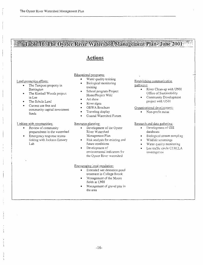
The watershed management plan, as it represents current activities, is contained in Table 10.
-14-

The Oyster River Watershed Management Plan
Qualities
Quality of the lakes, rivers and streams:.. Water quality'" Natural historJ
Clean drinking water:• Quality of the surface and
groundwater
Threats
Quality of the lakes, rivers and streams:.. Lee traffl'l!: circle-runoff, hazardous
materials, road salt• Agricultural runoff• University parking lot runoff• Illegal dumping'" Development and roadway networks
Other: '\mple water supplv:.. Management of .. Lamprey/Oyster
school and town interbasin transferholdings .. Excessive
.. General lack of withdrawals ofcitizen awareness water
.. General .. Consumptionhomeowner within and exportimpacts-lawn out of therunoff, do-it- watershedyourselfers .. Sustainable water
.. Disincentives to budget for thestewardship watershedbecause of taxlaws
Open space and unfragmented lands:.. Open space and its effect
on quality and quantity ofwater
.. Undeveloped lands
.. Corridors
Recreational access andareas:
.. Recreational trailsfor hiking, birding,skiing, equestrian,snowmobiling andfishing
Ample water s...lli2!2l.L.. Quantity of surface and
groundwater
Historic value:.. Mil1 pond.. Other historical
Clean drinking water:• Gravel pits
• MtBE gas
Recreational access:.. Access and
parking
-15-
Rural character:• Development and
roadway networks• Growth in general
Open space andunfragmented lands:
.. Development androadway networks
The Oyster River Watershed Management Plan
Actions
Land protection efforts:
• The Tamposi property inBarrington
• The Kimball Woods projectin Lee
• The Schulz Land• Current use fess and
community capital investmentfunds
Linking with communities:
• Review of communitypreparedness in the watershed
• Emergency response teamslinking with Jackson EstuaryLab
Educational programs:
• Water quality training• Biological monitoring
training
• School program-ProjectHomelProject Wild
• Art show• River signs• ORWA Brochure• Traveling display• Coastal Watershed Forum
Resource planning:
• Development of the OysterRiver WatershedManagement Plan
• Risk analysis for existing andfuture conditions
• Development ofenvironmental indicators forthe Oyster River watershed
Encouraging local regulation:
• Extended wet detention pondtreatment in College Brook
• Management of the Moorefields at UNH
• Management of gravel pits inthe area
-16-
Establishing communicationpathwavs:.
• River Clean-up with UNHOffice of Sustainability
• Community Developmentproject with UNH
Organizational development:
• Non-profit status
Research and data gathering:
• Development of GISdatabases
• Biological stream sampling• Wildlife screenings• Water quality monitoring• Lee traffic circle CERCLA
investigation

The Oyster River Watershed Management Plan
B. The watershed plan comes to life; A description of activities to date
Below is a list of activities that have been completed or are currently underway.
• ~rganizational development• Educational programs• Land protection efforts• Research and data gatheringIt Resource planningIt Linking with communities
• Encouraging local regulation
Organizational development
Non-profit status
The Association has been working to obtain non-profit status within the State of New
Hampshire. The Articles of Agreement of A New Hampshire Nonprofit Corporation have been
drafted by a working group and submitted to the Association for review. The organizational
bylaws have been drafted by the working group. A final copy of the bylaws was signed by
members of the Association in April 2001, and submitted to the state.
Educational programs
Water quality monitoring training
Training for water quality monitoring was held on May 24,2001 with the help of the New
Hampshire Department of Environmental Services Volunteer River Assessment Program.
Funding for the monitoring has been provided in part through the New Hampshire Department of
Environmental Services Source Water Assessment Program. Some of the volunteers (15) are new
members of the watershed association and offered their time after they were contacted during the
community assessment of qualities and concerns as part of the development of the Oyster River
Watershed Management Plan.
-17-

The Oyster River Watershed Management Plan
Biological monitoring training
A workshop on biological stream screening techniques was held in July 2000 with the help of
Rob Brown, a high school biology teacher from the Wheeler School in Providence, Rhode Island.
The session was attended by ten people, where they learned about sampling procedures for
aquatic macroinvertebrates in combination with water quality parameters (dissolved oxygen) to
detennine aquatic health.
Project Home/Project Wild
The New Hampshire Department of Fish and Game is working with students at the Oyster River
Middle School to increase environmental awareness through the creation of wildlife habitat
around the school. Two fifth grade classes are studying the watershed and doing some water
testing with the salmon-raising project.
Art show
An art show that could serve as a community awareness and educational tool has been discussed.
A desired location is the Mill Pond Center in conjunction with the Durham Art Association.
River signs
An effort has been made to design and install river signs on highly traveled roadways in the
watershed. Some desired locations for river signs include state roadways (Routes 155, 125,4,
155A, and 108). Currently the state is looking into the issue of "sign pollution" and has restricted
the placement of signs along these roadways. It is hoped that this could become an Eagle Scout
project.
ORWA Brochure
A brochure was developed for use as a handout at public gatherings. The brochure contains
information about the Watershed Association, what it hopes to achieve, and how citizens can be
involved in long-term protection. Contact names and a listing of other watershed efforts are
provided.
-18-

The Oyster River Watershed Management Plan
Traveling display
The traveling display was created so that various members could bring information to local
events and other locations within the watershed. Many pictures in the display were taken during
the wildlife assessments. The traveling display has been used at Madbury Day (June 10,2000,
and June 9, 2001), Lee Country Days Celebration (June 17, 2000), Lee Fair (September 9,2000),
Durham Day (September 17, 2000), UNH Employee Benefit Fair (October 19, 2000), the DES
Watershed Conference (November 18, 2000), the Coastal Watershed Forum (February 8, 2001),
the annual meeting of the Strafford County District (April 5, 2001), the Strafford County
Cooperative Extension Farmers Meeting, and Earth Day at the University of New Hampshire
(April 22, 2000). The display was used at local libraries as a display in Lee (August
September),the Durham Public Library (October), and the Oyster River Middle School Library
(January-February). The display was used for the public meetings held in Banington (March 17,
2001) and Durham (March 19,2001). Town meetings in Madbury and Lee provided
opportunities for the display to be put up. The ORWA teamed up with the Office of
Sustainability to have the display at the UNH Ben Thompson Work Day on April 26,2001.
Coastal Watershed Forum
The Coastal Watershed Forum was attended on February 8, 2000. The Oyster River Watershed
Project was one of the only protection efforts represented at this meeting, as compared to other
watershed projects that were concerned with restoration.
Working with neighboring watershed associations
The Moose Mountain Watershed Association and the town of North Barnstead (Upper Suncook
region) have been in contact with the Oyster River Watershed Association to find out more about
forming an association and ways to get things moving. Both organizations will be invited to
attend future meetings.
-19-

The Oyster River Watershed Management Plan
Land Protection Efforts
The Tamposi property
The first meeting for the Tamposi property was held on October 26, 2000. The land is
approximately 1350 acres and one of the largest unfragmented forests in the area, and the site of
three Atlantic White Cedar swamps which are endangered. The land forms the headwaters for the
Oyster River and a tributary of the Bellamy River, both of which are public water supplies. The
land is being considered for purchase under the States Water Supply Protection Program. All
communities (Barrington, Dover, Durham, Lee, Madbury, and UNH) agreed to give $6,000
towards costs associated with acquisition. The state is providing $700,000 towards acquisition
while the remainder is being taken as a charitable contribution from the property owner. Work
contin\les on activities such as the land appraisal and boundary survey.
The Kimball Woods project
The Town of Lee worked with the Friends of Kimball Woods to purchase the land, which is 75
acres in size. It was placed on town warrant for the Lee Town meeting in March and passed with
the approval to spend $225,000 as a fee simple purchase. Neighboring landowners (Joe Ford, "70
acres, Don Qu"igley, 40 acres, Fred Short, 10 acres, Tom Lee, 10 acres, and John McLean 4 acres)
have volunteered to donate easements adjacent to Kimball Woods, which would allow for the
preservation of over 200 acres of land in Lee.
The Schulz Land
Steven Schulz has given a 93-acre conservation easement to the Town of Lee. The Town of Lee
accepted this easement in March.
Current use fees and community capital investment funds
The City of Dover approved in November of 1999 that all current use fees be set aside for
conservation, including land and easement acquisition. The Town of Lee has been setting aside
and using funds to buy easements and land for conservation. They have a committee that actively
seeks out and evaluates potential acquisitions. The Town of Madbury is also active in looking
for lands to purchase for conservation.
-20-

The Oyster River Watershed Management Plan
Research and data gathering
Development of Geographic Information Systems (GIS) spatial databases
A series of GIS maps have been developed from existing databases and available information for
use by the Watershed Association with the help of the Strafford Regional Planning Commission
through its GIS Services.
Infolmation that was important to
have on the maps included
hydrography, wetlands, land
use, soil information,
aquifer location and
transmissivity, flood zones,
community zoning and tax map
parcels, topography, roadways, unfragmented lands, historical and natural heritage features, and
co-occurrence of farmlands, wetlands and aquifers. To date, the maps which the Association has
gathered or developed include (1) Conservation lands, (2) Land use and zoning, (3) Wetlands and
floodplains, (4) Ground Water Resources and Hazards, (5) Farmland Soils, (6) Unfragmented
lands, (7) Co-occurring Critical Features, (8) Municipal Sourcewater Protection Areas and (9)
Municipal Source and Service Areas (See Figures 2-8, Figures 12-13). The maps have provided a
focal point for many discus:,\ions within the Association and at public gatherings. As an
assessment tool, the maps have been used to identify high priority areas for water quality, and
biological and wildlife assessment sites throughout the watershed. As a planning tool, the maps
have been used to support the development of a watershed risk assessment and environmental
indicators. As an educational tool, the maps have been used to direct mailings to citizens within
the watershed. The critical base maps that have been developed by the Association will be of use
for future natural resource management purposes as well. For example, planning and
management decisions which relate to erosion, water quality, hydrologic modifications, upland
habitat, aquatic habitat, channel networks and community resources can all be supported through
the use of these GIS maps.
-21-
The Oyster River Watershed Management Plan
Biological stream sampling
Biological stream sampling was conducted at several sites throughout the watershed. The
biological stream sampling helped the Association detennine the overall status of the watershed
and to identify potential areas for restoration. Based upon the biological sampling, the watershed
was detennined to be in good condition, and that the emphasis should be on protecting the
quality of the resources. (See Figure 10).
Wildlife screenings
Wildlife screenings were conducted beginning in July 2000. The wildlife screenings suggested
that a diverse wildlife population existed in the watershed that was consistent with the forest type
and location. Prominent wildlife signs that were observed or direct observations that were made
indicated that the area was inhabited by beaver, river otter, deer, fox, herons and connorants.
(See Figure 10).
Water quality monitoring
The water quality sampling in selected areas of the water supply watershed will yield infonnation
on the long tenns trends of the quality of the water. Testing is being conducted in the headwaters
to the water treatment plant as well as other areas throughout the watershed. (See Figure 11).
Lee traffic circle CERCLA site investigation
The Association will be inviting a representative from the New Hampshire Department of
Environmental Services (Susan Willoughby) to speak about the contamination problems
associated with MtBE at the Lee traffic circle.
Resource planning
Development of the Oyster River Watershed Management Plan
The Watershed Association began the development of a watershed plan in August 2000 with
funds from the New Hampshire Estuary Program. The effort focuses on finding common ground
with communities, the University and different agencies including the Great Bay Estuaries
-22-
The Oyster River Watershed Management Plan
project. An emphasis has been placed on integrating the plan with municipal Master Planning
Process. A large part of the project has been to develop organizational structure and set up
communication pathways. Establishing community liaisons to bring forth the concems of the
watershed association will be important. Focused interviews along with surveys of riverfront
property owners and ORWA members were used to identify priorities related to qualities,
concerns and actions for the Watershed Association. A workgroup was formed to develop the
framework for the management pIal'!. Public meetings were held in Barrington and Durham
(March 17th and 1~' 2001) to gather public input into the plan.
Risk analysis for existing and future conditions
The concept of using a risk assessment that identified existing and future sources of risk
throughout the landscape has been discussed. It was apparent that as the communities
changed over time through changes in land use, the type and degree of risk would change as well.
More importantly than the changes in the risk itself would be the capabilities of the individual
communities in addressing the risks. Any risk assessment will need to include a mechanism for
change. The risk assessment can serve as a central core from which a watershed management
plan can evolve and act as a catalyst for change within the communities and the Association. For
these communities, this means that the results of the risk assessment need to be tied directly into
their master planning process and land use regulations. It will be through this mechanism that the
watershed management plan can become a living, working document.
Development of environmental indicators for the Oyster River Watershed
Whether to use a risk assessment to direct short and long term management of this watershed
brought up a discussion of environmental indicators for the watershed. There was a clear desire
on the part of the workgroup members to pursue the use of indicators that reflect the changes in
-23-

The Oyster River Watershed Management Plan
the quality and quantity of the drinking water over time. The indicators could be based upon the
risk factors that would be used as part of the risk assessment. A series of preliminary risk factors
were identified by the workgroup. The risk factors were used to help initiate a discussion of
preliminary environmental indicators that could be used by the Association and the communities.
Linking with communities
Review of community preparedness
An interview with the Fire Chief in the Town of Lee has indicated that the Town itself is not as
prepared as it would like to be to respond to an emergency situation, or to respond to catastrophic
events. There was a suggestion that an effort be made to have discussions with neighboring
communities regarding the possibility of creating a regional response team. It was felt that site
specific events were a concern, but the catastrophic events could be more of a concern over time.
Catastrophic events would include response to fires and floods.
Establishing communication pathways
River Clean-up with the Office of Sustainability
A river clean-up was held in conjunction with the University of New Hampshire Office of
Sustainability Programs and the New Hampshire Coastal Program in September 2000 as part of
the International Coastal Clean-up Day.
Community Development project with UNH
Students from the University of New Hampshire developed a project to link the university
community with the watershed. The project will include the construction of a permanent sign at
the Water Treatment Plant, which will have space for current events and exhibits.
-24-

The Oyster River Watershed Management Plan
Encouraging local regulation
Extended wet detention pond treatment in College Brook
The University of New Hampshire has obtained approval for the construction of an extended wet
detention pond to treat runoff prior to entry into College Brook. Funds for the construction of the
project are directly from the University.
Management of the Moore fields at UNH
The University of New Hampshire is currently having discussions with a local business to
develop the Moore Fields into a soccer complex that would include a stadium, bleachers, two
Astroturf fields and nine grass playing fields. Drainage plans are being carefully designed to
prevent nonpoint source pollution into the river.
Management of gravel pits in the area
Important gravel pits have been identified on Snell Road, Mill Road and Old Concord Road. The
management of gravel pits is closely tied with community tax incentives for management of
lands. This issue will be looked into through the Department of Revenue. In addition to the
taxation issue is the long-term management of these areas. As part of the Source Water
Protection Plan for the Water Treatment Plant, inspections of the area around the Durham well
will be conducted. This area includes six (6) gravel pits. Regular inspections should help to
prevent contamination of the aquifer.
-25-

IV. Growth of the Oyster River Watershed fl1anagement Plan:
A Process for Change
A cormorant rests on the Wiswall Dam

The Oyster River Watershed Management Plan
IV. Growth of the Oyster River Watershed Management Plan:
A Process for Change
The purpose of the community sessions was to clarify where commonalties and differences were
within the watershed. For the Oyster River Watershed Association (ORWA), the community
sessions presented a challenge along with a tremendous opportunity. The ch.illenge was that the
organization itself was little more than one year old. Although projects such as the display board
had been underway to let local people know about the Association, it was difficult to determine
how many people knew about their efforts and would be willing to become involved in this
process. The Association wanted to ensure that they were developing a plan that would reflect
community desires. In light of this challenge, the community sessions were viewe~ as an
opportunity to engage a broader audience in the overall efforts while gaining insights into
common desires and differences. The entire process was viewed as a time to grow as well as to
refine, and perhaps a time to consider change as well as to further embrace fundamental beliefs .•
To move forward, the ORWA decided to use an approach that allowed them to evaluate and
refine their own identity, while casting a broad net outward to more fully understand what a
greater community identity might be. The approach utilized a core group working in tandem with
public meetings. For both the core group and the public meetings, the desired outcome was to
understand perceived qualities within the watershed, to identify their concerns, and to identify
actions that could be taken, primarily by the Association. The watershed workgroup consisted of
two representatives from each of the five communities, along with representatives from the
Association and the University of New Hampshire. The workgroup met a total of three times
prior to the public meetings. Two public meetings were held in the watershed, one in Barrington
and one in Durham. Barrington and Durham were both considered critical communities to the
efficacy of the management plan, but for different reasons. Barrington was in the process of
spearheading an ambitious inter-community effort to purchase a large tract of land (the Tamposi
property) in the headwaters of the Oyster River. The Bellamy River watershed is immediately
adjacent to the Oyster River watershed. The inter-community dynamics that did effectuate the
purchase of the Tamposi property would be the same dynamics necessary for a viable watershed
management plan. Durham was selected because of the diverse community groups in the town.
The community groups were all very active individually. It was perceived that it was important to
-26-

The Oyster River Watershed Management Plan
welcome and utilize this diversity to fully understand the broad perspectives of the entire
watershed community.
A. Understanding Community Values and Concerns to Develop Future Action for the
Watershed
The 'Watershed Workgroup
The watershed workgroup decided to use information gathered from a previous survey of
Association members and riverfront property owners to open their discussion of qualities,
concerns and actions. The results of the survey regarding uses showed that wildlife habitat was
ranked the most important followed closely by the quality of the lakes, rivers and streams. Open
space and unfragmented lands were ranked the third most important quality. When survey
participants responded to the perception of diminishing quality or threat, the quality of lakes,
rivers and streams was ranked first, followed by open space and unfragmented lands, and thirdly
by a reduction in the quality of drinking water.
The workgroup wanted to explore more fully the concept of water and what it meant to the
greater community in the watershed. It was clear from their discussion that the fundamental issue
was the watershed itself as a water-bearing unit that provided the drinking water for the area.
They felt that the plan should be about drinking water as a unifying theme, as the stated concern
for the group and as the highest priority for the watershed management plan. With drinking water
as the focus for this plan, it was quickly recognized that both the quality and quantity of this
resource needed to be
addressed. The importance of
water for human
consumption did not,
however, negate the importance of other qualities in the watershed. It was felt that these other
qualities, such as open space and unfragmented lands, could be viewed in relation and attendant
to maintaining the quality of the drinking water.
-27-

The Oyster River Watershed Management Plan
With these thoughts in mind, the workgroup began to question the status of the drinking water in
the watershed. The watershed was considered by many to be at high risk in regards to quality and
quantity, but not necessarily in a state of crisis. However, it was very clear that the window of
opportunity to put long-term protection measures into place might have already passed. As such,
aggressive, proactive management needed to be considered along with a diminution of future risk
to the water supply.
The Public Meetings
The public meetings were conducted in a manner that facilitated open discussion and reporting
while allowing for integration of everyone's opinion. A Master of Ceremonies who was from the
Oyster River Watershed Association conducted the entire meeting. This person introduced the
organization and was responsible for collecting and recording the information as the meeting
proceeded. Working tables of 8-10 people were established, with a single facilitator at each table.
Each facilitator was a member of the Watershed Association or a representative from a
community on the workgroup. Each table was given a period of time to discuss an issue,
beginning with
Qualities, followed
by Concerns and then
by Actions. At the
end of the time
period, all of the tables reported back to the Master of Ceremonies, and a master list was
compiled. An important dynamic for the public meetings were the small working tables and the
use of community or watershed representatives as facilitators. The facilitators were not just
familiar with the issues, they were living with the issues. There was no need for interpretation of
the intent and desire of the community. There was no need to do any more searching for answers
to community concerns, or to understand what needed to be done. It was all said as it was being
lived.
A great recommendation from the public meetings came at the end of the meeting in Durham. An
elderly gentleman raised his hand, and asked if he could speak to the group in general, to offer
-28-
The Oyster River Watershed Management Plan
some advice to the group as a whole. His advice was true and real, expressing the wisdom that
comes with time, "After going through this process, you will find there are priorities. When you
come to know them, stay with them. Then, go out and do what you do best as an organization.
Keep this in mind and you will be successful." Knowing the organization, knowing the priorities
and taking actions.
B. Summary of qualities, threats and concerns and recommended actions
The process of examining the perceptions held by the Association, the workgroup and the
watershed community revealed that the commonalties were many and the differences few. In
fact, many qualities, concerns and actions were repeated. These qualities, concerns and actions
have been summarized for the entire community (Tables 11-13). Although these lists provide
insight into the current status of the watershed, they do not begin to tell the real story of the
dynamics within this watershed. The real story is how the watershed has shaped the communities
and the people that live within it. The watershed and its communities are very diverse, all
interacting with the watershed and its resources in different ways. Sometimes these interactions
are very individual and offer unique community perspectives. It could be a special place within
the landscape favored by community locals. It could be the unique community heritage that
emerges from a diversity of land uses as historical industrial areas blend with outlying farmlands.
Sometimes these interactions are encompassing and offer insights into the shared community
desires. The enjoyment of broad landscapes and gently rolling hills. And so it is with the Oyster
River watershed, a mixture of individual and community responses to the natural system that
supports and surrounds them. What emerged from this process as priorities were those aspects of
the watershed that offered interaction to the community as a whole.
-29-

The Oyster River Watershed Management Plan
Quality of the lakes, rivers and streams:
• Water quality• Natural history• Tidal Alarshes• Non-tidal marshes
• Soil quality• Wetlands
Ample water supply:
• Quality of the surface anil.groundwater
• Aquifers
Clean drinking water:
• Quality of the surface andground water
Wildlife habitat:
• Biodiversity and wildlife• Flora and fauna• Wildlife habitat
Open space and unfragmentedlands:
• Effect of open space onthe quality and quantityof water in the system
• Corridors• Unfragmented lands
Rural character:
• Solitude• Rural character• Variety of land uses
creating a mosaic
Other:
• Area for education andresearch
• Watershed as unifyingbody for communities
• Inter-municipalcommunication
• Role in Great Bayecosystem
-30-
Recre~ional access and areas:• Recreational trails for
hiking, biking, birding,skiing, equestrian andfishing
• Public access and therole ofUNH
Historic value:
• Historical uses forbrickyards, mills anddams
• Historical agriculturallands
• Other historical features
Fisheries:
• Fish stocks for fishing andfood for wildlife
• Fish habitat• Wildlife habitat
Scenic values:
• Scenic vistas

The Oyster River Watershed Management Plan
Quality of the lakes, rivers andstreams:
• University parking lot runoff• Lee traffic circle-parking lot
runoff, hazardous materials,road salt
• Illegal dumping• Development and expansion
of roadways
• Upstream impacts anddownstream uses
• Agricultural runoff• Effect of development and
siltation to Beards Creek andMill pond
• Enforcement of existingregulations
• Development or refinement ofregulations to meet localdesires
• Designation of primewetlands
• Disposal of biosolids andsolid waste
• Lack of floodolain
Open space and unfragmented lands:
• Growth in generaldevelopment and expansion
Fisheries:
• Restoration of shellfish toestuary
Ample water supply:
• Lamprey/Oyster inter-basintransfer
• Excessive withdrawals of water• Consumption within and export
out of the watershed
• Sustainable water budget for thewatershed
• Effect of imperviousness onrecharge
• Growth of UNH campus
Historic value:
• Preservation of dams, primeagricultural soils andagricultural lands
• Community heritage asagricultural use
Other:
• Management of public lands bythe school district and towns
• General homeowners impact;lawn runoff, do-it-yourselfers,etc.
• General lack of citizenunderstanding of how to use theriver and its resourcessustainably
• Understanding what it means to"Keep it Clean"
• Disincentives in stewardshipbecause of local taxing policies
-31-
Clean drinking water:
• Gravel pits• Madbury Metals-migration
into aquifer
• Lee traffic circle-MillE• Identification of aquifer
boundary in Durham
• Aquifer contamination• Private well identification
Recreational access and areas:
• Access and parking• Meet local needs first
Rural character:
• Growth in generaldevelopment and expansionof roadways
• Traffic corridordevelopment
Wildlife habitat:
• Loss of native species andthreats of exotic invasi vesin both aquatic andterrestrial habitats

The Oyster River Watershed Management Plan
Educational program:
• Community educatioon• River cle..n-up• Oyster River awareness
for school children
• Create a physical modelof the Oyster River andwatershed
• Working with the UNHOffice of SustainabilityPrograms
Linking with communities:
• Regional approach forwatershed managementneeds
• Meeting the needs of theseacoast
J:stablishing communication pathwavs:
• Web site and informationclearing house
• State supported recreationalopportunities
• Fish and game access• Communicate with other
organizations
Land protection efforts:
• Easements anddevelopment rights
• Look at communitytaxing structure toencourage stewardship
• Protection in general
• Greenways• Wildlife corridors• Critical habitat protection• Land preservation
Encouraging local regulation:
• Management of gravel pits inthe area
• Consistent shorelandprotection
• Consistent implementation ofzoning regulations
• Biodiversity policy for thewatershed
• Local enforcement• Roadside vegetation control• Alternative patterns for
development
• Model legislation• Improved zoning ordinances• Private well log requirements• Water conservation all the
time
• Management of fresh waterimpoundments
• State and other agencies moreinvolved
-32-
Resource planning:
• Watershed risk assessment• Development of
environmental indicators
• Develop management plan• Prime wetlands designation• Delineation of the aquifer
Environmental advocacv:
• Evoking feelings aboutspecial places
Research and data gathering:
• Inventory of riverfrontowners
• Inventory of wetlands• Inventory of all natural
resources along the river
• Comprehensive monitoringprogram
• Identify point and nonpointsources of pollution
• Identify river crossings• Delineate aquifer boundary
better

The Oyster River Watershed Management Plan
C. Linking with neighboring watershed efforts-A comparison with the Coastal Program,
Great Bay, Exeter River, and the River
Each watershed will possess unique qualities that the community will want to protect or enhance.
The watershed will also possess qualities that it may share, through landscape linkages, with
neighboring watersheds. These shared qualities can sometimes serve as broad, overarching goals
that are often recognized as part of large basin plans. In reviewing the plans for neighboring
watersheds ( the Exeter River and the Lamprey River) it was found that there were shared
qualities that could be managed through complimentary efforts. The qualities for the Exeter
River included the protection of water quality and quantity through an identification of point and
nonpoint sources of pollution by establishing local land use controls, the protection of wildlife
habitat through the protection of riparian zones, and a desire to educate the citizenry through the
use of best management practices (BMP's) and land protection. In the Lamprey River, shared
qualities included protection of water quality through the management of nonpoint sources of
pollution, managing water quantity through water conservation efforts, and to sustain the river's
integrity through land protection (shoreland, floodplain and wetland protection) and sensitive
development.
The qualities and priority actions that were identified in the Oyster River watershed which are
also recognized as part of the Great Bay Management Plan include the protection of shorelines
through land protection and the preservation of community identity and rural character through
open space management and protection. The Coastal Program efforts are focused on protecting
water quality through nonpoint source management, land use management and education, and
conservation easements.
-33-

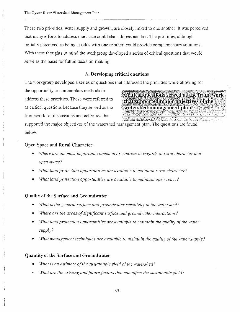
v. Developing priorities for the Oyster River Watershed Association
The reservoir from the water treatment plant
The Oyster River Watershed Management Plan
v. Developing priorities for the Oyster River Watershed Association
Although the workgroup had previously discussed what the priorities for the management plan
could be, it was important now to take the recommendations gathered from the community
sessions and weave together a management plan that reflected community consensus while
targeting priority issues. The workgroup looked to the topic that seemed to dominate most
discussions at the community sessions; the quality and quantity of the drinking water. This
priority appears to have evolved because of the inter-community and inter-basin transfer of water
supplies, along with the use of private wells. The Town of Durham and its residents are host to
the University of New Hampshire, a community within itself. The Oyster River provides the
public water supply for the University and a portion of Durham. The demand for water to sustain
the combined population is significant enough, especially during low flow conditions, to
necessitate inter-basin transfers from the neighboring Lamprey watershed. The Town of Durham
also has additional supply from a groundwater well that is located in the Town of Lee. Water
bans have been used in the past in Durham during drought conditions. The City of Portsmouth,
which lies outside of the watershed, partially provides for its residents through three groundwater
wells located within the watershed in the Town of Madbury. A majority of the residents in the
watershed who live in outlying rural areas such as Barrington, Madbury and Lee are on private
wells.
The other priority which garnered as much attention and discussion as water supply was the
impact of growth upon the watershed. The discussions that were held concerning growth
identified issues that were much larger than the need for more roads and housing. Discussions
revolved around the impact of growth upon the landscape as a whole, how growth would change
the feel of the watershed; altering the rolling terrain, blocking scenic views, destroying
woodlands, forever changing the expansiveness provided by open agricultural fields along the
roadways, fragmenting the community heritage. The watershed and its landscape reflect
generations of people who lived an agricultural life. This heritage, as expressed through the
landscape, is threatened by growth.
-34-
The Oyster River Watershed Management Plan
These two priorities, water supply and growth, are closely linked to one another. It was percei ved
that many efforts to address one issue could also address another. The priorities, although
initially perceived as being at odds with one another, could provide complementary solutions.
With these thoughts in mind the workgroup developed a series of critical questions that would
serve as the basis for future decision-making.
A. Developing critical questions
The workgroup developed a series of questions that addressed the priorities while allowing for
the opportunity to contemplate methods to
address these priorities. These were referred to
as critical questions because they served as the
framework for discussions and activities that
supported the major objectives of the watershed management plan. The questions are found
below.
Open Space and Rural Character
• 'Where are the most important community resources in regards to rural character and
open space?
• What land protection opportunities are available to maintain rural character?
• What land protection opportunities are available to maintain open space?
Quality of the Surface and Groundwater
• What is the general surface and groundwater sensitivity in the watershed?
• Where are the areas of significant surface and groundwater interactions?
• What land protection opportunities are available to maintain the quality of the water
supply?
• What management techniques are available to maintain the quality of the water supply?
Quantity of the Surface and Groundwater
• What is an estimate of the sustainable yield of the watershed?
• What are the existing andfuturefactors that can affect the sustainable yield?
-35-

The Oyster River Watershed Management Plan
• What management techniques are available to maintain the quantity of the water supply?
• What management techniques, such as water conservation, are available to support wise
use ofavailable water supplies?
B. Utilizing a Relative Risk Assessment as a Planning Tool
To answer several of the critical questions, a risk mfalysis was considered to identify and rank
risk factors that contribute to the degradation of the qualit)" and quantity of the water supply in
the Oyster River watershed. These risk
factors can be overlain onto areas that
contribute to maintaining a clean and
ample water supply. Within these areas,
various watershed management practices
can be implemented. A GIS map was
developed to aid in the discussion of the
existing and future risks to identified water supply resources in the watershed (Figure 12,
described in detail below).
A review of completed risk assessments for the area included the New Hampshire Comparative
Risk Assessment (May 1997) and the New Hampshire Estuaries Project: Identification of Critical
Lands Threatened by Development.
The New Hampshire Comparati ve Risk Assessment identified specific risk categories for a
number of concerns (ecological integrity, public health, and the economy) and allowed the
development of weighting factors for each risk factor. Each concern was then summed up
individually, and then all three concerns were combined to yield a comparative risk
assessment for all risk factors.
New Hampshire Estuaries Project was conducted to evaluate relative risk from one specific
risk factor, that being increased development. To identify critical areas, developable land
(available lands - marginal lands) were identified and then overlain with critical natural
resource characteristics (water quality buffers, wildlife habitat, locally important lands,
drinking water resources, and unfragmented lands).
-36-

The Oyster River Watershed Management Plan
In looking at these two projects, it becomes apparent that areas the Estuaries Project generalized
as threatened by future development were identified by the Comparative Risk Project as
individual risk factors: The Estuaries Project did not try to rank any of the critical natural
resource values.
(II degradation of surface water habitat;(II' loss of land habitat from development;(II physical alteration of aquatic and shoreland habitat;(II loss of aquatic habitat;(II degradation of forest habitat by fragmentation;(II petroleum in groundwater;(II hazardous wastes in groundwater;(II nitrates in groundwater;(II petroleum in surface water;• soil damage from erosion;(II other metals in surface water;
• road salt impact on land use;(II road salt impact on groundwater;• Polycyclic aromatic compounds (PAR's) in surface water.
The Oyster River risk assessment project could be somewhat of a hybrid between each of these
approaches, in that water supply (quality and quantity) has already been identified as the priority
issue, and a relative ranking could be conducted for existing and future risk factors. A GIS format
would be useful, taking advantage of critical data layers already developed by the Association.
These data layers would include hydrography, aquifers, topography, land use, infrastructure and
population. The most important work, remaining to be done, is an agreement on the risk factors
and the development of the ranking system (if desired). A table of risk factors was drafted for
discussion purposes (See Table 14).
The limitation for conducting a risk assessment that would be useful for local communities was
the lack of site-specific information. The data sets that are currently available from the state
addresses regional issues but are not detailed enough to help local municipalities. Site-specific
information is needed to conduct defensible planning and decision-making at this scale. Data
needs include actual location of homes and estimates of residents by home-site in the watershed
-37-

The Oyster River Watershed Management Plan
along with reasonable estimates of consumers by type (residential, commercial, industrial) within
the watershed to determine whether they are on private wells and septic systems, or a municipal
system. Location data are necessary before detailed consumption maps and threatened growth
areas can be identified.
Urban Lands
Protection of water Road runoffquality
Agricultural Lands
Cropland Increase and intensification ofurban land use
Gas stations Pesticide storage
Industrial uses UST's
Accidental spills On-site septic systems
Private homes
Snow dumping
Automotive and repair shops
Junk and salvage operations
Car washes
Landfills, solid waste transferstations
Golf courses
UST's
On site septic systems
Gravel operations
Protection of waterquantity
Direct withdrawal from wells
Excess surface water withdrawals
-38-
Increased withdrawal from wells
Conversion of lands into urbanland uses

The Oyster River Watershed Management Plan
c. Development of a Water Budget for the Oyster River Watershed
The Oyster River Watershed Association is interested in assessing the availability of water within
the watershed to support human consumptive use and at the same time sustain the existing
aquatic ecology. A desire has been expressed to quantify water availability. All water within the
Oyster River watershed is ultimately derived from precipitation. From long-term precipitation
records the average annual input of water to this region is slightly over 40-inches per year. The
Oyster River watershed covers approximately 20,000 acres or roughly 31 square miles. At 42
inches of precipitation per year, the total water input to the watershed is approximately 22.5
billion gallons per year.
In the Oyster River region, more than half of the precipitation is returned to the atmosphere
through combined processes of evaporation and transpiration. The remaining water input to the
watershed is locally estimated to be approximately 18 inches per year (or 9.7 billion gallons per
year over the 31 square mile watershed). This amount would also represent the total discharge of
the watershed to the Great Bay estuary. The United States Geological Survey (USGS) maintains
a gauging station on the Oyster River immediately upstream of the Route 155A bridge in
Durham. Average annual discharge measured at this station between 1994 and 1998 was 5.1
billion gallons. This number is roughly half of the estimated total discharge. However, since the
gauging station is located in the middle of the watershed, these measurements do not reflect the
discharge of the watershed areas downstream of the station. The USGS estimates that discharge
from 12.1 square miles (40%) of the watershed is measured by the gauging station. Based on the
recent gauging data, the rough approximation for total evapo-transpiration losses agrees fairly
well. In local watersheds the total discharge is divided fairly evenly between direct runoff
(overland flow) and water that infiltrates to become part of the groundwater flow system. The
rate of infiltration of precipitation to groundwater is determined primarily by slope and soil
permeability. This rate varies from over 20-inches per year in coarse sandy soils, to almost zero
inches per year through heavy clay soils. Infiltration through loamy soils generally ranges from 6
to 12 inches per year in this region.
~39-
The Oyster River Watershed Management Plan
Groundwater is simply water which is present in the pore spaces of soils or uncon:solidated
surficial deposits, or water which is present within fractures in the bedrock. The quantity of
precipitation that infiltrates to the groundwater system is significant to the ecology of the Oyster
River watershed because it is the slow discharge of groundwater through springs and seeps that
provides streamflow between precipitation events. Hydrologists call this discharge ltaseflow.
Manmade influences can dismpt the baseflow of a natural system. One of the mos(: widely
recognized factors is the effect of impervious surfaces. Increased paving, building roof 3urface
area, and replacement of native forest vegetation with lawns causes precipitation to mn off more
rapidly, thereby decreasing the proportion of water recharged to the groundwater system. Studies
have also shown that when the amount of impervious surface becomes greater than 10 to 20% of
the land area, the surface water quality within nearby streams tends to be degraded.
Large groundwater withdrawals for municipal water supplies or irrigation systems can lower the
local groundwater table below the nearby stream base level and actually induce infiltration from
a stream or river to replace what is removed from the groundwater system. A recently completed
study by hydrology students from UNH indicated that the Town of Durham water supply well in
Lee draws a portion of its flow from induced infiltration from the Oyster River. The City of
Dover takes advantage of enhanced production from the artificial aquifer recharge that occurs at
sand and gravel washing operations adjacent to several of its municipal supply wells. The City
of Dover also operates its own artificial aquifer recharge systems by pumping from the Isinglass
and Bellamy Rivers when the privately-operated gravel washing operations shut down for the
winter. For most of the year, such utilization of water resources by drawing from the interaction
of groundwater and surface water sources is not a problem. However, during seasonally dry
periods, municipal water service demands can place a significant strain on the health of riparian
ecosystems.
-40-
The Oyster River Watershed Management Plan
Water resource planners are very sensitive to meeting the demand for municipal water during
extended periods of drought. The long-term median daily flow rate of the Oyster River at the
USGS gauging station during July, August and September averages 1.7 million gallons per day.
During the early 1990's the average daily demand on the DurhamJUNH water system was slightly
over one million gallons per day, greater than half of the total Oyster River flow. This illustrates
the challenge that the Durham water system faces in terms of meeting demand during dry
periods. Through extensive water conservation programs, Durham has reduced its average daily
water use to less than 800,000 gallons per day. However, the anticipated increase in the demand
of the Durham water system must somehow be accommodated.
Figure 12 depicts the three municipal sourcewater protection areas present within the Oyster
River watershed. The Town of Durham and UNH water system source areas are shown in pink,
Portsmouth is shown in tan, and Dover is shown in green. On this figure, wellhead protection
areas have been delineated by the municipalities and are based primarily on the NHDES Phase I
delineation methodology. Surface water supply protection areas are depicted as those areas
recognized as "conservation lands" surrounding the reservoirs, only some of which have formal
use restrictions. It should be noted that all areas of the watershed upstream of the water system
intakes contribute water to the municipal supply.
• Durham draws water from a wellfield located in Lee and from a reservoir on the Oyster
River. Both source areas are located entirely within the Oyster River watershed. Annual
production of the Durham drinking water system has averaged 346 million gallons from
1990 through 1999, or approximately 3.6 % of the total estimated discharge of the
watershed.
• The City of Portsmouth draws water from a reservoir on the Bellamy River located in
Dover and Madbury, a wellfield located off Freshet Road in Madbury, and also several
wells located in Portsmouth and Greenland. Portsmouth's Freshet Road wellfield is
located within the Oyster River watershed. The annual production of this wellfield in
1998 was 255 million gallons, or approximately 2.6% of the tot?1 estimated discharge of
-4 J-

The Oyster River Watershed Management Plan
the watershed. All of the water collected by Portsmouth's water systems in Madbury and
Dover is exported from the source area watersheds.
• Dover draws water from multiple groundwater source areas, some of which cross into
adjoining towns. Two of Dover's qelineated groundwater source areas lie astride the
boundary between the Oyst~r and Bell8}my River watersheds. Estimating th~ amount of
water that Dover draws from the Oyster River watershed is difficult because the position
of the groundwater flow divide be~ween the Bell~my and Oyster River drainages is poorly
defined, the Portsmouth and Dover source areas overlap in this area, and Dover's
artificial aquifer recharge system (noted above) is located very near the watershed's
~oul'ldary. Between 1995 and 2000, Dover has obtained approximately 37% (an average
of 315 million gallons annually) of its drinking water from aquifers located along this
watershed boundary area.
Figure 13 depicts the source and service areas for the three municipal water systems that impact
the Oyster and Bellamy River watershed regions. From an inspection of this figure, it becomes
readily apparent that the NH seacoast's larger municipalities are dependent of the water resources
of adjoining communities, primarily in the Oyster and Bellamy River watersheds. What is
significant about the draw of the municipal water systems is that they have the potential to export
large quantities of water out of a watershed, thereby potentially lowering stream flow at times of
critical low flow. Figure 13 illustrates the need for ever-increasing inter-municipal cooperation
in managing water resources on a regional and watershed basis.
The municipal water system source and service areas shown in Figure 13 represent only two
components of three-part systems that can affect water resources planning within the Oyster
Ri ver watershed region. A third factor is represented by the Dover and Durham municipal
wastewater collection and treatment systems. Dover's drinking water system draws heavily from
source areas in the Oyster and Bellamy watersheds. Dover's wastewater disposal system
discharges to the tidal portion of the Cocheco River. Durham draws its drinking water from
sources within the upper reaches the Oyster River watershed and discharges to the tidal portion
-42-

The Oyster River Watershed Management Plan
of the river. Such large-scale transfers of water from upper portions of watersheds to
downstream areas, or outside the watershed, can negatively impact the riparian ecosystem,
particularly during low flow periods.
It should be noted that a significant portion of the population within the Oyster River watershed
relies on individual wells and on-site wastewater disposal systems (or septic systems). From a
watershed-water budget perspective, such systems do not significantly alter the availability of
water unless that which is drawn from wells or surface water impoundments is used for large
scale irrigation projects. Water that is drawn for homeowner use generally comes from bedrock
(artesian) wells and is disposed on-site through septic systems into the shallow groundwater
zone. Homes with municipally-provided water and on-site septic systems may actually enhance
baseflow within the watershed, if the municipal source lies outside the watershed. The design
estimate for household water use is generally based on the number of bedrooms in a home. The
NHDES uses a design flow of 150 gallons per day per bedroom for residential dwellings.
There is concern that the detailed information necessary to complete a water budget for the
watershed is not readily available. We have some information, such as square miles of the
watershed, rainfall, and consumption rates, but the demographic information is not precise
enough to address hydrologic dynamics and the resulting questions. There are specific data
needed to be able to discuss this issue more completely. For example, occasionally the Town of
Durham and the University of New Hampshire pump water from the Lamprey River to augment
the municipal water supply. Exact figures on the number of residents that live within the
watershed using private wells are unknown. In addition, complete information on the volumes of
water being discharged, either as wastewater from the treatment plant or through on-site septic
systems, by watershed residents is unavailable.
-43-
The Oyster River Watershed Management Plan
D. Linking a Relative Risk Assessment with Environmental Indicators
The workgroup detennined that the use of environmental indicators to describe the changes in
relative risk to the watershed over time would be useful. The preliminary risk assessment
identified priority risk factors as those that would have the most significant impact on the quality
and quantity of the water supply in the watershed. The environmental indicators developed for
this management plan would be based upon water consumption. In the Oyster River watershed, a
profile of water users revealed that some residents are on private wells, some are served by
municipal water systems, and some water is exported out of the watershed to serve neighboring
communities. Specifically, the Town of Durham receives some of its water from the Lee well
site, the University of New Hampshire withdraws from the Oyster River to service a percentage
of Durham residents and the university population, and Portsmouth withdraws from the Freshet
Road wellfield in Madbury, and Dover draws an undetermined amount of water from the same
aquifer utilized by Portsmouth. The representation of the water consumption, as shown in Figure
13, offers a striking overview of the issues related to consumption and inter-basin transport for
the Oyster Ri ver watershed.
Using data obtained from readily available sources, a preliminary effort was made to describe the
withdrawal scenarios for each community relative to one another. The preliminary estimates
indicate a large increase, in the past five years, in the number of private wells drilled in
Barrington and Lee. This indicator of water consumption demonstrated that the greatest rate of
residential growth is occurring in the rural headwaters of the watershed. From a water-quality
perspective, this type of consumption (through private wells) suggests that the water that is
withdrawn from the site is probably being recharged on-site through private septic systems. This
may indicate that environmental concerns attributed to development (increased roadways, other
impervious area, homeowner actions) may become more important over time in these headwatcr
areas. Thc rate of consumption of watcr through public water supplies has stcadily incrcased
during thc past 10 years. Thc amounts withdrawn by Durham and Portsmouth havc varicd
through thc past 10 years but the net volumes from 1995 onward have been comparablc.
-44-

The Oyster River Watershed Management Plan
The limitations for developing environmental indicators that would be of use for long term
planning at the community level were the lack of site-specific infonnation. The data, which is
currently available from the state addresses regional issues, but are not detailed enough to allow
coordinated municipal planning on a watershed basis. Site-specific information is needed to
conduct defensible planning and decision-making at this scale. Data needs include actual number
of consumers by type (residential, commercial, industrial) within the watershed and whether they
are on private wells or the municipal system. Location data are necessary for each user before
consumption volume estimates within the watershed can be generated and meaningful
consumption indicators for use by the watershed communities developed.
-45-

VI. An Assessment of Tools and Techniques to Achieve Change
A summer day on the Mill Pond

The Oyster River Watershed Management Plan
VI. An Assessment of Tools and Techniques to Achieve Change
Change can bring about the desired action necessary to implement a watershed management plan.
This change sometimes occurs on an individual level or it occurs on a collective community
level. As individuals and communities, when change is seriously contemplated and subsequently
acted upon, a series of factors will be considered, either consciously or unconsciously, relative to
the change. These
factors or decision
criteria are
significant to
developing an
intuitive sense of
whether the change will ultimately be successful. For example, a common decision criteria would
be the availability of tools necessary for change. Another criteria would be the cultural
significance of the area. In watershed management, common decision criteria include community
needs, socioeconomic factors, cultural significance, community support, technical capability,
resource quality, available funding, time frame, watershed size, cost of inaction, and available
information.
As part of the process of developing the watershed management plan, a series of focused
interviews were conducted with representatives from the Oyster River Watershed Association,
the communities of Barrington, Dover, Durham, Lee and Madbury, and representatives from the
University of New Hampshire. The participants represented a broad range of citizens, including
landowners, members of planning boards, zoning boards, conservation commissions, Boards of
Selectmen, Recreation Commissions, local citizenry, and university professors, managers and
staff. The selection process for these participants relied heavily upon recommendations from
their peer group. When there was convergence, that person was approached and asked to
participate in the process. Using this approach, it was felt that the messages conveyed during the
interview, although from an individual, would be as reflective of the greater community as
possible. The responses from the individual participants have been gathered together to create
-46-

The Oyster River Watershed Management Plan
what are called Perceptions. Perceptions can be used to create a deeper understanding of how
individuals and communities will make decisions and advance through the process of change.
These perceptions are offered below to provide insight into this dynamic collective effort to
protect the Oyster River watershed.
A. Perceptions
Barrington
What is the community's philosophical approach towards management ofthe naturalresources in this area, and what is the greatest need?The citizenry wants to slow growth and to stay ahead of urban sprawl to retain its rural character.In Barrington, efforts were made in the 1980's to implement protection measures, but the townwas not ready for this town. Recently, prime wetlands designation has been adopted by the townas it moves towards long term resource management. Barrington is starting to use protectiontechniques such as conservation easements. Inaction of the community over time has putBarrington in a reactive mode while faced with important growth management issues. The townwill probably end up doing more management than protection.
How closely do you perceive that organization you represent (board, citizens group, etc)reflects the intention ofthe greater community (e.g. plan viability vs. community intent).The land use boards are starting to move towards consensus on issues, but they still operate onindividual levels to some degree. An example of the boards beginning to work together is therecent request from the Planning Board to the Board of Selectmen for help on legal/growthmanagement issues. The Conservation Commission is presently moving forward aggressively toconserve natural resources in the town, however there is a general perception that they may betoo aggressive. Appointments to the boards need to be a little stronger to be able to maintain thecommunity character and to reflect overall community intent.
What are the public perceptions of the Oyster River and how this management plan fits in?In Barrington growth may be unknowingly allowed and public will see benefit of the watershedapproach perhaps a little too late. An educational effort needs to be conducted with the PlanningBoard and Board of Selectmen to show them how this effort will benefit Barrington before aserious commitment is made to the project.
What were the catalysts for the formation ofor community interest in the watershedassociation?There is a lot of support for regional management of the natural resources using a watershedmanagement approach.
How would you describe the goals ofthe community in comparison to those ofthe ORWA?In Barrington there are many large landowners that are very receptive the use of conservationeasements and protection efforts. However, there are also people who want development. For
-47-
The Oyster River Watershed Management Plan
example the cluster development regulations are not well used and the recent update of theMaster Plan did not include an update relative to Open Space. Because of this protection may nota high priority. As a result Barrington may remain more reactive than proactive as far asmanagement of its resources.
What do yOIl perceive as (a) beneficial olltcome(s) from this watershed management planningeffort throllgh the watershed association?It will be beneficial to establish an organization to manage the resources within the watershed,with mechanisms for regionalization and management of the services that the natural resourcesprovide. In doing this the community should find a balance in doing environmental protectionwith a realistic view of growth.
How will YOllr commll1lity or organization benefit from being involved in the project?Success will be taking part in the process and looking inward to develop consensus on amanagement plan.
How significantly do yOIl see private property rights affecting the olltcome of this effort?Private property rights used to be more important to the community. Historically there was not agreat deal of community support for the Isinglass River project or the establishment of an aquiferprotection district. However the community is beginning to realize the need for better planningand the concerns over property rights have diminished over time.
What specific mechanisms will be the most effective for watershed management in this area?Planning
-48-
The Oyster River Watershed Management Plan
Dover
What is the community's philosophical approach towards management ofthe naturalresources in this area, and what is the greatest need?Dover's livelihood is based upon economic development and need for wellhead protection.Although the city is pro-growth, there is a citizen movement for more protection of the remainingresources. Currently the town is looking at creative land protection and shoreland protectionapproaches.
How closely do you perceive that organization you represent (board, citizens group, etc)reflects the intention ofthe greater community (e.g. plan viability vs. community intent).Historically, the residents in Dover have handed over the decision making process to localgoverning bodies. There has been a recent change in that the residents see the need to takeresponsibility and become actively involved to ensure that the governing body does reflectcommunity intent. This is best reflected by the relationship between the ConservationCommission and the greater community. There are many issues and lots of battles, but thecommunity is beginning to ask for and get more with the help of the Conservation Commission.The entire process of alignment could take as much as 10-15 years to solidify.
What are the public perceptions ofthe Oyster River and how this management plan fits in?Public does not really "see" the Oyster River because there is only a very small (Johnson Creek)tributary in Dover which discharges into the Oyster River. However, the public is more aware ofissues related to wellhead protection. The management plan could be the beginning of raisingawareness of inter-community issues related to water supply management.
What were the catalysts for the formation of or community interest in the watershedassociation?It is perceived that the efforts of the association., leading by example, could be used to generateindividual and community interest in becoming actively involved in town government. Inaddition, there are currently land acquisition projects going on in and around Dover which couldbe linked together nicely with help of the watershed association
How would you describe the goals ofthe community in comparison to those ofthe ORWA?Land protection and shoreland protection are very important natural resource issues in the townof Dover. Water supply would be an additional issue that needs to be addressed. This seems to bealigned with the general protection ethic of the ORWA.
What do you perceive as (a) beneficial outcome(s) from this watershed management planningeffort through the watershed association?Linking parcels for comprehensive land protection across watershed and community boundaries,with the secondary objective of maintaining the quality of the water supply
-49-
The Oyster River Watershed Management Plan
How will your community or organization benefit from being involved in the project?There are several opportunities. First, this project could provide small projects for citizens to"live" environmental management. The community needs to have small successes to encouragecitizens to "take back" the process of making decisions within their landscape. Second, themanagement plan could be a vehicle to provide for outreach and education that would help tosustain CUlTent land protection efforts.
How significantly do you see private properly rights affecting the outcome ofthis effort?There is a strong desire not to invade private pioperty rights. Dover s.eems to be in a quandarybecause of the desire to ke~p taxes low (limit flew residential) while at the same time startin~ tobe concerned about the placement of commerciallindustrial in sensitive areas. Consensus on acommunity perspective of private Hroperty rights will not be apparent for some time.
What specific mechanisms will be the most Iffictive for watershed management in this area?Linking existing parcels through conservation easements
-50-

The Oyster River Watershed Management Plan
Durham
What is the communities' philosophical approach towards management ofthe naturalresources in this area, and what is the greatest need?Regional management of water supplies through land protection
How closely do you perceive that organization you represent (board, citizens group, etc)reflects the intention ofthe greater community (e.g. plan viability vs. community intent).Durham has many different groups within the community. Presently town is in a state of flux asfar as professional staff, as they have had a large overturn lately. To help focus the communityand provide long term direction, the Master Plan document should prove to be beneficial.
What are the public perceptions ofthe Oyster River and how this management plan fits in?The community is generally aware of the river because it is the water supply for the town. Also asignificant amount of attention is paid to the Mill Pond area and its' specific management needs.The public needs to be more involved in the process of development of the management planitself.
What were the catalysts for the formation ofor community interest in the watershedassociation?The community wants to encourage use of regional approaches to managing the naturalresources. The Oyster River Watershed Association can help with this.
How would you describe the goals ofthe community in comparison to those of the ORWA?The goals of both organizations are very similar. Together we can encourage regional planningand action, while looking at protection of open space for future water supply.
What do you perceive as (a) beneficial outcome(s) from this watershed management planningeffort through the watershed association?The watershed association can serve to gather community support to leverage the actions thatneed to be taken to protect water supply. They can be a place to identify common goals and theplaces where they overlap between the communities.
How will your community or organization benefitfrom being involved in the project?Participation in this collecti ve process will bring together all of the loose ends into onedocument. Plan can be a mechanism for going to Durham to request funds (part of capitalimprovement) to purchase source water lands.How significantly do you see private property rights affecting the outcome ofthis effort?Durham residents are willing to use the tools such as shoreland protection, wetlands protection,and aquifer protection overlay zone to the greatest extent possible. However, there will always bea fine line between what is desired for environmental protection and what the community willbear as far as "taking". In this case, community fathers and mothers need to be sensitive and havefunds available to make outright purchases of land in high priority areas.
-51-

The Oyster River Watershed Management Plan
What specific mechanisms will be the most effective for watershed management in this area?We must use appropriate management techniques, based upon community perception of thedesired uses and the community needs.
-52-
The Oyster River Watershed Management Plan
Lee
What is the communities' philosophical approach towards management ofthe naturalresources in this area, and what is the greatest need?The Town of Lee has been using resource based zoning since the 1960's. Land protection andmaintenance of open space through the use of management tools such as planning, zoning, andconservation easements have been useful in the past.
How closely do you perceive that organization you represent (board, citizens group, etc)reflects the intention ofthe greater community (e.g. plan viability vs. community intent).The town boards in Lee are very closely aligned with community. First time in a while thatdesires of the Selectmen, Planning Board and Zoning Board are so closely aligned with thecommunity sentiment and intentions. Currently the Boards are working towards moving ahead ofwhat state and federal requirements are by making restrictions stronger.
What are the public perceptions ofthe Oyster River and how this management plan fits in?It is not readily apparent how conscious the community of Lee is of the river itself, but it needs tobe protected regardless. There is some degree of name recognition because of the Oyster Riverschool district.
What were the catalysts for the formation ofor community interest in the watershedassociation?Recently there have been changes in the land use, which is viewed as being adverse. The Cox'sstarted doing conservation easements and began to find out about others doing this as well. Thecommunity became interested when the Cox's started the group.
How would you describe the goals ofthe community in comparison to those of the OR WA?The goals for Lee are somewhat different from those of the ORWA. The goals in Lee are notwater quality/environmental based but based upon the desire to maintain the community andcultural heritage of farming. The citizens in Lee want to slow growth because of taxes while thenewer more educated citizens want to have zoning and conservation. Together this equals naturalresource protection in Lee which serves everyone's purpose but for different reasons.
What do you perceive as (a) beneficial outcome(s) from this watershed management planningeffort through the watershed association?A program for the town that has a goal of land protection along with long-term regionalmanagement of the water supply. There are many options still available in Lee for conductingland protection. The town just used capital funds to purchase a selected property in town. Theselectmen are presently considering borrowing money to make more purchases. The Associationis percei ved as an organization that can develop consensus on these issues.
-53-

The Oyster River Watershed Management Plan
How will your community or organization benefit from being involved in the project?There would be short term (land protection and protection of rural character) and long-term(water supply and water quality management) oppOltunities to Lee from this effort. The futuredevelopment of Lee depends upon the Oyster River and aquifers for its future water supply.Because of this, there is a need for a regional approach to consider consumption andmanagement.
H4Jw significantly do you see private property rights affecting the outcome ofthis effort?The preservation of private property rights will be very significant. Initially, the community didnot want zoning (too invasive), but then saw how it could be used to maintain the good and doaway with the bad. Generally the population does not like government intervention but it alsosees how it can be used to protect the river.
What specific mechanisms will be the most effective for watershed management in this area?There will be a need to allow for flexibility in solutions within the landscape of the community.For example, Lee is already having problems with utilization of commercial lands in aquifer zonebecause of impervious restrictions. In the end, we will only use the authority of regulations whenneeded.
-54-

The Oyster River Watershed Management Plan
Madbury
What is the community's philosophical approach towards management ofthe naturalresources in this area, and what is the greatest need?The community of Madbury wants to protection of water resources, by having these resourcesserve as the prime basis for planning
How closely do you perceive that organization you represent (board, citizens group, etc)reflects the intention ofthe greater community (e.g. plan viability vs. community intent).There seems to be a change in the interpretation of conservation between the "old" residents andthe "new" residents. The effect of the gentrification of the area has lead to new perceptions ofwhat conservation is. The two groups may have similar goals, but methods of getting there maynot be the same. This has to be kept in mind as we move forward.
What are the public perceptions ofthe Oyster River and how this management plan fits in?The public is not very aware of the Oyster River itself. There is a need for more outreach to thecommunity at large. The Oyster River has been somewhat overshadowed by the Great Bayprogram. There is a need to bring awareness up into the freshwater portion.
What were the catalysts for the formation ofor community interest in the watershedassociation?There is a need to balance use between communities while maintaining quality of the area.An approach which embraces regional planning is needed to address the broader environmentalmanagement issues.
How would you describe the goals of the community in comparison to those ofthe ORWA?Goals of community and ORWA are very similar. The focus will be to lessen the impacts ofgrowth and to maintain the rural character.
What do you perceive as (a) beneficial outcome(s) from this watershed management planningeffort through the watershed association?Watershed association can be an organization that endorses protection, whatever the issue maybe, anticipating problems rather than dealing with crisis. In this way the management plan canbegin to address issues such as water supply management and carrying capacity regionally.
How will your community or organization benefitfrom being involved in the project?The greatest benefit will be if we can base the Master Plan on a watershed concept utilizingregional cooperation to achieve the goals. For example, if Madbury becomes the keeper of thewater, then consuming communities should somehow compensate Madbury for their protectionefforts.
How significantly do you see private property rights affecting the outcome of this effort?In Madbury, private property rights are an important issue. However, it is also recognized thatmunicipal intervention is necessary to maintain the quality of life.
-55-
The Oyster River Watershed Management Plan
What specifit mechanisms will be the most effective for watershed management in this area?Although there is a need for consistency, getting there will be difficult. Communities in the areaare very individualistic. As such, this should be a flexible management program that canaccommodate dynamic changes over time.
-56-

The Oyster River Watershed Management Plan
UNH
What is the community 's philosophical approach towards management ofthe naturalresources in this area, and what is the greatest need?The university is attempting to manage the university system with concepts of environmentalmanagement. For example, we are using farmland and forestry management practices on thefarms and woodlots. We are also beginning an aggressive water consumption campaign oncampus (student education) along with the construction of a delivery system from Lamprey Riverdirectly into water treatment plant, rather than continually having water loss in old deliverysystem. Recently, there has been a shift to concerns with the water quality. Ten years ago thephilosophy was just to treat the water as best as possible and to provide delivery to the studentsand Durham as a water quantity issue. There has been an increased effort to manage the quantitywater better over time (water consumption and new delivery line from Lamprey). Now there ismore attention being paid to water quality (as related to SOC's and roC's) and prevention. In thefuture, we want to deal with turbidity (silt/clays and algae) violations after storm events. Many ofthe objectives that we have can be met through education.
How closely do you perceive that organization you represent (board, citizens group, etc)reflects the intention ofthe greater community (e.g. plan viability vs. community intent).There is an to lead the university community towards a greater awareness of the resource and anunderstanding of the student populations' relationship with that resource.
What are the public perceptions ofthe Oyster River and how this management plan fits in?The student population is starting to become more aware of the source of the water that it drinksand where its wastewater goes. The watershed management plan can help to express that in adifferent way. Hopefully, they will begin to see the water resource itself being more closely tiedto the watershed and the importance of the watershed management plan over the long term.
What were the catalysts for the formation ofor community interest in the watershedassociation?There is a need to discuss what the shared values can be throughout the watershed. For example,it will be important to integrate the day to day issues at the water treatment plant and all facilitieson the campus.
How would you describe the goals ofthe community in comparison to those ofthe ORWA?Goals are shifting to good water management and appropriate land management for water qualityprotection, but not necessarily at land protection. The goals are very complimentary as a desire toestablish watershed citizenship through education.
What do you perceive as (a) beneficial outcome(s) from this watershed management planningeffort through the watershed association?Mechanisms for communication between all the communities in the watershed will beestablished as a result of this project. This will be important meet the overall objective for
-57-

The Oyster River Watershed Management Plan
protecting and maintaining existing quality. Plan should layout an aggressive policy forachieving this.
How will your community or organization benefit from being involved in the project?For the university, there will be a number of benefits. Initially, there is an interest to initiate somecollaborative efforts with the watershed association. For example, we need help doing long termbase line monitoring of the river coming into the reservoir, and would like to getuniversity/watershed association linhd together to cover the whole year Secondly, it will bebeneficial to have a clear undetstand~ngof tiole values for the watershed and what is prudent tomaintain those' qualities.
How significantly do you see private property rights affecting the outcome ofthis effort?The university will continue to grow, but will also incorporate as many new technologies aspossible that are required.
What specific mechanisms will be the most effective for watershed management ill this area?Implementation of specific management practices to accommodate the changes in land use. Rightnow the university is looking at maximization of the water delivery system and waterconsumption. Other mechanisms (storm water management) need to be discussed. However, auniform prescription should not be imposed, but a shared set of values must be developed tobegin with.
-58-
The Oyster River Watershed Management Plan
ORWA
What is the communities' philosophical approach towards management ofthe naturalresources in this area, and what is the greatest need?The approach should be based on protection, with management following. The river needs to beprotected from overdevelopment and deterioration so we don't destroy what it is that people arecoming here for, for example the rural character.
What are the public perceptions ofthe Oyster River and how this management plan fits in?It will be important to start with the river and then work towards other natural resourcemanagement issues. In general there is not much awareness of the river, although discussion ofthe river does not appear to generate antagonism within the communities.
What were the catalysts for the formation ofor community interest in the watershedassociation?The formation of the organization came about because of the changes that were occuning in thecommunity at large. Existing open space was being depleted, and there was a change in characterof the community. It was apparent that economic development and growth was changing the faceof the landscape. The growth in the area has necessitated an increased need for communityservices, including new schools. There has been growing contention between communitiesbecause of the school issues.
What do you perceive as (a) beneficial outcome(s) from this watershed management planningeffort through the watershed association?The Association can be a place to discuss community issues together acting, as a communicationlinkage between the towns and other organizations. There are many options that the organizationhas for addressing the immediate community needs, such as the need for land protection,especially in Lee, Durham and Madbury. It is the goal of the organization to take on an advisoryrole to remind people of the responsibility for the future through education.
How will your community or organization benefitfrom being involved in the project?The Association needs to develop specific agenda and list of things to do to stay in business andgain notoriety within the area. This is a good time for looking inward into the organization. If wewant to remain viable, we need more people to get involved. However, people only want to getinvolved in projects that are doable, definable and worthwhile to the cause. The managementplan will be an important part of this process.
How significantly do you see private property rights affecting the outcome of this effort?Pri vate property rights will become significant issue. It is important for the municipal ordinancesto reflect the private property owners' desire for conservation in concert with the concerns aboutprivate property. At times, the Association may need to look to other methods besides townordinances to get things done. An example of this may be the need to use public/privatepartnerships.
-59-
The Oyster River Watershed Management Plan
What specific mechanisms will be the most effective for watershed management in this area?We need to identify goals while allowing for a dynamic process while setting goals for theenvironment with recognition of community needs. These goals have to be balanced based uponthe issues and individual community needs. There will have to be a place to accept individualtown solutions as compared to consistency throughout the watershed.
-60-

Barrington 1995 X X XDover 2000 X X X
Durham 2000 X X XLee 1995 X X X
Madbury In progress X X X
The Oyster River Watershed Management Plan
B. A Review of Municipal Ordinances
Municipal ordinances are the most powerful tool that communities have to determine the
direction of their future in regards to natural resource management. Ordinances can be developed
to serve several purposes, ranging from protection of the resources to one that prescribes
management. Ordinances are typically written in a manner that clearly outlines community intent
and sets forth performance standards that meet that intent. An overview of the municipal
ordinances that are already in place in the communities in the Oyster River watershed is
contained in Table 15. It is clear that many protection and management tools are available to
.• J<:-l: :'J''')l~-;:''''; '_~" ,r"~~t; ~I\'\,., '1 ,-,~.l~\- ','!·r;/:;·:'~1;:-'~~lii,'~-:(.Ff:'- 0:~;,-{/rl·~(~-·' ·t:;.'?'~;, V:f~ \¢::"~' ,,:\"~~ b:;~ ~)~::<~,\,;.,:);f~(;:~) ~::;,'_J;' -;.~<'.~;; ;l;;.r'~~;:~:~ ", ,-< .I-l.'.~"", :':C"',::'';: ..:: ':i
, .,.;:,:r"I.""i~.:'~l" ~'£;Ih,'.','.',·;;r,::.,·•.~.::~,!.'"i:,r,..',"··'·'·,..i,'..,•.:"t,..~.••:.'.:'Z.':,,~\~r.i.{,'·,..t·.:.::i.','.,.;.i;,1~:i'.'!"".•, •..., •. eptic!:1{~~~-Erosi6n':]tKSt6ifuwatef~?Aqtiifef::;Wetland'.~~- ~-T,' - _? .....' '; ,:. __ ~__ --. ", ~ .." f.~~';,~.'~, ,~:~~{Wr't\/:ft>l:~-1_il\t:,;,~.-~ji~~·:.f:."i.;;"$M;;iVf)"\/';'\<:7>'¥'.:\i:>\~J.~":';_:'71,~t:;~~ "':'" '//" -:f:.-::,: ',;, '~,," '~7<' -" .:;r.;""L>~. ~:~
':;;(:~~U'own }t,'/:~';Master .. anOohtiolsf~'i,Coi1tibli)!!~1iContr61 ',:.:::PrOiectioilProtecuonX
X XX XX XX X
,;:;:~r~;.:~,::::,~~:.X::;:';?'2'·J:.'/;~_': ',' J,.-<:.:, .1:,: -/.,~l :'~: ..,/;~ :'~_',::"':,'~.~;,~.}L',~:_:~> .,:, ,.~_:." ,,:"~':: .;", . .',;'i,{{~!i'i.~i'" 'Shoreland ;F'i9pen :i:j;.·~Gravel· '. Floodplam .Site' Plan Impact,Town '. Protection' . Space .. Excavation Ordinance Review fees'
Barrington X X X X X XDover X X X X X
Durham X X X XLee X X X X
Madbury X X X
these communities. A closer review of the ordinances provides insight into the intent of the
individual community via the performance standards. A review of the performance standards is
contained in Table 16. For example, there are shoreland protection ordinance in all communities.
However, the performance standard for building setback from the shoreland may vary. Important
considerations in watershed management are how these tools are currently used to address
priorities and whether changes are necessary to meet the priorities. These decisions become very
-61-

The Oyster River Watershed Management Plan
difficult, because they often rely upon community desire as well as appropriate use of the
ordinailce based upon site-specific considerations. In the Oyster River watershed, there is
consistency in the enactment of ordinances but diversity in the performance standards and
application of the ordinances. This is not an unusual situation. This dynamic may presl£nt an
obstacle to achieving the goals and priorities of the watershed management plan. If this is an
obs.tacle, overcoming it may necessitate actions through the Association or the individual
communities. It will be for the Association to determine, in con,ert with the communities, how
to best proceed.
-62-

The Oyster River Watershed Management Plan
Community BarringtonZoning Minimum lot sizerequirements of 80,000 sq. feet,
60,000 free ofHydric A, uplandnot less than35,000 sq. feet
DoverRiverfront residentialwith lot size as 3 timesminimum requirement;wetland acreage limitedto 50% of minimum lotarea: minimum frontageof 100 feet when onsewer, 150 feet when onseptic.
DurhamRural zone: 2.75 acreminimum lot size; <20% lot coverage bybuildings, < 25%poorly drained soils;no very poorlydrained soils allowed,minimum shorelandfrontage of 200 feet.
Lee MadburyResidential; 2 acre Minimum lot sizes fromminimum lot size, 20,000 sq. ft (cluster)64,000 square feet up to 180,000 sq ftmust be developable; (commercial/industrial).25% impervious lot
coverage
ShorelandProtection
75 foot setback for 250 foot setback for 125 foot setback for 100 foot setback for 300 feet from Bellamystructures and structures; eXIsting structures; 150 foot roads, structures, and Reservoir, 150 feet fromother disturbances structures limited to 25% septic setback; septic; limits Little Bay Estuary, 100(driveways). Zone increase in size; no restricts chemical use, vegetation cuts. No feet from mean highwithin 100 feet of mobile homes closer than tilling within 75'; clear cuts. water of Bellamy andmean high water of 100 feet to stream, lake limits vegetation cuts Oyster, 50 feet from allthe Isinglass River. or pond. Limit of cutting within in 150 feet of other brooks; No
50% basal area in 10 river and 75' feet of structures allowedyears, including shrubs. perennial streams. No within setback; natural
clear cuts. vegetation to remain.
River Access Not addressed atthis time
Not addressed at thistime
I per lot; up to 10%lot frontage.
-63-
Not addressed at this Not addressed at thistime time

The Oyster River Watershed Management Plan
CommunityAquiferProtection
Barrington Dover40% impervious cover20% impervious restrictionsrestriction fro in secondary zone; Passiveresidential, 75% use allowed in primary zone;industrial. Contains restriciton of use in
secondary zone (hazardousmaterials, road salts,petroleum products).
Du~am L~
25% impervious cover 10% impervious coverrestrictions; PB and restriction; Low densityCouncil review residential; Certainstormwater plans; All uses prohibitions (road salt,conditional; minimum underground storageroad salt; hydrologic tanks).analysis required forprojects with greater than10 lots; Sewer hook-upsrequired.
Madbury50% impervious coverrestrictions;
Excavation Not addressed at this Excavations have reclamation Requires conditional use Requires site plan review;Revegetation plan requiretime requirements to minimize permit in residential and Allowed ~ly in mllst meet slope standards
erosion. office/research zones; Not commercial zonepermitted in rural zone
ClusterDevelopment
Available for use atthe Planning Boardsdiscretion
Alternative lot layouts may Used on developments Allowed forbe allowed to encourage open greater than 20 acres; 20% developments greaterspace, in open space, residential than 20 acres in size;
and nonresidential; 25% to open space,Provides for greater residential only;density with formula for community watercalculating net acreage: required; No increase inCity Council approves. overall density allowed
-64-
Allowed at discretion ofplanning board: 10 acreminimum; 25% open spacrequirement: Applicationsneed to consider septicrequirements, erosion andsediment control, andstormwater management.

The Oyster River Watershed Management Plan
CommunityFloodplainregulations
BarringtonNo activity in theregulatory floodwaywhich causes andincrease in floodlevels.
DoverNo activity in floodplainwhich causes an increase inflood levels.
DurhamBuilding inspectorreviews applications; noactivity in regulatoryfloodplain which causesan increase in floodlevels; regulatoryflood way mapped toWiswall Dam; 100 -yearfloodplain mapped.
Lee ~adbury
Development in Not addressed at this timeregulatory flood way maynot increase base flooddischarge; flood hazardzone and floodplain aredefined as undevelopablefor lot sizedetermination; 100-yearfloodplain mapped
WetlandsProtection
Protects poorly and Protects poorly and veryvery poorly drained poorly drained soils, andsoils, streams and poorly drained soilwaterbodies. contiguous to surface watersWetlands setback of in 100-yr flood zone;50 feet for structures. Wetland acreage not
included in minimum lotsize; Septic sethack of 75 ft;75 ft setback when changingsurface configuation.
Protects poorly and very Protects poorly, verypoorly drained soils, poorly drained soils,surface waters and rivers. marshed, bogs, and50-75 foot setback for swamps. No structuresstructures; 75 foot septic and no changes insetback; Planning board natural surfacemay grant conditional configuration; Erosionuses, but limited by buffercontrols for activitieszone provisions within 75 ft; 125 ft
leachfield setback; Nostructures within 75 ft;Taxed as open space
-05-
Protects poorly and verypoorly drained soils; 50feet of natural vegetationrequired from edge intoupland; Septic setback of100 feet from wetlandsoils, public water bodiesand permanent streams;

The Oyster River Watershed Management Plan
CommunitySteep sloperestrictions
Barrington DoverIdentified as critical Not addressed at this timearea as slope lengths> 25 feet on slopes>15%; critical areasto be preserved aspart of plan design
Du~am L~
Steep slope identified as Slopes> 15% definedcriteria for conditional as undevelopable forlise decisions; Slopes> lot size conditions25% considered in PUDopen space and lotcalculations.
-66-
MadburyNot addressed at thistime
I·

VII. The Oyster River Watershed Plan-June 2001 and Beyond
Birches along the Oyster River

The Oyster River Watershed Management Plan
VII. The Oyster River Watershed Plan-June 2001 and Beyond
The future plans for action within the Oyster River watershed are contained in Table 17 and
Table 18. The specific actions were developed from a review of the previous management plans
(Tables 9 and 10) and the recommendations from the community sessions (Table 13).The plans
for action have been specifically developed to serve as guides for the Association itself, and for
the communities. The actions may represent a unique project, or they may represent activities,
which when woven together, create a collective project. Over time, the combination of small,
unique and large, collective projects will merge to become the comprehensive watershed
management plan. It is anticipated that as this plan moves forward, opportunities will be taken
when available, and flexibility allowed in the manner in which goals and priorities are achieved.
After all, the purpose of the Oyster River Watershed Management Plan is to create a platform for
conversations regarding the long-term protection and management of the natural resources within
the Oyster River watershed.
Research and data gathering:• Complete inventory of
riverfront property owners• Continue water quality
monitoring program• Conduct cultural history
inventory and identifypriority lands for protection
Linking with communities:
• Develop regional approachfor watershed managementincluding inter-basin transferand long term sustainabilityof water supply
Organizational development• Secure sources of funding
for projects
Educational programs• Expand River clean-up into
freshwater portion• Develop water conservation
program for homeowners• Continue work with UNH
Community Outreach programto develop projects
• Develop a recreational accessand trailways map
• Initiate awareness program toencourage "a sense of place"and cultural heritage in thewatershed
Land protection efforts:• Support of the Tamposi
Property Management Planand Advisory Council
Establishing communication pathways:• Ensure ready availability of data
from state and federal agencies
-67-
Resource planning:• Refine the environmental
indicators• Complete relative risk
assessment• Gather information• necessary for development of a
regional water budget
Encouraging local regulation:• Encourage water conservation
programs in industrial andcommercial areas
• Utilize private well logrequirements
• Encourage alternative patterns ofdevelopment
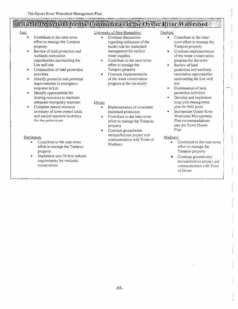
The Oyster River Watershed Management Plan
• Contribute to the inter-towneffort to manage the Tamposiproperty
• Review of land protection andwetlands restorationopportunities surrounding theLee well site
• Continuation of lal!.d protectionactivities
• Identify protocols and potentialimprovements in emergencyresponse in Lee
• Identify opportunities forsharing resources to maintainadequate emergency response
• Complete natural resourceinventory of town owned landsand natural resource inventoryfor the entire town
Barrington:• Contribute to the inter-town
effort to manage the Tamposiproperty
• Implement new SO foot setbackrequirements for wetlandsconservation
University of New Hampshire:
• Continue discussionsregarding utilization of themodel rule for watershedmanagement for surfacewater supplies
• Contribute to the inter-towneffort to manage theTamposi property
• Continue implementationof the water conservationprogram at the university
Dover:
• Implementation of consistentshoreland protection
• Contribute to the inter-towneffort to manage the Tamposiproperty
• Continue groundwaterreclassification project andcommunication with Town ofMadbury
-68-
Durham:
• Contribute to the intertown effort to manage theTamposi property
• Continue implementationof the water conservationprogram for the town
• Review of landprotection and wetlandsrestoration opportunitiessurrounding the Lee wellsite
• Continuation of landprotection acti vities
• Develop and implementlong term managementplan for Mill pond
• Incorporate Oyster RiverWatershed ManagementPlan recommendationsinto the Town MasterPlan
Madburv:• Contribute to the inter-town
effort to manage theTamposi property
• Continue groundwaterreclassification project andcommunication with Townof Dover
The Oyster River Watershed Management Plan
Appendix A
This appendix contains a variety of suggested actions that could be taken by the communities to
effectively manage the natural resources in the Oyster River Watershed. These include "Specific
Recommendations", "Environmental Planning Approaches" and "Environmental Characteristics
Zoning".
Specific Recommendations
Subsurface Wastewater Treatment Systems" Know the location of your septic tank and leaching area. Mark the tank covers with
partially buried bricks" Inspect the tank on an annual basis. If the sludge or surface scum combined are as thick as
1/3 the liquid depth of your tank, have the tank pumped out by a licensed pumper• Do not flush bulky items such as disposable diapers or sanitary pads into the system• Do not flush toxic materials such as paint thinner, pesticides, or chlorine into your system
since they may kill the necessary bacteria in the tank• Repair leaking fixtures promptly and use water reducing fixtures whenever possible• Avoid putting food waste and grease into the system• Keep deep-rooted tress and bushes away from the leach field• Do not allow vehicles, livestock or heavy foot traffic over the leach field• Avoid colored toilet paper, it does not break down in the tank as rapidly as white paper• Many bathroom cleaning products, such as toilet bowl cleaner, contain chlorine. Use
alternatives whenever possible• Municipal officials should consider implementing a locally administered septic system
education and inspection program. Consider adopting a local health ordinance for septicsystem regulation
Road Salting and Snow Dumping• Facilities should be located on flat sites away from surface water and on impervious
surfaces that are easily protected from overland runoff• Sensitive areas, such as public water supplies, lakes and ponds, should be identified and
made known to salt applicators• Know when to plow and reapply salt. Give salt time to work. Time plowing operations to
allow maximum melting by the salt before the snow is plowed off of roadways• For lesser traveled roads, consider applying salt in a 4-8 foot strip along the centerline of
the roadway• Disposed snow should be stored near flowing surface waters, but at least 25 feet from the
high water mark of the surface water. This way the sodium chloride is diluted with riverwater and impacts to groundwater, lakes and wetlands are avoided. Solid materials thatare contained in the snow can be removed in the spring when the snow melts
-69-

The Oyster River Watershed Management Plan
• A silt fence or equivalent barrier should be securely placed between the snow storage andthe high water mark
• The snow storage should be at least 75 feet away from any private water supplies, at least200 feet from an y community water supply wells, and at least 400 feet away from anymunicipal wells
Control of Sand and Gravel Operations• Investigate proposed pit areas as part of planning. RSA 674:2 describes a construction
materials section for a municipal master plan• Allow space for mild pit slopes (no greater than 2: 1, diversions and adjacent owner
protection• Maintain an adequate depth of unexcavated material above the seasonal high water table,
as a filter, for present and future conditions• Assess the impact of the excavation on nearby drinking water wells especially if
groundwater or surface water is to be withdrawn from the pit area• Store petroleum products outside the pit area where possible• Provide an above-ground containment area that can fully contain any spill if petroleum
storage is essential in the pit• Develop a spill prevention plan and provide employee training• Maintain and wash equipment outside the sit area• Control dust as necessary to prevent nuisance and public hazard• Use retention basins to trap fine material, clean as necessary.• Provide buffer strips of natural vegetation between the pit and surface water, wetlands,
public roads, and property lines• Use "anti-tracking" pads at gravel pit access roads.
Urban Runoff ManagementThe state best management practices manual, "Stormwater Management and Erosion andSediment Control Handbook for Urban and Developing Areas in New Hampshire, is acomprehensi ve reference for structural and vegetati ve practices, inc! uding the following:
• Detention Basins• Diversions• Grassed Waterways or outlets• Level Spreader• Outlet Protection• Parking Lot Storage Area• Rock Riprap• Sediment Basin• Silt Fence• Hay Bale Barrier• Temporary Gravel Construction Entrance• Vegetated Filter Strip• Vegetated Swale
-70-

The Oyster River Watershed Management Plan
Management of Chemical and Petroleum Products.. Maintain an up-to-date material inventory and routinely cleanup operations on the site.. Conduct periodic visual inspections for leaks and conditions that would lead to a
discharge, or for conditions that could lead to the direct contact of storm-water with rawmaterials, intermediate materials, waste materials or products
.. Have a spill prevention and response plan that describes spill containment, di version,isolation and cleanup practices and procedures for notifying appropriate authorities
.. Store containers in areas that will contain leaks
.. Manage service stations and auto repair areas to minimize release of hazardous materialsand hazardous waste into the environment
Environmental Planning Approaches
Timing and phasing of development.. Communities can ensure that development takes place in an organized fashion. Phasing
of developments ensures that large tracts of land remain intact until they are ready to beactively developed. In addition, restrictions on construction during certain times of theyear (during rainy seasons) will reduce the potential for erosion problems.
.. Intensity and use incentives
.. Communities can direct types of development into areas within the landscape which aremore suitable to different types of use. High intensity zones can be balanced with openspace and community conservation areas, resulting in a mosaic of uses and intensities.
.. Transfer of development rights
.. Development rights for significant areas can be purchased from land owners to ensurethat these areas remain intact.
.. Planned unit developments
.. Planned unit developments reduce the overall size of a development by using a variety ofdesigns to achieve an overall density, thereby reducing the need for extensive roadwaysand infrastructure within the development. Planned unit developments can incorporateopen space into the original site layout.
Cluster development.. Cluster development offers the developers of land.. Lot Size and Spatial Requirements.. Planning Boards should re-evaluate their lot size and subsurface wastewater treatment
requirements. Lot sizing should be determined based upon soil type to ensure thatdevelopment in the area is reflects site specific carrying capacity.
.. Lot Coverage Standards (e.g. impervious area management)• Efforts should be made by communities to minimize the impact of impervious surfaces
on the surface water quality and the natural recharge of the aquifer. Methods which canbc used to achievc this include:
-71-

The Oyster River Watershed Management Plan
• Post development rates and volumes of run-off should be equal to the pre-developmentrates and volumes for run-off up to the five-year return period. All water from the twoyear storm should be infiltrated
• The use of angled parking and smaller spaces on one-way streets and parking lots41 Reduced parking ratios where possible41 Use vertical parking areas where possible• Use permeable spill-over parldng where appropriate• Modify landscaping of parking lots to use permeable dividers and street-side buffer strips• Use skinny streets to reduce roadway impacts• Use grass swales instead of curbs and gutters• Use one-sided sidewalks or paths• Roof leaders and sump pumps should be recharged onsite rather than being conducted to
the storm drain or sewage system• Leave native vegetation intact between developments and streams. Encourage the
planting of native plant species in landscaping design• When rezoning, use lowest density residential development possible• Develop clearing and grading construction guidelines that minimize site disturbance and
vegetative loss
• Use mulched areas for part of the lawn• Minimize lawn size and increase native landscaped areas
Environmental Characteristics Zoning
'Wetlands ZoningMunicipalities should ensure that the wetland information they are requiring is the most currentand accurate available. Minimum information required should be consistent with that required atthe state and federalleve!. Planning boards should require that local approved projects beconditioned upon approval of state and federal wetland permits. Planning boards should considerhaving requirements for vegetative buffers to protect priority wetlands that would include thefollowing:
• Require buffer limits on all plans. Establish clear vegetative targets and rules for differentzones of the buffer
• Use level spreaders or other techniques to prevent channelized flow through the buffer• Mark buffer boundaries with permanent signs or fences describing allowable uses• Conduct periodic walkthroughs to inspect the condition of the buffer network
Floodplain ZoningPlanning boards should include setbacks and site specific data requirements in floodplainordinances that are similar to those found in wetlands ordinances. Requirements for minimum orno increases in peak flood levels should be considered in floodplain zoning ordinances
-72-

The Oyster River Watershed Management Plan
Watershed ZoningMunicipalities should consider using the watershed zoning to protect the surface andgroundwater supplies in the watershed. Performance standards should be implemented at themunicipal level.
Aquifer ZoningMunicipalities should consider aquifer protection overlay zones where they will act to protectwater quality and quantity. Aquifer zones can be used to further to protection afforded by awellhead protection overlay zone.
Steep slopes ZoningSteep slope restrictions should be considered in areas where erosion and sedimentation pose aserious threat to the surface water resource. In addition, steep slope restrictions can be used toprotect areas which provide scenic values and specialized habitat.
Shoreland ZoningShoreland protection districts should be considered for all ephemeral streams in the towns.Special consideration should be gi ven to the protection of fragile areas such as first and secondorder streams.
-73-

The Oyster River Watershed Management Plan
Suggested References
Best Management Practices for Irrigation in New Hampshire, Department of Agriculture,Markets and Food
Best Management Practices for Land Application of Biosolids, University of New HampshireCooperative Extension, 1997
Best Management Practices for Urban Stormwater Runoff, New Hampshire Department ofEnvironmental Services, 1996
Best Management Practices to Control Nonpoint Source Pollution: A Guide for Citizens andTown Officials, New Hampshire Department of Environmental Services, November 1997
Bl~ffers for Wetlands and Slllface Waters, A Guidebookfor New Hampshire Municipalities,Chase, Deming and Latawiec, November, 1995
Manual of Best Management Practices for Agriculture in New Hampshire, Depaltment ofAgriculture, Markets and Food, June, 1995
Corps of Engineers Wetlands Delineation Manual, 1987
Model Rule for the Protection of Water Supply Watersheds, New Hampshire Department ofEnvironmental Services, April 2000
Strafford Region Natural Resources Inventory, Strafford Regional Planning Commission,December 1998
Regional Field Indicators for Identifying Hydric Soils in New England, New England InterstateWater Pollution Control Commission, May, 1995
Site Specific Soil Mapping Standards for New Hampshire and Vermont, Society of Soil Scientistsof Northern New England, Publication No.3, 1997
Stormwater Management and Erosion and Sediment Control Handbookfor Urban andDeveloping Areas in New Hampshire, New Hampshire Department of Environmental Services,1992
Water Resources Protection and Geographic Inventory Procedures, Office of State Planning,January, 1992
Water Budget Methodologies Part I: Goals, Literature Search, Explanations and Reviews, NewHampshire Department of Environmental Services, September 1988
-74-


![Strafford Regional CEDS 2013 Annual Update [Public Review Draft]](https://static.fdocuments.us/doc/165x107/5790549d1a28ab900c915ba4/strafford-regional-ceds-2013-annual-update-public-review-draft.jpg)