Stormwater Master Plan - Amazon Web Services · stormwater master plan an element of arlington...
79
Stormwater Master Plan AN ELEMENT OF ARLINGTON COUNTY’S COMPREHENSIVE PLAN FINAL - ADOPTED SEPTEMBER 20, 2014 ARLINGTON COUNTY, VIRGINIA
Transcript of Stormwater Master Plan - Amazon Web Services · stormwater master plan an element of arlington...
Stormwater Master Plan
AN ELEMENT OF ARLINGTON COUNTY’SCOMPREHENSIVE PLAN
FINAL - ADOPTED SEPTEMBER 20, 2014
A R L I N G T O N C O U N T Y , V I R G I N I A

II
Acknowledgments Arlington County Board Jay Fisette, Chair Mary Hughes Hynes, Vice-Chair Libby Garvey Walter Tejada John Vihstadt
County Manager’s Office Barbara Donnellan, County Manager M. Jay Farr, Acting Deputy County Manager
Staff Contributors Greg Emanuel, Director, DES Jeff Harn, Chief, Office of Sustainability and Environmental Management, DES Aileen Winquist, Watershed Outreach Manager, DES Jen McDonnell, Stormwater Outreach Specialist, DES Allan Rowley, Stormwater Infrastructure Program Manager, DES Regan Carver, Stormwater Infrastructure Planner, DES Joanne Gabor, Development Services Bureau, DES Jason Papacosma, Watershed Programs Manager, DES Gayle England, Stormwater Management Specialist, DES Christin Jolicoeur, Watershed Planner, DES Vincent Verweij, Forester, DPR
Consultants Tara Ajello, CH2M HILL Laurens van der Tak, CH2M HILL Greg Hoffman, Center for Watershed Protection Randy Sewell, Vanesse Hangen Brustlin, Inc.
III
Contents Acknowledgments................................................................................................................................................. ii
Executive Summary .............................................................................................................................................. vi
1 Introduction ............................................................................................................................................. 1 Purpose ................................................................................................................................................... 1 Plan Elements .......................................................................................................................................... 2 Background ............................................................................................................................................. 3
2 Stormwater Management Goals and Strategies ....................................................................................... 5
3 Regulatory Overview and Pollution Reduction Goals ................................................................................ 8 How Is Stormwater Regulated? ............................................................................................................... 8 Existing Ordinances ................................................................................................................................. 8 New Regulatory Requirements ............................................................................................................... 9 Achieving the TMDL Pollution Reduction Requirements ....................................................................... 10
Overview .................................................................................................................................. 10 Uncertainties ............................................................................................................................ 11 Resource and Funding Implications .......................................................................................... 11 A Final Note: How Stream Restoration, Watershed Retrofits, and Redevelopment Work
Together ...................................................................................................................... 12 Conclusions ........................................................................................................................................... 13
4 System Assessment ................................................................................................................................ 14 System Description ................................................................................................................................ 14 Storm Sewer System Capacity Study ..................................................................................................... 14 Data Collection ...................................................................................................................................... 16 Runoff Analysis ...................................................................................................................................... 16 Existing System Results ......................................................................................................................... 17 Capacity Improvements ........................................................................................................................ 17 Results ................................................................................................................................................. 18 Capacity Improvement Projects ............................................................................................................ 18 Cost Estimate ........................................................................................................................................ 22 Additional Factors and Risk ................................................................................................................... 22 Current Projects .................................................................................................................................... 23
Flood Risk Reduction Projects and Studies ............................................................................... 23 Conclusions and Future Goals .................................................................................................. 25
Stream Assessment ............................................................................................................................... 26 Introduction ............................................................................................................................. 26 Methods ................................................................................................................................... 26
Results ................................................................................................................................................. 28 Conclusions and Future Goals .................................................................................................. 31
Water Quality Monitoring ..................................................................................................................... 32 Bacteria Monitoring ................................................................................................................. 32 Macroinvertebrate Monitoring ................................................................................................ 34 Stream Bioassessment ............................................................................................................. 35 Conclusions and Future Goals .................................................................................................. 36
5 Stormwater Management Facilities ....................................................................................................... 37 Why Stormwater Facilities Are Important ............................................................................................. 37
CONTENTS
IV
Stormwater Facility Limitations ............................................................................................................. 39 Conclusions and Future Goals ............................................................................................................... 40 Watershed Retrofits .............................................................................................................................. 41
Watershed Retrofit Assessment ............................................................................................... 42 Objectives ................................................................................................................................. 42 Methodology ............................................................................................................................ 43 Retrofit Projects ....................................................................................................................... 45 High-Priority Projects ............................................................................................................... 46 Implementation ........................................................................................................................ 47 Bioretention Project Case Study ............................................................................................... 47 Maintenance ............................................................................................................................ 48
Conclusions and Future Goals ............................................................................................................... 49 Role of Trees in Stormwater Management ........................................................................................... 50
6 Outreach and Civic Engagement ............................................................................................................ 52 Outreach Programs ............................................................................................................................... 52
Regional Stormwater Education Campaign .............................................................................. 52 Presentations and Workshops ................................................................................................. 53 Regional Rain Barrel Program ................................................................................................... 53 Rain Garden Workshops ........................................................................................................... 54 StormwaterWise Landscapes Program .................................................................................... 54 Educational Materials for Businesses ....................................................................................... 54 Trash Free Potomac Watershed Education Campaign ............................................................. 55 Stream Volunteer Activities ...................................................................................................... 55
Civic Engagement .................................................................................................................................. 56 Conclusions ........................................................................................................................................... 56
7 Emerging Issues ..................................................................................................................................... 57 Climate Change ..................................................................................................................................... 57 Single-Family Home Redevelopment .................................................................................................... 60 Monitoring Stream and Storm Sewer Pipe Flows .................................................................................. 60
8 Funding Issues ....................................................................................................................................... 62
9 Conclusions ............................................................................................................................................ 65
Glossary .............................................................................................................................................................. 66
Abbreviation List ................................................................................................................................................. 68
Technical Appendices.......................................................................................................................................... 70
Tables
1. Storm Sewer Capacity Project List by Priority Category ........................................................................ 19 2. Potential Flood Risk Reduction Projects and Studies ............................................................................ 24 3. Bacteria-Monitoring Stations ................................................................................................................ 33 4. Macroinvertebrate Sampling Stations ................................................................................................... 35 5. 100-Point Scoring System for Retrofits ................................................................................................. 44 6. Retrofit Projects, Cumulative and by Watershed .................................................................................. 45 7. High Priority Stormwater Infrastructure Projects .................................................................................. 63 8. High Priority Environmental Quality Projects ........................................................................................ 63
CONTENTS
V
Figures
1. Arlington County’s Original Stream Network Compared to Present-Day Drainage Network .................. 3 2. Phosphorous and Nitrogen Reductions from Various Programs Through 2028 .................................... 12 3. Phosphorous and Nitrogen Reductions from Various Programs Through 2063 .................................... 13 4. Arlington County Watersheds ............................................................................................................... 15 5. Comparison of June 2006 and 10-Year Type II Rainfall Rates ................................................................ 17 6. Potential Flood Control Project Map ..................................................................................................... 25 7. Channel Evolution Model ...................................................................................................................... 27 8. Eroded Stream Banks along Windy Run ................................................................................................ 31 9. Eroded Stream Banks and Infrastructure on Gulf Branch ..................................................................... 31 10. Map of Bacteria Monitoring Stations .................................................................................................... 32 11. Map of Macroinvertebrate Monitoring Stations ................................................................................... 34 12. Examples of Stormwater Management Facilities, Including a Green Roof, a Rain Garden, and Filterra
Catch Basin Insert .................................................................................................................................. 37 13. Cumulative Increase in Impervious Area vs. Impervious Area Treated ................................................. 38 14. Impervious Cover Increases from Single Family Home Development ................................................... 39 15. Cumulative Number of Stormwater Management Water Quality Facilities through 2013 ................... 40 16. A Bioretention Retrofit in the Spout Run Watershed ............................................................................ 42 17. Patrick Henry Green Street in July 2011, Shortly after Construction, and in July 2012 ......................... 48 18. Trees Intercept and Slow Down Stormwater ........................................................................................ 50 19. Tree Canopy Change by Arlington County Watershed from 2008 to 2011 ........................................... 51 20. Wayne the Water Drop Helps to Educate Constituents at the Arlington County Fair about Protecting
and Conserving Water ........................................................................................................................... 53 21. Two Completed StormwaterWise Projects: a Permeable Driveway and a Permeable Walkway .......... 54 22. Pollution Prevention: The Business of Keeping Water Clean Folder and Selected Fact Sheets ............. 55 23. Trash Free Potomac Watershed Initiative Educational Ads ................................................................... 55 24. Extent of Potomac River Storm Surge and Sea Level Rise (FEMA and U.S. Army Corps of Engineers,
2009) ..................................................................................................................................................... 59
VI
Executive Summary This Stormwater Master Plan evaluates the current state of stormwater management and the condition of storm sewers, streams and watersheds in Arlington County. It charts a path to a more sustainable community by providing a comprehensive framework for managing stormwater, streams, and watersheds for the next 20 years.
A comprehensive assessment of the County’s stormwater pipes, streams and stormwater facilities provides critical information to manage the system in the coming years. Key results from this assessment include:
Approximately one-third of the storm sewer system that has been modeled needs additional capacity to reduce flooding risks associated with the modeled storms. A prioritized list of capacity improvement projects will allow the County to be proactive in maintaining and improving the system.
70 percent of the storm sewer outfalls were rated in excellent condition and 9 percent were in poor condition. Outfalls rated in poor condition will be evaluated for repairs.
More than five miles of County streams continue to experience severe and continuing erosion from stormwater runoff. The streams in the northern, steeper Palisades portion of the County are the most severely affected. Sections of Windy Run and Gulf Branch are priorities for future stream restoration projects.
Adding new stormwater facilities on public land has the potential to treat stormwater runoff from approximately 9 percent of the Arlington’s land area and approximately 10 percent of the County’s impervious cover. The 1,176 possible stormwater retrofits identified have the potential to remove approximately 500 pounds of phosphorus and 4,000 pounds of nitrogen annually from stormwater runoff.
Because the Chesapeake Bay Preservation Ordinance was strengthened in 2011, more runoff from impervious areas is now being treated by stormwater facilities than is being created by new or re-development. This trend is expected to continue with more stringent State-mandated regulations set to take effect in 2014.
Arlington is striving to comply with new and evolving stormwater regulations and pollution reduction goals. This is a transformational time for stormwater management, requiring holistic stormwater management practices that go beyond the traditional urban stormwater drainage systems of the past to address multiple stormwater management objectives that include reducing flood risks, improving stream ecology, and complying with stringent regulatory requirements.
The state and federal Chesapeake Bay cleanup mandate now requires Arlington to achieve specific nutrient and sediment pollutant reductions, defined in terms of pounds of sediment, phosphorus, and nitrogen. These requirements must be met in full by 2028. Key to meeting these nutrient and sediment reduction requirements will be stream restoration projects, the Ballston Pond Improvement project, stormwater treatment gains from redevelopment, and street sweeping. In the long term, watershed retrofits will become more important as the finite number of stream restoration projects that can provide nutrient and sediment reduction credits are completed.
Nutrient reductions achieved through the recent Water Pollution Control Plant (WPCP) upgrade can allow the County additional time to achieve stormwater nutrient reductions, through a legal mechanism known as nutrient trading. Nutrient trading will likely be necessary, given that most stormwater impacts in Arlington derive from development that occurred before stormwater was regulated, and mitigating these affects through stormwater retrofits and stream restoration projects is costly and the projects take many years to complete.
EXECUTIVE SUMMARY
VII
Finding resources to implement projects is a critical challenge to meeting regulatory goals. The County will need to increase both staff and funding resources for the stormwater program, starting now and extending into the future. There is currently a significant gap between staff resources and programmed capital resources through the Stormwater Fund to implement stream restoration and watershed retrofit projects. In addition, strengthening the stormwater treatment requirements for redevelopment has increased the number of stormwater facilities dramatically, which requires increases in recordkeeping, inspections, follow up, and enforcement to ensure facilities are maintained and operating effectively.
Compliance with the 2028 nutrient and sediment reduction deadlines will be possible through a combination of increased capital and operating funding to implement projects, as well as by using nutrient credits from the County’s wastewater treatment plant to satisfy our load reduction requirements temporarily (through nutrient trading). This strategy will allow additional time beyond 2028 to achieve the stormwater infrastructure improvements necessary to achieve full compliance.
An even greater challenge emerging for local governments are state and federal requirements to address water quality impairments in local streams – caused primarily by the volume and rate of stormwater runoff generated in our watersheds. Unlike the Bay restoration requirements, these local requirements cannot be met by nutrient trading. Instead, expanded retrofits, development controls, and stream restoration implementation will be the tools required. Like the Bay restoration effort, however, the timeframe associated with widespread implementation, even at the increased levels of funding that will be required, will be many decades.
The County must also prepare for the potential affects from climate change. Sea level rise, coupled with potential storm surges from hurricanes, may cause significant flooding in low-lying areas, and could affect critical infrastructure (e.g., the WPCP, Long Bridge Park, and components of the regional transportation network such as Reagan Washington National Airport and the above-ground sections of Metro’s Blue Line). The County will work with other local, state, regional, and federal agencies to increase the region’s resilience to protect critical infrastructure, particularly in the event of a major hurricane.
CHAPTER 1
1
Introduction Managing the rainwater that runs off land surfaces during storms is one of many challenges facing urban areas like Arlington County. Historically, the primary goal in dealing with stormwater runoff was to prevent immediate threats to life and property due to flooding, followed closely by a desire to keep streets safe and passable at all times. In recent decades, it has become clear that to create a sustainable community, Arlington’s stormwater runoff must also be managed to address the serious adverse impacts that increased runoff and the nutrients, sediment, and other pollutants carried by this runoff are having on Arlington’s local streams, the Potomac River, and ultimately on the health of the Chesapeake Bay.
This Stormwater Master Plan evaluates the current state of stormwater management and the condition of streams and watersheds in Arlington County. This is a transformational time for stormwater management, as Arlington begins to implement more holistic stormwater management practices that go beyond traditional urban stormwater drainage systems of the past to address multiple stormwater management objectives that include reducing flood risks, improving stream ecology, and complying with stringent regulatory requirements.
In the last decade, stormwater has become much more heavily regulated at the state and federal levels. This master plan focuses on two key strategies to respond to these new requirements – watershed retrofits and stream restoration. These strategies also have the benefit of achieving multiple objectives beyond stormwater management, including improved ecology, infrastructure protection, aesthetics, and recreation.
Purpose The Stormwater Master Plan is one of the 10 plans that together make up the County’s Comprehensive Plan. Established in 1960, the purpose of the Comprehensive Plan is to guide the coordinated and harmonious development in the County by establishing high standards for public services and facilities. Ten plans make up the Comprehensive Plan:
General Land Use Plan
Master Transportation Plan
Water Distribution System Master Plan
Sanitary Sewer Collection System Master Plan
Stormwater Master Plan
Recycling Program Implementation Plan and Map
Chesapeake Bay Preservation Ordinance and Plan
Public Spaces Master Plan
Historic Preservation Master Plan
Community Energy Plan
The County’s Master Plans vary from general policy guidance to more detailed technical assessment and implementation strategies. The Stormwater Master Plan is unique in that it is driven to a large extent by state and federal regulatory requirements, and therefore it focuses primarily on the implementation strategies necessary to meet current regulatory pollution reduction targets.
The Stormwater Master Plan was initially adopted in 1958 and contained an analysis of 40 years of rainfall data and a master plan for storm sewer infrastructure. It was updated in 1996 to prioritize individual

CHAPTER 1 INTRODUCTION
2
watersheds for detailed hydrologic, hydraulic, and water quality analyses and to address new state and federal environmental laws and regulations, floodplain management issues, concerns regarding stream valley conditions, new technology, design methods, and engineering practices.
In 2001, the County’s first Watershed Management Plan was adopted by the County Board to address a variety of ecological issues affecting Arlington’s streams and adjacent riparian areas. This ecological and water quality information has been updated and incorporated into the current version of the Stormwater Master Plan to provide a comprehensive framework for managing stormwater, streams, and watersheds for a planning horizon of approximately 20 years.
In 2003, the Chesapeake Bay Preservation Ordinance (CBPO), which was initially adopted in 1992, was updated to reflect new state regulations. The Stormwater Master Plan and the CBPO are closely coordinated to provide consistent and clear direction for stormwater management and to minimize the impact of new development and redevelopment on County streams and watersheds.
Arlington County is facing a time of change for its traditional urban stormwater system, given the increasingly stringent regulations and continuing development and growth within the County. There has been so much change since 1996 that an updated plan is necessary to reflect current knowledge of the existing stormwater infrastructure systems and to respond to anticipated regulatory requirements that will directly affect Arlington’s stormwater management programs and priorities in the coming years. Arlington County is known for its commitment to environmental leadership and this Stormwater Master Plan demonstrates the County’s intention to be innovative and proactive in managing stormwater. This plan documents the goals and strategies needed to ensure Arlington manages stormwater comprehensively, protects public health and safety, reduces the impact of flooding, improves the quality of the County’s streams, contributes to the health of the Potomac River and Chesapeake Bay, and demonstrates its commitment to creating a sustainable community.
Plan Elements This Stormwater Master Plan contains an evaluation of the elements that make up the County’s Stormwater Management System. These elements include a storm sewer capacity analysis to assess the County’s current storm sewer infrastructure, a County-wide stream assessment to evaluate stream and storm sewer outfall conditions, and a watershed retrofit assessment that identifies locations to add new stormwater treatment facilities to help slow down and filter stormwater runoff.
This update is organized in the following sections:
Chapter 1—Introduction
Chapter 2—Stormwater Management Goals and Strategies
Chapter 3—Regulatory Overview
Chapter 4—System Assessment
Chapter 5—Stormwater Management Facilities
Chapter 6—Outreach and Civic Engagement
Chapter 7—Emerging Issues
Chapter 8—Funding Issues
Chapter 9—Conclusions
Each chapter provides an overview of the current issues that Arlington County faces in managing stormwater and identifies the strategic direction the County should follow to provide effective policies and programs.
CHAPTER 1 INTRODUCTION
3
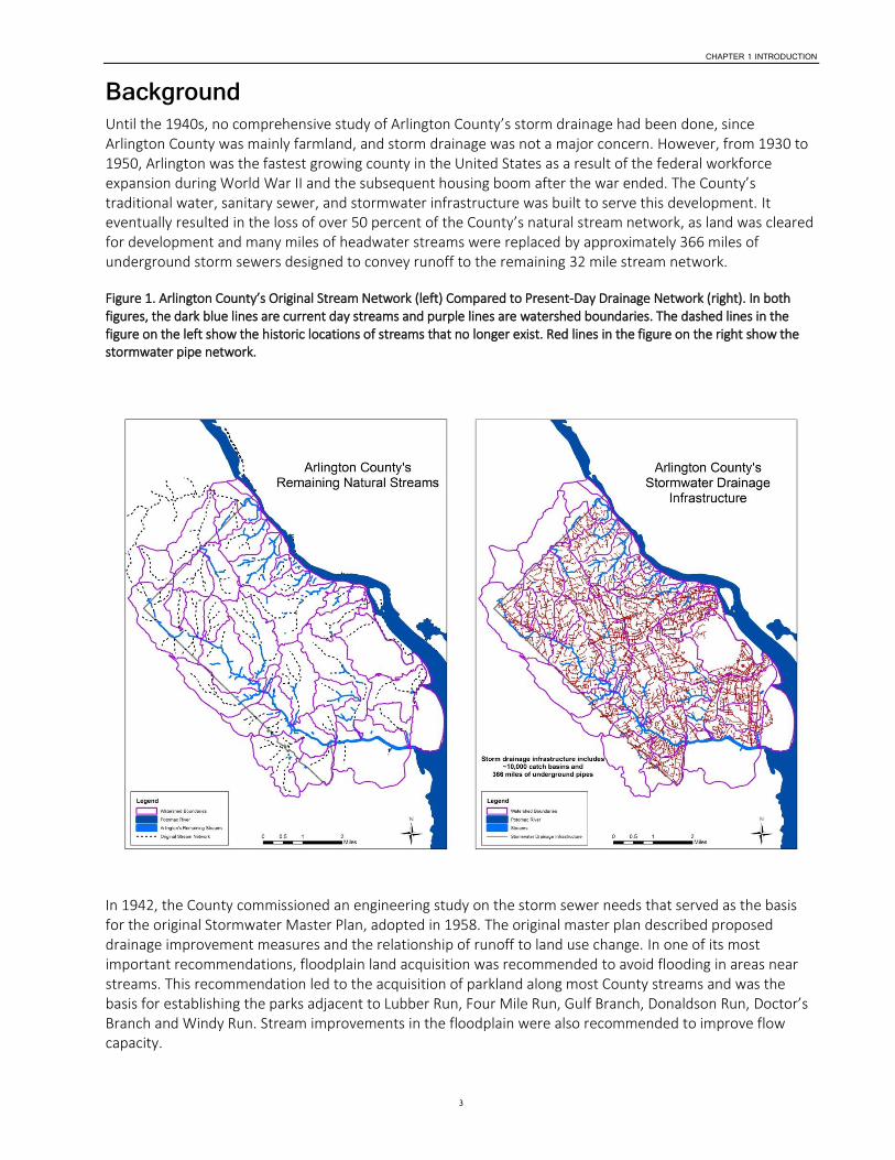
Background Until the 1940s, no comprehensive study of Arlington County’s storm drainage had been done, since Arlington County was mainly farmland, and storm drainage was not a major concern. However, from 1930 to 1950, Arlington was the fastest growing county in the United States as a result of the federal workforce expansion during World War II and the subsequent housing boom after the war ended. The County’s traditional water, sanitary sewer, and stormwater infrastructure was built to serve this development. It eventually resulted in the loss of over 50 percent of the County’s natural stream network, as land was cleared for development and many miles of headwater streams were replaced by approximately 366 miles of underground storm sewers designed to convey runoff to the remaining 32 mile stream network.
Figure 1. Arlington County’s Original Stream Network (left) Compared to Present-Day Drainage Network (right). In both figures, the dark blue lines are current day streams and purple lines are watershed boundaries. The dashed lines in the figure on the left show the historic locations of streams that no longer exist. Red lines in the figure on the right show the stormwater pipe network.
In 1942, the County commissioned an engineering study on the storm sewer needs that served as the basis for the original Stormwater Master Plan, adopted in 1958. The original master plan described proposed drainage improvement measures and the relationship of runoff to land use change. In one of its most important recommendations, floodplain land acquisition was recommended to avoid flooding in areas near streams. This recommendation led to the acquisition of parkland along most County streams and was the basis for establishing the parks adjacent to Lubber Run, Four Mile Run, Gulf Branch, Donaldson Run, Doctor’s Branch and Windy Run. Stream improvements in the floodplain were also recommended to improve flow capacity.
CHAPTER 1 INTRODUCTION
4
The original Stormwater Master Plan was the basis for stormwater infrastructure projects constructed between 1958 and 1974, with the primary purposes of increasing the conveyance capacity of the drainage system. Large-scale stormwater planning was completed only as a result of new ordinances that were adopted because of federal and state mandates. The first such mandate, in 1974, required an agreement from Arlington and Alexandria to manage stormwater flows as a condition of the U.S. Army Corps of Engineers making channel improvements to lower Four Mile Run to reduce increasingly severe flooding in the Arlandria area during the late 1960s.
Since that time, Arlington County has adopted four ordinances to regulate stormwater and development near streams to comply with federal and state programs:
Floodplain management (1977) to comply with the National Flood Insurance Program (most recent update 2013)
Erosion and sediment control (1976) to comply with state regulations
Stormwater detention (1976) to comply with state regulations
Chesapeake Bay preservation (1992) to comply with Virginia’s Chesapeake Bay Local Assistance Board regulations (amended in 2003)
In 1997, Virginia’s Department of Environmental Quality (DEQ) issued the County’s first Municipal Separate Storm Sewer System (MS4) permit for discharges from storm sewers as part of the U.S. Environmental Protection Agency’s (EPA) Storm Water National Pollutant Discharge Elimination System (NPDES) Program established under the authority of the Clean Water Act.
In 2010, EPA issued the Chesapeake Bay Total Maximum Daily Load (TMDL).1 This established a pollution budget for the Chesapeake Bay, requiring significant reductions in phosphorus, nitrogen, and sediment, with specific load reductions to be incorporated into all future MS4 permits.
Virginia reissued Arlington’s MS4 permit in June, 2013. The current permit requires much more extensive water quality monitoring, inspections, training, and outreach and education activities, as well as specific measures to meet the nutrient and sediment load reductions required to meet the TMDL. These new regulatory requirements are determining how stormwater will be managed over the next 20 years and thus are a major driver for this Stormwater Master Plan. This new regulatory framework is still in its infancy and it is unknown at this time whether it will ultimately be successful in restoring the health of the Chesapeake Bay. What is clear is that stormwater will continue to be strictly regulated and the County will need to continue to be flexible in adapting to new regulations as they appear. More fundamentally, these growing and evolving requirements require the County to increase its stormwater management efforts in an incremental and sustained way.
1 Terms such as this are explained further in the glossary, at the end of this Stormwater Master Plan update.

CHAPTER 2
5
Stormwater Management Goals and Strategies The Stormwater Master Plan provides guidance to help manage stormwater, reduce urban sources of pollution, protect County streams and watersheds, and improve the health of the Potomac River and Chesapeake Bay. This plan will help constituents and decision-makers look at stormwater comprehensively to ensure stormwater management and the health of streams and watersheds are integrated into planning and future development within the County.
Arlington has established four overarching goals that are key to an effective and sustainable stormwater management program:
Goal 1—Reduce the potential for stormwater threats to public health, safety, and property
Goal 2—Reduce the impacts of existing urban development and redevelopment on Arlington streams, the Potomac River and the Chesapeake Bay
Goal 3—Comply with state and federal regulations for stormwater, water quality and floodplain management
Goal 4—Comply with County ordinances for stormwater detention, Chesapeake Bay preservation, erosion and sediment control, and floodplain management
Strategies to meet these goals are listed below, along with specific actions that the County is taking or needs to implement over time to achieve these goals. As technology, regulations, and community understanding of stormwater management challenges evolve and change, Arlington County will need to respond with new strategies and actions.
Strategy 1—Reduce flooding risks to public and private property
Update floodplain maps as new information becomes available to reflect the best available information about potential flood risks
Complete a storm sewer capacity analysis for all of the watersheds in Arlington’s system using appropriate hydraulic and hydrologic simulation modeling tools
Continue to investigate both potential flood control projects and small-area drainage issues to reduce the risk of flooding, including acquisition of property as necessary.
Strategy 2—Maintain and upgrade stormwater infrastructure
Continue storm sewer inspection programs
Continue to proactively replace pipes to ensure system integrity, initially focusing on replacement of 11 miles of aging corrugated steel and terra cotta storm sewer pipes throughout the County
Acquire easements, if needed, for existing stormwater infrastructure as capital projects proceed and other opportunities become available
Repair failing stormwater outfalls to ensure system integrity and minimize adverse impacts on downstream properties and streams
Adopt sump pump design and discharge guidelines to help individuals resolve specific drainage issues and to protect public health and safety
Strategy 3—Restore stream corridors
Continue to implement stream restoration projects, as identified in the County’s Capital Improvement Plan (CIP)
CHAPTER 2 STORMWATER MANAGEMENT GOALS AND STRATEGIES
6
Implement new State detention standards designed to protect storm sewer system capacity and stream stability
Acquire property or easements for streams as stream restoration capital projects are implemented
Strategy 4—Improve existing stormwater management facilities and construct new facilities
Continue to implement watershed retrofits according to Stormwater Master Plan priorities and as opportunities arise
Continue to develop design, construction, and maintenance standards for County stormwater management facilities, including green streets
Continue to develop community engagement processes to address competing uses of street right-of-ways
Maximize stormwater benefits as new County projects are developed
Pursue green infrastructure solutions related to stormwater management, including measures to preserve and enhance tree canopy.
Strategy 5—Revise requirements for on-site stormwater controls for development to meet federal and state regulations
Adopt new Virginia stormwater management regulations for development that are required to be incorporated into local ordinances and take effect by July 1, 2014
Strategy 6—Implement urban housekeeping best practices such as street sweeping and catch basin cleaning
Review effectiveness of street sweeping and catch basin–cleaning programs and target program implementation to maximize efficiency and effectiveness, including credits for the Chesapeake Bay TMDL
Strategy 7—Provide ongoing public outreach, education and volunteer monitoring programs
Continue to support rigorous volunteer water quality monitoring programs
Continue to provide incentive programs like the StormwaterWise Landscapes program to encourage private property owners to manage stormwater runoff more effectively
Continue outreach activities across all forms of media to inform and educate a broad spectrum of County constituents about the County’s environment and the important role constituents can play in protecting the County’s water resources
Continue programs that effectively use volunteers and other non-County resources
Inform and engage the community about the potential impacts of climate change on the County’s stormwater infrastructure
Strategy 8—Comply with MS4 permit and Chesapeake Bay TMDL regulations
Provide the funds necessary to meet MS4 permit and Chesapeake Bay TMDL requirements and to address other important stormwater infrastructure needs, like ensuring adequate capacity for flood control, replacing aging infrastructure, and performing preventive maintenance
Strategy 9—Initiate climate adaptation and resilience planning
Begin necessary studies to assess the impacts and risks related to climate change, including more frequent severe storms, predicted sea level rise, and potential flooding caused by hurricane storm surge

CHAPTER 2 STORMWATER MANAGEMENT GOALS AND STRATEGIES
7
Initial efforts should focus special attention on Arlington’s homes, businesses, and critical infrastructure near the Potomac River and lower Four Mile Run that may be most at risk from flooding during major hurricanes
CHAPTER 3
8
Regulatory Overview and Pollution Reduction Goals Arlington County is committed to helping restore the Chesapeake Bay and to improve the health of local streams as important natural resources that enhance the quality of life for County residents. Arlington County has adopted several local ordinances to reduce the effects of development activities on its water resources. The County has taken a proactive role in the Bay restoration by tightening its development regulations and was the first locality in Virginia to begin implementation of a new stormwater permit that includes explicit nutrient and sediment reduction requirements that must be met to comply with the requirements of the Chesapeake Bay Total Maximum Daily Load (TMDL)—a pollution budget for the Bay issued by EPA in 2010. These local ordinances and state and federal regulatory programs are described in the following sections.
How Is Stormwater Regulated? Stormwater runoff is regulated by several discrete characteristics: the amount of runoff (volume), the speed at which the runoff flows (runoff rate), and how clean or polluted the runoff is (water quality).
Runoff volume regulations aim to reduce the amount of water that becomes runoff from a site. In forests and other natural areas, most rainfall infiltrates into the ground. In urban regions, where there are large expanses of impervious area (paved roads, for example) and minimal amounts of pervious area (parkland, for example), much less rainfall infiltrates into the limited remaining pervious areas, and this results in a large amounts of stormwater runoff. Additionally, in portions of Arlington County, the underlying soils, because of their clay content do not allow for much infiltration, thereby causing additional challenges.
Runoff rate regulations aim to slow the flow of runoff leaving a site. With greater expanses of impervious areas connected together, such as along roads, runoff flows faster and can erode streams and other pervious areas that are not able to withstand the runoff velocity. Even a small volume of runoff can reach erosive velocities that damage streams and hillsides.
Water quality regulations aim to remove pollution from urban stormwater runoff. As runoff flows across roads and other impervious areas, it picks up sediment and other pollutants and transports them to the nearest stream. Polluted runoff adversely affects streams and estuaries by decreasing these water bodies’ ability to support aquatic life.
Existing Ordinances The Arlington County Code contains several ordinances that regulate the County’s water resources. The Stormwater Detention Ordinance (Chapter 60), Chesapeake Bay Preservation Ordinance (Chapter 61), and Erosion and Sediment Control Ordinance (Chapter 57) provide legal authority to address the potentially adverse impacts of stormwater runoff during and after development. The Floodplain Management Ordinance (Chapter 48) regulates development adjacent to streams to minimize the impacts of flooding. The Utilities Ordinance (Chapter 26) also provides sanctions for discharging pollutants to the County’s storm sewers and streams.
The County’s Stormwater Detention Ordinance requires that the peak runoff rate from new development and redevelopment be maintained close to predevelopment (undeveloped) levels. Arlington County first enacted the ordinance in 1976 and expanded it in 1982 in response to the Four Mile Run flood control agreement with the U.S. Army Corps of Engineers, City of Alexandria, Falls Church City, and Fairfax County.
It is important to note that in Virginia there is currently no legal authority granted by the General Assembly for local governments to regulate runoff volume directly. Arlington County cannot pass regulations to

CHAPTER 3 REGULATORY OVERVIEW AND POLLUTION REDUCTION GOALS
9
regulate the volume of runoff from a property without new state legislation. Other jurisdictions, both nationally and in the region (Washington, D.C., for example), have begun to establish volume-based performance standards for development, but at this time such authority has not been granted to local governments in Virginia, which follows a strict interpretation of the legal philosophy known as the Dillon Rule.
The Chesapeake Bay Preservation Ordinance (CBPO) requires water quality treatment for development activities and also establishes special protections for lands near Arlington’s streams known as Resource Protection Areas. The CBPO was first adopted in 1992, and revised in 2003 and 2011. Approximately 1,500 parcels in Arlington are directly affected by Resource Protection Area–related development restrictions, although the ordinance designates the entire County a Chesapeake Bay Resource Management Area (RMA). This means that development throughout the entire County is subject to some degree of regulation whenever an area greater than 2,500 square feet is disturbed during the development or redevelopment process.
Arlington County revised its CBPO policies in late 2011 for on-site stormwater management of development projects. The revised policy maximizes the on-site stormwater quality treatment requirements allowed under the authority of the ordinance and also requires that the on-site treatment strategies include measures that help reduce runoff (keeping in mind that, as noted above, Arlington does not have authority to mandate a specific volume reduction).
More stringent state stormwater management regulations were adopted in October, 2011, with local implementation required by July 1, 2014. These new regulations reflect the stormwater pollution reduction requirements of the Chesapeake Bay TMDL issued by EPA in 2010. The Chesapeake Bay TMDL also requires Arlington County to implement a more stringent local stormwater management program through its MS4 permit.
The new state stormwater management regulations will require comprehensive revisions to the Chesapeake Bay Preservation and Stormwater Detention Ordinances, including a completely new framework for regulating stormwater quality and volume by July 1, 2014. The new regulations will not require a specific volume reduction performance standard but will explicitly reward practices that help reduce runoff with increased pollution reduction credits.
Both the existing CBPO and the new state stormwater management regulations require a minimum 10 percent net reduction in pollutant loads for redevelopment projects. As a result, with the sustained redevelopment occurring in Arlington, pollutant loads associated with development should decline over time.
The Erosion and Sediment Control Ordinance was first adopted in 1976 to regulate land-disturbing activities and minimize erosion off-site and to reduce sediments leaving a site. During land-disturbing activities, such as construction, areas of exposed soils are vulnerable to runoff from the site during heavy rains that can release large amounts of sediments into the County’s streams.
The Floodplain Management Ordinance, first adopted in 1977 and revised several times since then, regulates how development can occur in federally regulated floodplains adjacent to streams. In general, designated floodplains include the area of land inundated during a 100-year flood. The adoption of a Floodplain Management Ordinance is required to participate in the National Flood Insurance Program, which is a federal program enabling property owners in participating communities to purchase affordable insurance protection against losses from flooding.
New Regulatory Requirements The two major new regulatory requirements facing Arlington County are the County’s revised MS4 permit, issued by the Virginia DEQ, and the Chesapeake Bay TMDL, issued by EPA.
Because the new regulations include significant pollution reduction requirements, the County has not set additional water quality goals for the stormwater management program. Stormwater program staff and resources are focused on striving to meet the TMDL pollution reduction requirements of the County’s MS4
CHAPTER 3 REGULATORY OVERVIEW AND POLLUTION REDUCTION GOALS
10
permit. Fortunately, these efforts will also help achieve a number of local environmental benefits and objectives, including improved stream water quality and stream corridor habitat.
The County’s MS4 permit, reissued on June 26, 2013 and expiring in 2018, requires Arlington County to implement a strengthened local stormwater management program that addresses and reduces stormwater impacts from existing land uses, new development/redevelopment, and County facilities, including the Trades Center in Shirlington. Although the County has had an MS4 permit since 1997, the new version of the permit is more stringent and includes new requirements for extensive water quality monitoring, inspections, training, and outreach and education activities.
The Chesapeake Bay TMDL issued in 2010 requires substantial nitrogen, phosphorus, and sediment reductions throughout the 64,000-square-mile Chesapeake Bay watershed to restore the water quality and habitat to levels established by EPA.
By the year 2028, the TMDL requires Arlington and other MS4 permittees to achieve specific nutrient and sediment reductions—defined in terms of pounds of sediment, phosphorus, and nitrogen—through local stormwater management programs. The significant nutrient reductions achieved through the County’s WPCP upgrade can allow the stormwater nutrient reductions to be achieved over a time frame longer than 15 years, through a legal mechanism known as nutrient trading. This approach will likely be necessary given the significant stormwater impacts from development in Arlington that occurred well before stormwater management regulations, and the high costs of mitigating these stormwater impacts by constructing stormwater retrofit and stream restoration projects.
In addition to the Chesapeake Bay TMDL, there may be future TMDLs to address local water quality impairments, such as bacteria and aquatic life impairments caused by both the pollutants in stormwater runoff and the stream erosion and water quality degradation caused by stormwater runoff. The level of effort and costs to meet the requirements of these future TMDLs will likely be substantial, and unfortunately the nutrient reduction benefits provided by the WPCP will not be a part of a solution because of the locations of the impairments (upstream of the plant) and the sources of the impairments.
Ultimately, the time frame over which local TMDL implementation is required will be critical in determining whether the TMDL pollution reduction requirements can be achieved within the real fiscal constraints faced by local governments. The success of the Chesapeake Bay TMDL in meeting its 2028 deadline for Virginia’s MS4 permittees will be a critical test to determine how the implementation schedules for other TMDLs will be established in the years ahead.
In addition to the regulatory requirements discussed above, Arlington’s Flood Insurance Study (FIS) and Flood Insurance Rate Map (FIRM) were recently updated by the Federal Emergency Management Agency (FEMA) and went into effect on August 19, 2013. The update includes revised Base Flood Elevations for the Potomac River, re-delineated 100-year and 500-year floodplains based on updated topographic information, and all map revisions since the last FIRM update in 1982.
Achieving the TMDL Pollution Reduction Requirements Overview The Chesapeake Bay TMDL requires Arlington and other MS4 permittees to achieve by the year 2028 specific nutrient and sediment reductions—defined in terms of pounds of sediment, phosphorus, and nitrogen—through local stormwater management programs. Arlington must reduce its share of TMDL pollution by 5 percent during the current MS4 permit (2013–2018), 35 percent during the second permit cycle (2018–2023), and 60 percent during the third permit cycle (2023–2028). The County’s MS4 permit requires that Arlington develop an action plan by June 26, 2015, to lay out the strategies to meet the Chesapeake Bay TMDL pollution reduction requirements.

CHAPTER 3 REGULATORY OVERVIEW AND POLLUTION REDUCTION GOALS
11
Stream restoration projects and watershed retrofits are two key strategies for reducing the nutrient and sediment pollution of stormwater runoff. Stream restoration projects will likely help the County achieve the majority of the sediment and phosphorous requirements. It will be more difficult to achieve the nitrogen reduction requirements.
In addition, stringent regulation of the stormwater effects of development/redevelopment will continue to achieve incremental and cumulative reductions in stormwater pollutants.
Uncertainties Despite the fact that the TMDL implementation has begun, there are still several uncertainties related to the TMDL requirements, including:
Baseline pollution load. The baseline pollution load, which is based on the area of land Arlington County is responsible for, is not finalized. The key input variable is the MS4 service area, defined as the area of land that drains through the County’s storm sewer system. Land owned by other state and federal entities (such as Virginia Department of Transportation and the federal government) or covered by separate stormwater permits is excluded from Arlington’s service area. Arlington’s MS4 service area delineation will be submitted to Virginia DEQ for review in 2014, and we expect DEQ’s determination by mid-2015.
Pollution reduction requirements. Because the MS4 service area is not yet officially defined, Arlington’s specific pollution reduction goals are not finalized.
Credits. The credits available for projects and programs that reduce pollution, such as stream restoration or street sweeping, are not finalized.
Nutrient trading. The ability to use nutrient credits from the WPCP will likely be a critical element of Arlington’s Chesapeake Bay TMDL compliance strategy. The full details of this nutrient trading program are not yet clear, and it is also not known how long these credits will be available. However, it is expected that nutrient credits from the WPCP will provide the stormwater program extra time beyond the 2028 MS4 permit deadline to address the regulatory requirements of the Chesapeake Bay TMDL.
Additional TMDLs. Arlington may have to address additional TMDLs for pollutants other than sediment, nitrogen and phosphorous in the future. Nutrient credits from the WPCP will not be able to assist in meeting these pending regulatory requirements.
Resource and Funding Implications Given the uncertainties outlined above, including an unknown but finite time period for using nutrient credits from the WPCP, stormwater program staff recommend the following resource and staffing adjustments:
During the first permit cycle (2013–2018), add additional staff necessary to spend existing Stormwater Program environmental quality capital funds (currently $2 million per year) available for project delivery.
During the second permit cycle (2018–2023), add the staff necessary to deliver the 159 high-priority watershed retrofit projects at a rate of 10 projects per year, along with the staff needed to implement 6 miles of stream restoration in 15 years, and use nutrient credits from the WPCP.
In most optimistic scenario, implementing the 159 high-priority watershed retrofit projects—along with the 6 miles of high-priority stream restoration projects (representing the likely maximum of fully creditable projects) with maximum stream restoration credits and MS4 service area deductions—could result in full TMDL compliance for phosphorous and sediment and 75 percent compliance with nitrogen, at a cost of approximately $50 million.
If this level of effort began during the second permit cycle and continued over 15 years through 2033, the capital cost per year would be approximately $3.3 million, compared with the current capital funding stream of $2 million.

CHAPTER 3 REGULATORY OVERVIEW AND POLLUTION REDUCTION GOALS
12
The proposed FY15–FY24 CIP includes an assumption of this increased capital funding.
There will be additional operating costs for the staff necessary to deliver these projects at this rate.
This general strategy will likely require a Stormwater Fund rate increase before the end of the first permit cycle ending in 2018. The magnitude of this increase is not yet known.
Adding key staff positions will be essential.
Additional operating funds for maintenance of retrofits and stream restoration projects will also be critical.
Future rate increases may also be needed.
Arlington will not be alone in ramping up stormwater operating and capital expenditures in response to its MS4 permit and the Chesapeake Bay TMDL requirements.
In the least optimistic scenario, if nutrient trading is not possible, and with lower stream restoration credits and MS4 service area deductions, TMDL compliance could require more than 1,000 projects (greatly exceeding staff’s implementation capacity) at a cost of more than $150 million.
Increasing the County’s level of effort in an incremental but significant way, focusing on high priority projects identified through this comprehensive master planning exercise, coupled with borrowing credits from the WPCP to extend the compliance deadline, appears to be the most fiscally responsible, realistic, and sustainable strategy at this time.
A Final Note: How Stream Restoration, Watershed Retrofits, and Redevelopment Work Together It should be noted that stream restoration provides more nutrient and sediment credits than watershed retrofits. Figure 2 shows the proportions of phosphorus and nitrogen reductions by program for the 2028 target date at the current implementation capacity. Stream restoration provides the bulk of the credits over this time period.
Figure 2. Phosphorous and Nitrogen Reductions from Various Programs Through 2028
Phosphorus Nitrogen
As discussed previously, fully creditable stream restoration projects are finite. In addition, stream restoration does not reduce the wide range of stormwater pollution from the urban landscape, cannot be used to get full TMDL credit for the other TMDLs on the horizon, and will not satisfy the specific requirements in the MS4 permit to implement retrofit projects.

CHAPTER 3 REGULATORY OVERVIEW AND POLLUTION REDUCTION GOALS
13
The identified watershed retrofit potential in the County is estimated to be able to treat stormwater runoff from 614 impervious acres, or about 10 percent of the County’s impervious area.
Projecting ahead 50 years, assuming full implementation of watershed retrofit and stream restoration potential and accounting for estimated nutrient reductions from redevelopment, the proportion of phosphorus and nitrogen reductions by program changes significantly—as shown in Figure 3.
Figure 3. Phosphorous and Nitrogen Reductions from Various Programs Through 2063
Phosphorus Nitrogen
In the long run, the County will need to complete watershed retrofits, redevelopment, and stream restoration to reduce stormwater runoff volume, pollution, and downstream erosion. There is not a single strategy that can be relied upon exclusively to meet regulatory requirements and watershed restoration targets.
There is still much uncertainty about what these strategies can achieve in terms of overall urban watershed restoration and about the maintenance requirements for the growing inventory of stormwater facilities. However, as discussed earlier in this section, implementation requirements in the regulatory environment are moving rapidly ahead. Arlington has planned for this with dedicated funding and a diverse stormwater program that includes all of the elements of a comprehensive urban watershed management program. As noted above, more resources will be needed for implementation and to put Arlington on a more robust path towards regulatory compliance and watershed restoration. In addition, more data and technical analyses will be needed to assess the effectiveness of these strategies individually and cumulatively.
Conclusions New federal and state stormwater quality mandates require that Arlington County implement an enhanced stormwater program. The question now facing the County is how robust the program needs to be to ensure the County meets its goal of complying with all local, state, and federal requirements. The regulatory requirements also shape how we look at and manage stormwater in the future. While the County has a good understanding of its existing storm sewer infrastructure, the challenge will be how best to reduce stormwater impacts caused by the County’s extensive traditional urban drainage network, which was developed before stormwater quality and downstream impacts were a consideration. Creating an effective stormwater drainage network that minimizes the adverse effects of urban stormwater pollution is a lofty goal, and achieving it will be a huge challenge to the community.

CHAPTER 4
14
System Assessment System Description Arlington County covers 25.8 square miles, approximately 41 percent of which is impervious surfaces, including streets, buildings, driveways and sidewalks. It is bordered on the north and east by the Potomac River and on the south and west by Fairfax County and the Cities of Alexandria and Falls Church. The majority of the County’s land area was developed starting in the 1940s, and most land area that is available for development in the County has already been developed. The County is heavily urbanized and one of the most densely populated counties in the United States.
The County is divided into 35 watersheds (Figure 4) that range widely in their imperviousness and drain to either the Potomac River, Pimmit Run or Four Mile Run. The stormwater drainage system consists of 32 miles of open channels and streams, 373 miles of storm sewers, and approximately 1,000 outfalls, where stormwater leaves the storm sewers and flows into open channels and streams. Through the course of development, more than half of the original stream network has been replaced by a system of underground storm sewer pipes. Rain water can flow overland directly to a stream or into the storm sewer system and eventually is discharged to the Potomac River, Pimmit Run, or Four Mile Run.
Most storm sewers in Arlington County are one of the following types of pipe: reinforced concrete, corrugated metal or terra cotta. Most of the collection system has been inspected over the past 12 years and is in good condition, with repairs, replacements and rehabilitations implemented as necessary. Reinforced concrete pipes typically have a life span of 75–100 years, and rehabilitation can increase the life span another 25–40 years. Corrugated metal and terra cotta pipes were installed in the early stages of the system construction, but these pipe materials have a significantly shorter life span and are not as strong as reinforced concrete pipes. Consequently, pipes made of these materials are being proactively replaced with pipes made of reinforced concrete.
Storm Sewer System Capacity Study Arlington County began developing a state-of-the-art hydrologic and hydraulic model of the County-controlled storm sewer system as part of the Stormwater Master Plan. The purpose for developing a comprehensive computer model was to develop a more thorough understanding of the system’s capacity limitations. This model will be used as an ongoing planning tool and a starting point for more detailed engineering analysis at locations where capacity issues are identified.
To identify system capacity limitations and determine the areas in which new or larger storm sewers could reduce flooding problems, the consulting firm CH2M HILL was chosen to model the existing storm sewer drainage networks in seven watersheds: Little Pimmit Run, Doctor’s Branch, Spout Run, Westover Branch, Roaches Run, Crossman Run, and Lubber Run. These watersheds were selected because they experience the most severe flooding problems in the County, based on historical information, such as the June 2006 flood of record for the Four Mile Run watershed. Eventually, all watersheds will be modeled.
The computer software used to develop the model is PCSWMM, a commercial version of EPA’s widely used stormwater management model (SWMM).

CHAPTER 4 SYSTEM ASSESSMENT
15
Figure 4. Arlington County Watersheds
CHAPTER 4 SYSTEM ASSESSMENT
16
The storm sewer system model included the pipes, open channels and streams that capture and convey stormwater runoff. The inlets that collect runoff at the most-upstream end of a watershed discharge to the smallest pipes. As more runoff from a larger drainage area is added, more capacity is needed within the pipes. This typically results in increasingly larger pipes, with the largest pipe being the most-downstream point in the pipe network, ultimately discharging runoff into a stream.
As with any model that attempts to replicate real-world phenomena, decisions must be made about the level of detail to include in the model to produce useful results. For the capacity models developed for the initial seven watersheds, it was decided that only pipes with diameters equivalent to at least 36 inches would be studied at this time. This would allow the County to focus on areas with higher flows and the potential for more flooding. The drainage areas upstream of the 36-inch pipes, where runoff is conveyed in smaller pipes, were represented as a single discharge point aggregating the upstream drainage. The seven modeled watersheds represent 37 percent of the land area within the County and contain 44 percent of the pipes with diameters of at least 36 inches and 10 percent of all pipes within the County-controlled drainage network. Ultimately, the goal is to model the entire County-controlled storm sewer system.
Data Collection Data describing the County’s existing storm sewer pipes were provided to CH2M HILL through a geographic information systems (GIS) database and existing engineering plans. Data provided by the Virginia Department of Transportation (VDOT) were also used as necessary. Data were reviewed with County staff to resolve any discrepancies or inaccuracies. If more than one pipe ran in parallel within the system, the parallel pipes were modeled as if their combined cross-sectional area was at least equivalent to a 36-inch-diameter pipe.
A watershed’s runoff is computed using a number of factors, such as drainage area, impervious area, soil type, and slope. These factors were computed using the GIS data. Roaches Run had the highest percentage of impervious area, at 67 percent. The other six watersheds’ impervious area varied between 38 percent and 50 percent.
Soils were classified as one of three types—loam, sandy loam, and silty loam—on the basis of the Arlington County soil survey. There was not a significant correlation between soils and capacity problems. Westover Branch, Crossman Run, and Little Pimmit Run watersheds are composed of mainly silty loam, Roaches Run is mainly loam, Doctors Branch is mainly sandy loam, and Spout Run and Lubber Run are split evenly among the three soil types.
Where storm sewer pipes flow into a stream, cross sections were added to the model along the streams to ensure continuity of flow. No streams were modeled for Roaches Run, Westover Branch, and Crossman Run, since these drainage networks consist entirely of underground pipes. Surveyed cross sections were added for any stretch of stream that had a relatively unique size and shape. Small streams and open concrete channel dimensions were taken from plans or measurements completed by County staff. All stream reaches were field verified.
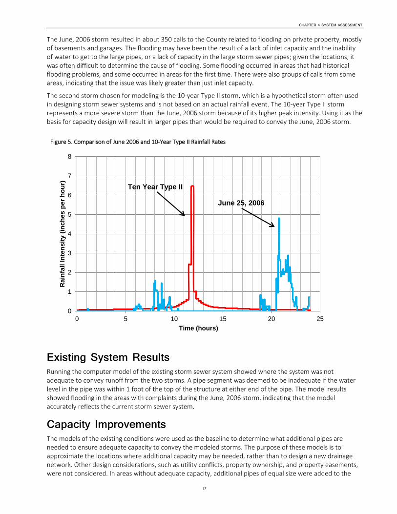
Runoff Analysis With the data in place to replicate a watershed and its pipe system, the last component of data input for a storm sewer capacity model is the rainfall. Two storms were chosen to model, as illustrated in Figure 5.
The first storm modeled was the June, 2006 storm. This storm had fairly uniform rainfall throughout the County and also caused widespread flooding. It occurred on June 25, 2006 and had a peak rainfall intensity of 4.80 inches/hour and a total rainfall of 5.84 inches over 24 hours, as recorded at the Donaldson Run lift station. Before June 25, it had been raining for several days and soil was saturated. Because the soil was unable to absorb more rain, pervious areas effectively acted as impervious areas, and most of the rainwater became runoff.
CHAPTER 4 SYSTEM ASSESSMENT
17
The June, 2006 storm resulted in about 350 calls to the County related to flooding on private property, mostly of basements and garages. The flooding may have been the result of a lack of inlet capacity and the inability of water to get to the large pipes, or a lack of capacity in the large storm sewer pipes; given the locations, it was often difficult to determine the cause of flooding. Some flooding occurred in areas that had historical flooding problems, and some occurred in areas for the first time. There were also groups of calls from some areas, indicating that the issue was likely greater than just inlet capacity.
The second storm chosen for modeling is the 10-year Type II storm, which is a hypothetical storm often used in designing storm sewer systems and is not based on an actual rainfall event. The 10-year Type II storm represents a more severe storm than the June, 2006 storm because of its higher peak intensity. Using it as the basis for capacity design will result in larger pipes than would be required to convey the June, 2006 storm.
Figure 5. Comparison of June 2006 and 10-Year Type II Rainfall Rates
Existing System Results Running the computer model of the existing storm sewer system showed where the system was not adequate to convey runoff from the two storms. A pipe segment was deemed to be inadequate if the water level in the pipe was within 1 foot of the top of the structure at either end of the pipe. The model results showed flooding in the areas with complaints during the June, 2006 storm, indicating that the model accurately reflects the current storm sewer system.
Capacity Improvements The models of the existing conditions were used as the baseline to determine what additional pipes are needed to ensure adequate capacity to convey the modeled storms. The purpose of these models is to approximate the locations where additional capacity may be needed, rather than to design a new drainage network. Other design considerations, such as utility conflicts, property ownership, and property easements, were not considered. In areas without adequate capacity, additional pipes of equal size were added to the
0
1
2
3
4
5
6
7
8
0 5 10 15 20 25
Rain
fall I
nte
nsit
y (
inch
es p
er
ho
ur)
Time (hours)
Ten Year Type II
June 25, 2006
CHAPTER 4 SYSTEM ASSESSMENT
18
modeled existing system to provide adequate capacity to prevent surcharging of storm sewer pipes or surface flooding and to help evaluate the potential effects on the rest of the system.
Results The models were completed using conservative assumptions to ensure that staff identified all areas in these seven watersheds that may not have adequate pipe capacity as defined by the two modeled events. According to the results of the storm sewer capacity models, 14 percent of the modeled pipes need additional capacity to adequately convey runoff from the June, 2006 storm, and 52 percent need additional capacity to convey runoff from the 10-year Type II storm. Roaches Run needs the least increase in capacity, at 3 percent and 35 percent for the June 2006 and 10-year Type II storms, respectively. Westover Branch needs the most capacity, at 35 percent and 73 percent for the two storms. The other five watersheds varied between 11 percent and 20 percent additional capacity needed for the June 2006 storm and between 45 percent and 67 percent for the 10-year Type II storm. Additional information on the capacity analysis and maps of the study areas are included in Appendix A.
The results did not point to one specific cause of flooding. In some cases, a choke point downstream causes flooding far upstream, and adding capacity in the upstream area where flooding occurs will not alleviate the flooding until the downstream pipe is enlarged.
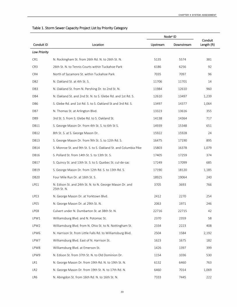
Capacity Improvement Projects Upgrades to the system were proposed on the basis of the hydrological model, and were broken into 107 distinct projects totaling almost 89,000 linear feet (16.8 miles) of pipe upgrades. Maps of the proposed projects are included in Appendix A. The project limits were chosen to provide a reasonable project length. Now that the projects have been identified, the next step is to complete a detailed engineering analysis of the storm sewer system in the project area. The model is a conservative screening tool, and with detailed analyses, the limits of the required pipe upgrades may be revised.
The projects were prioritized using several factors to identify the locations that were most vulnerable to flooding. The prioritization factors included land ownership; location in the watershed; whether the model results showed additional capacity was needed for the June 2006 storm; and, the length of pipe requiring additional capacity. The factors were weighted to provide a numerical score from 0 to 100, with 0 being lowest priority and 100 being highest priority.
The numerical score results were reviewed and the projects grouped into four categories: high, medium, low, and very low priority. Projects with similar scores were grouped together. Without more information on each project, it is difficult to determine which project within a given group has a higher priority than another, but this grouping provides a smaller set of projects to focus on first, as there are other design considerations to review during the design phase of a project.
Other factors may raise or lower the prioritization of projects. Arlington County is a very urban area with a large amount of existing infrastructure, which makes it challenging to install new, larger storm sewer pipes. Some existing storm sewer pipes are on private property and may not be located in an easement, or they may be owned by another government entity, such as VDOT. These challenges and others could delay a project or cause it to be revised as more detailed design work is completed. Conversely, if another County project is being completed in a certain area, a project could move up in priority so that the construction activities of several projects could be completed together. Table 1 lists the projects by priority.

CHAPTER 4 SYSTEM ASSESSMENT
19
Table 1. Storm Sewer Capacity Project List by Priority Category
Conduit ID Location
Nodea ID Conduit
Length (ft) Upstream Downstream
High Priority
CR2 N. Rockingham St. from 24th St. N. to Lee Hwy. 6263 6771 631
LPE7 Williamsburg Blvd. at N. Columbus St. 1359 1377 86
LPW3 Williamsburg Blvd. from N. Nottingham St. to N. Harrison St. 2223 1675 2,274
LPW5 Williamsburg Blvd. at N. Harrison St. 1675 1584 615
LR3 N. Edison St. from 17th Rd. N. to 16th St. N. 7014 7695 2,176
SR13 N. Upton St. from 19th St. N. to 18th St. N. 5716 6052 556
SR14 N. Upton St. and 18th St. N. to N. Utah St. and 17th St. N. 6052 6415 603
WB3 John Marshall Dr. from 25th St. N. to Lee Hwy. 5533 5870 378
Medium Priority
DB1 N. Pollard St. and 5th Rd. N. to N. Oakland St. and 5th St. N. 23816 11479 1,411
DB5 S. Glebe Rd. at 1st Rd. S. 13785 13621 174
DB15 S. Oakland and Columbia Pike to S. Quebec St. cul-de-sac 16441 17099 1,108
DB18 S. Quebec St. cul-de-sac to S. George Mason Dr. and 12th Rd. S. 17099 17190 361
DB8 S. Glebe Rd. from 6th St. S. to 3rd St. S. 14587 14202 733
LPE2 N. George Mason Dr. and 25th St. N. to 26th Rd. N. 3693 2862 1,091
LPE6 Culvert under Williamsburg Blvd. at N. George Mason Dr. 1417 1365 129
LR4 N. Edison St. and 16th St. N. to Buchanan St. N. and 14th St. N. 7695 8195 1,270
LR5 N. Cameron St. and 17th Rd. N. to N. Buchanan St. and 16th St. N.
6539 7445 1,175
LR12 N. Stuart St. and Washington Blvd. to N. Glebe Rd. and 11th St. N.
8669 9339 1,550
LR20 N. Abingdon St. at N. Carlin Springs Rd 11671 11684 17
SR11 N. Vermont St. and 20th St. N. to N. Upland St. and 19th Rd. N. 4890 5254 430
SR12 N. Upland St. and 19th Rd. N. to N. Upton St. and 19th St. N. 5254 5716 891
SR15 N. Utah St. and 17th St. N. to N. Taylor St. and 16th St. N. 6415 6819 719
SR17 N. Taylor St. and 16th St. N. to N. Stafford St. and 15th St. N. 6819 7331 585
SR20 Kirkwood Rd. from 17th St. N. to 19th Rd. N. 6437 5114 1,672
SR23 18th St. N. from N. Monroe St to N. Johnson St. 5720 6028 771
SR27 Lee Hwy. from N. Kenmore St. to Kirkwood Rd. 4341 4483 1,130
WB4 John Marshall Dr. from Lee Hwy. to 22nd St. N. 5870 7265 1,325
WB5 N. Ohio St. from 22nd St. N. to Washington Blvd. 7265 8224 1,011
WB6 N. Ohio St. from Washington Blvd. to I-66 8224 9730 1,614
CHAPTER 4 SYSTEM ASSESSMENT
20
Table 1. Storm Sewer Capacity Project List by Priority Category
Conduit ID Location
Nodea ID Conduit
Length (ft) Upstream Downstream
Low Priority
CR1 N. Rockingham St. from 26th Rd. N. to 26th St. N. 5135 5574 381
CR3 26th St. N. to Tennis Courts within Tuckahoe Park 6186 6256 92
CR4 North of Sycamore St. within Tuckahoe Park 7035 7097 96
DB2 N. Oakland St. at 4th St. S. 11706 11701 14
DB3 N. Oakland St. from N. Pershing Dr. to 2nd St. N. 11984 12610 960
DB4 N. Oakland St. and 2nd St. N. to S. Glebe Rd. and 1st Rd. S. 12610 13497 1,239
DB6 S. Glebe Rd. and 1st Rd. S. to S. Oakland St and 3rd Rd. S. 13497 14377 1,064
DB7 N. Thomas St. at Arlington Blvd. 13323 13616 355
DB9 3rd St. S. from S. Glebe Rd. to S. Oakland St. 14138 14364 717
DB11 S. George Mason Dr. from 4th St. S. to 6th St S. 14939 15348 651
DB12 8th St. S. at S. George Mason Dr. 15922 15928 24
DB13 S. George Mason Dr. from 9th St. S. to 12th Rd. S. 16475 17190 895
DB14 S. Monroe St. and 9th St. S. to S. Oakland St. and Columbia Pike 15803 16378 1,079
DB16 S. Pollard St. from 14th St. S. to 13th St. S. 17405 17259 374
DB17 S. Quincy St. and 13th St. S. to S. Quebec St. cul-de-sac 17249 17099 685
DB19 S. George Mason Dr. from 12th Rd. S. to 13th Rd. S. 17190 18120 1,185
DB20 Four Mile Run Dr. at 16th St. S. 18925 19064 240
LPE1 N. Edison St. and 24th St. N. to N. George Mason Dr. and 25th St. N.
3705 3693 766
LPE3 N. George Mason Dr. at Yorktown Blvd. 2412 2270 254
LPE5 N. George Mason Dr. at 29th St. N. 2063 1971 246
LPE8 Culvert under N. Dumbarton St. at 38th St. N. 22716 22715 42
LPW1 Williamsburg Blvd. and N. Potomac St. 2370 2359 58
LPW2 Williamsburg Blvd. from N. Ohio St. to N. Nottingham St. 2334 2223 408
LPW6 N. Harrison St. from Little Falls Rd. to Williamsburg Blvd. 2504 1584 2,192
LPW7 Williamsburg Blvd. East of N. Harrison St. 1623 1675 182
LPW8 Williamsburg Blvd. at Emerson St. 1426 1397 399
LPW9 N. Edison St. from 37th St. N. to Old Dominion Dr. 1154 1036 530
LR1 N. George Mason Dr. from 19th Rd. N. to 19th St. N. 6132 6460 763
LR2 N. George Mason Dr. from 19th St. N. to 17th Rd. N. 6460 7014 1,069
LR6 N. Abingdon St. from 16th Rd. N. to 16th St. N. 7333 7445 222
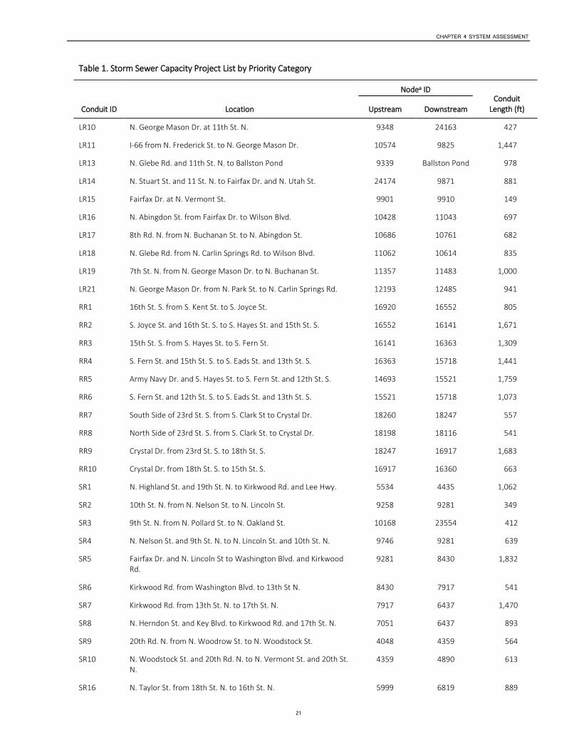
CHAPTER 4 SYSTEM ASSESSMENT
21
Table 1. Storm Sewer Capacity Project List by Priority Category
Conduit ID Location
Nodea ID Conduit
Length (ft) Upstream Downstream
LR10 N. George Mason Dr. at 11th St. N. 9348 24163 427
LR11 I-66 from N. Frederick St. to N. George Mason Dr. 10574 9825 1,447
LR13 N. Glebe Rd. and 11th St. N. to Ballston Pond 9339 Ballston Pond 978
LR14 N. Stuart St. and 11 St. N. to Fairfax Dr. and N. Utah St. 24174 9871 881
LR15 Fairfax Dr. at N. Vermont St. 9901 9910 149
LR16 N. Abingdon St. from Fairfax Dr. to Wilson Blvd. 10428 11043 697
LR17 8th Rd. N. from N. Buchanan St. to N. Abingdon St. 10686 10761 682
LR18 N. Glebe Rd. from N. Carlin Springs Rd. to Wilson Blvd. 11062 10614 835
LR19 7th St. N. from N. George Mason Dr. to N. Buchanan St. 11357 11483 1,000
LR21 N. George Mason Dr. from N. Park St. to N. Carlin Springs Rd. 12193 12485 941
RR1 16th St. S. from S. Kent St. to S. Joyce St. 16920 16552 805
RR2 S. Joyce St. and 16th St. S. to S. Hayes St. and 15th St. S. 16552 16141 1,671
RR3 15th St. S. from S. Hayes St. to S. Fern St. 16141 16363 1,309
RR4 S. Fern St. and 15th St. S. to S. Eads St. and 13th St. S. 16363 15718 1,441
RR5 Army Navy Dr. and S. Hayes St. to S. Fern St. and 12th St. S. 14693 15521 1,759
RR6 S. Fern St. and 12th St. S. to S. Eads St. and 13th St. S. 15521 15718 1,073
RR7 South Side of 23rd St. S. from S. Clark St to Crystal Dr. 18260 18247 557
RR8 North Side of 23rd St. S. from S. Clark St. to Crystal Dr. 18198 18116 541
RR9 Crystal Dr. from 23rd St. S. to 18th St. S. 18247 16917 1,683
RR10 Crystal Dr. from 18th St. S. to 15th St. S. 16917 16360 663
SR1 N. Highland St. and 19th St. N. to Kirkwood Rd. and Lee Hwy. 5534 4435 1,062
SR2 10th St. N. from N. Nelson St. to N. Lincoln St. 9258 9281 349
SR3 9th St. N. from N. Pollard St. to N. Oakland St. 10168 23554 412
SR4 N. Nelson St. and 9th St. N. to N. Lincoln St. and 10th St. N. 9746 9281 639
SR5 Fairfax Dr. and N. Lincoln St to Washington Blvd. and Kirkwood Rd.
9281 8430 1,832
SR6 Kirkwood Rd. from Washington Blvd. to 13th St N. 8430 7917 541
SR7 Kirkwood Rd. from 13th St. N. to 17th St. N. 7917 6437 1,470
SR8 N. Herndon St. and Key Blvd. to Kirkwood Rd. and 17th St. N. 7051 6437 893
SR9 20th Rd. N. from N. Woodrow St. to N. Woodstock St. 4048 4359 564
SR10 N. Woodstock St. and 20th Rd. N. to N. Vermont St. and 20th St. N.
4359 4890 613
SR16 N. Taylor St. from 18th St. N. to 16th St. N. 5999 6819 889

CHAPTER 4 SYSTEM ASSESSMENT
22
Table 1. Storm Sewer Capacity Project List by Priority Category
Conduit ID Location
Nodea ID Conduit
Length (ft) Upstream Downstream
SR18 I-66 from N. Stafford St. to N. Nelson St. 7331 6955 1,827
SR19 I-66 and N. Nelson St. to Kirkwood St. and 17th St. N. 6955 6541 1,459
SR21 N. Nelson St. and I-66 6359 6670 331
SR22 N. Oakland St. and 20th St. N. to N. Monroe St. and 18th St. N. 5197 5720 951
SR24 18th St. N. from N. Johnson St. to Kirkwood Rd. 6028 6148 387
SR25 Kirkwood Rd. from Lee Hwy. to I-66 4969 3939 2,569
SR26 Lee Hwy. from N. Pollard St to N. Kenmore St. 4348 4341 1,867
WB1 John Marshall Dr. from 26th Rd. N. to 25th St. N. 4531 5533 1,284
WB2 John Marshall Dr. at 25th St. N. 5361 5533 123
WB7 N. Ohio St. from I-66 to Four Mile Run stream 9730 10016 246
Very Low Priority
DB10 S. Oakland St. and 3rd St S. to S. Quincy St. and 6th St. S. 14364 14688 564
LPE4 29th St. N. from N. Brandywine St. to N. George Mason Dr. 1985 2064 1,292
LPW4 Little Falls Rd. and John Marshall Dr. to N. Kensington St. and 33rd St. N.
2432 2164 751
LR7 N. Abingdon St. from 16th St. N. to 14th St. N. 7445 8156 695
LR8 N. Glebe Rd. from 16th St. N. to 13th St. N. 7023 8232 1,246
LR9 I-66 from N. Abingdon St. to N. Glebe Rd. 8232 8526 407
WB8 Lee Hwy. west of John Marshall Dr. 5895 5870 385
a A feature, such as a manhole or catch basin, that delineates a conduit.
Cost Estimate Without a detailed design for each project, project costs cannot be quantified accurately, and thus they are not presented here. A cost estimate for the high priority projects is presented in Chapter 8, Funding Issues.
Additional Factors and Risk It is important to remember that all properties have a small but real risk of flooding, and that while the capacity of the public storm sewer system can be increased to reduce the risk of flooding, that risk can never be reduced to zero. While the pipes may be sufficient to convey all runoff for a given storm, flooding may occur because of insufficiently sized or blocked inlets, poor overland relief, or a blockage in a pipe. Overland relief is sufficient when water is able to flow away from the area even if the storm sewer system is not functioning before posing a risk to property or life. Additionally, no matter what size storm a system is designed for, there is always the chance of a larger storm. For this reason, overland relief is important no matter what size pipes are in the ground. For example, many basements in Arlington are potentially vulnerable to flooding since there is no relief path. If the relief is a sump pump, it is vulnerable if the

CHAPTER 4 SYSTEM ASSESSMENT
23
electricity goes out, or if the rate of flow into the ponded area is greater than the pump capacity. Property owners should evaluate their risk tolerance and take appropriate steps to protect themselves. Those steps could include regrading the property, flood-proofing the structure, or providing an alternate means of operating the sump pump.
The County’s storm sewer system was originally designed and constructed based on the location of existing streams as neighborhoods were developed, since storm sewer networks are generally designed to flow by gravity. In areas that are mostly residential, this has led to numerous storm sewer pipes on private property—in backyards, in side yards between houses, and in other areas without access. If the pipes on private property are located within an easement dedicated to the County for maintenance, the County can maintain and replace the pipes as required. If the pipe is not located within an easement, then the County may work with the homeowner to obtain an easement for the pipe in order to maintain, upsize, or relocate it. Though the County cannot maintain, relocate, or enlarge a pipe without an easement, the property owner is not legally required to provide the County with one. The County is working to identify areas without easements and to obtain easements as appropriate, but this is a very laborious process.
Information about the Storm Sewer Capacity Analysis can be found on the County Website.2
Current Projects Current storm sewer capacity CIP projects in the design or construction phase will address some of the larger known flooding issues. One project recently completed is at the intersection of John Marshall Drive and Lee Highway in Westover Branch watershed. Several additional CIP projects that should be completed in the next several years will address known areas of flooding that were identified before the PCSWMM models were completed. These projects are located at (1) 33rd Street North between John Marshall Drive and Williamsburg Boulevard in the Little Pimmit Run watershed; (2) the intersection of 18th Street North and North Upton Street in the Spout Run watershed; and (3) North Liberty Street between 9th Road North and 10th Road North in the Four Mile Run watershed.
Flood Risk Reduction Projects and Studies In addition to storm sewer pipe capacity projects, the County has also analyzed locations for flood control projects that will address flow capacity in stream channels. Arlington County has reviewed the recently updated FEMA floodplain boundaries to determine the effects on private property. The updated boundaries show approximately 340 structures located in the 100-year floodplain. A review of the updated Flood Insurance Rate Map (FIRM) indicates that there are opportunities for updated flood analyses and potential capital projects that could significantly reduce the risk to approximately 228 individual properties and even remove them from the FEMA-designated floodplain. In addition to reducing the risk to property owners, the need for flood insurance may potentially be reduced. Those locations are listed in Table 2 and shown in Figure 6. Staff will continue to evaluate other opportunities to reduce risk to the remaining properties in the 100-year floodplain.
2 See http://projects.arlingtonva.us/plans-studies/environment/storm-sewer-capacity-study/ .
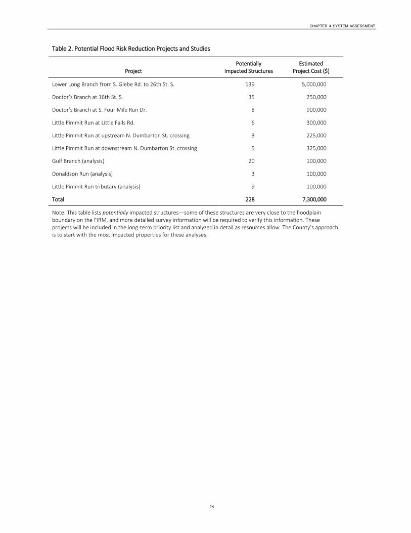
CHAPTER 4 SYSTEM ASSESSMENT
24
Table 2. Potential Flood Risk Reduction Projects and Studies
Project Potentially
Impacted Structures Estimated
Project Cost ($)
Lower Long Branch from S. Glebe Rd. to 26th St. S. 139 5,000,000
Doctor’s Branch at 16th St. S. 35 250,000
Doctor’s Branch at S. Four Mile Run Dr. 8 900,000
Little Pimmit Run at Little Falls Rd. 6 300,000
Little Pimmit Run at upstream N. Dumbarton St. crossing 3 225,000
Little Pimmit Run at downstream N. Dumbarton St. crossing 5 325,000
Gulf Branch (analysis) 20 100,000
Donaldson Run (analysis) 3 100,000
Little Pimmit Run tributary (analysis) 9 100,000
Total 228 7,300,000
Note: This table lists potentially impacted structures—some of these structures are very close to the floodplain boundary on the FIRM, and more detailed survey information will be required to verify this information. These projects will be included in the long-term priority list and analyzed in detail as resources allow. The County’s approach is to start with the most impacted properties for these analyses.
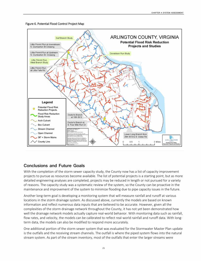
CHAPTER 4 SYSTEM ASSESSMENT
25
Figure 6. Potential Flood Control Project Map
Conclusions and Future Goals With the completion of the storm sewer capacity study, the County now has a list of capacity improvement projects to pursue as resources become available. The list of potential projects is a starting point, but as more detailed engineering analyses are completed, projects may be reduced in length or not pursued for a variety of reasons. The capacity study was a systematic review of the system, so the County can be proactive in the maintenance and improvement of the system to minimize flooding due to pipe capacity issues in the future.
Another long-term goal is developing a monitoring system that will measure rainfall and runoff at various locations in the storm drainage system. As discussed above, currently the models are based on known information and reflect numerous data inputs that are believed to be accurate. However, given all the complexities of the storm drainage network throughout the County, it has not yet been demonstrated how well the drainage network models actually capture real-world behavior. With monitoring data such as rainfall, flow rates, and velocity, the models can be calibrated to reflect real-world rainfall and runoff data. With long-term data, the models can also be modified to respond more accurately.
One additional portion of the storm sewer system that was evaluated for the Stormwater Master Plan update is the outfalls and the receiving stream channels. The outfall is where the piped system flows into the natural stream system. As part of the stream inventory, most of the outfalls that enter the larger streams were
CHAPTER 4 SYSTEM ASSESSMENT
26
identified and rated on the basis of their condition. It was noted if the outfalls were stable, connected to the stream, and structurally sound. The outfalls were rated, and those in the worst shape are being monitored to understand if they have stabilized in their current conditions, or if there is active erosion and degradation occurring at the outfall. The outfalls are also being reviewed from the perspective of maintenance, whether there is access to the outfalls, and whether the County needs an easement to complete any maintenance or repairs. The goal, as resources are made available, is to complete a detailed analysis of each outfall and determine a course of action—be it to monitor the outfall, repair the outfall, or design and install a new outfall in a different location.
An additional area for future policy decisions relates to sump pump discharges. Beginning in 1968, new homes were not allowed to connect sump pumps to the sanitary sewer system. New regulatory requirements will most likely result in more water remaining on site and being infiltrated into the ground. Coupled with the current redevelopment trends of larger houses and/or basements and new building code requirements, it is projected there will likely be more sump pumps installed and more water pumped through them that will need to discharge to an appropriate location. In sections of the County with high groundwater tables and limited storm drain infrastructure, the County will need to determine how to best locate sump pump discharges to minimize icing and slipping hazards in the public right-of-way.
Stream Assessment Introduction During 2011 and 2012, Arlington County completed a county-wide stream assessment to determine stream condition and restoration potential, for the purpose of developing a prioritized list of stream restoration projects as part of the County’s Stormwater Master Plan update.
Stream restoration can reduce stream bank erosion and downstream sedimentation and improve stream habitat for aquatic organisms. Stream restoration can also protect nearby storm and sanitary sewer and potable water infrastructure in a way that is more sustainable than hardening the stream crossing or using other pipe protection methods. The county-wide stream assessment looked closely at both physical stream conditions and infrastructure conditions with the goal of developing restoration priorities for specific stream systems and surrounding infrastructure.
Secondary objectives of the stream assessment included characterizing in-stream habitat and riparian buffer conditions to enable prioritization of stream and buffer restoration needs and potential.
The stream assessment is also a complementary element to the County’s Natural Resources Management Plan, which includes several recommendations for protecting and managing stream corridors.
Methods Arlington County hired a consultant, Vanasse Hangen Brustlin, Inc. (VHB), to assess the streams within the County, and they assessed approximately 23 miles during the 2011-12 assessment. An additional approximately two miles were assessed previously (see Little Pimmit Run and Donaldson Run Tributary B below). The 25 miles assessed in total represents approximately 80 percent of the streams within the County.
Individual stream reaches were delineated and located in the field using the U.S. Army Corps of Engineers Unified Stream Methodology–Stream Assessment Reach (SAR) approach and by applying the channel evolution model (CEM) and Unified Stream Assessment (USM) methodology. A SAR is a stream segment that exhibits consistent physical characteristics, such as entrenchment, width/depth ratio, and slope, throughout its length. When physical characteristics of the stream are observed to change significantly along the stream corridor, a new SAR is established for analysis and evaluation.
The Channel Evolution Model (CEM) is a useful tool for evaluating a stream’s condition. As the watershed surrounding a stream is developed, more runoff flows into the stream than before. In response to this

CHAPTER 4 SYSTEM ASSESSMENT
27
increased flow, the stream changes shape, or evolves, in a predictable way. As Figure 7 shows, streams typically first erode down, becoming deeper, and then gradually widen to accommodate the higher flows. Over time, the stream will create a new, larger stable channel that can accommodate the higher flows. During this evolutionary process, large amounts of sediment are eroded and washed downstream. The CEM is used to determine where the stream is in this evolutionary process. Most urban streams are in stages II or III, incision or widening.
Figure 7. Channel Evolution Model
USM methods are used to evaluate stormwater outfall and sanitary sewer/water infrastructure conditions. Other data collected include Rosgen stream classification, flow regime (perennial, ephemeral, etc.), riparian buffer and in-stream habitat, and Cowardin wetland classification.
Several streams were not assessed, including those at the Washington Golf and Country Club (because it is private property), at the Arlington Cemetery and Fort Myer (because they are federal property), and at Four Mile Run downstream of Shirlington Road within the Four Mile Run flood control project (because of ongoing work with the U.S. Army Corps of Engineers and the City of Alexandria about the capacity requirements and restoration potential for this stream corridor).
VHB evaluated the physical condition of stormwater outfalls, storm and sanitary sewer and potable water infrastructure, exposed utilities, and stream blockages; collected data using the USM methodology; and took photographs for reference. For stormwater outfalls, the field evaluation focused primarily on the physical condition of the outfall, with an emphasis on erosion and pipe conditions. Conditions where pollutants were seen discharging from the outfalls (known as illicit discharges), were rare, but when identified, County staff members were informed to resolve the situation. For infrastructure impacts, the field evaluation focused primarily on impacts to the stream due to the infrastructure, with a secondary focus on the condition of the infrastructure. Condition scores range from 1 (best) to 5 (worst).
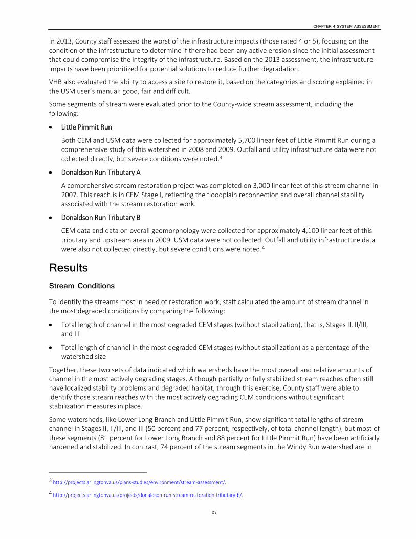
CHAPTER 4 SYSTEM ASSESSMENT
28
In 2013, County staff assessed the worst of the infrastructure impacts (those rated 4 or 5), focusing on the condition of the infrastructure to determine if there had been any active erosion since the initial assessment that could compromise the integrity of the infrastructure. Based on the 2013 assessment, the infrastructure impacts have been prioritized for potential solutions to reduce further degradation.
VHB also evaluated the ability to access a site to restore it, based on the categories and scoring explained in the USM user’s manual: good, fair and difficult.
Some segments of stream were evaluated prior to the County-wide stream assessment, including the following:
Little Pimmit Run
Both CEM and USM data were collected for approximately 5,700 linear feet of Little Pimmit Run during a comprehensive study of this watershed in 2008 and 2009. Outfall and utility infrastructure data were not collected directly, but severe conditions were noted.3
Donaldson Run Tributary A
A comprehensive stream restoration project was completed on 3,000 linear feet of this stream channel in 2007. This reach is in CEM Stage I, reflecting the floodplain reconnection and overall channel stability associated with the stream restoration work.
Donaldson Run Tributary B
CEM data and data on overall geomorphology were collected for approximately 4,100 linear feet of this tributary and upstream area in 2009. USM data were not collected. Outfall and utility infrastructure data were also not collected directly, but severe conditions were noted.4
Results Stream Conditions To identify the streams most in need of restoration work, staff calculated the amount of stream channel in the most degraded conditions by comparing the following:
Total length of channel in the most degraded CEM stages (without stabilization), that is, Stages II, II/III, and III
Total length of channel in the most degraded CEM stages (without stabilization) as a percentage of the watershed size
Together, these two sets of data indicated which watersheds have the most overall and relative amounts of channel in the most actively degrading stages. Although partially or fully stabilized stream reaches often still have localized stability problems and degraded habitat, through this exercise, County staff were able to identify those stream reaches with the most actively degrading CEM conditions without significant stabilization measures in place.
Some watersheds, like Lower Long Branch and Little Pimmit Run, show significant total lengths of stream channel in Stages II, II/III, and III (50 percent and 77 percent, respectively, of total channel length), but most of these segments (81 percent for Lower Long Branch and 88 percent for Little Pimmit Run) have been artificially hardened and stabilized. In contrast, 74 percent of the stream segments in the Windy Run watershed are in
3 http://projects.arlingtonva.us/plans-studies/environment/stream-assessment/.
4 http://projects.arlingtonva.us/projects/donaldson-run-stream-restoration-tributary-b/.
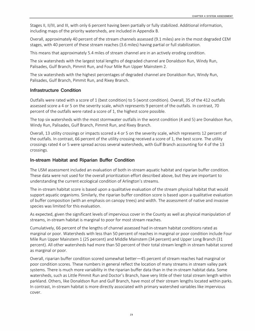
CHAPTER 4 SYSTEM ASSESSMENT
29
Stages II, II/III, and III, with only 6 percent having been partially or fully stabilized. Additional information, including maps of the priority watersheds, are included in Appendix B.
Overall, approximately 40 percent of the stream channels assessed (9.1 miles) are in the most degraded CEM stages, with 40 percent of these stream reaches (3.6 miles) having partial or full stabilization.
This means that approximately 5.4 miles of stream channel are in an actively eroding condition.
The six watersheds with the largest total lengths of degraded channel are Donaldson Run, Windy Run, Palisades, Gulf Branch, Pimmit Run, and Four Mile Run Upper Mainstem 2.
The six watersheds with the highest percentages of degraded channel are Donaldson Run, Windy Run, Palisades, Gulf Branch, Pimmit Run, and Rixey Branch.
Infrastructure Condition Outfalls were rated with a score of 1 (best condition) to 5 (worst condition). Overall, 35 of the 412 outfalls assessed score a 4 or 5 on the severity scale, which represents 9 percent of the outfalls. In contrast, 70 percent of the outfalls were rated a score of 1, the highest score possible.
The top six watersheds with the most stormwater outfalls in the worst condition (4 and 5) are Donaldson Run, Windy Run, Palisades, Gulf Branch, Pimmit Run, and Rixey Branch.
Overall, 13 utility crossings or impacts scored a 4 or 5 on the severity scale, which represents 12 percent of the outfalls. In contrast, 66 percent of the utility crossing received a score of 1, the best score. The utility crossings rated 4 or 5 were spread across several watersheds, with Gulf Branch accounting for 4 of the 13 crossings.
In-stream Habitat and Riparian Buffer Condition The USM assessment included an evaluation of both in-stream aquatic habitat and riparian buffer condition. These data were not used for the overall prioritization effort described above, but they are important to understanding the current ecological condition of Arlington’s streams.
The in-stream habitat score is based upon a qualitative evaluation of the stream physical habitat that would support aquatic organisms. Similarly, the riparian buffer condition score is based upon a qualitative evaluation of buffer composition (with an emphasis on canopy trees) and width. The assessment of native and invasive species was limited for this evaluation.
As expected, given the significant levels of impervious cover in the County as well as physical manipulation of streams, in-stream habitat is marginal to poor for most stream reaches.
Cumulatively, 66 percent of the lengths of channel assessed had in-stream habitat conditions rated as marginal or poor. Watersheds with less than 50 percent of reaches in marginal or poor condition include Four Mile Run Upper Mainstem 1 (25 percent) and Middle Mainstem (34 percent) and Upper Long Branch (31 percent). All other watersheds had more than 50 percent of their total stream length in stream habitat scored as marginal or poor.
Overall, riparian buffer condition scored somewhat better—45 percent of stream reaches had marginal or poor condition scores. These numbers in general reflect the location of many streams in stream valley park systems. There is much more variability in the riparian buffer data than in the in-stream habitat data. Some watersheds, such as Little Pimmit Run and Doctor’s Branch, have very little of their total stream length within parkland. Others, like Donaldson Run and Gulf Branch, have most of their stream lengths located within parks. In contrast, in-stream habitat is more directly associated with primary watershed variables like impervious cover.

CHAPTER 4 SYSTEM ASSESSMENT
30
Restoration Priorities The worst cumulative conditions for both streams and infrastructure, are in the steeper, northern portion of the County. In these stream valleys there is significant stream energy and velocity, along with stormwater infrastructure discharging to steep slopes. (The one exception is the Upper Four Mile Run Upper Mainstem 2 which, comprising approximately 4 miles of stream length, has about half of its stream channel length in the most degraded CEM stage and is not otherwise stabilized. As a percentage of total stream length in the watershed, however, these reaches represent less than 20 percent of the system.)
Looking at stream and infrastructure conditions together, the highest-priority watersheds for stream restoration and infrastructure protection work are in the northern section of the County:
Gulf Branch
Windy Run
Donaldson Run
Pimmit Run
Palisades
Outside of the northern portion of the County, the next group of priority watersheds comprises the following:
Four Mile Run Upper Mainstem 2
Rixey Branch
Four Mile Run Upper Mainstem 1
Where stormwater or sanitary infrastructure is in poor condition but the stream condition is stable, the infrastructure elements are undergoing evaluation for protection and repair.
Priority Streams for Restoration Using the stream assessment results—and taking into account factors such as a specific stream reach’s proximity to other stream reaches with priority conditions and whether the stream reach is on County-owned land—staff identified two discrete reaches for further field investigation within the Windy Run and Gulf Branch watersheds (Figures 8 and 9). Maps of the priority watersheds are included in Appendix B.
In Windy Run watershed, the priority reaches total 1,568 linear feet, with 83 percent of this distance lacking any stabilization features. In Gulf Branch watershed, the priority reaches total 3,832 linear feet, with 58 percent of this distance lacking any stabilization features. The poorest-condition reaches in Gulf Branch are upstream of Military Road where two tributaries converge.
CHAPTER 4 SYSTEM ASSESSMENT
31
Figure 8. Eroded Stream Banks along Windy Run
Figure 9. Eroded Stream Banks and Infrastructure on Gulf Branch
Conclusions and Future Goals Beyond identifying the two priority watersheds discussed in the previous section, long-term goals are to complete additional evaluation of each priority watershed to establish discrete stream restoration projects
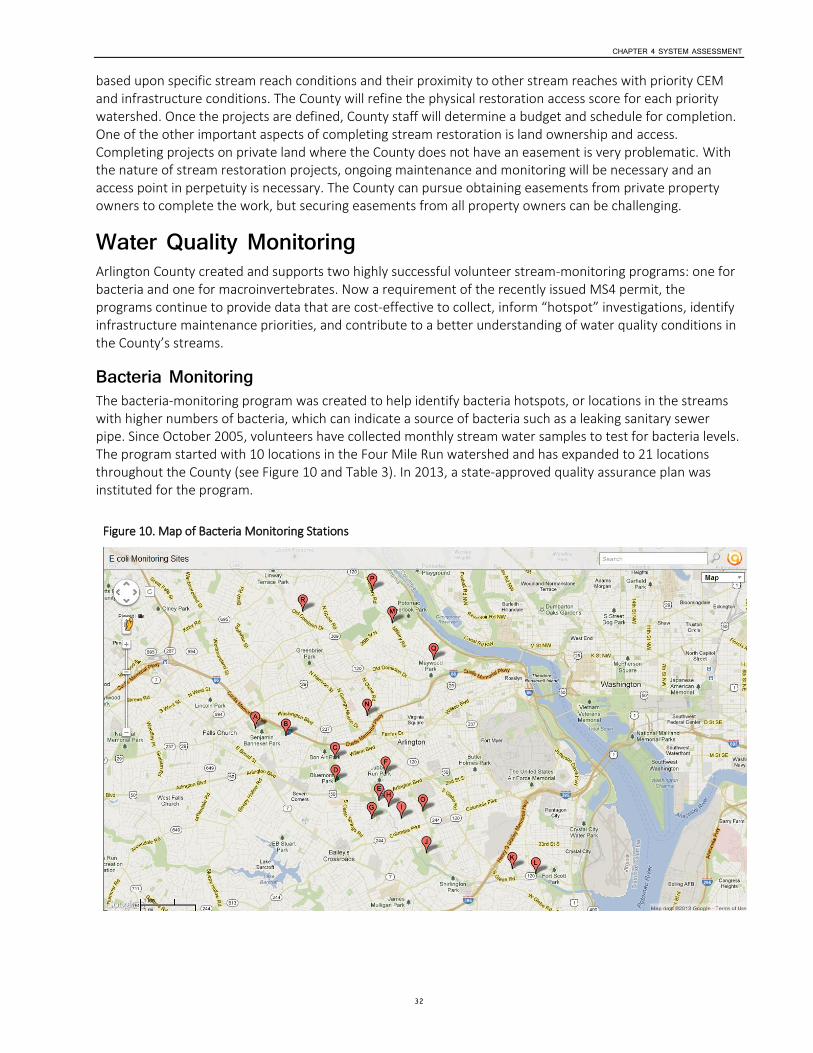
CHAPTER 4 SYSTEM ASSESSMENT
32
based upon specific stream reach conditions and their proximity to other stream reaches with priority CEM and infrastructure conditions. The County will refine the physical restoration access score for each priority watershed. Once the projects are defined, County staff will determine a budget and schedule for completion. One of the other important aspects of completing stream restoration is land ownership and access. Completing projects on private land where the County does not have an easement is very problematic. With the nature of stream restoration projects, ongoing maintenance and monitoring will be necessary and an access point in perpetuity is necessary. The County can pursue obtaining easements from private property owners to complete the work, but securing easements from all property owners can be challenging.
Water Quality Monitoring Arlington County created and supports two highly successful volunteer stream-monitoring programs: one for bacteria and one for macroinvertebrates. Now a requirement of the recently issued MS4 permit, the programs continue to provide data that are cost-effective to collect, inform “hotspot” investigations, identify infrastructure maintenance priorities, and contribute to a better understanding of water quality conditions in the County’s streams.
Bacteria Monitoring The bacteria-monitoring program was created to help identify bacteria hotspots, or locations in the streams with higher numbers of bacteria, which can indicate a source of bacteria such as a leaking sanitary sewer pipe. Since October 2005, volunteers have collected monthly stream water samples to test for bacteria levels. The program started with 10 locations in the Four Mile Run watershed and has expanded to 21 locations throughout the County (see Figure 10 and Table 3). In 2013, a state-approved quality assurance plan was instituted for the program.
Figure 10. Map of Bacteria Monitoring Stations
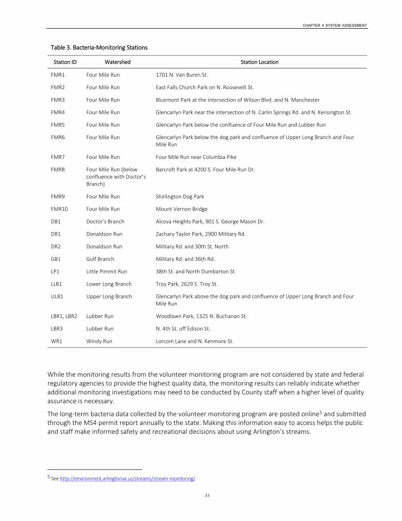
CHAPTER 4 SYSTEM ASSESSMENT
33
Table 3. Bacteria-Monitoring Stations
Station ID Watershed Station Location
FMR1 Four Mile Run 1701 N. Van Buren St.
FMR2 Four Mile Run East Falls Church Park on N. Roosevelt St.
FMR3 Four Mile Run Bluemont Park at the intersection of Wilson Blvd. and N. Manchester
FMR4 Four Mile Run Glencarlyn Park near the intersection of N. Carlin Springs Rd. and N. Kensington St.
FMR5 Four Mile Run Glencarlyn Park below the confluence of Four Mile Run and Lubber Run
FMR6 Four Mile Run Glencarlyn Park below the dog park and confluence of Upper Long Branch and Four Mile Run
FMR7 Four Mile Run Four Mile Run near Columbia Pike
FMR8 Four Mile Run (below confluence with Doctor’s Branch)
Barcroft Park at 4200 S. Four Mile Run Dr.
FMR9 Four Mile Run Shirlington Dog Park
FMR10 Four Mile Run Mount Vernon Bridge
DB1 Doctor’s Branch Alcova Heights Park, 901 S. George Mason Dr.
DR1 Donaldson Run Zachary Taylor Park, 2900 Military Rd.
DR2 Donaldson Run Military Rd. and 30th St. North
GB1 Gulf Branch Military Rd. and 36th Rd.
LP1 Little Pimmit Run 38th St. and North Dumbarton St.
LLB1 Lower Long Branch Troy Park, 2629 S. Troy St.
ULB1 Upper Long Branch Glencarlyn Park above the dog park and confluence of Upper Long Branch and Four Mile Run
LBR1, LBR2 Lubber Run Woodlawn Park, 1325 N. Buchanan St.
LBR3 Lubber Run N. 4th St. off Edison St.
WR1 Windy Run Lorcom Lane and N. Kenmore St.
While the monitoring results from the volunteer monitoring program are not considered by state and federal regulatory agencies to provide the highest quality data, the monitoring results can reliably indicate whether additional monitoring investigations may need to be conducted by County staff when a higher level of quality assurance is necessary.
The long-term bacteria data collected by the volunteer monitoring program are posted online5 and submitted through the MS4 permit report annually to the state. Making this information easy to access helps the public and staff make informed safety and recreational decisions about using Arlington’s streams.
5 See http://environment.arlingtonva.us/streams/stream-monitoring/.
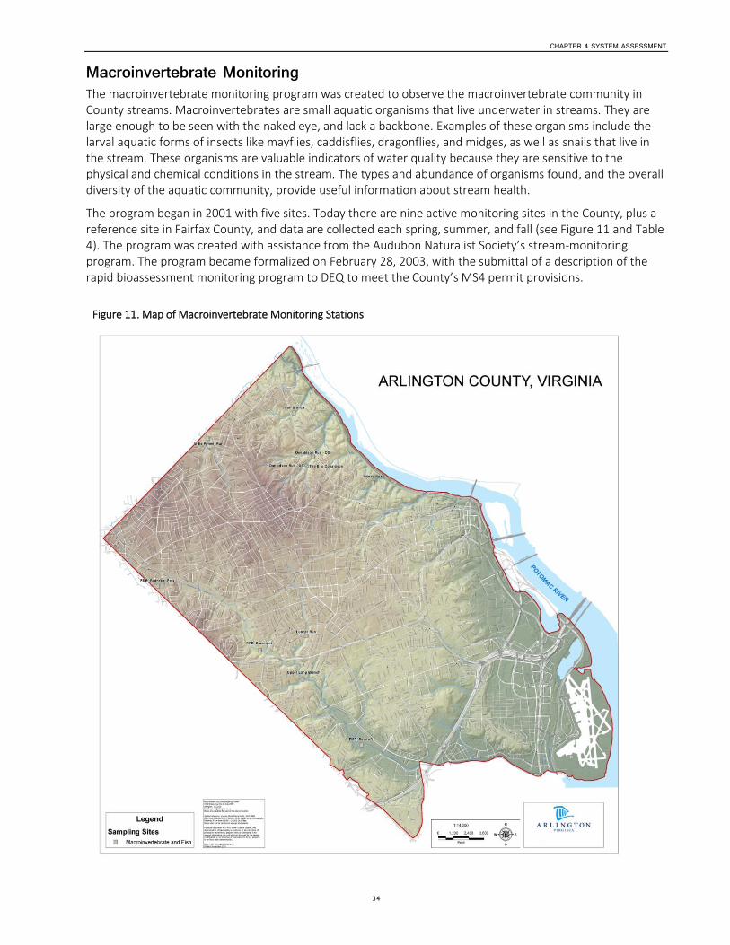
CHAPTER 4 SYSTEM ASSESSMENT
34
Macroinvertebrate Monitoring The macroinvertebrate monitoring program was created to observe the macroinvertebrate community in County streams. Macroinvertebrates are small aquatic organisms that live underwater in streams. They are large enough to be seen with the naked eye, and lack a backbone. Examples of these organisms include the larval aquatic forms of insects like mayflies, caddisflies, dragonflies, and midges, as well as snails that live in the stream. These organisms are valuable indicators of water quality because they are sensitive to the physical and chemical conditions in the stream. The types and abundance of organisms found, and the overall diversity of the aquatic community, provide useful information about stream health.
The program began in 2001 with five sites. Today there are nine active monitoring sites in the County, plus a reference site in Fairfax County, and data are collected each spring, summer, and fall (see Figure 11 and Table 4). The program was created with assistance from the Audubon Naturalist Society’s stream-monitoring program. The program became formalized on February 28, 2003, with the submittal of a description of the rapid bioassessment monitoring program to DEQ to meet the County’s MS4 permit provisions.
Figure 11. Map of Macroinvertebrate Monitoring Stations
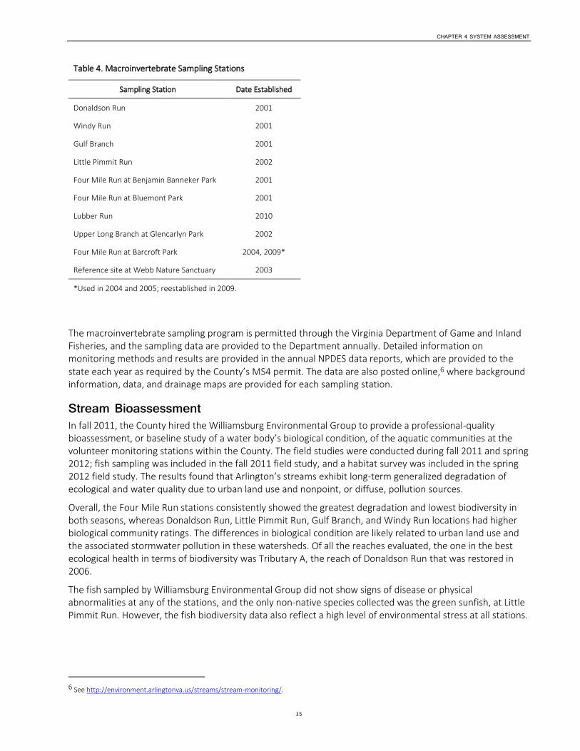
CHAPTER 4 SYSTEM ASSESSMENT
35
Table 4. Macroinvertebrate Sampling Stations
Sampling Station Date Established
Donaldson Run 2001
Windy Run 2001
Gulf Branch 2001
Little Pimmit Run 2002
Four Mile Run at Benjamin Banneker Park 2001
Four Mile Run at Bluemont Park 2001
Lubber Run 2010
Upper Long Branch at Glencarlyn Park 2002
Four Mile Run at Barcroft Park 2004, 2009*
Reference site at Webb Nature Sanctuary 2003
*Used in 2004 and 2005; reestablished in 2009.
The macroinvertebrate sampling program is permitted through the Virginia Department of Game and Inland Fisheries, and the sampling data are provided to the Department annually. Detailed information on monitoring methods and results are provided in the annual NPDES data reports, which are provided to the state each year as required by the County’s MS4 permit. The data are also posted online,6 where background information, data, and drainage maps are provided for each sampling station.
Stream Bioassessment In fall 2011, the County hired the Williamsburg Environmental Group to provide a professional-quality bioassessment, or baseline study of a water body’s biological condition, of the aquatic communities at the volunteer monitoring stations within the County. The field studies were conducted during fall 2011 and spring 2012; fish sampling was included in the fall 2011 field study, and a habitat survey was included in the spring 2012 field study. The results found that Arlington’s streams exhibit long-term generalized degradation of ecological and water quality due to urban land use and nonpoint, or diffuse, pollution sources.
Overall, the Four Mile Run stations consistently showed the greatest degradation and lowest biodiversity in both seasons, whereas Donaldson Run, Little Pimmit Run, Gulf Branch, and Windy Run locations had higher biological community ratings. The differences in biological condition are likely related to urban land use and the associated stormwater pollution in these watersheds. Of all the reaches evaluated, the one in the best ecological health in terms of biodiversity was Tributary A, the reach of Donaldson Run that was restored in 2006.
The fish sampled by Williamsburg Environmental Group did not show signs of disease or physical abnormalities at any of the stations, and the only non-native species collected was the green sunfish, at Little Pimmit Run. However, the fish biodiversity data also reflect a high level of environmental stress at all stations.
6 See http://environment.arlingtonva.us/streams/stream-monitoring/.

CHAPTER 4 SYSTEM ASSESSMENT
36
Conclusions and Future Goals Arlington County’s watershed management programs, especially its stream restoration programs, are expected to have a positive effect on the health of the macroinvertebrate community—an important indicator of stream health. As the formal bioassessment showed, it was Donaldson Run’s restored reach that produced the highest score for the biological community of all of Arlington’s sites. We expect that as stream restoration projects mature, the macroinvertebrate community will improve. However, stormwater runoff and pollution will remain key stressors to the ecology of the overall stream system, given the high amount of impervious surfaces in County watersheds and the density of the stormwater collection network that discharges untreated urban runoff directly to County streams. These stressors are much harder to address and require many decades of effort, as discussed in more detail in the watershed retrofit and Chesapeake Bay TMDL sections of this document.
Arlington’s volunteer monitoring program has demonstrated a long-term interest and commitment on the part of Arlington constituents who want to contribute to improving the health of Arlington’s streams. In the coming years, the volunteer monitoring program will shift to a more detailed identification program to provide more and better quality data to understand the health of County streams. This monitoring information will be essential to demonstrate that water quality is improving as a result of the stormwater management program.
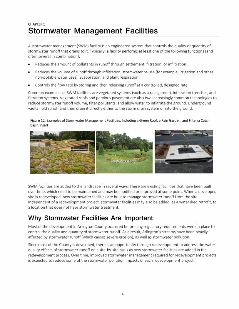
CHAPTER 5
37
Stormwater Management Facilities A stormwater management (SWM) facility is an engineered system that controls the quality or quantity of stormwater runoff that drains to it. Typically, a facility performs at least one of the following functions (and often several in combination):
Reduces the amount of pollutants in runoff through settlement, filtration, or infiltration
Reduces the volume of runoff through infiltration, stormwater re-use (for example, irrigation and other non-potable water uses), evaporation, and plant respiration
Controls the flow rate by storing and then releasing runoff at a controlled, designed rate
Common examples of SWM facilities are vegetated systems (such as a rain garden), infiltration trenches, and filtration systems. Vegetated roofs and pervious pavement are also two increasingly common technologies to reduce stormwater runoff volume, filter pollutants, and allow water to infiltrate the ground. Underground vaults hold runoff and then drain it directly either to the storm drain system or into the ground.
Figure 12. Examples of Stormwater Management Facilities, Including a Green Roof, a Rain Garden, and Filterra Catch Basin Insert
SWM facilities are added to the landscape in several ways. There are existing facilities that have been built over time, which need to be maintained and may be modified or improved at some point. When a developed site is redeveloped, new stormwater facilities are built to manage stormwater runoff from the site. Independent of a redevelopment project, stormwater facilities may also be added, as a watershed retrofit, to a location that does not have stormwater treatment.
Why Stormwater Facilities Are Important Most of the development in Arlington County occurred before any regulatory requirements were in place to control the quality and quantity of stormwater runoff. As a result, Arlington’s streams have been heavily affected by stormwater runoff (which causes severe erosion), as well as stormwater pollution.
Since most of the County is developed, there is an opportunity through redevelopment to address the water quality effects of stormwater runoff on a site-by-site basis as new stormwater facilities are added in the redevelopment process. Over time, improved stormwater management required for redevelopment projects is expected to reduce some of the stormwater pollution impacts of each redevelopment project.
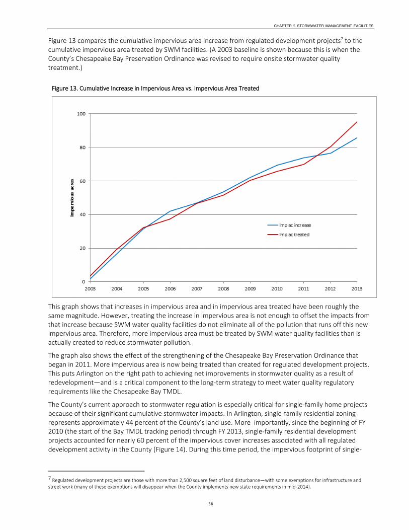
CHAPTER 5 STORMWATER MANAGEMENT FACILITIES
38
Figure 13 compares the cumulative impervious area increase from regulated development projects7 to the cumulative impervious area treated by SWM facilities. (A 2003 baseline is shown because this is when the County’s Chesapeake Bay Preservation Ordinance was revised to require onsite stormwater quality treatment.)
Figure 13. Cumulative Increase in Impervious Area vs. Impervious Area Treated
This graph shows that increases in impervious area and in impervious area treated have been roughly the same magnitude. However, treating the increase in impervious area is not enough to offset the impacts from that increase because SWM water quality facilities do not eliminate all of the pollution that runs off this new impervious area. Therefore, more impervious area must be treated by SWM water quality facilities than is actually created to reduce stormwater pollution.
The graph also shows the effect of the strengthening of the Chesapeake Bay Preservation Ordinance that began in 2011. More impervious area is now being treated than created for regulated development projects. This puts Arlington on the right path to achieving net improvements in stormwater quality as a result of redevelopment—and is a critical component to the long-term strategy to meet water quality regulatory requirements like the Chesapeake Bay TMDL.
The County’s current approach to stormwater regulation is especially critical for single-family home projects because of their significant cumulative stormwater impacts. In Arlington, single-family residential zoning represents approximately 44 percent of the County’s land use. More importantly, since the beginning of FY 2010 (the start of the Bay TMDL tracking period) through FY 2013, single-family residential development projects accounted for nearly 60 percent of the impervious cover increases associated with all regulated development activity in the County (Figure 14). During this time period, the impervious footprint of single-
7 Regulated development projects are those with more than 2,500 square feet of land disturbance—with some exemptions for infrastructure and street work (many of these exemptions will disappear when the County implements new state requirements in mid-2014).

CHAPTER 5 STORMWATER MANAGEMENT FACILITIES
39
family parcels increased by an average of 50 percent. This pace of single-family parcel impervious cover increase would add more than the footprint of the Pentagon (about 30 acres) every 10 years.
Therefore, cumulatively, single-family home projects accounted for the majority of pollutant load increases from development activity in the County during the time period studied. The Bay TMDL and Arlington’s MS4 permit require the County to offset these pollutant load increases if each project does not do so. Because of physical space constraints, it is not feasible for the County to take on this responsibility, and doing so will create a significant MS4 permit compliance risk.
Figure 14. Impervious Cover Increases from Single Family Home Development
These obligations are a shared public-private responsibility, with the County government doing its part through its watershed retrofit and stream restoration programs, and the development community implementing stormwater management controls required by the CBPO.
As discussed in Section 3, both the existing CBPO and the new state stormwater management regulations require a minimum 10 percent net reduction in pollutant loads for redevelopment projects. As a result, with the sustained redevelopment occurring in Arlington, pollutant loads associated with development are expected to decline over time.
Stormwater Facility Limitations While redevelopment projects in Virginia8 are required to reduce stormwater pollution relative to existing conditions, redevelopment projects are not required to reduce overall stormwater runoff volume. Stormwater runoff volume is a critical indicator of overall stormwater impacts, and this especially affects stream erosion. Because most redevelopment projects result in increases in impervious cover and therefore increased stormwater runoff volume, stormwater facilities may not be sufficient to offset the overall stormwater volume impacts of redevelopment. Additionally, the ability to install enough stormwater
8 Local governments in Virginia are limited in regulatory authority by the Virginia General Assembly due to the Dillon Rule. See Section 3 for more information.

CHAPTER 5 STORMWATER MANAGEMENT FACILITIES
40
management facilities to offset all impervious areas is not realistic due to limitations in available land area, technology, and budgetary constraints.
In addition, while stormwater management facilities can reduce the impact of relatively small rain events, they cannot eliminate the impacts of the more severe storm events that can present flood risks to Arlington constituents and properties. This is why the stormwater capacity analysis described in this Stormwater Master Plan is also a key component of the County’s comprehensive stormwater management program. The stormwater management facilities and stormwater system must complement each other to minimize the flooding risks throughout the County.
Conclusions and Future Goals The number of SWM facilities in Arlington has started to increase at a rapid rate because of today’s more stringent regulatory environment for stormwater. Figure 15 shows the cumulative number of SWM water quality facilities (the County’s primary focus because of the water quality obligations reflected in the new MS4 permit) built since 2003.
Figure 15. Cumulative Number of Stormwater Management Water Quality Facilities through 2013
While each property owner bears the responsibility of maintaining the SWM facilities located on their property,9 the County is required to ensure that every SWM facility is functioning as designed—for the life of the approved development currently on the property (through Chapters 60 and 61 of the County code and its MS4 permit).
Program responsibilities include recordkeeping, inspections, follow-ups, and even enforcement. As the number of SWM facilities is now rapidly increasing, the responsibilities will soon grow beyond the current staff capacity to administer. As a result, more staff and contractor resources will be necessary in the near future, with sustained resource increases over time. At the same time, creative strategies already in place will need to be expanded. These include requiring owners to self-certify, inspecting a subset of SWM facilities whose owners fail to self-certify, and randomly inspecting a subset of SWM facilities. This combination of
9 For each plan approved with SWM facilities, the property owner is required to record a maintenance agreement in the land records.
0
100
200
300
400
500
600
2003 2004 2005 2006 2007 2008 2009 2010 2011 2012 2013YTD
Nu
mb
er
of
Sto
rmw
ate
r M
an
ag
em
en
t W
ate
r Q
au
lity
F
ac
ilit
ies
Year
Cumulative Number of Stormwater Management Water Quality Facilities
(2013 figure
CHAPTER 5 STORMWATER MANAGEMENT FACILITIES
41
County inspections and owner maintenance certifications is allowed under the County’s MS4 permit, but under any combination of these two strategies, with a rapidly growing number of SWM facilities to track, the resource implications are significant.
For County-owned SWM facilities constructed as part of new parks and buildings, as well as retrofit projects, the maintenance burden will also be increasing. This means that operating budgets will need to be increased steadily over time to account for maintenance costs.
As the number of County-owned SWM facilities continues to grow, one option is for a single County maintenance group to maintain these systems (through a contractor or with County crews or through some combination). If this approach is taken, however, it may mean that this maintenance group will specify the types of SWM facilities that can be built with County projects as well as the specific engineering specifications of each facility. This represents a change from current practice, where the department responsible for the funding, designing, constructing, and maintaining facilities specifies the types of SWM facility to be constructed with the project.
Watershed Retrofits A watershed retrofit adds a SWM facility to a location where one currently does not exist, or improves an existing facility. Watershed retrofits are not completed as part of a redevelopment project, but are intended solely to increase stormwater treatment.
Three categories of retrofits are available to reduce stormwater volume and pollutants. Retrofits that store large volumes of stormwater for extended periods of time include constructed wetlands and wet ponds. These retrofits rely on gravity to cause sediment, along with other pollutants attached to sediment particles, to settle out of stormwater. Biological and microbial processes provide additional pollutant removal. These retrofits require significant land areas, and opportunities to implement them in urban communities like Arlington are typically limited.
The second category of retrofits filter captured runoff through soil, sand, or gravel to remove pollutants; examples of such retrofits are pervious pavements including pavers and pervious concrete, sand filters, infiltration trenches, dry and wet swales, and bioretention retrofits (rain gardens, for example). They can also be designed to encourage stormwater infiltration. Some filtration retrofits, in particular bioretention filters and swales, include plantings that foster microbial pollutant removal processes.
Bioretention is the most flexible of the filtration retrofits, as it can be added to an existing landscape, in parking lots, or within the public right-of-way to capture and filter stormwater. Bioretention filters include a landscaped depression or ponding area that temporarily stores stormwater. Sub-surface layers of soil and gravel filter the captured polluted runoff. Within the gravel, a perforated pipe, known as an underdrain, is connected to local stormwater infrastructure and conveys treated water to the stormwater system. A rain garden is a type of bioretention area, but typically smaller in scale and most appropriate for single-family home lots. Figure 16 shows a bioretention retrofit at the corner of 23rd St. North and N. Albemarle St., in the Spout Run watershed.

CHAPTER 5 STORMWATER MANAGEMENT FACILITIES
42
Figure 16. A Bioretention Retrofit in the Spout Run Watershed
The third category of retrofits includes facilities that decrease or capture rooftop runoff, such as green roofs, stormwater planters, and rainwater-harvesting systems. Structural concerns—and in the case of rainwater-harvesting systems, limited opportunities for water re-use—can make these retrofits challenging and cost-prohibitive to install on existing buildings. However, new buildings are often a prime candidate for such retrofits since they can be incorporated into the design at an early stage and provide substantial stormwater runoff reductions, energy savings, and aesthetic benefits.
Watershed Retrofit Assessment In 2008, the County initiated a watershed retrofit assessment to identify and prioritize locations for new stormwater facilities. From 2008 through 2013, the County contracted with the Center for Watershed Protection (CWP) to conduct the retrofit assessment. The County-wide watershed retrofit assessment resulted in a retrofit plan for each of Arlington’s watersheds and created a ranked County-wide retrofit inventory. These plans and the accompanying project list establish a strategic agenda for the County as it seeks to reduce stormwater pollution and volume given the County’s extensive existing development, and protect and improve water quality in local streams, the Potomac River, and the Chesapeake Bay to the maximum extent practicable.
Objectives Prior to initiating the watershed retrofit assessment, the County worked with CWP to define the assessment’s objectives. The fundamental objective of the watershed retrofit assessment was twofold: reducing stormwater pollution and decreasing stormwater volume. For this reason, identified sources of concentrated stormwater pollution known as hotspots (gas stations, car repair facilities, and dog parks, for example) and locations that generate significant stormwater volumes were targeted for retrofits during the assessment.
Once in place, watershed retrofits become part of the texture of the community and therefore should enhance the community whenever possible. Community aesthetics, traffic and pedestrian safety,
CHAPTER 5 STORMWATER MANAGEMENT FACILITIES
43
environmental education, habitat improvement, recreation, and green space enhancement have the potential to be affected through judicious location, design, and implementation of watershed retrofits, and were established as secondary objectives of Arlington County’s watershed retrofit assessment.
Methodology In 2007, the CWP published Urban Stormwater Retrofit Practices, Version 1.0.10 This manual outlines the methodology for completing a watershed retrofit assessment and describes the types of retrofits that can be implemented to decrease stormwater pollution and limit stormwater volume. The methodology, as applied in Arlington County, consists of seven key components:
Performing a desktop retrofit analysis using available GIS data
Establishing performance criteria for retrofits
Encouraging public involvement
Performing field assessments to evaluate potential retrofit locations
Creating a retrofit project list
Ranking retrofit projects
Developing concept designs for highly ranked retrofit projects
The desktop retrofit analysis involves screening geographic information, including aerial photography of each watershed and GIS data such as topographic features, utilities, and property boundaries. This analysis is guided by performance criteria for retrofits developed jointly by CWP and the County. These criteria set minimum standards for stormwater volume and pollutant reductions for retrofits and ensure that identified projects can be constructed, are cost-effective, and provide for public safety. The criteria were developed to be easily evaluated using GIS and field parameters.
Along with desktop analysis, public input from local constituents provides valuable information about potential retrofit opportunities. The County scheduled public forums to introduce the watershed retrofit study and collect ideas for locations for retrofit opportunities in local neighborhoods. Following field assessment and project evaluation, constituents were invited to a second session to learn about the watershed retrofit assessment results and view the inventory of retrofit projects. Ten public meetings, two for each group of watersheds, were held from 2008 through 2013 to collect ideas about potential retrofits and share results of the watershed retrofit assessment.
Field assessment is necessary to determine if each potential project site is suitable for a retrofit and to identify the most appropriate type of retrofit for the location. During a field visit, data necessary for evaluating the potential water quality and quantity benefits of a project—such as the extent of the drainage area, the potential dimensions of the retrofit project, the location of existing utilities—and potential constraints, including site use, are collected. Field data are evaluated against the performance criteria for retrofits to determine if potential projects should be excluded or incorporated in the retrofit project list. For projects that meet the criteria, photographs are taken and a conceptual sketch made.
The retrofit project list includes retrofit projects that have been identified in the desktop analysis or through public input and field assessed. GIS and field data gathered for each project are reviewed for accuracy and consistency and then added to the inventory. These data are subsequently used to evaluate and rank each retrofit.
10 Schueler, T., Hirschman, D., Novotney, M., and J. Zielinski. 2007. Urban Stormwater Retrofit Practices, Version 1.0. Center for Watershed Protection. Ellicott City, MD.
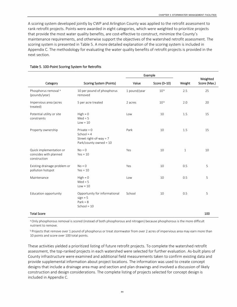
CHAPTER 5 STORMWATER MANAGEMENT FACILITIES
44
A scoring system developed jointly by CWP and Arlington County was applied to the retrofit assessment to rank retrofit projects. Points were awarded in eight categories, which were weighted to prioritize projects that provide the most water quality benefits, are cost-effective to construct, minimize the County’s maintenance requirements, and otherwise support the objectives of the watershed retrofit assessment. The scoring system is presented in Table 5. A more detailed explanation of the scoring system is included in Appendix C. The methodology for evaluating the water quality benefits of retrofit projects is provided in the next section.
Table 5. 100-Point Scoring System for Retrofits
Category Scoring System (Points)
Example
Weight Weighted
Score (Max.) Value Score (0–10)
Phosphorus removal a (pounds/year)
10 per pound of phosphorus removed
1 pound/year 10 b 2.5 25
Impervious area (acres treated)
5 per acre treated 2 acres 10 b 2.0 20
Potential utility or site constraints
High = 0 Med = 5 Low = 10
Low 10 1.5 15
Property ownership Private = 0 School = 4 Street right-of-way = 7 Park/county owned = 10
Park 10 1.5 15
Quick implementation or coincides with planned construction
No = 0 Yes = 10
Yes 10 1 10
Existing drainage problem or pollution hotspot
No = 0 Yes = 10
Yes 10 0.5 5
Maintenance High = 0 Med = 5 Low = 10
Low 10 0.5 5
Education opportunity Opportunity for informational sign = 5 Park = 8 School = 10
School 10 0.5 5
Total Score 100
a Only phosphorous removal is scored (instead of both phosphorous and nitrogen) because phosphorous is the more difficult nutrient to remove.
b Projects that remove over 1 pound of phosphorus or treat stormwater from over 2 acres of impervious area may earn more than 10 points and score over 100 total points.
These activities yielded a prioritized listing of future retrofit projects. To complete the watershed retrofit assessment, the top-ranked projects in each watershed were selected for further evaluation. As-built plans of County infrastructure were examined and additional field measurements taken to confirm existing data and provide supplemental information about project locations. The information was used to create concept designs that include a drainage area map and section and plan drawings and involved a discussion of likely construction and design considerations. The complete listing of projects selected for concept design is included in Appendix C.
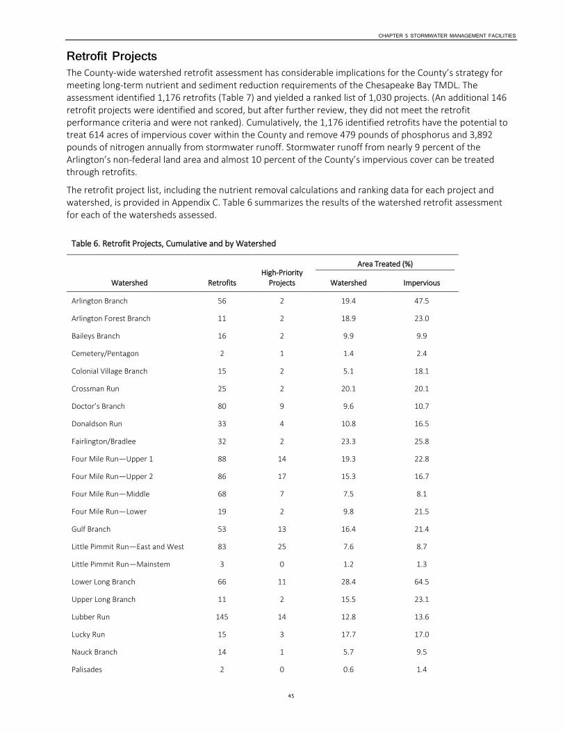
CHAPTER 5 STORMWATER MANAGEMENT FACILITIES
45
Retrofit Projects The County-wide watershed retrofit assessment has considerable implications for the County’s strategy for meeting long-term nutrient and sediment reduction requirements of the Chesapeake Bay TMDL. The assessment identified 1,176 retrofits (Table 7) and yielded a ranked list of 1,030 projects. (An additional 146 retrofit projects were identified and scored, but after further review, they did not meet the retrofit performance criteria and were not ranked). Cumulatively, the 1,176 identified retrofits have the potential to treat 614 acres of impervious cover within the County and remove 479 pounds of phosphorus and 3,892 pounds of nitrogen annually from stormwater runoff. Stormwater runoff from nearly 9 percent of the Arlington’s non-federal land area and almost 10 percent of the County’s impervious cover can be treated through retrofits.
The retrofit project list, including the nutrient removal calculations and ranking data for each project and watershed, is provided in Appendix C. Table 6 summarizes the results of the watershed retrofit assessment for each of the watersheds assessed.
Table 6. Retrofit Projects, Cumulative and by Watershed
Watershed Retrofits High-Priority
Projects
Area Treated (%)
Watershed Impervious
Arlington Branch 56 2 19.4 47.5
Arlington Forest Branch 11 2 18.9 23.0
Baileys Branch 16 2 9.9 9.9
Cemetery/Pentagon 2 1 1.4 2.4
Colonial Village Branch 15 2 5.1 18.1
Crossman Run 25 2 20.1 20.1
Doctor’s Branch 80 9 9.6 10.7
Donaldson Run 33 4 10.8 16.5
Fairlington/Bradlee 32 2 23.3 25.8
Four Mile Run—Upper 1 88 14 19.3 22.8
Four Mile Run—Upper 2 86 17 15.3 16.7
Four Mile Run—Middle 68 7 7.5 8.1
Four Mile Run—Lower 19 2 9.8 21.5
Gulf Branch 53 13 16.4 21.4
Little Pimmit Run—East and West 83 25 7.6 8.7
Little Pimmit Run—Mainstem 3 0 1.2 1.3
Lower Long Branch 66 11 28.4 64.5
Upper Long Branch 11 2 15.5 23.1
Lubber Run 145 14 12.8 13.6
Lucky Run 15 3 17.7 17.0
Nauck Branch 14 1 5.7 9.5
Palisades 2 0 0.6 1.4

CHAPTER 5 STORMWATER MANAGEMENT FACILITIES
46
Table 6. Retrofit Projects, Cumulative and by Watershed
Watershed Retrofits High-Priority
Projects
Area Treated (%)
Watershed Impervious
Pimmit Run 3 2 1.5 4.2
Rixey Branch 18 0 9.3 16.6
Roaches Run 16 1 5.0 13.9
Rocky Run 16 0 3.5 10.2
Rosslyn 4 1 1.2 3.3
Spout Run 73 5 5.5 5.7
Stohman’s Run 22 0 11.9 21.9
Torreyson Run 47 9 10.4 12.9
Virginia Highlands 17 0 2.5 7.2
Westover Branch 14 5 2.7 3.9
Windy Run 23 3 9.6 10.5
County-wide 1,176 159 8.6 9.5
The retrofit project list also does not fully depict the potential for retrofits within the County. Pervious pavement projects and private residential retrofits were generally excluded from the assessment because opportunities for these projects are widespread within the County. The pollutant reductions associated with redevelopment are also not included in this analysis, nor are the potential reductions that could be achieved through additional requirements and public-private partnerships for site plan development. Together, retrofitting, redevelopment, and public-private partnerships will be an important combined strategy to reduce pollutant loads from the urban landscape.
Among watersheds, the potential for retrofits varies significantly. In the Lower Long Branch watershed, retrofits have the potential to treat stormwater from 28 percent of the watershed and almost 65 percent of the impervious cover. In contrast, in the Westover Branch watershed, treating stormwater runoff from less than 3 percent of the watershed and from less than 4 percent of the impervious cover is possible. Such wide variation in retrofit potential among watersheds results from such factors as differences in utility and infrastructure configurations, land use, and topography and suggests that implementation is not likely to be evenly distributed among watersheds. Clear differences in potential pollutant removal among projects as demonstrated by the County-wide rankings further support a distributed approach to implementation.
Among the 21 different types of retrofit facilities identified, bioretention is by far the most common type of retrofit. Approximately 89 percent of the potential retrofits County-wide are bioretention retrofits, of which 70 percent are proposed for the public right-of-way. Retrofit objectives are therefore closely linked to Arlington’s other priorities and projects within the public right-of-way.
High-Priority Projects A subset of high-priority projects was created from the County-wide retrofit project list. The 100 most highly ranked projects, along with an additional 59 projects, were chosen. The additional 59 projects were selected because they complement another highly ranked retrofit or could be incorporated into an upcoming County capital project, have a high cost-benefit ratio, or can help address known drainage concerns.
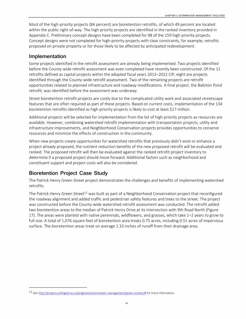
CHAPTER 5 STORMWATER MANAGEMENT FACILITIES
47
Most of the high-priority projects (84 percent) are bioretention retrofits, of which 49 percent are located within the public right-of-way. The high priority projects are identified in the ranked inventory provided in Appendix C. Preliminary concept designs have been completed for 98 of the 159 high-priority projects. Concept designs were not completed for high-priority projects with clear constraints, for example, retrofits proposed on private property or for those likely to be affected by anticipated redevelopment.
Implementation Some projects identified in the retrofit assessment are already being implemented. Two projects identified before the County-wide retrofit assessment was even completed have recently been constructed. Of the 11 retrofits defined as capital projects within the adopted fiscal years 2013–2022 CIP, eight are projects identified through the County-wide retrofit assessment. Two of the remaining projects are retrofit opportunities related to planned infrastructure and roadway modifications. A final project, the Ballston Pond retrofit, was identified before the assessment was underway.
Street bioretention retrofit projects are costly due to the complicated utility work and associated streetscape features that are often required as part of these projects. Based on current costs, implementation of the 134 bioretention retrofits identified as high-priority projects is likely to cost at least $17 million.
Additional projects will be selected for implementation from the list of high-priority projects as resources are available. However, combining watershed retrofit implementation with transportation projects, utility and infrastructure improvements, and Neighborhood Conservation projects provides opportunities to conserve resources and minimize the effects of construction in the community.
When new projects create opportunities for watershed retrofits that previously didn’t exist or enhance a project already proposed, the nutrient reduction benefits of the new proposed retrofit will be evaluated and ranked. The proposed retrofit will then be evaluated against the ranked retrofit project inventory to determine if a proposed project should move forward. Additional factors such as neighborhood and constituent support and project costs will also be considered.
Bioretention Project Case Study The Patrick Henry Green Street project demonstrates the challenges and benefits of implementing watershed retrofits.
The Patrick Henry Green Street11 was built as part of a Neighborhood Conservation project that reconfigured the roadway alignment and added traffic and pedestrian safety features and trees to the street. The project was constructed before the County-wide watershed retrofit assessment was conducted. The retrofit added two bioretention areas to the median of Patrick Henry Drive at its intersection with 9th Road North (Figure 17). The areas were planted with native perennials, wildflowers, and grasses, which take 1–2 years to grow to full size. A total of 1,076 square feet of bioretention area treats 0.75 acres, including 0.51 acres of impervious surface. The bioretention areas treat on average 1.33 inches of runoff from their drainage area.
11 See http://projects.arlingtonva.us/programs/stormwater-management/green-streets/# for more information.

CHAPTER 5 STORMWATER MANAGEMENT FACILITIES
48
Figure 17. Patrick Henry Green Street (left) in July 2011, Shortly after Construction, and (right) in July 2012
Cuts in the curb allow stormwater runoff draining from the street to enter the bioretention ponding areas. During heavy or intense rains, stormwater overflows into the storm sewer system inlets.
The total cost of construction for the bioretention components was approximately $56,000, or $52 per square foot. The project has received both positive and negative feedback from Arlington constituents. Some consider the naturalistic planting and depressed median innovative and beautiful, while others regard it as a messy “ditch.” Likely because the plantings have grown and flourished and the bioretention area has blended into the landscape and surrounding area, most of the recent comments County staff have received about this project have been very positive. However, other recent projects, like the 16th Street South bioretention project, encountered opposition from some constituents, primarily because of the potential loss of parking spaces, which led to design work being suspended at that location.
Maintenance To ensure that retrofits continue to function and provide pollutant removal benefits, bioretention facilities must be maintained. Existing bioretention retrofits are currently maintained at least quarterly by a County contractor. Maintenance includes landscaping tasks such as mulching, pruning, weeding, and replacing plants as necessary. Maintenance also includes removing sediment and trash from the ponding area, inlets, associated curb line, and crosswalks, and inspecting the overflow and underdrain pipe. Maintenance costs are included in the annual watershed retrofit budget. Currently, the maintenance cost for bioretention is calculated on the basis of surface area of the retrofit. For the Patrick Henry Green Street, the annual maintenance cost is $1,500.
Clearly, the total cost of maintenance will continue to grow as the number of retrofits increases.

CHAPTER 5 STORMWATER MANAGEMENT FACILITIES
49
Conclusions and Future Goals Anticipating multiple new retrofit projects within public right-of-ways, the County has developed and is refining a Green Streets program.12 Such public street and right-of-way projects intimately affect Arlington’s constituents, by altering pedestrian and vehicular traffic patterns, changing the right-of-way aesthetic, and in some cases removing parking. Significant outreach, both project specific and program focused, is required to inform constituents about the significant environmental benefits of bioretention retrofits and to present potential configurations for these retrofits within the public right-of-way.
As additional projects are designed, constructed, and monitored following construction, the development of County standards, particularly for street bioretention, is likely to become necessary. The current Virginia Department of Conservation and Recreation standard for bioretention13 does not provide details that address the unique and complex conditions associated with street bioretention design and construction. The standard also does not take into account Americans with Disabilities Act requirements or existing Arlington County roadway and utility design standards that have the potential to affect street bioretention projects. Accommodating these standards often increases the cost of and constrains the space available for bioretention retrofits in the street and public right-of-way. Developing a County-wide Green Infrastructure Plan will require the County to examine current connections and conflicts and develop a unified set of objectives.
12 See http://projects.arlingtonva.us/programs/stormwater-management/green-streets/#.
13 Virginia Department of Conservation and Recreation Stormwater Design Specification No. 9: Bioretention, Version 1.9. March 1, 2011. http://vwrrc.vt.edu/swc/NonPBMPSpecsMarch11/VASWMBMPSpec9BIORETENTION.html, accessed May 16, 2013.

CHAPTER 5 STORMWATER MANAGEMENT FACILITIES
50
Role of Trees in Stormwater Management While the aesthetic and air quality benefits of trees have long been appreciated, recently more attention has been focused on the importance of trees for stormwater management (see Figure 18). Healthy trees can reduce the amount of runoff and pollutants in receiving waters. Through permitting process revision by the EPA, and various watershed management projects throughout the country, trees and other green infrastructure are becoming more accepted for their role in stormwater control, supplementing traditional grey infrastructure of pipes and culverts in reducing and holding stormwater.
Using trees as green infrastructure solutions can provide benefits for a wide variety of projects, including those where space is limited, in which trees can be placed along street frontages and in common space. Urban areas with higher numbers of trees exhibit hydrology closer to natural conditions as compared with urban areas without a tree canopy. Trees intercept stormwater and retain a significant volume of the captured water on their leaves and branches, allowing for evaporation and providing runoff reduction benefits.14 For example, a large mature oak tree (over 30 inches in diameter breast height) can intercept and retain more than 500 to 1,000 gallons of rainfall in a given year.15 Furthermore, the shade provided by trees keeps the ground under the trees cooler, thereby reducing the amount of heat gained by runoff that flows over the surface under the trees. This attenuation of heat in storm water helps control increases in stream temperatures.16 With a current trend of canopy reduction, shown in Figure 19, there is a need to be proactive about protecting urban forest, to preclude expensive grey infrastructure projects needed to replace these valuable ecosystem services.
Figure 18. Trees Intercept and Slow Down Stormwater17
14 Brack, C. 2001. Pollution mitigation and carbon sequestration by an urban forest. Environmental Pollution Volume 116, Supplement 1, March, 2002 , S195-S200. 15 Akbari, Davis, Dorsano, Huang and Winnett, 1992, Cooling Our Communities: A Guidebook on Tree Planting and Light Colored Surfacing.
16 Wynn, T. 2006. Streambank Retreat: A Primer. Watershed Update , 1-14. 17 Xiao, Q.; McPherson, E.G.; Ustin, S.L.; Grismer, M.E. 2000. A new approach to modeling tree rainfall interception. Journal of Geographical Research Atmospheres 105: 29173-29188
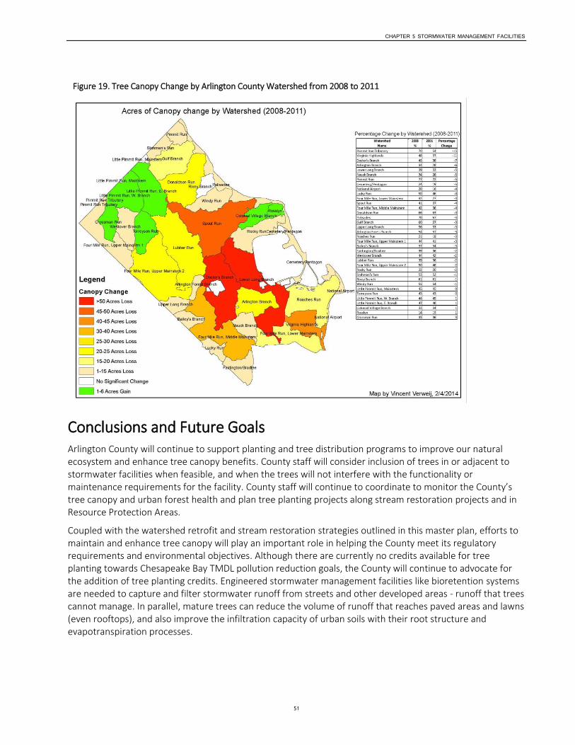
CHAPTER 5 STORMWATER MANAGEMENT FACILITIES
51
Figure 19. Tree Canopy Change by Arlington County Watershed from 2008 to 2011
Conclusions and Future Goals Arlington County will continue to support planting and tree distribution programs to improve our natural ecosystem and enhance tree canopy benefits. County staff will consider inclusion of trees in or adjacent to stormwater facilities when feasible, and when the trees will not interfere with the functionality or maintenance requirements for the facility. County staff will continue to coordinate to monitor the County’s tree canopy and urban forest health and plan tree planting projects along stream restoration projects and in Resource Protection Areas.
Coupled with the watershed retrofit and stream restoration strategies outlined in this master plan, efforts to maintain and enhance tree canopy will play an important role in helping the County meet its regulatory requirements and environmental objectives. Although there are currently no credits available for tree planting towards Chesapeake Bay TMDL pollution reduction goals, the County will continue to advocate for the addition of tree planting credits. Engineered stormwater management facilities like bioretention systems are needed to capture and filter stormwater runoff from streets and other developed areas - runoff that trees cannot manage. In parallel, mature trees can reduce the volume of runoff that reaches paved areas and lawns (even rooftops), and also improve the infiltration capacity of urban soils with their root structure and evapotranspiration processes.

CHAPTER 6
52
Outreach and Civic Engagement Outreach Programs Arlington County conducts education and outreach activities to support the MS4 permit requirements for a comprehensive variety of stormwater and watershed management issues, including illicit discharges and pollution prevention, household hazardous waste, litter, recycling, stream buffer and stream restoration, and water quality monitoring. Programs are delivered through a variety of means, including multi-media outreach efforts, Web-based information, school and civic presentations, and volunteer programs like storm drain marking (marking drains with the reminder that only rain should go down storm drains) and stream cleanups. A significant community engagement effort is a standard part of all the stormwater management and stream restoration capital projects that are completed by Arlington County.
Regional Stormwater Education Campaign Starting in 2003, Arlington County helped organize a regional educational partnership called the Northern Virginia Clean Water Partners.18 The partnership enables Northern Virginia jurisdictions to pool outreach funds to conduct a regional stormwater education campaign that includes radio advertising, online advertising, blogs, and cable TV advertising.
Campaign messages have focused primarily on educating residents and businesses to pick up pet waste, use less fertilizer, and recycle motor oil. Regular public opinion surveys measure the effectiveness of the campaign to change resident behaviors related to water pollution.
Five hundred Northern Virginia residents were surveyed during summer 2013 to measure the effectiveness of the campaign. Twenty percent of the respondents recalled seeing the advertisements on TV, even though the ads had only been running for four months at the time of the survey. Of those respondents who recalled the ads, 3 percent state they now pick up their pet waste more often, 13 percent state they plan to fertilizer fewer times per year, and 4 percent are more careful with motor oil.
Other interesting findings in the 2013 survey include:
Respondents selected fertilizers and pesticides and runoff as the main causes of pollution in the Potomac River and Chesapeake Bay for the third year in a row.
The number of respondents selecting polluted runoff from streets and parking lots as the number one cause of pollution has increased over the past 3 years.
Forty-three percent of respondents knew they live in Potomac River watershed, up from 42 percent in 2012. Fifty-three percent of Arlingtonians knew they live in the Potomac River Watershed.
Over 54 percent of respondents recalled seeing the “Only Rain Down the Storm Drain” logo.
Almost 80 percent of people surveyed reported that they always pick up after their pet, as compared with 30 percent in previous surveys.
Over 90 percent of residents surveyed stated that stormwater goes into the Potomac River or the Chesapeake Bay, or to local streams and rivers.
18 See http://www.onlyrain.org/ .
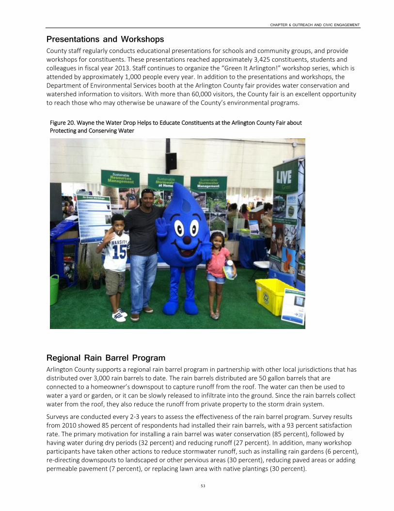
CHAPTER 6 OUTREACH AND CIVIC ENGAGEMENT
53
Presentations and Workshops County staff regularly conducts educational presentations for schools and community groups, and provide workshops for constituents. These presentations reached approximately 3,425 constituents, students and colleagues in fiscal year 2013. Staff continues to organize the “Green It Arlington!” workshop series, which is attended by approximately 1,000 people every year. In addition to the presentations and workshops, the Department of Environmental Services booth at the Arlington County fair provides water conservation and watershed information to visitors. With more than 60,000 visitors, the County fair is an excellent opportunity to reach those who may otherwise be unaware of the County’s environmental programs.
Figure 20. Wayne the Water Drop Helps to Educate Constituents at the Arlington County Fair about Protecting and Conserving Water
Regional Rain Barrel Program Arlington County supports a regional rain barrel program in partnership with other local jurisdictions that has distributed over 3,000 rain barrels to date. The rain barrels distributed are 50 gallon barrels that are connected to a homeowner’s downspout to capture runoff from the roof. The water can then be used to water a yard or garden, or it can be slowly released to infiltrate into the ground. Since the rain barrels collect water from the roof, they also reduce the runoff from private property to the storm drain system.
Surveys are conducted every 2-3 years to assess the effectiveness of the rain barrel program. Survey results from 2010 showed 85 percent of respondents had installed their rain barrels, with a 93 percent satisfaction rate. The primary motivation for installing a rain barrel was water conservation (85 percent), followed by having water during dry periods (32 percent) and reducing runoff (27 percent). In addition, many workshop participants have taken other actions to reduce stormwater runoff, such as installing rain gardens (6 percent), re-directing downspouts to landscaped or other pervious areas (30 percent), reducing paved areas or adding permeable pavement (7 percent), or replacing lawn area with native plantings (30 percent).

CHAPTER 6 OUTREACH AND CIVIC ENGAGEMENT
54
Rain Garden Workshops County staff partner with the Northern Virginia Soil and Water Conservation District and the Northern Virginia Regional Commission to conduct Rain Garden for Homeowners workshops twice each year. The rain garden workshops are generally well attended, attracting 30–40 constituents for each session. A follow-up survey of workshop attendees showed that 24 percent of the attendees installed a rain garden after attending the workshop, and 53 percent stated that they are still planning to install a rain garden. Seventy-five percent of respondents had taken another runoff-related action at home besides installing a rain garden. The most popular actions taken were re-directing downspouts, installing rain barrels, reducing lawn area, and using native plants.
StormwaterWise Landscapes Program In 2012, Arlington County, working in partnership with a local environmental group, Arlingtonians for a Clean Environment, created a pilot incentive program for private property owners to improve stormwater management on their property. The StormwaterWise Landscapes program19 provides incentives for private property owners to install rain gardens, permeable pavement, and conservation landscaping and to remove impervious pavement (see Figure 21). Funding from this program provides participants in the County’s Green Home Choice program with the opportunity to install a cistern or green roof and receive financial assistance for the project. Staff assess the property’s stormwater management issues and provide a written report with recommendations for practices that are appropriate for the property. Participants then select one or more practices to install. The current goal is to provide a financial incentive for up to 60 projects per year.
Figure 21. Two Completed StormwaterWise Projects: (left) a Permeable Driveway and (right) a Permeable Walkway
Educational Materials for Businesses County staff develops educational materials for many types of businesses in Arlington County, such as builders, construction firms, auto repair shops, restaurants, and commercial pools focused on a wide variety of topics. The most recent restaurant poster focused on proper housekeeping procedures to reduce pollutants in runoff due to cleaning practices. Some sample materials for businesses and property managers are included in Figure 22.
19 See http://environment.arlingtonva.us/stormwater-watersheds/stormwaterwise-landscapes/.

CHAPTER 6 OUTREACH AND CIVIC ENGAGEMENT
55
Figure 22. Pollution Prevention: The Business of Keeping Water Clean Folder and Selected Fact Sheets
Trash Free Potomac Watershed Education Campaign In 2005, the Alice Ferguson Foundation spearheaded the Trash Free Potomac Watershed Initiative, which initially set a goal to achieve a trash-free Potomac by 2013. This Initiative engages government agencies, communities, private organizations, and corporations through the Annual Potomac River Watershed Cleanup, the Potomac Watershed Trash Summit, and the Potomac Watershed Trash Treaty. The Foundation believes a trash-free Potomac can become a reality with education, local governmental support, and community-based action.
As part of the Initiative, organizers have developed a regional public education program for constituents, businesses, and community organizations. Arlington County provided financial support to this effort in 2008 and serves on the steering committee for the initiative. Arlington used the educational materials in all County schools, community centers, on the County Arlington Transit bus system, on the County Website, and in County park kiosks. Figure 23 is one of the materials created for this campaign.
Figure 23. Trash Free Potomac Watershed Initiative Educational Ads
Stream Volunteer Activities The storm drain marking program enlists volunteers to mark the County’s storm drains with “Only Rain Down the Drain” markers. The storm drain marker is a reminder for constituents (and potential polluters) that only rain should go down a storm drain and that dumping in storm drains is illegal. Since the program began, more than 10,000 bi-lingual door hangers have been distributed. In late 2011, the County began tracking its marking effort through a GIS-mapping application. During calendar year 2012, volunteers walked and marked 13 miles of Arlington roads. More than 26 miles were marked in 2013.
CHAPTER 6 OUTREACH AND CIVIC ENGAGEMENT
56
Civic Engagement Civic engagement is an important element of all stormwater management projects. The civic engagement process is customized for each project on the basis of its potential effects on the public. Stormwater projects range from smaller neighborhood projects affecting a small number of households, to larger-scale projects that affect multiple neighborhoods.
Engagement activities for a smaller project (one affecting under 20 households) typically include coordinating with the neighborhood’s civic association. In some cases, a special meeting may be organized with the affected constituents living adjacent to the project to gain their input, if the project is not of general interest to an entire civic association.
For a medium-scale project, one affecting 20–50 households, County staff will generally organize a public meeting about the project to present information on the project, answer constituent questions, and gather public input. Staff may choose to organize a site tour depending on the type of project. Staff may also create a webpage about the project with project information and updates.
For a large-scale project, one affecting multiple neighborhoods or a heavily used County park, additional engagement activities will be conducted. Often a Citizen Advisory Group is created to represent the various neighborhoods and groups affected by the project to share project information and gather input. Staff will generally hold several broader public meetings to review project designs, including one on-site if appropriate, in addition to meeting with the advisory group. Information about the project may be shared with all County constituents through various communications channels, such as the Insider e-newsletter or a project-specific Website.
Information about the project will also be presented to interested County commissions, such as Environment and Energy Conservation Commission; Parks, Recreation and Cultural Resources Commission; Planning Commission; Fiscal Affairs Advisory Commission; and Arlingtonians for a Clean Environment. Often after the project is completed, a celebratory event or ribbon cutting event is scheduled as well.
Conclusions These outreach activities help enlist the public’s help to reduce stormwater pollution and ensure that project information and general stormwater management information is provided to as many people as possible through a variety of communication venues. Arlington County is striving to reach as many people as possible and engage those individuals in reducing stormwater pollution through their actions. Since a large portion of the County consists of private residential properties, engaging constituents in helping reduce stormwater will go a long way towards achieving a sustainable community and meeting the County’s MS4 permit obligations.
As stormwater regulations become stricter and more projects are completed within the public area adjacent to homes, it is imperative to maintain public support. Engaging the public early and often provides constituents with a better understanding of the issues and explains the reasons behind the projects. The County’s goal is to engage the public, gather input on stormwater and watershed projects, and help constituents understand and support the County’s stormwater management program.

CHAPTER 7
57
Emerging Issues Climate Change This Stormwater Master Plan update provides a direction for the stormwater program for the next 20 years and focuses mainly on those programs required by local, state, and federal regulations and on the desire to be a more sustainable community. There are additional issues, particularly those associated with climate change, that staff is beginning to study to determine their effects on the County’s stormwater and other critical infrastructure. At this time, most climate change research is projecting changes that will begin to become evident by 2050–2100. The changes are expected to occur gradually, and the County has time to review research and determine the proper path for the County to adapt appropriately to these changes.
Climate change potentially can affect the ambient temperature, precipitation amount and intensity, and sea level. One of the uncertainties in preparing for the effects of climate change is that climate change models are generally global or at least regional, and down-scaling those modeled changes with great certainty for an area as small as Arlington County is difficult. Current available research provides some general trends for the Chesapeake Bay area, but there is uncertainty in pinpointing what will occur. The forecasting is challenging because researchers are not using historical trends to predict the future, but must utilize models to predict the future based on the impacts of climate change on physical oceanic and atmospheric processes that control the Earth’s energy and water cycles.
The effects of a warming Earth have been studied by numerous agencies, and as has been predicted by several sources, the general trend is for an increase in temperature across the United States. The average air temperature increase for the Mid-Atlantic region is estimated to be 3°F by 2050 and as much as 9°F by 2100, resulting in milder winters and extended periods of warmer summer temperatures. The number of days with an air temperature over 90°F is projected to double by 2100.20 The increased temperature will affect the evaporation of water from land and sea, resulting in more moisture being held in the atmosphere. For every 1°F rise in temperature, the water-holding capacity of the atmosphere increases by about 4 percent.21 This could also affect local stream levels if there is more evaporation.
Based on climate change models prepared by the U.S. Global Change Research Program, the yearly total rainfall amount in the Mid-Atlantic region is projected to increase by less than 10 percent by 2100, an amount not considered significant.22 Of much greater concern is that the intensity and frequency of storms is projected to increase. Current models predict more storms and more-intense storms with increased peak flooding in urban areas. Models predict that by 2050–2100, what is currently considered a 100-year storm event may become a 50-year storm event, effectively doubling the chance of a 100-year storm event happening in a year. Such higher-intensity runoff events could result in decreased water quality, including increased discharges of sediment and other urban pollutants to the region’s streams. Also predicted are more episodic storms with periods of drought in the summer and increased rainfall in the winter and spring. More-intense storms could also bring more-intense winds that can topple trees and power lines and cause other public safety risks.
Arlington County is adjacent to the Potomac River to the north and east and Four Mile Run to the south. The Potomac River and a portion of Four Mile Run are tidally influenced, and the effects of climate change on sea level rise and storm surge need to be considered. In 2010, Arlington County had a consultant complete an
20 “Global Warming and the Free State.” University of Maryland Center for Environmental Science. www.umces.edu.
21 See http://nca2009.globalchange.gov/water-resources .
22 See www.globalchange.gov .
CHAPTER 7 EMERGING ISSUES
58
analysis that evaluated predicted sea level rise due to climate change. Several climate change scenarios were reviewed, and the rise in sea level is projected to be between 1.75 and 2.44 feet by 2100. Other documents reviewed regarding sea level rise in the Chesapeake Bay area predict a rise of from 1.6 to 4.6 feet by 2100, based on current predictions of global ice sheet melting, as well as on the geologic phenomenon known as hydrostatic rebound: the Mid-Atlantic Region is slowly subsiding as the North American continental crust continues to rebound following its deformation by the weight of glaciers in the last Ice Age, approximately 10,000 years ago.
Projected sea level rise does not appear to be a significant threat at this time for Arlington County given its location near the maximum extent of tidal influence in the Potomac River estuary. However, sea level rise coupled with storm surge from hurricanes may cause significant flooding in low-lying areas. This is a particular concern for the County’s WPCP and for other critical infrastructure along Four Mile Run and the Potomac River (for example, Reagan Washington National Airport, Long Bridge Park, and above-ground sections of Metro’s Blue Line). Since the WPCP is considered critical infrastructure and relocation would be extremely costly, planning should begin in the near future on a strategy to mitigate potential storm surge effects. This will allow the County to begin evaluating the flooding risks in these areas as more data about climate change and the effects of sea level rise and storm surge become available. The recommended planning study should include an analysis of additional flood protection measures for these critical infrastructure components, particularly in the event of a major hurricane.
One of the most serious effects of increasing global temperatures, according to the Intergovernmental Panel on Climate Change (IPCC), is an increase in the intensity and occurrence of severe storms, with Atlantic hurricanes being of special concern in this region. Between 1970 and 2004, the number of major hurricanes (Category 4 or 5) worldwide nearly doubled, now making up approximately 35 percent of all hurricanes. Major hurricanes in the North Atlantic increased from 16 storms between 1974 and 1989 to 25 storms between 1989 and 2004, a 56 percent increase. One of the most significant concerns for this region is the potential for catastrophic storm surges along the Potomac River caused by a major hurricane moving up the Chesapeake Bay.
We have already experienced hurricanes with storm surges in this area. Hurricane Isabel in 2003 caused significant flooding due to a roughly 7.2-foot storm surge along the Potomac River shoreline south of Alexandria. Isabel had been a Category 5 hurricane when it was farther out in the Atlantic; by the time it made landfall near the Outer Banks of North Carolina, it was “only” a Category 2 storm, and by the time it passed this area in Virginia it was basically a Category 1 storm. Based on the average accelerated rate of sea level rise currently predicted, an equivalent hurricane could generate a roughly 11-foot storm surge by 2100.
Figure 24 shows the combined impact of sea level rise and storm surge for a Category 1 hurricane (shown in green), up to a Category 4 hurricane (shown in red), based on modeling of the Potomac River conducted by FEMA and the U.S. Army Corps of Engineers in 2009. Note that this modeling analysis assumed that the maximum hurricane storm surge occurred during high tide. This represents a worst-case analysis since the storm surge at high tide could be 3–4 feet higher, relative to low tide conditions.
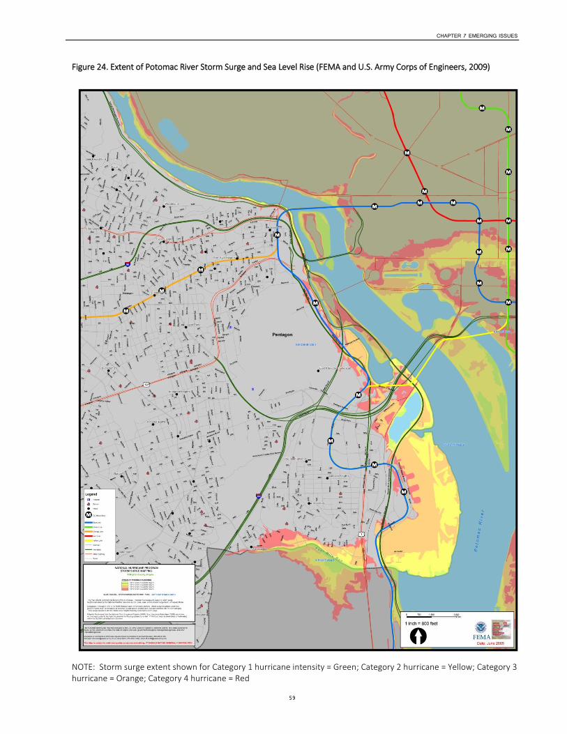
CHAPTER 7 EMERGING ISSUES
59
Figure 24. Extent of Potomac River Storm Surge and Sea Level Rise (FEMA and U.S. Army Corps of Engineers, 2009)
NOTE: Storm surge extent shown for Category 1 hurricane intensity = Green; Category 2 hurricane = Yellow; Category 3 hurricane = Orange; Category 4 hurricane = Red
CHAPTER 7 EMERGING ISSUES
60
Single-Family Home Redevelopment In Arlington, single-family residential zoning represents approximately 44 percent of the County’s land use. Since the beginning of FY 2010 (the start of the Bay TMDL tracking period) through FY 2013, single-family residential development projects accounted for nearly 60 percent of the impervious cover increases associated with all regulated development activity in the County. During this time period, the impervious footprint of single-family parcels increased by an average of 50 percent. This pace of single-family parcel impervious cover increase would add more than the footprint of the Pentagon (~30 acres) every 10 years.
Therefore, cumulatively, single-family home projects accounted for the majority of pollutant load increases from development activity in the County during the time period studied. The Bay TMDL and Arlington’s MS4 permit require the County to offset these pollutant load increases if each project does not do so.
From an overall community sustainability perspective, the issue of single family home redevelopment and lot coverage deserves a more comprehensive look given that it represents half of the County's overall land use. However, the issues raised by single family home redevelopment go beyond just stormwater runoff to include tree preservation, lot coverage, building code requirements for lot grading, basement excavation depths relative to groundwater levels, sump pump discharges, energy use, and affordable housing.
Monitoring Stream and Storm Sewer Pipe Flows As mentioned in Chapter 4, Arlington County has begun developing a state-of-the-art hydrologic and hydraulic model of the entire County-controlled storm sewer system to have a more thorough understanding of the system’s capacity limitations. This model will be used as an ongoing planning tool and a starting point for more detailed engineering analysis at locations where capacity issues are identified. As more parts of the County storm sewer system are modeled, it is important to ensure that the model results are calibrated to real-world data so that the results are accurate. At this time, there is only one stream gauging station operated by the U.S. Geological Survey (USGS) in Arlington County. This station is located on Four Mile Run, just downstream from Shirlington Road.
Of the two storms noted in Section 4 that are being used for the modeling—the 10-year Type II storm and the June 2006 storm—only one, the June 2006 storm, is based on stream gauge data. For that storm, we have rainfall data but not definitive information on the runoff from the storm, so we do not know how the storm sewer system responded to the rainfall event in terms of amount and timing of runoff. Without such data, the various input parameters are set using available County data, industry standards, and engineering judgment. Revising the parameter inputs will result in different output data that can change the results, potentially by a significant amount. The model results for the June 2006 storm have been compared to the location of calls related to flooding during the storm itself, but that is only an indirect and not statistically acceptable means to determine if the model is responding as the watershed truly does.
What is needed is a system of rain gauges and stream flow monitors to collect data to use in the models. The monitoring network would need to be in place for a minimum of several months to obtain storm data to determine the response of the watershed, but the longer the monitoring time frame and the larger the number of monitors, the more accurate the data. Since the monitors would be in the open, there is the potential for them to be damaged by storms or by vandalism, so redundancy is important in designing a monitoring network. Monitors in several locations also allow for the capture of rainfall data in various locations to increase the number of data points, since most storms do not uniformly cover the entire County.
With the large cost and effort required to upgrade the storm sewer pipes, it is desirable to have as much information as possible to ensure the system is modeled accurately and improvements completed in the most appropriate locations. Some locations may be at the limit of adequate capacity, and it is important to make sure the County reviews those areas closely. In addition to stream flow monitors, flow in specific pipes should be monitored to understand how a specific pipe segment responds to various levels and intensities of rainfall and runoff. This may be useful for locating potential projects or troubleshooting problems—if, for example,

CHAPTER 7 EMERGING ISSUES
61
an area of the system does not appear to have adequate capacity, determining which of several nearby pipes is causing the flow problem. As mentioned earlier, in some instances the model will show a pipe having inadequate capacity when the issue is actually downstream of that specific pipe. Monitoring in the specific pipe in question would provide more information about the location of potential choke points in the system. Expansion of the County’s monitoring systems will be necessary to obtain this data and should be reflected in future budget proposals.
CHAPTER 8
62
Funding Issues Complying with federal and state regulations and meeting our stormwater management goals will require a consistent source of funds to ensure that long-term plans can be implemented. Historically, dealing with stormwater problems in a piecemeal fashion is not effective, as both stormwater drainage and urban stormwater quality issues are larger problems that cannot be dealt with in isolation. Stormwater infrastructure needs to be treated as a large-scale community asset that needs to be effectively managed by the County.
The County’s original stormwater infrastructure was developed starting in the 1940s, but it was designed using very traditional urban drainage elements (e.g., curbs and gutters, catch basins, and underground storm sewers discharging runoff to the nearest stream). Virtually none of the County’s entire stormwater infrastructure provided any controls to address stormwater quantity or quality. Since the adoption of the County’s stormwater detention ordinance in 1972, there has been a substantial increase in the number of underground detention vaults that have slowed discharge rates in an effort to minimize flooding along Lower Four Mile Run. There has also been an increase in the number of stormwater quality treatment facilities constructed to comply with new County requirements since 2003, but the number and area treated by these facilities is still quite small relative to the total area drained by traditional storm sewers.
As discussed in Chapter 5, it is much harder and more costly to retrofit an area to manage stormwater than to incorporate stormwater management as part of a site’s initial design. Now that the countywide assessments have been completed for retrofits and streams, and a large part of the County has been assessed for stormwater capacity, there is a greater understanding of the existing conditions and options for meeting the regulatory requirements. The big unknown is cost for the proposed projects and the level of funding available to complete the work.
In 2008, the County Board approved a dedicated sanitary district tax to fund stormwater system improvements. The tax was initially set at $0.01/$100 of assessed property value, equating to approximately $54 per year for the typical residential household. In 2011, the rate was increased to $0.013/$100 of assessed property value, equating to approximately $72 per year for a typical residential household. This tax currently generates approximately $8 million in revenue annually, of which approximately half goes towards capital construction projects.
As federal and state stormwater regulations have become more stringent, Arlington County has had to balance funding and resources available for meeting the regulatory requirements within today’s economic climate. At this time, the majority of the County’s existing conditions and resources have been identified, proposed projects have been identified and prioritized, and the regulatory requirements are known. The question becomes, how much of the available resources are we able to dedicate to the issues?
In the past 5 years, the Office of Sustainability and Environmental Management has grown in staff and responsibility because of the requirements of the MS4 permit issued in 2002. The new MS4 permit, which was finally issued by the state in June, 2013, includes additional performance requirements and stricter regulations. Arlington County needs to be prepared to provide a defensible level of funding to meet these new regulatory requirements in coming years.
As has been discussed in this Stormwater Master Plan, there are numerous projects that could result in large construction costs. While not all of the projects have to be completed in the next 5 years, one of the critical issues facing the County is to determine the appropriate level of project completion from a funding perspective, and to understand what is required from a regulatory perspective. This issue will need to be discussed and reviewed within the context of the County’s economic climate and multiple demands for community services.
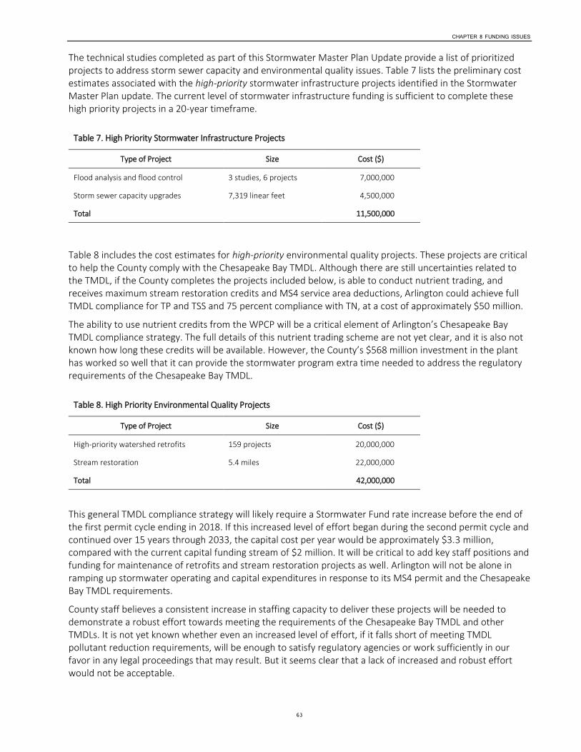
CHAPTER 8 FUNDING ISSUES
63
The technical studies completed as part of this Stormwater Master Plan Update provide a list of prioritized projects to address storm sewer capacity and environmental quality issues. Table 7 lists the preliminary cost estimates associated with the high-priority stormwater infrastructure projects identified in the Stormwater Master Plan update. The current level of stormwater infrastructure funding is sufficient to complete these high priority projects in a 20-year timeframe.
Table 7. High Priority Stormwater Infrastructure Projects
Type of Project Size Cost ($)
Flood analysis and flood control 3 studies, 6 projects 7,000,000
Storm sewer capacity upgrades 7,319 linear feet 4,500,000
Total 11,500,000
Table 8 includes the cost estimates for high-priority environmental quality projects. These projects are critical to help the County comply with the Chesapeake Bay TMDL. Although there are still uncertainties related to the TMDL, if the County completes the projects included below, is able to conduct nutrient trading, and receives maximum stream restoration credits and MS4 service area deductions, Arlington could achieve full TMDL compliance for TP and TSS and 75 percent compliance with TN, at a cost of approximately $50 million.
The ability to use nutrient credits from the WPCP will be a critical element of Arlington’s Chesapeake Bay TMDL compliance strategy. The full details of this nutrient trading scheme are not yet clear, and it is also not known how long these credits will be available. However, the County’s $568 million investment in the plant has worked so well that it can provide the stormwater program extra time needed to address the regulatory requirements of the Chesapeake Bay TMDL.
Table 8. High Priority Environmental Quality Projects
Type of Project Size Cost ($)
High-priority watershed retrofits 159 projects 20,000,000
Stream restoration 5.4 miles 22,000,000
Total 42,000,000
This general TMDL compliance strategy will likely require a Stormwater Fund rate increase before the end of the first permit cycle ending in 2018. If this increased level of effort began during the second permit cycle and continued over 15 years through 2033, the capital cost per year would be approximately $3.3 million, compared with the current capital funding stream of $2 million. It will be critical to add key staff positions and funding for maintenance of retrofits and stream restoration projects as well. Arlington will not be alone in ramping up stormwater operating and capital expenditures in response to its MS4 permit and the Chesapeake Bay TMDL requirements.
County staff believes a consistent increase in staffing capacity to deliver these projects will be needed to demonstrate a robust effort towards meeting the requirements of the Chesapeake Bay TMDL and other TMDLs. It is not yet known whether even an increased level of effort, if it falls short of meeting TMDL pollutant reduction requirements, will be enough to satisfy regulatory agencies or work sufficiently in our favor in any legal proceedings that may result. But it seems clear that a lack of increased and robust effort would not be acceptable.

CHAPTER 8 FUNDING ISSUES
64
Staff are comparing the stormwater program to other County programs that deliver capital projects at a faster pace, such as the Neighborhood Conservation Program and Transportation Capital Program. At a minimum, dedicated project management, engineering, and construction management resources are needed to implement a capital program at more than a pilot or demonstration scale, as is currently the case. The current practice of relying on carrying out watershed retrofit projects in partnership with Neighborhood Conservation and Transportation Capital Programs, while efficient in certain ways and desirable, will not be sufficient to complete projects at the rate called for under the new stormwater regulations.
An additional challenge is that regulations will most likely become stricter in the coming years as EPA and DEQ address other water quality impairments in local streams by creating additional TMDL obligations (for example, PCBs and other toxic chemicals and benthic impairments). The County needs to be flexible to respond to these changing regulations and to continue to address the entire range of stormwater needs the community expects.
CHAPTER 9
65
Conclusions This Stormwater Master Plan update evaluates the current state of stormwater management and the condition of storm sewers, streams and watersheds in Arlington County. This update provides a comprehensive framework for managing stormwater, streams, and watersheds for the next 20 years.
Given new federal and state stormwater quality requirements, Arlington County and its constituents no longer have a choice about whether to implement an enhanced stormwater program. The question facing the County now is how robust the program needs to be to ensure meeting all external regulatory requirements and the County’s own sustainability goals.
With the completion of the Stormwater Master Plan Update, the County now has a prioritized list of projects to improve storm sewer system capacity and to treat stormwater runoff. At the current level of funding, it is anticipated that it would take 100 years to complete all of the projects identified in the Stormwater Master Plan. Increased resources and staff to complete stormwater projects will be necessary to complete these projects and meet the County’s regulatory requirements, as will additional resources for maintenance and inspection of stormwater facilities.
In addition, some areas for future consideration include:
Development of a rainfall and runoff monitoring system to provide more robust data for hydrologic models;
Re-organization of the stormwater facility maintenance function within a single County maintenance group using contractors, County crews, or some combination of both;
Development of County policy for street bioretention that take into account Americans with Disabilities Act requirements and existing Arlington County roadway and utility design standards;
Development of a County-wide Green Infrastructure Plan that addresses the programs related to tree canopy, parks, stormwater facilities, and natural resources, examines current connections and conflicts, and develops a unified set of objectives; and,
Participation in the regional analysis of additional flood protection measures to protect critical infrastructure components, such as the WPCP, Reagan Washington National Airport, Long Bridge Park, and above-ground sections of Metro’s Blue Line, in the event of a major hurricane.
66
Glossary 10-year storm: A storm event of such size that is has a 10 percent chance of occurring in a given year.
10-year Type II storm: A hypothetical storm not based on an actual rainfall event that is often used in modeling and designing storm sewer systems.
100-year storm: A storm event of such size that it has a 1 percent chance of occurring in a given year.
Best management practice (BMP): Structural or engineered control devices and systems (such as retention ponds) to treat polluted stormwater, as well as operational or procedural practices (such as minimizing use of chemical fertilizers and pesticides).
Benthic: Bottom dwelling, as in aquatic organisms that live in the bottom substrate of streams.
Bioretention: A shallow, planted depression designed to retain or detain stormwater before it infiltrates into the ground or is discharged downstream.
Channel evolution model: A qualitative model used to describe how a stream channel will respond to developmental changes in the upstream watershed.
Cowardin wetland classification: A method of describing and categorizing the physical characteristics of a wetland using a standard set of criteria (such as salinity and vegetation types). Wetlands are classified alphanumerically.
Floodplain: An area of land adjacent to a stream or river that stretches from the banks of its channel to the base of the enclosing valley walls and experiences flooding during periods of high flow.
June 2006 storm: A storm that produced a record flood for the Four Mile Run watershed and that the County has used as a benchmark for modeling storm sewer capacity.
Municipal Separate Storm Sewer System (MS4): A system of publically owned stormwater conveyances (street curbs, storm drains, etc.) that conveys stormwater and discharges it to waters of the United States.
Nonpoint source pollution: Pollution from a diffuse source on the landscape, such as stream bank erosion or lawn fertilization.
Overland relief: The path stormwater will take when the stormwater collection system reaches capacity and stormwater flows over land instead of into the collection system.
Peak runoff rate: The highest rate of runoff from a given area of land during a storm event.
Point source pollution: Pollution from a specific source or location, for example, a storm drain outfall. Rainfall distribution: The amount of rain that falls in an area over a certain period of time.
Rational Method: A popular approach for determining the peak runoff rate, the Rational Method considers the entire drainage area as a single unit and estimates the peak discharge at the most downstream point of that area.
Resource Protection Area: Land adjacent to streams, lakes, bays, wetlands, or other water bodies that has an intrinsic water quality value because of the ecological and biological processes it performs or because it is sensitive to impacts that may significantly degrade the quality of state waters. Resource Protection Areas are typically 100 feet wide, but can be wider in some situations.
Rosgen stream classification: A system of describing and categorizing the physical characteristics of a stream using a standard set of criteria (such as channel slope and width-to-depth ratio). Streams are classified Level I through Level V.
GLOSSARY
67
Sanitary sewer: A system of pipes that is designed to carry sewage from houses and commercial buildings to a treatment facility.
Storm sewer: A system of pipes and other structures which carries rainwater from streets, parking lots, and other areas to streams.
Stormwater: Rainfall that does not soak into the ground and instead flows over the land surface or into a storm sewer to the nearest water body.
Stormwater runoff first flush: The first rain that flows over dry pavement, picking up the greatest concentration of pollutants.
Total maximum daily load (TMDL): The maximum daily amount of a pollutant a water body can receive and still meet water quality standards. For Arlington County, this typically refers to the Chesapeake Bay and limits in the amounts of phosphorous, nitrogen, and sediments that can be discharged into it.
Water quality volume: The volume of stormwater generated by 1 inch of rain. Watershed retrofits are designed to treat the water quality volume, because treating this stormwater removes more pollutants and has the greatest benefits for water quality.
Watershed: An area of land that drains to a water body, such as a river or lake.
Watershed retrofit: The addition of a stormwater management facility (such as a bioretention pond) to a location where none currently exists, to decrease the volume of stormwater and remove pollutants by temporarily storing runoff and encouraging soil infiltration.
68
Abbreviation List BMP: Best Management Practice
CEM: Channel Evolution Model
CIP: Capital Improvement Program
CBPO: Chesapeake Bay Preservation Ordinance
CEM: Channel Evolution Model
CFS: Cubic Feet per Second
COE: U.S. Army Corps of Engineers
CWP: Center for Watershed Protection
DCR: Virginia Department of Conservation and Recreation
DEQ: Virginia Department of Environmental Quality
DES: Department of Environmental Services
DPR: Department of Parks and Recreation
EPA: Environmental Protection Agency
E&S: Erosion and Sediment Control
FEMA: Federal Emergency Management Agency
FIRM: Flood Insurance Rate Map
GIS: Geographic Information Systems
IPCC: Intergovernmental Panel on Climate Change
MEP: Maximum Extent Practicable
MS4 Permit: Municipal Separate Storm Sewer System Permit
MS-19: Minimum Standard 19
NPDES: National Pollutant Discharge Elimination System
PCSWMM: Personal Computer Stormwater Management Model
RMA: Resource Management Area
RSAT: Rapid Stream Assessment Technique
SAR: Stream Area Reach
SWM: Stormwater Management
SWMM: Stormwater Management Model (developed by EPA)
SWMP: Stormwater Master Plan
TMDL: Total Maximum Daily Load
TN: Total Nitrogen
TP: Total Phosphorous
USM: Unified Stream Assessment Methodology

ABBREVIATION LIST
69
WPCP: Water Pollution Control Plant
VDOT: Virginia Department of Transportation

70
Technical Appendices Additional detailed information from each of the technical studies included in the Master Plan is available online in the appendices. In addition, printed reference copies of the Draft Stormwater Master Plan Update with the full appendices will be made available at the Central Library and the Courthouse Plaza Branch Library.
Appendix A: Storm Sewer Capacity Study
To identify system capacity limitations and determine the areas in which new or larger storm sewers could minimize flooding problems, the existing storm sewer drainage networks were modeled in seven watersheds: Little Pimmit Run, Doctor’s Branch, Spout Run, Westover Branch, Roaches Run, Crossman Run, and Lubber Run. These watersheds were selected because they have the most severe flooding problems in the County, based on historical information. Eventually, all County watersheds will be modeled.
The computer software used to develop the model is PCSWMM, a commercial version of EPA’s widely used stormwater management model.
View technical reports on each storm sewer study and maps of the areas with sewer capacity issues.
Crossman Run Capacity Analysis Report
Crossman Run Watershed Map
Doctor’s Branch Capacity Analysis Report
Doctor’s Branch Watershed Map
Little Pimmit Run Capacity Analysis Report
Little Pimmit Run Watershed Map
Lubber Run Capacity Analysis Report
Lubber Run Watershed Map
Roaches Run Capacity Analysis Report
Roaches Run Watershed Map
Spout Run Capacity Analysis Report
Spout Run Watershed Map
Westover Branch Capacity Analysis Report
Westover Branch Watershed Map
http://projects.arlingtonva.us/plans-studies/environment/storm-sewer-capacity-study/
Appendix B: Stream Inventory and Assessment
During 2011 and 2012, Arlington County completed a county-wide stream assessment to determine stream condition and restoration potential for the purpose of developing a prioritized list of stream restoration projects.
Stream restoration can reduce stream bank erosion and downstream sedimentation and improve stream habitat for aquatic organisms. Stream restoration can also protect nearby storm and sanitary sewer and potable water infrastructure in a way that is more sustainable than hardening the stream crossing or using on other pipe protection methods. The county-wide stream assessment looked closely at both physical stream conditions and infrastructure conditions with the goal of developing restoration priorities for specific stream systems and surrounding infrastructure.
Stream Inventory Data Analysis Methods and Overview of Results
Stream Inventory Scoring Charts by Watershed
High Priority Watershed Maps (based on assessment scores):
Donaldson Run Stream Inventory Map

TECHNICAL APPENDICES
71
Gulf Branch Stream Inventory Map
Palisades Stream Inventory Map
Pimmit Run Stream Inventory Map
Windy Run Stream Inventory Map
http://projects.arlingtonva.us/plans-studies/environment/stream-assessment/
Appendix C: Watershed Retrofit Studies
In 2008, the County initiated a watershed retrofit assessment to identify and prioritize locations for new stormwater facilities. From 2008 through 2013, the County contracted with the Center for Watershed Protection to conduct the retrofit assessment. The County-wide watershed retrofit assessment resulted in a retrofit plan for each of Arlington’s watersheds and created a ranked County-wide retrofit inventory. These plans and the accompanying inventory establish a strategic agenda for the County as it seeks to reduce stormwater pollution and volume given the County’s extensive existing development, and protect and improve water quality in local streams, the Potomac River, and the Chesapeake Bay to the maximum extent practicable.
Little Pimmit Run Study—completed
Donaldson Run, Gulf Branch, Upper Four Mile Run Study—completed
Lubber Run, Spout Run, Windy Run, Doctor's Branch—completed
Four Mile Run, Upper and Middle Mainstem—completed
Potomac Palisades and Four Mile Run, Lower Mainstem—completed
http://projects.arlingtonva.us/plans-studies/environment/watershed-retrofit-study/

Department of Environmental ServicesOffice of Sustainability and Environmental Management2100 Clarendon Boulevard, Suite 705Arlington, Virginia 22201TEL 703.228.4488 FAX 703.228.7134