STORMWATER MANAGEMENT REPORT - nhctap.com Hog Hill...... \_PROJECT\0907221\DRAINAGE\STORMWATER...
112
V:\_PROJECT\0907221\DRAINAGE\STORMWATER MANAGEMENT REPORT.DOC STORMWATER MANAGEMENT REPORT HOG HILL BROOK Island Pond Road and West Side Drive Atkinson, New Hampshire December 21, 2009 KNA Project No. 09-0722-1 Prepared For: Ted Stewart, Road Agent Town of Atkinson 21 Academy Avenue Atkinson, New Hampshire Prepared By: Keach-Nordstrom Associates, Inc. 10 Commerce Park North, Suite 3 Bedford, New Hampshire 03110 (603) 627-2881 (603) 627-2915 (fax)
Transcript of STORMWATER MANAGEMENT REPORT - nhctap.com Hog Hill...... \_PROJECT\0907221\DRAINAGE\STORMWATER...
V:\_PROJECT\0907221\DRAINAGE\STORMWATER MANAGEMENT REPORT.DOC
STORMWATER MANAGEMENT REPORT
HOG HILL BROOK Island Pond Road and West Side Drive
Atkinson, New Hampshire
December 21, 2009
KNA Project No. 09-0722-1
Prepared For: Ted Stewart, Road Agent
Town of Atkinson 21 Academy Avenue Atkinson, New Hampshire Prepared By: Keach-Nordstrom Associates, Inc. 10 Commerce Park North, Suite 3 Bedford, New Hampshire 03110 (603) 627-2881 (603) 627-2915 (fax)
PAGE 2
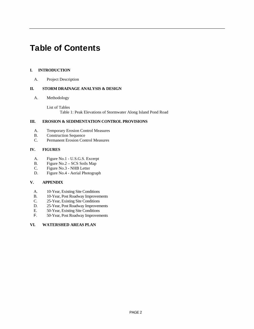
Table of Contents
I. INTRODUCTION
A. Project Description
II. STORM DRAINAGE ANALYSIS & DESIGN
A. Methodology List of Tables Table 1: Peak Elevations of Stormwater Along Island Pond Road
III. EROSION & SEDIMENTATION CONTROL PROVISIONS
A. Temporary Erosion Control Measures B. Construction Sequence C. Permanent Erosion Control Measures
IV. FIGURES
A. Figure No.1 - U.S.G.S. Excerpt B. Figure No.2 – SCS Soils Map C. Figure No.3 - NHB Letter D. Figure No.4 - Aerial Photograph
V. APPENDIX
A. 10-Year, Existing Site Conditions B. 10-Year, Post Roadway Improvements C. 25-Year, Existing Site Conditions D. 25-Year, Post Roadway Improvements E. 50-Year, Existing Site Conditions F. 50-Year, Post Roadway Improvements
VI. WATERSHED AREAS PLAN

PAGE 3
I. INTRODUCTION
A. Project Description
In May 2006 southern New Hampshire experienced devastating floods that destroyed many local roadways and bridges. Heavy rains drenched the area for days. Island Pond Road in Atkinson, New Hampshire was no exception. Hog Hill Brook crosses beneath Island Pond Road at three locations. The first crossing is through a 48” diameter reinforced concrete pipe (Pond 3P on the attached Watershed Areas Plan). The second two crossings are accomplished through existing 45” diameter reinforced concrete pipes (Ponds 4P and 6P respectively). Between the second and third crossings of Hog Hill Brook under Island Pond Road, an existing 60” diameter reinforced concrete pipe underlies an abandoned gravel roadway. This pipe does not restrict flow and add to the existing deficiencies because it is so much larger than those both upstream and downstream. During the 2006 spring rainstorms, Island Pond Road experienced significant damage when storm surges overwhelmed the three existing crossings and overtopped the road. The watershed area contributing to the subject crossings is approximately 4.79 square miles in area. The area combines woodland, developed residential and commercial property, and wetlands. Approximately 13% of the overall watershed is wet. The attached Watershed Areas Plan delineates four separate watershed areas that contribute to the flow of water beneath Island Pond Road. Sawmill Swamp collects and conveys stormwater from higher elevations in Hampstead, New Hampshire into Johnsons Pond. For the purpose of the attached Stormwater Management report, it was assumed that the outlet of Johnsons Pond consists of an earthen broad crested weir, 20’ in length and 5’ in breadth. Stormwater that outlets over the Johnsons Pond weir is directed toward Hog Hill Pond through a natural drainage way. For the purpose of this analysis, the drainage way has an assumed 20’ width and 20:1 earthen side slopes. The conservative assumption was made that the conveyance channels between water bodies would not create restrictions and lessen peak flow rates through the subject crossings. From Hog Hill Pond, stormwater is directed through another shallow natural drainage way to Hodges Mill Pond. Hodges Mill Pond is a man-made water impoundment approximately 1 acre in area. The impoundment consists of a dam approximately 60’ in length and 10’ in height. At the approximate center of the dam is a narrow breach. The New Hampshire Department of Environmental Services (NHDES) has identified the breach at 7’ wide and 1.5’ in breadth. According to a report prepared by NHDES, the bottom of the breach is approximately 1’ from the bottom of the impoundment. The dam is considered “non-menace” at this time because, as stated in an inspection report from NHDES dated December 20, 2006, “if the dam were to breach during the storm very limited additional flow would occur downstream as a result.” The first and second culvert crossings under Island Pond Road are situated between the outlet of Hog Hill Pond and the inlet of Hodges Mill Pond. The third crossing under Island Pond Road is downstream of the dam at Hodges Mill Pond. The purpose of the proposed roadway improvements project is to replace the existing round culverts with adequately sized concrete box culverts. The attached HydroCAD analysis suggests that the existing crossings are overwhelmed during the 10-year design storm causing water to overtop Island Pond Road. The design of the proposed culverts is based on the results of a watershed analysis during the 50-year return frequency storm event at the crossing passing the largest peak flow of stormwater. Based on the results of the attached hydraulic analysis, we recommend the installation of three 9’ wide by 5’ tall concrete box culverts with both inlet and outlet headwalls; one at each of the three Island Pond Road crossings. These precast units will accommodate flow from the 50-year return frequency storm event without overtopping the roadway. The results of the attached HydroCAD hydraulic analysis were compared to those available online through the USGS New Hampshire Streamstats database. The peak flow estimates were very similar, within a margin of error for a study of this size, which confirms the magnitude of stormwater flow at each location.

PAGE 4
In response to a further inquiry from the Atkinson Highway Department, this report was expanded to analyze the crossing of Hog Hill Brook beneath West Side Drive. Information relative to the existing conditions at this location is based entirely on available USGS topographic data and the results of a visual site inspection conducted by this office. The crossing consists of an 8’ diameter corrugated metal culvert with dry-stack boulder headwalls at both the inlet and outlet. Upstream of the crossing, a 7.5-acre impoundment area exists. The flow of water from the impoundment is controlled by a broad crested earthen berm made primarily of large boulders. The attached HydroCAD hydraulic analysis reveals that even during the 50-year storm event, Hog Hill Brook does not reach the elevation of the West Side Drive road surface. In other words, the existing crossing at West Side Drive is appropriately sized to accommodate the design storm event, and therefore does not require replacement due to hydraulic capacity. To address concerns relative to potential erosion and undermining of the existing culvert, we suggest the injection of a non-shrink hydraulic cement or mortar. It is our understanding that the Atkinson Road Agent may seek the services of a private contractor to slip line the existing culvert, creating a seamless conduit that matches very closely the existing pipe diameter and flow capacity. Our office is prepared to review shop drawings for the proposed product. Upon receipt of these drawings, we would be happy to render our opinion relative to the same.

PAGE 5
II. Storm Drainage Analysis & Design
A. Methodology
The 50-Year return frequency storm event has been used in the various aspects of analysis and design of the proposed culvert replacements for the subject project. The proposed culvert replacements will prevent stormwater from overtopping Island Pond Road at each of the three Hog Hill Brook crossings during the 50-year return frequency storm event, as summarized in Table 1, below.
In appreciation of the benefits and limitations related to each of the various methods available to design professionals for estimating peak stormwater discharge volumes for use in analysis and design, the TR-20 computer model was used. Values for Time of Concentration used in analysis were estimated using the methodology contained within USDA-S.C.S. publication Urban Hydrology for Small Watersheds Technical Release No. 55 (TR 55).
All design and analysis calculations performed using the referenced methodologies are attached to this report. These calculations document each catchment area, a breakdown of surface type, time of concentration, rainfall intensity, peak discharge volume, Manning’s value, peak velocity, and other descriptive design data for each watershed and pipe segment evaluated. In addition, the “Watershed Areas Plan,” attached in the back of this report, graphically defines and illustrates the extent of the area for each watershed or catchment area investigated.
TABLE 1: Peak Elevations of Stormwater Along Island Pond Road
Pre Post Pre Post Pre Post
First Crossing 206.92 203.85 207.50 205.31 207.78 206.11(flood elev.=206.48)
Second Crossing 201.47 197.22 202.20 198.66 202.56 199.46(flood elev.=200.40)
Third Crossing 187.89 183.49 188.50 184.94 188.78 185.74(flood elev.=186.92)
10-Year Storm Event 25-Year Storm Event 50-Year Storm Event
III. EROSION & SEDIMENTATION CONTROL PROVISIONS
A. Temporary Erosion Control Measures
As an integral part of the engineering design of this site, an erosion and sedimentation control plan has been developed with the intent of limiting the potential for soil loss and associated receiving water quality degradation, both during and after the construction period. As the project plans indicate, traditional temporary erosion and sedimentation control devices and practices, such as siltation fencing, hay baling and seeding have been specified for use during the construction period. In preparation of these provisions, reference was made to the Stormwater Management and Erosion and Sediment Control Handbook for Urban and Developing Areas in New Hampshire. Construction details for each temporary erosion control measure and practice specified have been added to the project plans. These plans also contain a number of erosion control notes, which are offered to the selected contractor in order to supplement the specified measures and practices to the extent practical. The design plans also caution the contractor and make note that the shown erosion control practices are a minimum standard and serve as a guide only. More extensive erosion control measures are, by mention, incorporated into the plat as field conditions warrant or as directed by the appropriate Local or State authority.
B. Construction Sequence
A site specific construction sequence sensitive to limiting soil loss due to erosion and associated water quality degradation was prepared specifically for this project and is shown on the project plans. As pointed out in the erosion control notes, it is important for the contractor to recognize that proper judgement in the implementation of work will be essential if erosion is to be limited and protection of completed work is to be realized. Moreover, any specific changes in sequence and/or field conditions effecting the ability of specific erosion control measures to adequately serve their intended purpose should be reported to this office by the contractor. Further, the contractor is encouraged to supplement specified erosion control measures during the construction period where and when in his best judgement additional protection is warranted.
C. Permanent Erosion Control Measures
In the original design of this site, consideration was given to limiting the potential for long-term erosion of completed improvements. As a result, several permanent erosion control measures are incorporated into the design of the site. These provisions include:
1) Placement of rip-rap where needed to reduce stormwater velocities to manageable levels;
2) Specification of a turf establishment schedule and seed mixture, utilizing materials and workmanship recognized as appropriate for the site conditions at hand.

IV. FIGURES
Figure No.1 - U.S.G.S. Excerpt
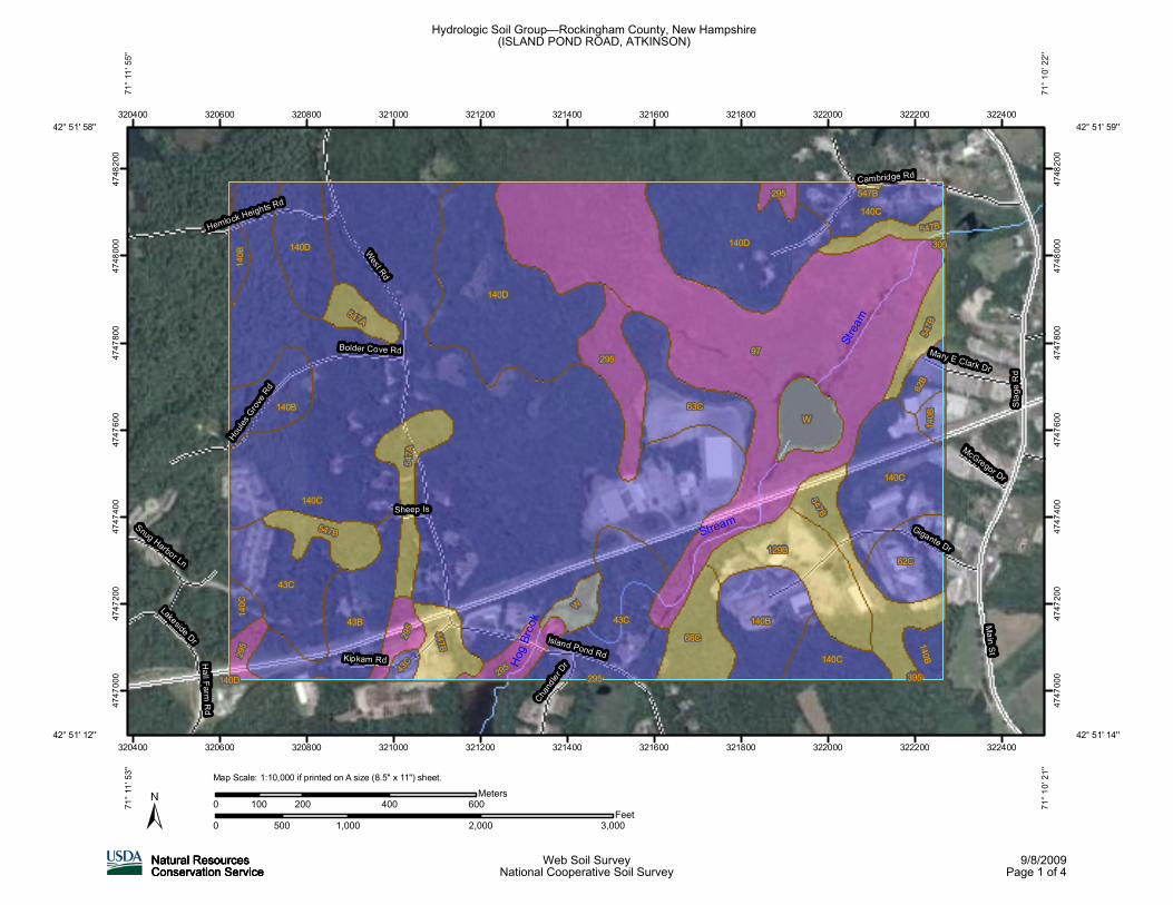
Figure No.2 – SCS Hydrologic Soil Group Map
Figure No.3 – New Hampshire Natural Heritage Inventory Letter
Figure No.4 – Aerial Photograph

FIGURE 1: USGS EXCERPT


FIGURE 2: SCS HYDROLOGIC SOIL GROUP MAP
Strea
m
Hog B
rook
Stream
West Rd
Stage
Rd
Gigante Dr
Cambridge Rd
Island Pond Rd
Main St
Hemlock Heights Rd
Kipkam Rd
Houles
Grove R
d
Bolder Cove Rd
Lakeside Dr
Chandle
r Dr
Mary E Clark Dr
Hall Farm Rd
McGregor Dr
Sheep IsSnug Harbor Ln
97
140C
140D
140D
43C43B
43C
140C
129B
63C
140B
W
295547B
62C
66C
140D
140C
140B54
7A
140C
W
547B
295
447B295
547B
62B
547A
547B29
5 140B14
0C14
0B
140B
43C
295 547B
305
395295140D
320400
320400
320600
320600
320800
320800
321000
321000
321200
321200
321400
321400
321600
321600
321800
321800
322000
322000
322200
322200
322400
322400
4747
000
4747
000
4747
200
4747
200
4747
400
4747
400
4747
600
4747
600
4747
800
4747
800
4748
000
4748
000
4748
200
4748
200
0 1,000 2,000 3,000500Feet
0 200 400 600100Meters
42° 51' 59''
71° 1
0' 22
''
42° 51' 14''
71° 1
0' 21
''
42° 51' 12''
42° 51' 58''71
° 11'
53''
71° 1
1' 55
''
Map Scale: 1:10,000 if printed on A size (8.5" x 11") sheet.
Hydrologic Soil Group—Rockingham County, New Hampshire(ISLAND POND ROAD, ATKINSON)
Natural ResourcesNatural ResourcesNatural ResourcesNatural ResourcesConservation ServiceConservation ServiceConservation ServiceConservation Service
Web Soil SurveyNational Cooperative Soil Survey
9/8/2009Page 1 of 4

MAP LEGEND MAP INFORMATION
Area of Interest (AOI)Area of Interest (AOI)
SoilsSoil Map Units
Soil RatingsA
A/D
B
B/D
C
C/D
D
Not rated or not available
Political FeaturesCities
Water FeaturesOceans
Streams and Canals
TransportationRails
Interstate Highways
US Routes
Major Roads
Local Roads
Map Scale: 1:10,000 if printed on A size (8.5" × 11") sheet.
The soil surveys that comprise your AOI were mapped at 1:24,000.
Please rely on the bar scale on each map sheet for accurate mapmeasurements.
Source of Map: Natural Resources Conservation ServiceWeb Soil Survey URL: http://websoilsurvey.nrcs.usda.govCoordinate System: UTM Zone 19N NAD83
This product is generated from the USDA-NRCS certified data as ofthe version date(s) listed below.
Soil Survey Area: Rockingham County, New HampshireSurvey Area Data: Version 10, Aug 18, 2009
Date(s) aerial images were photographed: 8/28/2003; 7/10/2003
The orthophoto or other base map on which the soil lines werecompiled and digitized probably differs from the backgroundimagery displayed on these maps. As a result, some minor shiftingof map unit boundaries may be evident.
Hydrologic Soil Group–Rockingham County, New Hampshire(ISLAND POND ROAD, ATKINSON)
Natural ResourcesConservation Service
Web Soil SurveyNational Cooperative Soil Survey
9/8/2009Page 2 of 4
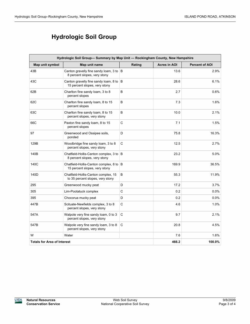
Hydrologic Soil Group
Hydrologic Soil Group— Summary by Map Unit — Rockingham County, New Hampshire
Map unit symbol Map unit name Rating Acres in AOI Percent of AOI
43B Canton gravelly fine sandy loam, 3 to8 percent slopes, very stony
B 13.6 2.9%
43C Canton gravelly fine sandy loam, 8 to15 percent slopes, very stony
B 28.6 6.1%
62B Charlton fine sandy loam, 3 to 8percent slopes
B 2.7 0.6%
62C Charlton fine sandy loam, 8 to 15percent slopes
B 7.3 1.6%
63C Charlton fine sandy loam, 8 to 15percent slopes, very stony
B 10.0 2.1%
66C Paxton fine sandy loam, 8 to 15percent slopes
C 7.1 1.5%
97 Greenwood and Ossipee soils,ponded
D 75.8 16.3%
129B Woodbridge fine sandy loam, 3 to 8percent slopes, very stony
C 12.5 2.7%
140B Chatfield-Hollis-Canton complex, 3 to8 percent slopes, very stony
B 23.2 5.0%
140C Chatfield-Hollis-Canton complex, 8 to15 percent slopes, very stony
B 169.9 36.5%
140D Chatfield-Hollis-Canton complex, 15to 35 percent slopes, very stony
B 55.3 11.9%
295 Greenwood mucky peat D 17.2 3.7%
305 Lim-Pootatuck complex C 0.2 0.0%
395 Chocorua mucky peat D 0.2 0.0%
447B Scituate-Newfields complex, 3 to 8percent slopes, very stony
C 4.6 1.0%
547A Walpole very fine sandy loam, 0 to 3percent slopes, very stony
C 9.7 2.1%
547B Walpole very fine sandy loam, 3 to 8percent slopes, very stony
C 20.8 4.5%
W Water 7.6 1.6%
Totals for Area of Interest 466.2 100.0%
Hydrologic Soil Group–Rockingham County, New Hampshire ISLAND POND ROAD, ATKINSON
Natural ResourcesConservation Service
Web Soil SurveyNational Cooperative Soil Survey
9/8/2009Page 3 of 4

Description
Hydrologic soil groups are based on estimates of runoff potential. Soils areassigned to one of four groups according to the rate of water infiltration when thesoils are not protected by vegetation, are thoroughly wet, and receive precipitationfrom long-duration storms.
The soils in the United States are assigned to four groups (A, B, C, and D) andthree dual classes (A/D, B/D, and C/D). The groups are defined as follows:
Group A. Soils having a high infiltration rate (low runoff potential) when thoroughlywet. These consist mainly of deep, well drained to excessively drained sands orgravelly sands. These soils have a high rate of water transmission.
Group B. Soils having a moderate infiltration rate when thoroughly wet. Theseconsist chiefly of moderately deep or deep, moderately well drained or well drainedsoils that have moderately fine texture to moderately coarse texture. These soilshave a moderate rate of water transmission.
Group C. Soils having a slow infiltration rate when thoroughly wet. These consistchiefly of soils having a layer that impedes the downward movement of water orsoils of moderately fine texture or fine texture. These soils have a slow rate of watertransmission.
Group D. Soils having a very slow infiltration rate (high runoff potential) whenthoroughly wet. These consist chiefly of clays that have a high shrink-swellpotential, soils that have a high water table, soils that have a claypan or clay layerat or near the surface, and soils that are shallow over nearly impervious material.These soils have a very slow rate of water transmission.
If a soil is assigned to a dual hydrologic group (A/D, B/D, or C/D), the first letter isfor drained areas and the second is for undrained areas. Only the soils that in theirnatural condition are in group D are assigned to dual classes.
Rating Options
Aggregation Method: Dominant Condition
Component Percent Cutoff: None Specified
Tie-break Rule: Lower
Hydrologic Soil Group–Rockingham County, New Hampshire ISLAND POND ROAD, ATKINSON
Natural ResourcesConservation Service
Web Soil SurveyNational Cooperative Soil Survey
9/8/2009Page 4 of 4

FIGURE 3: NHB LETTER

New Hampshire Natural Heritage Bureau
Department of Resources and Economic Development DRED/NHB Division of Forests and Lands PO Box 1856 (603) 271-2214 fax: 271-6488 Concord NH 03302-1856
The NH Natural Heritage database has been checked for records of rare species and exemplary natural communities near the area mapped below. The species considered include those listed as Threatened or Endangered by either the state of New Hampshire or the federal government. We currently have no recorded occurrences for sensitive species near this project area. A negative result (no record in our database) does not mean that a sensitive species is not present. Our data can only tell you of known occurrences, based on information gathered by qualified biologists and reported to our office. However, many areas have never been surveyed, or have only been surveyed for certain species. An on-site survey would provide better information on what species and communities are indeed present
This review is valid through 9/17/2010.
9/17/2009Date:To: Patrick ColburnKeach Nordstrom Associates, Inc.10 Commerce Park No. Suite 3BBedford, NH 03110
NH Natural Heritage BureauFrom:
Review by NH Natural Heritage Bureau of request dated 9/17/2009Re:
VALID ONLY FOR NOTIFICATION OR MINIMUM EXPEDITEDAPPLICATIONS SUBMITTED TO THE NHDES WETLANDS BUREAU
Applicant: Patrick ColburnNHB09-1990NHB File ID:
Description: ISLAND POND ROAD WHERE HOG HILL BROOK CROSSES Atkinson
Project Categories: Bank Stablization: Retaining wall Roads, Driveways, Bridges: Culvert(s) Roads, Driveways, Bridges: Guardrail installation Roads, Driveways, Bridges: Road construction

New Hampshire Natural Heritage Bureau
Department of Resources and Economic Development DRED/NHB Division of Forests and Lands PO Box 1856 (603) 271-2214 fax: 271-6488 Concord NH 03302-1856
MAP OF PROJECT BOUNDARIES FOR: NHB ID# NHB09-1990

FIGURE 4: AERIAL PHOTOGRAPH
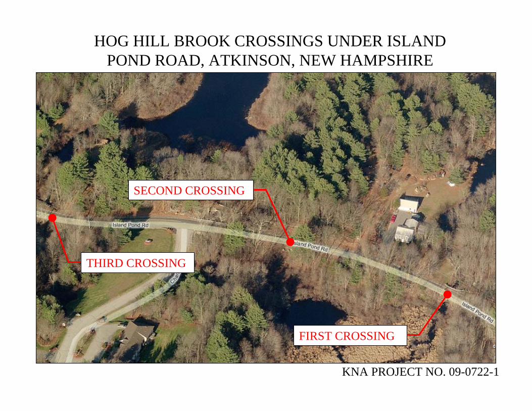
THIRD CROSSING
SECOND CROSSING
FIRST CROSSING
HOG HILL BROOK CROSSINGS UNDER ISLAND POND ROAD, ATKINSON, NEW HAMPSHIRE
KNA PROJECT NO. 09-0722-1

V. APPENDIX
A. 10-Year, Existing Site Conditions
B. 10-Year, Post Roadway Improvements
C. 25-Year, Existing Site Conditions
D. 25-Year, Post Roadway Improvements
E. 50-Year, Existing Site Conditions
F. 50-Year, Post Roadway Improvements

A: 10-YEAR, EXISTING SITE CONDITIONS

1S
1S
2S
2S
4S
4S
5S
5S
7S
7S
1R
THROUGH 2S
2R
THROUGH 5S
3R
THROUGH 4S
4R
THROUGH 5S
5R
HODGES MILL POND TO ISLAND POND
ROAD
6R
HOG HILL BROOK TO IMPOUNDMENT AREA
1P
JOHNSONS POND
2P
HOG HILL POND
3PCB
48" RCP UNDER ISLAND POND ROAD
4PCB
45" RCP UNDER ISLAND POND ROAD AND 60" RCP UNDER
TRAIL
5P
HODGES MILL POND
6PCB
45" CROSSING UNDER ISLAND POND ROAD
7P
EXISTING IMPOUNDMENT AREA
8PCB
CROSSING UNDER WEST SIDE DRIVE
1L
HOG HILL BROOK
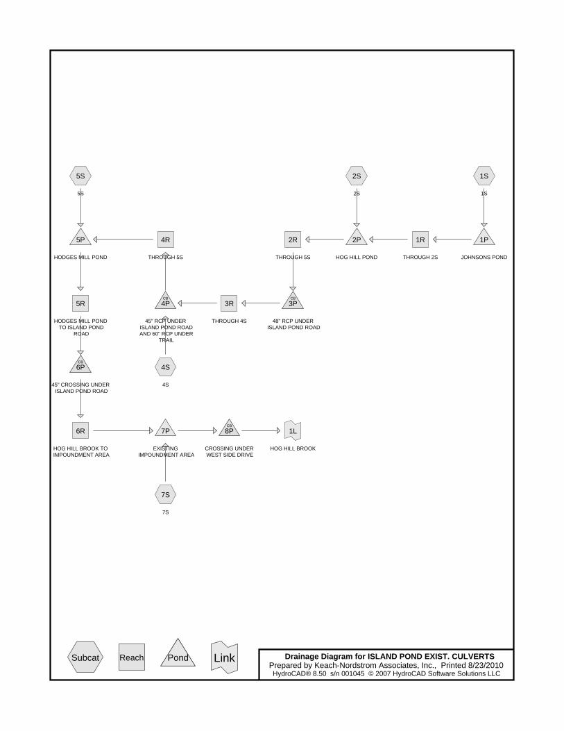
Drainage Diagram for ISLAND POND EXIST. CULVERTSPrepared by Keach-Nordstrom Associates, Inc., Printed 8/23/2010HydroCAD® 8.50 s/n 001045 © 2007 HydroCAD Software Solutions LLC
Subcat Reach Pond Link

ISLAND POND EXIST. CULVERTS Printed 8/23/2010Prepared by Keach-Nordstrom Associates, Inc.
Page 2HydroCAD® 8.50 s/n 001045 © 2007 HydroCAD Software Solutions LLC
Area Listing (all nodes)
Area
(acres)
CN Description
(subcatchment-numbers)
3,405.000 55 Woods, Good, HSG B (1S,2S,4S,5S,7S)
1,006.500 65 2 acre lots, 12% imp, HSG B (1S,2S,4S,5S,7S)
679.500 77 Woods, Good, HSG D (1S,2S,4S,5S,7S)
5,091.000 TOTAL AREA

ISLAND POND EXIST. CULVERTS Printed 8/23/2010Prepared by Keach-Nordstrom Associates, Inc.
Page 3HydroCAD® 8.50 s/n 001045 © 2007 HydroCAD Software Solutions LLC
Soil Listing (all nodes)
Area
(acres)
Soil
Goup
Subcatchment
Numbers
0.000 HSG A
4,411.500 HSG B 1S, 2S, 4S, 5S, 7S
0.000 HSG C
679.500 HSG D 1S, 2S, 4S, 5S, 7S
0.000 Other
5,091.000 TOTAL AREA
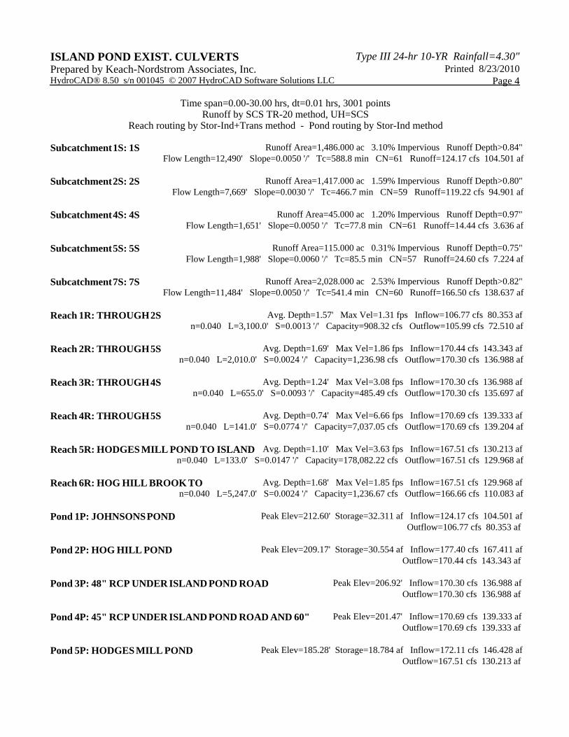
Type III 24-hr 10-YR Rainfall=4.30"ISLAND POND EXIST. CULVERTS Printed 8/23/2010Prepared by Keach-Nordstrom Associates, Inc.
Page 4HydroCAD® 8.50 s/n 001045 © 2007 HydroCAD Software Solutions LLC
Time span=0.00-30.00 hrs, dt=0.01 hrs, 3001 pointsRunoff by SCS TR-20 method, UH=SCS
Reach routing by Stor-Ind+Trans method - Pond routing by Stor-Ind method
Runoff Area=1,486.000 ac 3.10% Impervious Runoff Depth>0.84"Subcatchment 1S: 1S Flow Length=12,490' Slope=0.0050 '/' Tc=588.8 min CN=61 Runoff=124.17 cfs 104.501 af
Runoff Area=1,417.000 ac 1.59% Impervious Runoff Depth>0.80"Subcatchment 2S: 2S Flow Length=7,669' Slope=0.0030 '/' Tc=466.7 min CN=59 Runoff=119.22 cfs 94.901 af
Runoff Area=45.000 ac 1.20% Impervious Runoff Depth=0.97"Subcatchment 4S: 4S Flow Length=1,651' Slope=0.0050 '/' Tc=77.8 min CN=61 Runoff=14.44 cfs 3.636 af
Runoff Area=115.000 ac 0.31% Impervious Runoff Depth=0.75"Subcatchment 5S: 5S Flow Length=1,988' Slope=0.0060 '/' Tc=85.5 min CN=57 Runoff=24.60 cfs 7.224 af
Runoff Area=2,028.000 ac 2.53% Impervious Runoff Depth>0.82"Subcatchment 7S: 7S Flow Length=11,484' Slope=0.0050 '/' Tc=541.4 min CN=60 Runoff=166.50 cfs 138.637 af
Avg. Depth=1.57' Max Vel=1.31 fps Inflow=106.77 cfs 80.353 afReach 1R: THROUGH 2Sn=0.040 L=3,100.0' S=0.0013 '/' Capacity=908.32 cfs Outflow=105.99 cfs 72.510 af
Avg. Depth=1.69' Max Vel=1.86 fps Inflow=170.44 cfs 143.343 afReach 2R: THROUGH 5Sn=0.040 L=2,010.0' S=0.0024 '/' Capacity=1,236.98 cfs Outflow=170.30 cfs 136.988 af
Avg. Depth=1.24' Max Vel=3.08 fps Inflow=170.30 cfs 136.988 afReach 3R: THROUGH 4Sn=0.040 L=655.0' S=0.0093 '/' Capacity=485.49 cfs Outflow=170.30 cfs 135.697 af
Avg. Depth=0.74' Max Vel=6.66 fps Inflow=170.69 cfs 139.333 afReach 4R: THROUGH 5Sn=0.040 L=141.0' S=0.0774 '/' Capacity=7,037.05 cfs Outflow=170.69 cfs 139.204 af
Avg. Depth=1.10' Max Vel=3.63 fps Inflow=167.51 cfs 130.213 afReach 5R: HODGES MILL POND TO ISLAND n=0.040 L=133.0' S=0.0147 '/' Capacity=178,082.22 cfs Outflow=167.51 cfs 129.968 af
Avg. Depth=1.68' Max Vel=1.85 fps Inflow=167.51 cfs 129.968 afReach 6R: HOG HILL BROOK TO n=0.040 L=5,247.0' S=0.0024 '/' Capacity=1,236.67 cfs Outflow=166.66 cfs 110.083 af
Peak Elev=212.60' Storage=32.311 af Inflow=124.17 cfs 104.501 afPond 1P: JOHNSONS POND Outflow=106.77 cfs 80.353 af
Peak Elev=209.17' Storage=30.554 af Inflow=177.40 cfs 167.411 afPond 2P: HOG HILL POND Outflow=170.44 cfs 143.343 af
Peak Elev=206.92' Inflow=170.30 cfs 136.988 afPond 3P: 48" RCP UNDER ISLAND POND ROAD Outflow=170.30 cfs 136.988 af
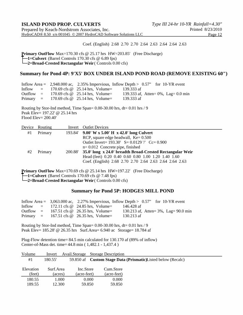
Peak Elev=201.47' Inflow=170.69 cfs 139.333 afPond 4P: 45" RCP UNDER ISLAND POND ROAD AND 60" Outflow=170.69 cfs 139.333 af
Peak Elev=185.28' Storage=18.784 af Inflow=172.11 cfs 146.428 afPond 5P: HODGES MILL POND Outflow=167.51 cfs 130.213 af
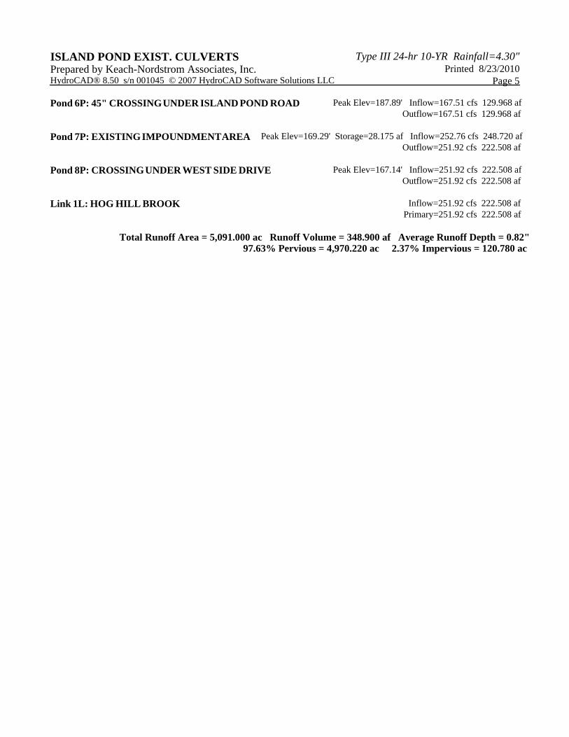
Type III 24-hr 10-YR Rainfall=4.30"ISLAND POND EXIST. CULVERTS Printed 8/23/2010Prepared by Keach-Nordstrom Associates, Inc.
Page 5HydroCAD® 8.50 s/n 001045 © 2007 HydroCAD Software Solutions LLC
Peak Elev=187.89' Inflow=167.51 cfs 129.968 afPond 6P: 45" CROSSING UNDER ISLAND POND ROAD Outflow=167.51 cfs 129.968 af
Peak Elev=169.29' Storage=28.175 af Inflow=252.76 cfs 248.720 afPond 7P: EXISTING IMPOUNDMENT AREA Outflow=251.92 cfs 222.508 af
Peak Elev=167.14' Inflow=251.92 cfs 222.508 afPond 8P: CROSSING UNDER WEST SIDE DRIVE Outflow=251.92 cfs 222.508 af
Inflow=251.92 cfs 222.508 afLink 1L: HOG HILL BROOK Primary=251.92 cfs 222.508 af
Total Runoff Area = 5,091.000 ac Runoff Volume = 348.900 af Average Runoff Depth = 0.82"97.63% Pervious = 4,970.220 ac 2.37% Impervious = 120.780 ac

Type III 24-hr 10-YR Rainfall=4.30"ISLAND POND EXIST. CULVERTS Printed 8/23/2010Prepared by Keach-Nordstrom Associates, Inc.
Page 6HydroCAD® 8.50 s/n 001045 © 2007 HydroCAD Software Solutions LLC
Summary for Subcatchment 1S: 1S
Runoff = 124.17 cfs @ 20.94 hrs, Volume= 104.501 af, Depth> 0.84"
Runoff by SCS TR-20 method, UH=SCS, Time Span= 0.00-30.00 hrs, dt= 0.01 hrsType III 24-hr 10-YR Rainfall=4.30"
Area (ac) CN Description250.000 77 Woods, Good, HSG D384.000 65 2 acre lots, 12% imp, HSG B852.000 55 Woods, Good, HSG B
1,486.000 61 Weighted Average1,439.920 Pervious Area
46.080 Impervious Area
Tc Length Slope Velocity Capacity Description(min) (feet) (ft/ft) (ft/sec) (cfs)588.8 12,490 0.0050 0.35 Shallow Concentrated Flow,
Woodland Kv= 5.0 fps
Summary for Subcatchment 2S: 2S
Runoff = 119.22 cfs @ 19.19 hrs, Volume= 94.901 af, Depth> 0.80"
Runoff by SCS TR-20 method, UH=SCS, Time Span= 0.00-30.00 hrs, dt= 0.01 hrsType III 24-hr 10-YR Rainfall=4.30"
Area (ac) CN Description151.000 77 Woods, Good, HSG D188.000 65 2 acre lots, 12% imp, HSG B
1,078.000 55 Woods, Good, HSG B1,417.000 59 Weighted Average1,394.440 Pervious Area
22.560 Impervious Area
Tc Length Slope Velocity Capacity Description(min) (feet) (ft/ft) (ft/sec) (cfs)466.7 7,669 0.0030 0.27 Shallow Concentrated Flow,
Woodland Kv= 5.0 fps
Summary for Subcatchment 4S: 4S
Runoff = 14.44 cfs @ 13.22 hrs, Volume= 3.636 af, Depth= 0.97"
Runoff by SCS TR-20 method, UH=SCS, Time Span= 0.00-30.00 hrs, dt= 0.01 hrsType III 24-hr 10-YR Rainfall=4.30"

Type III 24-hr 10-YR Rainfall=4.30"ISLAND POND EXIST. CULVERTS Printed 8/23/2010Prepared by Keach-Nordstrom Associates, Inc.
Page 7HydroCAD® 8.50 s/n 001045 © 2007 HydroCAD Software Solutions LLC
Area (ac) CN Description11.000 77 Woods, Good, HSG D4.500 65 2 acre lots, 12% imp, HSG B
29.500 55 Woods, Good, HSG B45.000 61 Weighted Average44.460 Pervious Area0.540 Impervious Area
Tc Length Slope Velocity Capacity Description(min) (feet) (ft/ft) (ft/sec) (cfs)77.8 1,651 0.0050 0.35 Shallow Concentrated Flow,
Woodland Kv= 5.0 fps
Summary for Subcatchment 5S: 5S
Runoff = 24.60 cfs @ 13.39 hrs, Volume= 7.224 af, Depth= 0.75"
Runoff by SCS TR-20 method, UH=SCS, Time Span= 0.00-30.00 hrs, dt= 0.01 hrsType III 24-hr 10-YR Rainfall=4.30"
Area (ac) CN Description9.500 77 Woods, Good, HSG D3.000 65 2 acre lots, 12% imp, HSG B
102.500 55 Woods, Good, HSG B115.000 57 Weighted Average114.640 Pervious Area
0.360 Impervious Area
Tc Length Slope Velocity Capacity Description(min) (feet) (ft/ft) (ft/sec) (cfs)85.5 1,988 0.0060 0.39 Shallow Concentrated Flow,
Woodland Kv= 5.0 fps
Summary for Subcatchment 7S: 7S
Runoff = 166.50 cfs @ 20.45 hrs, Volume= 138.637 af, Depth> 0.82"
Runoff by SCS TR-20 method, UH=SCS, Time Span= 0.00-30.00 hrs, dt= 0.01 hrsType III 24-hr 10-YR Rainfall=4.30"
Area (ac) CN Description258.000 77 Woods, Good, HSG D427.000 65 2 acre lots, 12% imp, HSG B
1,343.000 55 Woods, Good, HSG B2,028.000 60 Weighted Average1,976.760 Pervious Area
51.240 Impervious Area

Type III 24-hr 10-YR Rainfall=4.30"ISLAND POND EXIST. CULVERTS Printed 8/23/2010Prepared by Keach-Nordstrom Associates, Inc.
Page 8HydroCAD® 8.50 s/n 001045 © 2007 HydroCAD Software Solutions LLC
Tc Length Slope Velocity Capacity Description(min) (feet) (ft/ft) (ft/sec) (cfs)541.4 11,484 0.0050 0.35 Shallow Concentrated Flow,
Woodland Kv= 5.0 fps
Summary for Reach 1R: THROUGH 2S
Inflow Area = 1,486.000 ac, 3.10% Impervious, Inflow Depth > 0.65" for 10-YR eventInflow = 106.77 cfs @ 23.44 hrs, Volume= 80.353 afOutflow = 105.99 cfs @ 24.63 hrs, Volume= 72.510 af, Atten= 1%, Lag= 71.5 min
Routing by Stor-Ind+Trans method, Time Span= 0.00-30.00 hrs, dt= 0.01 hrs / 9Max. Velocity= 1.31 fps, Min. Travel Time= 39.4 minAvg. Velocity = 1.12 fps, Avg. Travel Time= 45.9 min
Peak Storage= 250,498 cf @ 23.98 hrs, Average Depth at Peak Storage= 1.57'Bank-Full Depth= 4.00', Capacity at Bank-Full= 908.32 cfs
20.00' x 4.00' deep channel, n= 0.040 Winding stream, pools & shoalsSide Slope Z-value= 20.0 '/' Top Width= 180.00'Length= 3,100.0' Slope= 0.0013 '/'Inlet Invert= 209.00', Outlet Invert= 205.00'
Summary for Reach 2R: THROUGH 5S
Inflow Area = 2,903.000 ac, 2.36% Impervious, Inflow Depth > 0.59" for 10-YR eventInflow = 170.44 cfs @ 24.65 hrs, Volume= 143.343 afOutflow = 170.30 cfs @ 25.17 hrs, Volume= 136.988 af, Atten= 0%, Lag= 31.3 min
Routing by Stor-Ind+Trans method, Time Span= 0.00-30.00 hrs, dt= 0.01 hrs / 9Max. Velocity= 1.86 fps, Min. Travel Time= 18.0 minAvg. Velocity = 1.63 fps, Avg. Travel Time= 20.5 min
Peak Storage= 183,561 cf @ 24.87 hrs, Average Depth at Peak Storage= 1.69'Bank-Full Depth= 4.00', Capacity at Bank-Full= 1,236.98 cfs
20.00' x 4.00' deep channel, n= 0.040Side Slope Z-value= 20.0 '/' Top Width= 180.00'Length= 2,010.0' Slope= 0.0024 '/'Inlet Invert= 205.00', Outlet Invert= 200.19'
Summary for Reach 3R: THROUGH 4S
Inflow Area = 2,903.000 ac, 2.36% Impervious, Inflow Depth > 0.57" for 10-YR eventInflow = 170.30 cfs @ 25.17 hrs, Volume= 136.988 afOutflow = 170.30 cfs @ 25.27 hrs, Volume= 135.697 af, Atten= 0%, Lag= 6.2 min
Routing by Stor-Ind+Trans method, Time Span= 0.00-30.00 hrs, dt= 0.01 hrs / 9Max. Velocity= 3.08 fps, Min. Travel Time= 3.5 minAvg. Velocity = 2.67 fps, Avg. Travel Time= 4.1 min

Type III 24-hr 10-YR Rainfall=4.30"ISLAND POND EXIST. CULVERTS Printed 8/23/2010Prepared by Keach-Nordstrom Associates, Inc.
Page 9HydroCAD® 8.50 s/n 001045 © 2007 HydroCAD Software Solutions LLC
Peak Storage= 36,234 cf @ 25.21 hrs, Average Depth at Peak Storage= 1.24'Bank-Full Depth= 2.00', Capacity at Bank-Full= 485.49 cfs
20.00' x 2.00' deep channel, n= 0.040Side Slope Z-value= 20.0 '/' Top Width= 100.00'Length= 655.0' Slope= 0.0093 '/'Inlet Invert= 199.94', Outlet Invert= 193.84'
Summary for Reach 4R: THROUGH 5S
Inflow Area = 2,948.000 ac, 2.35% Impervious, Inflow Depth > 0.57" for 10-YR eventInflow = 170.69 cfs @ 25.14 hrs, Volume= 139.333 afOutflow = 170.69 cfs @ 25.15 hrs, Volume= 139.204 af, Atten= 0%, Lag= 0.6 min
Routing by Stor-Ind+Trans method, Time Span= 0.00-30.00 hrs, dt= 0.01 hrs / 9Max. Velocity= 6.66 fps, Min. Travel Time= 0.4 minAvg. Velocity = 4.86 fps, Avg. Travel Time= 0.5 min
Peak Storage= 3,612 cf @ 25.14 hrs, Average Depth at Peak Storage= 0.74'Bank-Full Depth= 4.00', Capacity at Bank-Full= 7,037.05 cfs
20.00' x 4.00' deep channel, n= 0.040Side Slope Z-value= 20.0 '/' Top Width= 180.00'Length= 141.0' Slope= 0.0774 '/'Inlet Invert= 191.47', Outlet Invert= 180.55'
Summary for Reach 5R: HODGES MILL POND TO ISLAND POND ROAD
Inflow Area = 3,063.000 ac, 2.27% Impervious, Inflow Depth > 0.51" for 10-YR eventInflow = 167.51 cfs @ 26.35 hrs, Volume= 130.213 afOutflow = 167.51 cfs @ 26.37 hrs, Volume= 129.968 af, Atten= 0%, Lag= 1.1 min
Routing by Stor-Ind+Trans method, Time Span= 0.00-30.00 hrs, dt= 0.01 hrs / 9Max. Velocity= 3.63 fps, Min. Travel Time= 0.6 minAvg. Velocity = 2.86 fps, Avg. Travel Time= 0.8 min
Peak Storage= 6,134 cf @ 26.36 hrs, Average Depth at Peak Storage= 1.10'Bank-Full Depth= 20.00', Capacity at Bank-Full= 178,082.22 cfs
20.00' x 20.00' deep channel, n= 0.040Side Slope Z-value= 20.0 '/' Top Width= 820.00'Length= 133.0' Slope= 0.0147 '/'Inlet Invert= 181.50', Outlet Invert= 179.55'
Summary for Reach 6R: HOG HILL BROOK TO IMPOUNDMENT AREA
Inflow Area = 3,063.000 ac, 2.27% Impervious, Inflow Depth > 0.51" for 10-YR eventInflow = 167.51 cfs @ 26.37 hrs, Volume= 129.968 afOutflow = 166.66 cfs @ 27.77 hrs, Volume= 110.083 af, Atten= 1%, Lag= 84.4 min

Type III 24-hr 10-YR Rainfall=4.30"ISLAND POND EXIST. CULVERTS Printed 8/23/2010Prepared by Keach-Nordstrom Associates, Inc.
Page 10HydroCAD® 8.50 s/n 001045 © 2007 HydroCAD Software Solutions LLC
Routing by Stor-Ind+Trans method, Time Span= 0.00-30.00 hrs, dt= 0.01 hrs / 9Max. Velocity= 1.85 fps, Min. Travel Time= 47.2 minAvg. Velocity = 1.38 fps, Avg. Travel Time= 63.3 min
Peak Storage= 471,670 cf @ 26.99 hrs, Average Depth at Peak Storage= 1.68'Bank-Full Depth= 4.00', Capacity at Bank-Full= 1,236.67 cfs
20.00' x 4.00' deep channel, n= 0.040Side Slope Z-value= 20.0 '/' Top Width= 180.00'Length= 5,247.0' Slope= 0.0024 '/'Inlet Invert= 179.55', Outlet Invert= 167.00'
Summary for Pond 1P: JOHNSONS POND
Inflow Area = 1,486.000 ac, 3.10% Impervious, Inflow Depth > 0.84" for 10-YR eventInflow = 124.17 cfs @ 20.94 hrs, Volume= 104.501 afOutflow = 106.77 cfs @ 23.44 hrs, Volume= 80.353 af, Atten= 14%, Lag= 150.4 minPrimary = 106.77 cfs @ 23.44 hrs, Volume= 80.353 af
Routing by Stor-Ind method, Time Span= 0.00-30.00 hrs, dt= 0.01 hrs / 9Peak Elev= 212.60' @ 23.44 hrs Surf.Area= 17.975 ac Storage= 32.311 af
Plug-Flow detention time= 213.7 min calculated for 80.353 af (77% of inflow)Center-of-Mass det. time= 121.4 min ( 1,461.4 - 1,340.0 )
Volume Invert Avail.Storage Storage Description#1 209.00' 90.000 af Custom Stage Data (Prismatic) Listed below (Recalc)
Elevation Surf.Area Inc.Store Cum.Store(feet) (acres) (acre-feet) (acre-feet)
209.00 0.000 0.000 0.000211.00 10.000 10.000 10.000213.00 20.000 30.000 40.000215.00 30.000 50.000 90.000
Device Routing Invert Outlet Devices#1 Primary 211.00' 20.0' long x 5.0' breadth Broad-Crested Rectangular Weir
Head (feet) 0.20 0.40 0.60 0.80 1.00 1.20 1.40 1.60 1.80 2.00 2.50 3.00 3.50 4.00 4.50 5.00 5.50 Coef. (English) 2.34 2.50 2.70 2.68 2.68 2.66 2.65 2.65 2.65 2.65 2.67 2.66 2.68 2.70 2.74 2.79 2.88
Primary OutFlow Max=106.77 cfs @ 23.44 hrs HW=212.60' (Free Discharge)1=Broad-Crested Rectangular Weir (Weir Controls 106.77 cfs @ 3.35 fps)

Type III 24-hr 10-YR Rainfall=4.30"ISLAND POND EXIST. CULVERTS Printed 8/23/2010Prepared by Keach-Nordstrom Associates, Inc.
Page 11HydroCAD® 8.50 s/n 001045 © 2007 HydroCAD Software Solutions LLC
Summary for Pond 2P: HOG HILL POND
Inflow Area = 2,903.000 ac, 2.36% Impervious, Inflow Depth > 0.69" for 10-YR eventInflow = 177.40 cfs @ 23.14 hrs, Volume= 167.411 afOutflow = 170.44 cfs @ 24.65 hrs, Volume= 143.343 af, Atten= 4%, Lag= 90.3 minPrimary = 170.44 cfs @ 24.65 hrs, Volume= 143.343 af
Routing by Stor-Ind method, Time Span= 0.00-30.00 hrs, dt= 0.01 hrs / 9Peak Elev= 209.17' @ 24.65 hrs Surf.Area= 15.224 ac Storage= 30.554 af
Plug-Flow detention time= 133.5 min calculated for 143.295 af (86% of inflow)Center-of-Mass det. time= 75.3 min ( 1,449.1 - 1,373.8 )
Volume Invert Avail.Storage Storage Description#1 205.00' 70.000 af Custom Stage Data (Prismatic) Listed below (Recalc)
Elevation Surf.Area Inc.Store Cum.Store(feet) (acres) (acre-feet) (acre-feet)
205.00 0.000 0.000 0.000207.00 7.000 7.000 7.000209.00 14.000 21.000 28.000211.00 28.000 42.000 70.000
Device Routing Invert Outlet Devices#1 Primary 207.00' 20.0' long x 5.0' breadth Broad-Crested Rectangular Weir
Head (feet) 0.20 0.40 0.60 0.80 1.00 1.20 1.40 1.60 1.80 2.00 2.50 3.00 3.50 4.00 4.50 5.00 5.50 Coef. (English) 2.34 2.50 2.70 2.68 2.68 2.66 2.65 2.65 2.65 2.65 2.67 2.66 2.68 2.70 2.74 2.79 2.88
Primary OutFlow Max=170.43 cfs @ 24.65 hrs HW=209.17' (Free Discharge)1=Broad-Crested Rectangular Weir (Weir Controls 170.43 cfs @ 3.92 fps)
Summary for Pond 3P: 48" RCP UNDER ISLAND POND ROAD
Inflow Area = 2,903.000 ac, 2.36% Impervious, Inflow Depth > 0.57" for 10-YR eventInflow = 170.30 cfs @ 25.17 hrs, Volume= 136.988 afOutflow = 170.30 cfs @ 25.17 hrs, Volume= 136.988 af, Atten= 0%, Lag= 0.0 minPrimary = 170.30 cfs @ 25.17 hrs, Volume= 136.988 af
Routing by Stor-Ind method, Time Span= 0.00-30.00 hrs, dt= 0.01 hrs / 9Peak Elev= 206.92' @ 25.17 hrsFlood Elev= 206.48'
Device Routing Invert Outlet Devices#1 Primary 200.19' 48.0" x 40.0' long Culvert RCP, square edge headwall, Ke= 0.500
Outlet Invert= 199.94' S= 0.0063 '/' Cc= 0.900 n= 0.012 Concrete pipe, finished
#2 Primary 206.48' 50.0' long x 24.0' breadth Broad-Crested Rectangular Weir Head (feet) 0.20 0.40 0.60 0.80 1.00 1.20 1.40 1.60 Coef. (English) 2.68 2.70 2.70 2.64 2.63 2.64 2.64 2.63

Type III 24-hr 10-YR Rainfall=4.30"ISLAND POND EXIST. CULVERTS Printed 8/23/2010Prepared by Keach-Nordstrom Associates, Inc.
Page 12HydroCAD® 8.50 s/n 001045 © 2007 HydroCAD Software Solutions LLC
Primary OutFlow Max=170.28 cfs @ 25.17 hrs HW=206.92' (Free Discharge)1=Culvert (Inlet Controls 131.53 cfs @ 10.47 fps)2=Broad-Crested Rectangular Weir (Weir Controls 38.75 cfs @ 1.78 fps)
Summary for Pond 4P: 45" RCP UNDER ISLAND POND ROAD AND 60" RCP UNDER TRAIL
Inflow Area = 2,948.000 ac, 2.35% Impervious, Inflow Depth > 0.57" for 10-YR eventInflow = 170.69 cfs @ 25.14 hrs, Volume= 139.333 afOutflow = 170.69 cfs @ 25.14 hrs, Volume= 139.333 af, Atten= 0%, Lag= 0.0 minPrimary = 170.69 cfs @ 25.14 hrs, Volume= 139.333 af
Routing by Stor-Ind method, Time Span= 0.00-30.00 hrs, dt= 0.01 hrs / 9Peak Elev= 201.47' @ 25.14 hrsFlood Elev= 200.88'
Device Routing Invert Outlet Devices#1 Device 2 193.84' 45.0" x 42.0' long Culvert RCP, square edge headwall, Ke= 0.500
Outlet Invert= 193.30' S= 0.0129 '/' Cc= 0.900 n= 0.012 Concrete pipe, finished
#2 Primary 192.48' 60.0" x 19.0' long Culvert RCP, square edge headwall, Ke= 0.500 Outlet Invert= 191.47' S= 0.0532 '/' Cc= 0.900 n= 0.012
#3 Primary 200.88' 35.0' long x 24.0' breadth Broad-Crested Rectangular Weir Head (feet) 0.20 0.40 0.60 0.80 1.00 1.20 1.40 1.60 Coef. (English) 2.68 2.70 2.70 2.64 2.63 2.64 2.64 2.63
Primary OutFlow Max=170.70 cfs @ 25.14 hrs HW=201.47' (Free Discharge)2=Culvert (Passes 127.60 cfs of 240.90 cfs potential flow)
1=Culvert (Inlet Controls 127.60 cfs @ 11.55 fps)3=Broad-Crested Rectangular Weir (Weir Controls 43.09 cfs @ 2.08 fps)
Summary for Pond 5P: HODGES MILL POND
Inflow Area = 3,063.000 ac, 2.27% Impervious, Inflow Depth > 0.57" for 10-YR eventInflow = 172.11 cfs @ 24.85 hrs, Volume= 146.428 afOutflow = 167.51 cfs @ 26.35 hrs, Volume= 130.213 af, Atten= 3%, Lag= 90.0 minPrimary = 167.51 cfs @ 26.35 hrs, Volume= 130.213 af
Routing by Stor-Ind method, Time Span= 0.00-30.00 hrs, dt= 0.01 hrs / 9Peak Elev= 185.28' @ 26.35 hrs Surf.Area= 6.940 ac Storage= 18.784 af
Plug-Flow detention time= 84.5 min calculated for 130.170 af (89% of inflow)Center-of-Mass det. time= 44.8 min ( 1,482.1 - 1,437.4 )
Volume Invert Avail.Storage Storage Description#1 180.55' 59.850 af Custom Stage Data (Prismatic) Listed below (Recalc)
Elevation Surf.Area Inc.Store Cum.Store(feet) (acres) (acre-feet) (acre-feet)
180.55 1.000 0.000 0.000189.55 12.300 59.850 59.850

Type III 24-hr 10-YR Rainfall=4.30"ISLAND POND EXIST. CULVERTS Printed 8/23/2010Prepared by Keach-Nordstrom Associates, Inc.
Page 13HydroCAD® 8.50 s/n 001045 © 2007 HydroCAD Software Solutions LLC
Device Routing Invert Outlet Devices#1 Primary 181.55' 7.0' long x 1.5' breadth Broad-Crested Rectangular Weir
Head (feet) 0.20 0.40 0.60 0.80 1.00 1.20 1.40 1.60 1.80 2.00 2.50 3.00 Coef. (English) 2.62 2.64 2.64 2.68 2.75 2.86 2.92 3.07 3.07 3.03 3.28 3.32
#2 Primary 190.55' 60.0' long x 1.0' breadth Broad-Crested Rectangular Weir Head (feet) 0.20 0.40 0.60 0.80 1.00 1.20 1.40 1.60 1.80 2.00 2.50 3.00 Coef. (English) 2.69 2.72 2.75 2.85 2.98 3.08 3.20 3.28 3.31 3.30 3.31 3.32
Primary OutFlow Max=167.50 cfs @ 26.35 hrs HW=185.28' (Free Discharge)1=Broad-Crested Rectangular Weir (Weir Controls 167.50 cfs @ 6.41 fps)2=Broad-Crested Rectangular Weir ( Controls 0.00 cfs)
Summary for Pond 6P: 45" CROSSING UNDER ISLAND POND ROAD
Inflow Area = 3,063.000 ac, 2.27% Impervious, Inflow Depth > 0.51" for 10-YR eventInflow = 167.51 cfs @ 26.37 hrs, Volume= 129.968 afOutflow = 167.51 cfs @ 26.37 hrs, Volume= 129.968 af, Atten= 0%, Lag= 0.0 minPrimary = 167.51 cfs @ 26.37 hrs, Volume= 129.968 af
Routing by Stor-Ind method, Time Span= 0.00-30.00 hrs, dt= 0.01 hrs / 9Peak Elev= 187.89' @ 26.37 hrsFlood Elev= 186.92'
Device Routing Invert Outlet Devices#1 Primary 179.55' 45.0" x 48.0' long Culvert RCP, square edge headwall, Ke= 0.500
Outlet Invert= 179.55' S= 0.0000 '/' Cc= 0.900 n= 0.012 #2 Primary 187.51' 50.0' long x 24.0' breadth Broad-Crested Rectangular Weir
Head (feet) 0.20 0.40 0.60 0.80 1.00 1.20 1.40 1.60 Coef. (English) 2.68 2.70 2.70 2.64 2.63 2.64 2.64 2.63
Primary OutFlow Max=167.44 cfs @ 26.37 hrs HW=187.89' (Free Discharge)1=Culvert (Inlet Controls 135.26 cfs @ 12.25 fps)2=Broad-Crested Rectangular Weir (Weir Controls 32.17 cfs @ 1.67 fps)
Summary for Pond 7P: EXISTING IMPOUNDMENT AREA
Inflow Area = 5,091.000 ac, 2.37% Impervious, Inflow Depth > 0.59" for 10-YR eventInflow = 252.76 cfs @ 25.62 hrs, Volume= 248.720 afOutflow = 251.92 cfs @ 26.18 hrs, Volume= 222.508 af, Atten= 0%, Lag= 33.5 minPrimary = 251.92 cfs @ 26.18 hrs, Volume= 222.508 af
Routing by Stor-Ind method, Time Span= 0.00-30.00 hrs, dt= 0.01 hrs / 9Peak Elev= 169.29' @ 26.18 hrs Surf.Area= 17.060 ac Storage= 28.175 af
Plug-Flow detention time= 86.0 min calculated for 222.508 af (89% of inflow)Center-of-Mass det. time= 45.3 min ( 1,455.5 - 1,410.2 )

Type III 24-hr 10-YR Rainfall=4.30"ISLAND POND EXIST. CULVERTS Printed 8/23/2010Prepared by Keach-Nordstrom Associates, Inc.
Page 14HydroCAD® 8.50 s/n 001045 © 2007 HydroCAD Software Solutions LLC
Volume Invert Avail.Storage Storage Description#1 167.00' 41.250 af Custom Stage Data (Prismatic) Listed below (Recalc)
Elevation Surf.Area Inc.Store Cum.Store(feet) (acres) (acre-feet) (acre-feet)
167.00 7.500 0.000 0.000170.00 20.000 41.250 41.250
Device Routing Invert Outlet Devices#1 Primary 167.00' 15.0' long x 10.0' breadth Broad-Crested Rectangular Weir
Head (feet) 0.20 0.40 0.60 0.80 1.00 1.20 1.40 1.60 Coef. (English) 2.49 2.56 2.70 2.69 2.68 2.69 2.67 2.64
#2 Primary 168.50' 60.0' long x 10.0' breadth Broad-Crested Rectangular Weir Head (feet) 0.20 0.40 0.60 0.80 1.00 1.20 1.40 1.60 Coef. (English) 2.49 2.56 2.70 2.69 2.68 2.69 2.67 2.64
Primary OutFlow Max=251.90 cfs @ 26.18 hrs HW=169.29' (Free Discharge)1=Broad-Crested Rectangular Weir (Weir Controls 137.62 cfs @ 4.00 fps)2=Broad-Crested Rectangular Weir (Weir Controls 114.28 cfs @ 2.40 fps)
Summary for Pond 8P: CROSSING UNDER WEST SIDE DRIVE
Inflow Area = 5,091.000 ac, 2.37% Impervious, Inflow Depth > 0.52" for 10-YR eventInflow = 251.92 cfs @ 26.18 hrs, Volume= 222.508 afOutflow = 251.92 cfs @ 26.18 hrs, Volume= 222.508 af, Atten= 0%, Lag= 0.0 minPrimary = 251.92 cfs @ 26.18 hrs, Volume= 222.508 af
Routing by Stor-Ind method, Time Span= 0.00-30.00 hrs, dt= 0.01 hrs / 9Peak Elev= 167.14' @ 26.18 hrsFlood Elev= 175.00'
Device Routing Invert Outlet Devices#1 Primary 161.00' 96.0" x 40.0' long Culvert CMP, square edge headwall, Ke= 0.500
Outlet Invert= 160.60' S= 0.0100 '/' Cc= 0.900 n= 0.025 Corrugated metal #2 Primary 175.00' 50.0' long x 24.0' breadth Broad-Crested Rectangular Weir
Head (feet) 0.20 0.40 0.60 0.80 1.00 1.20 1.40 1.60 Coef. (English) 2.68 2.70 2.70 2.64 2.63 2.64 2.64 2.63
Primary OutFlow Max=251.91 cfs @ 26.18 hrs HW=167.14' (Free Discharge)1=Culvert (Barrel Controls 251.91 cfs @ 8.41 fps)2=Broad-Crested Rectangular Weir ( Controls 0.00 cfs)
Summary for Link 1L: HOG HILL BROOK
Inflow Area = 5,091.000 ac, 2.37% Impervious, Inflow Depth > 0.52" for 10-YR eventInflow = 251.92 cfs @ 26.18 hrs, Volume= 222.508 afPrimary = 251.92 cfs @ 26.18 hrs, Volume= 222.508 af, Atten= 0%, Lag= 0.0 min
Primary outflow = Inflow, Time Span= 0.00-30.00 hrs, dt= 0.01 hrs

B: 10-YEAR, POST ROADWAY IMPROVEMENTS

1S
1S
2S
2S
4S
4S
5S
5S
7S
7S
1R
THROUGH 2S
2R
THROUGH 5S
3R
THROUGH 4S
4R
THROUGH 5S
5R
HODGES MILL POND TO ISLAND POND
ROAD
6R
HOG HILL BROOK TO IMPOUNDMENT AREA
1P
JOHNSONS POND
2P
HOG HILL POND
3PCB
9'X5' BOX UNDER ISLAND POND ROAD
4PCB
9'X5' BOX UNDER ISLAND POND ROAD (REMOVE EXISTING
60")
5P
HODGES MILL POND
6PCB
9'X5' BOX CROSSING UNDER ISLAND POND
ROAD
7P
EXISTING IMPOUNDMENT AREA
8PCB
CROSSING UNDER WEST SIDE DRIVE
1L
HOG HILL BROOK
Drainage Diagram for ISLAND POND PROP. CULVERTSPrepared by Keach-Nordstrom Associates, Inc., Printed 8/23/2010HydroCAD® 8.50 s/n 001045 © 2007 HydroCAD Software Solutions LLC
Subcat Reach Pond Link

ISLAND POND PROP. CULVERTS Printed 8/23/2010Prepared by Keach-Nordstrom Associates, Inc.
Page 2HydroCAD® 8.50 s/n 001045 © 2007 HydroCAD Software Solutions LLC
Area Listing (all nodes)
Area
(acres)
CN Description
(subcatchment-numbers)
3,405.000 55 Woods, Good, HSG B (1S,2S,4S,5S,7S)
1,006.500 65 2 acre lots, 12% imp, HSG B (1S,2S,4S,5S,7S)
679.500 77 Woods, Good, HSG D (1S,2S,4S,5S,7S)
5,091.000 TOTAL AREA

ISLAND POND PROP. CULVERTS Printed 8/23/2010Prepared by Keach-Nordstrom Associates, Inc.
Page 3HydroCAD® 8.50 s/n 001045 © 2007 HydroCAD Software Solutions LLC
Soil Listing (all nodes)
Area
(acres)
Soil
Goup
Subcatchment
Numbers
0.000 HSG A
4,411.500 HSG B 1S, 2S, 4S, 5S, 7S
0.000 HSG C
679.500 HSG D 1S, 2S, 4S, 5S, 7S
0.000 Other
5,091.000 TOTAL AREA

Type III 24-hr 10-YR Rainfall=4.30"ISLAND POND PROP. CULVERTS Printed 8/23/2010Prepared by Keach-Nordstrom Associates, Inc.
Page 4HydroCAD® 8.50 s/n 001045 © 2007 HydroCAD Software Solutions LLC
Time span=0.00-30.00 hrs, dt=0.01 hrs, 3001 pointsRunoff by SCS TR-20 method, UH=SCS
Reach routing by Stor-Ind+Trans method - Pond routing by Stor-Ind method
Runoff Area=1,486.000 ac 3.10% Impervious Runoff Depth>0.84"Subcatchment 1S: 1S Flow Length=12,490' Slope=0.0050 '/' Tc=588.8 min CN=61 Runoff=124.17 cfs 104.501 af
Runoff Area=1,417.000 ac 1.59% Impervious Runoff Depth>0.80"Subcatchment 2S: 2S Flow Length=7,669' Slope=0.0030 '/' Tc=466.7 min CN=59 Runoff=119.22 cfs 94.901 af
Runoff Area=45.000 ac 1.20% Impervious Runoff Depth=0.97"Subcatchment 4S: 4S Flow Length=1,651' Slope=0.0050 '/' Tc=77.8 min CN=61 Runoff=14.44 cfs 3.636 af
Runoff Area=115.000 ac 0.31% Impervious Runoff Depth=0.75"Subcatchment 5S: 5S Flow Length=1,988' Slope=0.0060 '/' Tc=85.5 min CN=57 Runoff=24.60 cfs 7.224 af
Runoff Area=2,028.000 ac 2.53% Impervious Runoff Depth>0.82"Subcatchment 7S: 7S Flow Length=11,484' Slope=0.0050 '/' Tc=541.4 min CN=60 Runoff=166.50 cfs 138.637 af
Avg. Depth=1.57' Max Vel=1.31 fps Inflow=106.77 cfs 80.353 afReach 1R: THROUGH 2Sn=0.040 L=3,100.0' S=0.0013 '/' Capacity=908.32 cfs Outflow=105.99 cfs 72.510 af
Avg. Depth=1.69' Max Vel=1.86 fps Inflow=170.44 cfs 143.343 afReach 2R: THROUGH 5Sn=0.040 L=2,010.0' S=0.0024 '/' Capacity=1,236.98 cfs Outflow=170.30 cfs 136.988 af
Avg. Depth=1.24' Max Vel=3.08 fps Inflow=170.30 cfs 136.988 afReach 3R: THROUGH 4Sn=0.040 L=655.0' S=0.0093 '/' Capacity=485.49 cfs Outflow=170.30 cfs 135.697 af
Avg. Depth=0.74' Max Vel=6.66 fps Inflow=170.69 cfs 139.333 afReach 4R: THROUGH 5Sn=0.040 L=141.0' S=0.0774 '/' Capacity=7,037.05 cfs Outflow=170.69 cfs 139.204 af
Avg. Depth=1.10' Max Vel=3.62 fps Inflow=167.51 cfs 130.213 afReach 5R: HODGES MILL POND TO ISLAND n=0.040 L=133.0' S=0.0147 '/' Capacity=3,061.83 cfs Outflow=167.51 cfs 129.967 af
Avg. Depth=1.68' Max Vel=1.85 fps Inflow=167.51 cfs 129.967 afReach 6R: HOG HILL BROOK TO n=0.040 L=5,247.0' S=0.0024 '/' Capacity=1,236.67 cfs Outflow=166.66 cfs 110.082 af
Peak Elev=212.60' Storage=32.311 af Inflow=124.17 cfs 104.501 afPond 1P: JOHNSONS POND Outflow=106.77 cfs 80.353 af
Peak Elev=209.17' Storage=30.554 af Inflow=177.40 cfs 167.411 afPond 2P: HOG HILL POND Outflow=170.44 cfs 143.343 af
Peak Elev=203.85' Inflow=170.30 cfs 136.988 afPond 3P: 9'X5' BOX UNDER ISLAND POND ROAD Outflow=170.30 cfs 136.988 af
Peak Elev=197.22' Inflow=170.69 cfs 139.333 afPond 4P: 9'X5' BOX UNDER ISLAND POND ROAD (REMOVE Outflow=170.69 cfs 139.333 af
Peak Elev=185.28' Storage=18.784 af Inflow=172.11 cfs 146.428 afPond 5P: HODGES MILL POND Outflow=167.51 cfs 130.213 af

Type III 24-hr 10-YR Rainfall=4.30"ISLAND POND PROP. CULVERTS Printed 8/23/2010Prepared by Keach-Nordstrom Associates, Inc.
Page 5HydroCAD® 8.50 s/n 001045 © 2007 HydroCAD Software Solutions LLC
Peak Elev=183.49' Inflow=167.51 cfs 129.967 afPond 6P: 9'X5' BOX CROSSING UNDER ISLAND POND ROAD Outflow=167.51 cfs 129.967 af
Peak Elev=169.29' Storage=28.174 af Inflow=252.75 cfs 248.719 afPond 7P: EXISTING IMPOUNDMENT AREA Outflow=251.92 cfs 222.507 af
Peak Elev=167.14' Inflow=251.92 cfs 222.507 afPond 8P: CROSSING UNDER WEST SIDE DRIVE Outflow=251.92 cfs 222.507 af
Inflow=251.92 cfs 222.507 afLink 1L: HOG HILL BROOK Primary=251.92 cfs 222.507 af
Total Runoff Area = 5,091.000 ac Runoff Volume = 348.900 af Average Runoff Depth = 0.82"97.63% Pervious = 4,970.220 ac 2.37% Impervious = 120.780 ac

Type III 24-hr 10-YR Rainfall=4.30"ISLAND POND PROP. CULVERTS Printed 8/23/2010Prepared by Keach-Nordstrom Associates, Inc.
Page 6HydroCAD® 8.50 s/n 001045 © 2007 HydroCAD Software Solutions LLC
Summary for Subcatchment 1S: 1S
Runoff = 124.17 cfs @ 20.94 hrs, Volume= 104.501 af, Depth> 0.84"
Runoff by SCS TR-20 method, UH=SCS, Time Span= 0.00-30.00 hrs, dt= 0.01 hrsType III 24-hr 10-YR Rainfall=4.30"
Area (ac) CN Description250.000 77 Woods, Good, HSG D384.000 65 2 acre lots, 12% imp, HSG B852.000 55 Woods, Good, HSG B
1,486.000 61 Weighted Average1,439.920 Pervious Area
46.080 Impervious Area
Tc Length Slope Velocity Capacity Description(min) (feet) (ft/ft) (ft/sec) (cfs)588.8 12,490 0.0050 0.35 Shallow Concentrated Flow,
Woodland Kv= 5.0 fps
Summary for Subcatchment 2S: 2S
Runoff = 119.22 cfs @ 19.19 hrs, Volume= 94.901 af, Depth> 0.80"
Runoff by SCS TR-20 method, UH=SCS, Time Span= 0.00-30.00 hrs, dt= 0.01 hrsType III 24-hr 10-YR Rainfall=4.30"
Area (ac) CN Description151.000 77 Woods, Good, HSG D188.000 65 2 acre lots, 12% imp, HSG B
1,078.000 55 Woods, Good, HSG B1,417.000 59 Weighted Average1,394.440 Pervious Area
22.560 Impervious Area
Tc Length Slope Velocity Capacity Description(min) (feet) (ft/ft) (ft/sec) (cfs)466.7 7,669 0.0030 0.27 Shallow Concentrated Flow,
Woodland Kv= 5.0 fps
Summary for Subcatchment 4S: 4S
Runoff = 14.44 cfs @ 13.22 hrs, Volume= 3.636 af, Depth= 0.97"
Runoff by SCS TR-20 method, UH=SCS, Time Span= 0.00-30.00 hrs, dt= 0.01 hrsType III 24-hr 10-YR Rainfall=4.30"

Type III 24-hr 10-YR Rainfall=4.30"ISLAND POND PROP. CULVERTS Printed 8/23/2010Prepared by Keach-Nordstrom Associates, Inc.
Page 7HydroCAD® 8.50 s/n 001045 © 2007 HydroCAD Software Solutions LLC
Area (ac) CN Description11.000 77 Woods, Good, HSG D4.500 65 2 acre lots, 12% imp, HSG B
29.500 55 Woods, Good, HSG B45.000 61 Weighted Average44.460 Pervious Area0.540 Impervious Area
Tc Length Slope Velocity Capacity Description(min) (feet) (ft/ft) (ft/sec) (cfs)77.8 1,651 0.0050 0.35 Shallow Concentrated Flow,
Woodland Kv= 5.0 fps
Summary for Subcatchment 5S: 5S
Runoff = 24.60 cfs @ 13.39 hrs, Volume= 7.224 af, Depth= 0.75"
Runoff by SCS TR-20 method, UH=SCS, Time Span= 0.00-30.00 hrs, dt= 0.01 hrsType III 24-hr 10-YR Rainfall=4.30"
Area (ac) CN Description9.500 77 Woods, Good, HSG D3.000 65 2 acre lots, 12% imp, HSG B
102.500 55 Woods, Good, HSG B115.000 57 Weighted Average114.640 Pervious Area
0.360 Impervious Area
Tc Length Slope Velocity Capacity Description(min) (feet) (ft/ft) (ft/sec) (cfs)85.5 1,988 0.0060 0.39 Shallow Concentrated Flow,
Woodland Kv= 5.0 fps
Summary for Subcatchment 7S: 7S
Runoff = 166.50 cfs @ 20.45 hrs, Volume= 138.637 af, Depth> 0.82"
Runoff by SCS TR-20 method, UH=SCS, Time Span= 0.00-30.00 hrs, dt= 0.01 hrsType III 24-hr 10-YR Rainfall=4.30"
Area (ac) CN Description258.000 77 Woods, Good, HSG D427.000 65 2 acre lots, 12% imp, HSG B
1,343.000 55 Woods, Good, HSG B2,028.000 60 Weighted Average1,976.760 Pervious Area
51.240 Impervious Area

Type III 24-hr 10-YR Rainfall=4.30"ISLAND POND PROP. CULVERTS Printed 8/23/2010Prepared by Keach-Nordstrom Associates, Inc.
Page 8HydroCAD® 8.50 s/n 001045 © 2007 HydroCAD Software Solutions LLC
Tc Length Slope Velocity Capacity Description(min) (feet) (ft/ft) (ft/sec) (cfs)541.4 11,484 0.0050 0.35 Shallow Concentrated Flow,
Woodland Kv= 5.0 fps
Summary for Reach 1R: THROUGH 2S
Inflow Area = 1,486.000 ac, 3.10% Impervious, Inflow Depth > 0.65" for 10-YR eventInflow = 106.77 cfs @ 23.44 hrs, Volume= 80.353 afOutflow = 105.99 cfs @ 24.63 hrs, Volume= 72.510 af, Atten= 1%, Lag= 71.5 min
Routing by Stor-Ind+Trans method, Time Span= 0.00-30.00 hrs, dt= 0.01 hrs / 9Max. Velocity= 1.31 fps, Min. Travel Time= 39.4 minAvg. Velocity = 1.12 fps, Avg. Travel Time= 45.9 min
Peak Storage= 250,498 cf @ 23.98 hrs, Average Depth at Peak Storage= 1.57'Bank-Full Depth= 4.00', Capacity at Bank-Full= 908.32 cfs
20.00' x 4.00' deep channel, n= 0.040 Winding stream, pools & shoalsSide Slope Z-value= 20.0 '/' Top Width= 180.00'Length= 3,100.0' Slope= 0.0013 '/'Inlet Invert= 209.00', Outlet Invert= 205.00'
Summary for Reach 2R: THROUGH 5S
Inflow Area = 2,903.000 ac, 2.36% Impervious, Inflow Depth > 0.59" for 10-YR eventInflow = 170.44 cfs @ 24.65 hrs, Volume= 143.343 afOutflow = 170.30 cfs @ 25.17 hrs, Volume= 136.988 af, Atten= 0%, Lag= 31.3 min
Routing by Stor-Ind+Trans method, Time Span= 0.00-30.00 hrs, dt= 0.01 hrs / 9Max. Velocity= 1.86 fps, Min. Travel Time= 18.0 minAvg. Velocity = 1.63 fps, Avg. Travel Time= 20.5 min
Peak Storage= 183,561 cf @ 24.87 hrs, Average Depth at Peak Storage= 1.69'Bank-Full Depth= 4.00', Capacity at Bank-Full= 1,236.98 cfs
20.00' x 4.00' deep channel, n= 0.040Side Slope Z-value= 20.0 '/' Top Width= 180.00'Length= 2,010.0' Slope= 0.0024 '/'Inlet Invert= 205.00', Outlet Invert= 200.19'
Summary for Reach 3R: THROUGH 4S
Inflow Area = 2,903.000 ac, 2.36% Impervious, Inflow Depth > 0.57" for 10-YR eventInflow = 170.30 cfs @ 25.17 hrs, Volume= 136.988 afOutflow = 170.30 cfs @ 25.27 hrs, Volume= 135.697 af, Atten= 0%, Lag= 6.2 min
Routing by Stor-Ind+Trans method, Time Span= 0.00-30.00 hrs, dt= 0.01 hrs / 9Max. Velocity= 3.08 fps, Min. Travel Time= 3.5 minAvg. Velocity = 2.67 fps, Avg. Travel Time= 4.1 min

Type III 24-hr 10-YR Rainfall=4.30"ISLAND POND PROP. CULVERTS Printed 8/23/2010Prepared by Keach-Nordstrom Associates, Inc.
Page 9HydroCAD® 8.50 s/n 001045 © 2007 HydroCAD Software Solutions LLC
Peak Storage= 36,234 cf @ 25.21 hrs, Average Depth at Peak Storage= 1.24'Bank-Full Depth= 2.00', Capacity at Bank-Full= 485.49 cfs
20.00' x 2.00' deep channel, n= 0.040Side Slope Z-value= 20.0 '/' Top Width= 100.00'Length= 655.0' Slope= 0.0093 '/'Inlet Invert= 199.94', Outlet Invert= 193.84'
Summary for Reach 4R: THROUGH 5S
Inflow Area = 2,948.000 ac, 2.35% Impervious, Inflow Depth > 0.57" for 10-YR eventInflow = 170.69 cfs @ 25.14 hrs, Volume= 139.333 afOutflow = 170.69 cfs @ 25.15 hrs, Volume= 139.204 af, Atten= 0%, Lag= 0.6 min
Routing by Stor-Ind+Trans method, Time Span= 0.00-30.00 hrs, dt= 0.01 hrs / 9Max. Velocity= 6.66 fps, Min. Travel Time= 0.4 minAvg. Velocity = 4.86 fps, Avg. Travel Time= 0.5 min
Peak Storage= 3,612 cf @ 25.14 hrs, Average Depth at Peak Storage= 0.74'Bank-Full Depth= 4.00', Capacity at Bank-Full= 7,037.05 cfs
20.00' x 4.00' deep channel, n= 0.040Side Slope Z-value= 20.0 '/' Top Width= 180.00'Length= 141.0' Slope= 0.0774 '/'Inlet Invert= 191.47', Outlet Invert= 180.55'
Summary for Reach 5R: HODGES MILL POND TO ISLAND POND ROAD
Inflow Area = 3,063.000 ac, 2.27% Impervious, Inflow Depth > 0.51" for 10-YR eventInflow = 167.51 cfs @ 26.35 hrs, Volume= 130.213 afOutflow = 167.51 cfs @ 26.37 hrs, Volume= 129.967 af, Atten= 0%, Lag= 1.1 min
Routing by Stor-Ind+Trans method, Time Span= 0.00-30.00 hrs, dt= 0.01 hrs / 9Max. Velocity= 3.62 fps, Min. Travel Time= 0.6 minAvg. Velocity = 2.83 fps, Avg. Travel Time= 0.8 min
Peak Storage= 6,154 cf @ 26.36 hrs, Average Depth at Peak Storage= 1.10'Bank-Full Depth= 4.00', Capacity at Bank-Full= 3,061.83 cfs
20.00' x 4.00' deep channel, n= 0.040Side Slope Z-value= 20.0 '/' Top Width= 180.00'Length= 133.0' Slope= 0.0147 '/'Inlet Invert= 181.50', Outlet Invert= 179.55'
Summary for Reach 6R: HOG HILL BROOK TO IMPOUNDMENT AREA
Inflow Area = 3,063.000 ac, 2.27% Impervious, Inflow Depth > 0.51" for 10-YR eventInflow = 167.51 cfs @ 26.37 hrs, Volume= 129.967 afOutflow = 166.66 cfs @ 27.77 hrs, Volume= 110.082 af, Atten= 1%, Lag= 84.4 min

Type III 24-hr 10-YR Rainfall=4.30"ISLAND POND PROP. CULVERTS Printed 8/23/2010Prepared by Keach-Nordstrom Associates, Inc.
Page 10HydroCAD® 8.50 s/n 001045 © 2007 HydroCAD Software Solutions LLC
Routing by Stor-Ind+Trans method, Time Span= 0.00-30.00 hrs, dt= 0.01 hrs / 9Max. Velocity= 1.85 fps, Min. Travel Time= 47.2 minAvg. Velocity = 1.38 fps, Avg. Travel Time= 63.3 min
Peak Storage= 471,670 cf @ 26.99 hrs, Average Depth at Peak Storage= 1.68'Bank-Full Depth= 4.00', Capacity at Bank-Full= 1,236.67 cfs
20.00' x 4.00' deep channel, n= 0.040Side Slope Z-value= 20.0 '/' Top Width= 180.00'Length= 5,247.0' Slope= 0.0024 '/'Inlet Invert= 179.55', Outlet Invert= 167.00'
Summary for Pond 1P: JOHNSONS POND
Inflow Area = 1,486.000 ac, 3.10% Impervious, Inflow Depth > 0.84" for 10-YR eventInflow = 124.17 cfs @ 20.94 hrs, Volume= 104.501 afOutflow = 106.77 cfs @ 23.44 hrs, Volume= 80.353 af, Atten= 14%, Lag= 150.4 minPrimary = 106.77 cfs @ 23.44 hrs, Volume= 80.353 af
Routing by Stor-Ind method, Time Span= 0.00-30.00 hrs, dt= 0.01 hrs / 9Peak Elev= 212.60' @ 23.44 hrs Surf.Area= 17.975 ac Storage= 32.311 af
Plug-Flow detention time= 213.7 min calculated for 80.353 af (77% of inflow)Center-of-Mass det. time= 121.4 min ( 1,461.4 - 1,340.0 )
Volume Invert Avail.Storage Storage Description#1 209.00' 90.000 af Custom Stage Data (Prismatic) Listed below (Recalc)
Elevation Surf.Area Inc.Store Cum.Store(feet) (acres) (acre-feet) (acre-feet)
209.00 0.000 0.000 0.000211.00 10.000 10.000 10.000213.00 20.000 30.000 40.000215.00 30.000 50.000 90.000
Device Routing Invert Outlet Devices#1 Primary 211.00' 20.0' long x 5.0' breadth Broad-Crested Rectangular Weir
Head (feet) 0.20 0.40 0.60 0.80 1.00 1.20 1.40 1.60 1.80 2.00 2.50 3.00 3.50 4.00 4.50 5.00 5.50 Coef. (English) 2.34 2.50 2.70 2.68 2.68 2.66 2.65 2.65 2.65 2.65 2.67 2.66 2.68 2.70 2.74 2.79 2.88
Primary OutFlow Max=106.77 cfs @ 23.44 hrs HW=212.60' (Free Discharge)1=Broad-Crested Rectangular Weir (Weir Controls 106.77 cfs @ 3.35 fps)

Type III 24-hr 10-YR Rainfall=4.30"ISLAND POND PROP. CULVERTS Printed 8/23/2010Prepared by Keach-Nordstrom Associates, Inc.
Page 11HydroCAD® 8.50 s/n 001045 © 2007 HydroCAD Software Solutions LLC
Summary for Pond 2P: HOG HILL POND
Inflow Area = 2,903.000 ac, 2.36% Impervious, Inflow Depth > 0.69" for 10-YR eventInflow = 177.40 cfs @ 23.14 hrs, Volume= 167.411 afOutflow = 170.44 cfs @ 24.65 hrs, Volume= 143.343 af, Atten= 4%, Lag= 90.3 minPrimary = 170.44 cfs @ 24.65 hrs, Volume= 143.343 af
Routing by Stor-Ind method, Time Span= 0.00-30.00 hrs, dt= 0.01 hrs / 9Peak Elev= 209.17' @ 24.65 hrs Surf.Area= 15.224 ac Storage= 30.554 af
Plug-Flow detention time= 133.5 min calculated for 143.295 af (86% of inflow)Center-of-Mass det. time= 75.3 min ( 1,449.1 - 1,373.8 )
Volume Invert Avail.Storage Storage Description#1 205.00' 70.000 af Custom Stage Data (Prismatic) Listed below (Recalc)
Elevation Surf.Area Inc.Store Cum.Store(feet) (acres) (acre-feet) (acre-feet)
205.00 0.000 0.000 0.000207.00 7.000 7.000 7.000209.00 14.000 21.000 28.000211.00 28.000 42.000 70.000
Device Routing Invert Outlet Devices#1 Primary 207.00' 20.0' long x 5.0' breadth Broad-Crested Rectangular Weir
Head (feet) 0.20 0.40 0.60 0.80 1.00 1.20 1.40 1.60 1.80 2.00 2.50 3.00 3.50 4.00 4.50 5.00 5.50 Coef. (English) 2.34 2.50 2.70 2.68 2.68 2.66 2.65 2.65 2.65 2.65 2.67 2.66 2.68 2.70 2.74 2.79 2.88
Primary OutFlow Max=170.43 cfs @ 24.65 hrs HW=209.17' (Free Discharge)1=Broad-Crested Rectangular Weir (Weir Controls 170.43 cfs @ 3.92 fps)
Summary for Pond 3P: 9'X5' BOX UNDER ISLAND POND ROAD
Inflow Area = 2,903.000 ac, 2.36% Impervious, Inflow Depth > 0.57" for 10-YR eventInflow = 170.30 cfs @ 25.17 hrs, Volume= 136.988 afOutflow = 170.30 cfs @ 25.17 hrs, Volume= 136.988 af, Atten= 0%, Lag= 0.0 minPrimary = 170.30 cfs @ 25.17 hrs, Volume= 136.988 af
Routing by Stor-Ind method, Time Span= 0.00-30.00 hrs, dt= 0.01 hrs / 9Peak Elev= 203.85' @ 25.17 hrsFlood Elev= 206.48'
Device Routing Invert Outlet Devices#1 Primary 200.19' 9.00' W x 5.00' H x 40.0' long Culvert
RCP, square edge headwall, Ke= 0.500 Outlet Invert= 199.94' S= 0.0063 '/' Cc= 0.900 n= 0.012 Concrete pipe, finished
#2 Primary 206.48' 50.0' long x 24.0' breadth Broad-Crested Rectangular Weir Head (feet) 0.20 0.40 0.60 0.80 1.00 1.20 1.40 1.60
Type III 24-hr 10-YR Rainfall=4.30"ISLAND POND PROP. CULVERTS Printed 8/23/2010Prepared by Keach-Nordstrom Associates, Inc.
Page 12HydroCAD® 8.50 s/n 001045 © 2007 HydroCAD Software Solutions LLC
Coef. (English) 2.68 2.70 2.70 2.64 2.63 2.64 2.64 2.63
Primary OutFlow Max=170.30 cfs @ 25.17 hrs HW=203.85' (Free Discharge)1=Culvert (Barrel Controls 170.30 cfs @ 6.89 fps)2=Broad-Crested Rectangular Weir ( Controls 0.00 cfs)
Summary for Pond 4P: 9'X5' BOX UNDER ISLAND POND ROAD (REMOVE EXISTING 60")
Inflow Area = 2,948.000 ac, 2.35% Impervious, Inflow Depth > 0.57" for 10-YR eventInflow = 170.69 cfs @ 25.14 hrs, Volume= 139.333 afOutflow = 170.69 cfs @ 25.14 hrs, Volume= 139.333 af, Atten= 0%, Lag= 0.0 minPrimary = 170.69 cfs @ 25.14 hrs, Volume= 139.333 af
Routing by Stor-Ind method, Time Span= 0.00-30.00 hrs, dt= 0.01 hrs / 9Peak Elev= 197.22' @ 25.14 hrsFlood Elev= 200.40'
Device Routing Invert Outlet Devices#1 Primary 193.84' 9.00' W x 5.00' H x 42.0' long Culvert
RCP, square edge headwall, Ke= 0.500 Outlet Invert= 193.30' S= 0.0129 '/' Cc= 0.900 n= 0.012 Concrete pipe, finished
#2 Primary 200.88' 35.0' long x 24.0' breadth Broad-Crested Rectangular Weir Head (feet) 0.20 0.40 0.60 0.80 1.00 1.20 1.40 1.60 Coef. (English) 2.68 2.70 2.70 2.64 2.63 2.64 2.64 2.63
Primary OutFlow Max=170.69 cfs @ 25.14 hrs HW=197.22' (Free Discharge)1=Culvert (Barrel Controls 170.69 cfs @ 7.48 fps)2=Broad-Crested Rectangular Weir ( Controls 0.00 cfs)
Summary for Pond 5P: HODGES MILL POND
Inflow Area = 3,063.000 ac, 2.27% Impervious, Inflow Depth > 0.57" for 10-YR eventInflow = 172.11 cfs @ 24.85 hrs, Volume= 146.428 afOutflow = 167.51 cfs @ 26.35 hrs, Volume= 130.213 af, Atten= 3%, Lag= 90.0 minPrimary = 167.51 cfs @ 26.35 hrs, Volume= 130.213 af
Routing by Stor-Ind method, Time Span= 0.00-30.00 hrs, dt= 0.01 hrs / 9Peak Elev= 185.28' @ 26.35 hrs Surf.Area= 6.940 ac Storage= 18.784 af
Plug-Flow detention time= 84.5 min calculated for 130.170 af (89% of inflow)Center-of-Mass det. time= 44.8 min ( 1,482.1 - 1,437.4 )
Volume Invert Avail.Storage Storage Description#1 180.55' 59.850 af Custom Stage Data (Prismatic) Listed below (Recalc)
Elevation Surf.Area Inc.Store Cum.Store(feet) (acres) (acre-feet) (acre-feet)
180.55 1.000 0.000 0.000189.55 12.300 59.850 59.850

Type III 24-hr 10-YR Rainfall=4.30"ISLAND POND PROP. CULVERTS Printed 8/23/2010Prepared by Keach-Nordstrom Associates, Inc.
Page 13HydroCAD® 8.50 s/n 001045 © 2007 HydroCAD Software Solutions LLC
Device Routing Invert Outlet Devices#1 Primary 181.55' 7.0' long x 1.5' breadth Broad-Crested Rectangular Weir
Head (feet) 0.20 0.40 0.60 0.80 1.00 1.20 1.40 1.60 1.80 2.00 2.50 3.00 Coef. (English) 2.62 2.64 2.64 2.68 2.75 2.86 2.92 3.07 3.07 3.03 3.28 3.32
#2 Primary 190.55' 60.0' long x 1.0' breadth Broad-Crested Rectangular Weir Head (feet) 0.20 0.40 0.60 0.80 1.00 1.20 1.40 1.60 1.80 2.00 2.50 3.00 Coef. (English) 2.69 2.72 2.75 2.85 2.98 3.08 3.20 3.28 3.31 3.30 3.31 3.32
Primary OutFlow Max=167.50 cfs @ 26.35 hrs HW=185.28' (Free Discharge)1=Broad-Crested Rectangular Weir (Weir Controls 167.50 cfs @ 6.41 fps)2=Broad-Crested Rectangular Weir ( Controls 0.00 cfs)
Summary for Pond 6P: 9'X5' BOX CROSSING UNDER ISLAND POND ROAD
Inflow Area = 3,063.000 ac, 2.27% Impervious, Inflow Depth > 0.51" for 10-YR eventInflow = 167.51 cfs @ 26.37 hrs, Volume= 129.967 afOutflow = 167.51 cfs @ 26.37 hrs, Volume= 129.967 af, Atten= 0%, Lag= 0.0 minPrimary = 167.51 cfs @ 26.37 hrs, Volume= 129.967 af
Routing by Stor-Ind method, Time Span= 0.00-30.00 hrs, dt= 0.01 hrs / 9Peak Elev= 183.49' @ 26.37 hrsFlood Elev= 186.92'
Device Routing Invert Outlet Devices#1 Primary 179.55' 9.00' W x 5.00' H x 48.0' long Culvert
RCP, square edge headwall, Ke= 0.500 Outlet Invert= 179.55' S= 0.0000 '/' Cc= 0.900 n= 0.012
#2 Primary 187.51' 50.0' long x 24.0' breadth Broad-Crested Rectangular Weir Head (feet) 0.20 0.40 0.60 0.80 1.00 1.20 1.40 1.60 Coef. (English) 2.68 2.70 2.70 2.64 2.63 2.64 2.64 2.63
Primary OutFlow Max=167.51 cfs @ 26.37 hrs HW=183.49' (Free Discharge)1=Culvert (Barrel Controls 167.51 cfs @ 6.31 fps)2=Broad-Crested Rectangular Weir ( Controls 0.00 cfs)
Summary for Pond 7P: EXISTING IMPOUNDMENT AREA
Inflow Area = 5,091.000 ac, 2.37% Impervious, Inflow Depth > 0.59" for 10-YR eventInflow = 252.75 cfs @ 25.62 hrs, Volume= 248.719 afOutflow = 251.92 cfs @ 26.18 hrs, Volume= 222.507 af, Atten= 0%, Lag= 33.5 minPrimary = 251.92 cfs @ 26.18 hrs, Volume= 222.507 af
Routing by Stor-Ind method, Time Span= 0.00-30.00 hrs, dt= 0.01 hrs / 9Peak Elev= 169.29' @ 26.18 hrs Surf.Area= 17.060 ac Storage= 28.174 af
Plug-Flow detention time= 86.0 min calculated for 222.433 af (89% of inflow)Center-of-Mass det. time= 45.3 min ( 1,455.5 - 1,410.2 )

Type III 24-hr 10-YR Rainfall=4.30"ISLAND POND PROP. CULVERTS Printed 8/23/2010Prepared by Keach-Nordstrom Associates, Inc.
Page 14HydroCAD® 8.50 s/n 001045 © 2007 HydroCAD Software Solutions LLC
Volume Invert Avail.Storage Storage Description#1 167.00' 41.250 af Custom Stage Data (Prismatic) Listed below (Recalc)
Elevation Surf.Area Inc.Store Cum.Store(feet) (acres) (acre-feet) (acre-feet)
167.00 7.500 0.000 0.000170.00 20.000 41.250 41.250
Device Routing Invert Outlet Devices#1 Primary 167.00' 15.0' long x 10.0' breadth Broad-Crested Rectangular Weir
Head (feet) 0.20 0.40 0.60 0.80 1.00 1.20 1.40 1.60 Coef. (English) 2.49 2.56 2.70 2.69 2.68 2.69 2.67 2.64
#2 Primary 168.50' 60.0' long x 10.0' breadth Broad-Crested Rectangular Weir Head (feet) 0.20 0.40 0.60 0.80 1.00 1.20 1.40 1.60 Coef. (English) 2.49 2.56 2.70 2.69 2.68 2.69 2.67 2.64
Primary OutFlow Max=251.90 cfs @ 26.18 hrs HW=169.29' (Free Discharge)1=Broad-Crested Rectangular Weir (Weir Controls 137.62 cfs @ 4.00 fps)2=Broad-Crested Rectangular Weir (Weir Controls 114.28 cfs @ 2.40 fps)
Summary for Pond 8P: CROSSING UNDER WEST SIDE DRIVE
Inflow Area = 5,091.000 ac, 2.37% Impervious, Inflow Depth > 0.52" for 10-YR eventInflow = 251.92 cfs @ 26.18 hrs, Volume= 222.507 afOutflow = 251.92 cfs @ 26.18 hrs, Volume= 222.507 af, Atten= 0%, Lag= 0.0 minPrimary = 251.92 cfs @ 26.18 hrs, Volume= 222.507 af
Routing by Stor-Ind method, Time Span= 0.00-30.00 hrs, dt= 0.01 hrs / 9Peak Elev= 167.14' @ 26.18 hrsFlood Elev= 175.00'
Device Routing Invert Outlet Devices#1 Primary 161.00' 96.0" x 40.0' long Culvert CMP, square edge headwall, Ke= 0.500
Outlet Invert= 160.60' S= 0.0100 '/' Cc= 0.900 n= 0.025 Corrugated metal #2 Primary 175.00' 50.0' long x 24.0' breadth Broad-Crested Rectangular Weir
Head (feet) 0.20 0.40 0.60 0.80 1.00 1.20 1.40 1.60 Coef. (English) 2.68 2.70 2.70 2.64 2.63 2.64 2.64 2.63
Primary OutFlow Max=251.91 cfs @ 26.18 hrs HW=167.14' (Free Discharge)1=Culvert (Barrel Controls 251.91 cfs @ 8.41 fps)2=Broad-Crested Rectangular Weir ( Controls 0.00 cfs)
Summary for Link 1L: HOG HILL BROOK
Inflow Area = 5,091.000 ac, 2.37% Impervious, Inflow Depth > 0.52" for 10-YR eventInflow = 251.92 cfs @ 26.18 hrs, Volume= 222.507 afPrimary = 251.92 cfs @ 26.18 hrs, Volume= 222.507 af, Atten= 0%, Lag= 0.0 min
Primary outflow = Inflow, Time Span= 0.00-30.00 hrs, dt= 0.01 hrs

C: 25-YEAR, EXISTING SITE CONDITIONS
1S
1S
2S
2S
4S
4S
5S
5S
7S
7S
1R
THROUGH 2S
2R
THROUGH 5S
3R
THROUGH 4S
4R
THROUGH 5S
5R
HODGES MILL POND TO ISLAND POND
ROAD
6R
HOG HILL BROOK TO IMPOUNDMENT AREA
1P
JOHNSONS POND
2P
HOG HILL POND
3PCB
48" RCP UNDER ISLAND POND ROAD
4PCB
45" RCP UNDER ISLAND POND ROAD AND 60" RCP UNDER
TRAIL
5P
HODGES MILL POND
6PCB
45" CROSSING UNDER ISLAND POND ROAD
7P
EXISTING IMPOUNDMENT AREA
8PCB
CROSSING UNDER WEST SIDE DRIVE
1L
HOG HILL BROOK
Drainage Diagram for ISLAND POND EXIST. CULVERTSPrepared by Keach-Nordstrom Associates, Inc., Printed 8/23/2010HydroCAD® 8.50 s/n 001045 © 2007 HydroCAD Software Solutions LLC
Subcat Reach Pond Link

ISLAND POND EXIST. CULVERTS Printed 8/23/2010Prepared by Keach-Nordstrom Associates, Inc.
Page 2HydroCAD® 8.50 s/n 001045 © 2007 HydroCAD Software Solutions LLC
Area Listing (all nodes)
Area
(acres)
CN Description
(subcatchment-numbers)
3,405.000 55 Woods, Good, HSG B (1S,2S,4S,5S,7S)
1,006.500 65 2 acre lots, 12% imp, HSG B (1S,2S,4S,5S,7S)
679.500 77 Woods, Good, HSG D (1S,2S,4S,5S,7S)
5,091.000 TOTAL AREA

ISLAND POND EXIST. CULVERTS Printed 8/23/2010Prepared by Keach-Nordstrom Associates, Inc.
Page 3HydroCAD® 8.50 s/n 001045 © 2007 HydroCAD Software Solutions LLC
Soil Listing (all nodes)
Area
(acres)
Soil
Goup
Subcatchment
Numbers
0.000 HSG A
4,411.500 HSG B 1S, 2S, 4S, 5S, 7S
0.000 HSG C
679.500 HSG D 1S, 2S, 4S, 5S, 7S
0.000 Other
5,091.000 TOTAL AREA
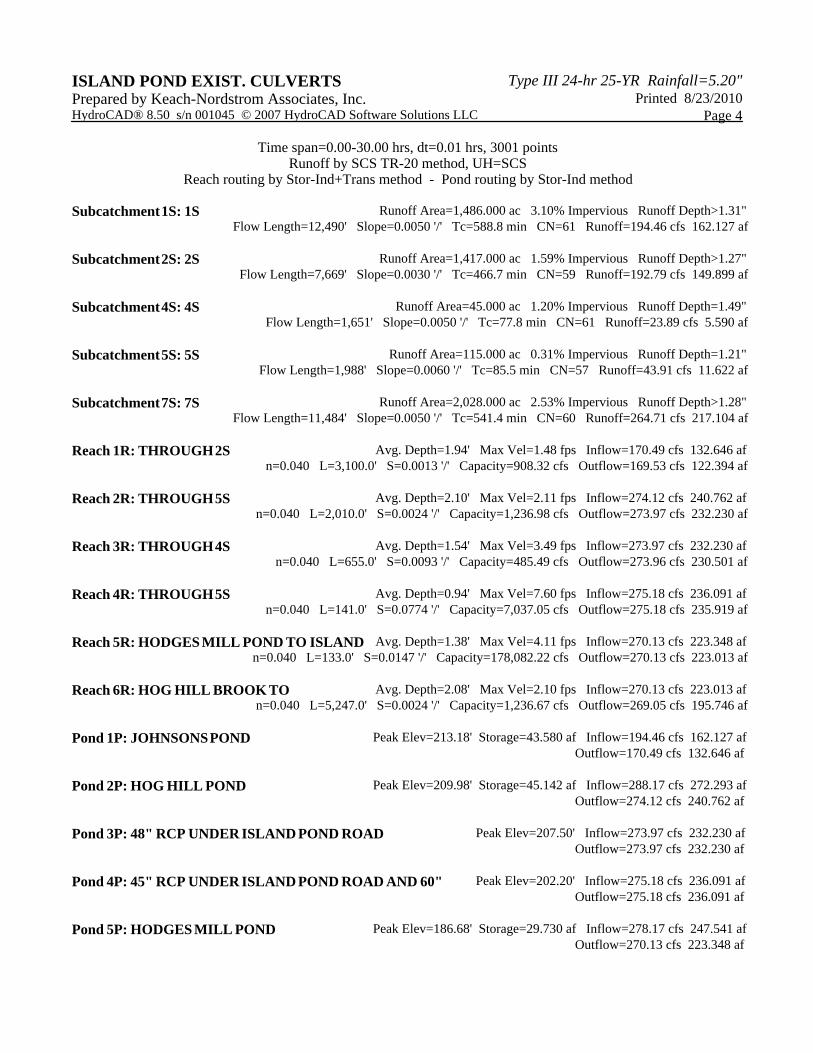
Type III 24-hr 25-YR Rainfall=5.20"ISLAND POND EXIST. CULVERTS Printed 8/23/2010Prepared by Keach-Nordstrom Associates, Inc.
Page 4HydroCAD® 8.50 s/n 001045 © 2007 HydroCAD Software Solutions LLC
Time span=0.00-30.00 hrs, dt=0.01 hrs, 3001 pointsRunoff by SCS TR-20 method, UH=SCS
Reach routing by Stor-Ind+Trans method - Pond routing by Stor-Ind method
Runoff Area=1,486.000 ac 3.10% Impervious Runoff Depth>1.31"Subcatchment 1S: 1S Flow Length=12,490' Slope=0.0050 '/' Tc=588.8 min CN=61 Runoff=194.46 cfs 162.127 af
Runoff Area=1,417.000 ac 1.59% Impervious Runoff Depth>1.27"Subcatchment 2S: 2S Flow Length=7,669' Slope=0.0030 '/' Tc=466.7 min CN=59 Runoff=192.79 cfs 149.899 af
Runoff Area=45.000 ac 1.20% Impervious Runoff Depth=1.49"Subcatchment 4S: 4S Flow Length=1,651' Slope=0.0050 '/' Tc=77.8 min CN=61 Runoff=23.89 cfs 5.590 af
Runoff Area=115.000 ac 0.31% Impervious Runoff Depth=1.21"Subcatchment 5S: 5S Flow Length=1,988' Slope=0.0060 '/' Tc=85.5 min CN=57 Runoff=43.91 cfs 11.622 af
Runoff Area=2,028.000 ac 2.53% Impervious Runoff Depth>1.28"Subcatchment 7S: 7S Flow Length=11,484' Slope=0.0050 '/' Tc=541.4 min CN=60 Runoff=264.71 cfs 217.104 af
Avg. Depth=1.94' Max Vel=1.48 fps Inflow=170.49 cfs 132.646 afReach 1R: THROUGH 2Sn=0.040 L=3,100.0' S=0.0013 '/' Capacity=908.32 cfs Outflow=169.53 cfs 122.394 af
Avg. Depth=2.10' Max Vel=2.11 fps Inflow=274.12 cfs 240.762 afReach 2R: THROUGH 5Sn=0.040 L=2,010.0' S=0.0024 '/' Capacity=1,236.98 cfs Outflow=273.97 cfs 232.230 af
Avg. Depth=1.54' Max Vel=3.49 fps Inflow=273.97 cfs 232.230 afReach 3R: THROUGH 4Sn=0.040 L=655.0' S=0.0093 '/' Capacity=485.49 cfs Outflow=273.96 cfs 230.501 af
Avg. Depth=0.94' Max Vel=7.60 fps Inflow=275.18 cfs 236.091 afReach 4R: THROUGH 5Sn=0.040 L=141.0' S=0.0774 '/' Capacity=7,037.05 cfs Outflow=275.18 cfs 235.919 af
Avg. Depth=1.38' Max Vel=4.11 fps Inflow=270.13 cfs 223.348 afReach 5R: HODGES MILL POND TO ISLAND n=0.040 L=133.0' S=0.0147 '/' Capacity=178,082.22 cfs Outflow=270.13 cfs 223.013 af
Avg. Depth=2.08' Max Vel=2.10 fps Inflow=270.13 cfs 223.013 afReach 6R: HOG HILL BROOK TO n=0.040 L=5,247.0' S=0.0024 '/' Capacity=1,236.67 cfs Outflow=269.05 cfs 195.746 af
Peak Elev=213.18' Storage=43.580 af Inflow=194.46 cfs 162.127 afPond 1P: JOHNSONS POND Outflow=170.49 cfs 132.646 af
Peak Elev=209.98' Storage=45.142 af Inflow=288.17 cfs 272.293 afPond 2P: HOG HILL POND Outflow=274.12 cfs 240.762 af
Peak Elev=207.50' Inflow=273.97 cfs 232.230 afPond 3P: 48" RCP UNDER ISLAND POND ROAD Outflow=273.97 cfs 232.230 af
Peak Elev=202.20' Inflow=275.18 cfs 236.091 afPond 4P: 45" RCP UNDER ISLAND POND ROAD AND 60" Outflow=275.18 cfs 236.091 af
Peak Elev=186.68' Storage=29.730 af Inflow=278.17 cfs 247.541 afPond 5P: HODGES MILL POND Outflow=270.13 cfs 223.348 af

Type III 24-hr 25-YR Rainfall=5.20"ISLAND POND EXIST. CULVERTS Printed 8/23/2010Prepared by Keach-Nordstrom Associates, Inc.
Page 5HydroCAD® 8.50 s/n 001045 © 2007 HydroCAD Software Solutions LLC
Peak Elev=188.50' Inflow=270.13 cfs 223.013 afPond 6P: 45" CROSSING UNDER ISLAND POND ROAD Outflow=270.13 cfs 223.013 af
Peak Elev=169.77' Storage=36.683 af Inflow=412.47 cfs 412.851 afPond 7P: EXISTING IMPOUNDMENT AREA Outflow=411.50 cfs 380.311 af
Peak Elev=169.42' Inflow=411.50 cfs 380.311 afPond 8P: CROSSING UNDER WEST SIDE DRIVE Outflow=411.50 cfs 380.311 af
Inflow=411.50 cfs 380.311 afLink 1L: HOG HILL BROOK Primary=411.50 cfs 380.311 af
Total Runoff Area = 5,091.000 ac Runoff Volume = 546.342 af Average Runoff Depth = 1.29"97.63% Pervious = 4,970.220 ac 2.37% Impervious = 120.780 ac

Type III 24-hr 25-YR Rainfall=5.20"ISLAND POND EXIST. CULVERTS Printed 8/23/2010Prepared by Keach-Nordstrom Associates, Inc.
Page 6HydroCAD® 8.50 s/n 001045 © 2007 HydroCAD Software Solutions LLC
Summary for Subcatchment 1S: 1S
Runoff = 194.46 cfs @ 20.93 hrs, Volume= 162.127 af, Depth> 1.31"
Runoff by SCS TR-20 method, UH=SCS, Time Span= 0.00-30.00 hrs, dt= 0.01 hrsType III 24-hr 25-YR Rainfall=5.20"
Area (ac) CN Description250.000 77 Woods, Good, HSG D384.000 65 2 acre lots, 12% imp, HSG B852.000 55 Woods, Good, HSG B
1,486.000 61 Weighted Average1,439.920 Pervious Area
46.080 Impervious Area
Tc Length Slope Velocity Capacity Description(min) (feet) (ft/ft) (ft/sec) (cfs)588.8 12,490 0.0050 0.35 Shallow Concentrated Flow,
Woodland Kv= 5.0 fps
Summary for Subcatchment 2S: 2S
Runoff = 192.79 cfs @ 19.18 hrs, Volume= 149.899 af, Depth> 1.27"
Runoff by SCS TR-20 method, UH=SCS, Time Span= 0.00-30.00 hrs, dt= 0.01 hrsType III 24-hr 25-YR Rainfall=5.20"
Area (ac) CN Description151.000 77 Woods, Good, HSG D188.000 65 2 acre lots, 12% imp, HSG B
1,078.000 55 Woods, Good, HSG B1,417.000 59 Weighted Average1,394.440 Pervious Area
22.560 Impervious Area
Tc Length Slope Velocity Capacity Description(min) (feet) (ft/ft) (ft/sec) (cfs)466.7 7,669 0.0030 0.27 Shallow Concentrated Flow,
Woodland Kv= 5.0 fps
Summary for Subcatchment 4S: 4S
Runoff = 23.89 cfs @ 13.14 hrs, Volume= 5.590 af, Depth= 1.49"
Runoff by SCS TR-20 method, UH=SCS, Time Span= 0.00-30.00 hrs, dt= 0.01 hrsType III 24-hr 25-YR Rainfall=5.20"

Type III 24-hr 25-YR Rainfall=5.20"ISLAND POND EXIST. CULVERTS Printed 8/23/2010Prepared by Keach-Nordstrom Associates, Inc.
Page 7HydroCAD® 8.50 s/n 001045 © 2007 HydroCAD Software Solutions LLC
Area (ac) CN Description11.000 77 Woods, Good, HSG D4.500 65 2 acre lots, 12% imp, HSG B
29.500 55 Woods, Good, HSG B45.000 61 Weighted Average44.460 Pervious Area0.540 Impervious Area
Tc Length Slope Velocity Capacity Description(min) (feet) (ft/ft) (ft/sec) (cfs)77.8 1,651 0.0050 0.35 Shallow Concentrated Flow,
Woodland Kv= 5.0 fps
Summary for Subcatchment 5S: 5S
Runoff = 43.91 cfs @ 13.30 hrs, Volume= 11.622 af, Depth= 1.21"
Runoff by SCS TR-20 method, UH=SCS, Time Span= 0.00-30.00 hrs, dt= 0.01 hrsType III 24-hr 25-YR Rainfall=5.20"
Area (ac) CN Description9.500 77 Woods, Good, HSG D3.000 65 2 acre lots, 12% imp, HSG B
102.500 55 Woods, Good, HSG B115.000 57 Weighted Average114.640 Pervious Area
0.360 Impervious Area
Tc Length Slope Velocity Capacity Description(min) (feet) (ft/ft) (ft/sec) (cfs)85.5 1,988 0.0060 0.39 Shallow Concentrated Flow,
Woodland Kv= 5.0 fps
Summary for Subcatchment 7S: 7S
Runoff = 264.71 cfs @ 19.86 hrs, Volume= 217.104 af, Depth> 1.28"
Runoff by SCS TR-20 method, UH=SCS, Time Span= 0.00-30.00 hrs, dt= 0.01 hrsType III 24-hr 25-YR Rainfall=5.20"
Area (ac) CN Description258.000 77 Woods, Good, HSG D427.000 65 2 acre lots, 12% imp, HSG B
1,343.000 55 Woods, Good, HSG B2,028.000 60 Weighted Average1,976.760 Pervious Area
51.240 Impervious Area

Type III 24-hr 25-YR Rainfall=5.20"ISLAND POND EXIST. CULVERTS Printed 8/23/2010Prepared by Keach-Nordstrom Associates, Inc.
Page 8HydroCAD® 8.50 s/n 001045 © 2007 HydroCAD Software Solutions LLC
Tc Length Slope Velocity Capacity Description(min) (feet) (ft/ft) (ft/sec) (cfs)541.4 11,484 0.0050 0.35 Shallow Concentrated Flow,
Woodland Kv= 5.0 fps
Summary for Reach 1R: THROUGH 2S
Inflow Area = 1,486.000 ac, 3.10% Impervious, Inflow Depth > 1.07" for 25-YR eventInflow = 170.49 cfs @ 23.07 hrs, Volume= 132.646 afOutflow = 169.53 cfs @ 24.09 hrs, Volume= 122.394 af, Atten= 1%, Lag= 61.2 min
Routing by Stor-Ind+Trans method, Time Span= 0.00-30.00 hrs, dt= 0.01 hrs / 9Max. Velocity= 1.48 fps, Min. Travel Time= 34.9 minAvg. Velocity = 1.27 fps, Avg. Travel Time= 40.7 min
Peak Storage= 354,751 cf @ 23.51 hrs, Average Depth at Peak Storage= 1.94'Bank-Full Depth= 4.00', Capacity at Bank-Full= 908.32 cfs
20.00' x 4.00' deep channel, n= 0.040 Winding stream, pools & shoalsSide Slope Z-value= 20.0 '/' Top Width= 180.00'Length= 3,100.0' Slope= 0.0013 '/'Inlet Invert= 209.00', Outlet Invert= 205.00'
Summary for Reach 2R: THROUGH 5S
Inflow Area = 2,903.000 ac, 2.36% Impervious, Inflow Depth > 1.00" for 25-YR eventInflow = 274.12 cfs @ 24.06 hrs, Volume= 240.762 afOutflow = 273.97 cfs @ 24.52 hrs, Volume= 232.230 af, Atten= 0%, Lag= 27.6 min
Routing by Stor-Ind+Trans method, Time Span= 0.00-30.00 hrs, dt= 0.01 hrs / 9Max. Velocity= 2.11 fps, Min. Travel Time= 15.9 minAvg. Velocity = 1.85 fps, Avg. Travel Time= 18.1 min
Peak Storage= 261,195 cf @ 24.26 hrs, Average Depth at Peak Storage= 2.10'Bank-Full Depth= 4.00', Capacity at Bank-Full= 1,236.98 cfs
20.00' x 4.00' deep channel, n= 0.040Side Slope Z-value= 20.0 '/' Top Width= 180.00'Length= 2,010.0' Slope= 0.0024 '/'Inlet Invert= 205.00', Outlet Invert= 200.19'
Summary for Reach 3R: THROUGH 4S
Inflow Area = 2,903.000 ac, 2.36% Impervious, Inflow Depth > 0.96" for 25-YR eventInflow = 273.97 cfs @ 24.52 hrs, Volume= 232.230 afOutflow = 273.96 cfs @ 24.61 hrs, Volume= 230.501 af, Atten= 0%, Lag= 5.4 min
Routing by Stor-Ind+Trans method, Time Span= 0.00-30.00 hrs, dt= 0.01 hrs / 9Max. Velocity= 3.49 fps, Min. Travel Time= 3.1 minAvg. Velocity = 3.04 fps, Avg. Travel Time= 3.6 min

Type III 24-hr 25-YR Rainfall=5.20"ISLAND POND EXIST. CULVERTS Printed 8/23/2010Prepared by Keach-Nordstrom Associates, Inc.
Page 9HydroCAD® 8.50 s/n 001045 © 2007 HydroCAD Software Solutions LLC
Peak Storage= 51,440 cf @ 24.56 hrs, Average Depth at Peak Storage= 1.54'Bank-Full Depth= 2.00', Capacity at Bank-Full= 485.49 cfs
20.00' x 2.00' deep channel, n= 0.040Side Slope Z-value= 20.0 '/' Top Width= 100.00'Length= 655.0' Slope= 0.0093 '/'Inlet Invert= 199.94', Outlet Invert= 193.84'
Summary for Reach 4R: THROUGH 5S
Inflow Area = 2,948.000 ac, 2.35% Impervious, Inflow Depth > 0.96" for 25-YR eventInflow = 275.18 cfs @ 24.53 hrs, Volume= 236.091 afOutflow = 275.18 cfs @ 24.54 hrs, Volume= 235.919 af, Atten= 0%, Lag= 0.5 min
Routing by Stor-Ind+Trans method, Time Span= 0.00-30.00 hrs, dt= 0.01 hrs / 9Max. Velocity= 7.60 fps, Min. Travel Time= 0.3 minAvg. Velocity = 5.63 fps, Avg. Travel Time= 0.4 min
Peak Storage= 5,105 cf @ 24.54 hrs, Average Depth at Peak Storage= 0.94'Bank-Full Depth= 4.00', Capacity at Bank-Full= 7,037.05 cfs
20.00' x 4.00' deep channel, n= 0.040Side Slope Z-value= 20.0 '/' Top Width= 180.00'Length= 141.0' Slope= 0.0774 '/'Inlet Invert= 191.47', Outlet Invert= 180.55'
Summary for Reach 5R: HODGES MILL POND TO ISLAND POND ROAD
Inflow Area = 3,063.000 ac, 2.27% Impervious, Inflow Depth > 0.88" for 25-YR eventInflow = 270.13 cfs @ 25.72 hrs, Volume= 223.348 afOutflow = 270.13 cfs @ 25.74 hrs, Volume= 223.013 af, Atten= 0%, Lag= 0.9 min
Routing by Stor-Ind+Trans method, Time Span= 0.00-30.00 hrs, dt= 0.01 hrs / 9Max. Velocity= 4.11 fps, Min. Travel Time= 0.5 minAvg. Velocity = 3.33 fps, Avg. Travel Time= 0.7 min
Peak Storage= 8,736 cf @ 25.73 hrs, Average Depth at Peak Storage= 1.38'Bank-Full Depth= 20.00', Capacity at Bank-Full= 178,082.22 cfs
20.00' x 20.00' deep channel, n= 0.040Side Slope Z-value= 20.0 '/' Top Width= 820.00'Length= 133.0' Slope= 0.0147 '/'Inlet Invert= 181.50', Outlet Invert= 179.55'
Summary for Reach 6R: HOG HILL BROOK TO IMPOUNDMENT AREA
Inflow Area = 3,063.000 ac, 2.27% Impervious, Inflow Depth > 0.87" for 25-YR eventInflow = 270.13 cfs @ 25.74 hrs, Volume= 223.013 afOutflow = 269.05 cfs @ 26.99 hrs, Volume= 195.746 af, Atten= 0%, Lag= 75.3 min
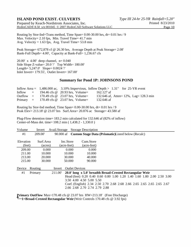
Type III 24-hr 25-YR Rainfall=5.20"ISLAND POND EXIST. CULVERTS Printed 8/23/2010Prepared by Keach-Nordstrom Associates, Inc.
Page 10HydroCAD® 8.50 s/n 001045 © 2007 HydroCAD Software Solutions LLC
Routing by Stor-Ind+Trans method, Time Span= 0.00-30.00 hrs, dt= 0.01 hrs / 9Max. Velocity= 2.10 fps, Min. Travel Time= 41.7 minAvg. Velocity = 1.63 fps, Avg. Travel Time= 53.8 min
Peak Storage= 672,878 cf @ 26.30 hrs, Average Depth at Peak Storage= 2.08'Bank-Full Depth= 4.00', Capacity at Bank-Full= 1,236.67 cfs
20.00' x 4.00' deep channel, n= 0.040Side Slope Z-value= 20.0 '/' Top Width= 180.00'Length= 5,247.0' Slope= 0.0024 '/'Inlet Invert= 179.55', Outlet Invert= 167.00'
Summary for Pond 1P: JOHNSONS POND
Inflow Area = 1,486.000 ac, 3.10% Impervious, Inflow Depth > 1.31" for 25-YR eventInflow = 194.46 cfs @ 20.93 hrs, Volume= 162.127 afOutflow = 170.49 cfs @ 23.07 hrs, Volume= 132.646 af, Atten= 12%, Lag= 128.3 minPrimary = 170.49 cfs @ 23.07 hrs, Volume= 132.646 af
Routing by Stor-Ind method, Time Span= 0.00-30.00 hrs, dt= 0.01 hrs / 9Peak Elev= 213.18' @ 23.07 hrs Surf.Area= 20.876 ac Storage= 43.580 af
Plug-Flow detention time= 183.2 min calculated for 132.646 af (82% of inflow)Center-of-Mass det. time= 108.2 min ( 1,438.2 - 1,330.0 )
Volume Invert Avail.Storage Storage Description#1 209.00' 90.000 af Custom Stage Data (Prismatic) Listed below (Recalc)
Elevation Surf.Area Inc.Store Cum.Store(feet) (acres) (acre-feet) (acre-feet)
209.00 0.000 0.000 0.000211.00 10.000 10.000 10.000213.00 20.000 30.000 40.000215.00 30.000 50.000 90.000
Device Routing Invert Outlet Devices#1 Primary 211.00' 20.0' long x 5.0' breadth Broad-Crested Rectangular Weir
Head (feet) 0.20 0.40 0.60 0.80 1.00 1.20 1.40 1.60 1.80 2.00 2.50 3.00 3.50 4.00 4.50 5.00 5.50 Coef. (English) 2.34 2.50 2.70 2.68 2.68 2.66 2.65 2.65 2.65 2.65 2.67 2.66 2.68 2.70 2.74 2.79 2.88
Primary OutFlow Max=170.48 cfs @ 23.07 hrs HW=213.18' (Free Discharge)1=Broad-Crested Rectangular Weir (Weir Controls 170.48 cfs @ 3.92 fps)

Type III 24-hr 25-YR Rainfall=5.20"ISLAND POND EXIST. CULVERTS Printed 8/23/2010Prepared by Keach-Nordstrom Associates, Inc.
Page 11HydroCAD® 8.50 s/n 001045 © 2007 HydroCAD Software Solutions LLC
Summary for Pond 2P: HOG HILL POND
Inflow Area = 2,903.000 ac, 2.36% Impervious, Inflow Depth > 1.13" for 25-YR eventInflow = 288.17 cfs @ 22.18 hrs, Volume= 272.293 afOutflow = 274.12 cfs @ 24.06 hrs, Volume= 240.762 af, Atten= 5%, Lag= 113.2 minPrimary = 274.12 cfs @ 24.06 hrs, Volume= 240.762 af
Routing by Stor-Ind method, Time Span= 0.00-30.00 hrs, dt= 0.01 hrs / 9Peak Elev= 209.98' @ 24.06 hrs Surf.Area= 20.880 ac Storage= 45.142 af
Plug-Flow detention time= 118.3 min calculated for 240.762 af (88% of inflow)Center-of-Mass det. time= 69.9 min ( 1,428.5 - 1,358.6 )
Volume Invert Avail.Storage Storage Description#1 205.00' 70.000 af Custom Stage Data (Prismatic) Listed below (Recalc)
Elevation Surf.Area Inc.Store Cum.Store(feet) (acres) (acre-feet) (acre-feet)
205.00 0.000 0.000 0.000207.00 7.000 7.000 7.000209.00 14.000 21.000 28.000211.00 28.000 42.000 70.000
Device Routing Invert Outlet Devices#1 Primary 207.00' 20.0' long x 5.0' breadth Broad-Crested Rectangular Weir
Head (feet) 0.20 0.40 0.60 0.80 1.00 1.20 1.40 1.60 1.80 2.00 2.50 3.00 3.50 4.00 4.50 5.00 5.50 Coef. (English) 2.34 2.50 2.70 2.68 2.68 2.66 2.65 2.65 2.65 2.65 2.67 2.66 2.68 2.70 2.74 2.79 2.88
Primary OutFlow Max=274.11 cfs @ 24.06 hrs HW=209.98' (Free Discharge)1=Broad-Crested Rectangular Weir (Weir Controls 274.11 cfs @ 4.59 fps)
Summary for Pond 3P: 48" RCP UNDER ISLAND POND ROAD
Inflow Area = 2,903.000 ac, 2.36% Impervious, Inflow Depth > 0.96" for 25-YR eventInflow = 273.97 cfs @ 24.52 hrs, Volume= 232.230 afOutflow = 273.97 cfs @ 24.52 hrs, Volume= 232.230 af, Atten= 0%, Lag= 0.0 minPrimary = 273.97 cfs @ 24.52 hrs, Volume= 232.230 af
Routing by Stor-Ind method, Time Span= 0.00-30.00 hrs, dt= 0.01 hrs / 9Peak Elev= 207.50' @ 24.52 hrsFlood Elev= 206.48'
Device Routing Invert Outlet Devices#1 Primary 200.19' 48.0" x 40.0' long Culvert RCP, square edge headwall, Ke= 0.500
Outlet Invert= 199.94' S= 0.0063 '/' Cc= 0.900 n= 0.012 Concrete pipe, finished
#2 Primary 206.48' 50.0' long x 24.0' breadth Broad-Crested Rectangular Weir Head (feet) 0.20 0.40 0.60 0.80 1.00 1.20 1.40 1.60 Coef. (English) 2.68 2.70 2.70 2.64 2.63 2.64 2.64 2.63

Type III 24-hr 25-YR Rainfall=5.20"ISLAND POND EXIST. CULVERTS Printed 8/23/2010Prepared by Keach-Nordstrom Associates, Inc.
Page 12HydroCAD® 8.50 s/n 001045 © 2007 HydroCAD Software Solutions LLC
Primary OutFlow Max=273.94 cfs @ 24.52 hrs HW=207.50' (Free Discharge)1=Culvert (Inlet Controls 139.37 cfs @ 11.09 fps)2=Broad-Crested Rectangular Weir (Weir Controls 134.57 cfs @ 2.65 fps)
Summary for Pond 4P: 45" RCP UNDER ISLAND POND ROAD AND 60" RCP UNDER TRAIL
Inflow Area = 2,948.000 ac, 2.35% Impervious, Inflow Depth > 0.96" for 25-YR eventInflow = 275.18 cfs @ 24.53 hrs, Volume= 236.091 afOutflow = 275.18 cfs @ 24.53 hrs, Volume= 236.091 af, Atten= 0%, Lag= 0.0 minPrimary = 275.18 cfs @ 24.53 hrs, Volume= 236.091 af
Routing by Stor-Ind method, Time Span= 0.00-30.00 hrs, dt= 0.01 hrs / 9Peak Elev= 202.20' @ 24.53 hrsFlood Elev= 200.88'
Device Routing Invert Outlet Devices#1 Device 2 193.84' 45.0" x 42.0' long Culvert RCP, square edge headwall, Ke= 0.500
Outlet Invert= 193.30' S= 0.0129 '/' Cc= 0.900 n= 0.012 Concrete pipe, finished
#2 Primary 192.48' 60.0" x 19.0' long Culvert RCP, square edge headwall, Ke= 0.500 Outlet Invert= 191.47' S= 0.0532 '/' Cc= 0.900 n= 0.012
#3 Primary 200.88' 35.0' long x 24.0' breadth Broad-Crested Rectangular Weir Head (feet) 0.20 0.40 0.60 0.80 1.00 1.20 1.40 1.60 Coef. (English) 2.68 2.70 2.70 2.64 2.63 2.64 2.64 2.63
Primary OutFlow Max=275.14 cfs @ 24.53 hrs HW=202.20' (Free Discharge)2=Culvert (Passes 135.40 cfs of 253.99 cfs potential flow)
1=Culvert (Inlet Controls 135.40 cfs @ 12.26 fps)3=Broad-Crested Rectangular Weir (Weir Controls 139.74 cfs @ 3.03 fps)
Summary for Pond 5P: HODGES MILL POND
Inflow Area = 3,063.000 ac, 2.27% Impervious, Inflow Depth > 0.97" for 25-YR eventInflow = 278.17 cfs @ 24.44 hrs, Volume= 247.541 afOutflow = 270.13 cfs @ 25.72 hrs, Volume= 223.348 af, Atten= 3%, Lag= 76.8 minPrimary = 270.13 cfs @ 25.72 hrs, Volume= 223.348 af
Routing by Stor-Ind method, Time Span= 0.00-30.00 hrs, dt= 0.01 hrs / 9Peak Elev= 186.68' @ 25.72 hrs Surf.Area= 8.698 ac Storage= 29.730 af
Plug-Flow detention time= 79.3 min calculated for 223.348 af (90% of inflow)Center-of-Mass det. time= 42.5 min ( 1,459.8 - 1,417.3 )
Volume Invert Avail.Storage Storage Description#1 180.55' 59.850 af Custom Stage Data (Prismatic) Listed below (Recalc)
Elevation Surf.Area Inc.Store Cum.Store(feet) (acres) (acre-feet) (acre-feet)
180.55 1.000 0.000 0.000189.55 12.300 59.850 59.850
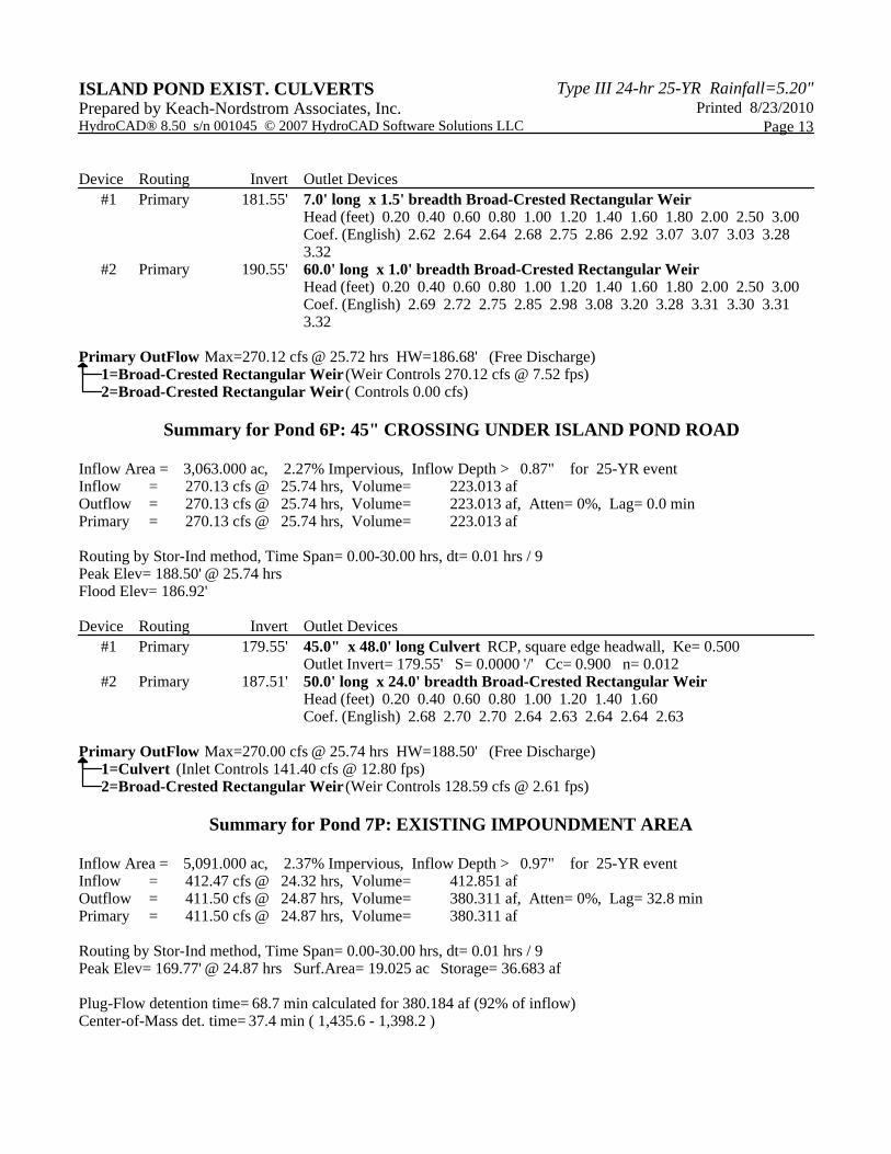
Type III 24-hr 25-YR Rainfall=5.20"ISLAND POND EXIST. CULVERTS Printed 8/23/2010Prepared by Keach-Nordstrom Associates, Inc.
Page 13HydroCAD® 8.50 s/n 001045 © 2007 HydroCAD Software Solutions LLC
Device Routing Invert Outlet Devices#1 Primary 181.55' 7.0' long x 1.5' breadth Broad-Crested Rectangular Weir
Head (feet) 0.20 0.40 0.60 0.80 1.00 1.20 1.40 1.60 1.80 2.00 2.50 3.00 Coef. (English) 2.62 2.64 2.64 2.68 2.75 2.86 2.92 3.07 3.07 3.03 3.28 3.32
#2 Primary 190.55' 60.0' long x 1.0' breadth Broad-Crested Rectangular Weir Head (feet) 0.20 0.40 0.60 0.80 1.00 1.20 1.40 1.60 1.80 2.00 2.50 3.00 Coef. (English) 2.69 2.72 2.75 2.85 2.98 3.08 3.20 3.28 3.31 3.30 3.31 3.32
Primary OutFlow Max=270.12 cfs @ 25.72 hrs HW=186.68' (Free Discharge)1=Broad-Crested Rectangular Weir (Weir Controls 270.12 cfs @ 7.52 fps)2=Broad-Crested Rectangular Weir ( Controls 0.00 cfs)
Summary for Pond 6P: 45" CROSSING UNDER ISLAND POND ROAD
Inflow Area = 3,063.000 ac, 2.27% Impervious, Inflow Depth > 0.87" for 25-YR eventInflow = 270.13 cfs @ 25.74 hrs, Volume= 223.013 afOutflow = 270.13 cfs @ 25.74 hrs, Volume= 223.013 af, Atten= 0%, Lag= 0.0 minPrimary = 270.13 cfs @ 25.74 hrs, Volume= 223.013 af
Routing by Stor-Ind method, Time Span= 0.00-30.00 hrs, dt= 0.01 hrs / 9Peak Elev= 188.50' @ 25.74 hrsFlood Elev= 186.92'
Device Routing Invert Outlet Devices#1 Primary 179.55' 45.0" x 48.0' long Culvert RCP, square edge headwall, Ke= 0.500
Outlet Invert= 179.55' S= 0.0000 '/' Cc= 0.900 n= 0.012 #2 Primary 187.51' 50.0' long x 24.0' breadth Broad-Crested Rectangular Weir
Head (feet) 0.20 0.40 0.60 0.80 1.00 1.20 1.40 1.60 Coef. (English) 2.68 2.70 2.70 2.64 2.63 2.64 2.64 2.63
Primary OutFlow Max=270.00 cfs @ 25.74 hrs HW=188.50' (Free Discharge)1=Culvert (Inlet Controls 141.40 cfs @ 12.80 fps)2=Broad-Crested Rectangular Weir (Weir Controls 128.59 cfs @ 2.61 fps)
Summary for Pond 7P: EXISTING IMPOUNDMENT AREA
Inflow Area = 5,091.000 ac, 2.37% Impervious, Inflow Depth > 0.97" for 25-YR eventInflow = 412.47 cfs @ 24.32 hrs, Volume= 412.851 afOutflow = 411.50 cfs @ 24.87 hrs, Volume= 380.311 af, Atten= 0%, Lag= 32.8 minPrimary = 411.50 cfs @ 24.87 hrs, Volume= 380.311 af
Routing by Stor-Ind method, Time Span= 0.00-30.00 hrs, dt= 0.01 hrs / 9Peak Elev= 169.77' @ 24.87 hrs Surf.Area= 19.025 ac Storage= 36.683 af
Plug-Flow detention time= 68.7 min calculated for 380.184 af (92% of inflow)Center-of-Mass det. time= 37.4 min ( 1,435.6 - 1,398.2 )

Type III 24-hr 25-YR Rainfall=5.20"ISLAND POND EXIST. CULVERTS Printed 8/23/2010Prepared by Keach-Nordstrom Associates, Inc.
Page 14HydroCAD® 8.50 s/n 001045 © 2007 HydroCAD Software Solutions LLC
Volume Invert Avail.Storage Storage Description#1 167.00' 41.250 af Custom Stage Data (Prismatic) Listed below (Recalc)
Elevation Surf.Area Inc.Store Cum.Store(feet) (acres) (acre-feet) (acre-feet)
167.00 7.500 0.000 0.000170.00 20.000 41.250 41.250
Device Routing Invert Outlet Devices#1 Primary 167.00' 15.0' long x 10.0' breadth Broad-Crested Rectangular Weir
Head (feet) 0.20 0.40 0.60 0.80 1.00 1.20 1.40 1.60 Coef. (English) 2.49 2.56 2.70 2.69 2.68 2.69 2.67 2.64
#2 Primary 168.50' 60.0' long x 10.0' breadth Broad-Crested Rectangular Weir Head (feet) 0.20 0.40 0.60 0.80 1.00 1.20 1.40 1.60 Coef. (English) 2.49 2.56 2.70 2.69 2.68 2.69 2.67 2.64
Primary OutFlow Max=411.49 cfs @ 24.87 hrs HW=169.77' (Free Discharge)1=Broad-Crested Rectangular Weir (Weir Controls 182.16 cfs @ 4.39 fps)2=Broad-Crested Rectangular Weir (Weir Controls 229.33 cfs @ 3.02 fps)
Summary for Pond 8P: CROSSING UNDER WEST SIDE DRIVE
Inflow Area = 5,091.000 ac, 2.37% Impervious, Inflow Depth > 0.90" for 25-YR eventInflow = 411.50 cfs @ 24.87 hrs, Volume= 380.311 afOutflow = 411.50 cfs @ 24.87 hrs, Volume= 380.311 af, Atten= 0%, Lag= 0.0 minPrimary = 411.50 cfs @ 24.87 hrs, Volume= 380.311 af
Routing by Stor-Ind method, Time Span= 0.00-30.00 hrs, dt= 0.01 hrs / 9Peak Elev= 169.42' @ 24.87 hrsFlood Elev= 175.00'
Device Routing Invert Outlet Devices#1 Primary 161.00' 96.0" x 40.0' long Culvert CMP, square edge headwall, Ke= 0.500
Outlet Invert= 160.60' S= 0.0100 '/' Cc= 0.900 n= 0.025 Corrugated metal #2 Primary 175.00' 50.0' long x 24.0' breadth Broad-Crested Rectangular Weir
Head (feet) 0.20 0.40 0.60 0.80 1.00 1.20 1.40 1.60 Coef. (English) 2.68 2.70 2.70 2.64 2.63 2.64 2.64 2.63
Primary OutFlow Max=411.51 cfs @ 24.87 hrs HW=169.42' (Free Discharge)1=Culvert (Barrel Controls 411.51 cfs @ 9.67 fps)2=Broad-Crested Rectangular Weir ( Controls 0.00 cfs)
Summary for Link 1L: HOG HILL BROOK
Inflow Area = 5,091.000 ac, 2.37% Impervious, Inflow Depth > 0.90" for 25-YR eventInflow = 411.50 cfs @ 24.87 hrs, Volume= 380.311 afPrimary = 411.50 cfs @ 24.87 hrs, Volume= 380.311 af, Atten= 0%, Lag= 0.0 min
Primary outflow = Inflow, Time Span= 0.00-30.00 hrs, dt= 0.01 hrs

D: 25-YEAR, POST ROADWAY IMPROVEMENTS
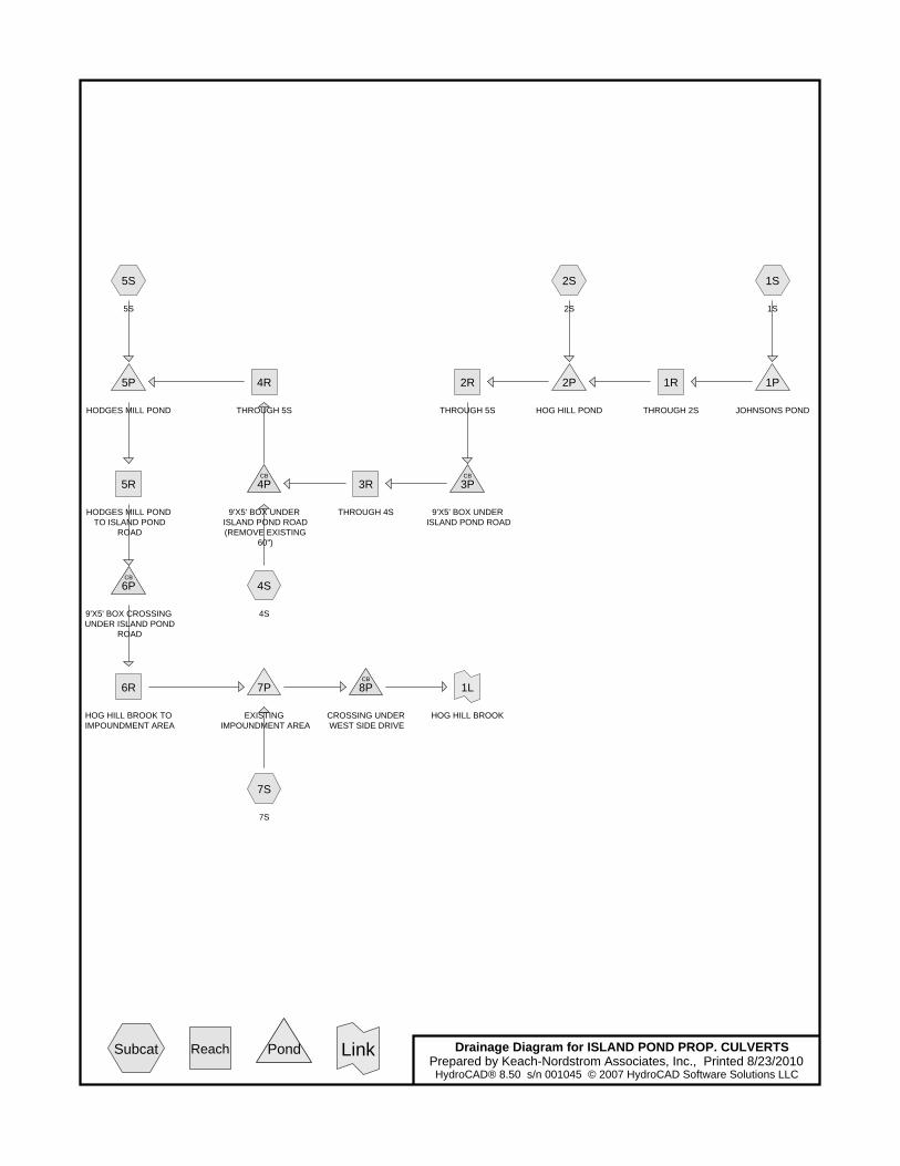
1S
1S
2S
2S
4S
4S
5S
5S
7S
7S
1R
THROUGH 2S
2R
THROUGH 5S
3R
THROUGH 4S
4R
THROUGH 5S
5R
HODGES MILL POND TO ISLAND POND
ROAD
6R
HOG HILL BROOK TO IMPOUNDMENT AREA
1P
JOHNSONS POND
2P
HOG HILL POND
3PCB
9'X5' BOX UNDER ISLAND POND ROAD
4PCB
9'X5' BOX UNDER ISLAND POND ROAD (REMOVE EXISTING
60")
5P
HODGES MILL POND
6PCB
9'X5' BOX CROSSING UNDER ISLAND POND
ROAD
7P
EXISTING IMPOUNDMENT AREA
8PCB
CROSSING UNDER WEST SIDE DRIVE
1L
HOG HILL BROOK
Drainage Diagram for ISLAND POND PROP. CULVERTSPrepared by Keach-Nordstrom Associates, Inc., Printed 8/23/2010HydroCAD® 8.50 s/n 001045 © 2007 HydroCAD Software Solutions LLC
Subcat Reach Pond Link

ISLAND POND PROP. CULVERTS Printed 8/23/2010Prepared by Keach-Nordstrom Associates, Inc.
Page 2HydroCAD® 8.50 s/n 001045 © 2007 HydroCAD Software Solutions LLC
Area Listing (all nodes)
Area
(acres)
CN Description
(subcatchment-numbers)
3,405.000 55 Woods, Good, HSG B (1S,2S,4S,5S,7S)
1,006.500 65 2 acre lots, 12% imp, HSG B (1S,2S,4S,5S,7S)
679.500 77 Woods, Good, HSG D (1S,2S,4S,5S,7S)
5,091.000 TOTAL AREA

ISLAND POND PROP. CULVERTS Printed 8/23/2010Prepared by Keach-Nordstrom Associates, Inc.
Page 3HydroCAD® 8.50 s/n 001045 © 2007 HydroCAD Software Solutions LLC
Soil Listing (all nodes)
Area
(acres)
Soil
Goup
Subcatchment
Numbers
0.000 HSG A
4,411.500 HSG B 1S, 2S, 4S, 5S, 7S
0.000 HSG C
679.500 HSG D 1S, 2S, 4S, 5S, 7S
0.000 Other
5,091.000 TOTAL AREA

Type III 24-hr 25-YR Rainfall=5.20"ISLAND POND PROP. CULVERTS Printed 8/23/2010Prepared by Keach-Nordstrom Associates, Inc.
Page 4HydroCAD® 8.50 s/n 001045 © 2007 HydroCAD Software Solutions LLC
Time span=0.00-30.00 hrs, dt=0.01 hrs, 3001 pointsRunoff by SCS TR-20 method, UH=SCS
Reach routing by Stor-Ind+Trans method - Pond routing by Stor-Ind method
Runoff Area=1,486.000 ac 3.10% Impervious Runoff Depth>1.31"Subcatchment 1S: 1S Flow Length=12,490' Slope=0.0050 '/' Tc=588.8 min CN=61 Runoff=194.46 cfs 162.127 af
Runoff Area=1,417.000 ac 1.59% Impervious Runoff Depth>1.27"Subcatchment 2S: 2S Flow Length=7,669' Slope=0.0030 '/' Tc=466.7 min CN=59 Runoff=192.79 cfs 149.899 af
Runoff Area=45.000 ac 1.20% Impervious Runoff Depth=1.49"Subcatchment 4S: 4S Flow Length=1,651' Slope=0.0050 '/' Tc=77.8 min CN=61 Runoff=23.89 cfs 5.590 af
Runoff Area=115.000 ac 0.31% Impervious Runoff Depth=1.21"Subcatchment 5S: 5S Flow Length=1,988' Slope=0.0060 '/' Tc=85.5 min CN=57 Runoff=43.91 cfs 11.622 af
Runoff Area=2,028.000 ac 2.53% Impervious Runoff Depth>1.28"Subcatchment 7S: 7S Flow Length=11,484' Slope=0.0050 '/' Tc=541.4 min CN=60 Runoff=264.71 cfs 217.104 af
Avg. Depth=1.94' Max Vel=1.48 fps Inflow=170.49 cfs 132.646 afReach 1R: THROUGH 2Sn=0.040 L=3,100.0' S=0.0013 '/' Capacity=908.32 cfs Outflow=169.53 cfs 122.394 af
Avg. Depth=2.10' Max Vel=2.11 fps Inflow=274.12 cfs 240.762 afReach 2R: THROUGH 5Sn=0.040 L=2,010.0' S=0.0024 '/' Capacity=1,236.98 cfs Outflow=273.97 cfs 232.230 af
Avg. Depth=1.54' Max Vel=3.49 fps Inflow=273.97 cfs 232.230 afReach 3R: THROUGH 4Sn=0.040 L=655.0' S=0.0093 '/' Capacity=485.49 cfs Outflow=273.96 cfs 230.501 af
Avg. Depth=0.94' Max Vel=7.60 fps Inflow=275.18 cfs 236.091 afReach 4R: THROUGH 5Sn=0.040 L=141.0' S=0.0774 '/' Capacity=7,037.05 cfs Outflow=275.18 cfs 235.919 af
Avg. Depth=1.38' Max Vel=4.11 fps Inflow=270.13 cfs 223.348 afReach 5R: HODGES MILL POND TO ISLAND n=0.040 L=133.0' S=0.0147 '/' Capacity=3,061.83 cfs Outflow=270.13 cfs 223.013 af
Avg. Depth=2.08' Max Vel=2.10 fps Inflow=270.13 cfs 223.013 afReach 6R: HOG HILL BROOK TO n=0.040 L=5,247.0' S=0.0024 '/' Capacity=1,236.67 cfs Outflow=269.05 cfs 195.746 af
Peak Elev=213.18' Storage=43.580 af Inflow=194.46 cfs 162.127 afPond 1P: JOHNSONS POND Outflow=170.49 cfs 132.646 af
Peak Elev=209.98' Storage=45.142 af Inflow=288.17 cfs 272.293 afPond 2P: HOG HILL POND Outflow=274.12 cfs 240.762 af
Peak Elev=205.31' Inflow=273.97 cfs 232.230 afPond 3P: 9'X5' BOX UNDER ISLAND POND ROAD Outflow=273.97 cfs 232.230 af
Peak Elev=198.66' Inflow=275.18 cfs 236.091 afPond 4P: 9'X5' BOX UNDER ISLAND POND ROAD (REMOVE Outflow=275.18 cfs 236.091 af
Peak Elev=186.68' Storage=29.730 af Inflow=278.17 cfs 247.541 afPond 5P: HODGES MILL POND Outflow=270.13 cfs 223.348 af

Type III 24-hr 25-YR Rainfall=5.20"ISLAND POND PROP. CULVERTS Printed 8/23/2010Prepared by Keach-Nordstrom Associates, Inc.
Page 5HydroCAD® 8.50 s/n 001045 © 2007 HydroCAD Software Solutions LLC
Peak Elev=184.94' Inflow=270.13 cfs 223.013 afPond 6P: 9'X5' BOX CROSSING UNDER ISLAND POND ROAD Outflow=270.13 cfs 223.013 af
Peak Elev=169.77' Storage=36.683 af Inflow=412.47 cfs 412.850 afPond 7P: EXISTING IMPOUNDMENT AREA Outflow=411.50 cfs 380.311 af
Peak Elev=169.42' Inflow=411.50 cfs 380.311 afPond 8P: CROSSING UNDER WEST SIDE DRIVE Outflow=411.50 cfs 380.311 af
Inflow=411.50 cfs 380.311 afLink 1L: HOG HILL BROOK Primary=411.50 cfs 380.311 af
Total Runoff Area = 5,091.000 ac Runoff Volume = 546.342 af Average Runoff Depth = 1.29"97.63% Pervious = 4,970.220 ac 2.37% Impervious = 120.780 ac

Type III 24-hr 25-YR Rainfall=5.20"ISLAND POND PROP. CULVERTS Printed 8/23/2010Prepared by Keach-Nordstrom Associates, Inc.
Page 6HydroCAD® 8.50 s/n 001045 © 2007 HydroCAD Software Solutions LLC
Summary for Subcatchment 1S: 1S
Runoff = 194.46 cfs @ 20.93 hrs, Volume= 162.127 af, Depth> 1.31"
Runoff by SCS TR-20 method, UH=SCS, Time Span= 0.00-30.00 hrs, dt= 0.01 hrsType III 24-hr 25-YR Rainfall=5.20"
Area (ac) CN Description250.000 77 Woods, Good, HSG D384.000 65 2 acre lots, 12% imp, HSG B852.000 55 Woods, Good, HSG B
1,486.000 61 Weighted Average1,439.920 Pervious Area
46.080 Impervious Area
Tc Length Slope Velocity Capacity Description(min) (feet) (ft/ft) (ft/sec) (cfs)588.8 12,490 0.0050 0.35 Shallow Concentrated Flow,
Woodland Kv= 5.0 fps
Summary for Subcatchment 2S: 2S
Runoff = 192.79 cfs @ 19.18 hrs, Volume= 149.899 af, Depth> 1.27"
Runoff by SCS TR-20 method, UH=SCS, Time Span= 0.00-30.00 hrs, dt= 0.01 hrsType III 24-hr 25-YR Rainfall=5.20"
Area (ac) CN Description151.000 77 Woods, Good, HSG D188.000 65 2 acre lots, 12% imp, HSG B
1,078.000 55 Woods, Good, HSG B1,417.000 59 Weighted Average1,394.440 Pervious Area
22.560 Impervious Area
Tc Length Slope Velocity Capacity Description(min) (feet) (ft/ft) (ft/sec) (cfs)466.7 7,669 0.0030 0.27 Shallow Concentrated Flow,
Woodland Kv= 5.0 fps
Summary for Subcatchment 4S: 4S
Runoff = 23.89 cfs @ 13.14 hrs, Volume= 5.590 af, Depth= 1.49"
Runoff by SCS TR-20 method, UH=SCS, Time Span= 0.00-30.00 hrs, dt= 0.01 hrsType III 24-hr 25-YR Rainfall=5.20"

Type III 24-hr 25-YR Rainfall=5.20"ISLAND POND PROP. CULVERTS Printed 8/23/2010Prepared by Keach-Nordstrom Associates, Inc.
Page 7HydroCAD® 8.50 s/n 001045 © 2007 HydroCAD Software Solutions LLC
Area (ac) CN Description11.000 77 Woods, Good, HSG D4.500 65 2 acre lots, 12% imp, HSG B
29.500 55 Woods, Good, HSG B45.000 61 Weighted Average44.460 Pervious Area0.540 Impervious Area
Tc Length Slope Velocity Capacity Description(min) (feet) (ft/ft) (ft/sec) (cfs)77.8 1,651 0.0050 0.35 Shallow Concentrated Flow,
Woodland Kv= 5.0 fps
Summary for Subcatchment 5S: 5S
Runoff = 43.91 cfs @ 13.30 hrs, Volume= 11.622 af, Depth= 1.21"
Runoff by SCS TR-20 method, UH=SCS, Time Span= 0.00-30.00 hrs, dt= 0.01 hrsType III 24-hr 25-YR Rainfall=5.20"
Area (ac) CN Description9.500 77 Woods, Good, HSG D3.000 65 2 acre lots, 12% imp, HSG B
102.500 55 Woods, Good, HSG B115.000 57 Weighted Average114.640 Pervious Area
0.360 Impervious Area
Tc Length Slope Velocity Capacity Description(min) (feet) (ft/ft) (ft/sec) (cfs)85.5 1,988 0.0060 0.39 Shallow Concentrated Flow,
Woodland Kv= 5.0 fps
Summary for Subcatchment 7S: 7S
Runoff = 264.71 cfs @ 19.86 hrs, Volume= 217.104 af, Depth> 1.28"
Runoff by SCS TR-20 method, UH=SCS, Time Span= 0.00-30.00 hrs, dt= 0.01 hrsType III 24-hr 25-YR Rainfall=5.20"
Area (ac) CN Description258.000 77 Woods, Good, HSG D427.000 65 2 acre lots, 12% imp, HSG B
1,343.000 55 Woods, Good, HSG B2,028.000 60 Weighted Average1,976.760 Pervious Area
51.240 Impervious Area

Type III 24-hr 25-YR Rainfall=5.20"ISLAND POND PROP. CULVERTS Printed 8/23/2010Prepared by Keach-Nordstrom Associates, Inc.
Page 8HydroCAD® 8.50 s/n 001045 © 2007 HydroCAD Software Solutions LLC
Tc Length Slope Velocity Capacity Description(min) (feet) (ft/ft) (ft/sec) (cfs)541.4 11,484 0.0050 0.35 Shallow Concentrated Flow,
Woodland Kv= 5.0 fps
Summary for Reach 1R: THROUGH 2S
Inflow Area = 1,486.000 ac, 3.10% Impervious, Inflow Depth > 1.07" for 25-YR eventInflow = 170.49 cfs @ 23.07 hrs, Volume= 132.646 afOutflow = 169.53 cfs @ 24.09 hrs, Volume= 122.394 af, Atten= 1%, Lag= 61.2 min
Routing by Stor-Ind+Trans method, Time Span= 0.00-30.00 hrs, dt= 0.01 hrs / 9Max. Velocity= 1.48 fps, Min. Travel Time= 34.9 minAvg. Velocity = 1.27 fps, Avg. Travel Time= 40.7 min
Peak Storage= 354,751 cf @ 23.51 hrs, Average Depth at Peak Storage= 1.94'Bank-Full Depth= 4.00', Capacity at Bank-Full= 908.32 cfs
20.00' x 4.00' deep channel, n= 0.040 Winding stream, pools & shoalsSide Slope Z-value= 20.0 '/' Top Width= 180.00'Length= 3,100.0' Slope= 0.0013 '/'Inlet Invert= 209.00', Outlet Invert= 205.00'
Summary for Reach 2R: THROUGH 5S
Inflow Area = 2,903.000 ac, 2.36% Impervious, Inflow Depth > 1.00" for 25-YR eventInflow = 274.12 cfs @ 24.06 hrs, Volume= 240.762 afOutflow = 273.97 cfs @ 24.52 hrs, Volume= 232.230 af, Atten= 0%, Lag= 27.6 min
Routing by Stor-Ind+Trans method, Time Span= 0.00-30.00 hrs, dt= 0.01 hrs / 9Max. Velocity= 2.11 fps, Min. Travel Time= 15.9 minAvg. Velocity = 1.85 fps, Avg. Travel Time= 18.1 min
Peak Storage= 261,195 cf @ 24.26 hrs, Average Depth at Peak Storage= 2.10'Bank-Full Depth= 4.00', Capacity at Bank-Full= 1,236.98 cfs
20.00' x 4.00' deep channel, n= 0.040Side Slope Z-value= 20.0 '/' Top Width= 180.00'Length= 2,010.0' Slope= 0.0024 '/'Inlet Invert= 205.00', Outlet Invert= 200.19'
Summary for Reach 3R: THROUGH 4S
Inflow Area = 2,903.000 ac, 2.36% Impervious, Inflow Depth > 0.96" for 25-YR eventInflow = 273.97 cfs @ 24.52 hrs, Volume= 232.230 afOutflow = 273.96 cfs @ 24.61 hrs, Volume= 230.501 af, Atten= 0%, Lag= 5.4 min
Routing by Stor-Ind+Trans method, Time Span= 0.00-30.00 hrs, dt= 0.01 hrs / 9Max. Velocity= 3.49 fps, Min. Travel Time= 3.1 minAvg. Velocity = 3.04 fps, Avg. Travel Time= 3.6 min

Type III 24-hr 25-YR Rainfall=5.20"ISLAND POND PROP. CULVERTS Printed 8/23/2010Prepared by Keach-Nordstrom Associates, Inc.
Page 9HydroCAD® 8.50 s/n 001045 © 2007 HydroCAD Software Solutions LLC
Peak Storage= 51,440 cf @ 24.56 hrs, Average Depth at Peak Storage= 1.54'Bank-Full Depth= 2.00', Capacity at Bank-Full= 485.49 cfs
20.00' x 2.00' deep channel, n= 0.040Side Slope Z-value= 20.0 '/' Top Width= 100.00'Length= 655.0' Slope= 0.0093 '/'Inlet Invert= 199.94', Outlet Invert= 193.84'
Summary for Reach 4R: THROUGH 5S
Inflow Area = 2,948.000 ac, 2.35% Impervious, Inflow Depth > 0.96" for 25-YR eventInflow = 275.18 cfs @ 24.53 hrs, Volume= 236.091 afOutflow = 275.18 cfs @ 24.54 hrs, Volume= 235.919 af, Atten= 0%, Lag= 0.5 min
Routing by Stor-Ind+Trans method, Time Span= 0.00-30.00 hrs, dt= 0.01 hrs / 9Max. Velocity= 7.60 fps, Min. Travel Time= 0.3 minAvg. Velocity = 5.63 fps, Avg. Travel Time= 0.4 min
Peak Storage= 5,105 cf @ 24.54 hrs, Average Depth at Peak Storage= 0.94'Bank-Full Depth= 4.00', Capacity at Bank-Full= 7,037.05 cfs
20.00' x 4.00' deep channel, n= 0.040Side Slope Z-value= 20.0 '/' Top Width= 180.00'Length= 141.0' Slope= 0.0774 '/'Inlet Invert= 191.47', Outlet Invert= 180.55'
Summary for Reach 5R: HODGES MILL POND TO ISLAND POND ROAD
Inflow Area = 3,063.000 ac, 2.27% Impervious, Inflow Depth > 0.88" for 25-YR eventInflow = 270.13 cfs @ 25.72 hrs, Volume= 223.348 afOutflow = 270.13 cfs @ 25.73 hrs, Volume= 223.013 af, Atten= 0%, Lag= 0.9 min
Routing by Stor-Ind+Trans method, Time Span= 0.00-30.00 hrs, dt= 0.01 hrs / 9Max. Velocity= 4.11 fps, Min. Travel Time= 0.5 minAvg. Velocity = 3.31 fps, Avg. Travel Time= 0.7 min
Peak Storage= 8,743 cf @ 25.73 hrs, Average Depth at Peak Storage= 1.38'Bank-Full Depth= 4.00', Capacity at Bank-Full= 3,061.83 cfs
20.00' x 4.00' deep channel, n= 0.040Side Slope Z-value= 20.0 '/' Top Width= 180.00'Length= 133.0' Slope= 0.0147 '/'Inlet Invert= 181.50', Outlet Invert= 179.55'
Summary for Reach 6R: HOG HILL BROOK TO IMPOUNDMENT AREA
Inflow Area = 3,063.000 ac, 2.27% Impervious, Inflow Depth > 0.87" for 25-YR eventInflow = 270.13 cfs @ 25.73 hrs, Volume= 223.013 afOutflow = 269.05 cfs @ 26.99 hrs, Volume= 195.746 af, Atten= 0%, Lag= 75.3 min

Type III 24-hr 25-YR Rainfall=5.20"ISLAND POND PROP. CULVERTS Printed 8/23/2010Prepared by Keach-Nordstrom Associates, Inc.
Page 10HydroCAD® 8.50 s/n 001045 © 2007 HydroCAD Software Solutions LLC
Routing by Stor-Ind+Trans method, Time Span= 0.00-30.00 hrs, dt= 0.01 hrs / 9Max. Velocity= 2.10 fps, Min. Travel Time= 41.7 minAvg. Velocity = 1.63 fps, Avg. Travel Time= 53.8 min
Peak Storage= 672,878 cf @ 26.29 hrs, Average Depth at Peak Storage= 2.08'Bank-Full Depth= 4.00', Capacity at Bank-Full= 1,236.67 cfs
20.00' x 4.00' deep channel, n= 0.040Side Slope Z-value= 20.0 '/' Top Width= 180.00'Length= 5,247.0' Slope= 0.0024 '/'Inlet Invert= 179.55', Outlet Invert= 167.00'
Summary for Pond 1P: JOHNSONS POND
Inflow Area = 1,486.000 ac, 3.10% Impervious, Inflow Depth > 1.31" for 25-YR eventInflow = 194.46 cfs @ 20.93 hrs, Volume= 162.127 afOutflow = 170.49 cfs @ 23.07 hrs, Volume= 132.646 af, Atten= 12%, Lag= 128.3 minPrimary = 170.49 cfs @ 23.07 hrs, Volume= 132.646 af
Routing by Stor-Ind method, Time Span= 0.00-30.00 hrs, dt= 0.01 hrs / 9Peak Elev= 213.18' @ 23.07 hrs Surf.Area= 20.876 ac Storage= 43.580 af
Plug-Flow detention time= 183.2 min calculated for 132.646 af (82% of inflow)Center-of-Mass det. time= 108.2 min ( 1,438.2 - 1,330.0 )
Volume Invert Avail.Storage Storage Description#1 209.00' 90.000 af Custom Stage Data (Prismatic) Listed below (Recalc)
Elevation Surf.Area Inc.Store Cum.Store(feet) (acres) (acre-feet) (acre-feet)
209.00 0.000 0.000 0.000211.00 10.000 10.000 10.000213.00 20.000 30.000 40.000215.00 30.000 50.000 90.000
Device Routing Invert Outlet Devices#1 Primary 211.00' 20.0' long x 5.0' breadth Broad-Crested Rectangular Weir
Head (feet) 0.20 0.40 0.60 0.80 1.00 1.20 1.40 1.60 1.80 2.00 2.50 3.00 3.50 4.00 4.50 5.00 5.50 Coef. (English) 2.34 2.50 2.70 2.68 2.68 2.66 2.65 2.65 2.65 2.65 2.67 2.66 2.68 2.70 2.74 2.79 2.88
Primary OutFlow Max=170.48 cfs @ 23.07 hrs HW=213.18' (Free Discharge)1=Broad-Crested Rectangular Weir (Weir Controls 170.48 cfs @ 3.92 fps)
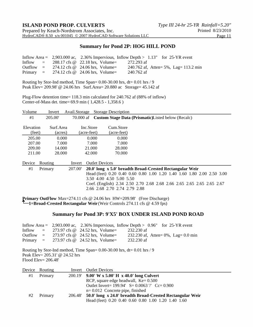
Type III 24-hr 25-YR Rainfall=5.20"ISLAND POND PROP. CULVERTS Printed 8/23/2010Prepared by Keach-Nordstrom Associates, Inc.
Page 11HydroCAD® 8.50 s/n 001045 © 2007 HydroCAD Software Solutions LLC
Summary for Pond 2P: HOG HILL POND
Inflow Area = 2,903.000 ac, 2.36% Impervious, Inflow Depth > 1.13" for 25-YR eventInflow = 288.17 cfs @ 22.18 hrs, Volume= 272.293 afOutflow = 274.12 cfs @ 24.06 hrs, Volume= 240.762 af, Atten= 5%, Lag= 113.2 minPrimary = 274.12 cfs @ 24.06 hrs, Volume= 240.762 af
Routing by Stor-Ind method, Time Span= 0.00-30.00 hrs, dt= 0.01 hrs / 9Peak Elev= 209.98' @ 24.06 hrs Surf.Area= 20.880 ac Storage= 45.142 af
Plug-Flow detention time= 118.3 min calculated for 240.762 af (88% of inflow)Center-of-Mass det. time= 69.9 min ( 1,428.5 - 1,358.6 )
Volume Invert Avail.Storage Storage Description#1 205.00' 70.000 af Custom Stage Data (Prismatic) Listed below (Recalc)
Elevation Surf.Area Inc.Store Cum.Store(feet) (acres) (acre-feet) (acre-feet)
205.00 0.000 0.000 0.000207.00 7.000 7.000 7.000209.00 14.000 21.000 28.000211.00 28.000 42.000 70.000
Device Routing Invert Outlet Devices#1 Primary 207.00' 20.0' long x 5.0' breadth Broad-Crested Rectangular Weir
Head (feet) 0.20 0.40 0.60 0.80 1.00 1.20 1.40 1.60 1.80 2.00 2.50 3.00 3.50 4.00 4.50 5.00 5.50 Coef. (English) 2.34 2.50 2.70 2.68 2.68 2.66 2.65 2.65 2.65 2.65 2.67 2.66 2.68 2.70 2.74 2.79 2.88
Primary OutFlow Max=274.11 cfs @ 24.06 hrs HW=209.98' (Free Discharge)1=Broad-Crested Rectangular Weir (Weir Controls 274.11 cfs @ 4.59 fps)
Summary for Pond 3P: 9'X5' BOX UNDER ISLAND POND ROAD
Inflow Area = 2,903.000 ac, 2.36% Impervious, Inflow Depth > 0.96" for 25-YR eventInflow = 273.97 cfs @ 24.52 hrs, Volume= 232.230 afOutflow = 273.97 cfs @ 24.52 hrs, Volume= 232.230 af, Atten= 0%, Lag= 0.0 minPrimary = 273.97 cfs @ 24.52 hrs, Volume= 232.230 af
Routing by Stor-Ind method, Time Span= 0.00-30.00 hrs, dt= 0.01 hrs / 9Peak Elev= 205.31' @ 24.52 hrsFlood Elev= 206.48'
Device Routing Invert Outlet Devices#1 Primary 200.19' 9.00' W x 5.00' H x 40.0' long Culvert
RCP, square edge headwall, Ke= 0.500 Outlet Invert= 199.94' S= 0.0063 '/' Cc= 0.900 n= 0.012 Concrete pipe, finished
#2 Primary 206.48' 50.0' long x 24.0' breadth Broad-Crested Rectangular Weir Head (feet) 0.20 0.40 0.60 0.80 1.00 1.20 1.40 1.60
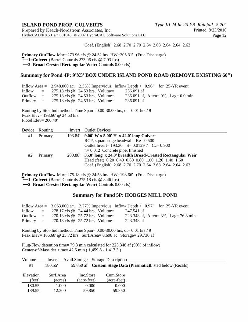
Type III 24-hr 25-YR Rainfall=5.20"ISLAND POND PROP. CULVERTS Printed 8/23/2010Prepared by Keach-Nordstrom Associates, Inc.
Page 12HydroCAD® 8.50 s/n 001045 © 2007 HydroCAD Software Solutions LLC
Coef. (English) 2.68 2.70 2.70 2.64 2.63 2.64 2.64 2.63
Primary OutFlow Max=273.96 cfs @ 24.52 hrs HW=205.31' (Free Discharge)1=Culvert (Barrel Controls 273.96 cfs @ 7.93 fps)2=Broad-Crested Rectangular Weir ( Controls 0.00 cfs)
Summary for Pond 4P: 9'X5' BOX UNDER ISLAND POND ROAD (REMOVE EXISTING 60")
Inflow Area = 2,948.000 ac, 2.35% Impervious, Inflow Depth > 0.96" for 25-YR eventInflow = 275.18 cfs @ 24.53 hrs, Volume= 236.091 afOutflow = 275.18 cfs @ 24.53 hrs, Volume= 236.091 af, Atten= 0%, Lag= 0.0 minPrimary = 275.18 cfs @ 24.53 hrs, Volume= 236.091 af
Routing by Stor-Ind method, Time Span= 0.00-30.00 hrs, dt= 0.01 hrs / 9Peak Elev= 198.66' @ 24.53 hrsFlood Elev= 200.40'
Device Routing Invert Outlet Devices#1 Primary 193.84' 9.00' W x 5.00' H x 42.0' long Culvert
RCP, square edge headwall, Ke= 0.500 Outlet Invert= 193.30' S= 0.0129 '/' Cc= 0.900 n= 0.012 Concrete pipe, finished
#2 Primary 200.88' 35.0' long x 24.0' breadth Broad-Crested Rectangular Weir Head (feet) 0.20 0.40 0.60 0.80 1.00 1.20 1.40 1.60 Coef. (English) 2.68 2.70 2.70 2.64 2.63 2.64 2.64 2.63
Primary OutFlow Max=275.18 cfs @ 24.53 hrs HW=198.66' (Free Discharge)1=Culvert (Barrel Controls 275.18 cfs @ 8.46 fps)2=Broad-Crested Rectangular Weir ( Controls 0.00 cfs)
Summary for Pond 5P: HODGES MILL POND
Inflow Area = 3,063.000 ac, 2.27% Impervious, Inflow Depth > 0.97" for 25-YR eventInflow = 278.17 cfs @ 24.44 hrs, Volume= 247.541 afOutflow = 270.13 cfs @ 25.72 hrs, Volume= 223.348 af, Atten= 3%, Lag= 76.8 minPrimary = 270.13 cfs @ 25.72 hrs, Volume= 223.348 af
Routing by Stor-Ind method, Time Span= 0.00-30.00 hrs, dt= 0.01 hrs / 9Peak Elev= 186.68' @ 25.72 hrs Surf.Area= 8.698 ac Storage= 29.730 af
Plug-Flow detention time= 79.3 min calculated for 223.348 af (90% of inflow)Center-of-Mass det. time= 42.5 min ( 1,459.8 - 1,417.3 )
Volume Invert Avail.Storage Storage Description#1 180.55' 59.850 af Custom Stage Data (Prismatic) Listed below (Recalc)
Elevation Surf.Area Inc.Store Cum.Store(feet) (acres) (acre-feet) (acre-feet)
180.55 1.000 0.000 0.000189.55 12.300 59.850 59.850

Type III 24-hr 25-YR Rainfall=5.20"ISLAND POND PROP. CULVERTS Printed 8/23/2010Prepared by Keach-Nordstrom Associates, Inc.
Page 13HydroCAD® 8.50 s/n 001045 © 2007 HydroCAD Software Solutions LLC
Device Routing Invert Outlet Devices#1 Primary 181.55' 7.0' long x 1.5' breadth Broad-Crested Rectangular Weir
Head (feet) 0.20 0.40 0.60 0.80 1.00 1.20 1.40 1.60 1.80 2.00 2.50 3.00 Coef. (English) 2.62 2.64 2.64 2.68 2.75 2.86 2.92 3.07 3.07 3.03 3.28 3.32
#2 Primary 190.55' 60.0' long x 1.0' breadth Broad-Crested Rectangular Weir Head (feet) 0.20 0.40 0.60 0.80 1.00 1.20 1.40 1.60 1.80 2.00 2.50 3.00 Coef. (English) 2.69 2.72 2.75 2.85 2.98 3.08 3.20 3.28 3.31 3.30 3.31 3.32
Primary OutFlow Max=270.12 cfs @ 25.72 hrs HW=186.68' (Free Discharge)1=Broad-Crested Rectangular Weir (Weir Controls 270.12 cfs @ 7.52 fps)2=Broad-Crested Rectangular Weir ( Controls 0.00 cfs)
Summary for Pond 6P: 9'X5' BOX CROSSING UNDER ISLAND POND ROAD
Inflow Area = 3,063.000 ac, 2.27% Impervious, Inflow Depth > 0.87" for 25-YR eventInflow = 270.13 cfs @ 25.73 hrs, Volume= 223.013 afOutflow = 270.13 cfs @ 25.73 hrs, Volume= 223.013 af, Atten= 0%, Lag= 0.0 minPrimary = 270.13 cfs @ 25.73 hrs, Volume= 223.013 af
Routing by Stor-Ind method, Time Span= 0.00-30.00 hrs, dt= 0.01 hrs / 9Peak Elev= 184.94' @ 25.73 hrsFlood Elev= 186.92'
Device Routing Invert Outlet Devices#1 Primary 179.55' 9.00' W x 5.00' H x 48.0' long Culvert
RCP, square edge headwall, Ke= 0.500 Outlet Invert= 179.55' S= 0.0000 '/' Cc= 0.900 n= 0.012
#2 Primary 187.51' 50.0' long x 24.0' breadth Broad-Crested Rectangular Weir Head (feet) 0.20 0.40 0.60 0.80 1.00 1.20 1.40 1.60 Coef. (English) 2.68 2.70 2.70 2.64 2.63 2.64 2.64 2.63
Primary OutFlow Max=270.13 cfs @ 25.73 hrs HW=184.94' (Free Discharge)1=Culvert (Barrel Controls 270.13 cfs @ 7.43 fps)2=Broad-Crested Rectangular Weir ( Controls 0.00 cfs)
Summary for Pond 7P: EXISTING IMPOUNDMENT AREA
Inflow Area = 5,091.000 ac, 2.37% Impervious, Inflow Depth > 0.97" for 25-YR eventInflow = 412.47 cfs @ 24.32 hrs, Volume= 412.850 afOutflow = 411.50 cfs @ 24.87 hrs, Volume= 380.311 af, Atten= 0%, Lag= 32.8 minPrimary = 411.50 cfs @ 24.87 hrs, Volume= 380.311 af
Routing by Stor-Ind method, Time Span= 0.00-30.00 hrs, dt= 0.01 hrs / 9Peak Elev= 169.77' @ 24.87 hrs Surf.Area= 19.025 ac Storage= 36.683 af
Plug-Flow detention time= 68.7 min calculated for 380.311 af (92% of inflow)Center-of-Mass det. time= 37.4 min ( 1,435.6 - 1,398.2 )

Type III 24-hr 25-YR Rainfall=5.20"ISLAND POND PROP. CULVERTS Printed 8/23/2010Prepared by Keach-Nordstrom Associates, Inc.
Page 14HydroCAD® 8.50 s/n 001045 © 2007 HydroCAD Software Solutions LLC
Volume Invert Avail.Storage Storage Description#1 167.00' 41.250 af Custom Stage Data (Prismatic) Listed below (Recalc)
Elevation Surf.Area Inc.Store Cum.Store(feet) (acres) (acre-feet) (acre-feet)
167.00 7.500 0.000 0.000170.00 20.000 41.250 41.250
Device Routing Invert Outlet Devices#1 Primary 167.00' 15.0' long x 10.0' breadth Broad-Crested Rectangular Weir
Head (feet) 0.20 0.40 0.60 0.80 1.00 1.20 1.40 1.60 Coef. (English) 2.49 2.56 2.70 2.69 2.68 2.69 2.67 2.64
#2 Primary 168.50' 60.0' long x 10.0' breadth Broad-Crested Rectangular Weir Head (feet) 0.20 0.40 0.60 0.80 1.00 1.20 1.40 1.60 Coef. (English) 2.49 2.56 2.70 2.69 2.68 2.69 2.67 2.64
Primary OutFlow Max=411.49 cfs @ 24.87 hrs HW=169.77' (Free Discharge)1=Broad-Crested Rectangular Weir (Weir Controls 182.16 cfs @ 4.39 fps)2=Broad-Crested Rectangular Weir (Weir Controls 229.33 cfs @ 3.02 fps)
Summary for Pond 8P: CROSSING UNDER WEST SIDE DRIVE
Inflow Area = 5,091.000 ac, 2.37% Impervious, Inflow Depth > 0.90" for 25-YR eventInflow = 411.50 cfs @ 24.87 hrs, Volume= 380.311 afOutflow = 411.50 cfs @ 24.87 hrs, Volume= 380.311 af, Atten= 0%, Lag= 0.0 minPrimary = 411.50 cfs @ 24.87 hrs, Volume= 380.311 af
Routing by Stor-Ind method, Time Span= 0.00-30.00 hrs, dt= 0.01 hrs / 9Peak Elev= 169.42' @ 24.87 hrsFlood Elev= 175.00'
Device Routing Invert Outlet Devices#1 Primary 161.00' 96.0" x 40.0' long Culvert CMP, square edge headwall, Ke= 0.500
Outlet Invert= 160.60' S= 0.0100 '/' Cc= 0.900 n= 0.025 Corrugated metal #2 Primary 175.00' 50.0' long x 24.0' breadth Broad-Crested Rectangular Weir
Head (feet) 0.20 0.40 0.60 0.80 1.00 1.20 1.40 1.60 Coef. (English) 2.68 2.70 2.70 2.64 2.63 2.64 2.64 2.63
Primary OutFlow Max=411.51 cfs @ 24.87 hrs HW=169.42' (Free Discharge)1=Culvert (Barrel Controls 411.51 cfs @ 9.67 fps)2=Broad-Crested Rectangular Weir ( Controls 0.00 cfs)
Summary for Link 1L: HOG HILL BROOK
Inflow Area = 5,091.000 ac, 2.37% Impervious, Inflow Depth > 0.90" for 25-YR eventInflow = 411.50 cfs @ 24.87 hrs, Volume= 380.311 afPrimary = 411.50 cfs @ 24.87 hrs, Volume= 380.311 af, Atten= 0%, Lag= 0.0 min
Primary outflow = Inflow, Time Span= 0.00-30.00 hrs, dt= 0.01 hrs

E: 50-YEAR, EXISTING SITE CONDITIONS

1S
1S
2S
2S
4S
4S
5S
5S
7S
7S
1R
THROUGH 2S
2R
THROUGH 5S
3R
THROUGH 4S
4R
THROUGH 5S
5R
HODGES MILL POND TO ISLAND POND
ROAD
6R
HOG HILL BROOK TO IMPOUNDMENT AREA
1P
JOHNSONS POND
2P
HOG HILL POND
3PCB
48" RCP UNDER ISLAND POND ROAD
4PCB
45" RCP UNDER ISLAND POND ROAD AND 60" RCP UNDER
TRAIL
5P
HODGES MILL POND
6PCB
45" CROSSING UNDER ISLAND POND ROAD
7P
EXISTING IMPOUNDMENT AREA
8PCB
CROSSING UNDER WEST SIDE DRIVE
1L
HOG HILL BROOK
Drainage Diagram for ISLAND POND EXIST. CULVERTSPrepared by Keach-Nordstrom Associates, Inc., Printed 8/23/2010HydroCAD® 8.50 s/n 001045 © 2007 HydroCAD Software Solutions LLC
Subcat Reach Pond Link

ISLAND POND EXIST. CULVERTS Printed 8/23/2010Prepared by Keach-Nordstrom Associates, Inc.
Page 2HydroCAD® 8.50 s/n 001045 © 2007 HydroCAD Software Solutions LLC
Area Listing (all nodes)
Area
(acres)
CN Description
(subcatchment-numbers)
3,405.000 55 Woods, Good, HSG B (1S,2S,4S,5S,7S)
1,006.500 65 2 acre lots, 12% imp, HSG B (1S,2S,4S,5S,7S)
679.500 77 Woods, Good, HSG D (1S,2S,4S,5S,7S)
5,091.000 TOTAL AREA

ISLAND POND EXIST. CULVERTS Printed 8/23/2010Prepared by Keach-Nordstrom Associates, Inc.
Page 3HydroCAD® 8.50 s/n 001045 © 2007 HydroCAD Software Solutions LLC
Soil Listing (all nodes)
Area
(acres)
Soil
Goup
Subcatchment
Numbers
0.000 HSG A
4,411.500 HSG B 1S, 2S, 4S, 5S, 7S
0.000 HSG C
679.500 HSG D 1S, 2S, 4S, 5S, 7S
0.000 Other
5,091.000 TOTAL AREA

Type III 24-hr 50-YR Rainfall=5.70"ISLAND POND EXIST. CULVERTS Printed 8/23/2010Prepared by Keach-Nordstrom Associates, Inc.
Page 4HydroCAD® 8.50 s/n 001045 © 2007 HydroCAD Software Solutions LLC
Time span=0.00-30.00 hrs, dt=0.01 hrs, 3001 pointsRunoff by SCS TR-20 method, UH=SCS
Reach routing by Stor-Ind+Trans method - Pond routing by Stor-Ind method
Runoff Area=1,486.000 ac 3.10% Impervious Runoff Depth>1.59"Subcatchment 1S: 1S Flow Length=12,490' Slope=0.0050 '/' Tc=588.8 min CN=61 Runoff=238.10 cfs 197.301 af
Runoff Area=1,417.000 ac 1.59% Impervious Runoff Depth>1.56"Subcatchment 2S: 2S Flow Length=7,669' Slope=0.0030 '/' Tc=466.7 min CN=59 Runoff=238.22 cfs 183.711 af
Runoff Area=45.000 ac 1.20% Impervious Runoff Depth=1.81"Subcatchment 4S: 4S Flow Length=1,651' Slope=0.0050 '/' Tc=77.8 min CN=61 Runoff=29.67 cfs 6.778 af
Runoff Area=115.000 ac 0.31% Impervious Runoff Depth=1.50"Subcatchment 5S: 5S Flow Length=1,988' Slope=0.0060 '/' Tc=85.5 min CN=57 Runoff=56.24 cfs 14.345 af
Runoff Area=2,028.000 ac 2.53% Impervious Runoff Depth>1.57"Subcatchment 7S: 7S Flow Length=11,484' Slope=0.0050 '/' Tc=541.4 min CN=60 Runoff=325.45 cfs 265.177 af
Avg. Depth=2.13' Max Vel=1.56 fps Inflow=209.35 cfs 164.746 afReach 1R: THROUGH 2Sn=0.040 L=3,100.0' S=0.0013 '/' Capacity=908.32 cfs Outflow=208.34 cfs 153.164 af
Avg. Depth=2.30' Max Vel=2.23 fps Inflow=338.33 cfs 300.351 afReach 2R: THROUGH 5Sn=0.040 L=2,010.0' S=0.0024 '/' Capacity=1,236.98 cfs Outflow=338.16 cfs 290.557 af
Avg. Depth=1.70' Max Vel=3.68 fps Inflow=338.16 cfs 290.557 afReach 3R: THROUGH 4Sn=0.040 L=655.0' S=0.0093 '/' Capacity=485.49 cfs Outflow=338.15 cfs 288.578 af
Avg. Depth=1.04' Max Vel=8.05 fps Inflow=339.72 cfs 295.356 afReach 4R: THROUGH 5Sn=0.040 L=141.0' S=0.0774 '/' Capacity=7,037.05 cfs Outflow=339.72 cfs 295.159 af
Avg. Depth=1.52' Max Vel=4.35 fps Inflow=333.09 cfs 280.307 afReach 5R: HODGES MILL POND TO ISLAND n=0.040 L=133.0' S=0.0147 '/' Capacity=178,082.22 cfs Outflow=333.09 cfs 279.923 af
Avg. Depth=2.28' Max Vel=2.21 fps Inflow=333.09 cfs 279.923 afReach 6R: HOG HILL BROOK TO n=0.040 L=5,247.0' S=0.0024 '/' Capacity=1,236.67 cfs Outflow=331.84 cfs 248.598 af
Peak Elev=213.49' Storage=50.324 af Inflow=238.10 cfs 197.301 afPond 1P: JOHNSONS POND Outflow=209.35 cfs 164.746 af
Peak Elev=210.42' Storage=54.895 af Inflow=357.22 cfs 336.875 afPond 2P: HOG HILL POND Outflow=338.33 cfs 300.351 af
Peak Elev=207.78' Inflow=338.16 cfs 290.557 afPond 3P: 48" RCP UNDER ISLAND POND ROAD Outflow=338.16 cfs 290.557 af
Peak Elev=202.56' Inflow=339.72 cfs 295.356 afPond 4P: 45" RCP UNDER ISLAND POND ROAD AND 60" Outflow=339.72 cfs 295.356 af
Peak Elev=187.45' Storage=36.793 af Inflow=343.42 cfs 309.505 afPond 5P: HODGES MILL POND Outflow=333.09 cfs 280.307 af

Type III 24-hr 50-YR Rainfall=5.70"ISLAND POND EXIST. CULVERTS Printed 8/23/2010Prepared by Keach-Nordstrom Associates, Inc.
Page 5HydroCAD® 8.50 s/n 001045 © 2007 HydroCAD Software Solutions LLC
Peak Elev=188.78' Inflow=333.09 cfs 279.923 afPond 6P: 45" CROSSING UNDER ISLAND POND ROAD Outflow=333.09 cfs 279.923 af
Peak Elev=170.04' Storage=41.250 af Inflow=510.39 cfs 513.776 afPond 7P: EXISTING IMPOUNDMENT AREA Outflow=514.03 cfs 477.675 af
Peak Elev=171.14' Inflow=514.03 cfs 477.675 afPond 8P: CROSSING UNDER WEST SIDE DRIVE Outflow=514.03 cfs 477.675 af
Inflow=514.03 cfs 477.675 afLink 1L: HOG HILL BROOK Primary=514.03 cfs 477.675 af
Total Runoff Area = 5,091.000 ac Runoff Volume = 667.313 af Average Runoff Depth = 1.57"97.63% Pervious = 4,970.220 ac 2.37% Impervious = 120.780 ac

Type III 24-hr 50-YR Rainfall=5.70"ISLAND POND EXIST. CULVERTS Printed 8/23/2010Prepared by Keach-Nordstrom Associates, Inc.
Page 6HydroCAD® 8.50 s/n 001045 © 2007 HydroCAD Software Solutions LLC
Summary for Subcatchment 1S: 1S
Runoff = 238.10 cfs @ 20.29 hrs, Volume= 197.301 af, Depth> 1.59"
Runoff by SCS TR-20 method, UH=SCS, Time Span= 0.00-30.00 hrs, dt= 0.01 hrsType III 24-hr 50-YR Rainfall=5.70"
Area (ac) CN Description250.000 77 Woods, Good, HSG D384.000 65 2 acre lots, 12% imp, HSG B852.000 55 Woods, Good, HSG B
1,486.000 61 Weighted Average1,439.920 Pervious Area
46.080 Impervious Area
Tc Length Slope Velocity Capacity Description(min) (feet) (ft/ft) (ft/sec) (cfs)588.8 12,490 0.0050 0.35 Shallow Concentrated Flow,
Woodland Kv= 5.0 fps
Summary for Subcatchment 2S: 2S
Runoff = 238.22 cfs @ 19.18 hrs, Volume= 183.711 af, Depth> 1.56"
Runoff by SCS TR-20 method, UH=SCS, Time Span= 0.00-30.00 hrs, dt= 0.01 hrsType III 24-hr 50-YR Rainfall=5.70"
Area (ac) CN Description151.000 77 Woods, Good, HSG D188.000 65 2 acre lots, 12% imp, HSG B
1,078.000 55 Woods, Good, HSG B1,417.000 59 Weighted Average1,394.440 Pervious Area
22.560 Impervious Area
Tc Length Slope Velocity Capacity Description(min) (feet) (ft/ft) (ft/sec) (cfs)466.7 7,669 0.0030 0.27 Shallow Concentrated Flow,
Woodland Kv= 5.0 fps
Summary for Subcatchment 4S: 4S
Runoff = 29.67 cfs @ 13.13 hrs, Volume= 6.778 af, Depth= 1.81"
Runoff by SCS TR-20 method, UH=SCS, Time Span= 0.00-30.00 hrs, dt= 0.01 hrsType III 24-hr 50-YR Rainfall=5.70"
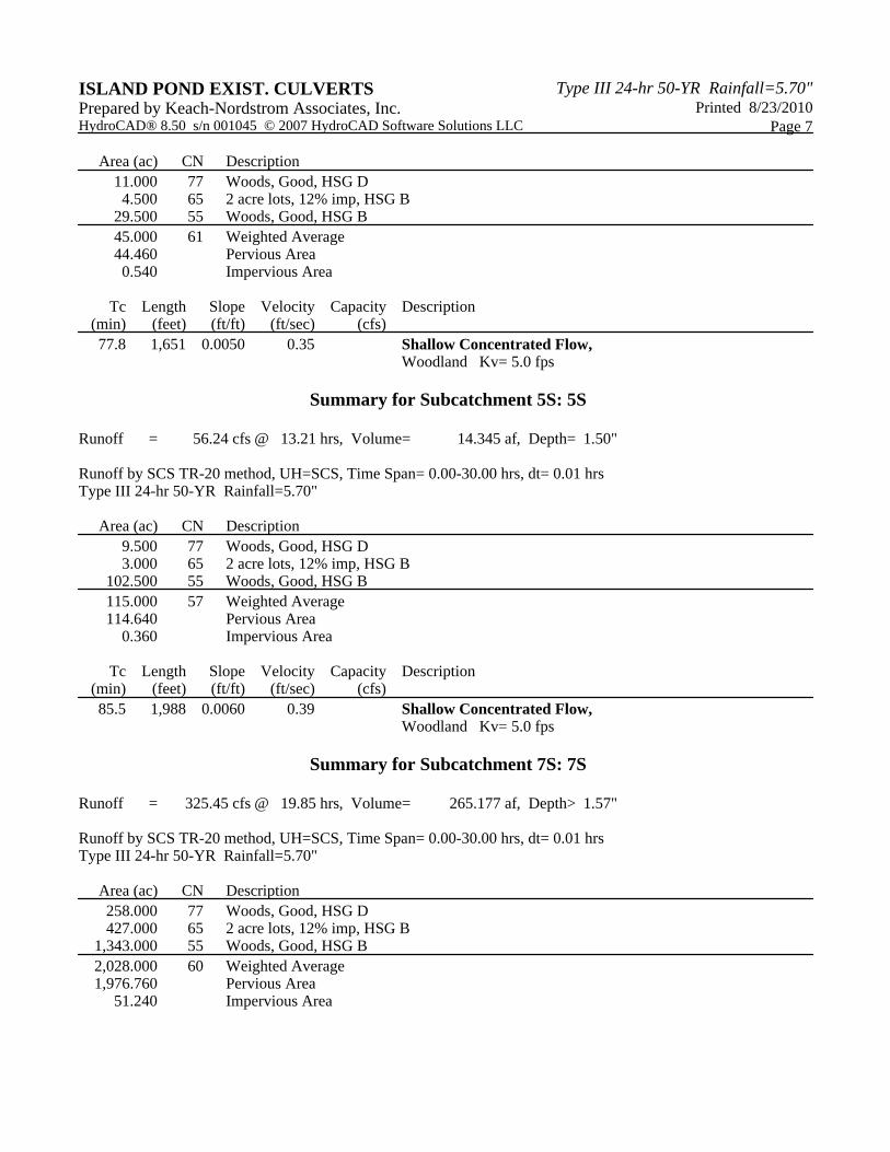
Type III 24-hr 50-YR Rainfall=5.70"ISLAND POND EXIST. CULVERTS Printed 8/23/2010Prepared by Keach-Nordstrom Associates, Inc.
Page 7HydroCAD® 8.50 s/n 001045 © 2007 HydroCAD Software Solutions LLC
Area (ac) CN Description11.000 77 Woods, Good, HSG D4.500 65 2 acre lots, 12% imp, HSG B
29.500 55 Woods, Good, HSG B45.000 61 Weighted Average44.460 Pervious Area0.540 Impervious Area
Tc Length Slope Velocity Capacity Description(min) (feet) (ft/ft) (ft/sec) (cfs)77.8 1,651 0.0050 0.35 Shallow Concentrated Flow,
Woodland Kv= 5.0 fps
Summary for Subcatchment 5S: 5S
Runoff = 56.24 cfs @ 13.21 hrs, Volume= 14.345 af, Depth= 1.50"
Runoff by SCS TR-20 method, UH=SCS, Time Span= 0.00-30.00 hrs, dt= 0.01 hrsType III 24-hr 50-YR Rainfall=5.70"
Area (ac) CN Description9.500 77 Woods, Good, HSG D3.000 65 2 acre lots, 12% imp, HSG B
102.500 55 Woods, Good, HSG B115.000 57 Weighted Average114.640 Pervious Area
0.360 Impervious Area
Tc Length Slope Velocity Capacity Description(min) (feet) (ft/ft) (ft/sec) (cfs)85.5 1,988 0.0060 0.39 Shallow Concentrated Flow,
Woodland Kv= 5.0 fps
Summary for Subcatchment 7S: 7S
Runoff = 325.45 cfs @ 19.85 hrs, Volume= 265.177 af, Depth> 1.57"
Runoff by SCS TR-20 method, UH=SCS, Time Span= 0.00-30.00 hrs, dt= 0.01 hrsType III 24-hr 50-YR Rainfall=5.70"
Area (ac) CN Description258.000 77 Woods, Good, HSG D427.000 65 2 acre lots, 12% imp, HSG B
1,343.000 55 Woods, Good, HSG B2,028.000 60 Weighted Average1,976.760 Pervious Area
51.240 Impervious Area
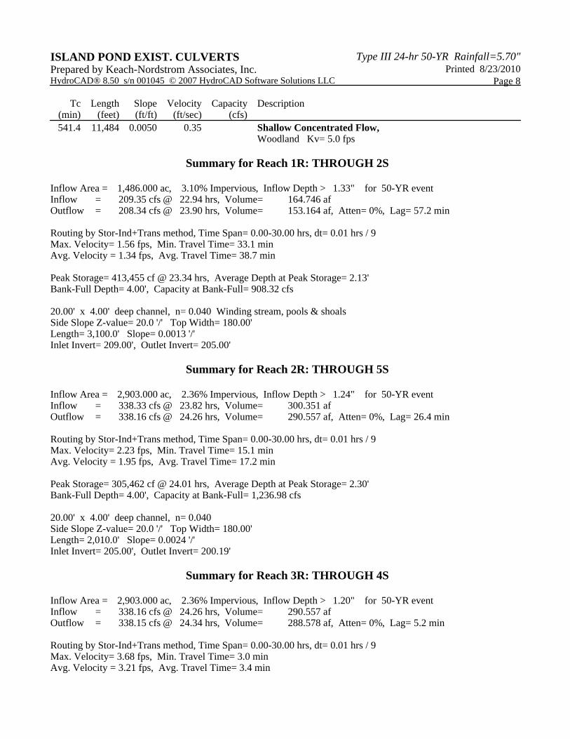
Type III 24-hr 50-YR Rainfall=5.70"ISLAND POND EXIST. CULVERTS Printed 8/23/2010Prepared by Keach-Nordstrom Associates, Inc.
Page 8HydroCAD® 8.50 s/n 001045 © 2007 HydroCAD Software Solutions LLC
Tc Length Slope Velocity Capacity Description(min) (feet) (ft/ft) (ft/sec) (cfs)541.4 11,484 0.0050 0.35 Shallow Concentrated Flow,
Woodland Kv= 5.0 fps
Summary for Reach 1R: THROUGH 2S
Inflow Area = 1,486.000 ac, 3.10% Impervious, Inflow Depth > 1.33" for 50-YR eventInflow = 209.35 cfs @ 22.94 hrs, Volume= 164.746 afOutflow = 208.34 cfs @ 23.90 hrs, Volume= 153.164 af, Atten= 0%, Lag= 57.2 min
Routing by Stor-Ind+Trans method, Time Span= 0.00-30.00 hrs, dt= 0.01 hrs / 9Max. Velocity= 1.56 fps, Min. Travel Time= 33.1 minAvg. Velocity = 1.34 fps, Avg. Travel Time= 38.7 min
Peak Storage= 413,455 cf @ 23.34 hrs, Average Depth at Peak Storage= 2.13'Bank-Full Depth= 4.00', Capacity at Bank-Full= 908.32 cfs
20.00' x 4.00' deep channel, n= 0.040 Winding stream, pools & shoalsSide Slope Z-value= 20.0 '/' Top Width= 180.00'Length= 3,100.0' Slope= 0.0013 '/'Inlet Invert= 209.00', Outlet Invert= 205.00'
Summary for Reach 2R: THROUGH 5S
Inflow Area = 2,903.000 ac, 2.36% Impervious, Inflow Depth > 1.24" for 50-YR eventInflow = 338.33 cfs @ 23.82 hrs, Volume= 300.351 afOutflow = 338.16 cfs @ 24.26 hrs, Volume= 290.557 af, Atten= 0%, Lag= 26.4 min
Routing by Stor-Ind+Trans method, Time Span= 0.00-30.00 hrs, dt= 0.01 hrs / 9Max. Velocity= 2.23 fps, Min. Travel Time= 15.1 minAvg. Velocity = 1.95 fps, Avg. Travel Time= 17.2 min
Peak Storage= 305,462 cf @ 24.01 hrs, Average Depth at Peak Storage= 2.30'Bank-Full Depth= 4.00', Capacity at Bank-Full= 1,236.98 cfs
20.00' x 4.00' deep channel, n= 0.040Side Slope Z-value= 20.0 '/' Top Width= 180.00'Length= 2,010.0' Slope= 0.0024 '/'Inlet Invert= 205.00', Outlet Invert= 200.19'
Summary for Reach 3R: THROUGH 4S
Inflow Area = 2,903.000 ac, 2.36% Impervious, Inflow Depth > 1.20" for 50-YR eventInflow = 338.16 cfs @ 24.26 hrs, Volume= 290.557 afOutflow = 338.15 cfs @ 24.34 hrs, Volume= 288.578 af, Atten= 0%, Lag= 5.2 min
Routing by Stor-Ind+Trans method, Time Span= 0.00-30.00 hrs, dt= 0.01 hrs / 9Max. Velocity= 3.68 fps, Min. Travel Time= 3.0 minAvg. Velocity = 3.21 fps, Avg. Travel Time= 3.4 min

Type III 24-hr 50-YR Rainfall=5.70"ISLAND POND EXIST. CULVERTS Printed 8/23/2010Prepared by Keach-Nordstrom Associates, Inc.
Page 9HydroCAD® 8.50 s/n 001045 © 2007 HydroCAD Software Solutions LLC
Peak Storage= 60,109 cf @ 24.29 hrs, Average Depth at Peak Storage= 1.70'Bank-Full Depth= 2.00', Capacity at Bank-Full= 485.49 cfs
20.00' x 2.00' deep channel, n= 0.040Side Slope Z-value= 20.0 '/' Top Width= 100.00'Length= 655.0' Slope= 0.0093 '/'Inlet Invert= 199.94', Outlet Invert= 193.84'
Summary for Reach 4R: THROUGH 5S
Inflow Area = 2,948.000 ac, 2.35% Impervious, Inflow Depth > 1.20" for 50-YR eventInflow = 339.72 cfs @ 24.30 hrs, Volume= 295.356 afOutflow = 339.72 cfs @ 24.31 hrs, Volume= 295.159 af, Atten= 0%, Lag= 0.6 min
Routing by Stor-Ind+Trans method, Time Span= 0.00-30.00 hrs, dt= 0.01 hrs / 9Max. Velocity= 8.05 fps, Min. Travel Time= 0.3 minAvg. Velocity = 5.95 fps, Avg. Travel Time= 0.4 min
Peak Storage= 5,954 cf @ 24.30 hrs, Average Depth at Peak Storage= 1.04'Bank-Full Depth= 4.00', Capacity at Bank-Full= 7,037.05 cfs
20.00' x 4.00' deep channel, n= 0.040Side Slope Z-value= 20.0 '/' Top Width= 180.00'Length= 141.0' Slope= 0.0774 '/'Inlet Invert= 191.47', Outlet Invert= 180.55'
Summary for Reach 5R: HODGES MILL POND TO ISLAND POND ROAD
Inflow Area = 3,063.000 ac, 2.27% Impervious, Inflow Depth > 1.10" for 50-YR eventInflow = 333.09 cfs @ 25.52 hrs, Volume= 280.307 afOutflow = 333.09 cfs @ 25.53 hrs, Volume= 279.923 af, Atten= 0%, Lag= 0.9 min
Routing by Stor-Ind+Trans method, Time Span= 0.00-30.00 hrs, dt= 0.01 hrs / 9Max. Velocity= 4.35 fps, Min. Travel Time= 0.5 minAvg. Velocity = 3.55 fps, Avg. Travel Time= 0.6 min
Peak Storage= 10,187 cf @ 25.52 hrs, Average Depth at Peak Storage= 1.52'Bank-Full Depth= 20.00', Capacity at Bank-Full= 178,082.22 cfs
20.00' x 20.00' deep channel, n= 0.040Side Slope Z-value= 20.0 '/' Top Width= 820.00'Length= 133.0' Slope= 0.0147 '/'Inlet Invert= 181.50', Outlet Invert= 179.55'
Summary for Reach 6R: HOG HILL BROOK TO IMPOUNDMENT AREA
Inflow Area = 3,063.000 ac, 2.27% Impervious, Inflow Depth > 1.10" for 50-YR eventInflow = 333.09 cfs @ 25.53 hrs, Volume= 279.923 afOutflow = 331.84 cfs @ 26.72 hrs, Volume= 248.598 af, Atten= 0%, Lag= 71.1 min

Type III 24-hr 50-YR Rainfall=5.70"ISLAND POND EXIST. CULVERTS Printed 8/23/2010Prepared by Keach-Nordstrom Associates, Inc.
Page 10HydroCAD® 8.50 s/n 001045 © 2007 HydroCAD Software Solutions LLC
Routing by Stor-Ind+Trans method, Time Span= 0.00-30.00 hrs, dt= 0.01 hrs / 9Max. Velocity= 2.21 fps, Min. Travel Time= 39.5 minAvg. Velocity = 1.74 fps, Avg. Travel Time= 50.3 min
Peak Storage= 786,447 cf @ 26.06 hrs, Average Depth at Peak Storage= 2.28'Bank-Full Depth= 4.00', Capacity at Bank-Full= 1,236.67 cfs
20.00' x 4.00' deep channel, n= 0.040Side Slope Z-value= 20.0 '/' Top Width= 180.00'Length= 5,247.0' Slope= 0.0024 '/'Inlet Invert= 179.55', Outlet Invert= 167.00'
Summary for Pond 1P: JOHNSONS POND
Inflow Area = 1,486.000 ac, 3.10% Impervious, Inflow Depth > 1.59" for 50-YR eventInflow = 238.10 cfs @ 20.29 hrs, Volume= 197.301 afOutflow = 209.35 cfs @ 22.94 hrs, Volume= 164.746 af, Atten= 12%, Lag= 159.1 minPrimary = 209.35 cfs @ 22.94 hrs, Volume= 164.746 af
Routing by Stor-Ind method, Time Span= 0.00-30.00 hrs, dt= 0.01 hrs / 9Peak Elev= 213.49' @ 22.94 hrs Surf.Area= 22.433 ac Storage= 50.324 af
Plug-Flow detention time= 172.8 min calculated for 164.746 af (83% of inflow)Center-of-Mass det. time= 103.7 min ( 1,429.4 - 1,325.7 )
Volume Invert Avail.Storage Storage Description#1 209.00' 90.000 af Custom Stage Data (Prismatic) Listed below (Recalc)
Elevation Surf.Area Inc.Store Cum.Store(feet) (acres) (acre-feet) (acre-feet)
209.00 0.000 0.000 0.000211.00 10.000 10.000 10.000213.00 20.000 30.000 40.000215.00 30.000 50.000 90.000
Device Routing Invert Outlet Devices#1 Primary 211.00' 20.0' long x 5.0' breadth Broad-Crested Rectangular Weir
Head (feet) 0.20 0.40 0.60 0.80 1.00 1.20 1.40 1.60 1.80 2.00 2.50 3.00 3.50 4.00 4.50 5.00 5.50 Coef. (English) 2.34 2.50 2.70 2.68 2.68 2.66 2.65 2.65 2.65 2.65 2.67 2.66 2.68 2.70 2.74 2.79 2.88
Primary OutFlow Max=209.34 cfs @ 22.94 hrs HW=213.49' (Free Discharge)1=Broad-Crested Rectangular Weir (Weir Controls 209.34 cfs @ 4.21 fps)

Type III 24-hr 50-YR Rainfall=5.70"ISLAND POND EXIST. CULVERTS Printed 8/23/2010Prepared by Keach-Nordstrom Associates, Inc.
Page 11HydroCAD® 8.50 s/n 001045 © 2007 HydroCAD Software Solutions LLC
Summary for Pond 2P: HOG HILL POND
Inflow Area = 2,903.000 ac, 2.36% Impervious, Inflow Depth > 1.39" for 50-YR eventInflow = 357.22 cfs @ 21.89 hrs, Volume= 336.875 afOutflow = 338.33 cfs @ 23.82 hrs, Volume= 300.351 af, Atten= 5%, Lag= 115.9 minPrimary = 338.33 cfs @ 23.82 hrs, Volume= 300.351 af
Routing by Stor-Ind method, Time Span= 0.00-30.00 hrs, dt= 0.01 hrs / 9Peak Elev= 210.42' @ 23.82 hrs Surf.Area= 23.927 ac Storage= 54.895 af
Plug-Flow detention time= 115.1 min calculated for 300.351 af (89% of inflow)Center-of-Mass det. time= 69.2 min ( 1,421.4 - 1,352.1 )
Volume Invert Avail.Storage Storage Description#1 205.00' 70.000 af Custom Stage Data (Prismatic) Listed below (Recalc)
Elevation Surf.Area Inc.Store Cum.Store(feet) (acres) (acre-feet) (acre-feet)
205.00 0.000 0.000 0.000207.00 7.000 7.000 7.000209.00 14.000 21.000 28.000211.00 28.000 42.000 70.000
Device Routing Invert Outlet Devices#1 Primary 207.00' 20.0' long x 5.0' breadth Broad-Crested Rectangular Weir
Head (feet) 0.20 0.40 0.60 0.80 1.00 1.20 1.40 1.60 1.80 2.00 2.50 3.00 3.50 4.00 4.50 5.00 5.50 Coef. (English) 2.34 2.50 2.70 2.68 2.68 2.66 2.65 2.65 2.65 2.65 2.67 2.66 2.68 2.70 2.74 2.79 2.88
Primary OutFlow Max=338.32 cfs @ 23.82 hrs HW=210.42' (Free Discharge)1=Broad-Crested Rectangular Weir (Weir Controls 338.32 cfs @ 4.95 fps)
Summary for Pond 3P: 48" RCP UNDER ISLAND POND ROAD
Inflow Area = 2,903.000 ac, 2.36% Impervious, Inflow Depth > 1.20" for 50-YR eventInflow = 338.16 cfs @ 24.26 hrs, Volume= 290.557 afOutflow = 338.16 cfs @ 24.26 hrs, Volume= 290.557 af, Atten= 0%, Lag= 0.0 minPrimary = 338.16 cfs @ 24.26 hrs, Volume= 290.557 af
Routing by Stor-Ind method, Time Span= 0.00-30.00 hrs, dt= 0.01 hrs / 9Peak Elev= 207.78' @ 24.26 hrsFlood Elev= 206.48'
Device Routing Invert Outlet Devices#1 Primary 200.19' 48.0" x 40.0' long Culvert RCP, square edge headwall, Ke= 0.500
Outlet Invert= 199.94' S= 0.0063 '/' Cc= 0.900 n= 0.012 Concrete pipe, finished
#2 Primary 206.48' 50.0' long x 24.0' breadth Broad-Crested Rectangular Weir Head (feet) 0.20 0.40 0.60 0.80 1.00 1.20 1.40 1.60 Coef. (English) 2.68 2.70 2.70 2.64 2.63 2.64 2.64 2.63

Type III 24-hr 50-YR Rainfall=5.70"ISLAND POND EXIST. CULVERTS Printed 8/23/2010Prepared by Keach-Nordstrom Associates, Inc.
Page 12HydroCAD® 8.50 s/n 001045 © 2007 HydroCAD Software Solutions LLC
Primary OutFlow Max=338.12 cfs @ 24.26 hrs HW=207.78' (Free Discharge)1=Culvert (Inlet Controls 143.03 cfs @ 11.38 fps)2=Broad-Crested Rectangular Weir (Weir Controls 195.09 cfs @ 3.01 fps)
Summary for Pond 4P: 45" RCP UNDER ISLAND POND ROAD AND 60" RCP UNDER TRAIL
Inflow Area = 2,948.000 ac, 2.35% Impervious, Inflow Depth > 1.20" for 50-YR eventInflow = 339.72 cfs @ 24.30 hrs, Volume= 295.356 afOutflow = 339.72 cfs @ 24.30 hrs, Volume= 295.356 af, Atten= 0%, Lag= 0.0 minPrimary = 339.72 cfs @ 24.30 hrs, Volume= 295.356 af
Routing by Stor-Ind method, Time Span= 0.00-30.00 hrs, dt= 0.01 hrs / 9Peak Elev= 202.56' @ 24.30 hrsFlood Elev= 200.88'
Device Routing Invert Outlet Devices#1 Device 2 193.84' 45.0" x 42.0' long Culvert RCP, square edge headwall, Ke= 0.500
Outlet Invert= 193.30' S= 0.0129 '/' Cc= 0.900 n= 0.012 Concrete pipe, finished
#2 Primary 192.48' 60.0" x 19.0' long Culvert RCP, square edge headwall, Ke= 0.500 Outlet Invert= 191.47' S= 0.0532 '/' Cc= 0.900 n= 0.012
#3 Primary 200.88' 35.0' long x 24.0' breadth Broad-Crested Rectangular Weir Head (feet) 0.20 0.40 0.60 0.80 1.00 1.20 1.40 1.60 Coef. (English) 2.68 2.70 2.70 2.64 2.63 2.64 2.64 2.63
Primary OutFlow Max=339.72 cfs @ 24.30 hrs HW=202.56' (Free Discharge)2=Culvert (Passes 139.14 cfs of 260.30 cfs potential flow)
1=Culvert (Inlet Controls 139.14 cfs @ 12.60 fps)3=Broad-Crested Rectangular Weir (Weir Controls 200.58 cfs @ 3.41 fps)
Summary for Pond 5P: HODGES MILL POND
Inflow Area = 3,063.000 ac, 2.27% Impervious, Inflow Depth > 1.21" for 50-YR eventInflow = 343.42 cfs @ 24.25 hrs, Volume= 309.505 afOutflow = 333.09 cfs @ 25.52 hrs, Volume= 280.307 af, Atten= 3%, Lag= 75.8 minPrimary = 333.09 cfs @ 25.52 hrs, Volume= 280.307 af
Routing by Stor-Ind method, Time Span= 0.00-30.00 hrs, dt= 0.01 hrs / 9Peak Elev= 187.45' @ 25.52 hrs Surf.Area= 9.664 ac Storage= 36.793 af
Plug-Flow detention time= 78.3 min calculated for 280.214 af (91% of inflow)Center-of-Mass det. time= 42.2 min ( 1,452.0 - 1,409.8 )
Volume Invert Avail.Storage Storage Description#1 180.55' 59.850 af Custom Stage Data (Prismatic) Listed below (Recalc)
Elevation Surf.Area Inc.Store Cum.Store(feet) (acres) (acre-feet) (acre-feet)
180.55 1.000 0.000 0.000189.55 12.300 59.850 59.850

Type III 24-hr 50-YR Rainfall=5.70"ISLAND POND EXIST. CULVERTS Printed 8/23/2010Prepared by Keach-Nordstrom Associates, Inc.
Page 13HydroCAD® 8.50 s/n 001045 © 2007 HydroCAD Software Solutions LLC
Device Routing Invert Outlet Devices#1 Primary 181.55' 7.0' long x 1.5' breadth Broad-Crested Rectangular Weir
Head (feet) 0.20 0.40 0.60 0.80 1.00 1.20 1.40 1.60 1.80 2.00 2.50 3.00 Coef. (English) 2.62 2.64 2.64 2.68 2.75 2.86 2.92 3.07 3.07 3.03 3.28 3.32
#2 Primary 190.55' 60.0' long x 1.0' breadth Broad-Crested Rectangular Weir Head (feet) 0.20 0.40 0.60 0.80 1.00 1.20 1.40 1.60 1.80 2.00 2.50 3.00 Coef. (English) 2.69 2.72 2.75 2.85 2.98 3.08 3.20 3.28 3.31 3.30 3.31 3.32
Primary OutFlow Max=333.09 cfs @ 25.52 hrs HW=187.45' (Free Discharge)1=Broad-Crested Rectangular Weir (Weir Controls 333.09 cfs @ 8.06 fps)2=Broad-Crested Rectangular Weir ( Controls 0.00 cfs)
Summary for Pond 6P: 45" CROSSING UNDER ISLAND POND ROAD
Inflow Area = 3,063.000 ac, 2.27% Impervious, Inflow Depth > 1.10" for 50-YR eventInflow = 333.09 cfs @ 25.53 hrs, Volume= 279.923 afOutflow = 333.09 cfs @ 25.53 hrs, Volume= 279.923 af, Atten= 0%, Lag= 0.0 minPrimary = 333.09 cfs @ 25.53 hrs, Volume= 279.923 af
Routing by Stor-Ind method, Time Span= 0.00-30.00 hrs, dt= 0.01 hrs / 9Peak Elev= 188.78' @ 25.53 hrsFlood Elev= 186.92'
Device Routing Invert Outlet Devices#1 Primary 179.55' 45.0" x 48.0' long Culvert RCP, square edge headwall, Ke= 0.500
Outlet Invert= 179.55' S= 0.0000 '/' Cc= 0.900 n= 0.012 #2 Primary 187.51' 50.0' long x 24.0' breadth Broad-Crested Rectangular Weir
Head (feet) 0.20 0.40 0.60 0.80 1.00 1.20 1.40 1.60 Coef. (English) 2.68 2.70 2.70 2.64 2.63 2.64 2.64 2.63
Primary OutFlow Max=333.08 cfs @ 25.53 hrs HW=188.78' (Free Discharge)1=Culvert (Inlet Controls 144.22 cfs @ 13.06 fps)2=Broad-Crested Rectangular Weir (Weir Controls 188.86 cfs @ 2.97 fps)
Summary for Pond 7P: EXISTING IMPOUNDMENT AREA
Inflow Area = 5,091.000 ac, 2.37% Impervious, Inflow Depth > 1.21" for 50-YR eventInflow = 510.39 cfs @ 23.76 hrs, Volume= 513.776 afOutflow = 514.03 cfs @ 23.75 hrs, Volume= 477.675 af, Atten= 0%, Lag= 0.0 minPrimary = 514.03 cfs @ 23.75 hrs, Volume= 477.675 af
Routing by Stor-Ind method, Time Span= 0.00-30.00 hrs, dt= 0.01 hrs / 9Peak Elev= 170.04' @ 23.75 hrs Surf.Area= 20.000 ac Storage= 41.250 af
Plug-Flow detention time= 62.9 min calculated for 477.675 af (93% of inflow)Center-of-Mass det. time= 34.6 min ( 1,427.6 - 1,392.9 )

Type III 24-hr 50-YR Rainfall=5.70"ISLAND POND EXIST. CULVERTS Printed 8/23/2010Prepared by Keach-Nordstrom Associates, Inc.
Page 14HydroCAD® 8.50 s/n 001045 © 2007 HydroCAD Software Solutions LLC
Volume Invert Avail.Storage Storage Description#1 167.00' 41.250 af Custom Stage Data (Prismatic) Listed below (Recalc)
Elevation Surf.Area Inc.Store Cum.Store(feet) (acres) (acre-feet) (acre-feet)
167.00 7.500 0.000 0.000170.00 20.000 41.250 41.250
Device Routing Invert Outlet Devices#1 Primary 167.00' 15.0' long x 10.0' breadth Broad-Crested Rectangular Weir
Head (feet) 0.20 0.40 0.60 0.80 1.00 1.20 1.40 1.60 Coef. (English) 2.49 2.56 2.70 2.69 2.68 2.69 2.67 2.64
#2 Primary 168.50' 60.0' long x 10.0' breadth Broad-Crested Rectangular Weir Head (feet) 0.20 0.40 0.60 0.80 1.00 1.20 1.40 1.60 Coef. (English) 2.49 2.56 2.70 2.69 2.68 2.69 2.67 2.64
Primary OutFlow Max=514.03 cfs @ 23.75 hrs HW=170.04' (Free Discharge)1=Broad-Crested Rectangular Weir (Weir Controls 210.00 cfs @ 4.60 fps)2=Broad-Crested Rectangular Weir (Weir Controls 304.03 cfs @ 3.29 fps)
Summary for Pond 8P: CROSSING UNDER WEST SIDE DRIVE
Inflow Area = 5,091.000 ac, 2.37% Impervious, Inflow Depth > 1.13" for 50-YR eventInflow = 514.03 cfs @ 23.75 hrs, Volume= 477.675 afOutflow = 514.03 cfs @ 23.75 hrs, Volume= 477.675 af, Atten= 0%, Lag= 0.0 minPrimary = 514.03 cfs @ 23.75 hrs, Volume= 477.675 af
Routing by Stor-Ind method, Time Span= 0.00-30.00 hrs, dt= 0.01 hrs / 9Peak Elev= 171.14' @ 23.75 hrsFlood Elev= 175.00'
Device Routing Invert Outlet Devices#1 Primary 161.00' 96.0" x 40.0' long Culvert CMP, square edge headwall, Ke= 0.500
Outlet Invert= 160.60' S= 0.0100 '/' Cc= 0.900 n= 0.025 Corrugated metal #2 Primary 175.00' 50.0' long x 24.0' breadth Broad-Crested Rectangular Weir
Head (feet) 0.20 0.40 0.60 0.80 1.00 1.20 1.40 1.60 Coef. (English) 2.68 2.70 2.70 2.64 2.63 2.64 2.64 2.63
Primary OutFlow Max=514.12 cfs @ 23.75 hrs HW=171.14' (Free Discharge)1=Culvert (Barrel Controls 514.12 cfs @ 10.42 fps)2=Broad-Crested Rectangular Weir ( Controls 0.00 cfs)
Summary for Link 1L: HOG HILL BROOK
Inflow Area = 5,091.000 ac, 2.37% Impervious, Inflow Depth > 1.13" for 50-YR eventInflow = 514.03 cfs @ 23.75 hrs, Volume= 477.675 afPrimary = 514.03 cfs @ 23.75 hrs, Volume= 477.675 af, Atten= 0%, Lag= 0.0 min
Primary outflow = Inflow, Time Span= 0.00-30.00 hrs, dt= 0.01 hrs

F: 50-YEAR, POST ROADWAY IMPROVEMENTS

1S
1S
2S
2S
4S
4S
5S
5S
7S
7S
1R
THROUGH 2S
2R
THROUGH 5S
3R
THROUGH 4S
4R
THROUGH 5S
5R
HODGES MILL POND TO ISLAND POND
ROAD
6R
HOG HILL BROOK TO IMPOUNDMENT AREA
1P
JOHNSONS POND
2P
HOG HILL POND
3PCB
9'X5' BOX UNDER ISLAND POND ROAD
4PCB
9'X5' BOX UNDER ISLAND POND ROAD (REMOVE EXISTING
60")
5P
HODGES MILL POND
6PCB
9'X5' BOX CROSSING UNDER ISLAND POND
ROAD
7P
EXISTING IMPOUNDMENT AREA
8PCB
CROSSING UNDER WEST SIDE DRIVE
1L
HOG HILL BROOK
Drainage Diagram for ISLAND POND PROP. CULVERTSPrepared by Keach-Nordstrom Associates, Inc., Printed 8/23/2010HydroCAD® 8.50 s/n 001045 © 2007 HydroCAD Software Solutions LLC
Subcat Reach Pond Link

ISLAND POND PROP. CULVERTS Printed 8/23/2010Prepared by Keach-Nordstrom Associates, Inc.
Page 2HydroCAD® 8.50 s/n 001045 © 2007 HydroCAD Software Solutions LLC
Area Listing (all nodes)
Area
(acres)
CN Description
(subcatchment-numbers)
3,405.000 55 Woods, Good, HSG B (1S,2S,4S,5S,7S)
1,006.500 65 2 acre lots, 12% imp, HSG B (1S,2S,4S,5S,7S)
679.500 77 Woods, Good, HSG D (1S,2S,4S,5S,7S)
5,091.000 TOTAL AREA

ISLAND POND PROP. CULVERTS Printed 8/23/2010Prepared by Keach-Nordstrom Associates, Inc.
Page 3HydroCAD® 8.50 s/n 001045 © 2007 HydroCAD Software Solutions LLC
Soil Listing (all nodes)
Area
(acres)
Soil
Goup
Subcatchment
Numbers
0.000 HSG A
4,411.500 HSG B 1S, 2S, 4S, 5S, 7S
0.000 HSG C
679.500 HSG D 1S, 2S, 4S, 5S, 7S
0.000 Other
5,091.000 TOTAL AREA

Type III 24-hr 50-YR Rainfall=5.70"ISLAND POND PROP. CULVERTS Printed 8/23/2010Prepared by Keach-Nordstrom Associates, Inc.
Page 4HydroCAD® 8.50 s/n 001045 © 2007 HydroCAD Software Solutions LLC
Time span=0.00-30.00 hrs, dt=0.01 hrs, 3001 pointsRunoff by SCS TR-20 method, UH=SCS
Reach routing by Stor-Ind+Trans method - Pond routing by Stor-Ind method
Runoff Area=1,486.000 ac 3.10% Impervious Runoff Depth>1.59"Subcatchment 1S: 1S Flow Length=12,490' Slope=0.0050 '/' Tc=588.8 min CN=61 Runoff=238.10 cfs 197.301 af
Runoff Area=1,417.000 ac 1.59% Impervious Runoff Depth>1.56"Subcatchment 2S: 2S Flow Length=7,669' Slope=0.0030 '/' Tc=466.7 min CN=59 Runoff=238.22 cfs 183.711 af
Runoff Area=45.000 ac 1.20% Impervious Runoff Depth=1.81"Subcatchment 4S: 4S Flow Length=1,651' Slope=0.0050 '/' Tc=77.8 min CN=61 Runoff=29.67 cfs 6.778 af
Runoff Area=115.000 ac 0.31% Impervious Runoff Depth=1.50"Subcatchment 5S: 5S Flow Length=1,988' Slope=0.0060 '/' Tc=85.5 min CN=57 Runoff=56.24 cfs 14.345 af
Runoff Area=2,028.000 ac 2.53% Impervious Runoff Depth>1.57"Subcatchment 7S: 7S Flow Length=11,484' Slope=0.0050 '/' Tc=541.4 min CN=60 Runoff=325.45 cfs 265.177 af
Avg. Depth=2.13' Max Vel=1.56 fps Inflow=209.35 cfs 164.746 afReach 1R: THROUGH 2Sn=0.040 L=3,100.0' S=0.0013 '/' Capacity=908.32 cfs Outflow=208.34 cfs 153.164 af
Avg. Depth=2.30' Max Vel=2.23 fps Inflow=338.33 cfs 300.351 afReach 2R: THROUGH 5Sn=0.040 L=2,010.0' S=0.0024 '/' Capacity=1,236.98 cfs Outflow=338.16 cfs 290.557 af
Avg. Depth=1.70' Max Vel=3.68 fps Inflow=338.16 cfs 290.557 afReach 3R: THROUGH 4Sn=0.040 L=655.0' S=0.0093 '/' Capacity=485.49 cfs Outflow=338.15 cfs 288.578 af
Avg. Depth=1.04' Max Vel=8.05 fps Inflow=339.72 cfs 295.356 afReach 4R: THROUGH 5Sn=0.040 L=141.0' S=0.0774 '/' Capacity=7,037.05 cfs Outflow=339.72 cfs 295.159 af
Avg. Depth=1.52' Max Vel=4.34 fps Inflow=333.09 cfs 280.307 afReach 5R: HODGES MILL POND TO ISLAND n=0.040 L=133.0' S=0.0147 '/' Capacity=3,061.83 cfs Outflow=333.09 cfs 279.922 af
Avg. Depth=2.28' Max Vel=2.21 fps Inflow=333.09 cfs 279.922 afReach 6R: HOG HILL BROOK TO n=0.040 L=5,247.0' S=0.0024 '/' Capacity=1,236.67 cfs Outflow=331.84 cfs 248.598 af
Peak Elev=213.49' Storage=50.324 af Inflow=238.10 cfs 197.301 afPond 1P: JOHNSONS POND Outflow=209.35 cfs 164.746 af
Peak Elev=210.42' Storage=54.895 af Inflow=357.22 cfs 336.875 afPond 2P: HOG HILL POND Outflow=338.33 cfs 300.351 af
Peak Elev=206.11' Inflow=338.16 cfs 290.557 afPond 3P: 9'X5' BOX UNDER ISLAND POND ROAD Outflow=338.16 cfs 290.557 af
Peak Elev=199.46' Inflow=339.72 cfs 295.356 afPond 4P: 9'X5' BOX UNDER ISLAND POND ROAD (REMOVE Outflow=339.72 cfs 295.356 af
Peak Elev=187.45' Storage=36.793 af Inflow=343.42 cfs 309.505 afPond 5P: HODGES MILL POND Outflow=333.09 cfs 280.307 af
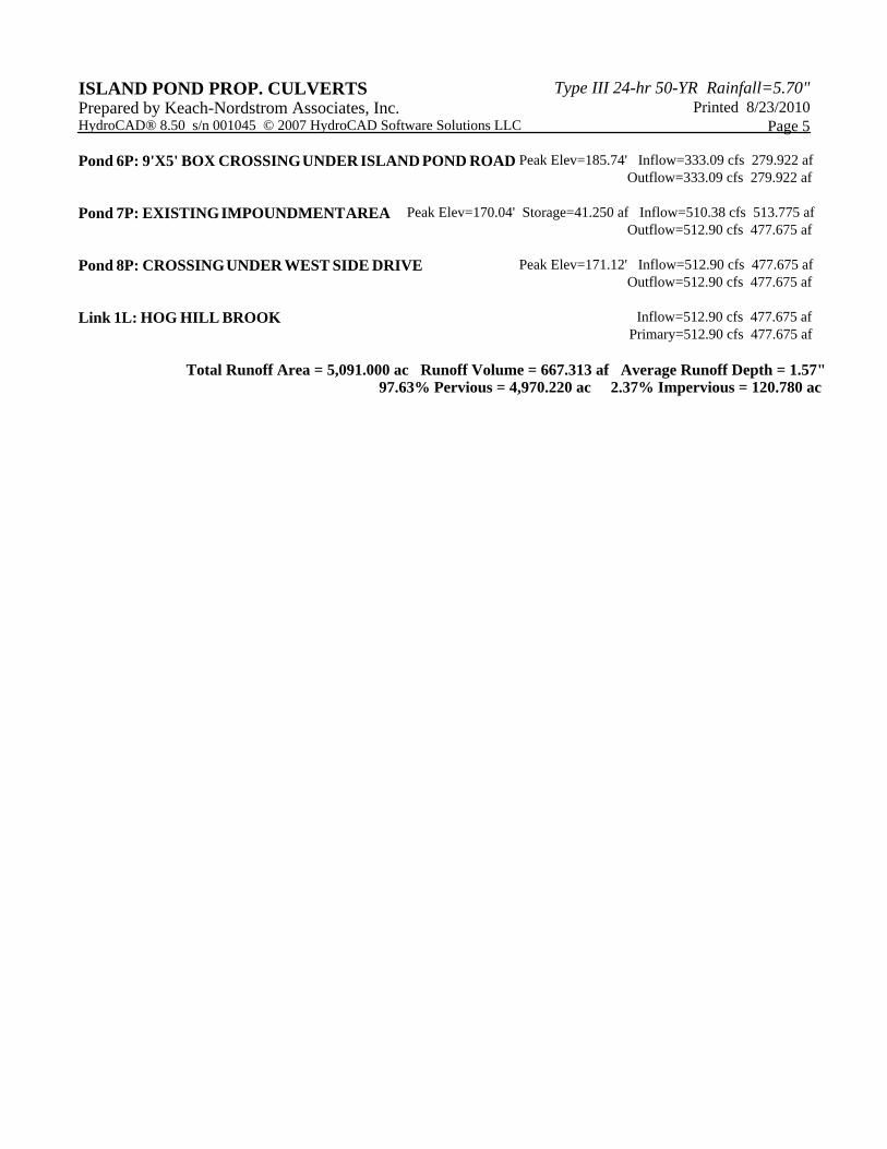
Type III 24-hr 50-YR Rainfall=5.70"ISLAND POND PROP. CULVERTS Printed 8/23/2010Prepared by Keach-Nordstrom Associates, Inc.
Page 5HydroCAD® 8.50 s/n 001045 © 2007 HydroCAD Software Solutions LLC
Peak Elev=185.74' Inflow=333.09 cfs 279.922 afPond 6P: 9'X5' BOX CROSSING UNDER ISLAND POND ROAD Outflow=333.09 cfs 279.922 af
Peak Elev=170.04' Storage=41.250 af Inflow=510.38 cfs 513.775 afPond 7P: EXISTING IMPOUNDMENT AREA Outflow=512.90 cfs 477.675 af
Peak Elev=171.12' Inflow=512.90 cfs 477.675 afPond 8P: CROSSING UNDER WEST SIDE DRIVE Outflow=512.90 cfs 477.675 af
Inflow=512.90 cfs 477.675 afLink 1L: HOG HILL BROOK Primary=512.90 cfs 477.675 af
Total Runoff Area = 5,091.000 ac Runoff Volume = 667.313 af Average Runoff Depth = 1.57"97.63% Pervious = 4,970.220 ac 2.37% Impervious = 120.780 ac

Type III 24-hr 50-YR Rainfall=5.70"ISLAND POND PROP. CULVERTS Printed 8/23/2010Prepared by Keach-Nordstrom Associates, Inc.
Page 6HydroCAD® 8.50 s/n 001045 © 2007 HydroCAD Software Solutions LLC
Summary for Subcatchment 1S: 1S
Runoff = 238.10 cfs @ 20.29 hrs, Volume= 197.301 af, Depth> 1.59"
Runoff by SCS TR-20 method, UH=SCS, Time Span= 0.00-30.00 hrs, dt= 0.01 hrsType III 24-hr 50-YR Rainfall=5.70"
Area (ac) CN Description250.000 77 Woods, Good, HSG D384.000 65 2 acre lots, 12% imp, HSG B852.000 55 Woods, Good, HSG B
1,486.000 61 Weighted Average1,439.920 Pervious Area
46.080 Impervious Area
Tc Length Slope Velocity Capacity Description(min) (feet) (ft/ft) (ft/sec) (cfs)588.8 12,490 0.0050 0.35 Shallow Concentrated Flow,
Woodland Kv= 5.0 fps
Summary for Subcatchment 2S: 2S
Runoff = 238.22 cfs @ 19.18 hrs, Volume= 183.711 af, Depth> 1.56"
Runoff by SCS TR-20 method, UH=SCS, Time Span= 0.00-30.00 hrs, dt= 0.01 hrsType III 24-hr 50-YR Rainfall=5.70"
Area (ac) CN Description151.000 77 Woods, Good, HSG D188.000 65 2 acre lots, 12% imp, HSG B
1,078.000 55 Woods, Good, HSG B1,417.000 59 Weighted Average1,394.440 Pervious Area
22.560 Impervious Area
Tc Length Slope Velocity Capacity Description(min) (feet) (ft/ft) (ft/sec) (cfs)466.7 7,669 0.0030 0.27 Shallow Concentrated Flow,
Woodland Kv= 5.0 fps
Summary for Subcatchment 4S: 4S
Runoff = 29.67 cfs @ 13.13 hrs, Volume= 6.778 af, Depth= 1.81"
Runoff by SCS TR-20 method, UH=SCS, Time Span= 0.00-30.00 hrs, dt= 0.01 hrsType III 24-hr 50-YR Rainfall=5.70"

Type III 24-hr 50-YR Rainfall=5.70"ISLAND POND PROP. CULVERTS Printed 8/23/2010Prepared by Keach-Nordstrom Associates, Inc.
Page 7HydroCAD® 8.50 s/n 001045 © 2007 HydroCAD Software Solutions LLC
Area (ac) CN Description11.000 77 Woods, Good, HSG D4.500 65 2 acre lots, 12% imp, HSG B
29.500 55 Woods, Good, HSG B45.000 61 Weighted Average44.460 Pervious Area0.540 Impervious Area
Tc Length Slope Velocity Capacity Description(min) (feet) (ft/ft) (ft/sec) (cfs)77.8 1,651 0.0050 0.35 Shallow Concentrated Flow,
Woodland Kv= 5.0 fps
Summary for Subcatchment 5S: 5S
Runoff = 56.24 cfs @ 13.21 hrs, Volume= 14.345 af, Depth= 1.50"
Runoff by SCS TR-20 method, UH=SCS, Time Span= 0.00-30.00 hrs, dt= 0.01 hrsType III 24-hr 50-YR Rainfall=5.70"
Area (ac) CN Description9.500 77 Woods, Good, HSG D3.000 65 2 acre lots, 12% imp, HSG B
102.500 55 Woods, Good, HSG B115.000 57 Weighted Average114.640 Pervious Area
0.360 Impervious Area
Tc Length Slope Velocity Capacity Description(min) (feet) (ft/ft) (ft/sec) (cfs)85.5 1,988 0.0060 0.39 Shallow Concentrated Flow,
Woodland Kv= 5.0 fps
Summary for Subcatchment 7S: 7S
Runoff = 325.45 cfs @ 19.85 hrs, Volume= 265.177 af, Depth> 1.57"
Runoff by SCS TR-20 method, UH=SCS, Time Span= 0.00-30.00 hrs, dt= 0.01 hrsType III 24-hr 50-YR Rainfall=5.70"
Area (ac) CN Description258.000 77 Woods, Good, HSG D427.000 65 2 acre lots, 12% imp, HSG B
1,343.000 55 Woods, Good, HSG B2,028.000 60 Weighted Average1,976.760 Pervious Area
51.240 Impervious Area

Type III 24-hr 50-YR Rainfall=5.70"ISLAND POND PROP. CULVERTS Printed 8/23/2010Prepared by Keach-Nordstrom Associates, Inc.
Page 8HydroCAD® 8.50 s/n 001045 © 2007 HydroCAD Software Solutions LLC
Tc Length Slope Velocity Capacity Description(min) (feet) (ft/ft) (ft/sec) (cfs)541.4 11,484 0.0050 0.35 Shallow Concentrated Flow,
Woodland Kv= 5.0 fps
Summary for Reach 1R: THROUGH 2S
Inflow Area = 1,486.000 ac, 3.10% Impervious, Inflow Depth > 1.33" for 50-YR eventInflow = 209.35 cfs @ 22.94 hrs, Volume= 164.746 afOutflow = 208.34 cfs @ 23.90 hrs, Volume= 153.164 af, Atten= 0%, Lag= 57.2 min
Routing by Stor-Ind+Trans method, Time Span= 0.00-30.00 hrs, dt= 0.01 hrs / 9Max. Velocity= 1.56 fps, Min. Travel Time= 33.1 minAvg. Velocity = 1.34 fps, Avg. Travel Time= 38.7 min
Peak Storage= 413,455 cf @ 23.34 hrs, Average Depth at Peak Storage= 2.13'Bank-Full Depth= 4.00', Capacity at Bank-Full= 908.32 cfs
20.00' x 4.00' deep channel, n= 0.040 Winding stream, pools & shoalsSide Slope Z-value= 20.0 '/' Top Width= 180.00'Length= 3,100.0' Slope= 0.0013 '/'Inlet Invert= 209.00', Outlet Invert= 205.00'
Summary for Reach 2R: THROUGH 5S
Inflow Area = 2,903.000 ac, 2.36% Impervious, Inflow Depth > 1.24" for 50-YR eventInflow = 338.33 cfs @ 23.82 hrs, Volume= 300.351 afOutflow = 338.16 cfs @ 24.26 hrs, Volume= 290.557 af, Atten= 0%, Lag= 26.4 min
Routing by Stor-Ind+Trans method, Time Span= 0.00-30.00 hrs, dt= 0.01 hrs / 9Max. Velocity= 2.23 fps, Min. Travel Time= 15.1 minAvg. Velocity = 1.95 fps, Avg. Travel Time= 17.2 min
Peak Storage= 305,462 cf @ 24.01 hrs, Average Depth at Peak Storage= 2.30'Bank-Full Depth= 4.00', Capacity at Bank-Full= 1,236.98 cfs
20.00' x 4.00' deep channel, n= 0.040Side Slope Z-value= 20.0 '/' Top Width= 180.00'Length= 2,010.0' Slope= 0.0024 '/'Inlet Invert= 205.00', Outlet Invert= 200.19'
Summary for Reach 3R: THROUGH 4S
Inflow Area = 2,903.000 ac, 2.36% Impervious, Inflow Depth > 1.20" for 50-YR eventInflow = 338.16 cfs @ 24.26 hrs, Volume= 290.557 afOutflow = 338.15 cfs @ 24.34 hrs, Volume= 288.578 af, Atten= 0%, Lag= 5.2 min
Routing by Stor-Ind+Trans method, Time Span= 0.00-30.00 hrs, dt= 0.01 hrs / 9Max. Velocity= 3.68 fps, Min. Travel Time= 3.0 minAvg. Velocity = 3.21 fps, Avg. Travel Time= 3.4 min
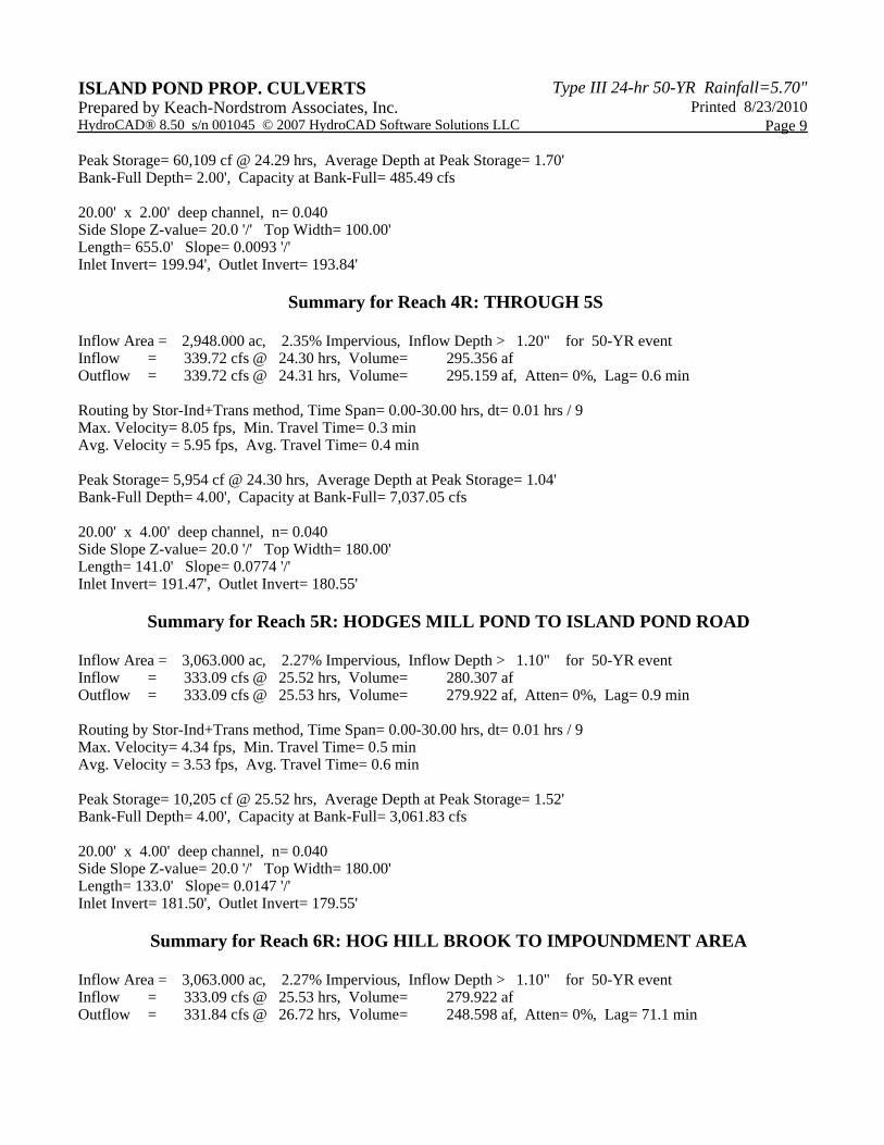
Type III 24-hr 50-YR Rainfall=5.70"ISLAND POND PROP. CULVERTS Printed 8/23/2010Prepared by Keach-Nordstrom Associates, Inc.
Page 9HydroCAD® 8.50 s/n 001045 © 2007 HydroCAD Software Solutions LLC
Peak Storage= 60,109 cf @ 24.29 hrs, Average Depth at Peak Storage= 1.70'Bank-Full Depth= 2.00', Capacity at Bank-Full= 485.49 cfs
20.00' x 2.00' deep channel, n= 0.040Side Slope Z-value= 20.0 '/' Top Width= 100.00'Length= 655.0' Slope= 0.0093 '/'Inlet Invert= 199.94', Outlet Invert= 193.84'
Summary for Reach 4R: THROUGH 5S
Inflow Area = 2,948.000 ac, 2.35% Impervious, Inflow Depth > 1.20" for 50-YR eventInflow = 339.72 cfs @ 24.30 hrs, Volume= 295.356 afOutflow = 339.72 cfs @ 24.31 hrs, Volume= 295.159 af, Atten= 0%, Lag= 0.6 min
Routing by Stor-Ind+Trans method, Time Span= 0.00-30.00 hrs, dt= 0.01 hrs / 9Max. Velocity= 8.05 fps, Min. Travel Time= 0.3 minAvg. Velocity = 5.95 fps, Avg. Travel Time= 0.4 min
Peak Storage= 5,954 cf @ 24.30 hrs, Average Depth at Peak Storage= 1.04'Bank-Full Depth= 4.00', Capacity at Bank-Full= 7,037.05 cfs
20.00' x 4.00' deep channel, n= 0.040Side Slope Z-value= 20.0 '/' Top Width= 180.00'Length= 141.0' Slope= 0.0774 '/'Inlet Invert= 191.47', Outlet Invert= 180.55'
Summary for Reach 5R: HODGES MILL POND TO ISLAND POND ROAD
Inflow Area = 3,063.000 ac, 2.27% Impervious, Inflow Depth > 1.10" for 50-YR eventInflow = 333.09 cfs @ 25.52 hrs, Volume= 280.307 afOutflow = 333.09 cfs @ 25.53 hrs, Volume= 279.922 af, Atten= 0%, Lag= 0.9 min
Routing by Stor-Ind+Trans method, Time Span= 0.00-30.00 hrs, dt= 0.01 hrs / 9Max. Velocity= 4.34 fps, Min. Travel Time= 0.5 minAvg. Velocity = 3.53 fps, Avg. Travel Time= 0.6 min
Peak Storage= 10,205 cf @ 25.52 hrs, Average Depth at Peak Storage= 1.52'Bank-Full Depth= 4.00', Capacity at Bank-Full= 3,061.83 cfs
20.00' x 4.00' deep channel, n= 0.040Side Slope Z-value= 20.0 '/' Top Width= 180.00'Length= 133.0' Slope= 0.0147 '/'Inlet Invert= 181.50', Outlet Invert= 179.55'
Summary for Reach 6R: HOG HILL BROOK TO IMPOUNDMENT AREA
Inflow Area = 3,063.000 ac, 2.27% Impervious, Inflow Depth > 1.10" for 50-YR eventInflow = 333.09 cfs @ 25.53 hrs, Volume= 279.922 afOutflow = 331.84 cfs @ 26.72 hrs, Volume= 248.598 af, Atten= 0%, Lag= 71.1 min

Type III 24-hr 50-YR Rainfall=5.70"ISLAND POND PROP. CULVERTS Printed 8/23/2010Prepared by Keach-Nordstrom Associates, Inc.
Page 10HydroCAD® 8.50 s/n 001045 © 2007 HydroCAD Software Solutions LLC
Routing by Stor-Ind+Trans method, Time Span= 0.00-30.00 hrs, dt= 0.01 hrs / 9Max. Velocity= 2.21 fps, Min. Travel Time= 39.5 minAvg. Velocity = 1.74 fps, Avg. Travel Time= 50.3 min
Peak Storage= 786,447 cf @ 26.06 hrs, Average Depth at Peak Storage= 2.28'Bank-Full Depth= 4.00', Capacity at Bank-Full= 1,236.67 cfs
20.00' x 4.00' deep channel, n= 0.040Side Slope Z-value= 20.0 '/' Top Width= 180.00'Length= 5,247.0' Slope= 0.0024 '/'Inlet Invert= 179.55', Outlet Invert= 167.00'
Summary for Pond 1P: JOHNSONS POND
Inflow Area = 1,486.000 ac, 3.10% Impervious, Inflow Depth > 1.59" for 50-YR eventInflow = 238.10 cfs @ 20.29 hrs, Volume= 197.301 afOutflow = 209.35 cfs @ 22.94 hrs, Volume= 164.746 af, Atten= 12%, Lag= 159.1 minPrimary = 209.35 cfs @ 22.94 hrs, Volume= 164.746 af
Routing by Stor-Ind method, Time Span= 0.00-30.00 hrs, dt= 0.01 hrs / 9Peak Elev= 213.49' @ 22.94 hrs Surf.Area= 22.433 ac Storage= 50.324 af
Plug-Flow detention time= 172.8 min calculated for 164.746 af (83% of inflow)Center-of-Mass det. time= 103.7 min ( 1,429.4 - 1,325.7 )
Volume Invert Avail.Storage Storage Description#1 209.00' 90.000 af Custom Stage Data (Prismatic) Listed below (Recalc)
Elevation Surf.Area Inc.Store Cum.Store(feet) (acres) (acre-feet) (acre-feet)
209.00 0.000 0.000 0.000211.00 10.000 10.000 10.000213.00 20.000 30.000 40.000215.00 30.000 50.000 90.000
Device Routing Invert Outlet Devices#1 Primary 211.00' 20.0' long x 5.0' breadth Broad-Crested Rectangular Weir
Head (feet) 0.20 0.40 0.60 0.80 1.00 1.20 1.40 1.60 1.80 2.00 2.50 3.00 3.50 4.00 4.50 5.00 5.50 Coef. (English) 2.34 2.50 2.70 2.68 2.68 2.66 2.65 2.65 2.65 2.65 2.67 2.66 2.68 2.70 2.74 2.79 2.88
Primary OutFlow Max=209.34 cfs @ 22.94 hrs HW=213.49' (Free Discharge)1=Broad-Crested Rectangular Weir (Weir Controls 209.34 cfs @ 4.21 fps)

Type III 24-hr 50-YR Rainfall=5.70"ISLAND POND PROP. CULVERTS Printed 8/23/2010Prepared by Keach-Nordstrom Associates, Inc.
Page 11HydroCAD® 8.50 s/n 001045 © 2007 HydroCAD Software Solutions LLC
Summary for Pond 2P: HOG HILL POND
Inflow Area = 2,903.000 ac, 2.36% Impervious, Inflow Depth > 1.39" for 50-YR eventInflow = 357.22 cfs @ 21.89 hrs, Volume= 336.875 afOutflow = 338.33 cfs @ 23.82 hrs, Volume= 300.351 af, Atten= 5%, Lag= 115.9 minPrimary = 338.33 cfs @ 23.82 hrs, Volume= 300.351 af
Routing by Stor-Ind method, Time Span= 0.00-30.00 hrs, dt= 0.01 hrs / 9Peak Elev= 210.42' @ 23.82 hrs Surf.Area= 23.927 ac Storage= 54.895 af
Plug-Flow detention time= 115.1 min calculated for 300.351 af (89% of inflow)Center-of-Mass det. time= 69.2 min ( 1,421.4 - 1,352.1 )
Volume Invert Avail.Storage Storage Description#1 205.00' 70.000 af Custom Stage Data (Prismatic) Listed below (Recalc)
Elevation Surf.Area Inc.Store Cum.Store(feet) (acres) (acre-feet) (acre-feet)
205.00 0.000 0.000 0.000207.00 7.000 7.000 7.000209.00 14.000 21.000 28.000211.00 28.000 42.000 70.000
Device Routing Invert Outlet Devices#1 Primary 207.00' 20.0' long x 5.0' breadth Broad-Crested Rectangular Weir
Head (feet) 0.20 0.40 0.60 0.80 1.00 1.20 1.40 1.60 1.80 2.00 2.50 3.00 3.50 4.00 4.50 5.00 5.50 Coef. (English) 2.34 2.50 2.70 2.68 2.68 2.66 2.65 2.65 2.65 2.65 2.67 2.66 2.68 2.70 2.74 2.79 2.88
Primary OutFlow Max=338.32 cfs @ 23.82 hrs HW=210.42' (Free Discharge)1=Broad-Crested Rectangular Weir (Weir Controls 338.32 cfs @ 4.95 fps)
Summary for Pond 3P: 9'X5' BOX UNDER ISLAND POND ROAD
Inflow Area = 2,903.000 ac, 2.36% Impervious, Inflow Depth > 1.20" for 50-YR eventInflow = 338.16 cfs @ 24.26 hrs, Volume= 290.557 afOutflow = 338.16 cfs @ 24.26 hrs, Volume= 290.557 af, Atten= 0%, Lag= 0.0 minPrimary = 338.16 cfs @ 24.26 hrs, Volume= 290.557 af
Routing by Stor-Ind method, Time Span= 0.00-30.00 hrs, dt= 0.01 hrs / 9Peak Elev= 206.11' @ 24.26 hrsFlood Elev= 206.48'
Device Routing Invert Outlet Devices#1 Primary 200.19' 9.00' W x 5.00' H x 40.0' long Culvert
RCP, square edge headwall, Ke= 0.500 Outlet Invert= 199.94' S= 0.0063 '/' Cc= 0.900 n= 0.012 Concrete pipe, finished
#2 Primary 206.48' 50.0' long x 24.0' breadth Broad-Crested Rectangular Weir Head (feet) 0.20 0.40 0.60 0.80 1.00 1.20 1.40 1.60

Type III 24-hr 50-YR Rainfall=5.70"ISLAND POND PROP. CULVERTS Printed 8/23/2010Prepared by Keach-Nordstrom Associates, Inc.
Page 12HydroCAD® 8.50 s/n 001045 © 2007 HydroCAD Software Solutions LLC
Coef. (English) 2.68 2.70 2.70 2.64 2.63 2.64 2.64 2.63
Primary OutFlow Max=338.16 cfs @ 24.26 hrs HW=206.11' (Free Discharge)1=Culvert (Barrel Controls 338.16 cfs @ 8.46 fps)2=Broad-Crested Rectangular Weir ( Controls 0.00 cfs)
Summary for Pond 4P: 9'X5' BOX UNDER ISLAND POND ROAD (REMOVE EXISTING 60")
Inflow Area = 2,948.000 ac, 2.35% Impervious, Inflow Depth > 1.20" for 50-YR eventInflow = 339.72 cfs @ 24.30 hrs, Volume= 295.356 afOutflow = 339.72 cfs @ 24.30 hrs, Volume= 295.356 af, Atten= 0%, Lag= 0.0 minPrimary = 339.72 cfs @ 24.30 hrs, Volume= 295.356 af
Routing by Stor-Ind method, Time Span= 0.00-30.00 hrs, dt= 0.01 hrs / 9Peak Elev= 199.46' @ 24.30 hrsFlood Elev= 200.40'
Device Routing Invert Outlet Devices#1 Primary 193.84' 9.00' W x 5.00' H x 42.0' long Culvert
RCP, square edge headwall, Ke= 0.500 Outlet Invert= 193.30' S= 0.0129 '/' Cc= 0.900 n= 0.012 Concrete pipe, finished
#2 Primary 200.88' 35.0' long x 24.0' breadth Broad-Crested Rectangular Weir Head (feet) 0.20 0.40 0.60 0.80 1.00 1.20 1.40 1.60 Coef. (English) 2.68 2.70 2.70 2.64 2.63 2.64 2.64 2.63
Primary OutFlow Max=339.72 cfs @ 24.30 hrs HW=199.46' (Free Discharge)1=Culvert (Barrel Controls 339.72 cfs @ 8.95 fps)2=Broad-Crested Rectangular Weir ( Controls 0.00 cfs)
Summary for Pond 5P: HODGES MILL POND
Inflow Area = 3,063.000 ac, 2.27% Impervious, Inflow Depth > 1.21" for 50-YR eventInflow = 343.42 cfs @ 24.25 hrs, Volume= 309.505 afOutflow = 333.09 cfs @ 25.52 hrs, Volume= 280.307 af, Atten= 3%, Lag= 75.8 minPrimary = 333.09 cfs @ 25.52 hrs, Volume= 280.307 af
Routing by Stor-Ind method, Time Span= 0.00-30.00 hrs, dt= 0.01 hrs / 9Peak Elev= 187.45' @ 25.52 hrs Surf.Area= 9.664 ac Storage= 36.793 af
Plug-Flow detention time= 78.3 min calculated for 280.214 af (91% of inflow)Center-of-Mass det. time= 42.2 min ( 1,452.0 - 1,409.8 )
Volume Invert Avail.Storage Storage Description#1 180.55' 59.850 af Custom Stage Data (Prismatic) Listed below (Recalc)
Elevation Surf.Area Inc.Store Cum.Store(feet) (acres) (acre-feet) (acre-feet)
180.55 1.000 0.000 0.000189.55 12.300 59.850 59.850

Type III 24-hr 50-YR Rainfall=5.70"ISLAND POND PROP. CULVERTS Printed 8/23/2010Prepared by Keach-Nordstrom Associates, Inc.
Page 13HydroCAD® 8.50 s/n 001045 © 2007 HydroCAD Software Solutions LLC
Device Routing Invert Outlet Devices#1 Primary 181.55' 7.0' long x 1.5' breadth Broad-Crested Rectangular Weir
Head (feet) 0.20 0.40 0.60 0.80 1.00 1.20 1.40 1.60 1.80 2.00 2.50 3.00 Coef. (English) 2.62 2.64 2.64 2.68 2.75 2.86 2.92 3.07 3.07 3.03 3.28 3.32
#2 Primary 190.55' 60.0' long x 1.0' breadth Broad-Crested Rectangular Weir Head (feet) 0.20 0.40 0.60 0.80 1.00 1.20 1.40 1.60 1.80 2.00 2.50 3.00 Coef. (English) 2.69 2.72 2.75 2.85 2.98 3.08 3.20 3.28 3.31 3.30 3.31 3.32
Primary OutFlow Max=333.09 cfs @ 25.52 hrs HW=187.45' (Free Discharge)1=Broad-Crested Rectangular Weir (Weir Controls 333.09 cfs @ 8.06 fps)2=Broad-Crested Rectangular Weir ( Controls 0.00 cfs)
Summary for Pond 6P: 9'X5' BOX CROSSING UNDER ISLAND POND ROAD
Inflow Area = 3,063.000 ac, 2.27% Impervious, Inflow Depth > 1.10" for 50-YR eventInflow = 333.09 cfs @ 25.53 hrs, Volume= 279.922 afOutflow = 333.09 cfs @ 25.53 hrs, Volume= 279.922 af, Atten= 0%, Lag= 0.0 minPrimary = 333.09 cfs @ 25.53 hrs, Volume= 279.922 af
Routing by Stor-Ind method, Time Span= 0.00-30.00 hrs, dt= 0.01 hrs / 9Peak Elev= 185.74' @ 25.53 hrsFlood Elev= 186.92'
Device Routing Invert Outlet Devices#1 Primary 179.55' 9.00' W x 5.00' H x 48.0' long Culvert
RCP, square edge headwall, Ke= 0.500 Outlet Invert= 179.55' S= 0.0000 '/' Cc= 0.900 n= 0.012
#2 Primary 187.51' 50.0' long x 24.0' breadth Broad-Crested Rectangular Weir Head (feet) 0.20 0.40 0.60 0.80 1.00 1.20 1.40 1.60 Coef. (English) 2.68 2.70 2.70 2.64 2.63 2.64 2.64 2.63
Primary OutFlow Max=333.09 cfs @ 25.53 hrs HW=185.74' (Free Discharge)1=Culvert (Barrel Controls 333.09 cfs @ 7.97 fps)2=Broad-Crested Rectangular Weir ( Controls 0.00 cfs)
Summary for Pond 7P: EXISTING IMPOUNDMENT AREA
Inflow Area = 5,091.000 ac, 2.37% Impervious, Inflow Depth > 1.21" for 50-YR eventInflow = 510.38 cfs @ 23.76 hrs, Volume= 513.775 afOutflow = 512.90 cfs @ 23.75 hrs, Volume= 477.675 af, Atten= 0%, Lag= 0.0 minPrimary = 512.90 cfs @ 23.75 hrs, Volume= 477.675 af
Routing by Stor-Ind method, Time Span= 0.00-30.00 hrs, dt= 0.01 hrs / 9Peak Elev= 170.04' @ 23.75 hrs Surf.Area= 20.000 ac Storage= 41.250 af
Plug-Flow detention time= 62.9 min calculated for 477.675 af (93% of inflow)Center-of-Mass det. time= 34.6 min ( 1,427.6 - 1,392.9 )

Type III 24-hr 50-YR Rainfall=5.70"ISLAND POND PROP. CULVERTS Printed 8/23/2010Prepared by Keach-Nordstrom Associates, Inc.
Page 14HydroCAD® 8.50 s/n 001045 © 2007 HydroCAD Software Solutions LLC
Volume Invert Avail.Storage Storage Description#1 167.00' 41.250 af Custom Stage Data (Prismatic) Listed below (Recalc)
Elevation Surf.Area Inc.Store Cum.Store(feet) (acres) (acre-feet) (acre-feet)
167.00 7.500 0.000 0.000170.00 20.000 41.250 41.250
Device Routing Invert Outlet Devices#1 Primary 167.00' 15.0' long x 10.0' breadth Broad-Crested Rectangular Weir
Head (feet) 0.20 0.40 0.60 0.80 1.00 1.20 1.40 1.60 Coef. (English) 2.49 2.56 2.70 2.69 2.68 2.69 2.67 2.64
#2 Primary 168.50' 60.0' long x 10.0' breadth Broad-Crested Rectangular Weir Head (feet) 0.20 0.40 0.60 0.80 1.00 1.20 1.40 1.60 Coef. (English) 2.49 2.56 2.70 2.69 2.68 2.69 2.67 2.64
Primary OutFlow Max=512.89 cfs @ 23.75 hrs HW=170.04' (Free Discharge)1=Broad-Crested Rectangular Weir (Weir Controls 209.69 cfs @ 4.60 fps)2=Broad-Crested Rectangular Weir (Weir Controls 303.20 cfs @ 3.29 fps)
Summary for Pond 8P: CROSSING UNDER WEST SIDE DRIVE
Inflow Area = 5,091.000 ac, 2.37% Impervious, Inflow Depth > 1.13" for 50-YR eventInflow = 512.90 cfs @ 23.75 hrs, Volume= 477.675 afOutflow = 512.90 cfs @ 23.75 hrs, Volume= 477.675 af, Atten= 0%, Lag= 0.0 minPrimary = 512.90 cfs @ 23.75 hrs, Volume= 477.675 af
Routing by Stor-Ind method, Time Span= 0.00-30.00 hrs, dt= 0.01 hrs / 9Peak Elev= 171.12' @ 23.75 hrsFlood Elev= 175.00'
Device Routing Invert Outlet Devices#1 Primary 161.00' 96.0" x 40.0' long Culvert CMP, square edge headwall, Ke= 0.500
Outlet Invert= 160.60' S= 0.0100 '/' Cc= 0.900 n= 0.025 Corrugated metal #2 Primary 175.00' 50.0' long x 24.0' breadth Broad-Crested Rectangular Weir
Head (feet) 0.20 0.40 0.60 0.80 1.00 1.20 1.40 1.60 Coef. (English) 2.68 2.70 2.70 2.64 2.63 2.64 2.64 2.63
Primary OutFlow Max=512.96 cfs @ 23.75 hrs HW=171.12' (Free Discharge)1=Culvert (Barrel Controls 512.96 cfs @ 10.41 fps)2=Broad-Crested Rectangular Weir ( Controls 0.00 cfs)
Summary for Link 1L: HOG HILL BROOK
Inflow Area = 5,091.000 ac, 2.37% Impervious, Inflow Depth > 1.13" for 50-YR eventInflow = 512.90 cfs @ 23.75 hrs, Volume= 477.675 afPrimary = 512.90 cfs @ 23.75 hrs, Volume= 477.675 af, Atten= 0%, Lag= 0.0 min
Primary outflow = Inflow, Time Span= 0.00-30.00 hrs, dt= 0.01 hrs

VI. WATERSHED AREAS PLAN