Stormwater Management Plan (SWMP) Compliance Calculations ... · Page 1 of 19 Stormwater Management...
19
Page 1 of 19 Stormwater Management Plan (SWMP) Compliance Calculations Checklist Sheet # Yes/ No Comments SWMP Review Orientation (Chapter 2 and Chapter 5) 1 Has the applicant identified the type of activity in the submission? (Check one) A Major Land Disturbing Activity - an activity that disturbs 5,000 square feet or greater of land area o SWRv is based on the 90 th percentile event (1.2 inches) A Major Substantial Improvement Activity - the building improvement (where the cost exceeds 50% of the market value of the structure before the improvement) and associated land disturbing activity exceed 5,000 square feet o SWRv is based on the 80 th percentile event (0.8 inch) o Exempt from the 2-year and 15-year storm-control requirements Mix of Major Substantial Improvement Activity and Major Land Disturbing Activity Public-Right-of-Way o Follow the Maximum Extent Practicable (MEP) Process Unregulated (review for Stormwater Retention Credits only) [Table 2.1 Sizing Criteria for Stormwater Management Performance Requirements, page 8 and Figures 2.3-2.7, pages 15-19] 2 What type of permit is submitted and what types of review are required? (Check One) Raze (R) - ESC Demolition (D) - ESC Excavation (EX) - ESC Sheeting and Shoring (SH) - ESC Foundation to Grade (FD) - ESC, SWM, and GAR Infrastructure (BCIV) - ESC, SWM, and GAR Building (B)- ESC, SWM, and GAR 3 Is the project’s SWMP vested under a regulated transition period? If vested, does the approval extend to the public right-of-way component of the project? (Check the Application for Vesting Status completed by Applicant) The vesting application can be downloaded from the attachment list at http://ddoe.dc.gov/swguidebook [2013 Stormwater Management Rule [2013 SWM Rule Sections 552 Transitions]
Transcript of Stormwater Management Plan (SWMP) Compliance Calculations ... · Page 1 of 19 Stormwater Management...

Page 1 of 19
Stormwater Management Plan (SWMP) Compliance Calculations Checklist Sheet #
Yes/No
Comments
SWMP Review Orientation (Chapter 2 and Chapter 5)
1 Has the applicant identified the type of activity in the submission? (Check one)
A Major Land Disturbing Activity - an activity that disturbs 5,000 square feet or greater of land area
o SWRv is based on the 90th
percentile event (1.2 inches)
A Major Substantial Improvement Activity - the building improvement (where the cost exceeds 50% of the market value of the structure before the improvement) and associated land disturbing activity exceed 5,000 square feet
o SWRv is based on the 80th
percentile event (0.8 inch)
o Exempt from the 2-year and 15-year storm-control requirements
Mix of Major Substantial Improvement Activity and Major Land Disturbing Activity
Public-Right-of-Way
o Follow the Maximum Extent Practicable (MEP) Process
Unregulated (review for Stormwater Retention Credits only)
[Table 2.1 Sizing Criteria for Stormwater Management Performance Requirements, page 8 and Figures 2.3-2.7, pages 15-19]
2 What type of permit is submitted and what types of review are required? (Check One)
Raze (R) - ESC
Demolition (D) - ESC
Excavation (EX) - ESC
Sheeting and Shoring (SH) - ESC
Foundation to Grade (FD) - ESC, SWM, and GAR
Infrastructure (BCIV) - ESC, SWM, and GAR
Building (B)- ESC, SWM, and GAR
3 Is the project’s SWMP vested under a regulated transition period? If vested, does the approval extend to the public right-of-way component of the project? (Check the Application for Vesting Status completed by Applicant) The vesting application can be downloaded from the attachment list at http://ddoe.dc.gov/swguidebook
[2013 Stormwater Management Rule [2013 SWM Rule Sections 552 Transitions]

Page 2 of 19
Stormwater Management Plan (SWMP) Compliance Calculations Checklist Sheet #
Yes/No
Comments
4 Is a GAR is required? Does the submission include GAR sheets or an exemption form? The GAR exemption forms can be downloaded from the GAR forms list at http://ddoe.dc.gov/gar
[Z.C. ORDER NO. 12-10 Green Area Ratio]
5 Does the SWMP application contain the following supporting documents?
Site Development Submittal Information Form—completed by DDOE intake
DC Water Storm Sewer Verification Form
DCRA Application for Construction Permit on Private Property
Environmental Intake Screening Form (EISF)- Signed by DCRA Reviewer
Environmental Questionnaire
DC Green Building Act Permit Application Intake Form (not applicable for SH permits)
Contract Agreement
Lead Permit Screening Form
Zoning Data Summary Form
Reasonable Accommodations and Modifications for Persons with Disabilities Form
USEPA Notice of Intent Form (required for disturbance of 1 or more acres)
6 Has the applicant identified the watershed and subwatershed (see http://geospatial.dcgis.dc.gov/watershedfinder/)?
SWMP Application Contents (Chapter 2 and 5)
7 Is the site located in a combined sewer system (CSS)?
Retain 50% of the SWRv for the entire site. No water quality treatment is required.
If 50% of the volume cannot be retained, has DDOE approved an application for relief from extraordinarily difficult site conditions? [Appendix E]
[Figure 2.6 Determining if minimum retention and water quality treatment requirements have been met, page 18]

Page 3 of 19
Stormwater Management Plan (SWMP) Compliance Calculations Checklist Sheet #
Yes/No
Comments
8 Is the site located in a MS4 system?
Treat or retain 50% of SWRv for each drainage area within the limits of disturbance.
Treat or retain 50% of the SWRv flowing from the entire vehicular access area.
If 50% of the volume cannot be retained, at least 80% total suspended solids (TSS) should be removed from the remaining volume
o [2.2 Stormwater Retention Volume, page 10]
If 50% of the volume cannot be retained, has DDOE approved an application for relief from extraordinarily difficult site conditions? [Appendix E]
[Figure 2.6 Determining if minimum retention and water quality treatment requirements have been met, page 18]
9 Do all three of the following conditions exist on the site? If so, the 2-year post development peak discharge requirements do not apply:
Site discharge flows directly to the main stem of the tidal Potomac or Anacostia Rivers, the Washington Channel, or the Chesapeake and Ohio Canal.
Site discharges do not flow into or through a tributary to those waterbodies that run above ground or that DDOE expects to daylight
Site discharges will not cause erosion of land or transport of sediment
[Figure 2.6 Determining if minimum retention and water quality treatment requirements have been met, page 18]
10 Is any part of this plan an “AWDZ site”? If so, see separate AWDZ checklist. If address falls in the AWDZ footprint, the project may not meet all criteria to be an AWDZ site. Check if applicant is claiming “Not an AWDZ site”. The AWDZ exemption form can be downloaded from the attachment list at http://ddoe.dc.gov/swguidebook
[Appendix U, page U-1 ]
Page 4 of 19
Stormwater Management Plan (SWMP) Compliance Calculations Checklist Sheet #
Yes/No
Comments
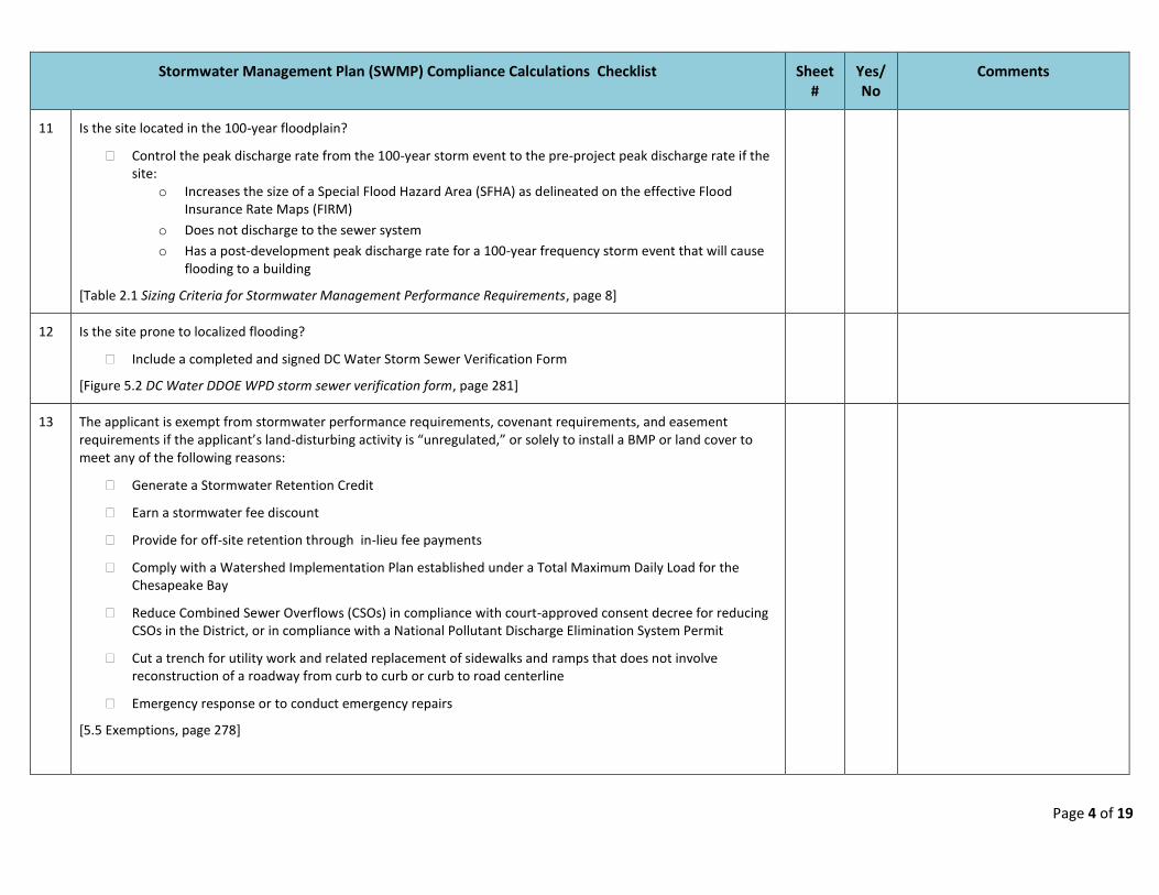
11 Is the site located in the 100-year floodplain?
Control the peak discharge rate from the 100-year storm event to the pre-project peak discharge rate if the site:
o Increases the size of a Special Flood Hazard Area (SFHA) as delineated on the effective Flood Insurance Rate Maps (FIRM)
o Does not discharge to the sewer system
o Has a post-development peak discharge rate for a 100-year frequency storm event that will cause flooding to a building
[Table 2.1 Sizing Criteria for Stormwater Management Performance Requirements, page 8]
12 Is the site prone to localized flooding?
Include a completed and signed DC Water Storm Sewer Verification Form
[Figure 5.2 DC Water DDOE WPD storm sewer verification form, page 281]
13 The applicant is exempt from stormwater performance requirements, covenant requirements, and easement requirements if the applicant’s land-disturbing activity is “unregulated,” or solely to install a BMP or land cover to meet any of the following reasons:
Generate a Stormwater Retention Credit
Earn a stormwater fee discount
Provide for off-site retention through in-lieu fee payments
Comply with a Watershed Implementation Plan established under a Total Maximum Daily Load for the Chesapeake Bay
Reduce Combined Sewer Overflows (CSOs) in compliance with court-approved consent decree for reducing CSOs in the District, or in compliance with a National Pollutant Discharge Elimination System Permit
Cut a trench for utility work and related replacement of sidewalks and ramps that does not involve reconstruction of a roadway from curb to curb or curb to road centerline
Emergency response or to conduct emergency repairs
[5.5 Exemptions, page 278]
Page 5 of 19
Stormwater Management Plan (SWMP) Compliance Calculations Checklist Sheet #
Yes/No
Comments
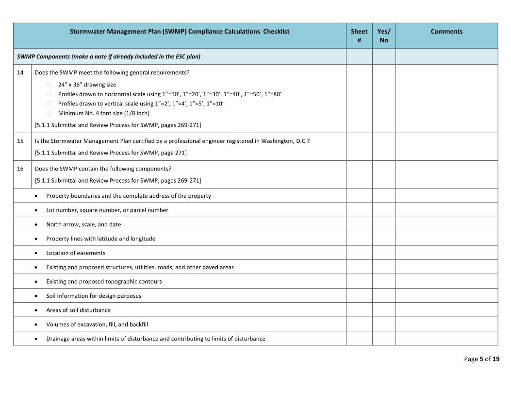
SWMP Components (make a note if already included in the ESC plan)
14 Does the SWMP meet the following general requirements?
24” x 36” drawing size
Profiles drawn to horizontal scale using 1”=10’, 1”=20’, 1”=30’, 1”=40’, 1”=50’, 1”=80’
Profiles drawn to vertical scale using 1”=2’, 1”=4’, 1”=5’, 1”=10’
Minimum No. 4 font size (1/8 inch)
[5.1.1 Submittal and Review Process for SWMP, pages 269-271]
15 Is the Stormwater Management Plan certified by a professional engineer registered in Washington, D.C.?
[5.1.1 Submittal and Review Process for SWMP, page 271]
16 Does the SWMP contain the following components?
[5.1.1 Submittal and Review Process for SWMP, pages 269-271]
Property boundaries and the complete address of the property
Lot number, square number, or parcel number
North arrow, scale, and date
Property lines with latitude and longitude
Location of easements
Existing and proposed structures, utilities, roads, and other paved areas
Existing and proposed topographic contours
Soil information for design purposes
Areas of soil disturbance
Volumes of excavation, fill, and backfill
Drainage areas within limits of disturbance and contributing to limits of disturbance

Page 6 of 19
Stormwater Management Plan (SWMP) Compliance Calculations Checklist Sheet #
Yes/No
Comments
Delineation of existing and proposed land covers with square footage by cover type (natural cover, compacted cover, impervious surface, and vehicular access areas)
Location of existing streams, wetlands, or other natural features
Location and size of existing utility lines
Legend identifying all symbols used on the plan
Applicable flood boundaries for the site’s 100-year floodplain (including partial)
Information regarding mitigation of any off-site impacts (safe conveyance of flows from adjacent properties that pass through the project site)
Stormwater Hotspot Cover Sheet and Checklist [Appendix P Stormwater Hotspots]
Construction specifications
Proprietary practices and practices outside the Stormwater Management Guidebook
Quantity of deficit SWRv requiring off-site mitigation identified and statement of participation in the In-Lieu Fee or Stormwater Retention Credit Trading Program to manage SWRv deficit shown (Off Site Retention Stamp)
A maintenance plan identifying routine and long-term maintenance needs, a maintenance schedule, and a Declaration of Covenants stating the owner’s specific maintenance responsibilities (government-owned properties are exempt)
A proposed construction and inspection control schedule [5.3 Inspection Schedule and Reports, page 274]
17 Where land disturbance is greater than 5,000 square feet and less than one acre, do the “Pollution Prevention Through Good Housekeeping” notes from Appendix Q appear as stamped notes in the SWMP? The PDF of these notes can be downloaded from the attachment list at http://ddoe.dc.gov/swguidebook
[Appendix Q Pollution Prevention Through Good Housekeeping, page Q-1]
18 Does the plan contain the current version of the following statements? The DDOE blocks can be downloaded from the attachment list at http://ddoe.dc.gov/swguidebook
Statement by Professional Engineer Registered in the District of Columbia - signed and sealed
Statement by Person Responsible for Maintenance - signed
As-Built Certification by Professional Engineer

Page 7 of 19
Stormwater Management Plan (SWMP) Compliance Calculations Checklist Sheet #
Yes/No
Comments
Stormwater Conveyance
19 Does the plan utilize one of the following acceptable methodologies and computer models for estimated runoff hydrographs before and after development?
Urban Hydrology for Small Watersheds TR-55
Storage-Indication Routing
HEC-1, WinTR-55, and SWMM Computer Models
Rational Method (limited to sites under 5 acres)
[Appendix H Acceptable Hydrological Methods and Models, page H-1]
20 Does the plan contain pre- and post-project stormwater detention input and calculations, including the following?
Summary of the soil conditions in the field data
Pre- and post-project curve number computation
Time of concentration
Peak discharge for each drainage area within the LOD for 2-year and 15-year 24-hour storms
[5.1.1 Submittal and Review Process for SWMP, page 272]
21 Are the following runoff condition assumptions included in the hydrology calculations?
Predevelopment runoff condition used for the 2-year storm is based on “meadow in good condition” or better, assuming good hydrologic conditions and land with grass cover
Pre-project runoff conditions used for the 15-year storm are based on the existing condition of the site
[Appendix H Acceptable Hydrological Methods and Models, page H-1]
22 Is the time of concentration based on the following assumptions?
Predevelopment time of concentration is the sum total of computed or estimated overland flow time and travel in natural swales, streams, creeks, and rivers, but not less than 6 minutes
Post-development time of concentration is the sum total of the inlet time and travel time in improved channels or storm drains, but not less than 6 minutes
[Appendix H Acceptable Hydrological Methods and Models, page H-2]

Page 8 of 19
Stormwater Management Plan (SWMP) Compliance Calculations Checklist Sheet #
Yes/No
Comments
23 Does the hydrologic method or model use approved Hydrologic Soil Groups listed in the Soil Survey of the District of Columbia Handbook? If the Hydrologic Soil Group is not available (e.g., “Urban Soils”), does the calculation or model use Hydrologic Soil Group C? [Appendix H Acceptable Hydrological Methods and Models, page H-2]
24 To calculate the peak discharge for the SWRv 1.2-inch storm event, does the plan apply the Modified CN Method shown on page H-7 of Appendix H?
[Appendix H Acceptable Hydrological Methods and Models, page H-7]
25 Using the conditions outlined in Chapter 2 Minimum Control Requirements (page 7), do the 2-year and 15-year post development peak discharges apply?
Reduce the peak discharge rate from the 2-year storm event to the predevelopment (meadow conditions or better) peak discharge rate
Reduce the peak discharge rate from the 15-year storm event to the pre-project discharge rate. [Appendix A]
26 If a hydrologic computer model was used, were the following items submitted with the SWMP?
Complete input data file and print-out at the 85% submittal stage
Supporting computations prepared for the data input file
Inflow-outflow hydrographs for each design storm
Schematic diagrams for all routings
[Appendix H Acceptable Hydrological Methods and Models, page H-5]
27 If a drainage area exceeds 25 acres that are heterogeneous with respect to land use, soils, RCN, or Time of Concentration, does the plan provide a separate hydrological analysis for each sub-area?
[Appendix H Acceptable Hydrological Methods and Models, page H-2]
General Retention Compliance Calculator
28 Does the retention calculator account for all the site’s individual drainage areas that have discrete discharge points or overland flows? [Appendix A]
29 Is the site drainage area divided into contributing drainage areas (CDAs) to each BMP? [Appendix A]
Page 9 of 19
Stormwater Management Plan (SWMP) Compliance Calculations Checklist Sheet #
Yes/No
Comments
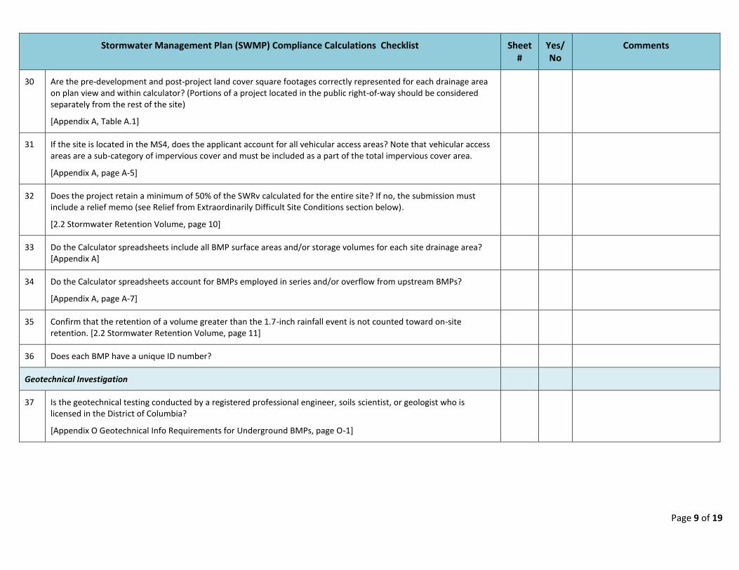
30 Are the pre-development and post-project land cover square footages correctly represented for each drainage area on plan view and within calculator? (Portions of a project located in the public right-of-way should be considered separately from the rest of the site)
[Appendix A, Table A.1]
31 If the site is located in the MS4, does the applicant account for all vehicular access areas? Note that vehicular access areas are a sub-category of impervious cover and must be included as a part of the total impervious cover area.
[Appendix A, page A-5]
32 Does the project retain a minimum of 50% of the SWRv calculated for the entire site? If no, the submission must include a relief memo (see Relief from Extraordinarily Difficult Site Conditions section below).
[2.2 Stormwater Retention Volume, page 10]
33 Do the Calculator spreadsheets include all BMP surface areas and/or storage volumes for each site drainage area? [Appendix A]
34 Do the Calculator spreadsheets account for BMPs employed in series and/or overflow from upstream BMPs?
[Appendix A, page A-7]
35 Confirm that the retention of a volume greater than the 1.7-inch rainfall event is not counted toward on-site retention. [2.2 Stormwater Retention Volume, page 11]
36 Does each BMP have a unique ID number?
Geotechnical Investigation
37 Is the geotechnical testing conducted by a registered professional engineer, soils scientist, or geologist who is licensed in the District of Columbia?
[Appendix O Geotechnical Info Requirements for Underground BMPs, page O-1]

Page 10 of 19
Stormwater Management Plan (SWMP) Compliance Calculations Checklist Sheet #
Yes/No
Comments
38 All in-ground stormwater BMPs require a geotechnical investigation. Does the plan include a geotechnical investigation with the following:
Depth to groundwater table and estimated depth to seasonally high groundwater table
Grain size analysis laboratory results
Soil descriptions for each boring or test pit, with enough detail to identify the boundary and elevations of any problem conditions
A map or plan indicating the locations of the test pits and borings
[Appendix O Geotechnical Info Requirements for Underground BMPs, page O-1]
39 Is an additional boring or test pit provided when the site meets one of the following conditions?
Soil or slope varies appreciably from the findings in the initial boring or test pit
Groundwater level is significantly higher than indicated by the initial boring or test pit
Groundwater level may adversely affect the proposed BMP facility
[Appendix O Geotechnical Info Requirements for Underground BMPs, page O-1]
40 Does the soil boring or test pit meet the following requirements?
Excavated or drilled to a depth of 2 feet below the proposed facility bottom
Classified using Unified Soil Classifications (USC) System or United States Department of Agriculture(USDA) System for soil textures
Soil classified at the proposed bottom and 4 feet below the bottom of the BMP
[Appendix O Geotechnical Info Requirements for Underground BMPs, page O-1]
41 If the plan includes infiltration, such as an infiltration practice, filtering system, storage practice, stormwater pond, or wetland, did the applicant include infiltration tests?
[Appendix O Geotechnical Info Requirements for Underground BMPs, page O-1]

Page 11 of 19
Stormwater Management Plan (SWMP) Compliance Calculations Checklist Sheet #
Yes/No
Comments
42 Was the infiltration test conducted using one of the following acceptable methods?
Constant Head-Bore-Hole Infiltration Test
Amoozemeter
Guelph Permeameter
Johnson Permeameter
Double-Ring Infiltrometer
[Appendix O Geotechnical Info Requirements for Underground BMPs, page O-1]
Stormwater Pipes and Structures
The focus of the Stormwater Management Guidebook is to define standards and specifications for design, construction, and maintenance of BMPs that are required to meet stormwater performance objectives. The components and considerations of the accompanying stormwater conveyance system should also be reviewed briefly:
43 Are pipe size, material, and installation based on the DC Water Standards and Specifications?
[Appendix F F.9 Pipe Systems, page F-5]
44 Does the design include separate pipe schedules for public and private pipes, tabulating pipe lengths by diameter and class?
[Appendix F F.9 Pipe Systems, page F-5]
45 Is the Hydraulic Grade Line (HGL) clearly indicated on the system profile, identified with the initials HGL on the line, and identified in the legend key?
[Appendix F F.11 Hydraulic Grade Lines, page F-7]
46 If the HGL is more than 1 foot above the pipe crown, are rubber gaskets shown on the plan (CSS)?
[Appendix F F.11 Hydraulic Grade Lines, page F-7]
47 If the structural BMP discharges into a storm sewer or a combined sewer system, is a detailed HGL analysis of the system, including the receiving system, provided with the SWMP for the 15-year and 100-year flow frequencies?
[Appendix F F.11 Hydraulic Grade Lines, page F-7]
Page 12 of 19
Stormwater Management Plan (SWMP) Compliance Calculations Checklist Sheet #
Yes/No
Comments
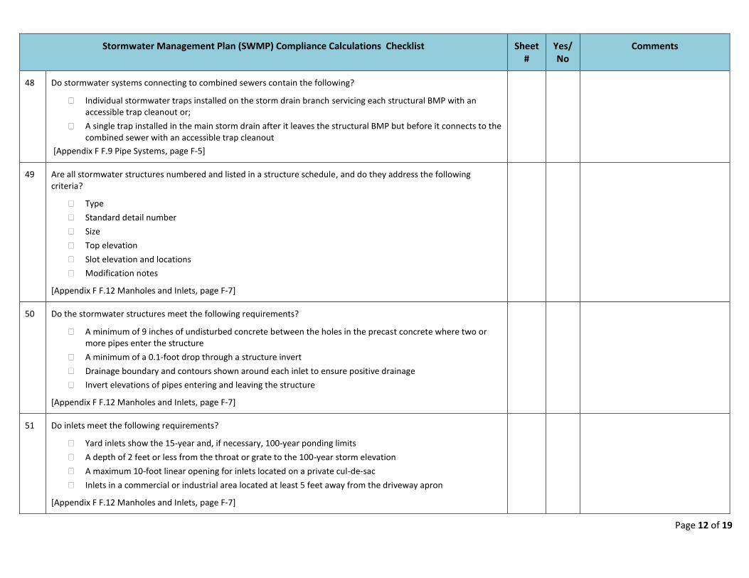
48 Do stormwater systems connecting to combined sewers contain the following?
Individual stormwater traps installed on the storm drain branch servicing each structural BMP with an accessible trap cleanout or;
A single trap installed in the main storm drain after it leaves the structural BMP but before it connects to the combined sewer with an accessible trap cleanout
[Appendix F F.9 Pipe Systems, page F-5]
49 Are all stormwater structures numbered and listed in a structure schedule, and do they address the following criteria?
Type
Standard detail number
Size
Top elevation
Slot elevation and locations
Modification notes
[Appendix F F.12 Manholes and Inlets, page F-7]
50 Do the stormwater structures meet the following requirements?
A minimum of 9 inches of undisturbed concrete between the holes in the precast concrete where two or more pipes enter the structure
A minimum of a 0.1-foot drop through a structure invert
Drainage boundary and contours shown around each inlet to ensure positive drainage
Invert elevations of pipes entering and leaving the structure
[Appendix F F.12 Manholes and Inlets, page F-7]
51 Do inlets meet the following requirements?
Yard inlets show the 15-year and, if necessary, 100-year ponding limits
A depth of 2 feet or less from the throat or grate to the 100-year storm elevation
A maximum 10-foot linear opening for inlets located on a private cul-de-sac
Inlets in a commercial or industrial area located at least 5 feet away from the driveway apron
[Appendix F F.12 Manholes and Inlets, page F-7]

Page 13 of 19
Stormwater Management Plan (SWMP) Compliance Calculations Checklist Sheet #
Yes/No
Comments
52 Are all inlets on private or public parcels outside the public right-of-way sized to ensure safe conveyance of stormwater flows exceeding the capacity of the approved on-site BMPs? Confirm they do not flow over property lines onto adjacent lots unless running into an existing natural water course.
[Appendix F F.5 Inlets, page F-3]
53 If the 100-year storm overflow path is not directly over the pipe, is an alternative overflow path shown on the plan view?
[Appendix F F.9 Pipe Systems, page F-5]
54 Does the stormwater conveyance system adhere to the following utility clearance requirements?
Show in plan and profile that all existing and proposed utilities crossing are parallel to the designed storm sewer system
Storm drain and utility crossings have more than a 45-degree angle between them
Provide minimum vertical and horizontal clearances, wall to wall, between storm drainage lines and other utilities as defined by District of Columbia Water and Sewer Authority (DC Water) Project Design Manual and Green Infrastructure Utility Protection Guidelines
[Appendix F F.2 Clearance with Other Utilities, page F-1]
Public Right-of-Way (PROW)
55 Are the portions of the project located in the PROW considered separately from the rest of the site?
[Appendix A]
56 Based on the description below, is the site required to follow the MEP process?
PROW projects required for the operation and maintenance of existing commercial and residential streets, existing alleyways, and other existing transportation infrastructure designed and maintained for safe conveyance of people and commerce (private subdivision roads or streets shall not be considered public right-of-way projects)
[Appendix B B.2 Public Right-of-Way Projects, page B-3]

Page 14 of 19
Stormwater Management Plan (SWMP) Compliance Calculations Checklist Sheet #
Yes/No
Comments
57 As defined below, is the PROW project classified as a Type 1 or Type 2 project?
Type 1– Reconstruction of existing PROW
Type 2– Parcel-based development projects that reconstruct the adjacent existing PROW as a portion of the project (skip to MEP Process Type 2 Section)
[Appendix B B.2 Public Right-of-Way Projects, pages B-3 & B-4]
Maximum Extent Practicable (MEP) Process Type 1
58 This application type requires a stormwater report that contains the DDOT Maximum Extent Practicable Design spreadsheet, plan view, and narrative for review at the 30%, 65%, and 90% design stages. Each later design stage report should include the prior DDOE concurrence issued.
[Appendix B B.2 Public Right-of-Way Projects, page B-4]
59 What design stage is this application addressing?
If the design stage is 30%, 65%, or 90%, is the stormwater report complete, and is prior concurrence included?
[Appendix B B.2 Public Right-of-Way Projects, page B-4]
60 If this is the final 100% submission, any deviation from the 90% concurrence must be identified and addressed.
[Appendix B B.2 Public Right-of-Way Projects]
61 Does the stormwater report illustrate a serious attempt to maximize stormwater retention, proposing, where possible, to retain above the regulated stormwater volume in the 30% design stage with the acknowledgement that site conflicts in later plan iterations may reduce the number of proposed BMPs?
[DDOT Green Infrastructure Standards 2.3.10 Soil Erosion and Sediment Control and Stormwater Management, page D-1]

Page 15 of 19
Stormwater Management Plan (SWMP) Compliance Calculations Checklist Sheet #
Yes/No
Comments
62 Does the submission address Step 1-Identify Drainage Areas and Calculate SWRv requirements? See Appendix B Table B.3 MEP Type 1 Submission Elements and Review Points at each review stage (30%, 65%, and 90%) for each of the following points:
Define the limits of disturbance (LOD) for the PROW project
Delineate the drainage area both within and contributing to the LOD
Prioritize areas conveying roadway runoff
Identify proposed land cover within the LOD (using Appendix N)
Calculate regulated SWRv based on area within LOD for the entire PROW project considering proposed land cover types
Calculate the portion of SWRv for each drainage area within PROW project
Calculate the SWRv from drainage areas outside the LOD but contributing to the LOD. These are off-site SWRvs. An applicant may choose to control these runoff volumes to reduce the regulated SWRv.
Consider land conversion and BMP designations in adjacent public lands to reduce the site’s SWRv, and include a description as to whether lands are available for SWRv.
Consider altering the drainage area profile if alteration will increase runoff capture opportunities. For example, add a crown in the roadway to direct runoff to a median with a bioswale retrofit.
[DDOT Green Infrastructure Standards 2.3.11.1.9 30% Design Submission Narrative, page D-5]
[Appendix B B.5 Design Process for PROW, pages B-10 & B-11]
63 Does the project address the following Step 2 Evaluate Infiltration requirements? See Appendix B Table B.3 MEP Type 1 Submission Elements and Review Points for expected submission elements at each review stage (30%, 65%, and 90%) for each of the following points:
Determine historical and actual water tables
Determine bedrock conflicts
Use USDA hydrologic soil groups to identify likely and unlikely infiltration areas
Use initial infiltration feasibility rates to determine areas that will require amended soils and underdrains
Provide Environmental Assessment finding to identify areas in LOD with known soil contamination
Identify adjacent land-use hotspots, such as gas stations
[Appendix B B.5 Design Process for PROW, page B-11]

Page 16 of 19
Stormwater Management Plan (SWMP) Compliance Calculations Checklist Sheet #
Yes/No
Comments
64 Does the submission address Step 3 Demonstrate Full Consideration of Opportunities with Existing Infrastructure requirements? See Appendix B Table B.3 MEP Type 1 Submission Elements and Review Points for elements at each review stage (30%, 65%, and 90%):
Identify any utility or substructure conflicts
Identify location and elevation of storm drainage system within and contributing to LOD
Identify existing trees to be preserved, including tree species, size, and preservation status
[Appendix B B.5 Design Process for PROW, pages B-11 & B-12]
65 Is the following approach used when considering the design and location of BMPs relative to existing utilities:
Avoidance - Whenever possible, locate BMPs to avoid a conflict that jeopardizes the functionality or longevity of the utility or complicates future utility maintenance
Mitigation - Adjust the BMP design to mitigate utility concerns
Relocation - Coordinate with the utility companies to allow them to replace or relocate their aging infrastructure while BMPs are being implemented
Acceptance - Accept the utility conflict, recognizing that the BMP may be temporarily impacted during utility work but the utility will replace the BMP, or alternatively, install a functionally comparable BMP
[Appendix B B.4 PROW Design Considerations, pages B-7 & B-8]
66 Does the project address the following Step 4 Demonstrate Full Consideration of Land Cover Conversions and Optimum BMP Placement requirements? See Appendix B Table B.3 MEP Type 1 Submission Elements and Review Points for expected submission elements at each review stage (30%, 65%, and 90%) for each of the following points:
Identify traffic islands, triangle parks, median islands, cul-de-sacs, and paper streets within and adjacent to PROW LOD
Evaluate opportunities to integrate traffic calming measures and delineate areas for impervious surface removal, BMP facilities, and tree planting
Delineate sections of right-of-way where existing conditions exceed minimum requirements
Select areas delineated as optimum opportunities for land conversion or BMP location and select the most appropriate BMP types
[Appendix B B.5 Design Process for PROW, page B-12]

Page 17 of 19
Stormwater Management Plan (SWMP) Compliance Calculations Checklist Sheet #
Yes/No
Comments
67 Does the project address the following Step 5 Size BMPs requirements? See Appendix B Table B.3 MEP Type 1 Submission Elements and Review Points for expected submission elements at each review stage (30%, 65%, and 90%) for each of the following points:
Delineate the drainage areas to BMPs, including contributing area outside LOD, prioritizing roadway runoff
Use the Stormwater Management Guidebook to size BMPs and calculate target sizing criteria
If the sizing criteria cannot be achieved, document the constraints that override application of BMPs and provide the largest portion of the sizing criteria that can be reasonably provided
Aggregate the retention values achieved with the BMPs and compare with the regulated SWRv for PROW project
If there is a retention volume deficiency, consider sizing BMPs to manage the off-site stormwater runoff volumes within the LOD and revisit Steps 1–4, increasing land conversion areas and the number of BMP facilities
[Appendix B B.5 Design Process for PROW, page B-12]
68 Does the project address the following Step 6 Address Drainage Areas Where Zero-Retention Practices Are Installed requirement? See Appendix B Table B.3 MEP Type 1 Submission Elements and Review Points for expected submission elements at each review stage (30%, 65%, and 90%) for the following:
If zero retention occurs in an MS4 area, the drainage area must incorporate water quality catch basins or other emergent technologies that provide water quality treatment for the SWRv of these drainage areas
[Appendix B B.5 Design Process for PROW, page B-13]
Maximum Extent Practicable (MEP) Process Type 2
69 For the MEP Type 2 project, does the applicant follow one of the methods below?
Follow the same six-step process as Type 1 projects, without the multi-stage review process for 30%, 65%, and 90% design process
Utilize the General Retention Compliance Calculator PROW spreadsheet to determine the stormwater retention volume
Request “relief from extraordinarily difficult site conditions,” following the process outlined in Appendix E
[Appendix B B.2 Public Right-of-Way Projects, page B-4]

Page 18 of 19
Stormwater Management Plan (SWMP) Compliance Calculations Checklist Sheet #
Yes/No
Comments
70 Has the applicant applied for a DDOT public space permit? The public space permit review should occur concurrently with DDOE’s review to ensure that all DDOT comments are addressed prior to the SWMP approval and prevent costly resubmissions.
Minor Disturbance in the Public Right-of Way
71 Does the project include minor disturbance in the public right-of-way?
Disturbance is less than 500 square feet, such as a driveway or apron
o May include multiple 500-square-foot disturbances if not adjacent (i.e., not along same side of building or divided by a road)
72 For minor disturbance in the PROW, does the applicant follow one of the methods below?
Attempt to plant trees or adjacent landscaping if trees are not possible.
Manage the 1.2-inch SWRv for the PROW disturbance elsewhere on the parcel
Relief from Extraordinarily Difficult Site Conditions
73 Is the applicant claiming that it is technically infeasible or environmentally harmful to comply with the minimum on-site retention requirements or on-site water quality treatment requirements? If so, the applicant may apply for relief from extraordinarily difficult site conditions. Did the applicant submit a memo following Appendix E?
[Appendix E Relief from Extraordinarily Difficult Site Conditions, page E-1]
74 Does the application meet the following conditions?
Remove 80% of the total suspended solids from a minimum of 50% of the SWRv
Identify off-site retention to offset the entire on-site retention deficit
[Appendix E Relief from Extraordinarily Difficult Site Conditions, page E-1]
75 A Relief Request Memo can be made in advance of the final SWMP, but not before the 65% design stage of the SWMP. Is this condition met?
[Appendix E Submission Requirements, page E-2]

Page 19 of 19
Stormwater Management Plan (SWMP) Compliance Calculations Checklist Sheet #
Yes/No
Comments
76 Does the Relief Request Memo contain the following?
Detailed explanation of each opportunity for on-site installation of retention BMPs that was considered and rejected and the reason for rejection
Address each BMP specified in the Stormwater Management Guidelines
Completed application and proof of payment for applicable fees
[Appendix E Submission Requirements, page E-2]