
STATEMENT OF ENVIRONMENTAL EFFECTS - … · Purpose and scope _____ 1 1.1 Overview ... The purpose...
29
PO Box 591|Moruya NSW 2537 0408258877|[email protected]|www.zenithplan.com.au STATEMENT OF ENVIRONMENTAL EFFECTS Lot 4 DP 583678, ‘Sherringham’, 198- 244 Sherringham Lane, Central Tilba Proposed 2 lot subdivision to excise Sherringham Farmhouse and Garden
Transcript of STATEMENT OF ENVIRONMENTAL EFFECTS - … · Purpose and scope _____ 1 1.1 Overview ... The purpose...

PO Box 591|Moruya NSW 2537
0408258877|[email protected]|www.zenithplan.com.au
STATEMENT OF ENVIRONMENTAL EFFECTS
Lot 4 DP 583678, ‘Sherringham’, 198-244 Sherringham Lane, Central Tilba
Proposed 2 lot subdivision to excise Sherringham Farmhouse and Garden
This page is left blank intentionally
TABLE OF CONTENTS
1. Purpose and scope _____________________________________________________ 1 1.1 Overview ____________________________________________________________________1
1.2 Scope of the report __________________________________________________________ 1
2. Site description, location and context ___________________________________ 2 2.1 Site description _______________________________________________________________2
2.2 Location and context ________________________________________________________ 4
3. Details of the proposed development ____________________________________ 5 3.1 Land use ____________________________________________________________________ 5
3.2 Access and parking arrangements ____________________________________________6
3.3 Services _____________________________________________________________________6
4. Site assessment ________________________________________________________ 7 4.1 Landform and vegetation ____________________________________________________7
4.2 Ecological assessment ________________________________________________________7
4.3 Natural hazards ______________________________________________________________9
4.4 Heritage ____________________________________________________________________10
5. Section 79C assessment ______________________________________________ 14 Attachment 1 - Site photographs

Document Details & History
Project number 0116
Project title Two lot subdivision
Document title Statement of Environmental Effects
Client Norm & Kathy Hoyer
Author Allen Grimwood
ABN 23 645 238 589
Version
Draft 19 April 2016
Final 8 December 2016
The contents of this report are Commercial in Confidence and are only to be used for the express purpose of supporting
the respective project, planning proposal or development application described above. The contents are not to be
reproduced or provided to any party other than in relation to the project or development application described above
except with the prior written approval of Zenith Town Planning.
The report has been prepared using information supplied by the client and other stakeholders. All care is taken to ensure
the accuracy and veracity of this information, however, no responsibility is accepted for the interpretation of that
information by end users.

1
1. Introduction
1.1 Overview
The purpose of this Statement of Environmental Effects is to support an application to
Eurobodalla Shire Council for the subdivision of the historic property known as ‘Sherringham’ in
Central Tilba.
This statement has been prepared with reference to advice provided by Eurobodalla Shire
Council regarding the development proposal that was provided in writing dated 5 November
2015 and subsequent verbal advice provided by Council officers and Council’s Heritage
Adviser.
The application is for integrated development as a bushfire safety authority is required to be
issued by the NSW Rural Fire Service for subdivision of bushfire prone land.
1.2 Scope of the report
The scope of this report is to describe the location and physical characteristics of the site on
which the development is proposed, identify relevant provisions of plans and policies applying
to the land, discuss any possible environmental impacts of the development and proposed
servicing arrangements.
An assessment against the matters for consideration listed in section 79C of the Environmental
Planning and Assessment Act 1979 is provided with a view to securing development consent for
the proposed activities.
This statement is accompanied by the following documents which support the development
application and have been submitted under separate cover:
• Development application form,
• Plan of proposed subdivision, prepared by John Healey & Associates,
• Conservation Management Strategy, prepared by Philip Leeson Architects Pty Ltd and
Zenith Town Planning, and
• Bushfire Assessment Report, South Coast Building Approvals & Inspections.
2
2. Site description, location and context
2.1 Site description
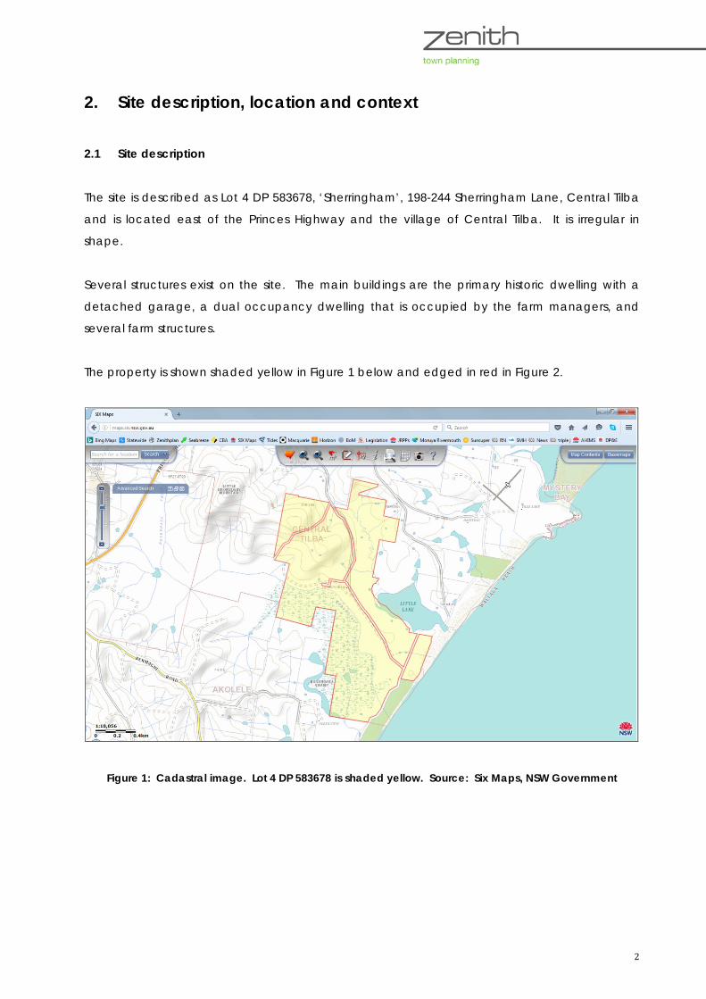
The site is described as Lot 4 DP 583678, ‘Sherringham’, 198-244 Sherringham Lane, Central Tilba
and is located east of the Princes Highway and the village of Central Tilba. It is irregular in
shape.
Several structures exist on the site. The main buildings are the primary historic dwelling with a
detached garage, a dual occupancy dwelling that is occupied by the farm managers, and
several farm structures.
The property is shown shaded yellow in Figure 1 below and edged in red in Figure 2.
Figure 1: Cadastral image. Lot 4 DP 583678 is shaded yellow. Source: Six Maps, NSW Government

3
Figure 2: Aerial image of Lot 4 DP 583678. Source: Six Maps, NSW Government
The property is accessed via Sherringham Lane which connects to the Princes Highway east of
Central Tilba opposite Corkhill Drive. Unformed Crown roads divide the property and separate
the north-western corner and an eastern section along the foreshore of the Tasman Sea.
Reticulated water and sewer services are not provided to the property.
Potable water is captured in rainwater tanks and effluent is disposed of on-site by way of a
septic system. The land is bushfire prone, is within the coastal zone and is mapped as a sensitive
coastal location.
Sherringham Farmhouse and Silos are listed as Item 76 of local heritage significance in
Eurobodalla Local Environmental Plan 2012. The item is of value for its association with early
agricultural endeavours in the Tilba district and is possibly the site of first European settlement in
the area. Peter Freeman & Partners noted in the Tilba Conservation Area Heritage Study 1992
that the farmhouse is historically significant as an early example of slab construction.
Sherringham is still used for agricultural purposes as are surrounding properties. A second
dwelling exists on the property to the north of Sherringham farmhouse and is occupied by the
managers of the farm. The original silo was fabricated of tin with timber frames. A second silo
was built in 1918 using tin. These two silos self-combusted in 2006 and no longer exist. They have
been replaced with modern silos that are still in use.

4
An early parish map shows an allotment of 16 acres (6.4 hectares) that was occupied by
Sherringham farmhouse. Most of these early portions have been consolidated into larger lots
over time.
Figure 3: Early parish map (unknown date) showing Lot 467 in the name of Hoyer that was occupied by
Sherringham farmhouse
2.2 Location and context
Sherringham and other farms situated east of the Princes Highway are of historic significance
and have contributed to the development of the villages of Central Tilba and Tilba Tilba as well
as the rural landscape character of the Tilba district. Other neighbouring farms and structures
listed as heritage items in Eurobodalla Local Environmental Plan 2012 include Haxstead, Henkley
and Lustleigh Park. Sherringham farm is located outside the boundaries of the Tilba
Conservation Area which covers land predominantly west of the Princes Highway.
The property extends onto Wallaga Beach to the east to the high water mark of the ocean and
is separated from the ocean by a thin strip of foreshore reserve that appears to be unzoned.
There are views over the foreshore, ocean and rural landscape from the farmhouse and other
buildings. The property also has a frontage to Little Lake and includes a portion of Bobundara
Creek and surrounding wetland at its southern extent.
Adjoining land is variously zoned for rural uses, environmental protection and partly deferred
from zoning under Eurobodalla LEP 2012. An Aboriginal heritage conservation area is partly
within Lot 4 at the north-western corner and extends beyond Lot 4 into adjoining land.
5
3. Details of the proposed development
3.1 Land use
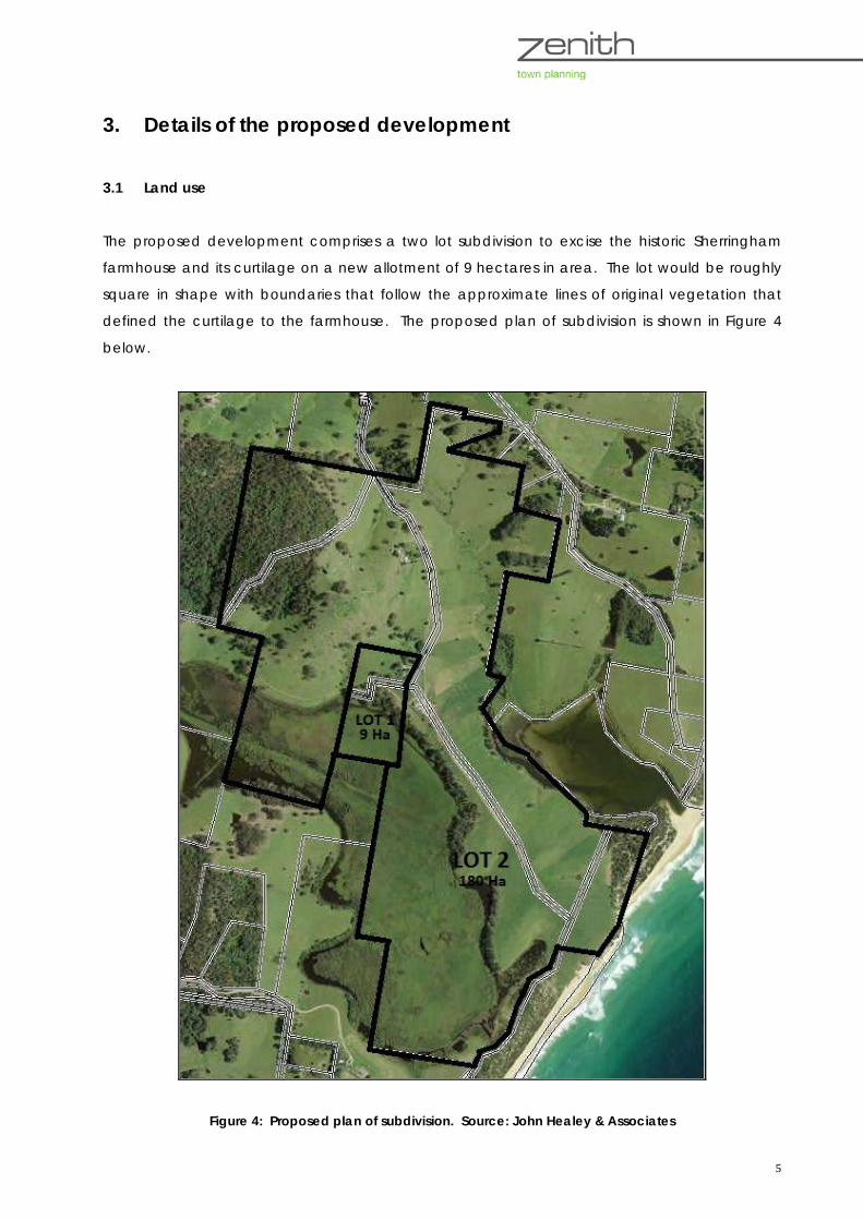
The proposed development comprises a two lot subdivision to excise the historic Sherringham
farmhouse and its curtilage on a new allotment of 9 hectares in area. The lot would be roughly
square in shape with boundaries that follow the approximate lines of original vegetation that
defined the curtilage to the farmhouse. The proposed plan of subdivision is shown in Figure 4
below.
Figure 4: Proposed plan of subdivision. Source: John Healey & Associates
6
It is proposed that Lot 2, the residue allotment, will have an area of 180 hectares. The farm
managers’ residence will be located within proposed Lot 2.
The proposal is integrated development as approval is required from the NSW Rural Fire Service
as well as Eurobodalla Shire Council. A bushfire safety authority is to be issued under section
100B of the Rural Fires Act 1997.
3.2 Access and parking arrangements
Sherringham Lane does not follow the Crown road reserve shown on cadastral maps. The
eastern boundary of the proposed Lot 1 adjoins an unformed road reserve. A right of
carriageway is required to be created over the existing accessway within proposed Lot 2 where
it is used to gain access to Lot 1 to provide legal and practical access extending from the
driveway to Sherringham farmhouse as far as nearest gate to the west. There will be no physical
change to existing access driveways or parking areas.
3.3 Services
Existing water, wastewater and sewer services will be maintained without change.
Telecommunications and electricity are available to the site and are provided by Telstra and
Essential Energy respectively. There will be no change to these arrangements for the provision of
these services other than the creation of an easement extending from the transformer located
in dairy buildings to the dwelling. The easement will encompass existing low voltage overhead
power lines. A separate meter would also be installed at Sherringham farmhouse.

7
4. Site assessment
4.1 Landform and vegetation
The site is gently undulating typical of the Tilba district rural landscapes. Category 2 and 3
watercourses cross lie within site and a wetland occupies a large portion of the southern part of
the site as shown in Figure 5 below. Category 2 watercourses are shown as green lines and
category 3 as blue lines.
Figure 5: Extract from the Wetlands Map, Riparian Lands and Watercourses Map CLI_014
The light blue patch shown in Figure 5 that lies across the southern half of the property is wetland.
This is protected under State Environmental Planning Policy No 14 – Coastal Wetlands.
4.2 Ecological assessment
The proposed development is located in the approximate centre of the property in the vicinity
of existing built structures associated with agricultural uses. The vegetation in this central area
comprises a mix of native and exotic plant species, with predominantly exotic species within
the garden inside the fenced yard of the farmhouse. There is no change proposed to this
garden.

8
The northern half of the property is mostly cleared and sown with pasture grasses. Some
patches of native vegetation remain scattered across this area. The southern half of the
property is mapped as containing an endangered ecological community. This has been
identified as being ‘sand-dune wetlands’ in EEC mapping carried out by NGH Environmental in
2006. Figure 6 below shows remnant native vegetation in light green and the endangered
ecological community corresponding with the wetland and the riparian corridor of Bobundra
Creek as dark green.
Figure 6: Extract from the Terrestrial Biodiversity Map Sheet BIO_014
It will not be necessary to remove any trees or shrubs to give effect to the subdivision. The
farmhouse is currently fenced and this fence is to remain in situ. The access driveway will
remain in the current location and an easement is to be created along the route of the
existing overhead electricity cabling which will not require any vegetation removal. The
proposed development will not affect the endangered ecological community, the habitat of
any threatened species or prevent threatened species from accessing, foraging and nesting
on the site. Approval to clear native vegetation under the Native Vegetation Act 2003 is not
required as it is not proposed to remove any vegetation.
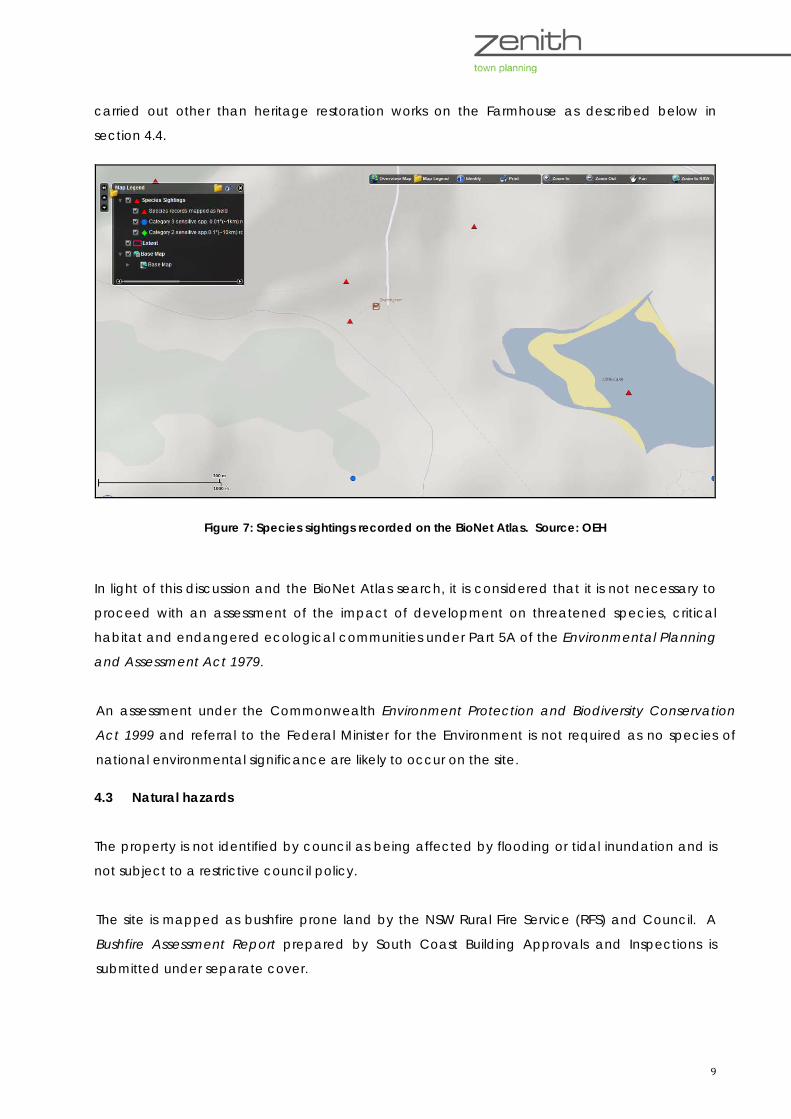
A search of the BioNet Atlas of NSW Wildlife was carried out on 19 April 2016 covering an area of
10 kilometres by 10 kilometres centred on the Sherringham property. The report lists valid records
of threatened entities that are listed in schedules to the Threatened Species Conservation Act
1995 that may occur on the site. Red triangles shown in Figure 7 below indicate sightings of
species. There would not be any impact on species as no physical works are proposed to be
9
carried out other than heritage restoration works on the Farmhouse as described below in
section 4.4.
Figure 7: Species sightings recorded on the BioNet Atlas. Source: OEH
In light of this discussion and the BioNet Atlas search, it is considered that it is not necessary to
proceed with an assessment of the impact of development on threatened species, critical
habitat and endangered ecological communities under Part 5A of the Environmental Planning
and Assessment Act 1979.
An assessment under the Commonwealth Environment Protection and Biodiversity Conservation
Act 1999 and referral to the Federal Minister for the Environment is not required as no species of
national environmental significance are likely to occur on the site.
4.3 Natural hazards
The property is not identified by council as being affected by flooding or tidal inundation and is
not subject to a restrictive council policy.
The site is mapped as bushfire prone land by the NSW Rural Fire Service (RFS) and Council. A
Bushfire Assessment Report prepared by South Coast Building Approvals and Inspections is
submitted under separate cover.
10
It is noted in the report that the vegetation on proposed Lot 1 is described as Southern Lowland
Shrubby Wet Schlerophyll Forest, equivalent to rainforest vegetation as defined in AS 3959-2009
Construction of buildings in bushfire prone areas. The vegetation has a fire run of less than 50m
and can be considered remnant vegetation. All land within 140 metres of the existing farm
managers residence (proposed Lot 2) is managed land and does not pose any bushfire risk to
the building.
It is noted in the report that the bushfire attack level for proposed Lot 1 is 19 in all directions
except the south-west which is BAL29. An asset protection zones is only recommended for the
south-west elevation which is 32 metres. Proposed Lot 2 is managed land and the existing 100m
cleared IPA is to be maintained.
Existing arrangements for access, and the supply of water, gas and electricity are adequate
and no further works are necessary to satisfy the acceptable solutions of Planning for Bushfire
Protection 2006.
It is concluded that the proposed subdivision will meet the requirements of Planning for Bushfire
Protection 2006 and standards required by the Environmental Planning and Assessment Act 1979
if the recommendations are implemented.
4.4 Heritage
Indigenous
The generic due diligence process outlined in the Due Diligence Code of Practice for the
Protection of Aboriginal Objects in NSW was implemented to ensure that an adequate due
diligence process that addresses Aboriginal cultural heritage issues has been carried out. This
process follows the following five steps:
1. Will the activity disturb the ground surface?
The proposed subdivision will not cause any ground disturbance. There are no proposed
changes to the existing structures or infrastructure on the land.
2a. Search the AHIMS database
In accordance with the code, an on-line search was carried out of the Aboriginal Heritage
Information Management Service (AHIMS) that is maintained by the Office of

11
Environment and Heritage on 7 April 2016. The search is part of the due diligence process and
remains valid for 12 months.
The search found that:
- There are 3 Aboriginal sites recorded in or near the selected locations, and
- There are no Aboriginal places that have been declared in or near the selected
locations.
It is noted that surveys for Aboriginal objects have not been carried out in all parts of NSW
and Aboriginal objects may exist on a parcel of land even though they have not been
recorded in AHIMS. Further, not all known Aboriginal sites are registered on the AHIMS database
and not all sites consist of physical evidence or remains, e.g. dreaming and ceremonial sites.
An extensive search was then carried out on 19 April 2016 to identify the location and type of
sites recorded on the property. The sites comprise two middens and an open camp site
evidenced by shells and artefacts. The locations of these sites are shown with purple crosses in
Figure 8 below.
Figure 8: Location of Aboriginal heritage sites
2b. Activities in areas where landscape features indicate the presence of Aboriginal objects
Given that no ground disturbing activities will be carried out in the vicinity of these sites, it is
considered that the development may proceed without risk to these indigenous heritage items.

12
3. Can you avoid harm to the object or disturbance of the landscape feature
Yes. There are no ground disturbing activities proposed to be carried out.
4. Desktop assessment and visual inspection
The sites are located at some distance from the proposed new allotment. As there are no
ground disturbing activities proposed to be carried out a visual inspection was not considered
warranted.
5. Further investigations and impact assessment
No further investigations are deemed necessary.
The Najanuka Place of Aboriginal Heritage Significance
The Najanuka Place of Aboriginal Heritage Significance is listed as a conservation area in
Schedule 5 of Eurobodalla LEP 2012. The conservation area, which surrounds Najanuka
mountain or Little Dromedary, encroaches into the property at the north-western corner. This is
shown edged with a yellow line in Figure 8 below.
Non-indigenous
Sherringham Farmhouse and Silos are listed as heritage items of local significance in Schedule 5
of Eurobodalla Local Environmental Plan 2012. The whole property is shown as item I76 in Figure
8 below.
These structures are of significance due to their contribution to early agricultural industry in the
Tilba district. Indeed, Sherringham was one of the first farms in the district and is integral to the
historic fabric of the local economy and community. A conservation management strategy has
been prepared by Philip Leeson Architects Pty Ltd and Zenith Town Planning and is submitted
under separate cover. Descriptions of the buildings, gardens, their original construction and
modifications are contained in the strategy.
The following works are recommended in the CMS to reverse unsympathetic external alterations:
1. Replace all aluminium doors and windows with new double hung timber framed units with
colonial glazing bars to match the surviving original window in Bedroom 1.

13
2. Replace the current front windows in the Front Living Room and Bedroom 1 with timber
French doors to match the surviving original set in the rear Living Room as closely as
possible. Make good the adjacent wall areas to match the original board and batten
cladding as closely as possible
3. Replace the front door with a traditional four panelled timber door – an external version of
the existing panelled interior doors
4. Replace the door from the Office to the front verandah with a timber framed door with
colonial glazing bars
5. Remove the unsympathetic iron lace brackets from the front verandah
6. Replace the southwest barge board to more closely match the original northeast board
7. Replace the Squareline gutters with traditional quad or ogee profiles (the round pvc
downpipes are acceptable)
8. Paint the entire house in a traditional late Victorian colour scheme for a timber cottage.
Work with the existing Woodland Gray Colorbond roof.
The CMS contains the following additional conservation policy recommendations:
9. The existing external house form should be conserved. Further additions are not
appropriate
10. The house and its garden setting should be retained. New detached structures are not
appropriate within the existing fenced garden area. Minor freestanding landscape
structures such as a trellis or pergola may be permissible
11. New structures outside the fenced garden area may be possible. They should not
dominate major views of the house and should be of a sympathetic form and materials
12. The garden should be conserved and managed in accordance with good horticultural
practice

14
5. Section 79C assessment
Below is an assessment of the proposed development under section 79C of the Environmental
Planning and Assessment Act 1979.
(a) the provisions of:
(i) any environmental planning instrument
State Environmental Planning Policy No 14 – Coastal Wetlands
The aim of SEPP 14 is to ensure that the coastal wetlands are preserved and protected in the
environmental and economic interests of the State.
The site encompasses part of a mapped wetland to the south which is connected to Bobundra
Creek. The consent of Council and the concurrence of the Secretary of the Department of
Planning & Environment is required to clear the wetland, construct a levee on the wetland or drain
or fill the wetland.
Comment: The policy does not contain any restrictions on development on land adjoining a coastal wetland.
No development is proposed on the protected wetland so the concurrence of the secretary of the
Department of Planning & Environment is not required to be obtained.
State Environmental Planning Policy No 55 – Remediation of Land
SEPP 55 requires Council to consider whether land is contaminated and to determine whether
the proposed use is suitable with or without contamination. Council can require an applicant for
development to conduct a preliminary investigation and a subsequent more detailed
investigation if warranted.
Where contamination exists and remediation is necessary, Council must be satisfied that the
remediation will take place before the land is used for the proposed purpose.
Comment: The property is not listed on a Council register of potentially contaminated land and there has
been no known historical usage that would cause the land to be contaminated. It is considered that a
preliminary investigation is not required for the proposed subdivision.

15
State Environmental Planning Policy (Rural Lands) 2008
SEPP (Rural Lands) 2008 was gazetted on 9 May 2008 and applies to all rural LGAs including
Eurobodalla Shire. Clause 8 of the policy specifies certain principles that apply to rural
subdivision. These are:
(a) the minimisation of rural land fragmentation,
(b) the minimisation of rural land use conflicts, particularly between residential land uses and
other rural land uses,
(c) the consideration of the nature of existing agricultural holdings and the existing and
planned future supply of rural residential land when considering lot sizes for rural lands,
(d) the consideration of the natural and physical constraints and opportunities of land,
(e) ensuring that planning for dwelling opportunities takes account of those constraints.
Clause 10 of the policy specifies matters to be considered in determining development
applications for rural subdivisions. Relevantly, Council must take into account the existing uses
and approved uses of land in the vicinity of the development, whether or not the development
is likely to have a significant impact on land uses that are likely to be preferred and the
predominant land uses in the vicinity of the development, compatibility with adjoining land uses
and measures to avoid or minimise land use conflict.
Comment: Existing and approved land uses in the vicinity of the proposed development are rural in
nature. Sherringham farm will continue to be used for agricultural purposes in keeping with the surrounding
rural landscape of the Tilba district. The proposed subdivision to excise the historical farmhouse would not
diminish the agricultural use of the property and would be compatible with existing uses. There are no
proposed changes to current land uses on either proposed Lot 1 or Lot 2.
SEPP No 71 – Coastal Protection
SEPP 71 applies to land situated within the coastal zone. This policy aims to protect and improve
existing public access to and along coastal foreshores, to protect and preserve native coastal
vegetation, and to ensure that the type, bulk, scale and size of development is appropriate for
the location and protects and improves the natural scenic quality of the surrounding area.
Clause 8 of the policy specifies matters that Council must consider when determining an
application for development within the coastal zone. These matters are:
(a) the aims of this Policy set out in clause 2,
16
(b) existing public access to and along the coastal foreshore for pedestrians or persons with a
disability should be retained and, where possible, public access to and along the coastal
foreshore for pedestrians or persons with a disability should be improved,
(c) opportunities to provide new public access to and along the coastal foreshore for
pedestrians or persons with a disability,
(d) the suitability of development given its type, location and design and its relationship with the
surrounding area,
(e) any detrimental impact that development may have on the amenity of the coastal
foreshore, including any significant overshadowing of the coastal foreshore and any
significant loss of views from a public place to the coastal foreshore,
(f) the scenic qualities of the New South Wales coast, and means to protect and improve these
qualities,
(g) measures to conserve animals (within the meaning of the Threatened Species Conservation
Act 1995) and plants (within the meaning of that Act), and their habitats,
(h) measures to conserve fish (within the meaning of Part 7A of the Fisheries Management Act
1994) and marine vegetation (within the meaning of that Part), and their habitats
(i) existing wildlife corridors and the impact of development on these corridors,
(j) the likely impact of coastal processes and coastal hazards on development and any likely
impacts of development on coastal processes and coastal hazards,
(k) measures to reduce the potential for conflict between land-based and water-based coastal
activities,
(l) measures to protect the cultural places, values, customs, beliefs and traditional knowledge of
Aboriginals,
(m) likely impacts of development on the water quality of coastal waterbodies,
(n) the conservation and preservation of items of heritage, archaeological or historic
significance,
(o) only in cases in which a council prepares a draft local environmental plan that applies to
land to which this Policy applies, the means to encourage compact towns and cities,
(p) only in cases in which a development application in relation to proposed development is
determined:
(i) the cumulative impacts of the proposed development on the environment, and
(ii) measures to ensure that water and energy usage by the proposed development is
efficient.
Comment: The proposed development is satisfactory to the aims and considerations of SEPP 71. The property
is located in the coastal zone and is a sensitive coastal location as shown in Figure 8 below. The subdivision to
excise the historic farmhouse from the remainder of the property will have no impact on access to the
foreshore of Wallaga Beach, scenic qualities or amenity, coastal process or hazards, or environmental or
cultural heritage values. Current uses of Sherringham farm will continue unchanged.

17
Figure 8: Sensitive coastal location map. Source: ESC
Eurobodalla Local Environmental Plan (LEP) 2012
The property is zoned part RU1 Primary Production under Eurobodalla LEP 2012, part E2
Environmental Conservation and part Deferred Matter (1(a) Rural (Environmental Constraints
and Agricultural) Zone under the Rural LEP 1987 (see Figure 10 below). Clause 4.1 of Eurobodalla
LEP 2012 applies a minimum lot size of 1,000 hectares to those parts of the property that are
zoned RU1 and E2.
The proposed subdivision applies only to land zoned RU1. The objectives of this zone are:
• To encourage sustainable primary industry production by maintaining and enhancing the
natural resource base.
• To encourage diversity in primary industry enterprises and systems appropriate for the area.
• To minimise the fragmentation and alienation of resource lands.
• To minimise conflict between land uses within this zone and land uses within adjoining
zones.
• To minimise the visual impact of development on the rural landscape.
18
• To provide for recreational and tourist activities that support the agricultural,
environmental and conservation value of the land.
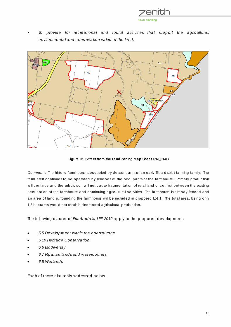
Figure 9: Extract from the Land Zoning Map Sheet LZN_014B
Comment: The historic farmhouse is occupied by descendants of an early Tilba district farming family. The
farm itself continues to be operated by relatives of the occupants of the farmhouse. Primary production
will continue and the subdivision will not cause fragmentation of rural land or conflict between the existing
occupation of the farmhouse and continuing agricultural activities. The farmhouse is already fenced and
an area of land surrounding the farmhouse will be included in proposed Lot 1. The total area, being only
1.5 hectares, would not result in decreased agricultural production.
The following clauses of Eurobodalla LEP 2012 apply to the proposed development:
• 5.5 Development within the coastal zone
• 5.10 Heritage Conservation
• 6.6 Biodiversity
• 6.7 Riparian lands and watercourses
• 6.8 Wetlands
Each of these clauses is addressed below.

19
5.5 Development within the coastal zone
This clause contains considerations for council to consider when assessing a development
application, such as the extent to which the proposal affects access to foreshore land, the
suitability of the development and relationship with surrounding land, and any impacts on
amenity, coastal processes and biodiversity. The site is located within the coastal zone and is
visible from Wallaga Beach and the South Pacific Ocean. It is separated from the ocean by a
thin strip of public foreshore land that is unzoned.
Comment: The proposed development will not involve any physical works and will not alter any public
pedestrian or vehicular access to or along the coastal foreshore. The proposed development will not be
affected by or exacerbate any coastal hazards as the subdivision will create new boundaries around
existing structures.
5.10 Heritage Conservation
Clause 5.10 establishes where development consent is required and circumstances where the
provision of heritage management documents may be required.
Sherringham farmhouse and silos are listed as heritage item 76 in Schedule 5 of Eurobodalla LEP
2012. The consent of council is required to subdivide the land under this clause and council
may require that a heritage management document be submitted if the development is likely
to affect heritage significance. The site is outside the boundaries of the Tilba Conservation Area,
however, the Najanuka Place of Aboriginal Heritage Significance encroaches into the property
at the north-western corner.
Sub-clause 5.10(10) enables Council to grant consent for any purpose on land on which a
heritage building is erected even though development for that purpose would not otherwise be
allowed so long as Council is satisfied that:
(a) the conservation of the heritage item or Aboriginal place of heritage significance is
facilitated by the granting of consent, and
(b) the proposed development is in accordance with a heritage management document that
has been approved by the consent authority, and
(c) the consent to the proposed development would require that all necessary conservation
work identified in the heritage management document is carried out, and
(d) the proposed development would not adversely affect the heritage significance of the
heritage item, including its setting, or the heritage significance of the Aboriginal place of
heritage significance, and
20
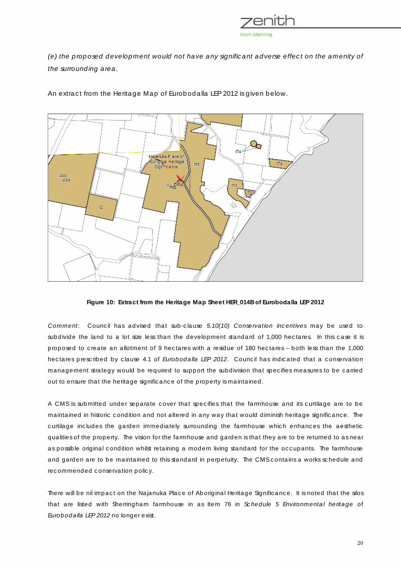
(e) the proposed development would not have any significant adverse effect on the amenity of
the surrounding area.
An extract from the Heritage Map of Eurobodalla LEP 2012 is given below.
Figure 10: Extract from the Heritage Map Sheet HER_014B of Eurobodalla LEP 2012
Comment: Council has advised that sub-clause 5.10(10) Conservation incentives may be used to
subdivide the land to a lot size less than the development standard of 1,000 hectares. In this case it is
proposed to create an allotment of 9 hectares with a residue of 180 hectares – both less than the 1,000
hectares prescribed by clause 4.1 of Eurobodalla LEP 2012. Council has indicated that a conservation
management strategy would be required to support the subdivision that specifies measures to be carried
out to ensure that the heritage significance of the property is maintained.
A CMS is submitted under separate cover that specifies that the farmhouse and its curtilage are to be
maintained in historic condition and not altered in any way that would diminish heritage significance. The
curtilage includes the garden immediately surrounding the farmhouse which enhances the aesthetic
qualities of the property. The vision for the farmhouse and garden is that they are to be returned to as near
as possible original condition whilst retaining a modern living standard for the occupants. The farmhouse
and garden are to be maintained to this standard in perpetuity. The CMS contains a works schedule and
recommended conservation policy.
There will be nil impact on the Najanuka Place of Aboriginal Heritage Significance. It is noted that the silos
that are listed with Sherringham farmhouse in as Item 76 in Schedule 5 Environmental heritage of
Eurobodalla LEP 2012 no longer exist.

21
6.6 Biodiversity
This clause aims to maintain terrestrial and aquatic biodiversity through design, siting and
managing to avoid, minimise and mitigate adverse environmental impacts on native flora and
fauna, ecological processes, recovery processes and habitat linkages.
The Terrestrial Biodiversity Map accompanying the LEP indicates that the land is affected by
significant (extant) vegetation in the north-western corner and an endangered ecological
community across the southern half of the property. The map indicates that the EEC exists over
the location of the farmhouse (see Figure 6 above).
Comment: The proposed development is subdivision to excise an allotment that encompasses an
historic farmhouse located in the approximate centre of the property with a curtilage containing a
garden and adjoining land. It will not be necessary to remove any trees or shrubs to give effect to the
subdivision. The farmhouse garden is currently fenced and this fence is to remain in situ. The access
driveway will remain in the current location and an easement is to be created along the route of the
existing overhead electricity cabling which will not require any vegetation removal. The proposed
development will not affect the biodiversity on the site.
6.7 Riparian lands and watercourses
This clause aims to protect and maintain water quality, ecological processes, habitats and
watercourse stability through design, siting and managing to avoid, minimise and mitigate
adverse environmental impacts on riparian lands and watercourses.
The Wetlands Map, Riparian Lands and Watercourses Map (Figure 5 above) indicates that the
land is affected by several riparian category 2 and 3 watercourses and a wetland.
Clause 6.7 applies to land within 20 metres of a category 2 watercourse and 10 metres of a
category 3 watercourse.
Comment: The existing dwelling and its curtilage are located more than 20 metres from any watercourse
and the wetland. The proposed development will not involve any physical works and will not impact on
watercourses or the wetland.
6.8 Wetlands
This clause aims to protect wetlands from the impacts of development through design, siting
and managing to avoid, minimise and mitigate adverse effects. Council must consider

22
potential impacts on flora and fauna, habitat for indigenous and migratory species, and surface
and groundwaters.
The Wetlands Map, Riparian Lands and Watercourses Map (Figure 5) indicates that the land is
affected by a wetland at the southern boundary.
Comment: The existing dwelling and its curtilage are located north of the wetland. The proposed
development will not involve any physical works within the wetland and will not impact on the wetland.
(ii) any draft environmental planning instrument that is or has been placed on public exhibition
and details of which have been notified to the consent authority (unless the Director-General has
notified the consent authority that the making of the draft instrument has been deferred
indefinitely or has not been approved)
There are no draft environmental planning instruments that have been placed on public
exhibition that apply to the land.
(iii) any development control plan
Development Control Plan (DCP) No 156 Rural Subdivision
DCP No 156 came into effect in December 1987. This DCP applies only to rural land that is subject
to Eurobodalla Rural LEP 1987 and cannot legally apply to land zoned under Eurobodalla LEP 2012.
Part of the property is ‘deferred matter’ and remains zoned under Eurobodalla Rural LEP 1987 and
therefore subject to DCP 156.
DCP No 156 aims generally to ensure that rural subdivision takes into account environmental
attributes and that the subdivision can be adequately serviced. The plan requires the nomination
of building envelopes on subdivision plans and establishes development parameters such as
setbacks, building appearance and the like for dwellings, dual occupancies and other buildings. It
advises of the information to be submitted with an application to subdivide rural land and
consultation procedures. It is noted in the plan that subdivision of rural land is to be in accordance
with Eurobodalla LEP 1987, i.e. for the purposes of agricultural operations or another permitted use.
Comment: The proposed subdivision will not affect that part of the property that is a ‘deferred matter’. The
boundaries of proposed Lot 1 include land that is zoned RU1 Primary Production under Eurobodalla LEP 2012.
The residue (proposed Lot 2) includes all remaining land including the land that a ‘deferred matter’. The
provisions of DCP 156 do not apply.
23
(iiia) any planning agreement that has been entered into under section 93F, or any draft
planning agreement that a developer has offered to enter into under section 93F
No planning agreement or draft planning agreement has been entered into relating to the
proposed development or the land.
(iv) the regulations (to the extent that they prescribe matters for the purposes of this paragraph),
that apply to the land to which the development application relates
There are no specific regulations that apply to the subject land.
(v) any coastal zone management plan (within the meaning of the Coastal Protection Act 1979),
that apply to the land to which the development application relates
There is no coastal zone management plan that applies to the subject land.
(b) the likely impacts of that development, including environmental impacts on both the natural
and built environments, and social and economic impacts in the locality
There are not expected to be any adverse impacts on the natural or built environments as
demonstrated by the response to relevant provisions of environmental planning instruments.
There are no changes proposed to land uses, the provision of services or existing structures.
The excised allotment to contain the historic farmhouse (proposed Lot 1) is mapped as being
affected by terrestrial biodiversity (an EEC) however, there are no physical changes proposed to
land uses or structures that would impact adversely on the EEC.
Similarly, there are not expected to be any social or economic impacts other than the
continued preservation of a listed heritage item through the implementation of management
measures identified in the conservation management plan.
(c) the suitability of the site for the development
The site is considered suitable for subdivision given that measures will be implemented to retain
and conserve the fabric of the historic farmhouse and surrounding garden.
The site is mapped as bushfire prone land. A bushfire assessment has made recommendations
to ensure that the development meets the requirements of Planning for Bushfire Protection 2006.
24
Bushfire protection measures, including minimum asset protection zones, water supply and
access arrangements, are adequate for the proposed development.
(d) any submissions made in accordance with this Act or the regulations,
The development application may be exhibited in accordance with council’s Advertising and
Notification Code for public comment. Council will consider any submissions received during
assessment of the application.
(e) the public interest.
There are no matters of public interest that arise as a result of the proposed subdivision. The
subdivision to a lot of lesser size than the minimum lot size applying to the land is permissible by
way of the heritage conservation incentives of Eurobodalla LEP 2012. Conservation measures to
be applied in accordance with the Conservation Management Plan will serve to protect the
heritage values of Sherringham for the benefit of the wider community.
It is recommended that the development application for a two lot subdivision at Lot 4 DP
583678, Central Tilba be approved.
___________________________________________
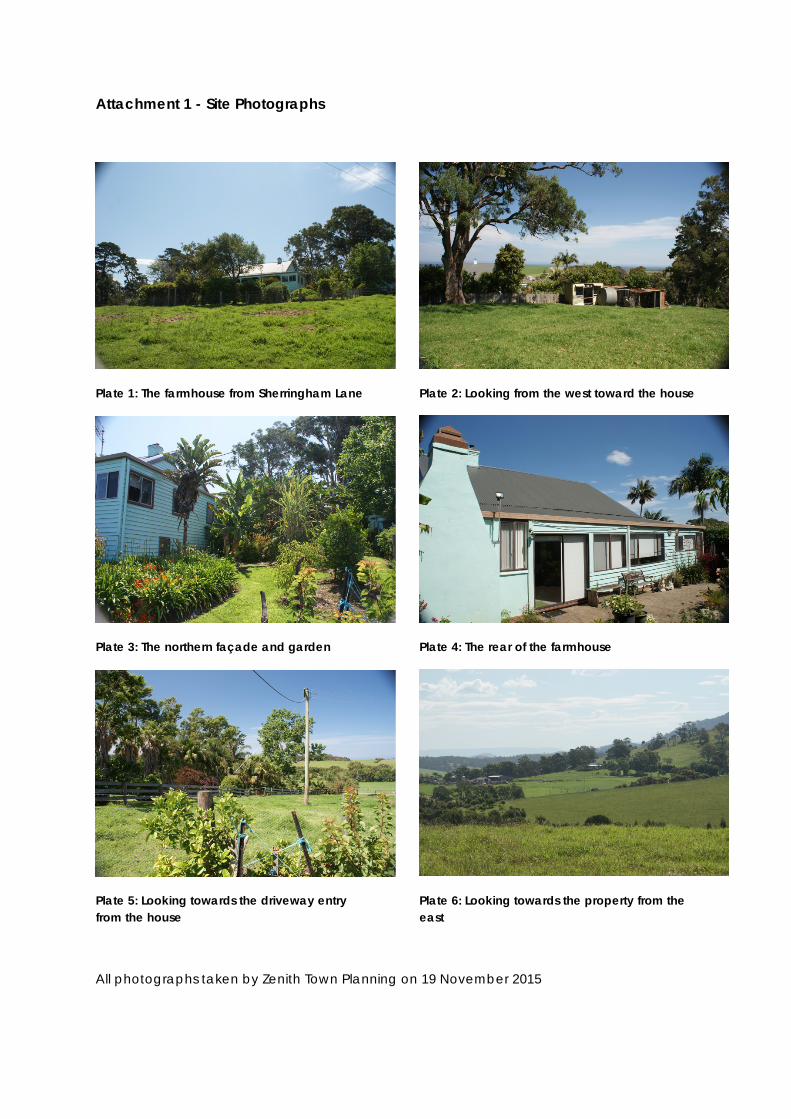
Attachment 1 - Site Photographs
Plate 1: The farmhouse from Sherringham Lane
Plate 3: The northern façade and garden
Plate 5: Looking towards the driveway entry from the house
Plate 2: Looking from the west toward the house
Plate 4: The rear of the farmhouse
Plate 6: Looking towards the property from the east
All photographs taken by Zenith Town Planning on 19 November 2015


