State Water Survey Division Water Survey Division SURFACE WATER SECTION AT THE UNIVERSITY OF...
22
State Water Survey Division SURFACE WATER SECTION AT THE UNIVERSITY OF ILLINOIS Illinois Department of Energy and Natural Resources SWS Contract Report 366 CACHE RIVER BASIN STUDY: PROGRESS REPORT AND PROJECT DESIGN by Misganaw Demissie and Nanl G. Bhowmik Prepared for the Illinois Department of Conservation Champaign, Illinois July 1985
Transcript of State Water Survey Division Water Survey Division SURFACE WATER SECTION AT THE UNIVERSITY OF...

State Water Survey Division SURFACE WATER SECTION
AT THE UNIVERSITY OF ILLINOIS
Illinois Department of Energy and Natural Resources
SWS Contract Report 366
CACHE RIVER BASIN STUDY:
PROGRESS REPORT AND PROJECT DESIGN
by
Misganaw Demissie and Nanl G. Bhowmik
Prepared for the
Illinois Department of Conservation
Champaign, Illinois
July 1985

CONTENTS
Page
Introduction 1 Major issues identified for the Cache River Basin 1
Agricultural drainage 1 Erosion and sedimentation 2 Natural wetlands 2 Aquatic and riparian habitat ............................ 4
Task Force recommendations 4 Initial agency response 4 Potential future response 7 Study costs 7
Project description 8 Hydrologic and sediment data collection 9 Hydrologic and hydraulic analyses 15
Future plans for the Cache River project 16
Summary 20 Acknowledgments 20

CACHE RIVER BASIN STUDY: PROGRESS REPORT AND PROJECT DESIGN
by Misganaw Demissie and Nani G. Bhowmik
INTRODUCTION
In June 1982 the Governor's Natural Resources Subcabinet formed an interagency task force to coordinate agency efforts in finding solutions to the complex problems of the Cache River Basin. State agencies represented on this task force are the Environmental Protection Agency and the Departments of Conservation (lead agency), Agriculture, Energy and Natural Resources -Water Survey, and Transportation - Division of Water Resources. After reviewing the Cache River Basin problems and identifying the issues, agency mandates, and concerns, the Task Force prepared an interagency statement to the Governor's subcabinet that expressed state interests in the Cache River Basin and recommended a plan of action to resolve the problems. The four major issues identified by the task force relate to:
1) Agricultural Drainage 2) Erosion and Sedimentation 3) Natural Wetlands 4) Aquatic and Riparian Habitat
Major Issues Identified for the Cache River Basin
Agricultural Drainage Agricultural drainage in the Cache River Basin has been a major problem
since the 1800's. Many attempts have been made to improve drainage in the lower Cache for agriculture. Drainage ditches built to improve the flow of water have been inadequate and are frequently choked with sediment. Furthermore, because of the flat slope of the lower Cache River and the backwater effects of the Mississippi River, flood waters from the watershed drain from the lower Cache River channel and floodplain very slowly.
The most significant attempt to improve drainage in the Cache River Basin was the construction of the Post Creek Cutoff by the Cache River Drainage District in 1915. Post Creek, which originally flowed north into
1

the Cache, was reversed and extended to flow south into the Ohio River. All of the normal drainage originating in the upper Cache River was diverted through the Post Creek Cutoff by the construction of a continuous spoil bank along the downstream side of the Forman Floodway channel and the upstream portion of the Post Creek Cutoff. This divided the old Cache River Basin nearly in half with 373 square miles of watershed draining into the Post Creek Cutoff and 365 square miles draining into the lower Cache River watershed. Although the construction of the Post Creek Cutoff may have improved drainage in the upper Cache River Basin, most of the present problems in the upper Cache River Basin and the Buttonland Swamp area can be attributed largely to the construction of this cutoff.
Erosion and Sedimentation Erosion and sedimentation can be identified as the main problems in the
Cache River Basin because of their negative impacts on agricultural drainage and on the preservation of natural areas. Erosion and sedimentation are natural processes that continually occur and gradually reshape the surface of the earth. However, human activities such as agricultural practices, construction of roads, highways, houses, reservoirs, etc., and modification of stream channels drastically increase the rates of erosion and sedimentation to dangerous proportions. The construction of the Post Creek Cutoff is a classic example of how man can drastically change the erosion and sedimentation pattern in a river basin. Because of this project, extensive bank erosion, channel bed entrenchment, and gully formation have taken place in the upper Cache River and in the Post Creek Cutoff area. Excessive sedimentation in Buttonland Swamp and in drainage ditches in the same general area are attributed to the change of flow pattern induced by the cutoff.
Natural Wetlands The Cache River Basin is one of the most unique and important areas in
the nation. Remnants of the most important and valuable wetlands in the state and in the nation are found within this watershed. Four of the major physiographic provinces of the United States—the Coastal Plain, the Interior Low Plateaus, the Ozark Plateaus, and the Central Lowlands—all converge in and around the Cache River Basin, providing the Cache River with a unique mix
2

of habitats and plant communities. The Basin is one of only six areas in the entire United States where four or more physiographic provinces converge.
The lower Cache River floodplain is within the Coastal Plain Physiographic Province and thus was formerly a cypress-tupelo swamp like those in Arkansas and Mississippi. The original extent of cypress-tupelo forest in southern Illinois before drainage activities began was about 250,000 acres. As a result of logging and the subsequent drainage of these swamps for agriculture, only a very few, small, scattered remnants of this formation remain today. Two of these remnants in the Cache River Basin, totalling 4861 acres, are on the Illinois Natural Areas Inventory. They are Little Black Slough-Heron Pond Nature Preserve, owned by the Illinois Department of Conservation, and Buttonland Swamp, a National Natural Landmark, currently owned in part by private individuals, a pulp and paper corporation, the Nature Conservancy, and the Department of Conservation. Two of the largest swamp trees in the United States, twelve state champion trees, and the reported oldest living stand of swamp trees east of the Mississippi River occur in and along the shallow floodplains of this basin and the lower Cache River.
Wetlands are important not only for the diverse biological communities they harbor, but also because they serve valuable hydrologic functions such as flood peak reductions, increased low flows, entrapment of sediment and nutrients, water quality improvements, ground-water recharge, and stabilization of stream banks and erosion control. At present, the existence and functions of wetlands in the Cache River Basin are threatened by erosion and sedimentation induced by the human activities in the watershed.
The Little Black Slough-Heron Pond wetland area is threatened by the entrenchment of the upper Cache River channel and the gully formation that accompanies channel entrenchment. The entrenchment of the upper Cache River channel is a direct result of the construction of the Post Creek Cutoff. The Cache River is the only outlet for water from these wetlands. As the Cache River stream channel is lowered to establish a new hydraulic equilibrium condition compatible with the Post Creek Cutoff, deeper and wider lateral gullies are formed by the erosive forces of runoff and seepage on the stream bank. The continual gully formation and deepening of stream channels may drain wetlands, whose elevation becomes significantly higher than the stream channel because of channel bed scour. There is ample example of the above process in the Cache River Basin. Bird Spring Pond has already been drained, and
3

extensive gully formation and bank erosion are taking place in the Heron Pond area.
The problem in the Buttonland Swamp is quite the opposite. Instead of the excessive erosion and channel entrenchment in the upper Cache River, there is excessive sedimentation and channel aggradation. Because of the reduced flow through Buttonland Swamp, most of the sediment from tributary streams draining into Buttonland Swamp is deposited near the mouth of the tributary streams and within Buttonland Swamp. This has reduced the depth of water within Buttonland Swamp and has degraded the aquatic and plant habitat within the area.
Aquatic and Riparian Habitat The unique natural vegetation and hydrology of the Basin support diverse
flora and fauna that are becoming rare in Illinois. The cypress-tupelo forest and the associated species of the swamps and sloughs are found only in the Cache River Basin and are totally dependent upon the natural hydrologic cycle of the Cache River. This unique vegetation will continue to be threatened until some favorable hydrologic conditions are recreated in the basin. This vegetation supports one of the most diverse assemblages of fauna found in any area of the state, and many of these species are becoming quite rare in Illinois. The river and its adjoining lakes and ponds were once well known for their quantity and quality of fish and also recognized among duck hunters as among the prime waterfowl areas in the state. The alterations in the natural habitat and hydrology of this basin have adversely impacted its flora and fauna.
TASK FORCE RECOMMENDATIONS After identifying and reviewing the four major issues discussed above,
the Cache River Task Force prepared the following recommendations.
Initial Agency Response Given the issues identified by the Task Force, the following member
agency responses identify mandates, regulatory functions, and ongoing operational reactions relating to these Cache River Basin issues. These responses
4

reflect current agency staffing and funding and may be considered a resource for the Task Force to use in its efforts to resolve the issues.
The Department of Agriculture (IDOA) is responsible for administering the State's soil and water conservation programs through coordination with local soil and water conservation districts. IDOA, since the "1975 Governor's Task Force Report for Flood Control in Illinois," is also responsible for flood control in rural areas, originally a mandate of the Department of Transportation, Division of Water Resources. Both IDOA and the local districts have technical staff which can provide efforts towards reducing the soil erosion from the watershed. Supportive of this planning process, they could:
• communicate with basin soil and water conservation districts on all agricultural drainage related problems as they relate to natural resources in the districts and advise the districts when their activities are not consistent with the objectives of this basin project,
• consider these problems at the local and district wide scale, and encourage solutions that ultimately would have a substantial cumulative effect on the basin, and
• initiate and coordinate educational and technical assistance programs for the agricultural community to encourage soil conservation practices through the proposed state-initiated soil conservation program.
The Department of Energy and Natural Resources - State Water Survey is primarily a research agency with technical staff and access to much basin data. Their professional staff could provide both data and expertise in interpreting this information. Specifically, the Survey can:
• collect and analyze existing data to develop analytical hydraulic relationships,
• coordinate and/or exchange data with the Corps of Engineers, and • develop a computer model to analyze all the historical and any collected data and determine what hydraulic and hydrologic data would be needed in order to identify solutions and help develop a plan of action.
5

The Department of Transportation - Division of Water Resources, a regulatory agency that in the past has done much data collection in the basin, could provide:
• historical hydraulic, hydrologic, and survey data, and • expertise in obtaining new hydraulic and stream cross section and profile survey data.
The Environmental Protection Agency, a regulatory agency, would be able to provide expertise on water quality issues. They also completed a water quality study of the Cache River in 1978 that could provide:
• base information for any future studies or water quality sampling for data collection, and
• comparative analyses of the water quality information with that gathered from the Blue Creek Watershed and Highland Silver Creek Watershed projects. IEPA and DENR (ISWS) professionals were involved in both of these projects.
Through the Department of Conservation's programs to conserve the state's natural resources, technical staff would be available to address the wetland and habitat issues of the basin and:
• provide monitoring of the status of the wetlands and habitats, • maintain communication and coordination with the Corps of Engineers on their current study of water-related problems in Alexander-Pulaski Counties,
• as originator and lead agency in this Task Force effort, continue all pursuits and coordination until issues are resolved, and
• complete a comprehensive inventory of all wetlands within the basin.
The issues identified by the Task Force are very closely interrelated. Before any effort takes place to solve one issue, it will have to be closely scrutinized in terms of how it would affect other issues or concerns. The greatest potential of this planning effort will be realized by pursuing solutions that will benefit two or more issues simultaneously. The Task Force is, therefore, committed to coordinated objectives and to finding a
6

combination of solutions that would benefit all issues. At the same time, it is committed to increasing general agency awareness of the basin issues so that ongoing activities may be directed and redirected where necessary to be consistent with this effort.
Potential Future Response The Task Force recognizes that agency responses within existing means
are not adequate to complete all aspects of a comprehensive plan for the Cache River Basin. A full investigation and analysis of all aspects of hydraulic, hydrologic, and environmental characteristics of the river basin is beyond the normal staff and funding capabilities of the agencies. However, the activities listed below, combined with the responses discussed earlier, would result in courses of action that might successfully resolve the issues within the Cache Basin.
1. Develop a systematic data collection and research plan to complete basin modeling based on all existing data, maps, reports, and historical information.
2. Collect data such as on water discharge, sediment load, ground water gradient, bed and bank material samples, stream cross sections and profiles, and present watershed characteristics for a three-year period. Continue to update modeling, to coordinate with the Corps of Engineers on their study, and to provide annual progress reports and summaries of data collection.
3. Complete modeling of basin data and information and develop a final recommended plan of action.
4. Develop a general plan for addressing soil erosion and sedimentation problems within the basin.
Study Costs The results of past practices, recent scientific findings, and our
changing priorities must all be weighed in the decisions on how much to conserve of the remainder of our natural resource heritage for the benefit of society as a whole. The following proposed budget is needed to supply necessary data and complement the ongoing efforts and responses from agencies involved in this planning effort. The majority of this work would be carried
7

out by the State Water and Geological Surveys with some involvement by the Division of Water Resources.
PLAN DEVELOPMENT Hydrographic mapping, collection and analysis of bed and bank materials, and installation of three sediment and streamgaging stations $14,600
YEAR 1 Hydraulic and hydrology data collection
and analyses $68,900 Geological investigation 25,900 Ground water study 12,000 Water quality sampling 7,500
$158,900 YEAR 2
Hydraulic and hydrology data collection, analyses, and modeling $73,700
Geological investigation 6,000 Ground water study 10,700 Water quality sampling 7,500
$ 97,900 YEAR 3
Hydraulic and hydrology data collection, analyses, and modeling $71,300
Geological investigation 6,000 Ground water study 11,500
$ 88,800 PROJECT TOTAL $345,600
Note: Costs for item 4 above have not been incorporated within the study costs. It is anticipated that this objective will be accomplished by the Department of Agriculture with active participation by IEPA and DENR (ISWS).
PROJECT DESCRIPTION Following the recommendations of the Task Force, the Illinois State
Water and Geological Surveys prepared a proposal in FY84 to perform the necessary investigations in the Cache River Basin as outlined by the Task Force. In FY85, $20,000 was made available for the project from the internal funds of the Department of Conservation, and the Illinois State Water and Geological Surveys initiated the Cache River project with the funds from IDOC and their own staff time and equipment. The immediate initiation of the
8

project was intended to get the data collection under way as soon as possible and to begin action on the Task Force's recommendations without delay.
The initial phase of the project concentrated on establishment of monitoring stations and collection of some hydrologic and geologic data. The following sections discuss the project plan, the monitoring stations, the types of data being collected, the method of data collection, and the future plans of the project.
Hydrologic and Sediment Data Collection In 1984, only one stream gaging and sediment station (Cache River at
Forman) in the Cache River Watershed was being monitored. The gaging station was operated by the U.S. Geological Survey, and sediment data were collected by the Illinois State Water Survey as part of the Instream Sediment Benchmark Network System. The complex nature of the Cache River hydrology requires data from more than one station to define the dynamics of the river. Furthermore, the construction of the Post Creek Cutoff has drastically altered the flow pattern in the lower Cache River. For instance, the Cache River in the Buttonland Swamp area has been observed to flow either east towards the Post Creek Cutoff or west towards the lower Cache River and finally to the Mississippi River depending on the water surface elevation in the lower Cache. There are no documented data about water discharge in the lower Cache River which show the changes in the flow regimes of the lower Cache River. The gaging station at Forman measures the water discharge from the upper Cache River, whose discharge has not been impacted significantly by the Post Creek Cutoff. Thus, the flow record at Cache River near Forman will not show the impact of the cutoff.
The construction of the Post Creek Cutoff not only altered the flow conditions in the lower Cache River but also changed the sediment transport dynamics in the lower Cache and in the Buttonland area. Sediment transported by tributary streams that used to be flushed by the annual flood in the Cache River is now deposited at a higher rate in the Buttonland Swamp area and around the mouth of the tributary streams. Also, tributary streams such as Cypress Creek and Big Creek have been channelized and re-routed several times in the past. Thus the present flow conditions and sediment transport characteristics of the Cache River Basin are drastically different from the natural
9

conditions which existed before the manipulation of the stream channels by man.
To understand and document these complex hydraulic behaviors, stream gaging and sediment monitoring stations in the Cache River and at tributary streams have been established by the Illinois State Water Survey. The locations of the gaging and sediment sampling stations are shown in Figure 1. The names of the stations and the type of data being collected from each station are indicated in Table 1.
The monitoring stations for Cache River at Routes 146 and 37 are shown in Figures 2 and 3 respectively. Stream gaging instruments to measure water surface elevations and a sediment sampling box with a DH-59 are installed at both stations. A similar installation for Main Ditch at Route 45 is shown in Figure 4, and the stream gaging installation for Big Creek is shown in Figure 5. It is installed at an old control structure just upstream of Perks Road, with the sediment sampling box installed at the Perks Road bridge. The installation for the Cache River at Forman site is similar to those shown in Figures 2 and 3; however, the stream gaging station is operated by USGS. The rest of the stations are used to monitor peak flow and sediment loads.
The monitoring stations are placed at strategic locations to provide the needed information on channel entrenchment in the upper Cache River and the Post Creek Cutoff and the sedimentation problem in the Buttonland Swamp area. The monitoring stations on Big Creek, Cypress Creek, Little Creek, and Cache River at Route 37 will provide the necessary data to calculate the sedimentation rate in Buttonland Swamp and will further assist in the development of alternative solutions for the area. The monitoring stations on the upper Cache River (Cache River at Route 146 and near Forman), Main Ditch, and Post Creek Cutoff will provide the necessary information to investigate channel entrenchment on the upper Cache River and Post Creek Cutoff. The stage recorder in Heron Pond will monitor the water level in Heron Pond continuously and, along with the ground water monitoring wells around the pond, will provide information needed to develop the water budget for Heron Pond. A summary of the data being collected will be presented in the near future, once the laboratory analyses are completed.
10

Figure 1. Illinois State Water Survey monitoring stations in the Cache River Basin
11

Table 1 . Illinois State Water Survey Monitoring Stations in the Cache River Basin
Station number
378 501 502
503 503a
504
505 506 507 508 509
Location Continuous discharge
Cache River @ Forraan, Illinois X*
Little Creek § Perks Road
Big Creek @ Perks Road
Cypress Creek @ Dongola Road
Cypress Creek § Perks Road
Post Creek @ Highway 169
Main Ditch § Route 45
Dutchman Creek § Route 45
Cache River @ Route 146
Cache River § Route 37
Heron Pond
X
X
X X
Peak discharge
X* X X X
X X X X
Sediment
X X X X X X X X X X
Stage
X X X X X X X X X X X
* Monitored by USGS
12
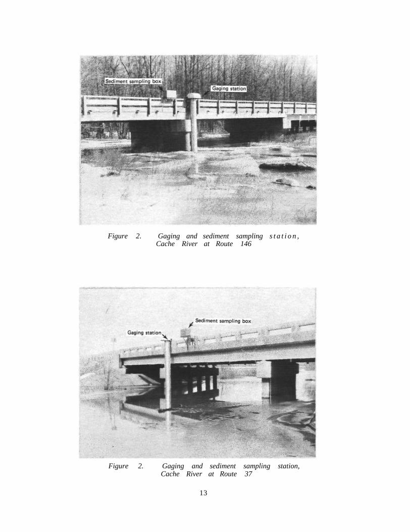
Figure 2. Gaging and sediment sampling s t a t i o n , Cache River at Route 146
Figure 2. Gaging and sediment sampling station, Cache River at Route 37
13

Figure 4. Gaging and sediment sampling station, Main Ditch at Route 45
Figure 5. Gaging station at Big Creek just upstream of Perks Road
14

Hydrologic and Hydraulic Analyses This component of the study consists of analysis of the Cache River
hydrology, as well as hydraulic analysis of stream flows, sediment transport, bank erosion, channel entrenchment, and sedimentation along the Cache River channel. The hydrologic study will include analysis of the precipitation pattern, surface runoff, and total water budget of the basin.
Because of the complexities of the watershed's hydrology and the many problems associated with stream hydraulics it is essential to develop computer models for the watershed, to properly investigate the problems and to outline alternative solutions. To accomplish these objectives, two models will be developed for the Cache River. The first model will be a watershed model for generating stream flows from precipitation for given watershed parameters such as drainage area, soil type, and vegetation cover and from antecedent soil moisture levels. The second model will be a flood routing and sediment transport model. This model will compute flood elevations, flow velocities, sedimentation rates, and channel entrenchment.
At this point of the project, the models that are being examined for the Cache River Basin include the HEC-1 and HEC-6 models of the Hydrologic Engineering Center, Corps of Engineers, and the Dynamic Flood Wave Routing Model (DOWPER) of the National Weather Service, National Oceanic and Atmospheric Administration. HEC-1 is a watershed model that generates flood hydrographs from precipitation based on the drainage area and antecedent watershed conditions. HEC-6 is a sediment transport model that calculates the sedimentation and scour rates for reservoirs and streams. DOWPER is a dynamic flood routing model that routes flood waves in streams and rivers and forecasts flood elevations and flow conditions.
All the above models have been successfully used by the Illinois State Water Survey on several projects in the state, and all are presently available at the Water Survey. The experience of Water Survey scientists and engineers in using and interpreting the results of various hydrologic and hydraulic models is a decisive advantage to the project. Most of the time in the development of the models will be spent in:
a) preparation of the input data required by each model. b) calibration and verification of the model(s) by testing the model
results against measured data in the field.
15

c) evaluation of a number of alternative solutions and of their effectiveness and hydraulic impacts.
All the above tasks are time consuming and need very careful evaluations at every stage of the modeling effort. Once the models are developed and calibrated with the data being collected, several alternative solutions will be evaluated by incorporating the alternative solutions in the models. The advantages and impacts of each alternative solution will be fully documented and discussed. Based on the results of the models, the best alternative solutions will be selected and recommended for implementation.
It should be emphasized, however, that the development of a watershed model is not very reliable without the necessary data for calibration and modifications. All modeling efforts need reliable data from the particular area to which they are applied. Therefore, the data collection program is not only essential in its own right, but also necessary in the development and calibration of models that produce the intended results.
FUTURE PLANS FOR THE CACHE RIVER PROJECT In FY85 the Cache River project was funded by IDOC for $20,000. This
funding and a significant contribution in time and effort by Water Survey and State Geological Survey scientists enabled the initiation of the project. The project as outlined by the Task Force cannot be pursued without adequate future funding. The Department of Conservation is presently appropriating $96,600 for FY86 for this project. Even though this is not full funding for Year 1, it will make a major contribution towards the progress of the project. However, there are several major problems which need to be addressed to assure the successful completion of the project: 1) based on past experience, future funding is uncertain; 2) the scope of work and project site need to be defined clearly to avoid false expectations, and 3) the planned mapping and surveying need to be done by the Division of Water Resources, Illinois Department of Transportation, as their contribution towards the project.
The following are three optional scopes of work for FY86 which can be performed by the Illinois State Water Survey. The choice as to which option to follow in FY86 or thereafter depends on the funding agency, the Department of Conservation.
16

Option 1: Project Area - Upper Cache River and Buttonland Swamp 1) Maintain all the existing gaging and sediment sampling stations. 2) Analyze all the flow data from each station. 3) Perform laboratory analysis of the sediment data. 4) Calculate the sediment load for each station. 5) Perform basic hydrologic and hydraulic analysis. 6) Initiate the development of the hydrologic and hydraulic models. 7) a. No ground water study
b. No geologic study c. No water quality data collection
Option 2: Project Area - Upper Cache River and Buttonland Swamp; also includes data collection on Mill Creek
1) Maintain all the existing gaging and sediment sampling stations. 2) Install a gaging and sediment station on Mill Creek in the lower
Cache. 3) Analyze all the flow data from each station. 4) Perform laboratory analysis of the sediment data. 5) Calculate the sediment load from each station. 6) Perform basic hydrologic and hydraulic analysis. 7) Initiate the development of the hydrologic and hydraulic models.* 8) a. No ground water study
b. No geologic study c. No water quality data collection
*Note: Under Option 2, the stage of model development will be at a lower level than in Option 1.
Option 3: Project Area - Upper and Lower Cache 1) Maintain all the existing gaging and sediment sampling stations. 2) Install gaging and sediment sampling stations on Mill Creek and
possibly on the lower Cache River downstream of the junction with Mill Creek.
3) Analyze all the flow data from each station. 4) Perform laboratory analysis of the sediment data. 5) Calculate the sediment load from each station.
17

6) Perform some basic hydrologic and hydraulic analysis for the whole Cache River Basin.
Option 1 corresponds to the first year of the original Cache River Task Force scope of work. Some of the work items omitted in Option 1 for FY86 will be initiated in FY87 and FY88 if adequate funding is available. Most of the study, data collection, and modeling effort was targeted for the upper Cache River Basin and the Buttonland Swamp area. Therefore no monitoring stations were established on the lower Cache River nor on the tributary streams that drain into the lower Cache River. The natural areas and wetlands that the Department of Conservation and the Task Force were interested in preserving are located in the upper Cache River Basin and in the Button-land Swamp. Although the study was designed to address those areas, the Task Force made sure that all interests, especially agriculture, would be considered in any study or plan that might be put forward and also stressed that "...ongoing activities may be directed or redirected where necessary to be consistent with this effort." This is important since agricultural interests have a major role in the future of the Cache River Basin.
Recently, agricultural interests have expressed dissatisfaction in the original Scope of Work recommended by the Task Force. They believe that the whole Cache River Basin should be treated as a unit and that the many agricultural problems in the lower Cache River should be included in the study. They are especially worried about the impacts of some of the remedial measures recommended by the Nature Preserve such as diverting Big Creek to flow to the lower Cache. Such a measure might possibly increase present flooding levels and sediment load in the lower Cache River, further aggravating the current flooding and sedimentation problems.
Agricultural interests, as represented by the Ilinois Farm Bureau, believe that the Cache River project should include studies of the following issues:
1) Rates of sedimentation in the lower Cache and impacts of sedimentation on flooding and drainage.
2) Impacts of dredging the mouth of the lower Cache on flooding and drainage.
3) Impacts of Mill Creek on flooding and sedimentation in the lower Cache.
18

4) Impacts of rerouting streams in the Cache River Basin. 5) Impacts of upland watershed detention basins. 6) Impacts of public ownership of additional wetlands and floodplain
areas. Options 2 and 3 were developed to address the questions raised by agri
cultural interests in the Cache River Basin. It is important to realize that the questions raised by agricultural interests concern real problems and deserve serious consideration. It is also important to realize that the cooperation of agricultural interests in the basin is crucial to the preservation of the natural areas in the Cache River Basin.
Under Option 2 the work outlined by the Task Force, including development of alternative solutions for the upper Cache River and Buttonland Swamp areas, will be completed. In addition three years of discharge and sediment data will be collected for Mill Creek. However, the Mill Creek watershed will not be included in the model, and the agricultural drainage problems in the area will not be analyzed.
Under Option 3 the problems in the whole Cache watershed (upper and lower) will be addressed. The model will include the upper and lower Cache. Alternative solutions will be developed for the upper Cache, Buttonland Swamp, and the lower Cache including the Mill Creek area.
The total project costs for the three options are as follows: Option 1 - $345,000 Option 2 - $369,000 Option 3 - $545,000
The $24,000 additional funding requested for Option 2 (above the $345,000 for Option 1) is needed to install and maintain the gaging and sediment station at Mill Creek and to analyze the station data.
The $200,000 additional funding request for Option 3 is to install and maintain two gaging and sediment stations (one at Mill Creek, one at the lower Cache River) and to incorporate the lower Cache River in the total project. About $100,000 will be spent in investigating alternative solutions to the drainage and flooding problems in the lower Cache River.
The duration of the project depends on the funding levels in FY87 and FY88. If full funding is not available, the project will need to be extended. The project duration also depends on when the Division of Water Resources, Illinois Department of Transportation, completes the required
19

surveying for the project. The budgets for the three options were prepared on the assumption that the project will be completed at the end of FY88.
SUMMARY This report summarizes the historical background of the Cache River
project, the plan of action recommended by the Cache River Task Force appointed by the Governor's Natural Resources Subcabinet, the data collection activities in FY85, the proposed funding levels for FY86, and the various data collection, analyses, and modeling efforts that could be pursued under different options. The report also shows how and why different options will enable the Illinois Department of Conservation to arrive at various end products.
Acknowledgments The authors would like to express their sincere thanks to the Cache
River Task Force for their initial effort in the formulation of the basic objectives of this project. Professionals from the Illinois Department of Conservation such as Bill Donels and Marv Hubbell have been extremely cooperative and helpful for the last few years as the basic format of this study was developed and implemented. Chief Stan Changnon, Assistant Chief Dick Schicht, and Surface Water Section Head Mike Terstriep of the Illinois State Water Survey offered many valuable suggestions when reviewing this report. Many Water Survey staff members including Kevin Davie, Don Blakley, Mark Grinter, and Bill Fitzpatrick have assisted in various phases of the project. Gail Taylor edited the report, and Becky Howard and Kathy Brown prepared the camera ready copy.
20