STATE OF CALIFORNIA-BUSINESS. … Soil Boring Information/210... · Materials Sources I-...
18
STATE OF CALIFORNIA- BUSINESS. TRANSPORTATION AND HOUSING AGENCY ARNOLD SCHWARZENEGGER Governor DEPARTMENT OF TRANSPORTATION DISTRICT 6 1352 WEST OLIVE AVENUE P. O. BOX 12616 ZESNO, CA 93778- 2616 HONE ( 559) 445- 6831 FAX ( 559) 488- 4160 TTY ( 559) 488- 4066 j u AP R March 22, 2006 9 ED 42006 FRESNO METROPOLITAN FLOOD CONTROL DISTRICT Mr. Verlyn Neufeld Fresno Metropolitan Flood Control District 5469 East Olive Avenue Fresno, CA 93727 Dear Mr. Neufeld: 0 Flex your power! Be energy e. irient! 06- Fre- 180- KP R86. 0/ R 89. 8 PM R 53. 4/ R 55. 8) 06- 342331 Fresno 180 West Freeway Segment 2 This is to inform you that the California Department of Transportation' s Fresno office has completed sampling and testing of soil samples within FMFCD Basins AO and ZZ. Enclosed for your information is a final copy of the test results, and your basin plans with boring locations plotted. Please contact Youssef Shapour, Transportation Engineer, Materials Branch of my staff at ( 559) 488- 4264, if you have any questions. Thank you for your cooperation. Sincerely, RON S. SEKHON Chief, Central Region Materials Branch Enclosures Caltrans improves mobility across California"
Transcript of STATE OF CALIFORNIA-BUSINESS. … Soil Boring Information/210... · Materials Sources I-...

STATE OF CALIFORNIA-BUSINESS. TRANSPORTATION AND HOUSING AGENCY ARNOLD SCHWARZENEGGER Governor
DEPARTMENT OF TRANSPORTATIONDISTRICT 6
1352 WEST OLIVE AVENUE
P.O. BOX 12616
ZESNO, CA 93778-2616
HONE (559) 445-6831
FAX (559) 488-4160
TTY (559) 488-4066j
uAP R
March 22, 2006
9 ED42006FRESNO METROPOLITAN
FLOOD CONTROL DISTRICT
Mr. Verlyn Neufeld
Fresno Metropolitan Flood Control District
5469 East Olive Avenue
Fresno, CA 93727
Dear Mr. Neufeld:
0Flex your power!
Be energy e.irient!
06-Fre-180-KP R86.0/R89.8
PM R 53.4/R 55.8)06-342331
Fresno 180 West FreewaySegment 2
This is to inform you that the California Department of Transportation's Fresno office has
completed sampling and testing of soil samples within FMFCD Basins AO and ZZ. Enclosed for
your information is a final copy of the test results, and your basin plans with boring locations
plotted.
Please contact Youssef Shapour, Transportation Engineer, Materials Branch of my staff at (559)488-4264, if you have any questions. Thank you for your cooperation.
Sincerely,
RON S. SEKHON
Chief, Central Region Materials Branch
Enclosures
Caltrans improves mobility across California"

MATERIALS INFORMATION
Not Part of The Contract)
For
Contract No. 06-342334
06-Fre- 1 80-KP R 86.0/R89.8
PM R 53.4/R 55.8)
In Fresno County, in Fresno, from 0.3 km (0.2 Mile) west of
Brawley Avenue to 0.2 km (0.1 mile) east of West Avenue.
Note: The records from which this compilation was made may be
inspected at the Caltrans District 6 Materials Laboratory at 1352
West Olive Avenue, Fresno, California.
CONTENTS
Investigated and Uninvestigated Materials Sources 1
Vicinity Map 2
Site Maps 3-5
Test Data Tabulation 6
Agreements 7

Materials Sources
I- Investigated Potential Sources
Owner: Fresno Metropolitan Flood Control District (FMFCD)
1-Basin ZZ, expansion of existing facility would produce approximatelya total quantity of 90,000 Cubic Meters (115,000 Cubic Yards)embankment material. The existing basin is located, on south side of
Whites Bridge Road, east and west of Crystal Avenue.
2- Basin AO, expansion of existing facility would produce approximatelya total quantity of 200,000 Cubic Meters (260,000 Cubic Yards)embankment material. The existing basin is located on north-east corner
of Belmont and Blythe Avenues.
II- Uninvestigated Potential Source
Owner: Fresno Metropolitan Flood Control District (FMFCD)
1-Basin AS/AT, Constructing a new facility, would produce an
approximate total of 430,000 Cubic Meters (560,000 Cubic Yards)of embankment. The basin is located on north west comer of California
and Valentine Avenue.
The estimated quantity of materials available at each site is provided by FMFCD.
These amounts are not guaranteed and are subject to change.

z y n
a
QIN Ashlan Ave MU5C2t01
o Q z
E AshliN
o W Griffeh ' Play ~ E GrifEfiti a
w
W Dakota Ave© z
W Dakota Ave ' r QE
4 Dayton Avea N Fountain ' Nay
z
y IN Shields Ave W Shields Ave E Shd
Y ? k IN Cornell Ayem a
W Prinreton Ayez
I Clinton Ave m 98 4V Clinton Ave E C!int?!
r; S~ i a
W Yale Ave-
4 9.1W McKinley Ave by McKinley ' Je 0
zE McKn
YBASIN AO z
W Floradora Avey
y
nllvP Ave 4l 19' TOli•:e Averw ~
IN Dudley Ave ¢ a zn ,_•z .
E Thoma2%, Belmont Ave m N Dalmont A•.* titito
Z
PRO,J XT LOCATION W Nielsen Ave - - _ w
G5
v
A
a
t,
may BI
W Madison Ave
apolis Ave `
and Ave E Hotlend Ave
Q t 4Ij E Ashlan A:.
Way >a
sing Waym akota Avea
x ` nrtlarW Ave
a m LL
Ave ~ s
a E Vasser A•re`
m,.
z
g y Ave
1 mi
offE Olive Ave
E~..ClayOva tJRn ~
s'i
W Eden Ave rn to
T ~ tgbU CP
N California Ave r E California A'.
ac
BASIN AS/AT
VICINITY MAP
ro
pr-T
a ' Aa ,
E Mcr
sedero zStE li!inr
Fresn0.1E 1
E
sEEyc4 LL
0
S a ~0 a
i C E Ha
9
2

w
cnW
z
e t+Y10YYf
116 219.6
11,916.9
la2720
3655
297.0
WHITES BRIDGE
I YnIO l1a~EKnUtlPO
TnNA(r FACMR ~ L0
Ll..l314SE
p = C287.0 XRSXLO) F 1135MFt
Q t se7ER~
824'± J 275.51 Ng9 Nbter Qewtiorr a 277.96
Q275.25
moma
TOP OFSSEI O
Fr'r+eoard EVU~fiAvrrq.
r2517 E 1 CN CAPAMY PAL n1 AZZW
2547E 255 U~ tl
275.84 274.34 i 255 Vi
1Ngti Va ter tE'lev. 271.98 ) e
19.06 AC.
C __WER E7EW71~V 171.66 - 27125
iEntre
F,_
t Elrv. Ac
E(ev. 259.7 = 725 AcL
255? Ff
yl 2575 U b/273.24 I
133Aclap&
AnaFl-
tQev. 259.7 =c Arra PRe
2557 E6X3r 03 Ac6
Rec Floor
1117 E 257,7 E 257.77w OF' SA'F2116 U
114 U7 I 567 U OS R-87J
Floa^ Elev. = 15.4Average Lover
12.1Rec Floor Elev.AverageI ME OF SlA E
Average Pod Elev. _
I - 1®W LOC 1116 U'
350'± i LOWER FLOOR
273.14 ~ a~ 1K6U~
MP OF SLDFC
272.04
2557 E
01-R-88''. 157.7I
UPPER FLOORA-M 1/fbb1 pwlh
7525675M
v 255T E
77 1572 U,'~ , / /
274.74
a
Sfv /
IH 2573 ~ '
273.84
LEvEND
G Frtperty Lire
F cenvru~r or strut
tC Tm of cr G-var
Trge oo`+r Craar
V Letnatr C_n
r E--to- C,-~
T, Tao or S_ _t c-`-
MANAGER
M.F C.D.
ENGIN--R
Va- ,r Low Floa^ 911ae Elev. 259.1
VoL = C 1.33)K 729• ~Lre 1.33X 725) 154 982 Ac,Ft
3
V.i- of EnfMe Aad' Moves Erv. 259.7 -
Vol. a Cl32BK̂19.06' C(32®C19.Q5)12J I = 1946 AC-Ft3
Total Va - - 992- 194.6 2629 AC-Ft A_^Ft O.C
t1VPfi'lFN7A A m'
Jtnrh Frovlaes
r
S S ppf~ta/ CaW.Ctty For h'aegpe Area 'P' .
A6u~eN b Ep.o! RahFa(( ~t - A-*, She.
cTTr !' A
A/Ya VftM Fra a %y Lees =21,5PA-
IYr CYE'7RILOPEC
YOwrt--- R.60 to Dry Cmak Card
NON-RESIDENTIAL DESIGN
77V R VISION FRESNO MEMOPOLITM'
DATUL FLOOD CONTROL DISTRICT
f DATE:
IDESBY: '1C
n??niC-i-03 `DES BY. 1 BA,3ITAI

I / 2~ - .
e
yr, ~YOrc~ E/evorion z~. ~ ~ ~IP~ hl 05-R-94I
05-R 99
0 259.25 U 255. C5 U j r0. zs3.t5U
2?a. P5 E2ra'o ~ 09 E 1 C54.
rSLpPE - - 1
I ----- 1I
1 r------- ~ Ir
I
s~ RECRELIT/ON Mr /4.25
AVER4GE, L/L T/MATE GiF,-7
vi ~ i \ Zf ~ GMmor~d I
I \ C i I I ~ 1 I
1 o Be ~ I I L 11I R, ~ ~ I I ~ I
II I
Ip I ~
Iford/i i I
U 1I I FiC/d \ I~
AI Og.R-911 / i -R
L10
I / 05-R-921. 95 -RA2j I
I \ 1Ih
I Qi~ \ I
I J 25a. 75 U
255. z5 255_ ~ E~I
I 2v ns F
pl
zm b' ~ I
9J
r' o r
s2
I1 h~i9hron\ ~ \I Cen>~i/.v7e
ro ~ ~ f/ov Cist~r, Gbrn/ N. \
r/yrit -of goy ~ \Q
I \
Too o / OLD _ s
IlS l
254.~U s
52.75 Z55..~E
I ~F p6
B05 R-931
6S0
Z3 51AI QDr
Y4 / ca c/ry of sin obovr 259.509
24C 5 UE rire QC5/n or z39.5o - s. 46 c
f45• SE / Enriie dersin or ~t'clO.cl7' Al. 5& Ac
OE3/GN wit .'kPm ' /J. 29
iLOW FLOW AiP~ _..-MV "7- 00
A!/6. UL T. PTN - - . w M Y7 ~ J: 7 x /2.50nw
le
44, syo/ s M9. /O A'- i7
n24
m / A /z. 271. t7 TOTAL IiGY U.HE // oG.SB Ac.fI -
b SUPPLEMENTLAL rs1AOC/rY
rn CSvOP.tnic'nrn/ Lbcs7crR/ fog Yn~ - Ao(7 ~.YN Ab
h 27/.217 r i ZU ' JP3_ . S4 G>9̀/gn CA -
O9 I __~~
yS7~CJYRJAGFRE~XI/ M - S/LE_AF~Ed
o
Ir 4 • /
I _: da 7 ~~^--S~,~J~p5~ ~ ~ pp/-Ell°~ Z//7M
rr.r rf'VEL - ' rn/mar or M ca- a{ dram2 EGEiI/O \
e .
cb-o.ze'vr)r:rol/
U - !/ LT/iK4TE GRQOE
E - EXCAV~9T/ON GRAOE \
z~4 7-LWU. 5. C. ~ G. 5:.O,4TUiYl
s
ZAAl LdV/5'- ~.e
MFCD MANAGER.
MFCD ENGINEER
BEG mcwr
I Low
n _IC .LG lo.Gb _ . 5d~ z/ie{O~gLVrrd. r!t/ie{
FREEBt~RO __ oK7dob~ _'n?. ,~wghfi7n Q7nb/
RS , ss~rx~ ~rcn xor~' mo:ao. dt StYoiae ofE~sin.
capACi7v GGL cULA rroiu,~ , gE5/OE~vTi.4L G~5/GrV
GoPocrrtr of Low iXy.~ArroLow F w' Floaa~ ' ' O'7AC.
LO.v F/Ow of P33.--Q • P.GI AC.c
f 1 ..... Avervc~e• Geiori'f 9. Q0
1 I . jFJf / 07 r.tGl.+yT07r£LSxJ. 75
3b7-T749 Ac. orr
LIME.
FRESNO METROPOLITAN
FLOOD CONTROL DISTRICT
DATE I 7-25'84 1DRAWN BY , BN BASIN nA011DES. BY : DM

sAAUrtrCA
61X$ rum r.
ror ,~ 66rx
w Joacx
Ax Xc"
x2 xr l rzxx
YLwT .
SCALE: 1 '=200'Ga. 6 d 7A.# C"- AYabep
BtisN a°iPAarr FAC7M i.o 'rf '••l Q'
RISE CAI 0}4 ~l?UZ~XO • 1! ,7.1a-Ft :
12 AAY - ( l113A'I.1) 17" Ac-n
1 MAW 6AI
W-* = (Y=lW a3) - OMW . A-n . .
11 A45E l1 - 4%WN A0-R
HyM1 66fr E7na0br E4v.b
6
4p l,IAdlMI- f7- Ad- Le.eif YLfAd (tar R"d)
ee Rsr I El.. A2xzr. - XX Ac1 j` NY. - AXX > AXx A-n aK.
AA£ATw (£rw 161 co) - f" A.
EnOYS Ash E)e.: 132/ - W7 A.
Lo. f)- Arv • E/er. 2511 - Aa Ac
X- 0 J, 521-AA? A.
EJ . I i. Aba floor - JAY A.
211.7 F A scup R- t7- - sia6V-
111 6 £ A-W. I- n- fb0- On: - 24Ad
250.6 U 2810 E 212T Efir \ Asrsp Ped E7.u - . 266A
251.6 E 146.0 U 151.5 U 1416 E ms. I 14Miw of R- fA- A-b- E hm 412 /
1346 U 24{6 U / 1 ld - ffA7h(1a1 / AF rwCuz1 - 25ae) - Mg Ac!f
l
RECREA710N AREA LOW FLOW AREA
A4jZ
NM.n. e/ Lw fb. Eve. L' 221
Hr. - (3a h FAOOUI -2) - AT6.AC-f7
1540 £1450E
3
V1 116.0 U 253.1 E 1411 E2420 If
I 16- W EnMr A~rr Aces Sm 2#,l
e
13a6 -U2521 U H.I U 1
14 - () Rit1(ll.f°f1 (Aeox IMP2"0 -Alto) - R A-rf -71 PJ
w., KA,- - f" + 666 f 1P"-J"f A.- F? > J4&4AC-4Y ax.
i
aOp {f{y7 APArfrAsh ROMdw ~ SRKd-me cq--Y/ 1u- pd.06e A- ATIA [
W CALIFORNIA pA- -d ft FwW AbhM A .-I en Aar1. S6a.
AVENUE p ArtyfE..-rohPY~
a - xrcxr
ma ccrln=Axt" rgalo (xxx1+ a6a(;0-) A:YXxx
xeoa
RESIDENTIAL DESIGN-
APPROVALSREVISION FRESNO METROPOLITAN
uufi FLOOD CONTROL DISTRICTF.M.F.C.D.ENGINEENGINEER
DATE DRS BY:
1A BASIN AS/ATDES BY:

Test Data Tabulation
Depth is the approximate distance below (negative) or above (positive) the
prevailing ground surface elevation of the surrounding area.
Basin Z-Z (Extension)
Boring Sample Depth R-ValueSand
Passing200
ResistivitypH
No. Desig. feet) Equivalent Sieveohm)
A 0.5'to -10.0' 70 29 13 10,000 7.5705-R-87
B 10.0' to -15.0' 57 18 31 N/A N/A
A 0.5' to -10.0' 69 28 14 N/A N/A
05-R-88 B 10.0' to -12.5' 73 15 33 N/A N/A
C 12.5'to -15.0' 71 14 36 3,900 8.40
N/A: Resistivity and pH not available no test performed
Basin A-O (Extension)
Boring Sample Depth R-ValueSand Passing
200 ResistivitypH
No. Desig. feet) Equivalent Sieveohm)
A 0.0' to -10.0' 73 22 36 3,400 8.2705-R-89
B 10.0' to -15.0' 76 19 52 N/A N/A
A 0.0' to -7.5' 51 17 36 N/A N/A
05-R-90 B 7.5' to -12.5' 74 19 57 4,600 8.75
C 12.5' to -15.0' 73 13 66 3,800 8.78
A 1.0' to -8.0' 33 16 37 N/A N/A05-R-91
B 8.0' to -15.0' 72 26 36 6,800 8.66
A 0.0' to -7.5' 77 18 42 2,700 8.38
05-R-92 B 7.5' to -11.0' 71 9 65 N/A N/A
C 11.0' to -15.0' 65 6 74 4,100 8.73
A 0.0' to -8.0' 71 21 37 N/A N/A05-R-93
B 8.0' to -15.0' 75 13 50 6,300 8.74
A 2.5' to +5.0' 77 31 20 N/A N/A05-R-94
B 0.0'to +2.5' 38 18 37 2,900 8.21
N/A: Resistivity and pH not available ...no test performed
6

AGREEMENTS
No agreement has been made between Caltrans and FMFCD regarding any of their
possible materials sources. It is understood that the contractor and FMFCD agree to keep
Caltrans, its employees, and agents harmless from any claims and all costs, damages, and
reasonable attorney's fees incurred in connection with any claim, lawsuit, or actions
against each other, or by any third party or parties such as, but not limited to, regulatory
agencies arising form use of any of the sites.
Information concerning availability, volume, cost, condition, permits, and environmental
issues may be obtained by contacting:
Mr. Verlyn Neufeld, Facilities Manager559) 456-3292 FAX (559) 456-3194
Fresno Metropolitan Flood Control District
5469 East Olive Avenue
Fresno, CA 93727
7
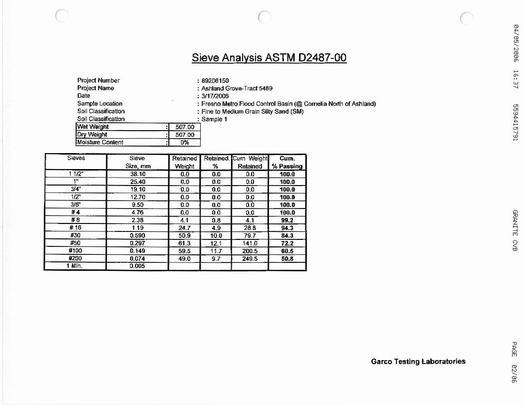
Siege Analysis ASTM D2487-00
Project Number
Project Name
Date
Sample Location
Soil Classification
Sail Classification
Wet Weight 507.00
D Weight 507.00
Moisture Content f19G
Sieves Sieve
Size, mm
Retained
Wei ht
Retained. Cum WeightRetained
Cum.
Passing1112" 38.10 0.0 0.0 0.0 100.0
1 ° 25.40 0.0 0.0 0.0 100.0
314" 19.10 0.0 0.0 0.0 100.0
112" 12.70 0.0 0.0 0.0 100.0
318" 9.50 0.0 0.0 0.0 100.0
4 4.76 0.0 0.0 0.0 100.0
8 2.38 4.1 0.8 4.1 99.2
16 1.19 24.7 4.9 28.8 94.3
30 0.590 50.9 10.0 79.7 84.3
50 0.297 61.3 12.1 141.0 72.2
100 0.149 59.5 171 200.5 60.5
200 0.074 49.0 9.7 249.5 50.8
1 Min. 0.005
89206150
Ashland Grove-Tract 5489
311712006
Fresno Metro Flood Control Basin (@ Comelia North of Ashland)Fine to Medium Grain Siity Sand (SM)Sample 1
Garco Testing LaboratoriesQ
0CD

Grain Size Anal Isis
Sample 1
Sieve Openings in U.S. Standard Sieve Numbers
100.0
JJWD
so_0
70.0
z
l Da5D°zz
w
4D0Uwd
1 I30.0
1
20.0
I i 110_D
a~00.00 10.00 1.00 o.i 0 0.01 0.00
Grain Size in Millimeters
rrolect dame Ashland Grove-Tract 5489 Soil Classification Fine to Medium Grain Silty Sand (SM)Project Number 89206150 Sample Number Sample 1 Sand Equivalent: 14
Gravel SandSi
Coarse Fine Coarse Medium Finelt or Clay
Garco Testing Laboratories

04/0512006 16:37 5594415791 GRANITE C ?B
R N- VALUE TESTASTM C - 2844 If CAL 301
Project Number
Project Name
Date
89206150
Ashland Grove-Tract 5488
3/22/2006
Sample Location/Curve Number Fresno Metro Flood Control Basin (Ashland)Soil Classification SM- (Fine to Medium Grain)
TEST A E CPercent Moisture Compaction, % 10,7 8.8 6.9
D Density, Ibm/cu_ft. 126.3 129.0 130.3Exudation Pressure, si 185 345 640
Expansion Pressure Dial Reading 0 0 0
Expansion Pressure, sf 0 0 0
Resistance Value R 38 49 fig
R Value at 340 PSI Exudation Pressure 46
R Value by Expansion Pressure (TI 5 Expansion Pressure Nil
4 0 300 PS I
3 6
goo
90
a aao
70
n
2 0
L 50
1 6
40
0 8
Y 20
rro a
10
O 4 q Lq 8 uS o U] LIEE4 O N N M E9 TC0
O2
Oq
oD
pApG1
W
oR
Q 8p
q
PAGE 04106
Garco Testing Laboratories

Sieve Analysis ASTM D2487-00
Project Number
Project Name
Date
Sample Location
Soil Classification
Soil Classification
89206150
Ashland Grove-Tract 5489
3/21!2006
Fresno Metro Flood Control Basin (@ Ashland West of Comelia)Fine to Medium Grain Silty Sand (SM)Sample 2
Wet Weight 510A0
Dry Weight 510.40
Moisture Content 0%
Sieves Sieve
Size, mm
Retained
Wei ht
Retained. Cum WeightRetained
Cum.
Passing110 38.10 0.0 0.0 0.0 100.0
1" 25.40 0.0 0.0 0.0 100.0
314" 19.10 0.4 0.0 0.0 100.0
112" 12.70 0.0 0.0 0.0 100.0
318" 9.50 0.0 0.0 0.0 100.0
4 4.76 4.3 0.8 4.3 99.2
8 2.38 23.1 4,5 27.4 9"
16 1.19 88.1 13.3 95.5 91.3
30 0.590 108.1 21.2 203.6 60.1
50 0.297 92.5 18.1 296.1 42.0
100 0.149 69.9 13.7 366.0 28.3
200 0.074 36.1 7.1 402.1 21.2
1 Min. 0.005
Garco Testing Laboratories

Grain Size Anal si
Sample 2
Sieve Openings in U.S. Standard Sieve NumbersHydromefie
7"' ~i100.0
99-D
J '
I8{1.6
70. D
z
60.0 U)
50.0 ~
zW
40.0 0
1u
30.04.
I Iza.©
10.0
D.D100.06 1 D,OD 1 AD 0.10 0.01 0.00
Grain Size in Millimeters
Gravel SandSilt or ClayGaam Fine Coarse 1Redium Fine
I7rw w.4 \I
7......,~,.,,~ rcrcu "IUYC-IlaUL- -+0z$ 3a1i 4iassmcanon nine to Medium Grain Silty Sand (SM)Project Number 89206450 Sample Number Sample 2 Sand Equivalent: 27
Garco Testing Laboratories

New
Document

Test Data Tabulation
Depth is approximate distance below generally
prevailing ground surface elevation of the surroundingarea.
Basin Z-Z
BORING NO. SAMPLE DEPTH R-VALUE SAND PASSING
DESIGNATION FEET) EQUIVALENT NO. 200
SIEVE
00-MS-37 A 15.0-25.0 43 19 28
B 25.0-30.0 32 17 47
00-MS-38 15.0-30.0 70 24 25
00-MS-39 A 0.0-2.5 18 13 56
B 2.5-14.0 53 17 39
C 14.0-17.5 17 10 58
D 17.5-25.0 38 10 50
E 25.0-30.0 11 7 68
00-MS-40 A 0.0-12.0 47 23 27
B 12.0-24.0 42 8 59
C 24.0-30.0 13 7 50
9
o-13-c~1

E14
tTJ
i
N r W'el
z
r
I/
I
1
Niyvy /r/,4iri- f:E'••o.}~cs • t.'ti/. ~ ~
F} 00-MS-37
as
e
I
1•, I IQ
iV
I ~
1
GE •Yi Cis
AN ~/S c/° ,S
N X13 •
jrr~1.• ~ ai/S '
i~r' EcsYiJJ•yJi/C0.S~•2/J.~ s.x
jhr.o/~/cvs/arm/,s ,F~o of ~•wb ofsue Vii' ~.c~'i'/, Sns̀ Gf S%vr-o Are. 7r
Scv/c F~EEBC.4 rcG
N
CAO.oC/rY C.aGC L-4Ti0Ns
Coc~xit~/ li1C./ Fi(,7C.~ G4.ba.iE.bYT Liios /
Laai fiix FiL1r~,+r~ E/sr, eW.7 +PR /
J
Airs? E.ts•,•r G4f'~• / B.O ~•C.
rVM / f/G'H 2X/.f°0(/yfJ ~I~L~ IrC
a tom/ . it.J.J ^~ia~a1 ~ es .lint
i 3 ( iceJ+/E5•G.~t.
r fducif / •
J / .rc.
rtroyr Gca th G '
I \ ~
Iash//~ •90'
i
I '
ICd ~ I ~ i f~i
I7y l v' ~ I ~ .
O O
V APPR ALSW O w,R.CDO `z ' pNeGE4
00-MS-38
a,lr6E.v0E • e',re.~rllydn CvvelsU • Citii~»stGECr.Jj TQpp~'~6•.-~-l~rr
0A7-aW
Cif~i d7h/T~
00-MS-39r~,5•i vh~wne• Zy6 .~e. Fr.
rsxrar1 Eqo/ r .4bwi/r47// ~ BOS/il Jii
lift'
cr.s̀ Ec° ~.~>.3 !3./~ (C~Sj ~ ~'~-'8 ,
s(/~EMENTAL Ci10AC/rY _
6as., 14z•' 11 xx -two (s r~ 'e/~ ~Y
NCW•pESf0EX7fAt~ (,iE`~'N
FRESNO METROPOUTAn
FL000 CONTROL DISTRICT
BASIN Z

WHITES, BRIDGE
E~cPwNSro.t ='70, 000 ~ s
y 665'tJ ~ F ATrAGNED
a82?± c~n
U
PROPOSEDEXPANSION
W ~ 3oti-
L _ ~a>> oo-MS-4o
350'+ t~ ~loFr
I
I
SCALEwt4-=t399-
EArA+JSToN = ± IZ0,000 yd3SEE- ATTAe-1+150
BASIN EXPANSI011DRAINAGE AREA: -IL
EXHIBIT NO. I
FRESNO METROPOLITAN FLOOD CONTROL DISTRICT
SAMPLE LOCATION PLAN B APPROXIMATE SAMPLE LOCATION
BASIN ZZ BORING NUMBER 00-MS40