State Legislative District Reference Map€¦ · Sandy Ridge Rd O l d M o u n Bayou Rd Yale St E...
1
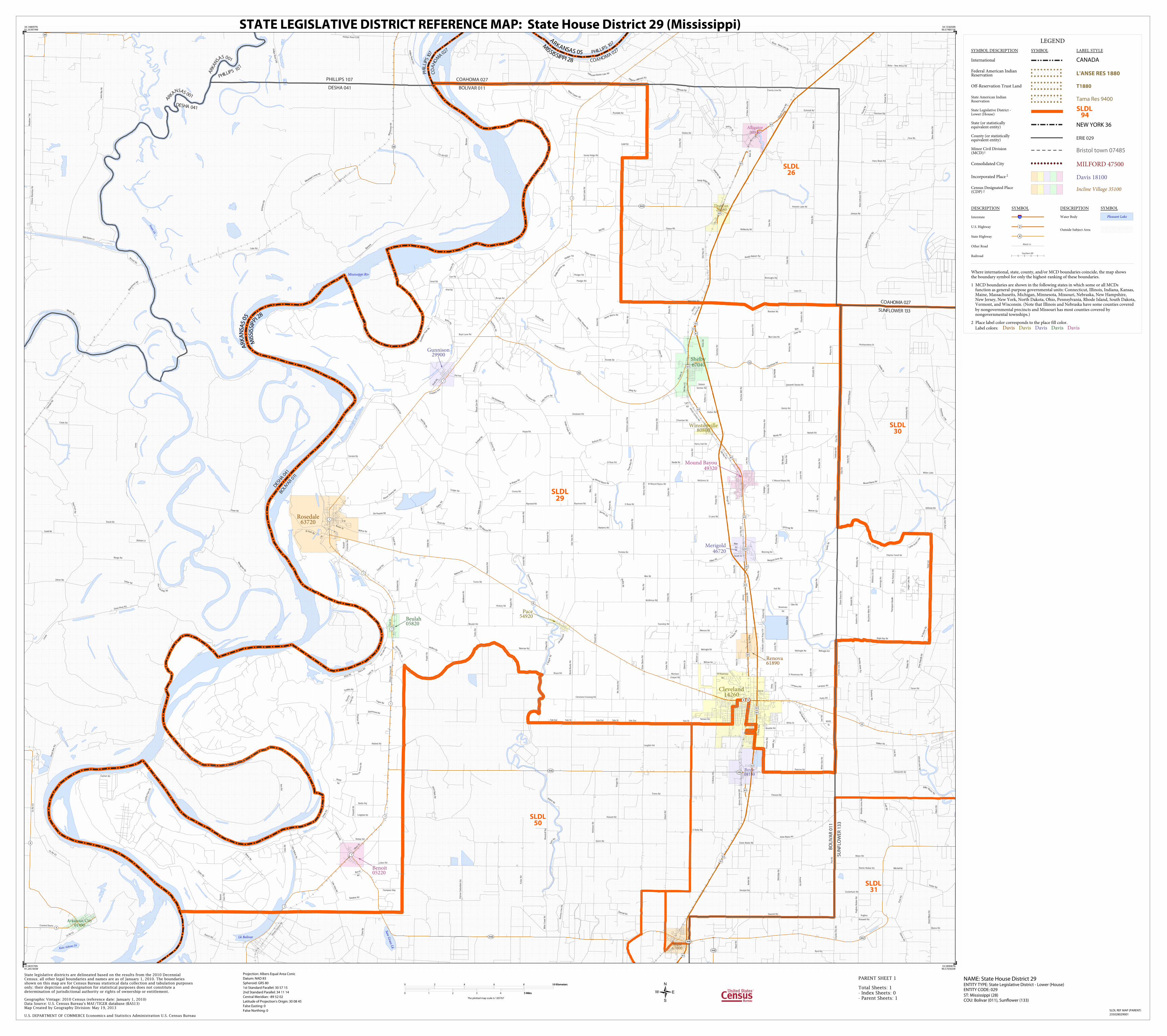
Kate Adams Lk Swan Lk Saw Grass Lk Mississippi Riv Lk Bolivar I lli n ois Central RR Illinois Central RR A b a nd o n e d R R Illinois Central RR Aban d o n e d R R Illinois Central RR Illinois Central RR Illinois Central RR Illinois Central RR Co Rd 43 G a n t R d Jen k i n s S t Stokes Rd N B r i dwel l R an c h Ainsworth Rd Young Rd H i l lh o use-Desoto Lake Rd Sawmill Rd Fox Rd Howard Rd Sandy Ri d g e R d Fava Rd Ho l d e r R d Malette-Jones Rd C o R d 622 Quinn Rd Harris Rd Bobo - New Africa Rd Cade Rd J a c k s B a y R d Sandpit Rd Banks Walker Rd Burroughs Rd Yeager Rd Ranch Rd Woodruff Rd Prevost Rd S Bri dwel l R a nch Palmer Satterfield Rd Conley Rd S awm il l R d R i m R d Bo g u e R d Parchman 3 R d Phillips Road 528 Jord a n R d Jefcoat-Lehr Rd Fullen Rd L e v e e Z e l ner R d Schmidt Rd Creek Rd Tyler Rd Gould Rd P r e w i t t R d S u n fl o w er Schoo l R d M on a g h an R d H i l l house Rd Old H wy 61 S t i mp s o n R d Co Rd 43 Great River Rd Clark Rd Benzal Rd Kline-Johnson Rd Di ckson Ln Mi tchell Rd Lusk Rd N New Africa Rd A l l i ga t o r - Hi l l h o us e R d Reinhart Rd Li nn Rd Wargo Rd M a g nol i a Hi l l Lake Rd Mi ssissippi L e vee Rd J ohnson Rd W o o d r o w T R d O Reilly Rd Herbison Rd A v e L a n d i ng Rd Byrd Rd Cockerham Rd Yancopi n Rd Bitte r C r e e k R d Claire Brake Rd Hearn R d J ones Bayou R d D ozer Rd Great River R d Hughes Braswell Rd W i l s o n R d Lus k R d B a rn e ri a Harry Black Rd Main St B o o g a Bo ttom R d D i t c h B ank R d B arne ri a Trotter Rd McMurchy Rd County Line Rd Wi l d Goo se Ln Hughes Walker Rd Evans Rd I n t e r s t a t e R d Howden Lake Rd Mixon Rd Palm er Rd Shel by Dr Phil li ps Ro ad 547 B u ck l e y Jo nes R d Hushpuckena Dr Lowe Cir Lombardy Rd S Bishop Rd Blaine Rd Steiner Rd Cast o n Rd Steed Mixon R d Zelner Rd Charlie Ellis Rd Gibert Rd Co n n Rd Crooked Bayou D r e w R ul ev i l l e R d Long Lake Rd B o bo - Rena L a r a Rd Tichnor Blacktop Rd Laughlin Rd Dockery Rd R ed F o r k R d Turner Rd New Africa Rd Wi l l i e M ar t in R d Millen Lake Dummy Line Rd Ph i l l i p s R o a d 5 49 Levee Grittman Rd G oul d Rd Wal ker Rd M o u nd Bayou Rd P a rchm a n 2 Rd M edi n a R d H a r r i s R d M u z z i R d C o Rd 4 3 Harkins Rd Whatley Rd H a n n a h R d Boyd Lane Rd D a t t l e R d Raymond Rd Boyette Rd N B a yo u R d G e o r g e S t V a n Li ew Rd B l ue Can e Rd N Martin Luther King Jr Dr Jo hns Rd Davis Rd Sixteen Section Rd Prentiss Mill Rd Cedar Rd Randl e Rd S peakes Rd W i g g i n s Rd S Ross Rd South St McCain Ln L e w i s R d Smith Rd Clark St Poe Rd Heinsz Rd Beevers Rd Old Hwy 61 Mal vi n a Rd Lucas Rd McKay Rd El l en Rd Hernry Hall Rd Loran Rd Oswalt Rd Sco t l a n d R d Hous e Rd Marberry Rd L a k e R d Tharpe Rd W Mound Bayou Rd Uni o n Rd T h o m p s o n - G o o d i n Ra y ne r R d S Lane Rd Mo u nt Zion R d M ul l i n s Rd Beulah Rd Bullock Rd H e n d e r s o n R d N Ross Rd Terrace Rd Rice Palmer Rd L a s i g e r L a k e R d W M o un d Ba y ou Rd McKnight Rd Main St Pears o n R d Stafford Rd Perths h i re Rd J W Mat t h e w Brown St R o chdal e Rd Nobl i n R d Hutton Rd Ms Shorty Rd N Ba y o u R d Pl edg e r R d Conner Rd B o b o R d O l d M a l vi n a Rd Bush Rd Isola St Bethany Ch Rd Gourlay Loop Rd Tarsi Rd O l d H w y 6 1 An d erson R d Dixon-Davis Rd Mai n St Burr us Rd La m pa r d Rd Hon ey Ba y ou R d Morrison Chapel Rd D o ss e t t e G r o ve R d Holmes Lake Rd Pha li a R d Cutoff Rd I nger s ol Rd Ol d Pea vi ne Rd Pledger Rd Dattl e R d Hawkins Rd Knowlton Rd Grainger Dorsey Rd Wender Rd Manning Rd D on a l dso n P oi nt Rd Tolliver Rd B i l e s R d St Pa r k R d J St Terre ne R d Haynes Caroll Rd Christmas Rd Pro s p e c t A v e Raymond Rd Crump Rd Lee Ave Blue Cane Rd Pemble Rd N B o g u e R d Spi ce w ood R d M c R a e R d She l by-Dee s e n Rd Cutoff Rd L a k e B ol i v a r R d Bel l Rd S an d y Rd Hi ter Rd Battle Rd Bruce Rd D ill i on Rd Jennings Rd Dossett Rd Cedar Rd Delta Council Dr Scott Rd 2nd Ave Dorothy Rd Cedar Rd Cottonw o o d Rd Lundy Rd K i t c h i n s R d Township Rd Graing e r Dorsey Rd Monroe R d Joel Rd Symonds Rd S n ak e C r ee k Rd C a t f i sh P o i n t R d S h i v e r s D r Ca t fi s h R d W Rosemary Rd C l ark St Hickory Rd Hackett Rd C arte r R d Hicks Rd Moody Rd Gentry Rd Grant Rd Reynolds Rd McWimus Rd Warfield Rd Cleveland Crossing Rd Odom Rd La ke Por t e r Rd San chez Rd D S t Rogers Rd G i b son Swamp Rd McCai n Rd Hutton Ln R u sse l l Rd McKni ght Rd Ferretti Rd Turner Rd D oo l i e s Rd C a tt l e Ra nch R d Leroy Rd Ol d Hwy 61 Rosemary Rd Mitchell Rd C urti s S mi th Rd O l d Gunni son Rd M i ng R d Chamber Rd Amel Rd Meri g ol d Dr e w Rd Zumbro Rd White St T h re e Wa y R d Dresback Rd Russell Crutcher Rd Kincade Rd Round Lake Rd Meyers Rd Th o m p so n Rd Oak Tree Rd Ira Rd Happy St Wa x h aw R d S L a ke St Bogy R d Carr Rd Symonds Rd Hall Rd Shel by Deeson R d Co nger Rd K i t c h i ng Rd John ' s R d McGinnis St Henry Hall Rd 3rd St Locust Rd Ray Rd Rayner Rd Pledger Rd Walker Rd Amel R d Bunge Rd Longshot Rd Sunrise Dr White Star Rd G r e e r R d Clay Rd M o u n d C i ty R d Lo g an Rd Newman Rd L ak e Vi sta Rd O ' N e a l R d Clay Murphree Rd Boschert Rd W a l ton Rd Litton Rd Si xteenth Secti on Rd S B o g u e R d Rives Rd Allendale Rd Yale St Feed Lot C r o s b y R d S ugar H i l l Rd Parks Rd Bol i va r Rd Peavine Rd Yale St Wayne Rd Lev ee R d Neblett Rd Bond-Busby Rd Y al e Exd Curti s S m i t h Loop Yale Exd Charlie's Rd Sandy Ridge Rd O l d M o u n d Bayou Rd Yale St E Rosemary Rd Th o mpson Way Lamp ar d Rd Shaw Skene Rd O dell Rd Bruckner-Kiker Rd E utaw Rd S Davis Ave White St A m b r o s e R d Clay Rd Beaver Dam Rd Pearman Rd F r a z i e r R d McKni ght R d Tullos Rd W St a c ey R d Levee Rd N ol an-T oppe r Rd O l d Rul evi l l e Rd County Line Rd Parchman Rd Yale Exd E Mound Bayou Rd R al ph Ray Rd 8 448 1 446 1 1 1 32 444 44 1 44 1 448 442 8 4 8 4 448 1 1 1 446 1 8 32 61 61 61 61 61 61 61 61 61 61 61 61 61 61 61 61 61 61 61 61 61 BOLIVAR 011 COAHOMA 027 PHILLIPS 107 DESHA 041 BOLIVAR 011 SUNFLOWER 133 SU N F LOWER 1 3 3 C O AH OMA 02 7 BO L I VA R 01 1 DES H A 041 P H I L L I PS 1 0 7 C O A H O M A 0 2 7 P H I L L I P S 1 0 7 C O A H O M A 0 2 7 ARK A N S A S 001 DESH A 041 PH I LLI P S 1 0 7 AR KA N S A S 0 01 M I S S I S S I P P I 2 8 A R K A N S A S 0 5 M I S S I S S I P P I 2 8 A R K A N S A S 0 5 Arkansas City 01990 Alligator 00940 Duncan 20380 Boyle 08180 Shaw 67000 Benoit 05220 Cleveland 14260 Merigold 46720 Mound Bayou 49320 Gunnison 29900 Winstonville 80800 Shelby 67040 Pace 54920 Renova 61890 Rosedale 63720 Beulah 05820 SLDL 30 SLDL 50 SLDL 26 SLDL 31 SLDL 29 LEGEND SYMBOL DESCRIPTION SYMBOL LABEL STYLE International CANADA Federal American Indian Reservation L'ANSE RES 1880 Off-Reservation Trust Land T1880 State American Indian Reservation Tama Res 9400 State Legislative District - Lower (House) SLDL 94 State (or statistically equivalent entity) NEW YORK 36 County (or statistically equivalent entity) ERIE 029 Minor Civil Division (MCD) 1 Bristol town 07485 Consolidated City MILFORD 47500 Incorporated Place 2 Davis 18100 Census Designated Place (CDP) 2 Incline Village 35100 DESCRIPTION SYMBOL DESCRIPTION SYMBOL Interstate 3 U.S. Highway 2 State Highway 4 Other Road Marsh Ln Railroad Southern RR Water Body Pleasant Lake Outside Subject Area Where international, state, county, and/or MCD boundaries coincide, the map shows the boundary symbol for only the highest-ranking of these boundaries. 1 MCD boundaries are shown in the following states in which some or all MCDs function as general-purpose governmental units: Connecticut, Illinois, Indiana, Kansas, Maine, Massachusetts, Michigan, Minnesota, Missouri, Nebraska, New Hampshire, New Jersey, New York, North Dakota, Ohio, Pennsylvania, Rhode Island, South Dakota, Vermont, and Wisconsin. (Note that Illinois and Nebraska have some counties covered by nongovernmental precincts and Missouri has most counties covered by nongovernmental townships.) 2 Place label color corresponds to the place fill color. Label colors: Davis Davis Davis Davis Davis 34.148097N 91.253974W 34.153650N 90.574851W 33.589087N 90.570365W 33.583570N 91.245185W State legislative districts are delineated based on the results from the 2010 Decennial Census; all other legal boundaries and names are as of January 1, 2010. The boundaries shown on this map are for Census Bureau statistical data collection and tabulation purposes only; their depiction and designation for statistical purposes does not constitute a determination of jurisdictional authority or rights of ownership or entitlement. U.S. DEPARTMENT OF COMMERCE Economics and Statistics Administration U.S. Census Bureau Geographic Vintage: 2010 Census (reference date: January 1, 2010) Data Source: U.S. Census Bureau's MAF/TIGER database (BAS13) Map Created by Geography Division: May 19, 2013 ENTITY TYPE: State Legislative District - Lower (House) ENTITY CODE: 029 NAME: State House District 29 Projection: Albers Equal Area Conic Datum: NAD 83 Spheroid: GRS 80 1st Standard Parallel: 30 57 15 2nd Standard Parallel: 34 11 14 Central Meridian: -89 52 02 Latitude of Projection's Origin: 30 08 45 False Easting: 0 False Northing: 0 Total Sheets: 1 - Index Sheets: 0 - Parent Sheets: 1 ST: Mississippi (28) COU: Bolivar (011), Sunflower (133) 0 2 4 6 8 10 Kilometers 10 Kilometers 0 1 2 3 4 5 Miles 5 Miles The plotted map scale is 1:85767 STATE LEGISLATIVE DISTRICT REFERENCE MAP: State House District 29 (Mississippi) SLDL REF MAP (PARENT) 235028029001 PARENT SHEET 1
Transcript of State Legislative District Reference Map€¦ · Sandy Ridge Rd O l d M o u n Bayou Rd Yale St E...
Kate Adams Lk
Swan Lk
Saw Grass Lk
Mississippi Riv
Lk Bolivar
Illino
is Ce
ntra
l RR
Illin
ois
Cent
ral R
R
Aban
done
d R R
Illino
is Ce
ntra
l RR
Aban
do
ned RR
Illinois Central RR
Illin
ois
Cent
ral R
R
Illin
ois
Cent
ral R
R
Illin
ois
Cent
ral R
R
Co Rd 43
Gant
Rd
Jenkins St
Stokes Rd
N Br
idw
ell R
anch
Ainsworth Rd
Youn
g Rd
Hillhouse-Desoto Lake Rd
Sawmill Rd
Fox
Rd
Howard Rd
Sandy Ridge Rd
Fava Rd
Hold
er R
d
Mal
ette
-Jon
es R
d
Co Rd 622
Quinn Rd
Har
ris R
d
Bobo - New Africa Rd
Cade
Rd
J ack
s Ba
y Rd
Sandpit Rd
Banks Walker Rd
Burroughs Rd
Yeag
er R
d
Ranch Rd
Woo
druf
f Rd
Prevost Rd
S Bridwell Ranch
Palm
er S
atte
rfiel
d Rd
Conl
ey R
d
Sawmill Rd
Rim R d
Bogue Rd
Parchman 3 Rd
Phillips Road 528
Jord
an R
d
Jefcoat-Lehr Rd
Fulle
n Rd
Leve
e
Zelner Rd
Schmidt Rd
Creek Rd
Tyle
r Rd
Gould Rd
Prewitt R d
Sunf
lowe
r Sch
ool R
d
Monaghan Rd
Hillhouse Rd
Old
Hw
y 61
S tim
pson
Rd
Co R
d 43
Great River Rd
Clar
k Rd
Benzal Rd
Klin
e-Jo
hnso
n Rd
Dickson Ln
Mitchell Rd
Lusk Rd
N N
ew A
frica
Rd
A lligator -Hillhouse Rd
Reinhart Rd
Linn Rd
Wargo Rd
Magnolia Hill
Lake Rd
Mississip
pi Levee Rd
Johnson Rd
Woo
dro w
T R
d
O Reilly Rd
Her
biso
n Rd
Ave Lan d ing Rd
Byrd Rd
Cockerham Rd
Yanc
opin
Rd
Bitte
r Cre
ek R
d
Claire Brake Rd
Hear
n R d
Jones Bayou Rd
Dozer Rd
Grea
t Rive
r Rd
Hughes
Braswell Rd
Wils
on R
d
Lusk Rd
Barn
eria
Harry Black Rd
Mai
n St
Booga Bottom Rd
Ditch Bank Rd
Barneri
a
Trotter Rd
McMurchy Rd
County Line Rd
Wild Goose Ln
Hug
hes
Wal
ker R
d
Evans Rd
Inter
s ta t
e Rd
Howden Lake Rd
Mixon Rd
Palm
er R
d
Shelby Dr
Phillips Road 547
Buckley Jones Rd
Hushpuckena Dr
Lowe Cir
Lom
bard
y Rd
S Bi
shop
Rd
Blaine Rd
Steiner Rd
Caston Rd
Stee
d M
ixon
Rd
Zelner Rd
Char
lie E
llis
Rd
Gib
ert R
d
Conn
Rd
Crooked Bayou
Drew
Rule
ville
Rd
Long
Lak
e Rd
Bo bo - Rena Lara Rd
Tich
nor B
lack
top
Rd
Laughlin Rd
Dockery Rd
Red Fork Rd
Turner Rd
New
Afri
ca R
d
Willie Mart in Rd
Millen Lake
Dum
my
Line
Rd
Phillips Road 549
Leve
e
Grittman Rd
Gould Rd
Walker Rd
Mound Bayou Rd
Parchman 2 Rd
Medina Rd
Harr
is Rd
Mu z
zi Rd
Co Rd 43
Har
kins
Rd
Wha
tley
Rd
Hann
ah R
d
Boyd Lane Rd
Datt l
e Rd
Raymond Rd
Boyette Rd
N Bayou
Rd
George St
Van
Liew
Rd
Blue
Cane Rd
N M
artin
Lut
her K
ing
Jr D
r
Johns Rd
Dav
is R
d
Sixteen
Section Rd
Pren
tiss
Mill
Rd
Ceda
r Rd
Randle Rd
Speakes Rd
Wig
g ins
Rd
S Ross Rd
South St
McC
ain
Ln
L ew
is Rd
Smith
Rd
Clar
k St
Poe
Rd
Hei
nsz
Rd
Beevers Rd
Old H
wy 61
Malvina Rd
Luca
s Rd
McKay Rd
Ellen Rd
Her
nry
Hal
l Rd
Lora
n Rd
Osw
alt R
d
Scot
land
Rd
HouseRd
Marberry Rd
Lake Rd
Thar
pe R
d
W Mound Bayou Rd
Union Rd
Tho m
pson
-Goo
d in
Rayner R d S Lane Rd
Mou
nt Z
ion
Rd
Mullins Rd
Beulah Rd
Bullock Rd
Hend
e rso
n Rd
N Ross Rd
Terrace Rd
Rice
Pal
mer
Rd
Las ig
er L
ake
Rd
W Mound Bayou Rd
McKnight Rd
Main S
t
Pearson Rd
Stafford Rd Perthshire Rd
J W M
atth
ew
Brown St
R ochdale Rd
Nobl
in R
d
Hutton Rd
Ms
Shor
ty R
d
N Ba
you
Rd
Pledger Rd
Conner Rd
Bobo Rd
O ld Malvi na Rd
Bush Rd
Isol
a St
Beth
any
Ch R
d
Gour
lay
Loop
Rd
Tarsi
Rd
Old
Hwy
61
Anderson Rd
Dix
on-D
avis
Rd
Main
St
Burr us
Rd
Lampar d Rd
Honey Bayou Rd
Morrison
Chapel Rd
Dosse t t
e G
rove
Rd
Hol
mes
Lak
e Rd
Phalia Rd
Cutoff R
d
Ingersol Rd
Old Peavine Rd
Pledger Rd
Dattle
Rd
Haw
kins
Rd
Knowlton Rd
Gra
inge
r Dor
sey
Rd
Wen
der R
d
Manning Rd
Dona
ldson
Poin
t Rd
Tolli
ver R
d
Bile
s Rd
St Park Rd
J St
Terrene Rd
Haynes Caroll Rd
Chris
tmas
Rd
Prospect Ave
Raymond Rd
Crump Rd
Lee
Ave
Blue Cane Rd
Pemble Rd
N Bogue Rd
Spicewood Rd
McRae Rd
Shelb
y-Dee
sen Rd
Cutoff Rd
Lake Bolivar Rd
Bell Rd
Sand
y Rd
Hiter Rd
Battle Rd
Bruce Rd
Dillion Rd
Jenn
ings
Rd
Dos
sett
Rd
Ceda
r Rd
Del
ta
Coun
cil D
r
Scot
t Rd
2nd Ave
Dor
othy
Rd
Ceda
r Rd
Cottonwood Rd
Lund
y Rd
Kitc
h ins
R d
Township Rd
Grai
nger
Dor
sey
Rd
Monroe Rd
Joel
Rd
Symonds Rd
Snake Creek Rd
Catfi
sh P
oint R
d
Shive
r s D
r
Cat fish Rd
W Rosemary
Rd
Clark
St
Hickory Rd
Hackett Rd
Carte
r Rd
Hic
ks R
d
Moody Rd
Gentry Rd
Gra
nt R
d
Reyn
olds
Rd
McWimus Rd
War
field
Rd
Cleveland Crossing Rd
Odo
m R
d
La
ke Po
rter Rd
Sanc
hez
Rd
D St
Roge
rs R
d
Gibson Sw
amp R
d
McCain Rd
Hut
ton
Ln
Ru
ssell R
d
McKnight Rd
Ferretti Rd
Turner Rd
Doolies Rd
Cattl
e Ra
nch
Rd
Lero
y Rd
Old Hwy 61
Rosemary
Rd
Mitc
hell
Rd
Curtis Smith Rd
Old Gunnison Rd
Ming Rd
Chamber Rd
Amel Rd
Merigold Drew Rd
Zumbro Rd
White St
Thre
e W
ay R
d
Dresback Rd
Russ
ell
Crut
cher
Rd
Kinc
ade
Rd
Roun
d La
ke R
d
Mey
ers
Rd
Thompson Rd
Oak
Tre
e Rd
Ira R
d
Happy St
Waxhaw Rd
S La
ke S
t
Bogy Rd
Carr Rd
Sym
onds
Rd
Hall Rd Shelby Deeson Rd
Conger Rd
Kitch ing Rd
John's Rd
McGinnis St
Henry Hall Rd
3rd St
Locu
st R
d
Ray
Rd
Rayn
er R
d
Pledger Rd
Walker Rd
Amel Rd
Bunge Rd
Longshot Rd
Sunr
ise
Dr
Whi
te S
tar R
d
Gree
r Rd
Clay
Rd
Mound City Rd
Logan Rd
Newman Rd
Lake Vista Rd
O'N
eal R
d
Clay
Mur
phre
e Rd
Boschert Rd
Walton Rd
Litton Rd
Sixteenth Section Rd
S Bo
gue
Rd
Rive
s Rd
Allendale Rd
Yale St
Feed
Lot
Cros
by R
d
Sugar H ill Rd
Parks Rd
Bolivar Rd
Peavine Rd
Yale St
Way
ne R
d
Leve
e R
d
Neblett Rd
Bond
-Bus
by R
d
Yale Exd
Curtis Sm ith
Loo
p
Yale Exd
Char
lie's
Rd
Sandy Ridge Rd
Old
Mou
nd
Bayo
u Rd
Yale St
E Rosemary Rd
Thompson Way
Lampard Rd
Shaw
Ske
ne R
d
Odell Rd
Bruc
kner
-Kik
er R
d
Eutaw Rd
S D
avis
Ave
White
St
Ambr
ose
Rd
Clay
Rd
Beav
er
Dam
Rd
Pear
man
Rd
Fraz
ier R
d
McKnight Rd
Tullo
s Rd
W S
tace
y Rd
Leve
e Rd
Nolan-Topper Rd
Old Ruleville Rd
Coun
ty L
ine
Rd
Parchman Rd
Yale Exd
E Mound Bayou Rd
Ralph Ray Rd
8
448
1
446
1
1
1
32
444
44
1
44
1
448
442
8
4
8
4
448
1
1
1
446
1
8
32
61
61
61
61
61
61
61
61
61
61
61
61
61
61
61
61
61
61
61
61
61
BOLIVAR 011
COAHOMA 027PHILLIPS 107
DESHA 041
BO
LIV
AR
01
1
SU
NF
LOW
ER
13
3
SUNFLOWER 133
COAHOMA 027
BOLI
VAR 011
DES
HA 041
PHILLIPS 107
COAHOMA 027
PH
ILLI
PS 10
7C
OA
HO
MA 027
ARKANSAS 001
DESHA 041
PHILLIPS 107
ARK
AN
SAS 001
MIS
SISS
IPPI
28
AR
KA
NSA
S 05
M
ISSISSIPPI 28
ARKANSAS 05
Arkansas City01990
Alligator00940
Duncan20380
Boyle08180
Shaw67000
Benoit05220
Cleveland14260
Merigold46720
Mound Bayou49320
Gunnison29900
Winstonville80800
Shelby67040
Pace54920
Renova61890
Rosedale63720
Beulah05820
SLDL30
SLDL50
SLDL26
SLDL31
SLDL29
LEGEND
SYMBOL DESCRIPTION SYMBOL LABEL STYLE
International CANADA
Federal American IndianReservation L'ANSE RES 1880
Off-Reservation Trust Land T1880
State American IndianReservation Tama Res 9400
State Legislative District -Lower (House)
SLDL94
State (or statisticallyequivalent entity) NEW YORK 36
County (or statisticallyequivalent entity) ERIE 029
Minor Civil Division(MCD)1 Bristol town 07485
Consolidated City MILFORD 47500
Incorporated Place 2 Davis 18100
Census Designated Place(CDP) 2 Incline Village 35100
DESCRIPTION SYMBOL DESCRIPTION SYMBOL
Interstate 3
U.S. Highway 2
State Highway 4
Other RoadMarsh Ln
RailroadSouthern RR
Water Body Pleasant Lake
Outside Subject Area
Where international, state, county, and/or MCD boundaries coincide, the map showsthe boundary symbol for only the highest-ranking of these boundaries.
1 MCD boundaries are shown in the following states in which some or all MCDs function as general-purpose governmental units: Connecticut, Illinois, Indiana, Kansas, Maine, Massachusetts, Michigan, Minnesota, Missouri, Nebraska, New Hampshire, New Jersey, New York, North Dakota, Ohio, Pennsylvania, Rhode Island, South Dakota, Vermont, and Wisconsin. (Note that Illinois and Nebraska have some counties covered by nongovernmental precincts and Missouri has most counties covered by nongovernmental townships.)
2 Place label color corresponds to the place fill color.
Label colors: Davis Davis Davis Davis Davis
34.148097N91.253974W
34.153650N90.574851W
33.589087N90.570365W
33.583570N91.245185W
State legislative districts are delineated based on the results from the 2010 DecennialCensus; all other legal boundaries and names are as of January 1, 2010. The boundariesshown on this map are for Census Bureau statistical data collection and tabulation purposesonly; their depiction and designation for statistical purposes does not constitute adetermination of jurisdictional authority or rights of ownership or entitlement.
U.S. DEPARTMENT OF COMMERCE Economics and Statistics Administration U.S. Census Bureau
Geographic Vintage: 2010 Census (reference date: January 1, 2010)Data Source: U.S. Census Bureau's MAF/TIGER database (BAS13)Map Created by Geography Division: May 19, 2013
ENTITY TYPE: State Legislative District - Lower (House)ENTITY CODE: 029
NAME: State House District 29 Projection: Albers Equal Area Conic
Datum: NAD 83
Spheroid: GRS 80
1st Standard Parallel: 30 57 15
2nd Standard Parallel: 34 11 14
Central Meridian: -89 52 02
Latitude of Projection's Origin: 30 08 45
False Easting: 0
False Northing: 0
Total Sheets: 1- Index Sheets: 0- Parent Sheets: 1
ST: Mississippi (28)COU: Bolivar (011), Sunflower (133)
0 2 4 6 8 10 Kilometers10 Kilometers
0 1 2 3 4 5 Miles5 Miles
The plotted map scale is 1:85767
STATE LEGISLATIVE DISTRICT REFERENCE MAP: State House District 29 (Mississippi)
SLDL REF MAP (PARENT)
235028029001
PARENT SHEET 1