
STANISLAUS COUNTY PLANNING COMMISSION ellenwood sr.pdf · This project will expand the current...
47
STANISLAUS COUNTY PLANNING COMMISSION April 1, 2010 STAFF REPORT USE PERMIT APPLICATION NO. 2009-16 FOSTER FARMS - ELLENWOOD REQUEST: TO EXPAND AN EXISTING CHICKEN HATCHERY BY 29,713 SQUARE FEET ON A 112± ACRE SITE IN THE A-2-40 (GENERAL AGRICULTURE) ZONING DISTRICT. APPLICATION INFORMATION Property Owner: Fresno Farming LLC - Foster Farms Applicant: Bob Miller Location: West of Ellenwood Road, between Ellenwood Road and the Oakdale Waterford Highway, in the Waterford area (1307 Ellenwood Road) Section, Township, Range: 17-3-11, 20-3-11 Supervisorial District: One (Supervisor O’Brien) Assessor’s Parcel: 015-003-012, 015-056-007, 015-056-008, 015-056-010, 015-056-011 Referrals: See Exhibit I Environmental Review Referrals Area of Parcel: 112± acres Water Supply: Water well Sewage Disposal: Septic/leach field system Existing Zoning: A-2-40 (General Agriculture) General Plan Designation: Agriculture Sphere of Influence: Not applicable Community Plan Designation: Not applicable Williamson Act Contract No.: 72-613 & 73-1237 Environmental Review: Mitigated Negative Declaration Present Land Use: A chicken hatchery, almond orchards, fields containing a forage crop, wastewater ponds, and one single-family dwelling Surrounding Land Use: Almond orchards and forage crops to the north, OID South Canal and orchards to the west, orchards and the Oakdale Waterford Highway to the south, and ranch properties to the east 1
Transcript of STANISLAUS COUNTY PLANNING COMMISSION ellenwood sr.pdf · This project will expand the current...

STANISLAUS COUNTY PLANNING COMMISSION
April 1, 2010
STAFF REPORT
USE PERMIT APPLICATION NO. 2009-16FOSTER FARMS - ELLENWOOD
REQUEST: TO EXPAND AN EXISTING CHICKEN HATCHERY BY 29,713 SQUARE FEET ONA 112± ACRE SITE IN THE A-2-40 (GENERAL AGRICULTURE) ZONINGDISTRICT.
APPLICATION INFORMATION
Property Owner: Fresno Farming LLC - Foster FarmsApplicant: Bob MillerLocation: West of Ellenwood Road, between Ellenwood
Road and the Oakdale Waterford Highway, inthe Waterford area (1307 Ellenwood Road)
Section, Township, Range: 17-3-11, 20-3-11Supervisorial District: One (Supervisor O’Brien)Assessor’s Parcel: 015-003-012, 015-056-007, 015-056-008,
015-056-010, 015-056-011Referrals: See Exhibit I
Environmental Review ReferralsArea of Parcel: 112± acresWater Supply: Water wellSewage Disposal: Septic/leach field systemExisting Zoning: A-2-40 (General Agriculture)General Plan Designation: AgricultureSphere of Influence: Not applicableCommunity Plan Designation: Not applicableWilliamson Act Contract No.: 72-613 & 73-1237Environmental Review: Mitigated Negative DeclarationPresent Land Use: A chicken hatchery, almond orchards, fields
containing a forage crop, wastewater ponds,and one single-family dwelling
Surrounding Land Use: Almond orchards and forage crops to thenorth, OID South Canal and orchards to thewest, orchards and the Oakdale WaterfordHighway to the south, and ranch properties tothe east
1

UP 2009-16Staff ReportApril 1, 2010Page 2
PROJECT DESCRIPTION
The project proposes an expansion of the existing Foster Farms - Ellenwood chicken hatchery. Theexpansion proposes a new incubator and hatch rooms, a new egg room, a new storage room, newoffices and break room, remodeling of part of the existing hatchery including removal of existingoffices and break room to make room for an increased chick room, and a new wastewater system.This project will expand the current building area by 29,713 square feet. The existing footprint ispresently 64,339 square feet. The Foster Farms site, including hatchery and orchards, totals 112±acres. Most of the surrounding area consists of almond orchards and pastureland. The propertyis currently enrolled in Williamson Act Contract Nos. 72-613 & 73-1237.
In regards to the hatchery, the current facility operates 24 hours a day, seven days a week. Theyhave one employee 24 hours a day for monitoring the incubators and hatchers. The site has oneresidence on the property where the supervisor lives. The number of chicks hatched at this facilitywill increase from 2.06 million birds per week to 3.3 million. This expansion will actually reduceweekly truck trips from 59 to 56 since the applicant will shut down the Albers Hatchery, eliminatingthe truck traffic from Albers to Ellenwood. Employee estimates are around 35 - 42 due to theexpansion. No more than 20 people will be present at any given time. The existing structure is aconcrete-tilt-up building, approximately 20 feet tall. The expansion to the existing building will besteel construction with insulated metal panels matching the existing concrete building.
A new wastewater system is also part of the proposal, to include two new lined ponds. The existingsouthern pond will be expanded. The new pond area will total 1.75 acres, which currently hasalmond trees on-site. They will continue using a screen and an irrigation system until the newwastewater system comes on-line. The screen is used to collect and remove “chick down” (youngchicken feathers and/or chicken waste) from the wastewater. The chick down that is collected(under 200 pounds per day) is taken to a landfill. The property also has about nine acres of pasturewhere wastewater is used for irrigation. The existing northern wastewater pond is proposed to beabandoned with construction of the new system. Storage of animal waste ponds shall be locateda minimum of fifty feet from any property line and three hundred feet from any dwelling on anadjacent property. Other standards may be imposed by other county or state agencies.
SITE DESCRIPTION
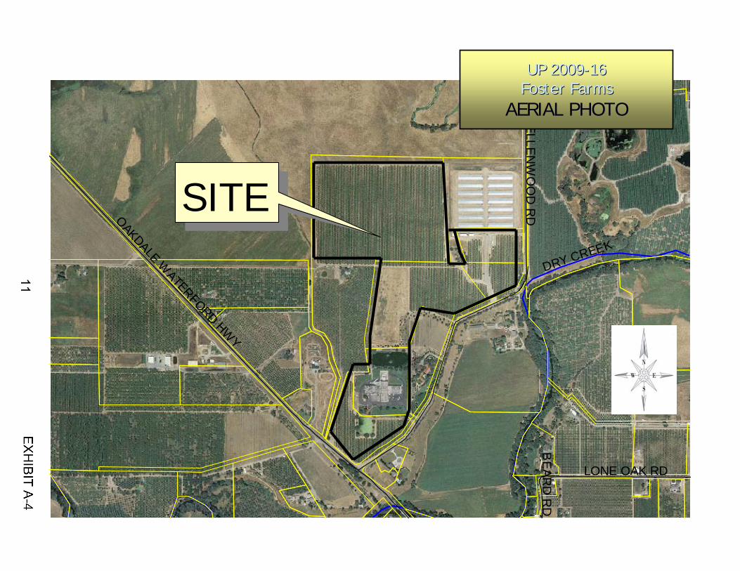
The site is located at 1307 Ellenwood Road, west of Ellenwood Road, between Ellenwood Roadand the Oakdale Waterford Highway, in the Waterford area. The site is accessible from a drivewayon Ellenwood Road. The main facility has been an existing chicken hatchery on its own 12-acreAssessor’s Parcel. The entire project site is approximately 112± acres comprised of five (5)separate Assessor’s Parcels all owned by Fresno Farms LLC - Foster Farms. In addition to thehatchery, the project site is developed with one single-family dwelling and planted in almondorchards and forage crops. The recycled water from the hatchery discharge is used to spray fieldsin the northern portion of the project site.
A review of land uses in the immediate vicinity reveals similar-sized properties. Structures consistof one single-family dwelling and the existing facility. The surrounding land uses include almondorchards to the north, OID South Canal and orchards to the west, orchards and the OakdaleWaterford Highway to the south, and ranch properties to the east.
2
UP 2009-16Staff ReportApril 1, 2010Page 3
DISCUSSION
The site is located in the General Agriculture (A-2) zoning district. Effective December 26, 2003,the A-2 zoning district requires a use permit for any new or expanding Confined Animal Facility(CAF) requiring a new or modified permit, waiver, or an order for Waste Discharge Requirements(WDRs) from the Regional Water Quality Control Board (RWQCB), where the issuance of wastedischarges require compliance with the California Environmental Quality Act (CEQA). If no permit,waiver, or order for WDRs is required by RWQCB, a CAF, including the expansion of a chickenhatchery, is considered a permitted use.
Typically, requests for new or expanding CAFs are referred to the RWQCB for a determinationregarding the need for a new or modified permit, waiver, or order for WDRs prior to a use permitapplication being submitted; however, in this case, the use permit was submitted to the Departmentof Planning and Community Development prior to a determination by the RWQCB based on theapplicant’s understanding that WDRs would be required as a result of preliminary discussions withthe RWQCB. Attempts by staff to obtain a determination from the RWQCB prior to processing ofthe use permit failed since the RWQCB would not issue a determination until they had anopportunity to review the CEQA environmental documentation for the project. This approach ishighly unusual since CEQA only applies if a use permit is required and the RWQCB’s determinationis needed to determine if a use permit is required.
In light of the impasse presented by the RWQCB’s inability to make a determination, the applicantand staff agreed to move forward with preparation of the use permit and environmental review onthe assumption that WDRs would be required by the RWQCB. During this time the applicant metindependently with the RWQCB on January 21, 2010. In response to the CEQA Initial Study, theRWQCB responded on March 1, 2010, stating that WDRs would be required for the project. (SeeExhibit H - Public Comments & Environmental Review Referral Responses.) A complete discussionon the environmental review for this project is provided in the section below.
A Use Permit may be granted if the Planning Commission makes the following finding:
• The establishment, maintenance, and operation of the proposed use or building applied foris consistent with the General Plan designation of “Agriculture” and will not, under thecircumstances of the particular case, be detrimental to the health, safety, and generalwelfare of persons residing or working in the neighborhood of the use and that it will not bedetrimental or injurious to property and improvements in the neighborhood or to the generalwelfare of the County.
Also, the project site is currently enrolled under the Williamson Act (Contract Nos. 72-613 & 73-1237). In compliance with Government Code Section 51238.1, Section 21.20.045(A) of the A-2zoning district requires that all uses requiring use permits that are approved on Williamson Actcontracted lands shall be consistent with three principles of compatibility:
1. The use will not significantly compromise the long-term productive agriculturalcapability of the subject contracted parcel or parcels or on other contracted landsin the A-2 zoning district;
3

UP 2009-16Staff ReportApril 1, 2010Page 4
2. The use will not significantly displace or impair current or reasonably foreseeableagricultural operations on the subject contracted parcel or parcels or on othercontracted lands in the A-2 zoning district. Uses that significantly displaceagricultural operations on the subject contracted parcel or parcels may be deemedcompatible if they relate directly to the production of commercial agriculturalproducts on the subject contracted parcel or neighboring lands, including activitiessuch as harvesting, processing, or shipping; and
3. The use will not result in the significant removal of adjacent contracted land fromagricultural or open-space use.
The proposed expansion, may be considered compatible if the Planning Commission finds that theuse is consistent with the three principles of compatibility listed above.
This project has been reviewed by the Department of Conservation on numerous occasions. Theyresponded that because the project does not involve a significant conversion of Prime Farmland,Unique Farmland, or Farmland of Statewide Importance they would have no specific project relatedcomments.
Staff has received a letter from a neighbor to the west raising concerns with a noisy on-site vacuumpump. (See Exhibit H - Public Comments & Environmental Review Referral Responses - letterdated March 10, 2010.) Per the neighbor’s letter, Foster Farms has tried to rectify the problem inthe past. The neighbor does not have a problem with the project, but hopes the noisy vacuumpump will get rectified with the expansion. The applicant has been notified of the concern and hasexpressed that the expansion will fix the issue.
Staff believes the necessary findings to approve this project can be made. With conditions ofapproval in place, there is no indication that, under the circumstances of this particular case, theproposed project will be detrimental to the health, safety and general welfare of persons residingor working in the neighborhood of the use and that it will not be detrimental or injurious to propertyand improvements in the neighborhood or to the general welfare of the county. The servicesprovided by the facility are an important component of the agricultural economy in StanislausCounty and there is no indication this project will interfere or conflict with other agricultural uses inthe area.
ENVIRONMENTAL REVIEW
Pursuant to the California Environmental Quality Act (CEQA), the proposed project was circulatedto all interested parties and responsible agencies for review and comment. (See Exhibit I -Environmental Review Referrals.) Based on the Initial Study prepared for the project, adoption ofa Mitigated Negative Declaration is being proposed.
The mitigation measure identified for the project requires the operator submit a complete Reportof Waste Discharge prior to any waste being discharged as a result of the proposed project, ifrequired by the RWQCB. The applicant has already submitted a Report of Waste Discharge to theRWQCB and, as discussed earlier, the RWQCB has determined WDRs will be required. In lightof the RWQCB’s determination, a condition of approval has been added to the project requiring the
4

UP 2009-16Staff ReportApril 1, 2010Page 5
WDRs be obtained prior to operation of the expanded hatchery. The original mitigation measureidentified prior to the RWQCB’s determination is still being incorporated as a condition of approvalsince additional information required by the RWQCB to ensure a complete Report of WasteDischarge may still be required.
While not required as part of the use permit application, the applicant provided to the County a“Technical Report in Support of Report of Waste Discharge” prepared by Condor Earth Technology,Inc. This report was not made an attachment to the project’s Initial Study, but was posted onlinewith the Initial Study for reference. The technical report may be viewed online at:http://www.stancounty.com/planning/pl/act-projects.shtm. The technical report’s Table of Contentsis provided as Exhibit G.
A referral response dated March 8, 2010, from the Army Corps of Engineers, suggests the needfor the applicant to prepare a wetland delineation due to the agency’s belief the facilities southernwastewater pond may be waters of the United States. In addition, the agency feels there may bewetlands in the agricultural land that is currently part of the proposed project footprint. Clearly theagency understands some of the waters of the United States may be wastewater ponds, which inthe opinion of staff do not warrant classification as wetlands; however, a standard project conditionof approval (Condition No. 12) has been applied to this project which requires the applicant to workwith the Army Corps of Engineers to determine if any “wetlands” or “waters of the United States”exist. The applicant will be required to submit written verification to show compliance with thecondition prior to issuance of a building permit.
RECOMMENDATION
Based on all evidence on the record, staff recommends that the Planning Commission take thefollowing actions regarding this project:
1. Adopt the Mitigated Negative Declaration pursuant to CEQA Guidelines Section 15074(b),by finding that on the basis of the whole record, including the Initial Study and anycomments received, that there is no substantial evidence the project will have a significanteffect on the environment and that the Mitigated Negative Declaration reflects StanislausCounty’s independent judgement and analysis.
2. Adopt the Mitigation Monitoring Plan pursuant to CEQA Guidelines Section 15074(d).
3. Order the filing of a Notice of Determination with the Stanislaus County Clerk-RecordersOffice pursuant to Public Resources Code Section 21152 and CEQA Guidelines Section15075.
4. Find That:
A. The establishment, maintenance, and operation of the proposed use or buildingapplied for is consistent with the General Plan designation of “Agriculture” and willnot, under the circumstances of the particular case, be detrimental to the health,safety, and general welfare of persons residing or working in the neighborhood ofthe use and that it will not be detrimental or injurious to property and improvementsin the neighborhood or to the general welfare of the County;
5
UP 2009-16Staff ReportApril 1, 2010Page 6
B. The use will not significantly compromise the long-term productive agriculturalcapability of the subject contracted parcel or parcels or on other contracted landsin the A-2 zoning district;
C. The use will not significantly displace or impair current or reasonably foreseeableagricultural operations on the subject contracted parcel or parcels or on othercontracted lands in the A-2 zoning district. Uses that significantly displaceagricultural operations on the subject contracted parcel or parcels may be deemedcompatible if they relate directly to the production of commercial agriculturalproducts on the subject contracted parcel or neighboring lands, including activitiessuch as harvesting, processing, or shipping; and
D. The use will not result in the significant removal of adjacent contracted land fromagricultural or open-space use.
5. Approve Use Permit Application No. 2009-16 - Foster Farms - Ellenwood, subject to theattached Conditions of Approval.
******
Note: Pursuant to California Fish and Game Code Section 711.4, all project applicants subject tothe California Environmental Quality Act (CEQA) shall pay a filing fee for each project. Therefore,the applicant will further be required to pay $2,067.25 for the Department of Fish and Game andthe Clerk Recorder filing fees. The attached Conditions of Approval ensure that this will occur.
Report written by: Sean D. Purciel, Associate Planner, March 17, 2010Reviewed by: Bill Carlson, Senior Planner
Attachments: Exhibit A - Project MapsExhibit B - Applicant’s Project DescriptionExhibit C - Conditions of ApprovalExhibit D - Initial StudyExhibit E - Mitigated Negative DeclarationExhibit F - Mitigation Monitoring PlanExhibit G - Technical Report in Support of Report of Waste
Discharge Table of ContentsExhibit H - Public Comments and Environmental Review
Referral ResponsesExhibit I - Environmental Review Referrals
I:\Staffrpt\UP\2009\UP 2009-16 - Foster Farms - Ellenwood\Staff Report.wpd
6

Vicinity Map
LONE OAK RDLONE OAK RD
MILNES RD
OAKDALE WATERFORD HW
Y
ELLE
NWOOD R
D
OLD
TIM
BEL
L R
D
PLEASA
NT AVE
TIM B
ELL RD
BEA
RD
RD
ELLENW
OO
D R
DEL POMAR RD
CITYOF
WATERFORD
SITE
DRY CREEK
UP 2009UP 2009--1616Foster FarmsFoster Farms
VICINITY MAP
7

Area MapSITE
ELLENW
OO
D R
DOAKDALE WATERFORD HW
Y
LONE OAK RD
BEAR
D R
DDRY CREEK
UP 2009UP 2009--1616Foster FarmsFoster FarmsAREA MAP
015-056-007
015-056-011
015-003-012
015-056-008
015-003-010
015-056-010
HatcheryLocation
8

9

SITEELLEN
WO
OD
RDOAKDALE W
ATERFORD HWY
LONE OAK RD
BEAR
D R
D
DRY CREEK
GP/ZoningAgriculture/
A-2-40UP 2009UP 2009--1616
Foster FarmsFoster FarmsGENERAL PLAN/ZONING
10
Aerial Photo
SITEELLEN
WO
OD
RDOAKDALE W
ATERFORD HWY
LONE OAK RD
BEAR
D R
D
DRY CREEK
UP 2009UP 2009--1616Foster FarmsFoster Farms
AERIAL PHOTO
11

12

13

14
DRAFTNOTE: Approval of this application is valid only if the following conditions are met. This permitshall expire unless activated within 18 months of the date of approval. In order to activate thepermit, it must be signed by the applicant and one of the following actions must occur: (a) a validbuilding permit must be obtained to construct the necessary structures and appurtenances; or, (b)the property must be used for the purpose for which the permit is granted. (Stanislaus CountyOrdinance 21.104.030)
CONDITIONS OF APPROVAL
USE PERMIT APPLICATION NO. 2009-16FOSTER FARMS - ELLENWOOD
Department of Planning and Community Development
1. This use shall be conducted as described in the application and supporting information(including the plot plan) as approved by the Planning Commission and/or Board ofSupervisors and in accordance with other laws and ordinances.
2. The applicant is required to defend, indemnify, or hold harmless the County, its officers andemployees from any claim, action, or proceedings against the County to set aside theapproval of the map as set forth in Government Code Section 66474.9. The County shallpromptly notify the subdivider of any claim, action, or proceeding to set aside the approvaland shall cooperate fully in the defense.
3. The Department of Planning and Community Development shall record a Notice ofAdministrative Conditions and Restrictions with the County Recorder’s Office within 30 daysof project approval. The Notice includes: Conditions of Approval/Development Standardsand Schedule; any adopted Mitigation Measures; and a project area map.
4. Developer shall pay all Public Facilities Impact Fees and Fire Facilities Fees as adopted byResolution of the Board of Supervisors. The Fees shall be payable at the time of issuancefor any building permit for any construction in the development project and shall be basedon the rates in effect at the time of building permit issuance.
5. Should any archeological or human remains be discovered during development, work shallbe immediately halted within 150 feet of the find until it can be evaluated by a qualifiedarchaeologist. If the find is determined to be historically or culturally significant, appropriatemitigation measures to protect and preserve the resource shall be formulated andimplemented.
6. Hours of construction on the project site shall be limited to 7:00 a.m. to 6:00 p.m., Mondaythru Saturday, with no construction allowed on Sundays and holidays.
7. Construction of the project shall comply with standardized dust controls adopted by the SanJoaquin Valley Air Pollution Control District.
8. All exterior lighting shall be designed (aimed down and towards the site) to provideadequate illumination without a glare effect.
15

UP 2009-16 DRAFTConditions of ApprovalApril 1, 2010Page 2
9. A plan for a proposed sign indicating the location, height, area of the sign, and messageconsistent with County Code §21.20.020(J) must be approved by the Planning Director ordesignee prior to installation.
10. The facility operator shall use best management practices for odor and vector control at alltimes. If the operator is unable to control flies, then the operator shall retain the servicesof a licensed vector control service.
11. Pursuant to Section 711.4 of the California Fish and Game Code (effective January 1,2010), the applicant is required to pay a Department of Fish and Game filing fee at the timeof recording a “Notice of Determination.” Within five (5) days of approval of this project bythe Planning Commission or Board of Supervisors, the applicant shall submit to theDepartment of Planning and Community Development a check for $2,067.25, made payableto Stanislaus County, for the payment of Fish and Game and Clerk Recorder filing fees.
Pursuant to Section 711.4 (e)(3) of the California Fish and Game Code, no project shall beoperative, vested, or final, nor shall local government permits for the project be valid, untilthe filing fees required pursuant to this section are paid.
12. Pursuant to Section 404 of the Clean Water Act, prior to construction, the developer shallbe responsible for contacting the US Army Corps of Engineers to determine if any"wetlands," "waters of the United States," or other areas under the jurisdiction of the Corpsof Engineers are present on the project site, and shall be responsible for obtaining allappropriate permits or authorizations from the Corps, including all necessary water qualitycertifications, if necessary.
13. Pursuant to the federal and state Endangered Species Acts, prior to construction, thedeveloper shall be responsible for contacting the US Fish and Wildlife Service andCalifornia Department of Fish and Game to determine if any special status plant or animalspecies are present on the project site, and shall be responsible for obtaining all appropriatepermits or authorizations from these agencies, if necessary.
14. Pursuant to Section 1600 and 1603 of the California Fish and Game Code, prior toconstruction, the developer shall be responsible for contacting the California Departmentof Fish and Game and shall be responsible for obtaining all appropriate stream-bedalteration agreements, permits or authorizations, if necessary. Written evidence of thecontact shall be submitted to the Planning Department prior to issuance of any buildingpermit. If permits from this agency are necessary, copies of permits shall be submitted tothe Planning Department prior to the issuance of any building permit.
15. Pursuant to State Water Resources Control Board Order 99-08-DWQ and National PollutantDischarge Elimination System (NPDES) General Permit No. CAS000002, prior toconstruction, the developer shall be responsible for contacting the California Regional WaterQuality Control Board to determine if a "Notice of Intent" is necessary, and shall prepare allappropriate documentation, including a Storm Water Pollution Prevention Plan (SWPPP).Once complete, and prior to construction, a copy of the SWPPP shall be submitted to theStanislaus County Department of Public Works.
16

UP 2009-16 DRAFTConditions of ApprovalApril 1, 2010Page 3
16. Storage of animal waste ponds shall be located a minimum of fifty feet from any propertyline and three hundred feet from any dwelling on an adjacent property. Other standardsmay be imposed by other county or state agencies.
Building Permits Division
17. Building Permits are required for the proposal. The proposed development must complywith current adopted California Code of Regulations (CCR), Title 24.
Stanislaus Fire Prevention Bureau / Consolidated Fire
18. Per the 2007 California Fire Code, fire apparatus access roads shall have an unobstructedwidth of not less than 20 feet and an unobstructed vertical clearance of not less than 13 feet6 inches. Fire apparatus access roads shall be designed and maintained to support theimposed load of fire apparatus (60,000 pounds) and shall be provided with a surface so asto provide all-weather driving capabilities. The turning radius of a fire apparatus accessroad shall be as approved (50-foot outside, 30-foot inside). The gradient for a fire apparatusaccess road shall not exceed the maximum approved (10 percent). Dead-end fireapparatus access roads in excess of 150 feet in length shall be provided with approvedprovisions for turning around of fire apparatus.
19. All buildings 5,000 square feet and greater shall be provided with an automatic fire sprinklersystem.
20. The modification and addition of the existing building shall comply with all applicable codes,ordinances and standards, including fire apparatus access, water for fire protection,automatic fire sprinklers, etc.
Modesto Irrigation District
21. In conjunction with related site improvement requirements, existing overhead andunderground electric facilities within or adjacent to the proposed development shall beprotected, relocated or removed as required by the District’s Electric EngineeringDepartment. Appropriate easements for electric facilities shall be granted as required.
22. Relocation or installation of electric facilities shall conform to the District’s Electric ServiceRules.
23. Costs for relocation and/or undergrounding the District’s facilities at the request of otherswill be borne by the requesting party. Estimates for relocating or undergrounding existingfacilities will be supplied upon request.
24. A 30’ MID easement is required centered on the existing 12kv overhead lines on the parcel015-056-010 in order to protect the existing electrical facilities, maintain the necessarysafety clearances, and serve the adjacent parcel (015-056-011).
17

UP 2009-16 DRAFTConditions of ApprovalApril 1, 2010Page 4
25. MID requires a 15’ PUE along all properties that are adjacent to road right-of-way and haveoverhead primary lines adjacent to them. The easements along Ellenwood Road and theOakdale Waterford Highway are required in order to protect the existing overhead electricfacilities and maintain minimum safety clearances.
26. Existing electrical service to the project site may not be adequate to serve any proposedload additions. The customer should contact the District’s Electric Engineering Departmentto coordinate electric service requirements for the project.
San Joaquin Valley Air Pollution Control District
27. The applicant shall contact the District’s Small Business Assistance (SBA) Office todetermine if an Authority to Construct (ATC) application and new Permits to Operate (PTO)are required.
28. The project shall comply with all applicable District Rules relating to operation and/orconstruction of the facility.
Department of Environmental Resources
29. Health and Safety Code Section 116550. Permits - Section 116550 (a) no person operatinga public water system shall modify, add to, or change his or her source of supply or methodof treatment of, or change his or her distribution system unless the person first submits anapplication to the department and receives an amended permit as provided in this chapterauthorizing the modification, addition, or change in his or her source of supply.
30. Health and Safety Code Section 116550. Technical Report - For a public water system, theapplicant shall submit a technical report to the department as part of the permit applicationor when required by the department. This report may include, but not be limited to, detailedplans and specifications, water quality information, physical descriptions of the existing orproposed system, and financial assurance information. (A qualified registered engineer,with at least three years experience in public water system design should prepare thereport.)
31. With the proposed addition, engineer design and calculations for On-site Waste WaterDisposal System (OSWDS) are required to verify the existing OSWDS is adequate or maybe required to be upgraded. The engineered OSWDS design shall be designed for themaximum occupancy of a building and total fixture units proposed within the building. Theleach field shall be designed and sized using data collected from soil profile and percolationtests performed at the location. With the proposed addition, Engineered plans andcalculations for the existing OSWDS shall be submitted to the Department. The plansshould include any addition to the fixture’s units that may require on-site wastewater toupgrade. The OSWDS designed system shall provide 100% expansion area.
32. The applicant shall determine, to the satisfaction of the Department of EnvironmentalResources (DER), that a site containing (or formerly containing) residences or farmbuildings, or structures, has been fully investigated (via Phase I study, and Phase II studyif necessary) prior to the issuance of a grading permit. Any discovery of undergroundstorage tanks, former underground storage tank locations, buried chemicals, buried refuse,or contaminated soil shall be brought to the immediate attention of DER.
18

UP 2009-16 DRAFTConditions of ApprovalApril 1, 2010Page 5
Department of Public Works
33. An encroachment permit must be obtained for any change to the driveway approach.
34. No parking, loading or unloading of vehicles shall be permitted within the right-of-way ofEllenwood Road. The developer will be required to install or pay for the installation of anysigns and/or markings.
35. Any additional parking area shall be paved and double striped to county standards.
36. A Grading and Drainage Plan for the property shall be approved by the Department ofPublic Works prior to the issuance of any building permit. This plan shall verify all runoffshall be kept on-site. After the plan is determined to be acceptable to the Department ofPublic Works, the plans shall be implemented prior to the final and/or occupancy of anybuilding.
Regional Water Quality Control Board
37. Waste Discharge Requirements shall be obtained prior to operation of the expandedhatchery.
Mitigation Measures
(Pursuant to California Public Resources Code 15074.1: Prior to deleting andsubstituting for a mitigation measure, the lead agency shall do both of the following:
1) Hold a public hearing to consider the project; and2) Adopt a written finding that the new measure is equivalent or more effective in
mitigating or avoiding potential significant effects and that it in itself will not cause anypotentially significant effect on the environment.)
38. If required by the Regional Water Quality Control Board, the operator shall submit acomplete Report of Waste Discharge prior to any waste being discharged as a result of theproposed project.
******
Please note: If Conditions of Approval/Development Standards are amended by the PlanningCommission or Board of Supervisors, such amendments will be noted in the upper right handcorner of the Conditions of Approval/Development Standards, new wording is in bold, and deletedwording will have a line through it.
I:\Staffrpt\UP\2009\UP 2009-16 - Foster Farms - Ellenwood\Staff Report.wpd
19

Stanislaus County Planning and Community Development
1010 10th Street, Suite 3400 Phone: (209) 525-6330Modesto, California 95354 Fax: (209) 525-5911
CEQA INITIAL STUDYAdapted from CEQA Guidelines APPENDIX G Environmental Checklist Form, Final Text, December 30, 2009
1. Project title: Use Permit Application No. 2009-16 - FosterFarms - Ellenwood
2. Lead agency name and address: Stanislaus County1010 10th Street, Suite 3400Modesto, CA 95354
3. Contact person and phone number: Sean Purciel, Associate Planner(209) 525-6330
4. Project location: West of Ellenwood Road and 700 feet north of theOakdale Waterford Highway, at 1309 EllenwoodRoad, in the Waterford area. APN: 015-003-012,015-056-007, 015-056-008, 015-056-010,015-056-011
5. Project sponsor’s name and address: Bob MillerFoster Farms520 C StreetTurlock, CA 95380
6. General Plan designation: Agriculture
7. Zoning: A-2-40 (General Agriculture)
8. Description of project:
The project proposes an expansion of the existing Foster Farms - Ellenwood chicken hatchery. The expansionproposes a new incubator and hatch rooms, a new egg room, a new storage room, new offices and break room,remodeling of part of the existing hatchery, including removal of existing offices and break room to make room foran increased chick room, and a new wastewater system. This project will expand the current building area by29,713 square feet. The existing footprint is presently 64,339 square feet. The Foster Farms site, includinghatchery and orchards, totals 112± acres. Most of the surrounding area consists of almond orchards andpastureland. In regards to the hatchery, the current facility operates 24 hours a day, seven days a week. They haveone employee 24 hours a day for monitoring the incubators and hatchers. Additional employees are required whenthe chicks hatch. The site has one residence on the property where the hatch supervisor lives. The number ofchicks hatched at this facility will increase from 2.06 million birds per week to 3.3 million. Truck traffic will bereduced from 59 trucks a week to 56 as the Ellenwood expansion will allow the applicants to shut down the AlbersHatchery, thereby eliminating the truck traffic from Albers to Ellenwood. Employee estimates are around 35 - 42due to the expansion. No more than 20 people will be present at any given time. The existing structure is aconcrete-tilt-up building, approximately 20 feet tall. The expansion to the existing building will be steel constructionwith insulated metal panels matching the concrete building (similar to the existing structure). A new wastewatersystem is also part of the proposal, to include two new lined ponds. They will continue using the existing screen
20
Stanislaus County Initial Study Checklist Page 2
and irrigation system until the new wastewater system comes on-line. The screen is used to collect and removechick down from the wastewater. The chick down that is collected (under 200 pounds per day) is taken to a landfill. The property also has about nine acres of pasture where wastewater is used for irrigation. The existingsouthern wastewater pond is proposed to be abandoned with construction of the new system. The property iscurrently enrolled in Williamson Act Contract No. 73-1237. This Initial Study is prepared on the assumption thatWaste Discharge Requirements will be required by the Regional Water Quality Control Board (RWQCB).
9. Surrounding land uses and setting: Almond orchards and a forage crop to the north,OID South Canal and orchards to the west,orchards and the Oakdale Waterford Highway tothe south, residential estate to the east.
10. Other public agencies whose approval is required (e.g.,permits, financing approval, or participation agreement.):
Department of Public WorksDepartment of Environmental ResourcesDepartment of ConservationRegional Water Quality Control Board (RWQCB)Oakdale Irrigation District
21

22
Stanislaus County Initial Study Checklist Page 4
EVALUATION OF ENVIRONMENTAL IMPACTS:
1) A brief explanation is required for all answers except “No Impact” answers that are adequately supported by theinformation sources a lead agency cites in the parentheses following each question. A “No Impact” answer isadequately supported if the referenced information sources show that the impact simply does not apply to projectslike the one involved (e.g., the project falls outside a fault rupture zone). A “No Impact” answer should be explainedwhere it is based on project-specific factors as well as general standards (e.g., the project will not expose sensitivereceptors to pollutants, based on a project-specific screening analysis).
2) All answers must take account of the whole action involved, including off-site as well as on-site, cumulative as wellas project-level, indirect as well as direct, and construction as well as operational impacts.
3) Once the lead agency has determined that a particular physical impact may occur, then the checklist answers mustindicate whether the impact is potentially significant, less than significant with mitigation, or less than significant.“Potentially Significant Impact” is appropriate if there is substantial evidence that an effect may be significant. If thereare one or more “Potentially Significant Impact” entries when the determination is made, an EIR is required.
4) “Negative Declaration: Less Than Significant With Mitigation Incorporated” applies where the incorporation ofmitigation measures has reduced an effect from “Potentially Significant Impact” to a “Less Than Significant Impact.”The lead agency must describe the mitigation measures, and briefly explain how they reduce the effect to a less thansignificant level (mitigation measures from Section XVII, “Earlier Analyses,” may be cross-referenced).
5) Earlier analyses may be used where, pursuant to the tiering, program EIR, or other CEQA process, an effect hasbeen adequately analyzed in an earlier EIR or negative declaration.
Section 15063(c)(3)(D). In this case, a brief discussion should identify the following:
a) Earlier Analysis Used. Identify and state where they are available for review.
b) Impacts Adequately Addressed. Identify which effects from the above checklist were within the scope ofand adequately analyzed in an earlier document pursuant to applicable legal standards, and state whethersuch effects were addressed by mitigation measures based on the earlier analysis.
c) Mitigation Measures. For effects that are “Less than Significant with Mitigation Measures Incorporated,”describe the mitigation measures which were incorporated or refined from the earlier document and the extentto which they address site-specific conditions for the project.
6) Lead agencies are encouraged to incorporate into the checklist references to information sources for potentialimpacts (e.g., general plans, zoning ordinances). Reference to a previously prepared or outside document should,where appropriate, include a reference to the page or pages where the statement is substantiated.
7) Supporting Information Sources: A source list should be attached, and other sources used or individualscontacted should be cited in the discussion.
8) This is only a suggested form, and lead agencies are free to use different formats; however, lead agencies shouldnormally address the questions from this checklist that are relevant to a project's environmental effects in whateverformat is selected.
9) The explanation of each issue should identify:
a) the significant criteria or threshold, if any, used to evaluate each question; and
b) the mitigation measure identified, if any, to reduce the impact to less than significant.
23

Stanislaus County Initial Study Checklist Page 5
ISSUES
I. AESTHETICS -- Would the project: PotentiallySignificant
Impact
Less ThanSignificant
With MitigationIncluded
Less ThanSignificant
Impact
NoImpact
a) Have a substantial adverse effect on a scenic vista? X
b) Substantially damage scenic resources, including, but notlimited to, trees, rock outcroppings, and historic buildingswithin a state scenic highway?
X
c) Substantially degrade the existing visual character or qualityof the site and its surroundings? X
d) Create a new source of substantial light or glare which wouldadversely affect day or nighttime views in the area? X
Discussion: The existing chicken hatchery is on a 12-acre parcel. The entire site is approximately 112± acres if youconsider the almond orchards, the fields containing a forage crop (which uses the water from the hatchery to spray thefields), and the wastewater ponds. Structures currently on the property consist of one single-family dwelling and the existingfacility, which is presently 64,339 square feet. There are no significant trees, rock outcroppings, or historic buildings in thevicinity of the site. The site is in a rural area of the County, located approximately 1.5 miles northwest of the City ofWaterford. The project and vicinity of the project are not identified as scenic vistas in the Stanislaus County General Plan,Land Use and Circulation Element. There are no eligible or designated State scenic highways in the area, according to theStanislaus County General Plan. Interstate 5 is the only officially designated State Scenic Highway in Stanislaus County.
The site is surrounded by large agricultural parcels, some with single-family dwellings. Notably, large tracts of almondorchards can be found in the vicinity. The proposed hatchery already exists and would not urbanize this area (anymore thanit already is) and would not substantially degrade the existing visual character or quality of the site.
The proposed project would not create a new source of light. The existing building is the only light source in the area. Thenew expansion will add wall-mounted exterior lights on the addition. The new office will take up some existing parking sothe applicant will add 17 new parking spaces. Also, one additional parking lot light will be added to the existing parking lot.The emission of light and glare would be considered minimal in the area. A condition of approval will be added to the projectfor exterior lighting of the parking areas. Lighting shall be designed (aimed down and towards the site) to provide adequateillumination without a glaring effect into surrounding properties.
Mitigation: None.
References: Stanislaus County General Plan1, Land Use and Circulation Element, Stanislaus County Code Title - 21- Zoning Ordinance.
24

Stanislaus County Initial Study Checklist Page 6
II. AGRICULTURE AND FOREST RESOURCES: In determiningwhether impacts to agricultural resources are significantenvironmental effects, lead agencies may refer to the CaliforniaAgricultural Land Evaluation and Site Assessment Model (1997)prepared by the California Department of Conservation as anoptional model to use in assessing impacts on agriculture andfarmland. In determining whether impacts to forest resources,including timberland, are significant environmental effects, leadagencies may refer to information compiled by the CaliforniaDepartment of Forestry and Fire Protection regarding the state’sinventory of forest land, including the Forest and RangeAssessment Project and the Forest Legacy Assessment project;and forest carbon measurement methodology provided inForest Protocols adopted by the California Air Resources Board.– Would the project:
PotentiallySignificant
Impact
Less ThanSignificant
With MitigationIncluded
Less ThanSignificant
Impact
NoImpact
a) Convert Prime Farmland, Unique Farmland, or Farmland ofStatewide Importance (Farmland), as shown on the mapsprepared pursuant to the Farmland Mapping and MonitoringProgram of the California Resources Agency, to non-agriculturaluse?
X
b) Conflict with existing zoning for agricultural use, or aWilliamson Act contract? X
c) Conflict with existing zoning for, or cause rezoning of, forestland (as defined in Public Resources Code section 12220(g)),timberland (as defined by Public Resources Code section 4526),or timberland zoned Timberland Production (as defined byGovernment Code section 51104(g))?
X
d) Result in the loss of forest land or conversion of forest landto non-forest use? X
e) Involve other changes in the existing environment which, dueto their location or nature, could result in conversion ofFarmland, to non-agricultural use or conversion of forest landto non-forest use?
X
Discussion: The site is enrolled under Williamson Act Contract No. 73-1237. Correspondence from the Department ofConservation has not been received at this time. Staff feels that the proposal and expansion would be deemed a compatibleuse and will not harm or detract from the agricultural use of the property. The hatchery has been in existence since thesixties and was expanded in the eighties. This project will not conflict with any bonafide agricultural activities in the areaand/or lands enrolled under the Williamson Act. The proposed parcels will be restricted by the General Agriculture (A-2)zoning district.
To characterize the agricultural resources for the vicinity, the Important Farmland Maps produced by the Department ofConservation’s Farmland Mapping and Monitoring Program (FMMP) for Stanislaus County were reviewed. The farmlandmap category for the site as defined by the Department of Conservation’s FMMP is “Prime,” “Statewide Importance” and“Unique” farmland. The proposed project would not convert important farm resources to urban uses.
The site is located outside the limits of an incorporated city, approximately a mile and a half from the City of Waterford. Itis designated as Agriculture in the Stanislaus County General Plan, Land Use Element. The proposed project will beconsistent with the County General Plan with approval of this permit. The County has a Right to Farm Ordinance in placeto protect agricultural operations from unjust nuisance complaints. The proposed project is considered a Tier II use in theA-2 (General Agriculture) zoning district in compliance with §21.20.030(B) of the Zoning Ordinance.
There is no forest land or timberland within the vicinity of the project. Therefore, this item is not applicable.
25

Stanislaus County Initial Study Checklist Page 7
Mitigation: None.
References: Stanislaus County General Plan1, Land Use & Agricultural Elements, Farmland Mapping Layer, CaliforniaState Department of Conservation Farmland Mapping and Monitoring Program - Stanislaus County Farmland - 2006,http://www.conservation.ca.gov/dlrp/FMMP/Pages/Index.aspx
III. AIR QUALITY -- Where available, the significance criteriaestablished by the applicable air quality management or airpollution control district may be relied upon to make thefollowing determinations. Would the project:
PotentiallySignificant
Impact
Less ThanSignificant
With MitigationIncluded
Less ThanSignificant
Impact
NoImpact
a) Conflict with or obstruct implementation of the applicable airquality plan? X
b) Violate any air quality standard or contribute substantially toan existing or projected air quality violation? X
c) Result in a cumulatively considerable net increase of anycriteria pollutant for which the project region is non-attainmentunder an applicable federal or state ambient air quality standard(including releasing emissions which exceed quantitativethresholds for ozone precursors)?
X
d) Expose sensitive receptors to substantial pollutantconcentrations? X
e) Create objectionable odors affecting a substantial number ofpeople? X
Discussion: According to the San Joaquin Valley Air Pollution Control District (SJVAPCD), the San Joaquin Valley,which includes Stanislaus County, air quality has been designated as “non-attainment” by the Environmental ProtectionAgency and by the Air Resources Board for PM-10 and PM 2.5 (fine particulate matter and dust). Additionally, the SanJoaquin Valley Air Basin (SJVAB) is currently in non-attainment for both the Federal and State designation for one-hourozone (O3) and is classified as “extreme.” The District maintains permit authority over stationary sources of pollutants. TheFederal Clean Air Act and the California Clean Air Act require areas that are designated non-attainment to reduce emissionsuntil standards are met.
Correspondence from the SJVAPCD was received on September 8, 2009. The project is not expected to have a significantadverse impact on air quality according to the District. We can consider that the proposed project will have minimal impactswith the implementation of the district’s rules and regulations, which will be conditioned into the project’s design. They havestated that the proposed project would be subject to the following rules and regulations: Regulation VIII (Fugitive PM10prohibitions), Rule 4102 (Nuisance), Rule 4601 (Architectural Coatings), Rule 4641 (Cutback, Slow Cure, and EmulsifiedAsphalt, Paving, and maintenance Operations), and District Rule 4002 (National Emissions Standards for Hazardous AirPollutants). If the addition exceeds 25,000 square feet of light industrial space, District Rule 9510 (Indirect Source Review)will apply.
The hatchery will not expose sensitive receptors to substantial pollutant concentrations, or create objectionable odorsaffecting a substantial number of people. The air emissions associated with the proposal will not exceed the thresholds setby the SJVAPCD. The applicant should be aware of the District’s Rules and Implementation Plans to reduce airborneparticulates, such as PM-10 and NOx during construction.
Mitigation: None.
References: Stanislaus County General Plan1, referral response dated August 26, 2009, from the San Joaquin ValleyAir Pollution Control District - Regulation VIII Fugitive Dust/PM-10 Synopsis, Guide for Assessing and Mitigating Air QualityImpacts (GAMAQI), Rule 9510 Indirect Source Review (ISR) (Adopted December 15, 2005),http://www.valleyair.org/index.htm.
26

Stanislaus County Initial Study Checklist Page 8
IV. BIOLOGICAL RESOURCES -- Would the project: PotentiallySignificant
Impact
Less ThanSignificant
With MitigationIncluded
Less ThanSignificant
Impact
NoImpact
a) Have a substantial adverse effect, either directly or throughhabitat modifications, on any species identified as a candidate,sensitive, or special status species in local or regional plans,policies, or regulations, or by the California Department of Fishand Game or U.S. Fish and Wildlife Service?
X
b) Have a substantial adverse effect on any riparian habitat orother sensitive natural community identified in local or regionalplans, policies, regulations or by the California Department ofFish and Game or US Fish and Wildlife Service?
X
c) Have a substantial adverse effect on federally protectedwetlands as defined by Section 404 of the Clean Water Act(including, but not limited to, marsh, vernal pool, coastal, etc.)through direct removal, filling, hydrological interruption, orother means?
X
d) Interfere substantially with the movement of any nativeresident or migratory fish or wildlife species or with establishednative resident or migratory wildlife corridors, or impede the useof native wildlife nursery sites?
X
e) Conflict with any local policies or ordinances protectingbiological resources, such as a tree preservation policy orordinance?
X
f) Conflict with the provisions of an adopted HabitatConservation Plan, Natural Community Conservation Plan, orother approved local, regional, or state habitat conservationplan?
X
Discussion: The parcel is designated as Agriculture and has an existing chicken hatchery on the property. The projectproposes a large addition to an existing building. Review of the County General Plan, Conservation and Open SpaceElement, confirms that the site is not located within a biologically sensitive area. No vernal pools, sensitive and endangeredspecies, or wetland habitats have been found in the vicinity of the project.
Staff believes the proposed project will have minimal impacts in regards to sensitive and endangered species, conservationplans, wildlife and vegetation habitat, and significant biological resources. The project will not conflict with a HabitatConservation Plan, a Natural Community Conservation Plan, or other locally approved conservation plan.
Mitigation: None.
References: Stanislaus County General Plan1, Conservation/Open Space Element, California Natural DiversityDatabase, U.S. Fish and Wildlife Service Conservation Plans and Agreements Database.
V. CULTURAL RESOURCES -- Would the project: PotentiallySignificant
Impact
Less ThanSignificant
With MitigationIncluded
Less ThanSignificant
Impact
NoImpact
a) Cause a substantial adverse change in the significance of ahistorical resource as defined in § 15064.5? X
b) Cause a substantial adverse change in the significance of anarchaeological resource pursuant to § 15064.5? X
27
Stanislaus County Initial Study Checklist Page 9
c) Directly or indirectly destroy a unique paleontologicalresource or site or unique geologic feature? X
d) Disturb any human remains, including those interred outsideof formal cemeteries? X
Discussion: The site is located in the eastern portion of Stanislaus County. According to the County General Plan,Conservation/Open Space Element, the area is not known to be within a location of archaeological resources. No knownhistorically important resources or paleontological resources have been found on the project site. It is possible that the sitecould contain undiscovered archaeological resources. Disturbance of any archaeological resources during construction ofthe project would be considered a significant environmental impact. The project proponent would be required to comply withthe General Plan Program, in regards to finding significant resources, which requires the developer to halt construction ifcultural resources are encountered unexpectedly during construction and requires consultation with a qualified archaeologistto determine the significance of the resource.
Standardized conditions of approval will be added to this project to address any discovery of cultural resources duringconstruction phases of the project. If there are suspected human remains identified through project construction, theStanislaus County Coroner’s Office shall be contacted immediately. If the remains or other archaeological materials areof Native American origin, the Native American Heritage Commission shall be contacted immediately.
Mitigation: None.
References: Stanislaus County General Plan1, Conservation/Open Space Element.
VI. GEOLOGY AND SOILS -- Would the project: PotentiallySignificant
Impact
Less ThanSignificant
With MitigationIncluded
Less ThanSignificant
Impact
NoImpact
a) Expose people or structures to potential substantial adverseeffects, including the risk of loss, injury, or death involving: X
I) Rupture of a known earthquake fault, as delineated onthe most recent Alquist-Priolo Earthquake Fault ZoningMap issued by the State Geologist for the area or basedon other substantial evidence of a known fault? Refer toDivision of Mines and Geology Special Publication 42.
X
ii) Strong seismic ground shaking? X
iii) Seismic-related ground failure, includingliquefaction? X
iv) Landslides? X
b) Result in substantial soil erosion or the loss of topsoil? X
c) Be located on a geologic unit or soil that is unstable, or thatwould become unstable as a result of the project, andpotentially result in on- or off-site landslide, lateral spreading,subsidence, liquefaction or collapse?
X
d) Be located on expansive soil, as defined in Table 1804.2 ofthe California Building Code (2007), creating substantial risks tolife or property?
X
28

Stanislaus County Initial Study Checklist Page 10
e) Have soils incapable of adequately supporting the use ofseptic tanks or alternative waste water disposal systems wheresewers are not available for the disposal of waste water?
X
Discussion: According to the Stanislaus County General Plan, Safety Element, several known faults exist in the DiabloRange, west of Interstate 5. The Ortigalita Fault, part of which is designated as an Alquist-Priolo Earthquake Fault Zone,is located in the southwestern portion of the County. The project site is located in eastern Stanislaus County. It has notbeen identified by the Alquist-Priolo Earthquake Fault Zone. Therefore, there is little impact in regards to this issue.
Any construction of new structures will be subject to all applicable County policies and ordinances. The County is withinSeismic Zone 3, indicating moderate potential for ground shaking. All structures and facilities constructed as part of theproposed project will be designed in compliance with the requirements of the California Building Code for seismic safety.Compliance with the engineering requirements of the Code would ensure that the risk of structural failure during a seismicevent is minimized to the greatest degree feasible. As a result, the risk of adverse effects from ground shaking would beminimal for the proposal.
The project will not be connecting to an urban water or sewer system. The current house found on the property has a welland a septic system. Wastewater and wastewater ponds will be discussed in the Hydrology Section. Correspondence fromthe Department of Environmental Resources has not indicated any geology & soils, or wastewater or sewer disposal issuesassociated with the project expansion. On-site Wastewater Disposal Systems will comply with the Department’s permittingrequirements as necessary. Any addition of a septic tank or alternative wastewater disposal system would require theapproval of the Department of Environmental Resources through the building permit process, which also takes soil type intoconsideration within the specific design requirements.
Mitigation: None.
References: California Building Code (2007), Stanislaus County General Plan1, Agriculture and Land Use Element,Farmland Mapping Layer, Stanislaus County Code Title - 21 - Zoning Ordinance, California State Department ofConservation Farmland Mapping and Monitoring Program - Stanislaus County Farmland, August 2004,http://www.conservation.ca.gov/dlrp/FMMP/Pages/Index.aspx, Stanislaus County Farmland 2002, NRCS -http://soils.usda.gov/, National Cooperative Soil Survey, U.S.A., referral response dated September 8, 2009, from theDepartment of Environmental Resources.
VII. GREENHOUSE GAS EMISSIONS – Would the project: PotentiallySignificant
Impact
Less ThanSignificant
With MitigationIncluded
Less ThanSignificant
Impact
NoImpact
a) Generate greenhouse gas emissions, either directly orindirectly, that may have a significant impact on theenvironment?
X
b) Conflict with an applicable plan, policy or regulation adoptedfor the purpose of reducing the emissions of greenhousegases?
X
Discussion: The project will not generate greenhouse gas emissions. Carbon dioxide, methane, nitrous oxide,hydrofluorocarbons, perfluorucarbons, and sulfur hexafluoride are not proposed at this location. The building presentlyexists and will not impact the environment with gas emissions.
Mitigation: None.
References: Stanislaus County General Plan and Support Documentation1.
29

Stanislaus County Initial Study Checklist Page 11
VIII. HAZARDS AND HAZARDOUS MATERIALS -- Would theproject:
PotentiallySignificant
Impact
Less ThanSignificant
With MitigationIncluded
Less ThanSignificant
Impact
NoImpact
a) Create a significant hazard to the public or the environmentthrough the routine transport, use, or disposal of hazardousmaterials?
X
b) Create a significant hazard to the public or the environmentthrough reasonably foreseeable upset and accident conditionsinvolving the release of hazardous materials into theenvironment?
X
c) Emit hazardous emissions or handle hazardous or acutelyhazardous materials, substances, or waste within one-quartermile of an existing or proposed school?
X
d) Be located on a site which is included on a list of hazardousmaterials sites compiled pursuant to Government Code Section65962.5 and, as a result, would it create a significant hazard tothe public or the environment?
X
e) For a project located within an airport land use plan or, wheresuch a plan has not been adopted, within two miles of a publicairport or public use airport, would the project result in a safetyhazard for people residing or working in the project area?
X
f) For a project within the vicinity of a private airstrip, would theproject result in a safety hazard for people residing or workingin the project area?
X
g) Impair implementation of or physically interfere with anadopted emergency response plan or emergency evacuationplan?
X
h) Expose people or structures to a significant risk of loss,injury or death involving wildland fires, including wherewildlands are adjacent to urbanized areas or where residencesare intermixed with wildlands?
X
Discussion: The County Department of Environmental Resources (DER) is responsible for overseeing hazardousmaterials and has not indicated any particular concerns in this area. Pesticide exposure is a risk in areas located in thevicinity of agriculture. Sources of exposure include contaminated groundwater and drift from spray applications. Applicationof sprays is strictly controlled by the Agricultural Commissioner and can only be used after first obtaining permits. Sprayingactivities on adjacent properties will be conditioned by the Agricultural Commissioners office as well. Therefore, this issueis considered minimal as the property is already built out, with exception to the expansion of new buildings.
The proposed project will comply with all Federal, State, and local regulations and policies involving the routine transport,use, or disposal of hazardous materials. The applicant should contact DER regarding appropriate permitting requirementsfor hazardous materials and/or wastes. The applicant and/or occupants handling hazardous materials or generatinghazardous wastes must notify DER relative to California Health and Safety, Division 20, which is a standard condition. Theapplicant will need to comply with the DER’s conditions of approval for the transport, use, and disposal of hazardousmaterials. Chlorine bleach is the main hazardous chemical found throughout the facility as a cleaning agent.
30
Stanislaus County Initial Study Checklist Page 12
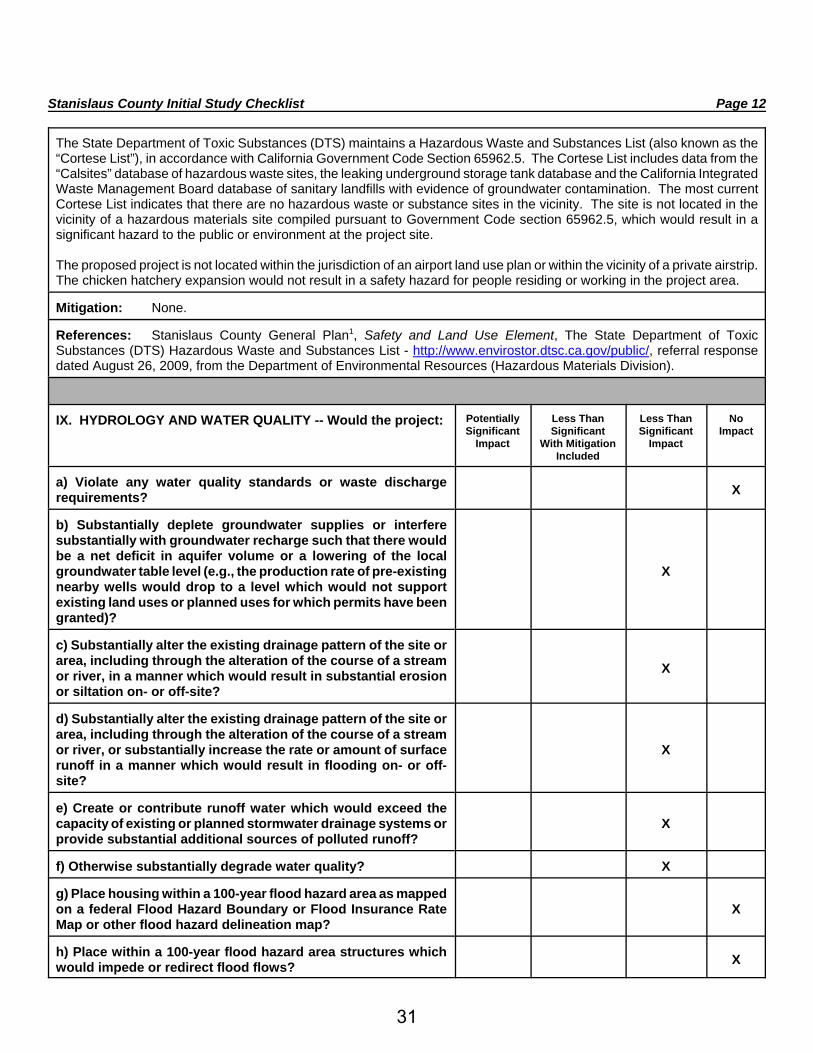
The State Department of Toxic Substances (DTS) maintains a Hazardous Waste and Substances List (also known as the“Cortese List”), in accordance with California Government Code Section 65962.5. The Cortese List includes data from the“Calsites” database of hazardous waste sites, the leaking underground storage tank database and the California IntegratedWaste Management Board database of sanitary landfills with evidence of groundwater contamination. The most currentCortese List indicates that there are no hazardous waste or substance sites in the vicinity. The site is not located in thevicinity of a hazardous materials site compiled pursuant to Government Code section 65962.5, which would result in asignificant hazard to the public or environment at the project site.
The proposed project is not located within the jurisdiction of an airport land use plan or within the vicinity of a private airstrip.The chicken hatchery expansion would not result in a safety hazard for people residing or working in the project area.
Mitigation: None.
References: Stanislaus County General Plan1, Safety and Land Use Element, The State Department of ToxicSubstances (DTS) Hazardous Waste and Substances List - http://www.envirostor.dtsc.ca.gov/public/, referral responsedated August 26, 2009, from the Department of Environmental Resources (Hazardous Materials Division).
IX. HYDROLOGY AND WATER QUALITY -- Would the project: PotentiallySignificant
Impact
Less ThanSignificant
With MitigationIncluded
Less ThanSignificant
Impact
NoImpact
a) Violate any water quality standards or waste dischargerequirements? X
b) Substantially deplete groundwater supplies or interferesubstantially with groundwater recharge such that there wouldbe a net deficit in aquifer volume or a lowering of the localgroundwater table level (e.g., the production rate of pre-existingnearby wells would drop to a level which would not supportexisting land uses or planned uses for which permits have beengranted)?
X
c) Substantially alter the existing drainage pattern of the site orarea, including through the alteration of the course of a streamor river, in a manner which would result in substantial erosionor siltation on- or off-site?
X
d) Substantially alter the existing drainage pattern of the site orarea, including through the alteration of the course of a streamor river, or substantially increase the rate or amount of surfacerunoff in a manner which would result in flooding on- or off-site?
X
e) Create or contribute runoff water which would exceed thecapacity of existing or planned stormwater drainage systems orprovide substantial additional sources of polluted runoff?
X
f) Otherwise substantially degrade water quality? X
g) Place housing within a 100-year flood hazard area as mappedon a federal Flood Hazard Boundary or Flood Insurance RateMap or other flood hazard delineation map?
X
h) Place within a 100-year flood hazard area structures whichwould impede or redirect flood flows? X
31

Stanislaus County Initial Study Checklist Page 13
I) Expose people or structures to a significant risk of loss, injuryor death involving flooding, including flooding as a result of thefailure of a levee or dam?
X
j) Inundation by seiche, tsunami, or mudflow? X
Discussion: The proposed chicken hatchery expansion will not connect to an urban water or sewer system. The watersource on-site is from groundwater from two wells, and a permitted public water system. The primary well is fitted with ahypochlorinator, which is permitted by the county. The residential structure also has a well and septic system. The mainhatchery has its own On-site Wastewater Disposal System (OSWDS). With the proposed addition, engineer design andcalculations for the OSWDS are required by DER, as the system will be upgraded. The engineered OSWDS design shallbe designed for the maximum occupancy of a building and total fixture units proposed within the building. The leach fieldshall be designed and sized using data collected from soil profile and percolation tests performed at the location. With theproposed addition, engineered plans and calculations for the existing OSWDS will be submitted to the Department. Theplans should include any addition to the fixture’s units that may require on-site wastewater to upgrade. The OSWDSdesigned system shall provide 100% expansion area. Furthermore, with the proposed expansion, on-site wastewater pondsare proposed to be upgraded to two new discharge ponds. The old pond will be abandoned with completion of the newfacility. Wastewater, groundwater geology, groundwater degradation analysis, water and well sampling, and water flowsare discussed in the Technical Report in Support of Report of Waste Discharge completed by Condor Earth Technology,Inc., dated September 2009. The proposed project will not substantially deplete groundwater supplies or interferesubstantially with groundwater recharge such that there would be a net deficit in aquifer volume or a lowering of the localgroundwater table level.
The proposed project does not include the placement of housing or other structures within the 100-year flood plain.However, the facility is 300 feet from Flood Zone A, with proximity to Dry Creek. The hatchery and reclamation fields areoutside the FEMA-designated flood plain area, and flood and river flows would not be impeded with the proposed additionto the existing facility. The project is not located in an area of major flood inundation. The proposed project would notexpose people or structures to a significant risk of loss, injury, or death involving flooding as a result of the failure of a dam.The project site is not in an area subject to seiche, tsunami, or mudflow.
Wastewater is generated at the facility by washing of incubators and hatch baskets. The wastewater is discharged into asoil-lined storm water pond found on the south side of the facility. The hatchery can divert fluids to the northern pond, aswell. Water used by the facility discharges into the 7.6-acre spray-field and then onto the 76-acre orchard. It is expectedthat the wastewater for the facility will increase due to the expansion and increase in chicks. The wastewater increase isexpected to be about six to ten percent. Based on the report by Condor Earth Technology, Inc., Technical Report in Supportof Report of Waste Discharge, the discharges from the facility have not caused any groundwater to exceed basin waterquality standards. Storm water, routed from buildings and parking areas, percolates throughout the property, but is mainlydiverted to the facility’s southern wastewater pond. After the expansion, all storm water will be diverted to the northern stormwater pond.
The RWQCB was contacted by phone on December 15, 2009. They have not determined that Waste DischargeRequirements will be required at this time. If required, the applicant will need to comply with the RWQCB Waste DischargeRequirements.
Mitigation:1. If required by the Regional Water Quality Control Board, the operator shall submit a complete Report of Waste
Discharge prior to any waste being discharged as a result of the proposed project.
References: Stanislaus County General Plan1, Safety Element, Federal Emergency Management Agency (FEMA),Technical Report in Support of Report of Waste Discharge, Condor Earth Technology, Inc., dated September 2009.
32

Stanislaus County Initial Study Checklist Page 14
X. LAND USE AND PLANNING -- Would the project: PotentiallySignificant
Impact
Less ThanSignificant
With MitigationIncluded
Less ThanSignificant
Impact
NoImpact
a) Physically divide an established community? X
b) Conflict with any applicable land use plan, policy, orregulation of an agency with jurisdiction over the project(including, but not limited to the general plan, specific plan,local coastal program, or zoning ordinance) adopted for thepurpose of avoiding or mitigating an environmental effect?
X
c) Conflict with any applicable habitat conservation plan ornatural community conservation plan? X
Discussion: The proposed project involves a Use Permit for a chicken hatchery expansion. The site is zoned A-2-40(General Agriculture) and the General Plan designation is Agriculture. The zoning of the site is consistent with the GeneralPlan land use classification. The use on the property is consistent with the County land use designation with approval ofa Use Permit for the facility. The project will not physically divide an established community to include the surroundingcommunity.
The project was submitted to the RWQCB on August 17, 2009. Staff has not received written comments from theDepartment. At this time, the RWQCB may wave the requirements depending on their review.
The project will not conflict with any applicable land use plan, policy, or regulation of any agency with jurisdiction over theproject, including but not limited to the Stanislaus County General Plan, specific plan, local coastal program, or zoningordinance adopted for the purpose of avoiding or mitigating an environmental effect. The proposed use of the project areadoes not conflict with the applicable zoning designation for the project area. The proposed project will not conflict with anapplicable habitat conservation plan or natural community conservation plan.
Mitigation: None.
References: Stanislaus County Code Title - 21 - Zoning Ordinance, Stanislaus County General Plan1, Land Use Element.
XI. MINERAL RESOURCES -- Would the project: PotentiallySignificant
Impact
Less ThanSignificant
With MitigationIncluded
Less ThanSignificant
Impact
NoImpact
a) Result in the loss of availability of a known mineral resourcethat would be of value to the region and the residents of thestate?
X
b) Result in the loss of availability of a locally-important mineralresource recovery site delineated on a local general plan,specific plan or other land use plan?
X
Discussion: The location of all commercially viable mineral resources in Stanislaus County has been mapped by theState Division of Mines and Geology in Special Report 173. There are no known significant resources on or immediatelyadjacent to the project site.
Mitigation: None.
References: Stanislaus County General Plan1, Safety and Land Use Element, State Division of Mines and GeologySpecial Report 173.
33

Stanislaus County Initial Study Checklist Page 15
XII. NOISE -- Would the project result in: PotentiallySignificant
Impact
Less ThanSignificant
With MitigationIncluded
Less ThanSignificant
Impact
NoImpact
a) Exposure of persons to or generation of noise levels inexcess of standards established in the local general plan ornoise ordinance, or applicable standards of other agencies?
X
b) Exposure of persons to or generation of excessivegroundborne vibration or groundborne noise levels? X
c) A substantial permanent increase in ambient noise levels inthe project vicinity above levels existing without the project? X
d) A substantial temporary or periodic increase in ambient noiselevels in the project vicinity above levels existing without theproject?
X
e) For a project located within an airport land use plan or, wheresuch a plan has not been adopted, within two miles of a publicairport or public use airport, would the project expose peopleresiding or working in the project area to excessive noiselevels?
X
f) For a project within the vicinity of a private airstrip, would theproject expose people residing or working in the project area toexcessive noise levels?
X
Discussion: The General Plan identifies 75 Ldn as the normally acceptable level of noise for agriculture, and othersimilar land uses. Noise impacts associated with on-site activities and associated traffic are not anticipated to exceed thenormally acceptable level of noise. On-site improvements and construction may temporarily increase ambient noise levels.Conditions of approval will be added to address potential impacts associated with noise.
Mitigation: None.
References: Stanislaus County General Plan1, Noise Element.
XIII. POPULATION AND HOUSING -- Would the project: PotentiallySignificant
Impact
Less ThanSignificant
With MitigationIncluded
Less ThanSignificant
Impact
NoImpact
a) Induce substantial population growth in an area, eitherdirectly (for example, by proposing new homes and businesses)or indirectly (for example, through extension of roads or otherinfrastructure)?
X
b) Displace substantial numbers of existing housing,necessitating the construction of replacement housingelsewhere?
X
c) Displace substantial numbers of people, necessitating theconstruction of replacement housing elsewhere? X
Discussion: The proposed use of the site will not create significant service extensions or new infrastructure that couldbe considered growth inducing. No housing or persons will be displaced by the project. The proposed project does notinclude the displacement of existing housing.
34
Stanislaus County Initial Study Checklist Page 16
Mitigation: None.
References: Stanislaus County General Plan1, Housing Element.
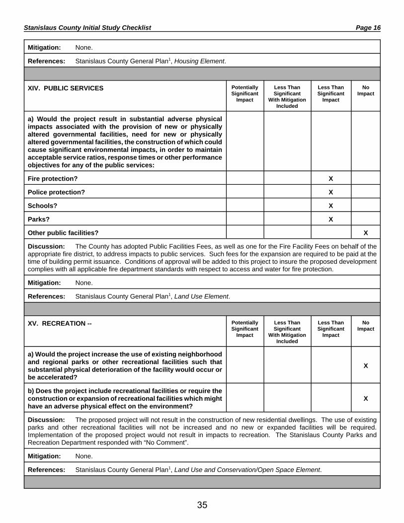
XIV. PUBLIC SERVICES PotentiallySignificant
Impact
Less ThanSignificant
With MitigationIncluded
Less ThanSignificant
Impact
NoImpact
a) Would the project result in substantial adverse physicalimpacts associated with the provision of new or physicallyaltered governmental facilities, need for new or physicallyaltered governmental facilities, the construction of which couldcause significant environmental impacts, in order to maintainacceptable service ratios, response times or other performanceobjectives for any of the public services:
Fire protection? X
Police protection? X
Schools? X
Parks? X
Other public facilities? X
Discussion: The County has adopted Public Facilities Fees, as well as one for the Fire Facility Fees on behalf of theappropriate fire district, to address impacts to public services. Such fees for the expansion are required to be paid at thetime of building permit issuance. Conditions of approval will be added to this project to insure the proposed developmentcomplies with all applicable fire department standards with respect to access and water for fire protection.
Mitigation: None.
References: Stanislaus County General Plan1, Land Use Element.
XV. RECREATION -- PotentiallySignificant
Impact
Less ThanSignificant
With MitigationIncluded
Less ThanSignificant
Impact
NoImpact
a) Would the project increase the use of existing neighborhoodand regional parks or other recreational facilities such thatsubstantial physical deterioration of the facility would occur orbe accelerated?
X
b) Does the project include recreational facilities or require theconstruction or expansion of recreational facilities which mighthave an adverse physical effect on the environment?
X
Discussion: The proposed project will not result in the construction of new residential dwellings. The use of existingparks and other recreational facilities will not be increased and no new or expanded facilities will be required.Implementation of the proposed project would not result in impacts to recreation. The Stanislaus County Parks andRecreation Department responded with “No Comment”.
Mitigation: None.
References: Stanislaus County General Plan1, Land Use and Conservation/Open Space Element.
35

Stanislaus County Initial Study Checklist Page 17
XVI. TRANSPORTATION/TRAFFIC -- Would the project: PotentiallySignificant
Impact
Less ThanSignificant
With MitigationIncluded
Less ThanSignificant
Impact
NoImpact
a) Conflict with an applicable plan, ordinance or policyestablishing measures of effectiveness for the performance ofthe circulation system, taking into account all modes oftransportation including mass transit and non-motorized traveland relevant components of the circulation system, includingbut not limited to intersections, streets, highways and freeways,pedestrian and bicycle paths, and mass transit?
X
b) Conflict with an applicable congestion management program,including, but not limited to level of service standards and traveldemand measures, or other standards established by the countycongestion management agency for designated roads orhighways?
X
c) Result in a change in air traffic patterns, including either anincrease in traffic levels or a change in location that results insubstantial safety risks?
X
d) Substantially increase hazards due to a design feature (e.g.,sharp curves or dangerous intersections) or incompatible uses(e.g., farm equipment)?
X
e) Result in inadequate emergency access? X
f) Conflict with adopted policies, plans, or programs regardingpublic transit, bicycle, or pedestrian facilities, or otherwisedecrease the performance or safety of such facilities?
X
Discussion: The Stanislaus County Department of Public Works and CalTrans have reviewed this project. CalTransdid not comment on the project. The proposed project will not increase the trip generation along adjacent streets andintersections, notably Ellenwood Road. The project will be conditioned to assure that all project related impacts are reducedto a level deemed to be less than significant. Any design improvements will be considered in accordance with CountyStandards and Specifications, and shall be approved by the Department of Public Works prior to development. TheDepartment of Public Works has not identified any significant traffic impacts to local County roads associated with thisproject. No mitigation or environmental concerns have been raised.
The proposed project will not conflict with any plans related to alternative transportation.
According to the Stanislaus Fire Prevention Bureau, the proposed project will not impair the District’s ability to access theproposed project during emergencies.
The project will not impair any air traffic patterns associated with flights departing and arriving into a municipal airport.
Mitigation: None.
References: Stanislaus County General Plan1, Circulation Element, referral response dated September 16, 2009, fromthe Department of Public Works.
36
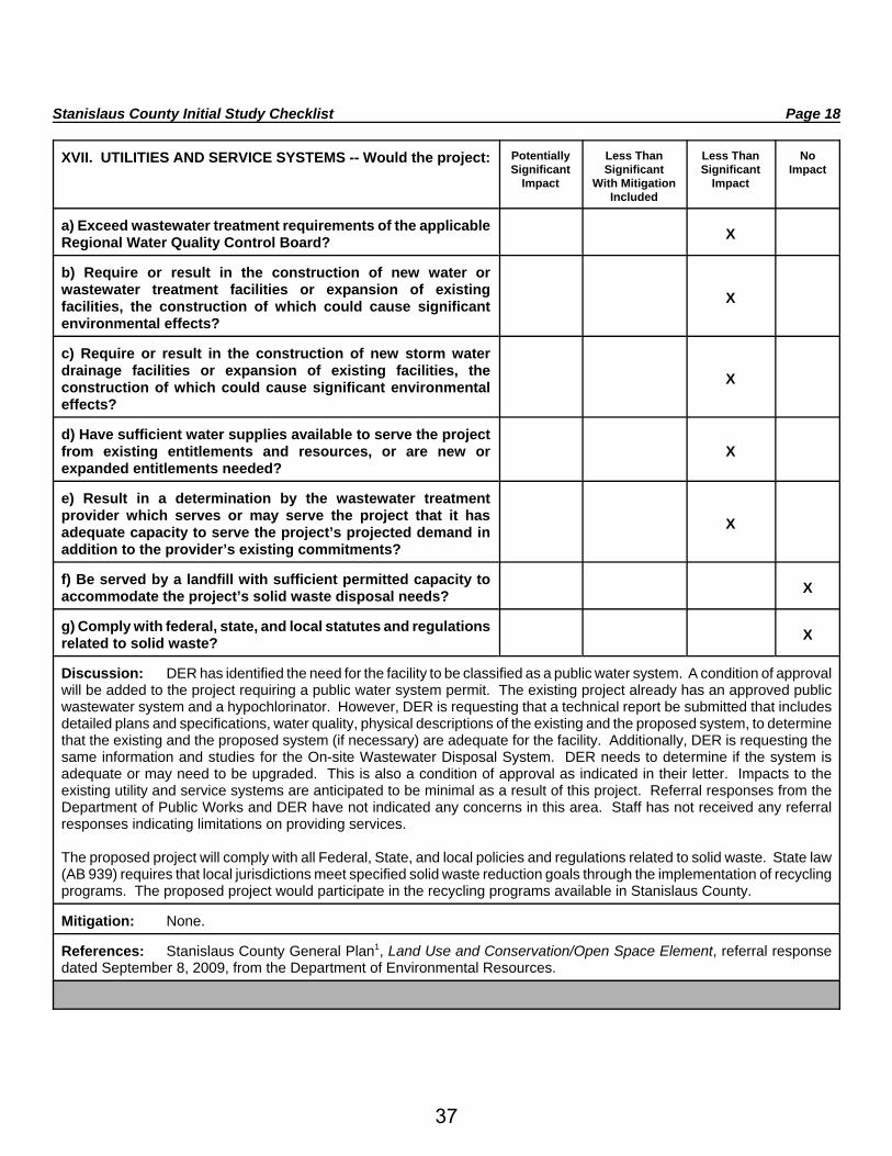
Stanislaus County Initial Study Checklist Page 18
XVII. UTILITIES AND SERVICE SYSTEMS -- Would the project: PotentiallySignificant
Impact
Less ThanSignificant
With MitigationIncluded
Less ThanSignificant
Impact
NoImpact
a) Exceed wastewater treatment requirements of the applicableRegional Water Quality Control Board? X
b) Require or result in the construction of new water orwastewater treatment facilities or expansion of existingfacilities, the construction of which could cause significantenvironmental effects?
X
c) Require or result in the construction of new storm waterdrainage facilities or expansion of existing facilities, theconstruction of which could cause significant environmentaleffects?
X
d) Have sufficient water supplies available to serve the projectfrom existing entitlements and resources, or are new orexpanded entitlements needed?
X
e) Result in a determination by the wastewater treatmentprovider which serves or may serve the project that it hasadequate capacity to serve the project’s projected demand inaddition to the provider’s existing commitments?
X
f) Be served by a landfill with sufficient permitted capacity toaccommodate the project’s solid waste disposal needs? X
g) Comply with federal, state, and local statutes and regulationsrelated to solid waste? X
Discussion: DER has identified the need for the facility to be classified as a public water system. A condition of approvalwill be added to the project requiring a public water system permit. The existing project already has an approved publicwastewater system and a hypochlorinator. However, DER is requesting that a technical report be submitted that includesdetailed plans and specifications, water quality, physical descriptions of the existing and the proposed system, to determinethat the existing and the proposed system (if necessary) are adequate for the facility. Additionally, DER is requesting thesame information and studies for the On-site Wastewater Disposal System. DER needs to determine if the system isadequate or may need to be upgraded. This is also a condition of approval as indicated in their letter. Impacts to theexisting utility and service systems are anticipated to be minimal as a result of this project. Referral responses from theDepartment of Public Works and DER have not indicated any concerns in this area. Staff has not received any referralresponses indicating limitations on providing services.
The proposed project will comply with all Federal, State, and local policies and regulations related to solid waste. State law(AB 939) requires that local jurisdictions meet specified solid waste reduction goals through the implementation of recyclingprograms. The proposed project would participate in the recycling programs available in Stanislaus County.
Mitigation: None.
References: Stanislaus County General Plan1, Land Use and Conservation/Open Space Element, referral responsedated September 8, 2009, from the Department of Environmental Resources.
37

Stanislaus County Initial Study Checklist Page 19
XVIII. MANDATORY FINDINGS OF SIGNIFICANCE -- PotentiallySignificant
Impact
Less ThanSignificant
With MitigationIncluded
Less ThanSignificant
Impact
NoImpact
a) Does the project have the potential to degrade the quality ofthe environment, substantially reduce the habitat of a fish orwildlife species, cause a fish or wildlife population to dropbelow self-sustaining levels, threaten to eliminate a plant oranimal community, reduce the number or restrict the range of arare or endangered plant or animal or eliminate importantexamples of the major periods of California history orprehistory?
X
b) Does the project have impacts that are individually limited,but cumulatively considerable? (“Cumulatively considerable”means that the incremental effects of a project are considerablewhen viewed in connection with the effects of past projects, theeffects of other current projects, and the effects of probablefuture projects)?
X
c) Does the project have environmental effects which will causesubstantial adverse effects on human beings, either directly orindirectly?
X
Discussion: Review of this project has not indicated any features which might significantly impact the environmentalquality of the site and/or the surrounding area. Any potential impacts from this project have been mitigated to a level of lessthan significant.
I:\Staffrpt\UP\2009\UP 2009-16 - Foster Farms - Ellenwood\Initial Study - Foster Farms.wpd
1Stanislaus County General Plan and Support Documentation adopted in October 1994, as amended. Optional andupdated elements of the General Plan and Support Documentation: Agricultural Element adopted on December 18, 2007;Housing Element adopted on December 12, 2003 and certified by the California Department of Housing and CommunityDevelopment Department on March 26, 2004; Circulation Element and Noise Element adopted on April 18, 2006.
38

MITIGATED NEGATIVE DECLARATION
NAME OF PROJECT: Use Permit Application No. 2009-16 - Foster Farms -Ellenwood
LOCATION OF PROJECT: West of Ellenwood Road and 700 feet north of the OakdaleWaterford Highway, at 1309 Ellenwood Road, in theWaterford area. APN: 015-003-012, 015-056-007,015-056-008, 015-056-010, 015-056-011
PROJECT DEVELOPER: Bob MillerFoster Farms520 C StreetTurlock, CA 95380
DESCRIPTION OF PROJECT: Request to expand the existing Foster Farms - Ellenwoodchicken hatchery by 29,713 square feet on a 112± acre site in the A-2-40 (General Agriculture)zoning district.
Based upon the Initial Study, dated January 25, 2010, the Environmental Coordinator finds asfollows:
1. This project does not have the potential to degrade the quality of the environment, nor tocurtail the diversity of the environment.
2. This project will not have a detrimental effect upon either short-term or long-termenvironmental goals.
3. This project will not have impacts which are individually limited but cumulativelyconsiderable.
4. This project will not have environmental impacts which will cause substantial adverseeffects upon human beings, either directly or indirectly.
The aforementioned findings are contingent upon the following mitigation measures (if indicated)which shall be incorporated into this project:
1. If required by the Regional Water Quality Control Board, the operator shall submit acomplete Report of Waste Discharge prior to any waste being discharged as a result of theproposed project.
The Initial Study and other environmental documents are available for public review at theDepartment of Planning and Community Development, 1010 10th Street, Suite 3400, Modesto,California.
Initial Study prepared by: Sean Purciel, Associate Planner
Submit comments to: Stanislaus CountyPlanning and Community Development Department1010 10th Street, Suite 3400Modesto, California 95354
(I:\Staffrpt\UP\2009\UP 2009-16 - Foster Farms - Ellenwood\Mitigated Negative Declaration.wpd)
39

Stanislaus CountyPlanning and Community Development
1010 10th Street, Suite 3400 Phone: (209) 525-6330Modesto, CA 95354 Fax: (209) 525-5911
Mitigation Monitoring PlanAdapted from CEQA Guidelines sec. 15097 Final Text, October 26, 1998
January 25, 20101. Project title and location: Use Permit Application No. 2009-16 - Foster
Farms - Ellenwood
West of Ellenwood Road and 700 feet north of theOakdale Waterford Highway, at 1309 EllenwoodRoad, in the Waterford area. APN: 015-003-012,015-056-007, 015-056-008, 015-056-010,015-056-011
2. Project Applicant name and address: Bob MillerFoster Farms520 C StreetTurlock, CA 95380
3. Person Responsible for Implementing Mitigation Program (Applicant Representative): Bob Miller
4. Contact person at County: Sean Purciel, Associate Planner (209) 525-6330
MITIGATION MEASURES AND MONITORING PROGRAM:
List all Mitigation Measures by topic as identified in the Mitigated Negative Declaration and complete the formfor each measure.
VIII. HYDROLOGY AND WATER QUALITY
No. 1 Mitigation Measure: If required by the Regional Water Quality Control Board, the operator shallsubmit a complete Report of Waste Discharge prior to any waste beingdischarged as a result of the proposed project.
Who Implements the Measure: Applicant
When should the measure be implemented: Ongoing
When should it be completed: Ongoing
Who verifies compliance: Stanislaus County Department of Planning &Community Development
Other Responsible Agencies: Regional Water Quality Control Board
40

Stanislaus County Mitigation Monitoring Plan Page 2Use Permit Application No. 2009-16 - Foster Farms - Ellenwood January 25, 2010
I, the undersigned, do hereby certify that I understand and agree to be responsible for implementing theMitigation Program for the above listed project.
Signature on file. January 25, 2010Person Responsible for Implementing DateMitigation Program
(I:\Staffrpt\UP\2009\UP 2009-16 - Foster Farms - Ellenwood\Mitigation Monitoring Plan.wpd)
41

42
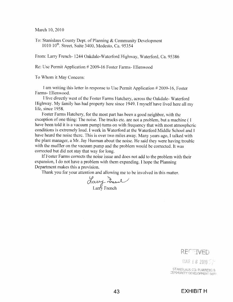
43

44
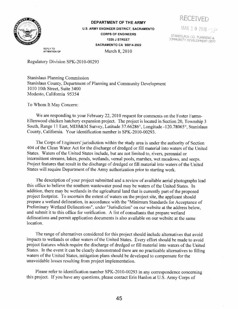
45

46
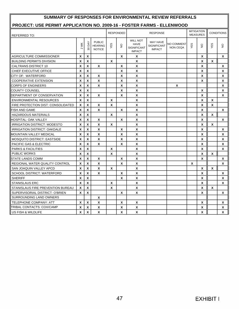
PROJECT: USE PERMIT APPLICATION NO. 2009-16 - FOSTER FARMS - ELLENWOOD
REFERRED TO:
2 W
K
30 D
AY PUBLIC HEARING NOTICE YE
S
NO
WILL NOT HAVE
SIGNIFICANT IMPACT
MAY HAVE SIGNIFICANT
IMPACT
NO COMMENT NON CEQA YE
S
NO
YES
NO
AGRICULTURE COMMISSIONER X X X X X X BUILDING PERMITS DIVISION X X X X X X CALTRANS DISTRICT 10 X X X X X X X CHIEF EXECUTIVE OFFICE X X X X X XCITY OF: WATERFORD X X X X X X X COOPERATIVE EXTENSION X X X X X X XCORPS OF ENGINEERS X X X X X X XCOUNTY COUNSEL X X X X X XDEPARTMENT OF CONSERVATION X X X X X X X ENVIRONMENTAL RESOURCES X X X X X X FIRE PROTECTION DIST: CONSOLIDATED X X X X X X XFISH AND GAME X X X X X X X HAZARDOUS MATERIALS X X X X X XHOSPITAL: OAK VALLEY X X X X X X X IRRIGATION DISTRICT: MODESTO X X X X X X X IRRIGATION DISTRICT: OAKDALE X X X X X X XMOUNTAIN VALLEY MEDICAL X X X X X X X MOSQUITO DISTRICT: EASTSIDE X X X X X X X PACIFIC GAS & ELECTRIC X X X X X X X PARKS & FACILITIES X X X X X X PUBLIC WORKS X X X X X XSTATE LANDS COMM X X X X X X X REGIONAL WATER QUALITY CONTROL X X X X X X X SAN JOAQUIN VALLEY APCD X X X X X X X SCHOOL DISTRICT: WATERFORD X X X X X X X SHERIFF X X X X X X STANISLAUS ERC X X X X X X STANISLAUS FIRE PREVENTION BUREAU X X X X X X SUPERVISORIAL DISTRICT: O'BRIEN X X X X X X SURROUNDING LAND OWNERS X TELEPHONE COMPANY: ATT X X X X X X XTRIBAL CONTACTS: COX/CAMP X X X X X X X US FISH & WILDLIFE X X X X X X X
SUMMARY OF RESPONSES FOR ENVIRONMENTAL REVIEW REFERRALS
RESPONDED RESPONSE MITIGATION MEASURES CONDITIONS
47