Standard for Digital Stormwater System Data ... - Metro GIS
69
STANDARD FOR DIGITAL STORMWATER SYSTEM DATA EXCHANGE PILOT PROJECT Carrie Mack GIS Technician Ramsey-Washington Metro Watershed District Little Canada, MN 55117 [email protected] Jane Onorati GIS Services Coordinator Minnesota Pollution Control Agency St. Paul, MN 55155 [email protected]
Transcript of Standard for Digital Stormwater System Data ... - Metro GIS

STANDARD FOR DIGITAL STORMWATER SYSTEM
DATA EXCHANGE PILOT PROJECT
Carrie Mack GIS Technician
Ramsey-Washington Metro Watershed District Little Canada, MN 55117 [email protected]
Jane Onorati
GIS Services Coordinator Minnesota Pollution Control Agency
St. Paul, MN 55155 [email protected]

Standard for Digital Stormwater System Data Exchange
Pilot Project Report – December 31, 2010
Table of Contents
RWMWD | Prepared by C. Mack and J. Onorati i
2.
3.
4.
5.
7.
ABSTRACT ............................................................................................................................... iii
1. INTRODUCTION ................................................................................................................... 1
Why an Exchange Standard ................................................................................................. 1
Anticipated Applications ....................................................................................................... 1
Stormwater Standard Development Workgroup ........................................................... 1
Current Status of Standard ................................................................................................... 2
PILOT PROJECT DESCRIPTION ...................................................................................... 2
Objectives ................................................................................................................................... 2
Contract and Scope ................................................................................................................. 2
PRODUCER DATA COLLECTION .................................................................................. 3
Macro Study Area Location .................................................................................................. 3
Data Collection Process ......................................................................................................... 4
Description/Evaluation of Data Collected ........................................................................ 4
Obstacles to Data Collection and Sharing ........................................................................ 5
Selection of Micro Study Area .............................................................................................. 5
PRODUCER DATA MIGRATION ..................................................................................... 6
Standard Geodatabase Template Creation ....................................................................... 6
Migration Preparation ............................................................................................................ 6
Schema Migration Process .................................................................................................... 7
PRODUCER DATA GEOMETRY EDITING .................................................................. 7
Create Topology and Correct Errors .................................................................................. 7
Create Geometric Network as a Final Check .................................................................. 9
6. ANALYSIS – LESSONS LEARNED .................................................................................... 9
About Data Collected ............................................................................................................. 9
Interpretation of Standard .................................................................................................... 10
Data Migration to Standard .................................................................................................. 10
Data Producer Feedback ........................................................................................................ 11
Usability Evaluation ................................................................................................................ 12
RECOMMENDATIONS ........................................................................................................ 12
Objectives ................................................................................................................................... 12
Standard Data Model: Recommendations for Features and Attributes .................. 13
Standard Data Model: Recommendations for Geometry .............................................. 15

Standard for Digital Stormwater System Data Exchange
Pilot Project Report – December 31, 2010
Table of Contents
RWMWD | Prepared by C. Mack and J. Onorati ii
9.
Standard: Other Recommendations ....................................................................................16
8. CONCLUSIONS .......................................................................................................................16
Potential Value of the Standard ............................................................................................16
Next Steps ..................................................................................................................................17
APPENDIXES ............................................................................................................................18
SDSSDE Data Model (Features and Attributes) ..............................................................18
Recommendation Table ..........................................................................................................25
Migration Report – General Notes ......................................................................................32
Migration Report – Landfall ..................................................................................................34
Migration Report – Maplewood ..........................................................................................35
Migration Report – MnDOT .................................................................................................41
Migration Report – North St. Paul ......................................................................................47
Migration Report – Oakdale .................................................................................................51
Migration Report – St. Paul ...................................................................................................55
Migration Report – Woodbury ............................................................................................62

Standard for Digital Stormwater System Data Exchange
Pilot Project Abstract – December 31, 2010
RWMWD | Prepared by C. Mack and J. Onorati iii
Elements of a stormwater utility system are owned and maintained by multiple entities even within a single municipal boundary. Accurate asset management of these systems is vital for operations and maintenance procedures as well as for modeling, land management and community planning. While each entity maintains their own digital or hard copy records of this system in a way that best suits their business needs, problems arise when overlapping or adjacent systems need to be viewed simultaneously in situations such as emergency spill response. The Standard for Digital Stormwater System Data Exchange (“Standard”) was developed to address this need by standardizing a framework to facilitate digital compilation of multijurisdictional datasets. The pilot project discussed here is the first test application of the provisional Standard.
Digital stormwater data was collected from eleven entities within and around the Ramsey-Washington Metro Watershed District in Minnesota. Battle Creek Subwatershed was selected as a suitable micro analysis area because of its inclusion of multiple contributing cities, counties and existence of major freeway systems. Producer data were found to have a variety of issues including incomplete/missing data, inconsistent attributes, lack of connectivity, lack of directionality, and lack of metadata. These data had to be individually evaluated and manually migrated to the Standard schema because each data producer had developed a unique data model. Following the schema conversion, a topology was created for the combined dataset and a geometric network was made to check and illustrate connectivity. This compiled dataset underwent a usability assessment by a pilot project coordinating committee and was viewed by interested data producers who gave feedback and contributed to recommendations for edits to the Standard. Proposed recommendations outlined in this report were submitted to the Standard Development Committee for review.
Compliance with a revised stormwater data exchange standard has great potential to serve needs of a diverse group of producers and users involved in surface water resource planning, management, analysis, and regulation without placing undue burden on data producers. For the Standard to be widely accepted and usable, some modifications are recommended including but not limited to: 1) changes to feature class aggregation, 2) revisions to domain restrictions, 3) improved definitions for attributes, feature classes, compliance and exchange formats. Cooperation with data producers will be imperative to the success of any Standard.

Standard for Digital Stormwater System Data Exchange
Pilot Project Report – December 31, 2010
RWMWD | Prepared by C. Mack and J. Onorati 1
1. Introduction
1.1. Why an Exchange Standard is needed
Elements of a stormwater utility system (pipes, catch basins, outfalls etc) are owned and maintained by multiple entities even within a single municipal boundary. These entities – cities, watershed districts, universities, transportation authorities, etc – use stormwater system data in a variety of ways including engineering, project management, and stormwater management/planning. Public Works departments rely on this information for asset management and maintenance of these infrastructure elements.
Each entity maintains their own digital or hard copy records of this system in a way that best suits their needs. This practice of using an individualized framework causes problems when digital data is shared with overlapping or peripheral entities in an effort to view or model system connections. Variability in feature representation, attribute inconsistencies, and synonymous terminology restrict benefits of data integration. The Standard for Digital Stormwater System Data Exchange (“Standard”) was created to mediate this problem by standardizing a framework to facilitate digital compilation of multiple datasets.
This need was also recognized in a recent study looking at updated mapping for metro area hydrography; “Recommendations for future improvements to the process [of mapping local hydrology including subsurface drainage information] include: 1) address data quality and inconsistency issues of locally generated data by developing and promoting a simplified GIS data standard and tools for local data generators.” (Kloiber and Hinz 2008 NHD study, http://www.metrocouncil.org/planning/environment/NHDupdateTCMA.pdf).
1.2. Anticipated applications
If successfully adopted by multiple agencies, current, complete and connected datasets would have wide-ranging applications. Because municipal boundaries were not developed based on water flow, and stormwater does not heed political boundaries, an accurate assessment for any multijurisdictional stormwater plan would need to consider multiple datasets. Emergency response, water quality management, project scoping, and permit regulation, are just a few predicted uses outlined in the Standard.
This pilot project was completed by an urban watershed district in Minnesota with specific business needs for such a data set. A completed stormwater utility map in this instance could be used to more easily track sediment plumes to construction sites, assess at-risk water bodies in cases of roadway spills, or aid in District-wide MS4 permitting, Illicit Discharge Detection and Elimination (http://cfpub.epa.gov/npdes/stormwater/idde.cfm), National Pollutant Discharge Elimination System permit compliance (http://cfpub.epa.gov/npdes/), or Total Maximum Daily Loads studies (http://water.epa.gov/lawsregs/lawsguidance/cwa/tmdl/index.cfm).
1.3. Stormwater Standard development workgroup
The Standard was developed by a diverse group of representatives from state, regional and local governments as well as private sector engineering firms. The intent was to construct a simplified framework that would represent key components of a connected stormwater system while complying with their individual business needs and work flow.

Standard for Digital Stormwater System Data Exchange
Pilot Project Report – December 31, 2010
RWMWD | Prepared by C. Mack and J. Onorati 2
Over a two year period, the Standard and a more detailed support document were developed, reviewed, revised, and deemed “provisional.” The provisional Standard was reviewed by the state MnGeo Standards Committee and made available for public review. The pilot project presented in this report is the first test application of the Standard.
1.4. Current status of Standard
Following the process described above, the MnGeo Standards Committee reviewed the completed draft Standard on July 19th, 2010 and then approved it for public review. The deadline for comments was December 15, 2010. Following the review phase and subsequent revisions, a revised Standard will go back to the MnGeo Standards Committee to be noticed and ultimately to seek approval (http://www.mngeo.state.mn.us/committee/standards/index.html).
2. Pilot Project Description
2.1. Objectives The pilot project, managed by the Ramsey-Washington Metro Watershed District (“RWMWD”), aimed to test the application of the Standard using data from local government producers, find and address possible issues with the Standard, assess the impact of using the Standard on data producers, and assess usability of datasets in Standard format when combined. The intent of the pilot project was to dissect representative samples of dataset formats/characteristics including major metro freeway systems, demonstrate how these datasets can be converted to the exchange standard format, and to substantiate integration and application of converted datasets.
2.2. Contract and scope
2.2.1. Contract An interagency agreement was entered into by and between RWMWD and the Metropolitan Council in September 2010, to test the Standard as outlined by the Scope of Services (2.2.2). The maximum contract amount was set at $10,000 to comply with the objectives, deliverables, timelines and estimated budget outlined in the contract agreement. The date of contract expiration was set at December 31, 2010 at which time a final report and combined dataset were submitted to Met Council and the MetroGIS Coordinating Committee.
2.2.2. Scope of Services The scope of this pilot project was to complete the stated objectives at a subwatershed scale by collecting, migrating and combining samples of data from organizations (cities, counties, MnDOT) and assessing the usability at this scale. Observations from this process, as outlined in this final report, were intended to guide revisions of the draft Standard and develop tools and suggestions for organizations interested in implementing the Standard.
2.2.3. Oversight A Coordinating Committee was assembled at the outset of this pilot project to guide decision making, monitor progress, and conduct usability assessment on the final combined dataset. This group, composed of representatives from the Standard development workgroup, Met

Standard for Digital Stormwater System Data Exchange
Pilot Project Report – December 31, 2010
RWMWD | Prepared by C. Mack and J. Onorati
Council, and data contributors, met once at the outset and again near the completion of the project.
3. Producer Data Collection
3.1. Macro study area location
The macro analysis requirements defined in the Standard Pilot Project Scope of Work required the contracted entity to include in their data sample a variety of organizations, including at least two cities, one or more counties and other applicable agencies such as MnDOT. All organizations had to be within the 7-county Twin Cities Metro area.
The area defined and projected outcomes made the Ramsey Washington Metro Watershed District a suitable candidate for the macro scale analysis. RWMWD is a special purpose unit of government responsible for protecting surface water resources. Within the 56 square mile legal boundary are all or part of 10 cities in Ramsey and Washington Counties. The watershed includes five major creeks, eleven lakes, thousands of wetlands, and six subwatersheds that drain to the Mississippi River.
3
Figure 1: The Ramsey-Washington Metro Watershed District

Standard for Digital Stormwater System Data Exchange
Pilot Project Report – December 31, 2010
RWMWD | Prepared by C. Mack and J. Onorati
3.2. Data collection process
Data requests were initially sent to municipalities within or bordering RWMWD in September 2010. Response and data format received are summarized in Table 1 below.
City/Organization Date of data delivery Data delivery format ArcGIS format
Gem Lake/White Bear Township NA NA NA Landfall 10/27/2010 Paper NA Little Canada NA NA NA Maplewood 9/2/2010 GIS Geodatabase MnDOT 9/24/2010 GIS Geodatabase North St. Paul 9/23/2010 GIS Shapefile Oakdale 9/7/2010 GIS Shapefile Ramsey County 9/27/2010 GIS Geodatabase Roseville 9/17/2010 GIS Geodatabase Shoreview 9/8/2010 GIS Geodatabase St. Paul 10/21/2010 GIS Shapefile Vadnais Heights 10/13/2010 GIS Geodatabase Washington County NA NA NA White Bear Lake 9/20/2010 GIS Shapefile
Table 1: Inventory of data requests and response from entities within or bordering RWMWD; “NA” indicates municipalities that were contacted but data could not be acquired.
3.3. Description/evaluation of data collected
As shown in Table 1, the predominant data delivery format were ArcGIS native formats. The data submitted by one agency in the form of a paper stormwater utility map was georeferenced as part of the pilot project using ArcGIS, and features were digitized directly into geodatabase/feature class format. Source data was shared with RWMWD by CD, zip file, fax, utilizing FTP sites and online file hosting (Wiggio).
Most if not all contributing agencies indicated that their data was incomplete and/or unverified. ‘Incomplete’ data indicated that data had been aggregated from CAD, paper maps, or earlier versions of ArcGIS, and were in a stage of transition to shapefile or geodatabase format. Sources indicating their shared data were ‘unverified’ referenced MS4 permit requirements for verifying a percentage of stormwater devices each year (http://www.pca.state.mn.us/publications/wq-strm4-51.pdf). For these reasons, data contained in final pilot project combined data set should be considered a static snapshot of source data from the data delivery date listed in Table 1.
4

Standard for Digital Stormwater System Data Exchange
Pilot Project Report – December 31, 2010
RWMWD | Prepared by C. Mack and J. Onorati 5
Other general observations of source data:
Two agencies required that a formal request be made and agreements regarding use be signed.
Metadata was not provided for all but one data set.
Connectivity was incomplete in all but one data set.
Gaps observed in data supported producer statements regarding missing features and/or incomplete data.
Attribute data was incomplete within several individual datasets.
All contributing agencies maintained common system features (e.g. pipes and catch basins), but methods of data organization varied greatly.
3.4. Obstacles to data collection and sharing
Collecting source data and disseminating migrated data for usability assessment exposed immediate limitations with data sharing. Source data problems initiated with finding the appropriate contact for acquiring the data. City Engineers, GIS Specialists, Consulting Engineers, Public Works Managers and even Parks Managers were eventual sources for stormwater system information. Email restrictions in place for security also posed a problem by limiting file size and formats (.zip).
Sharing migrated data posed further problems with software incompatibility. The completed dataset was compiled in ArcGIS v.10 and published to a map package, but map packages can only be opened with ArcGIS v.10. It was determined that most data producers and members of the coordinating committee had v. 9.3.0 or higher and deliverables would have to be reformatted as such. While the Standard does not indicate what formats shared data should be in, compatibility limitations would be minimized by assuming most entities require data readable by ArcGIS v.9x or higher.
3.5. Selection of micro study area
Because the nature of the project was to assess stormwater flow, a subwatershed boundary (rather than a political or arbitrary area of interest) was determined to be an appropriate extent. The Battle Creek Subwatershed (HUC 070102060805) is completely within RMWWD and has a land area of approximately 7122 acres. The region is centered north of St. Paul and includes five municipalities (Landfall, Maplewood, Oakdale, St. Paul and Woodbury), two counties (Ramsey and Washington), and major highways and interstates (I-94, I-494/694, Hwy 120). This area was selected as a suitable micro analysis area because these factors conformed to the desired scope and because data producer contribution was contiguous.

Standard for Digital Stormwater System Data Exchange
Pilot Project Report – December 31, 2010
RWMWD | Prepared by C. Mack and J. Onorati 6
4. Producer Data Migration
Figure 2: The Battle Creek Subwatershed
4.1. Standard geodatabase template creation
Before converting collected data in the micro test area to Standard format, it was necessary to understand the design of the Standard data model and the structure and content of each dataset. In addition to the Standard, a support document had been developed by the originators of the Standard as a supplement to provide examples, additional detail, and guidance. The pilot project team studied both documents and then created a file geodatabase containing the feature classes, attribute fields, and domains specified. This was not as straightforward a task as might be expected as the two documents did not agree on every specification. Therefore, it was decided to regard the Standard as the ultimate authority and only use the Support document if needed information was not available in the Standard. The Standard lists all feature classes and descriptions, attribute fields and descriptions, data types, and domains. However, only the Support document contained shapefile-compliant field names and field lengths. One additional field not contained in the Standard was added to the file geodatabase to store data source information.
4.2. Migration preparation
Examination of the data revealed that each data producer had developed a unique data model for storage of their stormwater drainage system data. From discussions with data producers and engineering consultants, it was learned that the primary concern for system owner/operators typically based in public works departments is maintenance and improvement of their systems. Decisions on database design and data collection have traditionally been made based on serving those foundational needs. Over the last few decades, those needs have been expanded to include such things as asset management for financial reporting, hydraulic and hydrologic modeling for

Standard for Digital Stormwater System Data Exchange
Pilot Project Report – December 31, 2010
RWMWD | Prepared by C. Mack and J. Onorati 7
new construction or system modifications, and tracking and reporting to comply with environmental regulations. The way in which this data was collected and stored before it came to exist in GIS format was sometimes evident, with a noticeable effect on attributes and to a lesser extent in some cases, geometry. For example, several datasets had field names that are found in AutoCAD formatted drawing files.
Because of this diversity of data models, no two data sets could be migrated in the same way. The project team first examined each dataset, determined which features and attributes could be migrated, and determined what field value conversions would be required to comply with Standard domain values. This information was recorded in migration crosswalk tables for each dataset (included in the Appendix), which were used to guide migration work and also to communicate with data producers on how their schemas were transformed. In order to identify needed value conversions and anticipate possible problems for migration, data types and field lengths were compared between source and destination fields, and in some cases the maximum length of values in fields had to be determined. Also the fields had to be summarized to find out what values existed to determine appropriate conversions. Some of this work may have been avoided if good metadata had been provided or there had been more time to consult with data producers regarding their data. Data producers familiar with their data would not be expected to spend as much time analyzing it. However, this could depend on the size and complexity of the dataset, the rules implemented for data integrity/validation, and the extent to which the data had been checked for errors.
4.3. Schema migration process
Once it was determined how producer data should be migrated, new Standard fields were added to working copies of each source dataset, and then field calculations were performed to populate them from the previously identified source fields within the dataset. Migration of the data to an empty Standard file geodatabase was accomplished by importing data from each source data working copy into destination Standard feature classes using the geoprocessing tools: Merge (if schemas were first made identical) or Append (using the No-Test option for non-identical schemas).
5. Producer Data Geometry Editing
5.1. Create topology and correct errors
In addition to providing specifications for features to be included and their attributes, the Standard also contains specifications for the topology and directionality of line features. Individual line features that represent connected real-world conduits should be coincident at endpoints, and directionality (based on start and end point) should be the same as the predominant flow direction that occurs in the conduits. Also, to complete connectivity of the system, the Standard includes line features called Artificial Paths to provide connectors where flow moves through two-dimensional (on a map) surface waters. This construct is also applied in the National Hydrography Dataset's Flowline feature (http://nhd.usgs.gov/). These specifications can expand functionality of the data beyond just the ability to show locations and spatial relationships of objects. A properly connected network of features representing stormwater pipes, ditches and streams can be used to model the behavior of a constructed stormwater drainage system integrated with natural surface waters.

Standard for Digital Stormwater System Data Exchange
Pilot Project Report – December 31, 2010
RWMWD | Prepared by C. Mack and J. Onorati 8
The work to enforce topology and directionality specifications for the migrated source data was the most time-consuming and tedious part of the project. The project team's objective of creating a completely integrated and connected dataset out of six individual datasets covering the micro project area was not achieved due to limited time constraints of the project. If the time requirement for this task had been understood at the outset, a smaller, yet more compliant dataset would have been opted for to provide a good demonstration application of the Standard.
A topology was created with the Pipe feature class participating. This task requires an ArcInfo license for ArcGIS Desktop. The cluster tolerance was set to 0.5 meters, and two rules were used in addition to the default rule of ‘Must Be Larger Than Cluster Tolerance’:
Must Not Intersect Or Touch Interior
Must Not Have Dangles
The default rule means that if there are features smaller than the cluster tolerance, they will not be deleted when the topology is validated. The first rule requires that a line should only touch other lines in the same feature class at endpoints, and the second rule requires that lines are connected to other lines at both endpoints. One would reasonably expect exceptions to exist for both rules in a stormwater drainage system. Pipes in reality can cross mid-span at different elevations which would appear in a 2-D map to be an intersection. Pipes also sometimes run under streams. The point of using the first rule is to find and fix situations where features should connect, but were not digitized properly, and also to find digitizing errors like overlapping or duplicate sets of features. For the second rule, upstream dangles could exist, but downstream dangles should not, except at spatial extent borders. A rule that only marked downstream endpoints as errors would have saved the tremendous amount of work required to mark all upstream dangle errors as exceptions. Another problem with using topology to find and fix errors for this dataset is that there is not a "no dangles" rule that applies between feature classes. Another rule that was considered as a candidate rule for use is ‘Endpoint Must Be Covered By.’ It requires that line endpoints are coincident with a participating point feature. If all data producers had an inlet-type point feature at the upstream end of pipe networks, this rule could be helpful. However, it appeared that structure point features were less complete than pipe line features, and all inlets, which were part of the stormwater device feature class, would have to be put in a separate feature class for this rule to work as intended.
Once the topology was created, the Error Inspector window and Topology toolbar tools were used in ArcMap to review and correct errors in an edit session. To prevent undesired results from occurring during validation, topology should be validated in small extents at a time. The work involves marking exceptions, fixing downstream dangles by adding appropriate connecting features, fixing intersect and touch errors by splitting a line, and fixing overlap errors by deleting a duplicate line or shortening one. Other issues that were not topology errors were addressed while working in each area. At municipal or state right-of-way boundaries, suspected duplicate lines created by two different data producers were found. These were identified as an error so one could be selected for deletion. Any lines with directionality that appeared to be incorrect were flipped. For the most part, the directionality of pipe mains appeared to be correct indicated by the location of natural sinks (lakes and streams), increasing pipe diameters in the direction of flow, and a positive correlation between pipe flow direction and surface elevation over longer distances.

Standard for Digital Stormwater System Data Exchange
Pilot Project Report – December 31, 2010
RWMWD | Prepared by C. Mack and J. Onorati 9
Pipe invert elevation data would have provided another check, but was not always available or happened to be in an unknown local datum. Some of the pipe features encountered that appeared to be in the wrong direction were catch basin (inlet) leads or pipes that were the first section of an outlet pipe adjacent to a pond. The latter could have been overflows with a negative grade by design.
5.2. Create geometric network as a final check
The second method used to examine topology and directionality of the combined dataset had been planned as a final check. This involved building a geometric network and performing analysis to display connected networks and trace upstream and downstream. The network was built with Pipe, Channel, and Artificial Path features as simple edges (compare complex vs. simple edges at http://help.arcgis.com/en/arcgisdesktop/10.0/help/index.html#//002r00000003000000.htm). An additional connector feature not included in the Standard was added by the project team in a few areas and also used as an edge. This was done to provide overland connections instead of using an Artificial Path, defined in the Standard as a connection through surface waters, not over terrain. Network analysis was tested in a few sample areas.
6. Analysis – Lessons Learned
6.1. About data collected
The most prominent deficiency of data collected was a lack of connectivity. This was mainly due to the absence of surface drainage connectors for small local drain networks and culverts, lack of connections to natural streams or constructed channels, and artificial connectors for flow through natural lakes/wetlands or constructed ponds/wetlands. Only one community in the entire macro area had a feature equivalent to artificial paths or other features to connect pipe networks together. Constructed ponds and wetlands were not always provided. When these features were included, the attributes describing them were fairly limited, and it was often unclear which were natural and which were constructed. Data models were most complete in representing the underground stormwater utilities. As mentioned earlier, datasets were presented as partial or unverified, and in a few areas the data appeared to be incomplete or had isolated stray features that were disconnected from the rest of the nearby network.
There were some features that were not included in the source data that would have been helpful for interpreting local drainage patterns and identifying significant connections. For example, drainage areas delineated by the data producer or their consultants based on both underground pipe networks and surface drainage. It is not known if some of the features not included were indeed not available, or just not provided. Some CAD geometry remnants (flared end sections drawn as a line symbol with the same start and end point) were found in a couple of data sets, but they appeared to be items that were just overlooked in data conversion and cleanup efforts. The Standard specifies that such items should not be included. Also, there was an absence of metadata provided to help users interpret the data and to provide guidance for appropriate use.
Directionality appeared to be substantially correct in almost all source data. The most commonly used projection was county coordinate systems, but UTM conversion to comply with the Standard was straightforward.

Standard for Digital Stormwater System Data Exchange
Pilot Project Report – December 31, 2010
RWMWD | Prepared by C. Mack and J. Onorati 10
6.2. Interpretation of Standard
The Standard implements a flexible and simplified approach to schema data model specifications. This was intended to minimize the burden on data producers and make compliance as simple as possible. However, this results in a somewhat ambiguous data model that can be difficult to consistently interpret and understand. Therefore, there is reason for concern that migrated data may be of limited utility and more importantly, that it will be difficult to combine different datasets migrated to the standard by different data producers due to incompatibility. This ultimately defeats the purpose for which a standard was developed.
6.3. Data migration to Standard
6.3.1. Techniques and tools Converting attribute values to comply with Standard domains and migrating data to template feature classes for this project was accomplished in a manual (interacting with each tool one at a time) or semi-automated way using the new Python window in ArcGIS 10. For data producers to complete this task, scripting could allow complete automation and a minimal investment of time and resources. This would prove to be cost effective if it is expected that the migration will need to be repeated periodically due to data updates and corrections. Adjustments to the script might be needed if the data model were revised.
The project team initially built a topology to find geometry errors and disconnected features. However, depending on the condition of the data, using a geometric network only to check and fix connectivity may be less work and equally as effective. Also, using complex edges instead of simple edges would have fixed some disconnected features automatically. It would be advisable to spend some time learning about geometric networks and testing their application for this purpose on the subject dataset.
6.3.2. Related dataset resources Reference datasets were used to help identify and even create natural features to connect pipes to. Some examples include the DNR PWI lakes and streams layers, the 24K NHD flowline and waterbody feature classes, and the MPCA AUID stream layer. These datasets do provide a starting point to add these features, but are not complete solutions. The reason for this is mainly a difference in data resolution. These layers are not high-resolution data, so do not have all the smaller features needed to connect high-resolution stormwater features to. It could require a considerable amount of work to add these features and associated connectors to achieve a high level of system connectivity.
High-resolution imagery (Bing WMS) and medium-resolution elevation datasets (NED10) were used in this project to allow visual checks for pipe directionality and get clues from the terrain on where connections might be needed. LiDAR data was not available for much of the project area, but would be an excellent choice for this work. The WMS used was slower to display than what would have been optimal, but provided very high quality and detailed scenes. Comparable high-resolution file-based imagery if available would be preferred.
6.3.3. Data reconciliation for adjacent systems Wherever data from different producers overlapped, duplicate sets of features were found. Determining which features to retain in these areas was difficult. The accuracy of municipal

Standard for Digital Stormwater System Data Exchange
Pilot Project Report – December 31, 2010
RWMWD | Prepared by C. Mack and J. Onorati 11
boundaries in the MCD reference layer used were not definitively known and the duplicate sets of features were rarely identical in location, dimensions, and types or numbers of features. It also was difficult to ascertain which features should be connected. This work would have been easier for the data producers to perform, and would benefit greatly from collaborations between data producers.
6.3.4. Data conversion - level of effort It is difficult to estimate time and other resource needs for data producers to migrate their data to the Standard format based on this study alone, due to several factors. The data collected for this pilot project may only be representative of the Twin Cities Metro Area, but not other areas in the state. Data producers would likely be able to complete some tasks more quickly and easily where their superior knowledge of their data would be advantageous. The data received is likely to be much better than what would be available in less urbanized areas. The fact that most all of the project data was available in GIS format is likely not representative of stormwater system information available in Minnesota as a whole.
The level of effort for migrating data that is already in GIS format is not severe if only existing data is migrated. In this case, no efforts would be made by the producer to add any features or attribute fields and values which otherwise would be missing in the Standard formatted transfer file. Assuming that directionality is generally correct, this data would still be useful to others for simply knowing where utilities exist and having some descriptive details about these features. However, the data could be confusing and difficult to work with for other applications, especially once it was combined with similar data from other overlapping or adjacent entities.
To attain the utility envisioned for standardized data, data producers will need to perform any unfinished corrections and completion of existing data. A second priority should be to collaborate with overlapping or peripheral agencies to reconcile duplicate data and complete connections between systems. These efforts would certainly have benefits for data producers, even if they never use the Standard to exchange data. The third priority would be to add features (natural and constructed channels and basins, and connector features) to complete internal connectivity. Once these more time consuming priorities are achieved, utilization of an exchange standard would be infinitely more straightforward.
6.4. Data producer feedback
Following the data assessment, migration, and usability evaluation, the pilot project team invited data producers to reconvene to see their data in Standard format, discuss the migration process, issues and what it would take for them to perform the migration. Representatives from Maplewood, Woodbury, and MnDOT were interested in the review. The overall impression was that the connected dataset would be of great value if data producers could verify and add to the incomplete/unverified submitted data sets. Comments made it evident that if more producers could see the data and understand intended uses, there would likely be a push for collaboration and cooperation to resolve conflicting information. Developing a strong business need for data producers was encouraged, though many felt the pilot project deliverable was an effective start on this. Questions that were posed by the pilot project team were also brought up in the discussions

Standard for Digital Stormwater System Data Exchange
Pilot Project Report – December 31, 2010
RWMWD | Prepared by C. Mack and J. Onorati 12
with the data producers. Issues with domain restrictions/options and suggested field additions were predominant critiques.
6.5. Usability evaluation
The final version of the combined dataset was submitted to the pilot project coordinating committee for a usability evaluation. As stated in section 3.4 of this report, the first obstacle was trying to share the combined dataset amid ArcGIS version incompatibilities. Once the data deliverable was converted to earlier versions of ArcGIS, and the committee was able to open and navigate the migrated data, review was overall positive. Committee members commented that even without complete connectivity, visual interpretation of the available data could be usable for many of the anticipated applications. Comments were made regarding the value of adding connector features which were absent in source data, but created in some areas of the micro study area. Committee members provided feedback for how the pilot project could have been improved with more time or resources, and indicated the value in conducting another similarly structured pilot project in the future. Other comments were similar to those made by data producers (section 6.4) and observations/recommendations made by the project team (section 7.2).
7. Recommendations
7.1. Objectives
The driving factors behind making modifications to the Standard are to facilitate comprehension and consistent interpretation of the Standard, minimize the amount of work required to migrate data to Standard format, and maximize the usefulness of standardized data to both data producers and end users. Data producers collect and record stormwater utility data first and foremost to support operation and maintenance needs for their system. Conversely, state and regional users are interested in hydrologic analysis and management of environmental and safety concerns at scales that exceed jurisdictional boundaries. The challenge is to have a data model that serves the interests of both, yet does not create an undue burden on data producers. With these objectives in mind, the project team identified a number of possible improvements to the Standard data model and the documentation for the Standard. Additional recommendations have been provided regarding tools or ideas that would help support adoption and application of the Standard. These recommendations have been complied with the expectation that the workgroup that developed the Standard will review them, along with recommendations received during the recent public comment period. This combination of feedback should be very effective at highlighting the most valuable revisions to the Standard.
The list of recommendations is quite extensive and exhaustive, therefore only a descriptive summary of the recommendations follows. A complete list can be found in the appendix. Recommendations generally fall into one of three different categories: Data Model - Features and Attributes, Data Model - Geometry, and Other. The last category contains recommendations for changes to Standard requirements other than those specific to data model design. This part of the report exposes some of the more challenging issues and significant recommendations.

Standard for Digital Stormwater System Data Exchange
Pilot Project Report – December 31, 2010
RWMWD | Prepared by C. Mack and J. Onorati 13
7.2. Standard Data Model: Recommendations for Features and Attributes
This set of recommendations includes changes in how features are modeled utilizing a set of feature classes, changes to which attribute fields are implemented and/or their definitions and domain values, and refinements to the definition and documentation of requirements related to features and attributes.
7.2.1. Multiple feature classes The Standard has no minimum requirements for what features and attributes should be included in the transfer file, or for level of detail or resolution. It is suggested language be added to provide some guidance on this even if it is not a requirement for compliance. Data producers would then understand where to prioritize their efforts in the development of their datasets so they might benefit the most from exchanging data with neighboring entities. Stormwater system owners that do not yet have their data in GIS might be less intimidated by the Standard, and more encouraged begin developing a basic dataset that supports their most important business needs.
There are attributes for feature classes to record owner and maintenance authority types and names, but not for who provided the data. The data collected for this project often contained drainage features owned by an entity other than who provided the data. Data producers include these features for convenient reference because they are located within the borders of their property, and have interconnections with infrastructure they themselves own and operate. Once datasets from multiple data producers are integrated in Standard format, it may be helpful to know what data came from whom.
The Standard document should clearly state that only values listed in domains are permitted values. Provide crosswalk tables if guidance seems warranted. The project team made few exceptions to a literal interpretation when assigning Standard domain values to producer data values. In a passage regarding inlets and outlets, line 227-8 of the Support Document reads "The mapping entity can add an attribute…" which might give the impression domain values are only examples instead of limit-to-lists. During this project it was quickly learned that names and terms for stormwater features mean different things to different people. Data anomalies will result from inconsistent domain value interpretation.
7.2.2. Pipe feature class This feature class includes all underground closed conduits for drainage of stormwater runoff. The main deficiency of the current model is that there is no way of identifying particular kinds of conduits. A pipe type attribute could be used to differentiate gravity mains from force mains or siphons. It would also be useful to be able to differentiate tunnels, culverts, and drain tile. This additional information about the conduit will help the user better understand the role of each feature and the behavior of the system. Some applications such as modeling are highly dependent on this kind of information.
The Standard documentation does not indicate whether only active pipes should be included in the transfer file. Many data producers include abandoned pipes that have been capped and left in place in their data, since Gopher State One Call regulations require these be located along with active pipes. Proposed pipes are also sometimes found in producer data. The Standard must address this issue by either adding values to the proposed pipe type attribute

Standard for Digital Stormwater System Data Exchange
Pilot Project Report – December 31, 2010
RWMWD | Prepared by C. Mack and J. Onorati 14
for identifying these features, or by specifying that these features not be included in the transfer file.
7.2.3. Channel feature class Channels include both natural streams and constructed channels. In contrast, basins are divided into two feature classes – one for natural and one for constructed. Separating either feature types is problematic because it requires a determination of what is natural in origin and what is not. This may be difficult, especially for minor features whose history is not well documented. On the other hand, attributes for natural features will not be the same as those for constructed features. Data producers that did provide these features tended to separate them by natural or constructed origin. Whichever approach is adopted, it seems logical to apply the same approach to both channels and basins for consistency.
A channel shape, width, and height attribute is provided presumably to extract channel cross-sections. The width dimension must be identified as bottom or top width, and add a ratio for side slopes. Then, together with longitudinal slope, discharges can be calculated and modeling performed. The channel bed slope could be estimated from the slope of the terrain or provided as another attribute. A length attribute also exists for this feature class, but why collect this information instead of using feature geometry shape properties? This attribute seems unnecessary.
7.2.4. Artificial Path feature class This feature class provides a connector feature so flow from pipes can be conveyed from outfalls through receiving waters – that is assuming the basin is not confined, i.e. it has an outlet. In the Flowline feature class of the National Hydrography Dataset there are two subtypes for use as connectors for pipes, ditches, and streams. One is called Artificial Path and the other is Connector. The NHD flowline connector is defined as “a known but nonspecific connection between two nonadjacent network segments”. There are cases where connector features could be applied beneficially, if they existed in the Standard. One example is where water flows out of pipes and then overland to receiving waters or to other conduits. Another example is where the exact path or method of conveyance has not been documented; yet the known flow patterns in the area validate this approximate flow path. These cases should be accommodated within the definition of this Standard feature class to make it easier to provide connections for line features.
7.2.5. Constructed Basin The only dimension attributes included in this feature class are area and depth. As with channel dimensions, this seems to leave out information that would be needed to make good use of these metrics. The recommendation here is to substitute an attribute for the design volume or maximum capacity.
7.2.6. Stormwater Device The project team found this feature class the most difficult to interpret and work with. All non-linear structures found in stormwater drainage systems are represented in the Standard using this one class of features, and the disparity between many of them is high. Symbolizing the data would demonstrate this problem. Because a single symbol for all structures (manholes, catch basins, grit chamber, etc.) would provide a convoluted view of the

Standard for Digital Stormwater System Data Exchange
Pilot Project Report – December 31, 2010
RWMWD | Prepared by C. Mack and J. Onorati 15
stormwater network, another method would need to be found. A logical alternative would be to symbolize by type. However, the type domain contains twenty-one (21) different values, and the project team identified several more that should be added. Instead of creating a separate symbol for twenty-plus features, it might be advantageous to simplify the structures by grouping them based on commonality or by assigning meaningful symbols to the ones that occur most frequently or are of most interest to a business need, and then give the rest a generic symbol. It is recommended that this organization of the data by type should be implemented in the data model.
Best practices for database design dictate that data is organized in separate tables based on a common set of attributes. This allows for the most efficient storage of data in terms of file size and speed of data retrieval for display and queries. There will be many more stormwater structures in a drainage dataset than any other type of feature, and this may result in performance problems for integrated datasets containing data from several entities. For example, the City of Minneapolis (http://www.ci.minneapolis.mn.us/stormwater/maintenance.asp) has over 18,000 manholes and 25,000 catch basins. This may explain why in data collected for this project, data producers did not store all their structures in one feature class. Most notably, a single feature class was typically reserved for catch basins alone.
7.2.7. Natural Surface Water Feature This feature class has three dimension attributes for mean depth, width, and length. Other than providing some descriptive attributes, as with dimension attributes for constructed basins, a volume dimension would seem preferable.
The horizontal accuracy attribute seems incongruous here.
7.3. Standard Data Model: Recommendations for Geometry
This set of recommendations includes changes in requirements and documentation for directionality and connectivity.
Recommendations regarding geometry connectivity and directionality mainly focus on tightening up Standard language defining requirements for compliance. Some requirements in the Standard no longer seem necessary given the state of current technology for building networks.
Similar to the recommendation to provide guidance on a minimum set of features and attributes, it is recommended that guidance on a minimum connectivity and resolution or level of detail thresholds is included in the Standard.
7.4. Standard: Other Recommendations
This set of recommendations covers data encoding, addresses problems with the presentation of documentation in the Standard and Support documents, and ideas on tools and templates to facilitate Standard adoption and use.
Documentation of information needed to build a GIS storage file for a standardized dataset is somewhat ambiguous. It is not specified that the Standard is for GIS data transfer, but that was the assumption of the project team. Specifications and descriptions of features and attributes are missing some essential information required for migrated data to become truly “standardized”.

Standard for Digital Stormwater System Data Exchange
Pilot Project Report – December 31, 2010
RWMWD | Prepared by C. Mack and J. Onorati 16
One or more file formats must be specified so complete field definitions and other characteristics of the data model can be provided. The project team recommends that data be encoded in either shapefile or a geodatabase format, and that comprehensive encoding specifications are provided for both formats. These specifications include feature names and aliases, field names and aliases, specific data types (e.g. ‘double’ or ‘integer’, instead of ‘number’), scale and precision (for shapefile and SDE geodatabases) and whether nulls are allowed.
The Standard document should be able to stand on its own as an authoritative source of essential information needed to use the data exchange format. The Support document should avoid duplicating information in the Standard and provide supplemental information and examples only. This will minimize the likelihood of accidentally creating conflicting information between the two documents in the process of updating the documents.
Some ideas for templates and tools that could be developed to support use of the Standard include shapefile, geodatabase, and metadata templates; migration and applications guides; and a demonstration dataset and symbology style set.
8. Conclusions
8.1. Potential Value of the Standard
A standard for stormwater drainage system data has great potential to serve needs of a diverse group of producers and users involved in surface water resource planning, management, analysis, and regulation. This data can provide the literal “missing link” in current statewide hydrography datasets so they can more correctly reflect real-world hydrologic behavior. Currently, the resolution of these datasets is too coarse to support the business needs of those who own and operate storm drain systems. With information on flow paths through underground drainage systems, the accuracy and precision of watershed boundaries can be improved, finer delineations of watersheds can be developed, and stream networks can completed with currently undocumented flow paths.
Publically available free data models for storm drain systems and even commercially available ones are not filling the need for frameworks to organize and encode this data in spatial databases. The former are usually too complex and/or not applicable to the needs of the user and the cost of the latter may be prohibitive. This conclusion is supported by the observed diversity of producer data models examined during this study, many of which appeared to have been developed internally. A simple data model with universal appeal that could be used as a foundation to build on would be a solution with benefits for many who manage stormwater utility systems. Those who adopted a standardized data model would also benefit from being able to exchange data with minimal effort required to distribute or utilize shared data. It may also provide help and incentives for organizations with limited resources who have not yet developed a storm drain utility dataset in GIS format.

Standard for Digital Stormwater System Data Exchange
Pilot Project Report – December 31, 2010
RWMWD | Prepared by C. Mack and J. Onorati 17
8.2. Next Steps
The Standard in its current form, which was tested for this project, needs more work to fulfill these needs. These needs and what is required to address them may not have been thoroughly understood at the beginning of development for the Standard. Storm drain system owners were underrepresented on the Standard development workgroup in light of their stake in outcomes. However, the results of this study and feedback obtained through gathering public comments should provide the impetus to try to make this Standard work for all significant stakeholders. The recommendations for data model changes provided by this study should be considered in the context of project limitations. These included time, scope, knowledge of the origin or purpose of particular fields in the data model, and level of expertise in storm drain system elements and hydrologic features and their attributes.
The next steps by the Standard workgroup for development should start with review of the results of this project along with recent public commentary. Any major revisions or successive versions of the Standard should be completed with greater participation of storm drain system owners. This can benefit finalizing the Standard, future maintenance, and development and review of tools and templates. This project identified a number of tools and templates that could make the final Standard more user-friendly and appealing to stormwater system owners. If additional pilot projects are conducted, they should test data from areas of the state of Minnesota other than the metro area. A map of MS4s (permitted storm drain system owners) can provide a good way to identify potential project areas. The ultimate success of this Standard will be truly measured by a proliferation in adoption for both data exchange and to some extent, data storage purposes. This can only happen through continued efforts to improve it based on feedback and active participation by stakeholders.

Standard for Digital Stormwater System Data Exchange
Pilot Project Report Appendix - Data Model (Features and Attributes)
RWMWD | Prepared by C. Mack and J. Onorati 18
Feature Classes (all information from Standard document)Feature Name Feature
Type Definition Attribute fields
Pipe Line A closed manmade conveyance device used to transport stormwater from location to location. This includes any pipe feature, such as mains and catch basin inlets.
ID, Shape, Material, Height, Width, Length, Upstream Invert, Downstream Invert, Horizontal Position Accuracy, Ownership Type, Ownership Name, Maintenance Authority Type, Maintenance Authority Name
Channel Line An open conveyance that transports water from location to location
ID, Type, AUID, Height, Width, Length, Channel Shape, Horizontal Position Accuracy, Ownership Type, Ownership Name, Maintenance Authority Type, Maintenance Authority Name
Artificial Path Line An artificial feature that connects other features. Artificial paths are often used to illustrate flow through lakes, ponds and wetlands. Typically line connectors have a horizontal flow component but not a significant vertical flow component. Connectors have directionality and must be must be encoded in the direction of predominant flow starting at the upstream point and ending with the downstream point.
ID
Constructed Basin
Point A feature constructed for detention, retention or infiltration of stormwater. Constructed ponds and wetlands have a small horizontal flow component. Ponds can have a significant vertical flow component if constructed for temporary storage. Infiltration basins have a significant vertical component.
ID, Type, Area, Mean Design Depth, Contributing Drainage Area, Infiltration Rate, Treatment Device, Horizontal Position Accuracy, Ownership Type, Ownership Name, Maintenance Authority Type, Maintenance Authority Name
Stormwater Device
Point A constructed stormwater device. ID, Type, Length, Width, Height, Invert Elevation of Outlet, Treatment Device, Bottom Elevation of Device, Contributing Drainage Area, Holds Water, Design Infiltration Rate, Horizontal Position Accuracy, Ownership Type, Ownership Name, Maintenance Authority Type, Maintenance Authority Name
Natural Surface Water Feature
Point A natural feature that temporarily or permanently stores and/or conveys water. This feature includes natural waters that have been modified.
ID, Type, DNR Lake ID, PWI Number, Height or Depth, Width, Length, Horizontal Position Accuracy, Ownership Type, Ownership Name, Maintenance Authority Type, Maintenance Authority Name

Standard for Digital Stormwater System Data Exchange
Pilot Project Report Appendix - Data Model (Features and Attributes)
RWMWD | Prepared by C. Mack and J. Onorati 19
Feature Pipe attributes (data types & domains from Standard and field names & field lengths from Support document; exceptions marked with asterisks) Field Name Field Alias Field Description Data Type Field Length Domain
1 PIPE_ID ID unique identifier CHARACTER 6 N/A2 PIPE_SHP Shape cross-sectional shape of the pipe CHARACTER 20 round, arch, box, elliptical,
tunnel, other, unknown 3 PIPE_MAT Material material of which a pipe is
constructed CHARACTER 30 concrete, plastic, steel,
aluminum, brick/masonry, other, unknown
4 PIPE_HT Height pipe height, in units of inches NUMBER 3 >0, NULL5 PIPE_WID Width pipe width, in units of inches NUMBER 3 >0, NULL6 PIPE_LGTH Length pipe length, in units of feet NUMBER 5 >0, NULL7 PIPE_IELVU* Upstream Invert the elevation of the bottom of the
inside portion of the pipe, at the upstream point, in units of feet above mean sea level
NUMBER
8 PIPE_IELVD* Downstream Invert
the elevation of the bottom of the inside portion of the pipe, at the downstream point, in units of feet above mean sea level
NUMBER
9 PIPE_ACRCY Horizontal Position Accuracy
spatial accuracy of the method used to locate the pipe, in units of meters
CHARACTER 20 < 0.5, 0.5-1.9, 2-4.9, 5-9.9, > 10, other, unknown
10 PIPE_OWTYP Ownership Type type of entity that owns the pipe CHARACTER 50 city, state, county, watershed district, township, university, other, unknown
11 PIPE_OWNAM Ownership Name
name of entity that owns the pipe CHARACTER 50 N/A
12 PIPE_MAINT Maintenance Authority Type
type of entity that maintains the pipe
CHARACTER 50 city, state, county, watershed district, township, university, other, unknown
13 PIPE_MAINN Maintenance Authority Name
name of entity that maintains the pipe
CHARACTER 50 N/A

Standard for Digital Stormwater System Data Exchange
Pilot Project Report Appendix - Data Model (Features and Attributes)
RWMWD | Prepared by C. Mack and J. Onorati 20
Feature Channel attributes (data types & domains from Standard and field names & field lengths from Support document; exceptions marked with asterisks) Field Name Field Alias Field Description Data Type Field
Length Domain
1 CHAN_ID ID unique identifier CHARACTER 6 N/A2 CHAN_TYPE Type type of open channel CHARACTER 20 ditch, swale, stream, lined
channel, other, unknown 3 CHAN_AUID AUID Assessment Unit ID, a water body
identifier that is the eight digit sub-basin code and the three digit reach number. The AUID constitutes a unique identifier for open channel reaches. Not all open channels have AUIDs.
CHARACTER 12 N/A
4 CHAN_HT Height channel height or depth, in units of feet
NUMBER 3 >0, NULL
5 CHAN_WID Width channel width, in units of feet NUMBER 3 >0, NULL6 CHAN_LGTH Length channel length, in units of feet NUMBER 5 >0, NULL7 CHAN-SHAPE Shape configuration of channel CHARACTER 15 triangular, trapezoidal,
segmental, other, unknown 8 CHAN_ACRCY Horizontal
Position Accuracy
spatial accuracy of the method used to locate the pipe, in units of meters
CHARACTER 20 0.5, 0.5-1.9, 2-4.9, 5-9.9, > 10, other, unknown
9 CHAN_OWTYP Ownership Type
type of entity that owns the pipe CHARACTER 50 city, state, county, watershed district, township, university, other, unknown
10 CHAN_OWNAM Ownership Name
name of entity that owns the pipe CHARACTER 50 N/A
11 CHAN_MAINT Maintenance Authority Type
type of entity that maintains the pipe
CHARACTER 50 city, state, county, watershed district, township, university, other, unknown
12 CHAN_ MAINN Maintenance Authority Name
name of entity that maintains the pipe
CHARACTER 50 N/A
Standard for Digital Stormwater System Data Exchange
Pilot Project Report Appendix - Data Model (Features and Attributes)
RWMWD | Prepared by C. Mack and J. Onorati 21
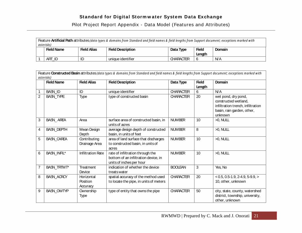
Feature Artificial Path attributes (data types & domains from Standard and field names & field lengths from Support document; exceptions marked with asterisks) Field Name Field Alias Field Description Data Type Field
Length Domain
1 ART_ID ID unique identifier CHARACTER 6 N/A
Feature Constructed Basin attributes (data types & domains from Standard and field names & field lengths from Support document; exceptions marked with asterisks) Field Name Field Alias Field Description Data Type Field
Length Domain
1 BASN_ID ID unique identifier CHARACTER 6 N/A2 BASN_TYPE Type type of constructed basin CHARACTER 20 wet pond, dry pond,
constructed wetland, infiltration trench, infiltration basin, rain garden, other, unknown
3 BASN_ AREA Area surface area of constructed basin, in units of acres
NUMBER 10 >0, NULL
4 BASN_DEPTH Mean Design Depth
average design depth of constructed basin, in units of feet
NUMBER 8 >0, NULL
5 BASN_CAREA Contributing Drainage Area
area of land surface that discharges to constructed basin, in units of acres
NUMBER 10 >0, NULL
6 BASN_INFIL* Infiltration Rate rate of infiltration through the bottom of an infiltration device, in units of inches per hour
NUMBER 10 >0, NULL
7 BASN_TRTMT* Treatment Device
indication of whether the device treats water
BOOLEAN 3 Yes, No
8 BASN_ACRCY Horizontal Position Accuracy
spatial accuracy of the method used to locate the pipe, in units of meters
CHARACTER 20 < 0.5, 0.5-1.9, 2-4.9, 5-9.9, > 10, other, unknown
9 BASN_OWTYP Ownership Type
type of entity that owns the pipe CHARACTER 50 city, state, county, watershed district, township, university, other, unknown

Standard for Digital Stormwater System Data Exchange
Pilot Project Report Appendix - Data Model (Features and Attributes)
RWMWD | Prepared by C. Mack and J. Onorati 22
Feature Constructed Basin attributes (data types & domains from Standard and field names & field lengths from Support document; exceptions marked with asterisks) Field Name Field Alias Field Description Data Type Field
Length Domain
10 BASN_OWNAM Ownership Name
name of entity that owns the pipe CHARACTER 50 N/A
11 BASN_MAINT Maintenance Authority Type
type of entity that maintains the pipe
CHARACTER 50 city, state, county, watershed district, township, university, other, unknown
12 BASN_MAINN Maintenance Authority Name
name of entity that maintains the pipe
CHARACTER 50 N/A
Feature Stormwater Device attributes (data types & domains from Standard and field names & field lengths from Support document; exceptions marked with asterisks) Field Name Field Alias Field Description Data Type Field
Length Domain
1 DEVC_ID ID unique identifier CHARACTER 6 N/A2 DEVC_TYPE Type type of device CHARACTER 20 grit chamber, sump, trap
manhole, skimmer, swirl separator, filter, settling device, filtering device, oil and grease separator, stormwater inlet trap, leaky well, seepage pipe, manhole, catch basin, drop inlet, lift station, pipe outfall, ditch outfall, apron outfall, splitter, other
3 DEVC_LGTH Length length of device, in units of feet NUMBER 5 >0, NULL4 DEVC_WID Width width of device, in units of feet NUMBER 3 >0, NULL5 DEVC_HT Height or
Mean Depth height of stormwater system component, in units of feet
NUMBER 3 >0, NULL
6 DEVC_ IELEV Invert Elevation of Outlet
the elevation of the bottom of the inside portion of the outlet, in units of feet above mean sea level
NUMBER 6 >0, NULL

Standard for Digital Stormwater System Data Exchange
Pilot Project Report Appendix - Data Model (Features and Attributes)
RWMWD | Prepared by C. Mack and J. Onorati 23
Feature Stormwater Device attributes (data types & domains from Standard and field names & field lengths from Support document; exceptions marked with asterisks) Field Name Field Alias Field Description Data Type Field
Length Domain
7 DEVC_TRTMT Treatment indication of whether the device treats water
BOOLEAN 3 Yes, No
8 DEVC_ BELEV Bottom Elevation of Device
the elevation of the bottom of the water treatment device, in units of feet above mean sea level.
NUMBER 6 >0, NULL
9 DEVC_AREA Contributing Drainage Area
applies only to water treatment devices - land surface area that discharges to the water treatment device, in units of acres
NUMBER 6 >0, NULL
10 DEVC_WAT Holds Water a determination of whether the bottom elevation of the device is below the invert elevation, in which case the device would be considered to hold water.
CHARACTER 10 wet, dry, unknown
11 DEVC_INFIL Design Infiltration Rate
rate of infiltration through the bottom of an infiltration device, in units of inches per hour
NUMBER 10 >0, NULL
12 DEVC_ACRCY Horizontal Position Accuracy
spatial accuracy of the method used to locate the pipe, in units of meters
CHARACTER 20 < 0.5, 0.5-1.9, 2-4.9, 5-9.9, > 10, other, unknown n
13 DEVC_OWTYP Ownership Type
type of entity that owns the pipe CHARACTER 50 city, state, county, watershed district, township, university, other, unknown
14 DEVC_OWNAM Ownership Name
name of entity that owns the pipe CHARACTER 50 N/A
15 DEVC_MAINT Maintenance Authority Type
type of entity that maintains the pipe
CHARACTER 50 city, state, county, watershed district, township, university, other, unknown
16 DEVC_MAINN Maintenance Authority Name
name of entity that maintains the pipe
CHARACTER 50 N/A

Standard for Digital Stormwater System Data Exchange
Pilot Project Report Appendix - Data Model (Features and Attributes)
RWMWD | Prepared by C. Mack and J. Onorati 24
Feature Natural Surface Water Feature attributes (data types & domains from Standard and field names & field lengths from Support document; exceptions marked with asterisks) Field Name Field Alias Field Description Data Type Field
Length Domain
1 WATR_ID ID Unique identifier CHARACTER 6 N/A2 WATR_TYPE Type type of water feature CHARACTER 20 lake, wetland, other3 WATR_DNRID DNR Lake ID A unique 8-digit identifier for each
lake polygon. The value of this field is the DNR Division of Waters lake identification number if one has been assigned. Otherwise, the Lake ID is a unique sequential number.
CHARACTER 10 N/A
4 WATR_PWI PWI Number A unique ID for public waters that have been mapped under Statute 103G.201
CHARACTER 8 N/A
5 WATR_DEPTH Height or Depth
mean depth of water feature, in units of feet
NUMBER 3 >0, NULL
6 WATR_WIDTH Width mean width of water feature, in units of feet
NUMBER 3 >0, NULL
7 WATR_LGTH Length mean length of water feature, in units of feet
NUMBER 5 >0, NULL
8 WATR_ACRCY Horizontal Position Accuracy
spatial accuracy of the method used to locate the pipe, in units of meters
CHARACTER 20 < 0.5, 0.5-1.9, 2-4.9, 5-9.9, > 10, other, unknown n
9 WATR_OWTYP Ownership Type
type of entity that owns the pipe CHARACTER 50 city, state, county, watershed district, township, university, other, unknown
10 WATR_OWNAM Ownership Name
name of entity that owns the pipe CHARACTER 50 N/A
11 WATR_MAINT Maintenance Authority Type
type of entity that maintains the pipe
CHARACTER 50 city, state, county, watershed district, township, university, other, unknown
12 WATR_MAINN Maintenance Authority Name
name of entity that maintains the pipe
CHARACTER 50 N/A
Standard for Digital Stormwater System Data Exchange
Pilot Project Report Appendix – Recommendations
RWMWD | Prepared by C. Mack and J. Onorati 25
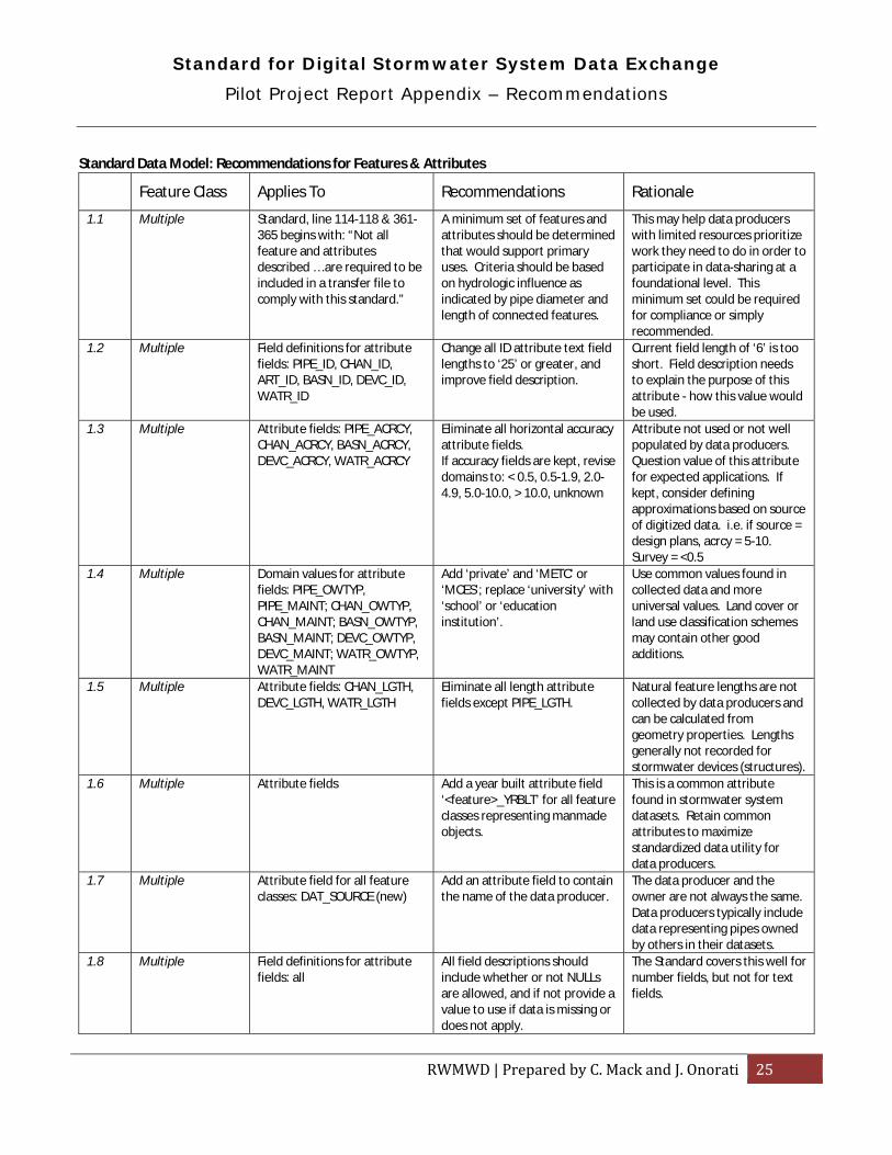
Standard Data Model: Recommendations for Features & Attributes
Feature Class Applies To Recommendations Rationale
1.1 Multiple Standard, line 114-118 & 361-365 begins with: “Not all feature and attributes described … are required to be included in a transfer file to comply with this standard.”
A minimum set of features and attributes should be determined that would support primary uses. Criteria should be based on hydrologic influence as indicated by pipe diameter and length of connected features.
This may help data producers with limited resources prioritize work they need to do in order to participate in data-sharing at a foundational level. This minimum set could be required for compliance or simply recommended.
1.2
Multiple Field definitions for attribute fields: PIPE_ID, CHAN_ID, ART_ID, BASN_ID, DEVC_ID, WATR_ID
Change all ID attribute text field lengths to ‘25’ or greater, and improve field description.
Current field length of ‘6’ is too short. Field description needs to explain the purpose of this attribute - how this value would be used.
1.3
Multiple Attribute fields: PIPE_ACRCY, CHAN_ACRCY, BASN_ACRCY, DEVC_ACRCY, WATR_ACRCY
Eliminate all horizontal accuracy attribute fields. If accuracy fields are kept, revise domains to: < 0.5, 0.5-1.9, 2.0-4.9, 5.0-10.0, > 10.0, unknown
Attribute not used or not well populated by data producers. Question value of this attribute for expected applications. If kept, consider defining approximations based on source of digitized data. i.e. if source = design plans, acrcy = 5-10. Survey = <0.5
1.4 Multiple Domain values for attribute fields: PIPE_OWTYP, PIPE_MAINT; CHAN_OWTYP, CHAN_MAINT; BASN_OWTYP, BASN_MAINT; DEVC_OWTYP, DEVC_MAINT; WATR_OWTYP, WATR_MAINT
Add ‘private’ and ‘METC’ or ‘MCES’; replace ‘university’ with ‘school’ or ‘education institution’.
Use common values found in collected data and more universal values. Land cover or land use classification schemes may contain other good additions.
1.5 Multiple Attribute fields: CHAN_LGTH, DEVC_LGTH, WATR_LGTH
Eliminate all length attribute fields except PIPE_LGTH.
Natural feature lengths are not collected by data producers and can be calculated from geometry properties. Lengths generally not recorded for stormwater devices (structures).
1.6 Multiple Attribute fields Add a year built attribute field ‘<feature>_YRBLT’ for all feature classes representing manmade objects.
This is a common attribute found in stormwater system datasets. Retain common attributes to maximize standardized data utility for data producers.
1.7 Multiple Attribute field for all feature classes: DAT_SOURCE (new)
Add an attribute field to contain the name of the data producer.
The data producer and the owner are not always the same. Data producers typically include data representing pipes owned by others in their datasets.
1.8 Multiple Field definitions for attribute fields: all
All field descriptions should include whether or not NULLs are allowed, and if not provide a value to use if data is missing or does not apply.
The Standard covers this well for number fields, but not for text fields.

Standard for Digital Stormwater System Data Exchange
Pilot Project Report Appendix – Recommendations
RWMWD | Prepared by C. Mack and J. Onorati 26
Feature Class Applies To Recommendations Rationale
1.9 Multiple Text domain values only: all Display text domain values in a consistent case. Specify that the displayed case must be used.
In many cases; queries, joins and other GIS operations are case-sensitive.
1.10 Multiple Domain values In the Standard document specify that only exact values in domains be used to populate fields (limit to list).
Clarify that domains are not just examples. The data will not be “standardized” without controls over attribute field contents.
2.0 Pipe Attribute field: PIPE_TYPE (new)
Add a pipe type attribute field ‘PIPE_TYPE’, with domain values: gravity main, force main, siphon, tunnel, catch basin run (or lateral), private connection (lateral), culvert, overflow, and drain tile or perforated pipe.
Clarify the role of each pipe segment and behavior of the system.
2.1 Pipe Domain Value PIPE_SHP Remove ‘tunnel’ value from domain
Typical attribute describing category of pipe. The value ‘tunnel’ is included in PIPE_SHP domain, but is not a shape (tunnels can have different shapes).
2.2 Pipe Attribute field: PIPE_ACTV (new)
If abandoned and proposed pipes are not desired in standardized data, then the Standard should specify that; otherwise add a new field ‘PIPE_ACTV’ or add values to ‘PIPE_TYPE’ domain.
Several producer datasets included abandoned or proposed pipes. Guidance is needed to omit these items or attribute values to indicate the active status of pipes: active, abandoned, or proposed.
2.3 Pipe Attribute field: PIPE_MAT Replace domain values with RCP, PVC, DIP, CMP, HDPE, VCP, PEP, CEM, CON … UNK
Replace pipe material domain values with those more universally used by data producers.
2.4 Pipe Attribute fields (suggested names): PIPE_IELVU & PIPE_IELVD, or PIPE_INVUP & PIPE_INVDN, or PIPE_UPINV & PIPE_DNINV
Add field names and field definitions for upstream and downstream invert elevation attributes that were omitted from the Support document (exists in Standard).
Fill in missing information in Standard and Support Document.
3.1 Channel Feature class definition and associated details
Separate natural and constructed channels into two feature classes: Natural Channel and Constructed Channel
Follow same convention used for natural and constructed basins.
3.2 Channel Attribute field: CHAN_WID Replace channel width with channel bottom width attribute ‘CHAN_BTWID’, and add side slope attribute ‘CHAN_SSLPE’.
These dimensions are more specific to channels and are used in hydraulic calculations.
3.3 Channel Attribute field: CHAN-SHAPE (in Support Document)
Rename field to ‘CHAN_SHP’ or ‘CHAN_SHAPE’ (and rename other feature class shape fields to match).
Dashes not allowed in shapefile and geodatabase field names. Use consistent naming for related fields in feature classes.
3.4 Channel Attribute field: CHAN_AUID Eliminate attribute for AUID. Attribute not used by data producers so field will likely always be left empty.

Standard for Digital Stormwater System Data Exchange
Pilot Project Report Appendix – Recommendations
RWMWD | Prepared by C. Mack and J. Onorati 27
Feature Class Applies To Recommendations Rationale
3.5 Channel Attribute field: CHAN_NAME (new)
Add an attribute field for the name of the channel. Determine a method to make names consistent and specify using ‘unknown’ or ‘unnamed’ if a name is unavailable.
Names are a lot more meaningful to most users than an ID number, and are useful for labeling maps.
4.1 Artificial Path Feature class definition and associated details
Change name of feature class to Flow Connector.
Extend use of this feature to overland and other undefined flow paths.
4.2 Artificial Path Attribute field: CONN_TYPE (new)
Add attribute field with domain to indicate feature represents an artificial path or a connector (see report for definition of connector)
Support recommended repurposing of Artificial Path feature class.
5.1 Constructed Basin Attribute fields: BASN_AREA and BASN_DEPTH
Replace area and depth attribute fields with one for design volume ‘BASN_DSVOL’ or design capacity ‘BASN_DSCAP’.
Volume measurement would seem to be more useful, and does not require other dimensions.
5.2 Constructed Basin Attribute field: BASN_CAREA Eliminate contributing area attribute.
Attribute not used or not well populated by data producers. Question value of this attribute for expected applications.
5.3 Constructed Basin Attribute field: BASN_INFIL Revise attribute description to specify that this is the design infiltration rate.
Attribute meaning needs to be clarified.
5.4 Constructed Basin Attribute field: BASN_TRTMT Eliminate treatment attribute. Treatment capability is indicated by basin type. Swales are included in the Channel feature class where no treatment attribute exists. If this attribute is retained, define treatment and what kinds of basins provide it.
6.1 Stormwater Device Feature class definition and associated details
Replace feature class with 4 feature classes: Manhole, End Structure (inlets & outlets), Control Structure, and Treatment Device. Definitions should give examples of appropriate features.
Variety of structures included in this feature class makes attributing and symbolization problematic. Does not follow any models used in collected datasets.
6.2 Stormwater Device Attribute field: DEVC_TYPE If feature class not replaced, replace domain values with main categories of structures (see item 5.1) instead of attempting to list all important structures. Also provide crosswalk table reference for matching specific structures to each category.
Maximize value match success between producer data and this domain. Symbolization is simplified. To provide additional detail, a free text field could be added to store producer’s name or description of structure.
6.3 Stormwater Device Attribute field: DEVC_TRTMT If feature class not replaced, this capability can be indicated by using a ‘DEVC_TYPE’ category of
Eliminate fields if information is already provided by another attribute.
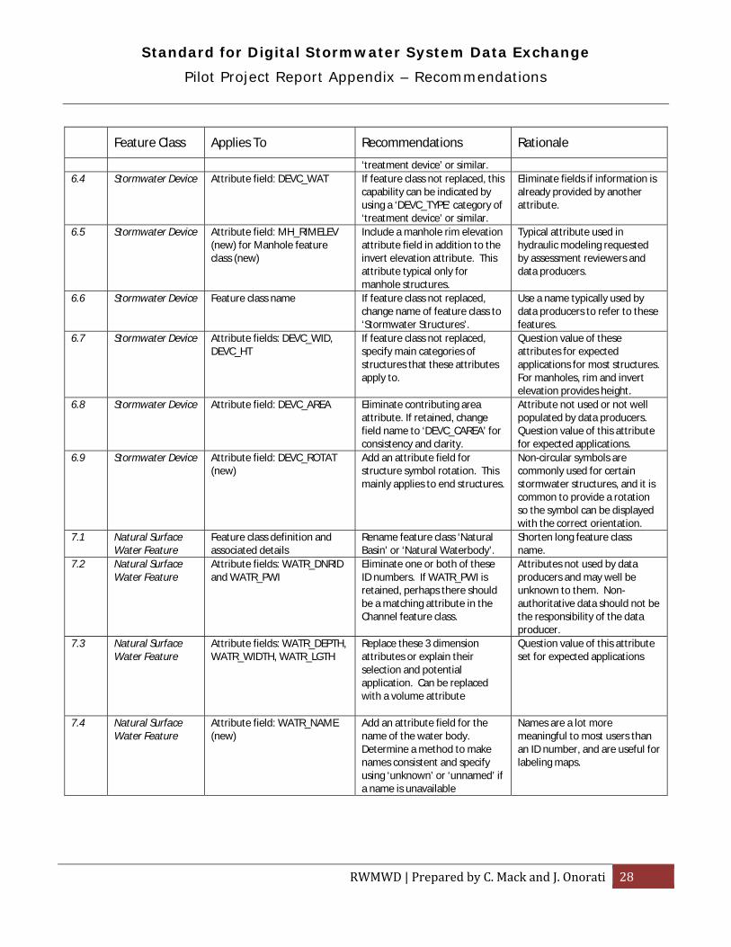
Standard for Digital Stormwater System Data Exchange
Pilot Project Report Appendix – Recommendations
RWMWD | Prepared by C. Mack and J. Onorati 28
Feature Class Applies To Recommendations Rationale
‘treatment device’ or similar. 6.4 Stormwater Device Attribute field: DEVC_WAT If feature class not replaced, this
capability can be indicated by using a ‘DEVC_TYPE’ category of ‘treatment device’ or similar.
Eliminate fields if information is already provided by another attribute.
6.5 Stormwater Device Attribute field: MH_RIMELEV (new) for Manhole feature class (new)
Include a manhole rim elevation attribute field in addition to the invert elevation attribute. This attribute typical only for manhole structures.
Typical attribute used in hydraulic modeling requested by assessment reviewers and data producers.
6.6 Stormwater Device Feature class name If feature class not replaced, change name of feature class to ‘Stormwater Structures’.
Use a name typically used by data producers to refer to these features.
6.7 Stormwater Device Attribute fields: DEVC_WID, DEVC_HT
If feature class not replaced, specify main categories of structures that these attributes apply to.
Question value of these attributes for expected applications for most structures. For manholes, rim and invert elevation provides height.
6.8 Stormwater Device Attribute field: DEVC_AREA Eliminate contributing area attribute. If retained, change field name to ‘DEVC_CAREA’ for consistency and clarity.
Attribute not used or not well populated by data producers. Question value of this attribute for expected applications.
6.9 Stormwater Device Attribute field: DEVC_ROTAT (new)
Add an attribute field for structure symbol rotation. This mainly applies to end structures.
Non-circular symbols are commonly used for certain stormwater structures, and it is common to provide a rotation so the symbol can be displayed with the correct orientation.
7.1 Natural Surface Water Feature
Feature class definition and associated details
Rename feature class ‘Natural Basin’ or ‘Natural Waterbody’.
Shorten long feature class name.
7.2 Natural Surface Water Feature
Attribute fields: WATR_DNRID and WATR_PWI
Eliminate one or both of these ID numbers. If WATR_PWI is retained, perhaps there should be a matching attribute in the Channel feature class.
Attributes not used by data producers and may well be unknown to them. Non-authoritative data should not be the responsibility of the data producer.
7.3
Natural Surface Water Feature
Attribute fields: WATR_DEPTH, WATR_WIDTH, WATR_LGTH
Replace these 3 dimension attributes or explain their selection and potential application. Can be replaced with a volume attribute
Question value of this attribute set for expected applications
7.4 Natural Surface Water Feature
Attribute field: WATR_NAME (new)
Add an attribute field for the name of the water body. Determine a method to make names consistent and specify using ‘unknown’ or ‘unnamed’ if a name is unavailable
Names are a lot more meaningful to most users than an ID number, and are useful for labeling maps.

Standard for Digital Stormwater System Data Exchange
Pilot Project Report Appendix – Recommendations
RWMWD | Prepared by C. Mack and J. Onorati 29
Standard Data Model: Recommendations for Geometry
Category Applies To Recommendations Rationale
8.1 Connectivity Standard, line 78: “Line features must have a terminus.”
Remove stipulation that line features much have a terminus.
Producer data line features often do not have points snapped to endpoints (a line terminus). .
8.2 Connectivity Standard, line 78-79: “Line features must be snapped to the endpoint of other line or point features.”
Revise statement to read: ‘Connecting line features must be snapped endpoint-to-endpoint or endpoint-to-vertex only.’ Connecting point features must be snapped to line vertexes or endpoints only.
Endpoint-to-vertex connections can also provide connectivity if modeled as complex instead of simple edges. Data producers may desire to not break lines at every connection point.
8.3 Connectivity Guidance in Standard document
Determine and describe what a minimum level of connectivity might look like or require. Criteria should be based on hydrologic influence of drainage features.
Endpoint-to-vertex connections can also provide connectivity if modeled as complex instead of simple edges. Data producers may desire to not break lines at every connection point.
8.4 Directionality Standard, line 94-96: “Additional cartographic flourishes, such as arrows or flared end sections as sometimes found in CAD drawing files, will not be included in the export file with the geographic features.”
Explain furthermore that polygons, lines that close on themselves (to represent structures such as manholes or flared end sections), and annotation features are not allowed in standardized data.
Clarify what ‘cartographic flourishes’ are.
8.5 Resolution/scale Level of feature detail to include in shared data.
A minimum level of feature detail should be determined that would support primary uses. This minimum level can be required for compliance or simply recommended.
This may help data producers with limited resources prioritize work they need to do in order to participate in data-sharing at a foundational level.

Standard for Digital Stormwater System Data Exchange
Pilot Project Report Appendix – Recommendations
RWMWD | Prepared by C. Mack and J. Onorati 30
Standard Data Model: Other Recommendations
Category Applies To Recommendations Rationale
9.1 Data encoding Geospatial data digital file format(s) to use for data exchange.
Specify that shapefile or geodatabase file formats must be used for data exchange.
Without any specifications on acceptable file formats, any electronic format is assumed to be acceptable including a scanned map. This makes it difficult to provide an unambiguous data model.
9.2 Data model documentation
Feature and attribute descriptions
Include all feature and attribute details in the Standard document. For feature classes this includes all feature names, aliases, and descriptions. For attributes this includes all field names, aliases, descriptions, and field definitions (data types, lengths, domains). Do not duplicate this information in the Standard Support document.
The Standard document should be able to stand on its own as an authoritative source of all essential information needed to use the data exchange format. The Standard Support document should avoid duplicating information in the Standard and provide supplemental information and examples only.
9.3 Documentation in general
Standard and Support documents
Fix editing errors in documents and resolve conflicts between documents.
Improve effectiveness of documentation.
9.4 Templates and Tools
Geodatabase and shapefile templates
Develop standardized data storage file templates.
Standardized templates will reduce work required by data producers to migrate their data, and make it more likely that data migrated will be in compliance with the Standard.
9.5 Templates and Tools
Metadata template Develop a metadata template for migrated datasets.
A metadata template will reduce work required by data producers to document their data, and make it more likely that good metadata will be included in the transfer file.
9.6 Templates and Tools
Migration guide Develop a migration guide that will discuss typical techniques and tools used to migrated data to the standard, and tell where to find helpful resources.
Provide data producers with a resource to help those that may be unfamiliar with methods and resources that will help them migrate their data.
9.7 Templates and Tools
Applications Develop an applications guide that will explain possible applications and benefits of participating in data sharing.
Help potential users learn why they might want to provide or collect standardized data.
9.8 Templates and Tools
Migration tool Develop a sample Python script for adding Standard fields and migrating producer fields.
Illustrate how to automate migration with typical geoprocessing tasks.
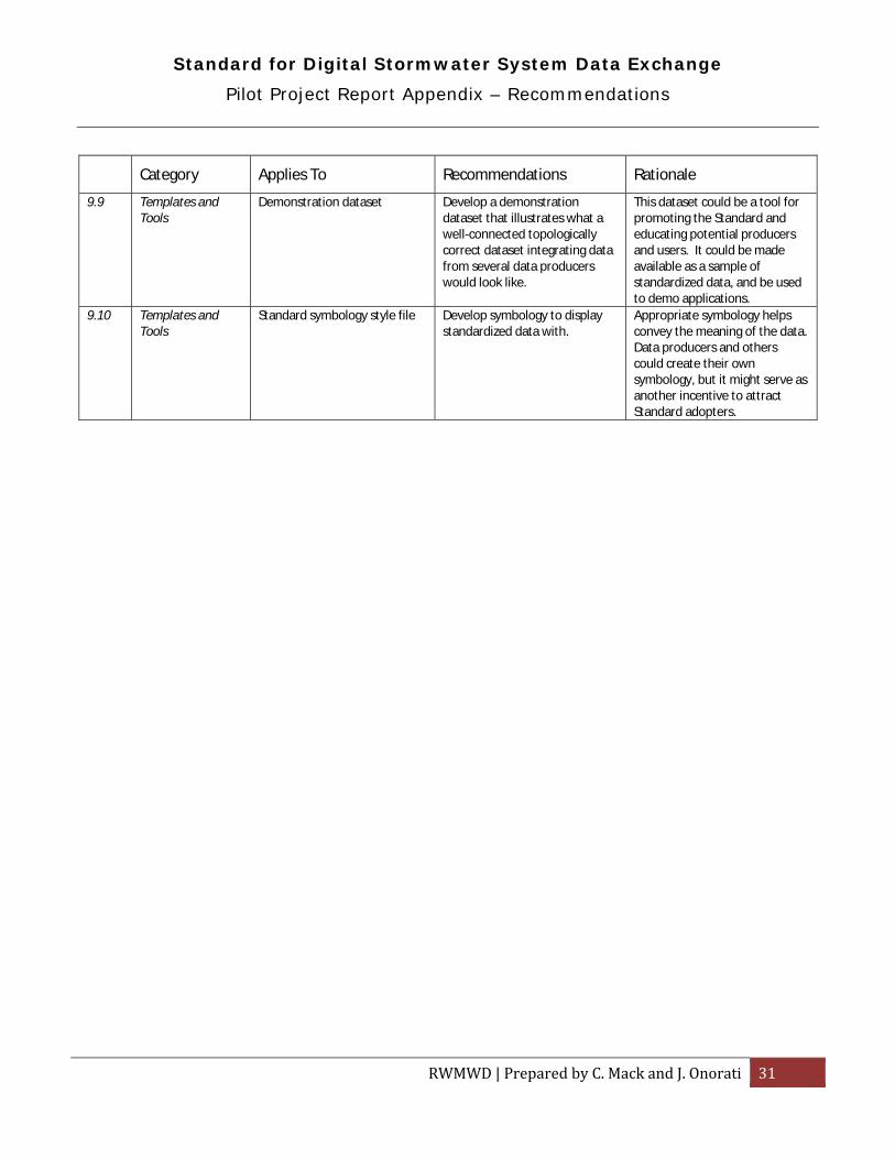
Standard for Digital Stormwater System Data Exchange
Pilot Project Report Appendix – Recommendations
RWMWD | Prepared by C. Mack and J. Onorati 31
Category Applies To Recommendations Rationale
9.9 Templates and Tools
Demonstration dataset Develop a demonstration dataset that illustrates what a well-connected topologically correct dataset integrating data from several data producers would look like.
This dataset could be a tool for promoting the Standard and educating potential producers and users. It could be made available as a sample of standardized data, and be used to demo applications.
9.10 Templates and Tools
Standard symbology style file Develop symbology to display standardized data with.
Appropriate symbology helps convey the meaning of the data. Data producers and others could create their own symbology, but it might serve as another incentive to attract Standard adopters.

Standard for Digital Stormwater System Data Exchange
Migration Report – General Notes
RWMWD | Prepared by C. Mack and J. Onorati 32
Migration to standard schema:
1. Review source data from data producer and compare with standard schema or database template to understand what tasks are required for migration.
2. Prepare migration tables to guide translation of fields and values (values that were changed to fit standard schema domains are noted in Conversions & Comments column)
3. Create working copies of source data feature classes, add relevant standard fields and populate. Perform value conversions if needed when populating new fields using Calculate Field.
4. Import data from working copies into destination standard feature classes using Merge (schemas must be identical) or Append (using No-Test option for non-identical schemas).
Schema general notes:
• A number of possibly incorrect assumptions were made to make data migration decisions due to unfamiliarity with the data. The data producer will be able to make more informed decisions based on their better understanding of their own data.
• The standard field PIPE_ID in the Pipe feature class is intended to hold data producer's preferred unique ID. This value could be used to help identify/link to individual features from the producer in a combined dataset containing data from multiple producers. The attribute selected from producer data that seemed to best fit this description may not be what the producer considers a preferred ID.
• The PIPE_ID field length was changed from 6 to 25 because it was too short to contain IDs that were migrated.
• The Standard support document specifies data types as “CHARACTER” or “NUMBER” and field lengths for both. Data types and lengths shown in migration tables for Standard fields are based on using a personal or file geodatabase hold standardized data. Double was selected as the data type for all number fields. Length, precision or scale cannot be specified in a non-ArcSDE geodatabase.
• Rule of thumb used for migration of values for all number fields: set all zero and non-numeric values to NULL.
Connectivity and directionality check/editing process:
1. Create a topology to identify and fix topology errors like dangles and undershoots or overshoots for all line features. Rules and settings used for this project: a. Cluster tolerance = 0.5 b. Rule: Must not have dangles c. Rule: Must not intersect or touch interior
2. Use Error Inspector and Topology toolbar tools in ArcMap to review errors. This is performed in an edit session.

Standard for Digital Stormwater System Data Exchange
Migration Report – General Notes
RWMWD | Prepared by C. Mack and J. Onorati 33
a. Validate topology – working in small areas at a time provides more control over the process. If undesired results occur, back out by not saving edits.
b. Mark exceptions, e.g. it is okay for pipes to have dangles at upstream end, but not downstream, and pipes may appear to intersect when they cross at different elevations.
c. Fix downstream dangles errors by adding connecting features wherever possible (Artificial Path features or other feature as indicated).
d. Fix intersect errors by splitting line if indicated. e. Fix overlap errors by deleting an extra feature and/or modifying another. f. Fix touch interior errors by spitting line touched (Standard requires that lines should only
connect at endpoints). 3. Examine features for duplicate features at adjacent jurisdictions and delete the one that is not
from the system owner. 4. Save edits and validate again to make sure no errors were created in fixing errors. 5. Build a geometric network on a separate copy of dataset with topology fixes (remove topology
first as a feature class cannot participate in both a topology and geometric network). 6. Use Utility Network Analyst toolbar tools to analyze geometric network.
a. Check connectivity with Find Connected tool. Fix anything that should or should not be connected.
b. Use Trace Downstream or Trace Upstream tools to check if directionality appears to be correct. Fix lines that have the wrong direction with the editing tool Flip Line.
7. Other types of checks possible to QA/QC pipes: a. If elevations are known, check for pipes with negative grade b. Check for adverse pipe diameters (not increasing in diameter in downstream direction). c. If elevations are known, check for too shallow or too deep of manhole structures
Connectivity and directionality general notes:
• Errors found in network build process – all type #12: The feature's begin and end vertex are the same. Found in Maplewood and Woodbury data.
• Incorrect line directionality
• Overlaps
• Minute line segments or questionable location
• Other issues

Standard for Digital Stormwater System Data Exchange
Pilot Project Notes – Landfall
RWMWD | Prepared by C. Mack and J. Onorati 34
Description:
• Source data comprised of 1 hard copy map showing the storm water system (sewer pipes, catch basins and manholes) , sanitary sewer, gate valves and hydrants.
Migration:
General notes:
• Map includes spring drain. This pipe contributes water from an underground source to the Oakdale Storm Sewer system. While this does not transport stormwater, it does add to the load of Oakdale’s stormwater utility and was therefore included in the digitization.
• Request for ownership and maintenance information: Landfall public works owns and maintains all pipes and stormwater devices.
• Data producer indicated that stormwater system was minimal because stormwater management relied heavily on street design transporting surface flow to Tanners Lake
Migration to standard schema:
1. Obtained high resolution paper copy of stormwater utility map. 2. Orthorectified scanned paper map in ArcView. 3. Verified catch basins and manholes using GPS. 4. Created new geodatabase using Standard schema. 5. Digitized pipes and stormwater features using orthorectified stormwater utility map and GPS
points. 6. Create geodatabase template with Standard schema. 7. Create conversion tables: New digitization. No migration of table data necessary. 8. Pipes symbolized as ‘storm sewer’ on utility map were digitized. Diameter and Material fields
populated as/when indicated on utility map. 9. Stormwater Devices: Catch basins and Manholes were digitized based on written map labels
and field verification. “Other” indicates instances where a feature on the stormwater utility map had the same symbology as catch basins in the rest of the map, but the particular feature was located along an underground spring drain pipe. “Unknown” indicates illegible label on map that was not field verified.
Connectivity check and editing process:
1. Data producer indicated that the spring drain outputs to Oakdale SS, but utility map did not indicate where this connection was located.
2. Connected internally. Disconnect with neighboring SS.
Directionality check and editing process:
1. Digitized pipe/line directionality coincides with paper map directionality.

Standard for Digital Stormwater System Data Exchange
Pilot Project Notes – Maplewood
RWMWD | Prepared by C. Mack and J. Onorati 35
Description:
• Source data comprised of 14 shapefiles; StormSystem – 3MStructures StormSystem –Basins StormSystem –CountyDitch StormSystem –DetentionPonds StormSystem –Dike StormSystem –FlowArrows StormSystem –FlowArrowsJunctions StormSystem –MainsAnno StormSystem – Pipe – new StormSystem –PrivateMains StormSystem –PrivateStructures StormSystem –Structures StormSystem –Weir StormSystem –3MPipes
Migration:
General notes:
• Many versions of data exist. Use data on CD and updated file called StormSystem –pipe – new.
• Converted all data to UTM.
Migration to standard schema:
1. Review source data from data producer and compare with standard schema or database template to understand what tasks are required for migration.
2. Prepare migration tables to guide translation of fields and values (values that were changed to fit standard schema domains are noted in Conversions & Comments column)
3. Create working copies of source data feature classes, add relevant standard fields and populate. Perform value conversions if needed when populating new fields using Calculate Field.
4. Import data from working copies into destination standard feature classes using Merge (schemas must be identical) or Append (using No-Test option for non-identical schemas).
5. Create migration tables:
Feature: 3M Pipes (line) TO Pipe (line) – data in 1 of 31 fields migrated FROM NAME FROM
TYPE FROM LENGTH
TO NAME TO TYPE TO LENGTH VALUES
HANDLE TEXT 16 PIPE_ID TEXT 25
• Unique ID created after migration and merge of “3MPipes,” “Pipes-new” and “PrivateMains-new.” • Elevation field = 4 records with data ranging 285-300. Local datum? Possible placement in UPIELV or
DNIELV, but could not be placed without more information.

Standard for Digital Stormwater System Data Exchange
Pilot Project Notes – Maplewood
RWMWD | Prepared by C. Mack and J. Onorati 36
Feature: StormSystem - Pipes - new (line) TO Pipe (line) – data in 5 of 10 fields migrated FROM NAME FROM TYPE FROM
LENGTH TO NAME TO TYPE TO LENGTH VALUES
ID TEXT 254 PIPE_ID TEXT 25 *
DIAMETER DOUBLE PIPE_WID NUMBER 3No conversion necessary
TYPE TEXT 254 PIPE_MAT TEXT 30 ** LAYER TEXT 254 PIPE_OWTYP TEXT 50 Draintile Private =
other. Draintile public = City. Storm mains private = other. Storm mains public = City.
LENGTH DOUBLE PIPE_LGTH NUMBER 5No conversion necessary
General notes:
• Unique ID created after migration and merge of “3MPipes,” “Pipes-new” and “PrivateMains-new.” • Elevation field = 4 records with data ranging 285-300. Relative elevation? Possible placement in
UPIELV or DNIELV, but cannot be placed without more info. • PIPE_OWTYP - Would be good to have "Private" as option in Standard
**If TYPE = ‘RCP ARCH’ than PIPE_SHP = ARCH **If TYPE = ‘STORMTECH’ than PIPE_SHP = OTHER **If TYPE = Blank, ‘28,’ ‘?,’ ‘Abandoned,’ ‘DRAINTILE,’ ‘PERF DAINTILE,’ or ‘TRENCH DRAIN’ than PIPE_MAT = UNKNOWN. If TYPE = CIPP, than PIPE_MAT = OTHER. If TYPE = ‘CMP,’ ‘CIP,’ ‘DIP,’ ‘DIP_FM,’ ‘ECP,’ ‘STEEL’ than PIPE_MAT = STEEL. If TYPE = ‘HDPE,’ ‘PERF HDPE,’ ‘PERFORATED HDPE,’ ‘PVC,’ ‘STORMTECH,’ or ‘PVC DRAIN TILE,’ than PIPE_MAT = PLASTIC. If TYPE = ‘RCP,’ ‘RCP ARCH,’ ‘RCP ARCH X 102’ than PIPE_MAT = concrete.
Feature: StormSystem - PrivateMains - new (line) TO Pipe (line) – data in 4 of 10 fields migrated FROM NAME
FROM TYPE FROM LENGTH TO NAME TO TYPE TO LENGTH VALUES
ID Text 254 PIPE_ID Text 25 * TYPE Text 254 PIPE_MAT Text 30 RCP=’concrete’ DIAMETER Double PIPE_WID Number 3 No conversion
necessary
LENGTH Double PIPE_LGTH Number 5

Standard for Digital Stormwater System Data Exchange
Pilot Project Notes – Maplewood
RWMWD | Prepared by C. Mack and J. Onorati 37
PIPE_OWTYP Text 50 Private Mains = Other
• Unique ID created after migration and merge of “3MPipes,” “Pipes-new” and “PrivateMains-new.”
Feature: StormSystem - 3MStructures (point) TO StormwaterDevice (point) – data in 2 of 34 fields migrated FROM NAME FROM TYPE FROM LENGTH TO NAME TO TYPE TO LENGTH VALUES
Handle TEXT 16 DEVC_ID Text 25 Alphanumeric
RefName TEXT 254 DEVC_TYPE Text 20
Apron=’apron outfall.’ CB= ‘catch basin.’ MH= ‘manhole.’ cb-r, CP, E-BEE, PIV and VLV= ‘other’
PIPE_OWTYP Text 50 3M=private = Other
The following field was considered for migration, but rejected: • ELEVATION: Local datum (range 144-299) and whether up or down stream invert.
Feature: StormSystem - PrivateStructures (point) TO StormwaterDevice (point) - data in 5 of 23 fields migrated FROM NAME FROM TYPE FROM LENGTH TO NAME TO TYPE TO LENGTH VALUES
GIS_ID Short (numeric) DEVC_ID TEXT 25 Only unique ID
BLOCKNAME TEXT 254 DEVC_TYPE? TEXT 20 ** SYMBOL TEXT 254 DEVC_TYPE TEXT 20 **
DIAMETER DOUBLE DEVC_WID NUMBER 3 No conversion necessary
LENGTH DOUBLE DEVC_LGTH NUMBER 5
Convert from inches to feet***
DEVC_OWTYP TEXT 50
Private Structures = Other

Standard for Digital Stormwater System Data Exchange
Pilot Project Notes – Maplewood
RWMWD | Prepared by C. Mack and J. Onorati 38
** Both BLOCKNAME and SYMBOL contribute to DEVC_TYPE. If BLOCKNAME=MH, but SYMBOL= Catch Basin Man Hole than DEVC_TYPE = Other. If BLOCKNAME=MH and SYMBOL= Man Hole than DEVC_TYPE:=Manhole. If BLOCKNAME=MH and SYMBOL= Tee or Bend than DEVC_TYPE:=Manhole. Else DEVC_TYPE = Other *** Needs to be rounded before final append. The following field was considered for migration, but rejected:
• DRAINAREA - uncertainty of drainage area delineation source. Feature: StormSystem - Structures (point) TO StormwaterDevice (point) ) - data in 5 of 23 fields migrated FROM NAME FROM TYPE FROM LENGTH TO NAME TO TYPE TO LENGTH VALUES
GIS_ID Short (numeric)
DEVC_ID TEXT 25
BLOCKNAME TEXT 254 DEVC_TYPE TEXT 20 ** SYMBOL TEXT 254 DEVC_TYPE TEXT 20 *** DIAMETER DOUBLE DEVC_WID No conversion
necessary
LENGTH Double DEVC_LGTH Convert from inches to feet****
** Both BLOCKNAME and SYMBOL contribute to DEVC_TYPE. If BLOCKNAME=MH, but SYMBOL= Catch Basin Man Hole than DEVC_TYPE = Other. If BLOCKNAME=MH and SYMBOL=Man Hole than DEVC_TYPE:=Manhole. BLOCKNAME=MH and SYMBOL= Tee or Bend than DEVC_TYPE: Manhole. SYMBOL = Sump Pump than DEVC_TYPE = sump. Else DEVC_TYPE = Other ***If SYMBOL = Sump Pump, than DEVC_WAT = wet **** Needs to be rounded before final append. Feature: StormSystem - Basins (polygon) TO Natural Surface Water Feature (point) - data in 1 of 8 fields migrated FROM NAME FROM TYPE FROM LENGTH TO NAME TO TYPE TO LENGTH VALUES
WATER_ Double x WATER_ID 25 **
* Feature class is polygon. Find centroid and convert to points. *WAT_TYPE = Unknown * Available evidence indicates that Basins line up with PWI and known natural lakes and wetlands. If there are constructed basins included, there is no table data to support this differentiation. **Existing values unique, but 274/764 have no values. Copied existing data over, then auto generate to fill rest migrating ObjectID field from original set.
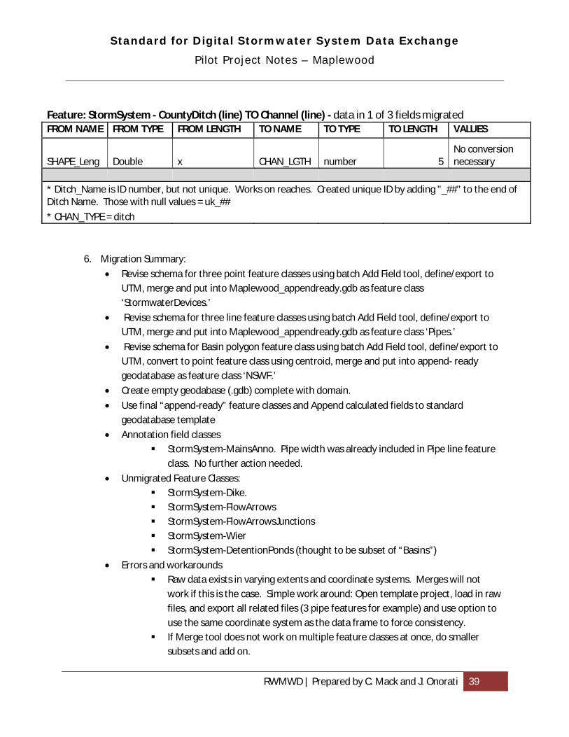
Standard for Digital Stormwater System Data Exchange
Pilot Project Notes – Maplewood
RWMWD | Prepared by C. Mack and J. Onorati 39
Feature: StormSystem - CountyDitch (line) TO Channel (line) - data in 1 of 3 fields migrated FROM NAME FROM TYPE FROM LENGTH TO NAME TO TYPE TO LENGTH VALUES
SHAPE_Leng Double x CHAN_LGTH number 5 No conversion necessary
* Ditch_Name is ID number, but not unique. Works on reaches. Created unique ID by adding "_##" to the end of Ditch Name. Those with null values = uk_##
* CHAN_TYPE = ditch
6. Migration Summary:
• Revise schema for three point feature classes using batch Add Field tool, define/export to UTM, merge and put into Maplewood_appendready.gdb as feature class ‘StormwaterDevices.’
• Revise schema for three line feature classes using batch Add Field tool, define/export to UTM, merge and put into Maplewood_appendready.gdb as feature class ‘Pipes.’
• Revise schema for Basin polygon feature class using batch Add Field tool, define/export to UTM, convert to point feature class using centroid, merge and put into append- ready geodatabase as feature class ‘NSWF.’
• Create empty geodabase (.gdb) complete with domain.
• Use final “append-ready” feature classes and Append calculated fields to standard geodatabase template
• Annotation field classes StormSystem-MainsAnno. Pipe width was already included in Pipe line feature
class. No further action needed.
• Unmigrated Feature Classes: StormSystem-Dike. StormSystem-FlowArrows StormSystem-FlowArrowsJunctions StormSystem-Wier StormSystem-DetentionPonds (thought to be subset of “Basins”)
• Errors and workarounds Raw data exists in varying extents and coordinate systems. Merges will not
work if this is the case. Simple work around: Open template project, load in raw files, and export all related files (3 pipe features for example) and use option to use the same coordinate system as the data frame to force consistency.
If Merge tool does not work on multiple feature classes at once, do smaller subsets and add on.

Standard for Digital Stormwater System Data Exchange
Pilot Project Notes – Maplewood
RWMWD | Prepared by C. Mack and J. Onorati 40
• Further clarification needed: Note: Original two shapefiles are Basins and Detention Ponds. Speculation as to
if ‘Basins’ are natural or modified natural surface water features, and if detention ponds indicate constructed. Visual observation of data shows that of 764 Basin polygons, 286 overlap polygons designated as Detention Ponds. This may indicate that Detention Ponds are a subset of Basins and should not be duplicated by merging the two. Decision: migrate Basin to NSWF, do not migrate Detention Pond.
Connectivity and directionality check/editing process:
1. See general notes document. 2. Used elevation and pipe size data to determine that many pipe systems did not contain correct
directionality. Reviewed line segments individually and used ‘flip’ command (in an edit session) where it seemed necessary. Data producers familiar with the structures would likely have far easier time with this.

Standard for Digital Stormwater System Data Exchange
Migration Report – MnDOT
RWMWD | Prepared by C. Mack and J. Onorati 41
Description:
• Source data comprised of 9 feature classes: Pipes, Pipes_9_2010, Ponds, Ponds_9_2010, SPCD, Special_Structures, Special_Structures_9_2010, Structures, and Structures_9_2010
Migration Process:
General notes:
• The feature classes with the suffix _9_2010 appear to be both geometry and attribute subsets of corresponding feature classes without the suffix. They were not checked to see if they were corrections to geometry or attributes, and also were not migrated to the Standard geodatabase.
• Only 23 features exist in the SPCD feature class and none of them exist in the Battle Creek subwatershed pilot project area so there was nothing to migrate.
• There were no exact matches between MnDOT STRUCTURE_TYPE values (Special_Structures feature class) and the DEVC_TYPE domain (SDSSDE Stormwater_Device feature class), so all features were migrated as DEVC_TYPE "other" rather than attempt a closest match of MnDOT values with Standard domain values. This was an issue for data from all data producers.
• There were scattered small features found in the Pipes feature class that were mostly not connected to any other pipes. The feature length of 2.3 feet did not match the PIPE_SEGMENT_LENGTH of 30-35 shown for many of these features. It was unclear how to handle these features, and whether they are errors or small culverts.
• Many point features appear to not be snapped to nearby pipes and there are numerous orphan point features that have no other structure nearby to snap to. However, currently the Standard only specifies that line features need to be snapped together (coincident at endpoints).
Migration to standard schema:
1. Review source data from data producer and compare with standard schema or database template to understand what tasks are required for migration.
2. Prepare migration tables to guide translation of fields and values (values that were changed to fit standard schema domains are noted in Conversions & Comments column)
3. Create working copies of source data feature classes, add relevant standard fields and populate. Perform value conversions if needed when populating new fields using Calculate Field.
4. Import data from working copies into destination standard feature classes using Merge (schemas must be identical) or Append (using No-Test option for non-identical schemas).
Connectivity and directionality check/editing process:
• See general notes document.

Standard for Digital Stormwater System Data Exchange
Migration Report – MnDOT
RWMWD | Prepared by C. Mack and J. Onorati 42
Migration Tables:
In the tables below, red text means that attributes would have been migrated as indicated if any had existed in the pilot project area.
Feature: Pipes (line) TO Pipe (line) – data in 7 of 106 fields migrated
FROM FIELD FROM TYPE
FROM LENGTH
TO FIELD TO TYPE
TO LENGTH
CONVERSIONS & COMMENTS
Pipe_id Long integer
NA PIPE_ID Text 25 No duplicates - values migrated as is
Pipe_shape Text 10 PIPE_ SHP Text 20 All values match Standard domain values
Material_Type Text 20 PIPE_MAT Text 30 All values match Standard domain values except: Bituminous & Liner = "other"
Height_qt Double NA PIPE_HT Double NA Convert zero values to NULLs. Convert values to inches if DIM_UNITS = "Feet"
Width_qt Double NA PIPE_WID Double NA Same as above PIPE_LGTH Double NA Calculated values based on
shape properties
Flowline_elevation Double NA PIPE_UPIELV Double NA Flowline_elevation values assumed in meters and converted to feet
Owner Text 20 PIPE _OWNAM Text 50 Metro = "MnDOT" Owner Text 20 PIPE _OWTYP Text 50 City = "city", Metro = "state",
blank = "unknown" Maint_responsibility Text 20 PIPE _ MAINT Text 50 City = "city", Metro = "state",
County = "county", null = "unknown"
Maint_organization Text 20 PIPE_MAINT Text 50 All city names & City = "city", County = "county", null= "unknown", MnDOT = "state"
Maint_organization Text 20 PIPE_MAINN Text 50 All city names & MnDOT name migrated, for County values used name in County field -"Hennepin"
• A Status field has values of "Inplace" or "Proposed". Only inplace features should be migrated. • Material_Type field was used instead of Material field. The former appears to be a standardized version
closely resembling Standard domain values.

Standard for Digital Stormwater System Data Exchange
Migration Report – MnDOT
RWMWD | Prepared by C. Mack and J. Onorati 43
• Length fields include: Pipe_segment_length, Total_Pipe_Length and Geometry_Length. There is no Shape_Length field?? Decided to calculate based on shape properties.
• There were no Flowline_elevation2 or Flowline_elevation_units values in the pilot project area. Flowline_elevation values were 138 - 350 so were assumed to be in meters.
• Does value of "Metro" in Owner and Maint_responsibility fields mean MnDOT Metro District? • Could not find consistent relationships between the Maint_responsibility and Maint_organization field
values. No other fields migrated. The following fields were considered for migration, but rejected: • Flowline_elevation2: Assumed to be downstream invert, but no values were populated in the project area. • Owner did not have any values in the pilot project area, otherwise it may have been used to populate
PIPE_OWNAM and PIPE_OWTYP. • Maint_responsibility did not have any values in the pilot project area, otherwise it could have been used
along with Maint_organization to populate PIPE _ MAINT. • Culvert_id: Could have been useful to identify culverts if Standard contained an attribute to record pipe
type • Date_built: could be a useful attribute but no similar field exists in standard
Feature: Ponds (point) TO Constructed_Basin (point) – data in 5 of 139 fields migrated
FROM NAME FROM TYPE
FROM LENGTH
TO NAME TO TYPE
TO LENGTH
CONVERSIONS & COMMENTS
Pond_id Long integer
NA BASN_ID Text 25 Values migrated as is
Local_name_original or Local_name_current
Text 40 BASN_TYPE Text 20 *pond*="pond", *wetland*="constructed wetland", other values not in Standard domain="other", nulls="unknown"
Outlet_design_current Text 20 BASN_TYPE Text 20 Concatenate values of wet or dry to ponds types
Owner Text 20 BASN_OWNAM Text 50 Metro = "MnDOT" Owner Text 20 BASN_OWTYP Text 50 Metro = "state", null =
"unknown" Maint_responsibility Text 20 BASN_MAINN Text 50 Metro =" MnDOT", City &
Unknown & null="unknown" Maint_responsibility Text 20 BASN_MAINT Text 50 City="city", Metro ="state",
Unknown & null="unknown" • A Status field has values of "Inplace" or "Proposed". Only inplace features should be migrated. No other fields migrated. The following fields were considered for migration, but rejected: • Lake_number appeared to be another possible candidate to use for BASN_ID instead of Pond_id . • Normal_water_elevation and Design_bottom_elevation field values could be used to calculate
BASN_DEPTH, but no values were populated in the project area. The Design_datum field was populated with all nulls so elevation units would be uncertain. Pond_depth appears to be an inspection field to record

Standard for Digital Stormwater System Data Exchange
Migration Report – MnDOT
RWMWD | Prepared by C. Mack and J. Onorati 44
approximate depth range at time of inspection. • Design_nwl_area and Area_units field values could be used to calculate BASN_AREA, but no values were
populated. • Date_built could be a useful attribute but no similar field exists in Standard. • Maint_organization did not have any values in the pilot project area, otherwise it could have been used
along with Maint_responsibility to populate PIPE _ MAINT.
Feature: Structures (point) TO Stormwater device (point) – data in 6 of 105 fields migrated
FROM NAME FROM TYPE
FROM LENGTH
TO NAME TO TYPE
TO LENGTH
CONVERSIONS & COMMENTS
Hystr_id Long integer
NA DEVC_ID Text 25 Migrate values as is
Inlet_type Text 25 DEVC_TYPE Text 20 Migrate values as is except Buried="OTHER" (buried manholes?), blank/null values= NULL
Structure_height Float NA DEVC_HT Double NA Convert zero values to NULLs. Convert to feet if Height_units= "Inches"
Flowline_elevation Double NA DEVC_IELEV Double NA Flowline_elevation values in project area assumed in meters and converted to feet
Sump Text 1 DEVC_WAT Text 10 Y="WET", N="DRY", blank/null values= "UNKNOWN"
Owner Text 20 DEVC_OWTYP Text 50 City = "city", Metro = "state", blank/null values = "unknown"
Owner Text 20 DEVC_OWNAM Text 50 Metro = "MnDOT" Maint_responsibility Text 20 DEVC_MAINT Text 50 City = "city", Metro = "state",
County = "county", blank/null values= "unknown"
Maint_organization Text 20 DEVC_MAINT Text 50 City names or City = "city", County names or County ="county", MnDOT="state", blank/null= "unknown", all others="other"
Maint_responsibility Text 20 DEVC_MAINN Text 50 Metro = "MnDOT" Maint_organization Text 20 DEVC_MAINN Text 50 Migrate values as is (MnDOT,
city or other names), except County= name in County field, City & blank/null= NULL
• A Status field has values of "Inplace" or "Proposed". Only inplace features should be migrated.

Standard for Digital Stormwater System Data Exchange
Migration Report – MnDOT
RWMWD | Prepared by C. Mack and J. Onorati 45
• The presence of the field Inlet_type seems to indicate that this feature class contains inlet structures and that allMnDOT manholes have grated covers to also serve as inlets.
• There were no Flowline_elevation_units values for some Flowline_elevation values, and no Height_units value for some Structure_height values. The unit was then assumed to be whatever made sense based on the number range or the same as the predominant unit used.
No other fields migrated. The following fields were considered for migration, but rejected: • Top_of_cast_elevation could be a useful attribute but no similar field exists in Standard. • Date_built could be a useful attribute but no similar field exists in Standard. • Maint_organization did not have any values in the pilot project area, otherwise it could have been used
along with Maint_responsibility to populate PIPE _ MAINT.
Feature: Special_Structures (point) TO Stormwater device (point) – data in 3 of 81 fields migrated
FROM NAME FROM TYPE
FROM LENGTH
TO NAME TO TYPE
TO LENGTH
CONVERSIONS & COMMENTS
Shystr_id Long integer
NA DEVC_ID Text 25 Values migrated as is
Structure_type Text 25 DEVC_TYPE Text 20 No values exactly match Standard domain values. Blank/null values=NULL, all other values= "other"
Flowline_elevation Double NA DEVC_IELEV Double NA Flowline_elevation values assumed in meters and converted to feet
Owner Text 20 DEVC_OWTYP Text 50 City = "city", Metro = "state", blank/null values = "unknown"
Owner Text 20 DEVC_OWNAM Text 50 Metro = "MnDOT" Maint_responsibility Text 20 DEVC_MAINT Text 50 City = "city", Metro = "state",
County = "county", blank/null values= "unknown"
Maint_organization Text 20 DEVC_MAINT Text 50 City names or City = "city", County names or County ="county", MnDOT="state", blank/null= "unknown", all others="other"
Maint_responsibility Text 20 DEVC_MAINN Text 50 Metro = "MnDOT" Maint_organization Text 20 DEVC_MAINN Text 50 MnDOT, city or other names
migrated, County= name in County field, City & blank/null= NULL
• A Status field has values of "Inplace" or "Proposed". Only inplace features should be migrated. • The presence of the field Inlet_type seems to indicate that this feature class contains inlet structures and

Standard for Digital Stormwater System Data Exchange
Migration Report – MnDOT
RWMWD | Prepared by C. Mack and J. Onorati 46
that allMnDOT manholes have grated covers to also serve as inlets. • There were no Flowline_elevation_units values for some Flowline_elevation values, and no Height_units
value for some Structure_height values. The unit was then assumed to be the same as the predominant unit used.
No other fields migrated. The following fields were considered for migration, but rejected: • Top_of_cast_elevation could be a useful attribute but no similar field exists in Standard. • Date_built could be a useful attribute but no similar field exists in Standard. • Maint_organization did not have any values in the pilot project area, otherwise it could have been used
along with Maint_responsibility to populate PIPE _ MAINT.

Standard for Digital Stormwater System Data Exchange
Pilot Project Notes – North St. Paul
RWMWD | Prepared by C. Mack and J. Onorati 47
Description:
• Source data comprised of 9 shapefiles; Bioretention_Basin Catch_Basins Flared_Ends Hwy36_Sewers Outfall_Pipe Outfalls Sewers Storm_Manholes Storm_Ponds
Migration:
General notes:
• CatchBasins, FlaredEnds, StormManholes, Hwy36Sewers, Sewers and StormPonds do not have an ID field. FID not ideal because of “0” value.
• CatchBasins, StormManholes, FlaredEnds and Outfalls will have to be combined into single StormwaterDevice feature class. Restructure tables, (model after Standard since producer data tables had no data fields) then merge data. Do not give unique IDs until data is merged.
• Before Stormwater Device merge could be done (above bullet), the four component feature classes had to be exported in the viewer extent (UTM, in NorthStPaul_UTM.gdb). Merge tool was producing empty outputs before, though all data sets were in Ramsey Co. Coord. (000117 : Warning empty output generated.)
• After Stormwater Device merge, DEVC_ID created using Field Calculator > DEVC_ID = OBJECTID
• All zero and non-numeric values for pipe dimensions set to NULL
Migration to standard schema
1. Review source data from data producer and compare with standard schema or database template to understand what tasks are required for migration.
2. Prepare migration tables to guide translation of fields and values (values that were changed to fit standard schema domains are noted in Conversions & Comments column)
3. Create working copies of source data feature classes, add relevant standard fields and populate. Perform value conversions if needed when populating new fields using Calculate Field.
4. Import data from working copies into destination standard feature classes using Merge (schemas must be identical) or Append (using No-Test option for non-identical schemas).
5. Create migration tables:

Standard for Digital Stormwater System Data Exchange
Pilot Project Notes – North St. Paul
RWMWD | Prepared by C. Mack and J. Onorati 48
Feature: Catch Basins (point) TO Stormwater Device (point) FROM NAME FROM
TYPE FROM LENGTH
TO NAME TO TYPE TO LENGTH VALUES
[no data] DEVC_TYPE = catch basins
* No attribute data exists. Merge with other stormwater device feature classes, and then create unique ID
Feature: Flared Ends (point) TO Stormwater Device (point) FROM NAME FROM
TYPE FROM LENGTH
TO NAME TO TYPE TO LENGTH VALUES
[no data] DEVC_TYPE = other
* No attribute data exists. Merge with other stormwater device feature classes, and then create unique ID.
Feature: Outfalls (point) TO Stormwater Device (point) FROM NAME FROM
TYPE FROM LENGTH
TO NAME TO TYPE TO LENGTH VALUES
STORM_ID Text 5 DEVC_ID Text 25
DEVC_TYPE Text 20 pipe outfall
* No attribute data exists. Merge with other stormwater device feature classes, and then create unique ID.
Feature: Storm_Manholes (point) TO Stormwater Device (point) FROM NAME FROM
TYPE FROM LENGTH
TO NAME TO TYPE TO LENGTH VALUES
Id Long numeric na DEVC_ID Text 25
All "0" see note below
DEVC_TYPE Text 25 manholes
* No attribute data exists. Merge with other stormwater device feature classes, and then create unique ID.

Standard for Digital Stormwater System Data Exchange
Pilot Project Notes – North St. Paul
RWMWD | Prepared by C. Mack and J. Onorati 49
Feature: Hwy36_Sewers (line) TO Pipe (line) FROM NAME FROM
TYPE FROM LENGTH
TO NAME TO TYPE TO LENGTH VALUES
Diameter1 Text 30 PIPE_WID Number 3
alpha numeric to numeric = manually done
* No unique ID. Merge with other pipe feature classes, and then create unique ID.
Feature: Outfall_Pipe (line) TO Pipe (line) FROM NAME FROM
TYPE FROM LENGTH
TO NAME TO TYPE TO LENGTH VALUES
Diameter Text 25 PIPE_WID Number 3
alpha numeric to numeric = manually done
* No unique ID. Merge with other pipe feature classes, and then create unique ID.
Feature: Sewers (line) TO Pipe (line) FROM NAME FROM
TYPE FROM LENGTH
TO NAME TO TYPE TO LENGTH VALUES
Diameter1 Text 20 PIPE_WID Number 3
alpha numeric to numeric = manually done
* No unique ID. Merge with other pipe feature classes, and then create unique ID. * DIAMETER field includes some shape and material data. Migrated to appropriate field. * Pipes with two Diameter values (30" 27") likely indicate taper or bend in pipe. Value left <NULL> *DIAMETER1 = '29" ARCG 22" ARCH' interpreted as PIPE_WID: 29", PIPE_HT:22", PIPE_SHP: ARCH *DIAMETER1 = '44" SPAN ' = PIPE_WID: 44", PIPE_SHP: other. *DIAMETER1 = '65" RCP - A' = PIPE_WID: 65", PIPE_MAT: Concrete *DIAMETER1='79" CMP-A' = PIPE_WID: 79", PIPE_MAT: Steel. *DIAMETER1= '91" LO_HED' PIPE_WID: 91, but not sure what LO_HED references.
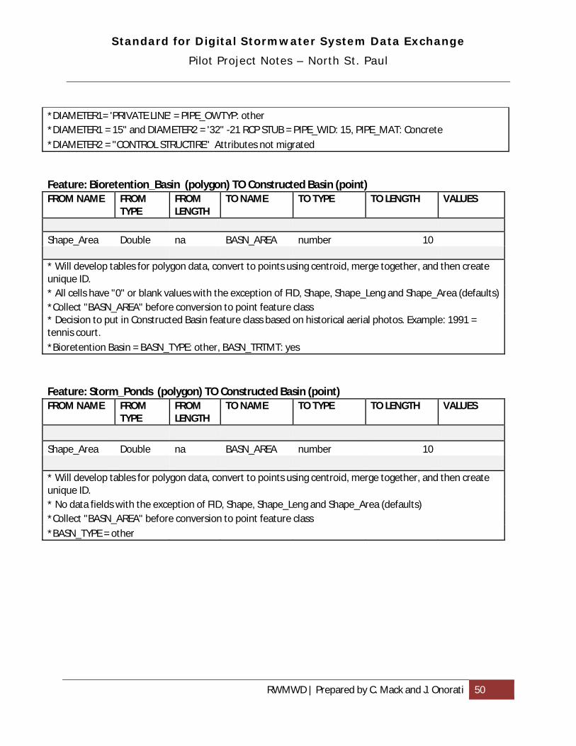
Standard for Digital Stormwater System Data Exchange
Pilot Project Notes – North St. Paul
RWMWD | Prepared by C. Mack and J. Onorati 50
*DIAMETER1= 'PRIVATE LINE' = PIPE_OWTYP: other *DIAMETER1 = 15" and DIAMETER2 = '32" -21 RCP STUB = PIPE_WID: 15, PIPE_MAT: Concrete
*DIAMETER2 = "CONTROL STRUCTIRE" Attributes not migrated
Feature: Bioretention_Basin (polygon) TO Constructed Basin (point) FROM NAME FROM
TYPE FROM LENGTH
TO NAME TO TYPE TO LENGTH VALUES
Shape_Area Double na BASN_AREA number 10 * Will develop tables for polygon data, convert to points using centroid, merge together, and then create unique ID. * All cells have "0" or blank values with the exception of FID, Shape, Shape_Leng and Shape_Area (defaults)*Collect "BASN_AREA" before conversion to point feature class * Decision to put in Constructed Basin feature class based on historical aerial photos. Example: 1991 = tennis court. *Bioretention Basin = BASN_TYPE: other, BASN_TRTMT: yes
Feature: Storm_Ponds (polygon) TO Constructed Basin (point) FROM NAME FROM
TYPE FROM LENGTH
TO NAME TO TYPE TO LENGTH VALUES
Shape_Area Double na BASN_AREA number 10 * Will develop tables for polygon data, convert to points using centroid, merge together, and then create unique ID. * No data fields with the exception of FID, Shape, Shape_Leng and Shape_Area (defaults) *Collect "BASN_AREA" before conversion to point feature class *BASN_TYPE = other

Standard for Digital Stormwater System Data Exchange
Migration Report – City of Oakdale
RWMWD | Prepared by C. Mack and J. Onorati 51
Description:
• Source data comprised of 4 shapefiles: storm, stormmh, catchbas, flare
Migration process:
General notes:
• This dataset was compact in terms of features represented and easy to interpret. There were a minimum of extraneous attributes (relative to Standard schema needs), making the job of feature migration fairly straightforward and quick.
• The Standard currently does not specify an attribute value in its feature class for structures (Stormwater_Device) that seemed suited to describe a "flare". It would be helpful to know if the function of these structures is known by feature: inlet, outlet, or both?
• Some pipe features in the storm feature class had directionality that were opposite of the downstream pipe. These were typically short sections sometimes found adjacent to catch basins, next to stormwater basin or small natural ponds, or connector pipes between two pipe networks. These could be errors or pipes that have backslope intentionally to function as overflows.
• Many point features appear to not be snapped to nearby pipes and there are some orphan point features that have no other structure nearby to snap to. However, currently the Standard only specifies that line features need to be snapped together (coincident at endpoints).
Migration to standard schema:
1. Review source data from data producer and compare with standard schema or database template to understand what tasks are required for migration.
2. Prepare migration tables to guide translation of fields and values (values that were changed to fit standard schema domains are noted in Conversions & Comments column)
3. Create working copies of source data feature classes, add relevant standard fields and populate. Perform value conversions if needed when populating new fields using Calculate Field.
4. Import data from working copies into destination standard feature classes using Merge (schemas must be identical) or Append (using No-Test option for non-identical schemas).
Connectivity and directionality check/editing process:
• See general notes document.
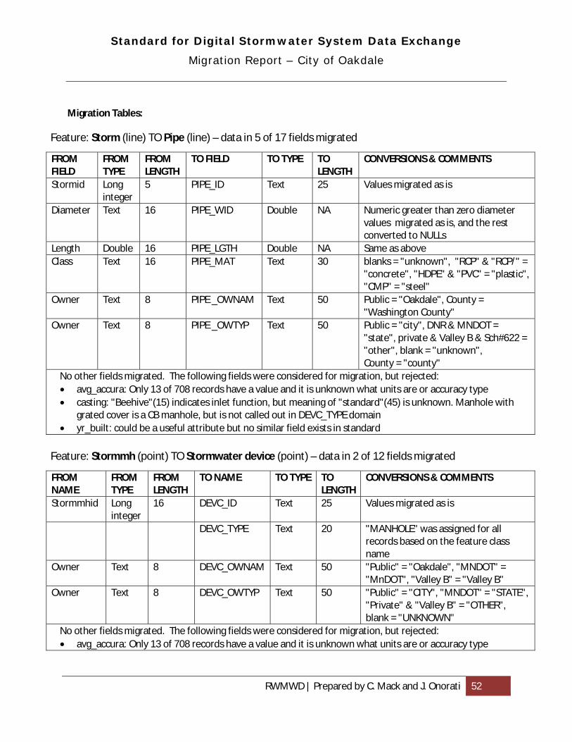
Standard for Digital Stormwater System Data Exchange
Migration Report – City of Oakdale
RWMWD | Prepared by C. Mack and J. Onorati 52
Migration Tables:
Feature: Storm (line) TO Pipe (line) – data in 5 of 17 fields migrated
FROM FIELD
FROM TYPE
FROM LENGTH
TO FIELD TO TYPE TO LENGTH
CONVERSIONS & COMMENTS
Stormid Long integer
5 PIPE_ID Text 25 Values migrated as is
Diameter Text 16 PIPE_WID Double NA Numeric greater than zero diameter values migrated as is, and the rest converted to NULLs
Length Double 16 PIPE_LGTH Double NA Same as above Class Text 16 PIPE_MAT Text 30 blanks = "unknown", "RCP" & "RCP/" =
"concrete", "HDPE" & "PVC" = "plastic", "CMP" = "steel"
Owner Text 8 PIPE _OWNAM Text 50 Public = "Oakdale", County = "Washington County"
Owner Text 8 PIPE _OWTYP Text 50 Public = "city", DNR & MNDOT = "state", private & Valley B & Sch#622 = "other", blank = "unknown", County = "county"
No other fields migrated. The following fields were considered for migration, but rejected: • avg_accura: Only 13 of 708 records have a value and it is unknown what units are or accuracy type • casting: "Beehive"(15) indicates inlet function, but meaning of "standard"(45) is unknown. Manhole with
grated cover is a CB manhole, but is not called out in DEVC_TYPE domain • yr_built: could be a useful attribute but no similar field exists in standard
Feature: Stormmh (point) TO Stormwater device (point) – data in 2 of 12 fields migrated
FROM NAME
FROM TYPE
FROM LENGTH
TO NAME TO TYPE TO LENGTH
CONVERSIONS & COMMENTS
Stormmhid Long integer
16 DEVC_ID Text 25 Values migrated as is
DEVC_TYPE Text 20 "MANHOLE" was assigned for all records based on the feature class name
Owner Text 8 DEVC_OWNAM Text 50 "Public" = "Oakdale", "MNDOT" = "MnDOT", "Valley B" = "Valley B"
Owner Text 8 DEVC_OWTYP Text 50 "Public" = "CITY", "MNDOT" = "STATE", "Private" & "Valley B" = "OTHER", blank = "UNKNOWN"
No other fields migrated. The following fields were considered for migration, but rejected: • avg_accura: Only 13 of 708 records have a value and it is unknown what units are or accuracy type

Standard for Digital Stormwater System Data Exchange
Migration Report – City of Oakdale
RWMWD | Prepared by C. Mack and J. Onorati 53
• worst_accu: same as above and probably would use avg_accura instead of this attribute • casting: "Beehive"(15) indicates inlet function, but meaning of "standard"(45) is unknown; manhole with
grated cover is a CB manhole (not specifically in DEVC_TYPE domain) • yrbuilt: could be a useful attribute but no similar field exists in standard • sump_cb: could be useful but only 1 of 708 records have a value ("no"); if "yes" then DEVC_WAT value
would be "YES"
Feature: Catchbas (point) TO Stormwater device (point) – data in 2 of 14 fields migrated
FROM NAME
FROM TYPE
FROM LENGTH
TO NAME TO TYPE TO LENGTH
CONVERSIONS & COMMENTS
Catchid Long integer
16 DEVC_ID Text 25 Values migrated as is
DEVC_TYPE Text 20 "CATCH BASIN" was assigned for all records based on the feature class name
Owner Text 8 DEVC_OWNAM Text 50 "Public" = "Oakdale", "MNDOT" = "MnDOT", "County" = "Washington County"
Owner Text 8 DEVC_OWTYP Text 50 "Public" = "CITY", "MNDOT" = "STATE", "Private" = "OTHER", "County" = "COUNTY" blank = "UNKNOWN"
No other fields migrated. The following fields were considered for migration, but rejected: • avg_accura: only 127 of 3596 not blank, unknown units and accuracy type • worst_accu: same as above and probably would use avg_accura instead of this attribute • casting_ty: "Beehive"(141), "Standard"(2304), blank(1151); if inlets were a separate feature class then this
data could be used in a grate type attribute • yr_built: could be a useful attribute but no similar field exists in standard • sump: could be useful but has no values; if it did DEVC_WAT value would be "YES"
Feature: Flare (point) TO Stormwater device (point) – data in 2 of 15 fields migrated
FROM NAME
FROM TYPE
FROM LENGTH
TO NAME TO TYPE TO LENGTH
CONVERSIONS & COMMENTS
Flareid Long integer
16 DEVC_ID Text 25 Values migrated as is
DEVC_TYPE Text 20 "OTHER" (no flared end section in std domain) was assigned for all records based on the feature class name

Standard for Digital Stormwater System Data Exchange
Migration Report – City of Oakdale
RWMWD | Prepared by C. Mack and J. Onorati 54
FROM NAME
FROM TYPE
FROM LENGTH
TO NAME TO TYPE TO LENGTH
CONVERSIONS & COMMENTS
Owner Text 8 DEVC_OWNAM Text 50 "Public" = "Oakdale", "County" = "Washington County", "MNDOT" = "MnDOT", "DNR" = "DNR", "Sch#622" = "Sch#622"
Owner Text 8 DEVC_OWTYP Text 50 "Public" = "CITY", "MNDOT" & "DNR" = "STATE", "Private"& "Sch#622" = "OTHER", "County" = "COUNTY" blank = "UNKNOWN"
No other fields migrated. The following fields were considered for migration, but rejected: • avg_accura: Only 27 of 1454 not blank, unknown units and accuracy type • worst_accu: same as above and probably would use avg_accura instead of this attribute • material (Reinforc, Corrugat, High Den, Ductile, Clay Til) could be a useful attribute but no similar field exists
in standard • yr_built: could be a useful attribute but no similar field exists in standard • pipesize: what does this provide as an attribute for a flare? • seditpond – this indicates what feature flare is associated with, but not sure how to use in standard (values:
DTCH, NURP, STRM)

Standard for Digital Stormwater System Data Exchange
Pilot Project Notes – St. Paul
RWMWD | Prepared by C. Mack and J. Onorati 55
Description:
• Source data comprised of 8 shapefiles: CATCH_BASIN_ACTIVE.shp STORM_FITTING_ACTIVE.shp STORM_FLARE_END_ACTIVE.shp STORM_MANHOLE_ACTIVE.shp STORM_NE_NODE_ACTIVE.shp STORM_PIPE_ACTIVE.shp STORM_PIPE_CAP_ACTIVE.shp STORM_REDUCER_ACTIVE.shp.
Migration:
General notes: • Raw data received in UTM. • Catch Basin Returns were received in CAD format. Will not migrate unless there is time to
convert properly to ArcView data format
Migration to standard schema:
1. Review source data from data producer and compare with standard schema or database template to understand what tasks are required for migration.
2. Prepare migration tables to guide translation of fields and values (values that were changed to fit standard schema domains are noted in Conversions & Comments column)
3. Create working copies of source data feature classes, add relevant standard fields and populate. Perform value conversions if needed when populating new fields using Calculate Field.
4. Import data from working copies into destination standard feature classes using Merge (schemas must be identical) or Append (using No-Test option for non-identical schemas).
Migration Tables:
Feature: CATCH_BASIN_ACTIVE (point) TO StormwaterDevice (point) – data in 3 of 12 fields migrated FROM NAME
FROM TYPE
FROM LENGTH
TO NAME TO TYPE
TO LENGTH
VALUES
FID_ Text 254 DEVC_ID Text 25
GML_ID Text 254 DEVC_TYPE Text 20Original formatted as [DEVC_TYPE]:[DEVC_ID]
OWNER Text 254 DEVC_OWTYP text 50 Owner:City = OWTYP: CITY & OWNAM: ST PAUL. Owner: MnDOT or Private = OWTYP: OTHER. Owner:MnDOT = OWNAM=MnDOT

Standard for Digital Stormwater System Data Exchange
Pilot Project Notes – St. Paul
RWMWD | Prepared by C. Mack and J. Onorati 56
Feature: STORM_MANHOLE_ACTIVE (point) TO StormwaterDevice (point) ) – data in 6 of 16 fields migrated
FROM NAME FROM TYPE
FROM LENGTH
TO NAME TO TYPE TO LENGTH
VALUES
FID_ Text 254 DEVC_ID Text 25
GML_ID Text 254 DEVC_TYPE Text 20 Original formatted as [DEVC_TYPE]:[DEVC_ID]
OWNER Text 254 DEVC_OWTYP text 50 See note below OWNER Text 254 DEVC_OWNAM text 50 See note below SUMP_ELEVA Text 254 DEVC_IELEV Number 6 In local datum. Add 694.1
to convert to sea level (R. Ekobena)
RIM_ELEVAT Text 254 DEVC_HT Number 3 subtract SUMP_ELEVA from RIM_ELEVAT to calculate DEVC_HT
Notes on OWNER field conversion
• OWNER = 'MAC' OR 'MCES' OR 'MnDOT' OR 'Port Authority' OR 'Private' Than OWTYP = "Other" & OWNAM = "[direct cell transfer]"
• OWNER = "City" Than OWTYP="CITY" & OWNAM = "StPaul". • OWNER = "South St. Paul" or "Maplewood" Then OWTYP = "CITY" & OWNAM = "[city name]". • OWNER = "Ramsey Co." Then OWTYP = "COUNTY" & OWNAM = RAMSEY • OWNER = "RWMWD" Then OWTYP = "WATERSHED DISTRICT" & OWNAM = "RWMWD"
*FID_ #275088 appears to have typo in SUMP_ELEVA field. Value: 25272 Notes on Elevation fields
• [RIM_ELEVA] - [SUMP_ELEVA] =DEVC_HT produced a few negative values. Likely an error in one of the elevation values. Not adjusting at this time.
• DEVC_IELEV: Select those that have value in SUMP_ELEV and whose value is NOT "-99" which is assumed unknown
• DEVC_HT: Records with SUMP_ELEVA = "-99" or "0" or if RIM_ELEVA = '0' height was not calculated
Feature: STORM_FLARE_END_ACTIVE (point) TO StormwaterDevice (point) ) – data in 6 of 12 fields migrated FROM NAME FROM
TYPE FROM LENGTH
TO NAME TO TYPE
TO LENGTH
VALUES
FID_ Text 254 DEVC_ID Text 25
GML_ID Text 254 DEVC_TYPE Text 20Original formatted as [DEVC_TYPE]:[DEVC_ID]
OWNER Text 254 DEVC_OWTYP text 50 * OWNER Text 254 DEVC_OWNAM text 50 * SUMP_ELEVA Text 254 DEVC_IELEV Number 6 In local datum. Add 694.1 to convert to
sea level (R. Ekobena). Values "-99" assumed unknown ("0")

Standard for Digital Stormwater System Data Exchange
Pilot Project Notes – St. Paul
RWMWD | Prepared by C. Mack and J. Onorati 57
RIM_ELEVAT Text 254 DEVC_HT Number 3 Subtract SUMP_ELEVA from RIM_ELEVA
Notes on OWNER field conversion
• OWNER = 'MAC' OR 'MCES' OR 'MnDOT' OR 'Port Authority' OR 'Private' Than OWTYP = "Other" & OWNAM = "[direct cell transfer]"
• OWNER = "City" Than OWTYP="CITY" & OWNAM = "StPaul". • OWNER = "Ramsey Co." Then OWTYP = "COUNTY" & OWNAM = RAMSEY • OWNER = "RWMWD" Then OWTYP = "WATERSHED DISTRICT" & OWNAM = "RWMWD"
Notes on Elevation fields • DEVC_IELEV: Select those that have value in SUMP_ELEV and whose value is NOT "-99" assumed
unknown • DEVC_HT: Records with SUMP_ELEVA = "-99" or "0" or if RIM_ELEVA = '0' height was not calculated • [RIM_ELEVA] - [SUMP_ELEVA] = DEVC_HT produced a few negative values. Likely an error in one of the
elevation values. Not adjusting at this time.
Feature: STORM_FITTING_ACTIVE (point) TO StormwaterDevice (point) – data in 6 of 12 fields migrated FROM NAME FROM
TYPE FROM LENGTH
TO NAME TO TYPE TO LENGTH
VALUES
FID_ Text 254 DEVC_ID Text 25
GML_ID Text 254 DEVC_TYPE Text 20 Original formatted as [DEVC_TYPE]:[DEVC_ID]
OWNER Text 254 DEVC_OWTYP text 50 * OWNER Text 254 DEVC_OWNAM text 50 * SUMP_ELEVA Text 254 DEVC_IELEV Number 6
In local datum. Add 694.1 to convert to sea level (R. Ekobena)
RIM_ELEVAT Text 254 DEVC_HT Number 3 Subtract SUMP_ELEVA from RIM_ELEVA
Notes on OWNER field conversion
• OWNER = 'MAC' OR 'MCES' OR 'MnDOT' OR 'Port Authority' OR 'Private' Than OWTYP = "Other" & OWNAM = "[direct cell transfer]"
• OWNER = "City" Than OWTYP="CITY" & OWNAM = "StPaul". • OWNER = "Maplewood" OR "West St. Paul" Then OWTYP = "CITY" & OWNAM = "[city name]". • OWNER = "Ramsey Co." Then OWTYP = "COUNTY" & OWNAM = RAMSEY • OWNER = "RWMWD" Then OWTYP = "WATERSHED DISTRICT" & OWNAM = "RWMWD"

Standard for Digital Stormwater System Data Exchange
Pilot Project Notes – St. Paul
RWMWD | Prepared by C. Mack and J. Onorati 58
Notes on Elevation fields • DEVC_IELEV: Select those that have value in SUMP_ELEV and whose value is NOT "-99" which is assumed
unknown • [RIM_ELEVA] - [SUMP_ELEVA] = DEVC_HT produced a few negative values. Likely an error in one of the
elevation values. Not adjusting at this time. • * DEVC_HT: Records with SUMP_ELEVA = "-99" or "0" or if RIM_ELEVA = '0' height was not calculated
The following field was considered for migration, but rejected: • FITTING_TY includes CB Connection, flared end section, horizontal bend, ne node, etc, but all would
qualify as DEVD_TYP=OTHER by the Standard.
Feature: STORM_NE_NODE_ACTIVE (point) TO StormwaterDevice (point) FROM NAME FROM
TYPE FROM LENGTH
TO NAME TO TYPE TO LENGTH
VALUES
FID_ Text 254 DEVC_ID Text 25
GML_ID Text 254 DEVC_TYPE Text 20 Original formatted as [DEVC_TYPE]:[DEVC_ID]
OWNER Text 254 DEVC_OWTYP text 50 * OWNER Text 254 DEVC_OWNAM text 50 * SUMP_ELEVA Text 254 DEVC_IELEV Number 6 In local datum. Add
694.1 to convert to sea level (R. Ekobena)
RIM_ELEVAT Text 254 DEVC_HT Number 3 Subtract SUMP_ELEVA from RIM_ELEVA
Notes on OWNER field conversion
• OWNER = 'MCES' Than OWTYP = "Other" & OWNAM = "[direct cell transfer]" • OWNER = "City" Than OWTYP="CITY" & OWNAM = "StPaul". • OWNER = “Maplewood" Then OWTYP = "CITY" & OWNAM = "[city name]". • OWNER = "Ramsey Co." Then OWTYP = "COUNTY" & OWNAM = RAMSEY
Notes on Elevation fields • DEVC_IELEV: Select those that have value in SUMP_ELEV and whose value is NOT "-99" which is assumed
unknown • [RIM_ELEVA] - [SUMP_ELEVA] = DEVC_HT produced a few negative values. Likely an error in one of the
elevation values. Not adjusting at this time. • DEVC_HT: Records with SUMP_ELEVA = "-99" or "0" or if RIM_ELEVA = '0' height was not calculated

Standard for Digital Stormwater System Data Exchange
Pilot Project Notes – St. Paul
RWMWD | Prepared by C. Mack and J. Onorati 59
Feature: STORM_PIPE_CAP_ACTIVE (point) TO StormwaterDevice (point) FROM NAME FROM
TYPE FROM LENGTH
TO NAME TO TYPE TO LENGTH
VALUES
FID_ Text 254 DEVC_ID Text 25
GML_ID Text 254 DEVC_TYPE Text 20 Original formatted as [DEVC_TYPE]:[DEVC_ID]
OWNER Text 254 DEVC_OWTYP text 50 * OWNER Text 254 DEVC_OWNAM text 50 * SUMP_ELEVA Text 254 DEVC_IELEV Number 6 In local datum. Add
694.1 to convert to sea level (R. Ekobena)
RIM_ELEVAT Text 254 DEVC_HT Number 3 Subtract SUMP_ELEVA from RIM_ELEVA
Notes on OWNER field conversion • OWNER = 'MAC' OR 'MCES' OR 'MnDOT' OR 'Port Authority' Than OWTYP = "Other" & OWNAM = "[direct
cell transfer]" • OWNER = "City" Than OWTYP="CITY" & OWNAM = "StPaul". • OWNER = "West St. Paul" Then OWTYP = "CITY" & OWNAM = "[city name]".
Notes on Elevation fields • DEVC_IELEV: Select those that have value in SUMP_ELEV and whose value is NOT "-99" which is assumed
unknown • [RIM_ELEVA] - [SUMP_ELEVA] = DEVC_HT produced a few negative values. Likely an error in one of the
elevation values. Not adjusting at this time. • DEVC_HT: Records with SUMP_ELEVA = "-99" or "0" or if RIM_ELEVA = '0' height was not calculated
Feature: STORM_REDUCER_ACTIVE (point) TO StormwaterDevice (point) FROM NAME FROM
TYPE FROM LENGTH
TO NAME TO TYPE TO LENGTH
VALUES
FID_ Text 254 DEVC_ID Text 25
GML_ID Text 254 DEVC_TYPE Text 20 Original formatted as [DEVC_TYPE]:[DEVC_ID]
OWNER Text 254 DEVC_OWTYP text 50 * OWNER Text 254 DEVC_OWNAM text 50 * SUMP_ELEVA Text 254 DEVC_IELEV Number 6 In local datum. Add
694.1 to convert to sea level (R. Ekobena)
RIM_ELEVAT Text 254 DEVC_HT Number 3 Subtract SUMP_ELEVA from RIM_ELEVA

Standard for Digital Stormwater System Data Exchange
Pilot Project Notes – St. Paul
RWMWD | Prepared by C. Mack and J. Onorati 60
Notes on OWNER field conversion
• OWNER = 'MCES' Than OWTYP = "Other" & OWNAM = "[direct cell transfer]" • OWNER = "City" Than OWTYP="CITY" & OWNAM = "StPaul". • OWNER = "Ramsey Co." Then OWTYP = "COUNTY" & OWNAM = RAMSEY
Notes on Elevation fields • DEVC_IELEV: Select those that have value in SUMP_ELEV and whose value is NOT "-99" which is assumed
unknown • [RIM_ELEVA] - [SUMP_ELEVA] = DEVC_HT produced a few negative values. Likely an error in one of the
elevation values. Not adjusting at this time. • DEVC_HT: Records with SUMP_ELEVA = "-99" or "0" or if RIM_ELEVA = '0' height was not calculated.
Feature: STORM_PIPE_ACTIVE (line) TO PIPE (line) FROM NAME FROM TYPE FROM LENGTH TO NAME TO TYPE TO LENGTH VALUES
FID_ Text 254 DEVC_ID Text 25 START_Z Text 254 PIPE_UPIELV Number 6 In local datum.
Add 694.1 to convert to sea level (R. Ekobena)
END_Z Text 254 PIPE_DNIELV Number 6 In local datum. Add 694.1 to convert to sea level (R. Ekobena)
OWNER Text 254 DEVC_OWTYP text 50 See note below OWNER Text 254 DEVC_OWNAM text 50 See note below FROM_DIAME Text 254 PIPE_WID Number 3 ** Assume
Inches TO_DIAMETE Text 254 PIPE_WID Number 3 *Assume Inches MATERIAL Text 254 PIPE_MAT Text 30 **
Notes on OWNER field conversion
• OWNER = 'MAC' OR 'MCES' OR 'MnDOT' OR 'Port Authority' OR 'Private' Than OWTYP = "Other" & OWNAM = "[direct cell transfer]"
*PIPE_WID: If FROM_DIAME was different than TO_DIAMETE than PIPE_WID = <NULL>
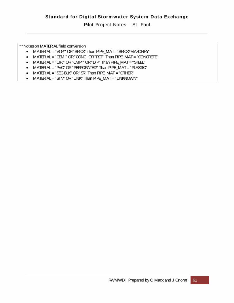
Standard for Digital Stormwater System Data Exchange
Pilot Project Notes – St. Paul
RWMWD | Prepared by C. Mack and J. Onorati 61
**Notes on MATERIAL field conversion • MATERIAL = "VCP," OR "BRICK" than PIPE_MAT= “BRICK/MASONRY” • MATERIAL = "CEM," OR "CONC" OR "RCP" Than PIPE_MAT = "CONCRETE" • MATERIAL = "CIP," OR "CMP," OR "DIP" Than PIPE_MAT = "STEEL" • MATERIAL = "PVC" OR "PERFORATED" Than PIPE_MAT = "PLASTIC" • MATERIAL = "SEG BLK" OR "SR" Than PIPE_MAT = "OTHER" • MATERIAL = "STN" OR "UNK" Than PIPE_MAT = "UNKNOWN"

Standard for Digital Stormwater System Data Exchange
Pilot Project Notes – Woodbury
RWMWD | Prepared by C. Mack and J. Onorati 62
Description:
• Source data comprised of 4 file geodatabase feature classes: stormMPCAPondInventory StormPipes, StormStructures StormWaterFlow
Migration:
General notes:
• Two batches of data received, 9/23/10 and 11/4/10. Later data had the following visible changes:
a. Feature class name change “storm_ponds” to “MPCAPondInventory.” b. “MPCAPondInventory” added multiple fields. c. Storm_structures feature class records added 12, 609 records. d. Minor changes to fields in StormStructures, StormFlow, and StormPipes
Migration to standard schema:
1. Review source data from data producer and compare with standard schema or database template to understand what tasks are required for migration.
2. Prepare migration tables to guide translation of fields and values (values that were changed to fit standard schema domains are noted in Conversions & Comments column)
3. Create working copies of source data feature classes, add relevant standard fields and populate. Perform value conversions if needed when populating new fields using Calculate Field.
4. Import data from working copies into destination standard feature classes using Merge (schemas must be identical) or Append (using No-Test option for non-identical schemas).
5. Create migration tables:
Feature: StormPipes (line) TO Pipe (line)
FROM NAME FROM TYPE
FROM LENGTH
TO NAME TO TYPE
TO LENGTH
VALUES
ID*** Double na PIPE_ID Text 25 “0” for 216 fields LENGTH Double na PIPE_LGTH Number 5 See note below.
Length deceiving for pipes whose LAYER="Culvert"
SIZE Double na PIPE_WID Number 3

Standard for Digital Stormwater System Data Exchange
Pilot Project Notes – Woodbury
RWMWD | Prepared by C. Mack and J. Onorati 63
MATERIAL Text 50 PIPE_MAT Text 30 Blank = "unknown", "RCP" & "RCP/" = "concrete", "HDPE" & "PVC" = "plastic", "CMP" = "steel", “CSP” = “steel”, DIP"& “VCP” & “SDR 35 PLA” = "plastic"
Name** Text 50 PIPE_OWTYP Text 50 “Abandon” & “Culvert” & “Forcemain” & “Private” = "other", “Public” = "City"
• Pipes with Layer (or “PIPE_OWTYP”) = CULVERT are lines forming a triangle with a diameter of ~5ft
** NAME includes owner and function data. Migrated as PIPE_OWTYP. *** No completed unique ID field (other than default). 216 records with ID = 0. Did not populate ‘0’ values.
Feature: StormStructures (point) TO Stormwater device (point)
FROM NAME FROM TYPE
FROM LENGTH
TO NAME TO TYPE
TO LENGTH
VALUES
ID Long
Integer na DEVC_ID Text 25
NAME* Text 29 DEVC_TYPE Text 20 Do not match domains in Standard well. Some names >20 characters
INVERT* Double na DEVC_ILEV Number 6
DIAMETER* Text 11 DEVC_WID Number 3 Use formulas to convert directly or with inch>foot conversion
FUNCTION Text 21 DEVC_TYPE Text 20 Function of device listed in "NAME" field. Used to aid population of DEVC_TYPE.*
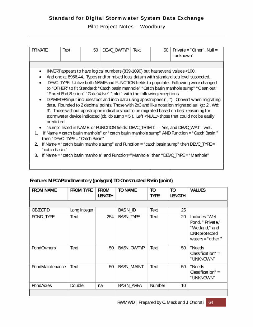
Standard for Digital Stormwater System Data Exchange
Pilot Project Notes – Woodbury
RWMWD | Prepared by C. Mack and J. Onorati 64
PRIVATE Text 50 DEVC_OWTYP Text 50 Private = "Other", Null = "unknown"
• INVERT appears to have logical numbers (839-1090) but has several values <100, • And one at 8966.44. Typos and/or mixed local datum with standard sea level suspected. • DEVC_TYPE: Utilize both NAME and FUNCTION fields to populate. Following were changed
to “OTHER” to fit Standard: “Catch basin manhole” “Catch basin manhole sump” “Clean out” “Flared End Section” “Gate Valve” “Inlet” with the following exceptions:
• DIAMETER input includes foot and inch data using apostrophes (‘, ‘’). Convert when migrating data. Rounded to 2 decimal points. Those with 2x3 and like notation migrated as Hgt: 2’, Wd: 3’. Those without apostrophe indicators had to be migrated based on best reasoning for stormwater device indicated (cb, cb sump = 5’). Left <NULL> those that could not be easily predicted.
• “sump” listed in NAME or FUNCTION fields: DEVC_TRTMT: = Yes, and DEVC_WAT = wet. 1. If Name = catch basin manhole” or “catch basin manhole sump” AND Function = “Catch Basin,”
then “DEVC_TYPE = “Catch Basin” 2. If Name = “catch basin manhole sump” and Function = “catch basin sump” then DEVC_TYPE =
“catch basin.” 3. If Name = “catch basin manhole” and Function=”Manhole” then “DEVC_TYPE = “Manhole”
Feature: MPCAPondInventory (polygon) TO Constructed Basin (point)
FROM NAME FROM TYPE FROM LENGTH
TO NAME TO TYPE
TO LENGTH
VALUES
OBJECTID Long Integer BASIN_ID Text 25
POND_TYPE Text 254 BASN_TYPE Text 20 Includes "Wet Pond. " Private," “Wetland,” and DNR protected waters = “other.”
PondOwners Text 50 BASN_OWTYP Text 50 "Needs Classification" = “UNKNOWN”
PondMaintenance Text 50 BASN_MAINT Text 50 "Needs Classification" = “UNKNOWN”
PondAcres Double na BASIN_AREA Number 10

Standard for Digital Stormwater System Data Exchange
Pilot Project Notes – Woodbury
RWMWD | Prepared by C. Mack and J. Onorati 65
• Feature class is polygon. Find centroid and convert to points. • DNRNo – indicates DNR Public Waters feature. Records with data in this field were removed
from original feature class and migrated to Natural Surface Water Feature (see table below). • BASN_TYPE includes “DNR Protected Water.” Categorized as “other” in BASN_TYPE.
**OBJECTID, OBJECTID_1, ID_1, OBJECTID_12 and ID all appear to be suitable ID fields. Used OBJECTID_1 for migration because it does not seem to have breaks in the sequence.
Feature: MPCAPondInventory (polygon) TO Natural Surface Water Feature (point)
FROM NAME FROM TYPE
FROM LENGTH
TO NAME TO TYPE
TO LENGTH
VALUES
OBJECTID_1 Long
Integer WATR_ID Text 25
DNRNo Text 254 WATR_PWI Text 8 Only 3-4 (alpha numeric) definitions in source data
PondOwners Text 50 WATR_OWTYP Text 50 "Needs Classification" = “UNKNOWN”
PondMaintenaence Text 50 WATR_MAINT Text 50 "Needs Classification" = “UNKNOWN”
• Source Feature class is polygon. Find centroid and convert to
points. • This feature class was created by selecting records from MPCAPondInventory with DNRNo OR
DNR Protected Water indications in the POND_TYPE field. DNRNo – indicates DNR Public Waters feature and reasoned that both instances indicates non-constructed basin.
**OBJECTID, OBJECTID_1, ID_1, OBJECTID_12 and ID all seem to be suitable ID fields. Using OBJECTID_1 because it does not seem to have breaks in the sequence.