Standard 3: ANALYZING THE SPATIAL ORGANIZATION OF PEOPLE, PLACES, AND ENVIRONMENTS Knowing and...
18
Standard 3: ANALYZING THE SPATIAL ORGANIZATION OF PEOPLE, PLACES, AND ENVIRONMENTS • Knowing and applying geography • Questioning approach to the world around them and ask what, where, when, why, and how • Formulate answers to critical questions about past, present, and future • Powerful tools for explaining the world at all scales • Ability to describe and analyze the spatial organization of people, places, and environments
-
Upload
doreen-waters -
Category
Documents
-
view
216 -
download
1
Transcript of Standard 3: ANALYZING THE SPATIAL ORGANIZATION OF PEOPLE, PLACES, AND ENVIRONMENTS Knowing and...

Standard 3: ANALYZING THE SPATIAL ORGANIZATION OF PEOPLE, PLACES, AND ENVIRONMENTS
• Knowing and applying geography
• Questioning approach to the world around them and ask what, where, when, why, and how
• Formulate answers to critical questions about past, present, and future
• Powerful tools for explaining the world at all scales
• Ability to describe and analyze the spatial organization of people, places, and environments
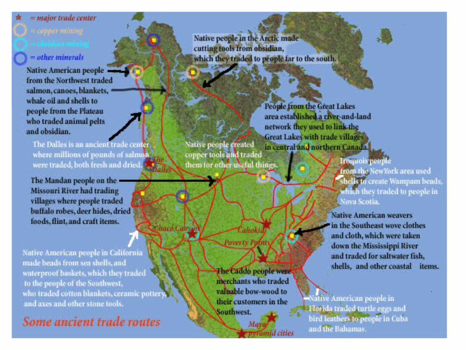

Analysis of prehistoric and historic trade & exchange networks provides insights into the possibility of Old World infectious disease transference & diffusion prior to European contact.
By showing the existence of established trade routes and exchange networks which date back into the prehistoric, the possibility is greatly increased that these trade routes and exchange networks acted as “access corridors” in the pre-contact diffusion and transference of many Old World infectious diseases such as smallpox, typhus, measles, and others.
Trade Routes and the Spread of Infectious Diseases
• Knowing and applying geography• Questioning approach to the world around them and ask what, where, when, why, and how• Formulate answers to critical questions about past, present, and future• Powerful tools for explaining the world at all scales• Ability to describe and analyze the spatial organization of people, places, and environments

ANALYZING THE SPATIAL ORGANIZATION OF PEOPLE, PLACES, AND ENVIRONMENTS
Geographic/Spatial Literacy Identifying features, structures, & human activity on Earth’s surface
– Physical environment (topography, streams and rivers, climates, vegetation types, soils)
– Human features (towns & cities, population, highways, trade flows, the spread of disease, national parks)
– Physical and Human taken together (beach resorts in relation to climate, topography, or major population centers)
– Location and Arrangement of both physical and human phenomena form regular and recurring patterns

ANALYZING THE SPATIAL ORGANIZATION OF PEOPLE, PLACES, AND ENVIRONMENTS
• The description of a pattern of spatial organization begins by breaking it into its simplest components: points, lines, areas, and volumes
• These 4 elements describe the spatial properties of objects:
• a shipyard can be thought of as a point…
• … connected by shipping and rail routes (lines)…
• …leading to nearby (and far
away) markets (areas) as well as leading from nearby iron ore mining sites (areas)…
• … and the lake or river the ships travel in can be thought of as a volume.

ANALYZING THE SPATIAL ORGANIZATION OF PEOPLE, PLACES, & ENVIRONMENTS
• Next, concepts such as: location, distance, direction, density, and arrangement (linear, grid-like, random) are considered.
• Thus the U.S. interstate highway system can be described as lines connecting points over an area—the arrangement is partly grid-like (with north-south and east-west routes as in the central United States) and partly radial or star-shaped (as in the highways centered on Atlanta)—and the pattern of interstates is denser in the East than it is in the West.


Applying Spatial Analysis & Putting It Into Practice: Developing a Safe Routes to School Walking Route Map
Roadrunner Elementary School, Phoenix, AZ
• Phoenix, like many other communities, works with school officials & parents to develop walking route maps to provide young students guidance on the safest routes to walk to and from school. The walking route plan helps to identify where improvements are needed, and where to place crosswalks, STOP signs and adult school crossing guards. The ultimate purpose of the walking routes is to encourage more children to walk to school and discourage parents from driving their children to school.
• The school provides the boundary map and parent volunteers to work on reviewing and developing the walking routes. The City provides aerial photographs, quarter-section maps, and guidelines for parents and school officials on how to conduct their reviews. The process requires parent volunteers or school officials to review the entire walking route and to identify the most desirable walking route to serve each household within the walking attendance boundary.
• Once the walking route maps are completed, traffic officials review the areas of concern and work with school officials to assure that the right number and placement of adult school crossing guards exists. The City provides final versions of the maps and maintains the computer files for the walking routes. It is the responsibility of the school officials to distribute the walking route plans to the parents at the start of the school year and when new students are enrolled at the school. School walking route maps are reviewed annually to identify if there are any changes to or within the school walking attendance boundary
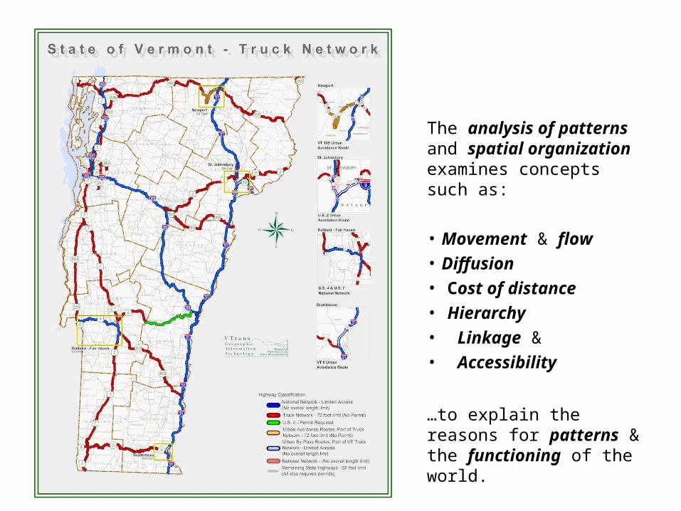
The analysis of patterns and spatial organization examines concepts such as:
• Movement & flow
• Diffusion
• Cost of distance
• Hierarchy
• Linkage &
• Accessibility
…to explain the reasons for patterns & the functioning of the world.

ANALYZING THE SPATIAL ORGANIZATION OF PEOPLE, PLACES, & ENVIRONMENTS
Geographers today place an emphasis on spatial organization that includes the concept of functional regions — areas defined by business and economic activities.
Functional regions are organized around a node, or focal point, with the surrounding areas linked to that node through systems, associations, and activities.
The concept of functional regions provides a way to examine the linkages and flows that create interdependence among people.
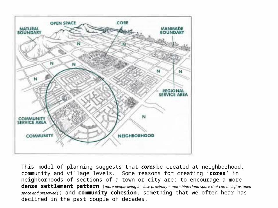
This model of planning suggests that cores be created at neighborhood, community and village levels. Some reasons for creating ‘cores’ in neighborhoods of sections of a town or city are: to encourage a more dense settlement pattern (more people living in close proximity = more hinterland space that can be
left as open space and preserved); and community cohesion, something that we often hear has declined in the past couple of decades.

Great Lakes Relief, Drainage and Urban Areas Map
• In the case of a physical pattern, such as a river or lake system, there is a complex hierarchical arrangement linking small streams and lakes with drainage basins and large rivers and with drainage basins.
• Like other regions, here we see the spatial & human relationships, linkages, and networks operating in the Great Lakes Region.
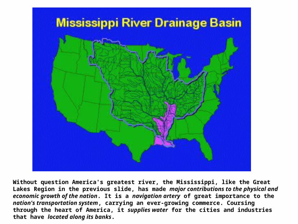
Without question America's greatest river, the Mississippi, like the Great Lakes Region in the previous slide, has made major contributions to the physical and economic growth of the nation. It is a navigation artery of great importance to the nation's transportation system, carrying an ever-growing commerce. Coursing through the heart of America, it supplies water for the cities and industries that have located along its banks.

Some Keywords / Concepts
• Transportation
• Linkages, Nodes, Hubs
• Communications
• Density Patterns

The Focused Growth Transit VisionThe region will be connected with a high quality, well balanced, fiscally responsible public transportation system.
The core functions of public transportation are:
To connect people to jobs
To connect people to major regional activity centers, such as downtown Pittsburgh, Oakland and the Airport
To connect people to local activity centers within each county

Fundamental Geographic Questions:
– Why are certain phenomena located or centered in particular places?
– How did they get there, and why?
– Why / how is their pattern of origin, evolution, and development significant?

Conclusion – Standard 3: Spatial Analysis
• Description & analysis of patterns of spatial organization must occur at scales ranging from local to global.
• Students confront a world that is increasingly interdependent.
• Widely separated places are interconnected as a consequence of improved transportation & communication networks.
• Human decisions at one location have physical impacts at another location (for example, the decision to burn coal rather than oil in a power plant may result in acid rain damaging vegetation in a location hundreds of miles away).

By Elizabeth Larson, PhDLecturer, School of Geographical
Sciences and Urban Planning, Arizona State University, 2010