Stage 1A Cultural Resources Survey New Cassel/Hicksville … · stage 1a cultural resources survey....
46
May 2013 Stage 1A Cultural Resources Survey New Cassel/Hicksville Groundwater Contamination Site Towns of Hempstead and North Hempstead Nassau County, New York Prepared for HDR Pearl River, New York By John Milner Associates, Inc. Croton-on-Hudson, New York R2-0011658
Transcript of Stage 1A Cultural Resources Survey New Cassel/Hicksville … · stage 1a cultural resources survey....
May
2013
Stage 1A Cultural Resources Survey
New Cassel/Hicksville Groundwater
Contamination Site
Towns of Hempstead and North Hempstead
Nassau County, New York
Prepared for
HDR
Pearl River, New York
By
John Milner Associates, Inc.
Croton-on-Hudson, New York
R2-0011658

STAGE 1A CULTURAL RESOURCES SURVEY
NEW CASSEL/HICKSVILLE GROUNDWATER CONTAMINATION SITE
TOWNS OF HEMPSTEAD AND NORTH HEMPSTEAD NASSAU COUNTY, NEW YORK
PREPARED FOR
HDR, INC. ONE BLUE HILL PLAZA, 12TH FLOOR
P.O. BOX 1509 PEARL RIVER, NEW YORK 10965
BY
TIMOTHY C. LLOYD, PH.D., RPA
JOHN MILNER ASSOCIATES, INC. 1 CROTON POINT AVENUE
CROTON-ON-HUDSON, NEW YORK 10520
MAY 2013
R2-0011659

MANAGEMENT SUMMARY
STAGE 1A CULTURAL RESOURCES SURVEY NEW CASSEL/HICKSVILLE GROUNDWATER CONTAMINATION
OPRHP MANAGEMENT SUMMARY
SHPO Review Number: 13PR01640 Involved State/Federal Agencies: NYSDEC, USEPA, USACE Phase of Survey: Stage/Phase 1A Location Information
Location: Old Country Road Minor Civil Divisions: Town of Hempstead (MCD 059.01) and
Town of North Hempstead (MCD 059.02) County: Nassau
Survey Area: Approximately 211 acres USGS 7.5 Minute Quadrangle Map: Hicksville, N.Y. and Freeport, N.Y. Results: Approximately 12 acres recommended for
Stage/Phase 1B subsurface archeological testing Report Author: Timothy C. Lloyd, Ph.D., RPA Date of Report: May 2013
R2-0011660

MANAGEMENT SUMMARY
STAGE 1A CULTURAL RESOURCES SURVEY NEW CASSEL/HICKSVILLE GROUNDWATER CONTAMINATION
JMA MANAGEMENT SUMMARY
JMA (John Milner Associates, Inc.) conducted a Stage 1A cultural resources survey in the Towns of Hempstead and North Hempstead, Nassau County, New York, for the New Cassel/Hicksville Groundwater Contamination Site. The Stage 1A investigation was conducted on behalf of HDR. The information and recommendations contained in this report are intended to assist the regulatory agencies in complying with their obligations under Section 106 of the National Historic Preservation Act, and other applicable historic preservation statutes and regulations. The purpose of the Stage 1A investigation is to identify previously recorded archaeological or historic sites that may be affected by remediation activities. The Stage 1A survey also evaluates the potential for there to be previously unrecorded archaeological or historic resources within the area that will be potentially affected by the undertaking. The information contained in this report is intended to help assess what effects remediation activities may have on archeological or historic resources. The cultural resources Study Area remained a relatively undeveloped grassland until the middle of the twentieth century. After WWII the Study Area witnessed intensive, fast-paced development, such that within a generation most of the 211 acres were covered by structures, asphalt, concrete, or manicured lawns. The densely-packed residential neighborhoods that had spread across the Study Area by the 1960s appear to have begun with the stripping of all vegetation. The stripping of vegetation and grading of the surface by heavy machinery, coupled with excavations for foundations/cellars, roads, sidewalks, storm water culverts, sewers, water lines, and a variety of other underground utilities, resulted in extensive ground disturbance. The extent of prior ground disturbance for such tightly-packed residential neighborhoods significantly diminishes the likelihood of intact near-surface soils. It is JMA’s opinion that no further cultural resources work is necessary in these areas. The exception is the approximately 12 acres of undeveloped land in between the storm water recharge basins at the southeast corner of the Study Area. If mitigation activities that involve ground disturbance are to take place in this area, it is JMA’s opinion that Stage 1B archeological subsurface testing be conducted prior to the mitigation activities.
R2-0011661

TABLE OF CONTENTS
STAGE 1A CULTURAL RESOURCES SURVEY NEW CASSEL/HICKSVILLE GROUNDWATER CONTAMINATION
TABLE OF CONTENTS
Management Summary List of Figures List of Photographs 1.0 INTRODUCTION ............................................................................................................................................ 1 1.1 Purpose and Goals of the Investigation .............................................................................................. 1 1.2 Project Location ................................................................................................................................. 1 1.3 Project Background ............................................................................................................................ 1 2.0 BACKGROUND RESEARCH ........................................................................................................................ 2 2.1 Geology and Soils .............................................................................................................................. 2 2.2 Previously Recorded Cultural Resources ........................................................................................... 3 2.3 History of the Region ......................................................................................................................... 3 2.4 Cartographic Analysis ........................................................................................................................ 5 2.5 Existing Conditions ............................................................................................................................ 6
3.0 ARCHEOLOGICAL SENSITIVITY ASSESSMENT .................................................................................... 7 3.1 Prehistoric-Period Archeological Sensitivity ..................................................................................... 7 3.2 Historic-Period Archeological Sensitivity ......................................................................................... 7 4.0 CONCLUSIONS AND RECOMMENDATIONS ........................................................................................... 8 4.1 Summary and Conclusions ................................................................................................................. 8 4.2 Recommendations .............................................................................................................................. 8 5.0 REFERENCES CITED ................................................................................................................................... 9 Figures Photographs Appendix A: Soil Data from USDA Web Soil Survey
R2-0011662
LIST OF FIGURES
STAGE 1A CULTURAL RESOURCES SURVEY NEW CASSEL/HICKSVILLE GROUNDWATER CONTAMINATION
LIST OF FIGURES Figure 1. Detail of the USGS 1967 (photorevised 1979) Hicksville, N.Y and 1994 Freeport, N.Y. 7.5-minute
topographic quadrangles showing the Study Area. Figure 2. Detail of the 1782 anonymous map showing the approximate location of the Study Area. Figure 3. Detail of the 1837 U.S. Coast Survey showing the location of the Study Area. Figure 4. Detail of the 1873 Beers Atlas of Long Island showing the location of the Study Area. Figure 5. Detail of the USGS 1898 Oyster Bay, N.Y.-CONN and the 1897 Hempstead, N.Y. 15-minute
topographic quadrangles showing the location of the Study Area. Figure 6. Detail of Plates 4 and 6 of the 1906 Belcher-Hyde Atlas of Nassau County Long Island showing
the location of the Study Area. Figure 7. Detail of Plates 17 and 23 of the 1914 Belcher-Hyde Atlas of Nassau County Long Island showing
the location of the Study Area. Figure 8. Detail of the USGS 1947 Hicksville, New York and Freeport, New York 7.5-minute topographic
quadrangles showing the location of the Study Area. Figure 9. Detail of the USGS 1957 Hicksville, N.Y. and Freeport, N.Y. 7.5-minute topographic quadrangles
showing the location of the Study Area. Figure 10. Detail of a 1966 aerial photograph showing the location of the Study Area. Figure 11. Recent aerial imagery (from ESRI 2013) showing the Study Area and the location and direction of
referenced photographs.
R2-0011663

LIST OF PHOTOGRAPHS
STAGE 1A CULTURAL RESOURCES SURVEY NEW CASSEL/HICKSVILLE GROUNDWATER CONTAMINATION
LIST OF PHOTOGRAPHS Photograph 1. Residential neighborhood, view to the south on Fieldstone Street. Photograph 2. Residential neighborhood, view to the northwest on Grand Boulevard. Photograph 3. Retail businesses, view to the southwest on Old Country Road. Photograph 4. Nassau Family Court building, view to the southwest. Photograph 5. WT Clarke Middle School and High School, view to the southeast. Photograph 6. Town of Hempstead Water Department facility at the south end of Iris Place, view to the
southwest. Photograph 7. Nassau County recharge basin at the eastern side of the Study Area, view to the south. Photograph 8. Nassau County recharge basin at the eastern side of the Study Area, view to the west.
R2-0011664
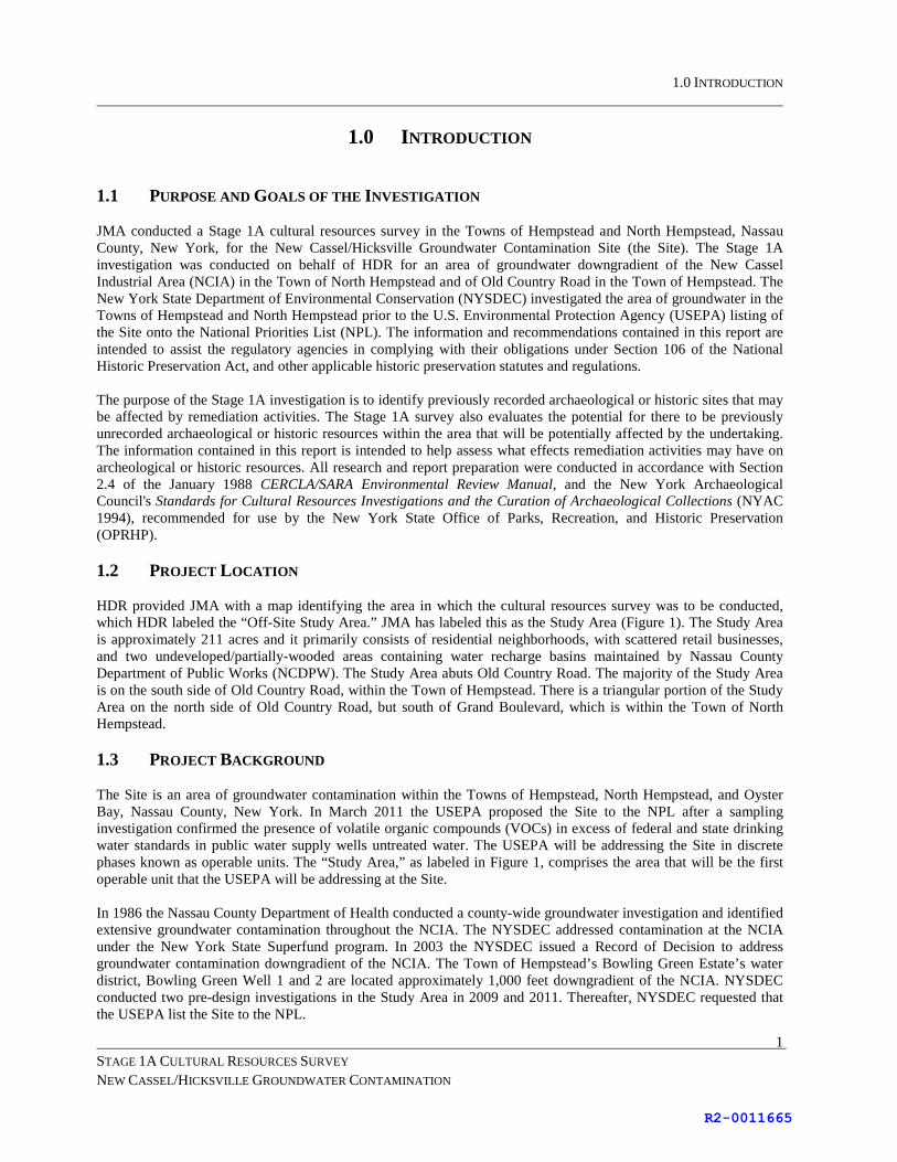
1.0 INTRODUCTION
STAGE 1A CULTURAL RESOURCES SURVEY NEW CASSEL/HICKSVILLE GROUNDWATER CONTAMINATION
1
1.0 INTRODUCTION 1.1 PURPOSE AND GOALS OF THE INVESTIGATION JMA conducted a Stage 1A cultural resources survey in the Towns of Hempstead and North Hempstead, Nassau County, New York, for the New Cassel/Hicksville Groundwater Contamination Site (the Site). The Stage 1A investigation was conducted on behalf of HDR for an area of groundwater downgradient of the New Cassel Industrial Area (NCIA) in the Town of North Hempstead and of Old Country Road in the Town of Hempstead. The New York State Department of Environmental Conservation (NYSDEC) investigated the area of groundwater in the Towns of Hempstead and North Hempstead prior to the U.S. Environmental Protection Agency (USEPA) listing of the Site onto the National Priorities List (NPL). The information and recommendations contained in this report are intended to assist the regulatory agencies in complying with their obligations under Section 106 of the National Historic Preservation Act, and other applicable historic preservation statutes and regulations. The purpose of the Stage 1A investigation is to identify previously recorded archaeological or historic sites that may be affected by remediation activities. The Stage 1A survey also evaluates the potential for there to be previously unrecorded archaeological or historic resources within the area that will be potentially affected by the undertaking. The information contained in this report is intended to help assess what effects remediation activities may have on archeological or historic resources. All research and report preparation were conducted in accordance with Section 2.4 of the January 1988 CERCLA/SARA Environmental Review Manual, and the New York Archaeological Council's Standards for Cultural Resources Investigations and the Curation of Archaeological Collections (NYAC 1994), recommended for use by the New York State Office of Parks, Recreation, and Historic Preservation (OPRHP). 1.2 PROJECT LOCATION HDR provided JMA with a map identifying the area in which the cultural resources survey was to be conducted, which HDR labeled the “Off-Site Study Area.” JMA has labeled this as the Study Area (Figure 1). The Study Area is approximately 211 acres and it primarily consists of residential neighborhoods, with scattered retail businesses, and two undeveloped/partially-wooded areas containing water recharge basins maintained by Nassau County Department of Public Works (NCDPW). The Study Area abuts Old Country Road. The majority of the Study Area is on the south side of Old Country Road, within the Town of Hempstead. There is a triangular portion of the Study Area on the north side of Old Country Road, but south of Grand Boulevard, which is within the Town of North Hempstead. 1.3 PROJECT BACKGROUND The Site is an area of groundwater contamination within the Towns of Hempstead, North Hempstead, and Oyster Bay, Nassau County, New York. In March 2011 the USEPA proposed the Site to the NPL after a sampling investigation confirmed the presence of volatile organic compounds (VOCs) in excess of federal and state drinking water standards in public water supply wells untreated water. The USEPA will be addressing the Site in discrete phases known as operable units. The “Study Area,” as labeled in Figure 1, comprises the area that will be the first operable unit that the USEPA will be addressing at the Site. In 1986 the Nassau County Department of Health conducted a county-wide groundwater investigation and identified extensive groundwater contamination throughout the NCIA. The NYSDEC addressed contamination at the NCIA under the New York State Superfund program. In 2003 the NYSDEC issued a Record of Decision to address groundwater contamination downgradient of the NCIA. The Town of Hempstead’s Bowling Green Estate’s water district, Bowling Green Well 1 and 2 are located approximately 1,000 feet downgradient of the NCIA. NYSDEC conducted two pre-design investigations in the Study Area in 2009 and 2011. Thereafter, NYSDEC requested that the USEPA list the Site to the NPL.
R2-0011665

2.0 BACKGROUND RESEARCH
STAGE 1A CULTURAL RESOURCES SURVEY NEW CASSEL/HICKSVILLE GROUNDWATER CONTAMINATION
2
2.0 BACKGROUND RESEARCH 2.1 GEOLOGY AND SOILS The Study Area is located within the Atlantic Coastal Plain physiographic province, an area of Cretaceous sedimentary bedrock overlaid by sediments carried from the eroding Appalachian Highlands during the Late Cretaceous Period (Isachsen et al. 2000; USDA 1987). The Raritan and Magothy formations, consisting of sand, silt, and clay, form the foundation of Long Island. This area was lifted above sea level in the Tertiary Period, during which the valley now occupied by Long Island Sound was cut by a major river system. Most of the sediments that comprise Long Island consist of Pleistocene glacial till, ground moraine, and outwash (Roberts-Dolgin 1989). During the Wisconsin glaciation, ice sheets advanced on Long Island to the Ronkonkoma terminal moraine. Later in the Wisconsin period the ice receded to the Harbor Hill terminal moraine along the north shore, but also extended over the Ronkonkoma moraine to a position near Staten Island. The result of these glacial movements was the formation of a wide band of irregular topography along the northern half of Nassau County. Nassau County is characterized by an undulating landscape in its northern part that gives way to a flat plain with a southward tilt in the southern section of the county. Extensive tidal areas and marshes comprise the area south of the plain, and barrier islands form the southern boundary of the region. Elevations range from sea level to 340 ft. above sea level along the eastern edge of the county (USDA 1987), with the steepest relief along drainage channels and side slopes adjacent to the north shore bays. An outwash plain south of the terminal moraine slopes gradually to the south for 10 mi. from Hicksville and reaches sea level at the tidal marshlands. The Site is located within what was once known as the Hempstead Plains. The Hempstead Plains was the only naturally occurring prairie east of the Appalachian Mountain Range, and consisted of a treeless landscape covered with short sedge and beard grasses forming a dense sod (Neidich-Ryder 1988a, 1988b). A unique ecosystem, the Plains supported a vast array of plant life, birds, and other fauna, many of which have gone extinct over the last 300 years. The prairie covered an area of approximately 60,000 acres, or 64 square miles, extending from Queens to Farmingdale. The Hempstead Plains was used as a common pasture by the early white settlers, and remained relatively undeveloped through the late-nineteenth century. The Plains has since been almost completely destroyed by rapid urbanization and intense commercial and residential construction. A small 19 acre remnant of the Plains is owned by Nassau County and Nassau Community College and is managed by the Long Island Chapter of the Nature Conservancy. The Nassau County area is drained by several perennial streams, most of which carry runoff to the Atlantic estuaries along the south shore. The stream closest to the Study Area is East Meadow Brook, which was located approximately 0.5 miles west of the Study Area in the mid-twentieth century. It flows south into the East Bay. To gather data on the soils in the Study Area, JMA consulted the Soil Survey of Nassau County (USDA 1987) and the U.S. Department of Agriculture’s Web Soil Survey (WSS) (USDA 2013). Detailed mapping and description of the soils in the Study Area downloaded from the WSS are presented in Appendix A. The vast majority of the soils in the Study Area (88%) are classified as Urban land (21%), Urban land-Hempstead complex (64%), or Urban land-Mineola complex (3%). Urban land (WSS Ug) consists of buildings, roads, parking lots, and other artificial features that have been subject to cuts, grading, soil relocation, and filling associated with major highway construction and intense commercial and residential development (USDA 1987). Urban land-Hempstead complex (WSS Uh) and Urban land-Mineola complex (WSS Um) are characterized as 75% Urban land and 25% other soil types. Therefore, areas mapped with these symbols consist of approximately 25% undeveloped surface (e.g., home yards, school yards, church yards, vacant lots, and parks).
R2-0011666

2.0 BACKGROUND RESEARCH
STAGE 1A CULTURAL RESOURCES SURVEY NEW CASSEL/HICKSVILLE GROUNDWATER CONTAMINATION
3
Approximately 6% of the Study Area is classified as Pits, ground-water recharge (WSS Pg). These locations (see Appendix A – Soil Map) correspond with rectangular water features shown in the southeast corner of the Study Area on Figure 1, which are recharge basins maintained by the NCDPW. The remaining 6% of the soils are classified as Hempstead silt loam (WSS He). This area (see Appendix A – Soil Map) corresponds with the undeveloped land in between the NCDPW recharge basins. It is JMA’s opinion that the classification of this area as Hempstead silt loam by the USDA in 1987 should not be interpreted as an assessment of the extent of prior disturbance of the soil in this area. 2.2 PREVIOUSLY RECORDED CULTURAL RESOURCES JMA reviewed the consolidated site files of the OPRHP and the New York State Museum (NYSM) to identify previously recorded archeological sites located within one mile of the Study Area. Reported archeological resources in the region include sites that were documented by archeologists in the early twentieth-century (e.g., Beauchamp 1900; Parker 1920), and these sources were consulted by JMA. JMA also reviewed prior cultural resources surveys conducted in the vicinity (e.g., EBI 2009; HP 2009; ILIA 2007; LBG 2002; NYSM 1994; TAS 2004). There are no previously recorded archeological sites within the Study Area, or within one mile of the boundary of the Study Area. The closest previously recorded archeological site is located in the Plain Lawn Cemetery (OPRHP A05903.000102), on the south side of Old Country Road, approximately 1.13 miles east of the Study Area. There is little information available regarding this site. The relative lack of previously recorded archeological sites in the area was noted in the prior cultural resources surveys reviewed by JMA. JMA reviewed the State and National Registers of Historic Places (S/NRHP). There are no properties determined eligible for the S/NRHP within the Study Area, or within one mile of the boundary of the Study Area. JMA also reviewed the properties designated as historically significant by the Town of Hempstead Landmarks Preservation Commission and the Town of North Hempstead Landmarks Preservation Commission, and there are no properties within or in the vicinity of the Study Area. 2.3 HISTORY OF THE REGION At the time of significant European contact in the early-seventeenth century, Long Island was inhabited by Algonquian-speaking descendants of what archeologists have labeled the Late Prehistoric/Late Woodland Clasons Point culture. The Site is located within the territory of the Massapequa. Their linguistic affiliation is unclear; they spoke either a Munsee dialect, or a language ancestral to eighteenth century Unquachog and more closely related to those of the southern New England Algonquians than to Munsee (Goddard 1978; Salwen 1978). By 1640 the Dutch had purchased much of western end of Long Island from the Native Americans. However, Native American populations had already begun to dramatically shrink earlier in the seventeenth-century. Around 1615 the first waves of European disease epidemics began to sweep over the populations of New England (Snow 1980). With mortality rates over 90 percent, whole villages were decimated within several decades, and by 1700 concomitant social changes had permanently altered and in most cases destroyed the Native American cultures first encountered by Europeans less than two hundred years before. The first permanent European settlement on the Hempstead Plains was established in 1644 (Seyfried 1984). Robert Fordham and Robert Carman began purchasing land from the Native Americans of Masapeague, Mericock and Rockaway. Their purchases included land that is now encompassed by the Towns of Hempstead and North Hempstead. The land they chose included an open meadow that stretched for miles across the central portion of the island. The meadow would later be known as the Hempstead Plains. The initial settlement was in the area that is now the Village of Hempstead. The site selected for the Village was at the southern edge of the Hempstead Plains, a location crossed by two streams that ran southward from the plains (Schultz 1937:13).
R2-0011667

2.0 BACKGROUND RESEARCH
STAGE 1A CULTURAL RESOURCES SURVEY NEW CASSEL/HICKSVILLE GROUNDWATER CONTAMINATION
4
Substantial portions of the Hempstead Plains were held as public land and were reserved primarily for the pasturage of sheep and cattle (Luke 1969:3). By 1657 there were 306 cattle and 74 weaned calves grazing on this land (Onderdonk 1878:14). Much of the Plains would remain unsettled into the twentieth century, but the settlement of Hempstead grew rapidly in the latter half of the seventeenth century (Schultz 1937). In 1683 three counties were established on Long Island: Kings, Suffolk, and Queens (Bailey 1949). The area that is now encompassed by the Towns of Hempstead, North Hempstead and Oyster Bay was then part of Queens County. During the eighteenth century, Hempstead gradually developed as a prosperous agricultural community. A 1722 census of the town indicates a total population of 2,220, and by 1761 its population had reached 5,940 inhabitants (Schulz 1937:26-27). By the late-eighteenth century a network of roads had been established across the region linking agricultural communities such as Hempstead with the major markets in Brooklyn and Manhattan. The increasing tensions which swept the Colonies during the 1760s in response to the Stamp Act also touched Long Island. Demonstrations were organized by the Sons of Liberty, and residents divided into two camps. The Whigs, who supported the Sons of Liberty, counted most of the militia among their members, while the Tories included most officeholders and large landowners (Bailey 1949:84). The Town of Hempstead, although not the site of any Revolutionary War battles, suffered privations during that conflict. The Hempstead Plains had been the site of military drilling since the time of the French and Indian War. During the Revolutionary War, the 17th Light Dragoons of the British Army were quartered there. Sheep and cattle pastured on the commons were sold to the British by local residents or were forcibly requisitioned, and the British in turn used the meat to supply their troops in the New York and Long Island areas. The Revolution also caused a schism within the town. The town meeting was controlled by the Tories, who voted to send no delegates to the Continental Congress. Residents of the northern section of the town, whose sympathies lay with the Colonists, voted to send their own delegation. This political divide remained throughout the War, and in April 1784, the New York legislature officially recognized it by the creation of the Towns of North and South Hempstead. The latter became the Town of Hempstead in 1796 (Bailey 1949:415). Throughout much of the nineteenth century, the major land use of Long Island remained agriculture. The relatively flat fertile land was well-suited for a variety of crops and livestock and nearby New York City provided a readily accessible market. The island began to undergo a transformation with the establishment of its first rail connections. In 1844 tracks had been laid between Brooklyn and Greenport, and two to three trains a day traversed the route. Initially the railroad catered to long distance travel and hauling of commercial and agricultural products, but the establishment of additional lines and the growth of the New York metro area as an industrial and employment center led to the development of a commuter railroad network. By 1875 the large number of small local railroad lines on Long Island had been consolidated into three main systems: the North Side, the South Side, and the Long Island Central (Smits 1974). By the end of the nineteenth century, increasing portions of Long Island were changing from farm villages to bedroom communities for New York City. Nassau County was established in 1899 and encompassed the towns of Hempstead, North Hempstead and Oyster Bay (Smits 1974:39-43). The population of Hempstead and nearby towns increased substantially in the late-nineteenth century in response to the growth of New York City. In 1880 Hempstead, North Hempstead and Oyster Bay had a combined population of 37,647, by 1900 the population had increased to 55,448 (Smits 1974:1). Despite this increase in population, the Hempstead Plains remained relatively undeveloped, except at the extreme ends. On the west end were the small farming villages of Elmont and Franklin Square. On the east were two larger, prosperous farming communities, Farmingdale and Hicksville, each with over 1,000 residents (Smits 1974:2). With the birth of aviation in the twentieth-century, the Hempstead Plains had a new role. In 1909 Glen Curtiss flew 25 kilometers over the plains to win a $10,000 prize for the first sustained aircraft flight. Curtiss later established his aircraft factory in Hempstead (Neidich-Ryder 1988b:60). The flat treeless plains became dotted with airfields, and flights originated from Hempstead, Mineola, Garden City, Hazelhurst, and Curtis airports. The Plains was the site of many significant aviation “firsts” including the first extensive cross-country flight, the first American-designed
R2-0011668

2.0 BACKGROUND RESEARCH
STAGE 1A CULTURAL RESOURCES SURVEY NEW CASSEL/HICKSVILLE GROUNDWATER CONTAMINATION
5
monoplane, the first American woman pilot, the first airmail flight, and Charles Lindbergh’s 1927 solo crossing of the Atlantic began on the Hempstead Plain (Neidich-Ryder 1988b:60-61). After World War II, Long Island saw rapid residential and commercial growth. The population of Nassau County doubled between 1950 and 1960, and population continued to grow through the 1970s. During these three decades, most of the current highway system developed, while densely-packed suburban neighborhoods spread across the landscape. 2.4 CARTOGRAPHIC ANALYSIS Historic maps examined by JMA include an anonymous 1782 map (Figure 2), an 1837 U.S. Coast Survey map (Figure 3), an 1873 Beers atlas (Figure 4), an 1897 and an 1898 USGS map (Figure 5), a 1906 Belcher-Hyde atlas (Figure 6), a 1914 Belcher-Hyde atlas (Figure 7), two 1947 USGS maps (Figure 8), two 1957 USGS maps (Figure 9), and a 1967/1979 and a 1994 USGS map (Figure 1). A 1966 aerial photograph (Figure 10) also proved helpful in JMA’s analysis of the history of the Study Area. Figure 3 shows the Study Area boundary superimposed on an 1837 map of the area. It shows scattered structures along what is now Old Country Road, including one structure that appears to be located within the Study Area. The structure is located on the north side of Old Country Road, in a triangular area on the west side of the intersection with what is now Grand Boulevard. Figures 4, 5, and 6 show the Study Area on maps in 1873, 1898, and 1906, respectively. These three figures show no structures in the Study Area. The structure shown on the 1837 map (Figure 3) was either incorrectly portrayed on the 1837 map (a distinct possibility on maps of this age), or the structure was no longer standing by 1873. There are no structures shown in the Study Area on the 1914 map (Figure 7). There is an irregularly-shaped area with the label “Schaefer,” which falls within a larger parcel that has the ownership label “Hempstead Plains Co.” The unusually shaped polygon encloses approximately 10 acres. There are no structures shown on the map in this area, and there are no entries in the atlas’ key/legend indicating what such a polygon is meant to represent. JMA was not able to determine definitively what this polygon represents, but we believe that it represents leased farmland. An individual named Schaefer was likely leasing the 10-acre plot from the Hempstead Plains Company, for growing crops, or as pasturage for livestock. If this interpretation is correct, and there were no associated structures, as indicated on the map, then the activities would have left minimal archeological traces. Figure 8 shows the Study Area on a 1947 USGS map. This map shows the beginnings of the gridded residential neighborhoods that now characterize most of the Study Area, with a few scattered structures. This map shows an unnamed drainage/stream flowing from northeast to southwest, passing through the southeast corner of the Study Area. This stream is a tributary to the East Meadow Brook, the headwaters of which are shown on Figure 8, west of the Study Area, nearly touching Old Country Road. Most of the small streams that flowed through this region are no longer shown on maps and cannot be seen while driving the local streets. The water now flows underground, through storm water culverts. Recharge basins temporarily catch excessive rainfall, allowing it to gradually drain into the aquifer. Figure 9 shows the Study Area on a 1957 USGS map. It shows the rapid growth of suburban residential neighborhoods. The unnamed drainage seen on the 1947 map is no longer shown, but there is a square water feature shown where the stream once passed. This location corresponds with one of the NCDPW recharge basins, and this likely represents the first of these basins to be established. Figure 10 is a 1966 aerial image and it shows all four of the recharge basins near the southeast corner of the Study Area, and another basin near the southwest corner of the Study Area, completely surrounded by residences. Figure 10 shows the area of the recharge basins devoid of trees and shrubs. It is likely that the vegetation was stripped during the creation of the basins. The creation of the basins would have involved the removal of soil,
R2-0011669

2.0 BACKGROUND RESEARCH
STAGE 1A CULTURAL RESOURCES SURVEY NEW CASSEL/HICKSVILLE GROUNDWATER CONTAMINATION
6
precluding the possibility of intact archeological deposits in the area of the basins themselves. The removal of trees and other vegetation from the areas in between the basins, coupled with grading by heavy machinery that would have taken place during the creation of the basins, may have resulted in the disturbance of all near-surface soils and potential archeological deposits. However, it is also possible that such disturbance in between the basins was minimal, or sporadic, and there may be areas of intact soil strata in between the recharge basins. A detailed review of the aerial image shown in Figure 10 reveals a landscape relatively devoid of trees and brush. The densely-packed residential neighborhoods that had spread across the Study Area by 1966 typically begin with the stripping of all vegetation. The stripping of vegetation and grading of the surface by heavy machinery, coupled with excavations for foundations/cellars, roads, sidewalks, storm water culverts, sewers, water lines, and a variety of other underground utilities, resulted in extensive ground disturbance. The extent of prior ground disturbance for such tightly-packed residential neighborhoods significantly diminishes the likelihood of intact near-surface soils. 2.5 EXISTING CONDITIONS JMA personnel conducted a reconnaissance walkover of the Study Area on January 30, 2013. The location and direction of referenced photographs taken during the reconnaissance are shown on Figure 11. The majority of the Study Area consists of residential neighborhoods (Photographs 1 and 2). These are heavily developed residential neighborhoods (i.e., tightly packed houses), with relatively small yards. There are some retail businesses in the Study Area, but they are primarily located along Old Country Road (Photograph 3). Trees throughout the Study Area are of a size indicating that they represent a secondary re-growth of vegetation subsequent to the apparent mid-twentieth century stripping of vegetation. The Nassau Family Court building (Photograph 4) and a juvenile detention facility are located near the northeast corner of the Study Area. Portions of the WT Clarke Middle School and High School fall within the southwest corner of the Study Area (Photograph 5). North of the school there is a recharge basin that occupies an area of approximately one acre. JMA was not able to examine the basin, or to photograph it, because it is surrounded by private residences. It is bounded on the west and south by Edgewood Drive, on the north by Bernard Drive, and on the east by Sherman Court, and it is depicted on Figure 1 near the southwest corner of the Study Area. The view from the street, looking in between residences, indicated that it is a basin-shaped depression, with trees and brush. Several structures associated with the Town of Hempstead Water Department are located in the north-central portion of the Study Area (Photograph 6). This location is part of the Town of Hempstead’s Bowling Green Estates water district. These Hempstead Water Department structures are adjacent to a 25-acre area of trees and brush that contains NCDPW recharge basins (Photographs 7 and 8). The basins cover approximately one-half of the 25-acre area. The 25-acre area with the NCDPW recharge basins is protected by a chain-link fence topped by barbed wire. JMA contacted the NCDPW and requested permission to enter the area to assess the potential for intact soils that could potentially contain archeological deposits, and to inquire about grading plans associated with the construction of the basins, but the NCDPW did not respond. Therefore, JMA viewed the area from vantage points outside of the fence. The basins are approximately 20 ft deep, with a flat ground surface surrounding. The entire 25-acrea area is covered by secondary growth of trees and brush. JMA’s cartographic analysis indicated the presence of a structure near the northwest corner of Grand Boulevard and Old Country Road on the 1837 map (Figure 3), a structure not depicted on the subsequent maps. JMA personnel viewed the structures in this area and none appeared to be of sufficient age to correlate with the structure on the 1837 map. If there was a structure in this area in 1837, it appears that it was subsequently removed.
R2-0011670

3.0 ARCHEOLOGICAL SENSITIVITY ASSESSMENT
STAGE 1A CULTURAL RESOURCES SURVEY NEW CASSEL/HICKSVILLE GROUNDWATER CONTAMINATION
7
3.0 ARCHEOLOGICAL SENSITIVITY ASSESSMENT The Study Area remained a relatively undeveloped grassland until the middle of the twentieth century. After WWII the Study Area witnessed intensive, fast-paced development, such that within a generation most of the 211 acres were covered by structures, asphalt, concrete, or manicured lawns. It is JMA’s opinion that the densely-packed residential construction resulted in extensive ground disturbance that significantly diminishes the likelihood of intact near-surface soils. The one possible exception is the approximately 12 acres of undeveloped land in between the NCDPW recharge basins at the southeast corner of the Study Area. 3.1 PREHISTORIC-PERIOD ARCHEOLOGICAL SENSITIVITY As has been repeatedly noted in reports of prior cultural resources surveys in the area, the Native American occupations on Long Island tended to concentrate along the coasts and along significant interior drainages. Native American occupation in the interior hinterlands has been identified, but such occupations tend to be small special purpose sites, rather than large villages. A tributary to the East Meadow Brook passed through the southeast portion of the Study Area. As a result of this water source, it is JMA’s opinion that the Study Area has a moderate potential for prehistoric Native American sites, but the sites would likely have been small, with limited artifacts and features. It is also JMA’s opinion that the intensive development during the mid-twentieth century significantly diminishes the likelihood of intact Native American archeological deposits throughout the Study Area. The exception to this is the area in between the recharge basins at the southeast corner of the Study Area. This is the area through which the stream passed, and it has the highest potential for intact soils. 3.2 HISTORIC-PERIOD ARCHEOLOGICAL SENSITIVITY JMA’s analysis indicates that prior to WWII, there was perhaps one structure in the Study Area, and no events of historic note took place in the Study Area. If there was a structure on the north side of Old Country Road in 1837 (see Figure 3), there may have been archeological deposits associated with this structure. However, the dense residential development of this area in mid-twentieth century significantly reduces the likelihood of intact archeological deposits or features.
R2-0011671

4.0 CONCLUSIONS AND RECOMMENDATIONS
STAGE 1A CULTURAL RESOURCES SURVEY NEW CASSEL/HICKSVILLE GROUNDWATER CONTAMINATION
8
4.0 CONCLUSIONS AND RECOMMENDATIONS 4.1 SUMMARY AND CONCLUSIONS Native American occupation of the Study Area would likely have been limited. Due to the presence of a small stream, and due to the potential for intact soils, the greatest potential for pre-contact Native American archeological deposits is the approximately 12 acres of undeveloped land in between the recharge basins at the southeast corner of the Study Area. The Study Area was a communal pasturage throughout the early historic period. There was perhaps one structure present in the early nineteenth century, and perhaps 10 acres of leased farm land in the early twentieth century. The study area then witnessed intense suburban development from the 1950s through the 1960s. It is JMA’s opinion that the densely-packed residential construction resulted in extensive ground disturbance that significantly diminishes the likelihood of intact near-surface soils. If there were any archeological deposits associated with earlier occupations of the Study Area, the intense development in the mid-twentieth century would likely have disturbed them. 4.2 RECOMMENDATIONS It is JMA’s opinion that no further cultural resources work is necessary for most of the Study Area, with the exception of the area in between the recharge basins at the southeast corner. If mitigation activities involving ground disturbance are to be conducted in the approximately 12 acres of land in between the NCDPW recharge basins at the southeast corner of the Study Area, it is JMA’s opinion that Stage 1B archeological subsurface testing be conducted prior to the ground disturbing activities.
R2-0011672

5.0 REFERENCES CITED
STAGE 1A CULTURAL RESOURCES SURVEY NEW CASSEL/HICKSVILLE GROUNDWATER CONTAMINATION
9
5.0 REFERENCES CITED Anonymous 1782 Plan of New York and Staten Islands with part of Long Island, survey’d in the years 1781, & 82. Library of
Congress website (http://memory.loc.gov/cgi-bin/query/D?gmd:6:./temp/~ammem_r4OC::). Accessed January 2013.
Bailey, P. 1949 Long Island, A History of Two Great Counties, Nassau and Suffolk. Volume I. Lewis Historical Publishing
Company, Inc., New York. Beauchamp, William M. 1900 Aboriginal Occupation of New York. New York State Museum Bulletin 32, Volume 7. The University of
the State of New York, Albany. Beers, Frederick W. 1873 Atlas of Long Island, New York from Recent and Actual Surveys and Records. Beers, Comstock and Cline,
New York. Belcher-Hyde, E. 1906 Atlas of Nassau County Long Island, N.Y. E. Belcher-Hyde, Brooklyn, NY. 1914 Atlas of Nassau County Long Island, N.Y. E. Belcher-Hyde, Brooklyn, NY. EBI Consulting, Inc. (EBI) 2009 Phase 1 Archeological Survey, LII2843B East Meadow Station 4, East Meadow, Nassau County, New York.
Prepared for Omnipoint Communications, Inc. Goddard, I. 1978 Delaware. In Northeast, vol 15. Handbook of North American Indians, edited by B. G. Trigger, pp. 213-
239. Smithsonian Institution, Washington, D.C. Historical Perspectives, Inc. (HP) 2009 Phase 1A Archaeological Assessment, Nassau County Health Care Corporation, Nassau University
Medical Center. Section 45 Block 572 Lots 1-12, East Meadow, Town of Hempstead, Nassau County, New York. Prepared for Saccardi & Schiff, Inc., White Plains, NY.
Institute for Long Island Archaeology (ILIA) 2007 A Stage 1A Archaeological Survey for the Jewish Congregation of Brookville Property in Muttontown,
Town of Oyster Bay, Nassau County, New York. Prepared for the Jewish Congregation of Brookville. Isachsen, I. W., E. Landing, J. M. Lauber, L. V. Rickard, and W. B. Rogers, editors 2000 Geology of New York: A Simplified Account. Second Edition. New York State Museum Educational Leaflet
28. The University of the State of New York, Albany. Louis Berger Group, Inc. (LBG) 2002 Mineola Intermodal Center, Mineola, New York, Draft Phase IA Cultural Resources Assessment. Prepared
for the Long Island Railroad, Jamaica, New York. Luke, M.H. 1969 Colonial Hempstead. Town of Hempstead 325th Anniversary Committee, Hempstead, New York.
R2-0011673

5.0 REFERENCES CITED
STAGE 1A CULTURAL RESOURCES SURVEY NEW CASSEL/HICKSVILLE GROUNDWATER CONTAMINATION
10
Neidich-Ryder, C. 1988a Long Island’s Vanishing Prairie: A Hempstead Plains Retrospective. The Nature Conservancy Long Island
Chapter News, Fall:4. 1988b The Hempstead Plains and the Birdfoot Violet. Long Island Forum, Spring:54-62. New York State Museum (NYSM) 1994 Cultural Resources Survey Report PIN 053.21.101, Meadowbrook State Parkway to Northern State
Parkway, Towns of Hempstead and North Hempstead, Nassau County, New York. Prepared for the NYS Department of Transportation.
New York Archaeological Council (NYAC) 1994 Standards for Cultural Resource Investigations and the Curation of Archaeological Collections in New
York State. New York State Office of Parks, Recreation, and Historic Preservation, Waterford. Onderdonk, H., Jr. 1878 The Annals of Hempstead, 1643 to 1832. Lott Van de Water, Hempstead, New York. Parker, Arthur C. 1920 The Archaeological History of New York, Part 2. New York State Museum Bulletin 237 and 238. The
University of the State of New York, Albany. Roberts-Dolgin, G.R. 1989 The Geology of Staten Island and Western Long Island, Kings and Queens Counties, New York. In
Geology and Engineering Geology of the New York Metropolitan Area, edited by Charles A. Baskerville, pp. 51-58. American Geophysical Union, Washington, D.C.
Salwen, Bert 1978 Indians of Southern New England and Long Island: Early Period. In Handbook of North American Indians,
Volume 15, edited by Bruce Trigger, pp. 160-176. Smithsonian Institution, Washington. Schultz, B. 1937 Colonial Hempstead. The Review-Star Press, Lynbrook, New York. Seyfried, V.F. 1984 300 Years of Long Island City: 1630-1930. Edgian Press, Inc. Smits, E.J. 1974 Nassau, Suburbia, U.S.A.: The First Seventy-five Years of Nassau County, New York, 1899 to 1974.
Doubleday & Company, Inc., Garden City, New York. Snow, D.R. 1980 The Archaeology of New England. Academic Press, New York. Tracker Archaeological Services (TAS) 2004 Phase I Archaeological Investigation for the Proposed F & D Homes, Village of Old Westbury, North
Hempstead, Nassau County, New York. Prepared for the Nelson, Pope, and Voorhis, LLC, Melville, New York.
United States Coast and Geodetic Survey (USCGS) 1837 Hicksville and Jamaica, Brushville and Miltham, New York. In 1837 the agency was known as U.S. Coast
Survey, Washington, D.C.
R2-0011674

5.0 REFERENCES CITED
STAGE 1A CULTURAL RESOURCES SURVEY NEW CASSEL/HICKSVILLE GROUNDWATER CONTAMINATION
11
United States Department of Agriculture (USDA) 1987 Soil Survey of Nassau County New York. USDA, Soil Conservation Service, Washington, D.C. 2013 Web Soil Survey. http://www.websoilsurvey.nrcs.usda.gov. USDA, Soil Conservation Service,
Washington, D.C. United States Environmental Protection Agency (USEPA) 1988 CERCLA/SARA Environmental Review Manual. USEPA, Region II, Office of Policy and Management,
Environmental Impacts Branch, New York. 2011 Support Document for the Revised National Priorities List, Final Rule – New Cassel/Hicksville
Groundwater Contamination. USEPA, Office of Solid Waste and Emergency Response, Washington, D.C. United States Geological Survey (USGS) 1897 Hempstead, N.Y. 15-minute topographic quadrangle. U.S. Geological Survey, Washington, D.C. 1898 Oyster Bay, N.Y.-CONN 15-minute topographic quadrangle. U.S. Geological Survey, Washington, D.C. 1947a Hicksville, New York 7.5-minute topographic quadrangle. U.S. Geological Survey, Washington, D.C. 1947b Freeport, New York 7.5-minute topographic quadrangle. U.S. Geological Survey, Washington, D.C. 1957a Hicksville, N.Y. 7.5-minute topographic quadrangle. U.S. Geological Survey, Washington, D.C. 1957b Freeport, N.Y. 7.5-minute topographic quadrangle. U.S. Geological Survey, Washington, D.C. 1967 Hicksville, N.Y. 7.5-minute topographic quadrangle (photorevised 1979). U.S. Geological Survey,
Washington, DC. 1994 Freeport, N.Y. 7.5-minute topographic quadrangle. U.S. Geological Survey, Washington, D.C.
R2-0011675

FIGURES
R2-0011676

Figure 1. Detail of the USGS 1967 (photorevised 1979) Hicksville, N.Y. and 1994 Freeport, N.Y. 7.5-minute topographic quadrangles showing the Study Area.
0 2000ft
0 500m
Study Area
R2-0011677

Figure 2. Detail of the 1782 anonymous map showing the approximate location of the Study Area.
Approximate Locationof Study Area
Not to scale
R2-0011678

Figure 3. Detail of the 1837 U.S. Coast Survey showing the location of the Study Area.
0 750m
0 3000ft
Study Area
R2-0011679

Figure 4. Detail of the 1873 Beers Atlas of Long Island showing the location of the Study Area.
Study Area
0 2000ft
0 500m
R2-0011680

Figure 5. Detail of the USGS 1898 Oyster Bay, N.Y.-CONN and the 1897 Hempstead, N.Y. 15-minute topographic quadrangles showing the location of the Study Area.
Study Area
0 300m
0 1500ft
R2-0011681

Figure 6. Detail of Plates 4 and 6 of the 1906 Belcher-Hyde Atlas of Nassau County Long Island showing the location of the Study Area.
Study Area
0 300m
0 1500ft
R2-0011682

Figure 7. Detail of Plates 17 and 23 of the 1914 Belcher-Hyde Atlas of Nassau County Long Island showing the location of the Study Area.
Study Area
0 300m
0 1500ft
R2-0011683

Figure 8. Detail of the USGS 1947 Hicksville, New York and Freeport, New York 7.5-minute topographic quadrangles showing the location of the Study Area.
Study Area
0 300m
0 1500ft
R2-0011684

Figure 9. Detail of the USGS 1957 Hicksville, N.Y. and Freeport, N.Y. 7.5-minute topographic quadrangles showing the location of the Study Area.
Study Area
0 200m
0 800ft
R2-0011685

Figure 10. Detail of a 1966 aerial photograph showing the location of the Study Area.
Study Area
0 200m
0 800ft
R2-0011686

Figure 11. Recent aerial imagery (from ESRI 2013) showing the Study Area and the location and direction of referenced photographs.
Study Area
0 150m
0 600ft
8
7
6
5
4
3
2
1
8 Photo location and view
R2-0011687

PHOTOGRAPHS
R2-0011688

Photograph 2. Residential neighborhood, view to the northwest on Grand Boulevard.
Photograph 1. Residential neighborhood, view to the south on Fieldstone Street.
R2-0011689

Photograph 4. Nassau Family Court building, view to the southwest.
Photograph 3. Retail businesses, view to the southwest on Old Country Road.
R2-0011690

Photograph 6. Town of Hempstead Water Department facility at the south end of Iris Place, view to the southwest.
Photograph 5. WT Clarke Middle School and High School, view to the southeast.
R2-0011691

Photograph 8. Nassau County recharge basin at the eastern side of the Study Area, view to the west.
Photograph 7. Nassau County recharge basin at the eastern side of the Study Area, view to the south.
R2-0011692

APPENDIX A:
SOIL DATA from USDA Web Soil Survey
R2-0011693

#
Old Country Rd
Main St
Grand Blvd
Merillon Ave
Mirabelle Ave
Washington Ave
Oliver Ave
Bowling Green Dr
Cypress Ln
Land Ln
Choir Ln
Lindy
Rd
Salisb
ury R
d
Roxbury Dr
Elton S
t
Cobalt Ln
Iris Pl
Dayton St
Myron R
d
Carleton St
Bromton Dr
Barrington St
Kinkel S
t
Carm
an A
ve
Sw
alm S
t
Urban Ave
Anna Ave
Regent Dr
Cottonw
ood Ln
Hopper S
t
Flower St
Stratfo
rd Dr
Edgewood Dr
Garden S
t
Westbury Rd
State S
t
Rushm
ore St
Arlington St
Sylvester S
t
Bond S
t
Bernard Dr
Howard Dr
Crown Ln
Stewart Ave
Sheldon Dr
Pleasant A
ve
Fieldston St Car
man
Ave
Ext
Highview
Ave
Park St
Cameo
Ln
Grand S
t
Magnolia A
ve
New
York Ave
Brooklyn A
ve
Crystal Ln
Lion Ln
Hyacinth St
Westle
y Rd
Aster Pl
Grayston St
Hilton S
t
Volante
Pl
Wantagh State Pkw
y
Rose Pl
Stratford Ct
Legend Ln
Frost St
Fairfield Ave
Sherman C
t
Cane Ln
Belmont Pl
Nelson Pl
Regent Ct
Ced
ar L
n
Lamp Ln
Westle
y Rd
Grand Blvd
Uh
Ug
He
Uh
Uh
Ug
Pg
Pg
Um
620600
620600
620800
620800
621000
621000
621200
621200
621400
621400
621600
621600
621800
621800
622000
622000
622200
622200
622400
622400
4511
600
4511
600
4511
800
4511
800
4512
000
4512
000
4512
200
4512
200
4512
400
4512
400
4512
600
4512
600
0 1,000 2,000 3,000500Feet
0 200 400 600100Meters
±
40° 45' 25''
73°
32' 5
8''
40° 44' 44''
73°
32' 5
9''
40° 44' 45''
40° 45' 26''73
° 34
' 20'
'73
° 34
' 19'
'
Map Scale: 1:9,060 if printed on A size (8.5" x 11") sheet.
Soil Map—Nassau County, New York(New Cassel-Hicksville Contaminated Groundwater)
Natural ResourcesNatural ResourcesNatural ResourcesNatural ResourcesConservation ServiceConservation ServiceConservation ServiceConservation Service
Web Soil SurveyNational Cooperative Soil Survey
1/15/2013Page 1 of 3
R2-0011694

MAP LEGEND MAP INFORMATION
Area of Interest (AOI)Area of Interest (AOI)
SoilsSoil Map Units
Special Point FeaturesBlowout
Borrow Pit
Clay Spot
Closed Depression
Gravel Pit
Gravelly Spot
Landfill
Lava Flow
Marsh or swamp
Mine or Quarry
Miscellaneous Water
Perennial Water
Rock Outcrop
Saline Spot
Sandy Spot
Severely Eroded Spot
Sinkhole
Slide or Slip
Sodic Spot
Spoil Area
Stony Spot
Very Stony Spot
Wet Spot
Other
Special Line FeaturesGully
Short Steep Slope
Other
Political FeaturesCities
Water FeaturesStreams and Canals
TransportationRails
Interstate Highways
US Routes
Major Roads
Local Roads
Map Scale: 1:9,060 if printed on A size (8.5" × 11") sheet.
The soil surveys that comprise your AOI were mapped at 1:24,000.
Warning: Soil Map may not be valid at this scale.
Enlargement of maps beyond the scale of mapping can causemisunderstanding of the detail of mapping and accuracy of soil lineplacement. The maps do not show the small areas of contrastingsoils that could have been shown at a more detailed scale.
Please rely on the bar scale on each map sheet for accurate mapmeasurements.
Source of Map: Natural Resources Conservation ServiceWeb Soil Survey URL: http://websoilsurvey.nrcs.usda.govCoordinate System: UTM Zone 18N NAD83
This product is generated from the USDA-NRCS certified data as ofthe version date(s) listed below.
Soil Survey Area: Nassau County, New YorkSurvey Area Data: Version 9, Dec 20, 2011
Date(s) aerial images were photographed: 7/31/2006
The orthophoto or other base map on which the soil lines werecompiled and digitized probably differs from the backgroundimagery displayed on these maps. As a result, some minor shiftingof map unit boundaries may be evident.
Soil Map–Nassau County, New York(New Cassel-Hicksville Contaminated Groundwater)
Natural ResourcesConservation Service
Web Soil SurveyNational Cooperative Soil Survey
1/15/2013Page 2 of 3
R2-0011695

Map Unit Legend
Nassau County, New York (NY059)
Map Unit Symbol Map Unit Name Acres in AOI Percent of AOI
He Hempstead silt loam 13.3 6.3%
Pg Pits, ground-water recharge 12.0 5.7%
Ug Urban land 44.3 21.0%
Uh Urban land-Hempstead complex 135.6 64.2%
Um Urban land-Mineola complex 5.8 2.8%
Totals for Area of Interest 211.2 100.0%
Soil Map–Nassau County, New York New Cassel-Hicksville Contaminated Groundwater
Natural ResourcesConservation Service
Web Soil SurveyNational Cooperative Soil Survey
1/15/2013Page 3 of 3
R2-0011696

Nassau County, New York
He—Hempstead silt loam
Map Unit SettingMean annual precipitation: 42 to 46 inchesMean annual air temperature: 50 to 54 degrees FFrost-free period: 190 to 230 days
Map Unit CompositionHempstead and similar soils: 80 percentMinor components: 20 percent
Description of Hempstead
SettingLandform: Outwash plainsLandform position (two-dimensional): SummitLandform position (three-dimensional): TreadDown-slope shape: ConvexAcross-slope shape: ConvexParent material: A silty mantle over highly siliceous stratified sandy
and gravelly glaciofluvial deposits
Properties and qualitiesSlope: 0 to 3 percentDepth to restrictive feature: More than 80 inchesDrainage class: Well drainedCapacity of the most limiting layer to transmit water
(Ksat): Moderately high to high (0.57 to 1.98 in/hr)Depth to water table: More than 80 inchesFrequency of flooding: NoneFrequency of ponding: NoneAvailable water capacity: Moderate (about 7.7 inches)
Interpretive groupsFarmland classification: All areas are prime farmlandLand capability (nonirrigated): 1Hydrologic Soil Group: B
Typical profile0 to 11 inches: Silt loam11 to 29 inches: Silt loam29 to 33 inches: Very gravelly loamy sand33 to 60 inches: Stratified very gravelly sand
Minor Components
EnfieldPercent of map unit: 10 percent
MineolaPercent of map unit: 5 percent
Map Unit Description: Hempstead silt loam–Nassau County, New York New Cassel-Hicksville Contaminated Groundwater
Natural ResourcesConservation Service
Web Soil SurveyNational Cooperative Soil Survey
1/15/2013Page 1 of 2
R2-0011697

UdipsammentsPercent of map unit: 5 percent
Data Source Information
Soil Survey Area: Nassau County, New YorkSurvey Area Data: Version 9, Dec 20, 2011
Map Unit Description: Hempstead silt loam–Nassau County, New York New Cassel-Hicksville Contaminated Groundwater
Natural ResourcesConservation Service
Web Soil SurveyNational Cooperative Soil Survey
1/15/2013Page 2 of 2
R2-0011698

Nassau County, New York
Pg—Pits, ground-water recharge
Map Unit SettingMean annual precipitation: 42 to 46 inchesMean annual air temperature: 50 to 54 degrees FFrost-free period: 190 to 230 days
Map Unit CompositionPits, ground-water recharge: 100 percent
Data Source Information
Soil Survey Area: Nassau County, New YorkSurvey Area Data: Version 9, Dec 20, 2011
Map Unit Description: Pits, ground-water recharge–Nassau County, New York New Cassel-Hicksville Contaminated Groundwater
Natural ResourcesConservation Service
Web Soil SurveyNational Cooperative Soil Survey
1/15/2013Page 1 of 1
R2-0011699

Nassau County, New York
Ug—Urban land
Map Unit SettingMean annual precipitation: 42 to 46 inchesMean annual air temperature: 50 to 54 degrees FFrost-free period: 190 to 230 days
Map Unit CompositionUrban land: 90 percentMinor components: 10 percent
Minor Components
EnfieldPercent of map unit: 2 percent
RiverheadPercent of map unit: 2 percent
HempsteadPercent of map unit: 2 percent
UdipsammentsPercent of map unit: 2 percent
UdorthentsPercent of map unit: 2 percent
Data Source Information
Soil Survey Area: Nassau County, New YorkSurvey Area Data: Version 9, Dec 20, 2011
Map Unit Description: Urban land–Nassau County, New York New Cassel-Hicksville Contaminated Groundwater
Natural ResourcesConservation Service
Web Soil SurveyNational Cooperative Soil Survey
1/15/2013Page 1 of 1
R2-0011700

Nassau County, New York
Uh—Urban land-Hempstead complex
Map Unit SettingMean annual precipitation: 42 to 46 inchesMean annual air temperature: 50 to 54 degrees FFrost-free period: 190 to 230 days
Map Unit CompositionUrban land: 75 percentHempstead and similar soils: 20 percentMinor components: 5 percent
Description of Hempstead
SettingLandform: Outwash plainsLandform position (two-dimensional): SummitLandform position (three-dimensional): TreadDown-slope shape: ConvexAcross-slope shape: ConvexParent material: A silty mantle over highly siliceous stratified sandy
and gravelly glaciofluvial deposits
Properties and qualitiesSlope: 0 to 3 percentDepth to restrictive feature: More than 80 inchesDrainage class: Well drainedCapacity of the most limiting layer to transmit water
(Ksat): Moderately high to high (0.57 to 1.98 in/hr)Depth to water table: More than 80 inchesFrequency of flooding: NoneFrequency of ponding: NoneAvailable water capacity: Moderate (about 7.7 inches)
Typical profile0 to 11 inches: Silt loam11 to 29 inches: Silt loam29 to 33 inches: Very gravelly loamy sand33 to 60 inches: Stratified very gravelly sand
Minor Components
EnfieldPercent of map unit: 3 percent
Map Unit Description: Urban land-Hempstead complex–Nassau County, NewYork
New Cassel-Hicksville Contaminated Groundwater
Natural ResourcesConservation Service
Web Soil SurveyNational Cooperative Soil Survey
1/15/2013Page 1 of 2
R2-0011701

MineolaPercent of map unit: 2 percent
Data Source Information
Soil Survey Area: Nassau County, New YorkSurvey Area Data: Version 9, Dec 20, 2011
Map Unit Description: Urban land-Hempstead complex–Nassau County, NewYork
New Cassel-Hicksville Contaminated Groundwater
Natural ResourcesConservation Service
Web Soil SurveyNational Cooperative Soil Survey
1/15/2013Page 2 of 2
R2-0011702

Nassau County, New York
Um—Urban land-Mineola complex
Map Unit SettingMean annual precipitation: 42 to 46 inchesMean annual air temperature: 50 to 54 degrees FFrost-free period: 190 to 230 days
Map Unit CompositionUrban land: 75 percentMineola and similar soils: 20 percentMinor components: 5 percent
Description of Mineola
SettingLandform: Outwash plainsLandform position (two-dimensional): SummitLandform position (three-dimensional): TreadDown-slope shape: ConcaveAcross-slope shape: ConvexParent material: A thin mantle of loamy glaciofluvial deposits over
stratified sand and gravel glaciofluvial deposits
Properties and qualitiesSlope: 0 to 3 percentDepth to restrictive feature: More than 80 inchesDrainage class: Moderately well drainedCapacity of the most limiting layer to transmit water (Ksat): High (1.98
to 5.95 in/hr)Depth to water table: About 24 to 48 inchesFrequency of flooding: NoneFrequency of ponding: NoneAvailable water capacity: Low (about 3.4 inches)
Typical profile0 to 11 inches: Sandy loam11 to 18 inches: Very gravelly loamy sand18 to 60 inches: Stratified very gravelly sand
Minor Components
HempsteadPercent of map unit: 3 percent
UdipsammentsPercent of map unit: 2 percent
Data Source Information
Soil Survey Area: Nassau County, New YorkSurvey Area Data: Version 9, Dec 20, 2011
Map Unit Description: Urban land-Mineola complex–Nassau County, New York New Cassel-Hicksville Contaminated Groundwater
Natural ResourcesConservation Service
Web Soil SurveyNational Cooperative Soil Survey
1/15/2013Page 1 of 1
R2-0011703