
Stabilization of the North Spur at Muskrat Falls: An...
14
__________________________________________________________ CDA 2015 Annual Conference – Mississauga, Ontario – October 2015 249 CANADIAN DAM ASSOCIATION ASSOCIATION CANADIENNE DE BARRAGES CDA 2015 Annual Conference Congrès annuel 2015 de l’ACB Mississauga, ON, Canada 2015 Oct 5-8 Stabilization of the North Spur at Muskrat Falls: An Overview Alvaro Ceballos, P.Eng, Senior Geotechnical Engineer, Muskrat Falls Project, SNC-Lavalin Inc, St. John’s, NL Greg Snyder, FEC, P.Eng, Engineering Manager, Muskrat Falls Project, SNC-Lavalin Inc, St. John’s, NL Regis Bouchard, FCGS, P.Eng, Lead Geotechnical Engineer, Muskrat Falls Project, SNC-Lavalin Inc, St. John’s, NL ABSTRACT: Nalcor Energy’s Lower Churchill Project is located on the Churchill River in the province of Newfoundland and Labrador, Canada. It consists of two potential hydroelectric sites and associated transmission systems: Gull Island hydroelectric development, located 225 km downstream of the existing Churchill Falls Generating Station; and Muskrat Falls hydroelectric development, located 60 km further downstream. The present generating site now being developed by Nalcor Energy is the Muskrat Falls hydroelectric facility located on the lower reaches of the Churchill River, approximately 35 km west of the town of Happy Valley – Goose Bay, Labrador. A critical feature of the development is the North Spur, a natural earth embankment that constricts the river at the project location. The North Spur is 1,000 m long, 500 m wide and 45 m to 60 m high and consists of unconsolidated mixed sand and marine silt and clay. Stabilization of this land mass is a key part of construction of Muskrat Falls. The North Spur is a unique case involving stabilization of a natural dam, and therefore it has come under considerable scrutiny and review. The modelling and geotechnical investigations have been quite extensive to give a confidence in the solution and to be prepared for actual conditions encountered in the field This paper will summarize the investigations that have taken place and discuss the key findings from each. It will also outline various studies that have taken place, and provide an overview of the evolution of the solution over the years. RÉSUMÉ Nalcor Energy développe le potentiel hydroélectrique de la rivière Churchill au Labrador, Canada. Le bas Churchill comporte 2 projets distincts, le projet de Gull Island, situé à 225 kilomètres de la centrale de Churchill Falls et le projet Muskrat Falls localisé quelques 60 km en aval de Gull Island. Muskrat Falls est donc 35 km en amont de la ville de Happy Valley – Goose Bay. Un élément critique du développement du projet Muskrat Falls est la présence d’un éperon de terre (North Spur) qui agit comme un barrage naturel sur la rivière Churchill. Le North Spur mesure environ un kilomètre de longueur sur 500 m de largeur, Le niveau du plateau est de 60 m environ soit 56m au dessus du niveau d’eau aval de la rivière et 42m au dessus du niveau amont. Il est constitué principalement par des dépôts stratifiés de sables, de silt et d’argile. Des cicatrices de glissements de terrain sont visibles sur le North Spur et dans la vallée du bas Churchill. La stabilisation de cette langue de terre est un élément clé du projet de Muskrat Falls. La stabilisation du North Spur est un cas unique d’intervention sur un barrage naturel, ces travaux ont donc fait l’objet d’une attention particulière et de plusieurs revues. Les investigations géotechniques et la conception des mesures de stabilisation ont été réalisées de façon à développer une grande confiance dans la solution de confortement et d’être préparé aux changements qui pourraient apparaitre durant la réalisation des travaux. L’article présente un historique des travaux de préparation réalisés depuis 1965 en mettant en évidence les éléments clés de ces travaux. Il décrit aussi sommairement les différentes solutions de stabilisation et leur évolution au fil des années en fonction de la connaissance des sols constituant cette langue de terre.
-
Upload
nguyendang -
Category
Documents
-
view
213 -
download
0
Transcript of Stabilization of the North Spur at Muskrat Falls: An...
__________________________________________________________
CDA 2015 Annual Conference – Mississauga, Ontario – October 2015
249
CANADIAN DAM ASSOCIATION
ASSOCIATION CANADIENNE DE BARRAGES
CDA 2015 Annual Conference
Congrès annuel 2015 de l’ACB
Mississauga, ON, Canada
2015 Oct 5-8
Stabilization of the North Spur at Muskrat Falls: An Overview
Alvaro Ceballos, P.Eng, Senior Geotechnical Engineer, Muskrat Falls Project, SNC-Lavalin Inc, St. John’s, NL
Greg Snyder, FEC, P.Eng, Engineering Manager, Muskrat Falls Project, SNC-Lavalin Inc, St. John’s, NL
Regis Bouchard, FCGS, P.Eng, Lead Geotechnical Engineer, Muskrat Falls Project, SNC-Lavalin Inc, St. John’s, NL
ABSTRACT:
Nalcor Energy’s Lower Churchill Project is located on the Churchill River in the province of Newfoundland and Labrador,
Canada. It consists of two potential hydroelectric sites and associated transmission systems: Gull Island hydroelectric
development, located 225 km downstream of the existing Churchill Falls Generating Station; and Muskrat Falls
hydroelectric development, located 60 km further downstream. The present generating site now being developed by Nalcor
Energy is the Muskrat Falls hydroelectric facility located on the lower reaches of the Churchill River, approximately 35 km
west of the town of Happy Valley – Goose Bay, Labrador. A critical feature of the development is the North Spur, a natural
earth embankment that constricts the river at the project location. The North Spur is 1,000 m long, 500 m wide and 45 m to
60 m high and consists of unconsolidated mixed sand and marine silt and clay. Stabilization of this land mass is a key part
of construction of Muskrat Falls.
The North Spur is a unique case involving stabilization of a natural dam, and therefore it has come under considerable scrutiny and review. The modelling and geotechnical investigations have been quite extensive to give a confidence in the solution and to be prepared for actual conditions encountered in the field This paper will summarize the investigations that have taken place and discuss the key findings from each. It will also outline various studies that have taken place, and provide an overview of the evolution of the solution over the years.
RÉSUMÉ Nalcor Energy développe le potentiel hydroélectrique de la rivière Churchill au Labrador, Canada. Le bas Churchill
comporte 2 projets distincts, le projet de Gull Island, situé à 225 kilomètres de la centrale de Churchill Falls et le projet
Muskrat Falls localisé quelques 60 km en aval de Gull Island. Muskrat Falls est donc 35 km en amont de la ville de Happy
Valley – Goose Bay. Un élément critique du développement du projet Muskrat Falls est la présence d’un éperon de terre
(North Spur) qui agit comme un barrage naturel sur la rivière Churchill. Le North Spur mesure environ un kilomètre de
longueur sur 500 m de largeur, Le niveau du plateau est de 60 m environ soit 56m au dessus du niveau d’eau aval de la
rivière et 42m au dessus du niveau amont. Il est constitué principalement par des dépôts stratifiés de sables, de silt et
d’argile. Des cicatrices de glissements de terrain sont visibles sur le North Spur et dans la vallée du bas Churchill. La
stabilisation de cette langue de terre est un élément clé du projet de Muskrat Falls.
La stabilisation du North Spur est un cas unique d’intervention sur un barrage naturel, ces travaux ont donc fait l’objet d’une
attention particulière et de plusieurs revues. Les investigations géotechniques et la conception des mesures de stabilisation
ont été réalisées de façon à développer une grande confiance dans la solution de confortement et d’être préparé aux
changements qui pourraient apparaitre durant la réalisation des travaux. L’article présente un historique des travaux de
préparation réalisés depuis 1965 en mettant en évidence les éléments clés de ces travaux. Il décrit aussi sommairement les
différentes solutions de stabilisation et leur évolution au fil des années en fonction de la connaissance des sols constituant
cette langue de terre.
__________________________________________________________
CDA 2015 Annual Conference – Mississauga, Ontario – October 2015
250
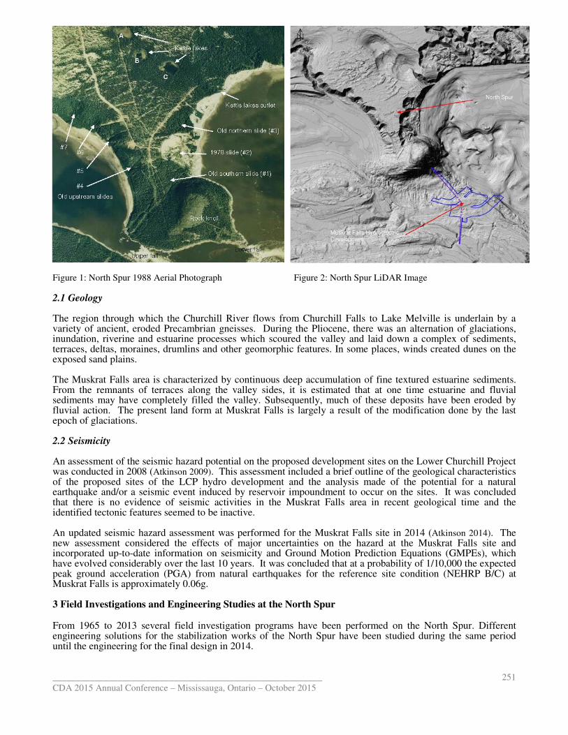
1 INTRODUCTION The North Spur was identified as an important and “fragile” part of the project since the project was first conceived in the early 1960s. The first geotechnical investigations took place in 1965 and there have been numerous investigation programs since then. The approach to remediation that was identified was to flatten and stabilize the slope, to protect against erosion and to lower the water table. With the increasing amount of information available, and the developments in tools for geotechnical investigations, analysis and modelling, the methodology and details of the stabilization has evolved but the basic approach has remained the same. The additional data and use of 3D models has been taken into account in final design and the models have allowed development of more certainty around effectiveness and robustness of the approach. The North Spur is a deposit of marine and estuarine sediments which naturally provides a partial closure of the Churchill River valley at the Muskrat Falls site. This natural closure is one of the economically attractive features of this site and needs to be preserved for the life of the project. This natural dam is about 1 kilometre long between the rock knoll in the south and the kettle lakes in the north, which represent natural boundaries of the North Spur, in terms of both seepage and stability. Main features of the North Spur are presented in an aerial photo taken in 1988, Figure 1. The early studies for the Muskrat Falls site recognized the importance of the North Spur as part of the reservoir retention works. A major slide on the downstream face of the Spur, in November 1978, revealed the fragility of this natural deposit and its susceptibility to groundwater level variations, toe erosion and ice accumulation in the bay downstream.. The stability and integrity of this natural dam during the stabilization works and during and after reservoir impoundment is discussed in this paper. 2 GENERAL SETTING OF THE NORTH SPUR The Muskrat Falls site is located on the Churchill River, about 30 km upstream from Happy Valley-Goose Bay in Labrador. The two falls, about 1 km apart, cause a drop of about 14 m in the Churchill River water level from 17 m at the upstream side to 3 m at the downstream side of the falls. A rock knoll with a top elevation of 142 m is located at the North side of the falls and is connected to the left bank of the river by a spur of land which is referred to as the “North Spur”. The Churchill River flows in a bedrock channel south of the rock knoll. Past continental glaciations followed by glacial, fluvio-glacial and marine activities formed the overburden in the Muskrat Falls area. The overburden consists of sands overlying silty sands, silty and clayey soils. The sediments also extend to the north of a rock knoll forming a narrow spur of land. The erosion and landslides within the spur have been an on-going feature of the area and are still active. The main terrace of the Spur is an elevation of about 60 m and represents an ice-contact stratified drift deposit. The deposit is characterized by the presence of kettles, local slumping and abrupt stratigraphy change within the first 50 to 70 m of depth. At higher elevations in the valley, there is initially a succession of smaller terraces and then glacial till with locally exposed bedrock. Above an elevation of approximately 250 m, the land primarily consists of Precambrian age bedrock with various types of glacial deposits, the most notable being glacial till drumlins just to the north of the Muskrat Falls.
The estuarine sediments of region are believed to be deposited in brackish, non-turbulent water and, as a result, often consist of silts and sensitive (after leaching) clay which are highly susceptible to retrogressive landslides. There is frequent evidence of slope instabilities along the Churchill River shoreline in the form of landslide scars. The boundaries of the North Spur are defined by the rock knoll in the south, the three kettle lakes in the north, and the Churchill River in the west and east. The crest of the North Spur in the north-south direction is about 1,000 m long and in the kettle lakes area the crest of the North Spur is about 1,000 m wide. In the south limit, close to the rock knoll, the width of the crest of the North Spur reduces to a minimum of 80 m. A LiDAR image of the Muskrat Falls site and the footprint of the related structures are shown in Figure 2.
__________________________________________________________
CDA 2015 Annual Conference – Mississauga, Ontario – October 2015
251
Figure 1: North Spur 1988 Aerial Photograph Figure 2: North Spur LiDAR Image 2.1 Geology The region through which the Churchill River flows from Churchill Falls to Lake Melville is underlain by a variety of ancient, eroded Precambrian gneisses. During the Pliocene, there was an alternation of glaciations, inundation, riverine and estuarine processes which scoured the valley and laid down a complex of sediments, terraces, deltas, moraines, drumlins and other geomorphic features. In some places, winds created dunes on the exposed sand plains. The Muskrat Falls area is characterized by continuous deep accumulation of fine textured estuarine sediments. From the remnants of terraces along the valley sides, it is estimated that at one time estuarine and fluvial sediments may have completely filled the valley. Subsequently, much of these deposits have been eroded by fluvial action. The present land form at Muskrat Falls is largely a result of the modification done by the last epoch of glaciations. 2.2 Seismicity An assessment of the seismic hazard potential on the proposed development sites on the Lower Churchill Project was conducted in 2008 (Atkinson 2009). This assessment included a brief outline of the geological characteristics of the proposed sites of the LCP hydro development and the analysis made of the potential for a natural earthquake and/or a seismic event induced by reservoir impoundment to occur on the sites. It was concluded that there is no evidence of seismic activities in the Muskrat Falls area in recent geological time and the identified tectonic features seemed to be inactive. An updated seismic hazard assessment was performed for the Muskrat Falls site in 2014 (Atkinson 2014). The new assessment considered the effects of major uncertainties on the hazard at the Muskrat Falls site and incorporated up-to-date information on seismicity and Ground Motion Prediction Equations (GMPEs), which have evolved considerably over the last 10 years. It was concluded that at a probability of 1/10,000 the expected peak ground acceleration (PGA) from natural earthquakes for the reference site condition (NEHRP B/C) at Muskrat Falls is approximately 0.06g. 3 Field Investigations and Engineering Studies at the North Spur
From 1965 to 2013 several field investigation programs have been performed on the North Spur. Different engineering solutions for the stabilization works of the North Spur have been studied during the same period until the engineering for the final design in 2014.
__________________________________________________________
CDA 2015 Annual Conference – Mississauga, Ontario
The outcomes of the field works and interpretations presented in the different engineering studies shaped the basis of the current knowledge of the geology, stratigraphy and hydrogeology of the North Spur. Extent of each investigation campaign is briefly reviewed in the followin
The different engineering studies of the North Spur stabilization woralso reviewed in this section, to show the evolution of the design over time as more information became available. 3.1 1965 Field Investigations and Studies
In 1965 a field investigation program was performed at the Muskrat Falls site in order to review and update a previous (1964) report on the Lower Churchill Project. Geological conditions on both banks of the river at Muskrat Falls were established from surface mapping. The 1965 field wordiamond drilling, test pitting, topographic surveys and mapping, river soundings and laboratory testing of drill and test pit samples. The work included one on the upstream slope) as part of these interpreted from the boreholes and the bedrock level was estimated from the geophysicaplan of the site and borehole locations and approximate test pit locations are shown in
The data collected was used to supplement existing information and aprogram which includes a basic design scheme for a hydroelectric development integrity.
Main features of the design were trimming angranular material on the downstream side of the Spur, construction of a protective groin, removal of all organic material before placing the embankments, construction of inverted filters deep hole downstream of the Spur and reduction of the eddy motion in the river
Figure 3: 1965 Field Investigations
3.4 1976 Engineering Study
In 1976 a geotechnical review of the 1965 layout was carried marine clays in Canada. The existing dataprevious field investigations.
The study concluded that certain design aspects of the previous study were possibly thus, the stabilization measures required to preserve the integrity of the North Spur were considerably less than those envisioned in the past. The propo
__________________________________________________________
Mississauga, Ontario – October 2015
ld works and interpretations presented in the different engineering studies shaped the basis of the current knowledge of the geology, stratigraphy and hydrogeology of the North Spur. Extent of each investigation campaign is briefly reviewed in the following sections.
The different engineering studies of the North Spur stabilization works carried out between 1965 andalso reviewed in this section, to show the evolution of the design over time as more information became
and Studies
In 1965 a field investigation program was performed at the Muskrat Falls site in order to review and update a report on the Lower Churchill Project. Geological conditions on both banks of the river at
s were established from surface mapping. The 1965 field work included geological surveys,diamond drilling, test pitting, topographic surveys and mapping, river soundings and laboratory testing of drill
The work included 13 test pits, 1 trench and two boreholes (one at the s part of these investigations. The stratigraphy of the overburden layers was
interpreted from the boreholes and the bedrock level was estimated from the geophysical surveys. A geological plan of the site and borehole locations and approximate test pit locations are shown in Figure
The data collected was used to supplement existing information and allowed the start of a full engineering basic design to a level suitable for estimating purposes. This study i
ydroelectric development at Muskrat Falls must include stabilization of the North Spur to ensure
trimming and slope protection of the existing slopes, buttress of free draining granular material on the downstream side of the Spur, construction of a protective groin, removal of all organic material before placing the embankments, construction of inverted filters on the downstream area, filling of the deep hole downstream of the Spur and reduction of the eddy motion in the river, as shown in
Figure 4: 1965 Concept
In 1976 a geotechnical review of the 1965 layout was carried using data from research existing data was supplement by a limited test program on samples
udy concluded that certain design aspects of the previous study were possibly overlythus, the stabilization measures required to preserve the integrity of the North Spur were considerably less than
he proposed scheme for the stabilization measures of the North Spur involved
252
ld works and interpretations presented in the different engineering studies shaped the basis of the current knowledge of the geology, stratigraphy and hydrogeology of the North Spur. Extent of each
ks carried out between 1965 and 2014 are also reviewed in this section, to show the evolution of the design over time as more information became
In 1965 a field investigation program was performed at the Muskrat Falls site in order to review and update a report on the Lower Churchill Project. Geological conditions on both banks of the river at
k included geological surveys, diamond drilling, test pitting, topographic surveys and mapping, river soundings and laboratory testing of drill
at the crest of the Spur and stratigraphy of the overburden layers was
l surveys. A geological ure 3.
the start of a full engineering study identified that any
of the North Spur to ensure
d slope protection of the existing slopes, buttress of free draining granular material on the downstream side of the Spur, construction of a protective groin, removal of all organic
on the downstream area, filling of the , as shown in Figure 4.
research into the behaviour of a limited test program on samples collected during
overly conservative and thus, the stabilization measures required to preserve the integrity of the North Spur were considerably less than
sed scheme for the stabilization measures of the North Spur involved
__________________________________________________________
CDA 2015 Annual Conference – Mississauga, Ontario
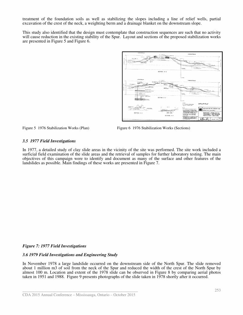
treatment of the foundation soils as well as stabilizing the slopes including a line of relief wells, partial excavation of the crest of the neck, a weighting berm and a drainage blanket
This study also identified that the design must contemplate that construction sequences are such that no activity will cause reduction in the existing stability of the Spur.are presented in Figure 5 and Figure 6.
Figure 5 1976 Stabilization Works (Plan) Figure 6 1976 Stabilization Works (Sections) 3.5 1977 Field Investigations In 1977, a detailed study of clay slide areas in the vicinity of the site was performed. The site work included a surficial field examination of the slide areas and the retrieval of samples for further laboratory testing. The main objectives of this campaign were to identify and document as many of the surface and other features of the landslides as possible. Main findings of these works are presented
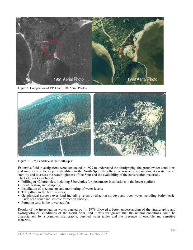
Figure 7: 1977 Field Investigations 3.6 1979 Field Investigations and Engineering Study In November 1978 a large landslide occurred on the downstream side of the North Spur. The slide removed about 1 million m3 of soil from the neck of the Spur and reduced the width of the crest of the North Spur by almost 100 m. Location and extent of the 19taken in 1951 and 1988. Figure 9 presents photographs of the slide taken in 1978 shortly after it occurred. __________________________________________________________
Mississauga, Ontario – October 2015
treatment of the foundation soils as well as stabilizing the slopes including a line of relief wells, partial excavation of the crest of the neck, a weighting berm and a drainage blanket on the downstream slope.
the design must contemplate that construction sequences are such that no activity will cause reduction in the existing stability of the Spur. Layout and sections of the proposed stabilization works
Figure 5 1976 Stabilization Works (Plan) Figure 6 1976 Stabilization Works (Sections)
In 1977, a detailed study of clay slide areas in the vicinity of the site was performed. The site work included a surficial field examination of the slide areas and the retrieval of samples for further laboratory testing. The main
gn were to identify and document as many of the surface and other features of the landslides as possible. Main findings of these works are presented in Figure 7.
Investigations and Engineering Study
In November 1978 a large landslide occurred on the downstream side of the North Spur. The slide removed about 1 million m3 of soil from the neck of the Spur and reduced the width of the crest of the North Spur by almost 100 m. Location and extent of the 1978 slide can be observed in Figure 8 by comparing aerial photos
presents photographs of the slide taken in 1978 shortly after it occurred.
253
treatment of the foundation soils as well as stabilizing the slopes including a line of relief wells, partial on the downstream slope.
the design must contemplate that construction sequences are such that no activity Layout and sections of the proposed stabilization works
Figure 5 1976 Stabilization Works (Plan) Figure 6 1976 Stabilization Works (Sections)
In 1977, a detailed study of clay slide areas in the vicinity of the site was performed. The site work included a surficial field examination of the slide areas and the retrieval of samples for further laboratory testing. The main
gn were to identify and document as many of the surface and other features of the
In November 1978 a large landslide occurred on the downstream side of the North Spur. The slide removed about 1 million m3 of soil from the neck of the Spur and reduced the width of the crest of the North Spur by
by comparing aerial photos presents photographs of the slide taken in 1978 shortly after it occurred.
__________________________________________________________
CDA 2015 Annual Conference – Mississauga, Ontario – October 2015
254
Figure 9 1978 Landslide Figure 8: Comparison of 1951 and 1988 Aerial Photos
Figure 9: 1978 Landslide at the North Spur Extensive field investigations were conducted in 1979 to understand the stratigraphy, the groundwater conditions and main causes for slope instabilities in the North Spur, the effects of reservoir impoundment on its overall stability and to assess the water tightness of the Spur and the availability of the construction materials. The field works included: • Drilling of 42 boreholes, including 3 boreholes for piezometer installations in the lower aquifer; • In-situ testing and sampling; • Installation of piezometers and monitoring of water levels; • Test pitting in the borrow areas; • Geophysical surveys over land including seismic refraction surveys and over water including bathymetric,
side scan sonar and seismic refraction surveys; • Pumping tests in the lower aquifer. Results of the investigation works carried out in 1979 allowed a better understanding of the stratigraphic and hydrogeological conditions of the North Spur, and it was recognized that the natural conditions could be characterized by a complex stratigraphy, perched water tables and the presence of erodible and sensitive materials.
__________________________________________________________
CDA 2015 Annual Conference – Mississauga, Ontario
The study identified stabilization works protection, surface run-off control and upstream slope the downstream slope, it was established that the ground water level should be lowered from elevation 30 m to at least elevation 15 m. Alternative seepage interception systems well scheme was the most economic and The works proposed included a line of relief wells in the crest of the Spur along the downstream slope, a secondary line of defence comprised of inclined gravity drains, permanent drainage of the Spur in the area of the Kettle Lakes, relieving weight by partial excavation on the slopeand a free draining berm with inverted filter in the upstream slope. As a complement to these stabilization works, it was concluded that the area must be properly instrumented and monitored both prior to and after the proposed remedial measures were undertakeneffectiveness of the drainage and slope treatment measures in the North Spur. proposed 1979 stabilization works are presented in
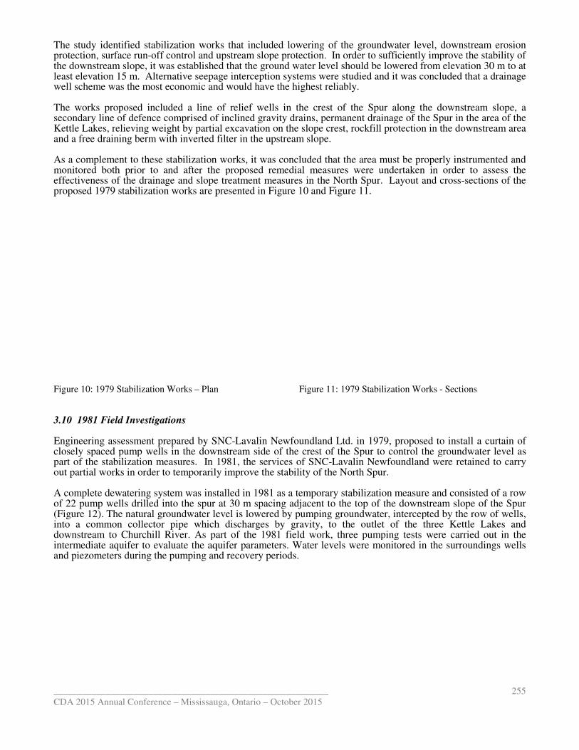
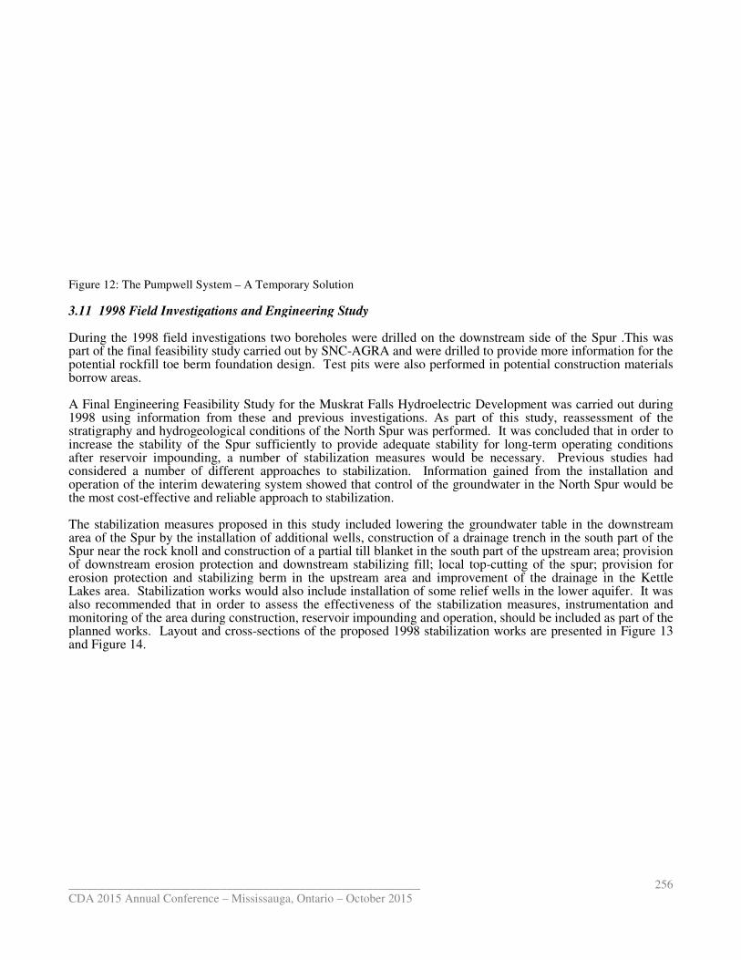
Figure 10: 1979 Stabilization Works – Plan 3.10 1981 Field Investigations Engineering assessment prepared by SNCclosely spaced pump wells in the downstream side of the crest of the Spur to control the groundwater level as part of the stabilization measures. In 1981, the services of SNCout partial works in order to temporarily improve the stability of the North Spur. A complete dewatering system was installed in 1981 as a temporary stabilization measureof 22 pump wells drilled into the spur at 30 m spacing adjacent to the top of t(Figure 12). The natural groundwater level is lowered by pumping groundwater, intercepted by the row of wells, into a common collector pipe which dischargesdownstream to Churchill River. As part of the 1981 field workintermediate aquifer to evaluate the aquifer parameters. Water levels and piezometers during the pumping and recovery periods.
__________________________________________________________
Mississauga, Ontario – October 2015
works that included lowering of the groundwater level, off control and upstream slope protection. In order to sufficiently improve the stability of
the downstream slope, it was established that the ground water level should be lowered from elevation 30 m to at Alternative seepage interception systems were studied and it was concluded
well scheme was the most economic and would have the highest reliably.
line of relief wells in the crest of the Spur along the downstream slope, a secondary line of defence comprised of inclined gravity drains, permanent drainage of the Spur in the area of the Kettle Lakes, relieving weight by partial excavation on the slope crest, rockfill protection in the downstream area and a free draining berm with inverted filter in the upstream slope.
stabilization works, it was concluded that the area must be properly instrumented and and after the proposed remedial measures were undertaken in order to assess the
effectiveness of the drainage and slope treatment measures in the North Spur. Layout and proposed 1979 stabilization works are presented in Figure 10 and Figure 11.
Plan Figure 11: 1979 Stabilization Works
Engineering assessment prepared by SNC-Lavalin Newfoundland Ltd. in 1979, proposed to install a curtain of closely spaced pump wells in the downstream side of the crest of the Spur to control the groundwater level as
1981, the services of SNC-Lavalin Newfoundland were retained to carry out partial works in order to temporarily improve the stability of the North Spur.
A complete dewatering system was installed in 1981 as a temporary stabilization measure and consisteof 22 pump wells drilled into the spur at 30 m spacing adjacent to the top of the downstream slope of the Spur
The natural groundwater level is lowered by pumping groundwater, intercepted by the row of wells, pipe which discharges by gravity, to the outlet of the three Kettle Lakes
As part of the 1981 field work, three pumping tests were carried out in the to evaluate the aquifer parameters. Water levels were monitored in the surroundings wells
and piezometers during the pumping and recovery periods.
255
ing of the groundwater level, downstream erosion In order to sufficiently improve the stability of
the downstream slope, it was established that the ground water level should be lowered from elevation 30 m to at t was concluded that a drainage
line of relief wells in the crest of the Spur along the downstream slope, a secondary line of defence comprised of inclined gravity drains, permanent drainage of the Spur in the area of the
crest, rockfill protection in the downstream area
stabilization works, it was concluded that the area must be properly instrumented and in order to assess the
Layout and cross-sections of the
Figure 11: 1979 Stabilization Works - Sections
Lavalin Newfoundland Ltd. in 1979, proposed to install a curtain of closely spaced pump wells in the downstream side of the crest of the Spur to control the groundwater level as
Lavalin Newfoundland were retained to carry
and consisted of a row he downstream slope of the Spur
The natural groundwater level is lowered by pumping groundwater, intercepted by the row of wells, three Kettle Lakes and
pumping tests were carried out in the were monitored in the surroundings wells
__________________________________________________________
CDA 2015 Annual Conference – Mississauga, Ontario
Figure 12: The Pumpwell System – A Temporary Solution 3.11 1998 Field Investigations and Engineering Study During the 1998 field investigations two boreholes were drilled on part of the final feasibility study carried out by SNCpotential rockfill toe berm foundation design. Tborrow areas. A Final Engineering Feasibility Study 1998 using information from these and previous investigationsstratigraphy and hydrogeological conditions of the North Spur was performedincrease the stability of the Spur sufficiently to provide adequate stability for longafter reservoir impounding, a number of stabilization measures considered a number of different approaches tooperation of the interim dewatering system showed that control of the groundwater in the North Spur the most cost-effective and reliable approach The stabilization measures proposed in this studyarea of the Spur by the installation of additional wells, construction of a drainage trench in the south part of the Spur near the rock knoll and construction of a partial till blanket in the south part of the upstream area; provision of downstream erosion protection and downstream stabilizing fill; local toperosion protection and stabilizing berm in the upstream area and improvement of the drainage in the Kettle Lakes area. Stabilization works would also includalso recommended that in order to assess the effectiveness of the stabilization measures, instrumentation and monitoring of the area during construction, reservoir planned works. Layout and cross-sections of the proposed 1998 stabilization works are presented in and Figure 14.
__________________________________________________________
Mississauga, Ontario – October 2015
A Temporary Solution
3.11 1998 Field Investigations and Engineering Study
wo boreholes were drilled on the downstream side of the Spur .This was part of the final feasibility study carried out by SNC-AGRA and were drilled to provide more information for the
m foundation design. Test pits were also performed in potential
A Final Engineering Feasibility Study for the Muskrat Falls Hydroelectric Development was carried out during using information from these and previous investigations. As part of this study,
stratigraphy and hydrogeological conditions of the North Spur was performed. It was concluded that increase the stability of the Spur sufficiently to provide adequate stability for long-term operating conditions
voir impounding, a number of stabilization measures would be necessary. ed a number of different approaches to stabilization. Information gained from
interim dewatering system showed that control of the groundwater in the North Spur effective and reliable approach to stabilization.
proposed in this study included lowering the groundwater tablepur by the installation of additional wells, construction of a drainage trench in the south part of the
Spur near the rock knoll and construction of a partial till blanket in the south part of the upstream area; provision m erosion protection and downstream stabilizing fill; local top-cutting of the spur; provision for
erosion protection and stabilizing berm in the upstream area and improvement of the drainage in the Kettle Stabilization works would also include installation of some relief wells in the lower aquifer.
n order to assess the effectiveness of the stabilization measures, instrumentation and monitoring of the area during construction, reservoir impounding and operation, should be included as part of the
sections of the proposed 1998 stabilization works are presented in
256
the downstream side of the Spur .This was were drilled to provide more information for the
construction materials
the Muskrat Falls Hydroelectric Development was carried out during . As part of this study, reassessment of the
. It was concluded that in order to term operating conditions
Previous studies had Information gained from the installation and
interim dewatering system showed that control of the groundwater in the North Spur would be
included lowering the groundwater table in the downstream pur by the installation of additional wells, construction of a drainage trench in the south part of the
Spur near the rock knoll and construction of a partial till blanket in the south part of the upstream area; provision cutting of the spur; provision for
erosion protection and stabilizing berm in the upstream area and improvement of the drainage in the Kettle e installation of some relief wells in the lower aquifer. It was
n order to assess the effectiveness of the stabilization measures, instrumentation and should be included as part of the
sections of the proposed 1998 stabilization works are presented in Figure 13
__________________________________________________________
CDA 2015 Annual Conference – Mississauga, Ontario
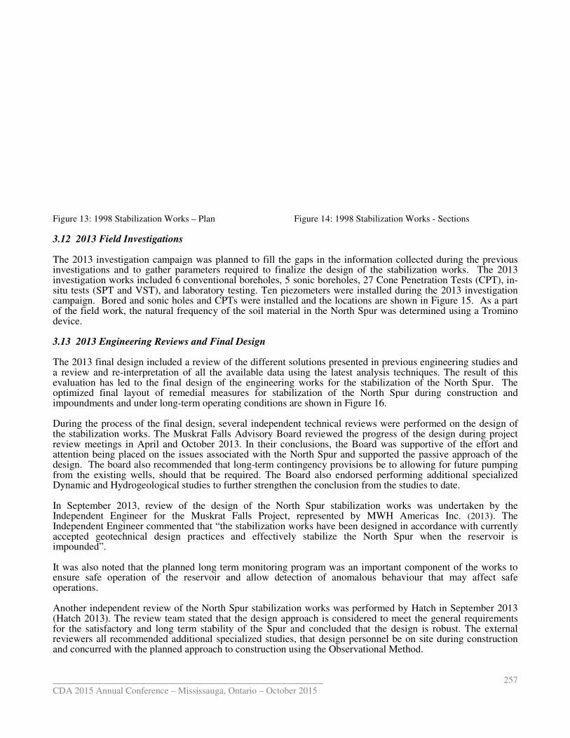
Figure 13: 1998 Stabilization Works – Plan 3.12 2013 Field Investigations The 2013 investigation campaign was planned to fill the gaps in the information investigations and to gather parameters investigation works included 6 conventional boreholes, 5 sonic boreholes, 27 Cone Penetration Tests (CPT), insitu tests (SPT and VST), and laboratory testing. Ten piezometers were installed duricampaign. Bored and sonic holes and CPTs of the field work, the natural frequency of the soil material in the North Spur was determined using device. 3.13 2013 Engineering Reviews and Final Design The 2013 final design included a review of the a review and re-interpretation of all the available data evaluation has led to the final design of the engineering works for the stabilization of the North Spuroptimized final layout of remedial measures for stabilization of the North Spur during construction and impoundments and under long-term operating conditions During the process of the final design, several independent technical reviews were performed on the design of the stabilization works. The Muskrat Falls review meetings in April and October 2013. attention being placed on the issues associated design. The board also recommended from the existing wells, should that be requiredDynamic and Hydrogeological studies to further In September 2013, review of the design of the North Spur stabilization works was undertaken by Independent Engineer for the Muskrat Falls ProjectIndependent Engineer commented that “the stabilization works have been designed in accordance with currently accepted geotechnical design practices and effectively stabilize the North Spur when the reservoir is impounded”. It was also noted that the planned long term monitoring program waensure safe operation of the reservoir and operations. Another independent review of the North Spur stabilization works was(Hatch 2013). The review team stated that the design approach is considered to meet the general requirements for the satisfactory and long term stability of the Spur and concluded that the design ireviewers all recommended additional specialized studiesand concurred with the planned approach to construction using the O
__________________________________________________________
Mississauga, Ontario – October 2015
Plan Figure 14: 1998 Stabilization Work
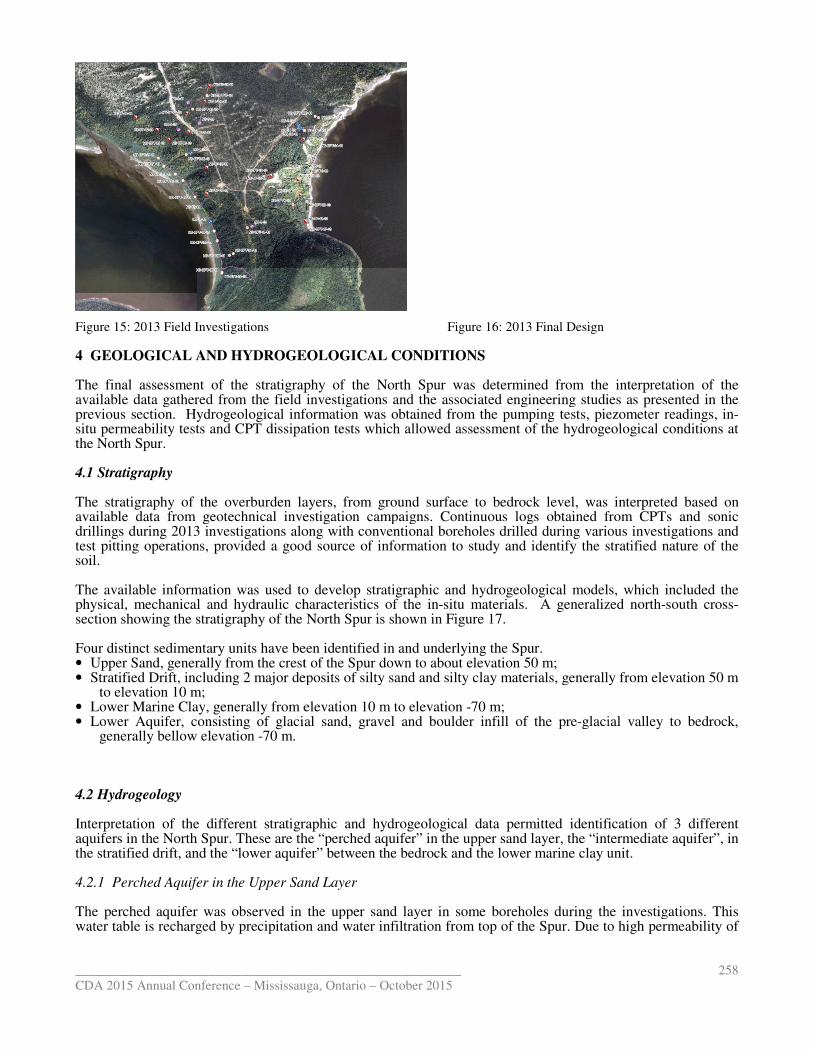
The 2013 investigation campaign was planned to fill the gaps in the information collected during investigations and to gather parameters required to finalize the design of the stabilization works. investigation works included 6 conventional boreholes, 5 sonic boreholes, 27 Cone Penetration Tests (CPT), insitu tests (SPT and VST), and laboratory testing. Ten piezometers were installed during the 2013 investigation
Bored and sonic holes and CPTs were installed and the locations are shown in of the field work, the natural frequency of the soil material in the North Spur was determined using
Reviews and Final Design
2013 final design included a review of the different solutions presented in previous engineering studies andinterpretation of all the available data using the latest analysis techniques
has led to the final design of the engineering works for the stabilization of the North Spurlayout of remedial measures for stabilization of the North Spur during construction and
term operating conditions are shown in Figure 16.
, several independent technical reviews were performed on the design of he Muskrat Falls Advisory Board reviewed the progress of the de
April and October 2013. In their conclusions, the Board was supportive of the effort and associated with the North Spur and supported the passive approach of the
recommended that long-term contingency provisions be to allowing , should that be required. The Board also endorsed performing
studies to further strengthen the conclusion from the studies to date
review of the design of the North Spur stabilization works was undertaken by for the Muskrat Falls Project, represented by MWH Americas Inc.
commented that “the stabilization works have been designed in accordance with currently accepted geotechnical design practices and effectively stabilize the North Spur when the reservoir is
long term monitoring program was an important component of the works ensure safe operation of the reservoir and allow detection of anomalous behaviour that may affect safe
Another independent review of the North Spur stabilization works was performed by Hatch. The review team stated that the design approach is considered to meet the general requirements
for the satisfactory and long term stability of the Spur and concluded that the design isadditional specialized studies, that design personnel be on site
approach to construction using the Observational Method.
257
s - Sections
collected during the previous to finalize the design of the stabilization works. The 2013
investigation works included 6 conventional boreholes, 5 sonic boreholes, 27 Cone Penetration Tests (CPT), in-ng the 2013 investigation
and the locations are shown in Figure 15. As a part of the field work, the natural frequency of the soil material in the North Spur was determined using a Tromino
engineering studies and using the latest analysis techniques. The result of this
has led to the final design of the engineering works for the stabilization of the North Spur. The layout of remedial measures for stabilization of the North Spur during construction and
, several independent technical reviews were performed on the design of reviewed the progress of the design during project
conclusions, the Board was supportive of the effort and and supported the passive approach of the
allowing for future pumping performing additional specialized
strengthen the conclusion from the studies to date.
review of the design of the North Spur stabilization works was undertaken by the MWH Americas Inc. (2013). The
commented that “the stabilization works have been designed in accordance with currently accepted geotechnical design practices and effectively stabilize the North Spur when the reservoir is
s an important component of the works to anomalous behaviour that may affect safe
atch in September 2013 . The review team stated that the design approach is considered to meet the general requirements
s robust. The external on site during construction
__________________________________________________________
CDA 2015 Annual Conference – Mississauga, Ontario
Figure 15: 2013 Field Investigations 4 GEOLOGICAL AND HYDROGEOLOGICAL CONDITIONS The final assessment of the stratigraphy of the North Spur was determined available data gathered from the field investigations and the associated engineering studies previous section. Hydrogeological information situ permeability tests and CPT dissipation teststhe North Spur. 4.1 Stratigraphy The stratigraphy of the overburden layers, from ground surface to bedrock level, was interpreted based on available data from geotechnical investigation campaigns. Continuous logs obtained from CPTs and sonic drillings during 2013 investigations along with conventional boreholes drilled during various investigations and test pitting operations, provided a goodsoil. The available information was used to develop physical, mechanical and hydraulic characteristics of the insection showing the stratigraphy of the North Spur Four distinct sedimentary units have been identified in and underlying the Spur.• Upper Sand, generally from the crest of the Spur down to• Stratified Drift, including 2 major deposits of silty sand and silty clay materials, generally from elevation 50 m
to elevation 10 m; • Lower Marine Clay, generally from elevation 10 m to elevation • Lower Aquifer, consisting of glacial sand, gravel and boulder infill of the pre
generally bellow elevation -70 m.
4.2 Hydrogeology Interpretation of the different stratigraphic and hydrogeological data permitted identifiaquifers in the North Spur. These are the “pthe stratified drift, and the “lower aquifer” 4.2.1 Perched Aquifer in the Upper Sand Layer The perched aquifer was observed in the upper sand layer in some boreholes water table is recharged by precipitation and water infiltration from top of the Spur. Due to high permeability of
__________________________________________________________
Mississauga, Ontario – October 2015
igure 15: 2013 Field Investigations Figure 16: 2013 Final Design
GEOLOGICAL AND HYDROGEOLOGICAL CONDITIONS
atigraphy of the North Spur was determined from the interpretation of the available data gathered from the field investigations and the associated engineering studies
ydrogeological information was obtained from the pumping tests, piezometer readings, inpermeability tests and CPT dissipation tests which allowed assessment of the hydrogeological conditions
The stratigraphy of the overburden layers, from ground surface to bedrock level, was interpreted based on available data from geotechnical investigation campaigns. Continuous logs obtained from CPTs and sonic drillings during 2013 investigations along with conventional boreholes drilled during various investigations and test pitting operations, provided a good source of information to study and identify the stratified nature of the
used to develop stratigraphic and hydrogeological modelphysical, mechanical and hydraulic characteristics of the in-situ materials. A generalized
of the North Spur is shown in Figure 17.
Four distinct sedimentary units have been identified in and underlying the Spur. Upper Sand, generally from the crest of the Spur down to about elevation 50 m; Stratified Drift, including 2 major deposits of silty sand and silty clay materials, generally from elevation 50 m
Clay, generally from elevation 10 m to elevation -70 m; lacial sand, gravel and boulder infill of the pre-glacial valley to bedrock,
Interpretation of the different stratigraphic and hydrogeological data permitted identifiThese are the “perched aquifer” in the upper sand layer, the “intermediate aquifer”,
the “lower aquifer” between the bedrock and the lower marine clay unit.
in the Upper Sand Layer
was observed in the upper sand layer in some boreholes during the investigationswater table is recharged by precipitation and water infiltration from top of the Spur. Due to high permeability of
258
from the interpretation of the available data gathered from the field investigations and the associated engineering studies as presented in the
obtained from the pumping tests, piezometer readings, in-the hydrogeological conditions at
The stratigraphy of the overburden layers, from ground surface to bedrock level, was interpreted based on available data from geotechnical investigation campaigns. Continuous logs obtained from CPTs and sonic drillings during 2013 investigations along with conventional boreholes drilled during various investigations and
the stratified nature of the
stratigraphic and hydrogeological models, which included the generalized north-south cross-
Stratified Drift, including 2 major deposits of silty sand and silty clay materials, generally from elevation 50 m
glacial valley to bedrock,
Interpretation of the different stratigraphic and hydrogeological data permitted identification of 3 different “intermediate aquifer”, in
lower marine clay unit.
during the investigations. This water table is recharged by precipitation and water infiltration from top of the Spur. Due to high permeability of

__________________________________________________________
CDA 2015 Annual Conference – Mississauga, Ontario
this layer the ground water easily drains through the upstream, downstream and kettle lakes slopes at elevations 40 to 45 m. 4.2.2 Intermediate Aquifer The intermediate aquifer was observed in the stratified drthroughout the Spur. The piezometric levels in this aquifer indicate Spur and discharges through the upstream and downstream slopesto the north-east of the Spur. Controlling the seepage and ldeemed to be extremely significant to reason for the installation of the pumpwell system in 1979. shown in Figure 18.
Figure 17: Simplified Stratigraphy 4.2.3 Lower Aquifer The lower aquifer was identified in the lower granular layer (generally below elevation thickness of this aquifer is about 44 m in the vicinity of the North Spur. The river bathymetrythat a deep depression, with a minimum elevation of about the Spur. Studies have shown that the lower aquifer is connected to the downstream side of the river in this area. 4.3 Slope Stability Numerous evidences of slope instabilities can be found in the form of landslide scars along the Churchill River shoreline. The North Spur has been subject to landslides in the past, and analysis has shown that it could be subject to future landslides if measures are not taken to stabilize the slopes. North Spur for the existing conditions are:
- Toe erosion due to water and ice level fluctuations.- High pore-water pressures within the stratified drift.- Surface erosion due to run-off water- Geometry of the slopes
The potential slope failure modes identified are:
- Shallow slab slide - Block sliding - Flow slides
__________________________________________________________
Mississauga, Ontario – October 2015
ins through the upstream, downstream and kettle lakes slopes at elevations
s observed in the stratified drift, between elevations 45 to 5ometric levels in this aquifer indicate it is recharged from the North
through the upstream and downstream slopes, through the three kettle lakes and their outlet Controlling the seepage and lowering the pore water pressure in this aquifer is
to the stability of the Spur. Lowering of this piezometric level was the reason for the installation of the pumpwell system in 1979. Piezometric contours of the intermediate aquifer are
Figure 17: Simplified Stratigraphy Figure 18: Intermediate Aquifer Piezome
lower aquifer was identified in the lower granular layer (generally below elevation thickness of this aquifer is about 44 m in the vicinity of the North Spur. The river bathymetrythat a deep depression, with a minimum elevation of about - 60 m, exists in the bay immediately downstream of
that the lower aquifer is connected to the downstream side of the river in this area.
Numerous evidences of slope instabilities can be found in the form of landslide scars along the Churchill River
The North Spur has been subject to landslides in the past, and analysis has shown that it could be subject to future landslides if measures are not taken to stabilize the slopes. The main causes of slope instabilities on the
are:
Toe erosion due to water and ice level fluctuations. water pressures within the stratified drift.
off water
The potential slope failure modes identified are:
259
ins through the upstream, downstream and kettle lakes slopes at elevations
ift, between elevations 45 to 5 m (approximately) recharged from the North side of the
through the three kettle lakes and their outlet owering the pore water pressure in this aquifer is
. Lowering of this piezometric level was the contours of the intermediate aquifer are
Figure 18: Intermediate Aquifer etric Contours
lower aquifer was identified in the lower granular layer (generally below elevation -70 m). The average thickness of this aquifer is about 44 m in the vicinity of the North Spur. The river bathymetry (Figure 2) shows
60 m, exists in the bay immediately downstream of that the lower aquifer is connected to the downstream side of the river in this area.
Numerous evidences of slope instabilities can be found in the form of landslide scars along the Churchill River
The North Spur has been subject to landslides in the past, and analysis has shown that it could be subject to The main causes of slope instabilities on the
__________________________________________________________
CDA 2015 Annual Conference – Mississauga, Ontario – October 2015
260
Three major slides have occurred on the downstream the North Spur, with the most recent one occurring in November, 1978. On the upstream side four landslide scarps or erosion marks are visible. A common feature of the previous slides on the North Spur is that they occurred in the stratified drift and little slide debris remained in the slide bowl which is an indication of the sensitive nature of the soils involved in the slide. The 1978 landslide that occurred removed about 1 million m3 of soil with a maximum distance of the retrogression from the original slope of less than 200 m. The results of the slope stability analysis showed that the stability conditions of the slopes examined were stable but with factors of safety very close to one. 5 Stabilization Works The design of the stabilization works of the North Spur followed the state-of-the-art methods and complies with appropriate standards and guidelines. The guidelines prepared by the Canadian Dam Association (CDA) were used as a basis for the design and constitute the primary framework. In the context of the Lower Churchill project, the North Spur is treated as a dam for the selection of the design criteria.
The final engineering design of the stabilization works of the North Spur was completed after last assessment of the geological and hydrogeological conditions of the Spur taking into consideration all previous engineering design studies and considering advances in technology available since the start of investigations in 1965.
The objectives of the stabilization works are to achieve the following:
- Lower the piezometric level,
- Inhibit infiltration from the reservoir (cut-off walls and till blanket),
- Capture and evacuate seepage water,
- Improve slope stability (Geometric correction), and
- Protect the toe and slopes against erosion.
The final design calls for a complete control of the groundwater in the North Spur; erosion protection both the upstream and downstream side of the Spur and local unloading of the upper part of the Spur. Groundwater control on the North Spur will be assured by:
- Construction of a cement bentonite cut-off wall and till blanket barrier in the upstream area;
- Construction of a cement bentonite cut-off wall in the northwest area;
- Construction of finger drains and inverted drains in the downstream area;
- Improvement of drainage of the Kettle Lakes;
- Installation of relief wells in the lower aquifer.
The existing dewatering system has to be maintained and kept in operation during the construction works. The intention following construction is that the stabilization measures will passive and therefore the pumpwell system will no longer be required. It will, however, be retained in an operational condition during the start of the operations at Muskrat Falls as an additional measure which could be implemented, should it be required.
6 Additional Studies The North Spur is an aspect of the Muskrat Falls Project which has been under a high degree of public scrutiny. For this reason, additional studies were undertaken following the completion of the final design to add additional confidence in the approach that was being undertaken at the North Spur. These studies included the following:
- Dynamic Study - Hydrogeologic Study - Progressive Failure Study
__________________________________________________________
CDA 2015 Annual Conference – Mississauga, Ontario – October 2015
261
The Dynamic Study revisited the seismic hazard analysis and updated the design response spectra. One and two dimensional models using soils information updated from the recent investigations were used to examine the behaviour of the North Spur under seismic loading. It was found that the 2D Equivalent-linear dynamic response modelling results indicate no potential for liquefaction of the granular materials nor potential for cyclic softening for the clay. Based on the findings of this complementary dynamic study, the North Spur integrity is not expected to be affected by the occurrence of the design seismic event (probability of 1/10 000) (Idriss 2014). A Hydrogeologic Study (Hatch 2015) was undertaken to simulate the behaviour of the intermediate and lower aquifers before and after impoundments to elevations 25 m and 39 m. It involved simulation of the installation of relief wells in the Lower Aquifer, simulation of the effect of the two cut off walls, and simulating the global effect of the stabilization works. The study also examined the effect of the operation of the existing pumpwell system. The study showed no major impact of the impoundment on the lower aquifer. This suggests that the relief wells into the lower aquifer will not be required. The behaviour of the lower aquifer on impoundment will be used to verify these conclusions before the final decision is made to cancel these wells. The model showed that the stabilization works, with the finger drains, adequately control the groundwater pressure build-up and are an effective solution for implementation. The Progressive Failure Study looked at the potential for a downhill progressive landslide at the North Spur. The calculations were calibrated to an existing slope at the North Spur and considered a rotational, flow slide, with a first movement at the toe. The study also takes into account the impact of a trigger from the uphill location. The conclusion of the study is that the stability measures put in place will be effective reducing the stress levels which could trigger a landslide. During construction, measures should in place to ensure that human activity does not trigger a landslide before the works can be completed. 7 Construction of the Stabilization Works Construction of the North Spur Stabilization works started in March 2015. The initial work was clearing of the area so that the stabilization work could commence when the weather improved and snow melted to allow full mobilization of the contractor. The Lower Churchill Project team also mobilized to site at this time in order to monitor construction progress and the stability of the North Spur during construction. 7.1 Construction Progress Work began with the upstream area, with flattening of the slopes and preparation of access to the water edge to begin the installation of the cement bentonite cutoff walls. Work has progressed well and, to date, conditions have been consistent with or better than expectation. 7.2 Surveillance Program A surveillance program has been set up to monitor the behaviour of the North Spur during construction. This includes regular walk-over of the area by the site geotechnical engineer and monitoring of piezometers and weirs in the area. The data is regularly reviewed by the team, and trigger indicators have been set up which are used to warn when anomalous reactions are occurring during construction. These triggers have been reviewed with the project safety group, and an emergency response protocol is in place which ties into the overall project emergency preparedness plan. The plan includes alert levels and a communication protocol to deal with potential emergencies. 7.3 Observational Method The observational method (also called “Adaptive Design Approach”) is used to allow a capability to react quickly and efficiently during construction works in the event that changes to the design are necessary due to unexpected conditions or deviation from the design expectations occurs. Prior to construction, the design team worked to identify worse-case possibilities which had potential to occur during construction and identified solutions which could be implemented to address each type of event. The potential triggers where evaluated so that the team could react with an adapted pre designed solution, and so that the required reaction time was understood.
__________________________________________________________
CDA 2015 Annual Conference – Mississauga, Ontario – October 2015
262
8 Conclusions North Spur stabilization works designs have been developed and updated over the years from 1964 to today. Information on soils stratigraphy, properties and groundwater behaviour are critical to the preparation of the engineering design for the stabilisation. Use of data collected from the early investigations, updated with more recent studies, and the use of more powerful assessment tools has helped to prepare a better final design. 8.1 Stratigraphy:
Use of more accurate investigation tools (CPTu, Sonic drilling, Tromino) gave a better stratigraphy understanding. The major inputs have been to define the lower clay deposit upper limit and to eliminate the presence of clean sand deposit in the stratified drift. 8.2 Mechanical Properties From1965 (NGI) to 2013 (Amec), mechanical properties does not change a lot and the effective cohesion and internal friction angle are very similar. Small change can be come from interpretation process instead the result itself. Mechanical in situ parameter (as shear strength) has been measured in 2013 using the CPT probe to have a continuous profile with depth. Correlation has been done with Cu value from Vane test. OCR show clearly the effect of erosion occurred on both side of the spur. 8.3 Groundwater Dissipation test done with CPTu confirm and implement the downward gradient on each side of the spur. New data have been used to review the slope stability analysis before, during and after stabilization works. 8.4 Software
The use of more powerful calculation tools permitted building numerical 3D models to represent the North Spur topography and the groundwater conditions. These models are used to reproduce the groundwater behaviour before, and after construction and to follow the effects of the construction activities. Finite Element Models (FEM) have been used to perform the dynamic and progressive failure studies. 1D and 2D models have been used to refine calculation.
The final design including all information and data has been improved and optimized to stabilise the North Spur accordingly with current standards for dam safety. 9 REFERENCES
Atkinson, G., 2009. Earthquake Hazard Analysis: Gull and Muskrat and Gull Damsites, Lower Churchill, Labrador.
Report to SNC-Lavalin.
Atkinson, G., 2014. Earthquake Hazard Analysis: Muskrat Damsite, Lower Churchill, Labrador. Draft Report to SNC-
Lavalin, May 22, 2014.
MWH Americas Inc, 2013. Interim Independent Engineer’s Report, Lower Churchill Project, November 2013.
Hatch Ltd, 2013. Cold Eyes Review of Design and Technical Specifications, North Spur Stabilization Works, October 2013.
Idriss, I.M., 2014. Review of Seismic Performance of the North Spur, Lower Churchill Project, December 2014.
Hatch Ltd, 2015. Three Dimensional (3D) Hydrogeological Study for the North Spur - Final Report, June 2015