
St Germain Special Activity 1425 Pound Road & 2100 … · 0 3 d r a f t St Germain Special Activity...
50
13M2191000 23/09/13 draft St Germain Special Activity Precinct 1425 Pound Road & 2100 Thompsons Road Clyde North Transport Impact Assessment
-
Upload
trinhthuan -
Category
Documents
-
view
214 -
download
0
Transcript of St Germain Special Activity 1425 Pound Road & 2100 … · 0 3 d r a f t St Germain Special Activity...

13
M2
191
000
2
3/0
9/1
3
d r a f t
St Germain Special Activity
Precinct
1425 Pound Road & 2100
Thompsons Road
Clyde North
Transport Impact Assessment

© GTA Consultants (GTA Consultants (VIC) Pty Ltd) 2013
The information contained in this document is confidential and
intended solely for the use of the client for the purpose for which it
has been prepared and no representation is made or is to be implied
as being made to any third party. Use or copying of this document in
whole or in part without the written permission of GTA Consultants
constitutes an infringement of copyright. The intellectual property
contained in this document remains the property of GTA Consultants.
TIA
/RSA
MA
– V
IC (
130603 v
7.2
))
St Germain Special Activity Precinct
1425 Pound Road & 2100 Thompsons Road, Clyde
North
Transport Impact Assessment
Issue: A-Dr 23/09/13
Client: Beveridge Williams
Reference: 13M2191000
GTA Consultants Office: VIC
Quality Record
Issue Date Description Prepared By Checked By Approved By Signed
A-Dr 23/09/13 Draft Herman Lai
Peter Wills Peter Wills John Kiriakidis

Table of Contents
13M2191000 23/09/13
St Germain Special Activity Precinct, 1425 Pound Road & 2100 Thompsons Road, Clyde North Issue: A-Dr
Transport Impact Assessment
draft
Table of Contents
1. Introduction 1
1.1 Background & Proposal 1
1.2 Subject Site 4
1.3 Purpose of this Report 6
1.4 References 6
2. Transport Policy 7
2.1 Strategic Context 7
2.2 Clause 18 (Casey Planning Scheme) 7
2.3 Transport Policy Discussion 7
3. Sustainable Transport Considerations 8
3.1 Walking & Cycling Network 8
3.2 Public Transport 8
3.3 Bicycle Parking & Associated Facilities 8
4. Car Parking Provision 11
4.1 Statutory Car Parking Requirements 11
4.2 Adequacy of Parking Provision 12
5. Car Parking Layout 14
6. Loading & Waste Collection 15
6.1 Statutory Requirements 15
6.2 Layout 15
6.3 Refuse Collection 15
7. Traffic Impact 16
7.1 Performance Objectives 16
7.2 Development Overview 16
7.3 Traffic Generation 17
7.4 Traffic Distribution and Assignment 17
7.5 Traffic Impact 18
8. Conclusion 28
Appendices
A: Proposed Development – Sub-Precincts
B: Existing Conditions
C: Planning Policy Background
D: Car Park Design Standards Assessment
E: Swept Paths
F: Traffic Generation
G: SIDRA Intersection Results
Table of Contents
13M2191000 23/09/13
St Germain Special Activity Precinct, 1425 Pound Road & 2100 Thompsons Road, Clyde North Issue: A-Dr
Transport Impact Assessment
draft
Figures
Figure 1.1: Interim Access Strategy 3
Figure 1.2: Proposed St Germain Village Interim Access Arrangements 3
Figure 1.3: Subject Site and its Environs 5
Figure 1.4: Land Zoning Map 5
Figure 7.1: Interim Road Network Arrangements 17
Figure 7.2: AM Peak Hour Site Generated Traffic Volumes 18
Figure 7.3: PM Peak Hour Site Generated Traffic Volumes 18
Figure 7.4: Existing AM Peak Hour Traffic Volumes 19
Figure 7.5: Existing PM Peak Hour Traffic Volumes 19
Figure 7.6: Berwick-Cranbourne Road / Thompsons Road – Existing Unsignalised
Intersection Configuration 20
Figure 7.7: Post-Development AM Peak Hour Traffic Volumes 21
Figure 7.8: Post-Development PM Peak Hour Traffic Volumes 22
Figure 7.9: Berwick-Cranbourne Road / Thompsons Road – Modified Unsignalised
Intersection Configuration 23
Figure 7.10: Year 2013 AM Peak Traffic Volumes with Site Traffic – New Access Points 24
Figure 7.11: Year 2013 PM Peak Traffic Volumes with Site Traffic – New Access Points 25
Figure 7.12: Bells Road / Thompsons Road – Proposed Unsignalised Intersection
Configuration 25
Figure 7.13: Site Access Road / Thompsons Road – Proposed Unsignalised Intersection
Configuration 26
Tables
Table 1.1: Development Schedule 1
Table 1.2: Car Parking Provision – standard spaces (disabled spaces) 2
Table 3.1: Statutory Requirement for Bicycle Facilities 9
Table 4.1: Statutory Car Parking Requirements 11
Table 4.2: BCA Car Parking Requirements for People with Disabilities 12
Table 4.3: Car Parking Demand Versus Provision 13
Table 7.1: Stage 1 Land Uses 16
Table 7.2: Berwick-Cranbourne Road / Thompsons Road – Existing Unsignalised
Intersection Operation 21
Table 7.3: Berwick-Cranbourne Road / Thompsons Road – Post Development ‘Interim’
Operating Conditions 22
Table 7.4: Berwick-Cranbourne Road / Thompsons Road – Modified Unsignalised
Intersection Operation 23
Table 7.5: Bells Road / Thompsons Road – Post Development ‘Interim’ Operating
Conditions in 2023 26
Table 7.6: Site Access Road / Thompsons Road – Post Development ‘Interim’ Operating
Conditions in 2023 26

Introduction
13M2191000 23/09/13
St Germain Special Activity Precinct, 1425 Pound Road & 2100 Thompsons Road, Clyde North Issue: A-Dr
Transport Impact Assessment Page: 1
draft
1. Introduction
1.1 Background & Proposal
A 96A application has been lodged with the Growth Areas Authority (GAA) for a proposed
Special Activity Centre incorporating a large medical facility on land located at 2100 Thompsons
Road and 1425 Pound Road in Clyde North. The subject site is a key site within the yet to be
finalised Thompsons Road Precinct Structure Plan (PSP #1053) and the wider Clyde North Growth
Area.
GTA Consultants was commissioned by the Applicant in June 2013 to undertake a transport
impact assessment of the proposed development.
The proposal includes the construction of a Special Activity Centre incorporating a large range of
uses across several areas as summarised in Table 1.1. For the purposes of clarity, the proposed
development has been split into five precincts as shown in Table 1.1 and shown diagrammatically
in Appendix A. The wider superblock (the area surrounding Stage 1) is to be developed in a
staged manner over the next 30 years.
Table 1.1: Development Schedule
Description Stage Use Size
Medical Precinct
(Lot A) Stage 1
Medical 7,850 m2
Pharmacy 350 m2
North-East Precinct
(Lot B)
Stage 1 Supermarket 4,000 m2
Retail / speciality shops / café 1,840 m2
Future stage
Mini major 1,550 m2
Retail / speciality shops 140 m2
Restaurant 450 m2
Tavern 750 m2
South East Precinct
(Lot C)
Stage 1
Retail / café 760 m2
Apartments 34 x 2 bedroom +
2 x Penthouses
Future stage
Community Activity Centre 1,000 m2
Gymnasium 1,000 m2
Child care 120 children
South West Precinct
(Lot D)
Stage 1 Office 1,770 m2
Retail 240 m2
Future stage SOHOs [1] 7
Townhouses 6
Retirement Village
(Lot E) Stage 1 Retirement Village
210 x 1-2 bedroom dwellings
34 x 3 bedroom dwellings
16 x 1-2 bedroom apartments
[1] SOHO = Small Office Home Office
It is proposed to provide bicycle parking spaces across the site in excess of the statutory
requirements.
Pedestrian paths have been provided across the subject site to provide a high level of access for
pedestrians. Paths will be provided on both sides of the internal roadways providing key links
between the four precincts within St Germain Village. The proposed St Germain Village east-west
Introduction
13M2191000 23/09/13
St Germain Special Activity Precinct, 1425 Pound Road & 2100 Thompsons Road, Clyde North Issue: A-Dr
Transport Impact Assessment Page: 2
draft
Main Street is to be highly pedestrianized with no less than four crossing points proposed close to
the town square.
Designated loading areas are provided for the medical centre, the supermarket and the mini
major tenancy (future stages). Access into these loading areas is provided via the internal road
network which provides access to the future north-south road (known as Bells Road) and
Thompsons Road.
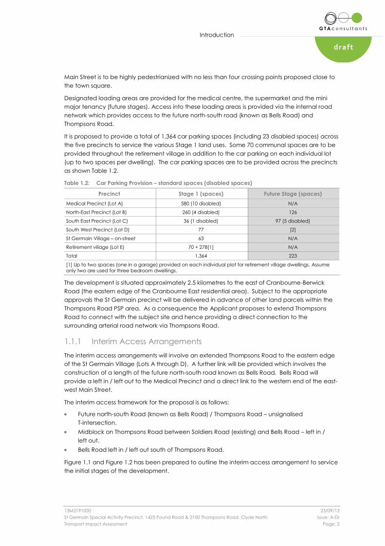
It is proposed to provide a total of 1,364 car parking spaces (including 23 disabled spaces) across
the five precincts to service the various Stage 1 land uses. Some 70 communal spaces are to be
provided throughout the retirement village in addition to the car parking on each individual lot
(up to two spaces per dwelling). The car parking spaces are to be provided across the precincts
as shown Table 1.2.
Table 1.2: Car Parking Provision – standard spaces (disabled spaces)
Precinct Stage 1 (spaces) Future Stage (spaces)
Medical Precinct (Lot A) 580 (10 disabled) N/A
North-East Precinct (Lot B) 260 (4 disabled) 126
South East Precinct (Lot C) 36 (1 disabled) 97 (5 disabled)
South West Precinct (Lot D) 77 [2]
St Germain Village – on-street 63 N/A
Retirement village (Lot E) 70 + 278[1] N/A
Total 1,364 223
[1] Up to two spaces (one in a garage) provided on each individual plot for retirement village dwellings. Assume
only two are used for three bedroom dwellings.
The development is situated approximately 2.5 kilometres to the east of Cranbourne-Berwick
Road (the eastern edge of the Cranbourne East residential area). Subject to the appropriate
approvals the St Germain precinct will be delivered in advance of other land parcels within the
Thompsons Road PSP area. As a consequence the Applicant proposes to extend Thompsons
Road to connect with the subject site and hence providing a direct connection to the
surrounding arterial road network via Thompsons Road.
1.1.1 Interim Access Arrangements
The interim access arrangements will involve an extended Thompsons Road to the eastern edge
of the St Germain Village (Lots A through D). A further link will be provided which involves the
construction of a length of the future north-south road known as Bells Road. Bells Road will
provide a left in / left out to the Medical Precinct and a direct link to the western end of the east-
west Main Street.
The interim access framework for the proposal is as follows:
Future north-south Road (known as Bells Road) / Thompsons Road – unsignalised
T-intersection.
Midblock on Thompsons Road between Soldiers Road (existing) and Bells Road – left in /
left out.
Bells Road left in / left out south of Thompsons Road.
Figure 1.1 and Figure 1.2 has been prepared to outline the interim access arrangement to service
the initial stages of the development.

Introduction
13M2191000 23/09/13
St Germain Special Activity Precinct, 1425 Pound Road & 2100 Thompsons Road, Clyde North Issue: A-Dr
Transport Impact Assessment Page: 3
draft
Figure 1.1: Interim Access Strategy
Figure 1.2: Proposed St Germain Village Interim Access Arrangements

Introduction
13M2191000 23/09/13
St Germain Special Activity Precinct, 1425 Pound Road & 2100 Thompsons Road, Clyde North Issue: A-Dr
Transport Impact Assessment Page: 4
draft
1.1.2 Ultimate Access Arrangements
The higher order anticipated ultimate access framework for the proposal is as follows:
Future north-south Road (known as Bells Road) / Thompsons Road – signalised
intersection.
Midblock on Thompsons Road between Soldiers Road (existing) and Bells Road – left in /
left out.
Thompsons Road east of the left in / left out – service road arrangement.
Midblock via new east-west Main Street on Bells Road between Hardys Road and
Thompsons Road – signalised intersection.
Bells Road left in / left out between Thompsons Road and Hardys Road.
1.2 Subject Site
The subject site is located in Clyde North and is part of a large triangular block of land bound in
part by Pounds Road and Thompsons Road. The site has frontages of 900m to Thompsons Road
and 320m to a future road which will connect with the existing Pound Road to the south and will
be known as Bells Road. In the medium term (10 to 20 years) it is anticipated that Thompsons
Road and Bells Road will be designated primary arterial roads and will be located within a Road
Zone 1.
The site is located within an Urban Growth Zone and is currently occupied by farmland.
The surrounding properties include a mix of rural land uses. The eastern edge of the Cranbourne
East residential area is approximately 2.5km to the west of the subject site.
The location of the subject site and the surrounding environs is shown in Figure 1.3, and the land
zoning is shown in Figure 1.4.

Introduction
13M2191000 23/09/13
St Germain Special Activity Precinct, 1425 Pound Road & 2100 Thompsons Road, Clyde North Issue: A-Dr
Transport Impact Assessment Page: 5
draft
Figure 1.3: Subject Site and its Environs
Figure 1.4: Land Zoning Map
(Reproduced from Land Channel web site)
SUBJECT SITE
Introduction
13M2191000 23/09/13
St Germain Special Activity Precinct, 1425 Pound Road & 2100 Thompsons Road, Clyde North Issue: A-Dr
Transport Impact Assessment Page: 6
draft
Further details regarding the subject site and the surrounding road network are provided in
Appendix B.
1.3 Purpose of this Report
The report sets out an assessment of the anticipated parking, traffic and transport implications of
the proposed development, including consideration of the:
i the adequacy of the proposed pedestrian, bicycle and public transport access
arrangements to the site
ii the adequacy of the proposed bicycle parking arrangements in terms of supply
(quantum) and layout
iii the adequacy of the proposed car parking provision
iv the adequacy of the proposed car park layout
v the adequacy of the proposed arrangements for loading and waste collection
vi the acceptability of the broad traffic impacts of the proposed development, including
the need for mitigating road works and appropriate vehicular access.
1.4 References
In preparing this report, a number of references have been made, including:
plans for the proposed development prepared by Clarke Hopkins Clarke, plan no
1353/TP01, dated 6 August 2013
Casey Planning Scheme
Australian Standard / New Zealand Standard, Parking Facilities (AS2890)
Vic Roads Access Management Policies May 2006 Version 1.02 (Guidelines to Transport
Impact Assessment Reports For major land use and development proposals)
traffic surveys undertaken by GTA Consultants as referenced in the context of this report
an inspection of the site and its surrounds
other documents as nominated.
Transport Policy
13M2191000 23/09/13
St Germain Special Activity Precinct, 1425 Pound Road & 2100 Thompsons Road, Clyde North Issue: A-Dr
Transport Impact Assessment Page: 7
draft
2. Transport Policy
2.1 Strategic Context
There are a number of key State Government policy documents applicable to the subject land
which provide guidance on appropriate land use and development. Those that are relevant in
the context of transport planning are as follows:
Clause 18 of the Casey Planning Scheme
Melbourne 2030 and Melbourne@5million
Victorian Transport Plan
SmartRoads Policy
Transport Integration Act (2010).
These documents are discussed in more detail in Appendix C.
2.2 Clause 18 (Casey Planning Scheme)
Clause 18 of the Planning Scheme is designed to reflect the intent of State Government
guidance and contains objectives and strategies in relation to Transport which are relevant to this
development, including, but not limited to:
To create a safe and sustainable transport system by integrating land-use and
transport.
Plan or regulate new uses or development of land near an existing or proposed
transport route to avoid detriment to, and where possible enhance the service, safety
and amenity desirable for that transport route in the short and long terms.
Encourage higher land use densities and mixed use developments near railway stations,
major bus terminals, transport interchanges, tramways and principal bus routes.
Pedestrian and cyclists access to public transport should be facilitated and
safeguarded.
To promote the use of sustainable personal transport.
To integrate planning for cycling with land use and development planning and
encourage as alternative modes of travel.
Achieve greater use of public transport by increasing densities, maximising the use of
existing infrastructure and improving the viability of the public transport operation.
2.3 Transport Policy Discussion
Encouraging the use of public transport and walking and cycling as modes of transport is central
to achieving the above objectives.
Based on guidance prepared by the GAA the site will ultimately be serviced by public transport
and all parts of the development are within walking distance of the proposed neighbourhood
activity centre. There are on-road cycle lanes proposed along the internal local roads. End of
trip cycle facilities are provided and it is expected that the site will be connected to the principal
bicycle route once it is extended to the area.
The proposed development as it is ultimately proposed is a prime opportunity to promote the
vision of this objective by encouraging the use of public transport, cycling, and walking and not
encourage an over use of motor vehicles.

Sustainable Transport Considerations
13M2191000 23/09/13
St Germain Special Activity Precinct, 1425 Pound Road & 2100 Thompsons Road, Clyde North Issue: A-Dr
Transport Impact Assessment Page: 8
draft
3. Sustainable Transport Considerations
3.1 Walking & Cycling Network
The proposed development is to be developed within a predominantly rural area, which does
not currently provide a walking and cycling network. With this in mind the precinct has been
designed to provide flexibility in terms of its connections with the ultimate walking and cycling
network, which is still to be confirmed. The Thompsons Road PSP will provide some guidance with
respect to the road hierarchy and hence the walking and cycling network. The project team
have been working closely with the GAA to ensure that the configuration of the proposed
walking and cycling network can relate to the networks set out within the PSP.
3.2 Public Transport
Subject to bus planning by Public Transport Victoria (PTV) it is expected that the proposed
development will be serviced by bus routes along Bells Road, Thompsons Road and potential a
local route running through the development. The internal roads have been designed to
accommodate buses.
3.3 Bicycle Parking & Associated Facilities
3.3.1 Overview
Clause 52.34 of the Casey Planning Scheme seeks to encourage cycling as a mode of travel
through the provision of appropriate bicycle parking and associated facilities. The discussion and
analysis presented below examines these requirements.
3.3.2 Statutory Requirements
Bicycle Parking Provision
The statutory requirements for the provision of bicycle facilities for the development proposal are
set out in Table 3.1.
Sustainable Transport Considerations
13M2191000 23/09/13
St Germain Special Activity Precinct, 1425 Pound Road & 2100 Thompsons Road, Clyde North Issue: A-Dr
Transport Impact Assessment Page: 9
draft
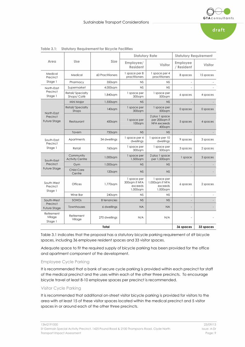
Table 3.1: Statutory Requirement for Bicycle Facilities
Area Use Size
Statutory Rate Statutory Requirement
Employee/
Resident Visitor
Employee
/ Resident Visitor
Medical
Precinct
Stage 1
Medical 60 Practitioners 1 space per 8
practitioners
1 space per 4
practitioners 8 spaces 15 spaces
Pharmacy 350sqm NS NS - -
North-East
Precinct
Stage 1
Supermarket 4,000sqm NS NS - -
Retail/ Specialty
Shops/ Café 1,840sqm
1 space per
300sqm
1 space per
500sqm 6 spaces 4 spaces
North-East
Precinct
Future Stage
Mini Major 1,550sqm NS NS - -
Retail/ Specialty
Shops 140sqm
1 space per
300sqm
1 space per
500sqm 0 spaces 0 spaces
Restaurant 450sqm 1 space per
100sqm
2 plus 1 space
per 200sqm if
NFA exceeds
400sqm
5 spaces 4 spaces
Tavern 750sqm NS NS - -
South-East
Precinct
Stage 1
Apartments 34 dwellings 1 space per 4
dwellings
1 space per 10
dwellings 9 spaces 3 spaces
Retail 760sqm 1 space per
300sqm
1 space per
500sqm 3 spaces 2 spaces
South-East
Precinct
Future Stage
Community
Activity Centre 1,000sqm
1 space per
1,500sqm
2 plus 1 space
per 1,500sqm 1 space 3 spaces
Gym 1,000sqm NS NS - -
Child Care
Centre 120sqm NS NS - -
South-West
Precinct
Stage 1
Offices 1,770sqm
1 space per
300sqm if NFA
exceeds
1,000sqm
1 space per
1,000sqm if NFA
exceeds
1,000sqm
6 spaces 2 spaces
Wine Bar 240sqm NS NS - -
South-West
Precinct
Future Stage
SOHOs 8 tenancies NS NS - -
Townhouses 6 dwellings NA NA - -
Retirement
Village
Stage 1
Retirement
Village 270 dwellings N/A N/A - -
Total 36 spaces 33 spaces
Table 3.1 indicates that the proposal has a statutory bicycle parking requirement of 69 bicycle
spaces, including 36 employee resident spaces and 33 visitor spaces.
Adequate space to fit the required supply of bicycle parking has been provided for the office
and apartment component of the development.
Employee Cycle Parking
It is recommended that a bank of secure cycle parking is provided within each precinct for staff
of the medical precinct and the uses within each of the other three precincts. To encourage
bicycle travel at least 8-10 employee spaces per precinct is recommended.
Visitor Cycle Parking
It is recommended that additional on-street visitor bicycle parking is provided for visitors to the
area with at least 15 of these visitor spaces located within the medical precinct and 5 visitor
spaces in or around each of the other three precincts.

Sustainable Transport Considerations
13M2191000 23/09/13
St Germain Special Activity Precinct, 1425 Pound Road & 2100 Thompsons Road, Clyde North Issue: A-Dr
Transport Impact Assessment Page: 10
draft
Associated Facilities
In addition to the requirement for bicycle parking, Clause 52.34-3 of the Casey Planning Scheme
requires 1 shower for the first 5 employee bicycle parking spaces and 1 shower for each
subsequent 10 employee bicycle parking spaces (if 5 or more employee bicycle parking spaces
are required).
Application of the above rates to the statutory employee bicycle parking requirement of 10
bicycle spaces per precinct indicates that the proposal has a statutory requirement of two
change rooms/showers per precinct. This provision could be centralised if this was deemed to be
a more effective use of space.
3.3.3 Adequacy of Bicycle Parking/Facilities Provision
On the basis of the discussions and analysis presented above, the development should include
on-site bicycle parking for at least 69 bicycle parking spaces and 4 change rooms/showers to
encourage cycling as a mode of travel to the site (as per the objective of Clause 52.34).
3.3.4 Bicycle Parking Layout & Access
The proposed bicycle parking layout has yet to be detailed. Space exists within the office and
apartment components of the development to provide the required number of bicycle spaces.

Car Parking Provision
13M2191000 23/09/13
St Germain Special Activity Precinct, 1425 Pound Road & 2100 Thompsons Road, Clyde North Issue: A-Dr
Transport Impact Assessment Page: 11
draft
4. Car Parking Provision
4.1 Statutory Car Parking Requirements
Statutory requirements for the provision of car parking are set out in Clause 52.06 of the Casey
Planning Scheme, with parking rates specified in Table 1 to Clause 52.06-5. An assessment of the
statutory parking requirements for the development proposal is set out in Table 4.1.
Table 4.1: Statutory Car Parking Requirements
Description Stage Use Size Statutory Parking Rate
Statutory
Parking
Requirement
Medical
Precinct Stage 1
Medical 7,850 m2
60 practitioners [1]
3 spaces per person
providing health services
[2]
182 spaces
Pharmacy (Shop) 350 m2 4 spaces per 100 m 2 of
leasable floor area 14 spaces
North
Precinct
Stage 1
Supermarket 4,000 m2 5 spaces per 100 m 2 of
leasable floor area 200 spaces
Retail / speciality
shops / café 1,840 m2
4 spaces per 100 m 2 of
leasable floor area 73 spaces
Future
Mini major 1,550 m2 4 spaces per 100 m 2 of
leasable floor area 62 spaces
Retail / speciality
shops 140 m2
4 spaces per 100 m 2 of
leasable floor area 5 spaces
Restaurant 450 m2
(150 patrons) [3] 0.4 spaces per patron 60 spaces
Tavern 750 m2
(200 patrons) [3] 0.4 spaces per patron 80 spaces
South East
Precinct
Stage 1
Retail / café 760 m2 4 spaces per 100 m 2 of
leasable floor area 30 spaces
Apartments 34 x 2 bedroom +
2 x Penthouses [4]
1 space per one or two
bedroom dwelling [4] 45 spaces
Future
Community
Activity Centre 1,000 m2 Not specified (NS) -
Gymnasium 1,000 m2 Not specified (NS) -
Child care 120 children 0.22 spaces per child 26 spaces
South West
Precinct
Stage 1
Office 1,770 m2 3.5 spaces per 100 m 2 of
net floor area) 61 spaces
Retail 240 m2 4 spaces per 100 m 2 of
leasable floor area 9 spaces
Future
SOHOs [5] 7 Not specified (NS) -
Townhouses 6 1 space per one or two
bedroom dwelling 7 spaces
Retirement
Village Stage 1 Retirement Village
226x 1-2 bedroom
34 x 3 bedroom
1 space per one or two
bedroom dwelling [4] 346 spaces
Stage 1 960 spaces
Future stages 240 spaces
Total 1,200 spaces
[1] Estimated number of practitioners [2] 5 spaces for the first practitioner [3] Assuming 1 patron per 3 m2
[4] Noting 2 spaces per three+ bedroom dwelling and 1 visitor space per five dwellings. [5] SOHO = Small Office
Home Office
Car Parking Provision
13M2191000 23/09/13
St Germain Special Activity Precinct, 1425 Pound Road & 2100 Thompsons Road, Clyde North Issue: A-Dr
Transport Impact Assessment Page: 12
draft
The above assessment anticipates that the Stage 1 development proposal has statutory
requirement of 960 spaces.
In this instance, the proposed on-site parking provision of 1,364 car spaces as part of the Stage 1
development exceeds the statutory parking requirement.
In addition to the above, it is noted that the statutory car parking requirement for the overall
development is 1,200 spaces, for those uses where a parking rate is nominated in the Scheme.
In this regard, the scheme does not specifically incorporate a recommended parking rate for the
community activity centre, gymnasium and SOHO land uses. In such circumstances, the scheme
notes:
“Where a use is not specified in Table 1 or … another provision of the planning scheme or in a
schedule to the Parking Overlay … car parking spaces must be provided to the satisfaction of the
responsible authority.”
It is recommended that the provision of car parking for the future stages of development are
considered when further detail is available surrounding the particular land uses to be provided.
Building Code of Australia (BCA) Requirement
In this instance, an empirical assessment is expected to accompany any subsequent planning
applications to set out the likely car parking demand across the site and as a consequence
provide commentary on the adequacy of the car parking provision.
In addition to the statutory car parking requirements in the Planning Scheme, the Building Code
of Australia (BCA) outlines requirements for the provision of car parking for people with disabilities.
An assessment of the BCA disabled car parking requirements for the development proposal is set
out in Table 4.2.
Table 4.2: BCA Car Parking Requirements for People with Disabilities
Description BCA Class BCA Disabled Parking Requirement
Apartments Class 2 None
Office Class 5 1 space for every 100 car parking spaces or part thereof
Retail Class 6 1 space for every 100 car parking spaces or part thereof
Clinic or day surgery Class 9A 1 space for every 100 car parking spaces or part thereof
Table 4.2 shows that the required rate for disabled spaces does not exceed 1 space per 100 for
office, retail or Clinic/Day Surgery land uses. Therefore, using a conservative approach and
adopting this rate to all allocated spaces within the development generates a requirement for 12
disabled parking spaces.
As stated in Section 1.1 of this report, it is proposed to provide a total of 23 disabled car parking
spaces across the four precincts, exceeding the BCA requirement.
4.2 Adequacy of Parking Provision
Table 4.3 has been prepared to summarise the statutory car parking requirement and provision
by precinct.
Car Parking Provision
13M2191000 23/09/13
St Germain Special Activity Precinct, 1425 Pound Road & 2100 Thompsons Road, Clyde North Issue: A-Dr
Transport Impact Assessment Page: 13
draft
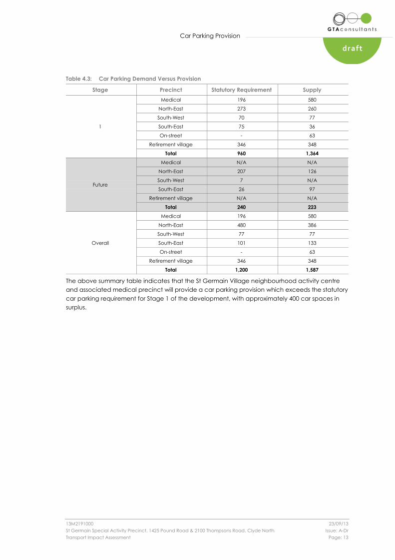
Table 4.3: Car Parking Demand Versus Provision
Stage Precinct Statutory Requirement Supply
1
Medical 196 580
North-East 273 260
South-West 70 77
South-East 75 36
On-street - 63
Retirement village 346 348
Total 960 1,364
Future
Medical N/A N/A
North-East 207 126
South-West 7 N/A
South-East 26 97
Retirement village N/A N/A
Total 240 223
Overall
Medical 196 580
North-East 480 386
South-West 77 77
South-East 101 133
On-street - 63
Retirement village 346 348
Total 1,200 1,587
The above summary table indicates that the St Germain Village neighbourhood activity centre
and associated medical precinct will provide a car parking provision which exceeds the statutory
car parking requirement for Stage 1 of the development, with approximately 400 car spaces in
surplus.
Car Parking Layout
13M2191000 23/09/13
St Germain Special Activity Precinct, 1425 Pound Road & 2100 Thompsons Road, Clyde North Issue: A-Dr
Transport Impact Assessment Page: 14
draft
5. Car Parking Layout
The proposed parking layout has been assessed in respect to the relevant Design Standards set
out in Clause 52.06 of the Planning Scheme. A summary of compliance is set out below, with a
full assessment provided in Appendix C.
Design Standard 1: Accessways
Complies
Design Standard 2: Car Parking Spaces
Complies
Design Standard 3: Gradients
The gradient of the ramp to the basement car parking area within the medical precinct
will be required to be designed in accordance with the Casey Planning Scheme and/or
the Australian Standard (AS2890).
Design Standard 4: Mechanical Parking
Not applicable.
Design Standard 5: Urban Design
Urban design is outside the scope of this report.
Design Standard 6: Safety
Lighting and signage is not shown but should be incorporated at the detailed design
stage.
Design Standard 7: Landscaping
Landscaping is outside the scope of this report.
Loading & Waste Collection
13M2191000 23/09/13
St Germain Special Activity Precinct, 1425 Pound Road & 2100 Thompsons Road, Clyde North Issue: A-Dr
Transport Impact Assessment Page: 15
draft
6. Loading & Waste Collection
6.1 Statutory Requirements
Clause 52.07 of the Casey Planning Scheme is applicable where buildings or works are
constructed for the manufacture, servicing, storage or sale of goods or materials.
The Clause anticipates the development proposal has a statutory requirement for loading as
follows:
North-east precinct:
Stage 1: Supermarket (5,000sqm) – 63.4sqm
Stage 2: mini-major (1,550sqm) – 27.4sqm.
Loading zones are provided across the site as follows:
Medical precinct – loading zone for 2 x 8.8m waste vehicles and 1 x 12.5m truck.
North-east precinct
Stage 1: supermarket (5,000sqm) – Loading zone for 1 x 19.0m articulated truck, 1 x
12.5m truck and 3 x 8.8 delivery / waste vehicles
Stage 2: mini major (1,550sqm) – Loading zone for 19.0m articulated truck.
In this instance, the statutory loading requirements are met by the proposed loading facilities.
6.2 Layout
The proposed loading areas have been designed to exceed Planning Scheme requirements and
are accessible by vehicles including 19.0m semi-trailer (depending on the loading zone) as
confirmed using AutoTURN (a computer package designed to simulate vehicle swept paths in a
CAD environment). The results of this swept path assessment are shown in Appendix E.
6.3 Refuse Collection
The development incorporates seven dedicated areas for bin storage as presented within the
waste management plan included within the Clarke Hopkins Clarke drawing pack.

Traffic Impact
13M2191000 23/09/13
St Germain Special Activity Precinct, 1425 Pound Road & 2100 Thompsons Road, Clyde North Issue: A-Dr
Transport Impact Assessment Page: 16
draft
7. Traffic Impact
7.1 Performance Objectives
Under the Vic Roads TIAR Guidelines, the proposed development is considered to be a ‘Major
Development’. Therefore, the transport performance objectives of the proposed development
should ensure that:
For new access arrangements direct to a site – provision is made for all access
arrangements to operate safely and efficiently into the future (at least 10 years after full
development).
For existing road infrastructure – any potential adverse effects from land use
development proposals on road safety and operational efficiency are identified and,
where necessary, developers provide mitigating road improvement works as part of the
development costs to minimise these effects and retain, within practical limitations, the
level of safety and operational efficiency that would have existed without the
development.
7.2 Development Overview
7.2.1 Proposed Development (Stage 1)
As discussed in Section 1 of this report, Stage 1 of the development proposes to construct the
land uses set out in Table 7.1, with remaining land to be developed as part of future stages of the
development. For the purposes of this analysis Stage 1 is considered as the “full development” as
outlined above in Section 7.1.
Table 7.1: Stage 1 Land Uses
Precincts Land Uses Size
Medical Precinct (Lot A) Medical 7,850 m2
Pharmacy 350 m2
North-East Precinct (Lot B) Supermarket 4,000 m2
Retail / speciality shops / café 1,840 m2
South East Precinct (Lot C)
Retail / café 760 m2
Apartments 34 x 2 bedroom +
2 x Penthouses
South West Precinct (Lot D) Office 1,770 m2
Retail 240 m2
Retirement Village (Lot E) Retirement Village
210 x 1-2 bedroom
34 x 3 bedroom
16 x 1-2 bedroom apartments
On this basis, the following analysis has been prepared to consider the likely impact of the
‘Stage 1’ development under the ‘interim’ 10 year future period with subsequent stages of the
development to be assessed, as and when required.
As outlined in Section 1.1.1, a section of Thompsons Road will be constructed to provide a link
from Stage 1 of the development to the Berwick-Cranbourne Road and Thompsons Road
intersection. It is noted that the detailed road layout is yet to be confirmed, but the subsequent
analysis has been prepared to inform the general level of required infrastructure. Figure 7.1 shows
the proposed interim road network connecting the subject site to the surrounding road network.

Traffic Impact
13M2191000 23/09/13
St Germain Special Activity Precinct, 1425 Pound Road & 2100 Thompsons Road, Clyde North Issue: A-Dr
Transport Impact Assessment Page: 17
draft
Figure 7.1: Interim Road Network Arrangements
7.2.2 Overall Development (Future Stages)
The subject site is ultimately proposed to incorporate additional land uses in keeping with those
already proposed as part of the special activity centre. The quantum and location of these uses
have yet to be defined and are therefore not considered as part of this report.
7.3 Traffic Generation
As detailed in Appendix F, Stage 1 of the development is expected to generate in the order of
500 and 1,050 vehicles per hour during the AM and PM peak hour respectively, and up to 12,000
vehicles per day.
7.4 Traffic Distribution and Assignment
The directional distribution and assignment of traffic generated by Stage 1 of the proposed
development will be influenced by a number of factors, including the following:
i configuration of the arterial road network in the immediate vicinity of the site
ii configuration of the proposed new roads (Thompsons Road extension)
iii existing operation of intersections providing access between the local and arterial road
network
iv configuration of the access points to the site.

Traffic Impact
13M2191000 23/09/13
St Germain Special Activity Precinct, 1425 Pound Road & 2100 Thompsons Road, Clyde North Issue: A-Dr
Transport Impact Assessment Page: 18
draft
For the purposes of this assessment, as outlined in Section 7.2.1, that in the interim period the
proposed development will be accessed via Thompsons Road only. The following directional
distributions of the site generated traffic have therefore been adopted at the intersection of
Berwick-Cranbourne Road and Thompsons Road:
Thompsons Road west 20%
Berwick-Cranbourne Road north 50%
Berwick-Cranbourne Road south 30%.
In addition, the directional split of traffic (i.e. the ratio between the inbound and outbound traffic
movements) are further distributed in accordance with the estimated in/out splits anticipated for
each land use. This detail is shown in Appendix F.
Based on the above, Figure 7.2 and Figure 7.3 have been prepared to show the estimated
increase in turning movements in the vicinity of the site following the completion of Stage 1 at the
intersection of Berwick-Cranbourne Road and Thompsons Road.
Figure 7.2: AM Peak Hour Site Generated Traffic
Volumes
Figure 7.3: PM Peak Hour Site Generated Traffic
Volumes
7.5 Traffic Impact
7.5.1 Overview
In accordance with Vic Roads TIAR Guidelines for existing road infrastructure, the following
section assesses the operation of the Berwick-Cranbourne Road / Thompsons Road intersection to
determine whether any mitigating road improvement works will be required to retain, within
practical limitations, the level of safety and operational efficiency that would have existed
without the proposed development.
50%
Be
rwic
k-C
ran
bo
urn
e R
oa
d
20%
=
41 "
? 102
Thompsons Road 8 < 8 $ 9
: # ; ? ;
61 < 117
! 47
> 70
30%
Be
rwic
k-C
ran
bo
urn
e R
oa
d
50%
Be
rwic
k-C
ran
bo
urn
e R
oa
d
20%
=
119 "
? 298
Thompsons Road 8 < 8 $ 9
: # ; ? ;
179 < 300
! 120
> 180
30%
Be
rwic
k-C
ran
bo
urn
e R
oa
d

Traffic Impact
13M2191000 23/09/13
St Germain Special Activity Precinct, 1425 Pound Road & 2100 Thompsons Road, Clyde North Issue: A-Dr
Transport Impact Assessment Page: 19
draft
For new site access points, in this case those connecting the subject site with Thompsons Road,
an assessment has been completed under ‘post development’ conditions (existing conditions
with traffic growth and Stage 1 development).
Notwithstanding the above, and having regard to the lack of available traffic growth data and
road configurations of the future arterial road network in the vicinity of the site, typical growth
rates have been adopted in this instance. For the purposes of this assessment a 3% per annum
linear growth rate has been applied to Thompsons Road. It is noted that whilst in other growth
corridors strategic modelling exists (which provides guidance on future levels of traffic growth), in
this instance a model which has been approved by the Department of Planning, Transport and
Local Industry (DPTLI) is not available for use.
7.5.2 Existing Conditions
GTA Consultants undertook traffic movement counts at the intersection of Berwick-Cranbourne
Road / Thompsons Road during the following peak periods:
Friday 13 September 2013 AM Peak 8:00am - 9:00am
Thursday 12 September 2013 PM Peak 5:00pm - 6:00pm.
The AM and PM peak hour traffic volumes are shown in Figure 7.4 and Figure 7.5, respectively.
Figure 7.4: Existing AM Peak Hour Traffic
Volumes
Figure 7.5: Existing PM Peak Hour Traffic
Volumes
The operation of the intersection of Berwick-Cranbourne Road/Thompsons Road has been
assessed using SIDRA INTERSECTION1, a computer based modelling package which calculates
intersection performance.
The commonly used measure of intersection performance is referred to as the Degree of
Saturation (DOS). The DOS represents the flow-to-capacity ratio for the most critical movement
on each leg of the intersection. For unsignalised intersections, a DOS of around 0.90 has been
1 Program used under license from Akcelik & Associates Pty Ltd.
Ber
wic
k-C
ran
bo
urn
e R
oad
374 =
20 "
112 ? 465 606 4
8 < 8 $ 9
: # ; ? ; Thompsons Road
86 718 16 < 0
! 12
> 15
Ber
wic
k-C
ran
bo
urn
e R
oad
Ber
wic
k-C
ran
bo
urn
e R
oad
378 =
14 "
106 ? 400 874 14
8 < 8 $ 9
: # ; ? ; Thompsons Road
162 758 10 < 12
! 14
> 24
Ber
wic
k-C
ran
bo
urn
e R
oad

Traffic Impact
13M2191000 23/09/13
St Germain Special Activity Precinct, 1425 Pound Road & 2100 Thompsons Road, Clyde North Issue: A-Dr
Transport Impact Assessment Page: 20
draft
typically considered the ‘ideal’ limit, beyond which queues and delays increase
disproportionately2.
Figure 7.6 and Table 7.2 presents a summary of the existing configuration and operation of the
intersection, with full results presented in Appendix G of this report.
Figure 7.6: Berwick-Cranbourne Road / Thompsons Road – Existing Unsignalised Intersection
Configuration
2 SIDRA INTERSECTION adopts the following criteria for Level of Service assessment:
Intersection Degree of Saturation (X)
Unsignalised Intersection Signalised Intersection
A Excellent <=0.50 <=0.60
B Very Good 0.50-0.70 0.60-0.75
C Good 0.70-0.80 0.75-0.90
D Acceptable 0.80-0.90 0.90-0.95
E Poor 0.90-1.00 0.95-1.00
F Very Poor >=1.0 >=1.0

Traffic Impact
13M2191000 23/09/13
St Germain Special Activity Precinct, 1425 Pound Road & 2100 Thompsons Road, Clyde North Issue: A-Dr
Transport Impact Assessment Page: 21
draft
Table 7.2: Berwick-Cranbourne Road / Thompsons Road – Existing Unsignalised Intersection Operation
Approach DOS Average Delay (sec)
95th Percentile Queue
(m)
AM PM AM PM AM PM
Berwick-Cranbourne Road (S) 0.36# 0.39 7s 6s 20m 22m
Thompsons Road (E) 0.04 0.08 8s 10s 1m 3m
Berwick-Cranbourne Road (N) 0.37 0.44# 8s 7s 20m 26m
Thompsons Road (W) 0.28 0.28 9s 9s 10m 10m
DOS – Degree of Saturation, # - Intersection DOS
Table 7.2 indicates that the intersection of Berwick-Cranbourne Road / Thompsons Road currently
operates well with minimal queues and delays on all approaches. The modelling outputs
presented above have been confirmed by on-site observations.
7.5.3 Post Development ‘Interim’ Conditions
Post Development Traffic Volumes
By adding the development traffic to the existing volumes we can assess the impact of the
development generated traffic on the operation of the road network. It is noted that typical
growth rates have been applied to Thompsons Road (i.e. 3% per annum linear for 10 years – year
2023) and in order to provide a conservative assessment3, it has been assumed an additional 50
vehicles per hour will travel east-west through the intersection of Berwick-Cranbourne Road and
Thompsons Road. The post development volumes are outlined in Figure 7.7 and Figure 7.8.
Figure 7.7: Post-Development AM Peak Hour Traffic Volumes
3 An attempt has been made to take into account the likely increases in background traffic along Thompsons Road in the
short term given that Thompsons Road is likely to only service this development in the first instance.
Ber
wic
k-C
ranb
our
ne R
oad
374 =
61 "
112 ? 465 606 106 117 " 65 "
8 < 8 $ 9 Thompsons Road 152 ? 52 ?
: # ; ? ; : ; ! 138 : ! 65
86 718 77 < 117 160 0 > 0 73 > 0
! 59
> 85
Ber
wic
k-C
ranb
our
ne R
oad
Bel
ls R
oad
Sit
e A
cces
s R
oad
SUBJECT SITE
SUBJECT SITE
SUBJECT SITE
SUBJECT SITE
Traffic Impact
13M2191000 23/09/13
St Germain Special Activity Precinct, 1425 Pound Road & 2100 Thompsons Road, Clyde North Issue: A-Dr
Transport Impact Assessment Page: 22
draft
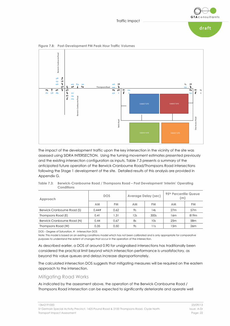
Figure 7.8: Post-Development PM Peak Hour Traffic Volumes
The impact of the development traffic upon the key intersection in the vicinity of the site was
assessed using SIDRA INTERSECTION. Using the turning movement estimates presented previously
and the existing intersection configuration as inputs, Table 7.3 presents a summary of the
anticipated future operation of the Berwick-Cranbourne Road/Thompsons Road intersections
following the Stage 1 development of the site. Detailed results of this analysis are provided in
Appendix G.
Table 7.3: Berwick-Cranbourne Road / Thompsons Road – Post Development ‘Interim’ Operating
Conditions
Approach DOS Average Delay (sec)
95th Percentile Queue
(m)
AM PM AM PM AM PM
Berwick-Cranbourne Road (S) 0.44# 0.62 9s 14s 27m 57m
Thompsons Road (E) 0.41 1.31 12s 300s 16m 819m
Berwick-Cranbourne Road (N) 0.44 0.67 8s 10s 25m 58m
Thompsons Road (W) 0.35 0.50 9s 11s 15m 26m
DOS – Degree of Saturation, # - Intersection DOS
Note: This model is based on an existing conditions model which has not been calibrated and is only appropriate for comparative
purposes to understand the extent of changes that occur in the operation of the intersection.
As described earlier, a DOS of around 0.90 for unsignalised intersections has traditionally been
considered the practical limit beyond which intersection performance is unsatisfactory, as
beyond this value queues and delays increase disproportionately.
The calculated intersection DOS suggests that mitigating measures will be required on the eastern
approach to the intersection.
Mitigating Road Works
As indicated by the assessment above, the operation of the Berwick-Cranbourne Road /
Thompsons Road intersection can be expected to significantly deteriorate and operate well
Ber
wic
k-C
ranb
our
ne R
oad
378 =
133 "
106 ? 400 874 312 216 " 65 "
8 < 8 $ 9 Thompsons Road 444 ? 151 ?
: # ; ? ; : ; ! 214 : ! 65
162 758 189 < 312 450 0 > 0 149 > 0
! 134
> 204
Ber
wic
k-C
ranb
our
ne R
oad
Bel
ls R
oad
Sit
e A
cces
s R
oad
SUBJECT SITE
SUBJECT SITE
SUBJECT SITE
SUBJECT SITE

Traffic Impact
13M2191000 23/09/13
St Germain Special Activity Precinct, 1425 Pound Road & 2100 Thompsons Road, Clyde North Issue: A-Dr
Transport Impact Assessment Page: 23
draft
above its theoretical limit during the PM peak hour. In particular, it is noted that traffic on the
eastern approach (Thompsons Road) is likely to experience significant delays and queues.
In this instance, it is considered that mitigating road works at the intersection will be required to
facilitate traffic movements on the east approach:
Provision of a short right turn lane in the order of 60m.
Provision of additional circulating lanes within the existing roundabout lane via
linemarking.
Figure 7.9 and Table 7.4 presents a summary of the modified roundabout configuration and its
intersection operation, with full results presented in Appendix G.
Figure 7.9: Berwick-Cranbourne Road / Thompsons Road – Modified Unsignalised Intersection
Configuration
Table 7.4: Berwick-Cranbourne Road / Thompsons Road – Modified Unsignalised Intersection
Operation
Approach DOS Average Delay (sec)
95th Percentile Queue
(m)
AM PM AM PM AM PM
Berwick-Cranbourne Road (S) 0.48# 0.70# 8s 14s 26m 55m
Thompsons Road (E) 0.19 0.66 11s 15s 6m 34m
Berwick-Cranbourne Road (N) 0.44 0.67 8s 10s 25m 58m
Thompsons Road (W) 0.34 0.52 9s 12s 14m 28m
DOS – Degree of Saturation, # - Intersection DOS

Traffic Impact
13M2191000 23/09/13
St Germain Special Activity Precinct, 1425 Pound Road & 2100 Thompsons Road, Clyde North Issue: A-Dr
Transport Impact Assessment Page: 24
draft
Table 7.4 indicates that the intersection of Berwick-Cranbourne Road / Thompsons Road can be
expected to operate in a satisfactory manner with manageable increases in both queues and
delays on all approaches. The proposed mitigating road works are therefore considered to be
appropriate and can be expected to materially improve the operation of the intersection upon
the completion of the Stage 1 development.
In addition to the above and whilst it is noted that additional mitigating works may be possible, it
is recommended that the need, nexus and equity of these additional road works, and their
benefit and feasibility, be examined at future stages of the development when further
information regarding the surrounding road network can be ascertained.
7.5.4 Nearby Intersections
Bells Road/Thompsons Road
The impact of the development has been assessed having regard to the traffic performance of
the road network with the proposed Stage 1development and adopting 3% per annum linear for
10 years scenario on Thompsons Road. As stated earlier, the aforementioned growth rate has
been applied in addition to the assumption that 50 vehicles per hour travel east-west along
Thompsons Road.
In this regard, the post development ‘Interim’ traffic volumes are presented below in Figure 7.10
and Figure 7.11 for both the AM and PM peak hours.
Figure 7.10: Year 2013 AM Peak Traffic Volumes with Site Traffic – New Access Points
117 " 65 "
Thompsons Road 152 ? 52 ?
: ; ! 138 : ! 65
160 0 > 0 73 > 0
Bel
ls R
oad
Sit
e A
cces
s R
oad
SUBJECT SITE
SUBJECT SITE
SUBJECT SITE
SUBJECT SITE

Traffic Impact
13M2191000 23/09/13
St Germain Special Activity Precinct, 1425 Pound Road & 2100 Thompsons Road, Clyde North Issue: A-Dr
Transport Impact Assessment Page: 25
draft
Figure 7.11: Year 2013 PM Peak Traffic Volumes with Site Traffic – New Access Points
Based on the above information, the proposed intersection configuration and a summary of its
intersection operation are presented in Figure 7.12 and Table 7.5, with full results presented in
Appendix G.
Figure 7.12: Bells Road / Thompsons Road – Proposed Unsignalised Intersection Configuration
216 " 65 "
Thompsons Road 444 ? 151 ?
: ; ! 214 : ! 65
450 0 > 0 149 > 0B
ells
Ro
ad
Sit
e A
cces
s R
oad
SUBJECT SITE
SUBJECT SITE
SUBJECT SITE
SUBJECT SITE

Traffic Impact
13M2191000 23/09/13
St Germain Special Activity Precinct, 1425 Pound Road & 2100 Thompsons Road, Clyde North Issue: A-Dr
Transport Impact Assessment Page: 26
draft
Table 7.5: Bells Road / Thompsons Road – Post Development ‘Interim’ Operating Conditions in 2023
Approach DOS Average Delay (sec)
95th Percentile Queue
(m)
AM PM AM PM AM PM
Bells Road (S) 0.17# 0.50# 9s 11s 5m 26m
Thompsons Road (E) 0.08 0.12 0s 0s 0m 0m
Thompsons Road (W) 0.16 0.46 5s 7s 4m 18m
DOS – Degree of Saturation, # - Intersection DOS
As indicated in Table 7.5, it is evident that the proposed unsignalised intersection at its ‘interim’
configuration can be expected to operate at ‘very good’ level of service with minimal queues
and delays on all approaches.
Site Access Road/Thompsons Road
Based on the traffic volumes presented in Figure 7.10 and Figure 7.11, the proposed Site Access
Road and Thompsons Road intersection configuration and a summary of its intersection
performance are presented in Figure 7.13and Table 7.6, with full results presented in Appendix G.
Figure 7.13: Site Access Road / Thompsons Road – Proposed Unsignalised Intersection Configuration
Table 7.6: Site Access Road / Thompsons Road – Post Development ‘Interim’ Operating Conditions in
2023
Approach DOS Average Delay (sec)
95th Percentile Queue
(m)
AM PM AM PM AM PM
Site Access Road (S) 0.07# 0.14 9s 9s 2m 4m
Thompsons Road (E) 0.04 0.04 0s 0s 0m 0m
Thompsons Road (W) 0.05 0.15# 4s 6s 1m 4m
DOS – Degree of Saturation, # - Intersection DOS

Traffic Impact
13M2191000 23/09/13
St Germain Special Activity Precinct, 1425 Pound Road & 2100 Thompsons Road, Clyde North Issue: A-Dr
Transport Impact Assessment Page: 27
draft
As indicated in Table 7.5, it is evident that the proposed unsignalised intersection at its ‘interim’
configuration can be expected to operate at ‘excellent’ level of service with minimal queues
and delays on all approaches. In addition, the analysis indicates that the intersection has
sufficient capacity to accommodate additional traffic in the future.

Conclusion
13M2191000 23/09/13
St Germain Special Activity Precinct, 1425 Pound Road & 2100 Thompsons Road, Clyde North Issue: A-Dr
Transport Impact Assessment Page: 28
draft
8. Conclusion
Based on the analysis and discussions presented within this report, the following conclusions are
made:
i The proposed development (Stage 1) generates a statutory parking requirement of
1,200 spaces, for those uses with nominated rates.
ii A supply of 1,364 spaces has been provided as part of Stage 1 of the development.
iii The proposed parking layout is consistent with the dimensional requirements as set out
in the Casey Planning Scheme and/or Australian/New Zealand Standards for Off Street
Car Parking (AS/NZS2890.1:2004 and AS/NZS2890.6:2009).
iv Clause 52.34 of the Casey Planning Scheme requires the provision of bicycle facilities
and some 69 bicycle parking spaces for both staff and visitors to St Germain Village.
Ample space exists across the site to provide this level of cycle parking and associated
facilities.
v The provision of loading areas across the site is deemed to be adequate and the
appropriate design vehicles can access the loading areas as required.
vi The site is expected to generate up to 1,050 and 12,000 vehicle movements in any peak
hour and daily respectively.
vii The following mitigating works are proposed on the road network to ameliorate offsite
traffic impacts:
Intersection of Berwick-Cranbourne Road and Thompsons Road
Provision of a short right turn lane in the order of 60m.
Provision of additional circulating lanes within the existing roundabout lane via
linemarking.
Other
Appropriate basic unsignalised intersection treatments (including a 30m right turn
lane on the west approach) at the following locations:
Thompsons Road / Future Bells Road
Thompsons Road / new north south road.
viii Provision is made for all access arrangements to operate safely and efficiently at least
10yrs after full development.
Appendix A
13M2191000 23/09/13
St Germain Special Activity Precinct, 1425 Pound Road & 2100 Thompsons Road, Clyde North Issue: A-Dr
Transport Impact Assessment
draftdraft
Ap
pe
nd
ix A
Ap
pe
nd
ix A
Appendix A
Proposed Development – Sub-Precincts

115 Sackville StreetCollingwood VIC Australia 3066Telephone (03) 9419 4340Facsimile (03) 9419 4345Email [email protected]
August 2013
1353_TP020
ClarkeHopkinsClarke
© ClarkeHopkinsClarke 2009A3
0N S3St Germain Village, Special Activity Centre - Thompsons Rd, Clyde NorthPrecinct Site Plan
300
Scale 1:6000 @ A3

MEDICAL PRECINCTNORTH-EAST PRECINCT
SOUTH-WEST PRECINCT
SOUTH-EAST PRECINCT
To Retirement Village

Thompsons Rd
To activity centre

Appendix B
13M2191000 23/09/13
St Germain Special Activity Precinct, 1425 Pound Road & 2100 Thompsons Road, Clyde North Issue: A-Dr
Transport Impact Assessment
draftdraft
Ap
pe
nd
ix A
Ap
pe
nd
ix B
Ap
pe
nd
ix B
Appendix B
Existing Conditions
Appendix B
13M2191000 23/09/13
St Germain Special Activity Precinct, 1425 Pound Road & 2100 Thompsons Road, Clyde North Issue: A-Dr
Transport Impact Assessment
draftdraft
B.1 Road Network
B.1.1 Adjoining Roads
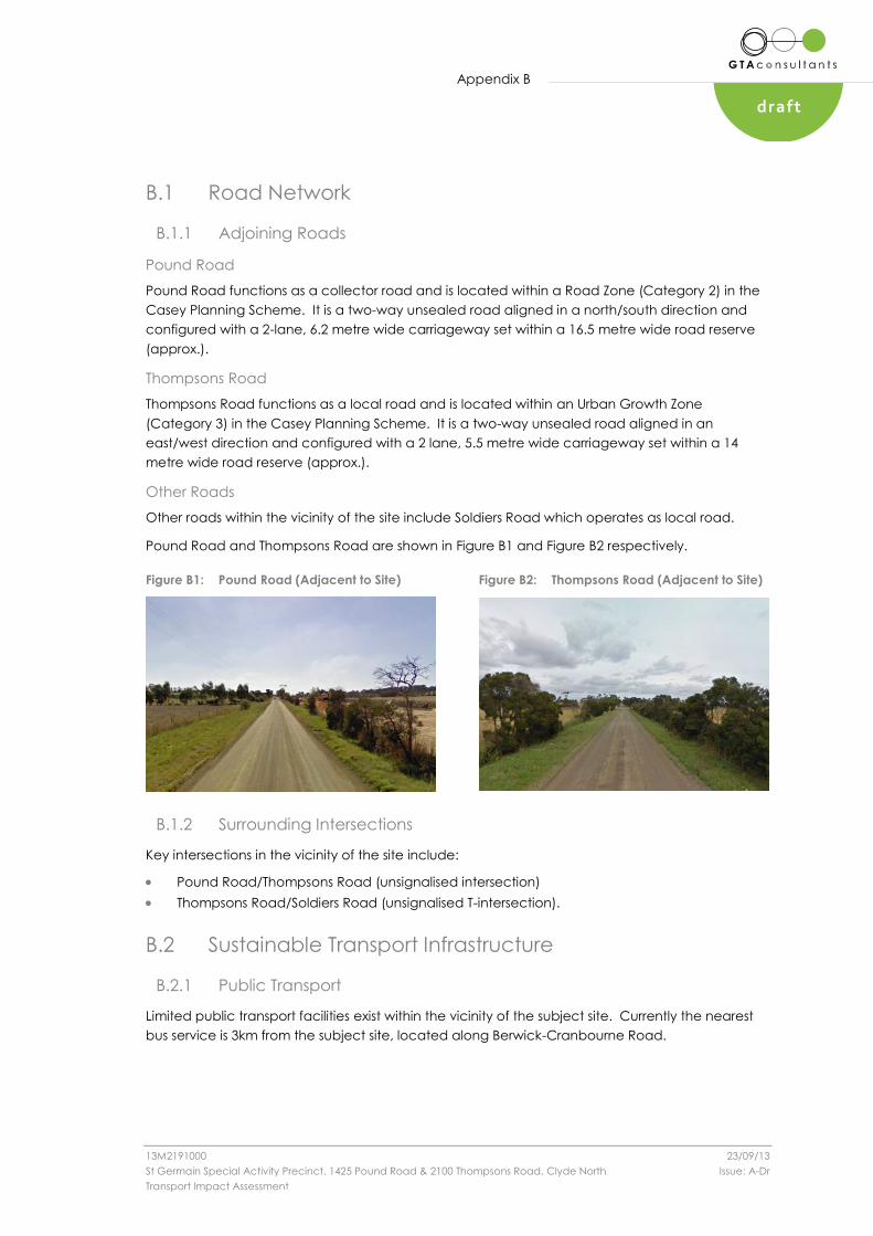
Pound Road
Pound Road functions as a collector road and is located within a Road Zone (Category 2) in the
Casey Planning Scheme. It is a two-way unsealed road aligned in a north/south direction and
configured with a 2-lane, 6.2 metre wide carriageway set within a 16.5 metre wide road reserve
(approx.).
Thompsons Road
Thompsons Road functions as a local road and is located within an Urban Growth Zone
(Category 3) in the Casey Planning Scheme. It is a two-way unsealed road aligned in an
east/west direction and configured with a 2 lane, 5.5 metre wide carriageway set within a 14
metre wide road reserve (approx.).
Other Roads
Other roads within the vicinity of the site include Soldiers Road which operates as local road.
Pound Road and Thompsons Road are shown in Figure B1 and Figure B2 respectively.
Figure B1: Pound Road (Adjacent to Site) Figure B2: Thompsons Road (Adjacent to Site)
B.1.2 Surrounding Intersections
Key intersections in the vicinity of the site include:
Pound Road/Thompsons Road (unsignalised intersection)
Thompsons Road/Soldiers Road (unsignalised T-intersection).
B.2 Sustainable Transport Infrastructure
B.2.1 Public Transport
Limited public transport facilities exist within the vicinity of the subject site. Currently the nearest
bus service is 3km from the subject site, located along Berwick-Cranbourne Road.

Appendix B
13M2191000 23/09/13
St Germain Special Activity Precinct, 1425 Pound Road & 2100 Thompsons Road, Clyde North Issue: A-Dr
Transport Impact Assessment
draftdraft
B.2.2 Pedestrian Infrastructure
Formalised pedestrian facilities (footpaths) are not provided along Pound Road and Thompsons
Road. It is feasible for pedestrians to walk along the wide road reserve areas adjacent to these
roads.
B.2.3 Cycle Infrastructure
The Principal Bicycle Network (PBN) is a network of arterial cycling routes in metropolitan
Melbourne:
The PBN currently consists of approximately 3500 kilometres of existing and proposed
on-road and off-road bicycle routes. So far, approximately 1200 kilometres of the
network has been completed.
Vic Roads has primary responsibility for managing the development of the PBN.
Bicycle facilities on the PBN are implemented by Vic Roads and local councils
depending on whether they are on an arterial or local road.
The following map shows the existing and proposed on and off road bicycle facilities making up
the PBN in the vicinity of the subject site.
Figure B.1: Vic Roads Principal Bicycle Network
(Reproduced from Vic Roads Website)
Figure B.1 shows that limited bike path facilities exist within the vicinity of the subject site.

Appendix C
13M2191000 23/09/13
St Germain Special Activity Precinct, 1425 Pound Road & 2100 Thompsons Road, Clyde North Issue: A-Dr
Transport Impact Assessment
draftdraft
Ap
pe
nd
ix C
Appendix C
Planning Policy Background
Appendix C
13M2191000 23/09/13
St Germain Special Activity Precinct, 1425 Pound Road & 2100 Thompsons Road, Clyde North Issue: A-Dr
Transport Impact Assessment
draftdraft
C.1 Melbourne 2030
Melbourne 2030 was a strategic plan prepared in 2002 to manage growth and change across
metropolitan Melbourne and its surrounding region. It established a framework to cater for the
anticipated population growth with the identification of required land uses and development in
a more sustainable manner.
One of the key focuses of Melbourne 2030 was to promote an increase in housing within the
established urban area, particularly around activity centres and other strategic sites suitable for
intense development.
Melbourne 2030 sought to encourage higher density development on sites in and around activity
centres and proximate to public transport. Such an outcome would under the framework of
Melbourne 2030:
“Provide for the forecast increase in population and households
Ensure the available housing stock better matches changing demand by widening
housing choice, particularly in middle and outer suburbs
Support opportunities for a wide range of income groups to choose housing in well
serviced locations
Increase the local population base that supports activity centres and local businesses
Encourage walking, cycling and public transport as viable transport alternatives.”
C.2 Melbourne @ 5 Million
Developed and released in conjunction with the Victorian Transport Plan, Melbourne @ 5 Million
provided a framework for the future vision of Melbourne. Following on from the objectives of
Melbourne 2030, Melbourne @ 5 Million continued the key themes of “a more compact city”,
“better management of growth”, “networks within regional cities” and “a more greener city”.
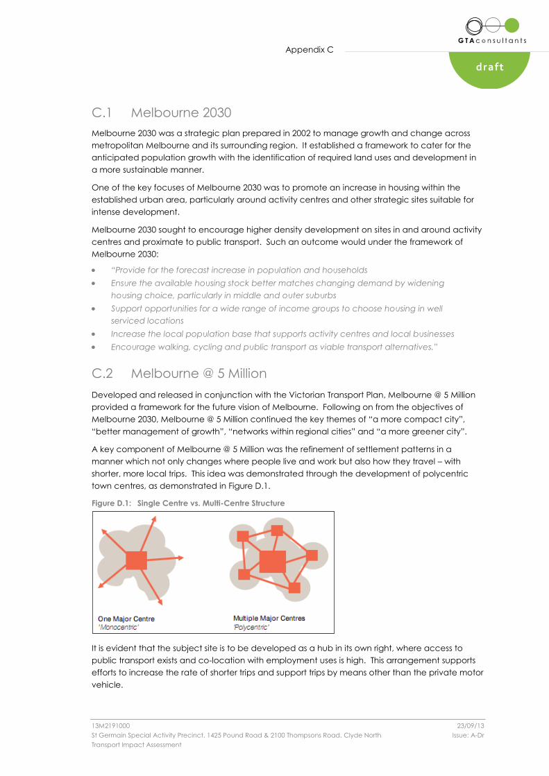
A key component of Melbourne @ 5 Million was the refinement of settlement patterns in a
manner which not only changes where people live and work but also how they travel – with
shorter, more local trips. This idea was demonstrated through the development of polycentric
town centres, as demonstrated in Figure D.1.
Figure D.1: Single Centre vs. Multi-Centre Structure
It is evident that the subject site is to be developed as a hub in its own right, where access to
public transport exists and co-location with employment uses is high. This arrangement supports
efforts to increase the rate of shorter trips and support trips by means other than the private motor
vehicle.

Appendix D
13M2191000 23/09/13
St Germain Special Activity Precinct, 1425 Pound Road & 2100 Thompsons Road, Clyde North Issue: A-Dr
Transport Impact Assessment
draftdraft
Ap
pe
nd
ix D
Appendix D
Car Park Design Standards Assessment

Appendix D
13M2191000 23/09/13
St Germain Special Activity Precinct, 1425 Pound Road & 2100 Thompsons Road, Clyde North Issue: A-Dr
Transport Impact Assessment
draftdraft
Design Standard 1 – Accessways
Standard Compliant
Accessways must:
Be at least 3 metres wide.
Have an internal radius of at least 4 metres at changes of direction
or intersection or be at least 4.2 metres wide.
Allow vehicles parked in the last space of a dead-end accessway
in public car parks to exit in a forward direction with one
manoeuvre.
Provide at least 2.1 metres headroom beneath overhead
obstructions, calculated for a vehicle with a wheel base of 2.8
metres.
If the accessway serves four or more car spaces or connects to a
road in a Road Zone, the accessway must be designed so that
cars can exit the site in a forward direction.
Provide a passing area at the entrance at least 5 metres wide and
7 metres long if the accessway serves ten or more car parking
spaces and is either more than 50 metres long or connects to a
road in a Road Zone.
Have a corner splay or area at least 50 per cent clear of visual
obstructions extending at least 2 metres along the frontage road
from the edge of an exit lane and 2.5 metres along the exit lane
from the frontage, to provide a clear view of pedestrians on the
footpath of the frontage road. The area clear of visual obstructions
may include an adjacent entry or exit lane where more than one
lane is provided, or adjacent landscaped areas, provided the
landscaping in those areas is less than 900mm in height.
If an accessway to four or more car parking spaces is from land in a
Road Zone, the access to the car spaces must be at least 6 metres
from the road carriageway.
If entry to the car space is from a road, the width of the accessway
may include the road.
Design Standard 2 – Car Parking Spaces
Standard Compliant
Car parking spaces and accessways must have the minimum
dimensions in Table 2 of the Clause.
A wall, fence, column, tree, tree guard or any other structure that
abuts a car space must not encroach into the area marked
‘clearance required’ on Diagram 1 other than:
A column, tree or tree guard, which may project into a space if it
is within the area marked ‘tree or column permitted’ on Diagram 1
of the design standard.
A structure, which may project into the space if it is at least 2.1
metres above the space.
Car spaces in garages or carports must be at least 6 metres long and
3.5 metres wide for a single space and 5.5 metres wide for a double
space measured inside the garage or carport.
Where parking spaces are provided in tandem (one space behind
the other) an additional 500 mm in length must be provided between
each space.
Where two or more car parking spaces are provided for a dwelling,
at least one space must be under cover.
Disabled car parking spaces must be designed in accordance with
AS 2890.6-2009 (disabled) and the Building Code of Australia.
Disabled car parking spaces may encroach into an accessway width
specified in Table 2 by 500mm.

Appendix D
13M2191000 23/09/13
St Germain Special Activity Precinct, 1425 Pound Road & 2100 Thompsons Road, Clyde North Issue: A-Dr
Transport Impact Assessment
draftdraft
Design Standard 3: Gradients
Standard Compliant
Accessway grades must not be steeper than 1:10 (10 per cent) within
5 metres of the frontage to ensure safety for pedestrians and vehicles.
This does not apply to accessways serving three dwellings or less.
Ramps (except within 5 metres of the frontage) must have the
maximum grades as outlined in Table 3 of the design standard and
be designed for vehicles travelling in a forward direction.
Where the difference in grade between two sections of ramp or floor
is greater that 1:8(12.5 per cent) for a summit grade change, or
greater than 1:6.7 (15 per cent) for a sag grade change, the ramp
must include a transition section of at least 2 metres to prevent
vehicles scraping or bottoming.
Plans must include an assessment of grade changes of greater than
1:5.6 (18 per cent) or less than 3 metres apart for clearances.
Design Standard 4: Mechanical Parking
Standard Compliant
At least 25% of the mechanical car parking spaces can
accommodate a vehicle clearance height of at least 1.8 metres
Car parking spaces that require the operation of the system are not
allocated to visitors unless used in a valet parking situation
The design and operation is to the satisfaction of the responsible
authority
Design Standard 5: Urban Design
Standard Compliant
Ground level car parking, garage doors and accessways must not
visually dominate public space.
Car parking within buildings (including visible portions of partly
submerged basements) must be screened or obscured where
possible, including through the use of occupied tenancies,
landscaping, architectural treatments and artworks.
Design of car parks must take into account their use as entry points to
the site.
Design of new internal streets in developments must maximise on
street parking opportunities.
Design Standard 6: Safety
Standard Compliant
Car parking must be well lit and clearly signed.
The design of car parks must maximise natural surveillance and
pedestrian visibility from adjacent buildings.
Pedestrian access to car parking areas from the street must be
convenient.
Pedestrian routes through car parking areas and building entries and
other destination points must be clearly marked and separated from
traffic in high activity parking areas.
Appendix D
13M2191000 23/09/13
St Germain Special Activity Precinct, 1425 Pound Road & 2100 Thompsons Road, Clyde North Issue: A-Dr
Transport Impact Assessment
draftdraft
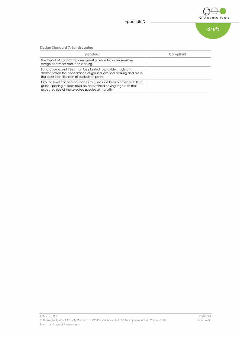
Design Standard 7: Landscaping
Standard Compliant
The layout of car parking areas must provide for water sensitive
design treatment and landscaping.
Landscaping and trees must be planted to provide shade and
shelter, soften the appearance of ground level car parking and aid in
the clear identification of pedestrian paths.
Ground level car parking spaces must include trees planted with flush
grilles. Spacing of trees must be determined having regard to the
expected size of the selected species at maturity.

Appendix E
13M2191000 23/09/13
St Germain Special Activity Precinct, 1425 Pound Road & 2100 Thompsons Road, Clyde North Issue: A-Dr
Transport Impact Assessment
draftdraft
Ap
pe
nd
ix E
Appendix E
Swept Paths

Appendix F
13M2191000 23/09/13
St Germain Special Activity Precinct, 1425 Pound Road & 2100 Thompsons Road, Clyde North Issue: A-Dr
Transport Impact Assessment
draftdraft
Ap
pe
nd
ix F
Appendix F
Traffic Generation

Appendix F
13M2191000 23/09/13
St Germain Special Activity Precinct, 1425 Pound Road & 2100 Thompsons Road, Clyde North Issue: A-Dr
Transport Impact Assessment
draft
F.1 Traffic Generation
F.1.1 Design Rates
Traffic generation estimates for the proposed development have been sourced from GTA Consultants’ survey database, RTANSW and other consultant’s
surveyed rates. These are summarised in the below table.
AM PM Daily AM PM Daily IN OUT IN OUT IN OUT IN OUT IN OUT IN OUT
A 1 Medical Centre/Super Clinic 60 practitioners 4.7 /practitioner 5.8 /practitioner 39.0 /practitioner 282 vph 348 vph 2,340 vpd 50% 50% 50% 50% 50% 50% 141 vph 141 vph 174 vph 174 vph 1,170 vpd 1,170 vpd
Supermarket 4,000 sqm 1.4 /sqm LFA 14.4 /sqm LFA 131.0 /sqm LFA 58 vph 576 vph 5,240 vpd 50% 50% 50% 50% 50% 50% 29 vph 29 vph 288 vph 288 vph 2,620 vpd 2,620 vpd
Retail / specialty shops / cafes 1,840 sqm 1.3 /sqm LFA 12.5 /100sqm LFA 121.0 /100sqm LFA 23 vph 230 vph 2,226 vpd 50% 50% 50% 50% 50% 50% 12 vph 12 vph 115 vph 115 vph 1,113 vpd 1,113 vpd
Mini Major 1,550 sqm 1.3 /sqm LFA 12.5 /100sqm LFA 121.0 /100sqm LFA 19 vph 194 vph 1,876 vph 50% 50% 50% 50% 50% 50% 10 vph 10 vph 97 vph 97 vph 938 vpd 938 vpd
Retail / specialty shops 140 sqm 1.3 /sqm LFA 12.5 /100sqm LFA 121.0 /100sqm LFA 2 vph 18 vph 169 vph 50% 50% 50% 50% 50% 50% 1 vph 1 vph 9 vph 9 vph 85 vpd 85 vpd
Licensed Restaurant 450 sqm 2.5 /100sqm GFA 5 /100sqm GFA 60 /100sqm GFA 11 vph 23 vph 270 vph 50% 50% 50% 50% 50% 50% 6 vph 6 vph 12 vph 12 vph 135 vpd 135 vpd
Tavern 750 sqm 2.2 /100sqm LFA 8.8 /100sqm LFA 12.5 /100sqm LFA 17 vph 66 vph 94 vpd 50% 50% 50% 50% 50% 50% 9 vph 9 vph 33 vph 33 vph 47 vpd 47 vpd
Retail / cafes / banks etc 760 sqm 1.3 /sqm LFA 12.5 /100sqm LFA 121.0 /100sqm LFA 10 vph 95 vph 920 vpd 50% 50% 50% 50% 50% 50% 5 vph 5 vph 48 vph 48 vph 460 vpd 460 vpd
2 bed apartments 34 dwellings 0.8 vph/dwelling 0.8 vph/dwelling 8.0 vpd/dwelling 27 vph 27 vph 272 vpd 20% 80% 60% 40% 50% 50% 5 vph 22 vph 16 vph 11 vph 136 vpd 136 vpd
Penthouses 2 dwellings 0.8 vph/dwelling 0.8 vph/dwelling 8.0 vpd/dwelling 2 vph 2 vph 16 vpd 20% 80% 60% 40% 50% 50% 0 vph 2 vph 1 vph 1 vph 8 vpd 8 vpd
Community Act Cntr (30 car spaces) 30 1.0 /place 1.0 /place 2.0 /place 30 vph 30 vph 60 vpd 50% 50% 50% 50% 50% 50% 15 vph 15 vph 15 vph 15 vph 30 vpd 30 vpd
Gymnasium 1,000 sqm 4.5 /100sqm GFA 9 /100sqm GFA 45 /100sqm GFA 45 vph 90 vph 450 vph 50% 50% 50% 50% 50% 50% 23 vph 23 vph 45 vph 45 vph 225 vpd 225 vpd
Child care centre 120 places 1.4 /place 0.7 /place 3.0 /place 168 vph 84 vph 360 vph 50% 50% 50% 50% 50% 50% 84 vph 84 vph 42 vph 42 vph 180 vpd 180 vpd
Offices 1,600 sqm 2.0 /100sqm LFA 2.0 /100sqm LFA 10.0 /100sqm LFA 32 vph 32 vph 160 vpd 90% 10% 20% 80% 50% 50% 29 vph 3 vph 6 vph 26 vph 80 vpd 80 vpd
Ground floor office suites 170 sqm 2.0 /100sqm LFA 2.0 /100sqm LFA 10.0 /100sqm LFA 3 vph 3 vph 17 vpd 90% 10% 20% 80% 50% 50% 3 vph 0 vph 1 vph 2 vph 9 vpd 9 vpd
Retail / wine bar 240 sqm 1.3 /sqm LFA 12.5 /100sqm LFA 121.0 /100sqm LFA 3 vph 30 vph 290 vpd 50% 50% 50% 50% 50% 50% 2 vph 2 vph 15 vph 15 vph 145 vpd 145 vpd
SOHOS 8 tenacies 0.8 vph/dwelling 0.8 vph/dwelling 8.0 vpd/dwelling 6 vph 6 vph 64 vph 20% 80% 60% 40% 50% 50% 1 vph 5 vph 4 vph 2 vph 32 vpd 32 vpd
Townhouses 6 dwellings 0.8 vph/dwelling 0.8 vph/dwelling 8.0 vpd/dwelling 5 vph 5 vph 48 vph 20% 80% 60% 40% 50% 50% 1 vph 4 vph 3 vph 2 vph 24 vpd 24 vpd
E Retirement Village (including
residential building)260 dwellings 0.2 vph/dwelling 0.2 vph/dwelling 2.0 vpd/dwelling 62 vph 52 vph 520 vph 20% 80% 60% 40% 50% 50% 12 vph 50 vph 31 vph 21 vph 260 vpd 260 vpd
TOTAL 805 vph 1,563 vph 15,392 vpd 388 vph 423 vph 955 vph 958 vph 7,697 vph 7,697 vph
Stage 1 with Retirement Village 502 vph 1,047 vph 12,001 vph 238 vph 266 vph 695 vph 701 vph 6,001 vph 6,001 vph
Stage2 303 vph 516 vph 3,391 vph 150 vph 157 vph 260 vph 257 vph 1,696 vph 1,696 vph
Superlot/
Precinct
Traffic Generation Rate Daily PM
1
AMAM
B
D
C
PMTraffic Generation
1
2
Unit
2
DailyStage
2
1
SizeUse

Appendix G
13M2191000 23/09/13
St Germain Special Activity Precinct, 1425 Pound Road & 2100 Thompsons Road, Clyde North Issue: A-Dr
Transport Impact Assessment
draftdraft
Ap
pe
nd
ix G
Appendix G
SIDRA Intersection Results

www.gta.com.au
Melbourne
A Level 25, 55 Collins Street
PO Box 24055
MELBOURNE VIC 3000
P +613 9851 9600
F +613 9851 9610
Canberra
A Unit 4, Level 1, Sparta Building, 55 Woolley
Street
PO Box 62
DICKSON ACT 2602
P +612 6263 9400
F +612 6263 9410
Townsville
A Level 1, 25 Sturt Street
PO Box 1064
TOWNSVILLE QLD 4810
P +617 4722 2765
F +617 4722 2761
Sydney
A Level 6, 15 Help Street
CHATSWOOD NSW 2067
PO Box 5254
WEST CHATSWOOD NSW 1515
P +612 8448 1800
F +612 8448 1810
Adelaide
A Suite 4, Level 1, 136 The Parade
PO Box 3421
NORWOOD SA 5067
P +618 8334 3600
F +618 8334 3610
Brisbane
A Level 3, 527 Gregory Terrace
BOWEN HILLS QLD 4006
PO Box 555
FORTITUDE VALLEY QLD 4006
P +617 3113 5000
F +617 3113 5010
Gold Coast
A Level 9, Corporate Centre 2
Box 37
1 Corporate Court
BUNDALL QLD 4217
P +617 5510 4800
F +617 5510 4814