srss; sr.arisrat - Bureau of Safety and Environmental ...
25
Haittaa. Ttxtt 77010 6errtlaet*: . * . '7'' srss; sr.arisrat -""^ Is nowfc«1n«cootldtrtd for approval« dtlM twlISrnSpoT •»« cwu»m1f*f thU plan. Sincerely your*. (Orife. rgd.) A. Donald Giroir Regional Supervisor F1a]d OparatlaAf NjTolbert:cckf05/31/S8:poeco« • >
Transcript of srss; sr.arisrat - Bureau of Safety and Environmental ...

Haittaa. Ttxtt 77010
6errtlaet*:
. * . '7''
srss; sr.arisrat -""^ Is now fc«1n« cootldtrtd for approval«
d t l M twlISrnSpoT • » « cwu»m1f*f thU plan.
Sincerely your*.
(Orife. rgd.) A. Donald Giroir
Regional Supervisor F1a]d OparatlaAf
NjTolbert:cckf05/31/S8:poeco«
• >

lExpinratum (Enmpang, Inf. 1331 LAMAR. SUITE 1065 HOUSTON. TEXAS 77010
(713 ) 652-2847
' ( " . • V i i . " ' . ; v
Nay 20, 1988
U.S. Department of the Inter ior Minerals Management Service 1201 Elmwood Park Boulevard New Orleans, Louisiana 70123-2394
Attention: Mr. Daniel Bourgeois Regional Supervisor Off ice of Field Operations
RE: I n i t i a l Plan of Exploration OCS-G 8690, Block 253 South Marsh Island Area Offshore Louisiana
Gentlemen:
Enclosed please find nine (9) copies of the In i t i a l Plan of Exploration with associated A i r Quality Review for lease OCS-G 8690, South Marsh Island Area, Block 253. Five (5) copies of the subject reports are for "Proprietary" information purposes and four (4) copies contain "Public Infonnation"; a l l copies being marked accordingly.
Excluded from the Public Information copies are certain geologic discussions, depth of wells and structure map.
Brooklyn Union Exploration Company, Inc. proposes d r i l l i n g operations to commence by June 20, 1988. Should further information be required, please contact our regulatory consultant, Ms. Jodie Connor, at 713/558-060/.
Sincerely,
G. Ross Frazer Operations Engineer
GRF:JAC:bna
enclosures

INITIAL PLAN OF EXPLORATION
SOUTH MARSH ISLAND AREA, BLOCK 253
OCS-G 8690
Brooklyn Union Exploration Company, Inc. subject block, submits this proposed Init dance with the regulations contained with
Brooklyn Union) as Operator of the al Plan of Exploration 1n accor-n Title 30 CFR 250.34 as follows:
1. Schedule of Operations
In order to delineate the hydrocarbon potential and limitations of this block, Brooklyn Union proposes to drill four (4) wells into South Marsh Island Area, Block 253. All wells (A, B, AA, & BB) will be drilled from two surface locations in Block 253.
The first well wi"!1 be spudded on or about June 20, 1988 subject to the approval of this Plan of Exploration and Issuance of the required Permit to Drill. Each well should take approximately 30 days to drill. The spud dates for the remaining wells have not been determined; however, exploratory drilling should be completed by June 30, 1992.
It should be emphasized that this schedule is tentative in the meaning of 30 CFR 250.34-l(a). Additional exploratory drilling must be predicated upon the need to further define structures and/or reservoir limitations. In addition to the drilling of the well(s), other activities which may be conducted under this Plan would be the setting of a well protector structure, a seafloor template, a velocity survey in a wellbore, and soil borings.
Transportation from the existing onshore facilities in Freshwater City, Louisiana to the block will involve the use of one supply boat making three (3) trips per week, one crew boat making five (5) trips per week, and one helicopter making five (5) trips per week.
2. Drilling Equipment
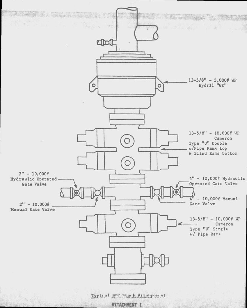
The proposed wells will be drilled with a jackup drilling rig. When a rig is selected, the rig specs will be made a part of the Application for Permit to Drill. A typical equipment 11st is enclosed herewith as Attachment I.
Safety features will Include well control and blowout prevention equipment as described in OCS Order No 2. The appropriate Ufe rafts, Ufe Jackets, ring buoys, etc. as prescribed by the U.S. Coast Guard will be maintained on the facility at all times.

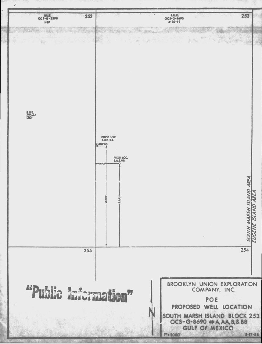
3. location of Wells
The approximate locations of the four (4) wells proposed in this Plan as well as the proposed depths, are shown on the accompanying Location Plat, enclosed herewith as Attachment II, and are described as follows:
A Surface: 6500' FSL & 650' FWL
6 Surface: 5250' FSL & 1475' FWL
AA Surface: 6500' FSL & 650' FWL
BB Surface: 5250' FSL & 1475' FWL
Water depth in Block 253 Is approximately 20 feet.
4. Geolog1cal/Geophys1cal Informat1on
The structure map 1s not Included 1n the Public Information section of this Plan.
A Shallow Drilling Hazards Report 1s not included 1n the Public Information Section of this Plan.
5. Archaeological Information
An Archaeological Survey was required with the Shallow Hazards Survey Report for South Marsh Island 253. It has been determined that there are no magnetic anomalies or cultural resources within 500 feet of the proposed well locations. Four copies of the Shallow Hazards Report and Archaeological survey are being submitted under separate cover.
6. Onshore Facilities
The service base for this area will be Freshwater City, Louisiana. This will be an established facility that will require no modifications.
7 dilution Prevention Information
Pollution prevention control measures will be in accordance with OCS Order No. 7. Brooklyn Union has on file with the MMS an approved Oil Spill Contingency Plan for the Gulf of Mexico. In the event of a spill,
"PuWk Information"
this Plan will be actuated. Brooklyn Union 1s a member of Clean Gulf Associates which provides spill containment equipment and clean-up equipment at six Halliburton Service Bases on the Gulf Coast: Galveston and Rockport In Texas; Grand Isle, Venice, Cameron, and Intracoastal City In Louisiana. If a spill should occur from the proposed operations, the equipment located at Intracoastal City, Louisiana would be utilized first, with additional equipment moved in from other bases, If necessary. Fast boat response with oil boom, skimmers, pump and storage tanks would require approximately 4-6 hours, including preparation time. A heavy equipment system response would require approximately 20-28 hours, Including six hours preparation time.
Drill cuttings and excess drilling fluids will be disposed of in accordance with applicable environmental regulations. The drilling fluid components and additives to be used are enclosed herewith as Attachment VI.
Enclosed are copies of the following information:
ATTACHMENT NO.
I Rig Information II Location Plats (Well & Vicinity) III Structure Maps IV Shallow Drilling Hazard Report V List of Mud Components and Additives
Also enclosed is the same number of Air Quality Reviews and Environmental Reports.

30" - 5000 VP Annular Preventer
OHM/ 6" - 2000/' VP
Manual Gate Valve
6" air-open remote conti
j butterfly v:
30" x 1" V.T Drive Pipe
6" - 2000/' VP hydraulic operated remote controlled gate valve
6" Tee
6" air-ope: remote com b u t t e r f l y i
Typical Diverter Hook-up
ATTACHMENT 1
2" - 10,0000 • Hydraulic Operated
Gate Valve
2" - 10,000* Manual Gate Valve
13-5/8" - 5,0000 WP Hydril "GK"
> 13-5/8" - 10,0000 Caineron
Type "U" Double
WP
w/Pipe Rams top & Blind Rams bottom
I W . , A" - 10,000# Hydraulic Operated Gate Valve
0000 Manual Gate Valve
> 13-5/8" - 10,00 ^ Camer
Type "U" Single
0000 WP on
v/ Pipe Rams
Tyi» 11 .il JMM* Sim V A_i r.n»|-«'twut
ATTACHHENT I
OCS-0-JSM 252
IB A-1
ML I . OCS-G-MM
PROP. IOC B.ULSA
PROP. LOC
255
u
253
254
BROOKLYN UNION EXPLORATION COMPANY. INC.
POE PROPOSED WELL LOCATION
SOUTH MARSH ISLANO BLOCK 253 OCS-G-8690 #A,AA,B,& BB
GULF OP MEXICO rtjooff s-i7-ea
C«Sf • * £ « • $
AMA

DRILLING MUD COMPONENTS
COMMON CHEMICAL OR CHLMICAL TRACE NAME DESCRIPTION OF MATERIAL
Aluminum Stearate "AXTAFLO-S" Barlte Calcium Carbonate Calcium Chlordie Calcium Oxide Calcium Sulfate Carboxymethyl Cellulose Caustic Potash Caustic Soda Chrome Lignite Chrome Lignosulfonate Dri l l ing Detergent "E-Pal" ' ^rrochrome Lignosulfonate
Gypsum Lignite Lignosulfonate "Mud Sweep" "MOR-REX" "Shale-Trol" Sapp Soda Ash Sodium Bicarbonate Sodium Carboxymethyl Cellulose Sodium Chloride Sodium Chromate Starch "TX-9010" "TORQ-Trim" "Black Magic" "Black Magic Supermix" Diesel
"Jel flake" MICA -Pipe-Lax" "Wall-Nutwood Fibers
Aluminum Stearate Nonionic Surfactant Barium Sulfate (BaSo4) Aragonite (CaCo3) Hydroph1l1*<* (CaC12) Lime (Quit Anhvdrit'- aS04) Carbon„ i Cellulose Potass -m riydi ate Sodium Hydroxide (NaOH) Chrome Lignite Chrome Lignosulfonate Soap Non-toxic, biodegradable defoamer Derived from wood pulp Sodium montmorillonite, bentonite, attapulgite CaSo4.2H20 Lignite Lignosulfonate Cement Pre-flush Hydroloyzed Cereal solid Organo-aluminum complex Sodium Acid Pyrophosphate Sodium Carbonate NaHC03 Sodium Carboxymethyl Cellulose NaCl NaCr04.10H20 Corn Starch Biodegradable drilling lubricant Biodegradable drilling lubricant Oil base mud cone. Sacked concentrated oil base mud Used to mix certain loss-circulation pills Plastic foil, shredded cellophane Loss-circulation material Surfactant mixed with diesel Ground walnut shells Loss-circulation material

P.O. Box 218753 Nous; an, Texas 77: 18 713-558-0607
PROJECTED AIR EMISSION SCHEDULE FOR EXPLORATION PROJECT
GENERAL INFORMATION
Location of Fa:?'1ty:
Distance Offshore: Name of Rig: Operator:
Contact Person: Total Well footage to he Drilled 1988 Date Drilling Will Begin:
South Marsh Island Block 253 OCS-G 2590 20 miles Jack-up Brooklyn Union Exploration 1331 Lamar, Suite J.065 Hojston, Texas 77010 Mr. G. Ross Frazer 45,000' June 20, 198i>
MAJOR SOURCE (QFFSHOai-]
Power used aboaro <*• Ulvng vessel; approximate footage drilled 45,000'.*
Emitted Substance
Projected Emissions (lbc/day**)tons/year
1938
CO SO 2
(ito] (47;
8.910 2.835
NOx VOC TSP
(697] (56 (49
41.850 3.375 2.970
Based on 60 hphr/ft. from Table a-3, "Atmospheric Emissions from Offshore Oil and Gas Development and Production", EPA No. 45-1/3-77-026, June, 1977.
EHfsion factors from Table 5.4.3-1. "Compilation of Air Pollutar.t Emission Factors", Third Edition.. EPA Report AP-1?, August, 1977.
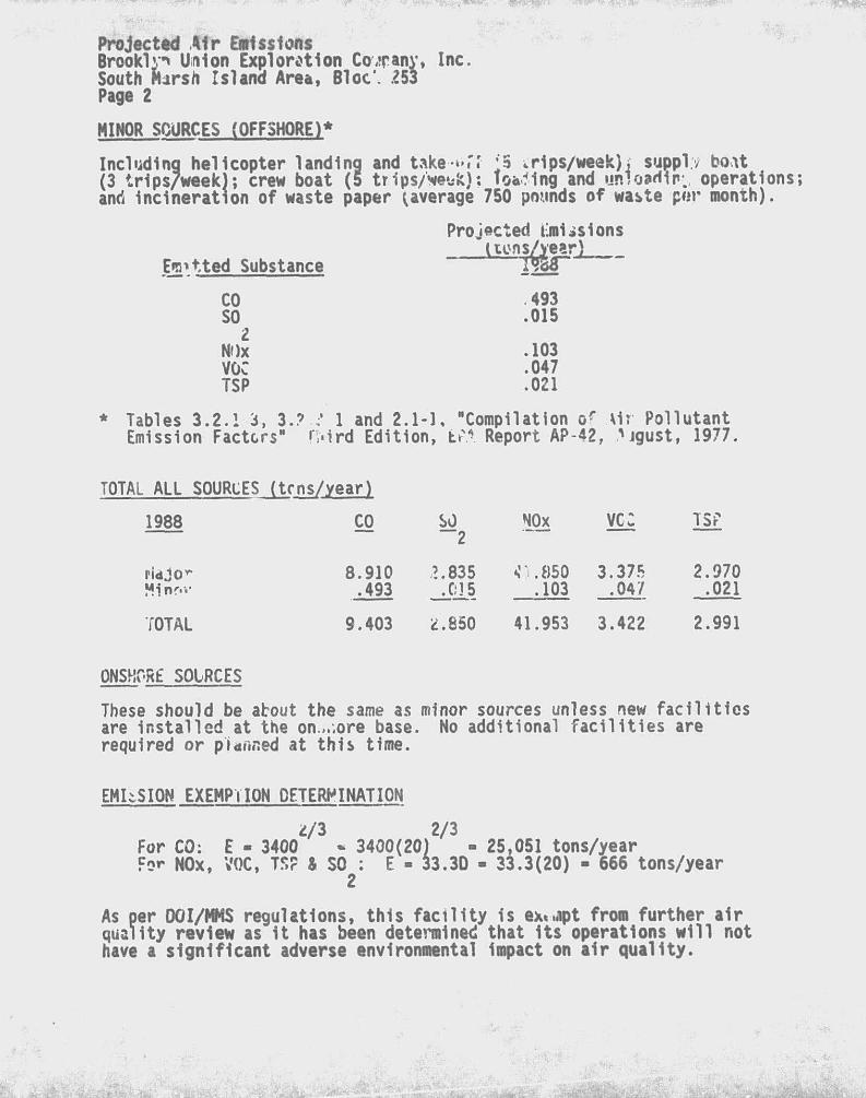
Projected Air Emissions Brooklyn Union Exploration Cowanv, Inc. South Marsh Island Area, Bloc*. £53 Page 2
MINOR SOURCES (OFFSHORE)*
Including helicopter landing and take-tiff ;5 ^rips/week); supply boat (3 trips/week); crew boat (5 tr1ps/Met*fe): foaming and unloading operations and incineration of waste paper (average 750 pounds of waste por month).
Projected timlislons (tons/year)
Fitted Substance TW"
CO 493 SO .015
2 NOx .103 VOC .047 TSP .021
* Tables 3.2.1 3, 3.? 1 and 2.1-1, "Compilation of \1r Pollutant Emission Factors" H«1rd Edition, b-A Report AP-42, igust, 1977.
TOTAL ALL SOURCES (tens/year)
1988 CO
ridjo r- 8.910 Mlnr.v .493
TOTAL 9.403
ONSHORE SOURCES
SO ""2
NOx vc: TSP
£.835 <1.850 3.375 2.970 _jjl5 .103 .047 .021
*.850 41.953 3.422 2.991
These should be about the same as minor sources unless new facilities are installed at the on,..ore base. No additional facilities are required or planned at this time.
EMISSION EXEMPTION DETERMINATION 2/3 2/3
For CO: E - 3400 - 3400(20) - 25,051 tons/year For NOx, VOC, TS? a SO : E - 33.3D - 33.3(20) - 666 tons/year
As per DOI/MMS regulations, this facility 1s ex«jpt from further air quality review as it has been determined that Its operations will not have a significant adverse environmental Impact on air quality.
ENVIRONMENT**' REPORT
FEDERA'. LEAfE OCS-G 8690 SOUTH MARSH ISLAND AREA, BLOCK 253
OFFSHORE LOUISIANA
THE FOLLOWING ENVIRONMENT*'. REPORT WAS PREPARE!) &Y J. CONNOJ-' CONSULTING FOR BROOKLYN UNION EXPLORATION COMPANY INC. FOR COASTAL ZONE CON>ir<ENCY DETERMINATION. BY THE STA7Z CF LOUISIANA ON OPERATION'; PROPOSED TO BE COXUCTED IV f«ri PLA* OF EXPLORATION FOR LEASE OCS-G 8690. FOR INQUIRIES RFGARDI G THIS REPORT LEASE CONTACT:
BROOKLYN UNION EXPLORATION COMPANY, INC.
1331 LAMAR, SUITE 1065
HOUSiON TEXAS 77010
ATTENTION: d. ROSS FRAZER
MAY, 1>"2

TABLL SF CONTENTS
TITLE PAGE
TABLE OF CONTENTS
I . DESCRIPTION OF PROPOSED ACTION
A. DESCRIPTION OF PROPOSED TKAVFL MODES, ROUTES AND FREQUENCY
B. ONSHORE SUr\)RT SYSTEMS C. NEW OR Ur JAL TECHNOLOGY D. VICINITV MAP E. PROPOSED MENS TO TRANSPORT OIL /AND GAS TO SHORE
ROUTES, QUANTITIES
I I . DESCRIPTION OF AFFECTED ENVIRONMENT
A. COMMERCIAL FISHING B. SHIPPING C. PLEASURE BOATING, SPORT FISHING AND RECREATION D. POTENTIAL OR KNOWN CULTURAL RESOURCES E. ECOLOGICALLY SENSITIVE FEATURES F. PIPELINES AND CABLES G. OTHER MINERAL. USES ><. OCEAN DUMPI' * I . ENDANGERED OK THREATENED SPcCIES AND CRITICAL
HABITAT
I I I . UNAVOIDABLE ADVERSE ENVIRONMENT EFFECTS
A. WATER QUALITY 6. EFFECTS OF MARINE ORGANISMS C. WETLANDS AND BEACH D. AIR QUALITY F. COMMERCIAL FISHING ; . SHIP NAVIGATION f i . CULTURAL RESOURCES h. RECREATION AND AESTHETIC VALUES
IV. SUMMARY
RF.V^NC'S
LIST OF rvanns A - VICINITY MAP

1. RIPTICSS 'VF PROPOSED ACTION
BrooNO,f» Unlcn Exploration Company, Inc. (Brooklyn Union) propose, to conduct explorato-y activities for South Marsh Island Area, Block 233, OCS-G QM.
As proposed th? Plaa cf Exploration for South Marsh Island B'locfc :53 Includes the drli'.Vtg of four (4) wells.
Activities under thJis ?lin of £xpl ration will commence June 20, 1988.
A. DESCRIPTION OF PROPOSED TRAVEL MODES, ROUTES AND FREQUENCY
Boats and helicopters will be dispatched from a support base located in Freshwater City, Louisiana. The boats will normally move to Block 253 via the most direct route from Freshwater City, Louisiana. Following 1s ar. estimate of bo*t and helicopter trips to ne proposed operations on South Marsh Island 253.
tv. ONSHORE SUPPORT BASE Tha proposed activities <vil utilize a support base located ct Fre&iwster City, Louisiana. This base provides 24-hour service, a radio tower with phone patch, dock space, office space, parking lot, equ'oinent and supply storage space, drink ina and drill water, etc. These proposed exploratory activities will nelp to maintain this ba*>e at its present level of activity. No expansion of the physical facilities or the creation of new jobs is expected tc 'usult from the work planned in conjunction with B^ck 253.
C. NEW Ort UNUSUAL TECHNOLOGY
No new techniques or unusual technology will be required for these operations.
D. VICINITY MAP
Sfe Attachment 1.
Drilling Operations
Crew Boats 3 trips per week 5 trip? per week 5 trips per week

E. PROPOSED MEANS TO TRANSPORT OIL ANO GAS TO SHORE, ROUTES, QUANTITIES
If producible hydrocarbons are found they are likely to be transported to shore through connections with pipelines already in or near 'utb Marsh BlocR 253.
II. DESCRIPTION OF AFFECTED ENVIRONMENT
A. COMMERCIAL FISHING
The Gulf fishery 1s dominated by tne shell fisheries: shrimp, crabs, and oysters (with smaller amounts of clams and scallops). The shrimp fishery in the Gulf area Includes brown, white, and pink shrimp. These are taken almost exclusively by trawl in water depths ranging from 2 to 73 meters.
South Marsh Island 253 is located within the major finfish grounds and brown shrimp harvest areas. Finfish volume for the Gulf states Is dominated by menhaden. Menhaden are number one in volume and second in vali e for Louisiana. Gulf Region lanaings in 1985 were 1.9 billion pounds, or 70% of the 2. billion pounds U.S. menhaden catch, most of which 1s landed at Louisiana ports (Fisheries of the United States 1985, April 1986.). Other flnflshes which contribute significantly to Louisiana's landings Include drum, catfish, sea trout, mackerel and snapper. (Louisiana Landings for Specified Periods, 1984 and 1985).
Since the majority of shrimp and commercial bottom fish are caught by trawling, sites occupied by drilling Has must be avoided by shrimpers, but are attractive to hook and Tine fishermen.
8. SHIPPING
South Marsh Island 253 1s clear of all shipping fairways and anchorage areas. The rig and each of the marine vessels will be equipped with all U. S. Coast Guard required navigational safety aids. There should be little or no impact on shipping resulting from the proposed operations.
C. PLEASURE BOATING, SPORT FISHING AND RECREATION
Sport fishing In Louisiana is a very popular form of recreation. Louisiana's coastal marshland with few roads reaching the shoreline has limited fishing access and precludes full utilization of the saHwater fishery resources. Nevertheless, a high percentage of Uu ;4ina residents own or have access to boats. Sport fishing arcind offshore oil and gas rigs 1s popular. Results of 'ecYVitienal fisheries surveys by Dltton and Graefe (1978) 1n the fiiVthte^tr-n Gulf of Mexico's Houston-Galveston area Indicated that rnly one-third of the boating population was saltwater fishermen and only 5% fished offshore. However, oil and gas structures attracted
2

the boats and 50% of all offshore recreational fishing effort were directly associated with oil and aas platforms in the Northwestern Gulf of Mexico; A Community Profile).
Boating in Louisiana's coastal areas 1s most often related to recreational fishing. Water skiing and sailing are growing in popularity, especially in estuarine lakes near South Louisiana's major urban centers.
Hunting is a popular recreational activity in Louisiana. The variety of water fowl are taken throughout the coastal marshes. There are three state wildlife refuges and numerous state and federal biologically sensitive land areas onshore from the area of operation.
With the exception of Grand Isle and vicinity and a stretch of beach area in Cameron Parish, (Peveto/Constance/Ocean View Beaches, Holly Beach, Hackberry Beach) Louisiana has very limited beach area suitable for recreation. Most of i t is very narrow, of poor recreational quality and generally inaccessible by automobile, some of the highest quality beach areas in coastal Louisiana are found along the barrier islands chain off Terrebonne Parish.
Several additional significant recreation resources are found along the Gulf Coast. Louisiana has ornamental gardens, scenic roads, rivers, and trails. No adverse impacts are anticipated.
D. POTENTIAL OR KNOWN CULTURAL RESOURCES
South Marsh Island 253 lies inside the Cultural Resource Sensitivity Demarcation Line (USDI, 1979, Visual 1), and therefore, falls 1n an area where cultural resources are likely to be found. An archaeological survey has been submitted for South Marsh Island 253. Results of this survey Indicate no evidence of high probability areas of archaeological sites. However, Brooklyn Union agrees that if any site, structure, or object of historical or archaeological significance should be discovered during any operation, the findings will immediately be reported to the Regional Director and every reasonable effort will be made to preserve and protect the cultural resource from damage until the Regional Director has given direction as to Its preservation.
E. ECOLOGICALLY SENSITIVE FEATURES
There are no areas of particular concern within Block 253. However, there are several areas of environmental concern that lie onshore from the lease site. These Include (1) Sabine Pass Lighthouse State Commemorative Area, (2) Paul 0. Rainey Wildlife Refuge, (3) Rockefeller State Wildlife Refuge, (4) Louisiana State Wildlife Refuge, and (5) Rutherford Beacn State Park and other recreational beaches.
3

Clean Gulf Associates has prepared and distributed to Members, maps of the coastline of the Gulf of Mexico listing environmentally sensitive areas onshore and near-shore which might be affected by an accidental hydrocarbon release. Since the entire coastline of the state of Louisiana can be considered environment?!ly sensitive in varying degrees, there 1s no benefit seen in listing all the major bays and wildlife refuges along the coast. No adverse Impacts are anticipated.
F. PIPELINES AND CABLES
Thore are no pipelines or cables crossing Block 253.
G. OTHER MINERAL USES The activities proposed for South Marsh Island 253 will have no direct or indirect impact on other mineral uses.
H. OCEAN DUMPING Ocean dumping 1s prohibited in this area.
I. ENDANGERED OR THREATENED SPECIES AND CRITICAL HABITAT
Five federally listed endangered whale species occur within the Central Gulf. These Include fin, humpback, right, sei, and sperm whales. Generally, these large cetaceans inhabit the continental slope and deep oceanic waters, occasionally they are sighted nearshore (Scnmidly, 1981). Sperm whales nave been sighted near the Louisiana Delta and offshore Brownsville (Frltts et al., 1983).
Four federally listed endangered turtle species (Kemp's ridley, green, hawksbill, and leatherback turtles) and one threatened species (loggerhead turtle) occur in the Gulf of Mexico.
The American alligator occurs generally throughout the Central Gulf coastal areas. Tne alligator is listed as endangered throughout its range except in the coastal areas of Florida and Texas where it is listed as threatened and in Louisiana where it is listed as "threatened by similarity of appearance".
Arctic peregrine falcons migrate along the ea*4*rn coast of Florida, the Florida Keys, and the Gulf coast of Texas. .;ome peregrine falcons overwinter along the Gulf coastal araas.
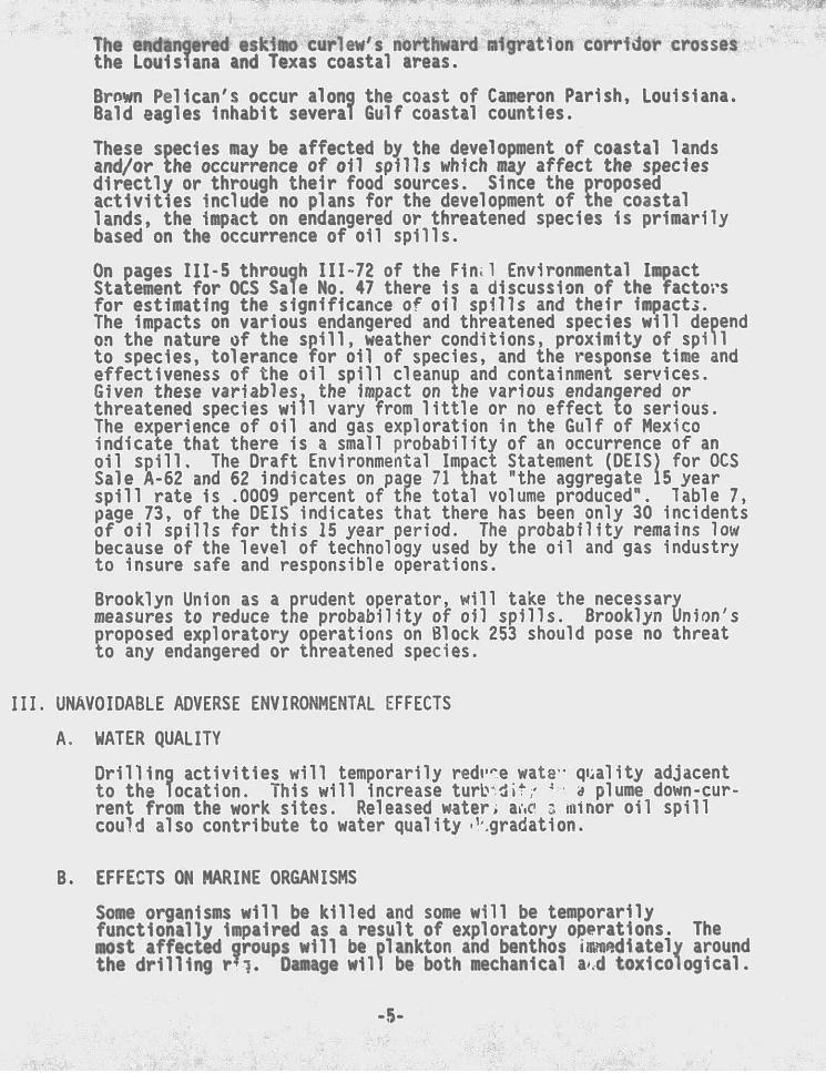
The endangered eskimo curlew's northward migration corridor crosses the Louisiana and Texas coastal areas.
Brown Pelican's occur along the coast of Cameron Parish, Louisiana. Bald eagles Inhabit several Gulf coastal counties.
These species may be affected by the development of coastal lands and/or the occurrence of oil spills which may affect the species directly or through their food sources. Since the proposed activities Include no plans for the development of the coastal lands, the Impact on endangered or threatened species Is primarily based on the occurrence of oil spills.
On pages III-5 through 111-72 of the Fin 1 Environmental Impact Statement for OCS Sale No. 47 there 1s a discussion of the factors for estimating the significance of oil spills and their impact*. The Impacts on various endangered and threatened species will depend on the nature of the spill, weather conditions, proximity of spill to species, tolerance for oil of species, and the response time and effectiveness of the oil spill cleanup and containment services. Given these variables, the impact on the various endangered or threatened species will vary from little or no effect to serious. The experience of oil and gas exploration in the Gulf of Mexico indicate that there is a small probability of an occurrence of an oil spill. The Draft Environmental Impact Statement (DEIS) for OCS Sale A-62 and 62 indicates on page 71 that "the aggregate 15 year spill rate is .0009 percent of the total volume produced". Table 7, page 73, of the DEIS indicates that there has been only 30 incidents of oil spills for this 15 year period. The probability remains low because of the level of technology used by the oil and gas industry to Insure safe and responsible operations.
Brooklyn Union as a prudent operator, will take the necessary measures to reduce the probability of oil spills. Brooklyn Union's
?roposed exploratory operations on Block 253 should pose no threat o any endangered or threatened species.
III. UNAVOIDABLE ADVERSE ENVIRONMENTAL EFFECTS
A. WATER QUALITY
Drilling activities will temporarily redi' e wate- quality adjacent to the location. This will Increase turtndit/ a plume down-current from the work sites. Released water; a c a minor oil spill could also contribute to water quality »' .gradation.
B. EFFECTS ON MARINE ORGANISMS
Some organisms will be killed and some will be temporarily functionally impaired as a result of exploratory operations. The most affected groups will be plankton and benthos immediately around the drilling r?i. Damage will be both mechanical a.d toxicological.
5

Discharge of hole cuttings w i l l damage plankton within the plume and bury some of the less mobile benthic fauna. These Impacts are considered to be localized, short term and reversible at the population leve l .
An o i l sp i l l could affect a broad spectrum of marine organisms. However, most effects would be localized and short term. Any effects on mammals and turt les would be signi f icant.
C. WETLANDS AND BEACH
In the unlikely event of a sp i l l occurring and reaching shore, organisms in wetland and beach habitats could be k i l l ed or functionally Impaired. Human community disruption could also occur. Although al l such effects would be localized, any effects on endangered species and/or c r i t i ca l habitats would be signif icant.
D. AIR QUALITY
The air quality at the lease site will be degraded temporarily during operations, but should return to normal once operations are measurably completed. Offshore activities probably will not affect onshore air quality. Air quality at the onshore base will be only insignificantly reduced by onshore activities. Any such effect will be temporary.
E. COMMERCIAL FISHING
Of the various types of fishing gear in use in the OCS areas, trawls have the greatest chance for operational conflicts with oil and gas activities. Losses may, however, be compensated under the Fishermen's Contingency Fund or other legal routes. Trawl nets can be snagged on underwater stubs causing damage or loss of the nets. In addition, it 1s conceivable that snags could damage underwater production equipment of pipelines causing a spill of oil or gas. because safety equipment is installed, which shuts in production when a loss of pressure occurs, the likelihood of a major spill resulting thereby 1s considered very small. Less frequently, large objects which were lost overboard from petroleum industry boats, pipeline lay barges, and platforms are caught by fishing gear resulting 1n damage to the gear and/or Its catch of fish; however, occurrence of this type of Incident is low. Also, commercial fishermen would probably not harvest fish in the area of an oil spill, as spilled oil could coat or contaminate commercial fish species rendering them unmarketable. Other unavoidable adverse impacts Include loss of fish space caused by Installation of unburied pipelines, rigs, platforms, or by other OCS-related structures. There may be some localized competition for shore facilities. These effects and any effect that the exploratory operations will have on stocks of Important species are considered minor.
-6

--
F. SHIP NAVIGATION
Very little Interference can be expected between the rig and marine vessels utilized during drilling operations and ships that use established fairways. However, at night and during rough weather, fog. and heavy seas, ships not using established fairways could collide with the rig.
G. CULTURAL RESOURCES
There 1s only a small probability that an unknown cultural resource exists in the lease area.
H. RECREATION ANO AESTHETIC VALUES
The rig and marine vessels may represent an obstacle to some sport fishermen, but such an effect is expected to be negligible and not permanent.
Even though existing regulations and orders prohibit indiscriminate littering of the marine evnlronment with trash, offshore oil and gas operations involving men, machines, equipment, and supplies is bound to result in some littering of the ocean. Human nature and accidents associated with offshore operations will contribute some floatable debris to the ocean environment which will eventually come ashore on major recreational beaches.
The effects that normal operations or a minor oil spill would have on any fish stocks Important to sport fishermen are also considered to be negligible.
A minor oil spill and/or non-petroleum floating debris could foul beaches inshore oc the lease area. The fouling of the beaches would be an aesthetic detriment that could adversely affect recreation. Any effects on beach recreation could adversely affect tourism and, consequently, the local economy.
IV. SUMMARY
The proposed activity will be carried out and completed with the guarantee of the following items.
A. The best available and safest technologies will be utilized throughout the project. This includes meeting all applicable requirements for equipment types, general project layout, safety systems, and equipment and monitoring systems.
B. All operations are coverd by a Minerals Management Service approved Oil Spill Contingency Plan.
7

C. m%\ applicable Federal. State and Local requirements regarding air emission and water quality and discharge for the proposed activities, as well as any other permit conditions, will be complied with.
D. The prorr • d activities described in detail in the Plan of Exploration will comply with Louisiana's and Alabama's Coastal Management Program and will be conducted in a manner consistent with such Programs.
8

REFERENCES
1. Final Environmental impact Statement, Proposed 011 and Gas Le*.se Sal as 94, 98 and 102, Gulf of Mexico OCS Region, OCS EIS, MMS 84-00*7.
2. Final Environmental Impact Statement, Proposed 011 and Gas Lease Sales 94, 98 and 102, Gulf of Mexico OCS Region, OCS EIS, MMS 84-0057, visuals.
3. ri'sher1es of the United States. 1985, April, 1986.
4. The Ecology of Petroleum Platforms In the Northwestern Gulf of Mexico: A Community Profile, Bureau of Land Management Open File Report 82-03, JUly, 198Z.
5. Environmental Report West Cameron Area Blocks 516 ?nd 524, March, 1987.
6. BLM Draft Environmental Impact Statement, OCS 011 and Gas Lease Sales A-bZ and "52":
7. BLM Final Environmental Impact Statement, OCS OH and Gas Lease Sales A-62 and 62.
8. BLM Final Environmental Impact Statement, OCS Oil and Gas Lease Sale 47.
9. Minerals Management Service, 1983. Final Regional Environmental Impact Statement, Gulf of Mexico. U. S. Department of the Interior.
10. Final Environmental Impact Statement, Proposed Oil and Gas Lease Sales 110 and 112, Gulf of Mexico OCS Region, OCS EIS, MMS 86-0087.
11. Final Environmental Impact Statement, Proposed Oil and Gas Lease Sales 110 and 112, Gulf of Mexico OCS Region, OCS EIS, MMS 86-0087, visuals.
12. Final Environmental Impact Statement, Proposed Oil and Gas Lease Sales 113, 115 and 116, Gulf of Mexico OCS Region, OCS EIS, MMS 87-0077.
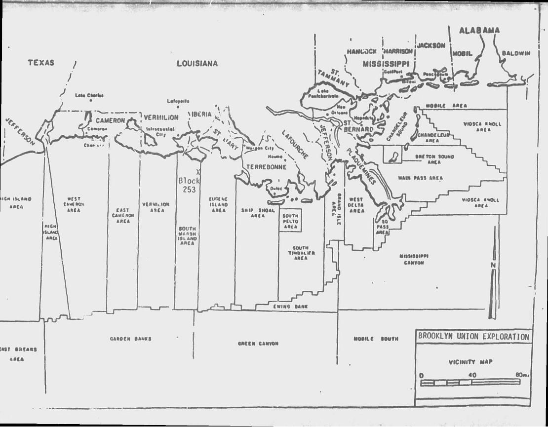
TEXAS LOUISIANA
U M Cl Laf«r«>K
CAMERON / * * } VWWUON M1>»c»««Ut
CAST CAMCMON
AftCA
AUCA
Bloclci 253
•OUTM WAA9N ISL ANO
AftCA
- J
QAftOCN •AMKS • M I N CANYON
MOIIL C SOUTH BROOKLYN UNION EXPLORATION
VICINITY MAP
40 60m

COASTAL ZONE MANAGEMENT
CONSISTENCY CERTIFICATION
PLAN OF EXPLORATION
SOUTH MARSH ISLAND AREA. BLOCK 253
OCS-G 8690
The proposed activities described in detail in this Plan comply with Louisiana's approved f c'\ Management Program and wil l be conducted in a manner cons is ten <?ch Program. Arrangements have beer -n* s State Times in Baton Rouge, Louisiana to publish a legal noc« than May 30, 1988.
Bro lyn Union Exploration Company Inc. Lessee or operator
DaTe r~r r
-10-