SR401 Skeet Range Record of Decision - United … type of equipment used will depend on the volume...
126
Final SR401 Skeet Range Record of Decision Former McClellan Air Force Base Air Force Real Property Agency McClellan, California June 2011 SDMS DOCID# 1127139
-
Upload
truonghanh -
Category
Documents
-
view
212 -
download
0
Transcript of SR401 Skeet Range Record of Decision - United … type of equipment used will depend on the volume...

F i n a l
SR401 Skeet Range Record of Decision
Former McClellan Air Force Base Air Force Real Property Agency
McClellan, California
June 2011
SDMS DOCID# 1127139

SAC/389146/102450026 (FINAL_SR401_ROD.DOC) iii
Section Page
Acronyms and Abbreviations ..........................................................................................................v
1 Declaration...........................................................................................................................1-11.1 Site Name and Location ........................................................................................1-11.2 Statement of Basis and Purpose...........................................................................1-11.3 Assessment of the Site ...........................................................................................1-21.4 Description of Selected Remedy ..........................................................................1-21.5 Statutory Determinations......................................................................................1-51.6 Data Certification Checklist..................................................................................1-61.7 Authorizing Signatures .........................................................................................1-7
2 Decision Summary.............................................................................................................2-12.1 Site Name and Location ........................................................................................2-12.2 Site History and Background ...............................................................................2-1
2.2.1 Site History.................................................................................................2-12.2.2 Previous Investigations ............................................................................2-12.2.3 Enforcement Activities .............................................................................2-2
2.3 Community Participation .....................................................................................2-22.4 Scope and Role of the SR401 Skeet Range Response Actions..........................2-62.5 Summary of Site Characteristics and Risks........................................................2-6
2.5.1 Site Characteristics ....................................................................................2-62.5.2 Current and Potential Future Land and Resource Uses ....................2-102.5.3 Summary of Human Health Risk Assessment....................................2-102.5.4 Summary of Ecological Risk Assessment ............................................2-232.5.5 Basis for Action........................................................................................2-23
2.6 Principal Threat Wastes ......................................................................................2-242.7 Remedial Action Objectives ...............................................................................2-252.8 Description of Alternatives.................................................................................2-25
2.8.1 Alternative 1 – No Action.......................................................................2-262.8.2 Alternative 2 – Excavation, Disposal, and Revegetation ...................2-262.8.3 Alternative 3 – Excavation, Soil Washing, Disposal, and
Revegetation............................................................................................2-332.8.4 Alternative 4 – Excavation, Solidification/Stabilization,
Disposal, and Revegetation...................................................................2-342.9 Comparative Analysis of Alternatives..............................................................2-352.10 Selected Remedy ..................................................................................................2-362.11 Statutory Determinations....................................................................................2-39
2.11.1 Protection of Human Health and the Environment ...........................2-402.11.2 Compliance with Applicable or Relevant and Appropriate
Requirements ..........................................................................................2-402.11.3 Cost Effectiveness....................................................................................2-45

CONTENTS, CONTINUED
iv SAC/389146/102450026 (FINAL_SR401_ROD.DOC)
2.11.4 Use of Permanent Solutions and Alternative TreatmentTechnologies or Resource Recovery Technologies............................ 2-45
2.11.5 Preference for Treatment as a Principal Element ............................... 2-452.11.6 Five-year Review Requirements ........................................................... 2-46
2.12 Documentation of Significant Changes............................................................ 2-46
3 Responsiveness Summary................................................................................................ 3-13.1 Background of Community Involvement.......................................................... 3-13.2 Summary of Significant Comments Received................................................... 3-1
3.2.1 Significant Comments Received during the July 15, 2010,Public Meeting and Air Force Responses ............................................. 3-1
3.2.2 Written Comments Received during the Public Comment Periodand Air Force Responses......................................................................... 3-2
4 Works Cited ........................................................................................................................ 4-1
Appendixes
A Screening Levels and Background Levels for Soil and SedimentB Screening Level Human Health Risk AssessmentC Screening Level Ecological Risk AssessmentD Sustainability Impact AnalysisE Administrative Record Index
Tables
1 Cleanup Levels for COCs Based on Potential Risk to Human Health2 State and Federal ARARs
Figures
1 Project Location Map2 SR401 Skeet Range3 Conceptual Site Model4 Shot Pellet Density and Distribution Results5 Clay Shard Density and Distribution Results6 Metals in Soil and Sediment Exceeding Background and Human Health Screening
Levels7 PAHs in Soil and Sediment Exceeding Human Health Screening Levels8 Metals in Soil and Sediment Exceeding Background and Ecological Screening Levels9 PAHs in Soil and Sediment Exceeding Ecological Screening Levels10 Selected Remedy Target Areas11 National Contingency Plan Criteria for Evaluating the Remedial Alternatives and
How the Alternatives for SR401 Skeet Range Meet the Criteria

SAC/389146/102450026 (FINAL_SR401_ROD.DOC) v
AFB Air Force Base
AFCEE Air Force Center for Engineering and the Environment
AFRPA Air Force Real Property Agency
ARAR applicable or relevant and appropriate requirement
bgs below ground surface
Cal/EPA California Environmental Protection Agency
Central Valley California Regional Water Quality Control Board, Central Valley RegionWater Board
CERCLA Comprehensive Environmental Response, Compensation, and LiabilityAct of 1980
CFR Code of Federal Regulations
COC contaminant of concern
CSM conceptual site model
DTSC Department of Toxic Substances Control
EPA U.S. Environmental Protection Agency
EPC exposure point concentration
FFA Federal Facilities Agreement
FS feasibility study
ft foot
HI hazard index
HQ hazard quotient
IC institutional control
ITRC Interstate Technology and Regulatory Council
McClellan former McClellan Air Force Base
mg/kg milligram(s) per kilogram
MMRP Military Munitions Response Program
NCP National Oil and Hazardous Substance Pollution Contingency Plan

ACRONYMS AND ABBREVIATIONS
vi SAC/389146/102450026 (FINAL_SR401_ROD.DOC)
NPDES National Pollutant Discharge Elimination System
NPL National Priorities List
OU operable unit
PAH polycyclic aromatic hydrocarbon
PRL Potential Release Location
RAB Restoration Advisory Board
RAO remedial action objective
RBSL risk-based screening level
RCRA Resource Conservation and Recovery Act
RI remedial investigation
ROD record of decision
SARA Superfund Amendments and Reauthorization Act of 1986
SLERA screening level ecological risk assessment
SLHHRA screening level human health risk assessment
SLUC State Land Use Covenant
SRT Sustainable Remediation Tool
STLC Soluble Threshold Limit Concentration
TCLP Toxicity Characteristic Leaching Procedure
TTLC Total Threshold Limit Concentration
USACE U.S. Army Corps of Engineers
USC U.S. Code
USFWS U.S. Fish and Wildlife Service
VOC volatile organic compound

SAC/389146/102450026 (FINAL_SR401_ROD.DOC) 1-1
SECTION 1
1.1 Site Name and LocationThis Record of Decision (ROD) is for the SR401 Skeet Range, located at the former McClellanAir Force Base (AFB) in Sacramento, California (see Figure 1).
Department of the Air ForceAir Force Real Property Agency (AFRPA)/Western Region Execution Center3411 Olson StreetMcClellan, California 95652-1003CERCLIS Identification Number CA 4570024337Superfund Site ID Number 0902759
The Air Force and state and federal regulatory agencies work as a team to investigate andclean up McClellan. The Air Force is the lead agency for environmental cleanup activities atMcClellan. The primary regulatory agencies overseeing the McClellan cleanup are theU.S. Environmental Protection Agency (EPA) and the California Environmental ProtectionAgency (Cal/EPA), represented by the Department of Toxic Substances Control (DTSC)and the California Regional Water Quality Control Board, Central Valley Region (CentralValley Water Board) (collectively, the “State”). In accordance with 42 U.S. Code (USC)Section 9620(e)(4), the Air Force and EPA co-select the remedy, with concurrence fromthe State.
1.2 Statement of Basis and PurposeThis ROD documents the selected remedy for the SR401 Skeet Range and addresses publiccomments to the Proposed Plan for the SR401 Skeet Range (Proposed Plan) (CH2M HILL,2010a). The Air Force issued a Proposed Plan as part of its Military Munitions ResponseProgram (MMRP). Contamination at MMRP sites is addressed in accordance with theComprehensive Environmental Response, Compensation, and Liability Act (CERCLA),commonly known as Superfund, and the Federal Facilities Agreement (FFA). Section 117 ofCERCLA (42 USC Section 9717) requires public involvement in decisions related to thecleanup and closure of the site. The Proposed Plan and subsequent ROD address thecommunity involvement requirements of CERCLA.
This ROD addresses elemental lead (Pb) and polycyclic aromatic hydrocarbons (PAHs) insoil and sediment that present a threat to human health or the environment. The Air Forceand the EPA selected the remedial action for the SR401 Skeet Range in accordance with theCERCLA process, as amended by the Superfund Amendments and Reauthorization Act of1986 (SARA) 42 USC Section 9601 et seq., and to the extent practicable, the National Oil andHazardous Substance Pollution Contingency Plan (NCP), 40 Code of Federal Regulations(CFR) Part 300. This decision is based on the Administrative Record, and in particular theSR401 Skeet Range Remedial Investigation/Feasibility Study (RI/FS) (CH2M HILL, 2010b),

SECTION 1: DECLARATION
1-2 SAC/389146/102450026 (FINAL_SR401_ROD.DOC)
which is part of the Administrative Record file for this site. The Administrative Record isavailable for review at the AFRPA office located at 3411 Olson Street, McClellan, California.The State concurs with the selected remedy.
1.3 Assessment of the SiteThe SR401 Skeet Range became a site of concern because of the known use of this site as askeet and trap range. Shooting from six former stations (four skeet and two trap stations) atthe SR401 Skeet Range released shot pellets and clay shards to the environment. The leadassociated with shot pellets and PAHs associated with shards of broken clay pigeons haveleached into soil and sediment. Concentrations of lead and PAHs were detected at greaterthan the industrial use, ecological, and surface water screening levels in sediment and soilsamples. No potential impacts to groundwater quality were identified at the site.
As a result of past activities at the SR401 Skeet Range, hazardous substances are present insoil and sediment. Actual or potential releases of hazardous substances from the SR401Skeet Range present a potential threat to public health and welfare, and the environment,if not addressed by implementing the response action selected in this ROD.
1.4 Description of Selected RemedyThe selected remedy presented in this ROD is Excavation, Disposal, Revegetation, andInstitutional Controls (Restricted Land Use) to protect public health. Soil and sedimentcontaminated with lead and PAHs will be excavated, and Taxiway 7611 will be swept tocapture and remove shot pellets remaining on the surface of the pavement. If shot is alsovisually observed in surface soil immediately adjacent to the side of the taxiway, surface soilmay be scraped to remove the shot, except within or immediately adjacent to vernal pools.The type of equipment used will depend on the volume and areal extent of shot observed onor immediately adjacent to the taxiway. Approximately 9,500 cubic yards of contaminatedsoil will be removed. The excavated soil and shot will then be transported to an offbaselandfill for disposal. Treatment of the contaminated soil will occur as needed at the offsitedisposal facility prior to placement in the facility’s engineered cell. The site will be backfilledusing clean fill, graded, and then revegetated to stabilize the soil and reduce erosion.
The selected remedy uses cleanup goals for restricted land use (i.e., industrial land use,which is the current and reasonably anticipated future use). Soil and sediment containingconcentrations of contaminants of concern (COCs) greater than industrial cleanup goals willbe removed. Excavation activities will have direct adverse effects on vernal pools locatedwithin the target excavation areas. The adverse effects on vernal pools will requiremitigation, as the pools have been determined to be jurisdictional wetlands and providepotential habitat for the federally threatened vernal pool fairy shrimp. Because the affectedvernal pools are located in an area planned for future industrial use, the Air Force will notrestore the vernal pools directly impacted by excavation activities. Vernal pools 355, 357,and 745 with an approximate total area of 0.05 acre will be permanently removed. Vernalpools adjacent to excavation areas will be protected during construction. Vernal poolsdirectly impacted by excavation and backfilling will be mitigated through the purchase ofmitigation credits (typically consisting of creation credits at a ratio of 1 to 1 and/or

!(
!H
!H
!H
!H
!H !̂
!H
!
Davis
Woodland
Roseville
Rancho Cordova
Citrus Heights
West Sacramento
North Highlands
Knights Landing
Sacramento
§̈¦I-80
SR401 Skeet Range Site
§̈¦I-80
·|}þ113
·|}þ99
·|}þ65
£¤50
§̈¦I-5
§̈¦I-5
FORMER McCLELLAN
AFB
Sacram
ento River
FIGURE 1Project Location MapSR401 Skeet Range Record of DecisionFormer McClellan Air Force BaseSacramento, California
0 1.5 3Miles
\\ZION\SACGIS\PROJ\MCCLELLAN\389146_SR041\MAPFILES\PROPOSEDPLAN\SR401_LOCATION_MAP.MXD SSCOPES 6/9/2010 14:34:26

SECTION 1: DECLARATION
SAC/389146/102450026 (FINAL_SR401_ROD.DOC) 1-5
preservation credits at a ratio of 2 to 1) in a habitat mitigation bank approved by theU.S. Fish and Wildlife Service (USFWS) and U.S. Army Corps of Engineers (USACE) and/orpayment of mitigation fees (i.e., to contribute to the long-term management of vernal poolsin McClellan’s West Nature Area). The specifics of the mitigation are being negotiated withthe USFWS and the USACE. The mitigation plan will be further addressed in the RemedialDesign document for the SR401 Skeet Range cleanup.
Under the selected remedy, the resulting land use is restricted, and institutional controls(ICs) will be implemented via deed restrictions to prohibit sensitive uses such as residences,daycare centers, healthcare centers, or schools in the portion of the property where theSR401 Skeet Range is located.
The Air Force has determined that the selected remedy for the SR401 Skeet Range isprotective of human health and the environment given the current and reasonablyanticipated future land use (industrial/commercial) and that the proposed IC measuresare necessary to protect public health from the residual contaminants at the site. TheAir Force will incorporate the ICs in the deed at the time of property transfer. The signeddeed will include the specific land use restrictions, and the transfer documents willstipulate that a State Land Use Covenant (SLUC) be executed and recorded within 10 daysof transfer.
1.5 Statutory DeterminationsThe Air Force has selected a remedy for the SR401 Skeet Range that is protective of humanhealth and the environment, complies with federal and state applicable or relevant andappropriate requirements (ARARs) for the remedial action, is cost effective, and utilizespermanent solutions and alternative treatment technologies or resource recoverytechnologies to the maximum extent practicable. Soil that is classified as hazardous wasteand which exceeds Land Disposal Restrictions must be treated prior to disposal at an offsitefacility. Therefore, the statutory preference for treatment as a principal element will be met.The hazardous substances at SR401 Skeet Range are not considered principle threat wastesand therefore do not trigger the NCP expectation for treatment of principal threat wastes.
Because the selected remedy will result in hazardous substances remaining onsite abovelevels that allow for unrestricted uses and unlimited exposures, reviews will be requiredevery 5 years to determine if the remedy remains effective and protective of human healthand the environment.

SECTION 1: DECLARATION
1-6 SAC/389146/102450026 (FINAL_SR401_ROD.DOC)
1.6 Data Certification ChecklistThe following information is included in Section 2 of this ROD (additional information canbe found in the Administrative Record):
Site location and description (Section 2.1)
COCs and respective concentrations (Section 2.5 and Figures 3 and 4)
Risks associated with the COCs (Section 2.5 and Figures 5 through 8)
Cleanup levels established for the COCs (Table 1)
How source materials constituting principle threats are addressed (Section 2.6)
Current and reasonably anticipated future land and resource use assumptions(Sections 2.5 and 2.10)
Potential land use that will be available at the site as a result of the Selected Remedy(Section 2.10)
Key factor(s) that led to selecting the remedy (Section 2.9 and Figure 10)
Estimated annual and present worth costs, discount rate, and number of years overwhich the remedy cost estimate is projected (Sections 2.10 and 2.11.3)
This document was prepared, voluntarily by the Air Force, consistent with guidancepublished by the EPA for preparation of RODs (EPA, 1999).

SECTION 1: DECLARATION
1.7 Authorizing Signatures This is the signature sheet for the SR401 Skeet Range ROD. EPA and the State had an opportunity to review and comment on the SR401 Skeet Range ROD, and all concerns have been addressed.
MAY 1 1 2011
Date Force Real Property Agency
U.S. Air Force \
Date ral Facilities and Site Cleanup Branch
Region 9, U.S. Environmental Protection Agency
Concur with the Selected Remedy:
CHARLES RIDENOUR Performance Manager Sacramento Office Brownfields and Environmental Restoration Program Department of Toxic Substances Control California Environmental Protection Agency
SAU389146/102450026 (TAB 1 - SRO1-ROD - SIGNATURE PAGE.DOC)

SAC/389146/102450026 (FINAL_SR401_ROD.DOC) 2-1
SECTION 2
2.1 Site Name and LocationMcClellan, which encompasses about 3,000 acres, is located 7 miles northeast of downtownSacramento, California (CERCLIS Identification Number CA 4570024337 and Superfund SiteID Number 0902759). McClellan is surrounded by the City of Sacramento to the west andsouthwest, unincorporated areas of Antelope on the north, Rio Linda on the northwest, andNorth Highlands on the east (see Figure 1).
The SR401 Skeet Range is located in the northwestern corner of McClellan. Several buildingsand a baseball field are present on the property and were built on top of the former SR401Skeet Range. Buildings 1080 and 1093 are currently used as commercial/industrial properties,and the anticipated future use of the site is industrial or commercial/industrial. The baseballfield and adjacent open-sided shade structure are not maintained and are no longer in use.Seven vernal pools and one unlined drainage ditch are present at the site (see Figure 2).Three of the vernal pools (355, 357, and 745) have been impacted by site-related COCs.The Operable Unit (OU) D cap, a former disposal area that was capped in 1986, is located onand immediately adjacent to the northwestern boundary of the skeet range. Taxiway 7611 liesalong the northeastern portion of the site and is not currently in use.
The Air Force is the lead agency for environmental cleanup activities at McClellan.The primary supporting agencies are the EPA, DTSC, and Central Valley Water Board.Funding of cleanup activities is provided by the Air Force Environmental RestorationAccount.
2.2 Site History and Background
2.2.1 Site HistoryFounded in 1936, McClellan AFB was an aircraft repair depot and supply base. McClellan’smission was to provide logistics and maintenance support for aircraft, communications, andelectronic systems. In 1995, the federal government decided to close McClellan under theBase Realignment and Closure Act, and it was officially closed in July 2001.
The SR401 Skeet Range was in use from 1971 until no later than 1985. It consisted ofsix former shooting stations (four skeet and two trap stations). The investigation area isapproximately 50 acres, including paved and unpaved areas. The sampling area (unpavedareas) is approximately 20 acres.
2.2.2 Previous InvestigationsDuring a visual site inspection in October 2008 (AFRPA, 2008), shot pellets were foundat several locations within a 900-foot radius of the former shooting stations. A fieldinvestigation was conducted at the SR401 Skeet Range in 2009. Results of the fieldinvestigation are provided in Section 2.5 (Summary of Site Characteristics and Risks).
SECTION 2: DECISION SUMMARY
2-2 SAC/389146/102450026 (FINAL_SR401_ROD.DOC)
Additional details on the contaminants identified for the SR401 Skeet Range can be found inthe SR401 Skeet Range Remedial Investigation/Feasibility Study (RI/FS) (CH2M HILL, 2010b).
2.2.3 Enforcement ActivitiesOn October 15, 1984, the EPA proposed listing McClellan as a candidate site for inclusionon the National Priorities List (NPL) also known as the Federal Superfund List. McClellanwas formally placed on the NPL on July 22, 1987. In 1989, the Air Force, EPA Region 9, andthe California Department of Health Services (currently, DTSC) signed an agreementregarding the cleanup process known as an FFA. The FFA was executed in 1990.
2.3 Community ParticipationMcClellan has had an active community relations/public participation program since thebeginning of restoration activities in the early 1980s. The purpose of the program is to helpcommunity members understand McClellan’s cleanup program and learn how to becomeinvolved in the cleanup decision-making process.
Highlights of the community relations activities undertaken by McClellan are as follows:
Restoration Advisory Board (RAB). In 1995, a RAB was formed to increasecommunication between the Air Force and the neighboring community. Through opencommunication and the exchange of ideas, interests, and concerns, the RAB supports thesearch for safe, timely, and effective cleanup solutions so that McClellan may betransferred from Air Force ownership to public/private ownership. RAB meetings areheld quarterly. These public meetings include discussions of the RAB’s advice onparticular issues, information on cleanup actions or public interest items, and updateson the status of the cleanup program. The Air Force provides seminars to RAB membersto aid in their review of documents and cleanup actions. In addition, the TechnicalAssistance for Public Participation program is available to provide funds to retain anindependent contractor to assist the community members in their reviews.
Administrative Record. McClellan established the Administrative Record at thebeginning of its environmental investigation to store all information that supportscleanup decisions at McClellan. An Information Repository was also set up to make allof the information, reports, and reference materials available for public review. Morethan 20 years of documentation is available for review by the public. This repository islocated at the AFRPA office, 3411 Olson Street, McClellan, California 95652. Documentsrelated to the cleanup efforts at McClellan also are available for review at DTSC,Central Valley Water Board, and EPA Region 9 offices.
Community Relations Plan. The first McClellan Community Relations Plan wasapproved in August 1985. The Community Relations Plan was last updated in 2009.The Community Relations Plan identifies the community‘s issues, needs, and concerns,and specifies activities, outreach products, or programs used to address the communityconcerns and expectations. The plan also explains how the community will be involvedin site cleanup.

FIGURE 2SR401 Skeet RangeSR401 Skeet Range Record of DecisionFormer McClellan Air Force BaseSacramento, California
SAC \\ZION\SACGIS\PROJ\MCCLELLAN\389146_SR041\MAPFILES\RECORD_OF_DECISION_REPORT\FIGURE2_ROD.MXD SSCOPES 3/1/2011 1:09:51 PM
VICINITY MAP
BLDG 1069(1993)
BLDG 1080(1988)
BLDG 1093(1977)
BLDG 712
Ball Field (1988)
Unpaved ParkingArea
Unpaved ParkingArea
OU D Cap InstallationStaging Area
Paved Area (early 1970's)
Taxiway 7611(no longer being used)
900' 1200'
Don Julio Creekrealigned 1985
Second Creek
PRL 033 Soil Removal Area (Bldg 1069)
PRL 033
353
355357
745 741
352
599
OU D CAP(11/1986)
0 300150
Feet
LEGENDIndustrial Use Target Area
Former Location of Skeet Station
Former Location of Trap Station
Developed in 1985Developed in 2001 Grassy Area
900' and 1200' Estimated Shotfall Areas
Controlled Flightline Area (Taxiway 7611)
Paved Area
Unlined Drainage Ditch (358)CreeksJurisdictional DitchVernal Pool
PRL 033 Soil Removal Area (Bldg 1069)
OU D
Base Boundary
Mapped Area
$
Notes:BUILDING CONSTRUCTION DATES
OU D Cap - Nov. 1986 (completed)Building 1093 - 1977Building 1080 - 1988 (estimated)Building 1069 - 1993
1) Used aerial photos from 1978, 1985, 1988, 1991 and 2001 2) Aerial background from 2006

SECTION 2: DECISION SUMMARY
SAC/389146/102450026 (FINAL_SR401_ROD.DOC) 2-5
Mailing List. A mailing list of all interested parties in the community is maintained bythe Air Force and updated regularly. In 2002, blanket mailings to all residents in thevicinity of McClellan were conducted in an effort to add new/interested parties to themailing list. Since then, the mailing list has been updated repeatedly.
Newsletters. Since May 1984, McClellan’s quarterly newsletter, the Environmental ActionUpdate, has been distributed to interested individuals and organizations. The newsletterincludes articles on the status of the Installation Restoration Program, meetingannouncements, listings of recently issued documents, and names of individuals tocontact for more information. The newsletter is mailed to more than 2,500 neighbors ofthe Base, community leaders, businesses, environmental organizations, civic clubs, andthe news media.
Web Site. The Air Force has established a Web site to support communication about itsenvironmental program (http://www.safie.hq.af.mil/afrpa/index.asp). The followinginformation is available on the Web site:
A search feature identifying the documents stored in the Administrative Record
Announcements for upcoming public meetings and RAB meetings
RAB information and meeting minutes
Copies of newsletters and fact sheets
Fact Sheets. Since May 1990, the Air Force has published fact sheets to help explainspecific topics. Topics have included descriptions of new cleanup technologies, cleanupmilestones, and descriptions of removal action plans. Fact sheets are also provided toincrease the community’s knowledge of technologies or the science of cleanup atMcClellan.
Public Comment Periods and Public Meetings. Public comment periods give thecommunity an opportunity to review documents and provide comments verbally or inwriting. Public meetings are held to solicit public comment on documents or actions andto address areas of public concern or interest. The final Proposed Plan (CH2M HILL,2010a) and a summary Proposed Plan Fact Sheet for the SR401 Skeet Range were issuedon July 7, 2010, and an associated public comment period was held from July 8 throughAugust 9, 2010, to provide the community an opportunity to comment on the proposedaction and anticipated future land use at this site. A public meeting was also held onJuly 15, 2010, to solicit public input on the proposed action at the SR401 Skeet Rangeand anticipated future land use at this site, and to provide the community anadditional opportunity to provide comments. The Air Force prepared a writtenresponse to the five public comments pertaining to the Proposed Plan. The responses tothe public comments are included in the Responsiveness Summary section of this ROD.This ROD will be available in the Administrative Record upon publication. The publicparticipation requirements of CERCLA and the NCP were met for the remedy selectionprocess.

SECTION 2: DECISION SUMMARY
2-6 SAC/389146/102450026 (FINAL_SR401_ROD.DOC)
2.4 Scope and Role of the SR401 Skeet Range ResponseActions
For environmental management purposes for implementation of the cleanup underCERCLA, McClellan was subdivided into the following 11 OUs: A, B, B1, C, C1, D, E, F, G,H, and the Groundwater OU, which encompasses the entire Base. The SR401 Skeet Range isan MMRP site, but the Air Force is implementing cleanup of the site using the CERCLAprocess because the site contains COCs.
This ROD addresses hazardous substances in soil and sediment at the SR401 Skeet Range,which is located within OU D.
The Air Force plans to transfer the property described within the SR401 Skeet Range RODto other parties. The Air Force will ensure through the property transfer process that thedeed for this property will include the ICs selected in this ROD.
2.5 Summary of Site Characteristics and Risks
2.5.1 Site CharacteristicsThe former Skeet Range consists of approximately 50 acres, including paved and unpavedareas. Several buildings and a baseball field are present on the property and were built ontop of the former Skeet Range. The baseball field and adjacent open-sided shade structureare no longer in use and are not maintained. Buildings 1080 and 1093 are currently usedas commercial/industrial properties, and the anticipated future use of the site iscommercial/industrial. The OU D cap, a former disposal area that was capped in 1986,is located on and immediately adjacent to the northwestern boundary of the skeet range.Taxiway 7611 is present along the northeastern portion of the site and is not currently inuse. Several vernal pools and an unlined drainage ditch north of Building 1069 are presentat the site. There is also a jurisdictional drainage ditch (under the authority of USACE andsubject to provisions of the Clean Water Act) located southeast of Building 1069, which isoutside the area of contamination.
Soil removal was conducted in October 1989 within the southern portion of the site duringconstruction of Building 1069 (northern portion of Potential Release Location [PRL] 033).Confirmation samples collected from the excavated area were analyzed for metals andPAHs, and concentrations were below the site-specific designated screening levels(CH2M HILL, 2009).
A conceptual site model (CSM) is used to develop an understanding of a site and to evaluatepotential risks to human health and the environment. The preliminary CSM developed forthis site was based on the known use of this site as a skeet and trap range; fieldobservations; and review and evaluation of historical documents, historical aerialphotographs, and skeet range literature (Figure 3).

��������������� ����������������������������
��������� ����������������������������� ����������������������������������������������������������������
���� ���!�
�� ����!���
�� ����!�"��#�
�� ����!����� ���!�"��#�
�� ����!�"��#�
�� ����!�"��#� $!!�%&��'�
�� ����!�"��#� $!!�%&��'�
������������ ����������������
�� ��������� ����������� ��
�� �������������
�� ��������������������
���"��&����!��(����) �"�&!����!�
����#����
*���"��&����!� ���+���!!�
,�!��-& ����.��/����0�����./����0�����1
"��&����!����!�
����������!"����
� ���#� ����� ������
��������������
$������
$ ���������
%������� ������
%�������� ��
�����������
�����������
���������
�����)�� �!��)��
*������!��!�
���� �����!�
(��)! ���!��2����� 3 !4
"���
��!�#4����$��!��
�� ���������
������������������
���!��5!��-��) �����!� ��������������!/��0�����1
�� ���������
�������������������
���������5!��-��) ����4�������)�&� ��6���� �1
,�!�))�#� ���!�
�7)�/���!�
8! �)� ��"������!�
96��!�6��#�)"��&����!�
��/�)��!�-�!��:!��� �/����)� 1
"� ������!��;�����!�#���!�
�����)�*����
��� !4�!�
"��&�!�
<�!���4����
������
$ ���������
������ ����
&��'���
���
����
(����
����
��)����
������
���
����
(����
����
��)����
������
���
��� ;�������!�� ����)������������� �)! ! �)� ��0����=������!��.���������� ��)�&�!��4����!��/� ������
*$ ��
(!������ 6)!#& ���&���4�6.0���!������������������&!���
��)!#& ���&���4�6�!������)�����!�
(!������ 6�� ����)����7&!����&���4�6������������������&!���
( ����#�6��'��&)!���#����������6&!�����)� ���������#�60��7&!������!� ��� ����!�!��!#� �!4�&�!��)�����)���06)!���#���������

SECTION 2: DECISION SUMMARY
SAC/389146/102450026 (FINAL_SR401_ROD.DOC) 2-9
The depth of soil potentially impacted by shot pellets and/or clay shards was expected tovary across the site because of various grading, disking, and development activities thatdisturbed the soil during the operation and after the closure of the Skeet Range. Thesedevelopment activities included construction of buildings, paved areas, and the OU D soilcap, disking and/or grading of the ball field and unpaved parking areas, and realignmentand construction of the gunite-lined Don Julio Creek. It was conservatively assumed thatnormal site preparation activities to support construction of buildings, parking areas, theball field, and landscaped areas could potentially disturb soil to a depth of 3 feet belowground surface (bgs). Grassy undeveloped areas, with the exception of the ball field andlandscaped areas around the buildings, were expected to consist of undisturbed or diskedsoil, so only surface soil (above 1 foot bgs) was expected to be impacted by shot pelletsand/or clay shards.
Work conducted at other skeet and trap ranges indicates that typical lead shot may travelup to an average distance of 680 feet from the shooter at a skeet range and 770 feet from theshooter at a trap range (Interstate Technology and Regulatory Council [ITRC], 2003). Thetypical maximum shot range is approximately 900 feet on native surfaces. Native surfacesinclude undisturbed, unpaved, or undeveloped grassy areas. Sections of pavement, such asthose found at the site, may cause shot to travel further and concentrate in the down-rangedirection along the edge of pavement. Considering the reference literature and that leadshot had only been observed at a maximum distance of approximately 800 feet from theshooting stations (October 2, 2008, site inspection), it was anticipated that a 900-foot radiusfrom the shooter would encompass the vast majority of shot pellets and/or clay shards(range debris) encountered. Clay shards were expected to be found closer to the skeet/trapstations than the shot pellets. A 1,200-foot radius was conservatively set as the maximumextent of the investigation to ensure that contamination was adequately delineated.
The reviewed literature indicated that the metals lead, arsenic, antimony, copper, iron, andzinc may be associated with shot pellets, and PAHs were anticipated to be associated withshards of broken clay pigeons.
Based on the use of the site, site-specific features, and the reviewed literature, thepreliminary CSM focused on metals and PAHs in shallow soil and sediment (0 to 3 feet bgs).Using the preliminary CSM, a field sampling plan was developed (CH2M HILL, 2009a), andaccordingly a field investigation was conducted at the SR401 Skeet Range in 2009.
The field investigation included visual inspection of the area, collection of soil and sedimentsamples from surface to a depth of 3 feet bgs, separation of the shot pellets and clay shards(range debris) from the soil or sediment samples, and sample analysis. Shot pellets and clayshards were identified mostly in surface samples (0- to 0.5-foot depth) collected within the900-foot estimated shot-fall area and in soil samples at depths of up to 3 feet bgs in areas ofdisturbed soil (Figures 4 and 5). Shot pellets were identified in soil samples outside the900-foot estimated shot-fall area in two locations from 0 to 0.5 foot bgs and from 1 to 1.5 feetbgs. Clay shards were identified at one location at or beyond the 900-foot estimated shot-fallarea from 0 to 0.5 foot bgs.
The analytical results were compared with site-specific screening levels for protection ofhuman health, ecological receptors, surface water quality, and groundwater (Appendix A).Samples containing PAHs and lead at concentrations greater than human and/or

SECTION 2: DECISION SUMMARY
2-10 SAC/389146/102450026 (FINAL_SR401_ROD.DOC)
ecological screening levels are shown on Figures 6 to 9. Lead and PAH concentrations atvarious locations also exceeded screening levels for protection of surface water quality(i.e., concentrations in surface soil and sediment that could affect surface water qualitydue to runoff). Based on a comparison of contaminant concentrations with screening levelsprotective of groundwater quality, no potential impacts to groundwater were identified.
As a result of the comparison with the initial screening levels, the following chemicalswere identified as COCs at the SR401 Skeet Range: lead and PAHs, includingacenaphthene, anthracene, benzo(a)anthracene, benzo(a)pyrene, benzo(g,h,i)perylene,benzo(k)fluoranthene, chrysene, dibenzo(a,h)anthracene, fluoranthene,indeno(1,2,3-c,d)pyrene, phenanthrene, and pyrene.
2.5.2 Current and Potential Future Land and Resource UsesThe current use of the site is primarily industrial/commercial, and the reasonablyanticipated future use of the site is also industrial/commercial. The designated beneficialuse of groundwater in the aquifers beneath the site is domestic or municipal water supply.However, there is no current use of groundwater as municipal drinking water. Surfacewater features at the site include an ephemeral unlined drainage ditch and a concrete-linedcreek that provide limited habitat value for aquatic wildlife.
2.5.3 Summary of Human Health Risk AssessmentPotential human health concerns were evaluated by conducting a screening level humanhealth risk assessment (SLHHRA).1 A copy of the SLHHRA is provided in Appendix B.
The SLHHRA identifies and characterizes the current and potential threats to human healthfrom the concentrations of metals and PAHs detected in soil and sediment at the site.Cumulative cancer risks and non-cancer hazard indexes (HIs) were calculated by summingthe cancer risks or non-cancer hazard quotients (HQs) for each COC. Health effects of leadwere evaluated separately by comparing the exposure point concentrations (EPCs) with thehuman health risk-based screening levels (RBSLs) for residents and industrial use receptors(i.e., occupational workers).
Risks greater than the target risk range (one-in-a-million to one-in-ten-thousand for addedcancer risks and/or HI greater than 1) are unacceptable, and require action. For risks thatfall within the target risk range, a risk management decision is made and considersinformation including potential land use and the nature of the contamination. No actionsare required for excess cancer risk values less than one-in-a-million, or an HI value lessthan 1 (Figures 6 and 7).2
1 The Air Force's use of a SLHHRA for the site is not a precedent for any other site or OU at McClellan or any other Air Forceinstallation/facility in or outside of California, nor does it prejudice any later decision by the Air Force to do a site-specificbaseline risk assessment. The same applies to all related appendices.2 The Air Force's election respecting this ROD for this site to consider only excess cancer risks less than one-in-a million asrepresenting acceptable risk and therefore not requiring action is limited solely to this site and ROD, and does not set aprecedent for, nor prejudice its right to make different decisions respecting, any other site or OU at McClellan or at any otherinstallation/facility. The same applies to the analysis in Appendix C and all other related appendices.

FIGURE 4Shot Pellet Density and Distribution ResultsSR401 Skeet Range Record of DecisionFormer McClellan Air Force BaseSacramento, California
SAC \\ZION\SACGIS\PROJ\MCCLELLAN\389146_SR041\MAPFILES\RECORD_OF_DECISION_REPORT\FIGURE4_SR401_PELLETS_SAMPLING_RESULTS.MXD SSCOPES 2/3/2011 7:47:32 AM
VICINITY MAP
Notes:a. Feet below ground surface (ft bgs)
b. Shot Density = Weight of Shot Weight of Soil Sample
BUILDING CONSTRUCTION DATES
OU D Cap - Nov. 1986 (completed)Building 1093 - 1977Building 1080 - 1988 (estimated)Building 1069 - 1993
_̂
_̂_̂
_̂
_̂_̂ _̂ _̂_̂ _̂
!A
!A
!A
!A!A
!A
!A
!A !(
!(
!A
!A
!A!( !A
!A
!A
!A
!(
!A !(
!A !(!A!A
!(
!A
!(
!A !A !( !A !A
!A !( !A!A
!A
!A !( !A !(
!A
")
") !A !A!(
!A
!A !A !A !A
!( ") !A!A
!(
!( !( !A
")!A !A !A
!(
!(!A !(
!A
!A
!(
!( !A
!( !A
!A !(
!A !A
!A
!A !A
!A !A !( !A
!A
")")")
!A
!(
!A
!A !A
!A
!A
!(
!A
!A
!A
!A
")
")
")
!(!(
!(
!(
!(
!(
!(
!(
!(!(
!(
!(
!( !(!(
!(!(
!(
!(!(
!(!(!( !( !(
!(
!(!(
!( !(
!( !(!(!(
!(
!(!(!(
!(!(!(
!( !(!(!(
!( !(!(!( !(!(
!(
!( !( !( !(!(!(
!( !( !(!(!( !(
!(!(!( !( !(!(
!(
!(!( !(!(!( !(
!(!( !( !(
!(!(!(
!(!(
!(
!(
!(!( !(
!(!( !(!(
!( !(!(!(
!( !(
!(
!( !(
!( !( !(!( !(!(
!(!(
!(
!(!(
!(
!( !(
!(
!(
!(!(!(
!(
!(
!(
!(
!(
!(
!(!(
!(!(
!(
!( !(!( !( !(
!(!(
!(
!(
!(
!(
!( !( !(
!(!(
!( !(!(
!( !( !(!(!(
!(
!(
!(
!(
!(
!(
0 to 0.5/0.00002
0 to 0.5/0.00461 to 1.5/0.000068
1 to 1.5/0.000092.5 to 3/0.000097
0 to 0.5/0.0029
0 to 0.5/0.0075
0 to 0.5/0.0128
0 to 0.5/0.000061 to 1.5/0.000057
0 to 0.5/0.00180 to 0.5/0.0065
0 to 0.5/0.0031
0 to 0.5/0.00011 to 1.5/0.000014
0 to 0.5/0.000361 to 1.5/0.0019
2.5 to 3/0.00037
0 to 0.5/0.00029
1 to 1.5/0.000011
0 to 0.5/0.000038
1 to 1.5/0.000023
0 to 0.5/0.000018
0 to 0.25/0.00029
0 to 0.5/0.000543
0 to 0.5/0.000025
0 to 0.5/0.000022
0 to 0.5/0.0000349 0 to 0.5/0.00111 to 1.5/0.0028
0 to 0.5/0.000011
0 to 0.5/0.000019
0 to 0.25/0.00074
0 to 0.25/0.00085
0 to 0.25/0.0013
1 to 1.5/0.00009
BLDG 1069(1993)
BLDG 1080(1988)
BLDG 1093(1977)
Ball Field (1988)
Unpaved ParkingArea
Unpaved ParkingArea
OU D Cap InstallationStaging Area
Taxiway 7611(no longer being used)
900' 1200'
Second Creek
PRL 033
PRL 033 Soil Removal Area(Bldg 1069)
OU D CAP(11/1986)
Paved Area(early 1970s)
3
1
9
2
7 8
56
4
84
79
70
83
71
6261
76
80
88
99989796
9392
89
9594
8786
9190
8281
85
7877
757473
60
69686772
59585766
55 6563
504948
47
56
45 54535251
393736
46
34 4443
40
2928272625
35
23
41
30 313332
22
21
24
20
181716
15 19
1413
10 11 12
100
64
4238
106
104
105
101102
103
0 300150
Feet
LEGEND Shot Pellet Results - (Sample Deptha/ Shot Densityb )
!( > 0% Shot!( 0% Shot
_̂Locations where lead shot was foundduring site inspection of 10/2/08
Former Location of Trap Station
Former Location of Skeet Station
Developed in 1985Developed in 2001 Grassy Area
900' and 1200' Estimated Shotfall Areas
100' x 100' Sample Grid
Controlled Flightline Area (Taxiway 7611)
Paved Area
Unlined Drainage DitchCreeksJurisdictional DitchVernal Pool
PRL 033 Soil Removal Area (Bldg 1069)
OU D
Base Boundary
Mapped Area
$
0 to 0.5/0.000011

FIGURE 5Clay Shard Density and Distribution ResultsSR401 Skeet Range Record of DecisionFormer McClellan Air Force BaseSacramento, California
SAC \\ZION\SACGIS\PROJ\MCCLELLAN\389146_SR041\MAPFILES\RECORD_OF_DECISION_REPORT\FIGURE5_SR401_SHARDS_SAMPLING_RESULTS.MXD SSCOPES 2/3/2011 7:49:11 AM
VICINITY MAP
Notes:a. Feet below ground surface (ft bgs)
b. Shard Density = Weight of Shard Weight of Soil Sample
BUILDING CONSTRUCTION DATES
OU D Cap - Nov. 1986 (completed)Building 1093 - 1977Building 1080 - 1988 (estimated)Building 1069 - 1993
!(!(
!(
!(
!(
!(
!(
!(
!(!(
!(!(
!(
!( !(!(!(
!(!(
!(
!(!(!(
!(!(!( !(
!(
!(!(
!(
!(!(
!( !(!(!(
!( !(!(!(!(!(
!(!(!(
!(!(!(
!(!(!(
!( !( !(!(!(!(!( !( !(
!( !(!(!( !(!(
!(
!( !(!(!( !( !(!(!(
!(
!(
!( !( !(!(!(!(
!(
!( !( !( !(
!(!(!( !( !(!(
!(!(!(
!(!(!( !(!(!(!(!( !(
!(!( !( !(
!(!(!(
!(!(!( !( !(!(!(
!(!(
!(!(!(
!(!( !(
!(!( !(!(
!( !(!(!(
!( !(
!(
!( !(
!( !( !(!(!( !(!(
!(!(!(
!(
!(!(
!(
!( !(
!(
!(
!(!(!(
!(
!(
!(
!(
!(!(
!(
!(!(
!(
!(
!(
!( !(
!(!(
!(!(
!(
!( !(!(
!(!(
!( !(
!(
!( !( !(
!(
!(
!(
!(
!(
!(
0 to 0.5/0.00005
0 to 0.5/0.0014
0 to 0.5/0.0085
0 to 0.5/0.0118
0 to 0.5/0.00036
0 to 0.5/0.00046
0 to 0.5/0.00029
1 to 1.5/0.00034
0 to 0.5/0.000872.5 to 3/0.0037
0 to 0.5/0.00047 0 to 0.5/0.00019
0 to 0.5/0.000932.5 to 3/0.000125
0 to 0.5/0.00215
0 to 0.5/0.000120 to 0.5/0.00139
0 to 0.5/0.00018
0 to 0.5/0.000016
1 to 1.5/0.000064
2.5 to 3/0.000035
0 to 0.5/0.000049
2.5 to 3/0.000053
0 to 0.5/0.000278
0 to 0.5/0.0012
0 to 0.5/0.000421 to 1.5/0.00033
0 to 0.25/0.0057
1 to 1.5/0.00039
Ball Field (1988)
Unpaved ParkingArea
Unpaved ParkingArea
OU D Cap InstallationStaging Area
Paved Area (early 1970's)
Taxiway 7611(no longer being used)
BLDG 1069(1993)
BLDG 1080(1988)
BLDG 1093(1977)
BLDG 1099
BLDG 1066
BLDG 710
BLDG 1085
BLDG 1091
BLDG 1086
BLDG 1096
BLDG 1098
BLDG 1084
900' 1200'
Second Creek
OU D CAP(11/1986)
PRL 033 Soil Removal Area(Bldg 1069)
PRL 033
3
1
9
2
7 8
56
4
84
79
70
83
71
6261
76
80
88
99989796
9392
89
9594
8786
9190
8281
85
7877
757473
60
69686772
595857
66
55 6563
50494847
56
45 545352
42
51
39383736
46
34 444340
29282726
25
35
23
41
30 313332
2221
24
20
1817
16
15 19
1413
10 11 12
103
100
64
105
101102
104
106
0 300150
Feet
LEGEND Clay Shard Sample Results = (Sample Deptha/ Shard Densityb )
!( > 0% Shard!( 0% Shard
_̂Locations where lead shot was foundduring site inspection of 10/2/08
Former Location of Trap Station
Former Location of Skeet Station
Developed in 1985Developed in 2001 Grassy Area
900' and 1200' Estimated Shotfall Areas
100' x 100' Sample Grid
Controlled Flightline Area (Taxiway 7611)
Paved Area
Unlined Drainage DitchCreeksJurisdictional DitchVernal Pool
PRL 033 Soil Removal Area (Bldg 1069)
OU D
Base Boundary
Mapped Area
$
0 to 0.5/0.000011

FIGURE 6Metals in Soil and Sediment ExceedingBackground and Human Health Screening LevelsSR401 Skeet Range Record of DecisionFormer McClellan Air Force BaseSacramento, California
SAC \\ZION\SACGIS\PROJ\MCCLELLAN\389146_SR041\MAPFILES\RECORD_OF_DECISION_REPORT\FIGURE6_SR401_METALS_HHRA.MXD SSCOPES 2/3/2011 7:50:11 AM
VICINITY MAP
Notes:Concentrations are in mg/kg.
AS = ArsenicPB = Lead
J = EstimatedResults with a ** are greater than screening levels for the protectionof groundwater.Results with a * are greater than screening levels for the protection of surface water.
Results shown in green are less than or equal to screening levels.Results shown in blue are greater than background and unrestricted use screening levels.Results shown in red are greater than background and industrial use screening levels.
Background screening levels were selected in accordancewith the McClellan site screening process.
BUILDING CONSTRUCTION DATES
OU D Cap - Nov. 1986 (completed)Building 1093 - 1977Building 1080 - 1988 (estimated)Building 1069 - 1993Notes:1) Used aerial photos from 1978, 1985, 1988, 1991 and 2001 2) Aerial background from 20063) Sediment samples were collected at three locations within the unlined drainage ditch and within select vernal pools.
!(
!(
!(
!(!(
!(
!( !( !( !(
!(
!(
")
!(
!(
!( !( !(
!(
!( !(
!( !( !(
!(
!(
")
")
")
")
85170 (1.0) PB *
45320 (2.5) PB
50450 (0.0) PB *
31290 (0.0) PB *
26400 (0.0) PB *
1043.9 (0.0) AS *
170 (0.0) PB *
106450 (0.0) PB *
487.4 (0.0) AS * **1,700 (0.0) PB *
586.4 (0.0) AS * **910 (0.0) PB *
37320 (0.0) PB *
5.6 (1.0) AS * **1,100 (1.0) PB * 30
6.3 (0.0) AS * **1,100 (0.0) PB *
296.3 (0.0) AS * **1,600 (0.0) PB *
105290 (0.0) PB *
14100 (0.0) PB *
2784J- (0.0) PB *170 (1.0) PB *
41110 (0.0) PB *
51150 (0.0) PB *
75150 (0.0) PB *500 (1.0) PB *
BLDG 1069(1993)
BLDG 1080(1988)
BLDG 1093(1977)
Ball Field (1988)
Unpaved ParkingArea
Unpaved ParkingArea
OU D Cap InstallationStaging Area
Paved Area (early 1970's)
Taxiway 7611(no longer being used)
900' 1200'
Don Julio Creekrealigned 1985
Second Creek
PRL 033 Soil Removal Area (Bldg 1069)
PRL 033
9
77
7473
47
28
OU D CAP(11/1986)
0 300150
Feet
LEGEND!( Soil Sampling Locations") Sediment Sampling Locations
Former Location of Skeet StationFormer Location of Trap StationDeveloped in 1985Developed in 2001 Grassy Area900' and 1200' Estimated Shotfall Areas100' x 100' Sample GridControlled Flightline Area (Taxiway 7611)
Paved AreaUnlined Drainage DitchCreeksJurisdictional DitchVernal PoolPRL 033 Soil Removal Area (Bldg 1069)OU D
Base Boundary
Mapped Area
$
SAMPLE LOCATIONCONCENTRATION (TOP DEPTH [feet below ground surface]) ANALYTE
Surface water flow direction

FIGURE 7PAHs in Soil and Sediment ExceedingHuman Health Screening LevelsSR401 Skeet Range Record of DecisionFormer McClellan Air Force BaseSacramento, California
SAC \\ZION\SACGIS\PROJ\MCCLELLAN\389146_SR041\MAPFILES\RECORD_OF_DECISION_REPORT\FIGURE7_SR401_PAHS_HHRA.MXD SSCOPES 3/1/2011 1:11:05 PM
VICINITY MAP
!(!(
!(
!(
!(
!( !(
!(!(
!(
!(
!( !(
!(
!( !(
!(
!( !( !(
!(
")
!(
!(
!(
")
BLDG 1069(1993)
BLDG 1080(1988)
BLDG 1093(1977)
Ball Field (1988)
Unpaved ParkingArea
Unpaved ParkingArea
OU D Cap InstallationStaging Area
Paved Area (early 1970's)
Taxiway 7611(no longer being used)
663.1 (1.0) BZAA *5.6 (1.0) BZAP *5.9 (1.0) BZBF *
2 (1.0) BZKF *3.7 (1.0) CHRYSENE *
1.1 (1.0) DBAHA *3.3 (1.0) INP123 *
561.9 (0.0) BZAA *3.2 (0.0) BZAP *3.2 (0.0) BZBF *1.3 (0.0) BZKF *
2.3 (0.0) CHRYSENE *0.55 (0.0) DBAHA *
1.8 (0.0) INP123 *
452.7 (2.5) BZAA
4 (2.5) BZAP3.7 (2.5) BZBF1.3 (2.5) BZKF
3.2 (2.5) CHRYSENE0.87 (2.5) DBAHA
2.8 (2.5) INP123
354.1 (0.0) BZAA *5.9 (0.0) BZAP *5.8 (0.0) BZBF *
2 (0.0) BZKF *4.9 (0.0) CHRYSENE *
1.4 (0.0) DBAHA *4.4 (0.0) INP123 *
0.55 (2.5) BZAA0.83 (2.5) BZAP0.75 (2.5) BZBF0.31 (2.5) BZKF
0.13 (2.5) DBAHA0.62 (2.5) INP123
236.5 (0.0) BZAA *10 (0.0) BZAP *8.9 (0.0) BZBF *3.9 (0.0) BZKF *
8.1 (0.0) CHRYSENE *2.3 (0.0) DBAHA *6.3 (0.0) INP123 *
243.3 (0.0) BZAA *4.8 (0.0) BZAP *4.5 (0.0) BZBF *1.8 (0.0) BZKF *
4 (0.0) CHRYSENE *1.2 (0.0) DBAHA *3.6 (0.0) INP123 *
2021 (0.0) BZAA *37 (0.0) BZAP *40 (0.0) BZBF *13 (0.0) BZKF *
25 (0.0) CHRYSENE *7.8 (0.0) DBAHA *22 (0.0) INP123 *
2112 (0.0) BZAA *17 (0.0) BZAP *16 (0.0) BZBF *6.2 (0.0) BZKF *
14 (0.0) CHRYSENE *4.1 (0.0) DBAHA *12 (0.0) INP123 *
155 (0.0) BZAA *
8.8 (0.0) BZAP *9 (0.0) BZBF *
3.4 (0.0) BZKF *6.2 (0.0) CHRYSENE *
2 (0.0) DBAHA *5.5 (0.0) INP123 *
741 (0.0) BZAA *1.5 (0.0) BZAP *1.4 (0.0) BZBF *0.65 (0.0) BZKF *1.2 (0.0) CHRYSENE *0.24 (0.0) DBAHA *0.67 (0.0) INP123 *
750.096 (1.0) BZAA0.17 (1.0) BZAP *0.19 (1.0) BZBF *
261.1 (0.0) BZAA *1.6 (0.0) BZAP *1.6 (0.0) BZBF *0.6 (0.0) BZKF *1.2 (0.0) CHRYSENE *0.25 (0.0) DBAHA *1.2 (0.0) INP123 *
300.055J (0.0) BZAP
90.12 (0.0) BZAP0.14 (0.0) BZBF
160.7 (0.0) BZAA *1.1 (0.0) BZAP *1.1 (0.0) BZBF *0.4 (0.0) BZKF *0.81 (0.0) CHRYSENE *0.2 (0.0) DBAHA *0.56 (0.0) INP123 *
360.12 (0.0) BZAA0.22 (0.0) BZAP *0.19 (0.0) BZBF *0.16 (0.0) CHRYSENE *0.05 (0.0) DBAHA
370.088 (0.0) BZAP0.13J- (1.0) BZAA0.25 (1.0) BZAP *0.25 (1.0) BZBF *0.15 (1.0) CHRYSENE *0.048J- (1.0) DBAHA0.13J- (1.0) INP123
1052 (0.0) BZAA *3J- (0.0) BZAP *3.1 (0.0) BZBF *0.97 (0.0) BZKF *2.4 (0.0) CHRYSENE *0.52 (0.0) DBAHA *1.7 (0.0) INP123 *
900' 1200'
Don Julio Creekrealigned 1985
Second Creek
PRL 033 Soil Removal Area (Bldg 1069)
PRL 033
102
0 300150
Feet
LEGEND!( Soil Sampling Locations") Sediment Sampling Locations; Sediment Sampling
Former Location of Skeet StationFormer Location of Trap StationDeveloped in 1985Developed in 2001 Grassy Area900' and 1200' Estimated Shotfall Areas100' x 100' Sample GridControlled Flightline Area (Taxiway 7611)Paved AreaUnlined Drainage DitchCreeksJurisdictional DitchVernal PoolPRL 033 Soil Removal Area (Bldg 1069)OU DBase Boundary
Mapped Area
$
Notes:Concentrations are in mg/kg.
BZAA = Benzo(a)anthraceneBZAP = Benzo(a)pyreneBZBF = Benzo(b)fluorantheneBZKF = Benzo(k)fluorantheneCHRYSENE = ChryseneDBAHA = Dibenzo(a,h)anthraceneINP123 = Indeno(1,2,3-c,d)pyrene
J = EstimatedResults with a ** are greater than screening levels for the protectionof groundwater.Results with a * are greater than screening levels for the protection of surface water.
Results shown in green are less than screening levels.Results shown in blue are greater than unrestricted use screening levels.Results shown in red are greater than industrial use screening levels.
BUILDING CONSTRUCTION DATES
OU D Cap - Nov. 1986 (completed)Building 1093 - 1977Building 1080 - 1988 (estimated)Building 1069 - 1993
1) Used aerial photos from 1978, 1985, 1988, 1991 and 2001 2) Aerial background from 20063) Sediment samples were collected at three locations within the unlined drainage ditch and within select vernal pools.
SAMPLE LOCATIONCONCENTRATION (TOP DEPTH [feet below ground surface]) ANALYTE
Surface water flow direction

FIGURE 8Metals in Soil and Sediment ExceedingBackground and EcologicalScreening LevelsSR401 Skeet Range Record of DecisionFormer McClellan Air Force BaseSacramento, California
SAC \\ZION\SACGIS\PROJ\MCCLELLAN\389146_SR041\MAPFILES\RECORD_OF_DECISION_REPORT\FIGURE8_SR401_METALS_ECO.MXD SSCOPES 2/3/2011 7:51:41 AM
VICINITY MAP
Notes:Concentrations are in mg/kg.
PB = Lead
J = Estimated
Results shown in green are less than screening levels.Results shown in red are greater than background and ecological screening levels.
+ Lead at this location does not exceed the preliminary cleanup goal for ecological receptors.
Background screening levels were selected in accordancewith the McClellan site screening process.
BUILDING CONSTRUCTION DATES
OU D Cap - Nov. 1986 (completed)Building 1093 - 1977Building 1080 - 1988 (estimated)Building 1069 - 1993
")
")
!(
!(")
!(
")
!(
")
!(
")
!(
31290 (0.0) PB
301,100 (0.0) PB
106450 (0.0) PB
105290 (0.0) PB
291,600 (0.0) PB
104170 (0.0) PB
41 +110 (0.0) PB
900'1200'
Seco
Don
Jul
io C
reek
352
353
358
355
745741
357
599
42
28
22101 102
0 10050
Feet
LEGEND!( Soil Sampling Locations") Sediment Sampling Locations
Former Location of Skeet Station
Former Location of Trap Station
Developed in 1985Developed in 2001 Grassy Area
900' and 1200' Estimated Shotfall Areas
100' x 100' Sample Grid
Paved Area
Unlined Drainage DitchCreeksVernal Pool
PRL 033 Soil Removal Area (Bldg 1069)
Base Boundary
Mapped Area
$
SAMPLE LOCATIONCONCENTRATION (DEPTH) ANALYTE

SAC \\ZION\SACGIS\PROJ\MCCLELLAN\389146_SR041\MAPFILES\RECORD_OF_DECISION_REPORT\FIGURE9_SR401_PAH_ECO.MXD SSCOPES 2/3/2011 7:52:09 AM
VICINITY MAP
")!(
")
!(
1050.26 (0.0) ACNP0.28 (0.0) ANTH2 (0.0) BZAA3 (0.0) BZAP2 (0.0) BZGHIP0.97 (0.0) BZKF2.4 (0.0) CHRYSENE0.52 (0.0) DBAHA2.3 (0.0) FLA1.7 (0.0) INP1231.1 (0.0) PHAN2.9 (0.0) PYR
900'1200'
Sec
Don
Jul
io C
reek
352
353
358
355
745741
357
599
30
22102
0 10050
Feet
LEGEND!( Soil Sampling Location") Sediment Sampling Location
Former Location of Skeet Station
Former Location of Trap Station
Developed in 1985Developed in 2001 Grassy Area
900' and 1200' Estimated Shotfall Areas
100' x 100' Sample Grid
Paved Area
Unlined Drainage DitchCreeksVernal Pool
PRL 033 Soil Removal Area (Bldg 1069)
Base Boundary
Mapped Area
$
SAMPLE LOCATIONCONCENTRATION (TOP DEPTH [feet below ground surface]) ANALYTE Notes:Concentrations are in mg/kg.
ACNP = AcenaphtheneANTH = AnthraceneBZAA = Benzo(a)anthraceneBZAP = Benzo(a)pyreneBZGHIP = Benzo(g,h,i)peryleBZKF = Benzo(k)fluorantheneCHRYSENE = ChryseneDBAHA = Dibenzo(a,h)anthraceneFLA = FluorantheneINP123 = Indeno(1,2,3-c,d)pyrenePHAN = PhenanthrenePYR = Pyrene
Results shown in green are less than screening levels.Results shown in red are greater than ecological screening levels.
BUILDING CONSTRUCTION DATES
OU D Cap - Nov. 1986 (completed)Building 1093 - 1977Building 1080 - 1988 (estimated)Building 1069 - 1993
FIGURE 9PAHs in Soil and Sediment ExceedingEcological Screening LevelsSR401 Skeet Range Record of DecisionFormer McClellan Air Force BaseSacramento, California

SECTION 2: DECISION SUMMARY
SAC/389146/102450026 (FINAL_SR401_ROD.DOC) 2-23
Risks for the occupational worker scenario and hypothetical residential scenario are asfollows:
For the occupational worker scenario, the SR401 Skeet Range has a potential cancer riskof 4 in 10,000 (or 4 × 10⁻⁴), which exceeds the target risk range and is thereforeunacceptable. The main risk driver for the carcinogenic risk is benzo(a)pyrene. The SR401Skeet Range has an HI of less than 1 for the occupational worker scenario.
For the hypothetical residential scenario, the SR401 Skeet Range has a potential cancerrisk of 3 in 1,000 (or 3 × 10⁻³), which also exceeds the target risk range and is thereforeunacceptable. The main risk driver for the carcinogenic risk is benzo(a)pyrene. The HI forthe SR401 Skeet Range is equal to 1 for the residential scenario. Arsenic accounts for themajority of the non-carcinogenic HI; however, arsenic concentrations at the site weredetermined to be representative of background.
Health effects of lead were evaluated separately. Based on the maximum site concentrationas the EPC (1,700 mg/kg), concentrations of lead detected at the SR401 Skeet Range exceedlevels that are protective of both residents (150 mg/kg) and occupational workers(800 mg/kg).
2.5.4 Summary of Ecological Risk AssessmentA screening level ecological risk assessment (SLERA) was also conducted for the SR401Skeet Range (Appendix C).
The SLERA identifies and characterizes the current and potential threats to ecologicalreceptors from metals and PAHs detected in sediment and soil within and adjacent toseven vernal pools (352, 353, 355, 357, 599, 741, and 745) and the unlined drainage ditch(ditch 358). The ditch is considered to provide low value aquatic habitat because it containswater only seasonally and is characterized by upland vegetation. Because a federally listedspecies associated with vernal pools (e.g., federally threatened vernal pool fairy shrimp) isknown to occur at McClellan, vernal pools are the primary features of concern for ecologicalreceptors.
Ecological risks were evaluated for surface soil (0 to 1 foot bgs), subsurface soil (1 to 4 feetbgs), and sediment (0 to 0.5 feet bgs) for birds, plants, and benthic invertebrates. For four ofthe vernal pools (352, 353, 599, and 741), site contaminants do not present an unacceptablerisk to any ecological receptors. Lead presents a potential risk to ecological receptors atvernal pools 357 and 745, and lead and PAHs present a potential risk to ecological receptorsat vernal pool 355 (Figures 8 and 9).
2.5.5 Basis for ActionBased on the results of the field investigation, screening process, and SLHHRA and SLERA,lead and benzo(a)pyrene were retained as COCs because they were the primary risk driversfor residential and industrial use human health risk scenarios and posed a risk to surfacewater quality and ecological receptors. The remaining PAHs that exceeded screening levelsco-occur with lead and benzo(a)pyrene, and therefore will be addressed by cleanup of theselected COCs. Table 1 identifies the industrial use cleanup levels, which are protective ofhuman health under an industrial use scenario. Unrestricted use levels are also provided inTable 1 as a point of reference for when land use restrictions are required. As described in

SECTION 2: DECISION SUMMARY
2-24 SAC/389146/102450026 (FINAL_SR401_ROD.DOC)
Section 2.7, cleanup to the industrial standards shown in Table 1 is expected to result in anaverage site concentration of lead that is below background for surface soils and removal ofPAHs at all locations where they occur above screening levels for the protection of surfacewater quality and ecological receptors. Sensitive ecological habitats impacted by site COCswould be removed as part of the cleanup action and mitigated at an offsite mitigation bank(see Section 2.7). Therefore, the selected remedy is expected to be protective of humanhealth, ecological receptors, and surface water quality.
TABLE 1Cleanup Levels for COCs Based on Potential Risk to Human HealthSR401 Skeet Range Record of Decision, Former McClellan Air Force Base, Sacramento, California
COC Restricted Use (Industrial) Unrestricted Use (Residential)
Lead* 800 mg/kg 150 mg/kg
Benzo(a)pyrene* 0.14 mg/kg 0.018 mg/kg
* Calculated risk-based values. See Footnotes 3 and 4 below for lead and benzo(a)pyrene, respectively.
Note:
mg/kg = milligram per kilogram
2.6 Principal Threat WastesThe NCP establishes an expectation that the EPA will use treatment to address principalthreat wastes wherever practicable. Principal threat wastes consist of materials that arehighly mobile or toxic, cannot be reliably controlled in place, or present a significant risk tohuman health or the environment should exposure occur. Contaminants in soil at the SR401Skeet Range have been determined through risk assessments to pose a threat to humanhealth and the environment; however, principal threat wastes are not present at the site.Should exposure occur, risks under the reasonable future land use scenario (industrial) arenear the acceptable risk range. In addition, the COCs in soil (PAHs and lead) have not andare not expected to migrate through air or groundwater. While concentrations ofcontaminants in soil exceeded screening levels for protection of surface water, contaminantshave not migrated in surface water to the adjacent drainage ditch. Therefore, the NCPexpectation for treatment of principle threat wastes is not applicable to the site.
3 The Unrestricted Use (Residential) value is based on the DTSC Leadspread 7 model. This value is protective of noncancerhealth effects (i.e., elevated blood-lead levels in children) and is based on a residential scenario that includes the followingexposure routes: soil ingestion, inhalation, dermal contact, and homegrown produce ingestion. Leadspread 7 default valueswere used except for a McClellan-specific air concentration. The Air Force's decision to utilize this value of 150 mg/kg forresidents vs. EPAs regional screening level of 400 mg/kg is limited solely to this site and ROD, and does not set anyprecedent, nor prejudice its right to determine at any other site/OU at McClellan or any other Air Force installation/facility adifferent concentration. The Restricted Use (Industrial) Cleanup Level for lead is the EPA RSL for lead. The EPA RSL isintended to be protective of a fetus that may be carried by a pregnant female worker. It is assumed that a cleanup goal that isprotective of a fetus will also afford protection for male or female adult workers.4 The Restricted Use (Industrial) Cleanup Level for benzo(a)pyrene corresponds to a 1 × 10⁻⁶ excess lifetime cancer risk basedon exposure via ingestion of soil/sediment, inhalation, and dermal contact. The Unrestricted Use (Residential) Cleanup Levelcorresponds to a 1 × 10⁻⁶ excess lifetime cancer risk based on exposure via ingestion of soil/sediment, ingestion of homegrownproduce, inhalation, and dermal contact.

SECTION 2: DECISION SUMMARY
SAC/389146/102450026 (FINAL_SR401_ROD.DOC) 2-25
2.7 Remedial Action ObjectivesRemedial action objectives (RAOs) define the extent to which the site will require cleanup tomeet the objectives of protecting human health and the environment. The RAOs reflect theCOCs, exposure routes and receptors, and acceptable concentrations or range ofconcentrations for contaminants in soil and sediment.
The RAO for the SR401 Skeet Range is to reduce risks to human health and the environmentto acceptable levels for the current and reasonably anticipated land use. The cleanup levelsestablished to attain this RAO are based on reducing the excess cancer risk toone-in-a-million to support industrial land use. The RAO will be attained if theconcentration of each COC in surface and subsurface soil is less than or equal to therestricted use (industrial) cleanup levels identified in Table 1, and use restrictions areimposed to limit future uses of the site to industrial.
Based on the results of the SLERA, lead and PAHs in sediment and soil pose a potential riskto ecological receptors at vernal pools 355, 357, and 745. Because COCs in these three vernalpools also exceed the industrial use cleanup levels for human health, excavation of soil andsediment to attain the industrial cleanup levels in Table 1 will result in the removal of thesevernal pools. The Air Force will mitigate the loss of these vernal pools but will not restorethe vernal pools because the site is intended for industrial use. To mitigate the loss, theAir Force will purchase mitigation credits (typically consisting of creation credits at a ratioof 1 to 1 and/or preservation credits at a ratio of 2 to 1) at a habitat mitigation bankapproved by the USFWS and USACE. The approximate area of excavation includesnine industrial use target areas where cleanup will occur. The cleanup target areas andapproximate volumes of soil to be excavated from each area are shown on Figure 10.
Cleanup to industrial standards is expected to result in an average site concentration of leadthat is below background for surface soils (i.e., 137 mg/kg), as the excavation areas will bebackfilled predominantly with subsurface soil, which has significantly lower backgroundlead concentrations (15.9 mg/kg). For PAHs, all impacted soil will be removed andbackfilled with clean soil with the exception of one location, where two PAHs were detectedat concentrations below screening levels for the protection of surface water quality andecological receptors. Confirmation sampling will be performed to ensure the cleanup levelsare attained, and additional soil would be excavated from the site as needed to meet thecleanup levels. Therefore, the Air Force has determined that cleanup to the industrialstandards shown in Table 1, with deed restrictions to limit future use of the site toindustrial, will be protective of human health and the environment.
2.8 Description of AlternativesThe Air Force evaluated cleanup alternatives to address hazardous substances in soil andsediment at the site in the RI/FS (CH2M HILL, 2010b). Under Alternatives 2, 3, and 4, thereare two options available: cleanup to restricted land use (Alternatives 2a, 3a, and 4a), orcleanup to unrestricted land use (Alternatives 2b, 3b, and 4b). The alternatives for the siteare described in detail in the RI/FS and are summarized below.

SECTION 2: DECISION SUMMARY
2-26 SAC/389146/102450026 (FINAL_SR401_ROD.DOC)
2.8.1 Alternative 1 – No ActionNo remedial activities for PAHs or lead would be implemented under this alternative.Evaluation of the No Action Alternative is required by the NCP to serve as a baseline forcomparison with other alternatives. No cost is associated with this alternative.
2.8.2 Alternative 2 – Excavation, Disposal, and RevegetationUnder Alternative 2, paved Taxiway 7611 would be swept, and soil and sediment would beexcavated and transported to an offbase landfill for disposal. The site would be backfilledusing onsite clean fill, graded, and then revegetated to stabilize the soil and reduce erosion.
Alternative 2a uses cleanup levels for restricted land use (i.e., industrial land use). Soilcontaining concentrations of COCs greater than industrial cleanup levels would be removed,and ICs would be implemented. Alternative 2b uses cleanup levels for unrestricted land use(residential land use). Soil containing concentrations of COCs greater than residential cleanuplevels would be removed, and no restrictions would be placed on the land after cleanup.
Excavation and backfilling performed under either Alternative 2a or 2b would result in theremoval of vernal pools 355, 357, and 745. These vernal pools will be mitigated through thepurchase of mitigation credits in a habitat mitigation bank and/or payment of mitigation fees.
Sweeping of the Paved Taxiway
Shot visually observed on Taxiway 7611 will be swept to capture and remove shot pelletsremaining on the surface of the pavement. If shot is also visually observed in surface soilimmediately adjacent to the side of the taxiway surface soil may be scraped or vacuumed toremove the shot, except within or immediately adjacent to vernal pools. The type ofequipment used would depend on the volume and areal extent of shot observed on orimmediately adjacent to the taxiway.
Excavation
Soil with concentrations of COCs exceeding cleanup levels would be physically excavatedusing conventional earthmoving equipment. The type and quantity of equipment usedwould depend on the depth, areal extent, and volume of soil requiring removal.
Site controls such as fencing, signage, and security would be implemented as necessaryduring the remedial action. Following initial excavation, confirmation sampling would beconducted to verify that cleanup levels have been achieved. If the analytical results indicatethat contamination has been adequately removed, then the excavation void would bebackfilled with clean soil and graded. Otherwise, excavation would continue until cleanuplevels are satisfied.
Disposal
Soil excavated and shot removed from the site may include hazardous waste anddesignated waste. Therefore, offbase disposal might be at a Class I or II landfill (or somecombination of these), as appropriate, with approval under the CERCLA Off-Site Rule(OSR) under 40 CFR 300.440. Waste stream profile sampling of the excavated materialswould be conducted to determine whether the material meets the waste acceptance criteriaat the receiving landfill. Contaminated soil will be treated at the Class I facility as necessaryprior to final placement.

FIGURE 10Industrial Use Target AreasSR401 Skeet Range Record of DecisionFormer McClellan Air Force BaseSacramento, California
SAC \\ZION\SACGIS\PROJ\MCCLELLAN\389146_SR041\MAPFILES\RECORD_OF_DECISION_REPORT\FIGURE10_SR401_INDUSTRIAL_TV.MXD SSCOPES 2/3/2011 7:52:37 AM
VICINITY MAP
!(
!(
!(
!(
!(
!(
!(
!(
!(
!(
!(
!(
!(
!(
!(
!( !(
!(
!(
!( !(
!( !(
!(
!(
!(
!(
!(
!(
!(
!(
!(
!(
!(
!( !(
!(
!(
")
")
")
")
")")
BLDG 1069(1993)
BLDG 1080(1988)
BLDG 1093(1977)
Ball Field (1988)
Unpaved ParkingArea
Unpaved ParkingArea
OU D Cap InstallationStaging Area
Paved Area (early 1970's)
Taxiway 7611(no longer being used)
900' 1200'
Don Julio Creekrealigned 1985
Second Creek
PRL 033 Soil Removal Area (Bldg 1069)
Area F = 8,450 square feet Depth = 1.5 feet
Approx. Volume = 469 cubic yards
PRL 033
Area A = 33,600 square feetDepth = 1.5 feet
Approx. Volume = 1,867 cubic yards
Area C = 42,200 square feetDepth = 0.5 feet
Approx. Volume = 781 cubic yards
Area D = 9,100 square feetDepth = 1.5 feet
Approx. Volume = 506 cubic yards
Area G = 31,500 square feetDepth = 0.5 feet
Approx. Volume = 583 cubic yards
Area I = 8,780 square feetDepth = 0.5 feet
Approx. Volume = 163 cubic yards
Area E = 15,900 square feet Depth = 0.5 feet
Approx. Volume = 294 cubic yards
Area B = 41,400 square feetDepth = 3 feet
Approx. Volume = 4,600 cubic yards
Area H= 10,300 square feet Depth = 0.5 feet
Approx. Volume = 191 cubic yards
9
81
85
77
757473
5857
66
4847
56
45
3736
282726
35
23
21
24
20
15
14
79
62
80
63
50
42
51
41
22
16
101 102
29 *106 *
30 *31 *
104 *
105 *
OU D CAP(11/1986)
0 300150
Feet
LEGEND!( Soil Sampling Locations") Sediment Sampling Locations
Industrial Use Target Area
Former Location of Skeet Station
Former Location of Trap Station
Developed in 1985Developed in 2001 Grassy Area
900' and 1200' Estimated Shotfall Areas
100' x 100' Sample Grid
Controlled Flightline Area (Taxiway 7611)
Paved Area
Unlined Drainage DitchCreeksJurisdictional DitchVernal PoolPRL 033 Soil Removal Area (Bldg 1069)
OU D
Base Boundary
Mapped Area
$
Notes:Sample locations shown in green are below the PCGs for ecological receptors and unrestricted use.Sample locations shown in blue are above the PCG for unrestricted use.Sample locations shown in red are above the PCG for industrial use.
* Sample locations are above PCGs for the protection of ecological receptors.
BUILDING CONSTRUCTION DATES
OU D Cap - Nov. 1986 (completed)Building 1093 - 1977Building 1080 - 1988 (estimated)Building 1069 - 1993
1) Used aerial photos from 1978, 1985, 1988, 1991 and 2001 2) Aerial background from 20063) Sediment samples were collected at three locations within the unlined drainage ditch and within select vernal pools.

SECTION 2: DECISION SUMMARY
SAC/389146/102450026 (FINAL_SR401_ROD.DOC) 2-29
For cost estimating purposes, it is conservatively assumed that 65 percent of the excavatedsoil under Alternative 2a and 75 percent under Alternative 2b would require disposal at aClass I landfill, and the remaining soil would be disposed of at a Class II landfill.
Backfilling, Grading, and Revegetation
The excavated area would be backfilled and graded, or just graded, depending onexcavation depth and surface drainage requirements. The backfill would consist of clean fillimported from the McClellan Clean Soils Holding Area (soil from unimpacted areas atMcClellan) or other available sources of clean soil. The backfilled area would be compactedappropriately during the grading process. The excavated area, and other areas of the siteimpacted by excavation activities, would be graded to approximate original conditions withpositive drainage and without low spots or areas of ponding. Soil would then be seeded andfertilized to establish vegetation. The vegetative cover would stabilize the soil, limit erosion,and reduce the amount of water leaching through the soil. Surface water monitoring will beperformed for the first five-year review to demonstrate that the remedy is protective ofsurface water quality.
Vernal Pool Mitigation
Construction activities (excavation, backfilling, and grading) associated with Alternative 2will impact vernal pools. It is anticipated that vernal pools 355, 357, and 745 will be removedcompletely because COCs in these three vernal pools exceed the industrial use cleanuplevels for human health. It is assumed that mitigation (purchase of credits in a habitatmitigation bank approved by the USFWS and the USACE or payment of mitigation fees ascompensation) would be required for impacted vernal pools. Typically, mitigation consistsof creation credits purchased at a rate of 1 to 1 and/or preservation credits purchased at arate of 2 to 1. The specifics of the mitigation are being negotiated with the USFWS and theUSACE. The mitigation plan will be further addressed in the Remedial Design document forthe SR401 Skeet Range cleanup. Costs are included for mitigating impacts to the vernalpools.
Institutional Controls
Under Alternative 2a, ICs would be used to eliminate exposure pathways for COCs tosensitive human receptors by prohibiting residential, school, day care, or hospital uses.After Alternative 2a is implemented, excavation and other site work could be allowed ifenvironmental and worker safety control measures involving proper soil handling andmanagement were implemented. ICs would remain in effect until such time as all COCs arereduced to levels that are safe for unrestricted use and unlimited exposure.
The responsibilities of the various parties are listed below, with more detailed descriptionsof the IC components provided in the following subsections.
Lease restrictions (Department of the Air Force, 1998) are in place and operational at thistime and will remain in place until the property is transferred by deed. At the time of deedtransfer, lease restrictions will be superseded by equivalent use restrictions to be included inthe federal deed and the SLUC. SLUCs provide the State with the authority to implement,monitor, and enforce protective restrictions.

SECTION 2: DECISION SUMMARY
2-30 SAC/389146/102450026 (FINAL_SR401_ROD.DOC)
Deed Restrictions and Reservation of Access. The federal deed(s) for any property includingthe SR401 Skeet Range will include a description of the residual contamination on theproperty, consistent with the Air Force’s obligations under CERCLA Section 120(h) and thespecific restrictions set forth in this section. The federal deeds may require additionalspecific restrictions from RODs addressing other residual contamination on the property.ICs, in the form of deed restrictions, are “environmental restrictions” under California CivilCode Section 1471 (Section 1471). The deeds will include a legal description of the propertyto which the ICs apply and will contain the provisions required by Section 1471 to qualifythe ICs as “environmental restrictions” so that they run with the land and are binding on allsubsequent transferees.
The Air Force and regulatory agencies may conduct inspections of the ICs and the affectedproperty. The deeds or associated transaction documents will also contain a reservation ofaccess to the property for the Air Force, the EPA, and the State of California, and theirrespective officials, agents, employees, contractors, and subcontractors for purposesconsistent with this ROD, CERCLA, the Air Force Installation Restoration Program, or theFederal Facilities Agreement. The Air Force will provide such access to regulatory agenciesprior to transfer.
The environmental restrictions are the basis for part of the CERCLA 120(h)(3) covenant thatthe United States is required to include in the deed for any property that has had hazardoussubstances stored for 1 year or more or known to have been released or disposed of on theproperty.
For any deed (non-federal entity) or letter of transfer (federal entity) transferring all or partof any parcel including the SR401 Skeet Range, ICs, in the form of land use restrictions, willbe incorporated in the deed as a grantee covenant, in substantially the following language:
Grantee covenants and agrees that it will not use the Site for residential purposes,hospitals for human care, public or private schools for persons under 18 years of age, orday-care centers for children.
Notice of Institutional Controls. The Air Force will include the specific deed restrictionlanguage set forth in the ROD in the deed for any parcel including the SR401 Skeet Range,and will provide a copy of the deed or other transfer documentation containing the userestrictions to the regulatory agencies as soon as practicable after transfer of fee title. TheAir Force will inform the property owner(s) of the necessary ICs and deed restrictions in thedraft deed. The signed deed and/or transfer document(s) are legally binding between theAir Force and the transferee will include the land use restrictions as well as a condition thatthe transferee execute and record a SLUC, within 10 days of transfer, to address any Stateobligations pursuant to State law, including 22 California Code of Regulations (CCR),Section 67391.1. Any letter of transfer (to a federal entity) will include a condition that futuredeeds to a non-federal entity include this requirement. The Air Force will ensure that thetransferee has met this condition. Concurrent with the transfer of fee title from the Air Forceto the transferee, the Finding of Suitability for Transfer (if cleanup actions have beencompleted) or the Finding of Suitability for Early Transfer (if cleanup actions have not yetbeen completed) and the location of the Administrative Record file will be communicated inwriting to the property owners and to appropriate state and local agencies (with a copy toEPA) with authority regarding any of the activities or entities addressed in the controls to

SECTION 2: DECISION SUMMARY
SAC/389146/102450026 (FINAL_SR401_ROD.DOC) 2-31
ensure that such agencies can factor the information into their oversight, approval, anddecision-making activities regarding the property.
Prior to conveyance of any Air Force property including the SR401 Skeet Range, EPA andDTSC representatives will be given reasonable opportunity to review and comment on theapplicable deed language described in this section and associated rights of entry forpurposes of IC oversight and enforcement.
The Air Force will provide notice to EPA and DTSC at least 6 months prior to any transfer orsale of property. If it is not possible for the facility to notify EPA and DTSC at least 6 monthsprior to any transfer or sale, then the facility will notify EPA and DTSC as soon as possiblebut no later than 60 days prior to the transfer or sale of any property subject to ICs.Additionally, the Air Force further agrees to provide EPA and DTSC with similar notice,within the same timeframes, as to federal-to-federal transfers of property.
Annual Evaluations/Monitoring. Prior to property transfer, the Air Force will conduct annualmonitoring, provide annual reports describing whether property use has conformed to ICsor use restrictions, and undertake prompt action to address activity that is inconsistent withthe IC objectives or use restrictions, or any action that may interfere with the effectiveness ofthe ICs. The monitoring results will be included in a separate report or as a section ofanother environmental report, if appropriate, and will be provided to EPA and DTSC.The annual monitoring reports will be used in preparation of the five-year review toevaluate the effectiveness of the remedy. Prior to transfer, the annual monitoring reportsubmitted to the regulatory agencies by the Air Force will evaluate the status of the ICs andhow any IC deficiencies or inconsistent uses, if any, have been addressed.
Upon the effective date of property conveyance, the transferee (or other entity acceptingsuch obligations [which may include, without limitation, subsequent transferees]) orsubsequent property owner(s) will conduct annual physical inspections of propertyincluding the SR401 Skeet Range to confirm continued compliance with all IC objectivesunless and until the ICs at the site are terminated. The transferee or subsequent propertyowner(s) will provide to the Air Force, EPA, and DTSC an annual monitoring report on thestatus of the ICs and how any IC deficiency or inconsistent uses have been addressed,whether use restrictions and controls were communicated in the deed(s) for any propertytransferred in the reporting period, and whether use of the property encompassing the areasubject to ICs has conformed to such restrictions and controls. The Air Force will place thesetransferee obligations in the deed or other transfer documentation.
If a transferee fails to provide an annual monitoring report as described above to theAir Force, the Air Force will notify EPA and DTSC as soon as practicable. If EPA or DTSCdoes not receive the annual monitoring report from the transferee, it will notify the Air Forceas soon as practicable. Within 30 days of the report’s due date, the Air Force will take steps todetermine whether ICs are effective and remain in place and advise the regulators of itsefforts. In any event, within 90 days of the report’s due date, the Air Force shall determinethe status of ICs and provide its written findings, with supporting evidence sufficient toconfirm the reported status, based on the use restrictions/ICs and site conditions, to EPA andDTSC unless either EPA or DTSC, in its sole discretion, acts to confirm the status of the ICsindependently.

SECTION 2: DECISION SUMMARY
2-32 SAC/389146/102450026 (FINAL_SR401_ROD.DOC)
The five-year reviews conducted by the Air Force will also address whether the ICs in theROD were inserted in the deed, if property was transferred during the period covered;whether the owners and state and local agencies were notified of the ICs affecting theproperty; and whether use of the property has conformed to such ICs. Five-year reviewswill make recommendations on the continuation, modification, or elimination of annualreports and IC monitoring frequencies. Reviews are submitted by the Air Force to theregulatory agencies for review and comment every 5 years.
Although the Air Force is transferring procedural responsibilities to the transferee and itssuccessors by provisions to be included in the deed(s) transferring title to the propertyincluding the SR401 Skeet Range and may contractually arrange for third parties to performany and all of the actions associated with the ICs, the Air Force is ultimately responsible forthe remedy.
Response to Violations. Prior to property transfer, the Air Force will notify EPA and DTSCas soon as practicable but no longer than 10 days after discovery of any activity that isinconsistent with the IC objectives or use restrictions, or any other action that may interferewith the effectiveness of the ICs. The Air Force will notify EPA and DTSC regarding howthe Air Force has addressed or will address the breach within 10 days of sending EPA andDTSC notification of the breach.
The deed will require that post-transfer, the transferee will notify the Air Force, EPA, andDTSC of any activity that is inconsistent with the IC objectives or use restrictions, or anyother action that may interfere with the effectiveness of the ICs, and will address suchactivity or condition as soon as practicable, but in no case will the process be initiated laterthan 10 days after the transferee becomes aware of the breach. Post-transfer, if the transfereefails to satisfy its obligations pursuant to the SLUC, DTSC may enforce such obligationsagainst the transferee. If there is failure of the selected remedy or a violation of selectedremedy obligations (for example, an activity inconsistent with IC objectives or userestrictions, or any action that may interfere with the effectiveness of the ICs), DTSC willnotify the Air Force and EPA in writing of such failure as soon as practicable (but no longerthan 14 days) upon discovery of the inconsistent activity or action that interferes with theeffectiveness of the IC, and initially seek corrective action or other recourse from thetransferee. If, after diligent efforts, DTSC is unable to enforce the obligations of the SLUC orremedy obligations against the transferee, within 21 days following DTSC’s notification, theparties shall confer to discuss re-implementation of the selected remedy or other necessaryremedial actions to address the breach of the IC. Once DTSC reports that the transferee isunwilling or unable to undertake the remedial actions, the Air Force will within 10 daysinform the other Parties of measures it will take to address the breach.
Approval of Land Use Modification. Prior to transfer, the Air Force shall not modify orterminate ICs or implementation actions, or modify use restrictions that are part of theselected remedy without approval by EPA and DTSC. The Air Force shall seek priorconcurrence before any anticipated action that may disrupt the effectiveness of the ICs orany action that may alter or negate the need for ICs.
Any grantee of property constrained by the ICs imposed through their transfer document(s)may request modification or termination of an IC. Modification or termination of an IC,except the SLUC (discussed below), requires Air Force, EPA, and DTSC approval.

SECTION 2: DECISION SUMMARY
SAC/389146/102450026 (FINAL_SR401_ROD.DOC) 2-33
State Land Use Covenant Modification. Any modification or termination of the SLUC must beundertaken in accordance with State law and will be the responsibility of the transferee orthen-current owner or operator.
2.8.3 Alternative 3 – Excavation, Soil Washing, Disposal, and RevegetationUnder Alternative 3, paved Taxiway 7611 would be swept, soil and sediment would beexcavated, and impacts to vernal pools within the site would be mitigated. The excavatedsoil would be treated via soil washing to remove shot and shards and then transported to anoffbase landfill for disposal. The site would be revegetated to stabilize the soil and reduceerosion.
Alternative 3a uses cleanup levels for restricted land use (i.e., industrial land use) and ICswould be implemented. Alternative 3b uses cleanup levels for unrestricted land use(residential land use), and no restrictions would be placed on the land after cleanup.
Sweeping of the Paved Taxiway
Sweeping of the paved taxiway would be implemented in the same manner as described inAlternative 2.
Excavation
Soil excavation would be implemented in the same manner as described in Alternative 2.
Soil Washing
Following excavation, soils would be treated via soil washing to remove shot and shardsfrom the bulk soil using equipment typically used in the aggregate industry to separatesand and gravel. A basic leaching agent, surfactant, or chelating agent may be added tothe wash water to help remove organics and heavy metals. If necessary, multiple washingstages may be used. This treatment process, if successful, would reduce/removecontaminants in soil thereby reducing the volume of soil that would require disposal ata Class I landfill.
During 2001, McClellan conducted a soil washing and stabilization treatability study.For metals-contaminated soil collected from a similar site (the Small Arms Firing Range),the washing process was partially effective but did not consistently attain the cleanupstandard for lead for industrial use. Soil washing of PAH-contaminated soil was also notsuccessful, and in many cases, the industrial cleanup levels were not achieved.Therefore, the effectiveness for treatment of soil from the SR401 Skeet Range is uncertain.
Disposal
Soil disposal would be implemented as described for Alternative 2. Liquids generatedduring the soil washing process would be disposed of appropriately; the disposal methodwill be dictated by analytical testing results. For cost estimating purposes, it is assumed thatthe soil washing treatment will result in an 80 percent reduction in the soil volume requiringdisposal at a Class I landfill.

SECTION 2: DECISION SUMMARY
2-34 SAC/389146/102450026 (FINAL_SR401_ROD.DOC)
Backfilling, Grading, and Revegetation
Areas disturbed by excavation would be backfilled and/or graded and revegetated in thesame manner as described for Alternative 2.
Vernal Pool Restoration and Mitigation
Mitigation for direct impacts to vernal pools during construction activities would beimplemented in the same manner as described for Alternative 2.
Institutional Controls
Under Alternative 3a, ICs would be implemented in the same manner as described forAlternative 2.
2.8.4 Alternative 4 – Excavation, Solidification/Stabilization, Disposal, andRevegetation
Under Alternative 4, paved Taxiway 7611 would be swept, soil and sediment would beexcavated, and impacts to vernal pools within the site would be mitigated. The excavatedsoil would be treated via solidification/stabilization to demobilize COCs and thentransported to an offbase landfill for disposal. The site would then be revegetated tostabilize the soil and reduce erosion.
As with Alternatives 2a and 3a, Alternative 4a uses cleanup levels for restricted land use(i.e., industrial land use), and ICs would be implemented. Alternative 4b uses cleanup levelsfor unrestricted land use (residential land use), and no restrictions would be placed on theland after cleanup.
Sweeping of the Paved Taxiway
Sweeping of the paved taxiway would be implemented in the same manner as described inAlternative 2.
Excavation
Soil excavation would be implemented in the same manner as described for Alternative 2.
Solidification/Stabilization
Following excavation, the contaminated soil would be mixed with lime, cement, or pozzolanmaterials using earth-moving equipment, conveyor systems, pug mills, batch plants, orgrout mixing equipment, as appropriate. This treatment process would reduce contaminantmobility by physically binding contaminants within a stabilized mass (solidification) orthrough chemical reactions between the stabilizing agent and the contaminants(stabilization). This treatment process would reduce the volume of soil that would requiredisposal at a Class I landfill but would increase the total volume requiring disposal. It isassumed that, if successful, all soil would meet the disposal requirements of a Class IIlandfill following the solidification/ stabilization process.
In 2003, a soil stabilization treatability study was conducted for McClellan. The applicationof several stabilization products and combinations of products was evaluated in the study.Treated soils from a similar site (the Small Arms Firing Range) failed to meet state or federalrequirements for disposal at a Class II landfill because of high lead concentrations and
SECTION 2: DECISION SUMMARY
SAC/389146/102450026 (FINAL_SR401_ROD.DOC) 2-35
presence of lead fragments in the material. Therefore, the effectiveness for treatment of soilfrom the SR401 Skeet Range is uncertain.
Disposal
Prior to treatment, some segregation of the waste and debris is anticipated to meet landfillrequirements and minimize disposal costs. It is assumed that soil that has been treated viasolidification/stabilization will be disposed of at a Class II landfill. However, waste streamprofile sampling of the treated soil would be conducted followingsolidification/stabilization to determine whether the material meets the waste acceptancecriteria at the receiving landfill.
Backfilling, Grading, and Revegetation
Areas disturbed by excavation would be backfilled and/or graded and revegetated in thesame manner as described for Alternative 2.
Vernal Pool Restoration and Mitigation
Mitigation for direct impacts to vernal pools during construction activities would beimplemented in the same manner as described for Alternative 2.
Institutional Controls
Under Alternative 4, ICs would be implemented in the same manner as described forAlternative 2.
2.9 Comparative Analysis of AlternativesThe Air Force evaluated and compared the alternatives against nine criteria. Thesenine criteria are part of the CERCLA process established to provide a format forselecting appropriate remedial alternatives. The first two criteria, overall protection ofhuman health and the environment and compliance with state and federal environmentalrequirements, are called threshold criteria. These two criteria must be met in order for thealternative to be eligible for selection. The remaining seven criteria, called modifying andbalancing criteria, are used to compare the eligible alternatives and help in the selection ofthe Preferred Alternative. The Air Force and the support agencies (i.e., EPA and State) havereached consensus on the selected remedy. The last criterion, Community Acceptance, wasevaluated through the Proposed Plan and associated public comments. The Air Forcedescribes community acceptance in the Responsiveness Summary section of this ROD.
The comparative analysis of the alternatives against the nine criteria is summarized inFigure 11. All of the alternatives, except the No Action alternative, are protective of humanhealth and the environment, are compliant with ARARs, are effective in the long-term, andare implementable. Alternative 2 is more effective in the short-term since it can be quicklyimplemented to protect human health. All of the alternatives, with the exception ofNo Action, provide for a reduction of toxicity, mobility, or volume through treatment, eithertreatment at the offsite landfill prior to disposal or treatment at the site prior to disposal bysoil washing or solidification/stabilization. Alternative 2a (restricted land use) has the lowestcosts. The costs for Alternatives 2b, 3 (soil washing), and 4 (solidification/stabilization) arehigher, with Alternative 3 having the highest costs.

SECTION 2: DECISION SUMMARY
2-36 SAC/389146/102450026 (FINAL_SR401_ROD.DOC)
Additionally, a sustainability evaluation of the alternatives was completed using theAir Force Sustainable Remediation Tool (SRT) to incorporate sustainability concepts into theremediation selection process. The SRT is not a legal requirement of CERCLA or the NCPbut an internal Air Force tool used to assess sustainability issues. The sustainabilityevaluation compared the alternatives against three metrics:
Air emissions from vehicles and equipment used during the remedial activities,including the production of carbon dioxide, sulfur oxides, nitrogen oxides, andparticulate matter.
Risk of accident and lost time impacts associated with the worker and public risks.
Non-renewable resource use such as fuel and/or electricity.
Calculations, assumptions, and sources used to evaluate the sustainability metrics for eachalternative are included in Appendix D. Alternative 1 (No Action ) was not evaluated and isassumed to have no impact.
Results of the sustainability evaluation indicate that Alternative 4 has about 40 percentlower energy consumption and air emission impacts compared with Alternatives 2 and 3.A major factor in the calculations is the disposal location. Under Alternative 4, all soil isdisposed of at a Class II landfill that is located closer to McClellan than the Class I landfillused for a portion of the soil under Alternatives 2 and 3. However, the SRT does notconsider the significant energy consumption and air emissions associated withmanufacturing of the cement used for treatment. Because of the reduced hauling distance,Alternative 4 also has a lower risk of accidents over the other alternatives.
Based on input received from the public during the Proposed Plan stage, the community(with one exception) accepts Alternative 2a (Excavation, Disposal, Revegetation, andInstitutional Controls [Restricted Land Use]) and believes that this alternative providesgood use of the property with reasonable cost considerations.
2.10 Selected RemedyThe Air Force’s selected remedy for the SR401 Skeet Range is Alternative 2a (Excavation,Disposal, Revegetation, and Institutional Controls [Restricted Land Use]). This cleanupalternative was presented in the Proposed Plan, and the Air Force has determined that theselected remedy is protective of human health and the environment given the current andreasonably anticipated future land use at the SR401 Skeet Range (i.e., industrial orindustrial/commercial). The proposed IC measures are necessary to protect public healthand the environment from the residual contaminants at the site. Annual costs for ICsassume a 30-year project life, but will need to be carried out in perpetuity or until such timeas all COCs are reduced to levels that are safe for unrestricted use and unlimited exposure.The selected remedy complies with ARARs (i.e., state and federal environmentalrequirements), is cost effective, and utilizes permanent solutions to the maximum extentpossible. The selected remedy is expected to provide the best balance with respect to themodifying and balancing criteria.

National Contingency Plan CriteriaAlternative 1
No Action
Alternative 2aExcavation, Disposal,Revegetation and ICs (Restricted Land Use)
Alternative 2bExcavation, Disposal,
and Revegetation (Unrestricted Land Use)
1
2
3
Overall Protectiveness of Human Health and the EnvironmentDetermines whether an alternative eliminates, reduces,or controls threats to public health and the environment through institutional controls, engineering controls, or treatment.
No
Compliance with State and Federal Environmental RequirementsEvaluates alternatives for compliance with environmental protection requirements.
Long-term EffectivenessConsiders an alternative’s ability to maintain reliable protection of human health and the environmentafter implementation.
4 Reduction of Toxicity, Mobility, or Volume of Contaminants through TreatmentEvaluates an alternative’s use of treatment toreduce the harmful effects of principal contaminants, their ability to move in the environment, and the amount of contamination present.
6 Short-term EffectivenessAddresses the period of time needed to achieve protection and any adverse impacts on human health and the environment that may be posed during the construction and implementation period, until cleanup goals are achieved.
8 State AcceptanceConsiders whether the state favors or objects to any of the alternatives based on the available information.
5 Cost+Weighs the benefits of a particular alternative against the cost of implementation.
7 ImplementabilityRefers to the technical and administrative feasibility of the alternative, including the availability of materials and services needed to implement a particular option.
9 Community AcceptanceIndicates whether community concerns are addressed by the alternative and whether the community has a preference for an alternative. Although public comment is an important part of the final decision, the Air Force must balance community concerns with all the previously mentioned criteria.
$0
Mobility is reduced by treatment at landfill for hazardous waste.
Mobility is reduced by treatment at landfill for hazardous waste.
Reduces toxicity and/or volume of COCs in soil through soil washing
but generates a liquid waste stream requiring treatment and/or
disposal. Meets the statutory preference for treatment.
Reduces toxicity and/or volume of COCs in soil through soil washing
but generates a liquid waste stream requiring treatment and/or
disposal. Meets the statutory preference for treatment.
$3,064,000*
No Good - Protective for industrial use
Better - Protective for unrestricted use
Good - Protective for industrial use
Better - Protective for unrestricted use
Good - Protective for industrial use
Better - Protective for unrestricted use
No Yes Yes
No Good - ICs required to monitor land use restrictions
Better Good - ICs required to monitor land use restrictions
Better
No
Yes, risks during excavation and construction can be managed
effectively since the alternative can be quickly implemented to protect
human health. Loss of existing vernal pools will be mitigated.
Yes, risks during excavation and construction can be managed
effectively since the alternative can be quickly implemented to protect
human health. Loss of existing vernal pools will be mitigated.
Yes, however, soil washing will increase the amount of
waste (liquid) and the level of effort. As with other options risks during excavation can
be managed effectively. Loss of existing vernal pools will
be mitigated.
Yes, however, soil washing will increase the amount of
waste (liquid) and the level of effort. As with other options risks during excavation can
be managed effectively. Loss of existing vernal pools will
be mitigated.
Easily implementable Easily implementable Easily implementable
No Yes Yes Yes Yes
Reduces the mobility of COCs in the soil through solidification/stabilization,
but increases the volume of soil requiring disposal. Meets the
statutory preference for treatment.
Reduces the mobility of COCs in the soil through solidification/stabilization,
but increases the volume of soil requiring disposal. Meets the
statutory preference for treatment.
Good - ICs required to monitor land use restrictions
Better
Yes, however, solidification/stabilization increases
the amount of waste for disposal and increases the level of effort.
As with other options, risks during excavation can be managed
effectively. Loss of existing vernal pools will be mitigated.
Yes, however, solidification/stabilization increases
the amount of waste for disposal and increases the level of effort.
As with other options, risks during excavation can be managed
effectively. Loss of existing vernal pools will be mitigated.
Yes Yes
$3,390,000–$4,460,000*
No Yes No
* The cost for Institutional Controls is based on a 30-year timeframe.+ Cost ranges reflect uncertainty in the target volumes for the unrestricted use alternatives, because the cleanup level (150 mg/kg) is approximately equivalent to background for lead in surface soil. It is assumed that pre-removal or confirmation sampling could identify additional locations above 150 mg/kg, as lead concentrations in the background data set for surface soil range up to 265 mg/kg. The upper cost in the ranges assumes an additional 3,925 cubic yards of soil within the central portion of the shotfall area would require excavation and disposal in a Class II landfill.
Alternative 3aExcavation, Soil Washing,
Disposal, Revegetation andICs (Restricted Land Use)
Alternative 3bExcavation, Soil Washing,
Disposal, and Revegetation (Unrestricted Land Use)
$5,388,000*
Yes Yes
More difficult to implement.Studies at McClellan indicate
treatment may not be effective.
More difficult to implement.Studies at McClellan indicate
treatment may not be effective.
More difficult to implement.Studies at McClellan indicate
treatment may not be effective.
More difficult to implement.Studies at McClellan indicate
treatment may not be effective.
$5,674,000–$8,175,000*
No No
Alternative 4aExcavation, Solidification/
Stabilization, Disposal,Revegetation and
ICs (Restricted Land Use)
Alternative 4bExcavation, Solidification/Stabilization, Disposal,
and Revegetation (Unrestricted Land Use)
$3,128,000*
Yes Yes
$3,254,000–$4,868,000*
No No
ES031710063258SAC
ES031710063258SAC Figure_11.ai 05.09.2011 tdaus
FIGURE 11NATIONAL CONTINGENCY PLAN CRITERIA FOR EVALUATING REMEDIAL ALTERNATIVES AND HOW THE ALTERNATIVES FOR SR401 SKEET RANGE MEET THE CRITERIASR401 SKEET RANGE RECORD OF DECISIONFORMER McCLELLAN AIR FORCE BASESACRAMENTO, CALIFORNIA

SECTION 2: DECISION SUMMARY
SAC/389146/102450026 (FINAL_SR401_ROD.DOC) 2-39
The costs associated with the selected remedy are as follows:
ICs – capital costs ($1,000)
ICs – annual costs ($130,200) – based on 30 years
Excavation ($864,600)
Hauling and offbase disposal ($2,013,900)
Reports – capital cost ($75,000)
Mitigation fees for directly impacted vernal pools (without restoration) – capital cost($21,600)
Total cost for selected remedy ($3,106,300)
The expected outcome of the selected remedy for the SR401 Skeet Range is potential futurecommercial and/or industrial use. The industrial use target volumes are shown onFigure 10.
Because the selected remedy will result in hazardous substances remaining onsite abovelevels that allow for unrestricted uses and unlimited exposures, reviews will be requiredevery 5 years to determine if the remedy remains effective and protective of human healthand the environment.
2.11 Statutory DeterminationsThe Air Force is issuing this ROD as part of its MMRP. Contamination at MMRP sites isaddressed in accordance with CERCLA and the Federal Facilities Agreement.
Under CERCLA Section 121 and the NCP, the lead agency must select remedies that areprotective of human health and the environment, comply with ARARs (unless a statutorywaiver is justified), are cost effective, and use permanent solutions and alternative treatmenttechnologies or resource recovery technologies to the maximum extent practicable.Remedies that employ treatment as a principal element to permanently and significantlyreduce the volume, toxicity, or mobility of hazardous substances, pollutants, orcontaminants are preferred. The offsite requirements of CERCLA 121(b)(1) and 40 CFRSection 300.440 require that the offsite disposal of hazardous or contaminated mediawithout treatment is the least preferred alternative when practicable treatment technologiesare available. The following sections discuss how the selected remedy meets therequirements of CERCLA Section 121 and the NCP.
It is noted that there is disagreement between the Air Force and the California Departmentof Fish and Game (DFG) regarding the relevance and appropriateness of California Fish andGame Code (F&GC) Section 3005. The DFG has requested that the following language beincluded: “The Air Force has determined that F&GC Section 3005 is not a State ARARbecause it is not applicable or relevant and appropriate. DFG-OSPR asserts that F&GCSection 3005 is a State ARAR because it is relevant and appropriate. Whereas the Air Forceand DFG agree to disagree upon whether F&GC Section 3005 is an ARAR, this paragraphof the ROD documents each party’s agree-to-disagree position on the statute.”
SECTION 2: DECISION SUMMARY
2-40 SAC/389146/102450026 (FINAL_SR401_ROD.DOC)
F&GC Section 3005 prohibits the “take of birds or mammals with any net, pound, cage, trap,set line or wire, or poisonous substance.” The Air Force has determined that Section 3005 isnot relevant and appropriate, in that the Selected Remedy does not involve activities(i.e., taking via a net, pound, cage, trap, set line or wire, or poisonous substance) orcircumstances sufficiently similar to those regulated by the statute. In addition, inclusion ofSection 3005 as an ARAR would not drive an RAO or response option that is moreprotective than the Selected Remedy. Therefore, F&GC Section 3005 has not been includedas an ARAR.
2.11.1 Protection of Human Health and the EnvironmentThe selected remedy would provide protection to human health (for industrial land use)and the environment because contaminants at concentrations exceeding the industrial usecleanup levels would be physically removed. The contaminated soil would be removedfrom the site and disposed of at an approved offbase landfill where appropriate measureswould be taken to protect human health and the environment near the facility, either bytreatment at the landfill before disposal and/or by disposing of the soil within anengineered containment system to prevent offsite contaminant migration. Under theselected remedy, contamination would remain at levels acceptable for commercial/industrial use. Therefore, use restrictions and ICs would be implemented to protect humanhealth by prohibiting residential and other sensitive uses at the site. Once the remedialaction is complete and ICs are implemented, there would be a minimal likelihood of risk tohuman health or to ecological receptors.
2.11.2 Compliance with Applicable or Relevant and Appropriate RequirementsSection 121(d) of CERCLA states that remedial actions on CERCLA sites must attain(or justify the waiver of) any federal or more stringent state environmental standards,requirements, criteria, or limitations that are determined to be ARARs. Applicablerequirements are those cleanup standards, criteria, or limitations promulgated under federalor state law that specifically extend to the situation at a CERCLA site. A requirement isapplicable if the jurisdictional prerequisites of the environmental standard show a directcorrespondence when objectively compared with the conditions at the site. Relevant andappropriate requirements are federal or state cleanup standards, requirements, criteria, orlimitations that, while not “applicable” to a hazardous substance, action, location, or othercircumstance at a CERCLA site, address problems or situations sufficiently similar to thosefound at the site that their use is well suited to the particular site. The selected remedycomplies with ARARs for protection of human health and the environment. ARARs arepresented in Table 2.

SECTION 2: DECISION SUMMARY
SAC/389146/102450026 (FINAL_SR401_ROD.DOC) 2-41
TABLE 2
State and Federal ARARsSR401 Skeet Range Record of Decision, Former McClellan Air Force Base, Sacramento, California
Location/ActionStandard, Requirement,Criterion, or Limitation ARAR Status Description Comment
Location-specific ARARs
California Toxics Rule 40 CFR Part 131 Relevant andAppropriate
Establishes criteria for surface water qualityand aquatic life for priority toxic pollutants.This regulation addresses inland surface waters,bays, and estuaries in California.
Used to determine dischargerequirements that are protectiveof surface water.
Endangered Species 50 CFR 222, 226, 227, and402
Substantive portions of theFederal and CaliforniaEndangered Species Act
Substantive portions of theNative Plant Protection Act
Applicable The remedial actions at McClellan are presumedto impact endangered or threatened species. Allprocedures must ensure that substantiveregulatory requirements are followed to avoid ormitigate impacts.
Federally endangered/threatenedwildlife species associated withvernal pools (e.g., fairy shrimp)are presumed to be present atthe site, and compensatorymitigation will be provided forimpacted vernal pools. No state-listed plant or wildlife species areknown to occur at the site;however, preconstruction surveyswill be conducted to verifyabsence.
Wetlands Subsection C, Appendix Ato Part 330, 33 CFR 330
Applicable The following conditions/practices must befollowed: any structure or fill shall be maintained,including maintenance to ensure public safety;erosion and siltation controls must be used andmaintained during construction and all fills must bepermanently stabilized at the earliest practicabledate; heavy equipment working in wetlands mustbe placed on mats or other measures must betaken to minimize soil disturbances; no activityconducted under a nationwide permit mustjeopardize the continued existence of athreatened or endangered species or a speciesproposed for designation.
Vernal pools, seasonaldepressional wetlands, lie withinthe site addressed in this ROD.Threatened or endangered wildlifespecies associated with vernalpools (e.g., fairy shrimp) arepresumed to be present at thesite.
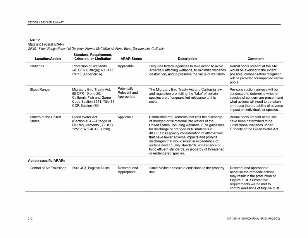
SECTION 2: DECISION SUMMARY
2-42 SAC/389146/102450026 (FINAL_SR401_ROD.DOC)
TABLE 2
State and Federal ARARsSR401 Skeet Range Record of Decision, Former McClellan Air Force Base, Sacramento, California
Location/ActionStandard, Requirement,Criterion, or Limitation ARAR Status Description Comment
Wetlands Protection of Wetlands(40 CFR 6.302(a); 40 CFRPart 6, Appendix A)
Applicable Requires federal agencies to take action to avoidadversely affecting wetlands, to minimize wetlandsdestruction, and to preserve the value of wetlands.
Vernal pools present at the sitewould be avoided to the extentpossible; compensatory mitigationwill be provided for impacted vernalpools.
Skeet Range Migratory Bird Treaty Act,50 CFR 10 and 20;California Fish and GameCode Section 3511; Title 14CCR Section 460
PotentiallyRelevant andAppropriate
The Migratory Bird Treaty Act and California lawand regulation prohibiting the “take” of certainspecies are of unquantified relevance to thisaction.
Pre-construction surveys will beconducted to determine whetherspecies of concern are present andwhat actions will need to be takento reduce the probability of adverseimpact on individuals or species.
Waters of the UnitedStates
Clean Water Act(Section 404)—Dredge orFill Requirements (33 USC1251-1376; 40 CFR 230)
Applicable Establishes requirements that limit the dischargeof dredged or fill material into waters of theUnited States, including wetlands. EPA guidelinesfor discharge of dredged or fill materials in40 CFR 230 specify consideration of alternativesthat have fewer adverse impacts and prohibitdischarges that would result in exceedance ofsurface water quality standards, exceedance oftoxic effluent standards, or jeopardy of threatenedor endangered species.
Vernal pools present at the sitehave been determined to bejurisdictional wetlands underauthority of the Clean Water Act.
Action-specific ARARs
Control of Air Emissions Rule 403, Fugitive Dusts Relevant andAppropriate
Limits visible particulate emissions to the propertyline.
Relevant and appropriatebecause the remedial actionsmay result in the production offugitive dust. Substantiverequirements will be met tocontrol emissions of fugitive dust.

SECTION 2: DECISION SUMMARY
SAC/389146/102450026 (FINAL_SR401_ROD.DOC) 2-43
TABLE 2
State and Federal ARARsSR401 Skeet Range Record of Decision, Former McClellan Air Force Base, Sacramento, California
Location/ActionStandard, Requirement,Criterion, or Limitation ARAR Status Description Comment
Hazardous WasteDetermination
22 CCR 66261.3(a)(2)(C)and (F)
Applicable toResourceConservation andRecovery Act(RCRA) orCaliforniahazardous waste
Provides specifications for determining whether awaste is a hazardous waste.
Hazardous waste determinationwill be made prior to transportingwaste offsite for disposal.
California HazardousWaste Control LawHazardous WasteDetermination
22 CCR 66261.21,66261.22(a)(1),66261.22(a)(2), 66261.23,and 66261.24(a)(1) orArticle 4, Chapter 11
Applicable toRCRA orCaliforniahazardous waste
Specifies that a solid waste is considered ahazardous waste if it exhibits any of thecharacteristics of ignitability, corrosivity, reactivity,or toxicity, if it is listed as a hazardous waste.
Toxicity Characteristic LeachingProcedure (TCLP) limits will beused to determine whetherexcavated soil is hazardous.
California HazardousWaste Determination
22 CCR 66261.24(a)(2) Applicable toCaliforniahazardous waste
Specifies that wastes can be classified asnon-RCRA, State-only hazardous wastes ifthey exceed the Soluble Threshold LimitConcentration (STLC) or Total Threshold LimitConcentration (TTLC) values. California hazardouswastes previously released into the environmentare considered hazardous substances underCalifornia law. New California hazardous wastesgenerated in the course of the response actionmust be properly managed as hazardous wastes.
TCLP limits will be used todetermine whether excavatedsoil is hazardous.
RCRA Hazardous WasteDetermination
22 CCR 66261.100 and66261.101(a)(1) and (a)(2)
Applicable toRCRA hazardouswaste
Provides specifications for determining whether awaste is a RCRA hazardous or RCRAnon-hazardous waste.
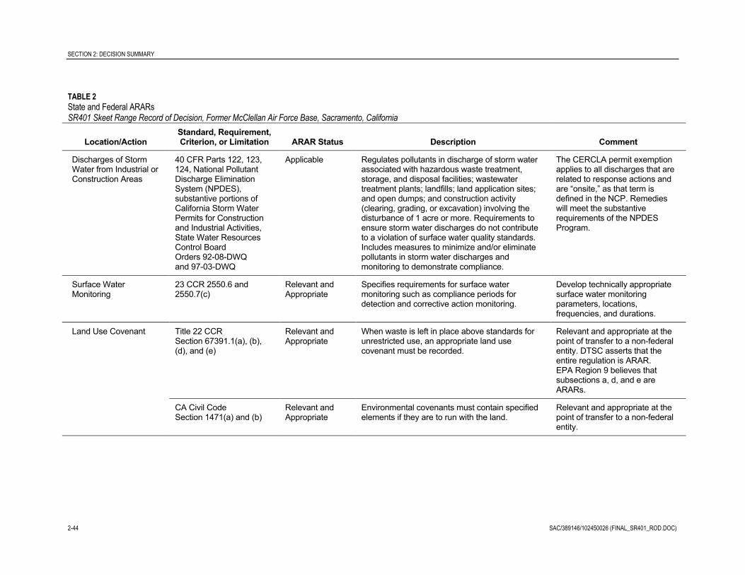
SECTION 2: DECISION SUMMARY
2-44 SAC/389146/102450026 (FINAL_SR401_ROD.DOC)
TABLE 2
State and Federal ARARsSR401 Skeet Range Record of Decision, Former McClellan Air Force Base, Sacramento, California
Location/ActionStandard, Requirement,Criterion, or Limitation ARAR Status Description Comment
Discharges of StormWater from Industrial orConstruction Areas
40 CFR Parts 122, 123,124, National PollutantDischarge EliminationSystem (NPDES),substantive portions ofCalifornia Storm WaterPermits for Constructionand Industrial Activities,State Water ResourcesControl BoardOrders 92-08-DWQand 97-03-DWQ
Applicable Regulates pollutants in discharge of storm waterassociated with hazardous waste treatment,storage, and disposal facilities; wastewatertreatment plants; landfills; land application sites;and open dumps; and construction activity(clearing, grading, or excavation) involving thedisturbance of 1 acre or more. Requirements toensure storm water discharges do not contributeto a violation of surface water quality standards.Includes measures to minimize and/or eliminatepollutants in storm water discharges andmonitoring to demonstrate compliance.
The CERCLA permit exemptionapplies to all discharges that arerelated to response actions andare “onsite,” as that term isdefined in the NCP. Remedieswill meet the substantiverequirements of the NPDESProgram.
Surface WaterMonitoring
23 CCR 2550.6 and2550.7(c)
Relevant andAppropriate
Specifies requirements for surface watermonitoring such as compliance periods fordetection and corrective action monitoring.
Develop technically appropriatesurface water monitoringparameters, locations,frequencies, and durations.
Land Use Covenant Title 22 CCRSection 67391.1(a), (b),(d), and (e)
Relevant andAppropriate
When waste is left in place above standards forunrestricted use, an appropriate land usecovenant must be recorded.
Relevant and appropriate at thepoint of transfer to a non-federalentity. DTSC asserts that theentire regulation is ARAR.EPA Region 9 believes thatsubsections a, d, and e areARARs.
CA Civil CodeSection 1471(a) and (b)
Relevant andAppropriate
Environmental covenants must contain specifiedelements if they are to run with the land.
Relevant and appropriate at thepoint of transfer to a non-federalentity.

SECTION 2: DECISION SUMMARY
SAC/389146/102450026 (FINAL_SR401_ROD.DOC) 2-45
2.11.3 Cost EffectivenessIn the Air Force’s judgment, the selected remedy for the SR401 Skeet Range (Excavation,Disposal, Revegetation, and Institutional Controls [Restricted Land Use]) is cost-effectiveand represents a reasonable value for the money to be spent. In making this determination,the following definition was used: “A remedy shall be cost-effective if its costs areproportional to its overall effectiveness” (NCP 300.430(f)(1)(ii)(D)). This was accomplishedby evaluating the “overall effectiveness” of those alternatives that satisfied the thresholdcriteria (i.e., protective of human health and the environment and ARAR compliant).Overall effectiveness was further evaluated by assessing the balancing criteria (long-termeffectiveness and permanence; reduction in toxicity, mobility, and volume throughtreatment; short-term effectiveness; and implementability). Overall effectiveness was thencompared with costs to determine cost effectiveness.
The present-worth cost for 30 years is $3,064,000. A detailed cost analysis for the selectedremedy is presented in the RI/FS, Appendix F (CH2M HILL, 2010b). Costs were estimatedin accordance with EPA guidelines (EPA, 2000). Per the guidelines, the discount rate usedfor the calculations was 2.7 percent and was taken from Appendix C of the Office ofManagement and Budget Circular A-94 (January 2008) for real discount rates over a 30-yearperiod.
Figure 11 summarizes the costs and provides the information needed to evaluate the costeffectiveness of the selected remedy. For each alternative, information is presented on thethreshold and balancing criteria.
2.11.4 Use of Permanent Solutions and Alternative Treatment Technologies orResource Recovery Technologies
The selected remedy would provide permanent and long-term effectiveness in protectinghuman health and the environment to the extent that the COCs are physically removed. TheAir Force has determined that the selected remedy represents the maximum extent to whichpermanent solutions and treatment technologies or resource recovery technologies can beused in a practicable manner at the SR401 Skeet Range. The selected remedy for the SR401Skeet Range provides the best balance of trade-offs in terms of the five balancing criteriaand State and community acceptance.
2.11.5 Preference for Treatment as a Principal ElementRemedies that employ treatment as a principal element to permanently and significantlyreduce the volume, toxicity, or mobility of hazardous substances, pollutants, orcontaminants are preferred. The offsite requirements of CERCLA 121(b)(1) require that theoffsite disposal of hazardous or contaminated media without treatment is the least preferredalternative when practicable treatment technologies are available. The statutory preferencefor treatment is met, in that treatment of contaminated soil will occur as needed at the offsitedisposal facility. Alternatives with treatment applied at the site were either not effective ornot cost-effective.
SECTION 3: RESPONSIVENESS SUMMARY
2-46 SAC/389146/102450026 (FINAL_SR401_ROD.DOC)
2.11.6 Five-year Review RequirementsBecause the selected remedy will result in hazardous substances remaining onsite abovelevels that allow for unrestricted uses and unlimited exposures, reviews will be requiredevery 5 years to determine if the remedy remains effective and protective of human healthand the environment. Typical information recorded during the review process will includethe status of the ICs, any changes in the land use, any changes to the site, and how thechanges were addressed. Reviews will continue until all COCs are reduced to levels that aresafe for unrestricted use and unlimited exposure. The next basewide five-year review isscheduled to be conducted no later than September 29, 2014.
2.12 Documentation of Significant ChangesThe Selected Remedy does not include significant changes from the Preferred Alternativepresented in the Proposed Plan for the SR401 Skeet Range.

SAC/389146/102450026 (FINAL_SR401_ROD.DOC) 3-1
SECTION 3
3.1 Background of Community InvolvementA proposed plan and public comment period are key parts of the decision-making processbecause the Air Force uses community input when making cleanup decisions. The proposedplan for this ROD was available for review during a public comment period from July 7through August 9, 2010. A public notice announced the start of the public comment period.
The Proposed Plan was available for review at the McClellan Information Repository, on theAFRPA online Administrative Record, and at the North Highland-Antelope Public Library.In addition, a public meeting was held on July 15, 2010, to explain the Proposed Plan and tosolicit comments from the public. Prior to the meeting, a fact sheet summarizing theProposed Plan and announcing the public comment period and meeting was distributed tothe entire mailing list. The public was encouraged to review the document and providecomments, either orally or in writing, about the cleanup alternatives presented in theProposed Plan.
3.2 Summary of Significant Comments ReceivedThe Air Force received five comments from members of the public during the publiccomment period. Their comments and the Air Force responses are provided below.Two people commented at the public meeting and three provided written comments duringthe public comment period. Specific comments and Air Force responses are provided below.The public comments did not result in modification of the preferred cleanup alternativespresented in the Proposed Plan.
3.2.1 Significant Comments Received during the July 15, 2010, Public Meetingand Air Force Responses
Mr. Burl Taylor: I think it’s pretty well summed up in there on the site. I was concerned about theammo dump. And I think—Is the ammo dump part of this area?
Note: This comment was preceded by a question from Mr. Taylor regarding the cleanup of the formershooting range at Camp Kohler in what is now Rosario Park. He asked if it could be investigatedfurther as part of the Skeet Range investigation and cleanup program.
Air Force Response: The former ammunitions dump is not part of the Skeet Range site.
Regarding Camp Kohler, the USACE is responsible for the site and the DTSC is activelyengaged in the USACE’s actions there.

SECTION 3: RESPONSIVENESS SUMMARY
3-2 SAC/389146/102450026 (FINAL_SR401_ROD.DOC)
Mr. Glenn Jorgensen: Okay. Regarding the mitigation for the vernal pools. I know you have saidtonight that you are going to propose doing some mitigation over in the West Nature Area. I wouldjust like to request that those mitigation plans and whatever cost or monies deposited with the ArmyCorps of Engineers or whatever be outlined in the Record of Decision so that it’s available to thepublic. Thank you.
Air Force Response: The specifics of the mitigation are being negotiated with the USACEand the USFWS; however, the ROD identifies that mitigation will be accomplished throughthe purchase of habitat mitigation credits in a mitigation bank approved by the USFWS andthe USACE. The mitigation plan will be further addressed in the Remedial Designdocument for the SR401 Skeet Range cleanup. In addition, the USFWS will issue a BiologicalOpinion on the mitigation. Both documents will be available to the public.
3.2.2 Written Comments Received during the Public Comment Period andAir Force Responses
Anonymous: Who is auditing the distribution of all monies for this purpose?
Air Force Response: The SR401 Skeet Range cleanup will be accomplished through acompetitive firm-fixed-price contract from the Air Force Center for Engineering and theEnvironment (AFCEE). Payments will be milestone-based, overseen by the AFCEEcontracting officer and his or her technical representative. In general, AFCEE contracts aresubject to audits by, but not limited to, the Air Force Audit Agency, the Air Force InspectorGeneral, the Department of Defense Inspector General, and the Government AccountabilityOffice.
Mr. Clarence Howard: I agree that the McClellan Skeet Range should be cleaned up, and I also agreewith the Air Force Proposed Plan. I believe the cleanup should be accomplished at the lowest cost.
Air Force Response: Thank you for your input.
Kit Rodden, President and CEO, Battery M.D., Inc.: Battery M.D. (Bldg 1093 tenant) votes forOption 2B. Battery M.D. has express interest in past in buying land/building but will only do that ifland is clean/unrestricted and does not need future monitoring or cleanup efforts.
Air Force Response: Only a small portion of the southwestern corner of the Building 1093lot would be impacted by the proposed ICs. The proposed ICs would restrict current andfuture land use to industrial, which is the current and future zoning for the area. Under theselected remedy, there would not be a need for future cleanup beyond what is described.Monitoring would be part of the 5-year monitoring as required by CERCLA to verify thatthe ICs are being enforced and are effective. In addition, the transferee or subsequentproperty owner(s) will be responsible for conducting annual physical inspections of theSR401 Skeet Range to confirm continued compliance with all IC objectives and will also beresponsible for providing to the Air Force, EPA, and DTSC an annual monitoring report onthe status of the ICs.
The Air Force still believes that the selected remedy is the appropriate cleanup action for theSR401 Skeet Range site. Given the current and anticipated future industrial land use, thisremedy is protective of human health and the environment and complies with state andfederal laws.

SAC/389146/102450026 (FINAL_SR401_ROD.DOC) 4-1
SECTION 4
Air Force Real Property Agency (AFRPA). 2008. Former McClellan Air Force Base Visual SiteInspection Report, Skeet Range. October.
CH2M HILL. 2010a. Proposed Plan for the SR401 Skeet Range. Prepared for the formerMcClellan Air Force Base. Final. July.
CH2M HILL. 2010b. SR401 Skeet Range Remedial Investigation/Feasibility Study. Prepared forthe former McClellan Air Force Base. Final. April.
CH2M HILL. 2009. SR401 Skeet Range Investigation Work Plan. Prepared for the formerMcClellan Air Force Base. Final. September.
Department of the Air Force. 1998. Lease of Property on Former McClellan Air Force Base,California. Lease No. BCA-MCC-12-98-0801. August.
Interstate Technology and Regulatory Council (ITRC). 2003. Characterization and Remediationof Soils at Small Closed Arms Firing Ranges.
U.S. Environmental Protection Agency (EPA). 2000. A Guide to Developing and DocumentingCost Estimates During the Feasibility Study. OSWER 9355.0-75. July.
U.S. Environmental Protection Agency (EPA). 1999. A Guide to Preparing Superfund ProposedPlans, Records of Decision, and Other Remedy Selection Decision Documents. EPA 540-R-98-031.OSWER 9200.1-23P. July.

Appendix AScreening Levels and Background Levels
for Soil and Sediment

SAC/371845/093010003 (FINAL_SR401_ROD.DOC) A-1
APPENDIX A
This appendix contains material published in the Final SR401 Skeet Range RemedialInvestigation/Feasibility Study, Former McClellan Air Force Base, California (CH2M HILL, 2010).

Groundwater Surface Water
Contaminant
Unrestricted Use Surface and
Shallow Soils(0 to 15 ft bgs)
Industrial Use Surface and
Shallow Soils(0 to 15 ft bgs)
Surface, Shallow, and Deep Soils
(0 to 30 ft bgs)Surface Soils(0 to 1 ft bgs)
Inorganics (mg/kg)Antimonyc,e 1.4E+01 3.7E+02 6.0E+02 1.9E+02 5 -- 3Arsenicd,f 9.3E-02 1.4E+00 3.3E+00 5.8E-01 18 43 9.79Copperd,f 1.4E+03 3.7E+04 2.5E+05 1.3E+02 70 28 31.6Irona,g 2.4E+04 6.4E+05 9.1E+04 9.6E+03 -- -- 20000Leadd,f 1.5E+02 8.0E+02 4.3E+03 2.9E+01 120 11 35.8Zinca,d,f 3.1E+03 2.8E+05 1.4E+05 1.7E+03 160 46 121
PAHs (mg/kg)Acenaphtheneb,c,h 2.9E+02 1.6E+04 1.6E+04 6.4E+02 20 -- 0.00671Acenaphthyleneh -- -- -- -- -- -- 0.00587Anthracenea,b,f 2.3E+03 1.0E+05 1.0E+05 3.1E+05 -- -- 0.0572Benzo(a)anthracenej 8.8E-02 8.8E-01 2.1E+01 1.4E-01 -- -- 0.0748Benzo(a)pyrenef 1.8E-02 1.4E-01 3.7E+01 1.4E-01 -- -- 0.15Benzo(b)fluoranthene 1.1E-01 8.8E-01 4.0E+01 1.4E-01 -- -- --Benzo(g,h,i)peryleneg 7.5E+02 1.1E+04 1.1E+04 -- -- -- 0.17Benzo(k)fluoranthenei 1.1E-01 8.8E-01 1.3E+01 1.4E-01 -- -- 0.0272Chryseneb,f 8.8E-01 8.7E+00 2.5E+01 1.4E-01 -- -- 0.166Dibenzo(a,h)anthracenei 3.8E-02 2.6E-01 7.8E+00 1.4E-01 -- -- 0.1Fluoranthenef 4.9E+02 1.5E+04 1.5E+04 9.6E+03 -- -- 0.423Fluoreneb,f 2.4E+02 1.3E+04 1.3E+04 4.2E+04 -- -- 0.0774Indeno(1,2,3-cd)pyrenei 1.2E-01 8.8E-01 2.2E+01 1.4E-01 -- -- 0.01732Naphthalenef 2.4E+00 5.1E+00 5.1E+00 6.7E+02 -- -- 0.176Phenanthrenef 2.6E+03 1.1E+05 1.1E+05 -- -- -- 0.204Pyreneb,f 3.5E+02 1.1E+04 1.1E+04 3.1E+04 0.195Total PAHsg -- -- -- -- -- -- 1.61
b The listed risk-based concentrations exceed the soil saturation concentration (EPA Region 9 default soil properties for PRGs) for acenapthene (1.3E+02 mg/kg), anthracene (6.1E+00 mg/kg), chrysene (3.8E+00 mg/kg), fluorene (1.6E+02 mg/kg), and pyrene (8.5E+01 mg/kg).
TABLE C1-13Screening Levels for Soil/SedimentSR401 Skeet Range RI/FS, Former McClellan Air Force Base, Sacramento, California
Screening Levels for Protection of
g Lowest effect level (LEL) from SQuiRTs developed by Buchman (2008) of NOAA
j Source of effects value is EPA IV: USEPA. 2001. Supplemental Guidance to RAGS: Region 4 Bulletins, Ecological Risk Assessment. Originally published November 1995. Website version last updated November 30, 2001 http://www.epa.gov/region4/waste/ots/ecolbul.htm.
h Threshold effect level (TEL) from SQuiRTs developed by Buchman (2008) of NOAAi ARCS Hyalella TEL from SQuiRTs developed by Buchman (2008) of NOAA
f Source of threshold effect concentration (TEC) for benthic invertebrates is Development and Evaluation of Consensus-Based Sediment Quality Guidelines for Freshwater Ecosystems (MacDonald et al., 2000)
Ecological ReceptorsHuman Health
c Source of ecological screening level is Toxicological Benchmarks for Screening Contaminants of Potential Concern for Effects on Terrestrial Plants: 1997 Revision (Efroymson et al., 1997)
AvianSurface Soils(0 to 1 ft bgs)
Benthic Invertebrates
Sediment(0 to 0.25 ft
-- = a screening level was not developedNote:
PlantsSurface and
Shallow Soils(0 to 4 ft bgs)
a EPA Region 9 recommends that a “ceiling limit” of 1E+05 be used when the risk-based value is higher. Documentation accompanying the PRGs also acknowledges that this recommendation is not a universally accepted approach.
d Source of ecological screening level is EPA’s Ecological Soil Screening Levels (http://www.epa.gov/ecotox/ecossl/)e Upper effects threshold (UET) from the Screening Quick Reference Tables (SQuiRTs) developed by Buchman (2008) of the National Oceanic and Atmospheric Administration (NOAA)
SCO/389146/101030009 (App. C1 excel tables_DRD2535.xls) 1 OF 1

ATTACHMENT C1-1Background LevelsSR401 Skeet Range RI/FS, Former McClellan Air Force Base, Sacramento, California
Residential PRGs Surface Soils Sediments Silts and Clays Sands CombinedAnalyte Method (mg/kg) (mg/kg) (N=27) (mg/kg) (N=15) (mg/kg) (N=69) (mg/kg) (N=51) (mg/kg) (N=162)
Antimony* SW6010 31 10 10 20 20 10
Arsenic SW7060 0.97 ca 5.8 (I)/2.8 (II,III,IV) 3.6 6.5 3.7 4.9
Copper SW6010 2,900 23.6 45.4 41.4 26.7 36.5
Iron SW6010 NE 23,597 25,529 46,293 34,759 39,695
Lead SW7421 500 137 150 15.9 6.8 74.0
Zinc SW6010 23,000 159.0 374 85.8 58.6 156
*Background established as reporting limit for this analyte
Notes:
Source of background levels is the Interim Basewide Report, McClellan AFB. All background levels calculated as the mean plus two times the standard deviation for the data set unless established as the reporting limit.I, II, III, IV = background study landscape typesca = carcinogenn = number of samplesNE = not establishedPRG = Preliminary Remediation Goal, EPA Region 9
SCO/389146/101030006 (App. C1_Attach C1_DRD2534.xls) 1 OF 1

Appendix BScreening Level Human Health Risk Assessment

SAC/389146/102450026 (FINAL_SR401_ROD.DOC) B-1
APPENDIX B
This appendix contains material published in the Final SR401 Skeet Range RemedialInvestigation/Feasibility Study, Former McClellan Air Force Base, California (CH2M HILL, 2010).

Appendix C2 Screening Human Health Risk Assessment
SAC/389146/093330005 (APPENDIX C2.DOC) C2-iii
Contents
Section Page
Acronyms and Abbreviations ...................................................................................................... C2-v C2.1 Introduction ....................................................................................................................... C2-1
C2.1.1 Objectives ........................................................................................................ C2-1 C2.1.2 Scope ................................................................................................................ C2-2 C2.1.3 Guidance Documents .................................................................................... C2-2 C2.1.4 Organization ................................................................................................... C2-2
C2.2 Site Background ................................................................................................................ C2-3 C2.3 Conceptual Site Model ..................................................................................................... C2-3 C2.4 Selection of Chemicals of Potential Concern ................................................................ C2-4
C2.4.1 Chemicals Considered to Be Essential Human Nutrients ........................ C2-4 C2.4.2 Background Levels ......................................................................................... C2-4
C2.5 Exposure Assessment ...................................................................................................... C2-6 C2.5.1 Potentially Complete Exposure Pathways ................................................. C2-6 C2.5.2 Computation of Exposure Point Concentrations ....................................... C2-7 C2.5.3 Human Health Exposure Assumptions ...................................................... C2-7
C2.6 Toxicity Assessment ......................................................................................................... C2-8 C2.6.1 Hazard Characterization ............................................................................... C2-8 C2.6.2 Dose-response Evaluation ............................................................................. C2-8 C2.6.3 Toxicity Values ............................................................................................... C2-8
C2.7 Risk Characterization ..................................................................................................... C2-10 C2.7.1 Soil Cancer and Noncancer Risk Estimation Method ............................. C2-10 C2.7.2 Evaluation of Exposure to Lead ................................................................. C2-10
C2.8 Uncertainty Analysis ...................................................................................................... C2-11 C2.8.1 Sampling and Analysis ................................................................................ C2-11 C2.8.2 COPC Selection Process .............................................................................. C2-11 C2.8.3 Exposure Assumptions................................................................................ C2-12 C2.8.4 Toxicity Values ............................................................................................. C2-13
C2.9 Human Health Risk Assessment for SR401 Skeet Range ......................................... C2-14 C2.9.1 Results ............................................................................................................ C2-14
C2.10 References ........................................................................................................................ C2-14 Attachment C2-1 Site-specific Risk Summary Tables Based on Cal/EPA Toxicity Criteria
Tables
1 Soil Risk Summary for SR401 Skeet Range Using Cal/EPA Toxicity Criteria Hierarchy- Residential Scenario
2 Soil Risk Summary for SR401 Skeet Range Using Cal/EPA Toxicity Criteria Hierarchy – Occupational Worker Scenario

SAC/389146/093330005 (APPENDIX C2.DOC) C2-v
Acronyms and Abbreviations
AFCEE Air Force Center for Engineering and the Environment
bgs below ground surface
Cal/EPA California Environmental Protection Agency
COPC contaminant of potential concern
CSM conceptual site model
DTSC Department of Toxic Substances Control
EPA U.S. Environmental Protection Agency
EPC exposure point concentration
FS feasibility study
HEAST Health Effects Assessment Summary Table
HI hazard index
HQ hazard quotient
IRIS Integrated Risk Information System
LOAEL lowest observed adverse effects level
mg/kg milligram(s) per kilogram
mg/kg-day milligram(s) per kilogram per day
NCEA National Center for Environmental Assessment
NOAEL no observed adverse effects level
PAH polynuclear aromatic hydrocarbon
PRG preliminary remediation goal
RBSL risk-based screening level
REL reference exposure level
RfC reference concentration
RfD reference dose
RICS remedial investigation characterization summaries
RI/FS remedial investigation/feasibility study
RME reasonable maximum exposure

ACRONYMS AND ABBREVIATIONS
C2-vi SAC/389146/093330005 (APPENDIX C2.DOC)
ROD record of decision
SLHHRA screening-level human health risk assessment
UCL upper confidence limit
URF unit risk factor
USAF U.S. Air Force
VOC volatile organic compound
SAC/389146/093330005 (APPENDIX C2.DOC) C2-1
APPENDIX C2
Screening Human Health Risk Assessment
C2.1 Introduction This appendix to the SR401 Skeet Range (Skeet Range) Remedial Investigation (RI)/ Feasibility Study (FS) report presents the screening-level human health risk assessment (SLHHRA) methods and results for the Skeet Range at the former McClellan Air Force Base (McClellan), located in Sacramento, California. The SLHHRA was completed to support the Skeet Range RI/FS.
The location of McClellan is shown on Figure 1-1 in Section 1 of the RI/FS report. The location of the Skeet Range is shown on Figure 1-2 in Section 1 of the RI/FS report.
C2.1.1 Objectives The SLHHRA was conducted to provide risk managers with a basis for evaluating whether action is warranted to mitigate potential health effects from chemicals in soil. This screening assessment was accomplished by characterizing potential cancer risks and risks of adverse noncancer health effects associated with chemicals at the site. The SLHHRA considers baseline conditions, that is, a case in which no remedy is implemented for chemical contamination at the site.
The methodology used for this SLHHRA is generally consistent with the risk assessment procedures developed in the McClellan Air Force Base, Operable Unit A, Part 2A – Interim Basewide Remedial Investigation Characterization Summaries (RICS) (Jacobs, 2001). However, the risk assessment procedures used for the McClellan RI program have been revised over time in response to input from regulatory agencies, updates to state and federal risk assessment guidance, and updates to toxicity values used in the risk calculations. These updates have been incorporated, as appropriate, into the SLHHRA methodology used for McClellan. Risk-based screening levels for soil were developed for the RI/FS and have been revised, as appropriate, when updated toxicity factors are published by the U.S. Environmental Protection Agency (EPA) or California Environmental Protection Agency (Cal/EPA).
The methodology used for the SLHHRA is consistent with the risk assessment procedures presented to the regulatory agencies in a meeting on 26 June 2008. In this meeting, a streamlined, screening risk assessment approach was agreed to by the regulatory agencies. The screening risk assessment approach includes quantitative evaluation of two receptor groups, industrial workers and hypothetical future residents, using maximum detected concentrations in the 0 to 10 feet bgs depth interval for soil. Although uncertainties exist and the degree of characterization differs among sites, the use of the SLHHRA, in conjunction with risk-based screening levels (RBSLs) for this effort (see Appendix C1), provides sufficient information for the remedial project managers to identify sites with potential impacts to human health and to evaluate appropriate remedial actions.

APPENDIX C2: SCREENING HUMAN HEALTH RISK ASSESSMENT
C2-2 SAC/389146/093330005 (APPENDIX C2.DOC)
C2.1.2 Scope The SLHHRA provides an evaluation of potential exposure to metals (lead, arsenic, antimony, copper, iron, and zinc) from shot pellets and polynuclear aromatic hydrocarbons (PAHs) associated with clay shards (from clay pigeons) in soil and sediment at the Skeet Range. Calculations are not included for the soil gas or groundwater pathways because characterization of these media was not a part of this investigation. More information on the status and current groundwater conditions at McClellan can be found in the Basewide VOC Groundwater Record of Decision (CH2M HILL, 2007), the Remedial Investigation/Feasibility Study for Non-VOCs in Groundwater (CH2M HILL, 2008), and the Groundwater Monitoring Program quarterly reports. Groundwater use restrictions for McClellan can also be found in the VOC ROD.
C2.1.3 Guidance Documents The methods that were used to conduct the SLHHRA are consistent with the following federal and state (i.e., EPA and DTSC) guidance documents:
Risk Assessment Guidance for Superfund, Volume I: Human Health Evaluation Manual, Part A (Interim Final) (EPA, 1989)
Exposure Factors Handbook, Volume I General Factors (EPA, 1997)
Risk Assessment Guidance for Superfund, Volume I: Human Health Evaluation Manual, (Part E, Supplemental Guidance for Dermal Risk Assessment) Final (EPA, 2004a)
Supplemental Guidance for Human Health Multimedia Risk Assessments of Hazardous Waste Sites and Permitted Facilities (DTSC, 1992)
Recommended DTSC Default Exposure Factors for Use in Risk Assessment at California Military Facilities (DTSC, 2005)
C2.1.4 Organization The remainder of this appendix is organized into the following sections:
Section C2.2: Site Background. Briefly summarizes the environmental investigations at the site.
Section C2.3: Conceptual Site Model. Provides a description of potential chemical sources, migration pathways, and potential human receptors.
Section C2.4: Selection of Contaminants of Potential Concern. Identifies the chemicals considered to be most important to the human health risk quantification process.
Section C2.5: Exposure Assessment. Identifies the pathways by which potential human exposures could occur; describes how they are evaluated; and evaluates the magnitude, frequency, and duration of these exposures.
Section C2.6: Toxicity Assessment. Provides a general summary of the toxicity assessment and references the toxicity value tables in Appendix C1 that were used for the risk calculations.

APPENDIX C2: SCREENING HUMAN HEALTH RISK ASSESSMENT
SAC/389146/093330005 (APPENDIX C2.DOC) C2-3
Section C2.7: Risk Characterization Methodology. Describes the methods used to integrate the information from the exposure and toxicity assessments to characterize the risks to human health from potential exposure to chemicals in environmental media.
Section C2.8: Uncertainty Analysis. Summarizes the uncertainties associated with results of the SLHHRA, as well as limitations of data and methodology.
Section C2.9: Human Health Risk Assessment for Skeet Range. Presents an overall summary of the risk and hazard results.
Section C2.10: References.
C2.2 Site Background See Section 1 of the RI/FS report for site background information.
C2.3 Conceptual Site Model This section presents a general description of the McClellan conceptual site model (CSM). The principal components of a CSM include:
Identification and characterization of contaminant sources Identification of potential contaminant migration pathways Identification of potential receptors
Contaminant releases at McClellan have resulted primarily from routine operations and maintenance activities, aviation support operations, vehicle and facility maintenance activities, accidental spills and releases, and onsite storage or disposal of hazardous materials and other activities, including shot pellets and clay shards associated with Skeet Range activities. Examples of potential sources of contamination for McClellan include the following:
Aboveground storage tanks Underground storage tanks Pipelines and underground fuel lines Aircraft, vehicle, and equipment maintenance facilities Waste storage facilities Industrial waste lines Surface spills and releases Surface drainage areas Oil/water separators Drains and sumps Transformers Fire Arm/Skeet Ranges
Details of the CSM for the Skeet Range are provided in Section 1.4 of the RI/FS report. Metals and PAHs were detected in samples collected at the site and identified as contaminants of potential concern (COPCs) for the SLHHRA. The release of these chemicals from soil may occur through wind erosion, mechanical erosion (e.g., excavation), leaching,

APPENDIX C2: SCREENING HUMAN HEALTH RISK ASSESSMENT
C2-4 SAC/389146/093330005 (APPENDIX C2.DOC)
or stormwater runoff. These types of releases may result in emissions in air of dust (with sorbed chemicals), chemical contamination in stormwater runoff, or the movement of chemicals downward into the subsurface with infiltrating rainwater, depending on site conditions and the physical and chemical properties of the COPCs.
Based on the McClellan Reuse Plan (EDAW, 2000) and the McClellan Park Special Planning Area (Sacramento County Ordinance No. SZC-2002-0029), future use of the site will be for industrial and commercial purposes. Although residential land use is not planned for the Skeet Range at this time, residential exposure scenarios were evaluated in the SLHHRA to provide information for future risk management decisions. The potential receptors evaluated in the SLHHRA include outdoor commercial/industrial workers and future residents (adults and children; indoor and outdoor exposure). Specific land use restrictions will be identified in the record of decision.
C2.4 Selection of Chemicals of Potential Concern COPCs are constituents that are included in the quantitative exposure estimation and risk characterization steps of the SLHHRA. Analytical data used to select the COPCs include those from surface and shallow soil (defined as the 0 to 3 feet below ground surface [bgs] depth interval) and surface sediment (0 to 0.5 foot bgs). All detected organic compounds were retained as COPCs. Some inorganic compounds are considered to be beneficial to human health or may be present only at naturally occurring levels. For this reason, an inorganic chemical was retained as a COPC for soil if:
It was detected in a depth interval for which at least one exposure pathway was considered to be complete.
It is not an essential human nutrient (EPA, 1989).
Detected concentrations were not representative of ambient levels at McClellan.
C2.4.1 Chemicals Considered to Be Essential Human Nutrients Elements considered to be essential human nutrients (i.e., calcium, iron, magnesium, potassium, and sodium) were eliminated as COPCs. EPA and DTSC guidance state that these elements can be deleted from the list of COPCs because of their low toxicity when detected at ambient concentrations (EPA, 1989; DTSC, 1992). Even if these constituents are present at concentrations above naturally occurring levels, they are eliminated as COPCs because they are toxic only at very high doses.
C2.4.2 Background Levels Metals considered to be representative of background were eliminated as COPCs. Background levels in soils at McClellan have been established for 24 inorganic analytes for surface soils, and for subsurface soils by soil type (i.e., silts and clays or sands) (AFCEE, 1994). For seven inorganic analytes (antimony, cadmium, mercury, molybdenum, selenium, silver, and thallium) where the percentage of non-detects was greater than 80 percent in the background data set, the background level was established as the method reporting limit for the analyte. Background levels for the remaining analytes were established as the mean

APPENDIX C2: SCREENING HUMAN HEALTH RISK ASSESSMENT
SAC/389146/093330005 (APPENDIX C2.DOC) C2-5
concentration plus two deviations for the background data set. Background levels for inorganic chemicals detected at the Skeet Range are presented in Attachment C1-1 of Appendix C1.
A two-step process was used to determine if metals concentrations were significantly different from background levels. For the first step, a metal was considered to be present at background levels and was eliminated as a COPC if the maximum detected concentration was below its established background level. Site data from the 0 to 3 feet bgs depth interval were compared to the lowest of the lithology-specific background levels. If the maximum detected concentration exceeded the lowest of the lithology-specific background levels, the Mann-Whitney test was used to determine if the central tendencies of the concentrations of metals in the site data set were significantly different than the background data set (DTSC, 1997). If the Mann-Whitney test indicated that there is not a significant difference between concentrations in the site data set and background data set, the metal was eliminated as a COPC.
Comparisons of central tendency are described in numerous guidance documents (DTSC, 1997; EPA, 1998; 2001) as appropriate methods to compare site data to background data. Such comparisons include the two-sample t-test and the Mann-Whitney test (or the Wilcoxon Rank Sum Test). Although DTSC guidance discusses both, it emphasizes the Mann-Whitney test because it does not depend on a parametric (distributional) assumption, such as normality.
The Mann-Whitney test makes use of the sum of the ranks of the ordered (smallest to largest concentration for the combined two data sets) concentrations to determine whether the mean of the ranks of the site concentrations is unexpectedly larger than the mean of the ranks of the background concentrations.
A central tendency background comparison is typically performed using a one-tailed significance level of 0.20. The one-tail method determines whether site concentrations exceed ambient concentrations, not whether ambient concentrations exceed site concentrations. The significance level of 0.20 is typically the appropriate one for comparisons of background to site populations (EPA, 1992; 2001). This significance level corresponds to a one-in-five chance of falsely concluding that the site population exceeds background.
When the p-value of the Mann-Whitney test falls below 0.20, this indicates that the site population exceeds the background population. If the p-value is not less than 0.20, the conclusion that the site population does not exceed background is accepted. This p-value is the probability that the differences observed between the site and background sample concentrations would occur randomly if both populations were actually equivalent.

APPENDIX C2: SCREENING HUMAN HEALTH RISK ASSESSMENT
C2-6 SAC/389146/093330005 (APPENDIX C2.DOC)
C2.5 Exposure Assessment The exposure assessment component of the SLHHRA identifies the means by which individuals may contact chemicals in environmental media at the site. It addresses exposures that may result under current site conditions and from reasonably anticipated potential uses of the site and the surrounding areas in the future. In addition, for this SLHHRA, the hypothetical future residential scenario is included to provide information for future risk management decisions. The exposure assessment also identifies the populations that might be exposed; the routes by which these individuals might become exposed; and the magnitude, frequency, and duration of potential exposures.
The exposure assessment step of an SLHHRA includes the following tasks:
Identification of potentially complete exposure pathways Computation of exposure point concentrations (EPCs) Development of exposure assumptions for potentially complete exposure pathways Calculation of chemical intake for COPCs
C2.5.1 Potentially Complete Exposure Pathways This section describes the potential exposure pathways resulting from site contaminants, based on currently available site information. The conceptual exposure model is formulated according to agency guidance, with the use of professional judgment and information on contaminant sources, release mechanisms, routes of migration, potential exposure points, potential routes of exposure, and potential receptor groups associated with the site.
An exposure pathway can be described as the physical course that a COPC takes from the point of release to a receptor. Chemical intake or route of exposure is the means by which a COPC enters a receptor. For an exposure pathway to be complete, all of the following components must be present:
A source A mechanism of chemical release and transport An environmental transport media An exposure point An exposure route A receptor or exposed population
In the absence of any one of these components, an exposure pathway is considered incomplete and, by definition, there is no risk or hazard.
C2.5.1.1 Contaminant Sources and Releases The primary potential source of contamination at the Skeet Range is related to use of the site as a skeet and trap range. Potential contaminants based on the history of the site include metals and PAHs.

APPENDIX C2: SCREENING HUMAN HEALTH RISK ASSESSMENT
SAC/389146/093330005 (APPENDIX C2.DOC) C2-7
C2.5.1.2 Potentially Complete Human Exposure Settings Based on the current understanding of land use conditions at and near the Skeet Range the most plausible exposure pathways that are considered for characterizing human health risks include the following:
Outdoor Occupational Worker Scenario. The outdoor occupational worker scenario is considered representative of future workers at a site who spend all of their workday outdoors. The outdoor occupational worker is assumed to work 50 weeks per year (250 days per year) for 25 years. The outdoor worker may be exposed to COPCs through direct contact routes (i.e., incidental ingestion of soil, dermal contact with soil, and inhalation of particulates).
As described previously, the current reuse plans for the Skeet Range are commercial/industrial land use, and it is unlikely that the area will be developed for residential purposes in the future. However, the hypothetical future residential scenario was evaluated to provide results for an unrestricted use scenario for future risk management purposes. It is assumed that residents spend the entire day at home 7 days per week for 50 weeks per year (350 days per year) for 30 years. Evaluated routes of exposure to soil include ingestion (incidental soil and homegrown produce), dermal contact, and inhalation of dust generated from wind. Based on the agreement between the U.S. Air Force (USAF) and regulatory agencies made at the 26 June 2008, meeting, data collected from the 0 to 10 feet bgs depth interval should be evaluated in the SLHHRA. For the Skeet Range, data were only collected from 0 to 3 feet bgs, based on the distribution of shot pellets and clay shards in sediment and surface and subsurface soil at the site.
C2.5.2 Computation of Exposure Point Concentrations EPCs are estimated chemical concentrations that a receptor might contact, and are specific to each exposure medium. The maximum detected concentrations from the soil (0 to 3 feet bgs depth interval) and sediment data sets were used as the soil EPCs. The entire Skeet Range is considered a single exposure area. An exposure area is the area in which receptors may work on a regular basis. In general, the administrative site boundaries plus soil borings used for site characterization comprise the soil exposure areas. For the incidental ingestion, dermal contact, and inhalation routes of exposure for soil/sediment, EPCs are represented by the maximum detected concentrations directly measured in soil/sediment.
C2.5.3 Human Health Exposure Assumptions The estimation of exposure requires numerous assumptions to describe potential exposure situations. A combination of central tendency and upper-bound exposure assumptions are used to estimate reasonable maximum exposure (RME) conditions to provide a bounding estimate on exposure.
Risk and hazard were calculated by the risk ratio approach using RBSLs for commercial/industrial land use or residential land use and the EPCs (i.e., maximum detected concentrations of each COPC in soil and sediment). Details of the methodology for calculating risk and hazard are presented in Section C2.7.1. Appendix C1 presents the exposure assumptions and methodology for the derivation of the RBSLs.

APPENDIX C2: SCREENING HUMAN HEALTH RISK ASSESSMENT
C2-8 SAC/389146/093330005 (APPENDIX C2.DOC)
C2.6 Toxicity Assessment The toxicity assessment in an SLHHRA evaluates the relationship between the magnitude of exposure to a chemical and the likelihood of adverse health effects to potentially exposed populations. This assessment provides, where possible, a numerical estimate of the increased likelihood of adverse effects associated with chemical exposure (EPA, 1989). The toxicity assessment contains two steps: hazard characterization and dose-response evaluation. These two components are discussed in the following two subsections.
C2.6.1 Hazard Characterization Hazard characterization identifies the types of toxic effects a chemical can exert. For the toxicity assessment, chemicals can be divided into two broad groups on the basis of their effects on human health: non-carcinogens and carcinogens. This classification has been selected because health risks are calculated differently for carcinogenic and non-carcinogenic effects, and separate toxicity values have been developed for them.
Carcinogens are those chemicals suspected of causing cancer following exposure; non-carcinogenic effects cover a wide variety of systemic effects, such as liver toxicity or developmental effects. Some chemicals (such as arsenic) are capable of eliciting both carcinogenic and non-carcinogenic responses; therefore, these carcinogens are also evaluated for systemic (non-carcinogenic) effects.
C2.6.2 Dose-response Evaluation The magnitude of chemical toxicity depends on the dose to a receptor. Dose refers to exposure to a chemical concentration over a specified period of time. Human exposures are generally classified as acute (typically less than 2 weeks), subchronic (about 2 weeks to 7 years), or chronic (7 years to a lifetime). This SLHHRA specifically addresses chronic exposure. Acute exposures and risks are evaluated only when chronic exposure estimates pose a high risk. A dose-response curve describes the relationship between the degree of exposure (the dose) and the incidence of the adverse effects (the response) in the exposed population. EPA uses this dose-response information to establish toxicity values for particular chemicals, as described in the following paragraphs.
C2.6.3 Toxicity Values The hierarchy of sources for toxicity values used for the derivation of the RBSLs and for calculation of cancer risk follows EPA and Air Force guidance (EPA, 2003; USAF, 2006) and is listed below in order of preference:
1. EPA IRIS online database (EPA, 2009)
2. EPA’s Provisional Peer Reviewed Toxicity Values (as cited in the 2004 EPA Region 9 preliminary remediation goal (PRG) table [EPA, 2004b])
3. Cal/EPA cancer potency factors and reference exposure level (REL) online database (Cal/EPA, 2009)
4. Other EPA sources (i.e., Health Effects Assessment Summary Table [HEAST], National Center for Environmental Assessment [NCEA] provisional toxicity values,

APPENDIX C2: SCREENING HUMAN HEALTH RISK ASSESSMENT
SAC/389146/093330005 (APPENDIX C2.DOC) C2-9
and route-extrapolated toxicity values as cited in the 2004 EPA Region 9 PRG table [EPA, 2004b]).
In addition, risks and hazards were calculated with RBSLs that were developed using the Cal/EPA toxicity values. The risk summary tables using Cal/EPA toxicity values are provided as Attachment C2-1. Risks and hazards calculated using the Cal/EPA toxicity values were compared to those calculated using the EPA hierarchy.
C2.6.3.1 Reference Doses for Noncancer Effects The toxicity value describing the dose-response relationship for noncancer effects is the reference dose (RfD) value. For non-carcinogenic effects, the body’s protective mechanisms must be overcome before an adverse effect is manifested. If exposure is high enough and these protective mechanisms (or thresholds) are exceeded, adverse health effects can occur. EPA attempts to identify the upper bound of this tolerance range in the development of noncancer toxicity values. EPA uses the apparent toxic threshold value, in conjunction with uncertainty factors based on the strength of the toxicological evidence, to derive an RfD. EPA defines an RfD as follows:
In general, the RfD is an estimate (with uncertainty spanning perhaps an order of magnitude) of a daily exposure to the human population (including sensitive subgroups) that is likely to be without an appreciable risk of deleterious effects during a lifetime. The RfD is generally expressed in units of milligrams per kilogram per day (mg/kg-day) (EPA, 1989).
The RfDs used for the derivation of the RBSLs and for the calculation of hazard are presented in Table C1-1 in Appendix C1. Some of the inhalation RfDs are derived from reference concentrations (RfC) or RELs. EPA defines an RfC as follows:
An estimate (with uncertainty spanning perhaps an order of magnitude) of a continuous inhalation exposure to the human population (including sensitive subgroups) that is likely to be without an appreciable risk of deleterious effects during a lifetime. It can be derived from a NOAEL, LOAEL, or benchmark concentration, with uncertainty factors generally applied to reflect limitations of the data used (EPA, 2009).
C2.6.3.2 Slope Factors for Cancer Effects The dose-response relationship for cancer effects is expressed as a cancer slope factor that converts estimated intake directly to excess lifetime cancer risk. Slope factors are presented in units of risk per level of exposure (or intake). The data used for estimating the dose-response relationship are taken from lifetime animal studies or human occupational or epidemiological studies where excess cancer risk has been associated with exposure to the chemical. However, because risk at low intake levels cannot be directly measured in animal or human epidemiological studies, a number of mathematical models and procedures have been developed to extrapolate from the high doses used in the studies to the low doses typically associated with environmental exposures. The model choice leads to uncertainty. EPA assumes linearity at low doses and uses the linearized multistage procedure when uncertainty exists about the mechanism of action of a carcinogen and when information suggesting nonlinearity is absent.

APPENDIX C2: SCREENING HUMAN HEALTH RISK ASSESSMENT
C2-10 SAC/389146/093330005 (APPENDIX C2.DOC)
It is assumed, therefore, that if a cancer response occurs at the dose levels used in the study, there is some probability that a response will occur at all lower exposure levels (i.e., a dose-response relationship with no threshold is assumed). Moreover, the dose-response slope chosen is usually the upper confidence limit (UCL) on the dose-response curve observed in the laboratory studies. As a result, uncertainty and conservatism are built into the EPA risk extrapolation approach. EPA has stated that cancer risks estimated by this method produce estimates that provide a rough but plausible upper limit of risk. In other words, it is not likely that the true risk would be much more than the estimated risk, but “the true value of the risk is unknown and may be as low as zero” (EPA, 1996a). The cancer slope factors used for the RBSLs and in the SLHHRA are summarized in Table C1-1 in Appendix C1. Some of the inhalation slope factors are derived from unit risk factors (URFs). EPA defines a URF as the upper-bound excess lifetime cancer risk estimated to result from continuous exposure to an agent at a concentration of 1 µg/m3 in air (EPA, 2009).
C2.7 Risk Characterization This section summarizes the approach used to develop the human health risk. In this risk characterization step, quantification of risk is accomplished by the risk ratio approach (i.e., dividing the EPCs by the RBSLs to provide numerical estimates of potential health effects). The quantification approach differs for potential noncancer and cancer effects, as described in the following subsections.
Although this SLHHRA produces numerical estimates of risk, it should be recognized that these numbers might not predict actual health outcomes because they are based largely on hypothetical assumptions. Their purpose is to provide a frame of reference for risk management decision-making. Any actual risks are likely to be lower than these estimates, and may even be zero. Interpretation of the risk estimates provided should consider the nature and weight of evidence supporting these estimates, as well as the magnitude of uncertainty surrounding them.
C2.7.1 Soil Cancer and Noncancer Risk Estimation Method For the potential soil/sediment risk calculations, the maximum detected concentrations of COPCs in soil were divided by the RBSLs presented in Appendix C1 (based on a target risk of 10-6) and multiplied by 1E-06. The individual chemical risks were summed to give the cumulative potential cancer risk for each receptor. For the noncancer hazard calculations, the maximum detected concentrations of COPCs in soil/sediment were divided by the RBSLs (based on a target hazard quotient [HQ] of 1). The ratios were summed to give the hazard index (HI) for each receptor.
C2.7.2 Evaluation of Exposure to Lead Neither EPA nor Cal/EPA publishes RfDs for lead, a COPC known to cause adverse noncancer health effects. The potential for health effects from exposure to lead may be assessed by comparing EPCs for lead to a risk-based level for the outdoor worker and residential scenarios. For the worker scenario, the EPCs for lead may be compared to the EPA Region 9 PRG for lead for commercial/industrial land use of 800 milligram(s) per kilogram (mg/kg). For the residential scenario, the EPCs for lead may be compared to

APPENDIX C2: SCREENING HUMAN HEALTH RISK ASSESSMENT
SAC/389146/093330005 (APPENDIX C2.DOC) C2-11
the EPA Region 9 PRG for lead for residential land use of 150 mg/kg. The values of 800 and 150 mg/kg that are shown in the Region 9 PRG Table (EPA, 2004b) for commercial/industrial and residential land use were derived using EPA’s Adult Lead Model.
Background levels for lead at McClellan are as follows (Attachment C1): 137 mg/kg in surface soil; 15.9 mg/kg in subsurface soil (silts and clays); 6.8 mg/kg in subsurface soil (sands); and 74 mg/kg for the combined data set. Where the concentrations of lead in soil exceed McClellan-specific background levels, the concentrations were compared to the EPA Region 9 PRGs of 800 mg/kg for the outdoor occupational worker scenario and 150 mg/kg for the residential scenario.
C2.8 Uncertainty Analysis Several sources of uncertainty are associated with the overall estimates of potential cancer risk and noncancer HIs as presented below and in Section 2.6.1 of the RI/FS report. The sources are generally associated with sampling and analysis, selection of COPCs, exposure assumptions, and toxicity values. Some general considerations of uncertainties are described below.
C2.8.1 Sampling and Analysis In general, the sampling approach employed for the investigation at the Skeet Range was judgmental (i.e., soil samples were collected from locations and specific depth intervals suspected to be associated with potential contaminant sources, as indicated by site history and shot pellet and clay shard distribution. This judgmental sampling approach increases the likelihood that all site-related constituents will be characterized; however, this approach requires the additional assumption that knowledge of the site is adequate to identify all potentially contaminated locations and constituents. In general, this judgmental approach to data collection will tend to overestimate cancer risks and noncancer HIs for the Skeet Range.
The maximum detected concentrations in soil were used as the EPCs for the estimation of risk for the occupational worker and residential scenarios. Using the maximum detected concentration may overestimate overall average exposure for the various receptors and therefore, potential cancer risks and noncancer hazards may be overestimated.
C2.8.2 COPC Selection Process The primary uncertainty associated with the COPC selection process is the possibility that a constituent may be inappropriately identified as a COPC for evaluation in the SLHHRA (i.e., a constituent detected may be inappropriately excluded or included as a COPC). The only constituents that were not designated as COPCs were constituents that were not detected in any samples, metals that were detected at or below background levels, and essential nutrients. For that reason, it is unlikely that any constituents were inappropriately excluded from the screening risk assessment. A more likely error in this screening risk assessment is the possibility that constituents were inappropriately included as COPCs. For example, the concentrations of some metals (e.g., arsenic) were found to be statistically different than background concentrations associated with McClellan based on the Mann-Whitney test, but were not necessarily greater than the background levels associated with

APPENDIX C2: SCREENING HUMAN HEALTH RISK ASSESSMENT
C2-12 SAC/389146/093330005 (APPENDIX C2.DOC)
the site-specific lithology. These metals were carried through the SLHHRA as COPCs but concentrations may be representative of naturally occurring levels rather than site-related contamination. Therefore, by including these metals as COPCs in the SLHHRA and adding the associated risks and hazards associated with naturally occurring levels of metals in soils, the cancer risks and noncancer HIs for site-related contaminants at the Skeet Range are most likely overestimated.
C2.8.3 Exposure Assumptions Current reuse plans for the Skeet Range are industrial/commercial and do not include residential use. Hence, the use of the residential scenario for the site is considered hypothetical at this time. The estimation of risks associated with the residential exposure scenarios were solely developed as a conservative estimate for risk management evaluation purposes. The risk and hazard estimates for the industrial/commercial scenario represent risks associated with current and anticipated future land use.
For purposes of the SLHHRA, it was assumed that exposure pathways involving contact with soil by workers are potentially complete. The construction worker scenario is a potentially complete exposure pathway. However, the construction worker scenario is not evaluated quantitatively based on agreements between the Air Force and regulatory agencies at the 26 June 2008, meeting. As several metals are more toxic by inhalation relative to other exposure routes (aluminum, barium, beryllium, boron, cadmium, total chromium and hexavalent chromium, cobalt, manganese, and nickel), the construction worker scenario was evaluated qualitatively for metals included in the risk estimates.
Considerable uncertainty is associated with the soil partition coefficients that are used to model uptake of COPCs by plants for the homegrown produce ingestion pathway. Most of the Kps values used in the SLHHRA are modeled values; they are not based on empirical data. For some metals, empirical data are available, but the range of available values spans more than an order of magnitude. For example, Kps values for cadmium in EPA’s Soil Screening Guidance document (EPA, 1996b) range from 0.004 to 0.36 for various types of produce. For arsenic, Kps values range from 0.002 to 0.036 (EPA, 1996b). In addition, the Soil Screening Guidance document only includes Kps values for six metals. Other Kps values are available from various literature sources but are not as well defined as the Soil Screening Guidance values.
On 7 August 2003, the regulatory agencies discussed this issue with the Air Force Real Property Agency. Given the available information, it was collectively decided that the Soil Screening Guidance values were most applicable for McClellan. Therefore, for this SLHHRA, plant root uptake of metals is only evaluated for those metals in the Soil Screening Guidance document. The rain splash component of the plant uptake was included for all metals.
Because of the factors described above, the uncertainties associated with the homegrown produce pathway input parameters result in uncertainties with the risk and hazard results for this pathway. The homegrown produce pathway is typically the main contributor to the estimated cancer risk and noncancer hazard estimates for many COPCs in many exposure areas. As described above, based on the planned reuse of the site, the likelihood of future residential use is hypothetical. However, homegrown produce ingestion is evaluated in the

APPENDIX C2: SCREENING HUMAN HEALTH RISK ASSESSMENT
SAC/389146/093330005 (APPENDIX C2.DOC) C2-13
SLHHRA because it may be a consideration for controlling site soils that might be removed during site development and construction activities and used elsewhere, resulting in potential offsite exposure. Therefore, in addition to the uncertainties associated with the homegrown produce calculations, the potential for a complete homegrown produce exposure pathway at McClellan is unlikely and primarily provided for risk management decision-making purposes.
C2.8.4 Toxicity Values The toxicological database was also a source of uncertainty. EPA has outlined some of the sources of uncertainty in the Risk Assessment Guidance for Superfund (EPA, 1989). These sources may include or result from the extrapolation from high to low doses and from animals to humans; the species, gender, age, and strain differences in a toxin’s uptake, metabolism, organ distribution, and target site susceptibility; and the human population’s variability with respect to diet, environment, activity patterns, and cultural factors.
For some chemicals, cancer slope factors or reference doses have only been established for one exposure route in the IRIS database. However, on the basis of the Final OU A RICS (Jacobs, 2001), toxicity values were extrapolated across exposure routes (e.g., oral toxicity values were used to evaluate inhalation exposure) for use in calculating potential cancer risks and hazards for the SLHHRA. Uncertainties are associated with this practice because the simple extrapolation method is based on the assumption that the route of administration is irrelevant to the dose delivered to a target organ. This assumption does not account for differences in port-of-entry effects or pharmacokinetic behavior of the chemicals in the body. Consequently, the contribution from the exposure route where the extrapolated toxicity factor was used might be overestimated or underestimated.
EPA has not published dermal RfDs or slope factors; therefore, oral toxicity factors were used to estimate absorbed doses. An unadjusted toxicity factor might have resulted in an underestimation of risk that was inversely proportional to the true oral absorption of the chemical.
In general, EPA makes assumptions to derive toxicity values that are intended to result in conservative, health-protective estimates for RfDs and slope factors. RfDs typically are derived from animal studies because data from human studies generally are unavailable. Uncertainty and modifying factors are then applied to the data from animal studies to increase the confidence that RfDs are protective of human health. Slope factors used to estimate cancer risk are also typically derived from data from animal studies. The data are adapted from studies that administered high doses of a test chemical to laboratory animals, and the reported response is extrapolated to the much lower doses that humans are likely to receive. Few experimental data are available on the nature of the dose-response relationship at low doses (e.g., a threshold may or may not exist). Therefore, EPA has selected a conservative model for estimating the low-dose relationship and uses an upper-bound estimate (the 95 UCL of the slope predicted by the extrapolation model) as the slope factor. An upper-bound estimate of potential cancer risks is obtained using that factor. Use of these conservative RfDs and slope factors may result in overestimates of actual cancer risks and noncancer hazards.

APPENDIX C2: SCREENING HUMAN HEALTH RISK ASSESSMENT
C2-14 SAC/389146/093330005 (APPENDIX C2.DOC)
C2.9 Human Health Risk Assessment for SR401 Skeet Range In this section, a summary of SLHHRA results is presented for the Skeet Range. The SLHHRA includes potential cancer risks and noncancer HIs associated with the soil and sediment exposure pathways (direct contact). Calculations are not included for the groundwater pathways because groundwater characterization was not a part of this investigation. Currently, there is a prohibition in place on the use of groundwater for any purposes at McClellan; therefore, groundwater is not currently used. More information on the status of current groundwater conditions, potential risks associated with groundwater, and groundwater remedies at McClellan can be found in the VOC ROD (CH2M HILL, 2007), the Non-VOCs in Groundwater RI/FS (CH2M HILL, 2008), and the Groundwater Monitoring Program quarterly reports.
A summary of the potential cancer risk and noncancer HI estimates for soil and sediment for the occupational and residential scenarios is presented in Tables 1 and 2. The detailed chemical-specific cancer risk and HI results for the occupational and residential scenarios for the Skeet Range are also included in Tables 1 and 2
C2.9.1 Results C2.9.1.1 Worker Scenarios As shown in Table 2 and based on the maximum concentrations used as EPCs, the Skeet Range has potential cancer risks for an occupational worker scenario above the risk management range of 1E-06 to 1E-04 at 4E-04. The Skeet Range has an HI less than 1 for the occupational worker scenario.
Health effects of lead were evaluated separately by comparing the EPCs to the human health risk-based screening levels for occupational workers. The EPC for the 0 to 10 feet bgs (1700 mg/kg) soil depth interval is greater than the occupational worker risk-based level of 800 mg/kg.
C2.9.1.2 Hypothetical Residential Scenarios As presented in Table 1 and based on the maximum concentrations used as EPCs, the Skeet Range has potential cancer risks for a residential scenario above the risk management range of 1E-06 to 1E-04 at 3E-03. The Skeet Range has an HI of equal to 1 for the hypothetical residential scenario.
Health effects of lead were evaluated separately by comparing the EPCs to the human health risk-based screening levels for residents. The EPC for the 0 to 10 feet bgs (1700 mg/kg) soil depth interval is greater than the residential risk-based level of 150 mg/kg.
C2.10 References Air Force Center for Engineering and the Environment (AFCEE). 1994. Basewide Background Study. Technical Memorandum for McClellan AFB, California. February.

APPENDIX C2: SCREENING HUMAN HEALTH RISK ASSESSMENT
SAC/389146/093330005 (APPENDIX C2.DOC) C2-15
California Environmental Protection Agency (Cal/EPA). 2009. Cancer Potency Factors and Reference Exposure Levels. Online database. Web site accessed in March 2009.
CH2M HILL. 2008. Remedial Investigation/Feasibility Study for Non-VOCs in Groundwater. Prepared for the Former McClellan Air Force Base, California. Final. February.
CH2M HILL. 2007. Basewide VOC Groundwater Record of Decision. Prepared for the former McClellan Air Force Base, California. June.
County of Sacramento. McClellan Park Special Planning Area. Sacramento County Ordinance No. SZC-2002-0029.
Department of Toxic Substances Control (DTSC). 2005. Recommended DTSC Default Exposure Factors for Use in Risk Assessment at California Military Facilities. Department of Toxic Substances Control. October 27.
Department of Toxic Substances Control (DTSC). 1997. Selecting Inorganic Constituents as Chemicals of Potential Concern at Risk Assessments at Hazardous Waste Sites and Permitted Facilities. Human and Ecological Risk Division. February.
Department of Toxic Substances Control (DTSC). 1992. Supplemental Guidance for Human Health Multimedia Risk Assessments of Hazardous Waste Sites and Permitted Facilities. Office of the Science Advisor. Sacramento, California. July.
EDAW. 2000. McClellan Air Force Base Draft Final Reuse Plan. Prepared for the County of Sacramento. July.
Jacobs Engineering Group, Inc. (Jacobs). 2001. McClellan Air Force Base, Operable Unit A, Part 2A – Interim Basewide Remedial Investigation Characterization Summaries. September.
U.S. Air Force (Air Force). 2006. Toxicity Values for Use in Risk Assessments and Establishing Risk-based Cleanup Levels. Memorandum from HQ USAL/A7CV; Gregory R. Ottoman, Major, Air Force. July.
U.S. Environmental Protection Agency (EPA). 2009. Integrated Risk Information System (IRIS). http://www.epa.gov.iris/. Web site accessed in March 2009.
U.S. Environmental Protection Agency (EPA). 2004a. Risk Assessment Guidance for Superfund, Volume I: Human Health Evaluation Manual (Part E, Supplemental Guidance for Dermal Risk Assessment). Final. EPA/540/R/99/005. Office of Solid Waste and Emergency Response, Washington, DC. PB99-963312. July.
U.S. Environmental Protection Agency (EPA). 2004b. Region 9 Preliminary Remediation Goals (PRG) Tables. http://www.epa.gov/Region9/waste/sfund/prg/.
U.S. Environmental Protection Agency (EPA). 2003. User’s Guide for Evaluating Subsurface Vapor Intrusion into Buildings. Contract No. 68-W-01-058. June.
U.S. Environmental Protection Agency (EPA). 2001. Guidance for Characterizing Background Chemicals in Soil at Superfund Sites. Office of Emergency and Remedial Response, Washington, DC.

APPENDIX C2: SCREENING HUMAN HEALTH RISK ASSESSMENT
C2-16 SAC/389146/093330005 (APPENDIX C2.DOC)
U.S. Environmental Protection Agency (EPA). 1998. Guidance for Data Quality Assessment, Practical Methods for Data Analysis. Office of Research and Development
U.S. Environmental Protection Agency (EPA). 1997. Exposure Factors Handbook, Volume I General Factors. National Center for Environmental Assessment. EPA/600/P-95/002FA. August.
U.S. Environmental Protection Agency (EPA). 1996a. Proposed Guidelines for Carcinogen Risk Assessment. APA/600/P-92/003C. April.
U.S. Environmental Protection Agency (EPA). 1996b. Soil Screening Guidance: Technical Background Document. Office of Solid Waste and Emergency Response, Washington, DC. EPA/540/R-95/128. PB96-963502. May.
U.S. Environmental Protection Agency (EPA). 1992. Supplemental Guidance to RAGS: Calculating the Concentration Term. Office of Solid Waste and Emergency Response. Publication 9285.7-081. May.
U.S. Environmental Protection Agency (EPA). 1989. Risk Assessment Guidance for Superfund, Volume I: Human Health Evaluation Manual, Part A. Interim Final. U.S. EPA/540/1-89/002. December.

Tables

SR401 Skeet Range - Soil (0-3 ft bgs)
Analyte
Frequency of
Detects Units
Minimum Detected
Conc
MaximumDetected
Conc
Cancer Target Risk=1.0x10⁻⁶
Non-Cancer Target
HI=1
Carcinogenic Risk
Non-Carcinogenic
Hazard
Exposure Point Concentration
(EPC)
EPC Basis
Risk-Based Screening Levels Estimated Risk
a
Combined Background
Value
Arsenic 36 / 36 mg/kg 1.1 7.4 1.5E-02 4.9E-04 84.1Max Detection7.4 0.0884.9
Organics
Acenaphthene 19 / 28 mg/kg 0.0033 3 --- --- 0.01Max Detection3 290---
Anthracene 19 / 28 mg/kg 0.0035 2.5 --- --- <0.01Max Detection2.5 2300---
Benzo(a)anthracene 24 / 28 mg/kg 0.0011 21 8.8E-02 2.4E-04 0.04Max Detection21 570---
Benzo(a)pyrene 25 / 28 mg/kg 0.0021 37 1.1E-02 3.4E-03 0.05Max Detection37 680---
Benzo(b)fluoranthene 25 / 28 mg/kg 0.0034 40 1.1E-01 3.6E-04 0.06Max Detection40 680---
Benzo(g,h,i)perylene 25 / 28 mg/kg 0.0022 22 --- --- 0.03Max Detection22 750---
Benzo(k)fluoranthene 23 / 28 mg/kg 0.001 13 1.1E-01 1.2E-04 0.02Max Detection13 670---
Chrysene 25 / 28 mg/kg 0.0026 25 8.8E-01 2.8E-05 0.04Max Detection25 570---
Dibenzo(a,h)anthracene 20 / 28 mg/kg 0.0019 7.8 2.1E-02 3.7E-04 <0.01Max Detection7.8 790---
Fluoranthene 24 / 28 mg/kg 0.0021 30 --- --- 0.06Max Detection30 490---
Fluorene 14 / 28 mg/kg 0.0013 0.43 --- --- <0.01Max Detection0.43 240---
Indeno(1,2,3-c,d)pyrene 24 / 28 mg/kg 0.0017 22 1.2E-01 1.8E-04 0.03Max Detection22 760---
Naphthalene 12 / 28 mg/kg 0.0011 0.27 2.4E+00 1.1E-07 0.01Max Detection0.27 25.0---
Phenanthrene 24 / 28 mg/kg 0.0011 10 --- --- <0.01Max Detection10 2600---
Pyrene 24 / 28 mg/kg 0.0021 30 --- --- 0.09Max Detection30 350---
Total Risk SR401 Skeet Range - Soil (0-3 ft bgs) 5E-03 85
Notes:
--- not available, no risk-based screening level has been established for this analytea
Risk-based screening levels are presented in Appendix C1.
\\zinfandel\proj\AFCEE\342957McClellan\HHRADb\TO143\Database\T0143Risk-soilbySample.mdb\rpt_risksummarytable2 Date Printed: 11/13/2009Page 1 of 1
TABLE 1Soil Risk Summary for SR401 Skeet Range - Residential ScenarioSR401 Skeet Range Remedial Investigation/Feasibility Study, Former McClellan Air Force Base, Sacramento, California
Inorganics

SR401 Skeet Range - Soil (0-3 ft bgs)
Analyte
Frequency of
Detects Units
Minimum Detected
Conc
MaximumDetected
Conc
Cancer Target Risk=1.0x10⁻⁶
Non-Cancer Target
HI=1
Carcinogenic Risk
Non-Carcinogenic
Hazard
Exposure Point Concentration
(EPC)
EPC Basis
Risk-Based Screening Levels Estimated Risk
a
Combined Background
Value
Inorganics
Arsenic 36 / 36 mg/kg 1.1 7.4 1.4E+00 5.3E-06 0.03Max Detection7.4 2304.9
Organics
Acenaphthene 19 / 28 mg/kg 0.0033 3 --- --- <0.01Max Detection3 16000---
Anthracene 19 / 28 mg/kg 0.0035 2.5 --- --- <0.01Max Detection2.5 100000---
Benzo(a)anthracene 24 / 28 mg/kg 0.0011 21 8.8E-01 2.4E-05 <0.01Max Detection21 11000---
Benzo(a)pyrene 25 / 28 mg/kg 0.0021 37 1.4E-01 2.6E-04 <0.01Max Detection37 11000---
Benzo(b)fluoranthene 25 / 28 mg/kg 0.0034 40 8.8E-01 4.5E-05 <0.01Max Detection40 11000---
Benzo(g,h,i)perylene 25 / 28 mg/kg 0.0022 22 --- --- <0.01Max Detection22 11000---
Benzo(k)fluoranthene 23 / 28 mg/kg 0.001 13 8.8E-01 1.5E-05 <0.01Max Detection13 11000---
Chrysene 25 / 28 mg/kg 0.0026 25 8.7E+00 2.9E-06 <0.01Max Detection25 11000---
Dibenzo(a,h)anthracene 20 / 28 mg/kg 0.0019 7.8 2.6E-01 3.0E-05 <0.01Max Detection7.8 11000---
Fluoranthene 24 / 28 mg/kg 0.0021 30 --- --- <0.01Max Detection30 15000---
Fluorene 14 / 28 mg/kg 0.0013 0.43 --- --- <0.01Max Detection0.43 13000---
Indeno(1,2,3-c,d)pyrene 24 / 28 mg/kg 0.0017 22 8.8E-01 2.5E-05 <0.01Max Detection22 11000---
Naphthalene 12 / 28 mg/kg 0.0011 0.27 5.1E+00 5.3E-08 <0.01Max Detection0.27 180---
Phenanthrene 24 / 28 mg/kg 0.0011 10 --- --- <0.01Max Detection10 110000---
Pyrene 24 / 28 mg/kg 0.0021 30 --- --- <0.01Max Detection30 11000---
Total Risk SR401 Skeet Range - Soil (0-3 ft bgs) 4E-04 0.06
Notes:
--- not available, no risk-based screening level has been established for this analytea
Risk-based screening levels are presented in Appendix C1.
\\zinfandel\proj\AFCEE\342957McClellan\HHRADb\TO143\Database\T0143Risk-soilbySample.mdb\rpt_risksummarytableInd2 Date Printed: 11/13/2009Page 1 of 1
TABLE 2 Soil Risk Summary for SR401 Skeet Range - Occupational Worker Scenario SR401 Skeet Range Remedial Investigation/Feasibility Study, Former McClellan Air Force Base, Sacramento, California

Attachment C2-1: Site-specific Risk Summary Tables Based on
Cal/EPA Toxicity Criteria

SR401 Skeet Range - Soil (0-3 ft bgs)
Analyte
Frequency of
Detects Units
Minimum Detected
Conc
MaximumDetected
Conc
Cancer Target Risk=1.0x10⁻⁶
Non-Cancer Target
HI=1
Carcinogenic Risk
Non-Carcinogenic
Hazard
Exposure Point Concentration
(EPC)
EPC Basis
Risk-Based Screening Levels Estimated Risk
a
Combined Background
Value
Arsenic 36 / 36 mg/kg 1.1 7.4 1.5E-02 4.9E-04 84.1Max Detection7.4 0.0884.9
Organics
Acenaphthene 19 / 28 mg/kg 0.0033 3 --- --- 0.01Max Detection3 290---
Anthracene 19 / 28 mg/kg 0.0035 2.5 --- --- <0.01Max Detection2.5 2300---
Benzo(a)anthracene 24 / 28 mg/kg 0.0011 21 8.8E-02 2.4E-04 0.04Max Detection21 570---
Benzo(a)pyrene 25 / 28 mg/kg 0.0021 37 1.1E-02 3.4E-03 0.05Max Detection37 680---
Benzo(b)fluoranthene 25 / 28 mg/kg 0.0034 40 1.1E-01 3.6E-04 0.06Max Detection40 680---
Benzo(g,h,i)perylene 25 / 28 mg/kg 0.0022 22 --- --- 0.03Max Detection22 750---
Benzo(k)fluoranthene 23 / 28 mg/kg 0.001 13 1.1E-01 1.2E-04 0.02Max Detection13 670---
Chrysene 25 / 28 mg/kg 0.0026 25 8.8E-01 2.8E-05 0.04Max Detection25 570---
Dibenzo(a,h)anthracene 20 / 28 mg/kg 0.0019 7.8 2.1E-02 3.7E-04 <0.01Max Detection7.8 790---
Fluoranthene 24 / 28 mg/kg 0.0021 30 --- --- 0.06Max Detection30 490---
Fluorene 14 / 28 mg/kg 0.0013 0.43 --- --- <0.01Max Detection0.43 240---
Indeno(1,2,3-c,d)pyrene 24 / 28 mg/kg 0.0017 22 1.2E-01 1.8E-04 0.03Max Detection22 760---
Naphthalene 12 / 28 mg/kg 0.0011 0.27 2.4E+00 1.1E-07 0.01Max Detection0.27 25.0---
Phenanthrene 24 / 28 mg/kg 0.0011 10 --- --- <0.01Max Detection10 2600---
Pyrene 24 / 28 mg/kg 0.0021 30 --- --- 0.09Max Detection30 350---
Total Risk SR401 Skeet Range - Soil (0-3 ft bgs) 5E-03 85
Notes:
--- not available, no risk-based screening level has been established for this analytea
Risk-based screening levels are presented in Appendix C1.
\\zinfandel\proj\AFCEE\342957McClellan\HHRADb\TO143\Database\T0143Risk-soilbySample.mdb\rpt_risksummarytable2 Date Printed: 11/13/2009Page 1 of 1
TABLE 1Soil Risk Summary for SR401 Skeet Range Using Cal/EPA Toxicity Criteria Hierarchy – Residential ScenarioSR401 Skeet Range Remedial Investigation/Feasibility Study, Former McClellan Air Force Base, Sacramento, California
Inorganics
ATTACHMENT C2-1

SR401 Skeet Range - Soil (0-3 ft bgs)
Analyte
Frequency of
Detects Units
Minimum Detected
Conc
MaximumDetected
Conc
Cancer Target Risk=1.0x10⁻⁶
Non-Cancer Target
HI=1
Carcinogenic Risk
Non-Carcinogenic
Hazard
Exposure Point Concentration
(EPC)
EPC Basis
Risk-Based Screening Levels Estimated Risk
a
Combined Background
Value
Inorganics
Arsenic 36 / 36 mg/kg 1.1 7.4 1.4E+00 5.3E-06 0.03Max Detection7.4 2304.9
Organics
Acenaphthene 19 / 28 mg/kg 0.0033 3 --- --- <0.01Max Detection3 16000---
Anthracene 19 / 28 mg/kg 0.0035 2.5 --- --- <0.01Max Detection2.5 100000---
Benzo(a)anthracene 24 / 28 mg/kg 0.0011 21 8.8E-01 2.4E-05 <0.01Max Detection21 11000---
Benzo(a)pyrene 25 / 28 mg/kg 0.0021 37 1.4E-01 2.6E-04 <0.01Max Detection37 11000---
Benzo(b)fluoranthene 25 / 28 mg/kg 0.0034 40 8.8E-01 4.5E-05 <0.01Max Detection40 11000---
Benzo(g,h,i)perylene 25 / 28 mg/kg 0.0022 22 --- --- <0.01Max Detection22 11000---
Benzo(k)fluoranthene 23 / 28 mg/kg 0.001 13 8.8E-01 1.5E-05 <0.01Max Detection13 11000---
Chrysene 25 / 28 mg/kg 0.0026 25 8.7E+00 2.9E-06 <0.01Max Detection25 11000---
Dibenzo(a,h)anthracene 20 / 28 mg/kg 0.0019 7.8 2.6E-01 3.0E-05 <0.01Max Detection7.8 11000---
Fluoranthene 24 / 28 mg/kg 0.0021 30 --- --- <0.01Max Detection30 15000---
Fluorene 14 / 28 mg/kg 0.0013 0.43 --- --- <0.01Max Detection0.43 13000---
Indeno(1,2,3-c,d)pyrene 24 / 28 mg/kg 0.0017 22 8.8E-01 2.5E-05 <0.01Max Detection22 11000---
Naphthalene 12 / 28 mg/kg 0.0011 0.27 5.1E+00 5.3E-08 <0.01Max Detection0.27 180---
Phenanthrene 24 / 28 mg/kg 0.0011 10 --- --- <0.01Max Detection10 110000---
Pyrene 24 / 28 mg/kg 0.0021 30 --- --- <0.01Max Detection30 11000---
Total Risk SR401 Skeet Range - Soil (0-3 ft bgs) 4E-04 0.06
Notes:
--- not available, no risk-based screening level has been established for this analytea
Risk-based screening levels are presented in Appendix C1.
\\zinfandel\proj\AFCEE\342957McClellan\HHRADb\TO143\Database\T0143Risk-soilbySample.mdb\rpt_risksummarytableInd2 Date Printed: 11/13/2009Page 1 of 1
TABLE 2 Soil Risk Summary for SR401 Skeet Range Using Cal/EPA Toxicity Criteria Hierarchy – Occupational Worker Scenario SR401 Skeet Range Remedial Investigation/Feasibility Study, Former McClellan Air Force Base, Sacramento, California
ATTACHMENT C2-1

Appendix CScreening Level Ecological Risk Assessment

SAC/389146/102450026 (FINAL_SR401_ROD.DOC) C-1
APPENDIX C
This appendix contains material published in the Final SR401 Skeet Range RemedialInvestigation/Feasibility Study, Former McClellan Air Force Base, California (CH2M HILL, 2010).

Appendix C3 Screening-level Ecological Risk Assessment

ES040910053634SCO/APP. C3_DRD3016.DOC/101030011 C3-iii
Contents
Section Page
Acronyms and Abbreviations ...................................................................................................... C3-v C3.1 Introduction ....................................................................................................................... C3-1
C3.1.1 Objectives ....................................................................................................... C3-1 C3.1.2 Scope ............................................................................................................... C3-1 C3.1.3 Guidance Documents ................................................................................... C3-2 C3.1.4 Organization .................................................................................................. C3-2
C3.2 Problem Formulation ....................................................................................................... C3-3 C3.2.1 Physical and Ecological Setting ................................................................... C3-3 C3.2.2 Identification of Chemicals of Potential Concern ..................................... C3-4 C3.2.3 Assessment Endpoints ................................................................................. C3-4 C3.2.4 Measures of Exposure and Effects .............................................................. C3-5 C3.2.5 Conceptual Site Model ................................................................................. C3-5
C3.3 Analysis .............................................................................................................................. C3-6 C3.3.1 Exposure Characterization .......................................................................... C3-7 C3.3.2 Ecological Effects Characterization ............................................................ C3-7
C.3.4 Risk Characterization ....................................................................................................... C3-8 C.3.4.1 Methodology ................................................................................................. C3-8 C3.4.2 Results ............................................................................................................ C3-9 C3.4.3 Uncertainty Analysis .................................................................................. C3-11
C3.5 Conclusions ..................................................................................................................... C3-12 C3.6 References ........................................................................................................................ C3-13
Tables
C3.2-1 Ecological Screening Values for the Protection of Ecological Receptors to Shallow Soil (0.5 to 3 feet), Surface Soil (0 to 0.5 foot), and Sediment (0 to 0.25 foot)
C3.3-1 Point-by-Point Hazard Quotients for Biota Exposed to Surface Soil (0 to 0.5 foot) Near Vernal Pool 352 at the SR401 Skeet Range
C3.3-2 Point-by-Point Hazard Quotients for Biota Exposed to Sediment (0 to 0.25 foot) in Vernal Pool 353 at the SR401 Skeet Range
C3.3-3 Point-by-Point Hazard Quotients for Biota Exposed to Sediment (0 to 0.25 foot) or Surface Soil (0 to 0.5 foot) in or Near Vernal Pool 355 at the SR401 Skeet Range
C3.3-4 Point-by-Point Hazard Quotients for Biota Exposed to Sediment (0 to 0.25 foot) or Surface Soil (0 to 0.5 foot) in or Near Vernal Pool 357 at the SR401 Skeet Range
C3.3-5 Point-by-Point Hazard Quotients for Biota Exposed to Surface (0 to 0.5 foot) or Shallow Soil (0.5 to 3 feet) Near Vernal Pool 741 at the SR401 Skeet Range
C3.3-6 Point-by-Point Hazard Quotients for Biota Exposed to Sediment (0 to 0.25 foot) or Surface Soil (0 to 0.5 foot) in or Near Vernal Pool 745 at the SR401 Skeet Range

CONTENTS, CONTINUED
C3-iv ES040910053634SCO/APP. C3_DRD3016.DOC/101030011
C3.3-7a Point-by-Point Hazard Quotients Based on Ecological Screening Values for Biota Exposed to Sediment (0 to 0.25 foot) or Surface Soil (0 to 0.5 foot [except as noted]) in or Near Ditch 358 at the SR401 Skeet Range
C3.3-7b Point-by-Point Hazard Quotients Based on Background Levels of metals for Biota Exposed to Sediment (0 to 0.25 foot) or Surface Soil (0 to 0.5 foot [except as noted]) in or Near Ditch 358 at the SR401 Skeet Range
C3.5-1 Risk Summary of Chemicals Exceeding Background Levels and Ecological Screening Values for Biota Exposed to Sediment/Soil in or Near Vernal Pools and Ditch 358 at the SR401 Skeet Range
Figure
C3.2-1 Ecological Conceptual Site Model

ES040910053634SCO/APP. C3_DRD3016.DOC/101030011 C3-v
Acronyms and Abbreviations
Air Force U.S. Air Force
Base former McClellan Air Force Base
bgs below ground surface
BI benthic invertebrates
BL background level
COC contaminant of concern
COPC chemical of potential concern
CSM conceptual site model
DTSC California Department of Toxic Substances Control
Eco-SSL Ecological Soil Screening Level
EPA U.S. Environmental Protection Agency
EPC exposure point concentration
ESV ecological screening value
HQ hazard quotient
McClellan former McClellan Air Force Base
NOAEL no observed adverse effect level
mg/kg milligram(s) per kilogram
RI/FS remedial investigation/feasibility study
NOAA National Oceanic and Atmospheric Administration
OU operable unit
PAH polynuclear aromatic hydrocarbon
SLERA screening-level ecological risk assessment
SQuiRT Screening Quick Reference Table
TEC threshold effect concentration
UET upper effects threshold
WNA West Nature Area
WRS Wilcoxon Rank Sum

ES040910053634SCO/APP. C3_DRD3016.DOC/101030011 C3-1
APPENDIX C3
Screening-level Ecological Risk Assessment
C3.1 Introduction This appendix to the SR401 Skeet Range (Skeet Range) Remedial Investigation (RI)/ Feasibility Study (FS) report presents the screening-level ecological risk assessment (SLERA) methods and results for the Skeet Range at the former McClellan Air Force Base (McClellan), located in Sacramento, California. The SLERA was completed to support the Skeet Range RI/FS.
The location of McClellan is shown on Figure 1-1 in Section 1 of the RI/FS report, and the location of the Skeet Range is shown on Figure 1-2 in Section 1 of the RI/FS report. Sample locations assessed for ecological risk are shown on Figure 2-2 in Section 2 of the RI/FS report.
C3.1.1 Objectives The SLERA was conducted to provide risk managers with a basis for evaluating whether action is warranted to mitigate potential adverse effects to ecological receptors from chemicals in sediment and soil in or near several vernal pools (352, 353, 355, 357, 599, 741, and 745) and the unlined drainage ditch (ditch 358) aquatic habitats at the site. The screening assessment characterizes potential risks to ecological receptors (benthic invertebrates, plants, and birds) from chemicals in these media at the site. Furthermore, the SLERA considers baseline conditions, that is, a case in which no remedy is implemented for chemical concentrations at the site.
C3.1.2 Scope The technical approach for the SLERA, outlined in the SR401 Skeet Range Investigation Work Plan dated September 2009 (CH2M HILL, 2009), generally follows the U.S. Environmental Protection Agency (EPA) and California Department of Toxic Substances Control (DTSC) guidance. This section presents the salient features of the approach, and the following section lists relevant EPA guidance documents.
EPA’s Ecological Risk Assessment Guidance (EPA, 1997) represents an eight-step process. The SLERA for the Skeet Range is limited to the first two of these eight steps. It includes the screening-level problem formulation and ecological effects evaluation (Step 1), and the screening-level exposure estimate and risk calculation (Step 2). The problem formulation identifies the major contaminants of concern (COCs), identifies and characterizes environmental exposure pathways, identifies potential receptors, indicator species, and endpoints, and identifies preliminary toxicity benchmarks for the site’s expected COCs and receptors. These components are then used to perform a SLERA based on the existing data. The SLERA integrates conservative measures of exposure with conservative measures of effects to differentiate between analytes, receptors, and locations for which unacceptable risks are unlikely, and those that may present potential risk.

APPENDIX C3: SCREENING-LEVEL ECOLOGICAL RISK ASSESSMENT
C3-2 ES040910053634SCO/APP. C3_DRD3016.DOC/101030011
The risk assessment procedures used for the McClellan RI program have been revised over time in response to input from regulatory agencies, updates to state and federal risk assessment guidance, and updates to toxicity values used in the risk calculations. These updates have been incorporated, as appropriate, into the SLERA methodology used for McClellan. The methodology used for the Skeet Range is consistent with the risk assessment procedures presented to the regulatory agencies in a meeting on 26 June 2008. A streamlined, screening risk assessment approach was agreed to by the regulatory agencies. Although uncertainties exist and the degree of characterization differs among sites, the use of the SLERA in conjunction with risk-based screening levels developed for this effort (see Appendix C1) provides sufficient information for the remedial project managers to identify sites with potential impacts to the environment and to evaluate appropriate remedial actions.
C3.1.3 Guidance Documents The procedures followed for conducting the SLERA at the site were consistent with those described in the following guidance provided by the DTSC and EPA:
Guidance For Ecological Risk Assessment at Hazardous Waste Sites and Permitted Facilities (DTSC, 1996)
Ecological Risk Assessment Guidance for Superfund: Process for Designing and Conducting Ecological Risk Assessments, Interim Final (EPA, 1997)
Screening Level Ecological Risk Assessment Protocol for Hazardous Waste Combustion Facilities (EPA, 1999a)
U.S. Environmental Protection Agency (EPA). 1998. Final Guidelines for Ecological Risk Assessment, Risk Assessment Forum. U.S. EPA, Washington, D.C., EPA/630/R-95/002F. April.
Ecological Risk Assessment and Risk Management Principles for Superfund Sites (EPA, 1999b)
The Role of Screening-Level Risk Assessments and Refining Contaminants of Concern in Baseline Ecological Risk Assessments (EPA, 2001)
In accordance with these guidance documents, this assessment serves as a SLERA. The primary guidance utilized in completing the SLERA was the Ecological Risk Assessment Guidance for Superfund (EPA, 1997) and the Final Guidelines for Ecological Risk Assessment (EPA, 1998).
C3.1.4 Organization The remainder of this appendix is organized into the following sections:
Section C3.2: Problem Formulation Section C3.3: Analysis Section C3.4: Risk Characterization Section C3.5: Risk Conclusions Section C3.6: References

APPENDIX C3: SCREENING-LEVEL ECOLOGICAL RISK ASSESSMENT
ES040910053634SCO/APP. C3_DRD3016.DOC/101030011 C3-3
C3.2 Problem Formulation The Problem Formulation integrates available information (sources, contaminants, effects, and environmental setting) to provide focus to the SLERA. This section includes a description of the site setting, identification of chemicals of potential concern (COPCs), identification of the important aspects of the site to be protected (referred to as assessment endpoints), and the means by which the assessment endpoints were evaluated (measures of exposure and effects). The end product of the problem formulation is a conceptual site model (CSM) that describes the contaminant sources and transport mechanisms, evaluates potential exposure pathways, and identifies the representative species that were used to assess potential ecological risk to those and other similar species (see Figure C3.2-1).
C3.2.1 Physical and Ecological Setting The topography of the site is generally flat, except for several vernal pools, an unlined drainage ditch (identified as ditch 358), a gunite-lined section of Don Julio Creek, and the Operable Unit (OU) D cap. Don Julio Creek traverses the central portion of the site and receives site runoff via storm drains, overland flow, and ditch 358 in the southern portion of the site. The creek flows toward the south along Patrol Road for about 0.5-mile, where it turns toward the west and continues in an unlined channel through the West Nature Area (WNA).
The terrestrial portions of the site have no ecological habitat (parking lots, buildings, and so forth), or they provide only marginal-quality upland habitat (a non-native annual grassland that is mowed [referred to as the grassy area elsewhere], or landscaped areas around buildings). Because ecological receptors are unlikely to be exposed significantly in the terrestrial habitat, the SLERA evaluates only the potential risk of ecological receptors’ exposure to vernal pools and ditch 358. Vernal pools are landscape depressions that have impervious subsoils and pond water during winter but are dry for the remainder of the year. Vernal pools are characterized by a unique assemblage of native plant species that are adapted to periodic inundation during the winter and early spring. The pools also provide seasonal aquatic habitat for invertebrates such as crustaceans and insect larvae. The federally threatened vernal pool fairy shrimp (Branchinecta lynchi) has been documented in vernal pools in the WNA of McClellan and may be present in other vernal pools across McClellan.
Seven vernal pools (352, 353, 355, 357, 599, 741, and 745) and ditch 358 are located within the Skeet Range. These aquatic habitats with associated sample locations are shown on Figure 2-2 in the RI/FS report. Vernal pool 352 (0.306 acre), located just southeast of Building 1080, is the largest of these topographic depressions and is characterized by wetland plants such as creeping spikerush (Eleocharis macrostachya), curly dock (Rumex crispus), and vernal pool buttercup (Ranunculus bonariensis) (CH2M HILL, 2008). Vernal pool 353 is the second-largest pool (a 0.093-acre shallow topographic depression), located southwest of vernal pool 352, and also has creeping spikerush and vernal pool buttercup among the wetland plants. The remaining vernal pools are shallow topographic depressions ranging from 0.003 to 0.030 acre in size and have a variety of wetland plants, including species characteristic of vernal pools. Ditch 358, located north of Building 1069, is unlined and contains water intermittently during the wet season (November through April). The ditch is a broad, shallow, excavated drainage channel characterized by upland vegetation. The ditch is considered to provide low value

APPENDIX C3: SCREENING-LEVEL ECOLOGICAL RISK ASSESSMENT
C3-4 ES040910053634SCO/APP. C3_DRD3016.DOC/101030011
aquatic habitat. Because a federally listed species associated with vernal is known to occur at McClellan, vernal pools are the primary features of concern for ecological receptors.
C3.2.2 Identification of Chemicals of Potential Concern COPCs are constituents that are included in the quantitative exposure estimation and risk characterization steps of the SLERA. Consistent with Appendix C2, Screening Human Health Risk Assessment, metals were selected as COPCs only if (1) it was detected in a depth interval for which at least one exposure pathway was considered to be complete, (2) it was not an essential nutrient (i.e., calcium, iron, magnesium, potassium, or sodium), and (3) it was not representative of ambient metals levels at McClellan. All detected polynuclear aromatic hydrocarbons (PAHs) were retained as COPCs (i.e., non-detects were not evaluated). The selected COPCs included two metals (arsenic and lead) and 15 PAHs (acenaphthene, anthracene, benzo(a)anthracene, benzo(a)pyrene, benzo(b)fluoranthene, benzo(g,h,i)perylene, benzo(k)fluoranthene, chrysene, dibenzo(a,h)anthracene, fluoranthene, fluorene, indeno(1,2,3-c,d)pyrene, naphthalene, phenanthrene, and pyrene) present in sediments or soils at the Skeet Range. These COPCs were evaluated in the SLERA.
C3.2.3 Assessment Endpoints Assessment endpoints are an expression of the important ecological values that should be protected at a site (Suter, 1990; 1993; EPA, 1998; Suter et al., 2000). Assessment endpoints are developed based on known information concerning the contaminants present, the study area, the ecological CSM, and risk hypotheses. There are three components to each assessment endpoint: an entity (e.g., birds), an attribute of that entity (e.g., individual survival), and a measure (e.g., a measurable value, such as an effect level). Measures are described following the general description of assessment endpoints (EPA, 1998; Suter et al., 2000).
The assessment endpoint entities for the site were selected based on the following principal criteria:
Ecological relevance Societal relevance Susceptibility (or high exposure) to known or potential stressors at the site
Assessment endpoints for the site include benthic invertebrates, plants, and birds in or near the vernal pool and ditch aquatic habitats. Because a federally listed species associated with vernal pools (e.g., federally threatened vernal pool fairy shrimp) is known to occur at McClellan, vernal pools are the primary features of concern for ecological receptors. The assessment endpoints include representative receptors for specific ecological groups associated with vernal pools and seasonal aquatic habitats. For purposes of this SLERA, individual species were not identified for estimation of exposures. Instead, generic receptors (benthic invertebrates, plants, and birds) were considered the receptors of concern. Benthic invertebrates, as used in this SLERA, are considered the representative receptor for the special-status vernal pool invertebrates. The ditch is considered to provide low value aquatic habitat.

APPENDIX C3: SCREENING-LEVEL ECOLOGICAL RISK ASSESSMENT
ES040910053634SCO/APP. C3_DRD3016.DOC/101030011 C3-5
C3.2.4 Measures of Exposure and Effects Measures are measurable attributes used to evaluate the risk hypotheses and are predictive of exposure and effects on the assessment endpoints (EPA, 1998). The three categories of measures include the following:
Measures of exposure—used to evaluate levels at which exposures may be occurring.
Measures of effects—used to evaluate the response of the assessment endpoints when exposed to the stressors.
Measures of ecosystem and receptor characteristics—used to evaluate the ecosystem characteristics that influence the assessment endpoints, the distribution of stressors, and the characteristics of the assessment endpoints that may affect exposure or response to the stressor.
For this assessment, only measures of exposure and effects were used.
C3.2.4.1 Measures of Exposure Measures of exposure can be an exposure point concentration (EPC) of a chemical in an environmental medium or food item, or a related dose estimate. For this screening assessment, detected concentrations of COPCs were used as the EPC for all receptors in a point-by-point evaluation of all COPCs. Although this is representative for immobile or nearly immobile receptors (e.g., plants and invertebrates), mobile receptors (birds) were conservatively assumed to forage exclusively onsite for this screening evaluation.
C3.2.4.2 Measures of Effects Measures of effects include media-specific ecological screening values (ESVs). The most current ESVs were selected from a number of sources to represent threshold values above which a potential risk to ecological receptors may be present. When multiple values were available for a particular receptor type, generally a reliable or conservative value was selected. Literature-based toxicity data were used including Ecological Soil Screening Levels (Eco-SSLs) developed by EPA (EPA, 2009) as available, as were other published screening data for plants (e.g., Efroymson et al., 1997). For the aquatic environment, published screening levels for sediment (e.g., MacDonald et al., 2000, and Buchman, 2008) were also used. Avian toxicity values were Eco-SSLs extracted from EPA (2009). The measures of exposure and effects (ESVs) are provided along with the assessment endpoints (plants, benthic invertebrates, and birds) in Table C3.2-1.
C3.2.5 Conceptual Site Model The CSM is a written and visual presentation of predicted relationships among stressors, exposure pathways, and assessment endpoints. It includes a description of the complete exposure pathways and outlines the potential routes of exposure for each assessment endpoint. A CSM diagram for ecological exposures was developed for the site and is presented on Figure C3.2-1.
The primary sources of contamination are lead shot and clay shards from the historic use of the site as a skeet and trap range. The subsequent development and clean-up activities at the site contributed to the redistribution of the lead shot and clay shards within the site.

APPENDIX C3: SCREENING-LEVEL ECOLOGICAL RISK ASSESSMENT
C3-6 ES040910053634SCO/APP. C3_DRD3016.DOC/101030011
Development activities included construction of buildings, paved areas, and the OU D soil cap; disking and/or grading of the ball field and unpaved parking areas; and realignment and construction of the gunite-lined Don Julio Creek, which resulted in lead shot and clay shards mixing into shallow soil. Primary release mechanisms include wind erosion, leaching, and runoff of contaminants from surface and shallow soils containing shot and shards to adjacent surface water, sediment, and surface and shallow soils at or near the vernal pools and ditch 358. Leaching of lead and PAHs from the primary sources into soil resulted in secondary contamination of shallow soil and sediment.
Potentially complete exposure pathways from contaminated surface and shallow soil, sediment, surface water, and biota to ecological receptors exist at the Skeet Range. Vernal pool plants are primarily exposed via contaminated sediment when it is present and in soil during the dry season In addition, plants may be exposed by uptake from contaminated interstitial or surface water sources or by aerial deposition onto foliage. Although benthic invertebrates may be exposed to contaminants via surface water, primary exposure is through sediment. Vernal pool fairy shrimp are primarily exposed to contaminants in surface water, aquatic vegetation, and invertebrates through preferential ingestion, and to contaminants in sediment through incidental ingestion.
Birds may be exposed directly to contaminants in surface water through ingestion and to contaminants in surface soil or sediment by incidental ingestion, dermal contact, or inhalation of wind-borne particles. Dermal exposure occurs when contaminants are absorbed directly through the skin, and inhalation exposure occurs when volatile compounds or fine particulates are inhaled into the lungs. Although methods are available for assessing these exposures, methods and data necessary to estimate dermal and inhalation exposures are poorly developed (EPA, 1993) or limited. Additionally, a wildlife receptor’s exposure to contaminants by inhalation and dermal contact usually contributes little to its overall exposure. Therefore, for the purposes of this assessment, both dermal and inhalation exposure were assumed to be negligible and were not further evaluated. Birds may also receive contaminant exposure through food-web transfer of chemicals from lower trophic levels (e.g., plants to herbivores, plants and prey animals to omnivores, and so forth).
The Skeet Range consists of bare ground or regularly mowed grassy areas and provides little or no cover for small mammals. The site is also located in an industrial area and is surrounded by buildings, roads, and parking lots. Mammal burrows were not observed at the site and are not expected due to the minimal cover and significant disturbances. The limited available habitat, lack of cover, traffic, and light industry at the site make the habitat unattractive to most wildlife, and the site is most likely used by only a few species of terrestrial birds tolerant of activities in light industrial areas. Groundwater is found at 110 feet bgs and does not surface at the site; therefore, there is no direct contact with biota and the pathway of exposure is incomplete.
C3.3 Analysis The analysis phase consists of the technical evaluation of chemical and ecological data to determine the potential for ecological exposure and adverse effects. The analysis phase includes the characterization of exposure and the characterization of effects.

APPENDIX C3: SCREENING-LEVEL ECOLOGICAL RISK ASSESSMENT
ES040910053634SCO/APP. C3_DRD3016.DOC/101030011 C3-7
C3.3.1 Exposure Characterization The exposure characterization provides a description and quantification of the nature and magnitude of the interaction between EPCs in sediment, and surface and shallow soil to ecological receptors. EPCs for the screening estimates are the maximum detected COPC concentrations in sediment and soils (surface and shallow [Tables C3.3-1 through C3.3 7b]). These data provide a conservative measure of exposure for the ecological receptors. Surface water was not present at the time of sampling and was not evaluated.
C3.3.1.1 Benthic Invertebrates Vernal pool invertebrates and benthic invertebrates experience exposure primarily through the medium where they live. For these receptors, exposure occurs as a consequence of living in a contaminated medium (i.e., receptors are directly exposed to COPCs). Although other exposure pathways (e.g., dietary exposure of surface water, algae, or invertebrates) may contribute to total exposure for these receptors, exposure through sediment predominates. Consequently, estimates of exposure for vernal pool invertebrates were represented as concentrations of COPCs in sediment and surface soils (milligram[s] per kilogram [mg/kg]) from 0 to 0.5 feet bgs.
C3.3.1.2 Plants Plants experience exposure primarily through the soil/sediment in which they live. This exposure occurs as a consequence of living in a contaminated medium (i.e., receptors are directly exposed to COPCs). Although other exposure pathways (e.g., uptake from water) may contribute to total exposure for these receptors, exposure through soil/sediment predominates. Consequently, estimates of exposure for plants were represented as concentrations of COPCs in sediment and surface or shallow soils (mg/kg) from 0 to 3 feet bgs (assumes rooting depth of up to 4 feet bgs for plant exposures and sample collection to 3 feet bgs).
C3.3.1.3 Birds Birds experience exposure through multiple pathways, including ingestion of abiotic media (surface water and sediment/soil) and biotic media (food), as well as inhalation and dermal contact. However, the screening estimate of exposure evaluated the COPC concentrations in surface soil, because the Eco-SSLs developed by the EPA (2009) include consideration of multiple exposure pathways. Avian Eco-SSLs represent soil concentrations that would result in dietary doses that do not exceed a no observed adverse effect level (NOAEL). Conservative assumptions (i.e., 100 percent bioavailability, 100 percent diet composition, 100 percent site use, and so forth) are used for the dietary dose calculations integrated into the Eco-SSLs. Estimates of exposure for birds were represented as concentrations of COPCs in sediment and surface soils from 0 to 1 foot bgs.
C3.3.2 Ecological Effects Characterization The ecological effects assessment consists of an evaluation of available toxicity or other effects information that can be used to relate the exposures to COPCs and adverse effects in ecological receptors. Data that can be used include literature-derived or site-specific single-chemical toxicity data, site-specific ambient-media toxicity tests, and site-specific field

APPENDIX C3: SCREENING-LEVEL ECOLOGICAL RISK ASSESSMENT
C3-8 ES040910053634SCO/APP. C3_DRD3016.DOC/101030011
surveys (Suter et al., 2000). For the site, single-chemical toxicity data from literature sources were the primary effects data.
C3.3.2.1 Benthic Invertebrates Currently, there are no EPA criteria for sediment. In general, it is difficult to predict sediment concentrations at which toxicity occurs because the type and form of the sediment and the chemistry of the overlying water affect bioavailability. However, sediment guidelines have been derived based on the relationship between the contaminant concentration in bulk sediment, the contaminant concentration in pore water, and measured biological effects (i.e., Buchman, 2008; MacDonald et al., 2000; EPA, 2001). These sediment guidelines provide an initial benchmark for predicting the potential for adverse effects due to elevated COPC concentrations in sediment. The freshwater sediment benchmarks for benthic invertebrates are shown in Table C3.2-1.
C3.3.2.2 Plants Single-chemical screening-level toxicity values for plants have been developed for a limited number of analytes as part of the EPA Eco-SSLs (EPA, 2009). For analytes lacking Eco-SSLs, additional data were obtained from the Oak Ridge National Laboratory (ORNL) benchmark report (Efroymson et al., 1997). Soil screening values for plants are presented in Table C3.2-1.
C3.3.2.3 Birds As described in Section C3.3.1.3, avian Eco-SSLs were used for all analytes for which they were available and are presented in Table C3.2-1.
C.3.4 Risk Characterization In the risk characterization, exposure and effects data are integrated to draw conclusions concerning the presence, nature, and magnitude of effects that may exist at the site. This section outlines the methodology by which exposure and effects data were integrated to estimate risk in the screening-level risk characterization and presents the results.
C.3.4.1 Methodology Data used for this SLERA were collected during the September through October 2009 sampling activity. Point-by-point ecological risks were estimated for sediment samples collected within a vernal pool, soil samples collected within 100 feet of a vernal pool, and sediment samples collected within the drainage ditch. Soil and sediment samples that had shot pellets or clay target debris (shards) were analyzed for metals or PAHs, respectively. Risk to ecological receptors was considered unlikely at locations where no shot or shard was observed. For samples with laboratory data,, the following media were evaluated in the SLERA:
Surface soil samples collected at depths from 0 to 0.5 foot bgs in the grassy areas within the 100-foot-by-100-foot sample grid adjacent to a vernal pool

APPENDIX C3: SCREENING-LEVEL ECOLOGICAL RISK ASSESSMENT
ES040910053634SCO/APP. C3_DRD3016.DOC/101030011 C3-9
Two shallow soil samples collected at depths of 1 to 1.5 foot and 2.5 to 3 feet at one location in the grassy area within the 100-foot-by-100-foot sample grid adjacent to vernal pool 741
Sediment samples collected at depths of 0 to 0.25 foot bgs in vernal pools
Sediment samples collected at depths of 0 to 0.5 foot bgs in ditch 358.
The data were selected to assess whether COPCs are likely to present risks to plants or animals in individual vernal pools or ditch 358. Risks to ecological receptors (plants, benthic invertebrates, and birds) were screened by calculating hazard quotients (HQs) for each individual sample to provide a point-by-point evaluation. The HQ was calculated by dividing the concentration of each COPC detected by the ESVs provided in Table C3.2-1. Concentrations of arsenic and lead (the only metals not considered to be representative of background for the site as a whole; see Appendix C2) in sediment and soil (both surface and shallow soil) also were compared to sediment and combined soil background levels, respectively (Tables C3.3-1 through C3.3-7b). Although arsenic and lead detected at the site were not considered in their entirety to be representative of background, some concentrations of these metals may be below background screening levels for McClellan (see Section 1.5.1 of the main report). Consistent with the site screening process (Section 1.5.1), the HQ for a representative background value was calculated to demonstrate the incremental risk from potential site contamination and to further refine the SLERA results. To be identified as a risk driver for an individual sample location, the metal concentration must exceed both the ESV and background screening levels.
HQ values less than 1.0 indicate that adverse effects associated with exposure to a given COPC are unlikely (EPA, 1997). These COPCs were not considered to present unacceptable risk. An HQ equal to or greater than 1.0 indicates data are insufficient to exclude the potential for risk, but does not necessarily indicate that risks are actually present. COPCs with HQs equal to or greater than 1.0 (and, for metals also exceeding background) were identified as potential risk drivers for the individual location. COPCs for which ESVs were unavailable or for which detection limits were insufficient were not further evaluated, but were retained as uncertainties.
C3.4.2 Results Results are presented in this section for individual vernal pools and for Ditch 358.
C3.4.2.1 Vernal Pool 352 The comparison of PAH concentrations in surface soil collected at sample locations 62 and 63 to ESVs are presented in Table C3.3-1. ESV-based hazard quotients (ESV HQ) did not exceed 1.0 for any of the COPCs. ESVs were not available for every detected PAH for each ecological receptor. Specifically, an ESV for benzo(b)fluoranthene was not available for benthic invertebrates, only one ESV (acenaphthene) was available for plants, and no ESVs were available for birds. Therefore, these COPCs were further evaluated in the uncertainty analysis.

APPENDIX C3: SCREENING-LEVEL ECOLOGICAL RISK ASSESSMENT
C3-10 ES040910053634SCO/APP. C3_DRD3016.DOC/101030011
C3.4.2.2 Vernal Pool 353 The comparison of metal concentrations in sediment collected at sample location 42 to ESVs and sediment background levels at McClellan are presented in Table C3.3-2. Lead concentrations exceeded the ESVs for benthic invertebrates and birds; however, none of the ESV HQs exceeded 1.0 for arsenic. Both lead and arsenic concentrations were consistent with sediment background levels at McClellan. Thus, no risk drivers were identified for this vernal pool.
C3.4.2.3 Vernal Pool 355 The comparison of metal concentrations in surface soil collected at sample locations 29, 31, and 41, metal and PAH concentrations in surface soil from sample location 30, and metals and PAHs in sediment collected at sample location 105 to ESVs are presented in Table C3.3-3. Lead concentrations exceeded the ESVs for benthic invertebrates and birds at all sample locations and four out of five sample locations for plants; however, none of the ESV HQs exceeded 1.0 for arsenic. Lead concentrations in all samples exceeded the background screening levels. In sample location 105, the ESV HQs for 12 of the 14 detected PAHs, as well as total PAHs, exceeded 1.0. PAH concentrations at sample location 30 were either non-detected or below the ESV. Consequently, lead was identified as a risk driver for multiple locations and receptors and represents a potential risk from soil adjacent to the vernal pool and sediment within the vernal pool. PAHs were risk drivers at one location and represent a potential risk from soil adjacent to the vernal pool.
C3.4.2.4 Vernal Pool 357 The comparison of metal concentrations in surface soil collected at sample locations 31 and 41, metal and PAH concentrations in surface soil from sample location 30, and metal concentrations in sediment collected at sample location 106 to ESVs are presented in Table C3.3-4. Lead concentrations exceeded the ESVs for all receptors at all sample locations except for plants at sample location 41, but none of the ESV HQs exceeded 1.0 for arsenic. Lead concentrations at all locations were above background screening levels. PAH concentrations at sample location 30 were either non-detected or below the ESV. Therefore, lead was the only risk driver for this vernal pool and represents a potential risk from soil adjacent to the vernal pool and from sediment within the vernal pool.
C3.4.2.5 Vernal Pool 599 Because no shot or shards were observed in the two samples collected within the selected 100-foot assessment area for vernal pool 599, the samples were not analyzed, and no metal and/or PAH data were evaluated. The criteria for laboratory analysis of samples collected at the Skeet Range and the selection of data associated with vernal pools and ditch 358 are provided in Sections 2.1.2 and 2.6 of the RI/FS report.
C3.4.2.6 Vernal Pool 741 Lead and arsenic data collected from surface soils at sample locations 22 and 31 are presented in Table C3.3-5. In addition, a shallow soil sample collected at 1 to 1.5 feet bgs and another sample at 2.5 to 3 feet bgs from sample location 22 were analyzed for metals, and metals and PAHs, respectively. Surface soil data were compared to ESVs for benthic invertebrates, plants, and birds; shallow soil data also were compared to ESVs for plants.

APPENDIX C3: SCREENING-LEVEL ECOLOGICAL RISK ASSESSMENT
ES040910053634SCO/APP. C3_DRD3016.DOC/101030011 C3-11
Neither of the shallow soil concentrations exceeded ESVs for plants or background screening levels. Lead concentration in surface soil at sample location 31 exceeded the ESVs for all receptors and also exceeded background screening levels. The lead concentration in surface soil exceeded the ESV for birds at sample location 22 and was above background. Thus, lead in soil adjacent to this vernal pool was identified as a risk driver.
C3.4.2.7 Vernal Pool 745 The comparison of metal concentrations in surface soil collected at sample locations 28 and 29, metal and PAH concentrations in surface soil from sample location 30, and metal concentrations in sediment collected at sample location 104 to ESVs are presented in Table C3.3-6. Lead concentrations exceeded the ESVs for all receptors at all sample locations except for benthic invertebrates and plants at sample location 28; none of the ESV HQs exceeded 1.0 for arsenic. Lead concentrations at sample locations 29, 30, and 104 were above background screening levels. PAH concentrations at sample location 30 were either non-detected or below the ESV. Consequently, lead was identified as a risk driver for three of four locations at this vernal pool and represents a potential risk from soil adjacent to the vernal pool and from sediment within the vernal pool.
C3.4.2.8 Ditch 358 The comparison of metals in a sediment sample collected at location 101 and PAHs in sediment collected at sample location 102 are presented in Table C3.3-7a.
None of the ESV HQs exceeded 1.0 for arsenic, lead, or PAHs. Thus, no risk drivers were identified for the ditch.
C3.4.3 Uncertainty Analysis Uncertainties are inherent in all risk assessments. The nature and magnitude of the uncertainties depend on the amount and quality of data available, the degree of knowledge concerning site conditions, and the assumptions made to perform the assessment. A qualitative evaluation of the major general uncertainties associated with this SLERA is outlined below in no particular order of importance.
C3.4.3.1 Selection of COPCs The uncertainties associated with the COPC selection is provided in Appendix C-2. Although the COPCs were used to conduct the SLERA, the process was not a component of the SLERA. Therefore, the process, including the uncertainty analysis, is not included in this appendix.
C3.4.3.2 Exposure and Effects The ESVs are designed to ensure a conservative estimate of a toxicological effect level or
endpoint. However, there is some uncertainty associated with toxicological endpoints, species, exposure duration, and site conditions. These uncertainties may lead to overestimation or underestimation of potential risks.
There were no PAH ESVs for the avian receptor, only one PAH ESV for the plant receptor, and no benzo(b)fluoranthene ESV for benthic invertebrates to quantify ecological risks for detected PAHs. Consequently, these constituents could not be evaluated and aggregate risks at the sites may have been underestimated.

APPENDIX C3: SCREENING-LEVEL ECOLOGICAL RISK ASSESSMENT
C3-12 ES040910053634SCO/APP. C3_DRD3016.DOC/101030011
However, bioaccumulation of PAHs by birds is generally low, and the lack of ESVs for birds is not likely to significantly affect conclusions.
The ESVs are usually based on a highly soluble and bioavailable form of the chemical. It is generally accepted that forms present in environmental media are not likely to be in a highly soluble form and, due to physical and chemical processes in the environment, are likely to be less than 100 percent bioavailable. As a consequence, risk may be overestimated.
In samples collected within 100 feet of a vernal pool and analyzed for PAHs, even one-half the reporting limits of non-detected PAHs exceeded the associated benthic invertebrate ESV in more than half of the samples. Eliminating these non-detects before comparison to screening values may underestimate aggregate risk from PAHs.
Analytical chemistry data collected within the exposure areas were assumed to adequately represent the exposure to wildlife, and COPCs were assumed to represent the distribution of constituents present. These assumptions could either underestimate or overestimate risk.
In general, risks are overestimated in this SLERA through the use of conservative exposure, effects, and risk characterization assumptions described in the previous sections. In some cases, uncertainties represent potential underestimates or overestimates of risk. However, the overall quantified risks represent the best model that could be assembled given the site-specific information.
C3.5 Conclusions A summary of the risks to ecological receptors from chemicals in sediment/soil in or near the vernal pools and ditch 358 is presented in Table C3.5-1. Although there is some uncertainty associated with the conclusions of the SLERA (e.g., avian ESVs for PAHs are unavailable), selected COPCs for the two vernal pools (352 and 353) located farthest from the former skeet station most likely do not present an unacceptable risk to any ecological receptors. PAHs are unlikely to present a risk to any receptor for vernal pools 357, 741, and 745 or ditch 358; however, lead presents a potential risk to all receptors in those vernal pools. Vernal pool 355 shows the highest level of potential risk; lead presents a potential risk to all receptors, and concentrations of 12 PAHs and total PAHs in a sediment sample collected from the vernal pool present potential risks to benthic invertebrates. Vernal pool 599 was not included in the quantitative evaluation because no shot or shards were observed in two samples collected within 100 feet of the vernal pool. Risk to ecological receptors was considered unlikely at locations where no shot or shard was observed. Conclusions of the SLERA are summarized as follows:
COPC concentrations in sediment/soil at vernal pools 352, 353, and 599, and in the unlined ditch (358), are not likely to present an unacceptable risk to ecological receptors.
Lead is the primary risk driver for the remaining vernal pools (355, 357, 741, and 745). Risk to vernal pool 741 is from surrounding soil only.
Concentrations of PAHs in sediment at vernal pool 355 pose potential risks to benthic invertebrates.

APPENDIX C3: SCREENING-LEVEL ECOLOGICAL RISK ASSESSMENT
ES040910053634SCO/APP. C3_DRD3016.DOC/101030011 C3-13
C3.6 References Buchman, M.F. 2008. NOAA Screening Quick Reference Tables, NOAA HAZMAT Report 99-1, Seattle, WA, Coastal Protection and Restoration Division, National Oceanic and Atmospheric Administration.
CH2M HILL. 2009. SR401 Skeet Range Investigation Work Plan. Final. Prepared for the Former McClellan Air Force Base, California.
CH2M HILL. 2008. Update to the Wetland Delineation for the Former McClellan Air Force Base. Prepared for the Former McClellan Air Force Base, California.
CH2M HILL. 2005. LRA Initial Parcel Feasibility Study #2. Prepared for the former McClellan Air Force Base, California. May. Department of Toxic substances Control (DTSC). 1996. Guidance for Ecological risk Assessment at Hazardous Waste Sites and Permitted Facilities. California Environmental Protection Agency, Department of Toxic Substances Control, Human and Ecological Risk Division. 1996.
Efroymson, R.A., M.E. Will, G.W. Suter II, and A.C. Wooten. 1997. Toxicological benchmarks for screening contaminants of potential concern for effects on terrestrial plants: 1997 Revision, ES/ER/TM-85/R3. Oak Ridge National Laboratory, Oak Ridge, TN.
MacDonald, D.D., C.G. Ingersoll, and T.A. Berger. 2000. Development and Evaluation of Consensus-Based Sediment Quality Guidelines for Freshwater Ecosystems. Arch. Environ. Contam. Toxicol. 39:20-31.
Suter, G.W. II. 1990. Endpoints for ecological risk assessments. Environ. Manage. 14:9-23.
Suter, G.W. II. 1993. Ecological risk assessment. Lewis Publishers, Chelsea, MI.
Suter, G.W., II., R.A. Efroymson, B.E. Sample, and D.S. Jones. 2000. Ecological Risk Assessment for Contaminated Sites. Lewis Publishers, Boca Raton, Florida.
U.S. Environmental Protection Agency (EPA). 1997. Ecological Risk Assessment Guidance for Superfund: Process for Designing and Conducting Ecological Risk Assessments, Interim Final. Office of Solid Waste and Emergency Response. EPA 540-R-97-006. June.
U.S. Environmental Protection Agency (EPA). 1998. Final Guidelines for Ecological Risk Assessment, Risk Assessment Forum. U.S. EPA, Washington, D.C., EPA/630/R-95/002F. April.
U.S. Environmental Protection Agency (EPA). 1999a. Screening Level Ecological Risk Assessment Protocol for Hazardous Waste Combustion Facilities. Peer Review Draft. November.
U.S. Environmental Protection Agency (EPA). 1999b. Ecological Risk Assessment and Risk Management Principles for Superfund Sites. October 7, 1999. OSWER Directive 92857.7-28P.
U.S. Environmental Protection Agency (EPA). 2001. Supplemental Guidance to RAGS: Region 4 Bulletins, Ecological Risk Assessment. Originally published November 1995. Web site version last updated November 30, 2001. http://www.epa.gov/region4/waste/ots/ecolbul.htm.

APPENDIX C3: SCREENING-LEVEL ECOLOGICAL RISK ASSESSMENT
C3-14 ES040910053634SCO/APP. C3_DRD3016.DOC/101030011
U.S. Environmental Protection Agency (EPA). 2001. The Role of Screening-Level Risk Assessments and Refining Contaminants of Concern in Baseline Ecological Risk Assessments. Office of Solid Waste and Emergency Response, ECO Update. Intermittent Bulletin, Publication 9345.0-14, EPA 540/F-01/014. June.
U.S. Environmental Protection Agency (EPA). 2009. Ecological Soil Screening Levels. Office of Solid Waste and Emergency Response. Washington, DC. http://www.epa.gov/ecotox/ecossl/. Accessed on October 15, 2009.

Tables

TABLE C3.2-1
SR401 Skeet Range RI/FS, Former McClellan Air Force Base, Sacramento, CaliforniaEcological Screening Values
Plants Avian Benthic Invertebrates
Contaminant
Surface and Shallow Soils
(0 to 4 ft bgs)Surface Soils(0 to 1 ft bgs)
Sediment(0 to 0.25 ft bgs)
Metals (mg/kg)Antimony 5 a -- 3 cArsenic 18 b 43 b 9.79 dCopper 70 b 28 b 31.6 dIron -- -- 20000 eLead 120 b 11 b 35.8 dZinca 160 b 46 b 121 dPolynuclear Aromatic Hydrocarbons (mg/kg) 0Acenaphthene 20 a -- 0.00671 fAnthracenea,c -- -- 0.0572 dBenzo(a)anthracene -- -- 0.0748 hBenzo(a)pyrene -- -- 0.15 dBenzo(b)fluoranthene -- -- -- --Benzo(g,h,i)perylene -- -- 0.17 eBenzo(k)fluoranthene -- -- 0.0272 gChrysenec -- -- 0.166 dDibenzo(a,h)anthracene -- -- 0.1 gFluoranthene -- -- 0.423 dFluorenec -- -- 0.0774 dIndeno(1,2,3-cd)pyrene -- -- 0.01732 gNaphthaleneb -- -- 0.176 dPhenanthrene -- -- 0.204 dPyrenec -- -- 0.195 dTotal PAHs 1.61 d
b Source of ecological screening level is EPA’s Ecological Soil Screening Levels (http://www.epa.gov/ecotox/ecossl/)
e Lowest effect level (LEL) from SQuiRTs developed by Buchman (2008) of NOAAf Threshold effect level (TEL) from SQuiRTs developed by Buchman (2008) of NOAAg ARCS Hyalella TEL from SQuiRTs developed by Buchman (2008) of NOAA
Ecological Screening Values for the Protection of Ecological Receptors to Shallow Soil (0.5 to 3 feet), Surface Soil (0 to 0.5 foot), andSediment (0 to 0.25 foot).
d Source of threshold effect concentration (TEC) for benthic invertebrates is Development and Evaluation of Consensus-Based Sediment Quality Guidelines for Freshwater Ecosystems (MacDonald et al., 2000)
hSource of effects value is EPA IV: EPA. 2001. Supplemental Guidance to RAGS: Region 4 Bulletins, Ecological Risk Assessment. Originally published November 1995. Website version last updated November 30, 2001, http://www.epa.gov/region4/waste/ots/ecolbul.htm.
a Source of ecological screening level is Toxicological Benchmarks for Screening Contaminants of Potential Concern for Effects on Terrestrial Plants: 1997 Revision (Efroymson et al., 1997)
c Upper effects threshold (UET) from the Screening Quick Reference Tables (SQuiRTs) developed by Buchman (2008) of the National Oceanic and Atmospheric Administration (NOAA)
SCO/389146/101030012 (App. C3 tables_DRD2536.xls) 1 OF 1

TABLE C3.3-1Point-by-Point Hazard Quotients for Biota Exposed to Surface Soil (0 to 0.5 foot) Near Vernal Pool 352 at the SR401 Skeet RangeSR401 Skeet Range RI/FS, Former McClellan Air Force Base, Sacramento, California
BI ESVPAHsBenzo(a)anthracene ND 0.002 0.0748 ND 0.0Benzo(a)pyrene ND 0.004 0.15 ND 0.0Benzo(g,h,i)perylene ND 0.007 0.17 ND 0.0Chrysene ND 0.005 0.166 ND 0.0Fluoranthene ND 0.006 0.423 ND 0.0Indeno(1,2,3-cd)pyrene ND 0.004 0.0173 ND 0.3Naphthalene ND 0.002 0.176 ND 0.0Phenanthrene ND 0.004 0.204 ND 0.0Pyrene ND 0.005 0.195 ND 0.0Total PAHs ND 0.04 1.61 ND 0.0
Plant ESVPAHsAcenaphthene ND ND 20 ND ND
*Sample was not analyzed for metals.
Notes:Table includes detected analytes for which ESVs are available.All units are in milligram(s) per kilogram (mg/kg) dry weight. PAHs were analyzed by method SW8270SIM.BI = Benthic InvertebratesConc = Detected concentrationND = Not Detected
Sample 63HQ
Sample 63Conc* ESV
Sample 62HQ
Benthic Invertebrates
Plants
AnalyteSample 62
Conc*
SCO/389146/101030012 (App. C3 tables_DRD2536.xls) 1 OF 1
TABLE C3.3-2Point-by-Point Hazard Quotients for Biota Exposed to Sediment (0 to 0.25 foot) in Vernal Pool 353 at the SR401 Skeet RangeSR401 Skeet Range RI/FS, Former McClellan Air Force Base, Sacramento, California
BI ESVMetalsArsenic 2.10 9.79 0.2 3.6 0.6Lead 60.00 35.8 1.7 150 0.4
Plant ESVMetalsArsenic 2.10 18 0.1 3.6 0.6Lead 60.00 120 0.5 150 0.4
Avian ESVMetalsArsenic 2.10 43 0.0 3.6 0.6Lead 60.00 11 5.5 150 0.4*Sample was not analyzed for PAHs.Notes:Table includes detected analytes for which ESVs and sediment background levels are available.All units are in milligram per kilogram (mg/kg) dry weight. Metals were analyzed by method SW6020.HQs in bold exceed 1.BI = Benthic InvertebratesBL = Background LevelConc = Detected concentrationND = Not Detected
SedimentBL
Sample 42BL HQ
Plants
Birds
ESVSample 42
ESV HQBenthic Invertebrates
AnalyteSample 42
Conc*
SCO/389146/101030012 (App. C3 tables_DRD2536.xls) 1 OF 1

TABLE C3.3-3Point-by-Point Hazard Quotients for Biota Exposed to Sediment (0 to 0.25 foot) or Surface Soil (0 to 0.5 foot) in or Near Vernal Pool 355 at the SR401 Skeet RangeSR401 Skeet Range RI/FS, Former McClellan Air Force Base, Sacramento, California
BI ESVMetalsArsenic 6.3 6.3 3.1 1.9 2.4 9.79 0.6 0.6 0.3 0.2 0.2 4.9 3.6 1.3 1.3 0.6 0.4 0.7Lead 1600 1100 290 110 290 35.8 44.7 30.7 8.1 3.1 8.1 74.0 150 21.6 14.9 3.9 1.5 1.9PAHsAcenaphthene -- ND -- -- 0.26 0.00671 -- ND -- -- 38.7 -- -- -- -- -- -- --Anthracene -- ND -- -- 0.28 0.0572 -- ND -- -- 4.9 -- -- -- -- -- -- --Benzo(a)anthracene -- ND -- -- 2 0.0748 -- ND -- -- 26.7 -- -- -- -- -- -- --Benzo(a)pyrene -- 0.06 -- -- 3 0.15 -- 0.4 -- -- 20.0 -- -- -- -- -- -- --Benzo(g,h,i)perylene -- 0.06 -- -- 2 0.17 -- 0.3 -- -- 11.8 -- -- -- -- -- -- --Benzo(k)fluoranthene -- ND -- -- 0.97 0.0272 -- ND -- -- 35.7 -- -- -- -- -- -- --Chrysene -- 0.06 -- -- 2.4 0.166 -- 0.4 -- -- 14.5 -- -- -- -- -- -- --Dibenzo(a,h)anthracene -- ND -- -- 0.52 0.1 -- ND -- -- 5.2 -- -- -- -- -- -- --Fluoranthene -- ND -- -- 2.3 0.423 -- ND -- -- 5.4 -- -- -- -- -- -- --Fluorene -- ND -- -- 0.05 0.0774 -- ND -- -- 0.6 -- -- -- -- -- -- --Indeno(1,2,3-cd)pyrene -- ND -- -- 1.7 0.0173 -- ND -- -- 98.3 -- -- -- -- -- -- --Naphthalene -- ND -- -- 0.03 0.176 -- ND -- -- 0.2 -- -- -- -- -- -- --Phenanthrene -- ND -- -- 1.1 0.204 -- ND -- -- 5.4 -- -- -- -- -- -- --Pyrene -- ND -- -- 2.9 0.195 -- ND -- -- 14.9 -- -- -- -- -- -- --Total PAHs -- 0.172 -- -- 17.51 1.61 -- 0.1 -- -- 10.9 -- -- -- -- -- -- --
Plants Plant ESVMetalsArsenic 6.3 6.3 3.1 1.9 2.4 18 0.4 0.4 0.2 0.1 0.1 4.9 3.6 1.3 1.3 0.6 0.4 0.7Lead 1600 1100 290 110 290 120 13.3 9.2 2.4 0.9 2.4 74.0 150 21.6 14.9 3.9 1.5 1.9PAHsAcenaphthene -- ND -- -- 0.26 20 -- ND -- -- 0.0 -- -- -- -- -- -- --
Birds Avian ESVMetalsArsenic 6.3 6.3 3.1 1.9 2.4 43 0.1 0.1 0.1 0.0 0.1 4.9 3.6 1.3 1.3 0.6 0.4 0.7Lead 1600 1100 290 110 290 11 145.5 100.0 26.4 10.0 26.4 74.0 150 21.6 14.9 3.9 1.5 1.9aSample was not analyzed for PAHs.bSediment sample, all other samples are surface soil (0 to 0.5 feet).
Notes:Table includes detected analytes for which ESVs and surface soil or sediment (as applicable) background levels are available.All units are in milligram per kilogram (mg/kg) dry weight. Metals were analyzed by method SW6020 and PAHs were analyzed by method SW8270SIM.HQs in bold exceed 1.BI = Benthic InvertebratesBL = Background LevelConc = Detected concentrationCSoil = Combined SoilND = Not Detected
Sample 41Conca ESV
Sample 41BL HQ
Sample 105BL HQ
Sample 105ESV HQ
CSoilBL
Sample 29BL HQ
Sample 30BL HQ
Sediment BL
Sample 31BL HQ
Sample 29ESV HQ
Sample 30ESV HQ
Sample 41ESV HQ
Benthic Invertebrates
Sample 31ESV HQAnalyte
Sample 29Conca
Sample 30Conc
Sample 105Concb
Sample 31Conca
SCO/389146/101030012 (App. C3 tables_DRD2536.xls) 1 OF 1

TABLE C3.3-4Point-by-Point Hazard Quotients for Biota Exposed to Sediment (0 to 0.25 foot) or Surface Soil (0 to 0.5 foot) in or Near Vernal Pool 357 at the SR401 Skeet RangeSR401 Skeet Range RI/FS, Former McClellan Air Force Base, Sacramento, California
BI ESVMetalsArsenic 6.3 3.1 1.9 2.9 9.79 0.6 0.3 0.2 0.3 4.9 3.6 1.3 0.6 0.4 0.8Lead 1100 290 110 450 35.8 30.7 8.1 3.1 12.6 74.0 150 14.9 3.9 1.5 3.0PAHsBenzo(a)pyrene 0.06 -- -- -- 0.15 0.4 -- -- -- -- -- -- -- -- --Benzo(g,h,i)perylene 0.06 -- -- -- 0.17 0.3 -- -- -- -- -- -- -- -- --Chrysene 0.06 -- -- -- 0.166 0.4 -- -- -- -- -- -- -- -- --Total PAHs 0.172 -- -- -- 1.61 0.1 -- -- -- -- -- -- -- -- --
Plants Plant ESVMetalsArsenic 6.3 3.1 1.9 2.9 18 0.4 0.2 0.1 0.2 4.9 3.6 1.3 0.6 0.4 0.8Lead 1100 290 110 450 120 9.2 2.4 0.9 3.8 74.0 150 14.9 3.9 1.5 3.0PAHsAcenaphthene ND -- -- -- 20 ND -- -- -- -- -- -- -- -- --
Birds Avian ESVMetalsArsenic 6.3 3.1 1.9 2.9 43 0.1 0.1 0.0 0.1 4.9 3.6 1.3 0.6 0.4 0.8Lead 1100 290 110 450 11 100.0 26.4 10.0 40.9 74.0 150 14.9 3.9 1.5 3.0Notes:Table includes detected analytes for which ESVs and surface soil or sediment (as applicable) background levels are available.All units are in milligram(s) per kilogram (mg/kg) dry weight. Metals were analyzed by method SW6020 and PAHs were analyzed by method SW8270SIM.HQs in bold exceed 1.aSample was not analyzed for PAHsbSediment sample, all other samples are surface soil (0 to 0.5 foot).BI = Benthic InvertebratesBL = Background LevelConc = Detected concentrationCSoil = Combined SoilHQ = Hazard QuotientND = Not Detected
Sample 106ESV HQ
Sample 106BL HQ
CSoilBL
Sample 30BL HQ
Sample 31BL HQ
Sample 41BL HQ
SedimentBL
Benthic InvertebratesAnalyte
Sample 30Conc
Sample 41ESV HQ
Sample 31ESV HQ
Sample 41Conca
Sample 106Concab
Sample 31Conca ESV
Sample 30ESV HQ
SCO/389146/101030012 (App. C3 tables_DRD2536.xls) 1 OF 1

TABLE C3.3-5Point-by-Point Hazard Quotients for Biota Exposed to Surface (0 to 0.5 foot) or Shallow Soil (0.5 to 3 feet) Near Vernal Pool 741 at the SR401 Skeet RangeSR401 Skeet Range RI/FS, Former McClellan Air Force Base, Sacramento, California
BI ESVMetalsArsenic 2.7 NA -- 3.1 9.79 0.3 NA -- 0.3 4.9 0.6 NA -- 0.6Lead 33 NA -- 290 35.8 0.9 NA -- 8.1 74.0 0.4 NA -- 3.9
Plants Plant ESVMetalsArsenic 2.7 2.1 -- 3.1 18 0.2 0.1 -- 0.2 4.9 0.6 0.4 -- 0.6Lead 33 47 -- 290 120 0.3 0.4 -- 2.4 74.0 0.4 0.6 -- 3.9PAHsAcenaphthene -- -- ND -- 20 -- -- ND -- -- -- -- -- --
Birds Avian ESVMetalsArsenic 2.7 NA -- 3.1 43 0.1 NA -- 0.1 4.9 0.6 NA -- 0.6Lead 33 NA -- 290 11 3.0 NA -- 26.4 74.0 0.4 NA -- 3.9aSample was not analyzed for PAHs.bSample was not analyzed for metals.
Notes:Table includes detected analytes for which ESVs and surface soil background levels are available.All units are in milligram(s) per kilogram (mg/kg) dry weight. Metals were analyzed by method SW6020 and PAHs were analyzed by method SW8270SIM.HQs in bold exceed 1.BI = Benthic InvertebratesBL = Background LevelConc = Detected concentrationCSoil = Combined SoilNA = Not applicable; depth evaluated only for plantsND = Not Detected
Sample 22(0-0.5') Conca
Sample 22(1-1.5') Conca
Sample 22(2.5-3') Concb
Sample 31(0-0.5') conca
CSoilBL
Sample 22(0-0.5') BL HQAnalyte
Benthic Invertebrates
Sample 31(0-0.5') BL HQESV
Sample 22(0-0.5')
ESV HQ
Sample 31(0-0.5')
ESV HQ
Sample 22(2.5-3')
ESV HQ
Sample 22(1-1.5')
ESV HQ
Sample 22(1-1.5') BL HQ
Sample 22(2.5-3') BL HQ
SCO/389146/101030012 (App. C3 tables_DRD2536.xls) 1 OF 1
TABLE C3.3-6Point-by-Point Hazard Quotients for Biota Exposed to Sediment (0 to 0.25 foot) or Surface Soil (0 to 0.5 foot) in or Near Vernal Pool 745 at the SR401 Skeet RangeSR401 Skeet Range RI/FS, Former McClellan Air Force Base, Sacramento, California
BI ESVMetalsArsenic 2.3 6.3 6.3 3.9 9.79 0.2 0.6 0.6 0.4 4.9 3.6 0.5 1.3 1.3 1.1Lead 20 1600 1100 170 35.8 0.6 44.7 30.7 4.7 74.0 150 0.3 21.6 14.9 1.1PAHsBenzo(a)pyrene -- -- 0.06 -- 0.15 -- -- 0.4 -- -- -- -- -- -- --Benzo(g,h,i)perylene -- -- 0.06 -- 0.17 -- -- 0.3 -- -- -- -- -- -- --Chrysene -- -- 0.06 -- 0.166 -- -- 0.4 -- -- -- -- -- -- --Total PAHs -- -- 0.172 -- 1.61 -- -- 0.1 -- -- -- -- -- -- --
Plant ESVMetalsArsenic 2.3 6.3 6.3 3.9 18 0.1 0.4 0.4 0.2 4.9 3.6 0.5 1.3 1.3 1.1Lead 20 1600 1100 170 120 0.2 13.3 9.2 1.4 74.0 150 0.3 21.6 14.9 1.1PAHsAcenaphthene -- -- ND -- 20 -- -- ND -- -- -- -- -- -- --
Birds Avian ESVMetalsArsenic 2.3 6.3 6.3 3.9 43 0.1 0.1 0.1 0.1 4.9 3.6 0.5 1.3 1.3 1.1Lead 20 1600 1100 170 11 1.8 145.5 100.0 15.5 74.0 150 0.3 21.6 14.9 1.1aSample was not analyzed for PAHs.bSediment sample, all other samples are surface soil (0 to 0.5 feet).
Notes:Table includes detected analytes for which ESVs and surface soil or sediment (as applicable) background levels are available.All units are in milligram(s) per kilogram (mg/kg) dry weight. Metals were analyzed by method SW6020 and PAHs were analyzed by method SW8270SIM.HQs in bold exceed 1.BI = Benthic InvertebratesBL = Background LevelConc = Detected concentrationCSoil = Combined SoilND = Not Detected
Sample 104BL HQ
Sample 28BL HQ
Sample 29BL HQ
Sample 30BL HQ
Sample 29Conca
CSoilBL
Sample 104ESV HQ
SedimentBL
Plants
Benthic Invertebrates
Sample 30ESV HQ
Sample 104Concab ESV
Sample 28ESV HQ
Sample 29ESV HQAnalyte
Sample 28Conca
Sample 30Conc
SCO/389146/101030012 (App. C3 tables_DRD2536.xls) 1 OF 1

TABLE C3.3-7a
SR401 Skeet Range RI/FS, Former McClellan Air Force Base, Sacramento, California
Benthic Invertebrates BI ESVMetalsArsenic 1.1 -- 9.79 0.1 --Lead 16 -- 35.8 0.4 --PAHsBenzo(a)anthracene -- 0.005 0.0748 -- 0.1Benzo(a)pyrene -- 0.007 0.15 -- 0.0Benzo(g,h,i)perylene -- 0.007 0.17 -- 0.0Benzo(k)fluoranthene -- 0.003 0.0272 -- 0.1Chrysene -- 0.006 0.166 -- 0.0Dibenzo(a,h)anthracene -- 0.002 0.1 -- 0.0Fluoranthene -- 0.006 0.423 -- 0.0Indeno(1,2,3-cd)pyrene -- 0.006 0.0173 -- 0.3Phenanthrene -- 0.002 0.204 -- 0.0Pyrene -- 0.007 0.195 -- 0.0Total PAHs -- 0.05 1.61 -- 0.0
PlantsPlant ESV
MetalsArsenic 1.1 -- 18 0.1 --Lead 16 -- 120 0.1 --PAHsAcenaphthene -- ND 20 -- ND
BirdsAvian ESV
MetalsArsenic 1.1 -- 43 0.0 --Lead 16 -- 11 1.5 --aSample was not analyzed for PAHs.bSample was not analyzed for metals.cSediment sample, all other samples are soil.
Notes:
All units are in milligram(s) per kilogram (mg/kg) dry weight.
HQs in bold exceed 1.NA = Not ApplicableBI = Benthic InvertebratesBL = Background LevelsConc = Detected concentration or the 1/2 the reported limitCSoil = Combined SoilNA = Not applicable; depth evaluated only for plantsND = Not Detected
Point-by-Point Hazard Quotients Based on Ecological Screening Values for Biota Exposed to Sediment (0 to 0.25 feet) or Surface Soil (0 to 0.5 feet [except as noted]) in or Near Ditch 358 at the SR401 Skeet Range
Table includes detected analytes for which ESVs and surface soil or sediment (as applicable) background levels are available.
Metals were analyzed by method SW6020 and PAHs were analyzed by method SW8270SIM.
Analyte ESV
Sample 102
Concbc
Sample 101
Concac
Sample 102
ESV HQ
Sample 101
ESV HQ
SCO/389146/101030012 (App. C3 tables_DRD2536.xls) 1 OF 1

TABLE C3.3-7b
SR401 Skeet Range RI/FS, Former McClellan Air Force Base, Sacramento, California
Benthic InvertebratesMetalsArsenic 1.1 -- 3.6 0.3 --Lead 16 -- 150 0.1 --
PlantsMetalsArsenic 1.1 -- 3.6 0.3 --Lead 16 -- 150 0.1 --
BirdsMetalsArsenic 1.1 -- 3.6 0.3 --Lead 16 -- 150 0.1 --aSample was not analyzed for metals.bSediment sample, all other samples are soil.Notes:
All units are in milligram(s) per kilogram (mg/kg) dry weight.
HQs in bold exceed 1.NA = Not ApplicableBL = Background LevelsConc = Detected concentrationCSoil = Combined Soil
Point-by-Point Hazard Quotients Based on Background Levels of metals for Biota Exposed to Sediment (0 to 0.25 foot) or Surface Soil (0 to 0.5 foot [except as noted]) in or Near Ditch 358 at the SR401 Skeet Range
Table includes detected analytes for which ESVs and surface soil or sediment (as applicable) background levels are available.
Metals were analyzed by method SW6020 and PAHs were analyzed by method SW8270SIM.
SedimentBLAnalyte
Sample 101
Concb
Sample 101
BL HQ
Sample 102
BL HQSample 102
Concab
SCO/389146/101030012 (App. C3 tables_DRD2536.xls) 1 OF 1

TABLE C3.5-1
LocationNumber of Samples
BackgroundExceedances
Benthic InvertebratesESV Exceedances
PlantsESV Exceedances
BirdsESV
Exceedances Risk SummaryVP 352
Metals 0 NA Not Analyzed Not Analyzed Not Analyzed Low-No Shot ObservedPAHs 2 NA ND and No Exceedances ND and No Exceedances No ESVs Unlikely Risk from PAHs
VP 353Metals 1 No Exceedances Lead No Exceedances Lead Low-Representative of BackgroundPAHs 0 NA Not Analyzed Not Analyzed Not Analyzed Low-No Shards Observed
VP 355Metals 5 Arsenic and Lead Lead Lead Lead Potential Risk from LeadPAHs 2 NA 12 PAHs from VP sample ND and No Exceedances No ESVs Potential Risk from PAHs to BI
VP 357Metals 4 Lead Lead Lead Lead Potential Risk from LeadPAHs 1 NA ND and No Exceedances ND and No Exceedances No ESVs Unlikely Risk from PAHs
VP 599VP 741
Metals 3 Lead Lead Lead Lead Potential Risk from Lead*PAHs 1 NA Not Analyzed ND and No Exceedances No ESVs Unlikely Risk from PAHs
VP 745Metals 4 Arsenic and Lead Lead Lead Lead Potential Risk from LeadPAHs 1 NA ND and No Exceedances ND and No Exceedances No ESVs Unlikely Risk from PAHs
Ditch 358Metals 1 No Exceedances No Exceedances No Exceedances No Exceedances Unlikely Risk from MetalsPAHs 1 NA ND and No Exceedances ND and No Exceedances No ESVs Unlikely Risk from PAHsNotes:* surrounding soil onlyOnly samples with observed shot and shards were analyzed for metals and PAHs, respectively. BI = Benthic InvertebratesNA = Not ApplicableND = Not Detected VP = Vernal Pool
No shot or shards were observed in 2 samples collected within 100 feet of VP 599; therefore, the VP was not evaluated.
Risk Summary of Chemicals Exceeding Background Levels and Ecological Screening Values for Biota Exposed to Sediment/Soil in or Near Vernal Pools and Ditch 358 at the SR401 Skeet RangeSR401 Skeet Range RI/FS, Former McClellan Air Force Base, Sacramento, California
SCO/389146/101030012 (App. C3 tables_DRD2536.xls) 1 OF 1

Figure

Figure C3.2-1Ecological Conceptual Site ModelSR401 Skeet Range Remedial Investigation, Former McClellan Air Force Base, Sacramento, California
Ben
thic
Inve
rtebr
ates
Pla
nts
Bird
s
X X xInhalation xPreferential/Incidental Ingestion X X
x XX
X X xInhalation xPreferential/Incidental Ingestion X X
Receptors
Dermal Contact
Sediment
Food Web Transport
Primary ContaminantMedia
Secondary Contaminant
MediaPrimary Exposure
Pathway
Shot and Shard from former Skeet and
Trap Shooting
Dermal ContactSurface Soil/
Sediment Surface Watera
Root Uptake
Primary Sources
Preferential/Incidental Ingestion X Xx X
X
X X xInhalation xPreferential/Incidental Ingestion X X
x XX
Footnotes:X = Potentially complete pathwayx = Insignificant potentially complete pathwayBlank = Incomplete pathwayaSurface water was not present at time of sampling and was not evaluated.
Root Uptake
Root Uptake
Dermal ContactSurface and Shallow Soil
Food Web Transport
Trap Shooting Stations
SedimentFood Web Transport
SCO/389146/101030012 (App. C3 tables_DRD2536.xls) 1 OF 1

Appendix DSustainability Impact Analysis
SAC/389146/102450026 (FINAL_SR401_ROD.DOC) D-1
APPENDIX D
A sustainability evaluation was completed for four alternatives at the Former McClellanAir Force Base using the Sustainable Remediation Tool (SRT). The SRT was developed forthe Air Force Center for Engineering and the Environment (AFCEE) to help incorporatesustainability concepts into a remediation decision-making process for the following:
Planning future remediation implementation
Optimizing operating remediation system
Comparing remediation technologies
The SRT allows users to estimate sustainability metrics for specific technologies. The currenttechnologies in the SRT are (1) Excavation, (2) Soil Vapor Extraction, (3) Pump and Treat,(4) Enhanced Bioremediation, (5) In Situ Chemical Oxidation, (6) Permeable ReactiveBarrier, (7) Monitored Natural Attenuation/Long-term Monitoring, and (8) Thermal SoilTreatment. AFCEE attends to add additional technology modules to the tool in the future.
This analysis focuses on the proposed plan for the cleanup at the SR401 Skeet Range locatedin the western portion of McClellan. A total of seven cleanup alternatives were evaluated.The alternatives are as follows:
Alternative 1: No Action
Alternative 2a: Excavation, Disposal, Revegetation, and Institutional Controls(Restricted Land Use)
Alternative 2b: Excavation, Disposal, and Revegetation (Unrestricted Land Use)
Alternative 3a: Excavation, Soil Washing, Disposal, Revegetation, and InstitutionalControls (Restricted Land Use)
Alternative 3b: Excavation, Soil Washing, Disposal, and Revegetation (UnrestrictedLand Use)
Alternative 4a: Excavation, Solidification/Stabilization, Disposal, Revegetation, andInstitutional Controls (Restricted Land Use)
Alternative 4b: Excavation, Solidification/Stabilization, Disposal, and Revegetation(Unrestricted Land Use)
Assumptions and sources used to calculate the sustainability metrics for each alternative arepresented below.

APPENDIX D: SUSTAINABILITY IMPACT ANALYSIS
D-2 SAC/389146/102450026 (FINAL_SR401_ROD.DOC)
Air EmissionsFor the air emissions analysis, metrics associated with the production of carbon dioxide,sulfur oxides, nitrogen oxides, and particle matter were considered. The following primarycomponents were evaluated for their air emission impacts:
Light vehicle use during construction
Heavy equipment (excavation, stockpiling, backfilling)
Heavy-duty trucks (highway hauling)
Fuel used for individual unit process such as soil stabilization or soils washing
Production of Portland Cement (outside SRT)
Sustainability metrics for light vehicle use were calculated assuming 14 miles per roundtrip for each visit to the site. The number of site visits for each alternative varied. The SRTestimated the amount of hours to excavate the required quantity of material for eachalternative. The hours required for excavation were divided by a 10-hour working day tocalculate the number of trips to the site. Air emissions were calculated by the SRT bymultiplying the vehicle emission factors times the total number of miles driven.
Sustainability metrics for heavy equipment were calculated assuming a certain area ofaffected soil that must be removed. For alternatives with Restricted Land Use controls it wasassumed that 9,500 cubic yards of material would be excavated. For alternatives withUnrestricted Land Use controls, 10,000 cubic yards of material were assumed to beexcavated. Using the SRT rules of thumb for excavation rates, backfill rates, equipment fuelconsumption rates, and mileages, the hours of equipment operation and amounts of fuelconsumed were calculated. For backfilling purposes, it was assumed that backfill wasavailable within 0.5 mile. The landfill distances used in the calculations were 230 miles for aClass I landfill and 70 miles for a Class II landfill. Air emissions were calculated by the SRTby multiplying the appropriate vehicle emission factors times the total number of milesdriven or the amount of diesel fuel used.
Sustainability metrics for soil washing activities were calculated based on the equipmentrequired (track-mounted screen plant, dozer, articulated trucks, loaders, etc.) to wash andseparate 10,000 cubic yards of soil. The estimated amount of time of operation for each pieceof equipment and the fuel usage rates were used to calculate the total amount of diesel fuelconsumed. It was assumed that the soil washing project would take approximately 16 days.The hours required for soil washing were calculated assuming a 10-hour working day. Theamount of gallons of diesel fuel consumed by soil washing activities (~19,000) was addedinto the initial SRT run conducted for the excavation activities.
Sustainability metrics for stabilization/solidification activities were calculated based onthe equipment required (track-mounted screen plant, dozer, articulated trucks, loaders, etc.)to mix and stabilize 10,000 cubic yards of soil with Portland Cement. The estimated amountof time of operation for each piece of equipment and the fuel usage rates were used tocalculate the total amount of diesel fuel consumed. It was assumed that the project wouldtake approximately 9 days. The hours required for solidification/stabilization wascalculated assuming a 10-hour working day. The amount of gallons of diesel fuel consumedfor solidification/stabilization (~7,000) was added into the initial SRT run conducted for theexcavation activities. Transportation of Portland Cement to the site was also included in the

APPENDIX D: SUSTAINABILITY IMPACT ANALYSIS
SAC/361477/090850006 (FINAL_SR401_ROD.DOC) D-3
fuel consumption estimate. In addition, the emissions (CO2 only) were calculated for theproduction of 1,640 tons of Portland Cement. The SRT does not have the capability to makethis calculation. The emission factor for CO2 was acquired from a freely available carbondatabase (Hammond and Jones, 2008). A simple calculation was performed by multiplyingthe emission factor and quantity of Portland Cement.
Risk of Accident and Lost TimeImpacts associated with risks to workers and the public were also evaluated for each site.Sustainability metrics for lost time resulting from hours worked and travel hours for vehicleuse during construction activities were based on the total number of miles driven for theeach alternative. The risk of non-fatal injuries was derived from United States Bureau ofLabor statistics based on onsite worker hours. Risk of accident and lost time calculations donot take into consideration the manufacturing of Portland Cement.
Non-renewable Resource UseThe different remediation alternatives being evaluated will result in the use of differentamounts of non-renewable resources such as fuel and/or electricity. Possible renewableresources were not factored in as part of the analysis. Soil washing in Alternatives 3a and 3bwill use a considerable amount of water. It is estimated that 600,000 gallons of water wouldbe required to wash 10,000 cubic yards of soil. Potable and/or palatable water is notrequired to perform the soil washing activities. Surface water not necessarily used fordrinking water is typically used rather than water from a municipal source, if available. Forthis evaluation it was assumed that no surface water is readily available. When water mustbe purchased, a typical water usage cost of approximately $8.00/1,000 gallons equates to awater cost of $4,800.
Results of AnalysisResults show that Alternatives 2 and 3 are very similar in energy consumption and airemission impacts compared with Alternative 4. Alternatives 2a and 3a contained the lowestenergy consumption and air emissions. CO2 emissions for Alternative 4 are three timeshigher when compared with the other alternatives. Significant energy consumption andemissions associated with the production of Portland Cement is the main cause for thesignificant increases. So from a sustainability impacts perspective, there is very littledifference between the alternatives with soil washing, which reduces hazardous soildisposal, and the alternatives with excavation and disposal only. Alternative 4 has a lowerrisk of accident because fewer heavy truck highway miles are required if stabilized soil cango to a closer Class II landfill. The risks for Alternative 4 do not include hours workedduring the production of cement. The associated impacts calculated for each alternativeusing the SRT are included in Table D-1.
APPENDIX D: SUSTAINABILITY IMPACT ANALYSIS
D-4 SAC/389146/102450026 (FINAL_SR401_ROD.DOC)
ReferencesAir Force Center for Engineering and the Environment (AFCEE). 2010. SustainableRemediation Tool Version 2.1. Microsoft Excel-based platform. May.
Hammond, Geoff and C. Jones. 2008. Inventory of Carbon & Energy (ICE), Version 1.6a.University of Bath, UK.
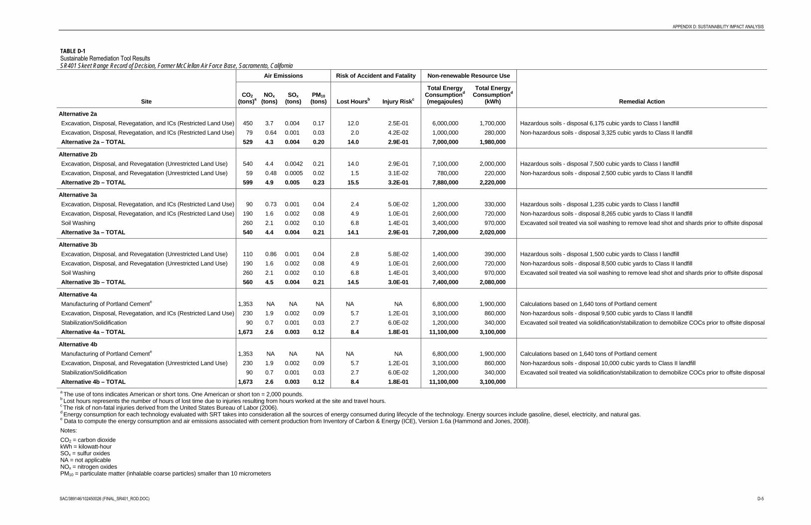
APPENDIX D: SUSTAINABILITY IMPACT ANALYSIS
SAC/389146/102450026 (FINAL_SR401_ROD.DOC) D-5
TABLE D-1 Sustainable Remediation Tool Results SR401 Skeet Range Record of Decision, Former McClellan Air Force Base, Sacramento, California
Site
Air Emissions Risk of Accident and Fatality Non-renewable Resource Use
Remedial Action CO2
(tons)a NOx
(tons) SOx
(tons) PM10 (tons) Lost Hoursb Injury Riskc
Total Energy Consumptiond
(megajoules)
Total Energy Consumptiond
(kWh)
Alternative 2a Excavation, Disposal, Revegatation, and ICs (Restricted Land Use) 450 3.7 0.004 0.17 12.0 2.5E-01 6,000,000 1,700,000 Hazardous soils - disposal 6,175 cubic yards to Class I landfillExcavation, Disposal, Revegatation, and ICs (Restricted Land Use) 79 0.64 0.001 0.03 2.0 4.2E-02 1,000,000 280,000 Non-hazardous soils - disposal 3,325 cubic yards to Class II landfill Alternative 2a – TOTAL 529 4.3 0.004 0.20 14.0 2.9E-01 7,000,000 1,980,000
Alternative 2b Excavation, Disposal, and Revegatation (Unrestricted Land Use) 540 4.4 0.0042 0.21 14.0 2.9E-01 7,100,000 2,000,000 Hazardous soils - disposal 7,500 cubic yards to Class I landfill Excavation, Disposal, and Revegatation (Unrestricted Land Use) 59 0.48 0.0005 0.02 1.5 3.1E-02 780,000 220,000 Non-hazardous soils - disposal 2,500 cubic yards to Class II landfillAlternative 2b – TOTAL 599 4.9 0.005 0.23 15.5 3.2E-01 7,880,000 2,220,000
Alternative 3a Excavation, Disposal, Revegatation, and ICs (Restricted Land Use) 90 0.73 0.001 0.04 2.4 5.0E-02 1,200,000 330,000 Hazardous soils - disposal 1,235 cubic yards to Class I landfill Excavation, Disposal, Revegatation, and ICs (Restricted Land Use) 190 1.6 0.002 0.08 4.9 1.0E-01 2,600,000 720,000 Non-hazardous soils - disposal 8,265 cubic yards to Class II landfillSoil Washing 260 2.1 0.002 0.10 6.8 1.4E-01 3,400,000 970,000 Excavated soil treated via soil washing to remove lead shot and shards prior to offsite disposal Alternative 3a – TOTAL 540 4.4 0.004 0.21 14.1 2.9E-01 7,200,000 2,020,000
Alternative 3b Excavation, Disposal, and Revegatation (Unrestricted Land Use) 110 0.86 0.001 0.04 2.8 5.8E-02 1,400,000 390,000 Hazardous soils - disposal 1,500 cubic yards to Class I landfill Excavation, Disposal, and Revegatation (Unrestricted Land Use) 190 1.6 0.002 0.08 4.9 1.0E-01 2,600,000 720,000 Non-hazardous soils - disposal 8,500 cubic yards to Class II landfillSoil Washing 260 2.1 0.002 0.10 6.8 1.4E-01 3,400,000 970,000 Excavated soil treated via soil washing to remove lead shot and shards prior to offsite disposal Alternative 3b – TOTAL 560 4.5 0.004 0.21 14.5 3.0E-01 7,400,000 2,080,000
Alternative 4a Manufacturing of Portland Cemente 1,353 NA NA NA NA NA 6,800,000 1,900,000 Calculations based on 1,640 tons of Portland cementExcavation, Disposal, Revegatation, and ICs (Restricted Land Use) 230 1.9 0.002 0.09 5.7 1.2E-01 3,100,000 860,000 Non-hazardous soils - disposal 9,500 cubic yards to Class II landfill Stabilization/Solidification 90 0.7 0.001 0.03 2.7 6.0E-02 1,200,000 340,000 Excavated soil treated via solidification/stabilization to demobilize COCs prior to offsite disposalAlternative 4a – TOTAL 1,673 2.6 0.003 0.12 8.4 1.8E-01 11,100,000 3,100,000
Alternative 4b Manufacturing of Portland Cemente 1,353 NA NA NA NA NA 6,800,000 1,900,000 Calculations based on 1,640 tons of Portland cementExcavation, Disposal, and Revegatation (Unrestricted Land Use) 230 1.9 0.002 0.09 5.7 1.2E-01 3,100,000 860,000 Non-hazardous soils - disposal 10,000 cubic yards to Class II landfill Stabilization/Solidification 90 0.7 0.001 0.03 2.7 6.0E-02 1,200,000 340,000 Excavated soil treated via solidification/stabilization to demobilize COCs prior to offsite disposalAlternative 4b – TOTAL 1,673 2.6 0.003 0.12 8.4 1.8E-01 11,100,000 3,100,000 a The use of tons indicates American or short tons. One American or short ton = 2,000 pounds. b Lost hours represents the number of hours of lost time due to injuries resulting from hours worked at the site and travel hours. c The risk of non-fatal injuries derived from the United States Bureau of Labor (2006). d Energy consumption for each technology evaluated with SRT takes into consideration all the sources of energy consumed during lifecycle of the technology. Energy sources include gasoline, diesel, electricity, and natural gas. e Data to compute the energy consumption and air emissions associated with cement production from Inventory of Carbon & Energy (ICE), Version 1.6a (Hammond and Jones, 2008). Notes: CO2 = carbon dioxide kWh = kilowatt-hour SOx = sulfur oxides NA = not applicable NOx = nitrogen oxides PM10 = particulate matter (inhalable coarse particles) smaller than 10 micrometers

Appendix EAdministrative Record Index

SAC/389146/102450026 (FINAL_SR401_ROD.DOC) E-1
APPENDIX E
TABLE E-1
Administrative Record Index
DocumentDate Subject or Title
Author /Corporate Affil
ARNumber
01 Apr 2000 RI, Final Report, Addenda, Vol I of V, OU-D Radian, Corp. 3801
01 Apr 2000 Update Pages, RI Final Report, Addenda, Vol II of V, OU-D Radian, Corp. 3802
01 Apr 2000 Update Pages, RI Final Report, Addenda, Vol III of V, OU-D Radian, Corp. 3803
01 Apr 2000 RI, Final Report, Addenda, Vol IV of V, Appendices A-C, OU-D Radian, Corp. 3804
01 Apr 2000 RI, Final Report, Addenda, Vol V of V, OU-D Radian, Corp. 3805.10
01 Apr 2000 RI, Final Report, Addenda, Vol V of V, OU-D Radian, Corp. 3805.20
01 May 2002 Final Technology Application Analysis Report, Ex Situ ThermalDesorption Treatability Study, Revision 0
URS Group, Inc. 4449
01 Jul 2002 Final Bench Scale Study Report For EX SITU Wet OxidationTreatability Study at McClellan Air Force Base
URS 4980
01 Sept 2003Former McClellan Air Force Base, Basewide Quality AssuranceProject Plan. Revision 5, Volume 1: General Sections
URS Group 4945
25 Jun 2004 Final Addendum to the 1999 McClellan Air Force Base BasewideVolatile Organic Compound Feasibility Study (VOC FS)
Brunner, Paul G. /AFRPA
5487
22 Sep 2005 Former McClellan AFB Interim Basewide Remedial InvestigationReport, Part 1, General Framework Revision 2, Final (DSR# 381-7)
Mitretek Systems, Inc. 5934
01 Nov 2006 Military Munitions Response Program (MMRP) Site Closure Criteria AFRPA 7143
01 Aug 2007 Final Basewide VOC Record of Decision Andy Cramer /CH2M HILL
6475
16 Oct 2007 Final Soils Data Gap Work Plan Nick Sjaarda /CH2M HILL
6971
02 Oct 2008 Former McClellan AFB Munitions Visual Site Inspection (VSI)Report, Skeet Range, MMRP Site SR401
AFRPA 7144
01 Jan 2009 Update to the Wetlands Delineation for the former McClellanAir Force Base
CH2M HILL 7145
01 Jan 2009 Update to the Wetlands Delineation for the Former McClellanAir Force Base
CH2M HILL 7145.10
29 Apr 2009 COE Comments on the Approved Pre-Rapanos, RevisedJurisdictional Determination for a Portion of Former McClellan AFB
Michael Finan / COE 6660
30 Jul 2009 Final Soils Data Gap Remedial Investigation CharacterizationSummaries Addenda
Latonya Coleman /CH2M HILL
6884

APPENDIX E: ADMINISTRATIVE RECORD INDEX
E-2 SAC/389146/102450026 (FINAL_SR401_ROD.DOC)
TABLE E-1
Administrative Record Index
DocumentDate Subject or Title
Author /Corporate Affil
ARNumber
30 Jul 2009 Final Soils Data Gap Remedial Investigation CharacterizationSummaries Addenda
Latonya Coleman /CH2M HILL
6884.10
30 Jul 2009 Final Soils Data Gap Remedial Investigation CharacterizationSummaries Addenda
Latonya Coleman /CH2M HILL
6884.20
22 July 2009 Final Non-VOC Amendment to the Basewide VOC GroundwaterRecord of Decision
Steve Mayer /AFRPA
7055
24 Sep 2009 Final SR401 Skeet Range Investigation Work Plan Brian Garber /CH2M HILL
7030
01 Apr 2010 Final SR401 Skeet Range Remedial Investigation/Feasibility Study Brian Garber /CH2M HILL
7142
09 July 2010 Skeet Range Proposed Plan CH2M HILL 7185


DISTRIBUTION LIST
ADDRESS NUMBER OF COPIES
AFRPAIWREC Administrative Record Phil Mook Molly Enloe Steve Mayer Buddy Walser 34 1 1 Olson Street McClellan CA 95652-1 003
U.S. Environmental Protection Agency Attn: Ms. Yvonne Fong 75 Hawthorne Street (SFD-8-1) San Francisco CA 941 05
Dept, of Toxic Substances Control Attn: Mr. John Harris 8800 Cal Center Drive Sacramento CA 95826-3200
Regional Water Quality Control Board Attn: Mr. James Taylor 1 1020 Sun Center Drive # 200 Rancho Cordova CA 95670-6 1 14
U.S. Fish and Wildlife Service Attn: Teny Adelsbach Endangered Species Program 2800 Cottage Way, Suite W-2605 Sacramento CA 95825
California Department of Fish and Game Attn: Mr. Allen Tsao Ofice of Spill Prevention and Response 1700 K Street, Suite 250 Sacramento CA 95814
TechLaw Inc. Attn: Mr. Rich Howard 92 1 1 l th Street, Suite 800 Sacramento, CA 958 14
5 hard copies 5 CDs
1 signed cover page (original)* 1 hard copy 2 CDs
1 signed cover page (original)* 1 CD
1 signed cover page (copy)* I CD
1 hard copy I CD
1 hard copy 1 CD
1 hard copy 1 CD
*Signed cover page to be inserted into hard copy transmitted on 12 May 201 1