Specific Site Assessment for Coal Combustion Waste ... · PDF file092881 Coal Ash Impoundment...
88
-
Upload
doankhuong -
Category
Documents
-
view
217 -
download
1
Transcript of Specific Site Assessment for Coal Combustion Waste ... · PDF file092881 Coal Ash Impoundment...

Geotechnical Environmental and
Water Resources Engineering
Specific Site Assessment for
Coal Combustion Waste
Impoundments at
Santee Cooper Grainger
Generating Station Conway, South Carolina
Submitted to: U.S. Environmental Protection Agency Office of Resource Conservation and Recovery 5304P 1200 Pennsylvania Avenue NW Washington, DC 20460
Submitted by: GEI Consultants, Inc. 4601 DTC Blvd., Suite 900 Denver, CO 80237
December 2010 Project 092881
Steven R. Townsley, P.E. Senior Project Engineer
GEI Consultants, Inc. i December 2010 092881 Coal Ash Impoundment SSA Report
Santee Cooper Grainger Generating Station
Table of Contents
1.0 Introduction 1
1.1 Purpose 1 1.2 Scope of Work 1 1.3 Authorization 2 1.4 Project Personnel 2 1.5 Limitation of Liability 2 1.6 Project Datum 2 1.7 Prior Inspections 2
2.0 Description of Project Facilities 3
2.1 General 3 2.2 Impoundment Dams and Reservoirs 3 2.3 Spillways 4 2.4 Intakes and Outlet Works 4 2.5 Vicinity Map 4 2.6 Plan and Sectional Drawings 4 2.7 Standard Operational Procedures 5
3.0 Summary of Construction History and Operation 6
4.0 Hazard Potential Classification 7
4.1 Overview 7 4.2 Ash Pond #1 7 4.3 Ash Pond #2 7
5.0 Hydrology and Hydraulics 9
5.1 Floods of Record 9 5.2 Inflow Design Floods 9
5.2.1 Ash Pond #2 9 5.2.2 Determination of the PMF 10
5.2.3 Freeboard Adequacy 10 5.2.4 Dam Break Analysis 10
5.3 Spillway Rating Curves 10 5.4 Evaluation 10
6.0 Geologic and Seismic Considerations 11
7.0 Instrumentation 12
7.1 Location and Type 12
7.2 Readings 12 7.2.1 Flow Rates 12

GEI Consultants, Inc. ii December 2010 092881 Coal Ash Impoundment SSA Report
Santee Cooper Grainger Generating Station
7.2.2 Staff Gauges 12 7.3 Evaluation 12
8.0 Field Assessment 14
8.1 General 14 8.2 Ash Pond #1 14 8.3 Ash Pond #2 15
8.3.1 Impoundment Dike 15 8.3.2 Seepage and Stability 15 8.3.3 Appurtenant Structures 15
9.0 Structural Stability 17
9.1 Visual Observations 17 9.2 Field Investigations 17 9.3 Methods of Analysis 17 9.4 Discussion of Stability Analysis and Results 18
9.5 Seismic Stability Liquefaction Potential 19 9.6 Summary of Results 19
10.0 Maintenance and Methods of Operation 20
10.1 Procedures 20 10.2 Maintenance of Impoundments 20 10.3 Surveillance 20
11.0 Conclusions 21
11.1 Assessment of Dams 21 11.1.1 Field Assessment 21 11.1.2 Adequacy of Structural Stability 21 11.1.3 Adequacy of Hydrologic/Hydraulic Safety 21 11.1.4 Adequacy of Instrumentation and Monitoring 21 11.1.5 Adequacy of Maintenance and Surveillance 21 11.1.6 Adequacy of Project Operations 22
12.0 Recommendations 23
12.1 Corrective Measures and Analyses for the Structures 23 12.2 Corrective Measures Required for Instrumentation and Monitoring
Procedures 23 12.3 Corrective Measures Required for Maintenance and Surveillance
Procedures 23 12.4 Corrective Measures Required for the Methods of Operation of the
Project Works 23
12.5 Summary 23 12.6 Acknowledgement of Assessment 24
13.0 References 26

GEI Consultants, Inc. iii December 2010 092881 Coal Ash Impoundment SSA Report
Santee Cooper Grainger Generating Station
List of Tables Table 2.1: Summary Information for Impoundment Dam Parameters Table 9.1: Stability Factors of Safety and Guidance Values
List of Figures Figure 1: Site Vicinity Map Figure 2: Site Aerial Map List of Appendices Appendix A: Inspection Checklists Appendix B: Inspection Photographs Appendix C: Instrumentation Appendix D: Reply to Request for Information under Section 104(e) List of Acronyms CCW coal combustion waste EPA U.S. Environmental Protection Agency FEMA Federal Emergency Management Agency FERC Federal Energy Regulation Committee GEI GEI Consultants, Inc. IDF inflow design flood MW megawatts NOAA National Oceanic Atmospheric Administration NPDES National Pollutant Discharge Elimination System NWS National Weather Service RCP reinforced concrete pipe USACE U.S. Army Corps of Engineers USBR U.S. Bureau of Reclamation USGS U.S. Geological Survey

GEI Consultants, Inc. 1 December 2010 092881 Coal Ash Impoundment SSA Report Santee Cooper Grainger Generating Station
1.0 Introduction
1.1 Purpose
This report presents the results of a specific site assessment of the dam safety of two coal combustion waste (CCW) impoundments at the Grainger Generating Station in Conway, South Carolina. The Grainger Generating Station is owned and operated by South Carolina Public Service Authority (Santee Cooper). Santee Cooper has operated Grainger Generating Station since it went into service. However, until the end of 2008, Grainger Generating Station was owned by Central Electric Power Cooperative and leased to Santee Cooper.
The two impoundments are Ash Pond #1 and Ash Pond #2. Ash Pond #2 is currently the only active impoundment for storing CCW at the Grainger Generating Station. Ash Pond #1 is used to store dry waste only and is continually dewatered. The specific site assessment was performed on June 24, 2010.
The specific site assessment was performed with reference to Federal Emergency Management Agency (FEMA) guidelines for dam safety, which includes other federal agency guidelines and regulations (such as U.S. Army Corps of Engineers [USACE] and U.S. Bureau of Reclamation [USBR]) for specific issues. The assessment defaults to state requirements where not specifically addressed by federal guidance or if the state requirements were more stringent.
1.2 Scope of Work
The scope of work between GEI Consultants, Inc. (GEI) and the U.S. Environmental Protection Agency (EPA) for the specific site assessment is summarized in the following tasks:
1. Acquire and review existing reports and drawings relating to the safety of the project provided by the EPA and Owners.
2. Conduct detailed physical inspections of the project facilities. Document observed conditions on Field Assessment Check Lists provided by EPA for each management unit being assessed.
3. Review and evaluate stability analyses of the project’s coal combustion waste impoundment structures.
4. Review the appropriateness of the inflow design flood (IDF), and adequacy of ability to store or safely pass the inflow design flood, provision for any spillways, including considering the hazard potential in light of conditions observed during the inspections or to the downstream channel.
GEI Consultants, Inc. 2 December 2010 092881 Coal Ash Impoundment SSA Report Santee Cooper Grainger Generating Station
5. Review existing dam safety performance monitoring programs and recommend additional monitoring, if required.
6. Review existing geologic assessments for the projects.
7. Submit draft and final reports.
1.3 Authorization
GEI performed the coal combustion waste impoundment assessment as a contractor to the EPA. This work was authorized by EPA under Delivery Order EP-CALL-001; PR-OSWER-10-00092 between EPA and GEI, dated June 14, 2010.
1.4 Project Personnel
The scope of work for this task order was completed by the following personnel from GEI:
Steven R. Townsley, P.E. Senior Project Engineer/Task Leader Stephen G. Brown, P.E. Project Manager Mary C. Nodine, P.E. Project Geotechnical Engineer Nick Miller, P.E. Project Water Resources Engineer
The Program Manager for the EPA was Stephen Hoffman.
1.5 Limitation of Liability
This report summarizes the assessment of dam safety of the Ash Pond #1 and Ash Pond #2 coal combustion waste impoundments at Grainger Generating Station, Conway, South Carolina. The purpose of each assessment is to evaluate the structural integrity of the impoundments and provide summaries and recommendations based on the available information and on engineering judgment. GEI used a professional standard of practice to review, analyze, and apply pertinent data. No warrantees, express or implied, are provided by GEI. Reuse of this report for any other purpose, in part or in whole, is at the sole risk of the user.
1.6 Project Datum
The project datum was not identified on the documents reviewed by the assessment team.
1.7 Prior Inspections
The dikes at the CCW impoundments at Grainger Generating Station are inspected monthly by Santee Cooper Grainger Generating Station personnel. We reviewed the completed inspection checklists from January 2009 through June 2010. The dikes have not been inspected by a third party. The CCW impoundments are not regulated by state or federal agencies.
GEI Consultants, Inc. 3 December 2010 092881 Coal Ash Impoundment SSA Report Santee Cooper Grainger Generating Station
2.0 Description of Project Facilities
2.1 General
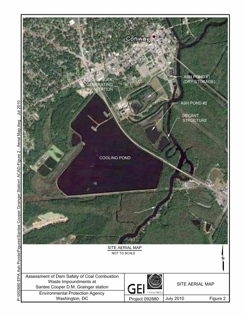
Grainger Generating Station is a coal-fired power plant consisting of two units that generate about 170 megawatts (MW) combined. Both units went online in 1966. The power plant is located in the town of Conway in Horry County, South Carolina (see Figure 1). Ash Pond #1 is located adjacent to, and northeast of the power plant. Ash Pond #2 is located southeast and downstream (along the Waccamaw River) of Ash Pond #1 (Figure 2). Ash Pond #1 stores only dry CCW, while Ash Pond #2 impounds wet CCW. Grainger Generating Station was owned by Central Electric Power Cooperative and leased to Santee Cooper from 1966 until the end of 2008, when the lease term ended. All units are now owned and operated by Santee Cooper.
2.2 Impoundment Dams and Reservoirs
The dikes at the CCW impoundments at the Grainger Generating Station have not been assigned a hazard potential by a state or federal agency. Based on the geometry of the impoundments and the facilities downstream, recommended hazard potential classifications for the impoundments have been developed in Section 4.0 of this report.
Both impoundments are used to store fly ash, bottom ash and boiler slag. Ash Pond #1 was used to impound wet sluiced CCW from 1966 until 1977, at which time it was converted to a dry handling unit. All wet sluiced CCW material is sent to Ash Pond #2 which has a permitted National Pollutant Discharge Elimination Systems (NPDES) outfall. After CCW materials settle, the solids are excavated from Ash Pond #2 and placed in Ash Pond #1 for disposal. Stormwater and any excess water from the CCW placed in Ash Pond #1 are continuously collected and pumped into Ash Pond #2. Currently Ash Pond #2 is the only pond on site that impounds wet sluiced CCW.
The dikes at Ash Ponds #1 and #2 are homogeneous in that they were not constructed with distinct zones of differing soil materials and they lack a system of internal drains, and were constructed of onsite silty sand, silty clay and lean clay. Some portions of the dike at Ash Pond #2 have a zone of clean sand in the downstream portion of the cross section. The dike at Ash Pond #1 has a crest width of 12 feet and design upstream and downstream side slopes of 3H:1V. The dike at Ash Pond #2 has a crest width of 9 to 11 feet, design upstream side slopes of 2H:1V or 3H:1V, and design downstream side slopes of 2H:1V. In 1990, the dike at Ash Pond #2 was raised 2 to 3 feet with resulting side slopes of about 1H:1V in the raised portion of the dike. The basic dimensions and geometry of the two CCW impoundments are summarized in Table 2.1.

GEI Consultants, Inc. 4 December 2010 092881 Coal Ash Impoundment SSA Report Santee Cooper Grainger Generating Station
Table 2:1: Summary Information for Impoundment Dike Parameters
Parameter Value Dam Ash Pond #1 Ash Pond #2 Maximum Height (ft) 7 13 Approximate Length (ft) 2400 2500 Average Crest Width (ft)* 12 10 Crest Elevation (ft) 10.0 14.5
Design Side Slopes (H:V) 3:1 US/3:1 DS 2:1-3:1 US/2:1 DS Estimated Freeboard (ft) at time of site visit NA 4.5 Storage Capacity (ac-ft)* 298 429 Surface Area (acres)* 42.5 39
* Storage capacity and area values provided by Santee Cooper.
2.3 Spillways
Neither of the impoundments have spillways.
2.4 Intakes and Outlet Works
Ash Pond #1 stores dewatered CCW. The intakes and outlet works are therefore not relevant to current operations of the impoundment and were not included in this assessment.
The intake structure at Ash Pond #2 consists of a 12-inch reinforced concrete decant pipe with a trashrack. Flow through the pipe is controlled by manually adding or removing wooden stop logs into the guides accessible from the concrete outlet structure. Decant water from Ash Pond #2 flows through the concrete pipe and through a Parshall flume before it discharges to the Waccamaw River via a riprap-lined channel. The flow rate of decant water discharging into the river is monitored by reading the height of flowing water in the Parshall flume.
2.5 Vicinity Map
Grainger Generating Station is located on the south side of the town of Conway in Horry County, South Carolina, as shown on Figure 1. The CCW impoundments are located adjacent to, and east and southeast of, the station.
2.6 Plan and Sectional Drawings
Engineering and as-built drawings for the CCW impoundments were prepared by Lockwood Greene Engineers, Inc.

GEI Consultants, Inc. 5 December 2010 092881 Coal Ash Impoundment SSA Report Santee Cooper Grainger Generating Station
2.7 Standard Operational Procedures
Grainger Generating Station is a coal-fired power plant composed of two coal-fired steam turbine electric power generating units that can produce a total combined capacity of 170 MW. Coal is delivered to the power plant by train, where it is then combusted to power the steam turbines. The burning of coal produces several gases which are vented from the boiler; fly ash, which is collected from the exhaust prior to venting to the atmosphere; and coarser bottom ash, which falls to the bottom of the boiler and is removed along with boiler slag.
Bottom ash, fly ash and boiler slag are combined at the plant and wet sluiced into Ash Pond #2. Plant process water, including ash transport water, coal pile runoff and low volume waste, is also discharged to Ash Pond #2. Ash Pond #2 consists of an east and a west cell, separated by a zone of earthfill. The CCW from the plant is discharged into an interior channel on the west side of the pond. Most of the CCW settles out of the water in the channel, and the water flows east and through a steel decant pipe to the east cell. Water is discharged from the east cell to the Waccamaw River. Discharge water from Ash Pond #2 meets National Pollutant Discharge Elimination System (NPDES) permit requirements for discharge without chemical treatment.
The interior channels in the western portion of Ash Pond #2 are periodically dewatered. CCW solids are excavated and hauled to Ash Pond #1, which serves as a dry ash storage area. Ash Pond #1 is continually dewatered to drain stormwater and excess water from CCW placed in the area. Additional water that drains from the ash or from precipitation falling into Ash Pond #1 is pumped to Ash Pond #2.
Cooling water at Grainger Generating Station is withdrawn from the Waccamaw River via the intake canal. This water is used to condense exhaust steam in the condensers, to cool turbine oil, and to cool turbine bearings. After use, the water is discharged to a cooling pond west of the plant and subsequently back to the Waccamaw River through an NPDES permitted outfall. This cooling water does not come in direct contact with any of the plant processes.

GEI Consultants, Inc. 6 December 2010 092881 Coal Ash Impoundment SSA Report Santee Cooper Grainger Generating Station
3.0 Summary of Construction History and Operation
The two units at Grainger Generating Station went online in 1966, at which time Ash Pond #1 went into service. Coal combustion waste was originally wet sluiced into Ash Pond #1. Ash Pond #2 went into service in 1977. At this time, Ash Pond #1 was drained and all CCW was wet sluiced from the power station directly to Ash Pond #2. Since 1977 Ash Pond #1 has functioned as a dry ash storage area. In 1990, Ash Pond #2 was raised 2 to 3 feet to increase storage capacity and lengthen retention time to remove more solids from the water.
We reviewed the original design drawings for the ash ponds and dikes, though design reports and construction records were not available. The dikes were typically constructed of earthfill obtained from on site, which consists of a combination of silty sand, clayey sand and lean clay. No notes about foundation preparation are present on the design drawings, but the drawings indicate that the dams were founded on the original ground surface and there is no evidence that they were constructed on top of CCW. Based on borings drilled at Ash Pond #2 in 1990, the dike foundation consists of dense silty sand with some lean clay. The borings extended a maximum of about 20 feet beneath the base of the dike and bedrock was not encountered. The dikes were not constructed with internal drains or seepage cutoffs.

GEI Consultants, Inc. 7 December 2010 092881 Coal Ash Impoundment SSA Report Santee Cooper Grainger Generating Station
4.0 Hazard Potential Classification
4.1 Overview
According to the Federal Guidelines for Dam Safety, the hazard potential classification for the CCW impoundments is based on the possible adverse incremental consequences that result from release of stored contents due to failure of the dam or misoperation of the dam or appurtenances. Impoundments are classified as Less than Low, Low, Significant, or High Hazard, depending on the potential for loss of human life and/or economic and environmental damages.
4.2 Ash Pond #1
Ash Pond #1 has a total surface area of 42.5 acres and a storage capacity of 298 acre-feet, and its dam is a maximum of 7 feet high. Based on current pond heights and storage capacity shown in Table 2.1, the size classification for Ash Pond #1 is “Small” in accordance with the USACE Recommended Guidelines for Safety Inspection of Dams ER 1110-2-106 criteria.
Ash Pond #1 functions as a dry CCW storage area. Excess water from the CCW as well as any stormwater that enters the impoundment are collected and pumped to Ash Pond #2. A failure of the Ash Pond #1 dike therefore does not have the potential to release CCW into the surrounding area, and is not capable of causing danger to humans or economic or environmental losses. Consistent with the Federal Guidelines for Dam Safety and the South Carolina Department of Health and Environmental Control Dams and Reservoirs Safety Act Regulations, we recommend the Ash Pond #1 dike be classified as a “Less Than Low” hazard structure.
4.3 Ash Pond #2
Ash Pond #2 has a total surface area of 39 acres and a storage capacity of 429 acre-feet, and its dam is a maximum of 13 feet high. Based on current pond heights and storage capacity shown in Table 2.1, the size classification for Ash Pond #2 is “Small” in accordance with the USACE Recommended Guidelines for Safety Inspection of Dams ER 1110-2-106 criteria.
There are no structures present between the downstream portion of Ash Pond #2 and the Waccamaw River. An uncontrolled release of the CCW impoundment’s contents due to a failure or misoperation of the dike at Ash Pond #2 therefore poses no threat to human life in our opinion. In the event of a failure of the dike, flood waters that reached the Waccamaw River would cause only a small rise in water level. Some environmental damage to the wetlands adjacent to the river is possible, but the amount of water and waste that could be discharged into the river is small due to the size of the impoundment.
GEI Consultants, Inc. 8 December 2010 092881 Coal Ash Impoundment SSA Report Santee Cooper Grainger Generating Station
Consistent with the Federal Guidelines for Dam Safety and the South Carolina Department of Health and Environmental Control Dams and Reservoirs Safety Act Regulations, we recommend the Ash Pond #2 dike be classified as a “Low” hazard structure.
GEI Consultants, Inc. 9 December 2010 092881 Coal Ash Impoundment SSA Report Santee Cooper Grainger Generating Station
5.0 Hydrology and Hydraulics
5.1 Floods of Record
Floods of record have not been evaluated and documented for the CCW impoundments at the Grainger Generating Station. The National Weather Service local rain gage data reportedly recorded maximum daily rainfall depths ranging from about 5.4 to 10.5 inches in the areas surrounding Charleston, South Carolina. The maximum rainfall event of 10.52 inches was recorded on September 21, 1998. These rainfall events are not expected to result in overtopping of the dams under the current normal operating conditions. No documentation has been provided to verify the storm results.
5.2 Inflow Design Floods
Currently there is no hazard classification for the CCW impoundments at the Grainger Generating Station. Ash Pond #1 is a dry storage unit that is continuously drained, and therefore an inflow design flood is not applicable. Based on observations during the field inspection, we recommend the Ash Pond #2 be classified as a “Low” hazard structure (Section 4.0). The South Carolina Department of Health and Environmental Control Dams and Reservoirs Safety Act Regulations specifies small sized, “Low” hazard dams be capable of passing a flood event that ranges from the 50-year to the 100-year storm without overtopping the dam. The USACE Recommended Guidelines for Safety Inspection of Dams ER 1110-20106 provide the same recommendations for inflow design storms. According to the National Oceanic Atmospheric Administration (NOAA) Atlas 14 (2006), the 24-hour 50-year precipitation event at the Grainger Generating Station is about 9.07 inches, and the 24-hour 100-year precipitation event is about 10.39 inches.
5.2.1 Ash Pond #2
The contributing drainage area to Ash Pond #2 includes the impoundment’s surface area (Table 2.1), as well as runoff from Ash Pond #1 and the coal pile adjacent to the plant, both of which are pumped to Ash Pond #2. The water surface in Ash Pond #2 is regulated by a stop log decant structure located in the eastern portion of the pond that discharges to the Waccamaw River. Currently, the Ash Pond #2 water level is maintained at a gage height of about 10.1 feet, which provides about 4.4 feet of freeboard. Based on the 24-hour 100-year precipitation event of 10.39 inches, the Ash Pond #2 water surface would increase by about 2 feet during the design storm, which would result in about 2.5 feet of residual freeboard. Based on these results, the Ash Pond #2 meets the regulatory requirements for storage of the 24-hour 100-year inflow design flood without overtopping the dam.

GEI Consultants, Inc. 10 December 2010 092881 Coal Ash Impoundment SSA Report Santee Cooper Grainger Generating Station
5.2.2 Determination of the PMF
Not applicable.
5.2.3 Freeboard Adequacy
Freeboard is adequate at Ash Pond #2.
5.2.4 Dam Break Analysis
No dam break analysis has been performed for the CCW impoundment at the Grainger Generating Station. The CCW impoundment at the Grainger Generating Station is located adjacent to the Waccamaw River; therefore dam break analyses and inundation mapping would be very limited
5.3 Spillway Rating Curves
Not applicable.
5.4 Evaluation
Based on the current facility operations and inflow design floods documents, the CCW impoundment at the Grainger Generating Station appears to have adequate capacity to store the regulatory design floods without overtopping the dams based on the recommended hazard classifications for the dams.

GEI Consultants, Inc. 11 December 2010 092881 Coal Ash Impoundment SSA Report Santee Cooper Grainger Generating Station
6.0 Geologic and Seismic Considerations
Boring logs taken by Geotec, Inc. in 1990 at the Grainger Generating Station indicate that the predominant overburden soil consists of dense tan and gray silty sand with some clay and organics. The borings extend to a maximum of about 20 feet below the dam foundation, and bedrock was not encountered. Geologic information about the underlying bedrock in the area was not available.
We are not aware of any seismic analyses that have been performed on the dams at the Grainger Generating Station. According to the 2008 U.S. Geological Survey (USGS) Seismic Hazard Map of South Carolina, the site has a regional probabilistic peak ground acceleration of 0.23g with a 2 percent Probability of Exceedance within 50 years (recurrence interval of approximately 2,500 years).
GEI Consultants, Inc. 12 December 2010 092881 Coal Ash Impoundment SSA Report Santee Cooper Grainger Generating Station
7.0 Instrumentation
7.1 Location and Type
Instrumentation associated with the impoundments at Grainger Generating Station include six staff gauges to measure water surface elevations in and around the ponds, and a Parshall flume at the outlet structure to monitor discharge to the Waccamaw River. Wells are installed on the property to monitor water quality to comply with NPDES permit requirements, but these are not located on the Ash Pond dikes.
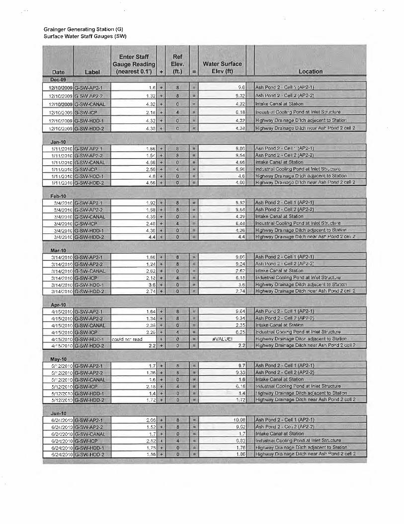
We reviewed flow rates measured at the Parshall flume from January 2007 to April 2010. The staff gauges were installed in 2009, and we reviewed monthly staff gauge readings from December 2009 to June 2010. The instrumentation data that we reviewed are attached in Appendix C. A location plan including staff gauge locations, surface and groundwater quality monitoring locations, and the locations of three piezometers (located near the cooling pond) is also included in Appendix C.
7.2 Readings
7.2.1 Flow Rates
Flow rates through the outlet structure are monitored with a strip chart, which records daily readings at the Parshall flume. Santee Cooper personnel read the strip chart monthly, logging the maximum and average daily flows for each month. Flow has remained relatively steady over the past several years, with average flows between 350 and 1400 gallons per minute.
7.2.2 Staff Gauges
The six staff gauges installed at the Grainger Generating Station are read monthly. The staff gauges are located in and around the CCW impoundments: one in each cell of Ash Pond #2, one in the intake canal near the power station, one in the inlet structure at the cooling pond west of the power station, and two in the highway drainage ditch west of the impoundments. Readings in the staff gauges in Ash Pond #2 and in the cooling pond have not changed significantly since December 2009 (less than 0.5 feet of fluctuation). Based on readings of the staff gauges in the intake canal and highway drainage ditch, which are connected to the Waccamaw River, Ash Pond #2 does not appear to be affected by the fluctuations in water levels of surrounding waterways.
7.3 Evaluation
The instrumentation installed at the Grainger Generating Station CCW impoundments appears to be functioning properly, and the frequency of readings is considered adequate.

GEI Consultants, Inc. 13 December 2010 092881 Coal Ash Impoundment SSA Report Santee Cooper Grainger Generating Station
There are currently no piezometers in place to monitor water levels within the Ash Pond #2 dike. Information on water levels within the embankment would be useful to estimate piezometric conditions for future slope stability analyses, and to monitor these conditions over time. However, due to the small size and low hazard classification of the impoundment, and since we observed no signs of instability or seepage during the June 2010 assessment, installing new piezometers in the Ash Pond #2 dike is not considered necessary. Several groundwater quality wells are located at the downstream toe of the dike. Santee Cooper currently records the elevation of water in the groundwater quality wells. It would be useful to use this information for future reference in slope stability analyses, as the piezometric surface within the dike could be estimated based on the water level in the impoundment and the water level at the toe of the dike.
GEI Consultants, Inc. 14 December 2010 092881 Coal Ash Impoundment SSA Report Santee Cooper Grainger Generating Station
8.0 Field Assessment
8.1 General
A site visit to assess the condition of the two CCW impoundments at the Grainger Generating Station was performed on June 24, 2010, by Steven R. Townsley, P.E., and Mary C. Nodine, P.E., of GEI. Ernest Hardwick, Denise Bunte-Bisnett, Jane Hood, Susan Jackson and Darren Tanner of Santee Cooper assisted in the assessment.
The weather during the site visit (June 24, 2010) was generally sunny with temperatures around 100 degrees Fahrenheit. The majority of the ground was dry at the time of the site visit.
At the time of inspection, GEI completed an EPA inspection checklist which is provided in Appendix A. Photographs are provided in Appendix B. Field assessment of the CCW impoundments included a site walk to observe the dam crest, upstream slope, downstream slope, intake structures and outlet structures. Ash Pond #1 and Ash Pond #2 are discussed separately below.
8.2 Ash Pond #1
Ash Pond #1 was converted to a dry storage area in 1977, at which time its NPDES outfall was eliminated. Ash Pond #2 was constructed in 1977, and all wet sluiced CCW from Grainger Generating Station has since been sent to Ash Pond #2. The dike surrounding Ash Pond #1 is still in place. We observed the existing dike to generally be in good condition, with no signs of movement, cracking, settling, erosion or deterioration. Trees have been allowed to grow on the downstream slope of the dike since it does not impound wet CCW.
The ground surface within Ash Pond #1 was dry at the time of our visit, and trees are growing in the area. We observed the piles of dry CCW that have been placed in the impoundment. The CCW is sprayed with water to reduce dust. A network of drainage ditches has been constructed within the impoundment to drain stormwater and excess water from the dry CCW. The water collected in the impoundment is pumped to Ash Pond #2. We observed water flowing in the drainage ditches, and the system appeared to be functioning properly.
Ash Pond #1 functions as a dry CCW storage area. Appurtenant structures associated with previous operations are not relevant to current operations and were not inspected.

GEI Consultants, Inc. 15 December 2010 092881 Coal Ash Impoundment SSA Report Santee Cooper Grainger Generating Station
8.3 Ash Pond #2
8.3.1 Impoundment Dike
8.3.1.1 Dike Crest
The crest of the dike at Ash Pond #2 appeared to be in good condition. No signs of cracking, settlement, movement, erosion or deterioration were observed during the assessment. The crest appears to be well-drained and no standing water was observed. The dike crest surface is generally composed of gravel road base material that traverses the length of the dike for vehicle access.
8.3.1.2 Upstream Slope
The upstream slopes of the dike at Ash Pond #2 have well-established grass growth. Riprap is present along the upstream slope where it is necessary for wave protection. The upstream slope protection appeared to be in good condition. No scarps, sloughs, depressions or other indications of slope instability or signs of erosion were observed during the inspection of the CCW impoundment.
8.3.1.3 Downstream Slope
The downstream slopes of the dike at Ash Pond #2 have well-established grass growth, which provides some erosion protection. Large trees are present immediately downstream of the toe. These should be monitored to ensure that they do not encroach upon the dike slope, but in our opinion they are not currently a threat to the stability of the dike. No scarps, sloughs, depressions or other indications of slope instability or signs of erosion were observed during the inspection of the CCW impoundment.
8.3.2 Seepage and Stability
We observed no signs of seepage or slope instability in the dike during our inspection of Ash Pond #2.
8.3.3 Appurtenant Structures
8.3.3.1 Outlet Structure
The outlet structure located in Ash Pond #2 appeared to be in good condition. The structure was observed to be working properly, discharging decant water downstream. Stop logs used to control the flow appeared to be functional, and a trashrack was in place. The outlet conduit consists of 12-inch reinforced concrete pipe (RCP) and appears to be in good condition. The Parshall flume used to monitor flow appeared to be functional and readable. Riprap in the outlet channel was also in good condition.

GEI Consultants, Inc. 16 December 2010 092881 Coal Ash Impoundment SSA Report Santee Cooper Grainger Generating Station
8.3.3.2 Pump Structures
No pumps are present at Ash Pond #2.
8.3.3.3 Emergency Spillway
No spillways are present at Ash Pond #2.
8.3.3.4 Drains
No internal or toe drains are present in the dike at Ash Pond #2.
8.3.3.5 Water Surface Elevations and Reservoir Discharge
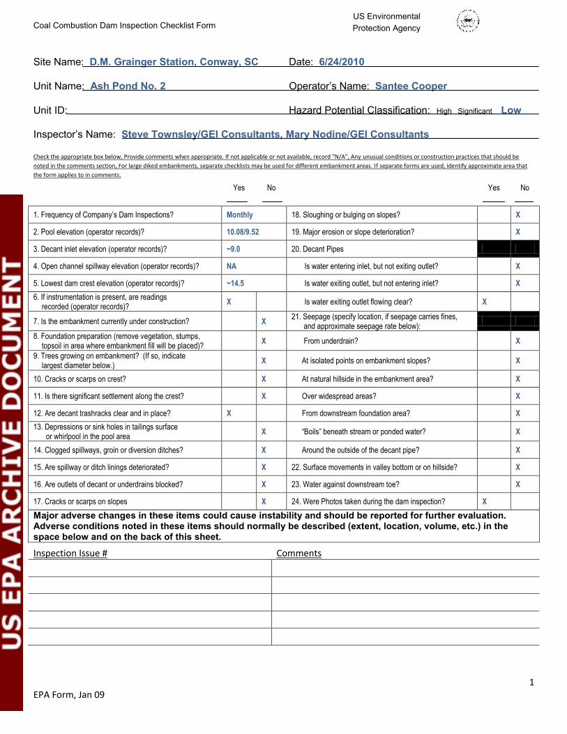
Staff gauges in Ash Pond #2 indicate that the west and east cell water surfaces at the time of our assessment (June 24, 2010) were at elevation (El.) 10.08 and El. 9.52, respectively.
Flow through the outlet structure on the day of our assessment was not provided, but from January to April 2010 the monthly average daily discharge varied from 347 to 1392 gallons per minute.

GEI Consultants, Inc. 17 December 2010 092881 Coal Ash Impoundment SSA Report Santee Cooper Grainger Generating Station
9.0 Structural Stability
9.1 Visual Observations
The assessment team saw no visible signs of instability associated with the dikes of the CCW impoundments during the June 24, 2010 site assessment.
9.2 Field Investigations
Records of borings completed when the CCW impoundments were designed and constructed were not available. We reviewed boring logs from an investigation performed at Ash Pond #2 in 1990, when the dike was raised 2 to 3 feet. Five borings were drilled at this time: four in the dike crest to depths of 20 to 25 feet, and one inside the pond to a depth of 15 feet. Boring logs and a location plan for the 1990 borings are included in the Report of Test Borings and Subsurface Investigation by Geotec, Inc. (1990).
9.3 Methods of Analysis
Stability analyses completed at the time the CCW impoundment dikes were designed were not available. A stability analysis was completed in 1990 by Santee Cooper in order to analyze the proposed 2- to 3-foot dike raise at Ash Pond #2. The analysis was performed using subsurface information collected in the 1990 investigation by Geotec. We reviewed the 1990 report, which included a summary of the analysis procedures and results.
The 1990 stability study included steady state analyses for a “typical” cross section, as well as a cross section at the intake canal between the pond and the power station, for the existing dike and for raises of both 2 and 3 feet. Seismic stability and rapid drawdown analyses were not performed in the 1990 stability study. The analyses were conducted using the software program UTEXAS2.
Analyses were performed for both the upstream and downstream slopes at the typical dike cross section. It is noted in the stability study that shallow slides were observed along the intake canal during the 1990 geotechnical investigation, and that the slope in the slide area is oversteepened compared to the design slope configuration (1.7H:1V vs. 2H:1V). Consequently, at the intake canal cross section the study included analyses of both deep and shallow failures for the downstream slope at a 1.7H: 1V configuration, and analyses of deep failures for the downstream slope at a 2H:1V configuration. The upstream slope in this area is not considered critical due to the slope height and the ash buildup against the dike in this area. The ash buildup was taken into account in analyses of the downstream slope.
GEI Consultants, Inc. 18 December 2010 092881 Coal Ash Impoundment SSA Report Santee Cooper Grainger Generating Station
The water level in the ash pond was assumed to be 2 feet below the proposed top of the dike for the analyses of the raised sections. The assumed piezometric surfaces using these water levels are not sketched on the cross sections. For analyses of the existing section, the assumed water level in the ash pond appears to be the existing water level at the time of the study. Piezometric surfaces sketched in the cross sections for these analyses correspond with the water levels found in the 1990 borings.
Material properties for the embankment fill, foundation material and ash were estimated by Geotec, Inc. using results of the 1990 borings and expected parameters for compacted fill placed for the dike raise. No laboratory testing was performed, so the parameters were based on SPT N-values and visual classifications of the materials.
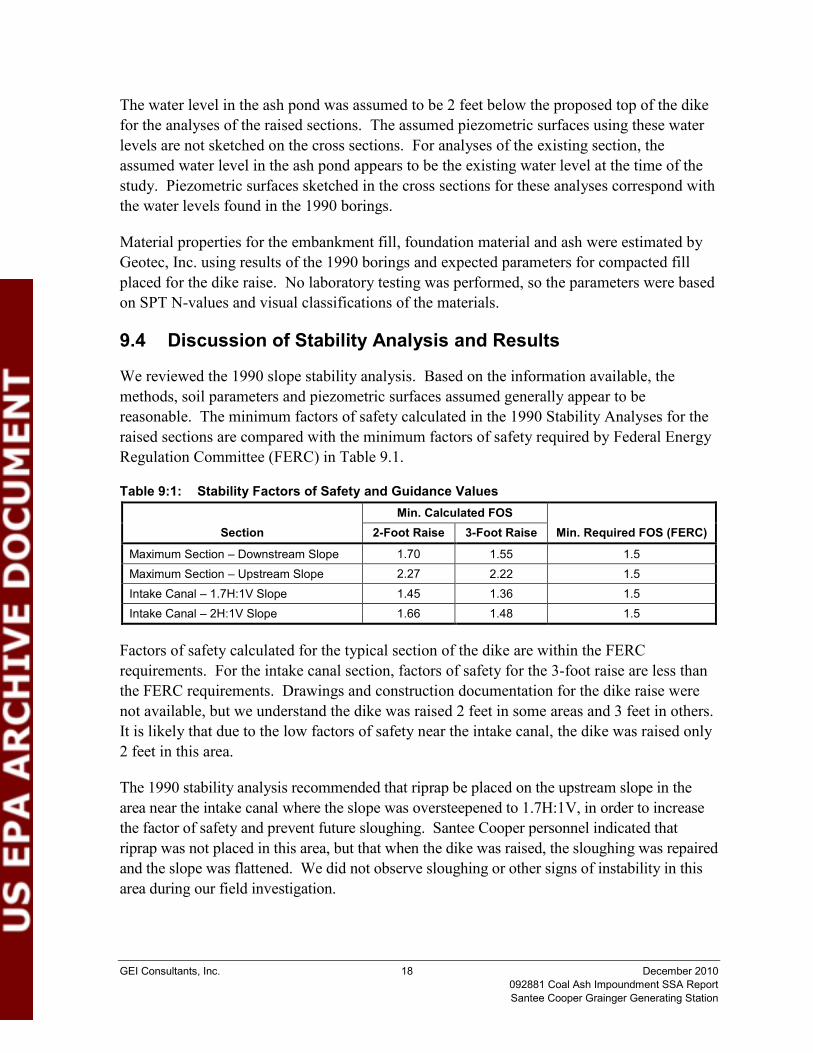
9.4 Discussion of Stability Analysis and Results
We reviewed the 1990 slope stability analysis. Based on the information available, the methods, soil parameters and piezometric surfaces assumed generally appear to be reasonable. The minimum factors of safety calculated in the 1990 Stability Analyses for the raised sections are compared with the minimum factors of safety required by Federal Energy Regulation Committee (FERC) in Table 9.1.
Table 9:1: Stability Factors of Safety and Guidance Values
Section Min. Calculated FOS
Min. Required FOS (FERC) 2-Foot Raise 3-Foot Raise
Maximum Section – Downstream Slope 1.70 1.55 1.5 Maximum Section – Upstream Slope 2.27 2.22 1.5 Intake Canal – 1.7H:1V Slope 1.45 1.36 1.5 Intake Canal – 2H:1V Slope 1.66 1.48 1.5
Factors of safety calculated for the typical section of the dike are within the FERC requirements. For the intake canal section, factors of safety for the 3-foot raise are less than the FERC requirements. Drawings and construction documentation for the dike raise were not available, but we understand the dike was raised 2 feet in some areas and 3 feet in others. It is likely that due to the low factors of safety near the intake canal, the dike was raised only 2 feet in this area.
The 1990 stability analysis recommended that riprap be placed on the upstream slope in the area near the intake canal where the slope was oversteepened to 1.7H:1V, in order to increase the factor of safety and prevent future sloughing. Santee Cooper personnel indicated that riprap was not placed in this area, but that when the dike was raised, the sloughing was repaired and the slope was flattened. We did not observe sloughing or other signs of instability in this area during our field investigation.
GEI Consultants, Inc. 19 December 2010 092881 Coal Ash Impoundment SSA Report Santee Cooper Grainger Generating Station
9.5 Seismic Stability Liquefaction Potential
The liquefaction potential of the embankment and foundation materials at the Ash Pond #2 dike has not been previously evaluated based on review of the available documents. Certain conditions are necessary for liquefaction, including saturated, loose, granular soils and an earthquake of sufficient magnitude and duration to cause significant strength loss in the soil. The soils comprising the dam and the foundation are typically silty sand with some clay. The borings drilled in 1990 indicate that the dike fill has blowcounts as low as 2 blows per foot, while the foundation soil typically has blowcounts greater than 10 blows per foot. Grain size analyses were not performed as part of the 1990 investigation. Depending on the percent fines in the soil (particularly the silty sand) comprising the dike and its foundation, these soils may be susceptible to liquefaction when subjected to the design earthquake.
9.6 Summary of Results
The 1990 stability analysis of the Ash Pond #2 dikes is considered adequate for steady state seepage conditions. Factors of safety obtained are acceptable according to FERC requirements, assuming the dike length represented by the intake canal cross section was raised only 2 feet. Future stability analyses could include piezometric surfaces estimated using water level readings obtained from the groundwater quality wells at the toe of the dike.
The analyses did not include rapid drawdown or seismic analyses, and liquefaction potential of the soils in the dike and foundation has not been considered. The rapid drawdown load case of the upstream slope is not considered critical due to the small size of the dike and the absence of a low-level outlet in the impoundment. Grainger Generating Station is located in a seismically significant area, with a probabilistic peak ground acceleration of 0.23g with a 2 percent probability of exceedance within 50 years based on a regional seismic hazard map (USGS, 2008). We recommend that a preliminary seismic slope stability analysis, such as a pseudo-static analysis, be completed in order to determine whether more detailed studies are necessary. A preliminary evaluation of liquefaction potential of the dike and foundation materials should also be completed.
GEI Consultants, Inc. 20 December 2010 092881 Coal Ash Impoundment SSA Report Santee Cooper Grainger Generating Station
10.0 Maintenance and Methods of Operation
10.1 Procedures
Santee Cooper’s experience with management of the coal combustion waste management system has resulted in the development of standard operational procedures to inspect, maintain, and operate the system. These procedures have not been formally documented in an operation and maintenance manual for the Grainger Generating Station ash ponds. The power plant is manned 24 hours a day, 7 days a week. Monthly inspections are performed for the entire ash pond facilities by operations staff to observe the general condition of structures and dikes, and inspection checklists are completed. The inspection procedure is documented, and personnel involved in the inspections are formally trained. Dam safety-related inspections have not been previously made by state or federal agencies or by third-party consultants.
10.2 Maintenance of Impoundments
Maintenance of the CCW impoundments is performed by Santee Cooper staff under the guidance of Santee Cooper managers and engineers.
10.3 Surveillance
The ash ponds are not regularly patrolled by Santee Cooper operations personnel. Plant personnel are available at the power plant and on 24-hour call for emergencies that may arise. The plant does not have an emergency alarm system, but they do have a public announcement system which can be used to notify personnel on site in the event of an emergency and convey instructions quickly and effectively.

GEI Consultants, Inc. 21 December 2010 092881 Coal Ash Impoundment SSA Report Santee Cooper Grainger Generating Station
11.0 Conclusions
11.1 Assessment of Dams
11.1.1 Field Assessment
The dams and outlet works facilities associated with the CCW impoundments at the Grainger Generating Station were generally found to be in satisfactory condition. No visual signs of instability, erosion, movement or seepage were observed. Slope protection and appurtenant structures appeared to be in good condition. Large trees are present close to the toe of the dike, and these should be monitored closely to ensure that they do not encroach on the dike slope.
11.1.2 Adequacy of Structural Stability
The slope stability analyses performed prior to the dike raise at Ash Pond #2 in 1990 are considered adequate for steady state seepage conditions, but do not include a seismic analysis. Liquefaction potential of the embankment and foundation materials has not been considered.
11.1.3 Adequacy of Hydrologic/Hydraulic Safety
Based on the current facility operations, recommended hazard classifications, and inflow design flood documents, Ash Pond #2 appears to have adequate capacity to store the regulatory design floods without overtopping the dike.
11.1.4 Adequacy of Instrumentation and Monitoring
The rate of discharge to the Waccamaw River from Ash Pond #2 is monitored by means of a Parshall flume at the outlet structure. Readings from the Parshall flume are measured with a strip chart and recorded monthly. The water levels at six staff gauges in Ash Pond #2 and in the surrounding waterways are monitored monthly. Monitoring of these instruments is considered adequate.
11.1.5 Adequacy of Maintenance and Surveillance
The CCW impoundments at the Grainger Generating Station have fair maintenance and surveillance programs. The facilities are adequately maintained and routine monthly surveillance, including inspection checklists, is performed by Santee Cooper staff.

GEI Consultants, Inc. 22 December 2010 092881 Coal Ash Impoundment SSA Report Santee Cooper Grainger Generating Station
11.1.6 Adequacy of Project Operations
Operating personnel are knowledgeable and are well trained in the operation of the project. The current operations of the facilities are satisfactory.
GEI Consultants, Inc. 23 December 2010 092881 Coal Ash Impoundment SSA Report Santee Cooper Grainger Generating Station
12.0 Recommendations
12.1 Corrective Measures and Analyses for the Structures
We recommend that a preliminary evaluation of site seismicity, seismic slope stability and liquefaction potential of the Ash Pond #2 dike be completed and documented to determine whether more detailed seismic studies are necessary. Although State and Federal regulatory agencies do not mandate that seismic evaluations be performed for embankments classified as small and low hazard, it would be prudent engineering to check whether seismic loads could affect the safety of the embankment.
12.2 Corrective Measures Required for Instrumentation and Monitoring Procedures
No corrective measures are required. We suggest that water level readings recorded in the groundwater quality wells at the toe of Ash Pond #2 be reviewed to monitor any changes in the piezometric surface, and that they be used to estimate the piezometric surface in future stability studies.
12.3 Corrective Measures Required for Maintenance and Surveillance Procedures
None.
12.4 Corrective Measures Required for the Methods of Operation of the Project Works
None.
12.5 Summary
The following factors were the main considerations in determining the final rating of the CCW impoundments at Grainger Generating Station.
The dike at Ash Pond #1 is a less-than-low hazard structure based on federal and state classifications. Ash Pond #1 facilities are suitable for their current function as dry ash storage.
The dike at Ash Pond #2 is a low-hazard structure based on federal and state classifications.
GEI Consultants, Inc. 24 December 2010 092881 Coal Ash Impoundment SSA Report Santee Cooper Grainger Generating Station
The Ash Pond #2 impoundments were generally observed to be in good condition in the field assessment.
Hydrologic analyses indicate the Ash Pond #2 dikes can store the regulatory design flood without overtopping.
Stability analyses of the Ash Pond #2 dike for static conditions were adequate.
Stability analyses of the Ash Pond #2 dike for seismic conditions have not been performed.
Liquefaction potential for the Ash Pond #2 dike and foundation material has not been evaluated.
Maintenance, surveillance and operational procedures are considered adequate.
12.6 Acknowledgement of Assessment
I acknowledge that the management unit(s) referenced herein was personally inspected by me and was found to be in the following condition (select one only):
SATISFACTORY FAIR
POOR
UNSATISFACTORY SATISFACTORY No existing or potential management unit safety deficiencies are recognized. Acceptable performance is expected under all applicable loading conditions (static, hydrologic, seismic) in accordance with the applicable criteria. Minor maintenance items may be required.
FAIR Acceptable performance is expected under all required loading conditions (static, hydrologic, seismic) in accordance with the applicable safety regulatory criteria. Minor deficiencies may exist that require remedial action and/or secondary studies or investigations.
POOR A management unit safety deficiency is recognized for any required loading condition (static, hydrologic, seismic) in accordance with the applicable dam safety regulatory criteria. Remedial action is necessary. POOR also applies when further critical studies or investigations are needed to identify any potential dam safety deficiencies.
UNSATISFACTORY Considered unsafe. A dam safety deficiency is recognized that requires immediate or emergency remedial action for problem resolution. Reservoir restrictions may be necessary.


GEI Consultants, Inc. 26 December 2010 092881 Coal Ash Impoundment SSA Report Santee Cooper Grainger Generating Station
13.0 References
Geotec, Inc. (1990). “Report of Test Borings and Sub-Surface Investigation, Grainger Generating Station,” prepared for Santee Cooper, April 19.
Lockwood Greene Engineers, Inc. (1964). “General Site Improvement Plan: Central Electric Power Cooperative, Inc.” Drawing 4000-A.
Lockwood Greene Engineers, Inc. (1967). “Ash Disposal Area – Plans and Details: Central Electric Power Cooperative, Inc.” Drawing 4000-C.
Lockwood Greene Engineers, Inc. (1977). “Ash Pond Layout Plan,” Dwg. CV-2.
Lockwood Greene Engineers, Inc. (1977). “Misc. Civil Details: Santee Cooper, Grainger Station,” Dwg. CV-3.
National Oceanic and Atmospheric Administration, National Weather Service (NOAA), (2006). “NOAA Atlas 14 Precipitation-Frequency Atlas of the United States, Volume 2, Version 3.0 - Delaware, District of Columbia, Illinois, Indiana, Kentucky, Maryland, New Jersey, North Carolina, Ohio, Pennsylvania, South Carolina, Tennessee, Virginia, West Virginia,” Silver Springs, Maryland: U.S. Department of Commerce, October.
National Weather Service (NWS), 1978. “Hydrometeorological Report No. 51, Probable Maximum Precipitation Estimates, United States East of the 105th Meridian,” United States Department of Commerce, National Oceanic and Atmospheric Administration, United States Department of the Army Corps of Engineers, Washington, DC, June.
Santee Cooper (1990). “Grainger Ash Pond Stability Analysis,” August 22.
Santee Cooper (2006). “Minimum Level of Treatment Calculations: Grainger Generating Station Ash Pond, 2006 NPDES Permit Renewal,” March. (Hydrology Calculations)
Santee Cooper (2010). “Generating Stations,” http://www.santeecoopergreen.com/portal/page/portal/SanteeCooper/AboutUs/GeneratingStations
South Carolina Department of Health and Environmental Control (1997). Dams and Reservoirs Safety Act Regulations, July 25.
U.S. Army Corps of Engineers (USACE), (1979). “Recommended Guidelines for Safety Inspections of Dams. (ER 1110-2-106).” September.
United States Geologic Survey (USGS), (2008). Seismic Hazard Map for South Carolina: Peak Ground Acceleration with 5% Probability of Exceedance within 50 years.

Figures


Appendix A
Inspection Checklists
Coal Combustion Dam Inspection Checklist Form
1 EPA Form, Jan 09
US Environmental Protection Agency
Site Name: D.M. Grainger Station, Conway, SC
Date: 6/24/2010
Unit Name: Ash Pond No. 1
Operator’s Name: Santee Cooper
Unit ID:
Hazard Potential Classification: High Significant Low
Inspector’s Name: Steve Townsley/GEI Consultants, Mary Nodine/GEI Consultants Check the appropriate box below, Provide comments when appropriate. If not applicable or not available, record "N/A", Any unusual conditions or construction practices that should be
noted in the comments section, For large diked embankments, separate checklists may be used for different embankment areas. If separate forms are used, identify approximate area that
the form applies to in comments.
Yes No Yes No
1. Frequency of Company’s Dam Inspections? Monthly 18. Sloughing or bulging on slopes? X
2. Pool elevation (operator records)? NA 19. Major erosion or slope deterioration? X
3. Decant inlet elevation (operator records)? NA 20. Decant Pipes
4. Open channel spillway elevation (operator records)? NA Is water entering inlet, but not exiting outlet? NA
5. Lowest dam crest elevation (operator records)? 10.0 Is water exiting outlet, but not entering inlet? NA
6. If instrumentation is present, are readings recorded (operator records)?
NA Is water exiting outlet flowing clear? NA
7. Is the embankment currently under construction? X 21. Seepage (specify location, if seepage carries fines,
and approximate seepage rate below):
8. Foundation preparation (remove vegetation, stumps, topsoil in area where embankment fill will be placed)?
X From underdrain? X
9. Trees growing on embankment? (If so, indicate largest diameter below.)
NA At isolated points on embankment slopes? X
10. Cracks or scarps on crest? X At natural hillside in the embankment area? X
11. Is there significant settlement along the crest? X Over widespread areas? X
12. Are decant trashracks clear and in place? NA From downstream foundation area? X
13. Depressions or sink holes in tailings surface or whirlpool in the pool area
NA “Boils” beneath stream or ponded water? X
14. Clogged spillways, groin or diversion ditches? NA Around the outside of the decant pipe? X
15. Are spillway or ditch linings deteriorated? NA 22. Surface movements in valley bottom or on hillside? X
16. Are outlets of decant or underdrains blocked? NA 23. Water against downstream toe? X
17. Cracks or scarps on slopes X 24. Were Photos taken during the dam inspection? X
Major adverse changes in these items could cause instability and should be reported for further evaluation. Adverse conditions noted in these items should normally be described (extent, location, volume, etc.) in the space below and on the back of this sheet.
Inspection Issue # Comments
5. Crest elevation based on original design drawings. Ash Pond No. 1 stored water and fly/bottom
Not confirmed in field. ash until 1977, when Ash Pond No. 2 was constructed.
9. Trees are growing on embankment, but this is not Since then, it has been a dry storage area. The
considered a problem – see comment. existing embankment is not considered a potential
threat since there is no potential for release of CCW.

2 EPA Form, Jan 09
Coal Combustion Waste (CCW) Impoundment Inspection
Impoundment NPDES Permit # NA INSPECTOR Steve Townsley/GEI
Date 6/24/2010
Impoundment Name Ash Pond No. 1, D.M. Grainger Station, Conway, SC
Impoundment Company Santee Cooper
EPA Region 4
State Agency (Field Office) Address South Carolina DHEC, 2600 Bull St, Columbia, SC 29201
Name of Impoundment Ash Pond No. 1 (Report each impoundment on a separate form under the same Impoundment NPDES Permit number)
New X Update Yes No
Is impoundment currently under construction? X Is water or ccw currently being pumped into the impoundment? X IMPOUNDMENT FUNCTION: Fly ash, bottom ash and boiler slag storage – currently dry only Nearest Downstream Town: Name Red Hill, SC Distance from the impoundment ~2 miles Impoundment Location: Does a state agency regulate this impoundment? YES NO X If So Which State Agency?
Longitude 33 Degrees 49 Minutes 37 Seconds 55 Latitude 79 Degrees 2 Minutes 58 Seconds 16 State SC County Horry

3 EPA Form, Jan 09
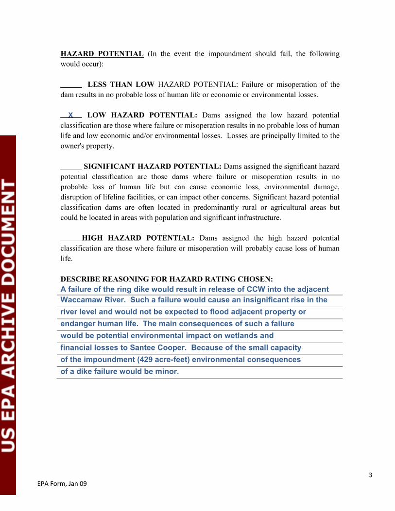
HAZARD POTENTIAL (In the event the impoundment should fail, the following would occur): X LESS THAN LOW HAZARD POTENTIAL: Failure or misoperation of the dam results in no probable loss of human life or economic or environmental losses.
LOW HAZARD POTENTIAL: Dams assigned the low hazard potential classification are those where failure or misoperation results in no probable loss of human life and low economic and/or environmental losses. Losses are principally limited to the owner's property.
SIGNIFICANT HAZARD POTENTIAL: Dams assigned the significant hazard
potential classification are those dams where failure or misoperation results in no probable loss of human life but can cause economic loss, environmental damage, disruption of lifeline facilities, or can impact other concerns. Significant hazard potential classification dams are often located in predominantly rural or agricultural areas but could be located in areas with population and significant infrastructure. HIGH HAZARD POTENTIAL: Dams assigned the high hazard potential classification are those where failure or misoperation will probably cause loss of human life. DESCRIBE REASONING FOR HAZARD RATING CHOSEN: Ash Pond No. 1 is no longer used for wet storage. The area has stored only compacted dry waste excavated from Ash Pond No. 2 since 1977. The embankment surrounding the impoundment therefore has no potential to release coal combustion waste, so the impoundment is not considered capable of causing danger to humans or economic or environmental losses if there is a failure of the embankment. The dry waste appears stable and is well-drained.
4 EPA Form, Jan 09
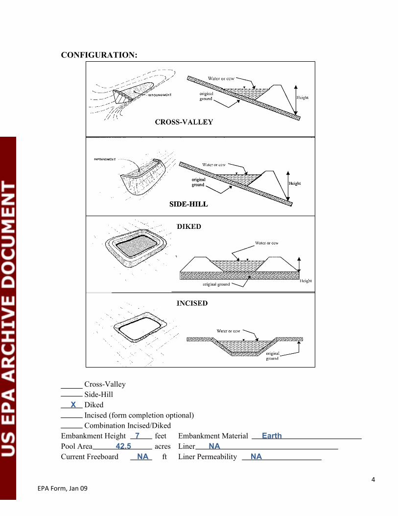
CONFIGURATION:
Cross-Valley Side-Hill X Diked Incised (form completion optional)
Combination Incised/Diked Embankment Height 7 feet Embankment Material Earth Pool Area 42.5 acres Liner NA Current Freeboard NA ft Liner Permeability NA
5 EPA Form, Jan 09
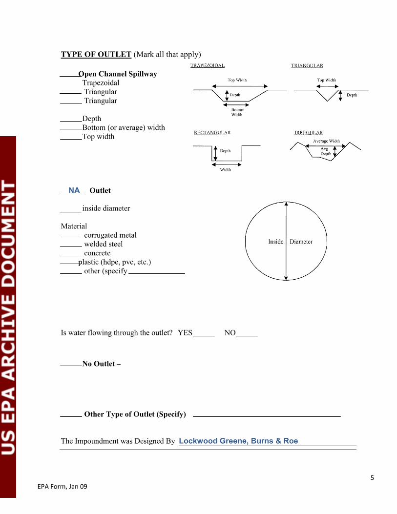
TYPE OF OUTLET (Mark all that apply)
Open Channel Spillway Trapezoidal
Triangular Triangular
Depth Bottom (or average) width Top width
NA Outlet
inside diameter Material
corrugated metal welded steel concrete
plastic (hdpe, pvc, etc.) other (specify
Is water flowing through the outlet? YES NO No Outlet –
Other Type of Outlet (Specify)
The Impoundment was Designed By Lockwood Greene, Burns & Roe

6 EPA Form, Jan 09
Has there ever been a failure at this site? YES NO X If So When?
If So Please Describe:

7 EPA Form, Jan 09
Has there ever been significant seepages at this site? YES NO X If So When?

8 EPA Form, Jan 09
Has there ever been any measures undertaken to monitor/lower Phreatic water table levels based on past seepages or breaches at this site? YES NO X If So which method (e.g., piezometers, gw pumping, …)?
If So Please Describe:
Coal Combustion Dam Inspection Checklist Form
1 EPA Form, Jan 09
US Environmental Protection Agency
Site Name: D.M. Grainger Station, Conway, SC
Date: 6/24/2010
Unit Name: Ash Pond No. 2
Operator’s Name: Santee Cooper
Unit ID:
Hazard Potential Classification: High Significant Low
Inspector’s Name: Steve Townsley/GEI Consultants, Mary Nodine/GEI Consultants Check the appropriate box below, Provide comments when appropriate. If not applicable or not available, record "N/A", Any unusual conditions or construction practices that should be
noted in the comments section, For large diked embankments, separate checklists may be used for different embankment areas. If separate forms are used, identify approximate area that
the form applies to in comments.
Yes No Yes No
1. Frequency of Company’s Dam Inspections? Monthly 18. Sloughing or bulging on slopes? X
2. Pool elevation (operator records)? 10.08/9.52 19. Major erosion or slope deterioration? X
3. Decant inlet elevation (operator records)? ~9.0 20. Decant Pipes
4. Open channel spillway elevation (operator records)? NA Is water entering inlet, but not exiting outlet? X
5. Lowest dam crest elevation (operator records)? ~14.5 Is water exiting outlet, but not entering inlet? X
6. If instrumentation is present, are readings recorded (operator records)?
X Is water exiting outlet flowing clear? X
7. Is the embankment currently under construction? X 21. Seepage (specify location, if seepage carries fines,
and approximate seepage rate below):
8. Foundation preparation (remove vegetation, stumps, topsoil in area where embankment fill will be placed)?
X From underdrain? X
9. Trees growing on embankment? (If so, indicate largest diameter below.)
X At isolated points on embankment slopes? X
10. Cracks or scarps on crest? X At natural hillside in the embankment area? X
11. Is there significant settlement along the crest? X Over widespread areas? X
12. Are decant trashracks clear and in place? X From downstream foundation area? X
13. Depressions or sink holes in tailings surface or whirlpool in the pool area
X “Boils” beneath stream or ponded water? X
14. Clogged spillways, groin or diversion ditches? X Around the outside of the decant pipe? X
15. Are spillway or ditch linings deteriorated? X 22. Surface movements in valley bottom or on hillside? X
16. Are outlets of decant or underdrains blocked? X 23. Water against downstream toe? X
17. Cracks or scarps on slopes X 24. Were Photos taken during the dam inspection? X
Major adverse changes in these items could cause instability and should be reported for further evaluation. Adverse conditions noted in these items should normally be described (extent, location, volume, etc.) in the space below and on the back of this sheet.
Inspection Issue # Comments

2 EPA Form, Jan 09
Coal Combustion Waste (CCW) Impoundment Inspection
Impoundment NPDES Permit # SC0001104 INSPECTOR Steve Townsley/GEI
Date 6/24/2010
Impoundment Name Ash Pond No. 2, D.M. Grainger Station, Conway, SC
Impoundment Company Santee Cooper
EPA Region 4
State Agency (Field Office) Address South Carolina DHEC, 2600 Bull St, Columbia, SC 29201
Name of Impoundment Ash Pond No. 2 (Report each impoundment on a separate form under the same Impoundment NPDES Permit number)
New X Update Yes No
Is impoundment currently under construction? X Is water or ccw currently being pumped into the impoundment? X IMPOUNDMENT FUNCTION: Fly ash, bottom ash and boiler slag storage Nearest Downstream Town: Name Red Hill, SC Distance from the impoundment ~2 miles Impoundment Location: Does a state agency regulate this impoundment? YES NO X If So Which State Agency?
Longitude 33 Degrees 49 Minutes 20 Seconds 2 Latitude 79 Degrees 2 Minutes 49 Seconds 51 State SC County Horry
3 EPA Form, Jan 09
HAZARD POTENTIAL (In the event the impoundment should fail, the following would occur): LESS THAN LOW HAZARD POTENTIAL: Failure or misoperation of the dam results in no probable loss of human life or economic or environmental losses. X LOW HAZARD POTENTIAL: Dams assigned the low hazard potential classification are those where failure or misoperation results in no probable loss of human life and low economic and/or environmental losses. Losses are principally limited to the owner's property.
SIGNIFICANT HAZARD POTENTIAL: Dams assigned the significant hazard
potential classification are those dams where failure or misoperation results in no probable loss of human life but can cause economic loss, environmental damage, disruption of lifeline facilities, or can impact other concerns. Significant hazard potential classification dams are often located in predominantly rural or agricultural areas but could be located in areas with population and significant infrastructure. HIGH HAZARD POTENTIAL: Dams assigned the high hazard potential classification are those where failure or misoperation will probably cause loss of human life. DESCRIBE REASONING FOR HAZARD RATING CHOSEN: A failure of the ring dike would result in release of CCW into the adjacent Waccamaw River. Such a failure would cause an insignificant rise in the river level and would not be expected to flood adjacent property or endanger human life. The main consequences of such a failure would be potential environmental impact on wetlands and financial losses to Santee Cooper. Because of the small capacity of the impoundment (429 acre-feet) environmental consequences of a dike failure would be minor.

4 EPA Form, Jan 09
CONFIGURATION:
Cross-Valley Side-Hill X Diked Incised (form completion optional)
Combination Incised/Diked Embankment Height 13 feet Embankment Material Earth Pool Area 39 acres Liner NA Current Freeboard ~4.5 ft Liner Permeability NA

5 EPA Form, Jan 09
TYPE OF OUTLET (Mark all that apply)
Open Channel Spillway Trapezoidal
Triangular Triangular
Depth Bottom (or average) width Top width
X Outlet
12 in. inside diameter Material
corrugated metal welded steel
X concrete plastic (hdpe, pvc, etc.)
other (specify
Is water flowing through the outlet? YES X NO No Outlet –
Other Type of Outlet (Specify)
The Impoundment was Designed By Lockwood Greene

6 EPA Form, Jan 09
Has there ever been a failure at this site? YES NO X If So When?
If So Please Describe:

7 EPA Form, Jan 09
Has there ever been significant seepages at this site? YES NO X If So When?

8 EPA Form, Jan 09
Has there ever been any measures undertaken to monitor/lower Phreatic water table levels based on past seepages or breaches at this site? YES NO X If So which method (e.g., piezometers, gw pumping, …)?
If So Please Describe:

Appendix B
Inspection Photographs

EPA Coal Ash Impoundment Assessment Region 4 – Site #3 – Santee Cooper Grainger Generating Station
July 2010
GEI Consultants, Inc. B 2 GEI Project 092881
Photo 1: Ash Pond #1 (dry handling, continually dewatered): Downstream slope.
Photo 2: Ash Pond #1: Overview.

EPA Coal Ash Impoundment Assessment Region 4 – Site #3 – Santee Cooper Grainger Generating Station
July 2010
GEI Consultants, Inc. B 3 GEI Project 092881
Photo 3: Ash Pond #1: Dry ash handling area – note sprinklers to reduce dust.
Photo 4: Ash Pond #1: Dewatering channel.

EPA Coal Ash Impoundment Assessment Region 4 – Site #3 – Santee Cooper Grainger Generating Station
July 2010
GEI Consultants, Inc. B 4 GEI Project 092881
Photo 5: Ash Pond #2: Primary ash slurry channel – dewatered and not in use during site visit.
Photo 6: Ash Pond #2: Ash slurry inflow.
EPA Coal Ash Impoundment Assessment Region 4 – Site #3 – Santee Cooper Grainger Generating Station
July 2010
GEI Consultants, Inc. B 5 GEI Project 092881
Photo 7: Ash Pond #2: Downstream slope, intake channel on left.
Photo 8: Ash Pond #2: Crest near intake channel.

EPA Coal Ash Impoundment Assessment Region 4 – Site #3 – Santee Cooper Grainger Generating Station
July 2010
GEI Consultants, Inc. B 6 GEI Project 092881
Photo 9: Ash Pond #2: Overview.
Photo 10: Ash Pond #2: Downstream slope.
EPA Coal Ash Impoundment Assessment Region 4 – Site #3 – Santee Cooper Grainger Generating Station
July 2010
GEI Consultants, Inc. B 7 GEI Project 092881
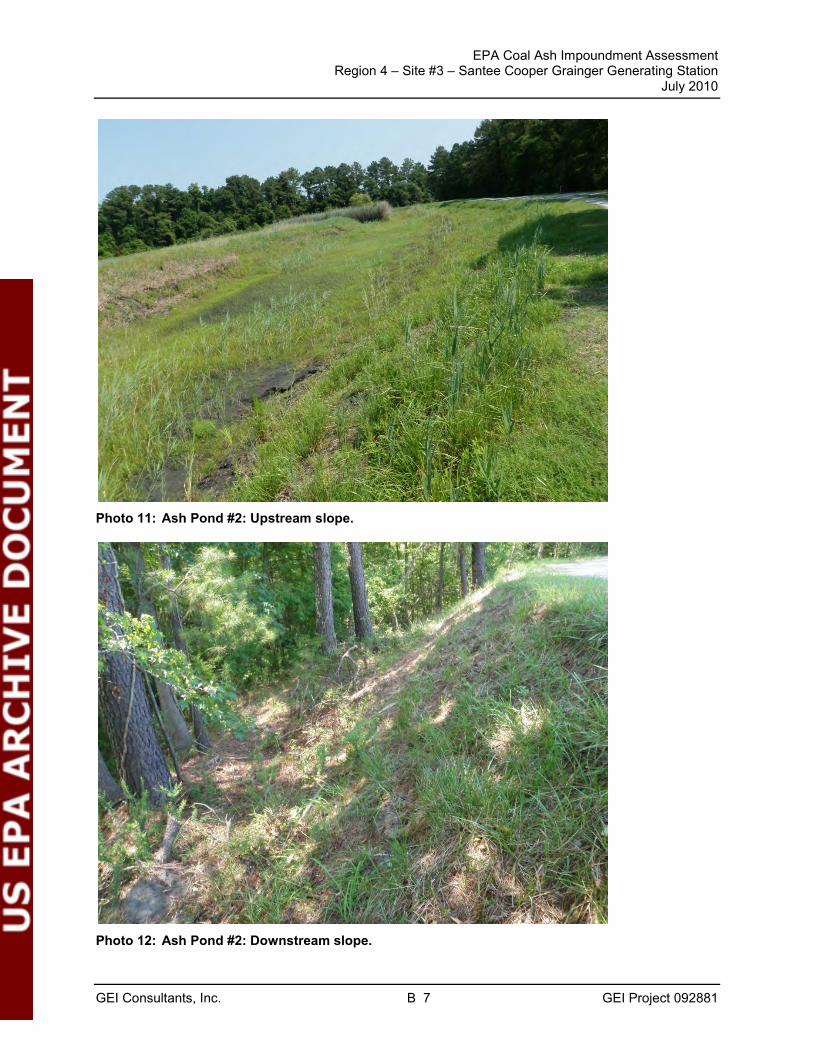
Photo 11: Ash Pond #2: Upstream slope.
Photo 12: Ash Pond #2: Downstream slope.

EPA Coal Ash Impoundment Assessment Region 4 – Site #3 – Santee Cooper Grainger Generating Station
July 2010
GEI Consultants, Inc. B 8 GEI Project 092881
Photo 13: Ash Pond #2: Crest.
Photo 14: Ash Pond #2: Upstream slope. Note riprap slope protection.

EPA Coal Ash Impoundment Assessment Region 4 – Site #3 – Santee Cooper Grainger Generating Station
July 2010
GEI Consultants, Inc. B 9 GEI Project 092881
Photo 15: Ash Pond #2: Outlet works and upstream slope.
Photo 16: Ash Pond #2: Decant inlet.

EPA Coal Ash Impoundment Assessment Region 4 – Site #3 – Santee Cooper Grainger Generating Station
July 2010
GEI Consultants, Inc. B 10 GEI Project 092881
Photo 17: Ash Pond #2: Outlet structure with Parshall Flume.
Photo 18: Ash Pond #2: Staff gauge at highway drainage ditch west of pond.

EPA Coal Ash Impoundment Assessment Region 4 – Site #3 – Santee Cooper Grainger Generating Station
July 2010
GEI Consultants, Inc. B 11 GEI Project 092881
Photo 19: Ash Pond #2: Divider fill between east and west cells.
Photo 20: Ash Pond #2: Decant pipe between cells – west cell inlet.

EPA Coal Ash Impoundment Assessment Region 4 – Site #3 – Santee Cooper Grainger Generating Station
July 2010
GEI Consultants, Inc. B 12 GEI Project 092881
Photo 21: Ash Pond #2: Decant pipe between cells – east cell outlet.
Photo 22: Ash Pond #2: Wastewater discharge into east cell.

Appendix C
Instrumentation
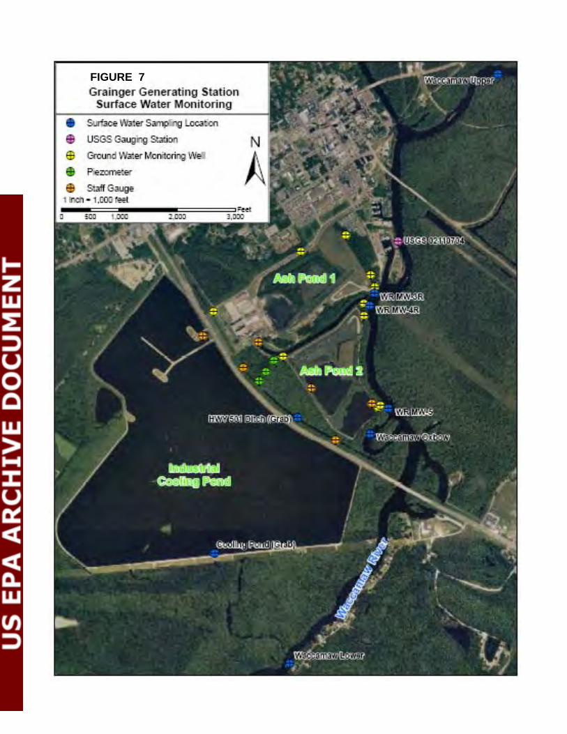
FIGURE 7


Appendix D
Reply to Request for Information under Section 104(e)

~p~__~~----=~=--e:_t_, _One Riverwood DriveMoncks Corner, SC 29461-2901(843) 761-8000PO. Box 2946101Moncks Corner, SC 29461-6101
March 25, 2009
Mr. Richard Kinch
US Environmental Protection Agency (5306P)1200 Pennsylvania Avenue, NWWashington, DC 20460
RE: South Carolina Public Service Authority (Santee Cooper) Response to EPA'sRequests for Information Under Section l04(e) of the Comprehensive EnvironmentalResponse, Compensation, and Liability Act, 42 U.S.C.9604(e)
Dear Mr. Kinch:
Enclosed are the South Carolina Public Service Authority's ("Santee Cooper") responses to theUnited States Environmental Protection Agency' s("EP A") Requests for Information("Requests") under Section 104(3) of the Comprehensive Environmental Response,Compensation, and Liability Act, 42 U.S.C.9604(e). Responses and Certifications are identifiedas Exhibit A and are enclosed for the following Requests:
Grainger Generating Station - Request dated March 9, 2009,received March 12,2009Jefferies Generating Station - Request dated March 9, 2009Winyah Generating Station - Request dated March 9,2009 and received March 16,2009Cross Generating Station - Request dated March 9, 2009 and received March 19,2009General Request to CEO - Request dated March 9, 2009 and received March 12,2009
We have not yet received Requests for Jefferies Generating Station but are moving forward withresponding to questions asked in the other Requests for these facilities with the expectation thatthe Requests not yet received will be identical to those already received. Copies of the Requestswe have received are attached hereto as Exhibit B for your reference.
Please note that Responses to the General Request to the CEO are included in the four stationresponses and as such there is not a separate document responding to this Request. However, thecover letter did inquire as to any additional Santee Cooper facilities which might have units that
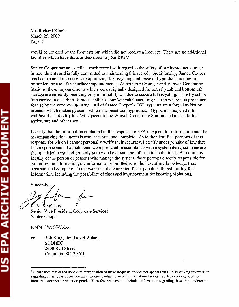
Mr. Richard Kinch
March 25, 2009Page 2
would be covered by the Requests but which did not receive a Request. There are no additionalfacilities which have units as described in your letter. 1
Santee Cooper has an excellent track record with regard to the safety of our byproduct storageimpoundments and is fully committed to maintaining this record. Additionally, Santee Cooperhas had tremendous success in optimizing the recycling and reuse of bypro ducts in order tominimize the use of the surface impoundments. At both our Grainger and Winyah GeneratingStations, these impoundments which were originally designed for both fly ash and bottom ashstorage are currently receiving only minimal fly ash due to successful recycling. The fly ash istransported to a Carbon Burnout facility at our Winyah Generating Station where it is processedfor use by the concrete industry. All of Santee Cooper's FGD systems are a forced oxidationprocess, which makes gypsum, which is a beneficial byproduct. Gypsum is recycled intowallboard at a facility located adjacent to the Winyah Generating Station, and also sold foragriculture and other uses.
I certify that the information contained in this response to EPA's request for information and theaccompanying documents is true, accurate, and complete. As to the identified portions of thisresponse for which I cannot personally verify their accuracy, I certify under penalty oflaw thatthis response and all attachments were prepared in accordance with a system designed to assurethat qualified personnel properly gather and evaluate the information submitted. Based on myinquiry of the person or persons who manage the system, those persons directly responsible forgathering the information, the information submitted is, to the best of my knowledge, true,accurate, and complete. I am aware that there are significant penalties for submitting falseinformation, including the possibility of fines and imprisonment for knowing violations .
. ,Since~&Singlernry I-Senior Vice President, Corporate ServicesSantee Cooper
RMM: JW: SWJ:dks
cc: Bob King, attn: David WilsonSCDHEC2600 Bull Street
Columbia, SC 2920 I
1 Please note that based upon our interpretation of these Requests, it does not appear that EP A is seeking informationregarding other types of surface impoundments which may be located at our facilities such as cooling ponds orindustrial storm water retention ponds. Therefore we have not included information regarding these impoundments.

Response to United States Environmental Protection Agency Request for Informationdated March 9,2009
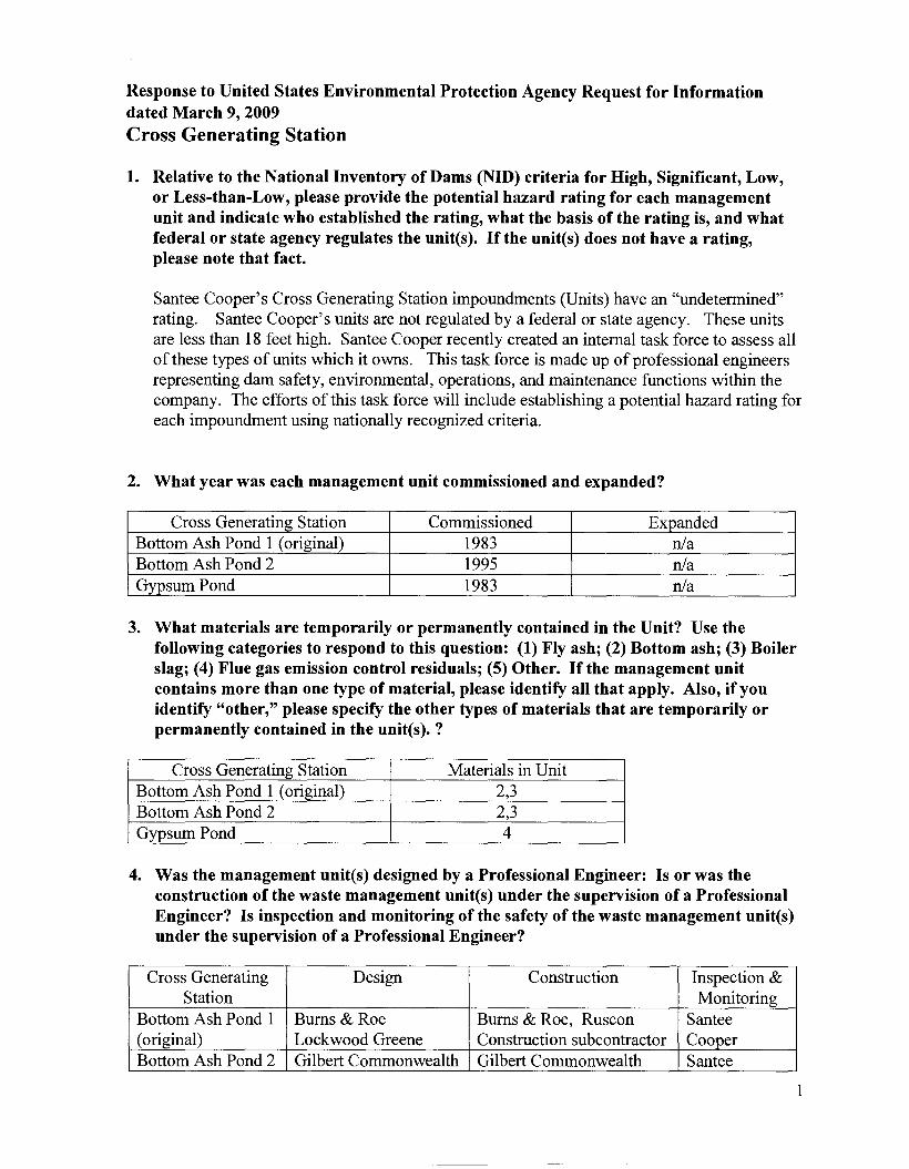
Cross Generating Station
1. Relative to the National Inventory of Dams (NID) criteria for High, Significant, Low,or Less-than-Low, please provide the potential hazard rating for each managementunit and indicate who established the rating, what the basis of the rating is, and whatfederal or state agency regulates the unit(s). If the unit(s) does not have a rating,please note that fact.
Santee Cooper's Cross Generating Station impoundments (Units) have an "undetermined"rating. Santee Cooper's units are not regulated by a federal or state agency. These unitsare less than 18 feet high. Santee Cooper recently created an internal task force to assess allof these types of units which it owns. This task force is made up of professional engineersrepresenting dam safety, environmental, operations, and maintenance functions within thecompany. The efforts of this task force will include establishing a potential hazard rating foreach impoundment using nationally recognized criteria.
2. What year was each management unit commissioned and expanded?
Cross Generating Station CommissionedExpandedBottom Ash Pond 1 (original)
1983n/aBottom Ash Pond 2
1995n/a
Gypsum Pond
1983n/a
3. What materials are temporarily or permanently contained in the Unit? Use thefollowing categories to respond to this question: (1) Fly ash; (2) Bottom ash; (3) Boilerslag; (4) Flue gas emission control residuals; (5) Other. If the management unitcontains more than one type of material, please identify all that apply. Also, if youidentify "other," please specify the other types of materials that are temporarily orpermanently contained in the unit(s). ?
Cross Generating Station Materials in Unit
Bottom Ash Pond 1 (original)2,3!
Bottom Ash Pond 22,3
Gypsum Pond
4
4. Was the management unit(s) designed by a Professional Engineer: Is or was theconstruction of the waste management unit(s) under the supervision of a ProfessionalEngineer? Is inspection and monitoring of the safety of the waste management unit(s)under the supervision of a Professional Engineer?
Cross Generating DesignConstructionInspection &Station
MonitoringBottom Ash Pond 1
Bums & RoeBums & Roe, RusconSantee
(original)
Lockwood GreeneConstruction subcontractorCooperBottom Ash Pond 2
Gilbert CommonwealthGilbert CommonwealthSantee
1

Higgerson-BuchanonCooperGypsum Pond
Burns & RoeBurns & Roe, RusconSanteeLockwood Greene
Construction subcontractorCooper
All of the Units were designed and constructed by nationally recognized professionalengineering and construction firms which included the oversight and direction byProfessional Engineers during all aspects of design and construction. Additionally, SanteeCooper served as our own General Contractor for construction of these Units, whichprovided an additional level of review and oversight by Professional Engineers.
Generating Station personnel perform quarterly inspections of the Units under the directionof a Station Supervisor. The same small group of people performs the inspections to ensureany changes or anomalies will be easily recognized. The inspectors are knowledgeableabout the operation, maintenance, and general condition of the impoundments. Writteninspection reports are prepared and reviewed and signed by the Station Manager. A copy ofthese reports is submitted to engineers in the corporate office for additional review.
If any structural or safety issues are noted during the inspections or are later noted in the
review cycle of the impoundment inspection reports, they are referred to Santee Cooper'sConstruction Services Department. Santee Cooper owns and operates a federally licensedhydroelectric facility with over 40 miles of dams & dikes regulated by the Federal EnergyRegulatory Commission (FERC). Santee Cooper's Construction Services Department hasdeveloped and oversees a comprehensive and well established dam safety program with astaff of trained dam safety engineers, under the supervision of a Professional Engineer. Thestaff is on-call 24/7 to address any questions or concerns regarding the structural integrity ofany of Santee Cooper's impoundments. This department has the necessary heavy earthmoving equipment and has a staff of experienced equipment operators and can readilyrespond to an emergency.
5. When did the company last assess or evaluate the safety (i.e., structural integrity) ofthe management unites)? Briefly describe the credentials of those conducting thestructural integrity assessments/evaluations. Identify actions taken or planned byfacility personnel as a result of these assessments or evaluations. If corrective actionswere taken, briefly describe the credentials of those performing the corrective actions,whether they were company employees or contractors. If the company plans anassessment or evaluation in the future, when is it expected to occur?
Because of the low head, age, good condition, ongoing maintenance, and original design andconstruction of each impoundment, a formal evaluation of the structural integrity has notbeen performed on these Units. The design criteria has always been very stringent andconsidered geotechnical conditions of the foundation, seismic conditions, groundwater
levels, and flood levels. Additionally none of the dikes are over 18 feet in height. Also,these facilities are located in South Carolina's coastal plain where surrounding terrain slopesare typically less than 1-2% further minimizing any potential impacts.
2

In addition, a task force was established in early 2009 to further evaluate the need and extentfor any future structural integrity assessments for each Unit based on a review of the hazardrating and other data. This assessment will be completed in 2010.
6. When did a State or a Federal regulatory official last inspect or evaluate the safety(structural integrity) of the management unit(s)? If you are aware of a planned stateor federal inspection or evaluation in the future, when is it expected to occur? Pleaseidentify the Federal or State regulatory agency or department which conducted or isplanning the inspection or evaluation. Please provide a copy of the most recent officialinspection report or evaluation.
These Units are not regulated by State or Federal agencies thus no formal structuralinspections have been performed by any agencies, except Santee Cooper. Santee Cooperperforms our own inspections and maintains the integrity and safety of these structures.However, the South Carolina Department of Health and Environmental Control("SCDHEC") performs periodic NPDES inspections and because these Units are permittedindustrial treatment facilities for station wastewater, the SCDHEC inspection incorporates areview of the operation of the bottom ash ponds and the permitted discharge.
7. Have assessments or evaluations, or inspections conducted by State or Federalregulatory officials conducted within the past year uncovered a safety issue(s) with themanagement unit(s), and, if so, describe the actions that have been or being taken todeal with the issue or issues. Please provide any documentation that you have for theseactions.
No safety issues have been identified for any of the Cross impoundments.
8. What is the surface area (acres) and total storage capacity of each ofthe managementunits? What is the volume of materials currently stored in each of the managementunit(s)? Please provide the date that the volume measurement(s) was taken Pleaseprovide the maximum height of the management unit(s). The basis for determiningmaximum height is explained later in this Enclosure.
Cross Generating SurfaceTotalVolume ofMaximumDate of LastStation
AreaStorageMaterialsHeightVolume
(acres)CapacityCurrently Stored(feet)Measurement
(acre-feet)(acre-feet)
Bottom Ash Pond 112.8230 2318Mar. 18,2009
(original) Bottom Ash Pond 2791158 78314Jan. 27,2009
Gypsum Pond
16Varies 16Weekly 1.
1 The gypsum pond serves as an intermediary staging area and settling pond for the FGDsystem's wash water and gypsum. Continuous maintenance occurs to remove the gypsummaterial and transport it by truck to the permitted industrial solid waste landfill on site.
3

9. Please provide a brief history of known spills or unpermitted releases from the unitwithin the last ten years, whether or not these were reported to State or Federalregulatory agencies. For purposes of this question, please include only releases tosurface water or to the land (do not include releases to groundwater)
There have been no spills or unpermitted releases from these Units within the last ten years.
10. Please identify all current legal owner(s) and operator(s) at the facility.
Santee Cooper (South Carolina Public Service Authority) is the owner and operator of alllisted impoundments.
CERTIFICATION
I certify that the information contained in this response to EPA's request for information and theaccompanying documents is true, accurate, and complete. As to the identified portions of thisresponse for which I cannot personally verify their accuracy, I certify under penalty of law that thisresponse and all attachments were prepared in accordance with a system designed to assure thatqualified personnel properly gather and evaluate the information submitted. Based on my inquiry ofthe person or persons who manage the system, those persons directly responsible for gathering theinformation, the information submitted is, to the best of my knowledge, true, accurate, andcomplete. I am aware that there are significant penalties for submitting false information, includingthe possibility of fines and imprisonment for knowing violations
" ce,P.E.ice President
Generation
4

Response to United States Environmental Protection Agency Request for Informationdated March 9,2009
Grainger Generating Station
1. Relative to the National Inventory of Dams (NID) criteria for High, Significant, Low,or Less-than-Low, please provide the potential hazard rating for each managementunit and indicate who established the rating, what the basis of the rating is, and whatfederal or state agency regulates the unit(s). If the unit(s) does not have a rating,please note that fact.
Santee Cooper's Grainger Generating Station impoundments (Units) have an"undetermined" rating. Santee Cooper's units are not regulated by a federal or stateagency. These units are less than 13 feet high. Santee Cooper recently created an internaltask force to assess all of these types of units which it owns. This task force is made up ofprofessional engineers representing dam safety, environmental, operations, and maintenancefunctions within the company. The efforts of this task force will include establishing apotential hazard rating for each impoundment using nationally recognized criteria.
2. What year was each management unit commissioned and expanded?
Grainger Generating Station CommissionedExpandedAsh Pond #1
19661967Ash Pond #2
19771990
3. What materials are temporarily or permanently contained in the Unit? Use thefollowing categories to respond to this question: (1) Fly ash; (2) Bottom ash; (3) Boilerslag; (4) Flue gas emission control residuals; (5) Other. If the management unitcontains more than one type of material, please identify all that apply. Also, if youidentify "other," please specify the other types of materials that are temporarily orpermanently contained in the unit(s). ?
Grainger Generating Station Materials in UnitAsh Pond #1
1,2,3Ash Pond #2
1,2,3
4. Was the management unit(s) designed by a Professional Engineer: Is or was theconstruction of the waste management unit(s) under the supervision of a ProfessionalEngineer? Is inspection and monitoring of the safety of the waste management unit(s)under the supervision of a Professional Engineer?
Grainger DesignConstructionInspection &Generating Station
MonitoringAsh Pond #1
Bums & RoeCentral Electric PowerSantee CooperLockwood Greene
Coop oversightAsh Pond #2
Lockwood GreeneLockwood GreeneSantee Cooper
Both Units were designed by nationally recognized professional engineering andconstruction firms which included the oversight and direction of Professional Engineers
5

during all aspects of design. Santee Cooper served as our own General Contractor fordesign and construction of the 1990 expansion of the Unit #2 Ash Pond which included theoversight and direction of Professional Engineers during all aspects of design andconstruction
Generating Station personnel perform quarterly inspections of the Units under the directionof a Station Supervisor. The same small group of people performs the inspections to ensureany changes or anomalies will be easily recognized. The inspectors are knowledgeableabout the operation, maintenance, and general condition of the impoundments. Writteninspection reports are prepared and reviewed by the Station Manager if any problems aredetected. A copy of these reports is submitted to engineers in the corporate office foradditional review.
If any structural or safety issues are noted during the inspections or are later noted in thereview cycle of the impoundment inspection reports, they are referred to Santee Cooper'sConstruction Services Department. Santee Cooper owns and operates a federally licensedhydroelectric facility with over 40 miles of dams & dikes regulated by the Federal EnergyRegulatory Commission (FERC). Santee Cooper's Construction Services Department hasdeveloped and oversees a comprehensive and well established dam safety program with astaff oftrained dam safety engineers, under the supervision of a Professional Engineer. Thestaff is on-call 24/7 to address any questions or concerns regarding the structural integrity ofany of Santee Cooper's impoundments. This department has the necessary heavy earthmoving equipment and has a staff of experienced equipment operators and can readilyrespond to an emergency.
5. When did the company last assess or evaluate the safety (i.e., structural integrity) ofthe management unit(s)? Briefly describe the credentials of those conducting thestructural integrity assessments/evaluations. Identify actions taken or planned byfacility personnel as a result of these assessments or evaluations. If corrective actionswere taken, briefly describe the credentials of those performing the corrective actions,whether they were company employees or contractors. If the company plans anassessment or evaluation in the future, when is it expected to occur?
Because of the low head, good condition, ongoing maintenance, and original design andconstruction of each impoundment, a formal evaluation of the structural integrity has notbeen performed with the exception of Ash Pond #2. In 1990, Santee Cooper's ConstructionServices Department performed a stability analysis of the dike to evaluate the impact ofraising the dike 2 to 3 feet. The analysis determined that adequate factors of safety wouldbe maintained upon raising the dike 3 feet.
The design criteria has always been very stringent and considered geotechnical conditions ofthe foundation, seismic conditions, groundwater levels, and flood levels. Additionally noneof the dikes are over 13 feet in height. Also, these facilities are located in South Carolina'scoastal plain where surrounding terrain slopes are typically less than 1-2% furtherminimizing any potential impacts.
In addition, a task force was established in early 2009 to further evaluate the need and extentfor any future structural integrity testing for each Unit based on a review of the hazard ratingand other data. This assessment will be completed in 2010.
6
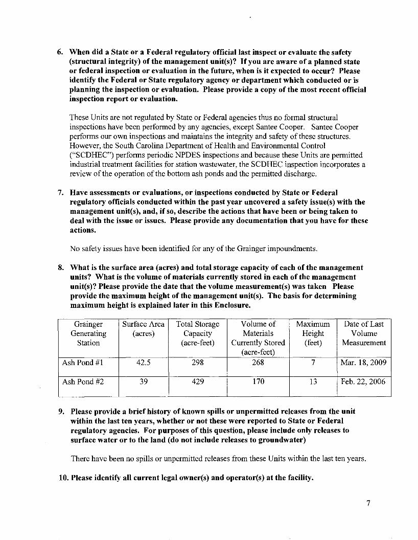
6. When did a State or a Federal regulatory official last inspect or evaluate the safety(structural integrity) of the management unit(s)? If you are aware ofa planned stateor federal inspection or evaluation in the future, when is it expected to occur? Pleaseidentify the Federal or State regulatory agency or department which conducted or isplanning the inspection or evaluation. Please provide a copy of the most recent officialinspection report or evaluation.
These Units are not regulated by State or Federal agencies thus no formal structuralinspections have been performed by any agencies, except Santee Cooper. Santee Cooperperforms our own inspections and maintains the integrity and safety of these structures.However, the South Carolina Department of Health and Environmental Control("SCDHEC") performs periodic NPDES inspections and because these Units are permittedindustrial treatment facilities for station wastewater, the SCDHEC inspection incorporates areview of the operation of the bottom ash ponds and the permitted discharge.
7. Have assessments or evaluations, or inspections conducted by State or Federalregulatory officials conducted within the past year uncovered a safety issue(s) with themanagement unit(s), and, if so, describe the actions that have been or being taken todeal with the issue or issues. Please provide any documentation that you have for theseactions.
No safety issues have been identified for any of the Grainger impoundments.
8. What is the surface area (acres) and total storage capacity of each of the managementunits? What is the volume of materials currently stored in each of the managementunit(s)? Please provide the date that the volume measurement(s) was taken Pleaseprovide the maximum height of the management unit(s). The basis for determiningmaximum height is explained later in this Enclosure.
Grainger Surface AreaTotal StorageVolume ofMaximumDate of Last
Generating(acres)CapacityMaterialsHeightVolume
Station(acre-feet)Currently Stored(feet)Measurement
(acre- feet)Ash Pond #1
42.52982687Mar. 18,2009
Ash Pond #2
3942917013Feb. 22,2006
9. Please provide a brief history of known spills or unpermitted releases from the unitwithin the last ten years, whether or not these were reported to State or Federalregulatory agencies. For purposes of this question, please include only releases tosurface water or to the land (do not include releases to groundwater)
There have been no spills or unpermitted releases from these Units within the last ten years.
10. Please identify all current legal owner(s) and operator(s) at the facility.
7

Santee Cooper is the legal owner and operator of the facility. Prior to the end of2008, itleased the facility pursuant to a long term lease with Central Electric Cooperative, Inc. andhas been the sole operator of the facility. At the end of2008 title vested in Santee Cooper,although Central has not yet delivered the deed to the property.
CERTIFICA nON
I certify that the information contained in this response to EPA's request for information and theaccompanying documents is true, accurate, and complete. As to the identified portions of thisresponse for which I cannot personally verify their accuracy, I certify under penalty oflaw that thisresponse and all attachments were prepared in accordance with a system designed to assure thatqualified personnel properly gather and evaluate the information submitted. Based on my inquiry ofthe person or persons who manage the system, those persons directly responsible for gathering theinformation, the information submitted is, to the best of my knowledge, true, accurate, andcomplete. I am aware that there are significant penalties for submitting false information, includingthe possibility of fines and imprisonment for knowing violations
8
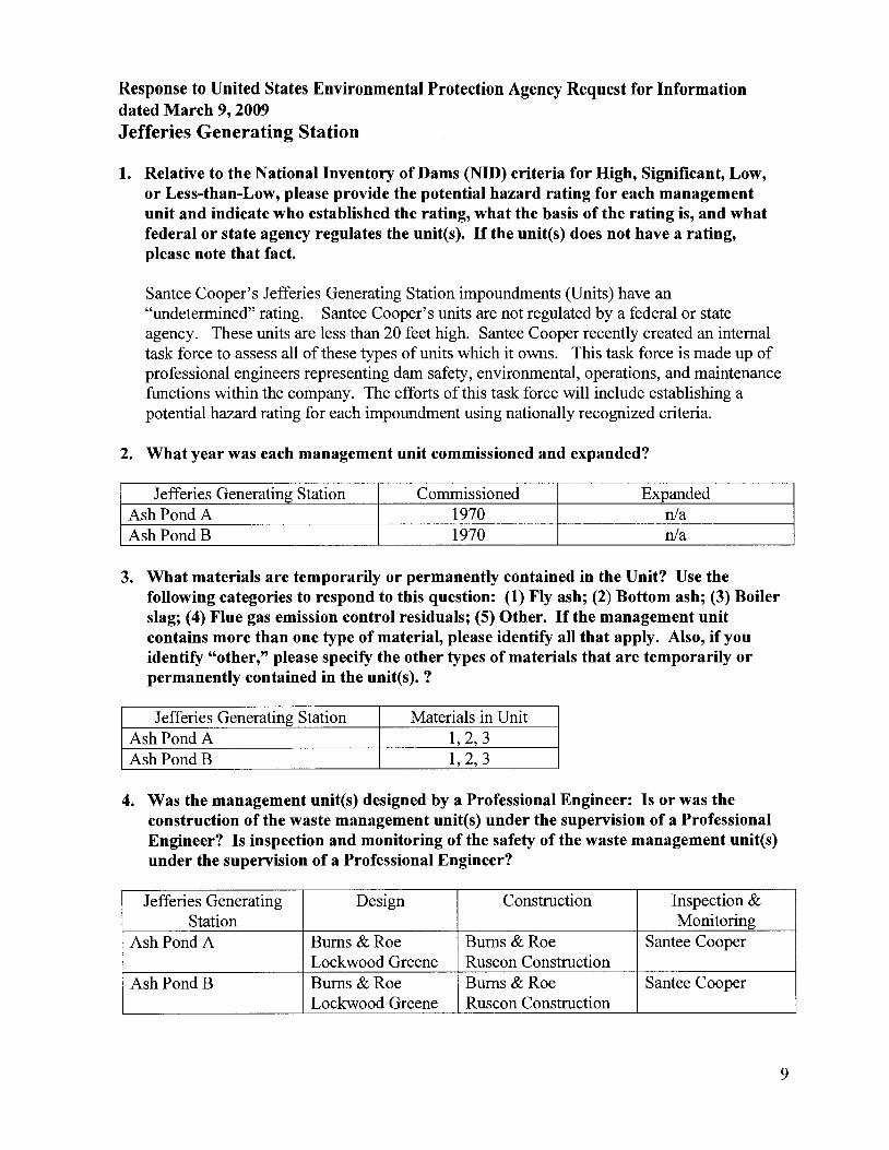
Response to United States Environmental Protection Agency Request for Informationdated March 9,2009
Jefferies Generating Station
1. Relative to the National Inventory of Dams (NID) criteria for High, Significant, Low,or Less-than-Low, please provide the potential hazard rating for each managementunit and indicate who established the rating, what the basis of the rating is, and whatfederal or state agency regulates the unit(s). If the unit(s) does not have a rating,please note that fact.
Santee Cooper's Jefferies Generating Station impoundments (Units) have an"undetermined" rating. Santee Cooper's units are not regulated by a federal or stateagency. These units are less than 20 feet high. Santee Cooper recently created an internaltask force to assess all of these types of units which it owns. This task force is made up ofprofessional engineers representing dam safety, environmental, operations, and maintenancefunctions within the company. The efforts of this task force will include establishing apotential hazard rating for each impoundment using nationally recognized criteria.
2. What year was each management unit commissioned and expanded?
Jefferies Generating Station CommissionedExpandedAsh Pond A
1970n1aAshPondB
1970n1a
3. What materials are temporarily or permanently contained in the Unit? Use thefollowing categories to respond to this question: (1) Fly ash; (2) Bottom ash; (3) Boilerslag; (4) Flue gas emission control residuals; (5) Other. If the management unitcontains more than one type of material, please identify all that apply. Also, if youidentify "other," please specify the other types of materials that are temporarily orpermanently contained in the unit(s). ?
Jefferies Generating Station Materials in UnitAsh Pond A
1,2,3
Ash Pond B1, 2, 3
4. Was the management unit(s) designed by a Professional Engineer: Is or was theconstruction of the waste management unit(s) under the supervision of a ProfessionalEngineer? Is inspection and monitoring of the safety of the waste management unit(s)under the supervision of a Professional Engineer?
Jefferies Generating DesignConstructionInspection &Station
MonitoringAsh Pond A
Burns & RoeBums & RoeSantee CooperLockwood Greene
Ruscon ConstructionAshPondB
Burns & RoeBurns & RoeSantee CooperLockwood Greene
Ruscon Construction
9
The engineering finn for both Units was Burns & Roe. Under Burns and Roe, the civildesign firm was Lockwood Greene and the construction was performed by RusconConstruction Company. Burns & Roe and Lockwood Greene are nationally recognizedprofessional engineering and construction firms thus the full scope of work was under theoversight and direction of Professional Engineers during all aspects of design andconstruction.
Generating Station personnel perform quarterly inspections of the Units under the directionof a Station Supervisor. The same small group of people performs the inspections to ensureany changes or anomalies will be easily recognized. The inspectors are knowledgeableabout the operation, maintenance, and general condition of the impoundments. Writteninspection reports are prepared and reviewed by the Station Manager if any problems aredetected. A copy of these reports is submitted to engineers in the corporate office foradditional review.
If any structural or safety issues are noted during the inspections or are later noted in thereview cycle of the impoundment inspection reports, they are referred to Santee Cooper'sConstruction Services Department. Santee Cooper owns and operates a federally licensedhydroelectric facility with over 40 miles of dams & dikes regulated by the Federal EnergyRegulatory Commission (FERC). Santee Cooper's Construction Services Department hasdeveloped and oversees a comprehensive and well established dam safety program with astaff of trained dam safety engineers, under the supervision of a Professional Engineer. Thestaff is on-call 24/7 to address any questions or concerns regarding the structural integrity ofany of Santee Cooper's impoundments. This department has the necessary heavy earthmoving equipment and has a staff of experienced equipment operators and can readilyrespond to an emergency.
5. When did the company last assess or evaluate the safety (i.e., structural integrity) ofthe management unites)? Briefly describe the credentials of those conducting thestructural integrity assessments/evaluations. Identify actions taken or planned byfacility personnel as a result of these assessments or evaluations. If corrective actionswere taken, briefly describe the credentials of those performing the corrective actions,whether they were company employees or contractors. If the company plans anassessment or evaluation in the future, when is it expected to occur?
Because of the low head, good condition, ongoing maintenance, and design and constructionof each impoundment, a formal evaluation of the structural integrity has not been performedon these Units. Additionally none of the dikes are over 20 feet in height. Also, thesefacilities are located in South Carolina's coastal plain where surrounding terrain slopes aretypically less than 1-2% further minimizing any potential impacts.
In addition, a task force was established in early 2009 to further evaluate the need and extentfor any future structural integrity testing for each Unit based on a review of the hazard ratingand other data. This assessment will be completed in 2010.
6. When did a State or a Federal regulatory official last inspect or evaluate the safety(structural integrity) of the management unites)? If you are aware of a planned stateor federal inspection or evaluation in the future, when is it expected to occur? Pleaseidentify the Federal or State regulatory agency or department which conducted or is
10

planning the inspection or evaluation. Please provide a copy of the most recent officialinspection report or evaluation.
These Units are not regulated by State or Federal agencies thus no formal structuralinspections have been performed by any agencies, except Santee Cooper. Santee Cooperperforms our own inspections and maintains the integrity and safety of these structures.However, the South Carolina Department of Health and Environmental Control("SCDHEC") performs periodic NPDES inspections and because these Units are permittedindustrial treatment facilities for station wastewater, the SCDHEC inspection incorporates areview of the operation of the bottom ash ponds and the permitted discharge.
7. Have assessments or evaluations, or inspections conducted by State or Federalregulatory officials conducted within the past year uncovered a safety issue(s) with themanagement unit(s), and, if so, describe the actions that have been or being taken todeal with the issue or issues. Please provide any documentation that you have for theseactions.
No safety issues have been identified for any of the Jefferies impoundments.
8. What is the surface area (acres) and total storage capacity of each ofthe managementunits? What is the volume of materials currently stored in each of the managementunit(s)? Please provide the date that the volume measurement(s) was taken Pleaseprovide the maximum height of the management unit(s). The basis for determiningmaximum height is explained later in this Enclosure.
Jefferies Surface AreaTotal StorageVolume ofMaximumDate of Last
Generating(acres)CapacityMaterialsHeightVolume
Station(acre-feet)Currently Stored(feet)Measurement
(acre-feet)Ash Pond A
12798278620Feb. 4,2004
Ash Pond B
422452510Feb. 4,2004
--
----
9. Please provide a brief history of known spills or unpermitted releases from the unitwithin the last ten years, whether or not these were reported to State or Federalregulatory agencies. For purposes of this question, please include only releases tosurface water or to the land (do not include releases to groundwater)
There have been no spills or unpermitted releases from these Units within the last ten years.
10. Please identify all current legal owner(s) and operator(s) at the facility.
Santee Cooper (South Carolina Public Service Authority) is the owner and operator of alllisted impoundments.
11
CERTIFICATION
I certify that the information contained in this response to EPA's request for information and theaccompanying documents is true, accurate, and complete. As to the identified portions of thisresponse for which I cannot personally verify their accuracy, I certify under penalty of law that thisresponse and all attachments were prepared in accordance with a system designed to assure thatqualified personnel properly gather and evaluate the information submitted. Based on my inquiry ofthe person or persons who manage the system, those persons directly responsible for gathering theinformation, the information submitted is, to the best of my knowledge, true, accurate, andcomplete. I am aware that there are significant penalties for submitting false information, includingthe possibility of fines and imprisonment for knowing violations
12

Response to United States Environmental Protection Agency Request for Informationdated March 9, 2009
Winyah Generating Station
1. Relative to the National Inventory of Dams (NID) criteria for High, Significant, Low,or Less-than-Low, please provide the potential hazard rating for each managementunit and indicate who established the rating, what the basis of the rating is, and whatfederal or state agency regulates the unites). If the unites) does not have a rating,please note that fact.
Santee Cooper's Winyah Generating Station impoundments (Units) have an "undetermined"rating. Santee Cooper's units are not regulated by a federal or state agency. These unitsare less than 32' high. Santee Cooper recently created an internal task force to assess all ofthese types of units which it owns. This task force is made up of professional engineersrepresenting dam safety, environmental, operations, and maintenance functions within thecompany. The efforts of this task force will include establishing a potential hazard rating foreach impoundment using nationally recognized criteria.
2. What year was each management unit commissioned and expanded?
Winyah Generating Station CommissionedExpandedAsh Pond A
1975n/aAsh Pond B
19751997South Ash Pond
1980n/aWest Ash Pond
1980n/a
Unit 2 Slurry Pond
1977n/a
Unit 3 & 4 Slurry Pond
1980n/a
3. What materials are temporarily or permanently contained in the Unit? Use thefollowing cate.gories to respond to this question: (1) Fly ash; (2) Bottom ash; (3) Boilerslag; (4) Fuel gas emission control residuals; (5) Other. If the management unitcontains more than one type of material, please identify all that apply. Also, if youidentify "other," please specify the other types of materials that are temporarily orpermanently contained in the unites). ?
Winyah Generating Station Materials in UnitAsh Pond A
1,2,3Ash Pond B
1,2,3South Ash Pond
1,2,3West Ash Pond
1,2,3
Unit 2 Slurry Pond
4
Unit 3 & 4 Slurry Pond
4
4. Was the management unites) designed by a Professional Engineer: Is or was theconstruction of the waste management unites) under the supervision of a Professional
13

Engineer? Is inspection and monitoring of the safety of the waste management unit(s)under the supervision of a Professional Engineer?
Winyah Generating DesignConstructionInspection &Station
MonitoringAsh Pond A
Burns & RoeBurns & RoeSantee CooperAsh Pond B
Bums & RoeBums & RoeSantee CooperPCRA
PCRASouth Ash Pond
Bums & RoeBums & RoeSantee CooperLockwood Greene
Lockwood GreeneWest Ash Pond
Bums & RoeBurns & RoeSantee CooperLockwood Greene
Lockwood Greene
Unit 2 Slurry Pond
Burns & RoeBurns & RoeSantee CooperLockwood Greene
Lockwood Greene
Unit 3 & 4 Slurry
Bums & RoeBums & RoeSantee CooperPond
Lockwood GreeneLockwood Greene
All of the Units were designed and constructed by nationally recognized professionalengineering and construction firms which included the oversight and direction ofProfessional Engineers during all aspects of design and construction. Additionally, SanteeCooper served as our own General Contractor for construction of new Units, which providesan additional level of review by Professional Engineers.
In 1993, a stability evaluation of Ash Pond B was completed and an expansion was designedby Paul C. Rizzo Associates, mc, (PCRA) a FERC approved Independent Consultant. Thegeotechnical investigation performed in conjunction with PCRA's evaluation indicated thatthe embankments were well constructed. Santee Cooper's Construction ServicesDepartment constructed the expansion under the direction of in-house professional engineerswith periodic inspections by PCRA. In 1999, PCRA performed a geotechnical investigationof Unit 2 Slurry Pond, Unit 3 & 4 Slurry Pond, and West Ash Pond. This investigationindicated that the embankments for these units were well constructed. Further, Ash Ponds Aand B are surrounded by a cooling pond. Spills involving Ponds A and B would dischargedirectly into the cooling pond.
Generating Station personnel perform quarterly inspections of the Units under the directionof a Station Supervisor. The same small group of people performs the inspections to ensureany changes or anomalies will be easily recognized. The inspectors are knowledgeableabout the operation, maintenance, and general condition of the impoundments. Writteninspection reports are prepared and reviewed and signed by the Station Manager. A copy ofthese reports is submitted to engineers in the corporate office for additional review.
If any structural or safety issues are noted during the inspections or are later noted in thereview cycle ofthe impoundment inspection reports, they are referred to Santee Cooper'sConstruction Services Department. Santee Cooper owns and operates a federally licensedhydroelectric facility with over 40 miles of dams & dikes regulated by the Federal EnergyRegulatory Commission (FERC). Santee Cooper's Construction Services Department has
14
developed and oversees a comprehensive and well established dam safety program with astaff of trained dam safety engineers, under the supervision of a Professional Engineer. Thestaff is on-call 24/7 to address any questions or concerns regarding the structural integrity ofany of Santee Cooper's impoundments. This department has the necessary heavy earthmoving equipment and has a staff of experienced equipment operators and can readilyrespond to an emergency.
5. When did the company last assess or evaluate the safety (i.e., structural integrity) ofthe management unit(s)? Briefly describe the credentials of those conducting thestructural integrity assessments/evaluations. Identify actions taken or planned byfacility personnel as a result of these assessments or evaluations. If corrective actionswere taken, briefly describe the credentials of those performing the corrective actions,whether they were company employees or contractors. If the company plans anassessment or evaluation in the future, when is it expected to occur?
Because of the moderate head, age, good condition, ongoing maintenance, and design andconstruction of each impoundment, a formal evaluation of the structural integrity has notbeen performed on these Units with the exception of Ash Pond B before it was raised in1997. A safety evaluation of Ash Pond B was performed by PCR, an internationallyrecognized dam safety engineering firm. PCR performs safety evaluations and rehabilitationdesign of dams, hydraulic control structures and hydroelectric facilities includingperforming dam safety inspections, geotechnical investigations and stability analyses andhydraulic evaluations. Additionally none of the dikes are over 32 feet in height. Also, thesefacilities are located in South Carolina's coastal plain where surrounding terrain slopes aretypically less than 1-2% further minimizing any potential impacts.
In addition, a task force was established in early 2009 to further evaluate the need and extentfor any future structural integrity testing for each Unit based on a review of the hazard ratingand other data. This assessment will be completed in 2010.
6. When did a State or a Federal regulatory official last inspect or evaluate the safety(structural integrity) of the management unit(s)? If you are aware ofa planned stateor federal inspection or evaluation in the future, when is it expected to occur? Pleaseidentify the Federal or State regulatory agency or department which conducted or isplanning the inspection or evaluation. Please provide a copy of the most recent officialinspection report or evaluation.
These Units are not regulated by State or Federal agencies thus no formal structuralinspections have been performed by any agencies, except Santee Cooper. Santee Cooperperforms our own inspections and maintains the integrity and safety of these structures.However, the South Carolina Department of Health and Environmental Control("SCDHEC") performs periodic NPDES inspections and because these Units are permittedindustrial treatment facilities for station wastewater, the SCDHEC inspection incorporates areview of the operation of the bottom ash ponds and the permitted discharge.
7. Have assessments or evaluations, or inspections conducted by State or Federalregulatory officials conducted within the past year uncovered a safety issue(s) with themanagement unit(s), and, if so, describe the actions that have been or being taken to
15

deal with the issue or issues. Please provide any documentation that you have for theseactions.
No safety issues have been identified for any of the Winyah impoundments.
8. What is the surface area (acres) and total storage capacity of each of the managementunits? What is the volume of materials currently stored in each of the managementunit(s)? Please provide the date that the volume measurement(s) was taken Pleaseprovide the maximum height of the management unit(s). The basis for determiningmaximum height is explained later in this Enclosure.
Winyah Generating SurfaceTotal StorageVolume ofMaximumDate of LastStation
AreaCapacityMaterialsHeightVolume
(acres)(acre-feet)Currently Stored(feet)Measurement
(acre-feet)Ash Pond A8880772624.5Mar. 18,2009
Ash Pond B
6353732231Mar. 18,2009
South Ash Pond
61112956522Mar. 18,2009
West Ash Pond
621178106032Mar. 18,2009
Slurry Pond 2
34416 27012Mar. 18, 2009
Slurry Pond 3 & 4
1001700119030Mar. 18, 2009
9. Please provide a brief history of known spills or unpermitted releases from the unitwithin the last ten years, whether or not these were reported to State or Federalregulatory agencies. For purposes of this question, please include only releases tosurface water or to the land (do not include releases to groundwater)
There have been no spills or unpermitted releases from Ash Pond A, Ash Pond B, South AshPond, West Ash Pond, or Slurry Pond 2 within the last ten years.
On February 14,2008, there was a release of wastewater from Slurry Pond 3 & 4 due to afailure of a seal on a drain pipe remaining in the dike wall from the original construction.The water was sampled and permit limits were not exceeded. There were no other off-siteimpacts. The release was reported to SC Department of Health and Environmental Controlverbally on February 14,2008 and in a letter on February 21,2008. The pipe was repairedunder the supervision of a Professional Engineer in Santee Cooper's Construction ServicesDepartment.
10. Please identify all current legal owner(s) and operator(s) at the facility.
16

Santee Cooper (South Carolina Public Service Authority) is the owner and operator of alllisted impoundments.
CERTIFICATION
I certify that the information contained in this response to EPA's request for information and theaccompanying documents is true, accurate, and complete. As to the identified portions of thisresponse for which I cannot personally verify their accuracy, I certify under penalty of law that thisresponse and all attachments were prepared in accordance with a system designed to assure thatqualified personnel properly gather and evaluate the information submitted. Based on my inquiry ofthe person or persons who manage the system, those persons directly responsible for gathering theinformation, the information submitted is, to the best of my knowledge, true, accurate, andcomplete. I am aware that there are significant penalties for submitting false information, includingthe possibility of fines and imprisonment for knowing violations
~,P.E.Vice PresidentGeneration
17