Species Status Assessment Report for Pediomelum ...
94
Species Status Assessment Report for Pediomelum pentaphyllum (Chihuahua Scurfpea) Photo: Mike Howard (Ret), Bureau of Land Management (2006) April 2018 U.S. Fish and Wildlife Service Region 2 Albuquerque, NM
Transcript of Species Status Assessment Report for Pediomelum ...
Species Status Assessment Report for
Pediomelum pentaphyllum (Chihuahua Scurfpea)
Photo: Mike Howard (Ret), Bureau of Land Management (2006)
April 2018
U.S. Fish and Wildlife Service
Region 2 Albuquerque, NM
Pediomelum pentaphyllum SSA ii April 2018
This document was prepared by Mark W. Horner and Angela D. Anders, Ph.D. We received valuable input and feedback from the following reviewers:
George D. Dennis, Ph.D., U.S. Fish and Wildlife Service, New Mexico Ecological Services Field Office Patrick Alexander, Botanist, Bureau of Land Management, Las Cruces District Office Joneen Cockman, Ph.D., Botanist, Bureau of Land Management, Safford Field Office Sabra Tonn and Sue Schuetze, Arizona Heritage Data Management System, Arizona Game and Fish Department Julie Crawford, Ph.D., Plant Ecologist, U.S. Fish and Wildlife Service, Arizona Ecological Services Field Office
We greatly appreciate their comments, which resulted in a more robust status assessment and report. We would also like to thank Chris Best, U.S. Fish and Wildlife Service, Texas Ecological Services Field Office for his help in researching the Mexican herbaria and databases. Suggested reference: U.S. Fish and Wildlife Service. 2018. Species status assessment report for Pediomelum
pentaphyllum (Chihuahua scurfpea). New Mexico Ecological Services Field Office, Version 1.0. Albuquerque, NM.

Pediomelum pentaphyllum SSA iii April 2018
Species Status Assessment Report for Pediomelum pentaphyllum
(Chihuahua Scurfpea)
Prepared by the U.S. Fish and Wildlife Service
EXECUTIVE SUMMARY
This Species Status Assessment (SSA) presents the results of a status review for Pediomelum pentaphyllum (Chihuahua scurfpea). It provides an assessment of the species’ needs, its current status, stressors, and future viability. For the purposes of this assessment, we define viability as the capacity to maintain populations in natural ecosystems over time. The SSA framework uses the conservation biology principles of resiliency, redundancy, and representation (collectively known as the 3-Rs) as a lens to evaluate the current and future condition of the species. The first tenet of the 3Rs is resiliency. Resilient populations are those that are able to withstand stochastic events and can generally be measured through metrics of population health. Highly resilient populations are better able to withstand disturbances such as random fluctuations in birth rates (i.e., demographic stochasticity), variations in precipitation (i.e., environmental stochasticity), or the effects of anthropogenic activities. Second is redundancy, which describes the ability of a species to withstand catastrophic events that may adversely impact one or more population. Redundancy can be measured by the number of populations, their resiliency, and their distribution and overall connectivity across the landscape. Lastly is representation. This component describes the ability to adapt to changing environmental conditions and can be measured by the breadth of genetic or habitat diversity within and among populations. Pediomelum pentaphyllum is a desert perennial with a sizable taproot/tuber that can facilitate survival through drought conditions. The species occurs in areas of deep, sandy soils in shrublands or marginal grasslands of the Chihuahuan Desert floristic region. Flowering occurs from March through May and, given favorable monsoon precipitation, again from July through September. In dry years, P. pentaphyllum can remain dormant with no aboveground growth and it is thought that dormancy can last for up to three growing seasons (spring-monsoon-spring) without plant mortality. The species occurred historically in New Mexico, Arizona, and Chihuahua, Mexico and may have also occurred in west Texas. It is currently known from four discrete, geographically defined analysis units located in southwestern New Mexico and southeastern Arizona (Figure ES-1). There remains, however, a significant amount of unsurveyed potential habitat adjacent to these areas, and in Mexico. Numbers of individual plants within the analysis units are apparently increasing with survey effort. Thus, it is at least plausible that the known abundance and area of distribution of P. pentaphyllum will increase over time as additional surveys are completed. No genetic analyses of P. pentaphyllum have been conducted. This species appears to occupy a relatively
Pediomelum pentaphyllum SSA iv April 2018
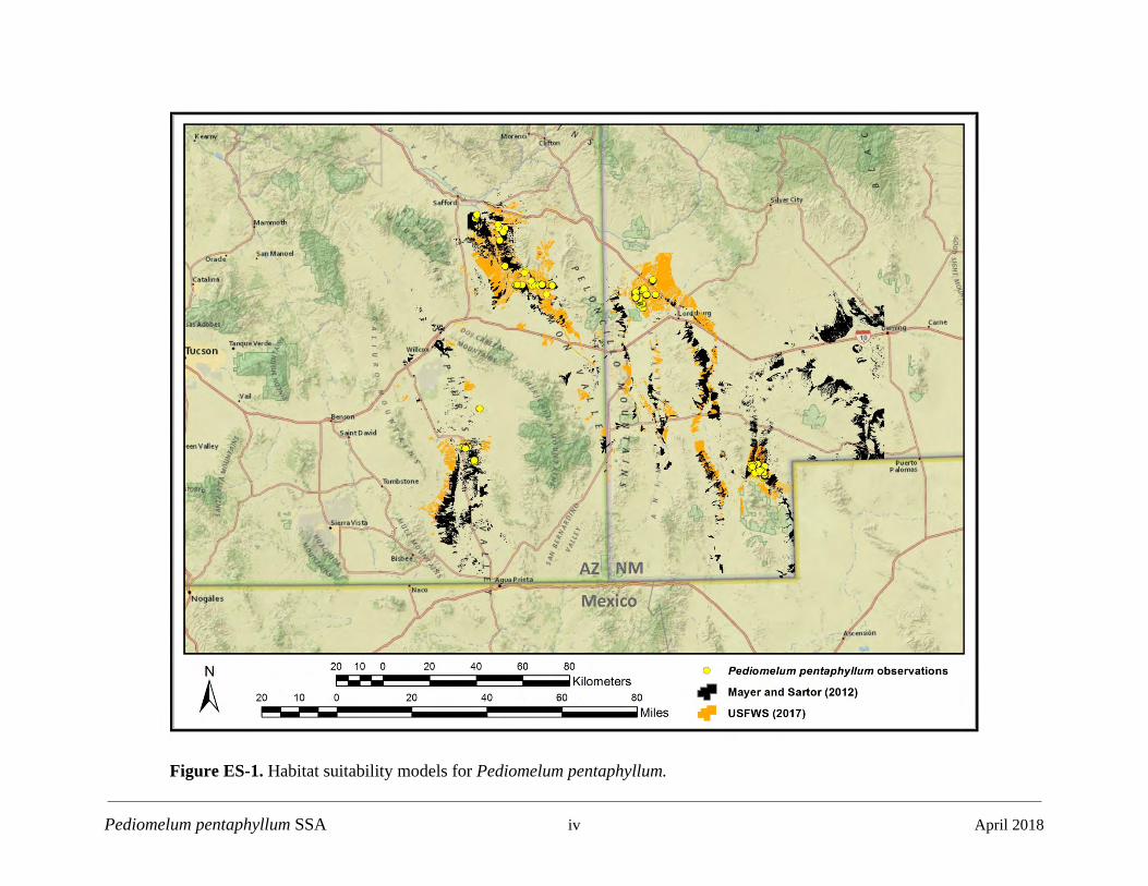
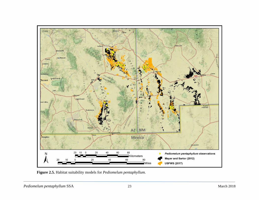
Figure ES-1. Habitat suitability models for Pediomelum pentaphyllum.

Pediomelum pentaphyllum SSA v April 2018
narrow habitat niche of deep, sandy soils where erosional or depositional processes tend to dominate. However, such soil types and their transitional ecotones are widespread in the Chihuahuan Desert. Our analyses of current conditions and future impacts on P. pentaphyllum long-term viability identified three factors/stressors that pose the greatest risk to the species: herbicide application for grassland restoration (reduction of woody shrub invasion), changes in precipitation associated with climate change, and surface disturbance (infrastructure installation and maintenance, oil and gas development, mining/mineral extraction, agricultural development, residential growth, wildlife herbivory, and livestock grazing). To evaluate the status of P. pentaphyllum into the future, we considered a range of possible conditions of the above stressors for the time periods of 2025-2049 and 2050-2074. We then assessed P. pentaphyllum resiliency, redundancy, and representation under five future scenarios. In addition, we constructed a deterministic habitat suitability model for two purposes: 1) as a demographic measure for the amount of potential habitat and 2) as a heuristic guide for future survey efforts. The former was used as a relative measure of the amount of perceived potential habitat where the analysis units could conceivably expand beyond their known extent. Figure ES-1 also shows the results of this model contrasted with a previous model. Under Scenario 1, Optimistic, due to appropriate protective measures on all Federal lands, we assume minimal impacts from herbicide use; no additional surface disturbance; and the least aggressive emissions scenario in which global warming is kept to 2°C (3.6°F) above pre-industrial temperatures via emissions mitigations. Under this scenario, we would expect P. pentaphyllum resiliency, redundancy, and representation to be identical to the Current Conditions. Specifically, two analysis units would be in a High resiliency condition, one would score as an overall Moderate, and one would be in a Low/Moderate condition (Table ES-1). Under Scenarios 2a (2025-2049) and 2b (2050-2074), Intermediate Impacts, we assume continued or increased herbicide use with continuing protective measures on all Federal lands; surface disturbance activities continued at current or slightly increased levels, and the intermediate climate change regime. Under these scenarios, we would expect P. pentaphyllum viability to be characterized by slightly lower levels of resiliency. However, overall resiliency ratings would categorically remain the same as those under Current Conditions and Scenario 1, with two analysis units in High overall condition, one in Moderate condition, and one in Low/Moderate condition (Table ES-1). Under Scenario 3a (2025-2049) and 3b (2050-2074), Increased Stressors, we assume an increase in herbicide use over previous scenarios with continuing protective measures on all Federal lands; an increase in surface disturbance activities on Federal and private lands; and climate change as characterized by an aggressive and uncompromising emissions scenario. Although resiliency scores slightly decrease relative to Scenarios 2a and 2b, the resiliency ratings would remain the same relative to Current Conditions (Table ES-1).

Pediomelum pentaphyllum SSA vi April 2018
Table ES-1. Pediomelum pentaphyllum analysis unit resiliency under current conditions and five possible future scenarios.
Pediomelum pentaphyllum SSA vii April 2018
Table of Contents Page
Executive Summary ...................................................................................................................... iii CHAPTER 1 Introduction .......................................................................................................... 1
CHAPTER 2 Biology, Ecology, and Habitat Suitability Model .............................................. 3
2.1. Taxonomy ............................................................................................................................... 3
2.2. Genetics .................................................................................................................................. 4
2.3. Morphological Description ..................................................................................................... 5
2.4. Life History, Ethnobotany, and Protection Status .................................................................. 6
2.5. Range and Distribution ......................................................................................................... 10
2.5.1. Historical and Current Range ............................................................................. 10
2.6. Resource Needs ..................................................................................................................... 16
2.6.1. Physiographic and Floristic Regions ................................................................. 16
2.6.2. Plant Community, Associated Species, and Soils .............................................. 16
2.7. Habitat Suitability Model ...................................................................................................... 20
2.7.1. Introduction ........................................................................................................ 20
2.7.2. Observations ...................................................................................................... 20
2.7.3. Brief Model Overview ....................................................................................... 20
2.7.4. Parameter Definitions ........................................................................................ 21
2.7.5. Final Model ........................................................................................................ 22
CHAPTER 3 Species Evaluation Factors and Current Condition ....................................... 24
3.1. Resiliency, Redundancy, and Representation ....................................................................... 24
3.1.1. Analysis Unit Resiliency.................................................................................... 24
3.2. Current Conditions ................................................................................................................ 33
3.2.1. Resiliency ........................................................................................................... 33
3.2.2. Redundancy........................................................................................................ 37
3.2.3. Representation.................................................................................................... 37
CHAPTER 4 Species Evaluation Factors Carried Forward, Future Scenarios, Future Conditions, and Conclusions ..................................................................................................... 39
4.1 Species Evaluation Factors Carried Forward ......................................................................... 39
4.1.1. Demographic Factors ......................................................................................... 39
4.1.2. Habitat Factors ................................................................................................... 42
Pediomelum pentaphyllum SSA viii April 2018
4.2 Future Scenarios .................................................................................................................... 47
4.2.1. Scenario 1: Optimistic........................................................................................ 48
4.2.2. Scenario 2a: Intermediate Impacts (years 2025-2049) ...................................... 48
4.2.3. Scenario 2b: Intermediate Impacts (years 2050-2074) ...................................... 49
4.2.4. Scenario 3a: Increased Stressors (years 2025-2049) ......................................... 49
4.2.5. Scenario 3b: Increased Stressors (years 2050-2074) ......................................... 49
4.3 Future Conditions .................................................................................................................. 50
4.3.1. Scenario 1: Optimistic........................................................................................ 50
4.3.2. Scenario 2a: Intermediate Impacts (years 2025-2049) ...................................... 53
4.3.3. Scenario 2b: Intermediate Impacts (years 2050-2074) ...................................... 55
4.3.4. Scenario 3a: Increased Stressors (years 2025-2049) ......................................... 57
4.3.5. Scenario 3b: Increased Stressors (years 2050-2074) ......................................... 59
4.4 Summary, Conclusions, and Recommendations .................................................................... 61
Pediomelum pentaphyllum SSA ix April 2018
List of Figures Page
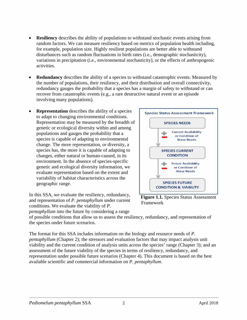
Figure 1.1. Species Status Assessment Framework ..................................................................... 2
Figure 2.1. Life history diagram ................................................................................................... 7
Figure 2.2. Known current and historic locales ............................................................................ 9
Figure 2.3. Known current range ............................................................................................... 11
Figure 2.4. Pediomelum pentaphyllum in the San Simon Valley near Safford, Arizona .......... 13
Figure 2.5. Habitat suitability models ......................................................................................... 23
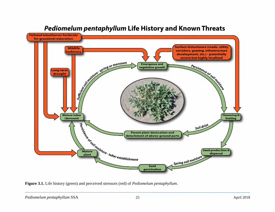
Figure 3.1. Life history and perceived stressors ......................................................................... 25
Figure 3.2. Number of plants detected by year for all compiled survey data ............................ 28
Figure 3.3. Area of modeled potential habitat factor ................................................................. 31
Figure 3.4. Area of modeled potential habitat and relative condition categories ...................... 32
Figure 4.1. Alignments of the SunZia and Southline power transmission lines ......................... 45
Figure 4.2. Results of Scenario 1: Optimistic ............................................................................ 52
Figure 4.3. Results of Scenario 2a: Intermediate Impacts (years 2025-2049) ............................ 54
Figure 4.4. Results of Scenario 2b: Intermediate Impacts (years 2050-2074) ............................ 56
Figure 4.5. Results of Scenario 3a: Increased Stressors (years 2025-2049) ............................... 58
Figure 4.6. Results of Scenario 3b: Increased Stressors (years 2050-2074) ............................... 60
_____________________________________
List of Tables
Page
Table 2.1. Plant associations ....................................................................................................... 17
Table 2.2. Soil types and descriptions ......................................................................................... 19
Table 3.1. Demographic factors .................................................................................................. 26

Pediomelum pentaphyllum SSA x April 2018
List of Tables (cont.) Page
Table 3.2. Habitat factors ............................................................................................................ 27
Table 3.3. Summary of demographic factors for the Current Condition .................................... 35
Table 3.4. Summary of habitat factors for the Current Condition .............................................. 36
Table 4.1. Precipitation mean percent change for RCP 4.5 and RCP 8.5 ................................... 43
Table 4.2. Summary of Current Conditions and Future Scenarios ............................................. 61
_____________________________________
Appendix A Tables for Future Condition Scenarios

Pediomelum pentaphyllum SSA 1 April 2018
CHAPTER 1 Introduction
Pediomelum pentaphyllum (Chihuahua scurfpea) is a desert perennial that grows to 25 cm (9.8 inches [in]) in height, with a long taproot and tuber which aids in drought tolerance. The plant primarily flowers and fruits in the spring during April and May, and again during the North American monsoon from July through September. At times, the monsoon reproductive period can extend into November. In dry years, P. pentaphyllum can remain dormant, with no aboveground growth, making surveys difficult during these time periods. The species occurred historically in New Mexico, Arizona, and Chihuahua, Mexico, and may have occurred in West Texas. It is known currently from southwestern New Mexico and southeastern Arizona. Primary stressors for P. pentaphyllum include herbicide use for grassland restoration and decreased precipitation in the future associated with climate change. On June 18, 2007, Forest Guardians (now WildEarth Guardians) submitted a petition to the U.S. Fish and Wildlife Service (Service) to list 475 species in the southwestern U.S. as threatened or endangered under the Endangered Species Act as amended; 16 USC 1531 et seq. (ESA; Wild Earth Guardians 2008: entire). This petition included P. pentaphyllum, with the species’ range listed as Arizona, New Mexico, and Texas. On October 9, 2008, WildEarth Guardians submitted a detailed petition to list P. pentaphyllum as threatened or endangered under the ESA and to concurrently designate critical habitat for the species. The Species Status Assessment (SSA) framework (Service 2016, entire; Smith et al. 2018, entire) is intended to support the review of a species’ biology, its resource needs, the current condition of the species, and an assessment of long-term viability. The intent is for the SSA report to be readily updated as new information becomes available and to support all functions of the Service Endangered Species Program from Candidate Assessment to Listing to Consultations to Recovery. As such, the SSA will be a living document upon which other documents, such as listing rules, recovery plans, and 5-year reviews, would be based if the species were to warrant listing under the ESA. The SSA for P. pentaphyllum is intended to provide the biological support for a decision on whether or not to propose to list the species as threatened or endangered and, if so, where to propose designating critical habitat. Importantly, the SSA does not result in a decision by the Service on whether this species should be proposed for listing under the ESA. Instead, this document provides a review of the available information strictly related to the biological needs and status of the species. The listing decision will be made by the Service after review of this document and all relevant laws, regulations, and policies. The results of a proposed decision will be announced in the Federal Register, with appropriate opportunities for public input. For the purposes of this assessment, we generally define viability as the ability of P. pentaphyllum to sustain populations over time. Using the SSA framework (Figure 1.1), we consider what the species needs to maintain viability by characterizing the status of the species in terms of its resiliency, redundancy, and representation (Wolf et al. 2015, entire; Smith et al. 2018, entire).
Pediomelum pentaphyllum SSA 2 April 2018
• Resiliency describes the ability of populations to withstand stochastic events arising from
random factors. We can measure resiliency based on metrics of population health including, for example, population size. Highly resilient populations are better able to withstand disturbances such as random fluctuations in birth rates (i.e., demographic stochasticity), variations in precipitation (i.e., environmental stochasticity), or the effects of anthropogenic activities.
• Redundancy describes the ability of a species to withstand catastrophic events. Measured by
the number of populations, their resiliency, and their distribution and overall connectivity, redundancy gauges the probability that a species has a margin of safety to withstand or can recover from catastrophic events (e.g., a rare destructive natural event or an episode involving many populations).
• Representation describes the ability of a species
to adapt to changing environmental conditions. Representation may be measured by the breadth of genetic or ecological diversity within and among populations and gauges the probability that a species is capable of adapting to environmental change. The more representation, or diversity, a species has, the more it is capable of adapting to changes, either natural or human-caused, in its environment. In the absence of species-specific genetic and ecological diversity information, we evaluate representation based on the extent and variability of habitat characteristics across the geographic range.
In this SSA, we evaluate the resiliency, redundancy, and representation of P. pentaphyllum under current conditions. We evaluate the viability of P. pentaphyllum into the future by considering a range of possible conditions that allow us to assess the resiliency, redundancy, and representation of the species under future scenarios. The format for this SSA includes information on the biology and resource needs of P. pentaphyllum (Chapter 2); the stressors and evaluation factors that may impact analysis unit viability and the current condition of analysis units across the species’ range (Chapter 3); and an assessment of the future viability of the species in terms of resiliency, redundancy, and representation under possible future scenarios (Chapter 4). This document is based on the best available scientific and commercial information on P. pentaphyllum.
Figure 1.1. Species Status Assessment Framework
Pediomelum pentaphyllum SSA 3 April 2018
CHAPTER 2 Biology, Ecology, and Habitat Suitability Model In this chapter, we provide basic biological and ecological information about P. pentaphyllum, including its taxonomic history and nomenclature, genetics, morphological description, life history, range and distribution, and resource needs. We also present a habitat suitability model created for purposes of this SSA and to assist in future survey and conservation efforts.
2.1. Taxonomy The history and taxonomy of this species is complex. The initial account ostensibly began when the Spanish collected seed somewhere in Mexico ca. 1740 (Warren 1994:1; Tonne 2010: 5). Eventually, specimens cultivated in Spain (Ockendon 1965: 122) were taken to Paris where they were examined in 1744 by Antoine Jussieu who was researching the medicinal properties of contrayerva as botanical remedies for contagious disease and malignant fevers (Jussieu 1744: entire). Jussieu conferred the basionym Psoralea pentaphylla (Jussieu 1744: 381) and marked the first documented description and illustration of the species (Jussieu 1744: 384, Plate 17). According to the conventions of botanical nomenclature, however, names conferred prior to the publication of Linnaeus’ Species Plantarum (1753) are considered invalid. Nonetheless, Linnaeus recognized Jussieu’s work in 1748 (Linnaeus 1748: 225) and became the first authority of Psoralea pentaphylla L. (Linnaeus 1753: 764). Rydberg (1919: 23) later divided the North American species of Psoralea in to five genera and transferred Psoralea pentaphylla in to the genus Pediomelum. Rydberg concluded the prior treatment of Jussieu and Linnaeus applied to what was later designated as Pediomelum palmeri (Grimes 1990: 88) which is a current synonym for P. ockendonii (Kartesz and Gandhi 1992a: 138). He described a new species, Pediomelum trinervatum and created a new combination of Pediomelum pentaphyllum; however, his description of P. pentaphyllum was for a decumbent species, whereas Jussieu’s illustration clearly represents an erect plant. Thus, the combination Pediomelum pentaphyllum was evidently a mistaken assignment of the species epithet. Ockendon (1965: 121) completed a thorough examination of available specimens and compared Jussieu’s original description (1744) to Rydberg’s (1919). Ockendon determined that there were no voucher specimens from Jussieu or Linnaeus in the Linnaean Herbarium in London or in the Hortus Upsaliensis Herbarium in Uppsala, Sweden (Ockendon 1965: 122). Tonne (2010: 6) attempted to locate voucher specimens in Paris in an online search, and this search was also unsuccessful. Ockendon treated Pediomelum as a subgenus of Psoralea and concluded that Jussieu’s original description could not be “confidently applied” to any known species, as it gives few measurements and fails to document “certain critical characters” (Ockendon 1965: 122). He thus suspended Pediomelum pentaphyllum as nomen dubium (doubtful name) and supplied a new name for Pediomelum pentaphyllum sensu Rydberg as Psoralea palmeri Ock. and maintained Pediomelum trinervatum as a distinct species that is “restricted and very rare” (Ockendon 1965: 113). Further, he stated, that the account of this species was somewhat incomplete, as there were only three collections available with notable differences. Ockendon believed, however, that these differences reflected variations in age, size, and reproductive status of the plant.
Pediomelum pentaphyllum SSA 4 April 2018
In a more recent review of the new world Psoraleeae, Grimes (1990: 82-84) concluded that Jussieu’s original description and illustration, taken together, was decisive and did indeed refer to P. trinervatum sensu Rydberg. He then revived the specific epithet pentaphyllum and elevated it, albeit in synonymy, over trinervatum. Kartesz and Ghandhi (1992b: 86-87) provide nomenclature clarity by attributing Rydberg’s (1919) combination (Pediomelum pentaphyllum [L.] Rydb.) to Rydberg with respect to his transfer of this species from Psoralea to Pediomelum. Therefore, the correct sequence of authority is in fact Pediomelum pentaphyllum (L.) Rydb. See also Gandhi (2015: 213). The USFWS recognizes this nomenclature. That is: Kingdom Plantae Division Tracheophyta Class Magnoliopsida Order Fabales Family Fabaceae Tribe Psoraleae Genus Pediomelum Rydb. Species Pediomelum pentaphyllum (L.) Rydb.; (common name/vernacular = Chihuahua scurfpea)
2.2. Genetics Egan and Crandall (2008a: entire) provide novel insight into the phylogenetic relationships of the North American Psoraleae. This study cloned, sequenced, and aligned two nuclear (ITS and Waxy) and six chloroplast (trnS/G, trnL/F, trnK, matK, trnD/T, and rpoBtrnC) genetic markers and constructed a Bayesian Inference phylogeny (Egan and Crandall 2008a: 541-542). Results are largely commensurate with Grimes (1990: entire), with minor exceptions which have no apparent relevance to the status P. pentaphyllum. The majority of species formed exclusive lineages, with the exception of several Pediomelum species (i.e., P. subacaule, P. megalanthum, and P. argophyllum; Egan and Crandall 2008a: 542). This result is likely due to the more conserved markers employed in this study and thus demonstrates, in general, the limits of the phylogenetic resolution. Unambiguously, however, the P. pentaphyllum clade is monophyletic and sister to P. hypogaeum var. scaposum and P. humile (east-central and south-central Texas, respectively). See also the analysis and monophyly of P. pentaphyllum in Egan (2006: entire). Branch length of the P. pentaphyllum clade is similar to others in the genus, indicating recent and rapid radiation events via global climate oscillations during Quaternary glaciations between 2.5 to 8 million years ago (Egan and Crandall (2008b: 5). Again, despite the monophyly of the P. pentaphyllum clade, species-level relationships of Egan and Crandall (2008a: entire) lack certainty. The authors point out that such inferences are better
Pediomelum pentaphyllum SSA 5 April 2018
addressed by more variable markers (e.g., microsatellites) and suggest this as future work. What is clear from Egan and Crandall (2008a: entire) is that P. pentaphyllum is an exclusive lineage, but its relationship to other Pediomelum species is uncertain as the species-level arrangement varied between methods (i.e., Maximum Parsimony and Bayesian Inference). While other comprehensive studies of Psoraleeae exist (e.g., Dludlu 2010: entire) population-level genetics for P. pentaphyllum is undefined, with no known studies that specifically address the issue. In an unpublished effort, however, Jones and Crandall (2013: entire) used microsatellites to investigate the population genetics of Pediomelum pariense (Paria River Indian breadroot), a highly restricted species with low numbers known only to Kane County, Utah. Their microsatellite analysis showed notable genetic diversity between the individual populations. Given the considerable distance between the known analysis units of P. pentaphyllum (see Chapter 2) it is at least plausible that such a dynamic may also exist if they are in fact geographically isolated with little or no gene flow. Future surveys may identify additional areas of P. pentaphyllum and refute this impression.
2.3. Morphological Description Non-technical – From Spellenberg (1999: entire) as adapted by Tonne (2010: 7; with field observations shown in brackets): Perennial herb up to about 25 cm (9.8 in) tall, with straight gray hairs that lie against the surface of the foliage; stems with a thin, cord-like, easily broken subterranean portion bearing a few small bracts, and a short aerial, leafy portion; root a deeply buried spindle-shaped taproot; leaves with minute, dark, glandular dots, palmately (or very shortly pinnately) compound, with petioles 8-15 cm (3.1-5.9 in) long; leaflets 5 [3, 4, or 6 observed less often], lanceolate, rhombic or oblanceolate, 25-50 mm long (1-2 in), 15-23 mm (0.6-0.9 in) wide, the lower surfaces more densely hairy than upper; flowers in a dense ovoid grayish-hairy cluster 2-4 cm (0.8-1.6 in) long, 2-2.5 (0.8-1 in) cm wide, on a peduncle 4-9 mm (0.16-0.35 in) long, each flower bilaterally symmetrical, pea-like, 14-18 mm (0.55-0.7 in) long, purple with white and often mostly hidden between green bracts; fruit a small pod 7-8 mm (0.28-0.31 in) long, barely surpassing the calyx teeth. Flowers in April and May, and again in July and August, depending on precipitation. Technical – By J. Grimes (1990: 82) as adapted by Tonne (2010: 7; with field observations shown in brackets, no English units given): Perennial herb to 25 cm tall; rootstock with a fusiform thickening; stems +/- absent or the main stem to 4 (-15) cm long but the leaves all crowded at the base of the plant; vestiture conspicuous, of appressed or +/- spreading hairs, also with sessile glands. Leaves palmate; leaflets 5 [3, 4 or 6]; stipules broadly lanceolate below, linear above, 9-15 mm long, to 5 mm wide, densely strigose, persistent; petioles 6-15 cm long, 15-23 mm wide, gland dotted, less densely hairy above. Inflorescences dense, globose to prolate, 2-6 cm long; peduncles 3-9 cm long; pedicels 1-2 mm long; flowers 12-18 mm long, corollas not much exserted; calyx tubes 4-5 mm long in flower, the lobes 10-12 mm long, much enlarging in fruit, very unequal (the lowest lobe elliptic, +/- 3 mm wide in flower and 7 mm long in fruit, with 3 prominent veins in fruit); petals purple [with white]. Fruit body elliptic-oblanceolate, 7-8 mm long, the beak stout, flat, broad, 10-15 mm long, projecting beyond the calyx lobes; seed reniform-oblong, 5-6 mm long, plump, gray-brown, markedly reticulate.
Pediomelum pentaphyllum SSA 6 April 2018
Tonne (2010: 7) notes that in Arizona and New Mexico there is no other sympatric1 Pediomelum that can be confused with P. pentaphyllum. He continues that P. megalanthum is allopatric2; however, current survey data shows that both P. pentaphyllum and P. megalanthum occur in Graham County, AZ (see Chapter 3 and U.S. Department of Agriculture [USDA] 2017: entire). P. megalanthum is a similar species but has more perfectly palmately compound leaves (rather than shortly pinnately compound) with 5-8 leaflets that are often broadly rounded at the tip (Tonne 2010: 7). Confusion should therefore be easily averted. In addition, P. palmeri (a.k.a. P. ockendonii) occurs to the west in Santa Cruz County, Arizona and Mexico, and “differs in its decumbent habit and its reddish-brown to violet-maroon flowers” (Tonne 2010: 7).
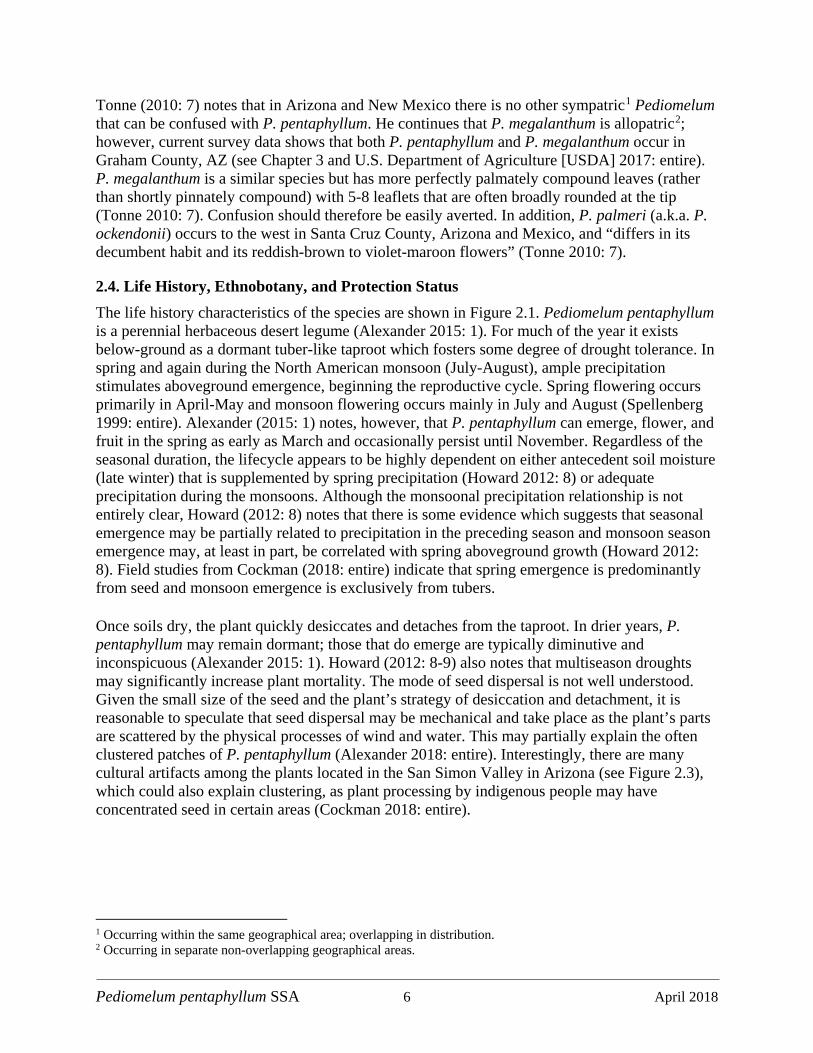
2.4. Life History, Ethnobotany, and Protection Status The life history characteristics of the species are shown in Figure 2.1. Pediomelum pentaphyllum is a perennial herbaceous desert legume (Alexander 2015: 1). For much of the year it exists below-ground as a dormant tuber-like taproot which fosters some degree of drought tolerance. In spring and again during the North American monsoon (July-August), ample precipitation stimulates aboveground emergence, beginning the reproductive cycle. Spring flowering occurs primarily in April-May and monsoon flowering occurs mainly in July and August (Spellenberg 1999: entire). Alexander (2015: 1) notes, however, that P. pentaphyllum can emerge, flower, and fruit in the spring as early as March and occasionally persist until November. Regardless of the seasonal duration, the lifecycle appears to be highly dependent on either antecedent soil moisture (late winter) that is supplemented by spring precipitation (Howard 2012: 8) or adequate precipitation during the monsoons. Although the monsoonal precipitation relationship is not entirely clear, Howard (2012: 8) notes that there is some evidence which suggests that seasonal emergence may be partially related to precipitation in the preceding season and monsoon season emergence may, at least in part, be correlated with spring aboveground growth (Howard 2012: 8). Field studies from Cockman (2018: entire) indicate that spring emergence is predominantly from seed and monsoon emergence is exclusively from tubers. Once soils dry, the plant quickly desiccates and detaches from the taproot. In drier years, P. pentaphyllum may remain dormant; those that do emerge are typically diminutive and inconspicuous (Alexander 2015: 1). Howard (2012: 8-9) also notes that multiseason droughts may significantly increase plant mortality. The mode of seed dispersal is not well understood. Given the small size of the seed and the plant’s strategy of desiccation and detachment, it is reasonable to speculate that seed dispersal may be mechanical and take place as the plant’s parts are scattered by the physical processes of wind and water. This may partially explain the often clustered patches of P. pentaphyllum (Alexander 2018: entire). Interestingly, there are many cultural artifacts among the plants located in the San Simon Valley in Arizona (see Figure 2.3), which could also explain clustering, as plant processing by indigenous people may have concentrated seed in certain areas (Cockman 2018: entire).
1 Occurring within the same geographical area; overlapping in distribution. 2 Occurring in separate non-overlapping geographical areas.
Pediomelum pentaphyllum SSA 7 April 2018
Figure 2.1. Life history diagram of Pediomelum pentaphyllum.
Pediomelum pentaphyllum SSA 8 April 2018
Over the last century in the southwestern U.S., extensive livestock grazing has promoted a widespread conversion of grasslands into woody shrublands. To combat this, efforts by government and non-government entities have employed herbicides that mostly target woody vegetation and foster the reestablishment of more productive grasslands. Pediomelum pentaphyllum is affected by this practice of herbicide use for grassland restoration. The contemporary occurrence of P. pentaphyllum in shrublands also has implications on the perceived habitat niche of the species (see Sections 2.6.2 and 4.1.1 for more details). In addition to being a human food source, P. pentaphyllum was purported as a remedy for numerous maladies such as thoracic pain, colic, and fevers (Bye 1979: 147; see also Maisch 1889: 5). Termed “contra yerba”, it was readily available in Chihuahua City markets in 1908 (Sivinski 1993: 7) and was also available in Durango and Saltillo, and Coahuila to the south during the late 19th century (Bye 1979: 147); however, the Durango and Saltillo collections may have been Psoralea palmeri Ock and likely sold for medicinal purposes. Examples of other medicinal and sustenance uses of Psoraleeae include Yang et al. (2006: entire) who report antifungal properties for Psoralea corylifolia. Stahnke et al. (2008: entire) also detail the historical, modern, and medicinal uses of Pediomelum esculenta (Pursh) Rydb. (prairie turnip) in North America. Currently, the State of New Mexico lists P. pentaphyllum as Endangered (New Mexico Energy Minerals and Natural Resources Department [NMEMNRD] 2017a). It is not listed by either Arizona or Texas. Other status designations include:
• Service; 90-day finding that ESA listing may be warranted (Federal Register 2009, 74 CFR 66866: entire);
• Bureau of Land Management (BLM; Sensitive; BLM 2017a: entire; BLM 2017b: entire) and U.S. Forest Service (USFS; Sensitive; USFS 2013: entire);
• NatureServe – Global rank of G1G2 (Critically Imperiled and Imperiled; NatureServe 2017);
• Natural Heritage New Mexico (NHNM) – State rank of S1 (Critically Imperiled; NHNM 2017);
• New Mexico Energy, Minerals, and Natural Resources Department, Forestry Division Plant Conservation Strategy; Conservation Status = Weakly Conserved (NMEMNRD 2017b: 62);
• Arizona Game and Fish Department (AZGFD) – S1S2 (Critically Imperiled and Imperiled; AZGFD 2016: entire);
• Texas Parks and Wildlife Department (TPW) – SH (possibly extirpated, known only from historical occurrences; TPWD 2017: entire).
Pediomelum pentaphyllum SSA 9 April 2018
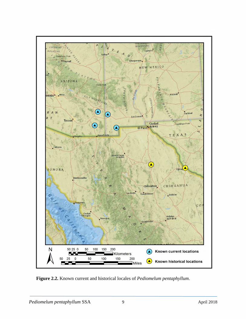
Figure 2.2. Known current and historical locales of Pediomelum pentaphyllum.
Pediomelum pentaphyllum SSA 10 April 2018
2.5. Range and Distribution 2.5.1. Historical and Current Range The historical range of P. pentaphyllum is likely larger than its known contemporary range. The known historical range covered discrete areas located in or near Presidio, Texas along the Rio Grandé near Big Bend and an area north of Chihuahua, Mexico, whereas current known locations are limited to southeastern Arizona, and southwestern New Mexico (Figure 2.2). Based on compiled observations, our current estimate of the total population in Arizona and New Mexico is 5,651 plants. Alexander (2015: 9 estimates the total population at approximately 7,000 plants. It is not known whether the locations in west Texas or Mexico are still extant, despite efforts in 1991 to relocate the account north of Chihuahua, Mexico (Tonne 2010: 5). The Presidio, Texas location, whether in Texas or potentially located just south of the border, has not been relocated since the original collection date ca.1853, although no concerted survey efforts are known to have been mounted (either in Texas or in Mexico). Nonetheless, P. pentaphyllum is a fairly wide-ranging but ostensibly uncommon species (Grimes 1990: 83). The current known range is distributed among four locales in southeastern Arizona and southwestern New Mexico (Figure 2.3). However, increased survey effort over the past decade has led to the discovery of both additional locations (Lordsburg Mesa, NM) and more individuals within existing locations. The known historical and extant locales are discussed further below.
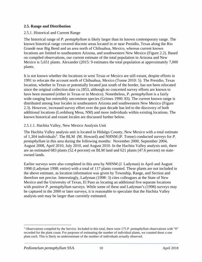
2.5.1.1. Hachita Valley, New Mexico Analysis Unit The Hachita Valley analysis unit is located in Hidalgo County, New Mexico with a total estimate of 1,304 individuals3. The BLM (M. Howard) and NHNM (P. Tonne) conducted surveys for P. pentaphyllum in this area during the following months: November 2000, September 2004, August 2008, April 2010, July 2010, and August 2010. In the Hachita Valley analysis unit, there are an estimated 683 plants (52.4 percent) on BLM land and 621 plants (47.6 percent) on state-owned lands. Earlier surveys were also completed in this area by NHNM (J. Ladyman) in April and August 1998 (Ladyman 1998: entire) with a total of 117 plants counted. These plants are not included in the above estimate, as location information was given by Township, Range, and Section and therefore not precise. Interestingly, Ladyman (1998: 3) cites colleagues at the State of New Mexico and the University of Texas, El Paso as locating an additional five separate locations with positive P. pentaphyllum surveys. While some of these and Ladyman’s (1998) surveys may be captured in the 2000 or later surveys, it is reasonable to speculate that the Hachita Valley analysis unit may be larger than currently estimated.
3 Observations compiled by the Service. Included in this total, there were 175 P. pentaphyllum observations with “0” recorded for the plant count. For purposes of estimating the number of individual plants, we counted these a one plant each. This is likely an underestimate of the number of individuals actually observed.

Pediomelum pentaphyllum SSA 11 April 2018
Figure 2.3. Pediomelum pentaphyllum known current range showing the geographic centers of each analysis unit.
Pediomelum pentaphyllum SSA 12 April 2018
Pediomelum pentaphyllum is a special status species with the BLM (BLM 2017a: entire; BLM 2017b: entire). As such, the BLM has proposed an Area of Critical Environmental Concern (ACEC) to protect this area (BLM 1993: 5-11; Department of Homeland Security [DHS] 2015: 2-2). The final ACEC designation is pending the completion of an updated Resource Management Plan; however, BLM policy guidance is proactively managing the area as if it were an ACEC (Alexander 2018: entire). The BLM has also taken additional, proactive measures to safeguard known P. pentaphyllum habitat under their jurisdiction in the Hachita Valley (DHS 2015: H-6 and H-7). The analysis unit center (latitude 31.751, longitude -108.365) is in the heart of the Hachita Valley, approximately 6 km (3.8 mi) east of the Little Hatchet Mountains (Figure 2.3). The area bounding the known Hachita Valley analysis unit (minimum bounding geometry; Esri 2016) is 2,492 hectares (6,157 acres) with mean elevation of 1,338 m (4,390 ft) and ranging from 1,320-1,367m (4,331-4,485 ft). The minimum bounding geometry is simply a polygon that encompasses all observations. The mean annual temperature is 16.5° C (61.7° F) and the mean annual precipitation total is 293 mm (11.4 in). We cannot fully estimate the proportion of occupied habitat within the minimum bounding geometry described above, which should not be misinterpreted as being completely occupied but rather the known range of the Hachita Valley analysis unit; however, the observations are fairly concentrated. Alexander (2018: entire) states, however, that surveys conducted from 2008-2012 are likely to have captured the majority of the occupied habitat. Thus, the above area may in fact be a reasonably accurate value. We also employ the convention of a minimum bounding geometry (polygon) in describing the range for each of the remaining analysis unit that follow.
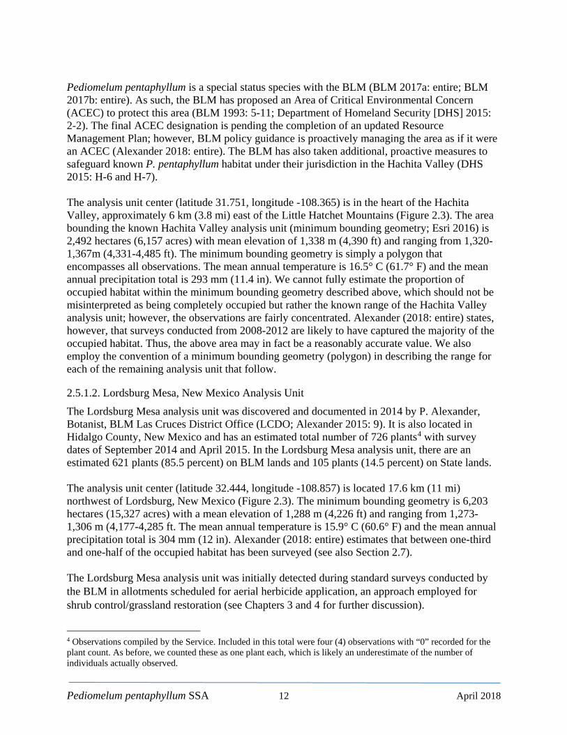
2.5.1.2. Lordsburg Mesa, New Mexico Analysis Unit The Lordsburg Mesa analysis unit was discovered and documented in 2014 by P. Alexander, Botanist, BLM Las Cruces District Office (LCDO; Alexander 2015: 9). It is also located in Hidalgo County, New Mexico and has an estimated total number of 726 plants4 with survey dates of September 2014 and April 2015. In the Lordsburg Mesa analysis unit, there are an estimated 621 plants (85.5 percent) on BLM lands and 105 plants (14.5 percent) on State lands. The analysis unit center (latitude 32.444, longitude -108.857) is located 17.6 km (11 mi) northwest of Lordsburg, New Mexico (Figure 2.3). The minimum bounding geometry is 6,203 hectares (15,327 acres) with a mean elevation of 1,288 m (4,226 ft) and ranging from 1,273-1,306 m (4,177-4,285 ft. The mean annual temperature is 15.9° C (60.6° F) and the mean annual precipitation total is 304 mm (12 in). Alexander (2018: entire) estimates that between one-third and one-half of the occupied habitat has been surveyed (see also Section 2.7). The Lordsburg Mesa analysis unit was initially detected during standard surveys conducted by the BLM in allotments scheduled for aerial herbicide application, an approach employed for shrub control/grassland restoration (see Chapters 3 and 4 for further discussion).
4 Observations compiled by the Service. Included in this total were four (4) observations with “0” recorded for the plant count. As before, we counted these as one plant each, which is likely an underestimate of the number of individuals actually observed.
Pediomelum pentaphyllum SSA 13 April 2018
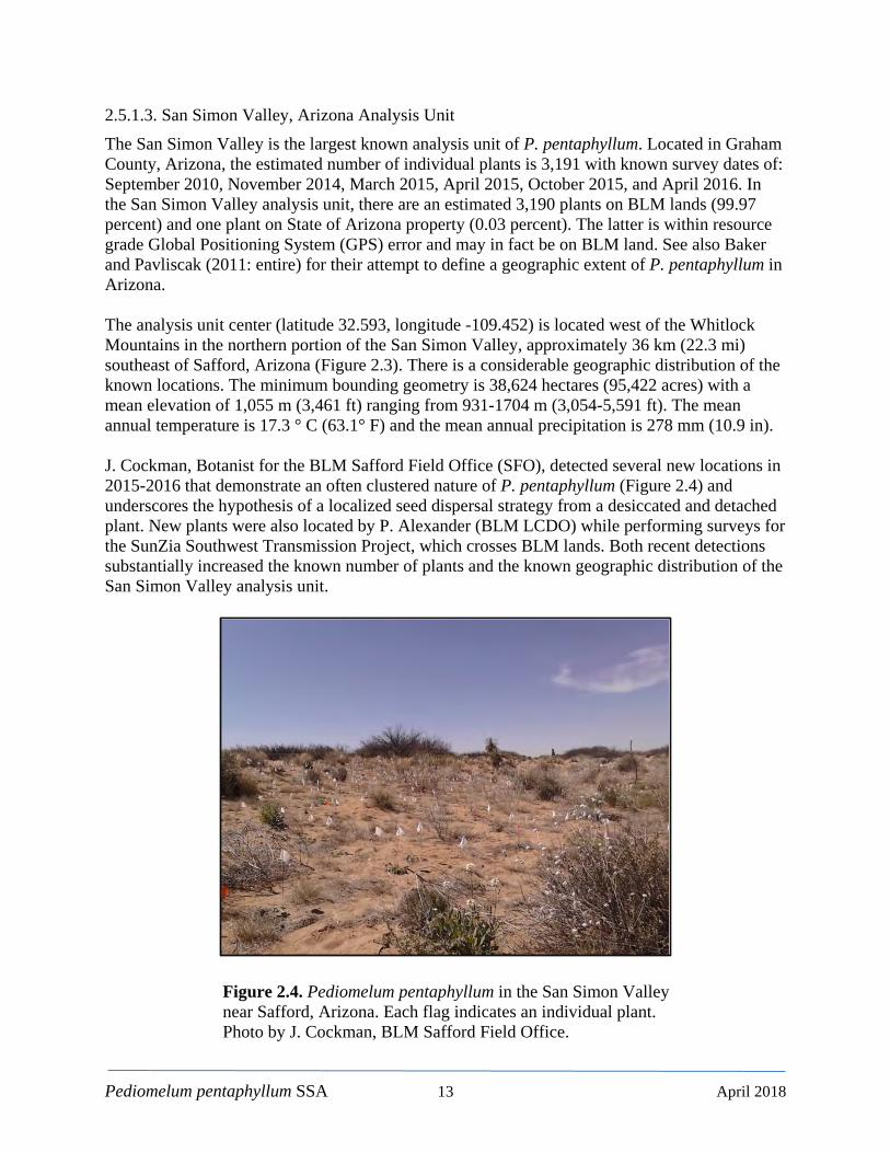
2.5.1.3. San Simon Valley, Arizona Analysis Unit The San Simon Valley is the largest known analysis unit of P. pentaphyllum. Located in Graham County, Arizona, the estimated number of individual plants is 3,191 with known survey dates of: September 2010, November 2014, March 2015, April 2015, October 2015, and April 2016. In the San Simon Valley analysis unit, there are an estimated 3,190 plants on BLM lands (99.97 percent) and one plant on State of Arizona property (0.03 percent). The latter is within resource grade Global Positioning System (GPS) error and may in fact be on BLM land. See also Baker and Pavliscak (2011: entire) for their attempt to define a geographic extent of P. pentaphyllum in Arizona. The analysis unit center (latitude 32.593, longitude -109.452) is located west of the Whitlock Mountains in the northern portion of the San Simon Valley, approximately 36 km (22.3 mi) southeast of Safford, Arizona (Figure 2.3). There is a considerable geographic distribution of the known locations. The minimum bounding geometry is 38,624 hectares (95,422 acres) with a mean elevation of 1,055 m (3,461 ft) ranging from 931-1704 m (3,054-5,591 ft). The mean annual temperature is 17.3 ° C (63.1° F) and the mean annual precipitation is 278 mm (10.9 in). J. Cockman, Botanist for the BLM Safford Field Office (SFO), detected several new locations in 2015-2016 that demonstrate an often clustered nature of P. pentaphyllum (Figure 2.4) and underscores the hypothesis of a localized seed dispersal strategy from a desiccated and detached plant. New plants were also located by P. Alexander (BLM LCDO) while performing surveys for the SunZia Southwest Transmission Project, which crosses BLM lands. Both recent detections substantially increased the known number of plants and the known geographic distribution of the San Simon Valley analysis unit.
Figure 2.4. Pediomelum pentaphyllum in the San Simon Valley near Safford, Arizona. Each flag indicates an individual plant. Photo by J. Cockman, BLM Safford Field Office.

Pediomelum pentaphyllum SSA 14 April 2018
2.5.1.4. Sulfur Springs Valley, Arizona Analysis Unit The Sulfur Springs Valley analysis unit is located in Cochise County, Arizona and has an estimated size of 430 individual plants. There has been only one known comprehensive survey conducted in September 2010 (Baker and Pavliscak 2011: entire). An additional occupied site was located in May 2015 on private land near the Pat Hills area, approximately 16.1 km (10 mi) northeast of the previously known locations. A local resident and botanist has purchased the occupied land in the Pat Hills area and is currently (as of February 2018) formulating a comprehensive study at this locale (Roll 2018: entire). In the Sulfur Springs Valley analysis unit, there are an estimated 419 plants on private land (97.4 percent) and 11 plants on State of Arizona lands (2.6 percent). The analysis unit center (latitude 31.896, longitude -109.66° W) is approximately 43 km (27 mi) southeast of Wilcox, Arizona in the Sulfur Springs Valley, west of the Chiricahua Mountains (Figure 2.3). The minimum bounding geometry is 6,853 hectares (16,934 acres) but is heavily influenced by the newly added Pat Hills site. The mean elevation is 1,324 m (4,344 ft) and ranges from 1,302-1,465 m (4,272-4,806 ft). The mean annual temperature is 16.6° C (61.9° F) and the mean annual precipitation is 339 mm (13.3 in).
2.5.1.5. Presidio, Texas Analysis Unit The Presidio, Texas analysis unit (Figure 2.2) is thought to be the source of the first collection of P. pentaphyllum in the United States ca. 1853 (Tonne 2010: 5); however, the location information on the herbarium specimen is ambiguous and open to interpretation. Sivinski (1993: 8) reports a hand-written excerpt from the specimen’s label stating the location as “Fields at the Presidio del Norte”. Presidio del Norte was the name of an eighteenth-century Spanish frontier fort and settlement located at the present-day town of Ojinaga, Chihuahua, Mexico on the south side of the Rio Grandé (Handbook of Texas Online 2017: entire). Thus, it is not clear that the location is within Texas. Although identified as Psoralea esculenta, (synonym of Pediomelum esculenta (Pursh) Rydb.; prairie turnip) Sivinski (1993: 8) does confirm that the specimen generally conforms to the P. pentaphyllum type specimen (Palmer 1908: entire, see below) and other specimens he examined. Pediomelum pentaphyllum has not been located in west Texas since 1853 and is generally considered not to occur in the state (Correll and Johnston 1979: 816).
2.5.1.6. Chihuahua, Mexico Analysis Unit El Gallego is the type locality for P. trinervatum Rydb. (syn. P. pentaphyllum (L.) Rydb.; Figure 2.2). Thus, P. pentaphyllum (L.) Rydb. has no assignable type specimen or locality. Nevertheless, El Gallego is accepted as the source location of what is taxonomically and contemporarily referred to as P. pentaphyllum (L.) Rydb., or the Chihuahua scurfpea. The type specimen (P. trinervatum Rydb.) was collected by Edward Palmer (1908: entire) who was studying the ethnobotany of the Tarahumara Indians and Mestizos (Bye 1979: 136, 147; Tonne 2000: 5). The specimen was brought to Palmer in Chihuahua City, Mexico by an assistant rendering subsequent accounts of this collection as being “in the vicinity of Chihuahua”. The actual entry in Palmer’s notebook, however, places the location at “Gallego FCCM” (Sivinski 1993: 7). Apparently, this refers to El Gallego, a rail stop some 140 km (87 mi) north of Chihuahua City. Hence, the precise location of the type specimen’s collection is not clear. It is also possible that the plant was brought to Chihuahua from an unknown area by medicinal plant
Pediomelum pentaphyllum SSA 15 April 2018
collectors for sale in the plant trade of Chihuahua City (Tonne 2010: 8). According to a letter from R. Bye, an ethnobotanist, in Sivinski (1993: 12) the plant was available in Chihuahua City markets in 1908 (see also Bye 1986: entire) but he had not seen it in recent years despite considerable effort to locate a specimen. In an attempt to further ascertain the status of P. pentaphyllum in Mexico, we queried the extensive list of herbaria within La Comisión Nacional para el Conocimiento y Uso de la Biodiversidad (The National Commission for the Knowledge and Use of Biodiversity; CONABIO 2017: entire) which included:
• Herbario XAL del Instituto de Ecología, A.C., México • Herbario de la Escuela Nacional de Ciencias Biológicas, México • Banco Nacional de Germoplasma Vegetal, México • Herbario de la Universidad de Texas - Austin • Herbario IEB del Instituto de Ecología, A.C., México • Herbario de la Universidad de Sonora, México • Herbario del CIBNOR,CONECTADA EN • Herbario Weberbauer de la Universidad Nacional Agraria La Molina • Flora Vascular de la Sierra de San Pedro Mártir, Baja California, México • Flora del Valle de Tehuacán-Cuicatlán, México • Herbario de la Universidad Autónoma de Baja California, México • Herbario de la Universidad de Arizona • Herbario del Centro de Investigación Científica de Yucatán, México • Agentes Bioactivos de Plantas Desérticas de Latinoamérica • Ejemplares tipo de plantas vasculares del Herbario de la Escuela Nacional de Ciencias
Biológicas, México • Estudio Florístico de la Sierra de Pachuca, Hidalgo, México • Herbario de Geo. B. Hinton, México • Colección de ejemplares tipo del Herbario de la Universidad de Texas – Austin • Programa de repatriación de datos de ejemplares • Colecciones de George Boole Hinton depositadas en el herbario de Kew • Repatriación de datos del Herbario de Arizona
No records were retrieved from any of the above herbaria for any of the four possible combinations of Pediomelum pentaphyllum/trinervatum or Psoralea pentaphylla/trinervata. Given the vast amount of potential habitat in the Mexican Apache Highlands and Chihuahuan Desert ecoregions (ca. 480,000 km2 or 185,000 mi2) it is plausible that there are at least some remnant locations of P. pentaphyllum in Mexico. Nevertheless, without further information, the presence or absence of the species in Mexico cannot be established or evaluated. We therefore treat contemporary occurrence in Mexico as an unknown.
Pediomelum pentaphyllum SSA 16 April 2018
2.6. Resource Needs 2.6.1. Physiographic and Floristic Regions The known analysis units of P. pentaphyllum reside in the Mexican Highlands Section of the Basin and Range Province. Basin and Range landscape is characterized by alternating sequences of fault-block uplifted mountain chains and parallel basins that are generally oriented in a north-south direction. Elevation changes can be abrupt and mountainous or more gradual, arising from gently sloping hills. Although P. pentaphyllum are located in the Apache Highlands Ecoregion of southeastern Arizona and southwestern New Mexico (The Nature Conservancy [TNC] 2009: entire), Tonne (2010: 14) lists the floristic region as the Chihuahuan Desert, which occupies large portions of west Texas and eastern and south-central New Mexico. Despite the apparent discrepancies in applied terminology, both the Chihuahuan Desert and Apache Highlands Ecoregions are largely characterized as deserts and xeric shrublands (TNC 2009: entire). Collectively in Mexico, they cover portions of the states of Sonora, Chihuahua, Coahuila, Durango, Zacatecas, San Luis Potosi, and Nuevo León. Bounded to the west by the Sierra Madre Occidental mountain range, the Apache Highlands and Chihuahuan Desert are subject to a substantial rain shadow, which tends to limit average annual precipitation within the U.S. portions of these ecoregions to approximately 382 mm (15 in; PRISM 2017). In addition, the north-south orientation of the mountain ranges frequently subjects the area to cold, dry arctic air, which also contributes to the region’s overall aridity. Roughly 50 percent of the annual precipitation totals can occur during the summer monsoon season.
2.6.2. Plant Community, Associated Species, and Soils Tonne (2010: 14) reports that Hachita Valley analysis unit was associated with deep, sandy soils within Prosopis glandulosa (honey mesquite) and Larrea tridentata (creosote bush) shrublands. Other individuals were located on the margins of degraded Bouteloua eriopoda (black grama) and Yucca elata (soaptree yucca) grasslands. Tonne (2010: 15) also notes the presence of the invasive species Eragrostis lehmanniana Nees. (Lehmann lovegrass) in both Arizona and New Mexico. Though most prevalent in Arizona, E. lehmanniana is native to South Africa and has been used in the southwestern U.S. for erosion control since the 1930s (Cable 1971: 17; Cox et al. 1988: entire). Alexander (2015: 9) also reports that all of the newly discovered P. pentaphyllum locations in New Mexico and Arizona (Lordsburg Mesa, Hidalgo County and San Simon Valley, Graham County, respectively) are also in sandy soils of well-developed, upland coppice dunes of aeolian origin or in alluvial deposits associated with ephemeral drainages. The shrub community of these more recent locations is similar to the Hachita Mountains reported by Tonne (2010: 16). The dominant shrubs are again honey mesquite and creosote bush, with the notable addition of Artemisia filifolia (sand sagebrush) and Atriplex canescens (fourwing saltbush). The dominant grass reported by Alexander (2015: 9) is Sporabolus flexuosus (mesa dropseed). Alexander (2015: 10) also provides an account of associated plant species (Table 2.1).
Pediomelum pentaphyllum SSA 17 April 2018
Table 2.1. Plant associations of Pediomelum pentaphyllum present at greater than or equal to 15 percent of the plant diversity photo points (PDPs) surveyed by Alexander (2015; Lordsburg Mesa and San Simon Valley analysis units). Species are listed in descending order of prevalence (adapted from Alexander 2015: 10).
Scientific name Common name P. pentaphyllum PDPs (%)
Prosopis glandulosa honey mesquite 96 Bouteloua aristidoides needle grama 77 Sporobolus flexuosus mesa dropseed 75 Atriplex canescens fourwing saltbush 67 Boerhavia torreyana Torrey's spiderling 63 Yucca elata soaptree yucca 63 Gutierrezia sarothrae broom snakeweed 52 Pectis angustifolia limoncillo 50 Amaranthus acanthochiton greenstripe 44 Tidestromia lanuginosa woolly tidestromia 44 Bouteloua barbata var. barbata sixweeks grama 42 Chamaesyce micromera desert spurge 40 Dimorphocarpa wislizenii spectaclepod 40 Artemisia filifolia sand sage 35 Pectis papposa limoncillo 27 Larrea tridentata creosote 25 Munroa squarrosa false buffalograss 25 Verbesina encelioides cowpen daisy 25 Dalea lanata var. terminalis woolly prairie-clover 23 Descurainia pinnata blunt tansy-mustard 23 Boerhavia spicata creeping spiderling 21 Baileya multiradiata desert marigold 19 Chamaesyce parryi Parry's spurge 19 Ipomopsis longiflora blue trumpets 19 Muhlenbergia porteri bush muhly 17 Portulaca oleracea garden purslane 17
In addition, several regionally uncommon sand-specialists not included in Table 2.1 were noted at or near these sites: Heliotropium convolvulaceum (trumpet heliotrope), Chamaesyce parryi (Parry’s spurge), Dalea lanata var. terminalis (Woolly prairie-clover); and Munroa squarrosa (false buffalograss). Both Tonne (2010: 14-16) and Alexander (2015: 9-11) provide a more inclusive list of P. pentaphyllum plant associations. Cockman (2018: entire) reports a predominance of lemonscent (Pectis angustifolia var. tenella [DC.] Keil), little hogweed (Portulaca oloracea), trailing windmills (Allionia incarnata),
Pediomelum pentaphyllum SSA 18 April 2018
and woolly tidestromia (Tidestromia lanuginosa) in the San Simon Valley. In addtion, Cockman (2013: 7) notes a high density of medicinal plants along with a paleo-archaic period (according to lithic scatter) roasting pit. Yucca elata is unambiguously associated with P. pentaphyllum and is a fundamental component of desert grasslands. Soaptree yucca may also indicate areas of shrubland conversion (e.g., Buffington and Herbel 1965: 139). Thus, by extension, there is ample evidence to suggest that P. pentaphyllum may be associated to some degree with desert grasslands (historically or currently), but it is not clear whether it once occupied high quality grasslands and merely persists today in converted or in the degraded periphery of historical grasslands. Despite this observation, and that P. pentaphyllum can occupy the fringes of adjacent soil types or vegetation communities, it appears that deep sandy soils in mixed shrublands is the “fundamental niche” (Alexander 2015: 9). Further, within this niche, P. pentaphyllum tends to occupy the interstitial areas of bare ground between shrub species where suitable soils are more likely to accumulate (Tonne 2010: 16). Disturbance may also be factor, as the niche where P. pentaphyllum occurs today is comparatively unstable (subject to erosion and deposition processes) and a likely result of anthropogenic land use practices (grazing). Tonne (2010: 15) further suggests that historically, if the occupied habitat was in fact grasslands, disturbance regimes could have been maintained by periodic fire, drought, and floods where either concentrated sheet flows occurred or ephemeral drainage features formed. Soils (Soil Survey Geographic Database [SSURGO] 2014: entire; Table 2.2; counties are: Greenlee, Graham, and Cochise in Arizona; Hidalgo and Luna in New Mexico) associated with the known analysis units of P. pentaphyllum are dominated by deep, sandy, and well-drained types of alluvial, aeolian, or erosional origin (e.g., flood plains, dunes, and piedmonts, respectively). Many have some degree of loamy content, and thus an increased cation-exchange capacity. To a much lesser extent, there are several gravelly/gravelly-loam mixes. Most are described as uplands and flat or gently sloping from ca. 0-5 percent slope, though there are some map units with slopes of greater than 20 percent. There are also two rocky outcrop types along with several types associated with hills and mountains; however, given the known observations and their documented soil types, it is likely that P. pentaphyllum occupies the more suitable areas (flat and sandy/sandy-loams) within the perceived suboptimal map units (sloped and gravelly/rock outcrop/hill and mountains). Sartor and Gori (2012: entire) also provide similar habitat characterizations, noting that their study sites contained a preponderance of bare ground.
Pediomelum pentaphyllum SSA 19 April 2018
Table 2.2. Soil types and descriptions for Pediomelum pentaphyllum. Map units are presented in descending order of occurrence with known observations (not total plants).
Mapunit Name Geomorphic Description Observations by Soil Type (%)
Stellar sandy clay loam alluvial fans, uplands 28.0 Pintura-Berino complex, eroded sand flows, uplands 13.7 Tres Hermanos gravelly loam terraces 9.3 Bluepoint-Gothard complex dunes, terraces 7.2 Ubar soils alluvial fans, uplands 6.7 Mohave sandy clay loam, 0 to 5 percent slopes alluvial fans, uplands 5.9
Anthony-Gila complex alluvial fans, flood plains 5.8 Durazo-Courtland complex, 1 to 5 percent slopes dunes 3.9
Gila-Anthony-Bluepoint complex alluvial fans, flood plains, terraces 3.6 Calciorthids and Torriorthents, eroded hills 2.7
Forrest-Bonita complex, 0 to 3 percent slopes basin floors 2.6
Nickel-Turney association, 0 to 5 percent slopes fan piedmonts, uplands 2.5
Terino-Turney association alluvial fans, uplands 1.8 Courtland-Sasabe-Diaspar complex, 1 to 8 percent slopes fan piedmonts 1.6
Sonoita-Yturbide complex alluvial fans, uplands 1.0
Verhalen silty clay loam alluvial fans, stream terraces, swales, valleys, valley-floor remnants 0.9
Gila loam alluvial flats, valleys 0.8 Bluepoint loamy sand alluvial fans, dunes 0.6 Deloro-Leyte-Lampshire complex, 3 to 55 percent slopes hills, mountains 0.5
Pedregosa-Tombstone complex, 3 to 20 percent slopes fan terraces 0.4
Berino loamy sand, hummocky alluvial fans, uplands 0.3 Atascosa-Graham-Rock outcrop hills, mountains 0.1 Jal-Karro association alluvial fans, uplands 0.1 Mabray-Rock outcrop complex, 3 to 45 percent slopes hills, mountains 0.1
Glendale-Gila complex, eroded alluvial fans, flood plains 0.05
Sonoita gravelly sandy loam alluvial fans, hillslopes, terraces, uplands 0.05
Upton gravelly loam, 1 to 9 percent slopes alluvial flats, uplands 0.05
Pediomelum pentaphyllum SSA 20 April 2018
2.7. Habitat Model 2.7.1. Introduction We constructed a deterministic habitat model for two purposes: 1) as a demographic measure for the amount of potential habitat within a standardized distance of an individual analysis unit’s geographic center and 2) as a guide for future survey efforts. The former was used as a relative measure of the amount of perceived potential habitat where known distributions could conceivably expand beyond their current extent (through population growth, additional surveys, or both). We employ an important distinction between the terms potential and suitable habitat, which are often used synonymously. Defined here, suitable habitat is potential habitat that has been field verified. Thus, the areas we delineate via the model output are potential habitat, even though some has been field verified and deemed suitable. Although there are four distinct known analysis units, we treated the entire distribution as a single population for the derivation of model parameters. While other uses of the model output are plausible, such applications should be employed with care. The additive effects of parameter-based error rates, resolution differences, errors and uncertainty in the observation data, as well as the many unknowns surrounding the ecology of P. pentaphyllum are key factors that compound any model’s inherent uncertainty. In addition, there has been no accuracy assessment performed to date, and thus probabilities of detection are largely unknown and should not be inferred. In other words, the spatial model output (potential habitat polygons) should be viewed or used only as a heuristic guide and not as an absolute binary or probability-based determination of presence or absence. Field validation is always warranted and strongly encouraged with any habitat suitability model.
2.7.2. Observations All model parameters were based on abiotic resources strictly derived from known P. pentaphyllum observations. Observation data were compiled from four sources: NHNM (2016); locations provided by BLM, (Alexander 2016; Cockman 2017); and a private landowner. All observation data were carefully reconciled to eliminate duplications and subsequently combined into a single geospatial dataset (points). Some of the observation data were collected on plots and are thus represented as a centroid point (the geographic center) with plant counts and dates of survey included in the attribute table. The compiled observation data span the period from 2000 to 2016, with varying levels of annual survey effort.
2.7.3. Brief Model Overview We geospatially combined the following parameters to create a comprehensive habitat suitability model: occupied soil map units (SSURGO 2014), elevation, aspect, and slope. Elevation information was extracted from the National Elevation Dataset (NED), ⅓ arc-second (ca. 10 m [32.8 ft] ground surface distance resolution) seamless digital elevation model (DEM; U.S. Geological Survey [USGS] 2012). Aspect and slope rasters were in turn derived from the NED DEM with units for both as degrees. Lastly, final model output was clipped with isopleths derived from the PRISM 30-year precipitation normals (1981-2010) for 1) the mean value for the late winter-spring period of January through May and 2) the mean value for the monsoon period of July through September (PRISM 2017: entire). For the late winter-spring period, we viewed antecedent precipitation (the late winter portion) as influential to aboveground emergence, given
Pediomelum pentaphyllum SSA 21 April 2018
the typically low precipitation totals for March-May. All geoprocessing and geospatial analysis was carried out with ArcGIS 10.4.1 (Esri 2016).
2.7.4. Parameter Definitions Soils – SSURGO soils data (SSURGO 2014: entire) were downloaded for each 8-digit hydrologic unit code (HUC8; USGS 2017a) that contained a P. pentaphyllum observation. We then intersected the soils data with the observation data to identify all occupied soil map units. The occupied map units were then used to create a Visual Basic query to select all corresponding polygons within the larger soils layers. The result of this query was then exported, merged, and used as a starting point for the habitat suitability model. Limiting the initial soils layer to occupied HUC8s fundamentally constrains the global extent of the predicted potential habitat. This is, at least in part, an artificial limitation but a reasonable first approximation in that the scale and extent of the potential habitat beyond the occupied HUC8s far exceeds our biological and ecological understanding of P. pentaphyllum. Thus, limiting the predictive model output to catchments where P. pentaphyllum is known to occur is a justifiably conservative approach. Elevation – Although the region includes a substantial elevation range, the known analysis units of P. pentaphyllum in Arizona and New Mexico are restricted to elevations from 940 to 1,368 m (3,083 to 4,488 ft). This is in general agreement with values presented by Tonne (2010: 12) where he cites 914 to 1,311 m (2,999 to 4,301 ft) in Arizona and 1,299 to 1,324 m (4,262 to 4,344 ft) in New Mexico. The 914 m (2,999 ft) value in Arizona was reported from a 1936 collection by D. Anderson (Tonne 2010: 12). The frequency distribution for elevation was bimodal with intervals of 940 to 1,140 m (3,083 to 3,740 ft) and 1,261 to 1,368 m (4,137 to 4,488 ft). Ordinarily, outliers are omitted by limiting the interval of selected values from 80 to 90 percent of the parameter frequency distribution. In this case, we chose to include both intervals and thus the entire range of elevation values where P. pentaphyllum is currently known to occur. Aspect – The frequency distribution for aspect was also bimodal. Here, however, we chose to limit the model parameter to range from the northeast to southeast (22.6 to 157.5°) and southwest to northwest (202.6-337.5°), essentially omitting north and south aspects. This resulted in 89.7 percent of the aspect frequency distribution of currently known plants. Slope – The slope where P. pentaphyllum occurs was more restricted. Although there are a number of observations on steeper slopes (184 out of 2,360), 92 percent of the frequency distribution of known plants occurs within the interval of 0-2 degrees (0-3.5 percent slope) which we selected as the slope input parameter. Precipitation – Again, there are two periods when precipitation is important to P. pentaphyllum, the late winter-spring and the North American monsoon (see also Section 2.4). To obtain the mean monthly values for both periods, we first downloaded the PRISM 30-year normals (800 m ground surface distance resolution; PRISM 2017: entire) for each month in the late winter-spring

Pediomelum pentaphyllum SSA 22 April 2018
and monsoon periods (Jan-May and Jul-Sep, respectively). We then created a derived raster that simply represents the cell-by-cell mean monthly precipitation of all input raster datasets. We then extracted the values from the mean precipitation rasters for each P. pentaphyllum observation. Here, we are not considering the interval (i.e., minimum and maximum) but rather an average minimum monthly value for the two discrete aboveground growth and reproductive periods. For the late winter-spring period, the value obtained was 11 mm (0.43 in) and the monsoon period was 35 mm (1.4 in). Since the 30-year normals of the PRISM dataset include both unusually wet and dry periods, the values derived here represent a sound estimate of mean precipitation.
2.7.5. Final Model The suitable soils layer is the starting point for the derivation of the final model. Using vector conversions of the above parameters (elevation, aspect, slope, and precipitation), each is successively used to clip the extent of the soils layer; effectively eliminating areas that do not meet the values specified by each parameter. The end result: 1) retains the original soil layer’s attributes for each polygon, 2) is a more user-friendly vector format, and 3) can be readily modified by simply backing the process up to a point where modifications are desired. The total predicted potential habitat with this model is 187,261 hectares (462,733 acres). Although we were conservative in parameter estimation, this is likely an over-estimate of potential habitat as the cumulative effect of many small polygons that are ultimately outliers is substantial. The results of our model are generally comparable to an earlier maximum entropy (MaxEnt) model (Mayer and Sartor 2012: entire). Notable differences can be attributed to fewer plants known in 2012 and the MaxEnt model boundary not being limited to the HUC8s. This resulted in some areas included in one model and not the other. Overall, however, the two models were quite similar and generally coincident, with the predicted area of potential habitat by Mayer and Sartor (2012) totaling 166,540 hectares (411,530 acres). Figure 2.5 compares the results of the two models.
Pediomelum pentaphyllum SSA 23 March 2018
Figure 2.5. Habitat suitability models for Pediomelum pentaphyllum.
Pediomelum pentaphyllum SSA 24 April 2018
CHAPTER 3 Species Evaluation Factors and Current Condition In this chapter, we present information on the demographic and habitat factors we used to evaluate the current and future conditions of P. pentaphyllum, and how they relate to species viability. We then apply these factors to assess the current condition of each analysis unit of P. pentaphyllum.
3.1. Resiliency, Redundancy, and Representation As discussed in Chapter 1, for the purposes of this assessment, we define viability as the ability of a species to sustain populations in the wild over time. Using the SSA framework, we assess species viability by characterizing the status of the species in terms of its resiliency, redundancy, and representation.
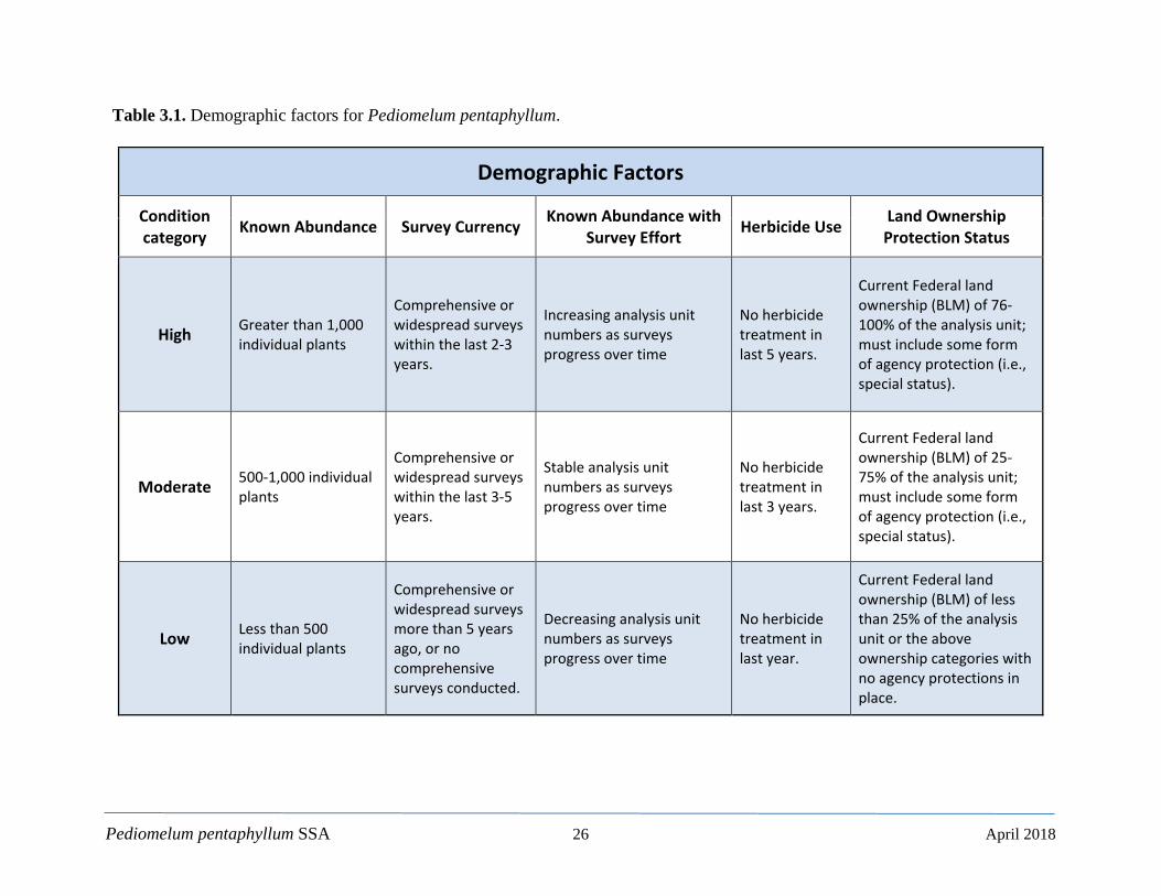
3.1.1. Population Resiliency For P. pentaphyllum to maintain viability, the analysis units, or some proportion therein, must be resilient to stochastic events. Stochastic events are those that arise from random chance but are part of a normal set of conditions that can influence a species’ overall abundance and distribution. Categorically, these include demographic factors (e.g., abundance) and habitat factors (e.g., soils). In addition, there are anthropogenic factors that may also affect species resiliency such as land use and land management. The factors we evaluated are presented below. Some are clearly stressors with additional details presented in Chapter 4. Figure 3.1 shows how these perceived stressors may impact the life cycle of P. pentaphyllum. To summarize the resiliency of each P. pentaphyllum analysis unit, we rated each of the demographic and habitat factors independently and then assigned discrete condition categories (High, Moderate, and Low; Tables 3.1 and 3.2).
3.1.1.1. Demographic Factors Known Abundance – Larger populations should be able to withstand stochastic events, as the probability of completely eliminating an entire population is reduced. Since, however, we have no genetic and little demographic information on the species, it is not possible to establish a scientifically based minimum viable or effective population size (Ne) by which we can assess the known abundance estimates. We therefore considered the relative abundance of each of the four P. pentaphyllum analysis units. Again, a species with greater abundance is better suited to endure adverse conditions and should be accordingly rated higher. We therefore considered that a High condition for the Known Abundance factor is greater than 1,000 individual plants whereas a Moderate condition is from 500-1,000 plants. A Low condition is less than 500 plants (Table 3.1). Survey Currency – This factor considers how recently comprehensive or widespread surveys have been conducted in a given analysis unit. If a survey was recent but limited to a smaller area
Pediomelum pentaphyllum SSA 25 April 2018
Figure 3.1. Life history (green) and perceived stressors (red) of Pediomelum pentaphyllum.
Pediomelum pentaphyllum SSA 26 April 2018
Table 3.1. Demographic factors for Pediomelum pentaphyllum.
Demographic Factors
Condition category Known Abundance Survey Currency Known Abundance with
Survey Effort Herbicide Use Land Ownership Protection Status
High Greater than 1,000 individual plants
Comprehensive or widespread surveys within the last 2-3 years.
Increasing analysis unit numbers as surveys progress over time
No herbicide treatment in last 5 years.
Current Federal land ownership (BLM) of 76-100% of the analysis unit; must include some form of agency protection (i.e., special status).
Moderate 500-1,000 individual plants
Comprehensive or widespread surveys within the last 3-5 years.
Stable analysis unit numbers as surveys progress over time
No herbicide treatment in last 3 years.
Current Federal land ownership (BLM) of 25-75% of the analysis unit; must include some form of agency protection (i.e., special status).
Low Less than 500 individual plants
Comprehensive or widespread surveys more than 5 years ago, or no comprehensive surveys conducted.
Decreasing analysis unit numbers as surveys progress over time
No herbicide treatment in last year.
Current Federal land ownership (BLM) of less than 25% of the analysis unit or the above ownership categories with no agency protections in place.
Pediomelum pentaphyllum SSA 27 April 2018
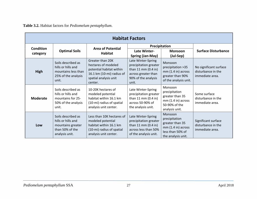
Table 3.2. Habitat factors for Pediomelum pentaphyllum.
Habitat Factors
Condition category Optimal Soils Area of Potential
Habitat
Precipitation Surface Disturbance Late Winter-
Spring (Jan-May) Monsoon (Jul-Sep)
High
Soils described as hills or hills and mountains less than 25% of the analysis unit.
Greater than 20K hectares of modeled potential habitat within 16.1 km (10-mi) radius of spatial analysis unit center.
Late Winter-Spring precipitation greater than 11 mm (0.4 in) across greater than 90% of the analysis unit.
Monsoon precipitation >35 mm (1.4 in) across greater than 90% of the analysis unit.
No significant surface disturbance in the immediate area.
Moderate
Soils described as hills or hills and mountains for 25-50% of the analysis unit.
10-20K hectares of modeled potential habitat within 16.1 km (10-mi) radius of spatial analysis unit center.
Late Winter-Spring precipitation greater than 11 mm (0.4 in) across 50-90% of the analysis unit.
Monsoon precipitation greater than 35 mm (1.4 in) across 50-90% of the analysis unit.
Some surface disturbance in the immediate area.
Low
Soils described as hills or hills and mountains greater than 50% of the analysis unit.
Less than 10K hectares of modeled potential habitat within 16.1 km (10-mi) radius of spatial analysis unit center.
Late Winter-Spring precipitation greater than 11 mm (0.4 in) across less than 50% of the analysis unit.
Monsoon precipitation greater than 35 mm (1.4 in) across less than 50% of the analysis unit.
Significant surface disturbance in the immediate area.
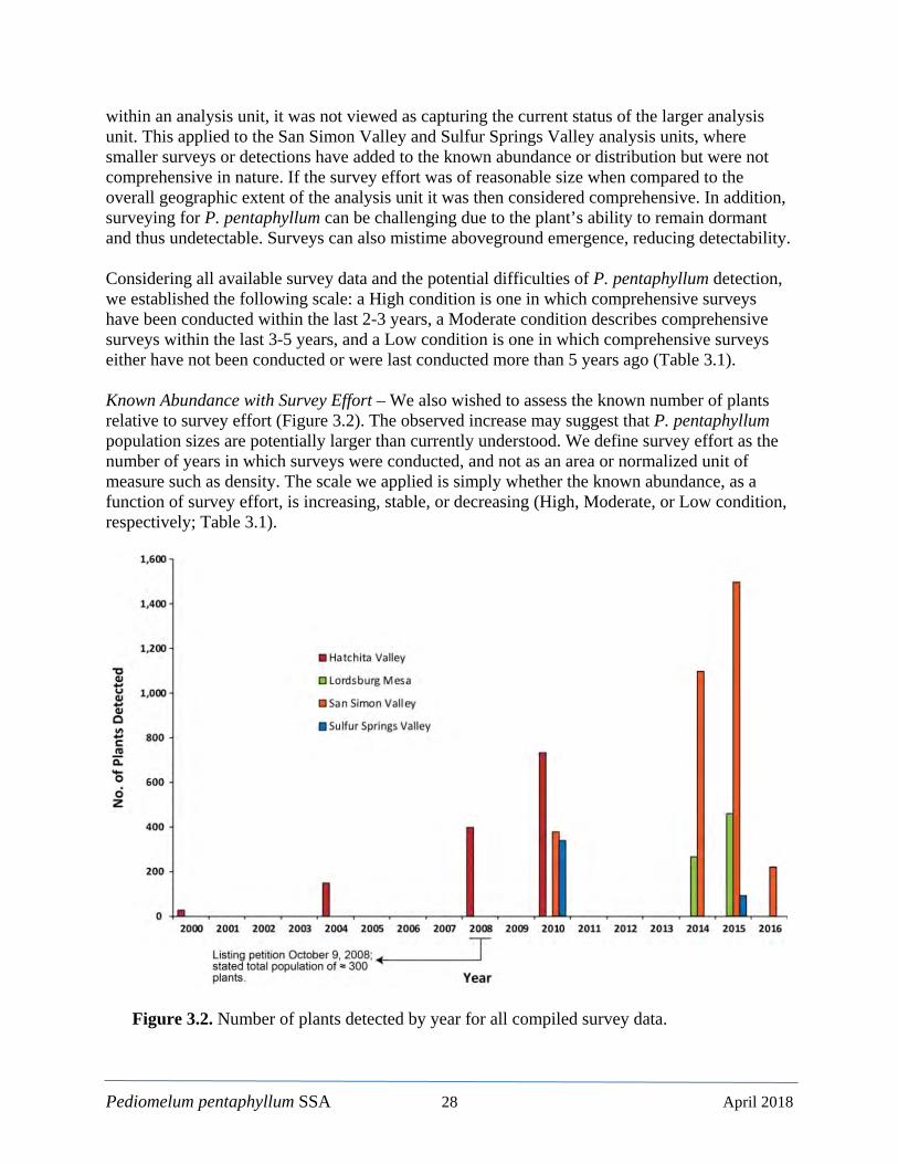
Pediomelum pentaphyllum SSA 28 April 2018
within an analysis unit, it was not viewed as capturing the current status of the larger analysis unit. This applied to the San Simon Valley and Sulfur Springs Valley analysis units, where smaller surveys or detections have added to the known abundance or distribution but were not comprehensive in nature. If the survey effort was of reasonable size when compared to the overall geographic extent of the analysis unit it was then considered comprehensive. In addition, surveying for P. pentaphyllum can be challenging due to the plant’s ability to remain dormant and thus undetectable. Surveys can also mistime aboveground emergence, reducing detectability. Considering all available survey data and the potential difficulties of P. pentaphyllum detection, we established the following scale: a High condition is one in which comprehensive surveys have been conducted within the last 2-3 years, a Moderate condition describes comprehensive surveys within the last 3-5 years, and a Low condition is one in which comprehensive surveys either have not been conducted or were last conducted more than 5 years ago (Table 3.1). Known Abundance with Survey Effort – We also wished to assess the known number of plants relative to survey effort (Figure 3.2). The observed increase may suggest that P. pentaphyllum population sizes are potentially larger than currently understood. We define survey effort as the number of years in which surveys were conducted, and not as an area or normalized unit of measure such as density. The scale we applied is simply whether the known abundance, as a function of survey effort, is increasing, stable, or decreasing (High, Moderate, or Low condition, respectively; Table 3.1).
Figure 3.2. Number of plants detected by year for all compiled survey data.
Pediomelum pentaphyllum SSA 29 April 2018
Here also, it is important to consider whether a survey was comprehensive or limited in scope and therefore not an apt characterization of the larger analysis unit. For example, Figure 3.2 shows a decrease in the number of plants detected in the Sulfur Springs Valley from 2010 to 2015 and the San Simon Valley from 2015 to 2016. This was not due to a population decline but rather to limited surveys during the latter years. In the Sulfur Springs Valley, the 2016 detections were limited to the Pat Hills area only. While this added to both the number of estimated plants (approximately a 21 percent increase) and the geographic distribution of the Sulfur Springs Valley analysis unit, the main portion of the analysis unit has not been surveyed since September 2010. Likewise, the San Simon Valley had limited surveys confined to several small plots in 2016. When omitting these limited surveys, the Hachita Valley, Lordsburg Mesa, and San Simon Valley analysis units show an increasing number of detections over time. Again, the Sulfur Springs Valley has only one comprehensive survey, in 2010, so conclusions on this analysis unit’s known abundance over time are not possible. The remaining patterns suggest that intensified survey efforts are resulting in an increase in the known distribution and number of plants. It is possible that double-counting may be influencing the total estimates; however, the salient characteristic is the increasing number of known plants as survey effort increases. In particular, the Hachita Valley analysis unit was estimated at ca. 300 individuals in 2008 (Wild Earth Guardians 2008: 15), which generally agrees with our compiled survey data estimate of 396 plants from that time period. Subsequently, in 2010, the estimated abundance from survey data nearly doubled to 734 individuals. Similar patterns can be seen for the San Simon Valley and, to a lesser degree, the Lordsburg Mesa analysis units. Partial surveys aside, all analysis units show a marked increase in known abundance with increased survey effort except for the Sulfur Springs Valley, which has only one comprehensive survey. Herbicide Use – In 2005, the New Mexico BLM began implementing Restore New Mexico, a cooperative partnership between the BLM, other Federal and state agencies, private landowners, conservation groups, and industry (USGS 2017b: entire). Restore New Mexico is a landscape-scale approach that seeks to restore grasslands, woodlands, and riparian areas to a healthier and more productive state. What started as a reclamation effort for abandoned oil and gas operations has evolved into a restoration program that seeks to restore wildlife habitat, alleviate the spread of invasive plant species, improve water quality, and reduce the impacts from catastrophic wildfire (BLM 2009: 1-1). Germane to P. pentaphyllum, Restore New Mexico’s efforts in grassland restoration focuses on the use of herbicides to control various shrub species and reverse the expansion of shrublands. This is discussed further in Chapter 4. This factor considers how recently herbicides (Tebuthiuron) has been applied to any given portion of an analysis unit. The Herbicide Use factor is principally based on observations of Howard (2012:8), where chronic effects of Tebuthiuron lasted for approximately 3 years (spring 2005 to summer 2008; see Chapter 4 for a discussion of Tebuthiuron effects). We assigned the 3-year reference point as representing an analysis unit in Moderate condition, as the effects of Tebuthiuron have the potential to last for roughly 2 more years, or 5 years in total, in more arid climates (Howard 2012: 3). A High condition would apply to an analysis unit that had no
Pediomelum pentaphyllum SSA 30 April 2018
herbicide use in the last 5 years. Conversely, a Low condition applies to an analysis unit in which Tebuthiuron application is more recent than the reference point. Here, we opted for 1 year because the soil half-life of Tebuthiuron is 12-15 months under the best of circumstances (EXTOXNET 1993: entire; Table 3.1). Land Ownership Protection Status – This factor is intended to capture the protective measures provided by virtue of land ownership, including land use and management, and the implementation of conservation efforts. Although P. pentaphyllum is listed as Endangered by the State of New Mexico for collecting purposes (not habitat modification) the BLM is the only jurisdictional entity with any standing procedures (i.e., survey and avoidance) intended to protect the species and foster its conservation (BLM 1991: 45; BLM 1993: L-5; BLM 2008: entire; Alexander et al. 2014: 2-3). Survey and avoidance is defined as a site assessment and survey with all P. pentaphyllum flagged and excluded from herbicide treatment. Land management by the BLM is therefore an important facet of protecting P. pentaphyllum habitat integrity. Our treatment of this factor focused on the proportion of a given analysis unit located within BLM lands. We also included a qualification to the condition categories in which the landowner or management entity must have some form of protection for the species in place in order to be rated as High or Moderate (Table 3.1). This allows for the Service’s consideration of potential positive or negative impacts of future landownership, other than by the BLM, where new locations of P. pentaphyllum may be discovered.
3.1.1.2. Habitat Factors Optimal Soils – For this factor, we drew upon the soils information derived during the creation of the habitat suitability model. Of the soil map units where P. pentaphyllum is currently located (Table 2.2) only 15 percent are described as being hills or hills and mountains, whereas 85 percent are described as some form of depositional process (alluvium, piedmonts, etc.) where deep, sandy loams tend to accumulate. Deep, sandy loams are considered optimal for P. pentaphyllum (e.g., Alexander 2015: 9). We therefore applied a scale that quantified the proportion of each analysis unit that fell within the suboptimal soil types (hills or hills and mountains); the greater the proportion (number of plants) of a given analysis unit within a suboptimal map unit, the lower the rank. Again, it should be noted that P. pentaphyllum likely occupies more optimal enclaves within the hills or hills and mountains map units (see also Section 2.6.2), but these suboptimal soil types represent less of an opportunity for localized population growth and thus a lower condition status for the Optimal Soils factor. The scale we established is essentially quartiles, in which the top two quartiles (i.e., greater than 50 percent of the analysis unit is within suboptimal soils) are grouped in the Low condition category. The Moderate condition is where 25-50 percent of the analysis unit is within suboptimal soils, and the High condition is less than 25 percent in suboptimal soils (Table 3.2). Area of Potential Habitat – This factor is intended to capture the amount of modeled potential habitat within a standardized area that represents a theoretical extent by which a known analysis unit could increase through reproduction, or numbers of known individuals could increase via additional surveys. Thus, a larger area of potential habitat equates to a higher condition status for this factor.
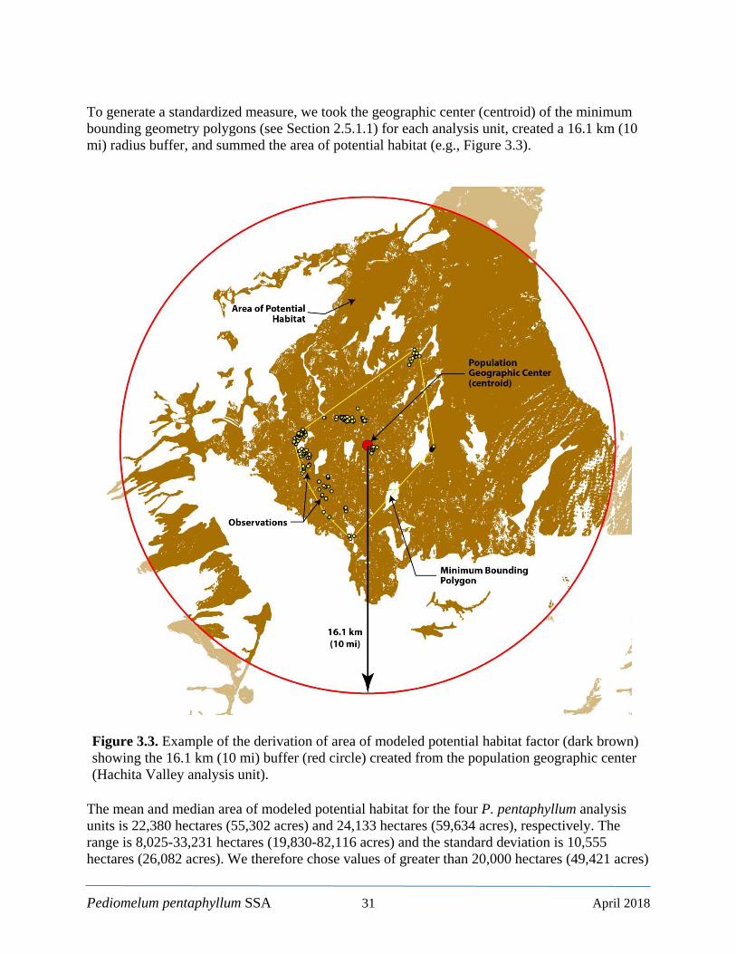
Pediomelum pentaphyllum SSA 31 April 2018
To generate a standardized measure, we took the geographic center (centroid) of the minimum bounding geometry polygons (see Section 2.5.1.1) for each analysis unit, created a 16.1 km (10 mi) radius buffer, and summed the area of potential habitat (e.g., Figure 3.3).
Figure 3.3. Example of the derivation of area of modeled potential habitat factor (dark brown) showing the 16.1 km (10 mi) buffer (red circle) created from the population geographic center (Hachita Valley analysis unit).
The mean and median area of modeled potential habitat for the four P. pentaphyllum analysis units is 22,380 hectares (55,302 acres) and 24,133 hectares (59,634 acres), respectively. The range is 8,025-33,231 hectares (19,830-82,116 acres) and the standard deviation is 10,555 hectares (26,082 acres). We therefore chose values of greater than 20,000 hectares (49,421 acres)

Pediomelum pentaphyllum SSA 32 April 2018
as representing a High condition, 10,000-20,000 hectares (24,711-49,421 acres) as a Moderate condition and less than 10,000 hectares (24,711 acres) as a Low condition for an analysis unit (Figure 3.4 and Table 3.2). Again, the habitat suitability model should be viewed as a heuristic guide that is subject to change and hopefully future improvement. Nonetheless, given the general level of agreement between the independently derived models discussed in Chapter 2 and in Mayer and Sartor (2012: entire), we are reasonably confident in the formulation and use of this factor in our assessment of current conditions.
Figure 3.4. Area of modeled potential habitat and relative condition categories. Precipitation – For this factor, we also drew upon data derived from the habitat suitability model (Section 2.7). To summarize, we created a set of continuous rasters that represents the mean precipitation for the late winter-spring (Jan-May) and the monsoon (Jul-Sep) periods using PRISM 30-year precipitation normals (1981-2010) These periods are the most important seasons of precipitation for this species. We then used each of the P. pentaphyllum observations to extract the specific values from the mean precipitation rasters, which provided a spatially explicit dataset of the seasonal amounts. As in the habitat suitability model, we chose the minimum average value for each season as a threshold for this factor. For the late winter-spring period, the value obtained was 11 mm (0.43 in) and the monsoon period was 35 mm (1.4 in). Since P. pentaphyllum has been observed in the various analysis units from 2000-2016, it is reasonable to conclude that there has been at least adequate reproduction and that the precipitation values derived from its locations are a reasonable estimation of seasonal amounts necessary to support its persistence. We then intersected the 11 and 35 mm isopleths with each of the known analysis unit to determine the proportion of each that is within the area of minimum average precipitation for each season (late winter-spring and monsoon). This measure is therefore intended to capture the proportion of each analysis unit that occurs within minimally suitable conditions with respect to

Pediomelum pentaphyllum SSA 33 April 2018
the empirically observed seasonal precipitation. Both seasons were scored separately and were considered equally in the precipitation factor since there is no definitive determination on the relative importance of one season over the other (however, see Howard 2012: 8 for perspectives on the relative importance of seasonal precipitation). A High condition was assigned when greater than 90 percent of an analysis unit was within the minimum precipitation isopleth. A Moderate condition was assigned when 50-90 percent of the analysis unit was within the minimum isopleth and a Low condition was assigned when the proportion was below 50 percent (Table 3.2). These are relatively high percentage thresholds but, again, are at minimally suitable precipitation levels. Surface Disturbance – The Surface Disturbance factor includes activities such as infrastructure installation and maintenance, oil and gas development, geothermal development, agricultural development, residential growth, wildlife herbivory, and livestock grazing. These are discussed further in Chapter 4. It is difficult to measure and form a quantifiable scalar for surface disturbance. We considered all of the above categories and established a qualitative measure whereby a High condition represents no significant surface disturbance in the immediate area, a Moderate condition allows for some surface disturbance, and a Low condition characterizes a situation where significant surface disturbance has or is likely to occur. For example, a Moderate condition may include a temporary disturbance regime such as the installation of powerlines with intermittent use of associated service roads. Significant surface disturbance would include fenced grazing, and agricultural or residential development. 3.1.1.3. Over Collection It is not clear what effect ethnobotanical/medicinal collecting has had on P. pentaphyllum over the years but the absence in Mexican markets noted by Sivinski (1993:7; see also Sections 2.4 and 2.5.1.6) may suggest some over collection pressure in the past. There is no clear evidence that over collecting for commercial or scientific purposes is an issue at this time. 3.2. Current Conditions 3.2.1. Resiliency Again, resiliency is the inherent ability to withstand stochastic events that result in a negative population trend. For example, demographic stochasticity includes fluctuations in birth or death rates that in turn influence population size, whereas environmental stochasticity includes factors such as changes in temperature or precipitation patterns. A larger population should, in theory, be able to endure such fluctuations and is therefore considered more resilient. Other factors affecting resiliency include anthropogenic activities such as land use or land management changes. Considering the biological and ecological information provided in Chapter 2 and the demographic and habitat factors discussed above and in Chapter 4, we present a summary of the perceived current conditions for each P. pentaphyllum analysis unit (Hachita Valley, NM;
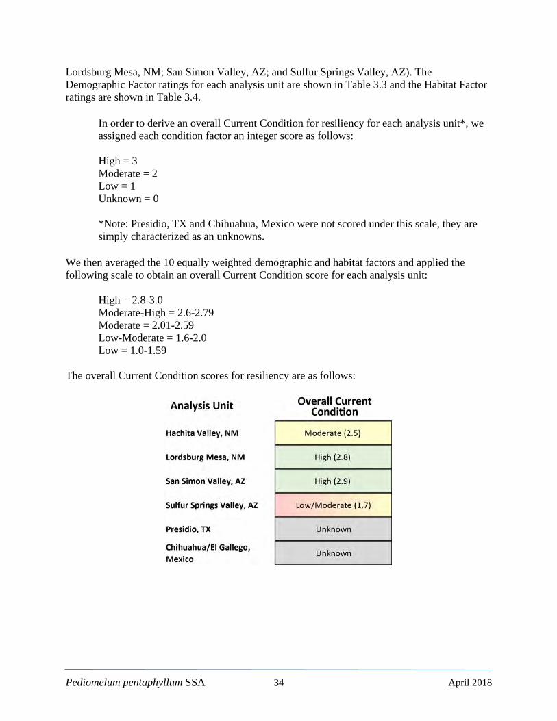
Pediomelum pentaphyllum SSA 34 April 2018
Lordsburg Mesa, NM; San Simon Valley, AZ; and Sulfur Springs Valley, AZ). The Demographic Factor ratings for each analysis unit are shown in Table 3.3 and the Habitat Factor ratings are shown in Table 3.4.
In order to derive an overall Current Condition for resiliency for each analysis unit*, we assigned each condition factor an integer score as follows: High = 3 Moderate = 2 Low = 1 Unknown = 0 *Note: Presidio, TX and Chihuahua, Mexico were not scored under this scale, they are simply characterized as an unknowns.
We then averaged the 10 equally weighted demographic and habitat factors and applied the following scale to obtain an overall Current Condition score for each analysis unit:
High = 2.8-3.0 Moderate-High = 2.6-2.79 Moderate = 2.01-2.59 Low-Moderate = 1.6-2.0 Low = 1.0-1.59
The overall Current Condition scores for resiliency are as follows:
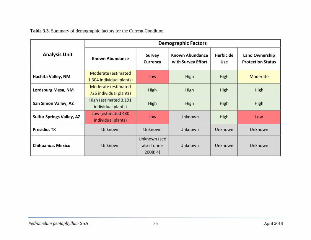
Pediomelum pentaphyllum SSA 35 April 2018
Table 3.3. Summary of demographic factors for the Current Condition.
Analysis Unit
Demographic Factors
Known Abundance Survey
Currency Known Abundance with Survey Effort
Herbicide Use
Land Ownership Protection Status
Hachita Valley, NM Moderate (estimated
1,304 individual plants) Low High High Moderate
Lordsburg Mesa, NM Moderate (estimated 726 individual plants)
High High High High
San Simon Valley, AZ High (estimated 3,191
individual plants) High High High High
Sulfur Springs Valley, AZ Low (estimated 430
individual plants) Low Unknown High Low
Presidio, TX Unknown Unknown Unknown Unknown Unknown
Chihuahua, Mexico Unknown Unknown (see
also Tonne 2008: 4)
Unknown Unknown Unknown
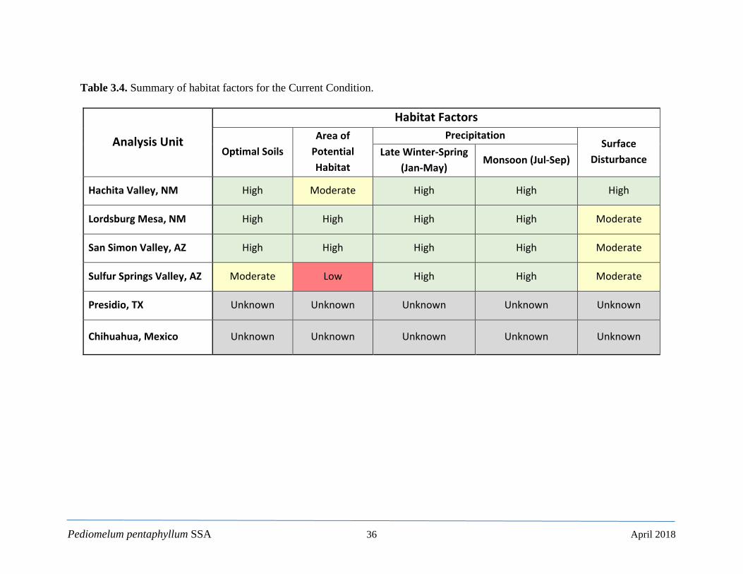
Pediomelum pentaphyllum SSA 36 April 2018
Table 3.4. Summary of habitat factors for the Current Condition.
Analysis Unit
Habitat Factors
Optimal Soils Area of
Potential Habitat
Precipitation Surface
Disturbance Late Winter-Spring
(Jan-May) Monsoon (Jul-Sep)
Hachita Valley, NM High Moderate High High High
Lordsburg Mesa, NM High High High High Moderate
San Simon Valley, AZ High High High High Moderate
Sulfur Springs Valley, AZ Moderate Low High High Moderate
Presidio, TX Unknown Unknown Unknown Unknown Unknown
Chihuahua, Mexico Unknown Unknown Unknown Unknown Unknown
Pediomelum pentaphyllum SSA 37 April 2018
Our assessment of current resiliency indicates that the Lordsburg Mesa, NM and the San Simon Valley, AZ analysis units are in the High condition category. Both have a Moderate Surface Disturbance score from the powerline projects, and the Lordsburg Mesa, NM has Moderate score for the Known Abundance factor. Nonetheless, they appear to be healthy, and known abundances are expanding based on increased survey efforts. The Hachita Valley, NM analysis unit scored an overall Moderate condition owing largely to a Low score in Survey Currency. The Sulfur Springs Valley, AZ analysis unit is in the Low/Moderate condition category because of Low or Moderate scores in the Known Abundance, Survey Currency, Land Ownership Protection Status, and Surface Disturbance factors, and the lowest values of any analysis unit for the Area of Potential Habitat factor. Again, the Presidio, TX, and Chihuahua, Mexico analysis units are of unknown status. 3.2.2. Redundancy Redundancy is a measure of the ability to withstand catastrophic events (e.g., a rare, destructive event or episode involving one or more populations). Largely predicated on the number of discrete populations, redundancy also includes elements such as habitat or population connectivity, their individual resiliency, and overall geographic distribution. These can all contribute to a species’ ability to recover from such an event and involves the interaction of multiple populations. We have grouped the known observations of P. pentaphyllum into four analysis units that are widely distributed over approximately 940,000 hectares (2.3 million acres) in southeast Arizona and southwest New Mexico. Although each analysis unit is somewhat isolated, there remains a significant amount of unsurveyed potential habitat around and between each of the analysis units (see Section 2.7 and Figure 2.5). Further, because the known abundances are growing with increased survey effort (see Section 3.1.1.1 and Figure 3.1) and the habitat suitability model was 1) functionally limited to HUC8s where known observations occurred and 2) has the potential to be expanded through an increased understanding of the species’ ecology, it is conceivable that the species’ known abundance and distribution will increase over time. Here, redundancy is established by multiple, resilient analysis units over a fairly wide distribution envelope that is likely to expand in the future. 3.2.3. Representation In short, representation describes the ability of a species to adapt to a dynamic or changing environment. Representation is thus a proxy measure of diversity that can be expressed as 1) genetic variation, whereby a species retains the genetic capacity to cope with such changing conditions through natural selection or 2) occupation of a broad variety of habitat types, which can serve to buffer the species’ persistence against environmental change. The only species-level genetic information we have on P. pentaphyllum is through analogy and inference. Microsatellite analysis of P. pariense (Paria River Indian breadroot) demonstrated a considerable degree of genetic diversity among several highly restricted populations (Jones and Crandall 2013: entire). It is yet unknown whether this model holds true for P. pentaphyllum, and
Pediomelum pentaphyllum SSA 38 April 2018
we cannot draw any conclusions therein. Nonetheless, there is at least some evidence for a significant amount of genus-level genetic diversity. In the absence of more definitive genetic data, we must turn to habitat diversity as the main buffer against environmental change and our key metric for representation. Although open to further research, P. pentaphyllum appears to occupy a comparatively narrow habitat niche; deep, sandy loams where erosional/depositional processes tend to dominate. Such soil types and their transitional ecotones (e.g., alluvial fans, piedmonts, etc.) are widespread in the region. Cockman (2018: entire) also reports that greenhouse studies are underway (initiated in the summer of 2017) through an arrangement between SFO BLM and The Arboretum at Flagstaff to examine soil properties of texture, moisture and temperature related to germination rates and plant vigor/viability. In addition, Section 2.6.2 and Table 2.1 document a fairly diverse set of plant associations, which may suggest a broader niche than is currently characterized. Lastly, uncertainty surrounding the historical versus contemporary vegetation communities (i.e., see Section 2.6.2 regarding the occupation of high quality grasslands, fringes of degraded grasslands, etc.) also suggests the capacity for P. pentaphyllum to occupy more habitat types, and thus potentially a more diverse habitat niche than is currently understood.

Pediomelum pentaphyllum SSA 39 April 2018
CHAPTER 4 Species Evaluation Factors, Future Scenarios, Future Conditions, and Conclusions In this chapter, we identify and discuss certain evaluation factors, including stressors, that were carried forward in order to assess the potential future conditions of the known P. pentaphyllum analysis units. To estimate the future conditions, we formulated five scenarios in which these evaluation factors were varied to capture a plausible range of conditions.
4.1 Species Evaluation Factors Carried Forward The species evaluation factors, including several stressors on P. pentaphyllum, carried forward in our assessment of the potential future conditions of the species are as follows: Demographic Factors
• Herbicide Use Habitat Factors
• Precipitation • Surface Disturbance
4.1.1. Demographic Factors Herbicide Use – The Restore New Mexico initiative is a cooperative program that strives to restore grasslands, woodlands, and riparian areas to a more natural and productive state. With respect to P. pentaphyllum, the use of herbicides in grassland restoration efforts has a toxic, detrimental impact on the species. It is for this reason that we include herbicide use as a demographic factor, both presently and into the future. In addition, while it does have implications on habitat alteration (i.e., shrubland to grassland conversions) and could be viewed as a habitat factor, there is at least some uncertainty whether P. pentaphyllum once occupied primordial grasslands (Tonne 2010:15) or is functionally limited to shrublands (Tonne 2010: 14; Alexander 2015: 9). Thus, any conclusions on the viability of P. pentaphyllum based on habitat conversion appear to be, at this point, a preliminary assertion. In other words, it is not clear whether grassland conversions, and thus a departure from the observed shrubland habitat, are detrimental to the species. It is clear, however, that herbicide use has potentially lethal effects to individuals and therefore, by extension, demographic relevance. Extensive grazing in New Mexico lasted into the early 20th century where vast areas of high-quality grama grasslands (Bouteloua spp.) supported well over seven million cattle, sheep, goats, and horses – more than three times contemporary levels (Dick-Peddie 1993: 18-19). The intense grazing pressure over the last 150 years has resulted in the widespread conversion of exceptionally diverse grasslands into desert shrublands and, to some degree, a transitional state of desert grasslands (Humphrey 1958: 199; Dick-Peddie 1993: 19, 106-107; Brown et al. 1997: 9729; Desmond and Montoya 2006:17). In addition, Chihuahuan Desert grasslands are especially susceptible to overgrazing due to the low precipitation (Humphrey 1958: 197). The broad array of human activities has greatly modified the region’s landscape and promoted the spread of
Pediomelum pentaphyllum SSA 40 April 2018
numerous non-native plant species. It is also likely that the same human activities have fostered colonization by native plant species “previously restricted to other areas” (Dick-Peddie 1993: 20). Although native, these shrub species have become dominant in much of the region’s primordial grasslands (Dick-Peddie 1993: 20).Thus, grassland restoration efforts under the Restore New Mexico initiative seek to reduce the amount of woody shrubs (e.g., creosote bush and honey mesquite) through targeted herbicide application. Similar patterns also occurred in Arizona. Cockman (2018: entire) states that open range ranching began in southern Arizona in the late 1870's and continued up until implementation of the Taylor Grazing Act in 1934. Cattle importation increased dramatically with the 1881 completion of the Southern Pacific Railroad across southern Arizona. Despite droughts from 1885 to 1904 cattle number reached a peak in 1891 with an estimated 1.5 million head of cattle on Arizona ranges. The first large permanent herds of livestock were imported to southern Arizona along with establishment of military outposts. The widely used herbicide Tebuthiuron (trade names of Spike, Graslan, Perflan, Herbic, Brush Bullet, EL-103, and Reclaim) is a broad spectrum herbicide used in noncropland areas, rangelands, rights-of-way, and industrial areas (EXTOXNET 1993: entire; EPA 1994: entire) and has been used extensively for control of woody vegetation in degraded rangelands (Howard 2012: 3). Tebuthiuron inhibits photosynthesis by disrupting certain elements of the electron transport chain, primarily in Photosystem II (Hatzios et al. 1980: 321). Because Tebuthiuron uptake is through the plant’s root system, it is applied in pelleted or granulated form where dissolution from rainfall transports it into the upper soil horizons. It is apoplastically translocated during transpiration (Ross and Childs 2011: 9) to stem and leaf tissues where it inhibits photosynthesis. Symptoms develop in lower shoots then progress upward to newer growth. Chlorosis (yellowing) first appears on leaf margins and between veins, followed by necrosis (Ross and Childs 2011: 9). Tebuthiuron is highly water soluble, weakly adsorbs to soil, and is especially recalcitrant; soil half-life is 12-15 months in areas of higher precipitation and up to 5 years in more arid climates (EXTOXNET 1993: entire; Howard 2012: 3). Microbial degradation, although present, appears to be slow and may not be the primary mode of breakdown in soils. Photodecomposition and volatilization are negligible as is aqueous degradation. Tebuthiuron is generally thought to have a low toxicity in animal and bacterial models (EPA 1994: entire). As part of a larger grassland restoration project, Howard (2012: entire) conducted a control study on the toxicity of Tebuthiuron on P. pentaphyllum in the Hachita Valley, Hidalgo County, New Mexico (Howard 2012: 1). At the inception of the study in 2004, the Hachita Valley contained the only known population of P. pentaphyllum and, given the perceived rarity of the species, the study was somewhat controversial. Nevertheless, the results yielded valuable data and insight into both the toxicity of Tebuthiuron and the ecology of the species. Not surprisingly, Howard (2012: 10-11) found that Tebuthiuron was acutely toxic to P. pentaphyllum, causing unmistakable signs of chlorosis and diminutive growth patterns with “oddly colored light green leaves” (Howard 2012: 8). Chronic effects lasted from the spring of 2005 through the summer of 2008. Above average precipitation during the final data collection period (2010) likely contributed to the presence of several large plants and numerous seedlings in the treated area (Howard 2012: 10). These observations, along with the inference that the tuber is seemingly able to recover from
Pediomelum pentaphyllum SSA 41 April 2018
short-term drought cycles (perhaps as little as one growth cycle with longer drought resulting in plant mortality), suggests that a given population of P. pentaphyllum is capable of reestablishment after herbicide treatment provided sufficient precipitation is present (Howard 2012:10). Further, P. pentaphyllum has clearly persisted through decadal drought cycles such as the 1950s. More remarkably, Egan and Crandall (2008b: 1) found that the North American Psoraleae began a rapid net diversification rate increase around 2 million years ago with a subsequent decrease around 440,000 years ago, in which quaternary climate oscillations likely contributed to the often narrow patterns of contemporary endemism. Given this model, P. pentaphyllum has also endured far more severe and longer drought periods around A.D. 1000 and the late 13th and 16th centuries (Gutzler 2003: 103). Thus, it appears that P. pentaphyllum is able to persist through severe drought and herbicide application. In terms of the demographic factors we invoke to evaluate resiliency, herbicide use has an additional dimension when coupled with drought or climate change. As noted above, populations of P. pentaphyllum can ostensibly recover from both drought periods and herbicide use. In the case of extended drought, it is likely that the primary mode of recovery is from the seed bank (Howard 2012: 10). This may also be the case for herbicide application but could plausibly include plants that survived through a shorter recalcitrance period of the herbicide, typically Tebuthiuron. When combined, however, drought and herbicide use have a potentially cumulative effect which represents a complementary set of stressors. If drought precludes or reduces the frequency of aboveground growth and Tebuthiuron is present (thus reducing the net efficiency of photosynthesis) the plant may succumb to a chronic inability to produce adequate photosynthate and survive an incipient drought cycle. Here also, the seed bank would tend to be a vital component of a given population’s resiliency. Successive herbicide applications would also have a cumulative effect and not only kill an established plant but prevent those that survive from producing seed, thereby depleting the seed bank. Herbicide use is the primary method for Restore New Mexico’s grassland restoration efforts, and these efforts vary over time and space. Herbicide has been widely used in grassland restoration efforts in New Mexico but far less so in Arizona. It is likely that this program will continue into the foreseeable future, and thus it is reasonable to conclude that herbicide use will continue to be a potential stressor on P. pentaphyllum where they coincide. Unfortunately, it is not possible to forecast where herbicide use will occur as Restore New Mexico funding is variable and often linked to many outside sources. As a result, we describe the future effects of the Herbicide Use condition factor in general terms as either maintained at current levels or increasing in scope; when increasing, there is a greater probability of impacting an occupied area. The effects of herbicide use are therefore intimately related to the Land Ownership Protection Status factor. Land Ownership Protection Status – is intended to summarize the protective measures afforded by a given landowner. BLM lands contain 79.5 percent of the known P. pentaphyllum individuals and are the only Federal lands on which known P. pentaphyllum occur. The BLM has designated P. pentaphyllum as a Sensitive Species in a stipulated effort to protect, conserve, and avoid listing under the ESA (BLM 1991: 45; BLM 1993: L-5; BLM 2008: entire; Alexander et al. 2014: 2-3). The Sensitive Species designation confers and requires special considerations with respect to any and all activities on BLM lands (BLM 2008: entire). At a minimum, these considerations include appropriate surveys and avoidance procedures. Although such protective
Pediomelum pentaphyllum SSA 42 April 2018
measures may apply to many different activities, we focus here on the measures and protocols in place by the BLM to safeguard both known and unknown areas of P. pentaphyllum habitat during herbicide application (see Alexander 2015: 1 for BLM programmatic and additional project-level specific references and procedures).
4.1.2. Habitat Factors Precipitation – Seasonal precipitation is a key element of P. pentaphyllum viability. To assess the future state of this factor, we built upon the Current Conditions framework presented in Chapter 3. Aside from natural variation, climate change is the primary source for future shifts in precipitation patterns. To model these changes, we began with the National Climate Change Viewer (NCCV) established by the U.S. Geological Survey, Climate Research and Development Program (USGS 2016: entire). The NCCV includes future climate projections relative to the historical climate normal (1981-2010) and contains statistically down-sampled output (800 m [2,625 ft] grid) for 30 General Circulation Models contained in the 5th Climate Model Intercomparison Program (CMIP5) for two of the Representative Concentration Pathways (RCP) included in the Intergovernmental Panel on Climate Change, Synthesis Report (IPCC 2014: 8). RCP4.5 is one of the intermediate emission scenarios where global greenhouse gas concentrations are generally stabilized and do not exceed a radiative forcing of 4.5 Wm-2 after 2100, which is roughly equivalent to 650 parts/million (ppm) CO2. RCP8.5 is the most aggressive and uncompromising scenario where 8.5 Wm-2 radiative forcing is equivalent to approximately 1,370 ppm CO2. As of September 2017, the current global mean CO2 concentration is 402.50 ppm (National Oceanic and Atmospheric Administration [NOAA] 2017: entire). The parameters we selected for the NCCV output are as follows:
• Model = Mean Model (the ensemble model for all 30 CMIP5 models); • Variable = Precipitation (mm/month); • Region Type = State/Counties (counties where P. pentaphyllum are located Hidalgo, NM;
Cochise, AZ, and Graham, AZ). The Time Period parameter allows for the selection of either an annual mean or a monthly timestep. Since the lifecycle of P. pentaphyllum is keyed to precipitation over several months in the spring and again during the monsoons, we averaged the NCCV monthly output for the late winter-spring (Jan-May) and monsoon (Jul-Sep) periods. We then took the mean percent difference between the historical (1981-2010) and two discrete future evaluation intervals (2025-2049 and 2050-2074) and adjusted the values contained in the mean PRISM 30-year normals used previously in the Habitat Suitability Model (Chapter 2) and Current Conditions assessment (Chapter 3). The future evaluation intervals described above define the overall time steps we employed for the future scenarios presented below. Finally, we used the same threshold isopleths as in the Current Conditions assessment (11 mm [0.43 in] for the late winter-spring period and 35 mm [1.4 in] for the monsoon period) to determine the proportion of each analysis unit that falls within an area equal to or greater than the above thresholds. This provides a quantifiable

Pediomelum pentaphyllum SSA 43 April 2018
and spatially explicit estimate of the future changes in precipitation patterns mediated by climate change. Interestingly, the NCCV predicts slight increases in the mean monsoon precipitation in the above counties for both RCPs and future evaluation intervals. The monsoonal precipitation increase ranges from 2.0-4.7 percent. For this reason, the future monsoon period precipitation does not decline; however, the late winter-spring precipitation does show considerable declines (Table 4.1). Again, P. pentaphyllum has a second, monsoonal emergence period.
Table 4.1. Precipitation mean percent change for RCP4.5 and RCP8.5 under evaluation intervals 2025-2049 and 2050-2074. Negative values indicate a decrease in precipitation.
Late Winter-Spring Period Precipitation (Jan-May) 2025-2049 2050-2074 RCP4.5 -10.4% -8.8% RCP8.5 -9.6% -19.5%
Monsoon Period Precipitation (Jul-Sep)
2025-2049 2050-2074
RCP4.5 2.6% 4.7% RCP8.5 2.0% 3.4%
Surface Disturbance – Surface disturbance includes a number of activities that disrupt the soil surface or to a depth sufficient enough to impact the tuber/taproot of P. pentaphyllum. Again, we considered the following sources: infrastructure installation and maintenance, oil and gas development, geothermal development, mining/mineral extraction, agricultural development, residential growth, wildlife herbivory, and livestock grazing. With respect to grazing, there are three plausible impacts: 1) direct herbivory; 2) trampling by livestock; and 3) erosion of suitable soils. According to recent observations, there is no clear evidence of direct herbivory by livestock, and only minimal accounts of trampling (Alexander 2018: entire) which only impacts the current year’s growth. Soil erosion is at least a potential issue with particular relevance to P. pentaphyllum. Savory (1983: 155; 2013: entire) promotes a “holistic resource management” and “planned grazing” approach where high-intensity grazing is intended to mimic the patterns of large, mobile herd species. At its core, the Savory method depends on an intensive management of livestock to ensure that overgrazing does not occur – a “time-controlled” exposure that reflects: 1) the growth rate of the forage, 2) the grazing return interval with respect to the forage growth rate, and 3) the nutritional needs of the livestock with respect to the grazing return interval and forage growth rate (Savory 1983: 158). If the Savory approach is implemented correctly, Savory and others contend, soil erosion, carbon sequestration, and virtually all other aspects of catchment health
Pediomelum pentaphyllum SSA 44 April 2018
will be enhanced, and desertification (including the expansion of shrublands) can be reversed (Savory 2013: entire; Teague 2014: entire). Critics of the Savory approach point to various experimental results, carbon cycle stoichiometry, and personal accounts that cast doubt on the method (e.g., Briske et al. 2013: entire; Cibils et al. 2014: entire; Teague and Borrelli 2014: entire). What seems clear from the debate is that if time controls are not observed, overgrazing and thus disproportionate effects, including soil erosion, will result when compared to more traditional rotation methods. Both grazing practices are employed near the various analysis units and it has been noted that soil erosion associated with grazing can be a localized issue for concern near certain sites and suitable habitat. Although difficult to measure and assess, long-term grazing (100-150 years) of any kind is likely to accelerate erosion albeit at a slow rate (Alexander 2018: entire). Accelerated soil erosion may also result from increased rainstorms (frequency or intensity) that could occur with shifts in climate patterns. The majority of the Lordsburg Mesa and San Simon Valley analysis units are located in BLM lands, as is roughly half of the Hachita Valley analysis unit. As such, these areas are subject to grazing leases and are located within active allotments where both the Savory and more traditional livestock management methods are employed (Alexander 2017: entire). Although surveyed and managed by the BLM to avoid excessive impacts to known P. pentaphyllum locations, it is possible that grazing activity could result in some localized erosion of suitable soil types. Given the protective measures accorded by the BLM, it is unlikely that grazing or erosion caused by grazing would result in widespread impacts; however, long-term impacts are difficult to assess but could represent a more pronounced risk. The Sulfur Springs Valley analysis is located almost entirely (97 percent) on private land and could be subject to unmanaged or fenced grazing, agricultural development, or residential growth. Through inspection of aerial photography (1996-2016) it does not appear, however, that any of these stressors have occurred over the past decade, as the landscape and the shrub community where this population resides has remained essentially unchanged. The future of the Sulfur Springs Valley population is nonetheless uncertain.
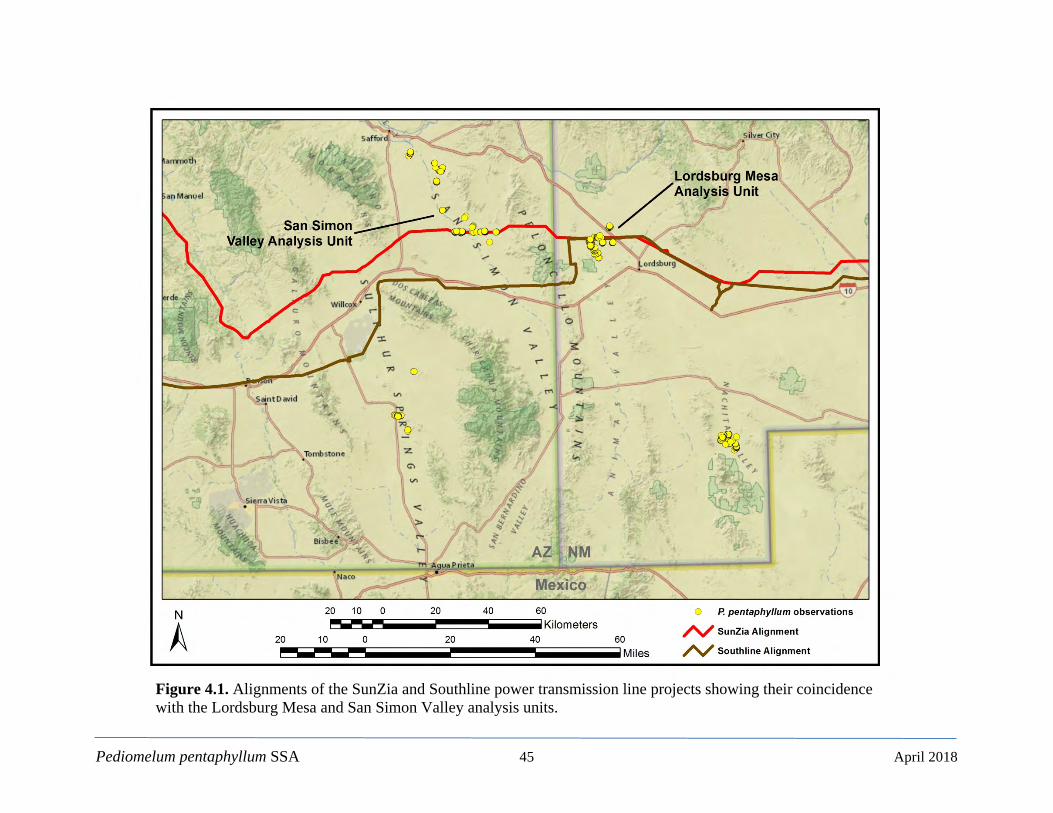
Pediomelum pentaphyllum SSA 45 April 2018
Figure 4.1. Alignments of the SunZia and Southline power transmission line projects showing their coincidence with the Lordsburg Mesa and San Simon Valley analysis units.
Pediomelum pentaphyllum SSA 46 April 2018
Other known sources of surface disturbance include the installation of the SunZia and Southline power transmission lines (Figure 4.1). Both project alignments coincide with portions of the Lordsburg Mesa analysis unit. In fact, surveys by the BLM are responsible for the discovery of P. pentaphyllum along the power line’s alignment, and subsequent surveys greatly expanded the known extent of the Lordsburg Mesa analysis unit. The SunZia alignment also intersects the southern extent of San Simon Valley analysis unit. Similarly, these plants were also detected through project surveys. For Lordsburg Mesa, where both powerlines generally share an alignment, the lateral footprint is estimated to be approximately 122 m (400 ft) wide. In the San Simon Valley, the SunZia lateral footprint is estimated at 61 m (200 ft) wide. Surface disturbance associated with construction and installation includes road construction, vehicle traffic, equipment staging areas, and the actual siting and installation of the towers and supporting equipment. The latter has the potential for direct plant mortality whereas the other activities tend to be transient in both their acute and cumulative effects. Nevertheless, there will likely be permanent maintenance roads established along the alignments that may serve to increase recreational off-road vehicle traffic and thus potentially impact aboveground P. pentaphyllum growth. In Arizona, Cockman (2018: entire) reports that the alignments are generally along existing trackways and very few new roads will be constructed; none of which are in suitable habitat. It is not anticipated that the construction of or traffic on the service roads will be a significant source of disturbance or plant mortality. Nonetheless, fugitive dust may impact plant vigor in areas with more frequently used roads (Chibuike and Obiora 2014: 1 and Waser et al. 2017: 90). Two species stand out as potential threats to P. pentaphyllum through herbivory: the collared peccary (or Javelina; Pecari tajacu) and feral hog (Sus scrofa). While other small herbivores may feed on roots and tubers, the peccary and feral hog have the size and abundance to potentially impact P. pentaphyllum. Both species are found in the range of P. pentaphyllum (BISON-M 2013, 2017: entire). The collared peccary is native to the continent but is considered a recent arrival in the southwestern United States, as archaeological remains and historical accounts are limited (Lamit and Hendrie 2009: 255; AZGFD 2017: entire). Speculation for the increase in collared peccary distribution stem from grassland conversion and the ongoing expansion of shrubland communities (Lamit and Hendrie 2009: 255). Collared peccary primarily feed on prickly pear cactus (Opuntia spp.) but are known to consume roots or tubers on occasion; however, this feeding behavior is uncommon in most food studies (Neal 1959: 188; Eddy 1961: 251–252; Corn and Warren 1985; 156; Everrit et al. 1991: 142). Eddy (1961: 255) reported considerable rooting by collared peccaries and observed that they can find edible subterranean food items by smell. AZGFD (2018: entire) provided additional information that, conversely, indicates rooting of tubers tends to nominally occur in spring and summer and prickly pear consumption tends to occur more during drought conditions. The feral hog is an introduced species (Taylor and Hellgrin 1997: 33; Lamit and Hendrie 2009: 253). It is a recent invader that primarily roots for food items and causes great disturbance to soils and plants (Adkins and Harveson 2006: 578–579). Feral hogs are known from Cochise County, AZ and Hidalgo County, NM where P. pentaphyllum suitable habitat occurs (USDA 2010: 10; Basmajian 2017: 21). There is an active feral hog eradication program in both Arizona and New Mexico (USDA 2009: entire; Basmajian 2017: 13). Feral hog abundance tends to increase with annual rainfall levels, and although feral hogs occurred at relatively low densities
Pediomelum pentaphyllum SSA 47 April 2018
in the Chihuahuan Desert, there is still concern over their potential damage to natural resources (Adkins and Harveson 2007: 156). Where collared peccaries and feral hogs overlap, there is typically an inverse relationship between the two species (Gabor and Hellgren 2000: 2520). Collared peccaries have a competitive advantage over feral hogs in dry environments due to better control of heat stress and water loss (Ilse and Hellgren 1995: 794), though feral hogs do better in grasslands without good cover and lacking in cactus food sources (Gabor and Hellgren 2000: 2520). Although there are clear cases of herbivory, the overall the level of this threat is difficult to assess (Alexander 2018: entire). Oil and gas activities could also potentially impact one or more of the P. pentaphyllum analysis units. To evaluate the status of these activities, we downloaded and queried geospatial datasets from the NMEMNRD (2017c: entire) and the Arizona Geological Survey (AGS 2005: entire). The NMEMNRD dataset is a continuously maintained record of wells drilled in New Mexico and is part of the State Oil Conservation Division’s permitting system. The AGS dataset was only maintained through 2005. The queries returned 58 wells in New Mexico and 90 wells in Arizona within 100 km (62.1 m) of any currently documented P. pentaphyllum location. We then reviewed the status of these wells and all were either abandoned, plugged, dry, or canceled. We thus concluded that, given the best available information, there are no known oil and gas interests that pose a significant threat to the known P. pentaphyllum analysis units; however, the Arizona data are outdated and cannot be considered complete. Geothermal resources are found within P. pentaphyllum potential habitat. Geothermal energy is tapped by drilling into subsurface rock and extracting steam and hot water. This requires equipment similar to oil and gas exploration and its associated infrastructure (roads, pipeline, and well pads), and has similar impacts. There is no recent assessment of geothermal activities in Arizona but low-temperature geothermal water is found the Sulphur Springs and San Simon Valleys (Stone and Witcher 1982: 89 and 185). Development to date has been minimal but future development could have impacts to P. pentaphyllum. In New Mexico, P. pentaphyllum potential habitat is found in the Lightning Dock Known Geothermal Resource Area (KGRA) in the Animas Valley (Crowell and Crowell 2014: entire). Geothermal development typically requires multiple exploratory wells to define the extent of the resource (Crowell and Crowell 2014: Figure 2). Current infrastructure consists of a power plant (10 megawatts full potential), greenhouses, and a fish farm (Bland 2010: 11; Crowell and Crowell 2014: 82). No P. pentaphyllum occupied sites are found in the KGRA or on current geothermal leases. The lack of extensive geothermal development suggest, at most, a minor threat to P. pentaphyllum potential habitat but future development should be preceded by a survey to help avoid occupied areas.
4.2 Future Scenarios The scenarios described below serve to frame a set of circumstances whereby the evaluation factors are varied in order to estimate the future conditions of the known P. pentaphyllum analysis units. We present five scenarios in which we attempt to cover a plausible range of
Pediomelum pentaphyllum SSA 48 April 2018
conditions for each evaluation factor. Given the difficulties in predicting future herbicide use, we focus on the protective measures employed by the BLM. It is equally problematic to estimate future surface disturbance regimes. We therefore categorically include all the aforementioned types of surface disturbances and characterize them as either remaining constant or increasing. We also view surface disturbance for the future scenarios in terms of occurring on Federal lands or, in the case of the Sulfur Springs Valley analysis unit, occurring on private lands. In addition, we omit the effects of livestock herbivory, trampling, and soil erosion as these elements are only known to be occasional, have localized impacts, and are not currently viewed as a widespread threat. Wildlife herbivory is also omitted for similar reasons. Again, however, soil erosion may pose a long-term threat depending on the rate of erosion versus deposition, which can vary greatly across the landscape. Precipitation is the evaluation factor that captures the future influence of climate change. The NCCV (USGS 2016: entire) provides projections for two future time periods (2025-2049 and 2050-2074) which also define our future evaluation intervals. In the scenarios that follow, we hold the surface disturbance and herbicide use factors constant in 2b and 3b to evaluate the effects of precipitation changes during the second evaluation interval (2050-2074). In other words, scenarios 2a and 3a have 1) a different treatment of the surface disturbance and herbicide use evaluation factors and 2) are for the evaluation interval of 2025-2049 for all factors. The future scenarios are further defined below.
4.2.1. Scenario 1: Optimistic
Minimal habitat alterations; mitigated, stable climate change regime approximating the RCP2.6 emissions (IPCC 2014: 8, 22); evaluation interval 2025-2049
• Precipitation and drought patterns remain generally stable; the RCP2.6 scenario, in which emissions are mitigated, aims to keep global warming to 2°C (3.6°F ) above pre-industrial temperatures and thus provide a comparatively normal pluvial and drought pattern that is commensurate with natural variation;
• No additional surface disturbance;
• No or minimal coincidence between herbicide use (grassland restoration) and any P. pentaphyllum analysis unit. When there is co-occurrence, the BLM LCDO maintains diligent protection measures; avoidance surveys are routinely completed and all P. pentaphyllum are flagged and excluded from herbicide treatment. The BLM SFO maintains current low levels of grassland restoration/herbicide use (which may, given the uncertainty of its habitat preferences be somewhat beneficial).
4.2.2. Scenario 2a: Intermediate Impacts (years 2025-2049)
Intermediate habitat alterations; intermediate climate change regime of RCP4.5 emissions (IPCC 2014: 8, 22); evaluation interval 2025-2049
Pediomelum pentaphyllum SSA 49 April 2018
• Climate change influences pluvial and drought patterns. Based on the NCCV (USGS
2016: entire), late winter-spring precipitation (Jan-May) decreases by 10.4 percent and monsoon precipitation (Jul-Sep) increases by 2.6 percent;
• Surface disturbance occurs at current levels with minimal infrastructure development on federal lands. The known Sulfur Springs Valley analysis unit remains generally undisturbed but may be somewhat impacted by nearby landowners (field clearing, agriculture, fenced/concentrated grazing, etc.);
• The BLM LCDO maintains focused herbicide protection measures. Herbicide treatments are increased by the BLM SFO and similar protection measures are observed.
4.2.3. Scenario 2b: Intermediate Impacts (years 2050-2074)
Intermediate habitat alterations; intermediate climate change regime of RCP4.5 emissions (IPCC 2014: 8, 22); evaluation interval 2050-2074
• Climate change influences pluvial and drought patterns. Based on the NCCV (USGS 2016: entire), late winter-spring precipitation (Jan-May) decreases by 8.8 percent and monsoon precipitation (Jul-Sep) increases by 4.7 percent;
• Surface disturbance, same as 2a;
• Herbicide use and protective status, same as 2a.
4.2.4. Scenario 3a: Increased Stressors (years 2025-2049)
Substantial habitat alterations; uncompromising climate change regime of RCP8.5 emissions (IPCC 2014: 8, 22); evaluation interval 2025-2049
• Climate change influences pluvial and drought patterns to a greater degree. Based on the NCCV (2016; entire) late winter-spring precipitation (Jan-May) decreases by 9.6 percent and monsoon precipitation (Jul-Sep) increases by 2.0 percent;
• Surface disturbance, including oil and gas development, roads, powerlines, pipelines,
mining, and other infrastructure increases on federal lands occupied by known analysis units or impacts suitable habitat. The known Sulfur Springs Valley analysis unit is impacted by agricultural/landowner development;
• The BLM LCDO maintains focused herbicide protection efforts. Herbicide treatments are increased by the BLM SFO and similar protection efforts are observed.
4.2.5. Scenario 3b: Increased Stressors (years 2050-2074)
Substantial habitat alterations; uncompromising climate change regime of RCP8.5 emissions (IPCC 2014: 8, 22); evaluation interval 2050-2074

Pediomelum pentaphyllum SSA 50 April 2018
• Climate change influences pluvial and drought patterns to a greater degree. Based on the NCCV (2016; entire) late winter-spring precipitation (Jan-May) decreases by 19.5 percent and monsoon precipitation (Jul-Sep) increases by 3.4 percent;
• Surface disturbance, same as 3a;
• Herbicide use and protective status, same as 3a.
4.3 Future Conditions To this point, we have considered what P. pentaphyllum requires for viability and assessed its current condition with respect to certain resources/stressors and the current resiliency, redundancy, and representation of the species. We created a heuristic, spatially explicit habitat model based on a number of empirically derived environmental characteristics and used this model to characterize potential habitat within the known range of P. pentaphyllum. We have also reviewed and presented the perceived stressors on the species. We now combine this synthesis with the five scenarios defined above to consider the potential future conditions and viability of the species. Our goal here is to capture the most salient demographic and habitat evaluation factors, which can be reasonably estimated into the future, and evaluate their influence on the future resiliency, redundancy, and representation of the known analysis units. Appendix A contains a series of tables which summarize the individual scores for the demographic and habitat factors for each of the five scenarios. Presented below are the final overall scores for each scenario. We employed the same scoring approach as the Current Conditions assessment. Here, we generally limit our discussion of the evaluation factors to those that have been carried forward and varied in the future analysis. The Presidio, Texas and Chihuahua, Mexico analysis units are unknowns and will not be discussed in further detail.
4.3.1. Scenario 1: Optimistic
Minimal habitat alterations; mitigated, stable climate change regime approximating the RCP2.6 emissions (IPCC 2014: 8, 22); evaluation interval 2025-2049
4.3.1.1. Resiliency Our overall assessment of resiliency for Scenario 1 (Appendix A) is identical to the Current Conditions; the Lordsburg Mesa, NM and the San Simon Valley, AZ analysis units are in the High condition category. Both have a Moderate Surface Disturbance score from the ongoing use of established service roads (both maintenance and off-road vehicles) for the SunZia and Southline powerlines. The Lordsburg Mesa, NM analysis unit has a Moderate score for the Known Abundance factor, as numbers of plants remain at roughly contemporary levels. Although it appears that the known abundances, as well as the number of known analysis units, are growing with survey effort, we cannot predict the number of future surveys or where they will occur. We therefore do not alter the Survey Currency or Abundance in any future scenarios from that of the current conditions.
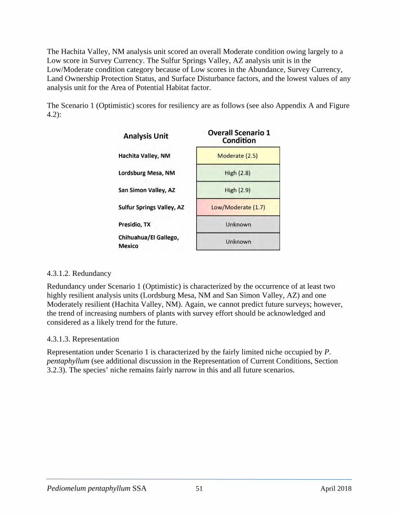
Pediomelum pentaphyllum SSA 51 April 2018
The Hachita Valley, NM analysis unit scored an overall Moderate condition owing largely to a Low score in Survey Currency. The Sulfur Springs Valley, AZ analysis unit is in the Low/Moderate condition category because of Low scores in the Abundance, Survey Currency, Land Ownership Protection Status, and Surface Disturbance factors, and the lowest values of any analysis unit for the Area of Potential Habitat factor. The Scenario 1 (Optimistic) scores for resiliency are as follows (see also Appendix A and Figure 4.2):
4.3.1.2. Redundancy Redundancy under Scenario 1 (Optimistic) is characterized by the occurrence of at least two highly resilient analysis units (Lordsburg Mesa, NM and San Simon Valley, AZ) and one Moderately resilient (Hachita Valley, NM). Again, we cannot predict future surveys; however, the trend of increasing numbers of plants with survey effort should be acknowledged and considered as a likely trend for the future.
4.3.1.3. Representation Representation under Scenario 1 is characterized by the fairly limited niche occupied by P. pentaphyllum (see additional discussion in the Representation of Current Conditions, Section 3.2.3). The species’ niche remains fairly narrow in this and all future scenarios.
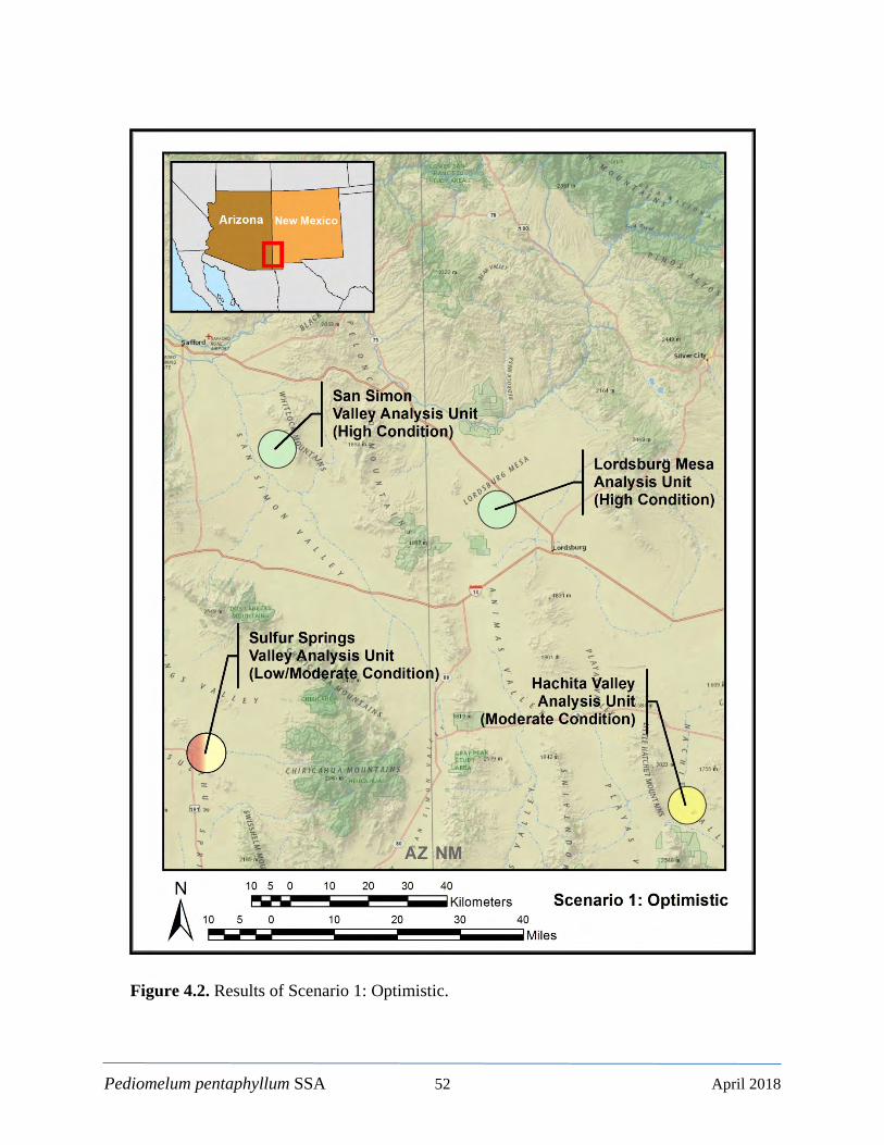
Pediomelum pentaphyllum SSA 52 April 2018
Figure 4.2. Results of Scenario 1: Optimistic.
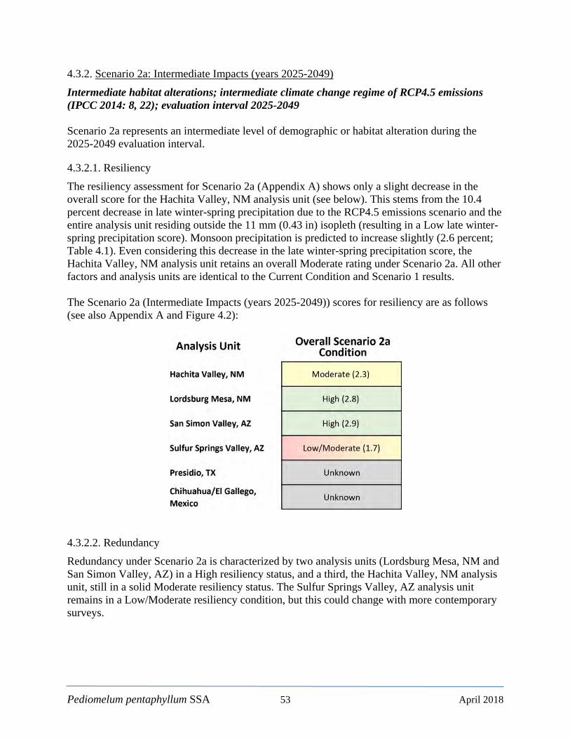
Pediomelum pentaphyllum SSA 53 April 2018
4.3.2. Scenario 2a: Intermediate Impacts (years 2025-2049)
Intermediate habitat alterations; intermediate climate change regime of RCP4.5 emissions (IPCC 2014: 8, 22); evaluation interval 2025-2049 Scenario 2a represents an intermediate level of demographic or habitat alteration during the 2025-2049 evaluation interval.
4.3.2.1. Resiliency The resiliency assessment for Scenario 2a (Appendix A) shows only a slight decrease in the overall score for the Hachita Valley, NM analysis unit (see below). This stems from the 10.4 percent decrease in late winter-spring precipitation due to the RCP4.5 emissions scenario and the entire analysis unit residing outside the 11 mm (0.43 in) isopleth (resulting in a Low late winter-spring precipitation score). Monsoon precipitation is predicted to increase slightly (2.6 percent; Table 4.1). Even considering this decrease in the late winter-spring precipitation score, the Hachita Valley, NM analysis unit retains an overall Moderate rating under Scenario 2a. All other factors and analysis units are identical to the Current Condition and Scenario 1 results. The Scenario 2a (Intermediate Impacts (years 2025-2049)) scores for resiliency are as follows (see also Appendix A and Figure 4.2):
4.3.2.2. Redundancy Redundancy under Scenario 2a is characterized by two analysis units (Lordsburg Mesa, NM and San Simon Valley, AZ) in a High resiliency status, and a third, the Hachita Valley, NM analysis unit, still in a solid Moderate resiliency status. The Sulfur Springs Valley, AZ analysis unit remains in a Low/Moderate resiliency condition, but this could change with more contemporary surveys.
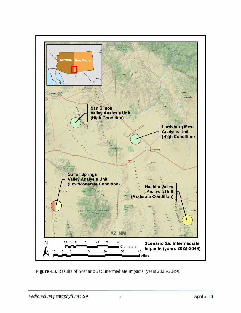
Pediomelum pentaphyllum SSA 54 April 2018
Figure 4.3. Results of Scenario 2a: Intermediate Impacts (years 2025-2049).

Pediomelum pentaphyllum SSA 55 April 2018
4.3.2.3. Representation Representation under Scenario 2a is characterized by the perceived niche limitations discussed in the Current Condition (Section 3.2.3) and Scenario 1 sections above.
4.3.3. Scenario 2b: Intermediate Impacts (years 2050-2074)
Intermediate habitat alterations; intermediate climate change regime of RCP4.5 emissions (IPCC 2014: 8, 22); evaluation interval 2050-2074 Like Scenario 2a, Scenario 2b represents an intermediate level of demographic or habitat alteration but during the 2050-2074 evaluation interval.
4.3.3.1. Resiliency The resiliency assessment for Scenario 2b (Appendix A) shows no difference from Scenario 2a. Although the evaluation interval is from 2050-2074, there is less of a predicted decrease in late winter-spring precipitation (-8.8 percent) as compared to Scenario 2a (-10.4 percent) when compared to the historical climate normal (1981-2010; Table 4.1) and monsoon precipitation increases to 4.7 percent over Scenario 2a. Thus, the scores for Scenario 2b are identical to 2a. The Scenario 2b (Intermediate Impacts (years 2050-2074)) scores for resiliency are as follows (see also Appendix A and Figure 4.4):
4.3.3.2. Redundancy Redundancy under Scenario 2b is similar to that under Scenarios 1 and 2a and Current Conditions, as there is no change in the numbers of analysis units or resiliency status from these scenarios.

Pediomelum pentaphyllum SSA 56 April 2018
Figure 4.4. Results of Scenario 2b: Intermediate Impacts (years 2050-2074).
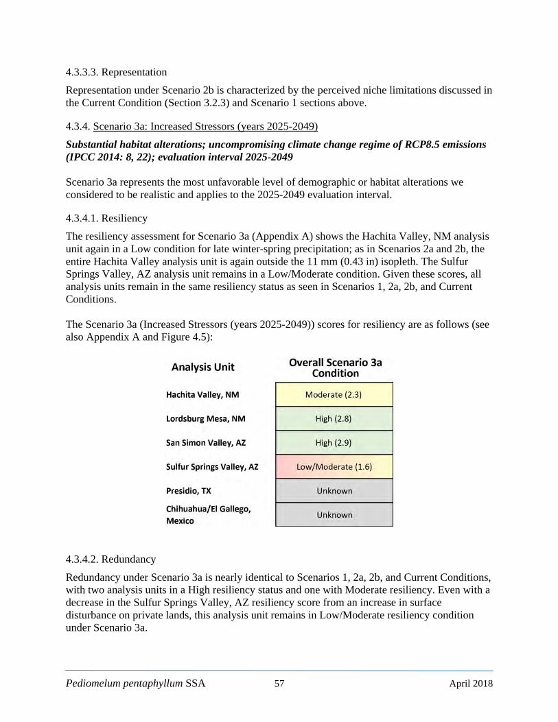
Pediomelum pentaphyllum SSA 57 April 2018
4.3.3.3. Representation Representation under Scenario 2b is characterized by the perceived niche limitations discussed in the Current Condition (Section 3.2.3) and Scenario 1 sections above.
4.3.4. Scenario 3a: Increased Stressors (years 2025-2049)
Substantial habitat alterations; uncompromising climate change regime of RCP8.5 emissions (IPCC 2014: 8, 22); evaluation interval 2025-2049 Scenario 3a represents the most unfavorable level of demographic or habitat alterations we considered to be realistic and applies to the 2025-2049 evaluation interval.
4.3.4.1. Resiliency The resiliency assessment for Scenario 3a (Appendix A) shows the Hachita Valley, NM analysis unit again in a Low condition for late winter-spring precipitation; as in Scenarios 2a and 2b, the entire Hachita Valley analysis unit is again outside the 11 mm (0.43 in) isopleth. The Sulfur Springs Valley, AZ analysis unit remains in a Low/Moderate condition. Given these scores, all analysis units remain in the same resiliency status as seen in Scenarios 1, 2a, 2b, and Current Conditions. The Scenario 3a (Increased Stressors (years 2025-2049)) scores for resiliency are as follows (see also Appendix A and Figure 4.5):
4.3.4.2. Redundancy Redundancy under Scenario 3a is nearly identical to Scenarios 1, 2a, 2b, and Current Conditions, with two analysis units in a High resiliency status and one with Moderate resiliency. Even with a decrease in the Sulfur Springs Valley, AZ resiliency score from an increase in surface disturbance on private lands, this analysis unit remains in Low/Moderate resiliency condition under Scenario 3a.

Pediomelum pentaphyllum SSA 58 April 2018
Figure 4.5. Results of Scenario 3a: Increased Stressors (years 2025-2049).

Pediomelum pentaphyllum SSA 59 April 2018
4.3.4.3. Representation Representation for Scenario 3a is characterized by the perceived niche limitations discussed in the Current Condition (Section 3.2.3) and Scenario 1 sections above.
4.3.5. Scenario 3b: Increased Stressors (years 2050-2074)
Substantial habitat alterations; uncompromising climate change regime of RCP8.5 emissions (IPCC 2014: 8, 22); evaluation interval 2050-2074 Like Scenario 3a, Scenario 3b represents the most unfavorable level of demographic or habitat alteration but during the 2050-2074 evaluation interval.
4.3.5.1. Resiliency The resiliency assessment for Scenario 3b (Appendix A) is similar to Scenarios 1, 2a, 2b, and 3a and Current Conditions. The score for the San Simon Valley, AZ analysis unit dropped to 2.8 (Scenario 3a score is 2.9) due to a decrease in the late winter-spring precipitation score to Moderate (only 54 percent of the analysis unit is within area of the 11 mm [0.43 in] isopleth). The remaining factors remain unchanged from Scenario 3a. The Scenario 3b (Increased Stressors (years 2050-2074)) scores for resiliency are as follows (see also Appendix A and Figure 4.6):
4.3.5.2. Redundancy Redundancy for Scenario 3b is similar to 3a with two analysis units in High condition and one in Moderate condition. The only difference is a slight reduction in the resiliency score for the San Simon Valley, NM analysis unit from a decrease in the late winter-spring precipitation factor. Redundancy under Scenario 3b is thus identical to that under Scenarios 1, 2a, 2b, and 3a and Current Conditions.
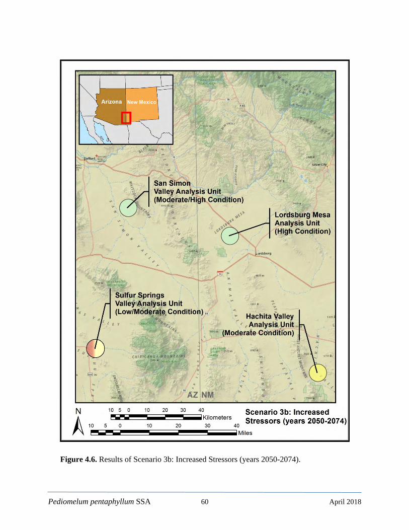
Pediomelum pentaphyllum SSA 60 April 2018
Figure 4.6. Results of Scenario 3b: Increased Stressors (years 2050-2074).
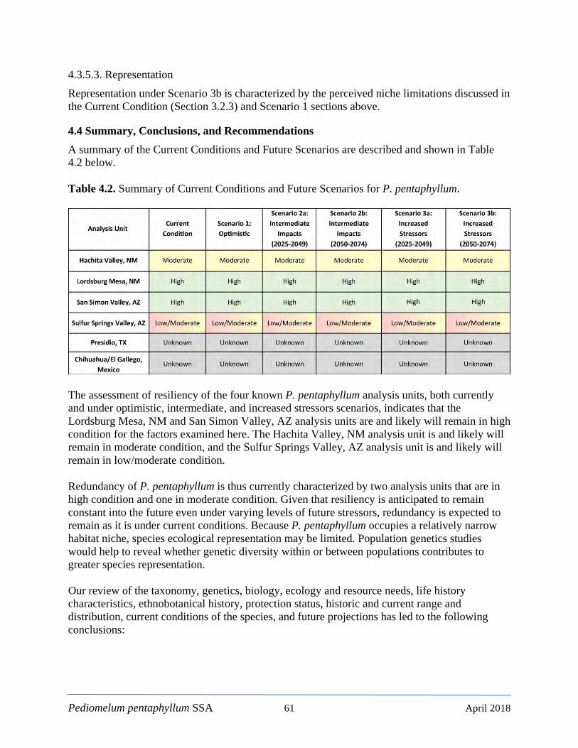
Pediomelum pentaphyllum SSA 61 April 2018
4.3.5.3. Representation Representation under Scenario 3b is characterized by the perceived niche limitations discussed in the Current Condition (Section 3.2.3) and Scenario 1 sections above.
4.4 Summary, Conclusions, and Recommendations A summary of the Current Conditions and Future Scenarios are described and shown in Table 4.2 below. Table 4.2. Summary of Current Conditions and Future Scenarios for P. pentaphyllum.
The assessment of resiliency of the four known P. pentaphyllum analysis units, both currently and under optimistic, intermediate, and increased stressors scenarios, indicates that the Lordsburg Mesa, NM and San Simon Valley, AZ analysis units are and likely will remain in high condition for the factors examined here. The Hachita Valley, NM analysis unit is and likely will remain in moderate condition, and the Sulfur Springs Valley, AZ analysis unit is and likely will remain in low/moderate condition. Redundancy of P. pentaphyllum is thus currently characterized by two analysis units that are in high condition and one in moderate condition. Given that resiliency is anticipated to remain constant into the future even under varying levels of future stressors, redundancy is expected to remain as it is under current conditions. Because P. pentaphyllum occupies a relatively narrow habitat niche, species ecological representation may be limited. Population genetics studies would help to reveal whether genetic diversity within or between populations contributes to greater species representation. Our review of the taxonomy, genetics, biology, ecology and resource needs, life history characteristics, ethnobotanical history, protection status, historic and current range and distribution, current conditions of the species, and future projections has led to the following conclusions:
Pediomelum pentaphyllum SSA 62 April 2018
1) There are four known analysis units of P. pentaphyllum that are widely distributed but ultimately restricted to a 9,585.6 km2 (3,701 mi2) area in southwest New Mexico and southeast Arizona (Figure 2.2 and 2.3);
2) The status of the historical populations in Mexico and Texas is unknown. Based solely
on the absence of the plant in Mexican markets in recent years, it has been suggested that P. pentaphyllum may be extirpated in Mexico; however, most of the potential habitat occurs in Mexico, and it is likely that at least some remnant populations still exists. We consider the Mexico population an unknown, but further inquiries or surveys could considerably expand the known range of the species;
3) Pediomelum pentaphyllum has not been collected in Texas since the mid-19th century,
but it is questionable whether this observation was in fact in Texas or across the border in Mexico. We consider the Texas population an unknown;
4) The four known analysis units appear to be increasing in known abundance with survey
effort; 5) Recent survey efforts (2014-2015) by the BLM LCDO have also discovered a
moderately sized new analysis unit (Lordsburg Mesa, NM); 6) 79.5 percent of all known P. pentaphyllum observations occur on BLM lands in New
Mexico and Arizona; 7) Pediomelum pentaphyllum is listed as a Sensitive Species with both the BLM and U.S.
Forest Service, which accords certain protections under agency policies and protocols. There are no known plants on Forest Service lands;
8) Pediomelum pentaphyllum is listed as Endangered by the State of New Mexico. This
prohibits: the taking, possession, transportation, exportation from New Mexico, processing, sale or offer for sale or shipment within the state (NMEMNRD 2017d; §75-6-1 NMSA 1978). This status does not protect against habitat modification;
9) Although herbicides (notably Tebuthiuron) used in Restore New Mexico’s grassland
restoration efforts are both acutely and chronically toxic to P. pentaphyllum, the BLM LCDO has exceptional and long-standing protective measures in place;
10) To date, grassland restoration/herbicide is not widely used in Arizona. Nonetheless, the
same BLM protective measures apply in Arizona; 11) There are no known active oil or gas interests within 100 km (62.1 mi) of any known P.
pentaphyllum observation; 12) Herbivory, trampling, and soil erosion from livestock grazing appears to be a negligible
or only highly localized stressor;
Pediomelum pentaphyllum SSA 63 April 2018
13) The BLM’s protective measures apply to all other surface disturbance activities on their lands;
14) Wildlife herbivory is ostensibly uncommon and not a widespread stressor; 15) Pediomelum pentaphyllum occupies a fairly limited niche (soil types, plant community,
etc.) but there is some question whether it is ultimately limited to that niche or is capable of occupying other or adjacent habitat types;
16) Our habitat model identified 187,261 hectares (462,733 acres) of potential P.
pentaphyllum habitat in New Mexico and Arizona. Although total survey effort over time is not known or available, only a small proportion of the potential habitat has been surveyed to date;
17) Pediomelum pentaphyllum is likely a conservation reliant species that will need long-
term protection by landowners (Scott et al. 2005: 386); and
18) In order to hopefully improve the habitat model, we should also consider soil water storage and evaporative (vapor pressure) deficit along with precipitation.
Recommendations:
1) Monitor all known analysis units more frequently to determine trends in abundance. A comprehensive monitoring plan should be developed that includes vegetation community, disturbance regimes, and other relevant characteristics;
2) Collect data to establish relationship between rainfall and reproductive success to help
plan successful future surveys;
3) Studies should also be initiated to define pollinators and seed dispersal mechanisms and distances;
4) Continue the greenhouse studies that BLM SFO and The Arboretum at Flagstaff have begun;
5) Survey all potential habitat as defined by the best available model(s) before ground-
disturbing activities are implemented. Where P. pentaphyllum is found, ground-disturbing activities should be avoided;
6) Prioritize conservation activities to the most vulnerable populations; and
7) Engage private landowners in the Sulfur Springs Valley, AZ in conservation agreements
to help maintain the population there.
Pediomelum pentaphyllum SSA 64 April 2018
LITERATURE CITED Adkins R. N., and L. A. Harveson. 2006. Summer diets of feral hogs in the Davis Mountains,
Texas. Southwestern Naturalist 51:578–580. Adkins, R. N., and L. A. Harveson. 2007. Demographic and spatial characteristics of feral hogs
in the Chihuahuan Desert, Texas. Human-Wildlife Conflicts 1:152–160. Alexander, P. 2015. Report on surveys for Chihuahua scurfpea (Pediomelum pentaphyllum),
night-blooming cereus (Peniocereus greggii var. greggii), and sand pricklypear (Opuntia arenaria) from July 2014 to October 2015. U.S. Bureau of Land Management, Las Cruces District Office, New Mexico.
Alexander, P. 2016. Scurfpeas, Pediomelum pentaphyllum locations and geospatial data.
Email. December 8, 2016. Botanist, Bureau of Land Management, Las Cruces District Office, New Mexico.
Alexander, P. 2017. Scurfpea, effects of grazing. Email. March 15, 2017. Botanist, Bureau of
Land Management, Las Cruces District Office, New Mexico. Alexander, P. 2018. Confirmation of various topics discussed during telephone and in-person
conversations. Email. April 18, 2018. Botanist, Bureau of Land Management, Las Cruces District Office, New Mexico.
Alexander, P., L. Ochoa, and S. J. Torrez. 2014. A brief overview of Chihuahuan Scurfpea
(Pediomelum pentaphyllum) distribution, habitat, and survey methods pertaining to linear rights of way in Southwestern New Mexico. U.S. Bureau of Land Management, Las Cruces District Office, New Mexico.
Arizona Game and Fish Department (AZGFD). 2016. Heritage Data Management System.
https://www.azgfd.com/PortalImages/files/wildlife/planningFor/speciesLists/SSSpecies_ByTaxon_019.pdf, accessed March 23, 2018.
Arizona Game and Fish Department (AZGFD). 2017. Javelina.
https://www.azgfd.com/hunting/species/biggame/javelina/ , accessed March 23, 2018. Arizona Game and Fish Department (AZGFD). 2018. Species Status Assessment review.
Email. February 4, 2018. Arizona Game and Fish Department, Phoenix, Arizona. Arizona Geological Survey (AGS). 2005. Oil and Gas Wells in the State of Arizona (Updated
January 2005): Tucson, Arizona Geological Survey Digital Information Series 33, ESRI shape files, dBase tables, and geodatabase. http://repository.azgs.az.gov/uri_gin/azgs/dlio/1030, accessed March 23, 2018.
https://www.azgfd.com/PortalImages/files/wildlife/planningFor/speciesLists/SSSpecies_ByTaxon_019.pdf
Pediomelum pentaphyllum SSA 65 April 2018
Baker, M. and L. Pavliscak. 2011. Current knowledge of Pediomelum pentaphyllum and an assessment of its geographic distribution in Arizona. Cooperative Endangered Species Conservation Fund, U.S. Fish and Wildlife Service, Arizona Ecological Services Field Office, Tuscon, Arizona.
Basmajian, Z. 2017. Feral swine. History of an expanding North American threat and
eradication efforts in Arizona. Presentation at the Colorado River Terrestrial and Riparian Group Meeting, 2017. https://www.lcrmscp.gov/crtr/presentations/2017/crtr17_09.pdf, accessed January 10, 2018.
BISON-M. 2013. Biota Information System of New Mexico. Feral pig, Sus scrofa.
http://www.bison-m.org/, accessed March 23, 2018. BISON-M. 2017. Biota Information System of New Mexico. Collared Peccary, Peccari tajacu.
http://www.bison-m.org/, accessed March 23, 2018. Bland, D. 2010. Geothermal applications in New Mexico. New Mexico Bureau of Geology and
Mineral Resources. Lite Geology 28:10–11. Bureau of Land Management (BLM). 1991. Safford District Resource Management Plan.
Environmental Impact Statement. Safford District Office, Safford, Arizona. https://eplanning.blm.gov/epl-front-office/projects/lup/81813/110477/135296/Safford_District_RMP-FEIS.pdf, accessed April 1, 2018.
Bureau of Land Management (BLM). 1993. Mimbres Resource Management Plan.
Environmental Impact Statement. Las Cruces District Office, New Mexico. https://archive.org/details/mimbresresourcem00unit, accessed April 1, 2018.
Bureau of Land Management (BLM). 2008. 6840 – Special Status Species Management.
Bureau of Land Management. https://www.blm.gov/sites/blm.gov/files/uploads/mediacenter_blmpolicymanual6840.pdf, April 1, 2018.
Bureau of Land Management (BLM). 2009. Bootheel Restoration Initiative. Environmental
Assessment. Las Cruces District Office, New Mexico. Bureau of Land Management (BLM). 2017a. Rare and cultural plant conservation.
https://www.blm.gov/programs/natural-resources/native-plant-communities/rare-and-cultural-plant-conservation/new-mexico, accessed April 1, 2018.
Bureau of Land Management (BLM). 2017b. Updated Bureau of Land Management Sensitive
Species List for Arizona. https://www.blm.gov/policy/az-im-2017-009, accessed April 1, 2018.

Pediomelum pentaphyllum SSA 66 April 2018
Briske, D. D., et al. 2013. The Savory method can not green deserts or reverse climate change. Rangelands 35:72–74.
Brown, J. H., T .J. Valone, and C. G. Curtin. 1997. Reorganization of and arid ecosystem in
response to recent climate change. Proceedings of the National Academy of Sciences 94:9729–9733.
Buffington, L. C., and C. H. Herbel. 1965. Vegetational changes on a semidesert grassland
range from 1858 to 1963. Ecological Monographs 35:139–164. Bye, R.A. Jr. 1979. An 1878 ethnobotanical collection from San Luis Potosí: Dr. Edward
Palmer’s first major Mexican collection. Economic Botany 33:135–162. Bye, R.A. Jr. 1986. Medicinal plants of the Sierra Madre: comparative study of Tarahumara and
Mexican market plants. Economic Botany 40:103–124. Cable, D. R. 1971. Lehmann lovegrass on the Santa Rita Experimental Range, 1937-1968.
Journal of Range Management, 24:17–21. Chibuike, G. U., and S. C. Obiora. 2014. Heavy metal polluted soils: effects on plants and
bioremediation methods. Applied and Environmental Soil Science 2014:1–12. Cibils, A. F., et al. 2014. Is holistic management really saving Patagonian rangelands from
degradation? A response to Teague. Rangelands 36:26–27. Cockman, J. 2013. Chihuahua scurfpea (Pediomelum pentaphyllum (L.) Rydberg, Fabacea) in
the San Simon Valley of Arizona September 2010 through September 2012: exploring a Cultural Connection. U.S. Bureau of Land Management, Safford Field Office, Safford, Arizona.
Cockman, J. 2017. Pediomelum pentaphyllum location data. Email, March 22, 2016. Botanist,
Bureau of Land Management, Safford Field Office, Safford, Arizona. Cockman, J. 2018. Species status assessment review. Email. January 31, 2018. Botanist,
Bureau of Land Management, Safford Field Office, Safford, Arizona. CONABIO. 2017. The National Commission for the Knowledge and Use of Biodiversity.
https://www.gob.mx/conabio., accessed March 23, 2018. Corn, J. L., and R. J. Warren. 1985. Seasonal food habits of the collared peccary in south Texas.
Journal of Mammalogy 66:155–159. Correll, D. S., and M. C. Johnston. 1979. Manual of the vascular plants of Texas. The
University of Texas at Dallas, Dallas, Texas.

Pediomelum pentaphyllum SSA 67 April 2018
Cox, J. R., et al. 1988. Lehmann lovegrass–central South Africa and Arizona, USA. Rangelands 10:53–55.
Crowell, J., and A. M. Crowell. 2014. The history of Lightning Dock KGRA: Identifying a
blind geothermal resource. Geothermal Resources Council Transactions 38:77–84. Department of Homeland Security (DHS). 2015. Final Environmental Assessment and Finding
of No Significant Impact addressing proposed Tactical Infrastructure Maintenance and Repair along the U.S./Mexico International Border in New Mexico. U.S. Department of Homeland Security, U.S. Customs and Border Protection, U.S. Border Patrol.
Desmond, M., and J. A. Montoya. 2006. Status and distribution of Chihuahuan desert
grasslands in the United States and Mexico. Pages 17-21 in Basurto, X, and D. Hanley, editors. Grasslands ecosystems, endangered species, and sustainable ranching in the Mexico-U.S. borderlands: Conference proceedings. RMRS-P-40. U.S. Department of Agriculture, Forest Service, Rocky Mountain Research Station, Fort Collins, Colorado. https://www.fs.fed.us/rm/pubs/rmrs_p040/rmrs_p040_017_025.pdf , accessed December 29, 2017.
Dick-Peddie, W. A. 1993. New Mexico vegetation: past, present, and future. University of
New Mexico Press, Albuquerque New Mexico. Dludlu, M. N. 2010. Systematic studies of the Southern African Psoraleoid legumes.
Dissertation, University of Cape Town, South Africa. https://open.uct.ac.za/handle/11427/11735, accessed March 23, 2018.
Eddy, T. A. 1961. Foods and feeding patterns of the collared peccary in southern Arizona.
Journal of Wildlife Management 25:248–257. Egan, A. N. 2006. Phylogenetics of North American Psoraleeae (Leguminosae): Rates and
Dates in a Recent, Rapid Radiation. All Theses and Dissertations. Paper 1294. Brigham Young University. https://scholarsarchive.byu.edu/cgi/viewcontent.cgi?article=2293&context=etd, accessed March 23, 2018
Egan, A. N., and K. A. Crandall. 2008a. Incorporating gaps as phylogenetic characters across
eight DNA regions: Ramifications for North American Psoraleeae (Leguminosae). Molecular Phylogenetics and Evolution 46:532–546.
Egan, A. N., and K. A. Crandall. 2008b. Divergence and diversification in North American
Psoraleeae (Fabaceae) due to climate change. BioMed Central Biology, 6:1–13. Environmental Protection Agency (EPA). 1994. Tebuthiuron R.E.D. Facts. EPA 738-F-94-006,
April 1994. https://archive.epa.gov/pesticides/reregistration/web/pdf/0054fact.pdf, accessed March 23, 2018.
Pediomelum pentaphyllum SSA 68 April 2018
Esri. 2016. ArcGIS for Desktop: Release 10.4.1. Redlands, CA: Environmental Systems Research Institute. https://desktop.arcgis.com/en/system-requirements/10.4/arcgis-desktop-system-requirements.htm, accessed April 1, 2018.
Everrit, J. H., et al. 1991. Food habits of the collared peccary on south Texas rangelands.
Journal of Range Management 31:141–144. EXTOXNET. 1993. Extension Toxicology Network. Cornell University, Michigan State
University, Oregon State University, and University of California at Davis. http://pmep.cce.cornell.edu/profiles/extoxnet/pyrethrins-ziram/tebuthiuron-ext.html. Accessed 08 March 2017, accessed 29 December 2017.
Gabor, T. M., and E. C. Hellgren. 2000. Variation in peccary populations: landscape
composition or competition by an invader. Ecology 81:2509–2524. Gandhi, K. N. 2015. Validation of Pediomelum palmeri (Fabaceae). Harvard Papers in Botany
20:213. Grimes, J. W. 1990. A revision of the new world species of Psoraleeae (Legusinosae:
Papilionoideae). The New York Botanical Garden 61:1–113. Gutzler, D. 2003. Drought in New Mexico: history, causes, and future prospects.
http://digitalrepository.unm.edu/eps_fsp/3, accessed March 23, 2018. Handbook of Texas Online. 2017. Presidio Del Norte.
http://www.tshaonline.org/handbook/online/articles/uqp04, accessed December 29, 2017. Hatzios, K. K., D. Penner, and D. Bell. 1980. Inhibition of photosynthetic electron transport in
isolated spinach chloroplasts by two 1,3,4-Thiadiazolyl derivatives. Plant Physiology 65:319–321.
Howard, M. 2012. Effects of Tebuthiuron herbicide applied to Chihuahua scurfpea
(Pediomelum pentaphyllum (L.) Rydberg, Fabaceae), Hidalgo Co., New Mexico September 2004 through September 2010. Bureau of Land Management, New Mexico State Office, Santa Fe, New Mexico.
Humphrey, R. R. 1958. The desert grassland a history of vegetational change and an analysis of
causes. Botanical Review 24:193–252. Ilse, L. M., and D. E. C. Hellgren. 1995. Resource partitioning in sympatric populations of
collared peccaries and feral hogs in southern Texas. Journal of Mammalogy 76:784–789. Intergovernmental Panel on Climate Change (IPCC). 2014. Climate change 2014 synthesis
report. http://www.ipcc.ch/pdf/assessment-report/ar5/syr/SYR_AR5_FINAL_full_wcover.pdf, accessed March 23, 2018.
Pediomelum pentaphyllum SSA 69 April 2018
Jones, A., and K. A. Crandall. 2013. A study of genetic variation in geographically separated populations of Pediomelum pariense. Brigham Young University. http://jur.byu.edu/?p=4804, accessed March 23, 2018.
Jussieu, M. 1744. Description D’une Plante du Mexique a la racine de laquelle les Ejpagnols
ont donné le nom de Contrayerva. Des Sciences. Kartesz, J. T., and K. N. Gandhi. 1992a. Pediomelum ockendonii sp. nov.: correct name for P.
palmeri Grimes (Fabaceae). SIDA 15:137–138. Kartesz, J. T., and K .N. Gandhi. 1992b. Nomenclature notes for the North American flora.
Phytologia 72:80-92. Ladyman, J. A. R. 1998. Relocation and status assessment of the Chihuahua scurfpea
(Pediomelum pentaphyllum) 1998 Canon Exploration Grants Program. New Mexico Natural Heritage Program, Albuquerque, New Mexico.
Lamit, L J., and M. N. Hendrie. 2009. Range expansion of the collared peccary in New Mexico:
potential for interactions between historically separate subspecies. Western North American Naturalist 69:253–256.
Linnaeus, C. 1748. Hortus upsaliensis: exhibens plantas exoticas, Horto upsaliensis academiae
a sese illatas, ab anno 1742, in annum 1748, additis differentiis, synonymis, habitationibus, hospitiis, rariorumque descriptionibus, in gratiam studiosae juventutis, Vol 1. StockholmiÆ Sumtu & literis Laurentii Salvii.
Linnaeus, C. 1753. Species Plantarum, exhibentes plantas rite cognitas, ad genera relates, cum
differentiis specificis, nominius trivialibus, synonymis selectis, locis natalibus, secundum systema sexuale digestas. Tomus II. HolmiÆ, Impensis Laurentii Salvii.
Maisch, J. M. 1889. Botanical medicine monographs and sundry. Useful plants of the genus
Psoralea. American Journal of Pharmacy 61:147–148. Mayer, T. M., and K. A. Sartor. 2012. Habitat model for the Chihuahua Scurfpea. The Nature
Conservancy in New Mexico, Santa Fe, New Mexico. NatureServe 2017. Pediomelum pentaphyllum. Explorer®, Version 7.1.
http://explorer.natureserve.org/servlet/NatureServe, accessed March 23, 2018. Neal, B. J. 1959. A contribution on the life history of the collared peccary in Arizona.
American Midland Naturalist 61:177–190. New Mexico Energy, Minerals and Natural Resources Department (NMEMNRD). 2017a. List
of New Mexico Endangered Plants http://www.emnrd.state.nm.us/SFD/ForestMgt/documents/NM_Endangered_Plant_List.pdf, accessed December 29, 2017.

Pediomelum pentaphyllum SSA 70 April 2018
New Mexico Energy, Minerals and Natural Resources Department (NMEMNRD). 2017b. New Mexico Rare Plant Conservation Strategy. Forestry Division and New Mexico Rare Plant Conservation Strategy Partnership, Santa Fe, New Mexico. http://www.emnrd.state.nm.us/SFD/documents/NMRarePlantConsStrategy_Final_reduced.pdf, accessed December 29, 2017.
New Mexico Energy, Minerals and Natural Resources Department (NMEMNRD). 2017c. Oil
Conservation Division (OCD) Geographic Information Systems. New Mexico Energy, Minerals and Natural Resources Department, Santa Fe, New Mexico. http://www.emnrd.state.nm.us/OCD/ocdgis.html, accessed December 29, 2017.
New Mexico Energy, Minerals and Natural Resources Department (NMEMNRD). 2017d.
Endangered plant species; definition; conservation; penalty; protection; permits. Section 75-6-1 NMSA 1978. http://www.emnrd.state.nm.us/SFD/ForestMgt/LE/documents/75-6-1.pdf , accessed December 29, 2017.
New Mexico Natural Heritage (NHNM). 2016. Biotics Database. Museum of Southwestern
Biology, University of New Mexico, Albuquerque, New Mexico. https://nhnm.unm.edu/about/bcd , accessed March 23, 2018.
New Mexico Natural Heritage (NHNM). 2017. Natural Heritage New Mexico, Museum of
Southwestern Biology, University of New Mexico, https://nhnm.unm.edu/, accessed March 23, 2018.
National Oceanic and Atmospheric Administration (NOAA). 2017. Trends in Atmospheric
Carbon Dioxide. Earth System Research System, Global Monitoring Division. https://www.esrl.noaa.gov/gmd/ccgg/trends/global.html#global_growth, accessed December 29, 2017.
Ockendon, D. J. 1965. A taxonomic study of Psoralea subgenus Pediomelum (Leguminosae).
Southwestern Naturalist 10:81–124. Palmer, E. 1908. Plate No. 356. Distributed through the United States National Herbarium;
Catalog No. 573820. http://n2t.net/ark:/65665/3f08ff19d-6b1f-4ea9-b18a-6cfc84024578, accessed January 18, 2018.
PRISM. 2017. PRISM Climate Group, Oregon State University. Spatial climate datasets for the
conterminous United States. http://www.prism.oregonstate.edu/, accessed March 23, 2018.
Roll, C. 2018. Acquisition of occupied habitat. Email, February 21, 2018. Private landowner. Ross, M. A., and D. J. Childs. 2011. Herbicide mode of action summary. Botany and Plant
Pathology, Cooperative Extension Unit, Purdue University. https://www.extension.purdue.edu/extmedia/WS/WS-23-W.pdf, accessed March 23, 2018.
Pediomelum pentaphyllum SSA 71 April 2018
Rydberg, A. 1919. North American flora (Rosales) Fabaceae Psoraleae. New York Botanical Garden 24:1–462.
Sartor, K., and D. Gori. 2012. Chihuahua scurfpea (Pediomelum pentaphyllum) Arizona and
New Mexico habitat characterization. The Nature Conservancy in New Mexico, Santa Fe, New Mexico.
Savory, A. 1983. The Savory grazing method or holistic resources management. Rangelands
5:155–159. Savory, A. 2013. How to green the worlds deserts and reverse climate change TED 2013.
https://www.ted.com/talks/allan_savory_how_to_green_the_world_s_deserts_and_reverse_climate_change, accessed March 23, 2018.
Scott, J. M., et al. 2005. Recovery of imperiled species under the Endangered Species Act: The
need for a new approach. Frontiers in Ecology and the Environment 3:383–389. Smith, D. R., et al. 2018. Development of a species status assessment process for decisions
under the U.S. Endangered Species Act. Journal of Fish and Wildlife Management 9:1–19.
Spellenberg, R. 1999. Pediomelum pentaphyllum (Chihuahua scurfpea). New Mexico Rare
Plants, http://nmrareplants.unm.edu/index.html, accessed March 23, 2018. Sivinski, R. 1993. Pediomelum pentaphyllum, Section 6 Report. New Mexico Energy Minerals
and Natural Resources Department, Santa Fe, New Mexico. SSURGO. 2014. Soil Survey Geographic Database. Soil survey staff, Natural Resources
Conservation Service, United States Department of Agriculture. Web Soil Survey. Accessed via the Esri SSURGO 2014 Snapshot Downloader: http://landscapeteam.maps.arcgis.com/apps/SimpleViewer/index.html?appid=4dbfecc52f1442eeb368c435251591ec, accessed December 29, 2017.
Stahnke, A., et al. 2008. Pediomelum esculentum (Pursh) Rydb. Historical and modern use,
propagation, and management of a new crop. Native Plants 9:46–58. Stone, C., and J. C. Witcher. 1982. Geothermal energy in Arizona. Arizona Geological Survey,
Open-file Report 83-12. http://repository.azgs.az.gov/sites/default/files/dlio/files/2010/u14/ofr83_12.pdf, accessed January 16, 2018.
Taylor, R. B., and E. C. Hellgren. 1997. Diet of feral hogs in the western South Texas Plains.
Southwestern Naturalist 42:33–39. Teague, R. 2014. Deficiencies in the Briske et al. rebuttal of the Savory method. Rangelands
36:37–38.

Pediomelum pentaphyllum SSA 72 April 2018
Teague, R., and P. Borrelli. 2014. Deficiencies in the Briske et al. rebuttal of the Savory method: a reply to the letter from Andres Cibils. Rangelands 36:28–29.
Texas Parks and Wildlife Department (TPWD). 2017. Texas Natural Diversity Database.
TXNDD Tracked Plants. https://tpwd.texas.gov/huntwild/wild/wildlife_diversity/txndd/documents/20171004_TXNDD_tracked_plants.pdf, accessed March 23, 2018.
The Nature Conservancy (TNC). 2009. Global Ecoregions, Major Habitat Types,
Biogeographical Realms, and The Nature Conservancy Terrestrial Assessment Units as of December 14, 2009. Geospatial data http://maps.tnc.org/gis_data.html, accessed March 23, 2018.
Tonne, P. 2000. Status Report for Chihuahua scurfpea (Pediomelum pentaphyllum; Fabaceae).
New Mexico Forestry and Resources Conservation Division, Santa Fe, New Mexico. Tonne, P. 2010. Status Report for Chihuahua scurfpea (Pediomelum pentaphyllum; Fabaceae).
Natural Heritage New Mexico, Museum of Southwestern Biology, University of New Mexico, Albuquerque, New Mexico.
U.S. Department of Agriculture (USDA). 2009. Feral swine damage management in New
Mexico. Environmental assessment, finding of no significant impact, and decision. United States Department of Agriculture, Animal and Plant Health Inspection Service, New Mexico Wildlife Services Program, Albuquerque, New Mexico. https://www.aphis.usda.gov/regulations/pdfs/nepa/FSDM%20EA%20NM%20Aug%2012-2009%20FONSI.pdf , accessed January 10, 2018.
U.S. Department of Agriculture (USDA). 2010. Feral hog biology, impacts and eradication
techniques. Albuquerque, New Mexico. https://www.aphis.usda.gov/wildlife_damage/state_office/state_web/new_mexico/Feral%20Hog%20Biology%20Behavior%20and%20Management%20(3).pdf , accessed January 10, 2018.
U.S. Department of Agriculture (USDA). 2017. Plants Database. Pediomelum megalanthum
(Wooton and Standl.) Rydb. https://plants.usda.gov/core/profile?symbol=PEME7., accessed March 23, 2018.
U.S. Fish and Wildlife Service (Service). 2009. Endangered and threatened wildlife and plants;
Partial 90-day finding on a petition to list 475 species in the southwestern United States as threatened or endangered with critical habitat. Federal Register 74:66,866–66,905.
U.S. Fish and Wildlife Service (Service). 2016. Species status assessment framework: an
integrated analytical framework for conservation. Version 3.4. https://www.fws.gov/endangered/improving_ESA/pdf/SSA%20Framework%20v3.4-8_10_2016.pdf, accessed March 23, 2018.

Pediomelum pentaphyllum SSA 73 April 2018
U.S. Forest Service (USFS). 2013. Southwestern Region. Sensitive Species list. U.S. Department of Agriculture, Forest Service. https://www.fs.usda.gov/detail/r3/plants-animals/?cid=FSBDEV3_022105, accessed March 23, 2018.
U.S. Geological Survey (USGS). 2012. National Elevation Dataset.
https://nationalmap.gov/elevation.html, accessed March 23, 2018. U.S. Geological Survey (USGS). 2016. National Climate Change Viewer.
https://www2.usgs.gov/climate_landuse/clu_rd/nccv.asp., accessed March 23, 2018. U.S. Geological Survey (USGS). 2017a. Watershed Boundary Dataset.
https://nhd.usgs.gov/wbd.html, accessed March 23, 2018. U.S. Geological Survey (USGS). 2017b. ScienceBase-Catalog, Restore New Mexico.
https://www.sciencebase.gov/catalog/item/573cda13e4b0dae0d5e4b15a., accessed March 23, 2018.
Warren, P. 1994. Taxonomic history of Pediomelum pentaphyllum (P. trinervatum). The
Nature Conservancy, Arizona Chapter, Phoenix, Arizona. Waser, N. M., et al. 2017. Effects of road dust on the pollination and reproduction of
wildflowers. International Journal of Plant Science 178:85–93. Wild Earth Guardians. 2008. Petition to list the Chihuahua Scurfpea (Pediomelum
pentaphyllum) under the U.S. Endangered Species Act. Santa Fe, New Mexico. Wolf, S., et al. 2015. Beyond PVA: why recovery under the Endangered Species Act is more
than population viability. BioScience 65:200–207. Yang , X., et al. 2006. Psc-AFP, an antifungal protein with trypsin inhibitor activity from
Psoralea corylifolia seeds. Peptides 27: 1726–1731.

Pediomelum pentaphyllum SSA A-1 April 2018
Appendix A
Tables for Future Condition Scenarios
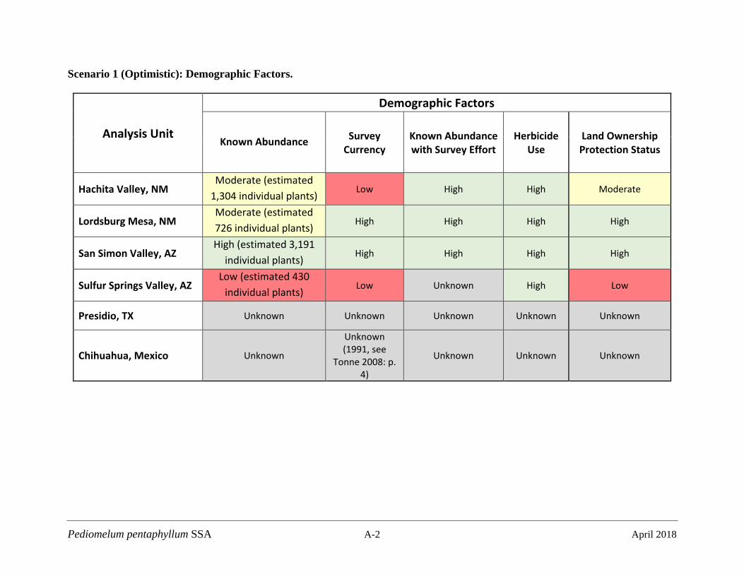
Pediomelum pentaphyllum SSA A-2 April 2018
Scenario 1 (Optimistic): Demographic Factors.
Analysis Unit
Demographic Factors
Known Abundance Survey Currency
Known Abundance with Survey Effort
Herbicide Use
Land Ownership Protection Status
Hachita Valley, NM Moderate (estimated
1,304 individual plants) Low High High Moderate
Lordsburg Mesa, NM Moderate (estimated 726 individual plants)
High High High High
San Simon Valley, AZ High (estimated 3,191
individual plants) High High High High
Sulfur Springs Valley, AZ Low (estimated 430
individual plants) Low Unknown High Low
Presidio, TX Unknown Unknown Unknown Unknown Unknown
Chihuahua, Mexico Unknown
Unknown (1991, see
Tonne 2008: p. 4)
Unknown Unknown Unknown

Pediomelum pentaphyllum SSA A-3 April 2018
Scenario 1 (Optimistic): Habitat Factors
Analysis Unit
Habitat Factors
Optimal Soils Area of
Potential Habitat
Precipitation Surface
Disturbance Late Winter-Spring (Jan-May) Monsoon (Jul-Sep)
Hachita Valley, NM High Moderate High High High
Lordsburg Mesa, NM High High High High Moderate
San Simon Valley, AZ High High High High Moderate
Sulfur Springs Valley, AZ Moderate Low High High Moderate
Presidio, TX Unknown Unknown Unknown Unknown Unknown
Chihuahua, Mexico Unknown Unknown Unknown Unknown Unknown
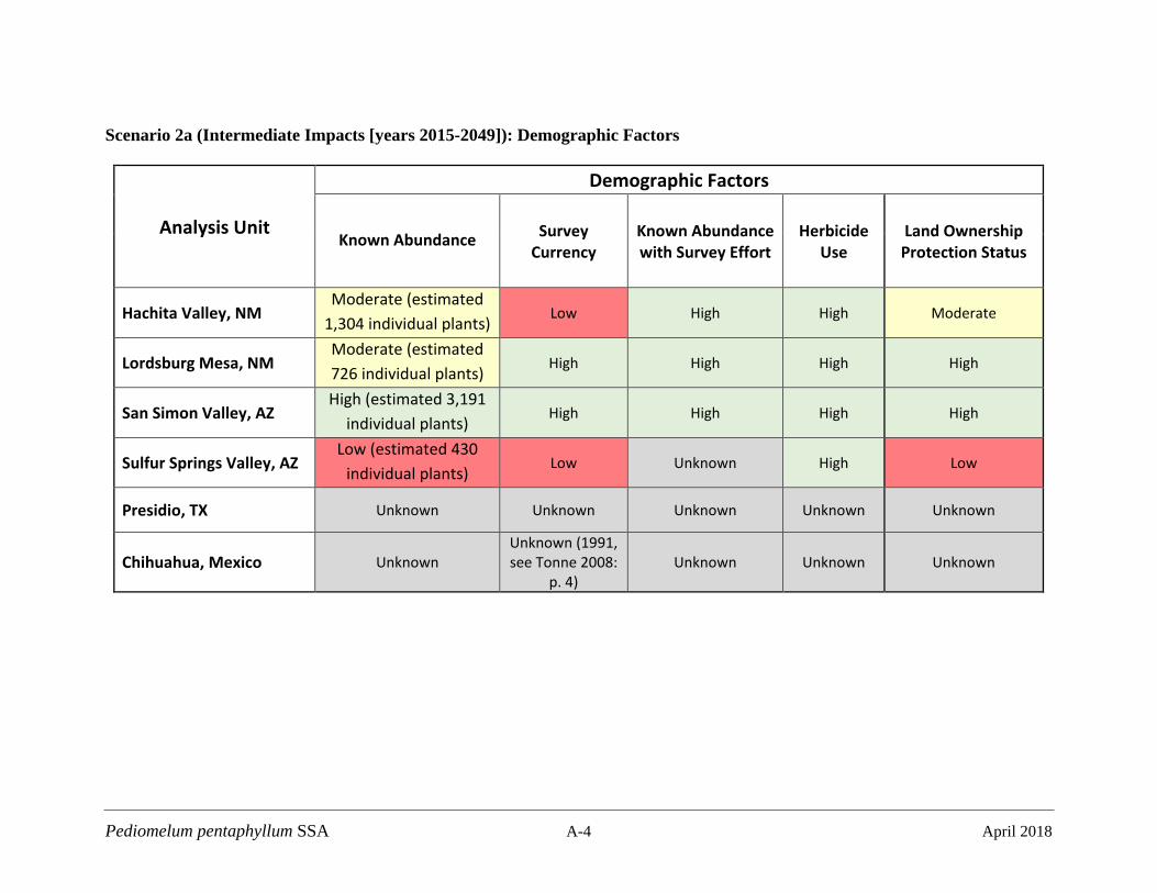
Pediomelum pentaphyllum SSA A-4 April 2018
Scenario 2a (Intermediate Impacts [years 2015-2049]): Demographic Factors
Analysis Unit
Demographic Factors
Known Abundance Survey Currency
Known Abundance with Survey Effort
Herbicide Use
Land Ownership Protection Status
Hachita Valley, NM Moderate (estimated
1,304 individual plants) Low High High Moderate
Lordsburg Mesa, NM Moderate (estimated 726 individual plants)
High High High High
San Simon Valley, AZ High (estimated 3,191
individual plants) High High High High
Sulfur Springs Valley, AZ Low (estimated 430
individual plants) Low Unknown High Low
Presidio, TX Unknown Unknown Unknown Unknown Unknown
Chihuahua, Mexico Unknown Unknown (1991, see Tonne 2008:
p. 4) Unknown Unknown Unknown
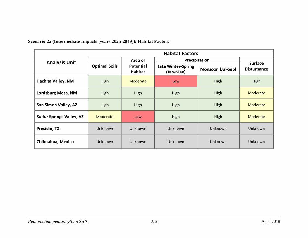
Pediomelum pentaphyllum SSA A-5 April 2018
Scenario 2a (Intermediate Impacts [years 2025-2049]): Habitat Factors
Analysis Unit
Habitat Factors
Optimal Soils Area of
Potential Habitat
Precipitation Surface
Disturbance Late Winter-Spring (Jan-May) Monsoon (Jul-Sep)
Hachita Valley, NM High Moderate Low High High
Lordsburg Mesa, NM High High High High Moderate
San Simon Valley, AZ High High High High Moderate
Sulfur Springs Valley, AZ Moderate Low High High Moderate
Presidio, TX Unknown Unknown Unknown Unknown Unknown
Chihuahua, Mexico Unknown Unknown Unknown Unknown Unknown
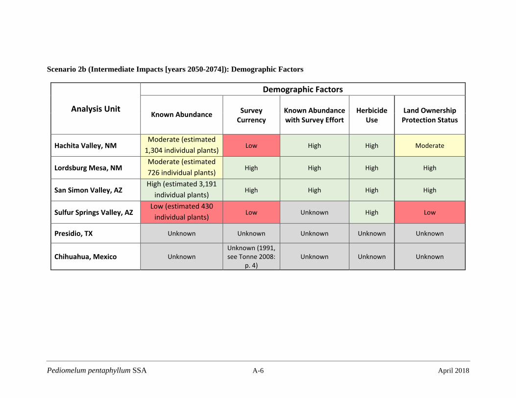
Pediomelum pentaphyllum SSA A-6 April 2018
Scenario 2b (Intermediate Impacts [years 2050-2074]): Demographic Factors
Analysis Unit
Demographic Factors
Known Abundance Survey Currency
Known Abundance with Survey Effort
Herbicide Use
Land Ownership Protection Status
Hachita Valley, NM Moderate (estimated
1,304 individual plants) Low High High Moderate
Lordsburg Mesa, NM Moderate (estimated 726 individual plants)
High High High High
San Simon Valley, AZ High (estimated 3,191
individual plants) High High High High
Sulfur Springs Valley, AZ Low (estimated 430
individual plants) Low Unknown High Low
Presidio, TX Unknown Unknown Unknown Unknown Unknown
Chihuahua, Mexico Unknown Unknown (1991, see Tonne 2008:
p. 4) Unknown Unknown Unknown

Pediomelum pentaphyllum SSA A-7 April 2018
Scenario 2b (Intermediate Impacts [years 2050-2074]): Habitat Factors
Analysis Unit
Habitat Factors
Optimal Soils Area of
Potential Habitat
Precipitation Surface
Disturbance Late Winter-Spring (Jan-May) Monsoon (Jul-Sep)
Hachita Valley, NM High Moderate Low High High
Lordsburg Mesa, NM High High High High Moderate
San Simon Valley, AZ High High High High Moderate
Sulfur Springs Valley, AZ Moderate Low High High Moderate
Presidio, TX Unknown Unknown Unknown Unknown Unknown
Chihuahua, Mexico Unknown Unknown Unknown Unknown Unknown
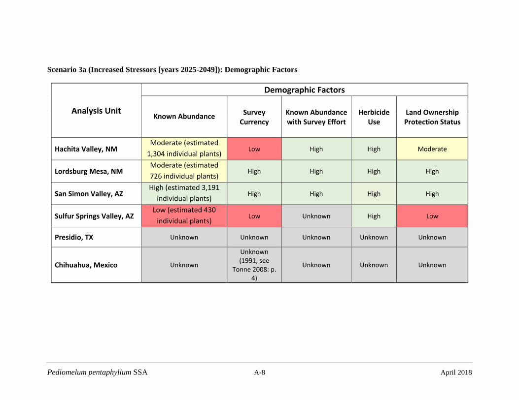
Pediomelum pentaphyllum SSA A-8 April 2018
Scenario 3a (Increased Stressors [years 2025-2049]): Demographic Factors
Analysis Unit
Demographic Factors
Known Abundance Survey Currency
Known Abundance with Survey Effort
Herbicide Use
Land Ownership Protection Status
Hachita Valley, NM Moderate (estimated
1,304 individual plants) Low High High Moderate
Lordsburg Mesa, NM Moderate (estimated 726 individual plants)
High High High High
San Simon Valley, AZ High (estimated 3,191
individual plants) High High High High
Sulfur Springs Valley, AZ Low (estimated 430
individual plants) Low Unknown High Low
Presidio, TX Unknown Unknown Unknown Unknown Unknown
Chihuahua, Mexico Unknown
Unknown (1991, see
Tonne 2008: p. 4)
Unknown Unknown Unknown
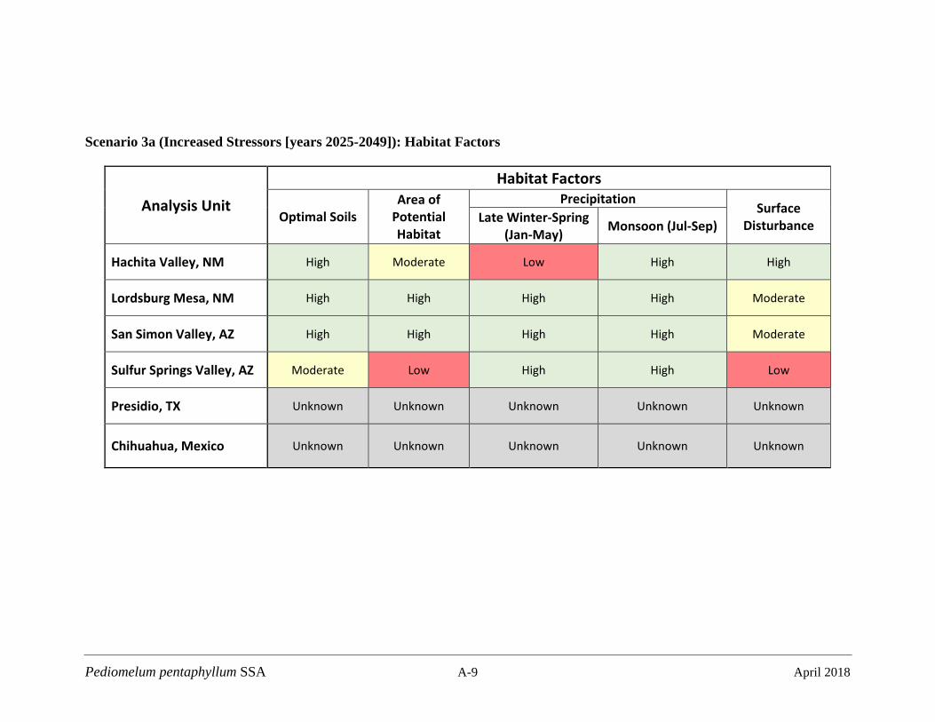
Pediomelum pentaphyllum SSA A-9 April 2018
Scenario 3a (Increased Stressors [years 2025-2049]): Habitat Factors
Analysis Unit
Habitat Factors
Optimal Soils Area of
Potential Habitat
Precipitation Surface
Disturbance Late Winter-Spring (Jan-May) Monsoon (Jul-Sep)
Hachita Valley, NM High Moderate Low High High
Lordsburg Mesa, NM High High High High Moderate
San Simon Valley, AZ High High High High Moderate
Sulfur Springs Valley, AZ Moderate Low High High Low
Presidio, TX Unknown Unknown Unknown Unknown Unknown
Chihuahua, Mexico Unknown Unknown Unknown Unknown Unknown
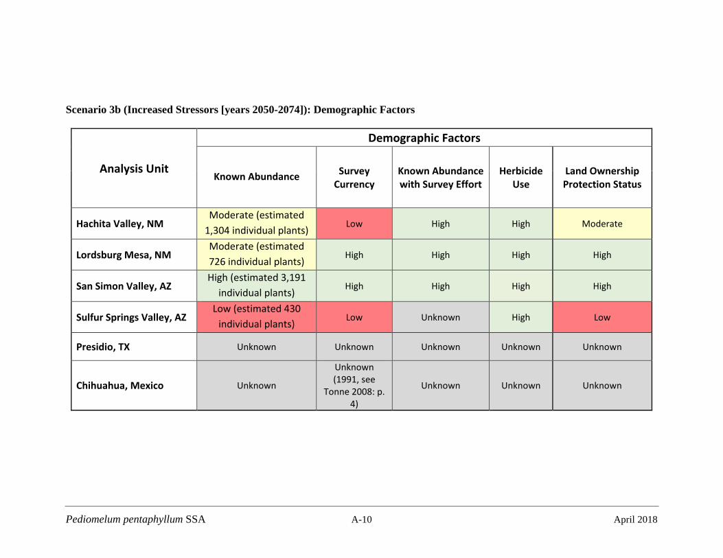
Pediomelum pentaphyllum SSA A-10 April 2018
Scenario 3b (Increased Stressors [years 2050-2074]): Demographic Factors
Analysis Unit
Demographic Factors
Known Abundance Survey Currency
Known Abundance with Survey Effort
Herbicide Use
Land Ownership Protection Status
Hachita Valley, NM Moderate (estimated
1,304 individual plants) Low High High Moderate
Lordsburg Mesa, NM Moderate (estimated 726 individual plants)
High High High High
San Simon Valley, AZ High (estimated 3,191
individual plants) High High High High
Sulfur Springs Valley, AZ Low (estimated 430
individual plants) Low Unknown High Low
Presidio, TX Unknown Unknown Unknown Unknown Unknown
Chihuahua, Mexico Unknown
Unknown (1991, see
Tonne 2008: p. 4)
Unknown Unknown Unknown
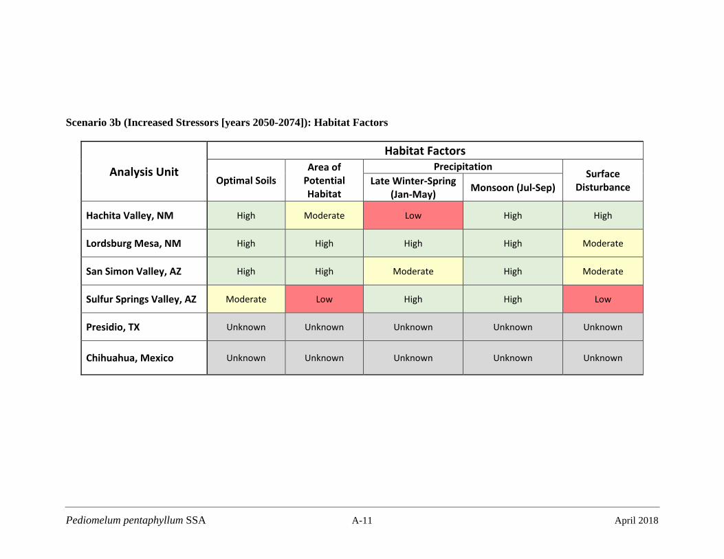
Pediomelum pentaphyllum SSA A-11 April 2018
Scenario 3b (Increased Stressors [years 2050-2074]): Habitat Factors
Analysis Unit
Habitat Factors
Optimal Soils Area of
Potential Habitat
Precipitation Surface
Disturbance Late Winter-Spring (Jan-May) Monsoon (Jul-Sep)
Hachita Valley, NM High Moderate Low High High
Lordsburg Mesa, NM High High High High Moderate
San Simon Valley, AZ High High Moderate High Moderate
Sulfur Springs Valley, AZ Moderate Low High High Low
Presidio, TX Unknown Unknown Unknown Unknown Unknown
Chihuahua, Mexico Unknown Unknown Unknown Unknown Unknown