Special Use Permit - Washoe County, Nevada · Property Owner Affidavit Applicant Name: _____ The...
31
Community Services Department Planning and Building SPECIAL USE PERMIT (see page 5) SPECIAL USE PERMIT FOR GRADING (see page 11) SPECIAL USE PERMIT FOR STABLES (see page 16) APPLICATION Community Services Department Planning and Building 1001 E. Ninth St., Bldg. A Reno, NV 89520 Telephone: 775.328.6100 1
Transcript of Special Use Permit - Washoe County, Nevada · Property Owner Affidavit Applicant Name: _____ The...

Community Services Department
Planning and Building
SPECIAL USE PERMIT(see page 5)
SPECIAL USE PERMIT FOR GRADING(see page 11)
SPECIAL USE PERMIT FOR STABLES(see page 16)
APPLICATION
Community Services Department Planning and Building
1001 E. Ninth St., Bldg. A Reno, NV 89520
Telephone: 775.328.6100
1

2
July 1, 2017
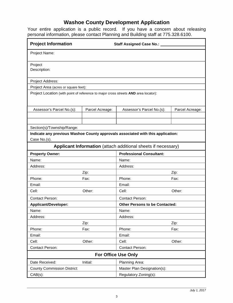
Washoe County Development Application Your entire application is a public record. If you have a concern about releasing personal information, please contact Planning and Building staff at 775.328.6100.
Project Information Staff Assigned Case No.:
Project Name:
Project Description:
Project Address: Project Area (acres or square feet): Project Location (with point of reference to major cross streets AND area locator):
Assessor’s Parcel No.(s): Parcel Acreage: Assessor’s Parcel No.(s): Parcel Acreage:
Section(s)/Township/Range: Indicate any previous Washoe County approvals associated with this application: Case No.(s).
Applicant Information (attach additional sheets if necessary) Property Owner: Professional Consultant: Name: Name: Address: Address:
Zip: Zip: Phone: Fax: Phone: Fax: Email: Email: Cell: Other: Cell: Other:
Contact Person: Contact Person: Applicant/Developer: Other Persons to be Contacted: Name: Name: Address: Address:
Zip: Zip: Phone: Fax: Phone: Fax: Email: Email: Cell: Other: Cell: Other: Contact Person: Contact Person:
For Office Use Only Date Received: Initial: Planning Area: County Commission District: Master Plan Designation(s): CAB(s): Regulatory Zoning(s):
3

July 1, 2017
Property Owner Affidavit
Applicant Name: ___________________________________________
The receipt of this application at the time of submittal does not guarantee the application complies with all requirements of the Washoe County Development Code, the Washoe County Master Plan or the applicable area plan, the applicable regulatory zoning, or that the application is deemed complete and will be processed.
STATE OF NEVADA ) )
COUNTY OF WASHOE )
I, , (please print name)
being duly sworn, depose and say that I am the owner* of the property or properties involved in this application as listed below and that the foregoing statements and answers herein contained and the information herewith submitted are in all respects complete, true, and correct to the best of my knowledge and belief. I understand that no assurance or guarantee can be given by members of Planning and Building.
(A separate Affidavit must be provided by each property owner named in the title report.)
Assessor Parcel Number(s):
Printed Name
Signed
Address
Subscribed and sworn to before me this ______ day of ___________________, ______. (Notary Stamp)
Notary Public in and for said county and state
My commission expires: __________________
*Owner refers to the following: (Please mark appropriate box.)
Owner
Corporate Officer/Partner (Provide copy of record document indicating authority to sign.)
Power of Attorney (Provide copy of Power of Attorney.)
Owner Agent (Provide notarized letter from property owner giving legal authority to agent.)
Property Agent (Provide copy of record document indicating authority to sign.)
Letter from Government Agency with Stewardship
4
Washoe County Planning and Building July 2017 SPECIAL USE PERMIT APPLICATION SUPPLEMENTAL INFORMATION
Special Use Permit Application Supplemental Information
(All required information may be separately attached)
Chapter 110 of the Washoe County Code is commonly known as the Development Code. Specific references to special use permits may be found in Article 810, Special Use Permits.
1. What is the type of project being requested?
2. What currently developed portions of the property or existing structures are going to be used with this
permit?
5
Washoe County Planning and Building July 2017 SPECIAL USE PERMIT APPLICATION SUPPLEMENTAL INFORMATION
3. What improvements (e.g. new structures, roadway improvements, utilities, sanitation, water supply, drainage, parking, signs, etc.) will have to be constructed or installed and what is the projected time frame for the completion of each?
4. What is the intended phasing schedule for the construction and completion of the project?
5. What physical characteristics of your location and/or premises are especially suited to deal with the
impacts and the intensity of your proposed use?
6

Washoe County Planning and Building July 2017 SPECIAL USE PERMIT APPLICATION SUPPLEMENTAL INFORMATION
6. What are the anticipated beneficial aspects or effects your project will have on adjacent properties and the community?
7. What will you do to minimize the anticipated negative impacts or effect your project will have on
adjacent properties?
7

Washoe County Planning and Building July 2017 SPECIAL USE PERMIT APPLICATION SUPPLEMENTAL INFORMATION
8. Please describe operational parameters and/or voluntary conditions of approval to be imposed on the project special use permit to address community impacts:
9. How many improved parking spaces, both on-site and off-site, are available or will be provided?
(Please indicate on site plan.)
8

Washoe County Planning and Building July 2017 SPECIAL USE PERMIT APPLICATION SUPPLEMENTAL INFORMATION
10. What types of landscaping (e.g. shrubs, trees, fencing, painting scheme, etc.) are proposed? (Please indicate location on site plan.)
11. What type of signs and lighting will be provided? On a separate sheet, show a depiction (height,
width, construction materials, colors, illumination methods, lighting intensity, base landscaping, etc.) of each sign and the typical lighting standards. (Please indicate location of signs and lights on site plan.)
12. Are there any restrictive covenants, recorded conditions, or deed restrictions (CC&Rs) that apply to
the area subject to the special use permit request? (If so, please attach a copy.)
Yes No
9

Washoe County Planning and Building July 2017 SPECIAL USE PERMIT APPLICATION SUPPLEMENTAL INFORMATION
13. Utilities:
a. Sewer Service b. Electrical Service c. Telephone Service d. LPG or Natural Gas Service e. Solid Waste Disposal Service f. Cable Television Service g. Water Service
For most uses, the Washoe County Code, Chapter 110, Article 422, Water and Sewer Resource
Requirements, requires the dedication of water rights to Washoe County. Please indicate the type and quantity of water rights you have available should dedication be required:
h. Permit # acre-feet per year i. Certificate # acre-feet per year j. Surface Claim # acre-feet per year k. Other # acre-feet per year
l. Title of those rights (as filed with the State Engineer in the Division of Water Resources of the
Department of Conservation and Natural Resources):
14. Community Services (provided and nearest facility):
a. Fire Station b. Health Care Facility c. Elementary School d. Middle School e. High School f. Parks g. Library h. Citifare Bus Stop
10

Washoe County Planning and Building July 2017 SPECIAL USE PERMIT GRADING APPLICATION SUPPLEMENTAL INFORMATION
Special Use Permit Application for Grading
Supplemental Information
(All required information may be separately attached)
Chapter 110 of the Washoe County Code is commonly known as the Development Code. Specific references to special use permits may be found in Article 810, Special Use Permits. Article 438, Grading, and Article 418, Significant Hydrologic Resources, are the ordinances specifically involved in this request.
1. What is the purpose of the grading?
2. How many cubic yards of material are you proposing to excavate on site?
3. How many square feet of surface of the property are you disturbing?
4. How many cubic yards of material are you exporting or importing? If none, how are you managing to
balance the work on-site?
11

Washoe County Planning and Building July 2017 SPECIAL USE PERMIT GRADING APPLICATION SUPPLEMENTAL INFORMATION
5. Is it possible to develop your property without surpassing the grading thresholds requiring a Special Use Permit? (Explain fully your answer.)
6. Has any portion of the grading shown on the plan been done previously? (If yes, explain the
circumstances, the year the work was done, and who completed the work.)
7. Have you shown all areas on your site plan that are proposed to be disturbed by grading? (If no,
explain fully your answer.)
12

Washoe County Planning and Building July 2017 SPECIAL USE PERMIT GRADING APPLICATION SUPPLEMENTAL INFORMATION
8. Can the disturbed area be seen from off-site? If yes, from which directions, and which properties or roadways?
9. Could neighboring properties also be served by the proposed access/grading requested (i.e. if you
are creating a driveway, would it be used for access to additional neighboring properties)?
10. What is the slope (Horizontal/Vertical) of the cut and fill areas proposed to be? What methods will be
used to prevent erosion until the revegetation is established?
11. Are you planning any berms?
Yes No If yes, how tall is the berm at its highest?
13

Washoe County Planning and Building July 2017 SPECIAL USE PERMIT GRADING APPLICATION SUPPLEMENTAL INFORMATION
12. If your property slopes and you are leveling a pad for a building, are retaining walls going to be required? If so, how high will the walls be and what is their construction (i.e. rockery, concrete, timber, manufactured block)?
13. What are you proposing for visual mitigation of the work?
14. Will the grading proposed require removal of any trees? If so, what species, how many and of what
size?
14

Washoe County Planning and Building July 2017 SPECIAL USE PERMIT GRADING APPLICATION SUPPLEMENTAL INFORMATION
15. What type of revegetation seed mix are you planning to use and how many pounds per acre do you intend to broadcast? Will you use mulch and, if so, what type?
16. How are you providing temporary irrigation to the disturbed area?
17. Have you reviewed the revegetation plan with the Washoe Storey Conservation District? If yes, have
you incorporated their suggestions?
18. Are there any restrictive covenants, recorded conditions, or deed restrictions (CC&Rs) that may
prohibit the requested grading?
Yes No If yes, please attach a copy.
15

Washoe County Planning and Building July 2017 SPECIAL USE PERMIT STABLES SUPLEMENTAL INFORMATION
Special Use Permit Application for Stables Supplemental Information
(All required information may be separately attached)
Chapter 110 of the Washoe County Code is commonly known as the Development Code. Specific references to administrative permits may be found in Article 810, Special Use Permits. 1. What is the maximum number of horses to be boarded, both within stables and pastured?
2. What is the maximum number of horses owned maintained by the owner/operator of the project, both
within stables and pastured?
3. List any ancillary or additional uses proposed (e.g., tack and saddle sales, feed sales, veterinary
services, etc.). Only those items that are requested may be permitted.
16
Washoe County Planning and Building July 2017 SPECIAL USE PERMIT STABLES SUPLEMENTAL INFORMATION
4. If additional activities are proposed, including training, events, competition, trail rides, fox hunts, breaking, roping, etc, only those items that are requested may be permitted. Clearly describe the number of each of the above activities which may occur, how many times per year and the number of expected participants for each activity.
5. What currently developed portions of the property or existing structures are going to be used with this permit?
6. To what uses (e.g., restrooms, offices, managers living quarters, stable area, feed storage, etc.) will
the barn be put and will the entire structure be allocated to those uses? (Provide floor plans with dimensions).
7. Where are the living quarters for the operators of the stables and where will employees reside?
17
Washoe County Planning and Building July 2017 SPECIAL USE PERMIT STABLES SUPLEMENTAL INFORMATION
8. How many improved parking spaces, both on-site and off-site, are available or will be provided? (Please indicate on site plan.) Have you provided for horse trailer turnarounds?
9. What are the planned hours of operation?
10. What improvements (e.g. new structures including the square footage, roadway/driveway
improvements, utilities, sanitation, water supply, drainage, parking, signs, etc.) will have to be constructed or installed and what is the projected time frame for the completion of each?
11. What is the intended phasing schedule for the construction and completion of the project?
18

Washoe County Planning and Building July 2017 SPECIAL USE PERMIT STABLES SUPLEMENTAL INFORMATION
12. What physical characteristics of your location and/or premises are especially suited to deal with the impacts and the intensity of your proposed use?
13. What are the anticipated beneficial aspects or affects your project will have on adjacent properties
and the community?
14. What are the adverse impacts upon the surrounding community (including traffic, noise, odors, dust,
groundwater contamination, flies, rats, mice, etc.) and what will you do to minimize the anticipated negative impacts or effects your project will have on adjacent properties?
15. Please describe operational parameters and/or voluntary conditions of approval to be imposed on the administrative permit to address community impacts.
19

Washoe County Planning and Building July 2017 SPECIAL USE PERMIT STABLES SUPLEMENTAL INFORMATION
16. What types of landscaping (e.g. shrubs, trees, fencing, painting scheme, etc.) are proposed? (Please
indicate location on site plan.)
17. What type of signs and lighting will be provided? On a separate sheet, show a depiction (height,
width, construction materials, colors, illumination methods, lighting intensity, base landscaping, etc.) of each sign and the typical lighting standards. (Please indicate location of signs and lights on site plan.)
18. Are there any restrictive covenants, recorded conditions, or deed restrictions (CC&Rs) that apply to the area subject to the administrative permit request? (If so, please attach a copy.)
Yes No 19. Community Sewer
Yes No
20. Community Water
Yes No
20

Washoe County Planning and Building July 2017 SPECIAL USE PERMITS APPLICATION SUBMITTAL REQUIREMENTS
Special Use Permits Development Application Submittal Requirements
1. Fees: See Master Fee Schedule. Bring payment with your application to Community Service Department (CSD). Make check payable to Washoe County.
2. Development Application: A completed Washoe County Development Application form.
3. Owner Affidavit: The Owner Affidavit must be signed and notarized by all owners of the property subject to the application request.
4. Proof of Property Tax Payment: The applicant must provide a written statement from the Washoe County Treasurer’s Office indicating all property taxes for the current quarter of the fiscal year on the land have been paid.
5. Application Materials: The completed Special Use Permit Application materials.
6. Title Report: A preliminary title report, with an effective date of no more than one hundred twenty (120) days of the submittal date, by a title company which provides the following information:
• Name and address of property owners. • Legal description of property. • Description of all easements and/or deed restrictions. • Description of all liens against property. • Any covenants, conditions and restrictions (CC&Rs) that apply.
Submit Title Report with “Original Packet” only. You may be requested to provide additional copies, but do not include Title Report in other copies of the packet.
7. Proposed Site Plan Specifications (Special Use Permit and Stables):
a. Lot size with dimensions drawn using standard engineering scales (e.g. scale 1” = 100’, 1” = 200’, or 1” = 500’) showing all streets and ingress/egress to the property.
b. Show the location and configuration of all proposed buildings (with distances from the property lines and from each other), all existing buildings that will remain (with distances from the property lines and from each other), all existing buildings that will be removed, and site improvements on a base map with existing and proposed topography expressed in intervals of no more than five (5) feet.
c. Show the location and configuration of wells and well houses, septic systems and leach fields, overhead utilities, water and sewer lines, and all easements.
d. Show locations of parking, landscaping, signage and lighting.
e. The cross sections of all rights-of-way, streets, alleys or private access ways within the proposed development, proposed name and approximate grade of each, and approximate radius of all curves and diameter of each cul-de-sac.
8. Existing Site Specifications (Special Use Permit and Stables):
a. Map to be drawn using engineering scales (e.g. scale 1” = 20’, 1” = 40’, or 1” = 100’) showing all streets and ingress/egress to the property.
b. Property boundary lines, distances and bearings.
c. Contours at five (5) foot intervals or two (2) foot intervals where, in the opinion of the County Engineer, topography is a major factor in the development.
d. Indication of prominent landmarks, rock outcroppings, and natural foliage which will be deciding considerations in the design of the development.
21

Washoe County Planning and Building July 2017 SPECIAL USE PERMITS APPLICATION SUBMITTAL REQUIREMENTS
e. The width and approximate location of all existing or proposed easements, whether public or private, for roads, drainage, sewers, irrigation, or public utility purposes.
f. Location and size of any land to be reserved or dedicated for parks, recreation areas, common open space areas, schools or other public uses.
g. If any portion of the land within the boundary of the development is subject to inundation or storm water overflow, as shown on the adopted Federal Emergency Management Agency’s Flood Boundary and Floodway Maps, that fact and the land so affected shall be clearly shown on the map by a prominent note on each sheet, as well as width and direction of flow of each water course within the boundaries of the development.
h. The location and outline to scale of each existing building or structure to remain in the development.
i. Existing roads, trails or rights-of-way within the development shall be designated on the map. Topography and existing developments within three hundred (300) feet must also be shown on the map.
j. Vicinity map showing the proposed development in relation to Interstate 80, Highway 395, I-580, or a major arterial. The vicinity map shall also include a north arrow.
k. Date, scale, and number of each sheet in relation to the total number of sheets, and the name of the person preparing the plans.
l. Location of snow storage areas sufficient to handle snow removed from public and private street, if above 5,500 feet.
m. All known areas of potential hazard (and the basis for delineation) including, but not limited to, earth slide areas, avalanche areas or otherwise hazardous slopes, shall be clearly designated on the map. Additionally, active fault lines (post-Holocene) shall be delineated on the map.
n. Location of areas with slopes greater than fifteen percent (15%) and thirty percent (30%).
o. Boundary of any wetland areas and/or floodplains within the project site.
p. Note by the project engineer or design professional indicating compliance with all applicable provisions of the Washoe County Development Code.
q. Significant Hydrological Resources. Indicate the critical and sensitive buffer zones according to Article 418 of the Washoe County Development Code.
9. Site Plan Specifications (Grading):
a. Vicinity map showing the proposed project in relation to Interstate 80, Highway 395, I-580, or a major arterial. The vicinity map may be part of the site plan.
b. Date, north arrow, scale, and number of each sheet in relation to the total number of sheets, and the name of person preparing the plans.
c. Location and limits of all work to be done.
d. Existing contours and proposed contours.
e. Location of all proposed and existing structures.
f. Location of any structures on adjacent parcels that are within fifteen (15) feet of the work site’s parcel boundary.
g. Existing draining (natural and man-made) and proposed drainage patterns.
h. Sufficient elevation data to show the drainage will work as proposed.
i. Quantities of excavation, fill and disturbed surface area shall be calculated and shown on the site plan. Areas under buildings and pavement need not be included in these calculations.
22
Washoe County Planning and Building July 2017 SPECIAL USE PERMITS APPLICATION SUBMITTAL REQUIREMENTS
j. Quantities of material proposed to be removed from the site must be shown. The proposed disposal area and the disposition of fill must be noted on the plan.
k. Limiting dimensions of cut and fill.
l. Proposed BMPs (Best Management Practices) for controlling water and wind erosion if a disturbed area is left undeveloped for more than thirty (30) days.
m. Cut and fill slopes setback from the property boundary.
n. Structure setbacks from a slope.
o. Location of areas with existing slopes greater than fifteen percent (15%) and thirty percent (30%).
p. Boundary of any wetland areas and/or floodplains within the project site.
q. Significant Hydrologic Resources. Indicate the critical and sensitive buffer zones according to Article 418 of the Washoe County Development Code.
10 Grading: In accordance with the grading provisions of Washoe County Code, Article 438, if the thresholds for a grading permit are met or exceeded, the grading plans shall indicate the existing and proposed grades, slope treatments (i.e. rip rap, erosion control, etc.) and drainage channels and the direction of flow. Cross sections must be provided at a minimum of two key locations.
11. Traffic Impact Report (Special Use Permit and Stables): Traffic impact reports are required whenever the proposed development project will generate 80 or more weekday peak hour trips as determined using the latest edition Institute of Transportation Engineers (ITE) trip generation rates or other such sources as may be accepted by Engineering and Capital Projects with less than 200 peak hour trips may not need to perform an impact analysis for future years. Traffic consultants are encouraged to contact Engineering and Capital Projects staff prior to preparing a traffic impact report.
12. Landscaping: Landscape plans may be required, for stables. Landscape plans may include: a soils evaluation; color and type of building material, such as fencing material; type of plant material; location of plant material and proposed maintenance schedule; size of plant material at planting and size of plant material at full maturation; type and amount of mulch material; and an irrigation plan.
a. Planting Plan Specifications: The planting plan must include all necessary information to satisfy Washoe County Code Section 110.412.60, Planting Standards.
Proposed Tree Locations. Individual trees shall be graphically depicted in the proposed locations; trees shall be identified as either evergreen or deciduous; trees shall be individually labeled or coded and cross referenced to the proposed plant species in the plant legend.
Proposed Plant Material. The preliminary plan must identify where, and a square footage amount for, one or all of the following items: trees, mulch (rock, DG or bark), seeded areas, etc.
Existing On-Site Vegetation. In the case of large strands of trees and shrubs, individual locations may be identified with a revision cloud symbol. Smaller numbers or strands of trees (six (6) inch caliper and greater) shall be identified individually. Shrub areas and other forms of vegetation such as grasses shall be identified with a revision cloud symbol.
Plant Legend. Legend shall include all proposed plant material, including the following: common name, botanical name, size at planting, spacing and quantity (of trees only).
Landscape Area Legend. A summary of proposed areas and their square footages shall include: lawn, existing and or proposed paving, existing trees to be preserved, existing trees to be removed and the amount of proposed shrubs.
b. Irrigation Plan Specifications: The irrigation plan must include all necessary information to satisfy Washoe County Code Section 110.412.65, Irrigation Standards.
23

Washoe County Planning and Building July 2017 SPECIAL USE PERMITS APPLICATION SUBMITTAL REQUIREMENTS
Location, size, and specifications of water source(s), water mains, meter(s), valves, and the controller.
Temporary or permanent water irrigation systems.
Specifications of irrigation equipment identified by manufacturer’s name and equipment identification number.
An approved backflow prevention device is required on all landscape irrigation systems.
13. Signage Plan: The signage plans shall include sign elevations and delineate location, height, style, dimensions, intensity of sign lighting and finish of any proposed signage:
14. Lighting Plan: Show the location and configuration of all proposed exterior lighting including a detail of the parking lot light fixtures, pole heights, security lighting, and wall mounted illumination fixtures. Parking lot areas shall be depicted showing lumen isolines demonstrating compliance with the provisions of the Washoe County Development Code.
15. Building Elevations: All buildings and structures including fences, walls, poles and monument signs proposed for construction within the project shall be clearly depicted in vertical architectural drawings provided in accurate architectural scale. All architectural elevations from all building faces shall be presented.
16. Packets: Six (6) packets and a flash drive or DVD. One (1) packet must be labeled “Original” and must include the fee schedule (including the appropriate fees) and the original signed and notarized Owner Affidavit. Each packet shall include an 8.5” x 11” reduction of any applicable site plan, development plan, and/or application map. These materials must be readable. Labeling on these reproductions should be no smaller than 8 point on the 8½ x 11" display. Four (4) of the application packets shall include large format maps; the rest of the packets shall include either 8.5” x 11” or 11” x 17” maps. Large format sheets should be included in a slide pocket(s). Any specialized reports identified above shall be included as attachments or appendices and be annotated as such.
Notes: (i) Application and map submittals must comply with all specific criteria as established in
the Washoe County Development Code and/or the Nevada Revised Statutes.
(ii) Appropriate map engineering and building architectural scales are subject to the approval of Planning and Building and/or Engineering and Capital Projects.
(iii) All oversized maps and plans must be folded to a 9” x 12” size.
(iv) Labels: The applicant is required to submit three (3) sets of mailing labels for every tenant residing in a mobile home park that is within five hundred (500) feet of the proposed project (or within seven hundred fifty (750) feet of the proposed project if the proposed project is a project of regional significance).
(v) Based on the specific nature of the development request, Washoe County reserves the right to specify additional submittal packets, additional information and/or specialized studies to clarify the potential impacts and potential conditions of development to minimize or mitigate impacts resulting from the project. No application shall be processed until the information necessary to review and evaluate the proposed project is deemed complete by the Director of Planning and Building.
(vi) Please be advised that the Washoe County Director of Planning and Building or his designee, Washoe County Board of Adjustment, and/or Washoe County Planning Commission have the ability to determine an application incomplete if they cannot ascertain what the applicant is requesting, or if there is insufficient information to determine a favorable outcome.
24

Note: If the SUP approval is for a project of regional significance, then the Regional Planning Commission and/or the Regional Planning Governing Board must take final action on the project before a permit for development or use of the property pursuant to the SUP shall be issued.
This flowchart is an overview of this development application process and is not intended to be a comprehensive guide. Please refer to the Development Code Article shown above for more complete information about the application, to include specifics on notice, internal and external agency review.
Special Use Permit (SUP) – Article 810
Initiation of SUP by property owner or by Board of County Commissioners (BCC)
Planning Commission (PC), Board of Adjustment (BOA), or hearing examiner reviews SUP (established through Article
302)
A: BCC hears appeal of SUP
BCC reverses or modifies appeal, and decision is final subject to judicial review
BCC upholds appeal, and
decision is final subject to
judicial review
Notice provided 10 days prior to public hearing
BCC hearing scheduled
within 60 days of filing of
appeal
PC, BOA, or hearing examiner approves, or approves with modifications, SUP
request with or without conditions of approval (See Note)
Public hearing held within 65 days of
acceptance of completed application
PC, BOA, or hearing examiner takes action on proposed SUP no later than 95 days
after acceptance of completed application
PC, BOA, or hearing examiner denies SUP request
Denial of SUP is not appealed
and is final
Denial of SUP is
appealed to BCC
Approval of SUP is
appealed to BCC (See A)
Action on SUP application is
effective upon expiration of appeal period
SUP expires at the time
specified in permit or, if
not specified, two years
from approval date
25

Intake Date
Tentative Meeting
DateIntake Date
Tentative Meeting
DateIntake Date
Tentative Meeting
DateIntake Date
Tentative PC
Meeting Date
11/15/2017 01/02/2018 11/15/2017 01/11/201812/15/2017 02/06/2018 12/15/2017 02/01/2018 12/15/2017 02/08/201801/16/2018 03/06/2018 01/16/2018 03/01/2018 01/16/2018 03/08/2018 01/16/2018 TBD02/15/2018 04/03/2018 02/15/2018 04/05/2018 02/15/2018 04/12/201803/15/2018 05/01/2018 03/15/2018 05/03/2018 03/15/2018 05/10/201804/16/2018 06/05/2018 04/16/2018 06/07/2018 04/16/2018 06/07/201805/15/2018 07/03/2018 05/15/2018 07/05/2018 05/15/2018 07/12/2018 05/15/2018 TBD06/15/2018 08/07/2018 06/15/2018 08/09/2018 06/15/2018 08/09/201807/16/2018 09/04/2018 07/16/2018 09/13/201808/15/2018 10/02/2018 08/15/2018 10/04/2018 08/15/2018 10/11/201809/17/2018 11/06/2018 09/17/2018 11/08/2018 09/17/2018 TBD10/15/2018 12/04/2018 10/15/2018 12/06/2018 10/15/2018 12/13/201811/15/2018 01/08/2019 11/15/2018 01/10/201912/17/2018 02/05/2019 12/17/2018 02/07/2019 12/17/2018 02/14/2019
2018 PUBLIC HEARING APPLICATION AND MEETING DATES
PLANNING COMMISSION BOARD OF ADJUSTMENTPARCEL MAP REVIEW
COMMITTEE MASTER PLAN AMENDMENTS

Development Code Master Fee Schedule Page 1 July, 2018
PLANNING NOTICING RTF ENGINEERING UTILITIES RTF PARKS RTF ENVIRON. VECTOR TOTAL
$1,111 $200 $52.44 $195 $26 $8.84 - $174 - $1,767.28$1,111 $200 $52.44 $195 - $7.80 - $174 - $1,740.24
$1,265 $200 $58.60 $65 $38 $4.12 - $174 $298 $2,102.72$1,265 $200 $58.60 $65 - $2.60 - $174 $298 $2,063.20
$250 - $10.00 $500 - $20.00 - $1,802 - $2,582.00$700 $200 $36.00 $390 - $15.60 - - - $1,341.60
$803 $200 $40.12 - - - - - $1,043.12$803 $200 $40.12 $390 - $15.60 - - - $1,448.72
- - - - - - - $0.00
$51 - $2.04 $268 $38 $12.24 - $174 - $545.28$51 - $2.04 $268 - $10.72 - $174 - $505.76
$1,230 - $49.20 - - - - - $1,279.20
$1,000 $200 $48.00 $65 $203 $10.72 - $572 - $2,098.72$1,000 $200 $48.00 $121 - $4.84 - $572 - $1,945.84
$3,500 $200 $148.00 - - - $572 $226 $4,646.00$5,000 $200 $208.00 - - - $572 $226 $6,206.00$2,242 $200 $97.68 $1,299 - $51.96 - - - $3,890.64
$338 - $13.52 - - - - - $351.52$65 - $2.60 - - - $174 - $241.60
In accordance with Nevada Revised Statutes, application fees must be deposited the day of receipt. This does not guarantee the application is complete.
Applications accepted by CSD, Planning and Building
Planning Engineering
Administrative/Code Enforcement Decision With Map No MapAPPEALS/INITATION OF REVOCATION
Tahoe Not TahoeBOUNDARY LINE ADJUSTMENT
DEVELOPMENT AGREEMENT Tahoe Not TahoeDETACHED ACCESSORY DWELLING ADMIN REVIEWCOOPERATIVE PLANNING
DEVELOPMENT CODE (Washoe County Code Chapter 110)MASTER FEE SCHEDULE
Tahoe Not TahoeADMINISTRATIVE PERMIT Tahoe Not TahoeABANDONMENT
AMENDMENT OF CONDITIONSAGRICULTURAL EXEMPTION LAND DIVISION
APPLICATIONS
COMMUNITY SERVICES DEPARTMENT FEESParks
HEALTH FEESHealth District
DEVELOPMENT CODE AMENDMENT 5 or More Parcels (See Note 1) Less Than 5 Parcels
DIRECTOR'S MODIFICATION OF STANDARDSDISPLAY VEHICLES
RTF = Regional Technology Fee. Adopted by the BCC on June 28, 2016 and is effective when the Regional License Platform (Accela) goes live. The RTF is 4% of each fee component. Health RTFs are included as a component of the Health fee.
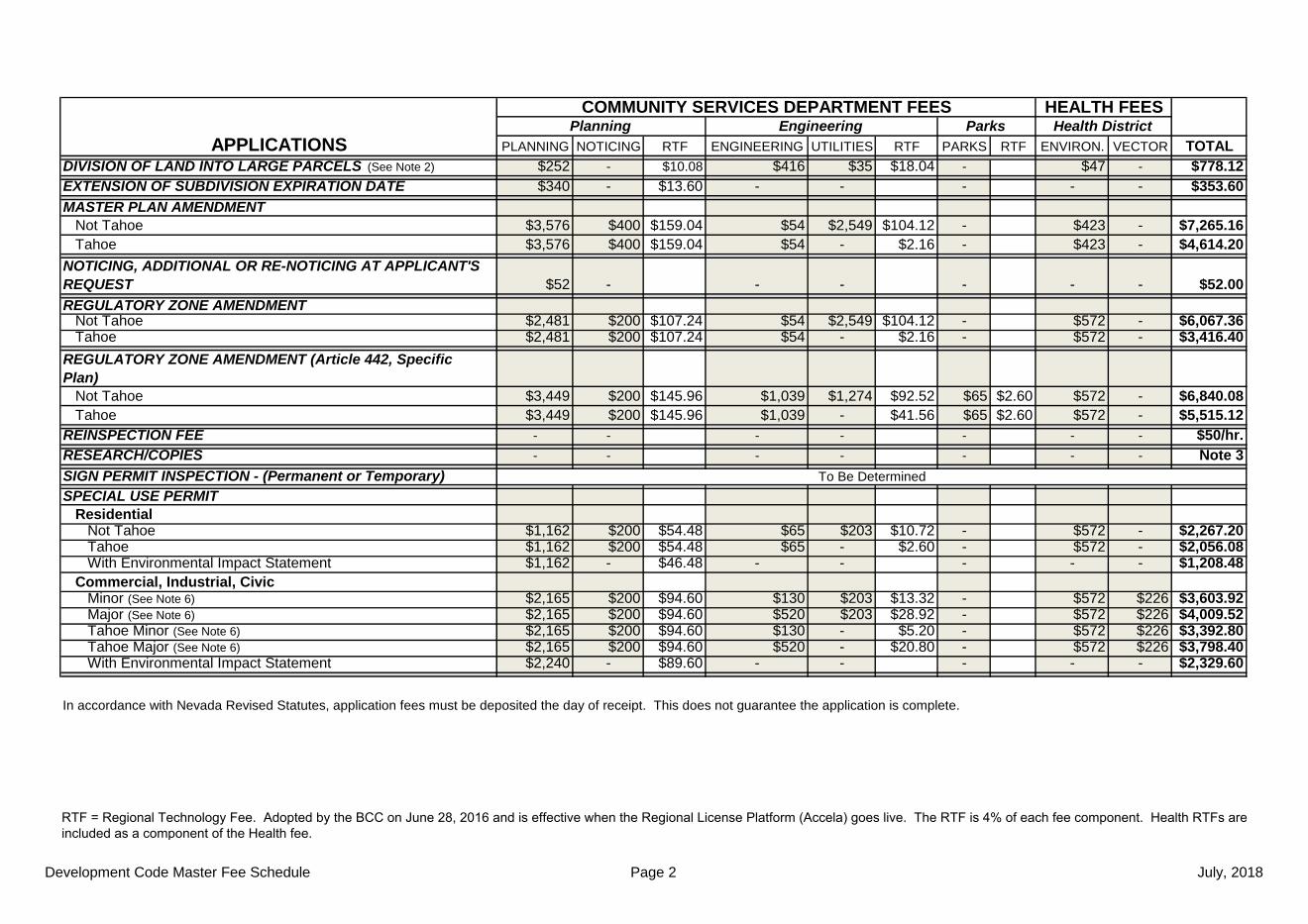
Development Code Master Fee Schedule Page 2 July, 2018
PLANNING NOTICING RTF ENGINEERING UTILITIES RTF PARKS RTF ENVIRON. VECTOR TOTAL$252 - $10.08 $416 $35 $18.04 - $47 - $778.12$340 - $13.60 - - - - - $353.60
$3,576 $400 $159.04 $54 $2,549 $104.12 - $423 - $7,265.16$3,576 $400 $159.04 $54 - $2.16 - $423 - $4,614.20
$52 - - - - - - $52.00
$2,481 $200 $107.24 $54 $2,549 $104.12 - $572 - $6,067.36$2,481 $200 $107.24 $54 - $2.16 - $572 - $3,416.40
$3,449 $200 $145.96 $1,039 $1,274 $92.52 $65 $2.60 $572 - $6,840.08$3,449 $200 $145.96 $1,039 - $41.56 $65 $2.60 $572 - $5,515.12
- - - - - - - $50/hr.- - - - - - - Note 3
$1,162 $200 $54.48 $65 $203 $10.72 - $572 - $2,267.20$1,162 $200 $54.48 $65 - $2.60 - $572 - $2,056.08$1,162 - $46.48 - - - - - $1,208.48
$2,165 $200 $94.60 $130 $203 $13.32 - $572 $226 $3,603.92$2,165 $200 $94.60 $520 $203 $28.92 - $572 $226 $4,009.52$2,165 $200 $94.60 $130 - $5.20 - $572 $226 $3,392.80$2,165 $200 $94.60 $520 - $20.80 - $572 $226 $3,798.40$2,240 - $89.60 - - - - - $2,329.60
In accordance with Nevada Revised Statutes, application fees must be deposited the day of receipt. This does not guarantee the application is complete.
HEALTH FEESHealth District
REGULATORY ZONE AMENDMENT Not Tahoe
Planning
Tahoe REGULATORY ZONE AMENDMENT (Article 442, Specific Plan) Not Tahoe Tahoe
Tahoe NOTICING, ADDITIONAL OR RE-NOTICING AT APPLICANT'S REQUEST
Residential Not Tahoe Tahoe
To Be DeterminedSIGN PERMIT INSPECTION - (Permanent or Temporary) SPECIAL USE PERMIT
With Environmental Impact Statement Commercial, Industrial, Civic Minor (See Note 6) Major (See Note 6) Tahoe Minor (See Note 6) Tahoe Major (See Note 6)
COMMUNITY SERVICES DEPARTMENT FEESParks
With Environmental Impact Statement
DIVISION OF LAND INTO LARGE PARCELS (See Note 2)
MASTER PLAN AMENDMENT Not Tahoe
EXTENSION OF SUBDIVISION EXPIRATION DATE
APPLICATIONS
REINSPECTION FEERESEARCH/COPIES
Engineering
RTF = Regional Technology Fee. Adopted by the BCC on June 28, 2016 and is effective when the Regional License Platform (Accela) goes live. The RTF is 4% of each fee component. Health RTFs are included as a component of the Health fee.

Development Code Master Fee Schedule Page 3 July, 2018
PLANNING NOTICING RTF ENGINEERING UTILITIES RTF PARKS RTF ENVIRON. VECTOR TOTAL
$803 $200 $40.12 $345 $68 $16.52 - $1,802 - $3,274.64$803 $200 $40.12 $345 $153 $19.92 - $772 - $2,333.04$803 $200 $40.12 $345 $153 $19.92 - $1,802 - $3,363.04$803 $200 $40.12 $345 $203 $21.92 - $772 - $2,385.04$803 $200 $40.12 $345 - $13.80 - $772 - $2,173.92$803 $200 $40.12 $345 $51 $15.84 - $772 - $2,226.96
$2,422 $200 $104.88 $1,299 - $51.96 $129 $5.16 $2,368 $371 $6,951.00$2,422 $200 $104.88 $1,299 $2,039 $133.52 $129 $5.16 $872 $371 $7,575.56$2,422 $200 $104.88 $1,299 $1,019 $92.72 $129 $5.16 $2,368 $371 $8,010.76$2,422 $200 $104.88 $1,299 $3,059 $174.32 $129 $5.16 $872 $371 $8,636.36$2,422 $200 $104.88 $1,299 - $51.96 $129 $5.16 $872 $371 $5,455.00$2,422 - $96.88 - - - - - $2,518.88$2,422 - $96.88 - - - - - $2,518.88$2,422 - $96.88 - - - - - $2,518.88
$1,060 $200 $50.40 $65 $26 $3.64 - $174 - $1,579.04$1,060 $200 $50.40 $65 - $2.60 - $174 - $1,552.00
NOTE 2: $750 fee capped by NRS for Division of Land into Large Parcels only. (Excludes RTF)NOTE 3: $50 per hour after first 1/2 hour for Planner, $20 per hour after first 1/2 hour for Clerk, Public Records Research/Copying. NOTE 4: Fee to be established by Truckee Meadows Regional Planning Agency.NOTE 5: Separate checks are required for the Nevada Departments of Environmental Health and Water Resources. See Submittal Requirements.NOTE 6: The following are major permit applications: bed and breakfast inns; commercial animal slaughtering; convention and meeting facilities; destination resorts;
eating and drinking establishments; gasoline sales and service stations - convenience and full service; gaming facilities: limited and unlimited; hostels; hotelsand motels; liquor sales on premises; lodging services; major public facilities; recycling centers: full service and remote collection and residential hazardoussubstances; vacation time shares. All other uses constitute minor permits.
In accordance with Nevada Revised Statutes, application fees must be deposited the day of receipt. This does not guarantee the application is complete.
HEALTH FEESHealth DistrictPlanning
TENTATIVE SUBDIVISION MAP (See Note 5)
TRUCKEE MEADOWS REGIONAL PLANNING AGENCYNOTICING FEE
2 Systems (Water and Sewer)
NOTE 1: $5,000 deposit on time and materials. Additional $5,000 increments may be required.
With Significant Hydrologic Resource - ADD With Common Open Space - ADD
See Note 4
APPLICATIONSEngineering
Tahoe (Sewer) Sun Valley (No WC Utilities)
No System 1 System (Sewer)
Not Tahoe Tahoe
1 System (Water) 2 Systems (Water and Sewer) Tahoe (Sewer) With Hillside Ordinance - ADD
VARIANCE - RESIDENTIAL/COMMERCIAL/INDUSTRIAL
No System 1 System (Sewer)
TENTATIVE PARCEL MAP/PARCEL MAP WAIVER
ParksCOMMUNITY SERVICES DEPARTMENT FEES
1 System (Water)
RTF = Regional Technology Fee. Adopted by the BCC on June 28, 2016 and is effective when the Regional License Platform (Accela) goes live. The RTF is 4% of each fee component. Health RTFs are included as a component of the Health fee.

Development Code Master Fee Schedule Page 4 July, 2018
PLANNING NOTICING RTF ENGINEERING UTILITIES RTF PARKS RTF ENVIRON. VECTOR TOTAL- - $70 - $2.80 - - - $72.80
$520 - $429 - - $872 $371 $2,192.00$520 - $429 - - $2,368 $371 $3,688.00
$308 - $1,949 - - $274 $662 $3,193.00$308 - $1,949 - - $274 $517 $3,048.00
$520 - $20.80 $780 $102 $35.28 - $572 - $2,030.08$828 - $33.12 $2,729 $102 $113.24 - $572 - $4,377.36$828 - $33.12 $2,729 $102 $113.24 - $572 - $4,377.36$520 - $20.80 $780 - $31.20 - $572 - $1,924.00$828 - $33.12 $2,729 - $109.16 - $572 - $4,271.28$828 - $33.12 $2,729 - $109.16 - $572 - $4,271.28$520 - $20.80 - - - - - $540.80$520 - $20.80 - - - - - $540.80$520 - $20.80 - - - - - $540.80
$51 - $2.04 $215 $26 $9.64 - $174 - $477.68$51 - $2.04 $215 - $8.60 - $174 - $450.64
NOTE 7: This application applies to construction plans that are not submitted as part of a Final Subdivision Map. The stand-alone Construction Plan Review application is not currently available through the Regional License and Permit Platform (Accela), so no regional technology fees (RTF) are charged. The RTF will be added once the application is available through the Platform (Accela).
NOTE 8: Contact the Engineering and Capital Projects Division for Technical Map Check fees.In accordance with Nevada Revised Statutes, application fees must be deposited the day of receipt. This does not guarantee the application is complete.
HEALTH FEESHealth District
Applications accepted by CSD, Engineering and Capital Projects
COMMUNITY SERVICES DEPARTMENT FEESPlanning
Not Tahoe
APPLICATIONS
With Catch Basin Without Catch Basin
Not Tahoe with Construction Plan without Catch Basin
Tahoe with Construction Plan without Catch Basin
Not Tahoe without Construction Plan
Tahoe without Construction Plan
Tahoe
No Sewer
FINAL SUBDIVISION MAP (See Note 8)
Not Tahoe with Construction Plan with Catch Basin
AMENDMENT OF MAP (MINOR) (NRS 278.473)
CONSTRUCTION PLAN REVIEW (See Note 7)
Parks
DEVELOPMENT CODE (Washoe County Code Chapter 110)MASTER FEE SCHEDULE
REVERSION TO ACREAGE
Tahoe with Construction Plan with Catch Basin
With Hillside Ordinance - ADD With a Significant Hydrologic Resource - ADD With CC&Rs - ADD
AMENDMENT OF MAP (MAJOR) (NRS 278.480) (See Note 7) With Sewer
Engineering
RTF = Regional Technology Fee. Adopted by the BCC on June 28, 2016 and is effective when the Regional License Platform (Accela) goes live. The RTF is 4% of each fee component. Health RTFs are included as a component of the Health fee.

Development Code Master Fee Schedule Page 5 July, 2018
actions within its authority. This application is not currently available through the Regional License and Permit Platform (Accela), so no regional technology fees (RTF) are charged. The RTF will be added once the application is available through the Platform (Accela).
In accordance with Nevada Revised Statutes, application fees must be deposited the day of receipt.
$30
Projects of less than one acre but are deemed sensitive/permitted by NDEP Additional $30
MASTER STORM WATER INSPECTION FEE SCHEDULE (Article 421)Inspection of Storm Water Quality Controls
CHARGES FOR PROJECT DURATION AND/OR LOCATION (See Note 9) CHARGES PER ACRE 0 - 6 Months Construction $30
INSPECTION FEES
ADMINISTRATIVE SERVICE FEE (See Note 9) FOR EACH APPLICATION
This does not guarantee the application is complete.
7 - 12 Months Construction $60 13 - 18 Months Construction $90 19 - 24 Months Construction $120
NOTE 9: The above listed fees shall be doubled if the construction activity is commenced prior to the issuance of the required permit and/or installation of the storm water controls. Payment of the double fee shall not preclude the County from taking any other enforcement
Over 24 Months Construction $190 Project within 1,000 feet of a FEMA Flood Zone A, AO, or AE Additional $30
Per Site