Spatio Temporal Model
24
May Yuan, Department of Geography, The University of Oklahoma T emporal GIS and Spatio-T emporal Modeling Abstract This paper investigates the development of temporal GIS and its applicability to support spatio-temporal modeling. Many GIS data models have been proposed to incorporate temporal information into spatial databases. Their general frameworks, with littl e considerations on data needs for spatio-temporal modeling, use a set of geometry-based spatial objects to represent reality. Thematic characteristics are represented as attributes of spatial objects. Temporal information is either associated with time-s tamped individual layers, such as the Snapshot Model (Armstrong, 1988), or individual spatial objects, such as the Space-Time Composite Model (Langran and Chrisman, 1988). The snapshot approach usually results in significant data redundancy. The space-tim e composite approach requires re-construction of thematic and temporal attribute tables whenever operations involve any changes in spatial objects (shape, size, or configuration). Consequently, geographic entities tend to be decomposed into fragments of s patial objects. For example, a wildfire event can be represented by a set of polygons with descriptions of burn seve rity and bu rn time . Proble ms appe ar, howe ver, in r eprese nting phe nomena l ike front lines, re-ignition, and spotting. The lack of direct map pings from GIS data to model input hampers GIS capabilities of spatio-temporal analysis, such as calculating periodicity, rate of movement, and process. Further attempts have been made to provide such direct mappings by event-based (Peuquet and Duan, 1995 ) or object-oriented data models (Worboys, 1992, Raper and Livingstone, 1995). This paper aims to (1) examine these typical temporal GIS data models, (2) discuss their applicability to facilitate spatio- temporal analytical modeling, (3) provide examples o f spatio-temporal analytical models and phenomena difficult to be handled in these proposed temporal GIS data models, and (4) synthesize important data concepts in spatio-temporal analytical models to be included in temporal GIS. I. Introduction A temporal GIS aims to process, manage, and analyze spatio-temporal data. However, the capabilities of any information system largely rely on the design of its data models. Data models present the conceptual core of an information system; they define data object types, relationships, operations, and rules to maintain database integrity (Date, 1995). A rigorous data model must anticipate spatiotemporal queries and analytical methods to be performed in the temporal GIS. Information about temporal constr ucts must be represented by data objects defined in data models to be stored or retrieved for analysis in a GIS. If a temporal
-
Upload
sudharsananprs -
Category
Documents
-
view
227 -
download
0
Transcript of Spatio Temporal Model
8/2/2019 Spatio Temporal Model
http://slidepdf.com/reader/full/spatio-temporal-model 1/24
May Yuan, Department of Geography, The University of Oklahoma
Temporal GIS and Spatio-Temporal
ModelingAbstract
This paper investigates the development of temporal GIS and its applicability to supportspatio-temporal modeling. Many GIS data models have been proposed to incorporate
temporal information into spatial databases. Their general frameworks, with littl e
considerations on data needs for spatio-temporal modeling, use a set of geometry-basedspatial objects to represent reality. Thematic characteristics are represented as attributes of
spatial objects. Temporal information is either associated with time-s tamped individual
layers, such as the Snapshot Model (Armstrong, 1988), or individual spatial objects, suchas the Space-Time Composite Model (Langran and Chrisman, 1988). The snapshot
approach usually results in significant data redundancy. The space-tim e composite
approach requires re-construction of thematic and temporal attribute tables whenever
operations involve any changes in spatial objects (shape, size, or configuration).Consequently, geographic entities tend to be decomposed into fragments of s patial objects.
For example, a wildfire event can be represented by a set of polygons with descriptions of
burn severity and burn time. Problems appear, however, in representing phenomena likefront lines, re-ignition, and spotting. The lack of direct map pings from GIS data to model
input hampers GIS capabilities of spatio-temporal analysis, such as calculating periodicity,
rate of movement, and process. Further attempts have been made to provide such direct
mappings by event-based (Peuquet and Duan, 1995 ) or object-oriented data models(Worboys, 1992, Raper and Livingstone, 1995). This paper aims to (1) examine these
typical temporal GIS data models, (2) discuss their applicability to facilitate spatio-temporal analytical modeling, (3) provide examples o f spatio-temporal analytical models
and phenomena difficult to be handled in these proposed temporal GIS data models, and
(4) synthesize important data concepts in spatio-temporal analytical models to be included
in temporal GIS.
I. Introduction
A temporal GIS aims to process, manage, and analyze spatio-temporal data. However, thecapabilities of any information system largely rely on the design of its data models. Datamodels present the conceptual core of an information system; they define data object types,
relationships, operations, and rules to maintain database integrity (Date, 1995). A rigorous
data model must anticipate spatiotemporal queries and analytical methods to be performedin the temporal GIS. Information about temporal constr ucts must be represented by data
objects defined in data models to be stored or retrieved for analysis in a GIS. If a temporal
8/2/2019 Spatio Temporal Model
http://slidepdf.com/reader/full/spatio-temporal-model 2/24
GIS does not have a good data model, its support for temporal queries and temporal
analysis of phenomena will be ineffectual.
Conventional GIS data models emphasize static representations of reality. Geographicinformation for a given area is decomposed into a set of single-theme layers as regular
(raster) or irregular (vector) tessellation models (Frank and Mark, 1991). The se layersconstrain GIS capabilities to represent dynamic information, such as transitions and
motion. Raster cells encode attribute values at every given location with no considerationsof the spatial characteristics of the theme they represent. Geometri cally indexed vector
objects, on the other hand, 'force a segmentation of the entities being represented into
separate layers whenever they interact in time or space: adopting this representationalmethod forces compromises on most environmental modeling' (Raper and Livingstone,
1995, pp. 359). GIS needs a complete and rigorous framework for geographical data
modeling (Goodchild, 1992) to overcome the difficulty in handling geographic complexity,scale differences, generalization, and accuracy (Burrough a nd Frank, 1995). The lack of
data representation schemata to integrate GIS data with models for spatiotemporal
processes appears to be a major shortcoming in current GIS.
The paper discusses the trend of modeling temporal data in GIS. Key temporal GIS datamodels will be elaborated on the development of modeling spatiotemporal data. The
discussion that follows provides difficult cases to be represented by the current t emporal
GIS data models. To improve the capabilities of temporal GIS, the paper suggestsimportant constructs in the representation of spatiotemporal phenomena.
II. The Trend of Temporal Data Modeling
in GISThe development of temporal data modeling in GIS parallels to the progress of temporal
data modeling in the computer science (CS). The incorporation of temporal components
has been implemented with the relational model and then with the object-oriente d datamodels in CS. The trend of temporal data modeling in GIS is moving from time-stamping
layers (similar to relational tables) to time-stamping events or processes (similar to
objects). Data semantics is a key issue in data modeling and the fundamenta l idea is toraise the level of abstraction in the transition from layers/tables to events/objects.
II.1. Representing spatiotemporal information by time-
stamping spatial objects
In the last decade considerable research effort has been directed to temporal databases andtemporal query languages (Tansel et al., 1993). Computer scientists have proposed methods
to incorporate temporal information into a relational database by tim e-stamping a relation
(a table, Gadia and Vaishnav, 1985), individual tuples (ungrouped relations, Snodgrass andAhn, 1985), or individual cells (grouped relations, Gadia and Yeung, 1988). In GIS,
8/2/2019 Spatio Temporal Model
http://slidepdf.com/reader/full/spatio-temporal-model 3/24
Langran and Chrisman (1988) and Langran (1988) explore the idea of temporal GIS to
outline a framework for conceptual design and implementation of incorporating temporal
information in GIS. As Snodgrass (1992) summarizes the progress on the support for time-varying information in database management systems, Lan gran (1993) provides a
comprehensive and compelling synthesis of temporal research in GIS. Parallel to the three
relational database approaches, temporal information has been incorporated into GISspatial data models by time-stamping layers (the snapshot models, Armstrong, 1988),
attributes (space-time composites, Langran and Chrisman, 1988), and spatial objects
(spatiotemporal objects, Worboys, 1992).
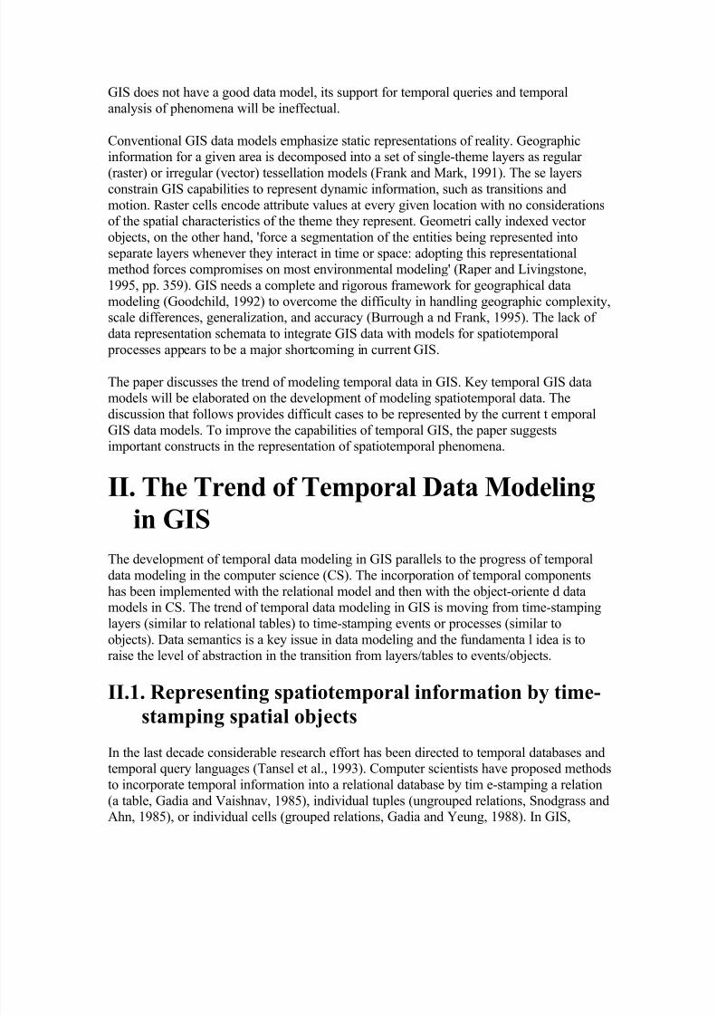
In the snapshot model, every layer is a collection of temporally homogeneous units of onetheme (Figure 1). It shows the states of a geographic distribution at different times without
explicit temporal relations among layers. Time intervals between an y two layers may vary
and there is no implication for whether changes occur within the time lag of any two layers.The Temporal Map Sets (TMS, Beller et al., 1991) model can be seen as extensions of the
snapshot model. The design of TMS purports to model geographic events in a defined area
(Figure 2). Events are defined as binary TMSs, specifying whether each cell is in or out of the event. These snapshot approaches always result in a large amount of data duplication
with unchanged properties in space and time. The major drawback is data redundancy and
the risk of data inconsistency.
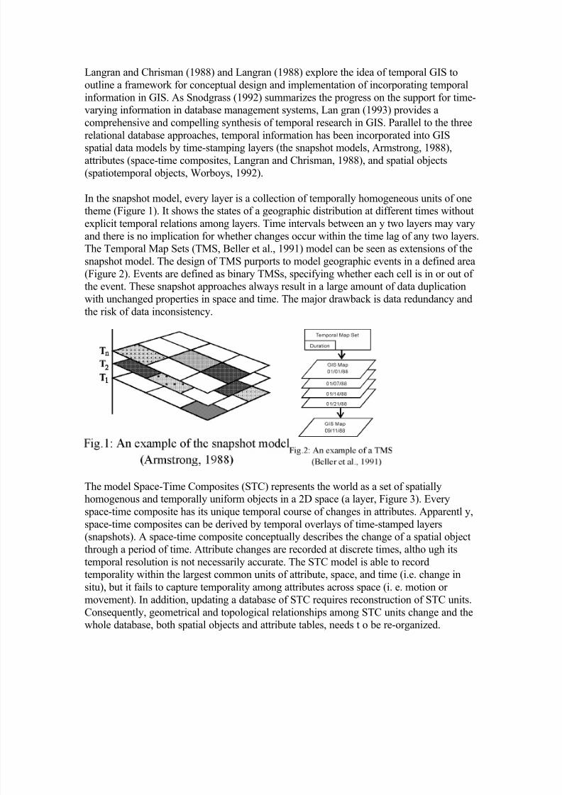
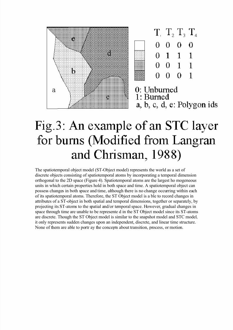
The model Space-Time Composites (STC) represents the world as a set of spatiallyhomogenous and temporally uniform objects in a 2D space (a layer, Figure 3). Every
space-time composite has its unique temporal course of changes in attributes. Apparentl y,
space-time composites can be derived by temporal overlays of time-stamped layers(snapshots). A space-time composite conceptually describes the change of a spatial object
through a period of time. Attribute changes are recorded at discrete times, altho ugh its
temporal resolution is not necessarily accurate. The STC model is able to recordtemporality within the largest common units of attribute, space, and time (i.e. change in
situ), but it fails to capture temporality among attributes across space (i. e. motion or
movement). In addition, updating a database of STC requires reconstruction of STC units.
Consequently, geometrical and topological relationships among STC units change and thewhole database, both spatial objects and attribute tables, needs t o be re-organized.
8/2/2019 Spatio Temporal Model
http://slidepdf.com/reader/full/spatio-temporal-model 4/24
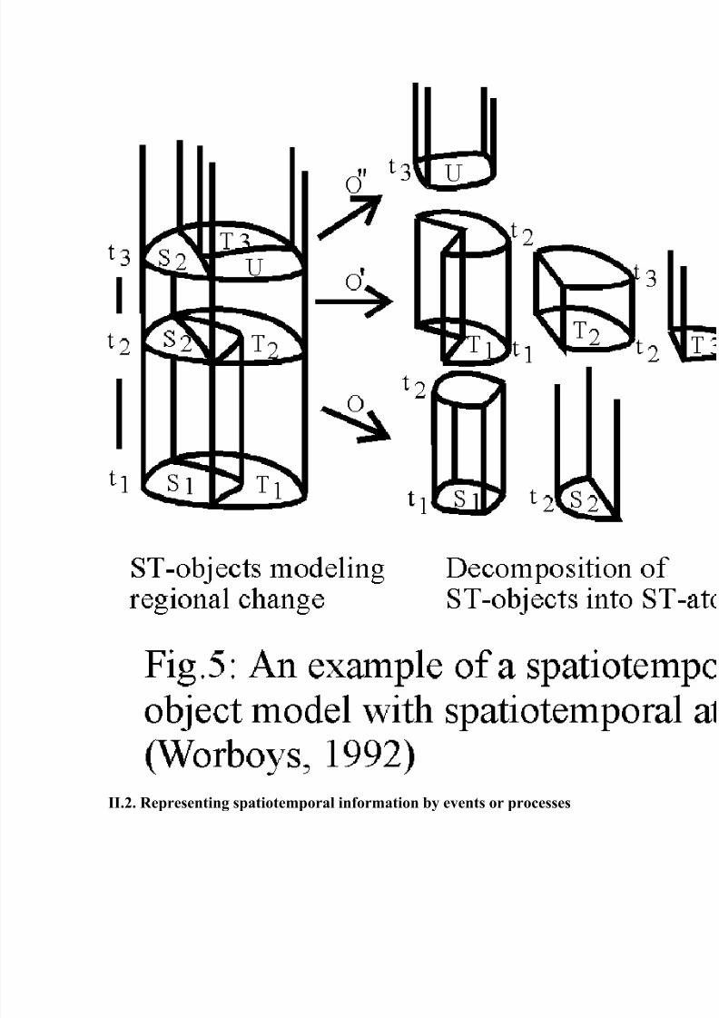
The spatiotemporal object model (ST-Object model) represents the world as a set of
discrete objects consisting of spatiotemporal atoms by incorporating a temporal dimensionorthogonal to the 2D space (Figure 4). Spatiotemporal atoms are the largest ho mogeneousunits in which certain properties hold in both space and time. A spatiotemporal object can
possess changes in both space and time, although there is no change occurring within each
of its spatiotemporal atoms. Therefore, the ST Object model is a ble to record changes inattributes of a ST-object in both spatial and temporal dimensions, together or separately, by
projecting its ST-atoms to the spatial and/or temporal space. However, gradual changes in
space through time are unable to be represente d in the ST Object model since its ST-atomsare discrete. Though the ST Object model is similar to the snapshot model and STC model,
it only represents sudden changes upon an independent, discrete, and linear time structure.
None of them are able to portr ay the concepts about transition, process, or motion.
8/2/2019 Spatio Temporal Model
http://slidepdf.com/reader/full/spatio-temporal-model 5/24
II.2. Representing spatiotemporal information by events or processes
8/2/2019 Spatio Temporal Model
http://slidepdf.com/reader/full/spatio-temporal-model 6/24
Computer scientists have developed temporal data models based on the concepts of time
sequences (STC: temporal sequence collection, Segev and Shoshani, 1993), and time
objects (OODAPLEX, Wuu and Dayal, 1992). These models are comparable to the recentstudies of temporal information modeling by events or processes, such as the event-based
spatio-temporal data model (ESTDM, Peuquet and Duan, 1995), and the geomorphologic
spatial model (OOgeomorph, Raper and Livingstone, 1995).
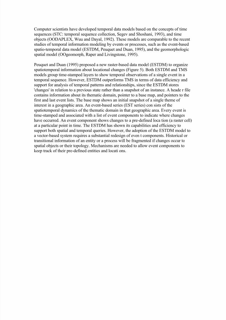
Peuquet and Duan (1995) proposed a new raster-based data model (ESTDM) to organizespatiotemporal information about locational changes (Figure 5). Both ESTDM and TMS
models group time-stamped layers to show temporal observations of a single event in a
temporal sequence. However, ESTDM outperforms TMS in terms of data efficiency andsupport for analysis of temporal patterns and relationships, since the ESTDM stores
'changes' in relation to a previous state rather than a snapshot of an instance. A heade r file
contains information about its thematic domain, pointer to a base map, and pointers to thefirst and last event lists. The base map shows an initial snapshot of a single theme of
interest in a geographic area. An event-based series (EST series) con sists of the
spatiotemporal dynamics of the thematic domain in that geographic area. Every event istime-stamped and associated with a list of event components to indicate where changes
have occurred. An event component shows changes to a pre-defined loca tion (a raster cell)
at a particular point in time. The ESTDM has shown its capabilities and efficiency to
support both spatial and temporal queries. However, the adoption of the ESTDM model toa vector-based system requires a substantial redesign of even t components. Historical or
transitional information of an entity or a process will be fragmented if changes occur to
spatial objects or their topology. Mechanisms are needed to allow event components tokeep track of their pre-defined entities and locati ons.
8/2/2019 Spatio Temporal Model
http://slidepdf.com/reader/full/spatio-temporal-model 7/24
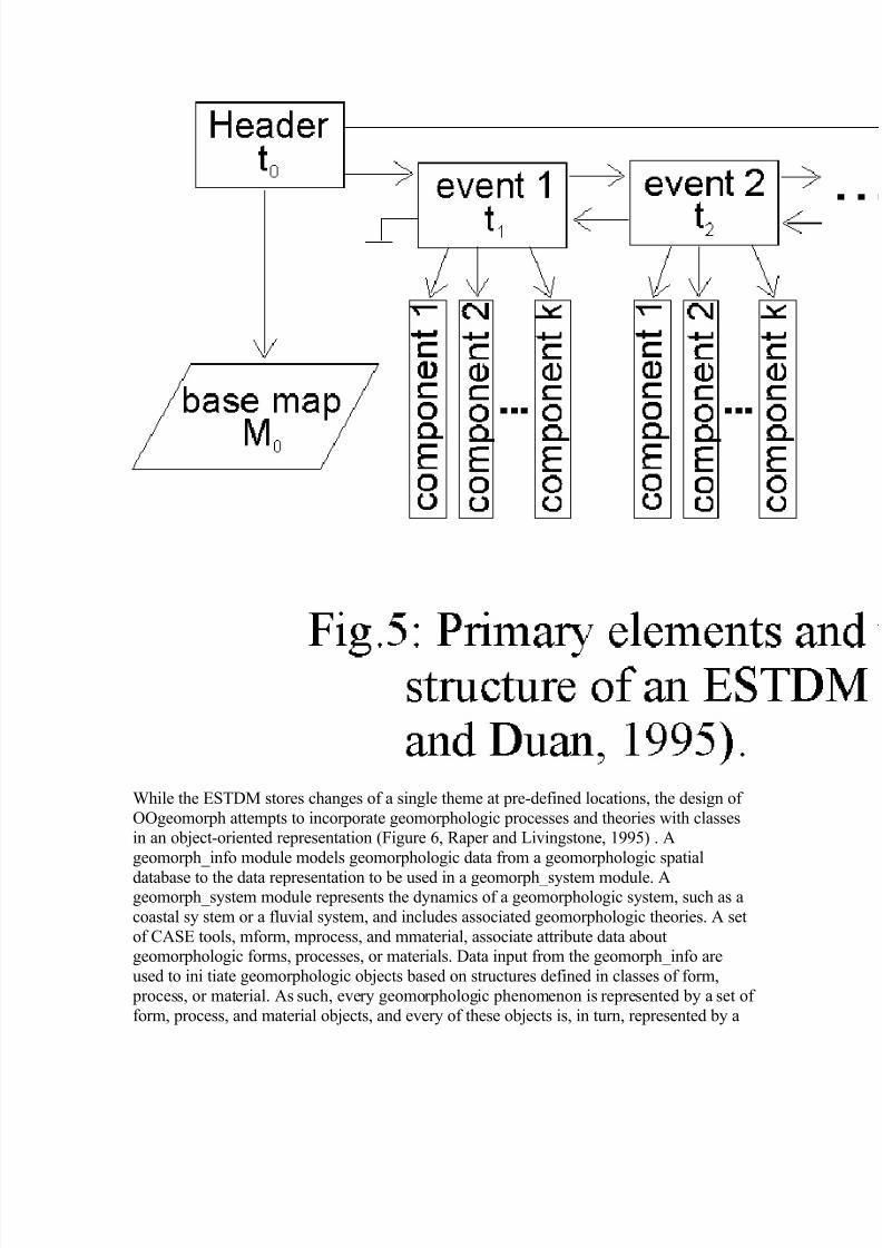
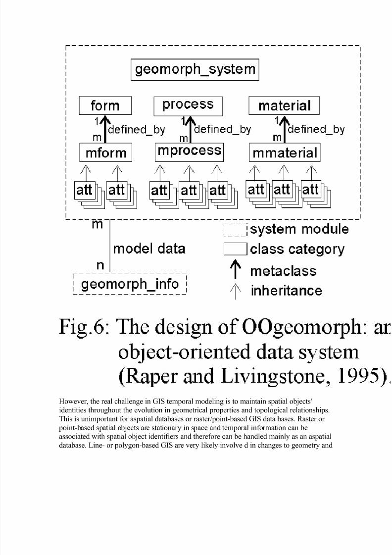
While the ESTDM stores changes of a single theme at pre-defined locations, the design of
OOgeomorph attempts to incorporate geomorphologic processes and theories with classesin an object-oriented representation (Figure 6, Raper and Livingstone, 1995) . A
geomorph_info module models geomorphologic data from a geomorphologic spatial
database to the data representation to be used in a geomorph_system module. Ageomorph_system module represents the dynamics of a geomorphologic system, such as a
coastal sy stem or a fluvial system, and includes associated geomorphologic theories. A set
of CASE tools, mform, mprocess, and mmaterial, associate attribute data aboutgeomorphologic forms, processes, or materials. Data input from the geomorph_info are
used to ini tiate geomorphologic objects based on structures defined in classes of form,
process, or material. As such, every geomorphologic phenomenon is represented by a set of
form, process, and material objects, and every of these objects is, in turn, represented by a

8/2/2019 Spatio Temporal Model
http://slidepdf.com/reader/full/spatio-temporal-model 8/24
set of attribute objects. Three-dimensional location (x, y, z) and one-dimensional time (t)
are referenced to objects in attribute classes (att). This approach is similar to Worboy's
space-time object model of space-time objects and space-time atoms , but OOgeomorphstresses the importance of a physical system and processes within the system. Space-time
objects and atoms are formed by their spatiotemporal associations, but objects in the
OOgeomorph are linked by their relationships defined in a geomo rphologic system. WhileOOgeomorph can handle point-based locational information well, it has difficulty in
manipulating area data and topological relationships.
8/2/2019 Spatio Temporal Model
http://slidepdf.com/reader/full/spatio-temporal-model 9/24
However, the real challenge in GIS temporal modeling is to maintain spatial objects'identities throughout the evolution in geometrical properties and topological relationships.
This is unimportant for aspatial databases or raster/point-based GIS data bases. Raster or
point-based spatial objects are stationary in space and temporal information can beassociated with spatial object identifiers and therefore can be handled mainly as an aspatial
database. Line- or polygon-based GIS are very likely involve d in changes to geometry and

8/2/2019 Spatio Temporal Model
http://slidepdf.com/reader/full/spatio-temporal-model 10/24
topology of spatial objects. Domain-oriented data models are proposed to manage complex
changes of spatial objects and maintain object identities.
The three domain model is developed by analyzing spatiotemporal information needs for wildfire studies and representational requirements to facilitate these studies in a GIS
environment. A wildfire information cycle shows the needs of four data schema ta.Snapshots represent states, fire entities represent processes, entity snapshots represent
changes, and fire mosaics represent history. These representational schemata are designedto support spatiotemporal data for wildfire studies of fire forecasting , fire behavior, fire
impacts, and fire history. A separation of semantical1, spatial, and temporal information is
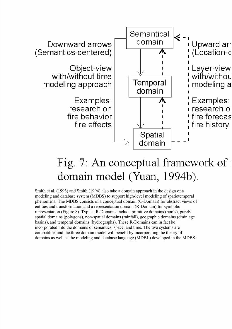
necessary in order to dynamically support all four schemata. The three domain modeldefines semantical, temporal, and spatial objects in thr ee separate domains. Time is
modeled as an independent concept in the three domain model, instead of being an attribute
of location as in the snapshot model or being an integral part of spatial entities as in thespace-time composites and spatiotemporal o bjects. Geographic concepts and entities are
represented by dynamically linking the three types of objects from a layer or object
perspective (Figure 7). The data model is able to represent reality from locational-centered,entity-centered, and time-cente red perspectives with six basic types of changes in
geographic information: attribute changes, static spatial distribution, static spatial changes,
dynamic spatial changes, mutation of a process, and movement of an entity (Yuan, 1995).
The major advantage of the three domain model is that there is no pre-defined dataschemata; rather the model will dynamically link relevant objects from the three domains
to represent a geographic entity or concept. Linkages among these objects can be numerical
or fuzzy me mbership functions. These functions are useful to represent dynamic boundaries such as transitions of soil distributions, seasonal changes in lake boundaries, or
diurnal changes in shorelines.
8/2/2019 Spatio Temporal Model
http://slidepdf.com/reader/full/spatio-temporal-model 11/24
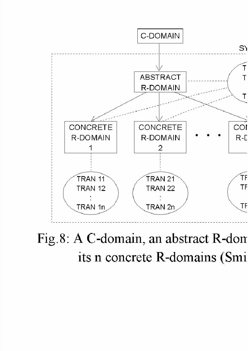
Smith et al. (1993) and Smith (1994) also take a domain approach in the design of a
modeling and database system (MDBS) to support high-level modeling of spatiotemporal
phenomena. The MDBS consists of a conceptual domain (C-Domain) for abstract views of entities and transformation and a representation domain (R-Domain) for symbolic
representation (Figure 8). Typical R-Domains include primitive domains (bools), purely
spatial domains (polygons), non-spatial domains (rainfall), geographic domains (drain age basins), and temporal domains (hydrographs). These R-Domains can in fact be
incorporated into the domains of semantics, space, and time. The two systems are
compatible, and the three domain model will benefit by incorporating the theory of domains as well as the modeling and database language (MDBL) developed in the MDBS.
8/2/2019 Spatio Temporal Model
http://slidepdf.com/reader/full/spatio-temporal-model 12/24
8/2/2019 Spatio Temporal Model
http://slidepdf.com/reader/full/spatio-temporal-model 13/24
III. Examples of Difficult Cases for
Temporal GIS
Changes occur to attributes of a phenomenon, environmental settings, behaviors of anevent, or mechanisms of a processes. There are six major types of spatial and/or temporal
changes in geographic information (Yuan, 1995):
I. For a given site where occurrences and duration of events or attributes may change from
time to time, analysis is done by fixing location, controlling attribute, and measuring time.
II. For a given point in time where a certain phenomenon may change its characteristics
from site to site, analysis is done by fixing time, controlling attribute, and measuringlocation.
III. For a given period of time where attributes may change from site to site through time,analysis is done by fixing time, controlling locations, and measuring attributes.
IV. For a given event where its characteristics or processes may change at sites throughtime, analysis is done by fixing attributes, controlling locations, and measuring time;
V. For a given area where attributes may change site to site and from time to time, analysis
is done by fixing location, controlling time, and measuring attributes.
VI. For a given event where its location may change from time to time, analysis is done by
fixing attributes, controlling time, and measuring locations.
Type I changes only involve variations in attributes over time; there is no variations in
spatial properties. Therefore, this kind of data modeling and analysis can be totally handled
in a semantical domain as historical transactions in a relational o r object-oriented database
management system. Type II changes describe static spatial distribution of a geographic phenomenon, such as topography or air pressure. Techniques, such as contouring,
choropleth mapping, and dasymetric mapping are often used to present such information,
while current GIS store this kind of information in forms of vector or raster layers. Changesof Types III to VI alter geometry or topology of spatial and/or temporal properties.
III.1. Spatial Changes
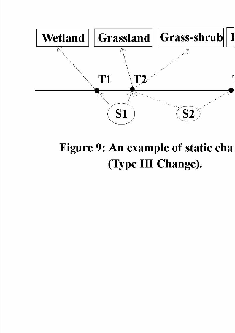
Spatial changes refer to variations across space at a given time or in a period, in which
comparisons are made between two or more sites according to data of the same vintage.Spatial changes can be classified as static (Type III) or transitional (Typ e IV). Static
spatial changes concern variations of a geographic phenomenon at a snapshot, whereas
transitional spatial changes compare states of an event or a process at different sites (Figure9) . For example, we can compare vegetation successions at Site A and Site B to examine
the ecological impact of air pollution. As another example, central and western India

8/2/2019 Spatio Temporal Model
http://slidepdf.com/reader/full/spatio-temporal-model 14/24
experience heavy rainfalls in El Nino years, while the northern India usually has deficit of
precipitation during these periods. Type IV tra nsitional changes describe variations of
spatial properties for a given event or process in a time series (Figure 10). Such changescan be shown by linkages from a set of temporal objects to a set of spatial objects. Three
basic parameters in measuring sp atial changes are attribute, duration, and continuity of a
phenomenon, event, or process. For example, we can compare transitional changes of landuse types at Site A with what has occurred at Site B from T1 to T2. Or, we can
compare impact of the monsoon trough on rainfall processes in El Ni(o years at these two
sites.
8/2/2019 Spatio Temporal Model
http://slidepdf.com/reader/full/spatio-temporal-model 15/24

8/2/2019 Spatio Temporal Model
http://slidepdf.com/reader/full/spatio-temporal-model 16/24
II.2. Temporal Changes
Temporal changes are changes occurring at different points or periods in time, and they are
recognized by changes in spatial properties and/or locations from time to time. Two typesof temporal changes are identified in this research: mutation (Type V ) or movement (Type
VI).
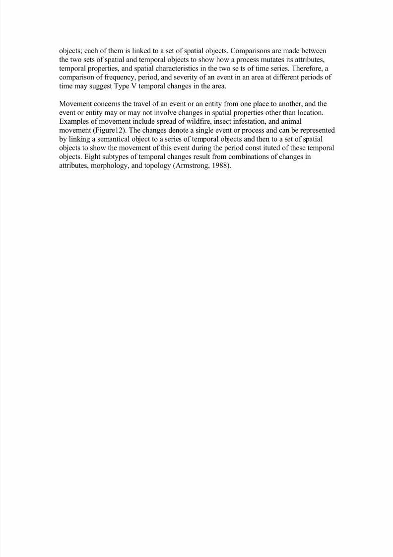
Mutation refers to changes occurring to the internal mechanisms of an event or a process,
or to the interactions between events/processes and their environments. For example, athunderstorm and a tornado may develop in a county and progress to other c ounties
(Figure11). A practice of artificial rainfall in a region may mutate the patterns of
precipitation and water resources in its surrounding area. Type V changes describe themutation of a type of processes or events (semantical objects) by two sets of temporal
8/2/2019 Spatio Temporal Model
http://slidepdf.com/reader/full/spatio-temporal-model 17/24
objects; each of them is linked to a set of spatial objects. Comparisons are made between
the two sets of spatial and temporal objects to show how a process mutates its attributes,
temporal properties, and spatial characteristics in the two se ts of time series. Therefore, acomparison of frequency, period, and severity of an event in an area at different periods of
time may suggest Type V temporal changes in the area.
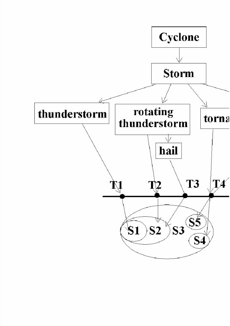
Movement concerns the travel of an event or an entity from one place to another, and the
event or entity may or may not involve changes in spatial properties other than location.Examples of movement include spread of wildfire, insect infestation, and animal
movement (Figure12). The changes denote a single event or process and can be represented
by linking a semantical object to a series of temporal objects and then to a set of spatialobjects to show the movement of this event during the period const ituted of these temporal
objects. Eight subtypes of temporal changes result from combinations of changes in
attributes, morphology, and topology (Armstrong, 1988).
8/2/2019 Spatio Temporal Model
http://slidepdf.com/reader/full/spatio-temporal-model 18/24
8/2/2019 Spatio Temporal Model
http://slidepdf.com/reader/full/spatio-temporal-model 19/24
The incorporation of temporal elements into databases itself is a nontrivial task, and it becomes even more complicated when we try to model spatiotemporal data in GIS. The
current temporal GIS data models lack of capabilities to represent Type III to Type VI
changes. The following section discusses important spatiotemporal concepts to beconsidered in GIS data modeling to improve GIS's representativity by including important
spatiotemporal concepts in its data models.
IV. Important Spatiotemporal Concepts to
be Included in a temporal GIS Data
Model
8/2/2019 Spatio Temporal Model
http://slidepdf.com/reader/full/spatio-temporal-model 20/24
Langran (1992) points out that '(p)recisely articulated information about what and where
changes occurred within a geographic area is at the heart of a TGIS' (p. 419). In doing so,
she suggests states, events, and evidence are the three principle ent ities of a temporal GIS.States describe the spatial distributions of a geographic phenomena. They can be
represented by snapshots or space-time composites. Events cause changes of states for a
given phenomena through time, such as floods or fires. Eviden ce describes how changesare discovered and measured. It provides basis for updating a state. Therefore, the
combination of states, events, and evidence show what has been in an area, what has
happened to the area, and how we know it has happened. The thr ee data types in factconstitute the key elements of temporal metadata in GIS.
States and changes of states are the main concern in temporal representation, although
events and evidence are critical to ensure data quality and detect causal relationships. It is
important to understand time when we try to record changes and associ ate aspatical andspatial objects with time. The representation of time is an important issue in the study of
states and changes of states. Time can be conceptualized as instances (point-based) or
intervals (Allen, 1983; Fresa, 1992). Time has multiple st ructures: linear time, cyclic time, parallel time, and branching time (Worboys, 1990). Time has multiple dimensions: valid
time and transactional time, user-define time, and institutional time (Snodgrass and Ahn,
1986; Berrera et al., 1991). In order to r epresent multiple time dimensions, Worboys
(1994) proposes a spatio-bitemporal model and operations to handle information aboutvalid time and transaction time in GIS. Other important concepts about time are elaborated
in Peuquet (1994) and Raper and Livi ngstone (1995).
In addition, temporal GIS data models need to incorporate the behaviors of natural
phenomena as the examples given in section III. To date, the design of conventional GISdata models have neglected the physical processes of natural phenomena. The basi c
concept in conventional GIS data models is "location." Basic GIS units are spatial objects(points, lines, polygons, and cells), and their static attributes. Spatial relationships or interactions are limited to being at the same location or in close pro ximity. In contrast, the
basic concepts in modeling of natural processes are "system states," "mass and energy
conservation," transformation and translocation," and "species and individuals' interactionand dynamics" (Fedra, 1993). GIS is, in its present state, unable to provide complete
support for spatiotemporal modeling of natural processes. Temporal GIS should support
both location-based analysis (Type III and Type IV Changes), such as landuse changes andecological succession, and process-based chang es (Type V and Type VI Changes), for
example fire spread and storm development. As such, locations, states, events, and
processes should be handled as individual data constructs in a temporal GIS. Semantical
analysis of natural phenomena on their characte ristics and behaviors is critical todetermine a set of high-level spatiotemporal constructs to be modeled in a temporal GIS
(Yuan, 1994b). Most of the current GIS data models, as described in section II, organize
geographic information according to spati al objects. Attributes are associated with a cell, a point, a line, or a polygon. As a result, GIS does not represent Interstate 35 as a integral
object, rather there are a set of independent line segments and they have an attribute value,
Interstate 35. Consequently, information about changes to Interstate 35 can not beeffectively represented in a temporal GIS.

8/2/2019 Spatio Temporal Model
http://slidepdf.com/reader/full/spatio-temporal-model 21/24
It is important to understand the fundamental spatiotemporal concepts to be successful in
modeling temporal data in GIS. Many GIS data models are developed from perspectives of
structures in spatial data. However, a process-oriented or semantics appro aches may leadto a new direction in modeling geographic information. GIS will be more effective and
precise by representing a fire, fire location, and how the fire spreads rather than burned
areas at each point in time.
V. Concluding Remarks
The study of modeling temporal information in GIS started in the mid 1980s. Many data
models have been proposed, and some of them have been implemented. The developmentof temporal data models in computer science has shown an influence on the trend of
temporal modeling in GIS. However, GIS data modelers need to consider the evolution of
spatial objects in addition to retroactive or postactive changes and all other issues to be
considered in a non-spatial databases (Snodgrass, 1992). Geographic inform ation has three
components: attributes, time, and space. While the three components can change and beanalyzed independently (Berry, 1964; Sinton, 1978), the proposed temporal GIS data
models, as reviewed in section II, cannot model all possible kinds of temporal informationlisted in section III. The Snapshot Model (Armstrong, 1988), Space-Time Model (Langran
and Chrisman, 1988), Spatiotemporal Object Model (Worboys, 1992) all can represent
states through time (Type I and Type II Changes). The Space-Tim e Model andSpatiotemporal Object Model can also represent state changes at locations (Type III
Changes). None of them can precisely nor effectively model transitions, mutation, and
movement of processes (Type IV, V, and VI Changes). While the Event-based
spatiotemporal data model (ESTDM, Peuquet and Duan, 1995) and the OOgeomorphmodel (Raper and Livingstone, 1995) are able to show transitions, they have difficulty in
handling mutation and movement. In addition, both of them are limited to raster or poin t- based GIS. Temporal GIS needs a top-down approach to modeling spatiotemporalinformation, because behaviors of natural phenomena need to be considered and should be
considered prior to available GIS data formats and data structures in constructing tempo ral
GIS representation. The process-oriented approach has been used in the development of theESTDM, OOgeomorph, the three domain model (Yuan, 1994), and the modeling and
database systems (MDBS, Smith et al., 1993) with a certain amount of success. Furthe r
research still needs to incorporate spatiotemporal constructs from natural phenomena intothe modeling of temporal information in GIS to fully represent Type III to Type VI
changes in space and time.
ReferencesAllen, J. F., 1983, Maintaining knowledge about temporal intervals. Communications of the ACM, 26(11): 832-843.
Armstrong, M. P., 1988, Temporality in spatial databases. Proceedings: GIS/LIS'88, 2:880-
889.
8/2/2019 Spatio Temporal Model
http://slidepdf.com/reader/full/spatio-temporal-model 22/24
Barrera, R., Frank, A., and Al-Taha, K., 1991, Temporal Relations in Geographic
Information Systems. NCGIA Technical Report 91-4.
Berry, B. J. L., 1964, Approaches to regional analysis: A synthesis. Annals of theAssociation of American Geographers, 54(1):2-11.
Burrough, P. A. and Frank, A. U., 1995, Concepts and paradigms in spatial information:
are current geographical information systems truly generic? International Journal of
Geographical Information Systems, 9(2): 101-116.
Beller, A., Giblin, T., Le, K. V., Litz, S., Kittel, T., and Schimel, D., 1991, A temporal GIS prototype for global change research. Proceedings: GIS/LIS'91, 2:752-765.
Date, C. J., 1995, An Introduction to Database Systems, 6th edition (Reading: Addison-
Wesley Publishing Company).
Fedra, K., 1993, GIS and environmental modeling. In Environmental Modeling with GIS,edited by . Goodchild , M. F, Parks, B. O., and Steyaert L. T. (New York: Oxford
University Press).
Frank, A. U. and Mark, D. M., 1991, Languages issues for GIS. In Geographic Information
Systems: Principles and Applications, edited by Maguire, D. J., Goodchild, M. F., andRhind, D. W., vol. 1 (Esses: Longman Scientific & Technical Inc.), pp. 147 -163.
Freksa, C., 1992, Temporal reasoning based on semi-intervals. Artificial Intelligence,
54:199-227.
Gadia, S. K. and J. H. Vaishnav. 1985. A query language for a homogeneous temporaldatabase. In Proceedings of the ACM Symposium on Principles of Database Systems, pp.
51-56.
Gadia, S. K. and C. S. Yeung. 1988. A generalized model for a relational temporal
database. In Proceedings of ACM SIGMOD International Conference on Management of Data, pp. 251-259.
Goodchild, M. F., 1992, Geographical information science. International Journal of
Geographical Information Systems, 6(1):31-45.
Langran, G. and Chrisman, N, R., 1988, A framework for temporal geographicinformation. Cartographica, 25(3):1-14.
Langran, G., 1988, Temporal design tradeoffs. In proceedings of GIS/LIS'88, Volume 2
(Falls Church, VA: ACSM), pp. 890-899.
Langran, G., 1992, States, events, and evidence: the principle entities of a temporal GIS. In
Proceedings: GIS/LIS'92, pp. 416-425.
8/2/2019 Spatio Temporal Model
http://slidepdf.com/reader/full/spatio-temporal-model 23/24
Langran, G., 1993, Time in Geographic Information Systems (Bristol, PA: Taylor &
Francis).
Peuquet, D. J., 1994, It's about time: a conceptual framework for the representation of temporal dynamics in geographic information systems. Annals of the Association of
American Geographers, 84(3):441-462.
Peuquet, D. J. and Duan, N., 1995, An event-based spatiotemporal data model (ESTDM)
for temporal analysis of geographical data. International Journal of GeographicalInformation Systems, 9(1): 7-24.
Rapper, J. and Livingstone, D., 1995, Development of a geomorphological spatial model
using object-oriented design. International Journal of Geographical Information Systems,
9(4): 359-384.
Segev, A. and Shoshani, A., 1993, A temporal data model based on time sequences. In
Tansel et al., eds. Temporal Databases: Theory, Design, and Implementation (Reading,MA: The Benjamin /Cummings Publishing Company, Inc.), pp. 248-270.
Smith, T. R., Su, J., Agrawal, D., El Abbadi, A., 1993, Database and modelling systems for the earth sciences. IEEE (6) (Special Issue on Scientific Databases).
Smith, T. R., 1994, On the integration of database systems and computational support for
high-level modelling of spatio-temporal phenomena. In M. F. Worboys ed. Innovations in
GIS (Bristol, PA: Taylor & Francis) pp. 11-24.
Sinton, D., 1978, The inherent structure of information as a constraint to analysis: mapped
thematic data as a case study. Harvard Papers on GIS, Volume 7, edited by G. Dutton,Addison-Wesley Publishing Company, Inc., Reading, MA.
Snodgrass, R. and Ahn, I., 1985. A taxonomy of time in databases. In Proceedings of ACM
SIGMOD International Conference on Management of Data. pp. 236-264.
Snodgrass, R. and Ahn, I., 1986. Temporal databases. IEEE Computer, September, 1986,
pp. 35-42.
Snodgrass, R. T., 1992. Temporal databases. In Frank, A. U. ed. Theories and Methods of
Spatio-Temporal Reasoning in Geographic Space (Berlin: Springer), pp. 22-64.
Sowa, J. F.. 1984. Conceptual Structures: Information Processing in Mind and Machine(Reading: Addison-Wesley Publishing Company, Inc.).
Steyaert, Louis T. and Michael F. Goodchild. 1994. Integrating geographic information
systems and environmental simulation models: A status review. In William K. Michener,James W. Brunt, and Susan G. Stafford eds. Environmental Information Management and
Analysis: Ecosystem to Global Scales (Bristol, PA: Taylor & Francis), pp. 333-356.
8/2/2019 Spatio Temporal Model
http://slidepdf.com/reader/full/spatio-temporal-model 24/24
Tansel, A. U., Clifford, J., Gadia, S., Jajodia, S., Segev, A., Snodgrass, R., ed., 1993,
Temporal Databases: Theory, Design, and Implementation (Reading, MA: The
Benjamin /Cummings Publishing Company, Inc.).
Wuu, G. and Dayal, U., 1992, A uniform model for temporal object-oriented databases. In
Proceedings of the International Conference on Data Engineering (Tempe, AZ), pp. 584-593.
Worboys, M. F. 1990, Reasoning about GIS Using Temporal and Dynamic Logics. NCGIATechnical Report 90-4.
Worboys, M. F., 1992, A model for spatio-temporal information. Proceedings: the 5th
International Symposium on Spatial Data Handling, 2:602-611.
Worboys, M. F., 1994, A unified model for spatial and temporal information. The
Computer Journal, 37(1):26-34.
Yuan, M., 1994a, Wildfire conceptual modeling for building GIS space-time models.
Proceedings: GIS/LIS'94, pp. 860-869.
Yuan, M., 1994b, Representation of Wildfire in Geographic Information Systems.
Unpublished Ph.D. dissertation. Department of Geography, State University of New York at Buffalo.
Yuan, M., 1995, Modeling semantical, temporal, and spatial information in geographic
information systems. Under review for inclusion in Progress in Trans-Atlantic Geographic
Information Research, First ESF-GISDATA and NSF-NCGIA Summer Institute in
Geograp hic Information, a book to be published by Taylor & Francis, Bristol, PA.1The word 'semantics' or 'semantical' is, in the context of data modeling, the meanings of
objects or concepts in the physical or abstract world (Date, 1995). It is to emphasize themeanings of geographic features and their aspatial and atemporal relation ships.