Spatial Logic of Morphological Ref 052 Transformation Spatial Morphology and... · Spatial Logic of...
15
Spatial Logic of Morphological Transformation A Paradigm of Planned - Unplanned Areas in Dhaka city Proceedings of the 7th International Space Syntax Symposium Edited by Daniel Koch, Lars Marcus and Jesper Steen, Stockholm: KTH, 2009. Ref 052 052:1 Nayma Khan Bangladesh University of Engineering and Technology, Department of Architecture, Dhaka, Bangladesh [email protected] Farida Nilufar Bangladesh University of Engineering and Technology, Department of Architecture, Dhaka, Bangladesh [email protected] Keywords organic city; Dhaka city; land use pattern; morphological transformation; planned and unplanned areas Abstract Cities are in a continuous process of change and readjustment of its different parts, which are spontaneously developed or deliberately planned under different socio-economic and political conditions in different period. Over the history, different parts of Dhaka city, which is the capital of Bangladesh, have undergone various physical and functional transformations. It is observed that in spite of several controls, the planned residential areas of Dhaka city have experienced morphological transformation in land use pattern with a minor change in the spatial layout to adapt with the community need. As a result, the planned residential areas tend to become transformed into an unplanned state in relation to their physical layout and distribution of non-residential function. The paper aims to find out the spatial logic of morphological transformation of functional pattern in planned residential areas of Dhaka city. This paper therefore explores the interrelation between land use pattern and spatial structure of three planned residential areas of Dhaka city by adopting a spatial analysis based on ‘Space Syntax’ theories and techniques. In an attempt to investigate the reason for morphological transformation of functional patterns, the study focuses on the analysis of their spatial transformation through the comparative syntactic analysis during the historic process of growth of Dhaka city within which the planned areas are embedded. In this paper, when planned areas are tested as an independent system, the spatial analysis shows minor changes in the spatial structure of the local area. But when it is analyzed as an embedded part of the whole system, it has been revealed that due to the changes in the global organic spatial structure of Dhaka city, the planned areas were more integrated in the process of time with the whole urban system which appear to be the main cause of morphological transformation in functional pattern of the planned residential areas. Thus unplanned grid of Dhaka city played an important role to transform the planned parts. 1. Foreword Cities are always developed and transformed through the interaction between different social, political, economical, and technological forces. Dhaka represents a composite urban form developed through ages. Indeed, above the level of technology and economic condition of the population, the pattern of aerial expansion and the urban form of Dhaka have been dominated largely by the physical configuration of the landscape in and around the city (Islam1996). Dhaka city has been spontaneously developed without any rigid planning proposal. The
Transcript of Spatial Logic of Morphological Ref 052 Transformation Spatial Morphology and... · Spatial Logic of...
Spatial Logic of Morphological Transformation A Paradigm of Planned - Unplanned Areas in Dhaka city
Proceedings of the 7th International Space Syntax Symposium Edited by Daniel Koch, Lars Marcus and Jesper Steen, Stockholm: KTH, 2009.
Ref 052
052:1
Nayma Khan
Bangladesh University of Engineering and Technology, Department of Architecture, Dhaka, Bangladesh [email protected] Farida Nilufar Bangladesh University of Engineering and Technology, Department of Architecture, Dhaka, Bangladesh [email protected] Keywords organic city; Dhaka city; land use pattern; morphological transformation; planned and unplanned areas Abstract Cities are in a continuous process of change and readjustment of its different parts, which are spontaneously developed or deliberately planned under different socio-economic and political conditions in different period. Over the history, different parts of Dhaka city, which is the capital of Bangladesh, have undergone various physical and functional transformations. It is observed that in spite of several controls, the planned residential areas of Dhaka city have experienced morphological transformation in land use pattern with a minor change in the spatial layout to adapt with the community need. As a result, the planned residential areas tend to become transformed into an unplanned state in relation to their physical layout and distribution of non-residential function. The paper aims to find out the spatial logic of morphological transformation of functional pattern in planned residential areas of Dhaka city. This paper therefore explores the interrelation between land use pattern and spatial structure of three planned residential areas of Dhaka city by adopting a spatial analysis based on ‘Space Syntax’ theories and techniques. In an attempt to investigate the reason for morphological transformation of functional patterns, the study focuses on the analysis of their spatial transformation through the comparative syntactic analysis during the historic process of growth of Dhaka city within which the planned areas are embedded. In this paper, when planned areas are tested as an independent system, the spatial analysis shows minor changes in the spatial structure of the local area. But when it is analyzed as an embedded part of the whole system, it has been revealed that due to the changes in the global organic spatial structure of Dhaka city, the planned areas were more integrated in the process of time with the whole urban system which appear to be the main cause of morphological transformation in functional pattern of the planned residential areas. Thus unplanned grid of Dhaka city played an important role to transform the planned parts.
1. Foreword Cities are always developed and transformed through the interaction between different social, political, economical, and technological forces. Dhaka represents a composite urban form developed through ages. Indeed, above the level of technology and economic condition of the population, the pattern of aerial expansion and the urban form of Dhaka have been dominated largely by the physical configuration of the landscape in and around the city (Islam1996). Dhaka city has been spontaneously developed without any rigid planning proposal. The
Proceedings of the 7th International Space Syntax Symposium Edited by Daniel Koch, Lars Marcus and Jesper Steen, Stockholm: KTH, 2009. 052:2
growing city seems to have exhibited a series of informal and organic spatial patterns. Within this framework, some parts of the city have been deliberately planned as residential areas to provide the citizen with civic facilities. In such planned schemes, land is subdivided into plot and infrastructure is constructed following conscious design by the authority in which land use is defined according to the master plan. In contrast, major part of the city has been developed organically in which land is subdivided through private initiative, roads are laid to serve their need without any approved plan. In process of time, these spontaneously developed organic areas start operating as part of the whole city with continuous adjustments. On the other hand, the planned areas, in spite of several controls, have undergone morphological changes in land use pattern to adapt to the community need with the passage of time. Not only that, due to the weakness in planning rules and zoning policy, non-residential functions invaded into the planned residential area to meet the demand of the growing population. Authority sometimes amended the rules to accommodate such changes, which in turn affected the character of the planned residential areas. As a result, the planned residential areas have changed into a mixed land use pattern and transformed into an unplanned state in relation to their physical layout. (Khan 2008) The objective of this paper is to understand the morphological transformation of planned residential areas of Dhaka city caused by the changes in the functional and spatial configuration of the urban grid. The paper uses methods of configurational analysis of the urban grid for three large planned residential areas of Dhaka city, Dhanmondi, Gulshan, and Banani, to understand any systematic relation between spatial structures and the functional pattern by analyzing the measure of accessibility of the changing spatial structure of these areas. It also tries to understand the domination of the unplanned organic spatial structure of the city, if any, on this process of transformation of the planned schemes. The research methodology in this paper is based on "Space Syntax"1 that is used as an analytical tool to understand the configurational properties of the spatial structure that shapes the morphology of the planned residential areas of Dhaka city within the process of urban evolution. This research also gathered land use data for statistical analysis. However here the research mainly focuses on the spatial analysis of Dhaka city by space syntax that will explore the way in which urban growth brought about changes in the configuration of the global structure. It also tries to analyze the spatial framework of planned residential areas under study within the evolving spatial structure of the city. In space syntax analysis axial maps2 were developed based on the Dhaka city map collected from the "Survey of Bangladesh" (SOB)3. According to the administrative boundary, all the axial maps of planned area in different study period from (1963-2007) has been processed in "Depth Map"4 to reveal the attributes of the spatial structure and to find out the transformation of spatial measure of axial lines as an independent system and also as embedded system. Later on, this will be compared to the changing land use pattern to understand the morphological transformation of planned residential areas. The study will attempt to identify whether the residential development and their further transformations in land use pattern follow any spatial logic because of their overall distribution in the urban grid.
2. The development of Dhaka city and it's spatial morphology Dhaka is one of the oldest major cities in South Asia. Through out its history, the city of Dhaka expands from a medieval trading town to a large metropolis. Its existence as the primate city has been consistent over a period of nearly 400 years (Islam 2005). The city of Dhaka is centrally located, almost in the middle portion of the country. Because of its geographical location and administrative position, the city has been enjoying most of the physical, economical, and social advantages and thus has been receiving primary impulses for its steady growth. However, in its stages of development, the city of Dhaka has developed without any robust planning guideline and shows no comprehensive urban design. Within its framework, two distinct spatial patterns are dominant in Dhaka; they are the planned and unplanned (i.e. organic or informal) patterns. However, the major part of this growing city is organic in nature. The pattern that exists in the historic city is the winding and intricate street

Proceedings of the 7th International Space Syntax Symposium Edited by Daniel Koch, Lars Marcus and Jesper Steen, Stockholm: KTH, 2009. 052:3
network, continuously twisted in and out, and were tortuous to an extreme degree in some places. The organic character of the old part of Dhaka is particularly distinctive because of the density of its built-up areas in comparison to the looseness of the later organic developments. Vast areas of the new city are also organic in nature and developed in an informal way without any detail planning intervention. They are labyrinthine mixture of lanes, by-lanes and cul-de-sac like old Dhaka but wider and less intricate. However, these spontaneous developments including the large urban blocks and main streets were incorporated into the broad land use proposals of the initial Master Plan in 1959 and it they appear as longer and wider lines in the city structure. Land uses are of a mixed type however, residential use gets prominence. The main thoroughfares appear as the major shopping strips.
Dhaka city 20073 0 3 6 Meter
LEGEND
1. Wari 2. Ramna3. Dhanmondi4. Gulshan5. Banani6. Mirpur7. Uttara
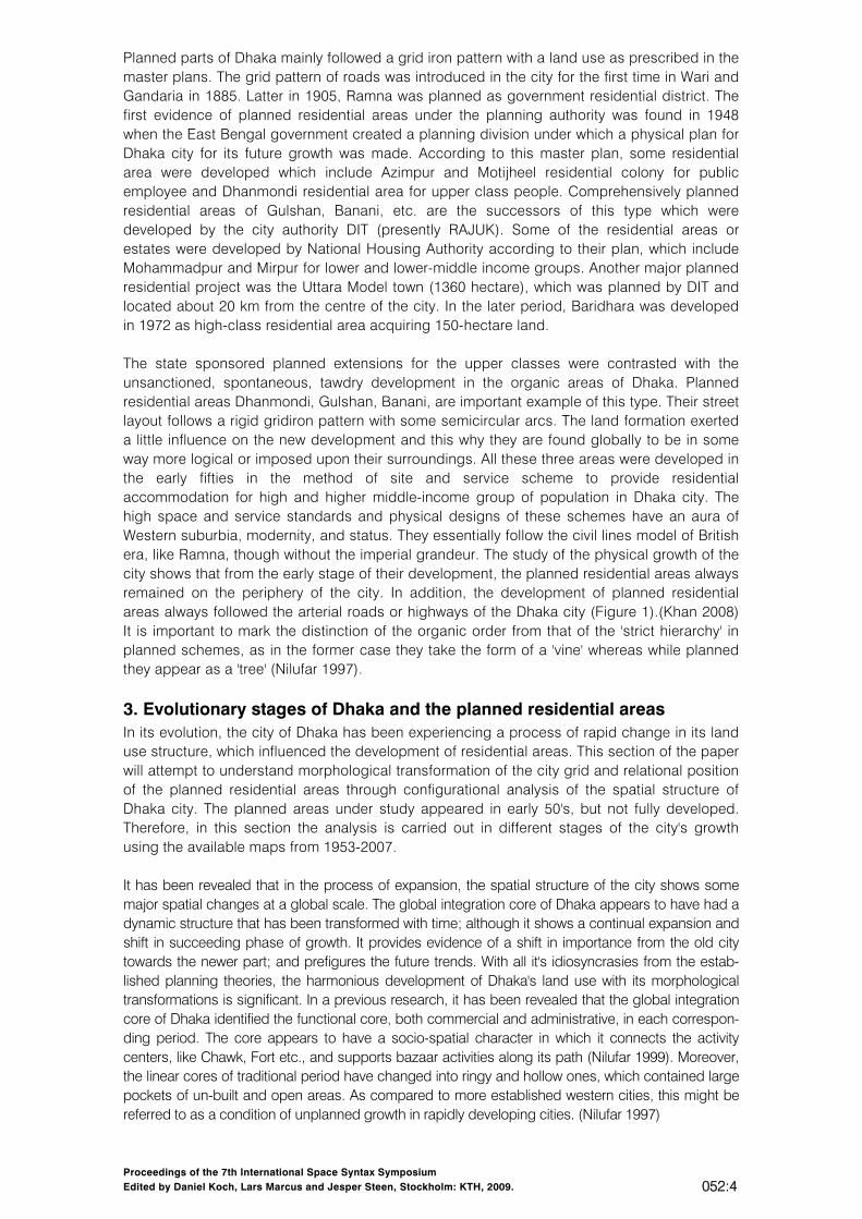
Figure 1 Location of the planned residential areas within the urban grid of Dhaka city
Proceedings of the 7th International Space Syntax Symposium Edited by Daniel Koch, Lars Marcus and Jesper Steen, Stockholm: KTH, 2009. 052:4
Planned parts of Dhaka mainly followed a grid iron pattern with a land use as prescribed in the master plans. The grid pattern of roads was introduced in the city for the first time in Wari and Gandaria in 1885. Latter in 1905, Ramna was planned as government residential district. The first evidence of planned residential areas under the planning authority was found in 1948 when the East Bengal government created a planning division under which a physical plan for Dhaka city for its future growth was made. According to this master plan, some residential area were developed which include Azimpur and Motijheel residential colony for public employee and Dhanmondi residential area for upper class people. Comprehensively planned residential areas of Gulshan, Banani, etc. are the successors of this type which were developed by the city authority DIT (presently RAJUK). Some of the residential areas or estates were developed by National Housing Authority according to their plan, which include Mohammadpur and Mirpur for lower and lower-middle income groups. Another major planned residential project was the Uttara Model town (1360 hectare), which was planned by DIT and located about 20 km from the centre of the city. In the later period, Baridhara was developed in 1972 as high-class residential area acquiring 150-hectare land. The state sponsored planned extensions for the upper classes were contrasted with the unsanctioned, spontaneous, tawdry development in the organic areas of Dhaka. Planned residential areas Dhanmondi, Gulshan, Banani, are important example of this type. Their street layout follows a rigid gridiron pattern with some semicircular arcs. The land formation exerted a little influence on the new development and this why they are found globally to be in some way more logical or imposed upon their surroundings. All these three areas were developed in the early fifties in the method of site and service scheme to provide residential accommodation for high and higher middle-income group of population in Dhaka city. The high space and service standards and physical designs of these schemes have an aura of Western suburbia, modernity, and status. They essentially follow the civil lines model of British era, like Ramna, though without the imperial grandeur. The study of the physical growth of the city shows that from the early stage of their development, the planned residential areas always remained on the periphery of the city. In addition, the development of planned residential areas always followed the arterial roads or highways of the Dhaka city (Figure 1).(Khan 2008) It is important to mark the distinction of the organic order from that of the 'strict hierarchy' in planned schemes, as in the former case they take the form of a 'vine' whereas while planned they appear as a 'tree' (Nilufar 1997).
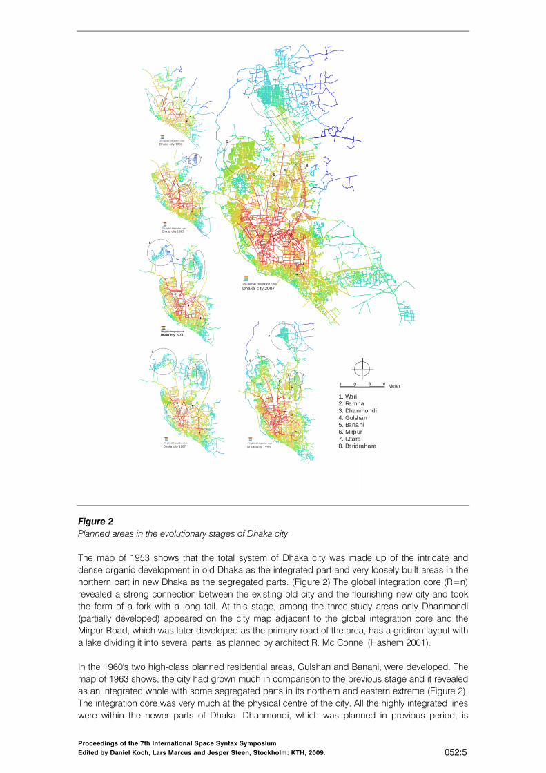
3. Evolutionary stages of Dhaka and the planned residential areas In its evolution, the city of Dhaka has been experiencing a process of rapid change in its land use structure, which influenced the development of residential areas. This section of the paper will attempt to understand morphological transformation of the city grid and relational position of the planned residential areas through configurational analysis of the spatial structure of Dhaka city. The planned areas under study appeared in early 50's, but not fully developed. Therefore, in this section the analysis is carried out in different stages of the city's growth using the available maps from 1953-2007. It has been revealed that in the process of expansion, the spatial structure of the city shows some major spatial changes at a global scale. The global integration core of Dhaka appears to have had a dynamic structure that has been transformed with time; although it shows a continual expansion and shift in succeeding phase of growth. It provides evidence of a shift in importance from the old city towards the newer part; and prefigures the future trends. With all it's idiosyncrasies from the estab-lished planning theories, the harmonious development of Dhaka's land use with its morphological transformations is significant. In a previous research, it has been revealed that the global integration core of Dhaka identified the functional core, both commercial and administrative, in each correspon-ding period. The core appears to have a socio-spatial character in which it connects the activity centers, like Chawk, Fort etc., and supports bazaar activities along its path (Nilufar 1999). Moreover, the linear cores of traditional period have changed into ringy and hollow ones, which contained large pockets of un-built and open areas. As compared to more established western cities, this might be referred to as a condition of unplanned growth in rapidly developing cities. (Nilufar 1997)
Proceedings of the 7th International Space Syntax Symposium Edited by Daniel Koch, Lars Marcus and Jesper Steen, Stockholm: KTH, 2009. 052:5
Dhaka city 20072% global Integration core
1
2
3
54
6
7
8
Dhaka c ity 19735% global Integration core
Dhaka c ity 19732% global Integration core
1
23
54
6
2% global Integration core
Dhaka c ity 1987
1
2
3
54
6
1
2
3
5
4
6
7
8
1. Wari 2. Ramna3. Dhanmondi4. Gulshan5. Banani6. Mirpur7. Uttara8. Baridrahara
Dhaka c ity 19632% global Integration core
1
2
4
3
3 0 3 6 Meter
1
23
Figure 2 Planned areas in the evolutionary stages of Dhaka city The map of 1953 shows that the total system of Dhaka city was made up of the intricate and dense organic development in old Dhaka as the integrated part and very loosely built areas in the northern part in new Dhaka as the segregated parts. (Figure 2) The global integration core (R=n) revealed a strong connection between the existing old city and the flourishing new city and took the form of a fork with a long tail. At this stage, among the three-study areas only Dhanmondi (partially developed) appeared on the city map adjacent to the global integration core and the Mirpur Road, which was later developed as the primary road of the area, has a gridiron layout with a lake dividing it into several parts, as planned by architect R. Mc Connel (Hashem 2001). In the 1960's two high-class planned residential areas, Gulshan and Banani, were developed. The map of 1963 shows, the city had grown much in comparison to the previous stage and it revealed as an integrated whole with some segregated parts in its northern and eastern extreme (Figure 2). The integration core was very much at the physical centre of the city. All the highly integrated lines were within the newer parts of Dhaka. Dhanmondi, which was planned in previous period, is
Proceedings of the 7th International Space Syntax Symposium Edited by Daniel Koch, Lars Marcus and Jesper Steen, Stockholm: KTH, 2009. 052:6
almost completely developed in this period. Syntactic analysis of 1963 map show that major roads of Dhanmondi coincide with the global core of Dhaka city. At this stage, the study area Gulshan was partially developed at the northern periphery of the city over an area of 715 acres. It was far away from the global integration core of Dhaka city in the initial stage. After the independence (in 1971), as there was a demand for more plots in Gulshan area, the government acquired more land at the northern part of this area for extension. Finally, Gulshan was developed as high-class residential area with 986 acres of land (RAJUK 2002). Although RAJUK started the residential development program of Banani in 1961, it was developed as a medium density high-class residential area after the independence in 1971 with 140 hectare of land and continuation of a lake, which exist inside Gulshan and Banani. In 1973, the growth of Dhaka city indicated by the previous stage comes to fruition. But the tendency to consolidate the urban grid was much more striking at the periphery than in the centre. The global integration core was identical to the core of 1960's and started to grow towards north. At this stage, Banani appeared on the map beside Gulshan residential area. But these two areas remained far away from the global integration core of this period. However, the study area Dhanmondi became part of the global integration core (Figure 2). In the map of 1987, the city had grown very little in comparison to the previous stage except the development of Progoti Sharani Road on the eastern edge of Dhaka. For that, the integration core remained static. In this period, Dhanmondi residential area was attached to the global core but Gulshan and Banani could not yet attain any global importance. In 1995, the total structure of the city gave the impression of being well balanced with integrated parts at the physical center and segregated part toward the periphery. The global integration core consists of two reverse wedges which coincide with three major thoroughfares (Mirpur Road, Mymansingh Road and Green Road) and Dhanmondi was attached to one of these wedges. The integration core was inclined toward east with respect to the total city structure and started to follow the Bijoy Sharani and Dhaka Mymansingh Road. Gulshan and Banani residential area were close to the global core of Dhaka city and started to get the global importance in this period (Figure 2). In the map of 2007, we find the structure of the city has extended further towards east with a segregated part in the east and north side of the city. Progoti Sharani Road located at the east side of Gulshan area started to get a degree of global importance. As a result, Gulshan and Banani residential area gained global importance in the city. The global core has extended beyond the limit of the previous stage and spread toward north and southeastern portion of the city (Figure 2). In this period, the spatial structure of Dhanmondi planned area show very little change in comparison to the previous stages. These observations regarding the shifting nature of global integration core shed light on the analysis of planned areas as embedded system in the city grid.
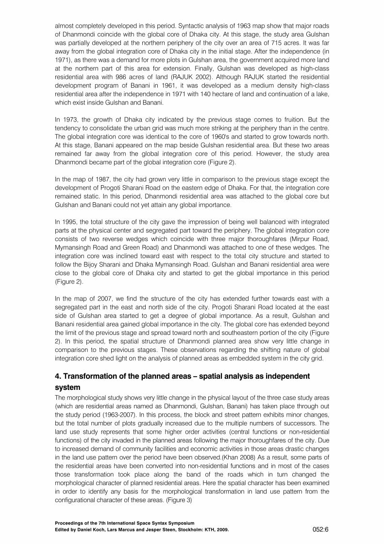
4. Transformation of the planned areas – spatial analysis as independent system The morphological study shows very little change in the physical layout of the three case study areas (which are residential areas named as Dhanmondi, Gulshan, Banani) has taken place through out the study period (1963-2007). In this process, the block and street pattern exhibits minor changes, but the total number of plots gradually increased due to the multiple numbers of successors. The land use study represents that some higher order activities (central functions or non-residential functions) of the city invaded in the planned areas following the major thoroughfares of the city. Due to increased demand of community facilities and economic activities in those areas drastic changes in the land use pattern over the period have been observed.(Khan 2008) As a result, some parts of the residential areas have been converted into non-residential functions and in most of the cases those transformation took place along the band of the roads which in turn changed the morphological character of planned residential areas. Here the spatial character has been examined in order to identify any basis for the morphological transformation in land use pattern from the configurational character of these areas. (Figure 3)
Proceedings of the 7th International Space Syntax Symposium Edited by Daniel Koch, Lars Marcus and Jesper Steen, Stockholm: KTH, 2009. 052:7
1973 1987
DHANMONDI R/A
1963 1987 1995 2007
GULSHAN R/A
BANANI R/A
1963LocalIntegration ( R4)
LocalIntegration ( R4)
LocalIntegration ( R4)
1995LocalIntegration ( R4)
2007LocalIntegration ( R4)
1963LocalIntegration ( R4)
1973LocalIntegration ( R4)
1987LocalIntegration ( R4)
1995LocalIntegration ( R4)
2007LocalIntegration ( R4)
LocalIntegration ( R4)
LocalIntegration ( R4)
LocalIntegration ( R4)
LocalIntegration ( R4)
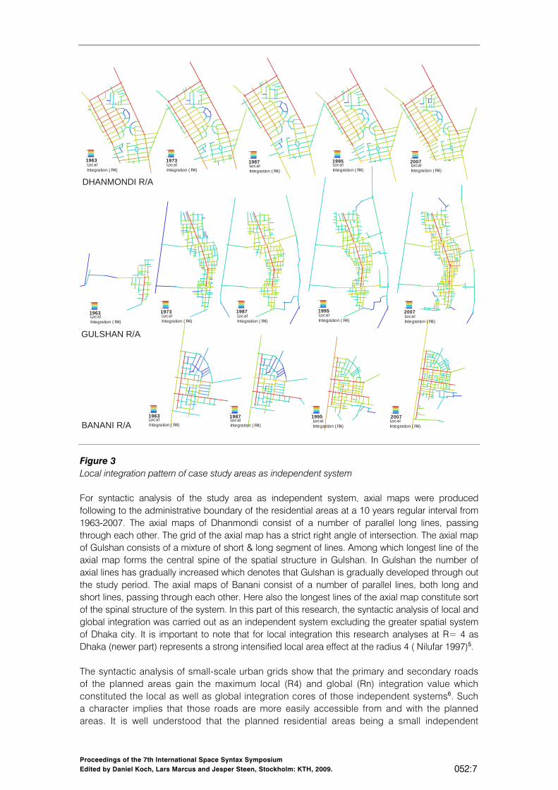
Figure 3 Local integration pattern of case study areas as independent system For syntactic analysis of the study area as independent system, axial maps were produced following to the administrative boundary of the residential areas at a 10 years regular interval from 1963-2007. The axial maps of Dhanmondi consist of a number of parallel long lines, passing through each other. The grid of the axial map has a strict right angle of intersection. The axial map of Gulshan consists of a mixture of short & long segment of lines. Among which longest line of the axial map forms the central spine of the spatial structure in Gulshan. In Gulshan the number of axial lines has gradually increased which denotes that Gulshan is gradually developed through out the study period. The axial maps of Banani consist of a number of parallel lines, both long and short lines, passing through each other. Here also the longest lines of the axial map constitute sort of the spinal structure of the system. In this part of this research, the syntactic analysis of local and global integration was carried out as an independent system excluding the greater spatial system of Dhaka city. It is important to note that for local integration this research analyses at R= 4 as Dhaka (newer part) represents a strong intensified local area effect at the radius 4 ( Nilufar 1997)5. The syntactic analysis of small-scale urban grids show that the primary and secondary roads of the planned areas gain the maximum local (R4) and global (Rn) integration value which constituted the local as well as global integration cores of those independent systems6. Such a character implies that those roads are more easily accessible from and with the planned areas. It is well understood that the planned residential areas being a small independent

Proceedings of the 7th International Space Syntax Symposium Edited by Daniel Koch, Lars Marcus and Jesper Steen, Stockholm: KTH, 2009. 052:8
systems represent a localized system in which the locally important roads always coincide with the global integration core (i.e. Rn of independent systems) and get importance to the local inhabitants as well as to outsiders. Analysis shows that this spatial character stayed more or less consistent throughout the study period. Therefore, the case study areas remained intelligible as an independent system. According to space syntax, in a more intelligible system the movement pattern is predictable from the measure of integration, and by this it is meant that the most integrated lines are most intensely used by the people (Hillier et al.1987). As a result, while comparing the present land use data with the local integration pattern (R4) of these case study areas, the study shows that with the passage of time the non-residential activities have invaded along those locally important roads violating the planning regulations as these roads were initially assigned for residential uses (Table 2). In the initial master plan, non- residential, i.e. mainly commercial function was not allowed in any of these three residential areas except the circle-1 & circle-2 of Gulshan. Later on, in response to spontaneous transformation/ evolution of land uses, non-residential functions were allowed on certain streets with conversion fee7 within those planned residential areas of Dhaka. Besides, the access roads located at the inner parts of the planned residential areas contain the larger number of plot used for residential purpose.
Period 1963 1973 1987 1995 2007
Dha
nmon
di R=n Max 1.94 2.07 2.14 2.22 2.14
R=n Min 0.82 0.76 0.78 0.84 0.73 R=4 Max 2.19 2.34 2.38 2.43 2.43 R=4 Min 0.96 0.90 0.89 0.80 0.63
R^=Rn-R4 0.97 0.97 0.98 0.98 0.97
Gul
shan
R=n Max 2.54 1.95 1.71 1.66 1.75 R=n Min 0.39 0.74 0.51 0.51 0.52 R=4 Max 2.54 2.51 2.50 2.54 2.60 R=4 Min 0.39 0.96 0.39 0.55 0.35
R^=Rn-R4 0.99 0.81 0.84 0.89 0.85
Ban
ani
R=n Max N/A 2.63 2.75 2.52 2.68 R=n Min N/A 1.00 1.04 0.69 0.64 R=4 Max N/A 2.63 2.74 2.76 3.01 R=4 Min N/A 1.18 1.20 0.58 0.59
R^=Rn-R4 N/A 0.96 0.96 0.98 0.99
Table 1 Syntactic variables of planned areas of Dhaka city as independent system Such a pattern of inconsistency between the land use transformation and syntactic attributes of the independent systems lead to look beyond the boundary of planned areas. To find out any logical cause behind such socio-spatial unpredictability, the planned residential areas were analyzed as a local spatial systems articulated within the whole urban system. In the next part it is examined how the integrated (R=4) roads of local areas (i.e. planned areas) became part of the global integration core of the organic city (unplanned city). In doing so, the paper describes how the planned residential areas of Dhaka city are plugged in the organic city grid, which is primarily unplanned in nature and grown spontaneously without any pre-conceived planning perspective. Thus it tries to determine any spatial logic behind the land use transformation as occurred in the planned residential areas of Dhaka city. Comparison of recently introduced non-residential function with the spatial structure of independent system (Figure 4, 5, 6) suggests that land use conversion seems to follow the local integration (R4) pattern in individual areas. This represents an accurate representation of the

Proceedings of the 7th International Space Syntax Symposium Edited by Daniel Koch, Lars Marcus and Jesper Steen, Stockholm: KTH, 2009. 052:9
assumptions as extended by space syntax theory. Following this, it appears that the independent system of the planned areas have been evolved effectively as residential neighbourhoods. In spite of that some idiosyncrasies raised suspicion. Such as, few roads having lower local integration (R4) value contain higher percentage of non–residential activities, such as South Gulshan Avenue and North Gulshan Avenue. In the same way, in Dhanmondi, Road 2, 4, 5, 6, 7, 8 show the similar pattern. Major incongruity lies with the fact that the land use transformation within the residential areas were not limited within localized activities; rather they attracted city scale commercial functions.
Area
Name of Road
Local Integration (Rn) (Independent System)
Global Integration (Rn) (Independent System)
Global Integration (Rn) (embedded System
Land use (%)
Res. Non-res.
DH
AN
MO
ND
I R
/A Mirpur
Road Seg-01 2.02 2.1079 0.80
2.09 97.91 Seg-02 2.31 1.732 0.79 Satmasjid Road 2.41 2.1404 0.70 16.98 83.01 Road #27 2.31 2.0972 0.74 28.85 71.64 Road #02 2.01 1.7447 0.75 23.25 76.75 Road # 04 1.55 1.266 0.75 30.76 69.23 Road #12 2.01 1.6033 0.66 34.48 65.51 Road #09 2.02 1.6033 0.66 35.3 64.7 Road # 26 2.16 1.9048 0.70 49 51
GU
LSH
AN
R/A
Gul
shan
A
venu
e Seg-01 1.68 1.126 0.66 10.86 89.14
Seg-02 2.41 1.6363 0.64 20.87 79.13 Seg-03 2.60 1.7459 0.68
Seg-04 2.51 1.3247 0.68 24.5 75.5 North Gul. Ave. 1.98 1.3941 0.70 19.14 80.85 South Gul. Ave. 1.96 1.2388 0.66 25 75 Road #103 2.18 1.403 0.66 52.17 47.83 Road #113 2.23 1.4632 0.64 34.48 65.51 Road # 116 & 126 2.05 1.3475 0.64 59.25 40.75
BA
NA
NI R
/A Kamal Ataturk 2.95 2.6784 0.69 6.25 93.75
Road #11 2.90 2.5226 0.67 21.96 78.04 Road #04 3.0 2.5093 0.65 42.75 57.25 Road #08 2.62 2.5093 0.65 52.83 47.16 Road #10 2.40 2.2921 0.65 36.73 63.27
Table 2 Transformation of land use pattern following the ranking order of the integration value and functional order of the street system as independent system (2007).
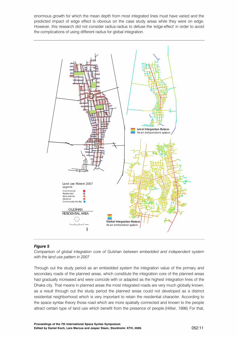
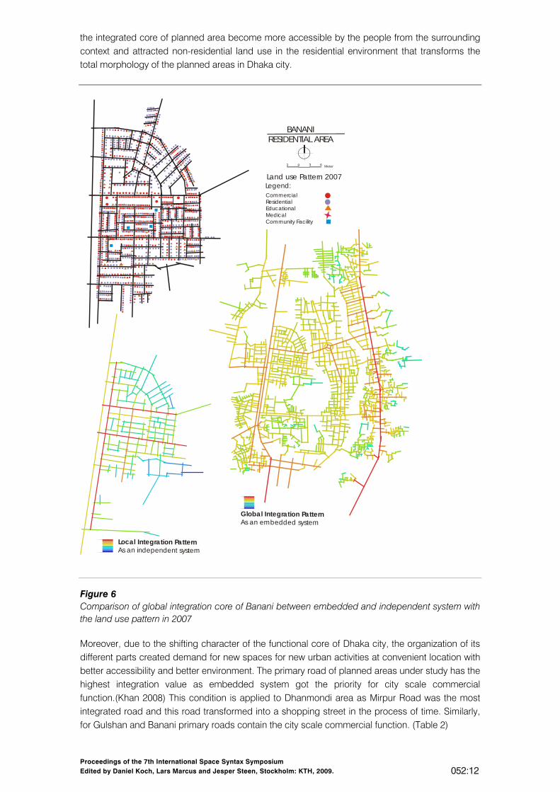
5. The urban core and the planned areas as embedded system In this part, the aim is to understand how the land use pattern of the planned areas has been transformed in relation to the changing configurational properties of the spatial structure of Dhaka city. This leads to analyze the planned residential areas as embedded system in the organic urban grid of Dhaka city. The properties of urban core define the spaces, which are more easily accessible or best integrated into the urban layout as a whole. In this research, the pattern of the global integration core of Dhaka city is formed of the highest 10% globally integrated lines. This integration core shows the pattern of accessibility to the area from the surrounding context and represent how the inside of a settlement can be reached from the out side and where the greatest possibilities of movement are likely to occur. Rather this study mainly concentrate on to compare the global integration core of planned areas as an embedded system with the urban core of Dhaka city of 2007 to show how much it is overlapped with the planned area. (Figure 4, 5, 6)

Proceedings of the 7th International Space Syntax Symposium Edited by Daniel Koch, Lars Marcus and Jesper Steen, Stockholm: KTH, 2009. 052:10
Global Integration PatternAs an embedded system
Land use Pattern 2007
CommercialResidentialEducationalMedicalCommunity Facility
Legend:
DHANMONDI RESIDENTIAL AREA
3 0 3 6 Meter
Local Integration PatternAs an independent system
Figure 4 Comparison of global integration core of Dhanmondi between embedded and independent system with the land use pattern in 2007 From the evolutionary changes (Figure 2) it is evident that, at the early stage of the study period, the study areas like Dhanmondi, Gulshan, Banani once lying at the periphery of the city and was developed as a secluded layout with distinctively different local structure from their surrounding. Due to the inward as well as outward growth of the city and the changes in the integration pattern of the whole system, the global core of Dhaka city tend to shift and the case study area become more integrated with in the whole system. These changes in the morphological character of the study area as a part of the whole city must have some influence in transforming the morphological component specially land use in the planned areas. Here it is important to note that the case study areas were initially located at the edge of the city which was later engulfed by the successive growth (unplanned) of the city. The following part shows how the once segregated planned residential areas laying at the edge gained higher position in terms of integration in due course of city growth. In spatial analysis, changing position of case study areas in terms of global position must have some impact from 'edge-effect' 8. This paper conjectures that as the city experienced
Proceedings of the 7th International Space Syntax Symposium Edited by Daniel Koch, Lars Marcus and Jesper Steen, Stockholm: KTH, 2009. 052:11
enormous growth for which the mean depth from most integrated lines must have varied and the predicted impact of edge effect is obvious on the case study areas while they were on edge. However, this research did not consider radius-radius to defuse the 'edge-effect' in order to avoid the complications of using different radius for global integration.
Global Integration PatternAs an embedded system
Land use Pattern 2007
Commerc ialResidentialEducationalMedicalCommunity Facility
Legend:
GULSHANRESIDENTIAL AREA
3 0 3 6 Meter
Local Integration PatternAs an independent system
Figure 5 Comparison of global integration core of Gulshan between embedded and independent system with the land use pattern in 2007 Through out the study period as an embedded system the integration value of the primary and secondary roads of the planned areas, which constitute the integration core of the planned areas had gradually increased and were coincide with or adapted as the highest integration lines of the Dhaka city. That means in planned areas the most integrated roads are very much globally known, as a result through out the study period the planned areas could not developed as a distinct residential neighborhood which is very important to retain the residential character. According to the space syntax theory those road which are more spatially connected and known to the people attract certain type of land use which benefit from the presence of people.(Hillier, 1996) For that,
Proceedings of the 7th International Space Syntax Symposium Edited by Daniel Koch, Lars Marcus and Jesper Steen, Stockholm: KTH, 2009. 052:12
the integrated core of planned area become more accessible by the people from the surrounding context and attracted non-residential land use in the residential environment that transforms the total morphology of the planned areas in Dhaka city.
Global Integration PatternAs an embedded system
Land use Pattern 2007
CommercialResidentialEducationalMedicalCommunity Facility
Legend:
BANANIRESIDENTIAL AREA
3 0 3 6 Meter
Local Integration PatternAs an independent system
Figure 6 Comparison of global integration core of Banani between embedded and independent system with the land use pattern in 2007 Moreover, due to the shifting character of the functional core of Dhaka city, the organization of its different parts created demand for new spaces for new urban activities at convenient location with better accessibility and better environment. The primary road of planned areas under study has the highest integration value as embedded system got the priority for city scale commercial function.(Khan 2008) This condition is applied to Dhanmondi area as Mirpur Road was the most integrated road and this road transformed into a shopping street in the process of time. Similarly, for Gulshan and Banani primary roads contain the city scale commercial function. (Table 2)

Proceedings of the 7th International Space Syntax Symposium Edited by Daniel Koch, Lars Marcus and Jesper Steen, Stockholm: KTH, 2009. 052:13
By comparing the land use pattern of the planned area with the global integration value, It is revealed from the figure 4, 5, 6 that the integration pattern of the independent system is quite different from that of the embedded system. Many parts of the planned area attained higher global integration value while it is embedded in the city grid and the land use pattern directly corresponds to those. It can be stated that land use invasion seems following the highly integrated lines and the character of the residential area is being drastically changed. This case is evident from Road 2, 4, 5, 8, 9A, 10A in Dhanmondi. In case of Gulshan, land use of Road 96, 99,100,102,101,126,132,133 shows a synchrony with the integration pattern revealed as embedded system, which is drastically changed in compared to independent system. In the similar pattern Road no 7, 10, 12 of Banani holds concentrations of non- residential functions, which has attained higher integration in embedded system. All these suggest that the dominating cause of land use transformation is determined by the organic city grid over the planned areas of Dhaka city.
6. Conclusion The brief historical and morphological overview has been highlighted the fact that because of unplanned nature of growth as well as with its vast territorial expansion, Dhaka city has undergone radical changes, not only in its sprawl but also through its internal physical transformation. In this city, planning intervened as piece meal efforts, which included a number of planned residential and commercial areas. Whereas, since historical time, organic growth characterized the spatial structure of Dhaka in general. The research findings show that the articulation of the planned areas within the spatial structure of the organic city of Dhaka reveals an inner order in organizing the planned area as a part of the whole system. In the process of transformation, each planned area, in spite of its rigid planning pre-determinants, has gained strong focus on its own local spine; at the same time those roads seem to attain global importance to certain degree. As a result, the city scale commercial function tends to grow along these local spines of planned residential areas. This sort of land use transformation beyond the rigid planning rationality seems has robust influence from the organic city grid as it engulfs the planned areas in due course of time. Over and above, this research identifies the influence of the global integration core of the organic city over its planned parts. The study reveals that the planned areas adopted certain degree of land use transformation, which is mainly guided by the pattern of local spatial structure of the planned area and the changing pattern of the growing city grid. Indeed, due to the shifting character of the global core of the unplanned spatial structure of Dhaka, the planned areas attained more global importance in certain phases. Thus it can be stated that the integration pattern of a organic city, like Dhaka, grasps the identity of the planned area and those area ultimately are being articulated with the unplanned part of the city grid with rigorous maladjustments with pre-planned decisions. As a result, city scale function invaded in the residential environments taking the lead from the global integration pattern of the city. Therefore, the finding of this research makes useful contribution to the knowledge of planning and development. Through understanding the inner order in organizing the planned area as a part of the whole urban system, this research will help to adjust the practical decisions of the planned residential area of Dhaka. In this process, any new planned interventions can be guided for possible transformation in due course of time and can also be planned through understanding how the transformation takes place and what aspect needs to be taken care off, if the city needs to remain as a workable whole. The research findings will create some amount of incentive for future researcher to improve the unplanned state of planned residential area due to their morphological transformation of land use pattern. So that, they can be adjusted at the right time and retain the residential character before turning to an unlivable state.
Notes 1 Space syntax defines the degree of spatial order, which exist in organic and planned layout by
analyzing the spatial configuration. This theory also proposes a fundamental relation between configuration of space in a city and that way that it functions. Integration is the relative depth or shallow ness of the system seen from any particular point within it. The integration value is then

Proceedings of the 7th International Space Syntax Symposium Edited by Daniel Koch, Lars Marcus and Jesper Steen, Stockholm: KTH, 2009. 052:14
rank order in to seven integration band varies from red to blue to represent the degree of integration. The set of most integrated street are collectively known as global integration core. The nature of the integration core, its shape size, coverage and so on depends basically on the connectedness and geometry of the urban system and on its mode of growth
2 Axial map is the basis of layout analysis. This refers how far observer can have an uninterrupted impression of visibility and permeability as they move about town and look at distance towards the various directions. The map is derived by drawing the fewest and longest lines of uninterrupted permeability, which are necessary to cover all public open space of an area the size of the system is measured in terms of the number of lines. (Hillier and Hanson 1984)
3 The SOB published maps of 1963, 1973, 1987, 1995, & 2007 are used as base map for generating axial maps. According to the administrative boundary, all the axial maps of planned area in different study period from (1963-2007) has been processed. As in the map of 1953, among three study areas, only 10% area of Dhanmondi was developed. For that the syntactic analysis was carried out for the year 1963-2007
4 Depthmap is primarily a computer-based program to perform configurational analyses, which come under the umbrella term of `space syntax'. Space syntax analyses examine the relationships between components of space; each analysis starts with a representation of the spatial components, then makes a graph of these components, and finally analyses this graph using for the most part, conventional graph theoretical measures.
5 In a previous research on localities and neighborhoods of Dhaka, it has been identified that new Dhaka represents intensified local area effect at the radius- 4, whereas the historic part characterized its localities at the radius- 3. (Nilufar 1997)
6 In any urban system, the integration core consists of most integrated road of the system and it mainly depends on the connectedness and geometry of the urban system and on its mode of growth.
7 Conversion of land use or building use was allowed to Road 27, Road 2 & Satmasjid Road in Dhanmondi; Gulshan Avenue, & North and South Avenue in Gulshan and Kamal Attaturk in Banani.
8 Edge effect is a phenomenon in axial analysis that occurs when the road that lie along the periphery of the axial map become segregated purely as a function of the size of the boundary selected for analysis (Penn et al., 1998).
References Hillier, Bill, Burdett, Richard, Peponis, John, and Penn Alen. 1987.Creating life or does architecture
determine anything?. Architecture and Behavior, vol-3 n-3 : 233-250. Hillier, Bill. 1996. “Cities as movement economies,” In Space is the Machine. United Kingdom. The
Press Syndicate of the University of Cambridge. Hashem, Maqsud. 2001. Trends of Development in Dhanmondi residential area of Dhaka city
M.U.R.P Thesis. Dept of Urban & Regional Planning. Bangladesh University of Engineering and Technology.
Islam, Nazrul. 1996. Dhaka from City to Mega city. Dhaka: Urban Studies Programme. Department of Geography, Dhaka University.
Islam, Nazrul. 2005. Dhaka now: Contemporary Urban Development. Bangladesh Geographical Society (BGS). Department of Geography, Dhaka University.
Nilufar, Farida. 1997. The Spatial and Social Structuring of Local Areas in Dhaka City - A Morphological Study of the Urban Grid with Reference to Neighbourhood Character within Naturally-grown Areas. PhD diss., University of London.
Nilufar, Farida. 1999. Spatial Structure of Urban Core and the Process of Transformation in Dhaka. Abstract and Paper accepted and Published in the Proceedings of the Sixth International Seminar on Urban Form (ISUF 1999), July 23-26 Italy.
Khan, Nayma. 2008. Study of Morphological Transformation in the Planned Residential Areas of Dhaka City. M.ARCH Thesis, Department of Architecture, Bangladesh University of Engineering and Technology.
Penn, A., Hillier, B., Bannister, D., and Xu, J. 1998. Configurational Modeling of Urban Movement Networks. Environment and Planning B: Planning and Design, 25, pp. 59-84.

Proceedings of the 7th International Space Syntax Symposium Edited by Daniel Koch, Lars Marcus and Jesper Steen, Stockholm: KTH, 2009. 052:15
Rajdhani Unnayan Kartipakkha (RAJUK). 2002. Dhaka Metropolitan Development Plan (DMDP). Detail area plan for Begunbari Khal and its influenced area, Location 4, Ministry of Housing & Public works, Government of Peoples Republic of Bangladesh.