Spatial Analysis of Dry Valley Floods in Salah Al-Din ...
19
Spatial Analysis of Dry Valley Floods in Salah Al-Din Governorate and Ramadan Valley Ali Mukhlif Sabea Department of Geography, College of Education for Humanities, Tikrit University, Tikrit, Iraq. ORCED: 0000-0001-93500-1522. E-mail: [email protected] Numman Hussain Atea Department of Geography, College of Education for Humanities, Tikrit University, Tikrit, Iraq. ORCED: 0000-0002-17448-6655. E-mail: [email protected] Sedeak Mustafa Jasim Department of Geography, College of Education for Humanities, Tikrit University, Tikrit, Iraq. ORCED: 0000-00002-0106-24479. E-mail: [email protected] Hussain Abid Ismaiel Department of Geography, College of Education for Humanities, Tikrit University, Tikrit, Iraq. ORCED: 0000-0002-7205-97366. E-mail: [email protected] Received September 12, 2019; Accepted December 27, 2019 Abstract Flash floods are considered to be one the worst kind of hazard. They are characterized by their suddenness, rarity, small scale, heavy rain and peak discharge, unpredictable, fast and violent movement. It has severe effects on human society in the form life losses, damages to property, roads, communication and on natural settings. Advances in hydrology, meteorology, engineering, using of GIS and remote sensing still not able to increase real time forecast. Researchers from
Transcript of Spatial Analysis of Dry Valley Floods in Salah Al-Din ...

Spatial Analysis of Dry Valley Floods in Salah Al-Din Governorate
and Ramadan Valley
Ali Mukhlif Sabea
Department of Geography, College of Education for Humanities, Tikrit University, Tikrit, Iraq.
ORCED: 0000-0001-93500-1522. E-mail: [email protected]
Numman Hussain Atea
Department of Geography, College of Education for Humanities, Tikrit University, Tikrit, Iraq.
ORCED: 0000-0002-17448-6655. E-mail: [email protected]
Sedeak Mustafa Jasim
Department of Geography, College of Education for Humanities, Tikrit University, Tikrit, Iraq.
ORCED: 0000-00002-0106-24479. E-mail: [email protected]
Hussain Abid Ismaiel
Department of Geography, College of Education for Humanities, Tikrit University, Tikrit, Iraq.
ORCED: 0000-0002-7205-97366. E-mail: [email protected]
Received September 12, 2019; Accepted December 27, 2019
Abstract
Flash floods are considered to be one the worst kind of hazard. They are characterized by their
suddenness, rarity, small scale, heavy rain and peak discharge, unpredictable, fast and violent
movement. It has severe effects on human society in the form life losses, damages to property,
roads, communication and on natural settings. Advances in hydrology, meteorology, engineering,
using of GIS and remote sensing still not able to increase real time forecast. Researchers from

Journal of Information Technology Management, 2019, Vol. 11, No. 4 38
developed countries have stressed to more focus to improve very short time an effective early
warning system with collaboration of local communities for flash flood risk supervision. The
data were combined with the Geographical Information System to analyze the temporal and
spatial distribution of flood events in Salah Al-Din Governorate and Ramadan Valley. The
analysis of the spatial distribution of the floods proves that most of the occurrences are recorded
in the southern part of the study area. Most of the flooded areas in the study area are mainly pre-
classified areas within the areas threatened by the flood due to the low level of its surface and its
proximity to the course of the main valley (Wadi Jarnav), which flows into the Tigris River. The
proposed method estimates the localization of sites prone to flood, and it may be used for flood
hazard assessment mapping and for flood risk management. It was therefore, suggested that
government agencies and policy makers should adopt this powerful technique for reliable and
well synthesized information which is a vital component of flood risk assessment and planning.
Keywords: Dry Valley Floods; Salah Al-Din Governorate; Ramadan Valley.
DOI: 10.22059/jitm.2019.74761 © University of Tehran, Faculty of Management
Introduction
The areas of Shirqat district are located in the transitional area between the semi-mountainous
regions of Iraq to the sedimentary plain area, which has a moderate slope that tends to the
shoulders of the Tigris River as it allows sudden flooding of the flood valleys adjacent especially
with heavy rains following the volatile climate prevailing in Iraq. This happened what was
expected to happen to the villages of Houriya and Khodrania affected by the floods coming from
the adjacent valley, which is the valley of Ramadan (Jarnav), which led to the sinking of these
villages with varying levels of water, especially the village of Houriya, which was affected by
the rapid and sudden floods that occurred at night, which flooded Most parts of this village, as
well as the village of Khadraniya affected by floods and high levels of the Tigris River. Note that
such a kind of flood does not occur annually and this gives reassurance to the inhabitants of the
region to live in the forbidden areas and therefore the occurrence of human and material losses,
and that the reasons for this annual fluctuation of the flood is due to the prevailing climate
fluctuations, but the occurrence of this flood to this degree causing losses due to several reasons
Natural and human we will come to mention later.
The location of the study area
The study area is determined by the area of flood occurrence, which is determined between the
longitudes (57° 25° 43° 43° 20 43° E) and two latitudes (20° 55° 35° 63° 50° 35°) north which
consist of the villages Al-Khadraniya, Al-Houriya and Shukran villages are the villages that
surround the estuary of Wadi Al-Jarnaf, map No. (1).

Spatial Analysis of Dry Valley Floods in Salah Al-Din Governorate and Ramadan ... 39
Map 1. Wadi Al - Ramadanyat (Jarnaf) and the distribution of villages in the study area
(Source: The work of the researcher based on satellite visual data and digital model)
Justification for the study
1. The area was hit by floods and devastating flash floods that led to huge human and
material losses in several villages of Shirqat, including the village of Houri and
Khadraniya.
2. The study area suffers from the decline of the agricultural area for several reasons, the
most important of which are: the successive years of drought and desert encroachment;
Ramadanis (Jarnav), which is characterized by fluctuation of discharge, depending on
the rainfall.
3. The presence of huge amounts of water that takes place during the rainy season,
especially in the spring in the valley of Jarnav and go without taking advantage of them.
4. Persuade decision-makers that the construction of small dams on the valley of Jarnav for
the purpose of harvesting water is necessary and is of great economic, social and
environmental feasibility.
5. Improving the living conditions of the residents of the Shirqat area and working to settle
the population of the area and prevent their migration towards urban centers.
Objectives of the study
The study aims to determine the impact and area of flooding in the study area and to calculate the
environmental and physical effects of the flood by showing its impact on human settlements, in
addition to the factors that led to this flood through the study of the valley through the analysis of
the water network of the basin in this The area to identify the most important hydrological

Journal of Information Technology Management, 2019, Vol. 11, No. 4 40
characteristics of the basin depending on the analysis of land cover capacity Controlling its
variations and variations represented (depth of runoff - runoff volume - volume of discharge), as
well as determining the most important reasons that led to the devastating floods in the region, in
addition to determining the appropriate site for the construction of a dam and the application of
water harvesting techniques and using modern geographic techniques. And the ways in which
this water wealth can be invested because of its long-term strategic dimensions
The importance of the study
The importance of the study was highlighted through the application of GIS techniques and RS
data in building a geographic database to calculate the environmental damage caused by the
flood and determine its results and causes by providing an advanced technical method of
measurement and morphometric analysis to reach accurate results that support the environmental
rehabilitation project of this valley. Provide advice to decision-makers in the establishment of
small dams for water retention, harvesting and development, treatment, storage and use of water
drainage for various purposes related to human activities. The importance of the study is also to
reveal the nature of hydrological processes Which is practiced in the basin and the resulting
effects which lead to an imbalance in the ecological balance of the basin, as well as the water
scarcity experienced by the region in the summer, and management of rainfall and rainfall
Studies of spatial analysis using modern techniques.
Spatial Analysis of Human Settlements Flooded in the Study Area
Spread of human settlements (villages) along the valley and the basin (53.5 km) and an area
(894) km2 of 32 villages, has varied in size in terms of population and the number of housing
units and in general villages tend to increase the population Whenever I went to the mouth of the
valley in the Tigris River, a number of residents of these villages made earthworks on some of
the waterways in this valley to benefit from storing water in the rainy period after the fifth month
of the year for the purpose of watering some crops and Breeding of livestock, these repayments
were among the many reasons that caused the flooding of this valley, because of the collapse of
these repayment after filling the depressions in front of the dams in one go.
The studied human settlements belong to the district of Shirqat within Salah al-Din governorate
within four villages threatened by flooding, Qura Al-Houriya, Al-Khadraniya, Al-Eitha and Shukran
villages. 500 to 1000 meters downstream.

Spatial Analysis of Dry Valley Floods in Salah Al-Din Governorate and Ramadan ... 41
Map 2. Human settlements in the study area
Source: Bariq, Unpublished Master Thesis, Tikrit University, College of Education for Humanities,
Department of Geography, 2018
The emergence of human settlements in the study area
The period of stay in the residential units in the two villages that were drowned by the torrential
torrents that swept through the valley of Jarnav, and the facts that can be noted in these villages,
have varied over the past 10 to 60 years. Fixed building materials (block, bricks and concrete)
reverse the predominant characteristic of residential units in the countryside of Iraq until the
nineties of the last century, which is mud construction and wood roofing and methods simulated
from reeds, and to show a detailed picture of the length of stay we will address as follows:
The village of Al-Khadraniya
Table 1 revealed that the number of housing units in the village amounted to (165) housing units.
The period of construction varied over (47%) of the housing units have been established since
(10-60) years. The previous period, despite the fall of the rain and in quantities not different from
what fell in this period, which indicates the existence of a reason for this large flooding of the
inhabitants of this village is not the amount of rain, as the table revealed that (36%) of the

Journal of Information Technology Management, 2019, Vol. 11, No. 4 42
housing units hard to exist between (4-10) (17 years) of which have been present in their current
places between (1-2) years, and it should be noted that the modern population units are T was
inundated (high water level) because of the proximity of these units to the base of the valley and
high water levels in it.
Table 1. Duration of Residence in Residential Units
The
village
name
Year Two
years
Proportion
of housing
units
3-6
years
Proportion
of housing
units
7-9
years Percentage
More
Than
10
years
Percentage
Al-
Khadrania 14 15 165 33 22.4% 25 15.1% 8 47.3%
Al-Hurria 02 2 1.9% 12 5.7% 5 2.4% 191 90.0%
Source: Field study and questionnaire
The village of Houriya
Table 1 revealed that the number of housing units in this village amounted to (212) housing
units. Of the total number of housing units in the village, the number of housing units that have
been established between (2-10) years is about (17) housing units (8%) of the total while the
modern houses number (4) housing units It is worth mentioning that the damage caused to the
residential units of this village is more than that of the residential units in Al-Khadrania village
due to the low level of the lands of these villages. So we found from the field visit that all the
housing units in this village were damaged with varying severity of damage according to the
proximity of the valley stream.
Human Damage Caused by the Flood
1. Deaths: The human damage varied between the two villages. The field study conducted by
the study team indicated that 83% of the deceased due to their drowning are from the village
of Houriya, with 15 people distributed among (9) males and (6) females. The number of
deceased in the village of Khadraniya (3) females 17 percent of the total number of deceased
in the two villages and it should be noted that most of the deaths in the villages were those
who live close to the course of the valley and who completed the construction of their role
before a short time, see Table 2.
Table 2. Casualties caused by the flood of Wadi Al-Jarnaf in the villages
The Village name Male Female Percentage
Al-Kadraniya 2 1 17%
Al-Hurriya 9 6 83%
Source: Field study and questionnaire
2. Livestock damage: The field study and Table 3 revealed that the damage of livestock was
more than that of Al-Houriya village, where the number of livestock that drowned in the

Spatial Analysis of Dry Valley Floods in Salah Al-Din Governorate and Ramadan ... 43
village of Al-Khadraniya reached (798) head between (cows, sheep, goats) and poultry
(chicken) (72%), while the village of Houriyeh, despite the increase in the number of housing
units in comparison with the village of Khadraniya, but the losses of livestock did not exceed
(30%) by (299) head between animals and birds, which indicates that the number of housing
units that were Breeding livestock in the vegetable is more than In addition, there are more
than (8) poultry fields in Al-Khadraniya that have been submerged due to the valley water; on
this side.
Table 3. Damage of livestock caused by the flood of Jarnaf Valley in the villages
The Village name Birds Chickens Cows\goats\sheeps
Al-Khadraniya 750 48
Al-Huriya 260 39
Total 1010 78 Source: Field study and questionnaire
3. Crop damage: The field study revealed that there are large areas of agricultural land, which
were planted with wheat, barley and vegetables, amounting to (318) dunums in the two
villages. 281 dunums and barley crop area (29) dunums while the area of agricultural land
affected in the village of Houriya (8) dunums only distributed between wheat crop (5) dunums
and barley crop (2) dunums and vegetables area (1) dunums.
4. Damage to services: The field study revealed that two schools were damaged, one in the
village of Houriyeh and the other in Khadraniya. Al-Khadraniya school was less water rise,
which caused less damage in terms of the spread of moisture throughout the classrooms and
the management rooms, but the fence, heavy water tank and furniture were not damaged as in
the school of the nymph.
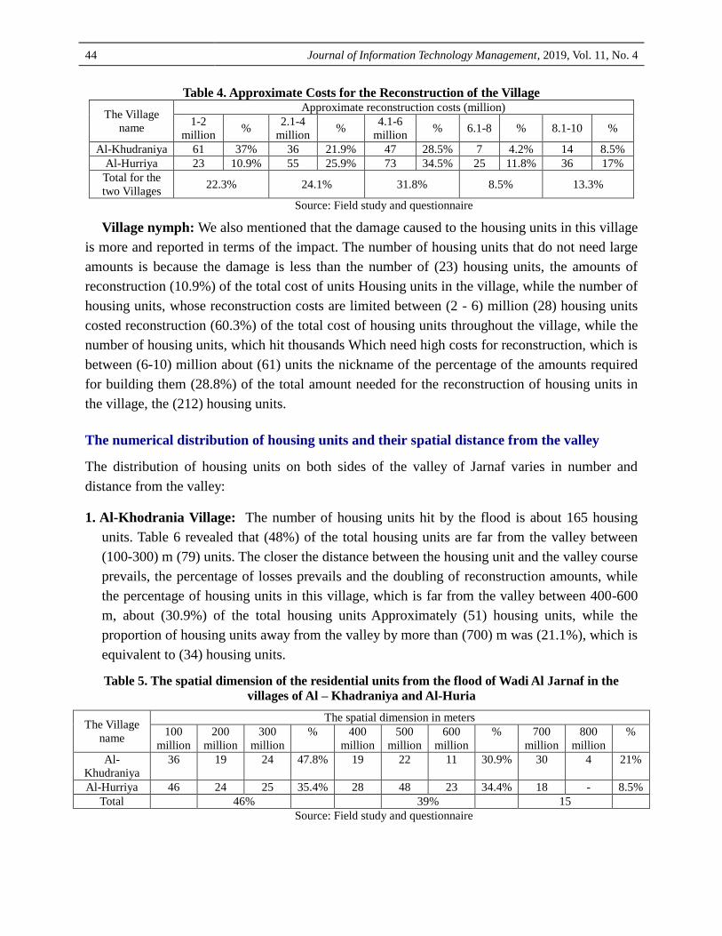
The approximate costs of renovating the housing units
Due to the varying spatial location of the valley stream of the residential units, it was reflected on
the amount of damage caused to them. The approximate costs for the reconstruction of housing
units:
1. Al-Khodrania Village: Table 4 revealed that the number of housing units requiring high costs
of restoration, which is limited to (6-10) million dinars, amounted to (21) housing units,
which constitute only (12.7%) of the cost of reconstruction of housing units in the village,
while the number of units was The housing units whose reconstruction costs are limited to
between (2 million - 6 million) (73) housing units constituting up to (50.4%) of the cost of
reconstruction of housing units in the village, while the number of housing units that do not
need large amounts, which is limited between (1) -2) million dinars (61) housing units, which
constitute (37%) of the total cost of reconstruction of housing units in the village, which
number(165) housing units.
Journal of Information Technology Management, 2019, Vol. 11, No. 4 44
Table 4. Approximate Costs for the Reconstruction of the Village
The Village
name
Approximate reconstruction costs (million)
1-2
million %
2.1-4
million %
4.1-6
million % 6.1-8 % 8.1-10 %
Al-Khudraniya 61 37% 36 21.9% 47 28.5% 7 4.2% 14 8.5%
Al-Hurriya 23 10.9% 55 25.9% 73 34.5% 25 11.8% 36 17%
Total for the
two Villages 22.3% 24.1% 31.8% 8.5% 13.3%
Source: Field study and questionnaire
Village nymph: We also mentioned that the damage caused to the housing units in this village
is more and reported in terms of the impact. The number of housing units that do not need large
amounts is because the damage is less than the number of (23) housing units, the amounts of
reconstruction (10.9%) of the total cost of units Housing units in the village, while the number of
housing units, whose reconstruction costs are limited between (2 - 6) million (28) housing units
costed reconstruction (60.3%) of the total cost of housing units throughout the village, while the
number of housing units, which hit thousands Which need high costs for reconstruction, which is
between (6-10) million about (61) units the nickname of the percentage of the amounts required
for building them (28.8%) of the total amount needed for the reconstruction of housing units in
the village, the (212) housing units.
The numerical distribution of housing units and their spatial distance from the valley
The distribution of housing units on both sides of the valley of Jarnaf varies in number and
distance from the valley:
1. Al-Khodrania Village: The number of housing units hit by the flood is about 165 housing
units. Table 6 revealed that (48%) of the total housing units are far from the valley between
(100-300) m (79) units. The closer the distance between the housing unit and the valley course
prevails, the percentage of losses prevails and the doubling of reconstruction amounts, while
the percentage of housing units in this village, which is far from the valley between 400-600
m, about (30.9%) of the total housing units Approximately (51) housing units, while the
proportion of housing units away from the valley by more than (700) m was (21.1%), which is
equivalent to (34) housing units.
Table 5. The spatial dimension of the residential units from the flood of Wadi Al Jarnaf in the
villages of Al – Khadraniya and Al-Huria
The Village
name
The spatial dimension in meters
100
million
200
million
300
million
% 400
million
500
million
600
million
% 700
million
800
million
%
Al-
Khudraniya
36 19 24 47.8% 19 22 11 30.9% 30 4 21%
Al-Hurriya 46 24 25 35.4% 28 48 23 34.4% 18 - 8.5%
Total 46% 39% 15
Source: Field study and questionnaire

Spatial Analysis of Dry Valley Floods in Salah Al-Din Governorate and Ramadan ... 45
2. The village of Houriya: The number of housing units that have been flooded and submerged
in varying proportions (212) housing units, and Table 5 based on the field study revealed that
(95) housing units away from the valley with a distance of (100-300) m, by (44.8%). It is
these units that have been flooded at higher levels than the rest of the housing units being
closer to the valley stream, while The number of housing units that are far from the course
between (400-600) m and (46%) of the total number of housing units, and it should be noted
that these units, despite the spatial distance from the valley, but it was affected by the high
moisture content of the soil A large scale in these housing units with the collapse of some
reservoirs of heavy water and external fences of these units, while the housing units that are
more than (700) m from the valley has reached (18) housing units formed (8.5%) of the total
housing units. The damage was less compared to other units, and in general the proportion of
housing units that was damaged Adults in both villages, which are (100-600) meters (85.1%).
Map 3. Spatial Dimensions of Residential Units from Wadi Ramadanyat Stream
(Source: The work of the researcher based on satellite visual data and field study)

Journal of Information Technology Management, 2019, Vol. 11, No. 4 46
The qualitative distribution of damage to the housing units in the villages of Al-Khadraniya
and Houriya
The field study carried out by the research team revealed that the damage caused to the housing
units inside the village and between the two housing units of the two villages was found to be
greater. The rise in Al-Khadraniya, which caused water levels to inundate a large number of
housing units in the nymph and a higher elevation than in Al-Khadraniya.
Damage to residential units in Al-Khadraniya village: Table 6 revealed that the housing
units that were partially damaged (ie, humidity, demolition of heavy water tank) or any other
damage were (85) housing units (51.5%) of the total number of housing units in Al-Khadraniya
which were damaged. (165) housing units, while the number of housing units that were totally
damaged (the humidity of the collapse of the external fence, water tank (heavy, external utilities)
due to high water levels flooded by about (80) housing units (48.5%). Of the total, if we
separated the damage to the housing units, we found that the largest number of housing units hit
by moisture and spread in nearly (162) housing units (98%), while the damage to the collapse of
external facilities ranked second numerically by about (132) housing units by The collapse of the
heavy water tank reached the third rank with about (126) housing units (76.3%).
Damage to residential units in the village of Houriya: We have pointed out in more than
one place in this study that the damage to housing units in this field is the most numerous and
reported the kind of high water levels that flooded this village, the field study and Table
7revealed that the partially damaged housing units amounted to (41) housing units (19.3% of the
total housing units that were damaged) (212) housing units in the village, while 85 housing units
(400%) were totally damaged of the total number of damaged housing units in the village, it
shows the qualitative and quantitative variation of the damages that hit the residential units if the
qualitative vocabulary of the damages is detailed as the humidity came with the largest number
of housing units as it reached (122) housing units, or (57.5%) of the total housing units. Second:
The demolition of the external fence with (96) housing units (45.3%). The number of housing
units affected by the collapse of the heavy water tank and the collapse of the external utilities in
this village and the number of (92.93) respectively and (43.8 and 43.4%), respectively.
Looking at Table 7 shows that the humidity in both villages accounted for 75.3% of the
housing units, while the collapse of the external utilities and the heavy water tank constituted
59.5 and 58% respectively, then the collapse of the external fence 53% of the total housing units
in the two villages (377) housing units.
Spatial analysis of the flood and its causes in the study area
One of the first requirements to know the effects of floods and human, physical and
environmental losses of any area is to know the area of flooding and spatial coverage of flood
water. The area covered by water flooded by floods during the hours of more than 13 km 2,

Spatial Analysis of Dry Valley Floods in Salah Al-Din Governorate and Ramadan ... 47
which led to the sinking of the village of Houriya and parts of the village of Al-Khadraniya and
Al-Aaitha, thanks to the sinking of a large number of residential units as in Table 6.
Table 6. The area of flooding and the number of submerged buildings in the villages of
the study area
No. The village name The area of flooding
is 2 km
Number of submerged
buildings
1 Al- Hurry 2.161 212
2 Al-Khadraniya 1.734 165
3 Shukran 0.14 11
4 Al-A'etha 0.06 6
total 4.095 373
Source: Work of the researcher accreditation on map 2 and field study
The area covered by flooding, which starts from the north-west side of the villages, which unites at
the end of the valley of the Jarnaf estuary to expand fan to cover most of the Tigris River Basin and
thus covers most parts of the village of Houriya and Khadraniya map (2), and also varied the area that
was flooded with water Among the villages that reached the flood map No. (3), where the village of
Houriya suffered the most losses, where flooded 212 housing units and 165 housing units, while the
losses in the village of Shukra and Al-Aaitha are the lowest and did not cause losses to prevent
residents from staying in their housing units.

Journal of Information Technology Management, 2019, Vol. 11, No. 4 48
Map 4. Villages that have been flooded and flooded (Source: The work of the researcher based on
satellite visual data and digital modeling)
Picture 1. Shows houses flooded Picture 2. Water immersion level for homes
On 23/11/2018
Factors causing flooding in the study area: The reconstruction of the villages of
Khadraniya and Houriya requires that we look at the reasons that led to the flooding of this
valley at this particular time, although more than 80% of its housing units have been established
for more than 50 years and throughout this period their role has not been exposed to the flood. Or
partial flooding, however close to the residential units of the valley, indicating the existence of
the reasons that led to this flood and through the field study and questionnaire distributed to the
inhabitants of these villages shows that the reasons for the flood of this valley due to several
factors:
Natural factors
1. Climatic factors represented in the increase of rainfall, which amounted to more than 125 mm
in hours, while the annual revenue of this region in previous years is approximately 200 mm,
Table 7, Figure 1.
Table 7. Rainfall in Makhmour Station (1988-2013)
Months Jun. Feb. Mar. Apr. May June July Aug. Sep. Oct. Nov. Dec. Total
Rain\ml 99.2 61.5 43.7 48.7 9.6 0.7 0 0 7.3 11.1 27.1 37.6 346.5
Source: The work of the researcher based on the data of the Meteorological Authority of
Makhmour station for the period (1988-2013) (unpublished data).

Spatial Analysis of Dry Valley Floods in Salah Al-Din Governorate and Ramadan ... 49
Figure 1. Rainfall Rates for Makhmour Station (1988-2013)
Al-Khaderaniya village pointed to an increase in the amount of rainfall this year, while 85%
of the residents of Al-Houriya village, whose housing units were damaged, said that the increase
in rainfall is one of the main reasons for this flood. (28 It is noteworthy that this year is one of
the wet years in Iraq in general, where the periods of rainfall continued continuously without the
presence of long time intervals between periods of rainfall, and that the amounts were more than
compared to previous years, as indicated by the field study and Table 8. More than 81% of the
respondents from.4%) in the two villages causes the flood to Ze Dah amounts of rain falling.
Table 8. Causes of flooding in Al-Jarfaf Valley
The
village
Rains
Blockage of the
Crimean bridge
openings
Bridge collapse Dirt repayment
collapse
Near housing
from the valley
No. % No. % No. % No. % No. %
Al-
khudraniya 135 81% 128 77% 99 60% 73 44% 22 135%
Al-huriya 181 855 % 171 80.6% 149 70% 140 66% 8 3.7%
Total 83% 78.5% 65% 55% 8.3%
Source: Field study and questionnaire
2. Topographic factors: It is a factor that follows the main valley influencing the occurrence of
the flood, which is the valley of Ramadaniyat (Jarnaf). 00- 58 َ35 ° N, as in Figure 1-1, the
study area extends northwest of Shirqat, from the village of Miran (northwest) to the village
of Houriya (southeast), and runs in the Tigris River in the southern border of this village It
covers an area of about 894 km2, the length of the main valley is about 53.5 km, and the
height of the valley at the source is about 320 m above sea level. The end of the valley is 155
meters above sea level.

Journal of Information Technology Management, 2019, Vol. 11, No. 4 50
Map 5. Wadi Al-Ramadanyat Basin
(Source: Sabbar Abdullah Saleh and others, Morphological analysis and calculation of water revenue at the section
of the proposed dam on the valley of Jernav / Sharqat / northern Iraq, Journal of the Faculty of Science, No.)
Human factors
1. Blockage of old bridge openings: There are two bridges on the valley of Al-Jirnan, one of
them is more than 70 years old and the last one is next to the old bridge. In addition to the
function of draining the running water in Wadi Jarnaf towards the Tigris River through the
openings in the two bridges, the field study and questionnaire indicated that (77%) Some of
the respondents in Al-Khadraniya indicated that the cause of the flooding of this valley is the
blockage of water drainage holes in the two bridges due to the collapse of the surface of the
old bridge, which lies north of the new bridge and the closure of the drainage holes in the
second bridge. This led to a rise in the water levels in the valley and the exit of water to the
residential units and submerged them, whether partially or completely. While (80.6%) of the
respondents in the village of Houriya said that the cause of the flood in addition to the high
amounts of rain falling is the blockage of the bridges and no drainage of running water in the
valley.
2. The collapse of the old bridge:We also pointed out that the surface of the old bridge has
slipped towards the new bridge, which is only 7 m away from it. This slide led to the closure
of the drainage holes of the water. Distances of up to 70 km, which led to the closure of the
water drainage holes in the new bridge. These quantities led to the inundation of large

Spatial Analysis of Dry Valley Floods in Salah Al-Din Governorate and Ramadan ... 51
numbers of units Residential Diachlorus nymph, has revealed that the field study (21.4%)
Some of the respondents in al-Khadraniya village indicated that the collapse of the bridge is
one of the causes of flooding and the outflow of water from the waterway to the neighboring
housing units, while (23.5%) of al-Houriya village pointed to this reason.
3. The collapse of the sand repayment in the top of the valley: It is well known that the
residents who are away from the permanently flowing watercourses resort to storing or
harvesting water in different ways, especially those who are practicing grazing mainly as well
as agriculture, through the establishment of dirt on the valleys to store water during periods of
rain, for use in periods of interruption, The field study and spatial monitoring of the valley
showed that the population groups make a dirt repayment on the course of this valley over a
distance of (23) km from the sites of these villages are strengthening these repayment in the
period of rain of each year, and because this repayment does not have drainage holes for
excess water About the ability of these To repay to endure, the dam has collapsed The first
one, including the water behind it, and the flow of water to the second dam, the second dam
collapsed because of its inability to bear such quantities. To the west and to the fall of large
amounts of rain in the southern and southwestern sections of Mosul. That (16.8%) Al-
Khadraniya residents attributed the cause of the flood to this reason, while (21.6%) of the
inhabitants of al-Houriyya blamed the cause of the flood to this reason. The study team
believes that the cause of this flood is the reimbursement which did not have drainage holes
for the surplus water. The answer does not weaken this reason because a large proportion of
the inhabitants who were questioned do not know anything about these dirt repayments which
were placed in the top of the valley.
Figure 1. Shows the earth dams built on the valley basin
(Source: Bariq, Unpublished Master Thesis, Tikrit University, College of Education for Humanities,
Department of Geography, 2018)

Journal of Information Technology Management, 2019, Vol. 11, No. 4 52
Spatial Proximity: The approach of the people to the course and settlement through the
establishment of housing units is one of the reasons for the flood on the lack of impact, because
we have already shown that more than (80%) of the housing units in the villages of Khadraniya
and Hurriyah have been in these places near the valley more For 50 years, there was no flood
threatening the existence of these housing units, in addition to the competent authorities
(Department of Water Resources) There are no taboos for this valley to prevent residents from
exceeding them by building. Khadraniya was the cause of drowning because of its proximity to
the valley and that 3.7% of the housing units in the nymph is due to the sinking of the proximity
of the valley of the Jarnav.
Delayed government agencies in the completion of the proposed dam projects on this valley,
which would have significantly reduced the occurrence of floods and turn the forbidden areas in
the valley to safe areas. The construction of dams and reservoirs on the streams of small valleys,
rather than the construction of large dams that are expensive time, effort and money is the best
way to do so, as small valleys have a small storage capacity compared to large dams in addition
to be low cost to set up, taking into account the importance Water harvesting through reducing
the risks of flooding as well as the possibility of investing this water in the development of the
region in terms of agricultural, recreational and livestock development, where two sites were
elected to construct dams taking into account the previously mentioned aspects
In summary, (97%) of the reasons for the flood are due to four reasons are frequent rain,
clogged drainage holes for the old bridge, and the collapse of the old bridge and the collapse of
the dirt repayment at the top of the river valley, and does not constitute near the housing units of
the course of a significant impact, and may be due to a small percentage To the fear of the
respondents not to compensate them for the damage if they have given the impact of this factor.
Solutions and remedies to prevent future floods
1. The need for the relevant government authorities to establish dams to prevent floods in the
valley of Jarnav, as it can be proposed more than one dam in several sites that can be used
to reduce the floods in the future in addition to investing in the harvesting of rainwater to
be used in the reclamation of vast land in the region and can be used as means of transport
As bridges as well as for tourist purposes, map (5).
2. The need to alert the population of these areas not to settle near the main stream of the
valley and stay away from the forbidden and threatened by the flood
3. Directing the population not to set up informal, irregular earth repayments because of its
effect in increasing the risk of flooding.
4. The need for the concerned authorities to conduct periodic maintenance on the old bridge
to avoid the recurrence of disasters caused by the neglect of this bridge.

Spatial Analysis of Dry Valley Floods in Salah Al-Din Governorate and Ramadan ... 53
5. The need to dig waterways from the end of the basin to the Tigris River to facilitate the
flow of flood water to the Tigris and not to climb to neighboring villages.
Map 6. Proposed Dam Locations in the Study Area
(Source: Bariq, Unpublished Master Thesis, Tikrit University, College of Education for Humanities,
Department of Geography, 2018)
Conclusions
The most important conclusions reached by this study, which can be summarized in the
following points:
1. Most of the flooded areas in the study area are mainly pre-classified areas within the areas
threatened by the flood due to the low level of its surface and its proximity to the course of
the main valley (Wadi Jarnav), which flows into the Tigris River.
2. This year is an abnormal year from previous years in terms of the amount of annual rainfall,
if the estimated daily rainfall on the day the flood occurred is equivalent to annual revenue
for a full year.
3. There are a number of causes that increased the risk of this flood, the most important of
which is the establishment of random dirt repayment, and the lack of implementation of the

Journal of Information Technology Management, 2019, Vol. 11, No. 4 54
proposed storage projects in the region, as well as the collapse of the old bridge and
clogged openings, which increased the accumulation of water and inundated residential
areas in a short period accelerated rapidly to increase human losses And physical in this
region.
4. As a result of this flood many losses in the region, including loss of lives in addition to
significant material losses as a result of the flooding of agricultural land and flooding of
houses, property and animals.
Recommendations
This study recommends a set of recommendations:
1. The study recommends the need for government agencies to implement the relentless
projects for the construction of reservoirs dams within the valley network to take
advantage of them in the prevention of floods as well as benefit from water storage in
addition to considering tourist areas.
2. The study recommends the need to educate the population in order to stay away from the
areas threatened by the flood in order to prevent the occurrence of human and material
losses, in addition to the need not to establish random earthen dams subject to demolition
at any moment, which increases the risk of flooding.
3. The study recommends the need for government agencies to compensate the people of
these areas, because the state bears part of the responsibility because it did not implement
irrigation projects, such as dams and reservoirs, which would protect these areas from
floods.
References
Abdullah, H. H. (2011). Morphometric variables of the lower part of the Zab Basin using GIS, Diyala
Journal of Pure Sciences, 7 (2).
Abdulsahib, G. M., & Khalaf, O. I. (2018). Comparison and evaluation of cloud processing models in
cloud-based networks. International Journal of Simulation--Systems, Science & Technology,
19(5).
Abu Al-Enain, H. S. A. A. (1990). Wadi Dibba Basin in the United Arab Emirates, Geography of
Nature and its Impact on Agricultural Development, Unspecified Press, Kuwait.
Al-Hayali, Shaima Basem Abdul Qader, (2015). Hydrological valleys flowing into the Tigris River /
Nineveh Governorate, Master Thesis (unpublished) Mosul University, College of Education for
Humanities.
Al-Jubouri, A. A. M. K. (2014). Geomorphology of the Right Side of Shirqat District Center, Master
Thesis (Unpublished), Tikrit University, Faculty of Education for Humanities.
Al-Jubouri, S. A. (2005). Climatic Water Budget for Mosul Stations, Baghdad and Basra, Ph.D.
Dissertation, College of Education (Ibn Rushd), University of Baghdad.

Spatial Analysis of Dry Valley Floods in Salah Al-Din Governorate and Ramadan ... 55
Al-Khafaji, S. N. (2010). Morphological and Hydrological Characteristics of Wadi Qurain Al-Thamad
Basin in Southern Iraq Badia - Najaf, Master Thesis (Unpublished), Muthanna University,
College of Education for Humanities.
Hameed, M. H. (2013) Water harvesting in Erbil Governorate, Kurdistan region, Iraq, Detection of
suitable sites using Geographic information system and Remote sensing,
Maidment, D. R. (1993). Handbook of hydrology. University of Texas at Austin, Texas, USA
Strahler, A. N. (1964). Quantitative geomorphology of drainage besihs and Channel network in a book
aplaid hydrology. edited by chow, V.T-MC. Grow-Hill. New York
Tamimi, B. F. M. (2016). Hydrological Modeling of Chamchamal Aquarium Using Geographic
Information Systems and Remote Sensing (GIS) and (RS). Ph.D. Thesis, (unpublished), Faculty
of Education for Humanities, Tikrit University.
Tara, M., Anwar, S., & Reynolds, S.G. (2019). Report Country Pasture/Forage Resource Profiles of
Iraq. Retrieved September 15, 2019, from www.fao.org
Bibliographic information of this paper for citing:
Sabea, Ali Mukhlif; Atea, Numman Hussain; Jasim, Sedeak Mustafa; & Ismaiel, Hussain Abid (2019).
Spatial Analysis of Dry Valley Floods in Salah Al-Din Governorate and Ramadan Valley. Journal of
Information Technology Management, 11(4), 37-55.
Copyright © 2019, Ali Mukhlif Sabea, Numman Hussain Atea, Sedeak Mustafa Jasim and
Hussain Abid Ismaiel.