Spatial analysis and agent-based modeling for ... · PDF fileSpatial analysis and agent-based...
18
Spatial analysis and agent-based modeling for understanding the population dynamics of changing human-environment landscapes Steven M. Manson [email protected] Department of Geography umn.edu/~manson University of Minnesota 414 Social Sciences 267 - 19th Avenue South Minneapolis, MN 55455 Brookings – December 2007
Transcript of Spatial analysis and agent-based modeling for ... · PDF fileSpatial analysis and agent-based...

Spatial analysis and agent-based modeling for understanding the population dynamics of changing human-environment landscapes
Steven M. Manson [email protected] of Geography umn.edu/~mansonUniversity of Minnesota414 Social Sciences267 - 19th Avenue SouthMinneapolis, MN 55455
Brookings – December 2007
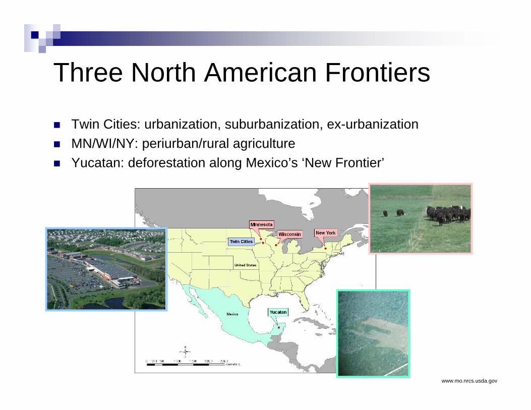
Three North American Frontiers
Twin Cities: urbanization, suburbanization, ex-urbanizationMN/WI/NY: periurban/rural agricultureYucatan: deforestation along Mexico’s ‘New Frontier’
www.mo.nrcs.usda.gov

Southern Yucatan Peninsular Region (SYPR)

Land use = 1338 km2 / 7.7 %
Land use = 2356 km2 / 13.4 %
27 km
2003
1987

20031987
1997

Movement
Land Use
Interaction Infrastructure
Land Cover
NaturalFactorsMarket/
Population
Land tenure
Access
Institutional Analysis and Development
Bounded RationalitySocial Rationality
Ecological FindingsLandscape Ecology
Actors EnvironmentInstitutions
Participate
Influence
LUCC
Constrain
Concepts
Theory
ModelComponents
(Examples)
Methods Agent-Based ModelSystem Model
Agent-Based ModelArtificial Intelligence Cellular Model
HELIA (Human-Environment Land Integrated Assessment)

Data
SpatialSatellite imagery (1975 - Present)Aerial photography (1969, 1980s)Environmental GIS layers (Ongoing)Land-use/cover maps (1970 - Present)
Surveys (1996, 2003, 2006)HouseholdLaborProductionInstitutions
Ecological (Ongoing)Structure / functionNutrient flowsBiodiversity
Archival (Ongoing)Land useInstitutionsClimate

Environment
Land Cover
Soils
A EI
Environmental conceptsEndogenous functionsExogenous impacts
Environmental cellular modelStates in spatial factorsRules

InstitutionsA EI
Institution conceptsInfluence actorsChannel drivers
Institutional agent-based modelDirect change of actor resourcesIndirect change of spatial factors
Market Tenure Group Affiliation
Targeted Market
Culture
Ejidos
AccessTargeted Market

ActorsActor concepts
Decision makingBounded rationality vs. perfect rationalityLearning under risk/uncertaintyNetworks/Ties/Formation
Population/DemographicsHousehold dynamicsMigration at multiple scales
Actor agent-based model
A EI
MovementLand Use Interaction/ Networks

Agent-Based Model
Standard approaches tend to focus on:General assumptionsGeneral model of decision makingAnalytical tractability (i.e., math/stats)Power/elegance
Agent-based models focus on:Varying decision making modelsVaried actorsActor interactionLocal interactionsSimplicity leading to complexity
A EI

Actor plants on available
land
Year 1
Current field invaded by
weeds
Year 2 Year 3
Actor plants on next parcel
Year 4
Field invaded by weeds: no
more land available
Year 5
Institution grants land
accessOR
Actor leaves
Actor must grow crops to meet needs
Land access influenced by institution
Potential for environmentaldegradation
Example Dynamics
Example Simulation
A EI

Household Product DiversityFactors ImportancePopulation 7.30Environment 6.85Institutions 28.33
Ejidal 12.86Market 15.47
Land Use/Cover 7.52Fragmentation 20.45Distance 20.47Cover type 16.60
Total 100
Model output: the aggregate results of the modeled subsystems (actors, institutions, environment) can be seen in (a) spatially-explicit mappings of LUCC, (b) estimates of correlation between LUCC and various factors, and (c) statistics for individual households. All of these results in turn can be applied to social and environmental scenarios.
(b)
(a)
(c)
A EI

No Ejidal Limits Ejidal limits

Complex Scales of Reality

Science-policy Gap Post-normal Science
Pattern vs. ProcessSimplicity vs. Complexity
ScaleSensitivity
EmergenceSupervenience
Scalar distributions
Deduction by analogyEquifinality
Pattern/Process conflation
Initial conditionsParameter sensitivity
Nonlinearity
Confounding behaviorUncertainty
Deep uncertaintySurprise
Deduction by analogy
Complex Reality, Complex Models

Conclusion
Regional modeling needsActors + Environment + InstitutionsScaleComplexity
Future researchContinued socioeconomic & ecological integrationHELIA
SYPR (NASA)Twin Cities region (NASA)Rotational grazing in MN, WI, and NY (NSF)

Manson, S. M. and T. Evans (2008). Agent-based modeling of deforestation in southern Yucatán, Mexico, and reforestation in the Midwest United States. Proceedings of the National Academy of Sciences (Accepted, in press).
Manson, S. M. (2008). Does scale exist? An epistemological scale continuum for complex human-environment systems. Geoforum (Accepted, in press).
Sander, H. and S. M. Manson (2007). Heights and locations of artificial structures in viewshed calculation: how close is close enough? Landscape and Urban Planning 82(4): 257-270.
Manson, S. M. (2007). Challenges in evaluating models of geographic complexity. Environment and Planning B 34(2): 245-260.Manson, S. M. (2006). Bounded rationality in agent-based models: experiments with evolutionary programs. International Journal of Geographic
Information Science 20(9): 991-1012.
Manson, S. M. and M. Bauer (2006). Changing Landscapes in the Twin Cities Metropolitan Area. CURA Reporter 36(3): 3-11.
Manson, S. M. (2006). Land use in the Southern Yucatan Peninsular Region of Mexico: scenarios of population and institutional change. Computers, Environment, and Urban Systems 30(3): 230-253.
Manson, S. M. and D. O'Sullivan (2006). Complexity theory in the study of space and place. Environment and Planning A 38(4): 677-692.
Manson, S.M., (2005). Agent-based modeling and genetic programming for modeling land change in the Southern Yucatan Peninsular Region of Mexico. Agriculture, Ecosystems and Environment 111(1): 47-62.
Manson, S. M., J. Geoghegan and B. L. Turner, II (2006). State of the art in describing future changes in ecosystem services: forecasting changes in land use and land cover. In Millennium Ecosystem Assessment: Ecosystems and Well-Being (Volume 2: Scenarios). H. Mooney and A. Cropper (eds). Geneva, Switzerland: Island Press, pp. 74-76..
Manson, S. M. (2004). The SYPR integrative assessment model: complexity in development. In Integrated Land-Change Science and Tropical Deforestation in the Southern Yucatán: Final Frontiers. B. L. Turner, D. Foster and J. Geoghegan (eds). Oxford, United Kingdom: Clarendon Press of Oxford University Press, pp. 271-291.
Brown, D. G., R. Walker, S. M. Manson and K. Seto (2004). Modeling land use and land cover change. In Land Change Science: Observing, Monitoring, and Understanding Trajectories of Change on the Earth's Surface. G. Gutman, A. Janetos, C. Justice, E. Moran, J. Mustard, R. Rindfuss, D. Skole and B. L. Turner II. (eds). Dordrecht, Netherlands: Kluwer Academic Publishers, pp. 395-409.
Manson, S. M. (2003). Validation and verification of multi-agent models for ecosystem management. In Complexity and Ecosystem Management: The Theory and Practice of Multi-Agent Approaches. M. Janssen (ed). Northampton, Massachusetts: Edward Elgar Publishers, pp. 63-74.
Parker, D. C., S. M. Manson, M. Janssen, M. J. Hoffmann and P. J. Deadman (2003). Multi-agent systems for the simulation of land use and land cover change. Annals of the Association of American Geographers 93(2): 314-337.
Manson, S. M. (2001). Simplifying complexity. Geoforum 32(3): 405-414.
Publications available from:
www.umn.edu/~manson