Southwestern Ontario Land Values - Valco Consultants
16
Southwestern Ontario Land Values 2020 Edition Ryan R. Parker, B.Comm, AACI, P.App, P.Ag, CAFA (519) 709-3088 [email protected]
Transcript of Southwestern Ontario Land Values - Valco Consultants

Southwestern Ontario Land Values
2020 Edition
Ryan R. Parker, B.Comm, AACI, P.App, P.Ag, CAFA
(519) 709-3088
Overview
Southwestern Ontario Land Value
2020 Land Values
2010-2020 Land Values
Huron County
Perth County
Oxford County
Middlesex County
Elgin County
Lambton County
Kent County
Essex County
Bruce County
Grey County
Wellington County
Parameters
Disclaimer
Contact
Table of Contents
Overview This past year will be remembered as the year of the pandemic where lives
were lost, stores were shuttered, vacations were cancelled and the federal
government planted a new orchard of money trees. However, as disruptive
as this past year has been, and continues to be, farmers have still found a
way to buy and sell farms with overall values continuing to increase. Some of
factors that have impacted land values over the last year are as follows:
Those of you who are regular readers of this study, or have heard
presentations I have given, know how much emphasis I put on interest
rates when discussing the main factors on farmland values. 2020 contin-
ued the trend of historically low interest rates with the pandemic being
responsible for yet another significant decrease in borrowing costs.
The 2020 crop year was a very good one in most parts of Ontario. Good
yields have been followed up with great prices to end 2020 and start
2021. The futures prices for the 3 main crops are well below the old crop
prices but are still significantly better than most we have seen in the past
6-7 years.
Livestock density in the traditional livestock areas of Ontario continues,
as it likely always will, to have an impact on land values.
Non-farmer buyers of land also continue to have big impacts on land val-
ues. Investors continued to buy more land in Ontario in 2020 with inves-
tor confidence in farmland values remaining quite high.
The mobility and movement of farmers from south to north, particularly
into Grey and Bruce Counties, has continued to close the value gap be-
tween southern and northern Counties.
Unlike the last number of years where land values have been increasing mod-
estly, I expect land values in 2021 to increase at a faster rate. The last few
months of 2020 and the first few of 2021 have produced various new highs
and current demand for land is resemblant of 2011-2012. This report and all the contents of this
report are proprietary and cannot be used
in or for any type of presentation, appraisal,
or separate study without written permis-
sion from the Author. Any violation of this
copyright will be viewed as a direct infringe-
ment of the copyright of this report.
To view the Full Disclaimer please refer to
the last page of the Report.
Copyright © 2020
Average 2019 to 2020 Change 5.33%
Average Annual Change from 2010 to 2020 10.72%
SW Ontario 2020 Median $15,000
Southwestern Ontario (11 Counties)
Overview
Southwestern Ontario Land Values
Copyright © 2020
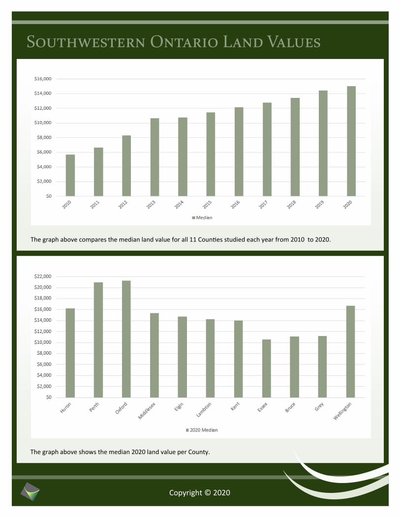
The graph above compares the median land value for all 11 Counties studied each year from 2010 to 2020.
The graph above shows the median 2020 land value per County.

Change in Values
Copyright © 2020
County 2010 to
2011
2011 to
2012
2012 to
2013
2013 to
2014
2014 to
2015
2015 to
2016
2016 to
2017
2017 to
2018
2018 to
2019
2019 to
2020 Average
Huron 23.88% 36.89% 20.24% -9.47% 1.54% 8.33% 3.57% 5.99% 7.33% -1.49% 9.68%
Perth 8.72% 34.38% 17.50% 8.05% 4.55% -2.80% 6.94% 3.47% 3.29% 5.78% 8.99%
Oxford 7.81% 19.07% 25.64% 5.58% 6.12% 5.60% 7.41% -1.44% -4.22% 9.44% 8.10%
Middlesex 41.80% 24.25% 5.82% 7.65% 4.58% 9.41% 7.78% 4.68% 6.86% -6.63% 10.62%
Elgin 37.65% 15.38% 29.01% 8.79% 5.31% 3.44% 12.86% -6.34% 3.13% 17.57% 12.68%
Lambton 4.34% 69.19% 36.80% -10.71% 3.98% -0.88% 17.64% 1.00% -2.00% 19.10% 13.84%
Kent 23.44% 14.06% 26.75% 8.00% -5.70% 2.28% 2.46% -0.37% 19.96% -0.92% 9.00%
Essex 2.37% 13.61% 18.44% 3.67% 3.44% 6.71% 12.57% 4.19% 6.09% 0.06% 7.11%
Bruce 43.90% 29.52% 39.30% -2.34% 1.72% 12.55% 2.20% 7.80% 0.63% 14.10% 14.94%
Grey 1.62% 50.29% -6.99% 16.71% 23.59% 7.29% 15.51% 7.72% 6.91% 4.84% 12.75%
Wellington 20.08% 20.21% 16.86% -2.97% 14.10% 2.42% 18.04% 1.89% 14.49% -3.17% 10.20%
Average 19.60% 29.71% 20.85% 2.99% 5.75% 4.94% 9.73% 2.60% 5.68% 5.33%

Huron
County
Overview
The graph above shows the median land values for Huron County each year
from 2010 to 2020.
The graph above shows the low and high land values for Huron County each year from 2010 to 2020.
Copyright © 2020
5 year Average Crop Yields
(bushels/acre)
Corn 169
Soybeans 49
Winter Wheat 90
Source: OMAFRA
2019 Top Farm Cash Receipt
Hogs $230,910,000
Source: OMAFRA

Perth
County
Overview
The graph above shows the median land values for Perth County each year
from 2010 to 2020.
The graph above shows the low and high land values for Perth County each year from 2010 to 2020.
Copyright © 2020
5 year Average Crop Yields
(bushels/acre)
Corn 173
Soybeans 52
Winter Wheat 92
Source: OMAFRA
2019 Top Farm Cash Receipt
Dairy $258,010,000
Source: OMAFRA

Oxford
County
Overview
The graph above shows the median land values for Oxford County each year
from 2010 to 2020.
The graph above shows the low and high land values for Oxford County each year from 2010 to 2020.
Copyright © 2020
5 year Average Crop Yields
(bushels/acre)
Corn 180
Soybeans 52
Winter Wheat 94
Source: OMAFRA
2019 Top Farm Cash Receipt
Dairy $276,530,000
Source: OMAFRA

Middlesex
County
Overview
The graph above shows the median land values for Middlesex County each
year from 2010 to 2020.
The graph above shows the low and high land values for Middlesex County each year from 2010 to 2020.
Copyright © 2020
5 year Average Crop Yields
(bushels/acre)
Corn 177
Soybeans 50
Winter Wheat 92
Source: OMAFRA
2019 Top Farm Cash Receipt
Corn $141,610,000
Source: OMAFRA

Elgin
County
Overview
The graph above shows the median land values for Elgin County each year
from 2010 to 2020.
The graph above shows the low and high land values for Elgin County each year from 2010 to 2020.
Copyright © 2020
5 year Average Crop Yields
(bushels/acre)
Corn 176
Soybeans 49
Winter Wheat 86
Source: OMAFRA
2019 Top Farm Cash Receipt
Corn $95,370,000
Source: OMAFRA

Lambton
County
Overview
The graph above shows the median land values for Lambton County each
year from 2010 to 2020.
The graph above shows the low and high land values for Lambton County each year from 2010 to 2020.
Copyright © 2020
5 year Average Crop Yields
(bushels/acre)
Corn 174
Soybeans 49
Winter Wheat 82
Source: OMAFRA
2019 Top Farm Cash Receipt
Soybeans $161,410,000
Source: OMAFRA

Kent
County
Overview
The graph above shows the median land values for Kent County each year
from 2010 to 2020.
The graph above shows the low and high land values for Kent County each year from 2010 to 2020.
Copyright © 2020
5 year Average Crop Yields
(bushels/acre)
Corn 186
Soybeans 51
Winter Wheat 92
Source: OMAFRA
2019 Top Farm Cash Receipt
Field Vegetables $191,950,000
Source: OMAFRA

Essex
County
Overview
The graph above shows the median land values for Essex County each year
from 2010 to 2020.
The graph above shows the low and high land values for Essex County each year from 2010 to 2020.
Copyright © 2020
5 year Average Crop Yields
(bushels/acre)
Corn 175
Soybeans 50
Winter Wheat 75
Source: OMAFRA
2019 Top Farm Cash Receipt
Greenhouse
Vegetables $744,820,000
Source: OMAFRA

Bruce
County
Overview
The graph above shows the median land values for Bruce County each year
from 2010 to 2020.
The graph above shows the low and high land values for Bruce County each year from 2010 to 2020.
Copyright © 2020
5 year Average Crop Yields
(bushels/acre)
Corn 158
Soybeans 46
Winter Wheat 89
Source: OMAFRA
2019 Top Farm Cash Receipt
Steers and Slaugh-
ter Heifers $174,700,000
Source: OMAFRA

Grey
County
Overview
The graph above shows the median land values for Grey County each year
from 2010 to 2020.
The graph above shows the low and high land values for Grey County each year from 2010 to 2020.
Copyright © 2020
5 year Average Crop Yields
(bushels/acre)
Corn 149
Soybeans 43
Winter Wheat 79
Source: OMAFRA
2019 Top Farm Cash Receipt
Steers and Slaugh-
ter Heifers $137,780,000
Source: OMAFRA

Wellington
County
Overview
The graph above shows the median land values for Wellington County each
year from 2010 to 2020.
The graph above shows the low and high land values for Wellington County each year from 2010 to 2020.
Copyright © 2020
5 year Average Crop Yields
(bushels/acre)
Corn 161
Soybeans 47
Winter Wheat 84
Source: OMAFRA
2019 Top Farm Cash Receipt
Dairy $210,500,000
Source: OMAFRA
This study has been completed to provide information on agricultural land values in the general Southwestern Ontario region. The
Counties of Huron, Perth, Oxford, Middlesex, Elgin, Lambton, Kent, Essex, Bruce, Grey and Wellington have all been analysed in this
report.
Only sales that occurred in 2020 were selected for the 2020 study. The majority of the sales chosen had no building improvements
(vacant land), with the exceptions being minimally improved properties (i.e. older house and shed) which have had the value of the
improvements extrapolated. Also, the sales utilized were considered to be used solely for farming purposes. The sales have been
analysed on a per tillable acre basis, as this rate is believed to be the most accurate reflection of the value of agricultural land.
In stating land values in this report, the median unit of measurement was used rather than the mean, as the median tends to
better protect against outliers in the sales data. The same study was completed from 2010 to 2019, with those results also shown
in this report.
Parameters
Ryan R. Parker
Partner at Valco Consultants Inc. (519) 709-3088 [email protected]
Disclaimer
The information contained in this report was obtained from sources believed to be reliable. Certain information in this report has
been accepted at face value; especially if there is no reason to doubt its accuracy. Certain empirical data required interpretive anal-
ysis pursuant to the objective of this report. However, I have not verified its accuracy and make no guarantee, warranty or repre-
sentation regarding it. The specific sales data provided is subject to the possibility of errors, omissions, mistakes in calculation of
total and tillable acre sizes, as well as error in reported sale price and/or sale date. Although an attempt has been made to find
every pertinent sale in the areas described, it is not possible to confirm that this is the case.
This report and all the contents of this report cannot be relied on for any financing, accounting, litigation, expropriation, and/or
any other use without written permission from the author. This report and the studies were completed as an informative tool and
were completed independently for no particular client.
This report and all the contents of this report are proprietary and cannot be used in or for any type of presentation, appraisal, or
separate study without written permission from the author. Any violation of this copyright will be viewed as a direct infringement
of the copyright of this report.