Southwark Council’s showcase of safe, sustainable and ... · Southwark Council’s showcase of...
8
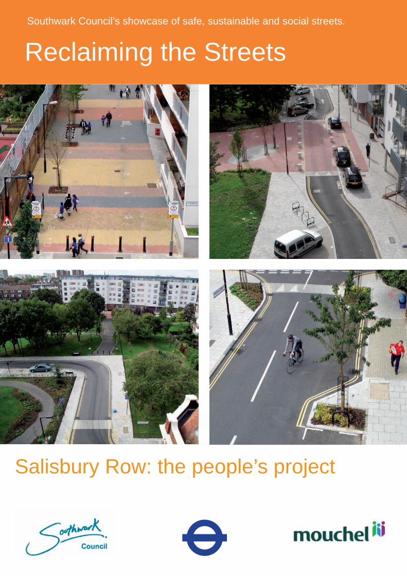
Reclaiming the Streets Southwark Council’s showcase of safe, sustainable and social streets. Salisbury Row: the people’s project
-
Upload
truongmien -
Category
Documents
-
view
225 -
download
0
Transcript of Southwark Council’s showcase of safe, sustainable and ... · Southwark Council’s showcase of...
Southwark Council’s showcase of safe, sustainable and social streets
Reclaiming the StreetsSouthwark Council’s showcase of safe, sustainable and social streets.
Salisbury Row: the people’s project
�
Engagement, partnership and ownership were the cornerstones of this innovative project. The focus was on returning the streets and streetscapes of Salisbury Row in South London to their rightful owners – the people and community who live within them and whose quality of life is so influenced by them.
The commitment of the local council, professional skills of the design team and dedication of the contractors were key. Success was truly founded by harnessing the dedication of all stakeholders, to allow the practical needs and ideas of members of the community of all ages and abilities to be understood. The result is a solution which delivers a quality of streetscape sought by the community and a contribution to the future quality of life which all those who have been involved, are confident will endure.
A place for people?
Salisbury Row is a neighbourhood located between the Bricklayers Arms roundabout and Elephant & Castle in Southwark. For residents who live in the terraces of houses around Salisbury park, streets dominated by traffic were an intrusive fact of life.
An attitude survey in �007 highlighted the need for reducing vehicle speed (70%), a desire for greener streets (63%) and streets with pedestrian and cyclist priority (6�%). Dependence on the car for local journeys was increasing, as were volumes of traffic. Streets were closed in an attempt to limit those travelling at high speed looking for shortcuts
Reclaiming the Streets Salisbury Row: the people’s project
through the neighbourhood from New Kent Road. The 2007 traffic surveys showed that over �,000 vehicles per day still travelled on some of the local streets.
The community was, however vibrant. Residents came together to save their park from development in �000 and have since been committed to improving their local environment with a series of community projects focused on the greening of their environment.
Community planting day, October �010
Southwark Council’s showcase of safe, sustainable and social streets
3
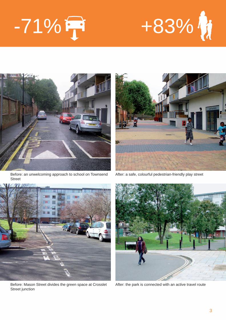
-71% +83%
Before: an unwelcoming approach to school on Townsend Street
Before: Mason Street divides the green space at Crosslet Street junction
After: the park is connected with an active travel route
After: a safe, colourful pedestrian-friendly play street
�
The people’s project
The Salisbury Row project builds on the enthusiasm and commitment of the community and epitomises the objectives that underscore the Mayor’s Transport Strategy and Southwark Council’s transport policies for achieving more accessible and sustainable travel patterns with streets as social spaces.
Transport for London (TfL) contributed £1.75 million to the scheme implementation through the then Area Based Schemes (now Major Schemes) LIP funding and Southwark Council contributed £160,000 overall.
Working in close partnership with TfL and the community, Southwark Council commissioned Mouchel in �007 to progress the design solutions and facilitate consultation. The work was completed in �010 by FM Conway, the appointed contractors.
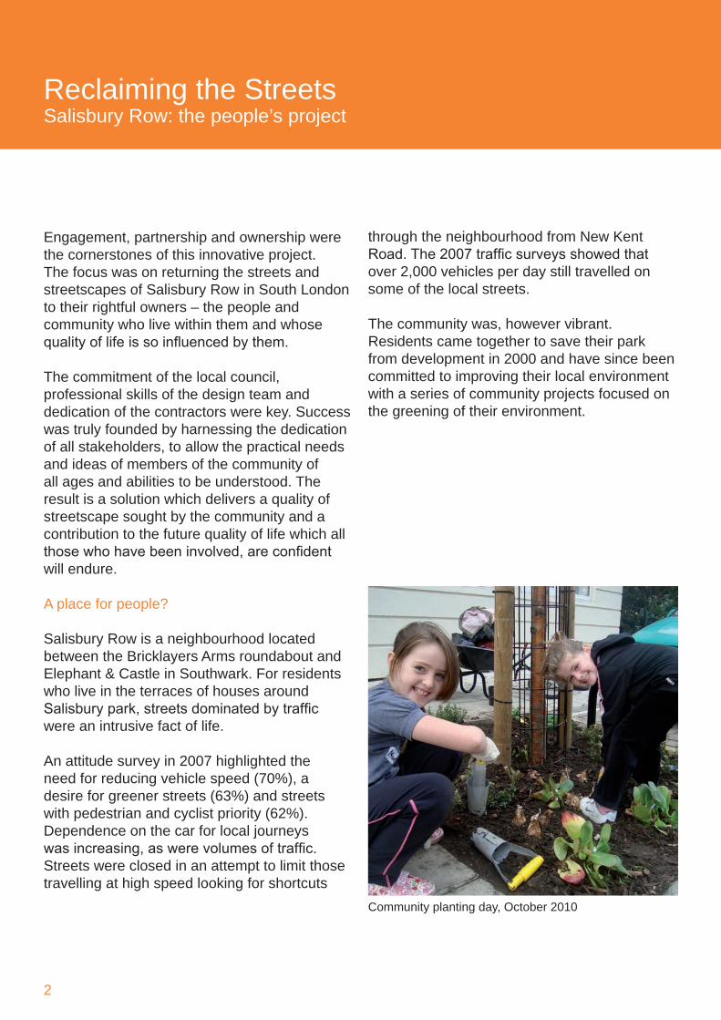
All members of the team have been committed to the revitalisation of the area in a way that fully responds to community goals. Engagement from the outset involved innovative techniques to ensure that the views of individuals and user groups were heard. Challenging the ABS guidelines, a ‘design for real’ approach was used during early meetings to enable the community to put forward their ideas. Children’s art events, attitude surveys, walkabouts, workshops and exhibitions were organised. In October 2010 fifty children and adults came together for a community planting day.
The vision
The vision that emerged was a slow-speed, greened environment which would reduce traffic dominance and promote local, sustainable transport. It recognised the role that established local assets could play in a more integrated environment where car and community co-exist whilst the prime purpose of the local ‘living’ environment is respected. It was a vision focused on accessibility, safety and quality.
Design solutions within this integrated whole included carefully planned one-way systems, partial road closures, sensible traffic calming solutions and shared spaces. These closures transformed streets into an extension of Salisbury Park. A new community Square has been created. The Park has become more inviting and is widely used by the community, to exercise and play, and as a valuable cycle and walking route.
The ‘play street’ outside the Townsend Primary School entrance creates a doorstep play space for the local children. It supports the school travel plan by encouraging children and parents to walk to school. Pedestrian activity during morning peak has increased 379% and car travel to school has reduced from �6% to 9% with a 7% rise in children walking.
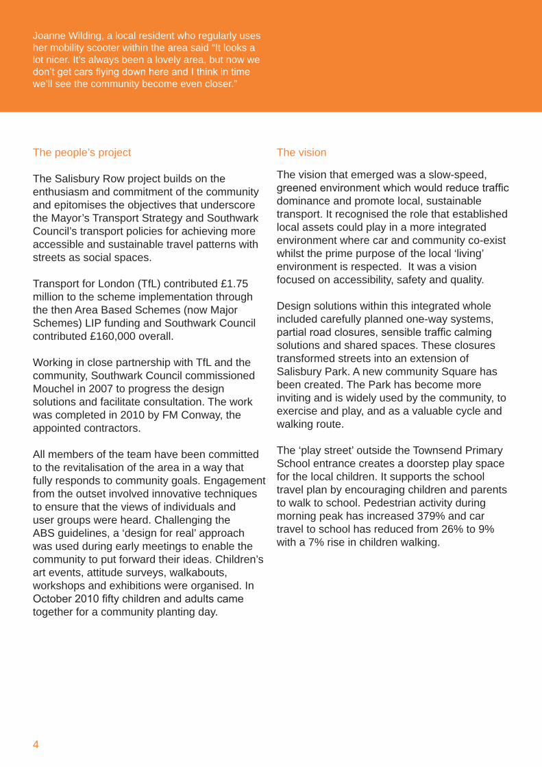
Joanne Wilding, a local resident who regularly uses her mobility scooter within the area said “It looks a lot nicer. It’s always been a lovely area, but now we don’t get cars flying down here and I think in time we’ll see the community become even closer.”
Southwark Council’s showcase of safe, sustainable and social streets
5
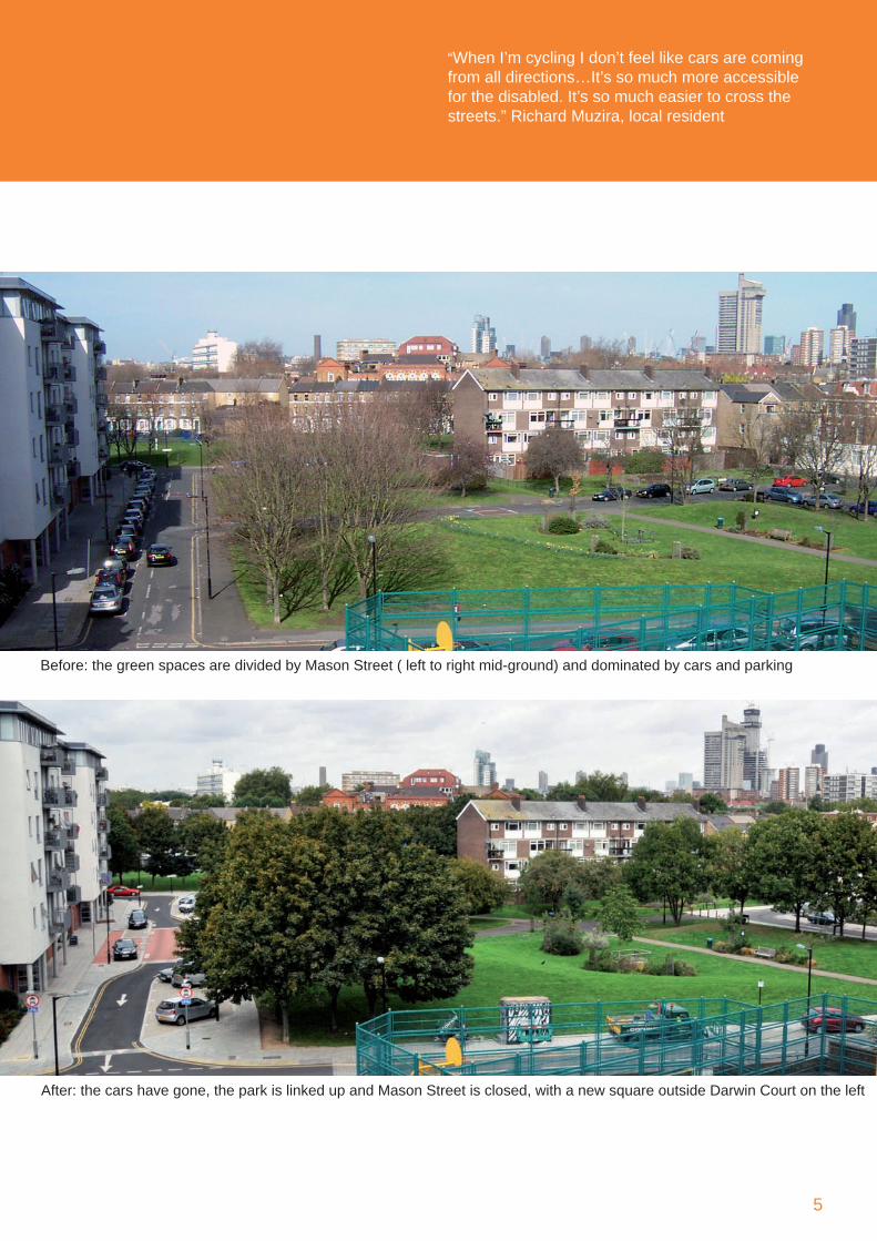
Before: the green spaces are divided by Mason Street ( left to right mid-ground) and dominated by cars and parking
After: the cars have gone, the park is linked up and Mason Street is closed, with a new square outside Darwin Court on the left
“When I’m cycling I don’t feel like cars are coming from all directions…It’s so much more accessible for the disabled. It’s so much easier to cross the streets.” Richard Muzira, local resident
6
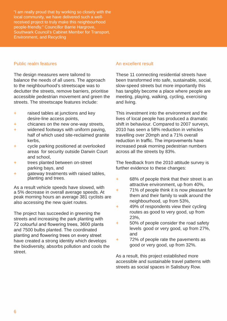
Public realm features
The design measures were tailored to balance the needs of all users. The approach to the neighbourhood’s streetscape was to declutter the streets, remove barriers, prioritise accessible pedestrian movement and green the streets. The streetscape features include:
+ raised tables at junctions and key desire-line access points, + chicanes on the new one-way streets,+ widened footways with uniform paving, half of which used site-reclaimed granite kerbs,+ cycle parking positioned at overlooked areas for security outside Darwin Court and school,+ trees planted between on-street parking bays, and + gateway treatments with raised tables, planting and trees.
As a result vehicle speeds have slowed, with a 5% decrease in overall average speeds. At peak morning hours an average 381 cyclists are also accessing the new quiet routes.
The project has succeeded in greening the streets and increasing the park planting with 72 colourful and flowering trees, 3600 plants and 7500 bulbs planted. The coordinated planting and flowering trees on every street have created a strong identity which develops the biodiversity, absorbs pollution and cools the street.
An excellent result
These 11 connecting residential streets have been transformed into safe, sustainable, social, slow-speed streets but more importantly this has tangibly become a place where people are meeting, playing, walking, cycling, exercising and living.
This investment into the environment and the lives of local people has produced a dramatic shift in behaviour. Compared to �007 surveys, �010 has seen a 58% reduction in vehicles travelling over �0mph and a 71% overall reduction in traffic. The improvements have increased peak morning pedestrian numbers across all the streets by 83%.
The feedback from the �010 attitude survey is further evidence to these changes:
+ 68% of people think that their street is an attractive environment, up from �0%,+ 71% of people think it is now pleasant for them and their family to walk around the neighbourhood, up from 53%,+ �9% of respondents view their cycling routes as good to very good, up from �3%,+ 50% of people consider the road safety levels good or very good, up from �7%, and+ 7�% of people rate the pavements as good or very good, up from 3�%.
As a result, this project established more accessible and sustainable travel patterns with streets as social spaces in Salisbury Row.
“I am really proud that by working so closely with the local community, we have delivered such a well-received project to truly make this neighbourhood people-friendly.” Councillor Barrie Hargrove, Southwark Council’s Cabinet Member for Transport, Environment, and Recycling
Southwark Council’s showcase of safe, sustainable and social streets
7
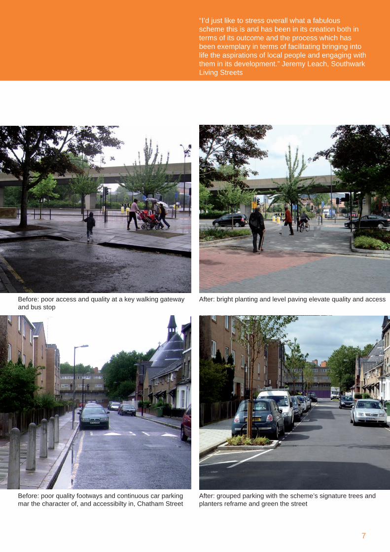
Before: poor quality footways and continuous car parking mar the character of, and accessibilty in, Chatham Street
After: grouped parking with the scheme’s signature trees and planters reframe and green the street
Before: poor access and quality at a key walking gateway and bus stop
After: bright planting and level paving elevate quality and access
“I’d just like to stress overall what a fabulous scheme this is and has been in its creation both in terms of its outcome and the process which has been exemplary in terms of facilitating bringing into life the aspirations of local people and engaging with them in its development.” Jeremy Leach, Southwark Living Streets
Contact
Ludovic Pittie Team LeaderLandscape & Urban Design m: 0797 63� 1598email: [email protected]
Contact
Franklin Uwakaneme Capital Programmes ManagerPublic Realm Division
t: 0�07 5�5 ��07; m: 0798 �11 8�60email: [email protected]
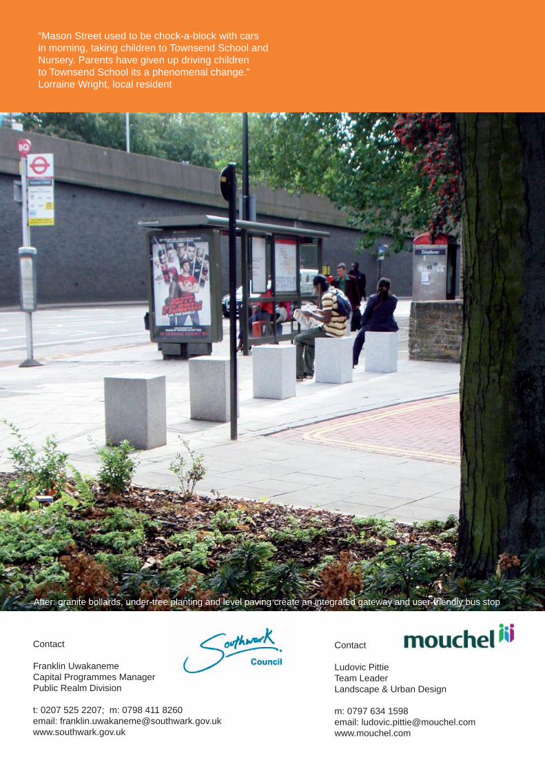
After: granite bollards, under-tree planting and level paving create an integrated gateway and user-friendly bus stop
“Mason Street used to be chock-a-block with cars in morning, taking children to Townsend School and Nursery. Parents have given up driving children to Townsend School its a phenomenal change.” Lorraine Wright, local resident