Southern Water Use Caution Area - Southwest Florida Water ... · advancing coastal saltwater...
22
Southern Water Use Caution Area Information Report April 1998
Transcript of Southern Water Use Caution Area - Southwest Florida Water ... · advancing coastal saltwater...

SouthernWater Use
Caution Area
Information ReportApril 1998
TABLE OF CONTENTS
Executive Summary....................................................................................................................i
I. INTRODUCTION ............................................................................................................ 1
II. BACKGROUND ............................................................................................................... 1 Historic Perspective ........................................................................................................ 3
III. HYDROLOGIC OVERVIEW ......................................................................................... 4
IV. WATER USE IN THE SWUCA ...................................................................................... 7
V. THE 1994 SWUCA RULE............................................................................................. 10 The Final Order ............................................................................................................12 Appeal of the Final Order .............................................................................................13
VI. THE FUTURE OF THE SWUCA ................................................................................ 14
VII. CONCLUSION ............................................................................................................... 17

i
Southern Water UseCaution AreaInformation Report
Executive Summary
problem is regional in nature. In other words,withdrawals at a single point in the SWUCAmay affect water levels over large areas.Historic over-withdrawals have reduced waterpressure in the aquifer, causing lake levels todecline in the Ridge area as recharge isinduced, and allowing seawater to intrude intothe Floridan Aquifer along the coast.
Section IV, Water Use in the SWUCA, showsthat 80–90 percent of total water use in thebasin is for four major uses; citrus, row crops(especially tomatoes), mining and publicsupply. In recent years, the actual waterpumped and used has been below the 650–700million gallons per day (mgd) the District hasidentified as the approximate sustainableamount the aquifer can yield. Water usedropped each year from 1991–95, averaging616 mgd, while 1996 use was up about tenpercent over the prior year. Currentprojections to 2020 indicate water use will beabout 760 mgd, creating the likely need for 50to 100 mgd from alternative sources to meetprojected demands.
Objectives of The 1994 SWUCA Rule(Section V) were: 1) to preserve freshwaterresources of the Floridan Aquifer and stabilizelake levels in Polk/Highlands counties, and 2)to limit regulatory impacts on the region’seconomy and existing users. A fundamentalaspect of the SWUCA Rule was the Board’srecognition that water resource problemsdeveloped over the long-term and could not becorrected immediately without serioussocioeconomic impacts. The principalconcept of the rules was to gradually reduceexisting withdrawals while not allowing newwithdrawals, and building in a mechanism(reallocation) to redistribute existing permitted
This report provides a concise summary of thehistory, current conditions and future plans forthe Southern Water Use Caution Area(SWUCA) within the Southwest Florida WaterManagement District (SWFWMD, or theDistrict). It describes the background leadingto the designation of the area, managementactivities such as the SWUCA Rule andchallenges to it, where the District is today inits planning and the approach to assuringwater resource management and protection.
The SWUCA was declared a “water usecaution area” (where water resources are orwill become critical in the next twenty years)in 1992 by the District Governing Board,encompassing an area of about 5,100 squaremiles covering the southern half of theDistrict. It includes all of Manatee, Sarasota,Hardee and DeSoto counties and portions ofHillsborough, Charlotte, Polk and Highlandscounties. Water resource concerns associatedwith the SWUCA involve the decline of lakelevels along the Highlands Ridge andadvancing coastal saltwater intrusion in theFloridan Aquifer.
Section III, Hydrologic Overview, identifiesthe Floridan Aquifer as the system of concern;about 85 percent of ground water use in theSWUCA comes from this source. Analysis oflong-term trends, including data from anextensive network of monitor wells that assessground water levels and quality, show the

ii
quantities to new uses and locations within theSWUCA. In March, 1997, the Districtreceived the administrative law judge’s FinalOrder upholding the Minimum FloridanAquifer Level (and the science used toestablish it) and the phasing in ofconservation, but ruling provisions forreallocation and preferential treatment ofexisting users invalid. As of the end of 1997,the Final Order is stayed and has no effectbecause the District and other parties haveappealed the ruling to the Second DistrictCourt of Appeals. This means the SWUCARule cannot go into effect until the appeal isresolved.
The Future of SWUCA (Section VI) beginswith the recognition that the need forspecialized water resource management in thearea continues. Seeing a window ofopportunity created by changingcircumstances, the Governing Board hasdirected staff to reevaluate the situation.These circumstances include only portions ofthe SWUCA Rule being upheld, temporarilyimproved water resource conditions (lowerwater use and higher ground water levels) andthe 1997 legislation on minimum flows andlevels that allows a “recovery strategy” if anactual level is below an established minimumlevel.
The District took several actions during 1997to initiate an effective reevaluation ofSWUCA conditions and management.Included were a statewide Discussion Groupto identify alternative approaches, publicworkshops in Bartow and Bradenton to briefthe public and seek feedback and formation ofa SWUCA Staff Team with a broad charge torevisit previous management efforts.
The District’s overall strategy will includeboth short and long-term aspects, and willattempt to balance regulation with technicaland financial incentives (e.g., implementationof a minimum aquifer level with waterresource development for alternatives toground water use) while closely monitoringwater use, water levels and water quality. Theintent is to achieve effective resourceprotection without negatively affecting thelocal economy. In the short term, the Districtwill:
• continue to use existing water use permittingrules for the Eastern Tampa Bay (ETB) andHighland Ridge (HR) Water Use CautionAreas (WUCAs).
• develop and adopt a “CompetingApplications Rule” which will allow theGoverning Board to determine whichpermits are most in the public interest.
• develop a revised SWUCA Rule as part ofan overall management strategy.
• appeal three specific components of theSWUCA ruling.
• continue forward with water supply planningefforts such as the “DistrictwideAssessment” and a subsequent “RegionalWater Supply Plan” for the SWUCA.
• establish an outreach program to reengagethe affected and interested public.

iii
Long-term strategies will follow, includingimplementation of the revised SWUCA ruleand associated minimum levels as part of anoverall recovery strategy, using the CompetingApplications Rule as needed. Continuousimprovement of a detailed monitoring systemto identify trends and refine our understandingof the resource will be coupled with acommitment to develop alternative watersupply sources, including but not limited to,reuse of stormwater and wastewater, aquiferstorage/recovery, sustainable use of surfacewater and water conservation.
In conclusion, years of data collection andscientific analysis make one fact evident: theprincipal cause of declines in Floridan Aquiferwater levels and quality in the SWUCA isground water withdrawals. It is the intentionof the Southwest Florida Water ManagementDistrict to effectively manage and protectthose resources, while recognizing the needfor full involvement of all parties, in order toachieve sustainable use in a phased, butreasonably expeditious manner.
1
Southern Water UseCaution AreaInformation Report
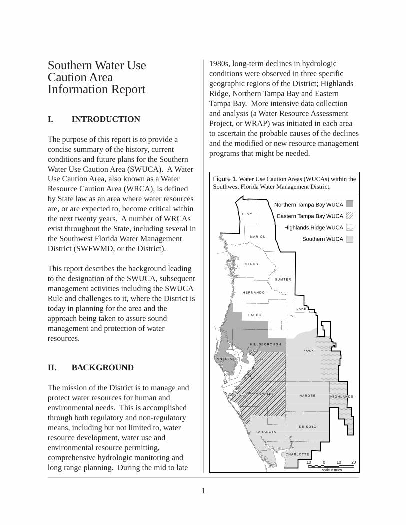
I. INTRODUCTION
The purpose of this report is to provide aconcise summary of the history, currentconditions and future plans for the SouthernWater Use Caution Area (SWUCA). A WaterUse Caution Area, also known as a WaterResource Caution Area (WRCA), is definedby State law as an area where water resourcesare, or are expected to, become critical withinthe next twenty years. A number of WRCAsexist throughout the State, including several inthe Southwest Florida Water ManagementDistrict (SWFWMD, or the District).
This report describes the background leadingto the designation of the SWUCA, subsequentmanagement activities including the SWUCARule and challenges to it, where the District istoday in planning for the area and theapproach being taken to assure soundmanagement and protection of waterresources.
II. BACKGROUND
The mission of the District is to manage andprotect water resources for human andenvironmental needs. This is accomplishedthrough both regulatory and non-regulatorymeans, including but not limited to, waterresource development, water use andenvironmental resource permitting,comprehensive hydrologic monitoring andlong range planning. During the mid to late
1980s, long-term declines in hydrologicconditions were observed in three specificgeographic regions of the District; HighlandsRidge, Northern Tampa Bay and EasternTampa Bay. More intensive data collectionand analysis (a Water Resource AssessmentProject, or WRAP) was initiated in each areato ascertain the probable causes of the declinesand the modified or new resource managementprograms that might be needed.
Figure 1. Water Use Caution Areas (WUCAs) within the Southwest Florida Water Management District.
���������
�����
����
����
���������
L E V Y
M A R I O N
C I T R U S
S U M T E R
H E R N A N D O
PA S C O
H I L L S B O R O U G H
M A N AT E EM A N AT E E
S A R A S O TA
P O L K
H A R D E E
D E S O T O
L A K E
C H A R L O T T E
P I N E L L A S
������
���Northern Tampa Bay WUCA
Eastern Tampa Bay WUCA
Highlands Ridge WUCA
Southern WUCA
H I G H L A NH I G H L A N D S
0
scale in miles
10 10 20

2
Each area was designated as a WUCA in 1989and specific water use permitting rules wereimplemented for the Highlands Ridge andEastern Tampa Bay WUCAs in 1990. Majorrule provisions emphasized water conservationand water use monitoring, including per capitagoals for public suppliers, crop efficiencystandards for agriculture and specificconservation plans for recreation, industrialand mining uses. Metering was also requiredfor all uses greater than 100,000 gallons perday.
The decision to designate the Highlands Ridgeand Eastern Tampa Bay WUCAs wasvalidated by the subsequent results of thedistrictwide Needs and Sources Report (1992).It showed the greatest projected percentageincrease in water use by 2020 would be in the
southern area of the District, wheresignificant stress already existed on theFloridan Aquifer. It verified that current andanticipated demands would create waterresource problems in the Highlands Ridge(HR) and Eastern Tampa Bay (ETB) WUCAsthat needed to be addressed.
The results of the Eastern Tampa Bay WRAPReport showed that ground water resources ofthe ETB and HR WUCAs are interdependentand must be addressed from a basin-wide orregional perspective. This led to theestablishment of the Southern Water UseCaution Area in 1992, encompassing the twoexisting WUCAs and all the area betweenthem (see Figure 1). Specifically, theSWUCA encompasses an area of about 5,100square miles and covers the southern half ofthe District, including all of Manatee,Sarasota, Hardee and DeSoto counties andportions of Hillsborough, Charlotte, Highlandsand Polk counties.
The water resource concerns associated withthe SWUCA involve the decline of lake levelsalong the Highlands Ridge and advancingsaltwater intrusion in coastal regions. Datashow the potentiometric surface in theFloridan Aquifer has declined significantlyduring the past 40 years. Informationprovided by the United States GeologicSurvey (USGS) reveals seasonal declines asgreat as 50 feet in 1989. Water qualitymonitoring shows increasing trends forsulfates, total dissolved solids and chloridesacross the coastal counties. Many lake levelsin the Highlands Ridge area have alsodeclined significantly, in some cases as muchas 20 feet.
������������
���������
Figure 2. Decline in potentiometric surface head of the Floridan aquifer, 1969–1975. (Mills and Laughlin, USGS, 1976)
�����������������
����0 – 5 ft.decline
5 – 10 ft. decline
10 – 20 ft. decline
20 – 30 ft. decline
30 – 40 ft. decline
greater than 40 ft. decline
0
scale in miles
10 10 20

3
Historic Perspective
Historically, there has been excessive groundwater pumping in the southern half of theDistrict. This imbalance is illustrated byFigure 2 which shows USGS potentiometricchange maps for 1969–1975, and reflectsextensive drawdowns in this part of theDistrict from ground water pumpage. TheWRAPs performed by the District wouldeventually show that these significant FloridanAquifer level declines remained in the late1980s and early 1990s (see Figure 3), and thatsaltwater intrusion and lowered lake levelswere linked to this fact.
Water use permitting in Florida is a relativelyrecent phenomena. In fact, water use permits
were not required in the SWFWMD until1977. Moreover, a large portion of theSWUCA was not included in the originalDistrict boundaries (see Figure 4). Most ofthe Eastern Tampa Bay and Highlands RidgeWater Use Caution Areas were not a part ofthe District until the late 1970s, with water usepermits not required there until 1980.
In effect, the District inherited a resource thatwas severely stressed prior to implementing
�
��������������������
���������
�
�
Figure 3. Potentiometric surface change in the Floridan aquifer, predevelopment to average of 1988–1992 conditions. (Southwest Florida Water Management District, 1994)
����0 – 10 ft.decline
10 – 20 ft. decline
20 – 30 ft. decline
30 – 40 ft. decline
40 – 50 ft. decline
greater than 50 ft. decline
���������������
0
scale in miles
10 10 20
Figure 4. Boundaries of the Southwest Florida Water Management District, 1974 and present. (Southwest Florida Water Management District, 1997)
�����������������������������
L E V Y
M A R I O N
C I T R U S
S U M T E R
H E R N A N D O
PA S C O
H I L L S B O R O U G H
S A R A S O TA
M A N AT E E
P O L K
H A R D E E
D E S O T O
L A K E
C H A R L O T T E
P I N E L L A S
1974 District boundary
Present District boundary
0
scale in miles
10 10 20
H I G H L A N D S
4
regulation and other management activities.This fact, coupled with the lack of hydrologicdata within the area in the 1970s, resulted inthe initial permitting activity being more of aninventory of use that was already there than atrue allocation of available resources.
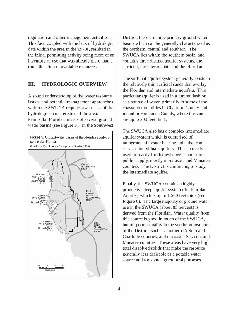
III. HYDROLOGIC OVERVIEW
A sound understanding of the water resourceissues, and potential management approaches,within the SWUCA requires awareness of thehydrologic characteristics of the area.Peninsular Florida consists of several groundwater basins (see Figure 5). In the Southwest
District, there are three primary ground waterbasins which can be generally characterized asthe northern, central and southern. TheSWUCA lies within the southern basin, andcontains three distinct aquifer systems, thesurficial, the intermediate and the Floridan.
The surficial aquifer system generally exists inthe relatively thin surficial sands that overlaythe Floridan and intermediate aquifers. Thisparticular aquifer is used in a limited fashionas a source of water, primarily in some of thecoastal communities in Charlotte County andinland in Highlands County, where the sandsare up to 200 feet thick.
The SWUCA also has a complex intermediateaquifer system which is comprised ofnumerous thin water bearing units that canserve as individual aquifers. This source isused primarily for domestic wells and somepublic supply, mostly in Sarasota and Manateecounties. The District is continuing to studythe intermediate aquifer.
Finally, the SWUCA contains a highlyproductive deep aquifer system (the FloridanAquifer) which is up to 1,500 feet thick (seeFigure 6). The large majority of ground wateruse in the SWUCA (about 85 percent) isderived from the Floridan. Water quality fromthis source is good in much of the SWUCA,but of poorer quality in the southernmost partof the District, such as southern DeSoto andCharlotte counties, and in coastal Sarasota andManatee counties. These areas have very hightotal dissolved solids that make the resourcegenerally less desirable as a potable watersource and for some agricultural purposes.
NorthernWest-Central
FloridaGround-Water
Basin
VolusiaGround-Water Basin
East Central FloridaGround-Water Basin
EastSouthFloridaGround-Water Basin
SouthernWest-Central
FloridaGround-Water
Basin
CentralWest-Central
FloridaGround-Water
Basin
����������������
Figure 5. Ground-water basins of the Floridan aquifer in peninsular Florida. (Southwest Florida Water Management District, 1994)
0
scale in miles
20 20 40

5
The Floridan Aquifer in the SWUCA is a wellconfined, highly transmissive, regional aquifersystem. This means monitor wells placedmiles apart may show a response to the samepumping stress. In other words, withdrawalsat a single point in the SWUCA can affectwater levels over large areas of the SWUCA.This relationship can be seen in Figure 7,which shows similar long-term declines inground water levels at various locationsthroughout the SWUCA.
Under natural conditions, recharge to theFloridan Aquifer in the SWUCA occurs in thevicinity of the Highlands Ridge WUCA.Along the Ridge, the surficial aquifer is quitepermeable and the intermediate aquifer ismostly absent. The confining layer claysbetween the surficial and Floridan aquifers
present in other parts of the SWUCA are thinto absent. In other areas of the SWUCA, theFloridan Aquifer is confined, causing water inthe Floridan to be under pressure. Thispressure is expressed in feet relative to sealevel. In low lying coastal elevations, thispressure is sufficient to cause water to flownaturally at land surface from deep wells.Withdrawal of water from the aquifer reducesthe water pressure which ultimately causeslake levels to decline in the Ridge area, andseawater to intrude along the coastal areas intothe freshwater portion of the Floridan.Similarly, overpumping can result inupconing, or the upward movement of sulfateand other mineral-rich waters into previouslygood quality waters. It also results in inducedrecharge from the Intermediate and Surficialaquifer systems to the Floridan Aquifer.
������������������������������������������������������������������
yyyyyyyyyyyyyyyyyyyyyyyyyyyyyyyyyyyyyyyyyyyyyyyyyyyyyyyyyyyyyyyyyy��yy
���������������������
yyyyyyyyyyyyyyyyyyyyy
NORTH
SE
A
LE
VE
L
SOUTH
CH
AR
LOTT
E C
O.
Top of HighlyPermeable Zone
Top of IntergranularEvaporites
PA
SC
O C
O.
HIL
LSB
OR
OU
GH
CO
.
Peac
e R
iver
PO
LK C
O.
HA
RD
EE
CO
.
HA
RD
EE
CO
.
DE
SO
TO C
O.
DE
SO
TO C
O.
HE
RN
AN
DO
CO
.
PA
SC
O C
O.
CIT
RU
S C
O.
HE
RN
AN
DO
CO
.
LEV
Y C
O.
CIT
RU
S C
O.
Ala
fia R
iver
SURFICIALAQUIFER
UPPER FLORIDAN AQUIFER
INTERMEDIATE AQUIFERConfiningBed
����������������
Hil
lsbo
roug
h R
iver
Wit
hlac
ooch
ee R
iver
Wac
casa
ssa
Riv
er
Northern West-Central FloridaGround-Water Basin
Central West-Central FloridaGround-Water Basin
Southern West-Central FloridaGround-Water Basin
Verticle Scale Greatly Exaggerated
KILOMETERS
MILES0
0 10
10
20
20
30
30
Figure 6. Hydrogeologic cross section of the Southwest Florida Water Management District.(Southwest Florida Water Management District, 1994)

6
In May, 1989, the District compared existingwater levels to those of the 1930s. Thisregional assessment found that on a long-termbasis, water levels have been drawn down by30 feet or more in a major part of the basin.Moreover, water levels had been lowered 40 to60 feet in about two-fifths of the 5000 squaremile basin. There was also a substantial areawhere levels dropped more than 60 feet.
The District has an extensive network ofmonitor wells to assess both ground waterlevels and quality, including its own wells andthose of the USGS. This includes 793 totalwells on 309 sites, and reflects 81 new wellsconstructed since 1989 as part of the RegionalObservation and Monitoring Program, orROMP (see Figure 8). A Five-Year Work Planis in place to refine the District’s network.
One well in the overall network, ROMPTR 9-3, in southern Hillsborough County,illustrates concerns over saltwater intrusion.
0
20
40
60
80
100
Wat
er L
evel
(F
eet A
bove
NG
VD
)
1930 1940 1950 1960 1970 1980 1990 2000 Note: Based on Average-Annual Levels
COLEY WELL
COLEY WELL
ROMP 60
ROMP 60
MARSHALL
MARSHALL
EDGEVILLE 3 DP
EDGEVILLE 3 DP
SARASOTA 9
SARASOTA 9
Figure 7. Ground-water level relationships in the Southern Water Use Caution Area. (Southwest Florida Water Management District, 1997)
�������
������Figure 8. SWUCA well monitoring network—1997. (Southwest Florida Water Management District, 1997)
�
�����������������
Active SWFWMD well
Active USGS well
0
scale in miles
10 10 20
2500
3000
3500
4000
4500
5000
5500
Con
cent
ratio
n (m
g/L)
Jan-91 Jan-92 Jan-93 Jan-94 Jan-95 Jan-96 Dec-96 Dec-97
Date
Chloride
ROMP TR 9-3
Figure 9. Saltwater intrusion at ROMP TR 9-3,Avon Park. (Southwest Florida Water Management District, 1997)
��������������

7
It shows that since 1991, chloride levels havesteadily increased, indicating the saltwaterinterface is moving inland and upward towardthe well (see Figure 9).
Lake levels have also been affected. In theHighlands Ridge area, Crooked Lake waterlevels have steadily declined from an elevationof 124 feet above sea level to less than 110feet above sea level in the last 30 years (seeFigure 10). Deep aquifer levels monitored bythe Coley Well in the same area also haveshown a decline for the same period. Thisreflects the surface and ground waterconnection prevalent along a good part of theRidge.
IV. WATER USE IN THE SWUCA
The overall quantities withdrawn within theSWFWMD as a whole have not appreciablychanged over the past several decades (see
Figure 11). Although there has been somedecline since 1990, most of this has beenspecific to the SWUCA, particularly in thecritical area of ground water withdrawals (seeFigure 12). This is due to a number of factors,including the District’s attention to theproblem. Provisional estimates for 1996,however, show increased use of about 60 mgd(or nearly 11 percent) over the previous year.The bulk of this increase was for agriculturalwithdrawals in Polk, Manatee, DeSoto,Hardee and Highlands counties. Year to yearvariability in water use and climatic conditionsare to be expected, and reinforces the need forvigilance in assuring sustainable supplies inthe SWUCA.
Coley Well
60
70
80
90
100
110
120
130
Wat
er L
evel
(ft.
NG
VD
)
1940 1950 1960 1970 1980 1990 2000
Year
Crooked Lake
Coley Well
Crooked Lake
Figure 10. Water levels at Coley well and Crooked Lake. (Southwest Florida Water Management District, 1997)
��������������
MG
D
YEAR
Figure 11. Estimated withdrawals in the SWFWMD,1963–1995. (Southwest Florida Water Management District, 1997)
0
300
600
900
1200
1500
1963 1970 1975 1981 1985 1990 1995
1385
12301314 1292
14181465
1231
YEAR
Figure 12. Estimated ground-water withdrawals in the SWUCA. (Southwest Florida Water Management District, 1997)
0
200
400
600
800
1000
1989 1990 1991 1992 1993 1994 1995 1996
832 798
680 656595 583 568
627
MG
D

8
The four major water uses in the SWUCA arerow crops (especially tomatoes), mining,citrus, and public supply. These uses accountfor 80 to 90 percent of total water use in thebasin. Total estimated use in the area showsagriculture at 54 percent, mining at 17 percentand 25 percent utilized by public suppliers(Estimated Water Use 1995 - SWFWMD).
In the early 1980s, commercial use, primarilymining, was 500–600 million gallons per day(mgd) annual average (see Figure 13). Sincethen, technological advances and an industrycommitment to conservation have created theability to recirculate water used in phosphatemining. Today, water use has been reducedto about 200 mgd industry-wide. The mostrecent water use projections (through 2020)show Industrial/Commercial and Mining/Dewatering use remaining fairly stable. Asan example of this aggressive conservationapproach, IMC Agrico (one of over 6,000permittees in the SWUCA) was using 70 mgdin the early 1990s, and now uses only 37 mgdof ground water. Their goal is to eliminateground water use in the future.
During the last decade, public supply use ofground water has remained steady and theprojection to 2020 is similar (see Figure 14).However, use of surface water has risen andis projected to continue rising. Most of thepopulation growth in the basin is expected inCharlotte, Sarasota, and Manatee counties.These counties will continue to be servedprimarily by surface water. Hardee, DeSoto,and Highlands counties are not expected toutilize very much additional ground water forpublic supply. In Polk County, althoughsome growth is expected, ground water forpublic supply should remain fairly flatthrough 2020.
Agricultural water use supports a number ofcrop types in the SWUCA, from strawberriesto pasture, and nursery operations to sodfarms. The primary crops in terms of wateruse, however, remain tomatoes and citrus. Itis important to recognize agriculture’s overallefforts to reduce water use. Growers haveinvested substantial amounts at their expenseon tools that reduce water use.
Actual MGD Projected MGD
'81 '82 '83 '84 '85 '89'86 '87 '88 '91'90 '93'92 '94 '950
100
200
300
400
500
600
700
800
Figure 13. Industrial/commercial and mining/dewatering use District-wide. (Southwest Florida Water Management District, 1997)
MG
D
Projected
20002010
2020
Figure 14. Public Supply Water Use in the Southern WUCA. (Southwest Florida Water Management District, 1997)
0
50
100
150
200
’70 ’72 ’74 ’76 ’78 ’80 ’82 ’84 ’86 ’88 ’90
Surface Water Ground Water
MG
D
’92 ’94
Projected Surface WaterProjected Ground Water
Projected
20002010
2020

9
Tomato acreage started to rise significantly in1975, but has decreased in recent years, withprojections through 2020 remaining relativelystable (see Figure 15). Significant progressin conservation is also being made in thisarea through best management practices andirrigation technology.The citrus industry is growing at a rapid rate,as has the percentage of acreage irrigated (90percent in 1990 versus 45 percent in 1966).Citrus acreage has grown from an historicalaverage of 250,000 acres to over 300,000
acres in the last five to ten years (see Figure16). Projections indicate that it could grow to400,000 acres by 2020. Growers continue toexpand use of micro-irrigation in response tothe multiple benefits such systems offer,including water conservation.
In terms of water use, one fact is evident: theprincipal cause of Floridan Aquifer waterlevel declines in the SWUCA is ground waterwithdrawals. This relationship is wellillustrated by data from 1989-1996(see Figure 17).
A significant issue in resource managementin the SWUCA is the relationship ofpermitted quantities to actual use. Currentpermitted quantities in the basin total about1.4 billion gallons of ground water per day,while estimated use has ranged from 832 mgd(1989) to 568 mgd (1995). The estimated useand permitted quantities relationship forground water in 1995 is shown in Figure 18(see next page).
Figure 15. Tomato acreage in the SWUCA. (Southwest Florida Water Management District, 1997)
AC
RE
S
30,000
25,000
20,000
15,000
10,000
5,000
0'60 '65 '70 '75 '80 '85 '90
YEAR
Projected
'952000
20102020
Figure 16. Citrus acreage in the SWUCA. (Southwest Florida Water Management District, 1997)
Total Planted Acreage
Estimated Irrigated Acreage
Acr
eage
(x1
000)
20002010
2020
Projected Planted Acreage
Projected Irrigated Acreage
300
250
350
400
200
150
100
50
0'66 '68 '70 '72 '74 '76 '78 '80 '82 '84 '86 '88 '90 '92 '94
45%50%
55%60%
63%66%
70%73%
76%80%
83%86%
90%90%
40
45
46
47
48
41
42
43
44
49
50
Ave
rage
Wat
er L
evel
(fe
et a
bove
NG
VD
)
550 600 650 700 750 800 850SWUCA Water Use (MGD)
Figure 17. SWUCA water use vs. SWUCA water level,1989–1996. (Southwest Florida Water Management District, 1997)
NOTE: Water use data based on estimates by the SWFWMD. 1996 Water use data is provisional. (graph last revised 10/97)
1995
1993
19941996 1992
1991
19901989

10
Addressing this issue is not as simple as justreducing existing water use permits (whichtypically run 10 years for agriculture). This isdue, in part, to the need for higher irrigationquantities for agricultural production duringdrought years as opposed to years of averageor high rainfall. Statistically, in 8 out of 10years, the actual quantity used for a givenpermit is likely to be less than the permittedquantity, but in the other years this quantitymay be needed to achieve full production.Agricultural uses under this permittingapproach represent a large portion of thepermitted water use quantities in the SWUCA.Other permitted versus actual use differencesrelate to market conditions (e.g., changes inmining, manufacturing and agriculturalproduct demands as prices rise and fall), andthe “growth factor” in public supply use overthe life of a permit. Narrowing the gapbetween actual and permitted quantities mustcarefully consider how to minimize disruptiveeconomic impacts.
In recent years, the actual amount of waterpumped and used has been substantially belowthe 650–700 mgd the District has determinedto represent the approximate sustainable
amount the aquifer can yield. Between 1991and 1995 average water use has been 616mgd. Current projections to the year 2020indicate water use will be slightly more than760 mgd. This creates the likely need for 50to 100 mgd from alternative sources to meetprojected demand in 2020 (see Figure 19).
Figure 19. Estimated future SWUCA water use needs. (Southwest Florida Water Management District, 1997)
Public Supply 119 140
1991-1995Average
Use
2020Projected
2020Estimated
Need
Agriculture
Mining/Industrial
Recreation
Total
376
106
15
616
460
122
39
761
21
84
16
24
145
* Estimated sustainable quantity SWUCA-wide is 650–700 MGD.
*
MG
D
Figure 18. SWUCA ground-water use (mgd), 1995, permitted and estimated. (Southwest Florida Water Management District, 1997)
0
200
400
600
800
1000
Agriculture IndustrialCommercial
Mining/Dewatering
PublicSupply Recreational
925348
9849
27
14
151
36
177122
Permitted Use: 1,378 mgdEstimated Use: 568 mgd
V. THE 1994 SWUCA RULE
In 1993, the District, local representatives ofagribusiness, public supply, industry, theenvironmental community and local andregional governments began work on aSWUCA management plan. Monthlymeetings set the course for balancing waterdemand with the ability of the resource tomeet that demand. A management plan wascompleted in April, 1994. This was followedby public meetings starting in June, 1994 incommunities across the multi-countySWUCA to gather public comment onproposed water management rules whichwould implement the minimum aquifer level,the primary means through which groundwater sustainability was to be achieved.

11
In considering where to set the minimumlevel, the District’s Governing Board assessedthree options:
1) Return the saltwater interface to ahistorical position closer to the coast;
2) Significantly reduce the rate oflandward saltwater intrusion; or
3) Maintain the status quo.
After a great deal of debate and considerationof a number of scientific, social and economicissues, the Board decided on option 2) anddirected staff to prepare a rule to effect such aresult. The objectives of the rule that followedwere clearly delineated. The first was topreserve the freshwater resources of theFloridan Aquifer and stabilize lake levels inPolk and Highlands counties. The second wasto limit the impact of the proposed regulationson the region’s economy and existing users.
A fundamental underpinning of the SWUCARule was the Board’s acknowledgment that thewater resource problems of the area haddeveloped over the long-term and could not becorrected immediately without serious socio-economic impacts. The regional public welfareimplications of numerous existing users losingtheir permits, and the resultant effects on theeconomy translated to a decision thatimmediate large-scale reductions by existingusers was not advisable. Rather, the principalconcept integrated within the rules was togradually reduce existing user withdrawalswhile not allowing new withdrawals to takeplace, and building in a mechanism(reallocation) to redistribute existing permittedquantities to new uses and at new locationswithin the SWUCA.
The District’s approach to the SWUCAdilemma included:
a) Using a Minimum Aquifer Level toprevent the withdrawal of new quantitiesfrom the Floridan Aquifer;
b) Allowing new uses to obtain waterthrough reallocation and development ofalternative sources;
c) Phasing additional conservationrequirements to gradually reduce existingpermitted quantities; and
d) Providing incentives and funding fordevelopment and use of alternativesources.
It is important to note there were two distinctsteps taken to institute the minimum level.The first was to establish the proper minimumlevel through years of data collection andscientific analysis. The second waspreparation of a plan to achieve this level byconsidering environmental, technical andsocioeconomic aspects of the imposition ofsuch a rule.
An innovative and controversial aspect of theSWUCA Rule was reallocation, a mechanismintended to reduce impacts of the Rule onexisting and future permittees. Since newquantities would not be permitted when thewater level was below the minimum level, therules provided for reallocation to movepermitted water between users to less stressedareas as an alternative to the competingapplications provisions in Chapter 373,Florida Statutes (F.S.).

12
The competing applications process isspecifically set out in Chapter 373.233, F.S. Itprovides that in the case of insufficient waterto satisfy all applicants, the Governing Boardmay determine which application best servesthe public interest and grant only that one.
The reallocation rule was designed as analternative to competing for water in that itwould allow those who needed water to get itfrom an existing permit and use it in anotherlocation for another purpose. If an existingpermittee and the person needing water couldagree to the transaction, they would apply forDistrict approval. The District wouldevaluate the application to determine if thenew use met permitting criteria, including thepublic interest test, just as it would with anynew permit. If so, the existing permit wouldbe modified to delete the transferred quantitieswhich would then be incorporated into a newpermit.
The SWUCA Rule also included higherefficiency standards for users, a requirementfor water conserving rate structures andGround Water Withdrawal Credit permits toencourage the use of alternative source water.Also significant were water-conserving creditsfor agriculture, the first time a watermanagement district in Florida incorporated aconservation incentive into the permittingprocess.
When the proposed rule was published foradoption in December, 1994, the Districtreceived notice of 26 challenges to the rule.The challengers were five county govern-ments, one environmental organization andtwenty agribusiness entities. After a series ofdiscussions and resulting rule clarification
changes, most of the agribusiness challengeswere withdrawn. The resulting hearing lasteda total of nine months, due in part to achallenge to the District’s entire water usepermitting program along with the changesassociated with the SWUCA.
The Final Order
In March 1997, the District received theadministrative law judge’s Final Order on thechallenges to the District’s Southern Water UseCaution Area rules. The Order also addressedthe existing water use permitting rulechallenges that were consolidated with thehearing on the proposed SWUCA rules.The Order, which took about one year for thejudge to write, followed a hearing that was thelongest in DOAH (Department ofAdministrative Hearings) history. Theadministrative law judge found the followingproposed rules valid:
1) Minimum Floridan Aquifer Level . Thejudge upheld the science that was used toestablish the level, and found thatsocioeconomic factors could be balanced withscience in establishing the minimum level.
2) Conservation Phased In. Existing permitsare subject to being reduced, but gradually overa ten-year phase-in period. All permittees mustachieve heightened water use efficiencythrough measures specific to use types.
The administrative law judge found thefollowing proposed rules invalid:
1) Preferential Treatment Of Existing Users.The proposed rules would have allowed theDistrict to treat renewal applications and permit

13
applications for new quantities differently. TheDistrict proposed to renew permits but denynew quantities when the potentiometric surfacewas below the established minimum. Thejudge found that applications for new quantitiesand renewal quantities must be treated the sameunder Chapter 373, F.S., unless such preferencecomes from the Legislature. Further, he foundthere is no vested right to a continuation ofwater use after expiration of a permit outsidethe competing use statute.
2) Reallocation. The judge found that specificlegislative authority is needed before theDistrict could authorize water users, amongthemselves and by private agreement, todetermine the allocation of scarce watersupplies.
3) Reuse and Desalination Investigations andDeterminations of Feasibility. The judgedetermined that the District does not have theauthority to determine whether development bythe applicant of a reuse or desalination systemis economically, technically andenvironmentally feasible.
With respect to reuse, the judge concluded thatwhile Chapters 373 and 403, F.S., recognizereuse as a desirable goal, the decision whetherto construct the necessary facilities wasspecifically left to the utilities and not theDistrict.
As to desalination, the judge found authorityfor the District to investigate and implementdesalination on its own but not to shift theresponsibility for developing desalination tocertain public supply applicants through thewater use permitting process.
4) Separate Permits for Wholesale PublicSupply Customers. The proposed rules wouldhave required wholesale public supplycustomers (i.e., a water utility without its ownsource of water that receives water from apermitted public supplier) to obtain a separatewater use permit as a way of implementingconservation measures and other permittingconditions. The judge found the District doesnot have the legal authority to require anindividual or entity receiving water from apermittee to obtain a separate permit.
In summary, the District’s approach hadevolved into a complex, integrated set ofproposed rules designed to work in conjunctionwith each other to accomplish the SWUCAobjectives. The deletion of certain keyprovisions had the effect of creating anineffective, even counterproductive result. TheDistrict, like all those involved, had the optionto appeal all or part of the ruling.
Appeal of the Final Order
As of the end of 1997, the effect of the FinalOrder is stayed and has no effect because theDistrict and all other parties to the case, exceptCharlotte County, (for a total of nine) haveappealed the Final Order to the Second DistrictCourt of Appeals. This means that none of theSWUCA rules can go into effect until theappeal is resolved. A work group made up ofthe five water management districts and theFlorida Department of EnvironmentalProtection (DEP) has been formed to discussappellate issues, such as the basis to appeal anyparticular ruling by the judge. The DEP andthe St. Johns River Water Management Districthave been granted leave to file briefs as amicuscuriae, or “Friends of the Court”.

14
In October, 1997, the Governing Board movedto appeal three specific components of theruling, and withdrew the Minimum AquiferLevel. The three parts of the ruling to beappealed include the provisions to:
1) require the investigation and, wherefeasible, implementation of reuse;
2) require the investigation and, wherefeasible, implementation of desalination;and
3) require wholesale public supplycustomers (i.e., a water utility without itsown source of water that receives waterfrom a permitted public supplier) toobtain a separate water use permit toimplement conservation measures.
The withdrawal of the minimum level, eventhough upheld by the judge, was the result of apart of the Rule that linked the intended levelto the provisions for reallocation andtreatment of renewals differently than newapplications. This has been called the “three-legged stool,” and was an important part ofgaining permittee support for the original rule.The failure of two of its “legs” resulted in theneed to withdraw and reevaluate the minimumlevel in its present form. This temporarywithdrawal of a minimum aquifer level doesnot negate the District’s ability to utilize thepreviously established Water Use permittingrules for the Eastern Tampa Bay, andHighlands Ridge WUCAs which remain ineffect. In addition, a comprehensivereevaluation of the SWUCA managementapproach is well underway (see thefollowing).
VI. THE FUTURE OF THE SWUCA
The conditions that resulted in the need forspecialized water resource management in theSWUCA have not gone away. Saltwaterintrusion persists and lowered lake levelsremain. Seeing a window of opportunitycreated by changing circumstances, theGoverning Board has determined there is aneed to reevaluate its management plan inlight of recent court rulings. This opportunityis based on a number of factors:
• significant portions of the SWUCA Rulewere ruled invalid by an Administrative LawJudge;
• a reduction in ground water usage hasoccurred since the SWUCA process began,resulting in lower water use projections forthe future;
• aquifer levels have recovered in most areasto the minimum level proposed by the earlierplan; and
• 1997 legislation on minimum flows andlevels allows a “recovery strategy” whenactual levels are below the minimum levels.
The District took several actions during 1997to initiate an effective reevaluation ofconditions and management in the SWUCA.In May, a statewide SWUCA DiscussionGroup made up of water resource expertsgenerally not involved with the previousefforts was convened to brainstorm alternativeapproaches to resolve the problems of thearea. This was followed in June by two publicworkshops in Bartow and Bradenton to briefaffected parties and the general public on the

15
latest developments and to seek feedback.Then, in September came the formation of astaff-based SWUCA Team with a broadcharge to revisit previous management effortsand try to build a consensus around acooperative approach to maintainingsustainable water supplies.
The SWUCA Team is a multidisciplinary staffgroup, ranging from hydrologists, geologistsand engineers to planners and other supportstaff. Both regulatory and resource projectscomponents are well represented, with thefocus of the Team on:
• carefully refining the issues to be addressed,including the development and implemen-tation of a resource management programwhich protects water and related naturalresources while maximizing water supply;
• identifying regulatory and non-regulatoryalternatives for cooperative management;
• evaluating and modifying the minimumaquifer level as needed;
• forming a work group of affected parties toassure full involvement;
• developing the prevention / recoverystrategy for the area;
• coordinating with other water districts, DEP,the Department of Agriculture andConsumer Services (DACS), CharlotteHarbor NEP and others; and
• maintaining ongoing communication withthe District’s Governing and Basin boards,advisory committees and other appropriateparties.
One point has already become crystal clear.The water resource problems of the SWUCAare long-term in nature — solutions must alsobe long-term. There is not an immediate crisisnow, and an effective resource managementapproach will assure one is avoided. Thevariability of water use, resultant effects onaquifer levels and the need to achieve andmaintain sustainable supplies indicates bothshort term and long-term strategies arenecessary.
The District’s overall strategy will attempt tobalance regulation with technical and financialincentives (e.g., implementation of a minimumaquifer level with water resource developmentfor alternatives to ground water use) whileclosely monitoring water use, water levels andwater quality. The intent is to achieveeffective resource protection withoutnegatively affecting the local economy.
In the short term, the District will:
• continue to use existing water use permittingrules for the Eastern Tampa Bay (ETB) andHighland Ridge (HR) Water Use CautionAreas (WUCAs), as summarized in Figure20 (next page). Districtwide rules willcontinue to be stringently applied in thebalance of the SWUCA.
• anticipate that demand for ground water willexceed the quantities available in at leastportions of the SWUCA, and develop andadopt a “Competing Applications Rule”which will allow the Governing Board todetermine which uses should receive permitsbased on those most in the public interest.
• develop a revised SWUCA Rule as part ofan overall management strategy. This will

16
include reestablishment of minimum levels,possible use of components from theoriginal SWUCA Rule that were notchallenged (e.g., water conserving creditsfor agriculture, ground water withdrawalcredits for use of alternative sources,heightened efficiency standards for all users,etc.) and revisions to some of the SWUCARule language to accomodate suggestions ofthe Judge.
• appeal three specific components of theSWUCA ruling (see earlier listing).
• continue forward with water supplyplanning efforts such as the “DistrictwideAssessment” and a subsequent “RegionalWater Supply Plan” for the SWUCA.Existing water resource development effortswill be enhanced pursuant to Chapter 97-160, Laws of Florida, so as to createeffective partnerships with localgovernments, utilities, agriculture, theregional water supply authority and others tomeet present and future water supply needs.
• establish an outreach program to reengagethe affected and interested public. Theprimary objectives will be to inform andinvolve, disseminating information on wateruse trends, projected uses and resource
management decisions, while gainingeffective feedback such as assessment ofrevised and new rule proposals and input onthe intent of comprehensive monitoringprograms.
This overall interim strategy is intended toallow water use permit renewals and somenew permits in parts of the SWUCA. Most ofthe associated quantities are expected to beoffset by reductions in permitted quantitiesdue to heightened water use efficiencyrequirements, retirement of some permits andcontinuing cooperation of user groups inachieving water conservation (e.g., industrialprocess improvements, public supply percapita reductions and best managementpractices among agriculture and recreationalusers cited earlier in this report).
The Administrative Law Judge concluded theDistrict cannot deny new uses based on waterresource concerns in the SWUCA without alsodenying renewals to existing users, i.e., allusers must be treated equally. Denial ofexisting permits would have significanteconomic impacts, and is not consideredpractical or desirable. The District intends toachieve sustainability in a phased, butreasonably expeditious manner.
Figure 20. Existing Highlands Ridge (HR) and Eastern Tampa Bay (ETB) Water Use Caution Areas (WUCAs) rules.
• No new quantities from confined aquifers that would impact the MIA
• No new quantities from confined aquifers in the Most Impacted Area (MIA)
• Metering of permits ≥100,000 gallons per day
• No new impacts to stressed lakes on Ridge
• New quantities can be permitted elsewhere within the HR and ETB WUCAs
• Increased conservation for all water users, both new and existing, in HR and ETB WUCAs
17
In the longer term, the District will continueand refine the short term approaches,including:
• implementation of the revised SWUCA Ruleand associated minimum levels as part of anoverall recovery strategy.
• use of the Competing Applications Rule asneeded.
• continuous improvement of the detailedmonitoring system necessary to identifytrends and refine our understanding of theresource.
• a commitment to develop alternative watersupply sources, including but not limited to,reuse of stormwater and wastewater, aquiferstorage/recovery, sustainable use of surfacewater and water conservation.
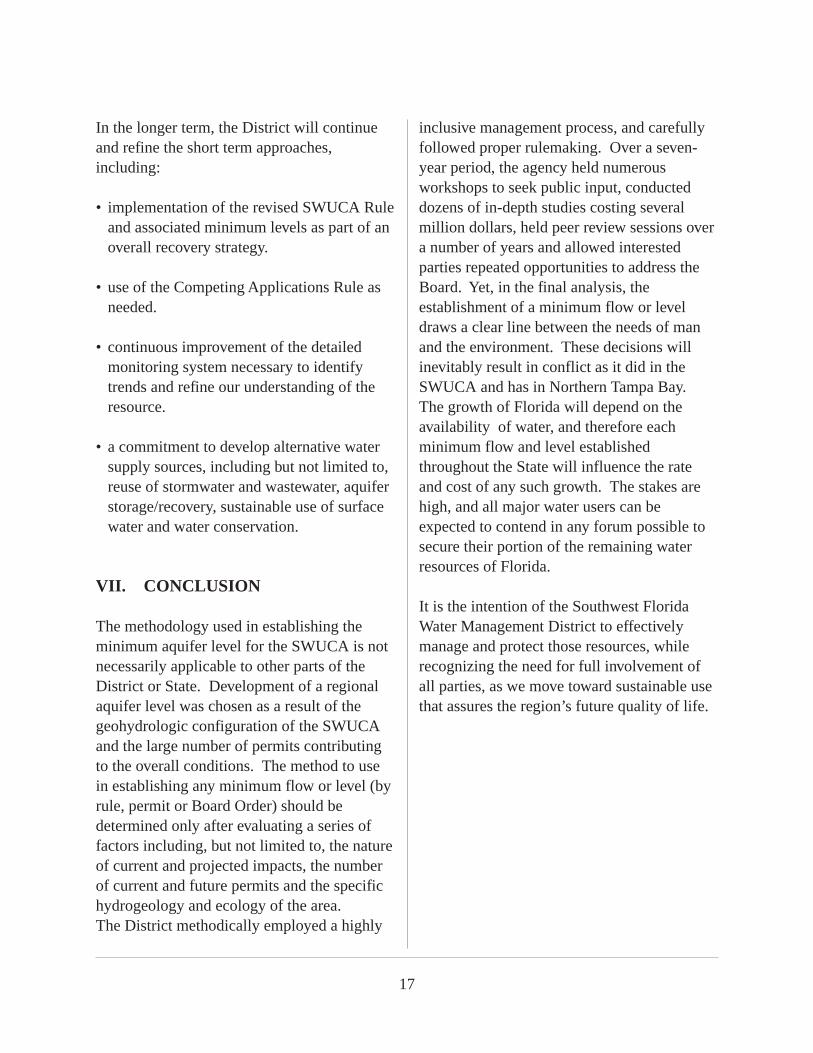
VII. CONCLUSION
The methodology used in establishing theminimum aquifer level for the SWUCA is notnecessarily applicable to other parts of theDistrict or State. Development of a regionalaquifer level was chosen as a result of thegeohydrologic configuration of the SWUCAand the large number of permits contributingto the overall conditions. The method to usein establishing any minimum flow or level (byrule, permit or Board Order) should bedetermined only after evaluating a series offactors including, but not limited to, the natureof current and projected impacts, the numberof current and future permits and the specifichydrogeology and ecology of the area.The District methodically employed a highly
inclusive management process, and carefullyfollowed proper rulemaking. Over a seven-year period, the agency held numerousworkshops to seek public input, conducteddozens of in-depth studies costing severalmillion dollars, held peer review sessions overa number of years and allowed interestedparties repeated opportunities to address theBoard. Yet, in the final analysis, theestablishment of a minimum flow or leveldraws a clear line between the needs of manand the environment. These decisions willinevitably result in conflict as it did in theSWUCA and has in Northern Tampa Bay.The growth of Florida will depend on theavailability of water, and therefore eachminimum flow and level establishedthroughout the State will influence the rateand cost of any such growth. The stakes arehigh, and all major water users can beexpected to contend in any forum possible tosecure their portion of the remaining waterresources of Florida.
It is the intention of the Southwest FloridaWater Management District to effectivelymanage and protect those resources, whilerecognizing the need for full involvement ofall parties, as we move toward sustainable usethat assures the region’s future quality of life.


![SALTWATER / BRACKISH-WATER AQ [objectives] Chapter 14](https://static.fdocuments.us/doc/165x107/56815907550346895dc63b2c/saltwater-brackish-water-aq-objectives-chapter-14.jpg)