Southern Nevada Economic Development and Conservation … › airquality › Documents ›...
11
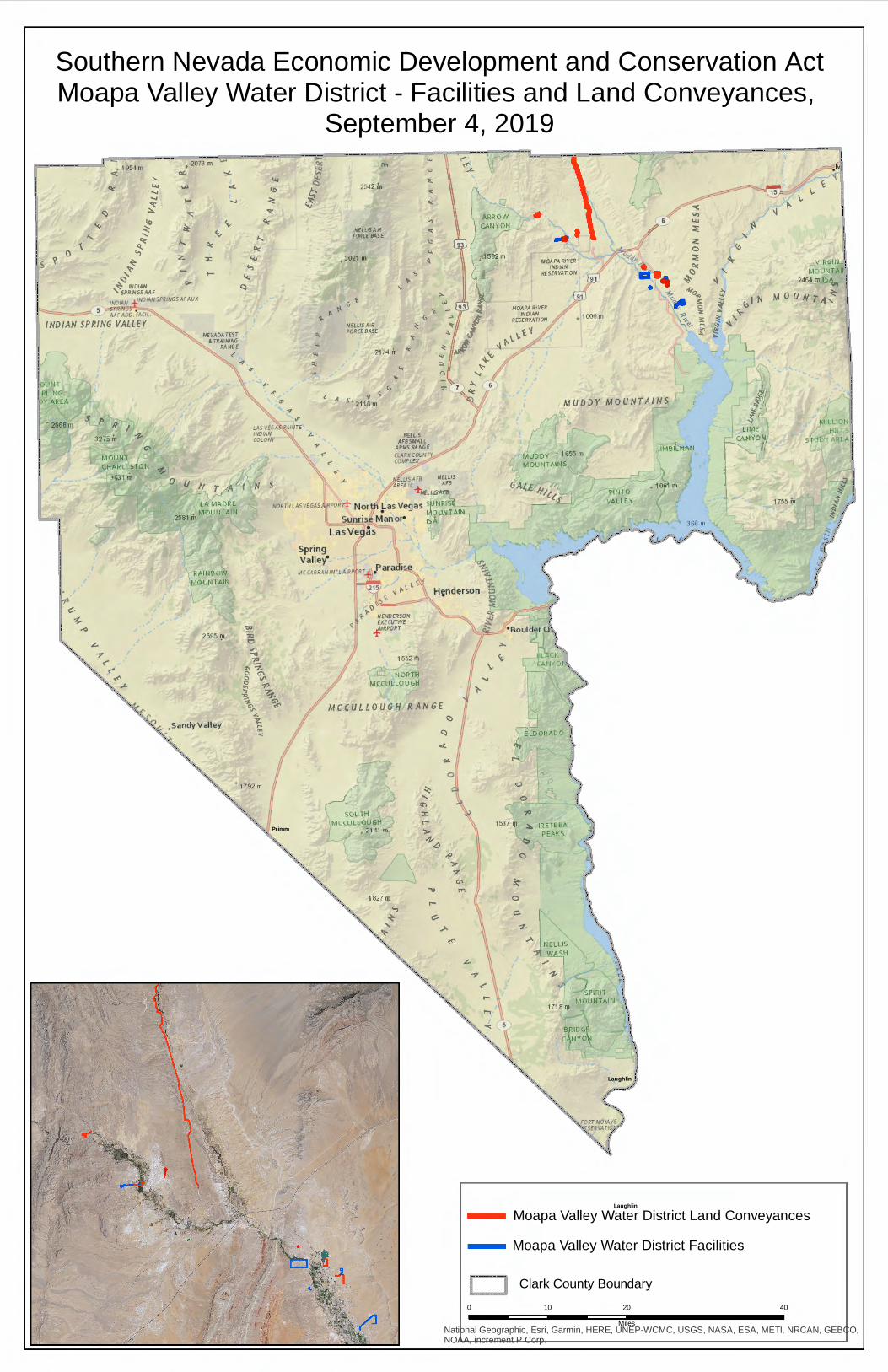
National Geographic, Esri, Garmin, HERE, UNEP-WCMC, USGS, NASA, ESA, METI, NRCAN, GEBCO, NOAA, increment P Corp. Southern Nevada Economic Development and Conservation Act Moapa Valley Water District - Facilities and Land Conveyances, September 4, 2019 Primm Laughlin Clark County Boundary Moapa Valley Water District Land Conveyances 0 20 40 10 Miles Laughlin Moapa Valley Water District Facilities l o i s y I l I I ! i l •IINT PLlllG r REA 26ti8 m I 2595 m ', "' ~' ' "'" ?0 'O V\ --0 -e "'~ 0 G"\ 0 V' t, --p "' .,, .., "- "' --< 1792 m "-,, ... ..,. ~fLtlSAIII FORCE BASE NELLISAl'l <ORCE BASE "' \, 2 174 ii, °' ', "' "' "' < "' ,,, < "' "' -I _,_ 1m'~1AFS ~iws + ~flllSA'8 RPOR& North Las Vegas <Utl Rl~E . • MOUNTAIIJ Sunrise Manor- 1, LasVe9as ..:. H;nderson g I) I'- HE~DERSO~ EXECUirlE J lr?POQ.T 1552 rti ll• • RTH M$;c\JLLO LI <., H RANGE ' <.> SOUTH :c 1-l CCU LLOII H r- , 2 141 m "> 1827 Ill <-, ' ' "-,,'" \, ,, ,,,,,~ .... ' >-- "'- ' MUDDY MOUNTAINS " 8L I lh v l' ). IRETEB PEAK S t, C c:. _.,. IIELLIS -? . H .,,. ,,,. ..,. 1718 (11 ', " " -~~ ' ,"- I ,PI RI, 11 )UNT PlllT ALLE ( ' I Ill \l ' i l _ __ ) If ~-- •ORT '-f()J/,.VE " ~sfq'/.4 TJO~-' ' /) 10',i1 m I ' IR ltl ' 1-\f "lllllT .,d 246ll m I MOUN 1 A~ ' l I \
Transcript of Southern Nevada Economic Development and Conservation … › airquality › Documents ›...
National Geographic, Esri, Garmin, HERE, UNEP-WCMC, USGS, NASA, ESA, METI, NRCAN, GEBCO,NOAA, increment P Corp.
Southern Nevada Economic Development and Conservation ActMoapa Valley Water District - Facilities and Land Conveyances,
September 4, 2019
Primm
Laughlin
Clark County Boundary
Moapa Valley Water District Land Conveyances
0 20 4010Miles
Laughlin
Moapa Valley Water District Facilities
l o i s y I
l
I I ! i l •IINT
PLlllG r REA
26ti8 m
I
2595 m
',
"' ~ '
' "'"
~ ?0 'O V\ --0
-e "'~ 0 G"\ 0 V' t, --p "' .,, ~ ..,
~ ~ "-
~ "' --<
1792 m
"-,,
... ..,.
~fLtlSAIII FORCE BASE
NELLISAl'l <ORCE BASE
"' \,
2174 ii, °'
',
"' "' "' <
"' ,,, <
"' "' -I
_,_ 1m'~1AFS ~iws + ~flllSA'8
RPOR& North Las Vegas <Utl Rl~E . • MOUNTAIIJ
Sunrise Manor- 1,
LasVe9as
~ ..:. ~
H;nderson g ~ I)
~ I'- HE~DERSO~ EXECUirlE
J lr?POQ.T
1552 rti
ll• •RTH M$;c\JLLO LI <.,H
RANGE
~
' <.> SOUTH :c
1-lCCU LLOII H r-, 2 141 m ">
1827 Ill
<-, ~
' ' "-,,'"
\,,,
,,,,,~
....
'
>--
"'-'
MUDDY MOUNTAINS
" 8L I lh v l '
). IRETEB PEAKS
t,
C
~
c:.
~
_.,. IIELLIS
-? . H .,,. ,,,.
..,.
1718 (11
',
" "-~~
',"-
I
,PI RI, 11 )UNT
PlllT ALLE (
' I Ill ~
\l
' i l
___ ) If
~--•ORT '-f()J/,.VE
"~sfq'/.4 TJO~-' ' /)
10',i1 m
I
' IR ltl ' 1-\f"lllllT .,d
246ll m I
MOUN 1 A~ ' l I \
National Geographic, Esri, Garmin, HERE, UNEP-WCMC, USGS, NASA, ESA, METI, NRCAN, GEBCO,NOAA, increment P Corp.
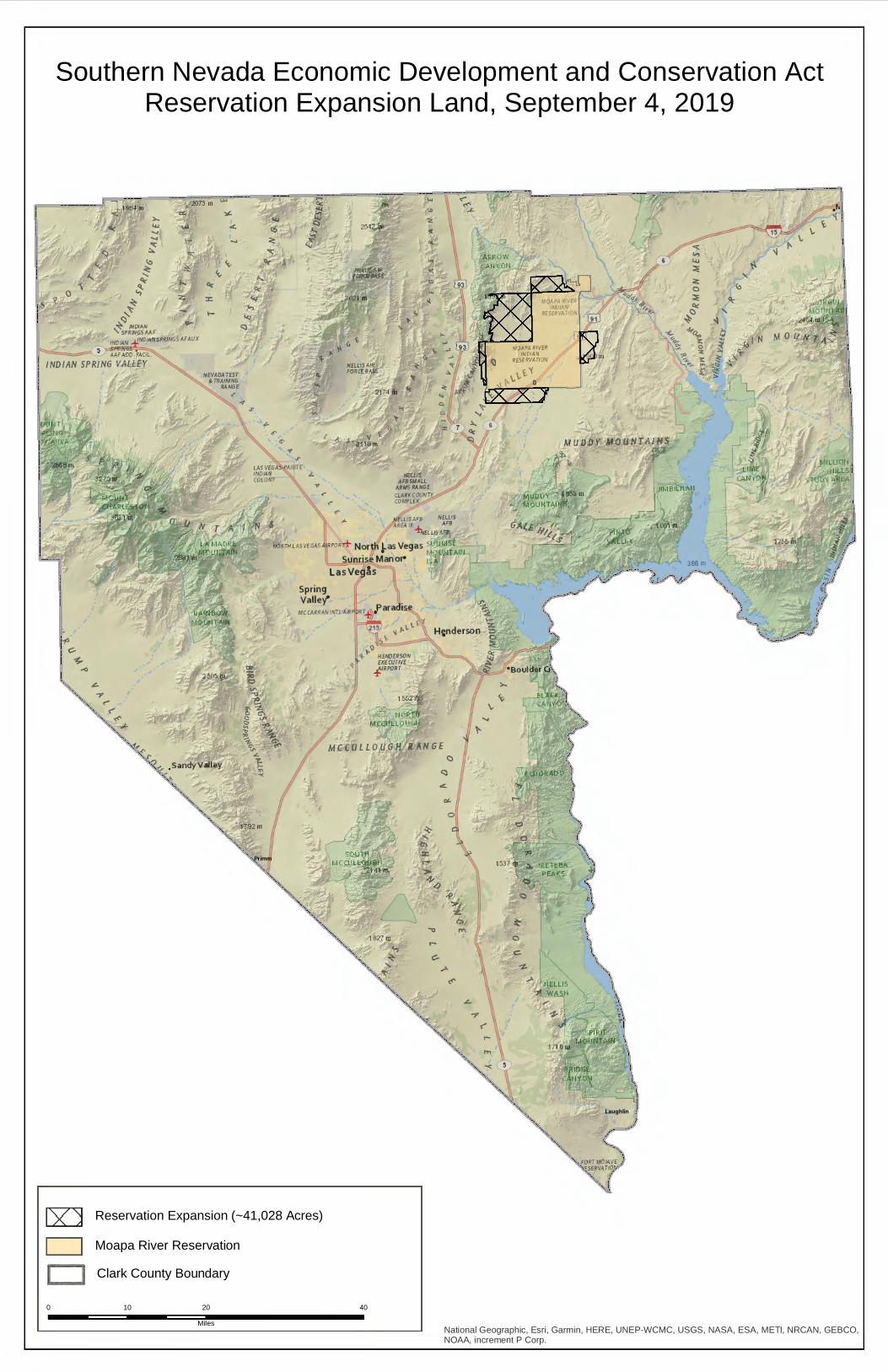
Southern Nevada Economic Development and Conservation ActReservation Expansion Land, September 4, 2019
Primm
Laughlin
0 20 4010Miles
Clark County BoundaryMoapa River ReservationReservation Expansion (~41,028 Acres)
:,..
"' .... ..., 'O:: ~
lo
~ ~
~ ~ ,~
+~ ~DIA~ '5pqfNGSAAF
•~DIA~ :f!~~5pqJNGSAFAUX
.::;,...._r ;-:SP'lN6'.S::, AAFADD.FACIL
IND/AN SPRING V,ALLEY
! i i ,_
:-1) ! C-
i ~ r ,.,
~., < ,.
'?.,., . sandyValley 1>,_~~
>- ~~lf,AFB ~i~~S + ~ElLIS'A'11
•PO•r±- Nortll 1-as Vegas 51:'JlH 'f • 1--1
Sunt1se Manol4 1s LasVegls
1827 01
<-, ~
' ,:,
--------- ------------------------- --- -- ----
23
26
11
1111
34
2728
33
25
02
13
20
29
0304
32
12
35
22
24
16
10
30
24
30
31
15
08
19
02
17
01
09
05
10
12
36
13
3634
21
03
25
14
353332
06
36
27
07
05
15
19
30
04
31
01
16
21
0908
03
06
28 27
07
20 22
32
15
29
33 34
10
02
09
35
26 30
23
14 16
23
01
25
24
13
12
20
28
17 14
19
18
08
06 05
07
31
18
26
04
2221
29
18
31
17
36 32
29
35
26 25
07
06
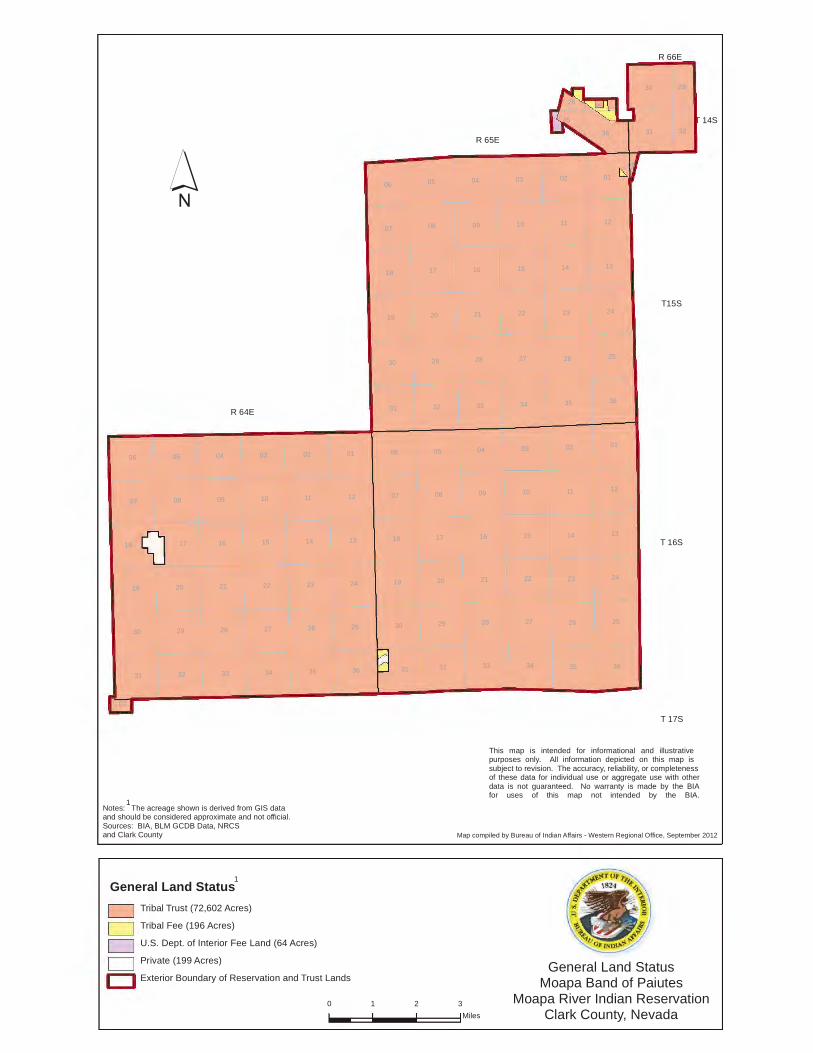
General Land StatusTribal Trust (72,602 Acres)Tribal Fee (196 Acres)U.S. Dept. of Interior Fee Land (64 Acres)Private (199 Acres)Exterior Boundary of Reservation and Trust Lands
´
0 1 2 3Miles
General Land StatusMoapa Band of Paiutes
Moapa River Indian ReservationClark County, Nevada
This map is intended for informational and illustrative purposes only. All information depicted on this map is subject to revision. The accuracy, reliability, or completenessof these data for individual use or aggregate use with otherdata is not guaranteed. No warranty is made by the BIAfor uses of this map not intended by the BIA.
Map compiled by Bureau of Indian Affairs - Western Regional Office, September 2012
Notes: The acreage shown is derived from GIS dataand should be considered approximate and not official. Sources: BIA, BLM GCDB Data, NRCSand Clark County
R 64E
R 65E
T 16S
T15S
R 66E
T 14S
T 17S
1
1
D D D D D
0 100 200 30050Feet
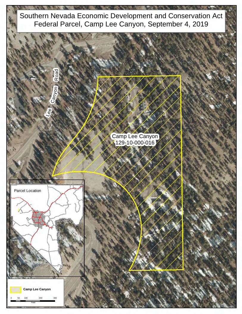
Camp Lee Canyon
Lee
Cany
onR o
ad
Camp Lee Canyon129-10-000-016
Southern Nevada Economic Development and Conservation ActFederal Parcel, Camp Lee Canyon, September 4, 2019
!.
Parcel Location
0 100 200 30050Feet
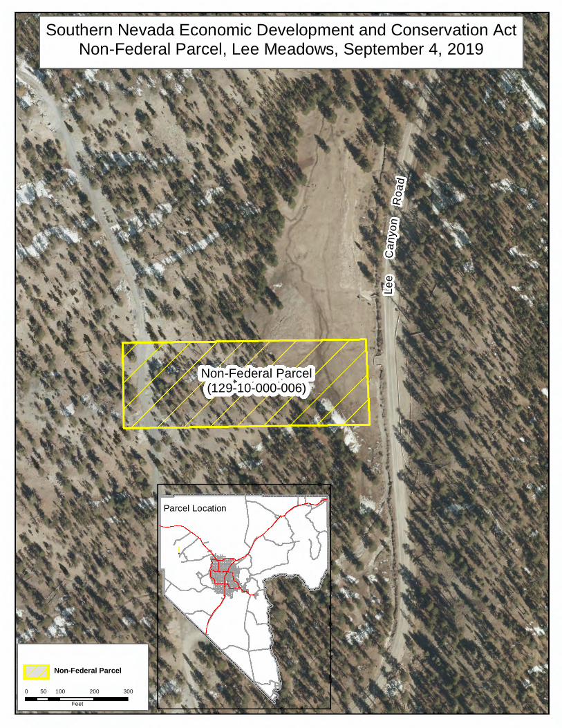
Non-Federal Parcel
Non-Federal Parcel(129-10-000-006)
Lee
Cany
onRo
ad
Southern Nevada Economic Development and Conservation ActNon-Federal Parcel, Lee Meadows, September 4, 2019
Parcel Location
!.
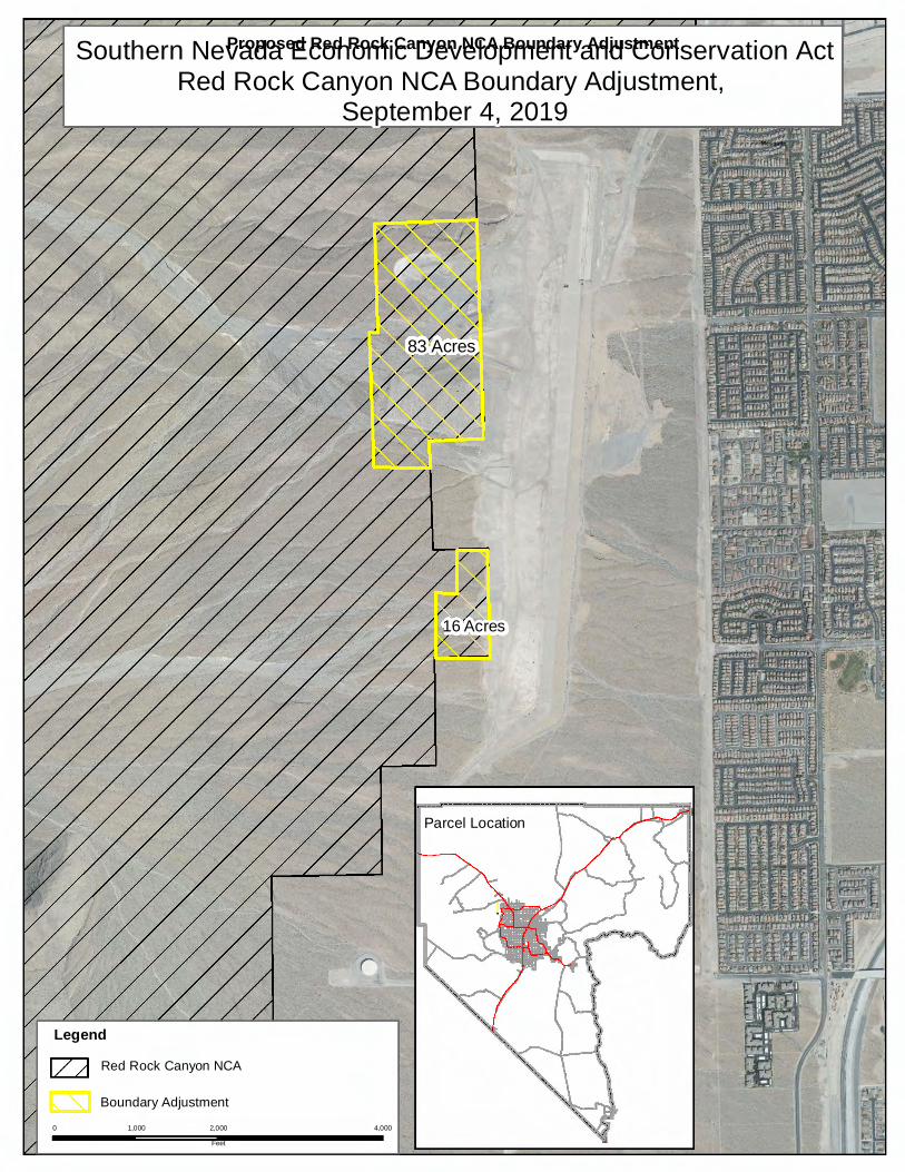
16 Acres
83 Acres
Proposed Red Rock Canyon NCA Boundary Adjustment
Mesquite
0 2,000 4,0001,000Feet
Legend
Boundary Adjustment
Red Rock Canyon NCA
Southern Nevada Economic Development and Conservation ActRed Rock Canyon NCA Boundary Adjustment,
September 4, 2019
Parcel Location
!.
r
/ /
/ / /
~ 7 / L
0 2,500 5,0001,250Feet
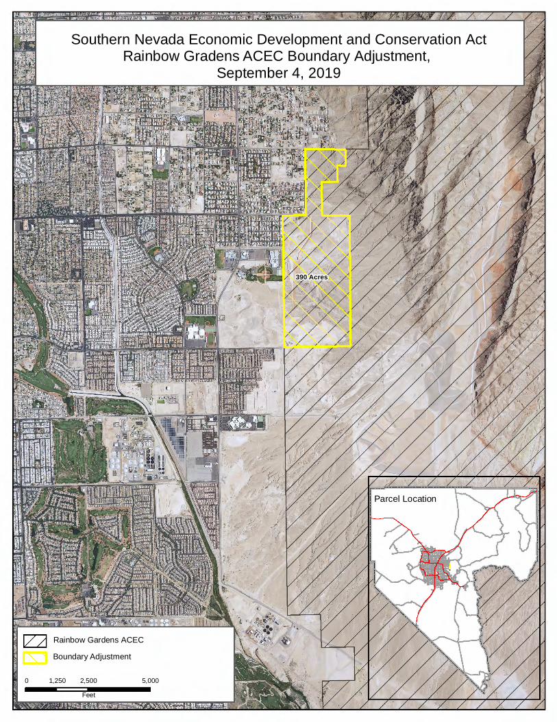
Rainbow Gardens ACEC Boundary Adjustment
390 Acres
Southern Nevada Economic Development and Conservation ActRainbow Gradens ACEC Boundary Adjustment,
September 4, 2019
Parcel Location
!.
National Geographic, Esri, Garmin, HERE, UNEP-WCMC, USGS, NASA, ESA, METI, NRCAN, GEBCO,NOAA, increment P Corp.
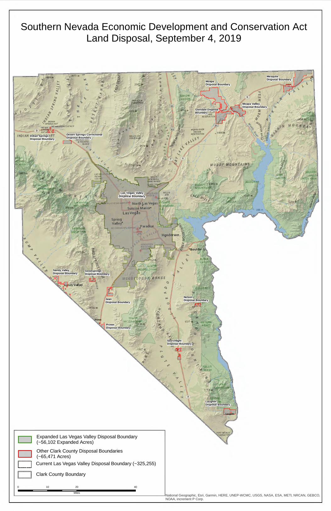
Southern Nevada Economic Development and Conservation ActLand Disposal, September 4, 2019
Primm
Laughlin
Glendale Disposal Boundary
Las Vegas ValleyDisposal Boundary
Moapa VallleyDisposal Boundary
MesquiteDisposal Boundary
Clark County Boundary
Expanded Las Vegas Valley Disposal Boundary(~56,102 Expanded Acres)
Current Las Vegas Valley Disposal Boundary (~325,255)
0 20 4010Miles
Other Clark County Disposal Boundaries(~65,471 Acres)
MoapaDisposal Boundary
Indian SpringsDisposal Boundary
Desert Springs CorrectionalDisposal Boundary
Sandy ValleyDisposal Boundary
PrimmDisposal Boundary
GoodspringsDisposal Boundary
JeanDisposal Boundary
NelsonDisposal Boundary
SearchlightDisposal Boundary
LaughlinDisposal Boundary
! i i ,_
:-1) ! C-
i ~ 1 ,<)
D D i---------, . . : : , ••••••••• .J
II Iii
.. ~f.. 1792 m
1827 01
<-, ~
.....
National Geographic, Esri, Garmin, HERE, UNEP-WCMC, USGS, NASA, ESA, METI, NRCAN, GEBCO,NOAA, increment P Corp.
Moapa
Primm
Laughlin
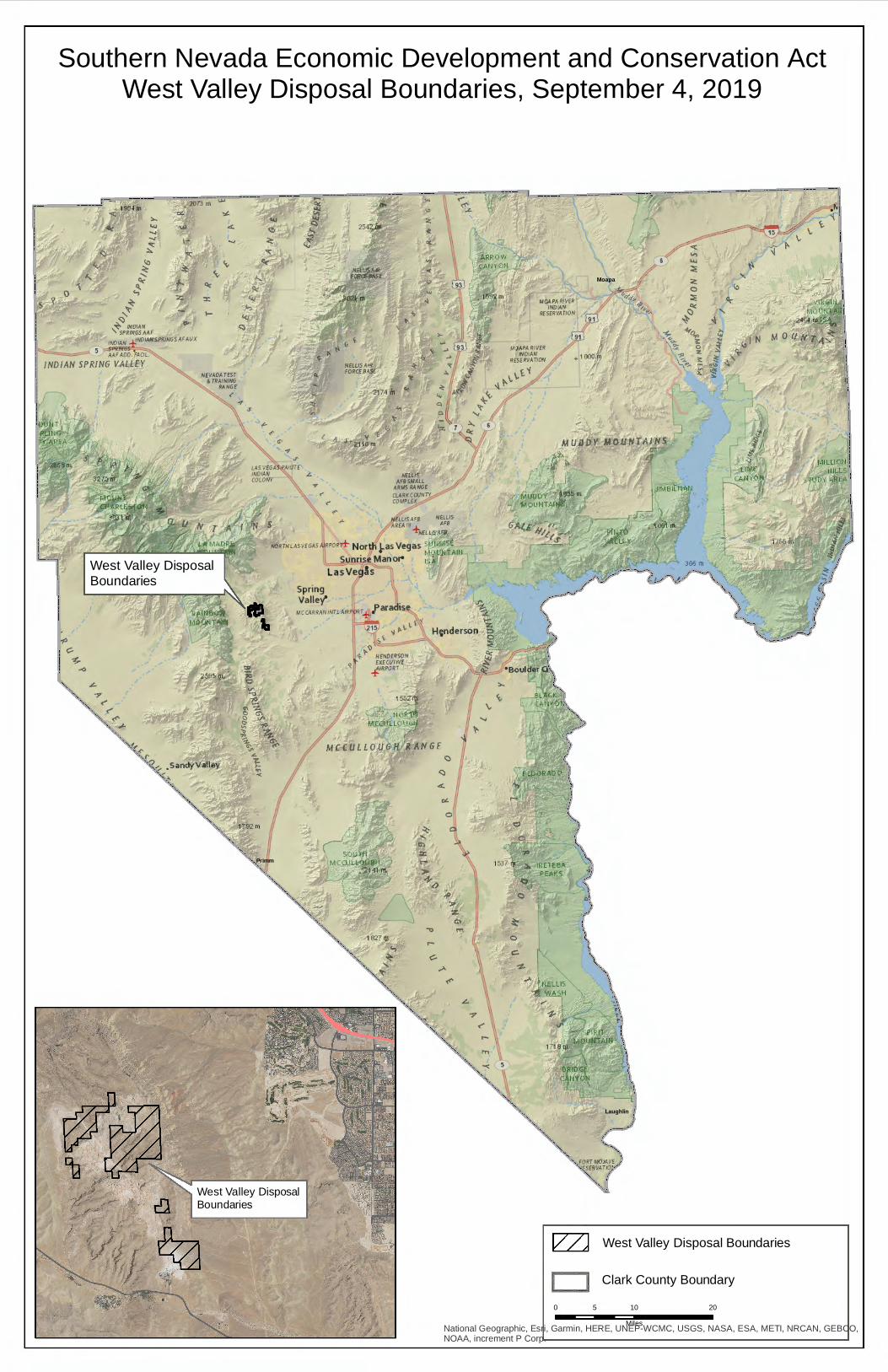
Southern Nevada Economic Development and Conservation ActWest Valley Disposal Boundaries, September 4, 2019
West Valley Disposal Boundaries
Clark County Boundary
West Valley Disposal Boundaries
0 10 205Miles
West Valley DisposalBoundaries
...., <i: ::,.
~ ~
' ~ ~ ~ ,~
~"1 INDIAN '5pq1N6SMF
l'IOJAN ..j,'.NOJANSfqJNGSAFAUX
5 ,s,,l!,rfl;¢. AA' AOO. FAOL
INDIAN SPRING VALLEY
' i· ,.,,, ! c-, ~ i -<)
"" J!..
'>f-,, <' ,..
' ~ y,. Sandy Valley ~
1827 !JJ <-, ~
.....
' ) ~
}
I •"'I '{ i
I I I
National Geographic, Esri, Garmin, HERE, UNEP-WCMC, USGS, NASA, ESA, METI, NRCAN, GEBCO,NOAA, increment P Corp.
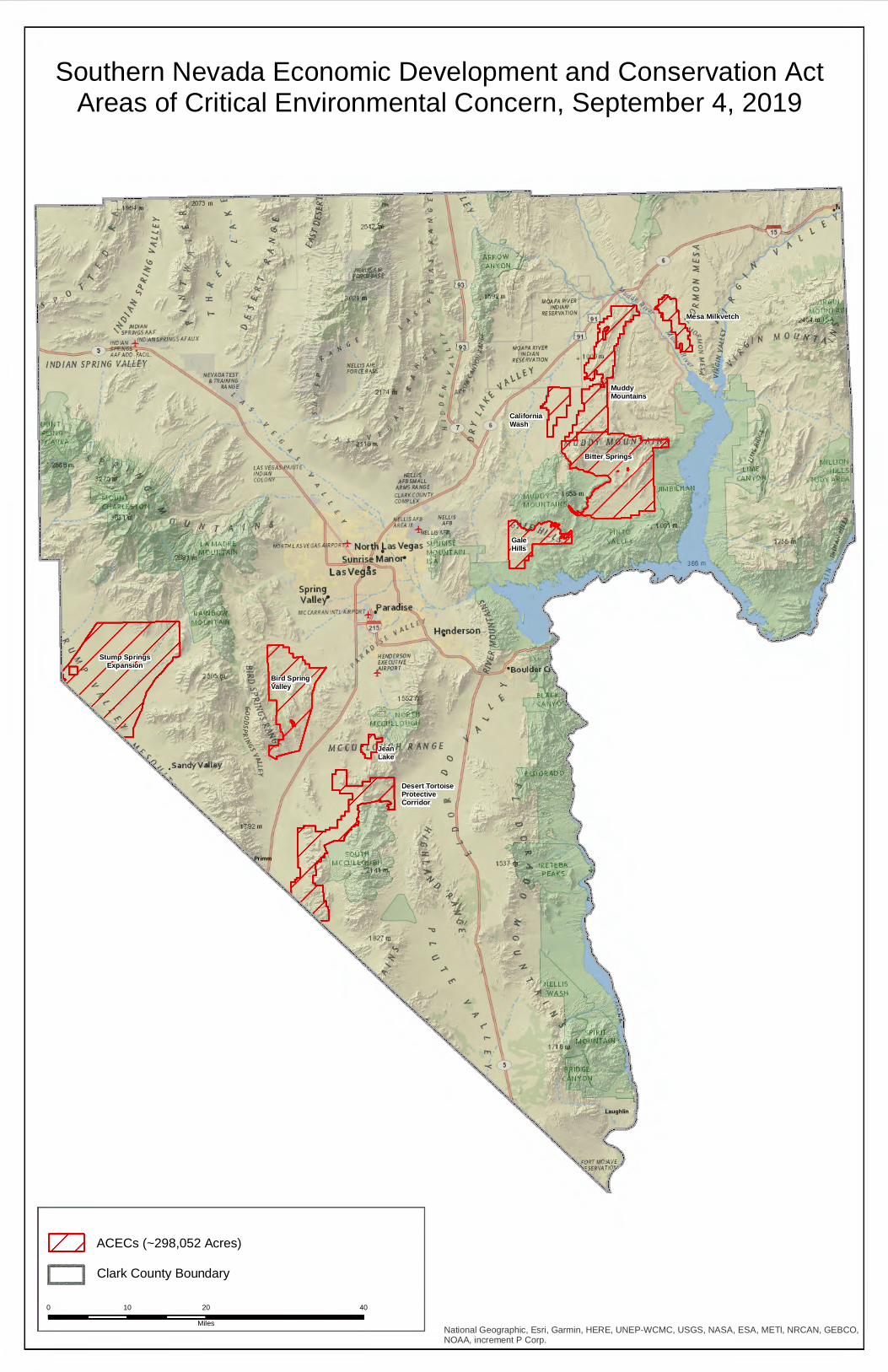
Southern Nevada Economic Development and Conservation ActAreas of Critical Environmental Concern, September 4, 2019
Mesa Milkvetch
Primm
Laughlin
Stump SpringsExpansion
Bird SpringValley
JeanLake
Bitter Springs
MuddyMountains
CaliforniaWash
GaleHills
0 20 4010Miles
Clark County BoundaryACECs (~298,052 Acres)
Desert Tortoise ProtectiveCorridor
.... ..., 'O:: ~
lo
~ ~
~ ~ ,~
+~ ~DIA~ '5pqfNGSAAF
•~DIA~ :f!~~5pqJNGSAFAUX ;-:SP'lN6'.S::, AAFADD.FACIL
IND/AN SPRING V,ALLEY
.. ~f.. 1792 m
>- ~~lf,AFB ~i~~S + ~ElLIS'A'11
•PO•r±- Nortll 1-as Vegas 51:'JlH 'f • 1--1
Sunt1se Manol4 1s LasVegls
1827 01
<-, ~
r--
--------- ---------------------- --------------- -1
-.~1 " : 15 " " \'.. I .I t- I
"' I I :
National Geographic, Esri, Garmin, HERE, UNEP-WCMC, USGS, NASA, ESA, METI, NRCAN, GEBCO,NOAA, increment P Corp.
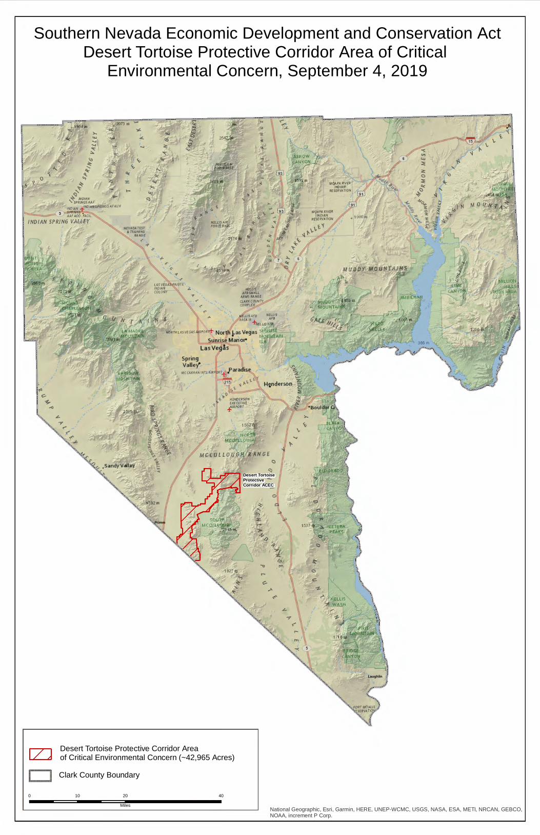
Southern Nevada Economic Development and Conservation ActDesert Tortoise Protective Corridor Area of Critical
Environmental Concern, September 4, 2019
Primm
Laughlin
Desert Tortoise ProtectiveCorridor ACEC
0 20 4010Miles
Clark County Boundary
Desert Tortoise Protective Corridor Areaof Critical Environmental Concern (~42,965 Acres)
:,..
"' .... ..., 'O:: ~
lo
~ ~
~ ~ ,~
+~ ~DIA~ '5pqfNGSAAF
•~DIA~ :f!~~5pqJNGSAFAUX
.::;,...._r ;-:SP'lN6'.S::, AAFADD.FACIL
IND/AN SPRING V,ALLEY
! i i ,_
:-1) ! C-
i ~ r ,.,
~., < ,.
'?.,., . sandyValley 1>,_~~
.. ~f.. 1792 m
[Z]
>- ~~lf,AFB ~i~~S + ~ElLIS'A'11
•PO•r±- Nortll 1-as Vegas 51:'JlH 'f • 1--1
Sunt1se Manol4 1s LasVegls
1827 01
<-, ~
' ,:,
--------- ------------------------- --- -- ----