Southeast Asia applied geophysics workshop:...
5
Southeast Asia applied geophysics workshop: Geoscientists without borders Lee M. Liberty*, Spencer H. Wood, Emily A. Hinz, and Dylan Mikesell, Boise State University, Fongsaward Singharajawarapan, Chiang Mai University, Jeffrey Shragge, University of Western Australia Summary As first-round recipients of the SEG Foundation Geoscientists Without Borders program, we conducted a geophysics workshop in northern Thailand to train students and professionals in geophysical methods to address environmental and engineering challenges. Faculty, technicians, professionals and students from fifteen participating institutions from seven countries acquired, processed and interpreted geophysical data at four separate sites in Chiang Mai, Thailand. These field sites were selected to train participants in the use of a variety of geophysical methods to address groundwater, archaeology, and geohazard concerns. The workshop consisted of one week of data acquisition followed by a week of data analysis for seismic, ground penetrating radar, electrical, electromagnetic, gravity, and magnetic data. Participants learned geophysical theory while acquiring, processing, and interpreting geophysical datasets. At the end of the workshop, participants documented and presented their results. Final products from the GWB-sponsored field training including a 125-page student generated field camp report and a 180-slide presentation. Photos and technical information can be found and downloaded at http://cgiss.boisestate.edu/gwb Introduction The SEG Geoscientists Without Borders (GWB) program was created to help connect universities and industries with communities in need using applied geophysics projects as a means to benefit people and the environment around the world. Our project was developed to educate and connect local geophysicists and students in Southeast Asia. The goal was to instruct participants, using modern geophysical instrumentation and software, how to address environmental and engineering applications in their home country. By gathering 41 professional and student participants from seven countries and fifteen institutes (Table 1), we believe we have honored the GWB mission. Our vision was to not directly address specific near-surface geophysical issues, but to provide scenarios to train local professionals and future geophysicists to solve hazards or geosciences problem found within their own countries borders. By providing the tools and skills necessary to address groundwater, geotechnical, and archaeology problems, we hope to have a greater impact on projects throughout Southeast Asia for many years to come. This model was derived from our existing geophysics field camp (e.g., Colorado School of Mines and Boise State University, 2009). Faculty, graduate students, and technicians provided student instruction (Table 2) both in the classroom and field settings (Figure 1). Introductory lectures were presented by local experts and visiting faculty to discuss field sites and an overview of geophysical methods applicable at each site. An instructor was provided for each geophysical tool and field site to guide the student participants through acquisition, processing, and interpretation phases of the training. All instruction was carried out in English with at least one bilingual (Thai) participant in each group and a 3:1 student/instructor ratio. Participants from government and private agencies provided leadership for some geophysical applications, but also provided a broadening of geophysical tools and a student connection to the work force. Boise State University (USA) Kasetsart University (Thailand) Chiang Mai University (Thailand) Mahidol University (Thailand) Chulalongkorn University (Thailand) Royal Irrigation Department (Thailand) Colorado School of Mines (USA) Siam Tone Co., Ltd. (Thailand) Department of Mineral Resources (Thailand) Universiti Teknologi Petronas (Malaysia) Electricity Generating Authority (Thailand) University of Science, Ho Chi Minh City (Vietnam) Gadjah Mada University (Indonesia) University of Western Australia Geonics Limited (Canada) Figure 1: Sarawute Chantraprasert, Chiang Mai University geosciences professor, provides a tectonic overview of the Chiang Mai Basin, Thailand to participants. 3853 SEG Denver 2010 Annual Meeting © 2010 SEG Downloaded 01 Feb 2011 to 132.178.2.64. Redistribution subject to SEG license or copyright; see Terms of Use at http://segdl.org/
Transcript of Southeast Asia applied geophysics workshop:...
Southeast Asia applied geophysics workshop: Geoscientists without borders Lee M. Liberty*, Spencer H. Wood, Emily A. Hinz, and Dylan Mikesell, Boise State University, Fongsaward Singharajawarapan, Chiang Mai University, Jeffrey Shragge, University of Western Australia Summary As first-round recipients of the SEG Foundation Geoscientists Without Borders program, we conducted a geophysics workshop in northern Thailand to train students and professionals in geophysical methods to address environmental and engineering challenges. Faculty, technicians, professionals and students from fifteen participating institutions from seven countries acquired, processed and interpreted geophysical data at four separate sites in Chiang Mai, Thailand. These field sites were selected to train participants in the use of a variety of geophysical methods to address groundwater, archaeology, and geohazard concerns. The workshop consisted of one week of data acquisition followed by a week of data analysis for seismic, ground penetrating radar, electrical, electromagnetic, gravity, and magnetic data. Participants learned geophysical theory while acquiring, processing, and interpreting geophysical datasets. At the end of the workshop, participants documented and presented their results. Final products from the GWB-sponsored field training including a 125-page student generated field camp report and a 180-slide presentation. Photos and technical information can be found and downloaded at http://cgiss.boisestate.edu/gwb Introduction The SEG Geoscientists Without Borders (GWB) program was created to help connect universities and industries with communities in need using applied geophysics projects as a means to benefit people and the environment around the world. Our project was developed to educate and connect local geophysicists and students in Southeast Asia. The goal was to instruct participants, using modern geophysical instrumentation and software, how to address environmental and engineering applications in their home country. By gathering 41 professional and student participants from seven countries and fifteen institutes (Table 1), we believe we have honored the GWB mission. Our vision was to not directly address specific near-surface geophysical issues, but to provide scenarios to train local professionals and future geophysicists to solve hazards or geosciences problem found within their own countries borders. By providing the tools and skills necessary to address groundwater, geotechnical, and archaeology problems, we hope to have a greater impact on projects throughout Southeast Asia for many years to come. This model was derived from our existing geophysics field camp (e.g., Colorado School of Mines and Boise State University, 2009).
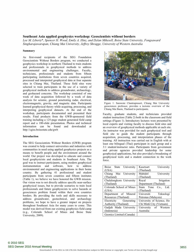
Faculty, graduate students, and technicians provided student instruction (Table 2) both in the classroom and field settings (Figure 1). Introductory lectures were presented by local experts and visiting faculty to discuss field sites and an overview of geophysical methods applicable at each site. An instructor was provided for each geophysical tool and field site to guide the student participants through acquisition, processing, and interpretation phases of the training. All instruction was carried out in English with at least one bilingual (Thai) participant in each group and a 3:1 student/instructor ratio. Participants from government and private agencies provided leadership for some geophysical applications, but also provided a broadening of geophysical tools and a student connection to the work force.
Boise State University (USA)
Kasetsart University (Thailand)
Chiang Mai University (Thailand)
Mahidol University (Thailand)
Chulalongkorn University (Thailand)
Royal Irrigation Department (Thailand)
Colorado School of Mines (USA)
Siam Tone Co., Ltd. (Thailand)
Department of Mineral Resources (Thailand)
Universiti Teknologi Petronas (Malaysia)
Electricity Generating Authority (Thailand)
University of Science, Ho Chi Minh City (Vietnam)
Gadjah Mada University (Indonesia)
University of Western Australia
Geonics Limited (Canada)
Figure 1: Sarawute Chantraprasert, Chiang Mai University geosciences professor, provides a tectonic overview of the Chiang Mai Basin, Thailand to participants.
3853SEG Denver 2010 Annual Meeting© 2010 SEG
Downloaded 01 Feb 2011 to 132.178.2.64. Redistribution subject to SEG license or copyright; see Terms of Use at http://segdl.org/
Southeast Asia applied geophysics workshop
Table 1. Participating Institutions
Table 2. Instructor Name, Affiliation In addition to the generous support of the SEG GWB program, many other institutes and individuals contributed to the success of this workshop (Table 3), with a combined contribution that exceeded $130,000. Contributions from participating institutions included release time for faculty, use of geophysical field equipment, and support from administrative assistants, accounting, travel services, etc. Additionally, travel funds and student support were provided through supporting institutions (Table 3). Seismic, gravity, magnetic, electrical, and resistivity equipment used during this training was provided by Boise State University, Chiang Mai University, Thailand Department of Mineral Industries, Siam Tone and University of Western Australia.
Table 3. Donor Institution and support
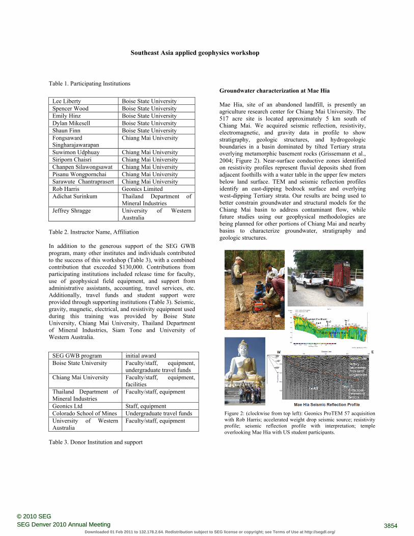
Groundwater characterization at Mae Hia Mae Hia, site of an abandoned landfill, is presently an agriculture research center for Chiang Mai University. The 517 acre site is located approximately 5 km south of Chiang Mai. We acquired seismic reflection, resistivity, electromagnetic, and gravity data in profile to show stratigraphy, geologic structures, and hydrogeologic boundaries in a basin dominated by tilted Tertiary strata overlying metamorphic basement rocks (Grissemann et al., 2004; Figure 2). Near-surface conductive zones identified on resistivity profiles represent fluvial deposits shed from adjacent foothills with a water table in the upper few meters below land surface. TEM and seismic reflection profiles identify an east-dipping bedrock surface and overlying west-dipping Tertiary strata. Our results are being used to better constrain groundwater and structural models for the Chiang Mai basin to address contaminant flow, while future studies using our geophysical methodologies are being planned for other portions of Chiang Mai and nearby basins to characterize groundwater, stratigraphy and geologic structures.
Lee Liberty Boise State University Spencer Wood Boise State University Emily Hinz Boise State University Dylan Mikesell Boise State University Shaun Finn Boise State University Fongsaward Singharajawarapan
Chiang Mai University
Suwimon Udphuay Chiang Mai University Siriporn Chaisri Chiang Mai University Chanpen Silawongsawat Chiang Mai University Pisanu Wongpornchai Chiang Mai University Sarawute Chantraprasert Chiang Mai University Rob Harris Geonics Limited Adichat Surinkum Thailand Department of
Mineral Industries Jeffrey Shragge University of Western
Australia
SEG GWB program initial award Boise State University Faculty/staff, equipment,
undergraduate travel funds Chiang Mai University Faculty/staff, equipment,
facilities Thailand Department of Mineral Industries
Faculty/staff, equipment
Geonics Ltd Staff, equipment Colorado School of Mines Undergraduate travel funds University of Western Australia
Faculty/staff, equipment Figure 2: (clockwise from top left): Geonics ProTEM 57 acquisition with Rob Harris; accelerated weight drop seismic source; resistivity profile; seismic reflection profile with interpretation; temple overlooking Mae Hia with US student participants.
3854SEG Denver 2010 Annual Meeting© 2010 SEG
Downloaded 01 Feb 2011 to 132.178.2.64. Redistribution subject to SEG license or copyright; see Terms of Use at http://segdl.org/
Southeast Asia applied geophysics workshop
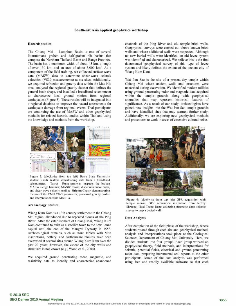
Hazards studies The Chiang Mai – Lamphun Basin is one of several intermontane graben and half-graben rift basins that compose the Northern Thailand Basin and Range Province. The basin has a maximum width of about 45 km, a length of over 130 km, and an area of about 3,000 km2. As a component of the field training, we collected surface wave data (MASW) data to determine shear-wave seismic velocities (VS30 measurements) at six sites. Additionally, we acquired refraction and gravity data within the Mae Hia area, analyzed the regional gravity dataset that defines the general basin shape, and installed a broadband seismometer to characterize local ground motion from regional earthquakes (Figure 3). These results will be integrated into a regional database to improve the hazard assessments for earthquake damage from regional events. Thai participants are continuing the use of MASW and other geophysical methods for related hazards studies within Thailand using the knowledge and methods from the workshop.
Archaeology studies Wiang Kum Kam is a 13th century settlement in the Chiang Mai region, abandoned due to repeated floods of the Ping River. After the establishment of Chiang Mai, Wiang Kum Kam continued to exist as a satellite town to the new Lanna capital until the end of the Mangrai Dynasty in 1558. Archaeological remains, such as stone tablets with Mon inscriptions, pottery, and earthenware moulds have been excavated at several sites around Wiang Kum Kam over the past 20 years; however, the extent of the city walls and structures is not known (e.g., Wood et al., 2004). We acquired ground penetrating radar, magnetic, and resistivity data to identify and characterize abandoned
channels of the Ping River and old temple brick walls. Geophysical surveys were carried out above known brick walls and where additional walls were suspected. Although no new buried walls were identified, an old levee system was identified and characterized. We believe this is the first documented geophysical survey of this type of levee system and likely defines the extent of the ancient city of Wiang Kum Kam. Wat Pan Sao is the site of a present-day temple within Chiang Mai where ancient walls and structures were unearthed during excavation. We identified modern utilities using ground penetrating radar and magnetic data acquired within the temple grounds along with geophysical anomalies that may represent historical features of significance. As a result of our study, archaeologists have gained new insights into the Wat Pan Sao temple grounds and have identified sites that may warrant further study. Additionally, we are exploring new geophysical methods and procedures to work in areas of extensive cultural noise.
Data Analysis After completion of the field phase of the workshop, where students rotated through each site and geophysical method, analysis and interpretations took place at the Geological Sciences Department of Chiang Mai University. Here, we divided students into four groups. Each group worked on geophysical theory, field methods, and interpretations for seismic, potential fields, electrical and ground penetrating radar data, preparing incremental oral reports to the other participants. Much of the data analysis was performed using free and readily available software so that each
Figure 3: (clockwise from top left) Boise State University student Randi Walters downloading data from a broadbandseismometer; Tawat Rung-Arunwan inspects the brokenMASW sledge hammer; MASW record, dispersion curve picks,and shear-wave velocity profile; Siriporn Chaisri demonstratingthe use of the CMU CG-3 gravimeter; processed gravity profileand interpretation from Mae Hia.
Figure 4: (clockwise from top left) GPR acquisition with temple monks; GPR acquisition instruction from Jeffrey Shragge; Hoai Trung Dang collecting magnetic data; seismic survey to map a buried wall.
3855SEG Denver 2010 Annual Meeting© 2010 SEG
Downloaded 01 Feb 2011 to 132.178.2.64. Redistribution subject to SEG license or copyright; see Terms of Use at http://segdl.org/
Southeast Asia applied geophysics workshop
participant could analyze the datasets without commercial restrictions. A team also worked on data archival and data integration. Participants prepared presentations and reports that were integrated into a master document and presentation. A presentation to the Chiang Mai University community was the final product of the workshop. Field data, processed results, field photos, and public domain software are posted at http://cgiss.boisestate.edu/gwb
Summary The overwhelming response of the participants was that this workshop was a success and has elevated the use and interest in applied geophysics to address engineering and environmental problems. Participants also suggest future trainings should continue to train the next generation geoscientists. Multinational institute collaboration proved very effective to bridge cultural and procedural differences to permit and acquire geophysical data, provide community outreach, and to obtain high quality results from geophysical instrumentation and software that is mostly available in Southeast Asia. We anticipate workshops to continue through community sponsors as a result of the SEG GWB program. Acknowledgements This geophysics workshop could not have been possible without the support of many organizations and individuals. We greatly appreciate the generous financial contributions made by the Society of Exploration Geophysicists Geoscientists Without Borders program, our primary sponsor. In addition to the SEG financial support, significant contributions were provided by Boise State University, Chiang Mai University, Colorado School of Mines, Thailand Department of Mineral Resources, Geonics Limited, University of Western Australia, and many individuals within this group that provided time, effort and personal funds to make this field training a success. Additionally, we wish to thank Chiang Mai University, the Chiang Mai Office of Archaeology and National Museum, The Fine Arts Department, and the Chief Monk of Wat Pan Sao for site access and historical documents.
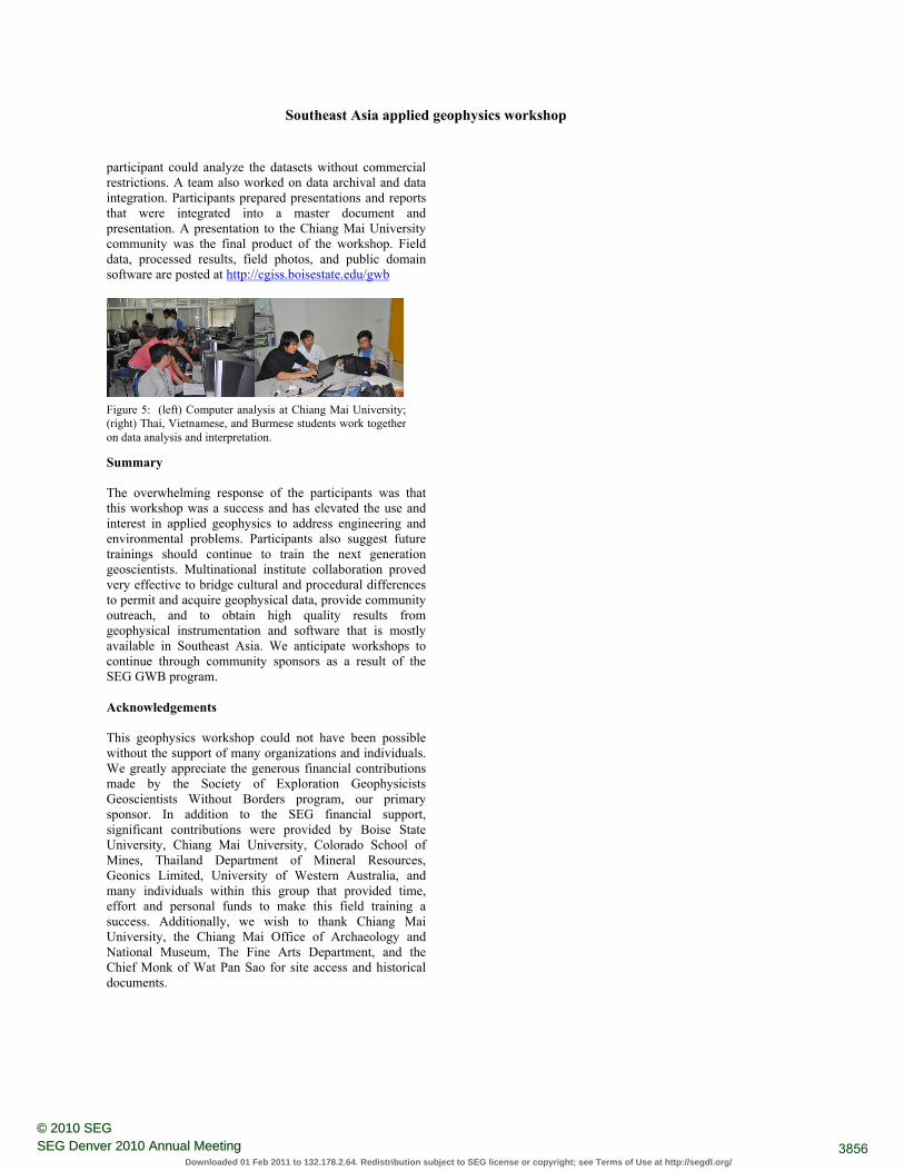
Figure 5: (left) Computer analysis at Chiang Mai University;(right) Thai, Vietnamese, and Burmese students work togetheron data analysis and interpretation.
3856SEG Denver 2010 Annual Meeting© 2010 SEG
Downloaded 01 Feb 2011 to 132.178.2.64. Redistribution subject to SEG license or copyright; see Terms of Use at http://segdl.org/
EDITED REFERENCES Note: This reference list is a copy-edited version of the reference list submitted by the author. Reference lists for the 2010 SEG Technical Program Expanded Abstracts have been copy edited so that references provided with the online metadata for each paper will achieve a high degree of linking to cited sources that appear on the Web. REFERENCES
Colorado School of Mines and Boise State University, 2009, Characterization of the Upper Arkansas River Basin : geophysics field camp report, http://pal.boisestate.edu/mediawiki/index.php/Field_camp
Grissemann, C., A. Schuck, K. Seidel, G. Lange, and W. Tantiwanit , 2004. Geophysical signatures of the abandoned waste disposal sites: Proceedings of the International Conference on Applied Geophysics, 50-59.
Wood, S. H., L. M. Liberty, F. S. Singharajwarapan, T. Bundarnsin, and E. Rothwell, 2004, Feasibility of gradient magnetometer surveys of buried brick structures at 13th Century (C.E.) Wiang Kum Kam, Chiang Mai Province, Thailand, in: Proceedings of the International Conference on Applied Geophysics, 22–30.
3857SEG Denver 2010 Annual Meeting© 2010 SEG
Downloaded 01 Feb 2011 to 132.178.2.64. Redistribution subject to SEG license or copyright; see Terms of Use at http://segdl.org/