SOUTHBANK BOULEVARD & DODDS STREET...SOUTHBANK BOULEVARD & DODDS STREET ii Cover image: Extract from...
162
SOUTHBANK BOULEVARD & DODDS STREET Ecological, Heritage and Cultural Place Assessment Final Report October 2015 Prepared for City of Melbourne
Transcript of SOUTHBANK BOULEVARD & DODDS STREET...SOUTHBANK BOULEVARD & DODDS STREET ii Cover image: Extract from...

SOUTHBANK BOULEVARD & DODDS STREET Ecological, Heritage and Cultural Place Assessment
Final Report October 2015
Prepared forCity of Melbourne

SOUTHBANK BOULEVARD & DODDS STREET
ii
Cover image: Extract from Henry Cox’s map of Melbourne dated 1865
Report Register
This report register documents the development and issue of the report entitled Southbank Boulevard & Dodds Street; Ecological. Heritage and Cultural Place Assessment undertaken by Context Pty Ltd in accordance with our internal quality management system.
Project No.
IssueNo.
Notes/description Issue Date
Issued to
2031 1a Partial Draft Report 7/10/15 Steve Perumel @ City of Melbourne
2031 1b Final Draft Report 14/10/15 Steve Perumel @ City of Melbourne
2031 2 Final Report 23/10/15 Steve Perumel @ City of Melbourne
Context Pty Ltd 2015
Project Team:
Ian Travers, Associate
Louise Honman, Director
Helen Doyle, Historian
Lawrie Conole, Ecologist
Georgia Melville, Consultant
Catherine McLay, Consultant
Context Pty Ltd 22 Merri Street, Brunswick VIC 3056
Phone 03 9380 6933 Facsimile 03 9380 4066
Email [email protected] Web www.contextpl.com.au

ECOLOGICAL, HERITAGE AND CULTURAL PLACE ASSESSMENT
iii
CONTENTS
1 INTRODUCTION 1
1.1 Purpose of the study 11.2 Background to the study 11.3 Study area 11.4 Study aims 2
1.4.1 Scope of assessment 31.5 Content of this report 31.6 Consultation 3
1.6.1 Heritage Victoria (HV) 31.6.2 Office of Aboriginal Affairs Victoria (OAAV) 41.6.3 Traditional Owners groups 41.6.4 Wider community 41.6.4 Local organisations 4
2 CITY OF MELBOURNE STRATEGIC FRAMEWORK 5
2.1 City of Melbourne Open Space Strategy (2011) 52.2 Southbank Structure Plan (2010) 52.3 Melbourne Arts Precinct Blueprint (2011) 62.4 City of Melbourne Urban Forest Strategy (2012) 72.5 City of Melbourne Heritage Strategy (2013) 72.6 City of Melbourne Reconciliation Action Plan (2011) 92.7 Aboriginal Heritage Action Plan 2015-2018 92.8 Other relevant initiatives 11
2.8.1 Acknowledgement of Places with Shared Heritage Values (2015) 11
3 LEGISLATION AND POLICY 12
3.1 Environment Protection and Biodiversity Conservation Act (EPBC Act) 1999, and Regulations 2000 12
3.1.1 World Heritage listing 123.1.2 National Heritage List 123.1.3 Commonwealth Heritage List 12
3.2 Victorian Heritage Act 1995 133.2.1 Victorian Heritage Register 143.2.2 Victorian Heritage Inventory 14
3.3 Victorian Planning and Environment Act 1987 153.3.1 City of Melbourne Heritage Overlay 15
3.4 Victorian Aboriginal Heritage Act 2006 153.4.1 Aboriginal cultural heritage and cultural sensitivity 16
3.5 Non-statutory heritage lists 173.5.1 National Trust of Australia (Victoria) Register 173.5.2 HERMES database 173.5.3 Register of the National Estate 17
3.6 Relevant heritage policy 183.6.1 City of Melbourne heritage policy 183.6.2 The Australia ICOMOS Burra Charter 2013 193.6.3 ‘Ask First’ – Australian Heritage Commission 2002 19

SOUTHBANK BOULEVARD & DODDS STREET
iv
4 ENVIRONMENTAL LAND USE HISTORY 20
4.1 Introduction 204.2 Ecological past 20
4.2.1 Introduction 204.2.2 Climate 204.2.3 Development of the pre-contact landscape 214.2.4 Pre-contact ecology, flora and fauna (resources available to Aboriginal people) 214.2.5 Ecology at contact: resources used by settlers 264.2.6 How ecology has changed with development 26
4.3 A place of natural beauty 274.3.1 Introduction 274.3.2 Newcomers arrive 284.3.3 The impact on Aboriginal people 32
4.4 The social dimension 334.4.1 Crimes and misdemeanours 334.4.2 Social welfare 334.4.3 Residential development 34
4.5 The industrial underside of Melbourne 354.5.1 Embryonic industry 354.5.2 ‘Marvellous Melbourne’ 354.5.3 Government services 41
4.6 Making public space 414.6.1 Arrival 414.6.2 A military presence 434.6.3 Police 434.6.4 Public entertainment 44
4.7 The south bank transformed 464.7.1 Arts and culture 464.7.2 Embracing the river 46
4.8 Chronology of maps and aerial photographs 48
5 LISTED HERITAGE PLACES 60
5.1 Methodology 605.2 Known heritage places in and adjacent to the Study Area 60
5.2.1 Places subject to the Commonwealth EPBC Act 615.2.2 Victorian Heritage Register 615.2.3 Victorian Heritage Inventory 615.2.4 City of Melbourne HO 615.2.5 Victorian Aboriginal Heritage Register 625.2.6 AAV sensitivity mapping 625.2.7 Places on non-statutory heritage lists 62
5.3 Known heritage places in the vicinity of the Study Area 625.3.1 Places subject to the Commonwealth EPBC Act 635.3.3 Victorian Heritage Inventory 635.3.4 City of Melbourne HO 635.3.5 Aboriginal heritage places 645.3.6 Places on non-statutory lists 64
5.4 Previous investigations 655.4.1 Investigations of Aboriginal archaeology in the vicinity 65

ECOLOGICAL, HERITAGE AND CULTURAL PLACE ASSESSMENT
v
5.4.2 Investigations of post-contact archaeology in the vicinity 65
6 WALKOVER SURVEY 67
6.1 Queensbridge Square to City Road 676.2 City Road to Sturt Street 736.3 Sturt Street to St Kilda Road 79
7 TRADITIONAL OWNER CONNECTIONS 87
7.2 Registered Aboriginal Party status of the Study Area 877.2.1 Traditional Owner consultation in the absence of a RAP 88
7.3 Links to the Aboriginal Heritage Action Plan 2015-2018 897.4 Proposed approach to Traditional Owner consultation 90
8 CONCLUSIONS 91
8.1 Extant ecology and heritage fabric 918.2 The potential for archaeological deposits in the Study Area 92
8.2.1 Potential for pre-contact Aboriginal deposits 928.2.2 Potential for post-contact deposits 93
8.3 Potential impacts on archaeological deposits 948.4 Recommendations for the management of impacts 94
8.4.1 Heritage input to planning 958.4.2 Consideration of designated heritage resources 958.4.3 Incorporation of unlisted fabric 958.4.4 Archaeological testing 958.4.5 Monitoring of intrusive works across the Study Area 958.4.6 Interpretation and presentation of archaeological remains 958.4.7 Requirement for a CHMP 96
8.5 Intangible heritage associations 96
9 MANAGEMENT AND DESIGN RECOMMENDATIONS 97
9.1 Introduction 979.2 Riverside precinct 97
9.2.1 Key heritage aspects 979.2.2 Character 979.2.3 Opportunities and challenges 979.2.4 Design directions 98
9.3 Local neighbourhood precinct 989.3.1 Key heritage aspects 989.3.2 Character 989.3.3 Opportunities and challenges 999.3.4 Design directions 99
9.4 Civic/Arts precinct 999.4.1 Key heritage aspects 999.4.2 Character 1009.4.3 Opportunities and challenges 1009.4.4 Design directions 100
BIBLIOGRAPHY 103
Primary sources 103Secondary sources 103

SOUTHBANK BOULEVARD & DODDS STREET
vi
PLANS 108
Plan 1: Listed Heritage Places in the Study Area 108
APPENDICES 109
A Directory listings, 1881, 1901, 1920 110
B Listed places adjacent to the Study Area 120
Victorian Heritage Register (VHR) 120Jones Bond Store, H0828 (HO763) 120Victorian Arts Centre & Hamer Hall, H1500 (HO760) 120National Gallery of Victoria, H1499 (HO792) 123Former Victoria Police Depot (Victoria College of the Arts), H1541 (HO910)125Domain Parklands, H2304 (HO398) 130
Victorian Heritage Inventory (VHI) 13822-31 Sturt Street, (H7822-0832) 138
City of Melbourne Heritage Overlay 138Jones Bond Store, 1 Riverside Quay, HO763 138115-141 City Road, HO366 13940-46 Kavanagh Street, HO384 [Demolished but still listed] 139102-118 Sturt Street, HO391 [Demolished but still listed] 13923-31 Sturt Street, HO388 [Demolished but still listed] 140South Melbourne Precinct, Southbank, HO5 140South Yarra Precinct, Southbank, HO6 141
C Listed places in the vicinity of the Study Area 142
Commonwealth Heritage List (CHL) 142Victoria Barracks Precinct (Place ID 105232) 142
Victorian Heritage Register (VHR) 145Queens Bridge, H1448 (HO791) 145Princes Walk Vaults, H0646 (HO523) 147Sandridge Railway Line Bridge, H0994 (HO762) 148Flinders Street Railway Station, H1083 (HO649) 149
Victorian Heritage Inventory (VHI) 152Queens Wharf, H7822-0597 152Lower South Wharf, H7822-0598 153Yarra Swinging Basin #1, H7822-0594 153Grant Street Old Nurses Home, H7822-0219 154
Victorian Heritage Inventory (VHI) - delisted 154Falls/ Falls Dam/ Falls Bridge/ Queens St Bridge, D7822-0726 154Le Souef's Falls Punt/ Ferry, D7822-0725 155Yarra River Embankment (1860s), D7822-0724 155Watt's Punt/ Princes Bridge, D7822-0721 156

ECOLOGICAL, HERITAGE AND CULTURAL PLACE ASSESSMENT
1
1 INTRODUCTION
1.1 Purpose of the study This assessment was commissioned by the Urban Sustainability branch of the City of Melbourne (CoM) to inform the creation of new public space along the length of Southbank Boulevard, a substantial thoroughfare within the suburb of Southbank on the south side of the Yarra River.
1.2 Background to the study Recent strategic documents prepared by the State Government and the CoM have identified the lack of public open space in Southbank, which has arisen as a result of the neighbourhood’s dramatic residential growth since the 1970s, as a key concern. A primary means by which the Southbank Structure Plan (2010) and City of Melbourne Open Space Strategy (2011) recommend delivering new public open space is by using Southbank Boulevard, and the CoM has recently completed testing ways in which new public space can be created along this route between the Yarra River and Domain Parklands (St Kilda Road).
Community engagement on this development is planned to start in November 2015 with clear objectives including:
To inform the community about the potential to create new public space in Southbank – where and how?
To find out what public space in Southbank means to local residents, businesses and visitors – what could it look like?
What should new public space in Southbank be – what do the community want to do there?
The project is an excellent opportunity to not only chart the heritage of the place, but to weave it into the proposed development in a way that will make a real positive difference to the local community, and nurture an appreciation for the area’s heritage that can be shared by the wider community of the City and beyond.
An initial insight into this many-layered narrative of the area is provided by just a few of the known significant places along the line of Southbank Boulevard. Its western end meets the Yarra near the extant remains of the Yarra Falls - a high basalt ledge that, before it was dynamited to make the upper Yarra navigable, divided the river into two different freshwater and salt water ecosystems and provided the only crossing point for several kilometres. The road then runs east to meet the State listed Domain Parklands, and in so doing it passes through now redeveloped historic industrial areas past the premises of numerous institutions which are core to Melbourne’s current identity.
1.3 Study area The Study Area lies in Southbank, an inner urban suburb of Melbourne which occupies the south side of the River Yarra opposite Melbourne's central business district and is one of the southern suburbs in the City of Melbourne municipality. Its northernmost area, in which the whole Study Area is located, is considered part of the Central Activities District and Capital City Zone area of the City.
Before settlement, the wetlands surrounding the Yarra River, the Birrarrung, were a focus for Aboriginal people, and the riverside location near to the CBD has made the area an important part of Melbourne throughout its history. The area was peripheral to the city’s early

SOUTHBANK BOULEVARD & DODDS STREET
2
development, accommodating migrant encampments and related infrastructure before becoming an industrial and commercial area, as part of South Melbourne, from the 1860s. Most recently it has become the home of Melbourne’s Arts Precinct. The area was transformed into a densely populated district of high rise apartment and office buildings beginning in the early 1990s, as part of an urban renewal program, and with the exceptions of the Arts Precinct along St Kilda Road little of the earlier historic fabric was spared by this redevelopment. Today, Southbank is dominated by high-rise development. It is one of the City’s primary business centres, and also its most densely populated suburb with a large cluster of apartment towers, including Australia's tallest tower measured to its highest floor, the Eureka Tower.
The Study Area, which is shown in Figure 1 below, comprises the full length of Southbank Boulevard and extends to include its intersection with Queensbridge Square, at its western end, and its junction with St Kilda Road to the east. To the north of Southbank Boulevard it also includes the sections of Kavanagh Street and Sturt Street as far as their junction, whilst to the south is also includes Dodds Street, and its junction with Grant Street at its southern end. Within this area, the Study Area comprises the full road reserves including pavement, carriageways and median strips, but no buildings are included with it.
Figure 1 - The Study Area, centred along Southbank Boulevard in the City of Melbourne suburb of Southbank (Source: City of Melbourne)
1.4 Study aims This study has been commissioned by the CoM to chart the ecological and pre- and post-settlement history of the Study Area and assess the heritage within it as a tool to inform the development of the new public space, including via community consultation.
The objectives of this study are:
To set out the legislative and policy framework within which the archaeological resource of the Study Area must be managed;
To examine ecological, ethno-historical and historical information concerning the Study Area to provide the story of the Study Area and its development, and to determine the extent of physical evidence that survives within it, including its archaeological potential;

ECOLOGICAL, HERITAGE AND CULTURAL PLACE ASSESSMENT
3
To determine the current heritage management framework, with regards to Aboriginal heritage in particular, and appropriate methods for consultation with the relevant Traditional Owner groups concerning the project;
To make recommendations to the CoM design team on ways in which the history and heritage of the area can be reflected in the new public space.
1.4.1 Scope of assessmentThis document represents the results of a desktop assessment and walkover survey. No intrusive testing has been carried out as part of the study.
With regard to Aboriginal heritage, this assessment does not constitute a Cultural Heritage Management Plan (CHMP), although its results could be employed as the basis for such a document and used to inform a subsequent Standard Assessment component. Recommendations regarding the completion of a CHMP are however included in this report.
1.5 Content of this report This report contains the following chapters:
Chapter 2 sets out the CoM strategic framework relevant to this project
Chapter 3 sets out the statutory and policy context for the assessment and project
Chapter 4 contains the environmental land use history, charting the ecology and historical development of the area from the earliest times
Chapter 5 lists the places in the vicinity of the Study Area which are recorded on the various relevant heritage lists and describes the results of previous heritage investigations in the area
Chapter 6 Relates the results of a walkover survey of the Study Area
Chapter 7 explains the current situation with regard to representative Traditional Owner groups, and determines the most appropriate approach to consultation with them
Chapter 8 sets out the conclusions of this assessment in relation to the heritage of the Study Area
Chapter 9 provides recommendations – directed to the CoM design team, on reflecting the heritage of the Study Area in the new public space.
Information on the occupants of the Study Area in 1881, 1901, 1920 obtained from historical Directory listings is presented in Appendix A. Citations for the individual heritage places identified adjacent to, and in the vicinity of, the Study Area are included as Appendices B & C.
1.6 Consultation
1.6.1 Heritage Victoria (HV) Heritage Victoria is the State Government body that administers the Heritage Act (1995) which serves to protect heritage in Victoria relating to non-indigenous or European settlement of the State. This heritage includes built structures and modifications to the natural landscape, including archaeological features and deposits, resulting from its historic use.
Heritage Victoria must be informed when a survey that aims to identify historical archaeological sites is to be undertaken by submitting a Notification of Intent to Conduct a Survey. A completed notification form was forwarded to Heritage Victoria on 24th November 2014.

SOUTHBANK BOULEVARD & DODDS STREET
4
1.6.2 Office of Aboriginal Affairs Victoria (OAAV) The Office of Aboriginal Affairs Victoria (OAAV) provides advice to the Victorian Government on Aboriginal policy and delivers a range of programs, including administering legislation that protects Aboriginal cultural heritage.
As this report does not constitute a Cultural Heritage Management Plan (CHMP), and the proposed survey works were not to involve any disturbance to any material of cultural heritage significance, it was not necessary to provide notice of intention to conduct a survey for Aboriginal Heritage to the Deputy Director of Aboriginal Affairs Victoria pursuant to Section 54 of the Aboriginal Heritage Act (2006). It is expected that a CHMP will be undertaken for the proposed development of the Study Area at the appropriate juncture.
1.6.3 Traditional Owners groups The City of Melbourne is the traditional country of the Woi wurrung and Boon wurrung peoples. Today these groups are represented by the Wurundjeri Tribe Land Compensation and Cultural Heritage Council, the Bunurong Land Council Aboriginal Corporation, the Bunurong Land and Sea Association and the Boon Wurrung Foundation (see Chapter 7 below). No Aboriginal community consultation has been undertaken with these groups to inform this assessment because of its non-intrusive desktop nature. However, it is understood that the CoM will be undertaking specific sessions with the relevant Traditional Owner groups as part of the community consultation process.
In relation to the Aboriginal heritage, this project provides an excellent opportunity to put into effect some of the actions in the recently finalised CoM Aboriginal Heritage Action Plan (AHAP) 2015-2018 (see Chapter 2), and to maintain the momentum achieved through work on the AHAP and its predecessor with regards to consultation with Traditional Owner groups in relation to the management and interpretation of their heritage in the city.
1.6.4 Wider community No consultation has been undertaken with the wider community as part of this assessment, but it is understood that its results will be employed to inform an extensive program of consultation commencing in November.
1.6.4 Local organisations We understand that the CoM project team has already been in discussions with some fifty arts, academic, business and residential groups that occupy premises along Southbank Boulevard and Dodds Street around their involvement in the proposed developments. These organisations include the National Gallery of Victoria, The Arts Centre, The Melbourne Recital and Theatre Centres, The ABC, the Australian Ballet and Victorian College of the Arts.

ECOLOGICAL, HERITAGE AND CULTURAL PLACE ASSESSMENT
5
2 CITY OF MELBOURNE STRATEGIC FRAMEWORK This assessment has been prepared within a framework composed of a number of important CoM strategies. The following introduces these documents and identifies the aspects of relevance to this assessment and the Southbank Boulevard project as a whole.
2.1 City of Melbourne Open Space Strategy (2011) The Open Space Strategy provides the overarching framework and strategic direction for public open space planning in the City of Melbourne.
Early in the Strategy it is acknowledged that ‘the City is located on the traditional land of the Kulin Nation’, and that ‘for the Wurundjeri, Boonerwrung, Taungurong, Djajawurrung, and the Wauthaurong groups who form the Kulin Nation it has always been an important meeting place for events of social, educational, sporting and cultural significance’.
The Strategy recognises that open space is important for numerous reasons, which include the following of relevance to this assessment:
Biodiversity, Cultural heritage and character – including Aboriginal and Torres Strait Islander cultural heritage values
World, National and State heritage significance of existing parks and gardens.
Most of the large open spaces in Melbourne today were set aside at the time of European settlement from 1842 onwards on the outskirts of the CBD as part of Governor La Trobe’s vision of a green belt of parks encircling Melbourne - near the study area these include the Royal Botanic Gardens and Domain Parklands. The strategy notes that these larger original reserves are synonymous with the character of Melbourne, and that they comprise the major part of a diverse, high quality and greatly valued open space network that contributes to the City of Melbourne’s reputation as one of the world’s most liveable cities. But it acknowledges that as the city changes and grows positive actions are required to upgrade existing and provide additional open space to maintain the role open space plays in shaping Melbourne’s image and liveability.
An overall direction of the Strategy is to ‘maintain and expand a quality open space network’ and one element of this will be:
Improvements to the design and function of some existing open spaces, achieving the objectives noted above and improvements to their natural features, character and biodiversity.
Within the suburb of Southbank the reconfiguring of Southbank Boulevard to establish new local open space is identified as an individual action, although no specific reference is made to the ecological or cultural heritage significance of the area.
2.2 Southbank Structure Plan (2010) The CoM has identified Southbank as an urban renewal area that will accommodate significantly more residents and employment growth over the next few decades. By 2040 its residential population is expected to reach an estimated 74, 000, a significant increase on its 2010 population of 10,500. The Southbank Structure Plan 2010 provides a vision and strategy for the future development of Southbank as an integral part of the central city, with the Yarra River at its centre. It seeks to ensure that growth is well planned and sustainable, helping Southbank become a more lively, accessible and livable neighbourhood.
The plan outlines a range of improvements for commercial, retail and community infrastructure, the creation of a better street environment for walking and cycling and new and improved public open spaces.

SOUTHBANK BOULEVARD & DODDS STREET
6
The Plan is part of the CoM’s commitment to delivering the Southbank Plan (2007). It is also the realisation of a number of key strategic policies including the Future Melbourne Community Plan, and the Municipal Strategic Statement.
The Physical Analysis Background Report to the Structure Plan identifies that the substantial redevelopment of Southbank since the 1990s have left ‘only pockets of historic assets within its boundaries’, and it notes that the focus on early development along St Kilda Road has resulted in a concentration of buildings of heritage status along that route. These include
Of relevance to the study area, the report lists as important the National Gallery of Victoria, the Former Victoria Police Depot (Victorian College of Arts), the Queen Victoria Gardens and Kings Domain, and the Victoria Barracks. It also identifies the three bridges across the Yarra which feed the suburb, including Queens Street Bridge, as historically significant to the growth of Southbank as an employment centre and later a suburb. In addition to these ‘main buildings’, it identifies the Jones Bond Store as one of ‘a collection of small isolated heritage buildings dotted throughout the suburb’.
The Structure Plan itself, which draws on the visions in the Southbank Plan, Future Melbourne and the Municipal Strategic Statement, sets out the ‘Vision for Southbank’ as being of:
An inclusive, diverse and resilient place that exemplifies the ecological, community and commercial prosperity of a sustainable urban district, while enhancing its presence as a world class cultural and arts precinct in the heart of Melbourne's parkland and riverfront.
However, the Structure Plan itself does not mention biodiversity or heritage specifically, except to state that:
There are limitations with development in the heritage overlay specific to the Southbank. This overlay generally serves the St Kilda Road edge of the study area. There are also numerous historic buildings along that road edge including the National Gallery of Victoria and the Victoria Barracks sites.
Heritage overlay and heritage listed buildings are equated to cover some 14.5ha, or 9% of the suburb’s total area.
2.3 Melbourne Arts Precinct Blueprint (2011) In May 2011 the State Government of Victoria initiated the Melbourne Arts Precinct Blueprint with a commitment to deliver a road map for the future development of the Arts Precinct. Developed by a stakeholder-led Arts Precinct Working Group the vision mapped out by the ‘Blueprint’ is for a connected Arts Precinct that is a must-see part of Melbourne, known for its distinctive character and vibrant arts experiences. The Blueprint sets out a range of strategies to achieve this vision, grouped around four themes – ‘bring life to the streets’, ‘create a ‘Melbourne’ experience’, ‘more to see and do’, and ‘make connections’.
The Blueprint is based on a strong recognition of the Arts heritage of the area, noting that the arts presence dates to the nineteenth century, but that it gained a permanent foothold in Southbank in 1946 when Wirths Park, now the site of the Arts Centre, was reserved for cultural purposes. In addition to the Arts Centre, it cites the importance of the Royal Botanic Gardens, The Shrine of Remembrance, The Victoria Barracks, The National Gallery of Victoria and The Victorian College of the Arts which had its origins in the National Gallery School founded in 1867 but started to consolidate in the buildings of the Former Victoria Police Depot on St Kilda Road in the 1970s.
Under the ‘Make Connections’ theme, an identified action of the Blueprint is to create ‘A welcoming precinct with a sense of identity’. This section of the document recalls that ‘what we now call the Melbourne Arts Precinct was once a busy centre for manufacturers and wholesalers. Streets like Sturt Street and City Road were major thoroughfares linking the city with the port of Melbourne’. Informed by this recognition, of potential relevance to this assessment and its goals are the following conclusions:

ECOLOGICAL, HERITAGE AND CULTURAL PLACE ASSESSMENT
7
Better connections will encourage people to walk to the Precinct and plan a journey that could include the Yarra River promenade, Domain Gardens, South Melbourne, St Kilda Road and Domain Interchange
The adaptive re-use of the heritage Police Stables building on Dodds Street represents a major opportunity to create a cohesive, walkable precinct and encourage greater connections throughout the campus and beyond
Better signage on the streets and branded place markers or pointers, as well as digital wayfinding, will also help people move around the Arts Precinct.
2.4 City of Melbourne Urban Forest Strategy (2012) The Urban Forest Strategy identifies trees as a defining part of Melbourne and its parks, gardens, green spaces and tree-lined streets as a major contributor to the City’s status as the world’s most liveable. But the Strategy recognises that after than a decade of drought, severe water restrictions and periods of extreme heat, combined with an ageing tree stock, the City’s trees under immense stress and many are now in a state of accelerated decline. Combined with this loss, Melbourne’s urban forest is facing two significant future challenges: climate change and urban growth.
The CoM’s Urban Forest Strategy seeks to manage this change and protect against future vulnerability by providing a robust strategic framework for the evolution and longevity of Melbourne's urban forest.
The aims of the Strategy include:
Increasing canopy cover from 22 per cent to 40 per cent by 2040
Increasing forest diversity with no more than five per cent of one tree species, no more than ten per cent of one genus and no more than 20 per cent of any one family
Improving biodiversity
Informing and consulting with the community.
One stated aim of the Strategy is to increase urban forest diversity. This entails the following considerations of potential relevance to this assessment and the goals of the wider project:
Diversifying the urban forest lowers the risk of significant loss in any individual or group of species due to these pests and diseases. What we choose to plant now must also have the resilience to tolerate hotter, drier conditions, and potentially also cope with major storm events
Changing demographic and cultural factors over the last fifty years have also increased pressure to preserve, restore and cultivate native vegetation in public landscapes.
The Strategy directs that these matters require careful consideration informed by consultation with authorities such as Heritage Victoria and community groups. Like-for-like replacement of trees based on species is often insisted upon for many heritage landscapes, and obviously new plantings should respect the heritage values and character of any area.
2.5 City of Melbourne Heritage Strategy (2013) The CoM’s Heritage Strategy sets out the Council’s plan to protect the city’s heritage buildings, places and objects. It has been developed to ensure the city's rich combination of traditions, memories, places and objects are identified and protected and states that the City aspires to be a leader in its approach to knowing, protecting, integrating and interpreting the city’s cultural and natural heritage.

SOUTHBANK BOULEVARD & DODDS STREET
8
The Strategy covers all aspects of Melbourne’s cultural and natural heritage for which the CoM has direct responsibility or where it can have some influence. It is complementary to other strategies, such as those with a special focus on natural and Indigenous heritage values, for example the Indigenous Heritage Strategy.
The four strands of the strategy are knowing, protecting, managing and communicating and celebrating our heritage.
Knowing our heritage - This involves identifying, assessing and documenting heritage places and assets, and establishing the information systems to make this knowledge publicly accessible. Relevant actions under this strand are as follows:
1.4 - Investigate, identify, assess and document, gaps in the record of items and places of cultural and/or natural heritage significance.
Protecting our heritage - This entails securing statutory protection for identified places and objects. Relevant actions under this strand are as follows:
2.1 - Progressively undertake a review of heritage in the high-growth and urban renewal areas and in the mixed use areas of the city 2.6 - Investigate and document the city’s natural heritage to determine cultural and historic significance.
Managing our heritage - This entails developing policies and guidelines to assist decision-making, management, provision of advisory services and financial assistance. Relevant actions under this strand are as follows:
3.10 - Identify the major custodians of Melbourne’s heritage places, for example, churches, museums, galleries, tertiary, financial, government and other institutions. Research and establish the best methods of working with these custodians to help them manage their heritage properties or assets.
Communicating and celebrating - This entails promoting public awareness and appreciation of Melbourne’s heritage.
This last theme is of most relevance to the current project, and the Strategy makes the following points:
Melbourne’s urban environment, including that of Southbank, encompasses a wealth of stories, and their interpretation reveals new meanings and builds new understandings of the city.
There are many opportunities to experience Melbourne’s history and heritage. For example, the CoM actively collaborates with local and Indigenous communities, helping them tell their stories through art, performance, storytelling and other projects. Further development of these initiatives can create connections across the city, linking heritage, history, place, culture and communities.
Opportunities for historic interpretation have expanded from the traditional modes such as signage, to new technologies, for example podcasts, e-trails and mobile phone/PDA applications.
Melbourne’s heritage is important to the people who work, live and play in the city, and to the whole of metropolitan Melbourne.
Engaging with all interested parties is important for the effective negotiation of complex heritage planning issues and for achieving the best outcomes.
Relevant actions under this strand are as follows:
4.2 - Help build an appreciation of Melbourne’s history and heritage by making material held by the City of Melbourne publicly accessible, such as through the city gallery

ECOLOGICAL, HERITAGE AND CULTURAL PLACE ASSESSMENT
9
4.5 - Continue to interpret and provide the wider community information about the city’s Indigenous landscape and culture and modern Indigenous stories 4.6 - Continue to support local communities recording and presenting of their local stories. Promote, support and encourage new and creative ways to tell Melbourne’s stories and interpret Melbourne’s heritage fabric, using new technologies, art and performance, celebrations, experiences, writing, visual and other methods.
2.6 City of Melbourne Reconciliation Action Plan (2011) The CoM was the first local government in Australia to register a Reconciliation Action Plan (RAP) with Reconciliation Australia in 2006. The CoM RAP acknowledges that Aboriginal and Torres Strait Islander peoples were the first people of this land and have strived to retain their culture and identity through the period of non-Indigenous settlement for more than two centuries.
The RAP recognises that, as a capital city council, the CoM has the capacity to showcase Aboriginal and Torres Strait Islander heritage and cultures.
It asserts the City’s commitment to working with the local Aboriginal and Torres Strait Islander community towards greater acknowledgment and recognition of their culture and heritage, including through the following:
recognition and protection of and respect for Aboriginal sacred sites and special places
education of the broader community about Aboriginal and Torres Strait Islander heritage and culture and the impact upon it of non-Indigenous settlement of this country.
The RAP makes a broad commitment to the appropriate management and presentation of Aboriginal heritage, but there are no specific actions of relevance to this assessment.
2.7 Aboriginal Heritage Action Plan 2015-2018 Indigenous Heritage Action Plan 2012-2015 In 2009 the CoM commissioned its first Indigenous Heritage Study. This was a key deliverable under the Council endorsed Indigenous Framework 2007-11.
The study was designed to document the places, objects and stories of importance to Victoria’s Aboriginal communities within or connected to the CoM. Stage 1 was a ‘desk top’ study which sets out a thematic framework charting the activities of Aboriginal people in the area, documents a cultural heritage survey of the municipality and makes recommendations for further works.
In August 2011 Council endorsed its Reconciliation Action Plan 2011-14 (RAP) which included an action to complete the cultural heritage database to assist in the management of these places. Consultation with the CoM’s Indigenous Advisory Panel and the drafting of Council’s Heritage Plan 2012-14, identified the need to develop a plan that would chart Council’s direction in relation to the Aboriginal places that had been identified. The IHAP was the City’s response to that need. The IHAP was thus designed to implement some of the findings of Stage 1 of the Indigenous Heritage Study, including the development of a GIS-enabled Aboriginal heritage database for the city, and ensure that a number of important places and events of Aboriginal history and heritage within the City would be properly protected, managed, maintained and interpreted.
The IHAP and its successor (the AHAP) set out how Council will work towards the improved recognition and management of Aboriginal heritage in the city, highlighting when actions will be undertaken and listing the resources needed to achieve them. In relation to Aboriginal heritage, these actions should be seen as supplementary to those included in the ‘Action Programme’ for the Melbourne Heritage Strategy 2012-16 (see above) which aspires to a more

SOUTHBANK BOULEVARD & DODDS STREET
10
holistic approach to heritage, including Aboriginal heritage values alongside those for non-Indigenous heritage.
Aboriginal Heritage Action Plan 2015-2018 Following on from the first Indigenous Heritage Action Plan 2012–15, the Aboriginal Heritage Action Plan 2015-2018 (AHAP) reaffirms the CoM’s Statement of Commitment to First Nations People by detailing a range of council-wide actions to build on the systems and processes established by the IHAP 2012–15.
The AHAP focuses on three key themes:
Conservation: developing a stronger understanding of the significance, extent and condition of Aboriginal heritage places across the municipality, ensuring they are appropriately managed and maintained. Relevant actions under this theme are as follows:
1.2 - Use multiple methods for capturing information about previously unrecorded or unknown sites, including voluntary Cultural Heritage Management Plans (CHMP), community consultation, oral histories, and community forums:
1.2.1 - Voluntary CHMPs undertaken on all “high impact” CoM building development projects, as defined by the Aboriginal Heritage Regulations 2007 1.2.4 - Different Aboriginal cultural heritage types recorded (e.g. oral, archaeological, historical, social, political, contemporary) from Traditional Owner Groups Aboriginal community other sources.
Celebration: of Melbourne as a place where people who live, work or visit can easily recognise, experience, understand and celebrate Melbourne as a place that was, is, and continues to be a significant place for Aboriginal people. Relevant actions under this theme are as follows:
2.1 - Share and celebrate existing publicly acknowledged places around Melbourne
2.2 - Increase the level of interpretation at key places in a culturally appropriate manner while also ensuring sensitive places are protected
2.2.3 - New interpretation signs at Aboriginal heritage places
2.3 - Develop the “Aboriginal Melbourne” website – and/or interactive multimedia tool promoting Aboriginal heritage in Melbourne.
2.3.3 - Develop an “Aboriginal Melbourne” platform suitable for use on mobile devices.
Collaboration: working with key stakeholders to ensure Aboriginal Melbourne is conserved and celebrated by all. The AHAP seeks to develop an enhanced community engagement and celebration of Aboriginal Melbourne through the digital environment, physical realm and in collaboration with the people of the city. Relevant actions under this theme are as follows:
3.1 Work with Traditional Owner and Aboriginal community groups to acknowledge and protect Aboriginal heritage in a culturally appropriate and meaningful way
3.1.1 [Increase] Number of times relevant Traditional Owner groups consulted regarding heritage matters 3.1.2 [Increase] Number of times relevant Aboriginal community organisations consulted regarding heritage matters.
3.3. In alignment with the Arts Strategy 2014-17 acknowledge and make visible the city’s Aboriginal heritage.

ECOLOGICAL, HERITAGE AND CULTURAL PLACE ASSESSMENT
11
2.8 Other relevant initiatives In addition to existing within the framework of CoM strategies set out above, the following is of some relevance to the interpretation and presentation of heritage places – particularly those on the Victorian Heritage Register, in and around the study area.
2.8.1 Acknowledgement of Places with Shared Heritage Values (2015) This project reflects a desire on the part of the Heritage Council of Victoria, working with the Victorian Aboriginal Heritage Council, to enhance the recognition of Aboriginal and ‘shared’values for places recognised under the Heritage Act 1995.
There are a number of ways that Aboriginal heritage can be acknowledged using legislation and heritage registers, and for the Heritage Council of Victoria the primary mechanism available is through the Victorian Heritage Register (VHR) which lists places which have been assessed to be of heritage significance at a State level. The VHR has generally been regarded as a register of ‘non-Indigenous’ heritage places, but this study recognises that places of cultural significance on the register may have unrecognised Aboriginal histories, connections and additional values.
This Heritage Council study is seen as providing the beginning of a best practice approach for the recognition of Aboriginal and shared heritage values. This State-wide study of places of state significance should provide the lead for Victorian studies at the municipal level, and the recommended methodology should be translated for use in this context.

SOUTHBANK BOULEVARD & DODDS STREET
12
3 LEGISLATION AND POLICY This chapter provides a summary of the heritage legislation and policy that applies to the study area, and their requirements.
3.1 Environment Protection and Biodiversity Conservation Act (EPBC Act) 1999, and Regulations 2000 The Environment Protection and Biodiversity Conservation Act 1999 (EPBC Act) came into force in July 2000. The EPBC Act establishes a new Commonwealth environment regime and provides for the assessment of proposed actions that are likely to impact on matters of environmental significance, including National and World Heritage values.
Environmental assessments required by the Act can be based on a variety of sources including preliminary documentation, public environment reports, environmental impact assessments or public inquiries, depending on the scale of the project. Approvals can take the form of bilateral agreements and declarations, Ministerial declarations or permits.
3.1.1 World Heritage listing World Heritage places are places listed by the United Nations Educational, Scientific and Cultural Organization (UNESCO) as being of outstanding cultural or natural importance to the common heritage of humanity.
Actions that will, or are likely to, have a significant impact on the World Heritage values of a declared World Heritage property, including relevant actions that occur outside the boundaries of a World Heritage property, are regulated through the EPBC Act.
There are no World Heritage places in the vicinity of the Study Area, the nearest (and only site located in Victoria) being the Royal Exhibition Building and Carlton Gardens c.2km to the north east.
3.1.2 National Heritage List The National Heritage List (NHL) was established under the Environment Protection and Biodiversity Conservation (EPBC) Act 1999 to include natural, historic and Indigenous places that are of outstanding national heritage value to the Australian nation.
There are no NHL places in the near vicinity of the Study Area, although the Sidney Myer Music Bowl (Place ID 105743) approximately 250m to the north east in the Domain Parklands is listed on the NHL.
3.1.3 Commonwealth Heritage List There is 1 CHL place within 200m of the Study Area. This is listed in Chapter 5 below.
The Commonwealth Heritage List (CHL), established under the Environment Protection and Biodiversity Conservation Act 1999 (EPBC Act) and compiled and maintained by the Department of the Environment, comprises natural, Indigenous and historic heritage places which are either entirely within a Commonwealth area, or outside the Australian jurisdiction and owned or leased by the Commonwealth or a Commonwealth Authority; and which the Minister is satisfied have one or more Commonwealth Heritage values. According to the Australian Heritage Council’s (AHC’s) 2010 document Identifying Commonwealth Heritage Values and Establishing a Heritage Register, a guideline for Commonwealth agencies, the threshold for inclusion on the Commonwealth Heritage List is local heritage significance (comparable with a municipal heritage overlay), but places on this list can be of greater relative significance - for example, in Victoria, comparable with that of places on the Victorian Heritage Register.
The CHL can include places connected to defence, communications, customs and other government activities.

ECOLOGICAL, HERITAGE AND CULTURAL PLACE ASSESSMENT
13
Requirements of CHL listing Australian Government agencies that own or control Commonwealth Heritage places must make plans for managing Commonwealth Heritage values and must not act inconsistently with the Commonwealth Heritage management principles.
In particular Section 341s of the Act and Schedule 7A—10.03B and 10.03G of its regulations apply to Commonwealth agencies in managing CHL places. Section 341s states:
A Commonwealth agency must not take an action that has, will have or is likely to have an adverse impact on the National Heritage values of a National Heritage place or the Commonwealth Heritage values of a Commonwealth Heritage place, unless:
(a) there is no feasible and prudent alternative to taking the action; and
(b) all measures that can reasonably be taken to mitigate the impact of the action on those values are taken.
Guidelines for assessments of CHL places are defined in: Management Plans for Places on the Commonwealth Heritage List: A guide for Commonwealth Agencies (Department of Environment and Heritage, 2006) and Working Together: Managing Commonwealth Heritage Places. A Guide for Commonwealth Agencies (Department of the Environment, Water, Heritage and the Arts 2008).
3.2 Victorian Heritage Act 1995 The Victorian Heritage Act, passed in 1995, is Victoria's principle legislation for the identification and management of non-Indigenous heritage places and objects of State significance, historical archaeological sites and maritime heritage.
The main purposes of the Act are:
To provide for the protection and conservation of places and objects of cultural heritage significance and the registration of such places and objects;
To establish a Heritage Council; and
To establish a Victorian Heritage Register.
The Act established the Victorian Heritage Register (VHR) and the Victorian Heritage Inventory (VHI), under Sections 18 and 120 respectively. Both are administered by Heritage Victoria, currently a branch of the Department of Environment, Land, Water and Planning.
The VHR provides a listing of places or objects, including buildings, structures and areas/precincts which have been assessed as being of outstanding cultural significance within the State of Victoria using assessment criteria established by the Victorian Heritage Council. The VHI lists all known archaeological sites and relics. Places may be on one or both lists and, whilst these listings are intended primarily to protect places and sites of non-Indigenous or ‘post-contact’ heritage, many of the places included will have ‘shared value’ in that they also relate to the activities of Aboriginal people in the historic period.
All places on the VHR and the VHI are legally protected under the Heritage Act 1995 – penalties apply for actions that may damage a place listed on either list. It should be noted that the Act also confers blanket protection on all significant heritage material of over 50 years in age, regardless of whether it is included on a statutory list, as this is particularly relevant in relation to archaeological material. The Act defines an archaeological relic as:
a) Any archaeological deposit; or
b) Any artefact, remains or material evidence associated with an archaeological deposit; which:
i. Relates to the non-Aboriginal settlement or visitation of the area or any part of the area which now comprises Victoria; and

SOUTHBANK BOULEVARD & DODDS STREET
14
ii. Is more than 50 years old (Heritage Act 1995 Part 1 Section 3).
Heritage Act Review The 1995 Heritage Act has been in operation in its current form for 20 years, and at the time of writing the Act was under review to modernise its scope.
To progress this, Heritage Victoria developed a Discussion Paper which identifies a range of areas to strengthen the operation of the Act. Information sessions were held in metropolitan and regional locations in Victoria in July and August 2015.
3.2.1 Victorian Heritage Register There are nine places within 200m of the Study Area that have been added to the VHR, either directly or via its predecessor the Register of Historic Buildings. These are listed in Chapter 5 below.
Together these sites hold a range of values which have been assessed to include historical, archaeological, aesthetic, architectural, scientific (horticultural) and social significance to the State of Victoria. These sites may contain contributory elements that apply to the entire or parts of the Site area.
Requirements of VHR listing Section 64 of the Heritage Act (1995), states that it is an offence under the Act to disturb or destroy a place or object on the Heritage Register, and changes to a registered place generally require a permit from Heritage Victoria unless the works are included in permit exemptions identified in the registration for that place.
Under Section 67 of the Act, a person may apply to the Executive Director of Heritage Victoria for a ‘Permit to carry out works or activities in relation to a registered place or a registered object…’. Applications must be made on the prescribed form and must be supported by accompanying details and plans of the proposed works and any other relevant supporting documentation, including a Heritage Impact Statement. The form asks for details of the place, applicant details, description of the works, cost of the works, and owner and/or occupier consent.
Permit applications within the classes of works identified in Section 64 must be referred to the Heritage Council which will state within 30 days of receiving a permit application whether it objects to the issue of a permit. They must also be publicly advertised, with formal notification provided to the relevant local government authorities by the Executive Director.
3.2.2 Victorian Heritage Inventory There are six VHI sites within 200m of the Study Area, and a further four which have been delisted (this is explained below). These sites are listed in Chapter 5 below.
Requirements of VHI listing Under Section 127 of the Act, it is an offence to disturb or destroy an archaeological site or relic, irrespective of whether it is listed on the Heritage Register or the Heritage Inventory. Formal consent is required from the Executive Director of Heritage Victoria for any works that will impact on a site or place listed on the VHI.
An application for a Consent to disturb or destroy historic archaeological sites or places listed on the VHI must be made on the prescribed form and should be supported by accompanying details and plans of the proposed works and any other relevant supporting documentation (such as a Consultant’s report). There are fees associated with applying for the Consent that vary according to whether the purpose is archaeological study/removal or whether it’s an application to deface, damage or interfere with a site/relic. Archaeological investigation or mitigation works should be undertaken in compliance with Heritage Victoria’s Guidelines for Investigating Historical Archaeological Artefacts and Sites (2014).
ECOLOGICAL, HERITAGE AND CULTURAL PLACE ASSESSMENT
15
A formal notification of intent to conduct an archaeological survey for non-Aboriginal historic sites must be sent to Heritage Victoria prior to undertaking any archaeological investigation.
Delisted sites Until recently the VHI has been used as a repository for information a wide variety of heritage places, many of which do not contain an archaeological component. The Act directs that only historical archaeological places can be included in the VHI, and in response HV has adopted the practice of ‘delisting’ places not considered to meet the threshold for inclusion in the VHI, giving sites a ‘D’ rather than an ‘H’ prefix to its record number.
The site card information for delisted sites is retained by HV as an archive for reference and comparison, but no level of statutory protection is extended to these sites and no Consent to damage is required from HV if they are to be disturbed. However, a consideration of delisted heritage sites does still help to build an appreciation of the heritage in an area.
3.3 Victorian Planning and Environment Act 1987 The Planning and Environment Act supports the Victorian Planning Provisions which provide planning regulation for all the municipalities in the State.
3.3.1 City of Melbourne Heritage Overlay Under Clause 43.01 of the Planning Provisions, Victorian municipalities must maintain a Heritage Overlay on which heritage places assessed to be of local significance will be listed. Local government manages the identification and protection of these places under the planning scheme.
Requirements of the local planning scheme The purpose of the HO is:
To implement the State Planning Policy Framework and the Local Planning Policy Framework, including the Municipal Strategic Statement and local planning policies
To conserve and enhance heritage places of natural or cultural significance
To conserve and enhance those elements which contribute to the significance of heritage places
To ensure that development does not adversely affect the significance of heritage places
To conserve specifically identified heritage places by allowing a use that would otherwise be prohibited if this will demonstrably assist with the conservation of the significance of the heritage place.
Councils are responsible for issuing planning permits for the use and development of these heritage places under the Planning and Environment Act.
Because some sites in the immediate vicinity of Southbank Boulevard hold State significance and are included on the VHR (see 3.1.1), decisions regarding heritage impacts at these sites would first and foremost be deferred to Heritage Victoria and subject to the VHR permitting process.
Places which are listed on the VHR, as being of state-level significance, are therefore also by definition of local significance and will be listed on the Heritage Overlay by virtue of Section 48 of the Heritage Act 1995 which dictates that the inclusion of a place on the VHR should be reflected in the municipal planning scheme.
3.4 Victorian Aboriginal Heritage Act 2006 The Aboriginal Heritage Act of 2006 Act replaced the previous dual system of Victorian Aboriginal heritage legislation – the Archaeological and Aboriginal Relics Preservation Act 1972 and

SOUTHBANK BOULEVARD & DODDS STREET
16
the Commonwealth Aboriginal and Torres Strait Islander Heritage Protection Act 1984, and introduced the following key features into the State’s Aboriginal heritage legislation:
Establishment of an Aboriginal Heritage Council to advise the Minister for Aboriginal Affairs;
Requirement for Cultural Heritage Management Plans (CHMP) to inform activities which may disturb Aboriginal cultural heritage;
Requirement for Cultural Heritage Permits (CHP) for activities that will harm Aboriginal cultural heritage;
Establishment of Registered Aboriginal Parties (RAPs) which are responsible for assessing CHMPs and permits; and
Strengthening of enforcement and monitoring measures including increased penalties, appointment of inspectors, audits and Stop Orders.
The Office of Aboriginal Affairs Victoria (OAAV) provides advice to the Victorian Government on Aboriginal policy and planning, including protecting Aboriginal cultural heritage by administering the Act.
A key element of this responsibility is maintaining the Victorian Aboriginal Heritage Register (VAHR), itself established by the 2006 Act. The VAHR’s purpose is to hold the details of all known Aboriginal cultural heritage places and objects within Victoria, including their location and a detailed description.
Aboriginal Heritage Act review The Aboriginal Heritage Act review was commenced according to Section 193 of the Act, which requires the Minister for Aboriginal Affairs to review the Act's 'efficacy and efficiency' by 28 May 2012. It is aimed at refining and improving the Act's operation with the benefit of five years' experience. The Victorian Government released an exposure draft of the Aboriginal Heritage Amendment Bill 2014 but at the time of writing the review was still in progress.
3.4.1 Aboriginal cultural heritage and cultural sensitivity Aboriginal cultural heritage in Victoria is managed through the inclusion of known places on registers, as with the above listings, but also through a predictive model established by the 2007 Regulations to the 2006 Act which is used to determine the likelihood that a development proposal may affect as yet unknown cultural heritage material.
The Victorian Aboriginal Heritage Register (VAHR) was established by the Aboriginal Heritage Act 2006 and is maintained by the Office of Aboriginal Affairs Victoria (OAAV). Its purpose is to record places that are of ‘cultural heritage significance to the Aboriginal people of Victoria’, with ‘cultural heritage significance’ including archaeological, anthropological, contemporary, historical, scientific, social or spiritual significance, as defined in the Act.
Although inclusion on the VAHR is not based on a system of significance grading, its remit is to include all of the significant places which are known. But it should be recognised that the Act protects all Aboriginal cultural heritage places and objects whether they are known and recorded on the register or not.
No part of the Study Area is included on the VAHR.
In addition to the VAHR, OAAV maintains a Historical Place Register. Whereas most of the places recorded on the VAHR date to before European contact, or to the period immediately afterwards, this register includes places from the ‘historic’ period. These places are not included on the statutory list proper, although, as described above, all places are protected under the Aboriginal Heritage Act whether they are included on the VAHR or not. Several places in the vicinity of the Study Area are recorded on this register.

ECOLOGICAL, HERITAGE AND CULTURAL PLACE ASSESSMENT
17
The 2007 Aboriginal Heritage Regulations, which give effect to the Act, set out the criteria for a state-wide predictive model which identifies areas of high cultural sensitivity – that is areas of land where it is likely that further evidence of cultural activities (including archaeological sites in particular) could be present, to provide a trigger for management requirements. The criteria include proximity to features such as watercourses and known VAHR sites, as well as certain geographic entities and types of geology. If a proposed development involves a ‘high impact activity’, such as a construction project, and all or part of the proposed activity is in an area identified as of culture heritage sensitivity, the Aboriginal Heritage Act 2006 requires that a Cultural Heritage Management Plan (CHMP) be prepared, unless it can be demonstrated that the site has already been disturbed to the extent that any archaeological material will already have been lost.
The portion of the Study Area to the west of City Road lies within an area of cultural heritage sensitivity according to the Aboriginal Heritage Regulations, owing to its proximity (within 200m) to a named waterway (the Yarra).
Aboriginal heritage management requirements As part of the Study Area is defined as of cultural heritage sensitivity, a mandatory CHMP would be required in advance of any proposed ‘high impact’ development, and this development would likely require a Cultural Heritage Permit to proceed.
Even where a mandatory CHMP is not required, the exercise may also be undertaken on a voluntary basis, and it should be noted that Action 1.2.1 of the CoM Aboriginal Heritage Action Plan 2015-2018 is for ‘Voluntary CHMPs [to be] undertaken on all “high impact” CoM building development projects, as defined by the Aboriginal Heritage Regulations 2007’ (see 2.8 above).
There is currently no Registered Aboriginal Party (RAP) for the Melbourne CBD, although the Wurundjeri Tribe Land Compensation and Cultural Heritage Council, Bunurong Land Council Aboriginal Corporation and Boon Wurrung Foundation Ltd have each submitted applications for RAP status which have been declined by the Aboriginal Heritage Council in recent years.
In the event that a specific planning application is made for the Study Area, consultation should be undertaken with each of these groups or with the RAP in the event that one has been appointed. But in the absence of a RAP, evaluation of any CHMP would be undertaken by OAAV. This is discussed further in Chapter 7 below.
3.5 Non-statutory heritage lists
3.5.1 National Trust of Australia (Victoria) Register The National Trust of Australia (Victoria) Register maintains a list of places that are either listed or classified by the Trust, and the Trust also maintains a register of historically significant trees. However, classification or listing by the Trust does not impose any legal restrictions on private property owners or occupiers and the Trust does not have any statutory legal powers.
3.5.2 HERMES database A number of sites in the Study Area are included on Heritage Victoria’s HERMES database by virtue of their inclusion on the above heritage lists and also formed part of previous heritage studies. Inclusion on the HERMES database does not in itself confer any legislative protection on a place, but many of the entries do relate to inclusion on other heritage lists, both statutory and non-statutory.
3.5.3 Register of the National EstateThe Register of the National Estate (RNE) is an Australia-wide list of heritage places established by the former Australian Heritage Commission (now Australian Heritage Council). Since the EPBC Act was instituted, the RNE has been retained but is inactive, being

SOUTHBANK BOULEVARD & DODDS STREET
18
superseded by the National and Commonwealth Heritage Lists in 2004. Unlike National or Commonwealth Heritage Listing, no protective mechanism is afforded through RNE listing.
3.6 Relevant heritage policy
3.6.1 City of Melbourne heritage policy Clause 22.04 of the Local Planning Policies in the CoM Planning Scheme relates to the heritage of the Capital City Zone area. The whole Study Area lies within this zone which covers the whole CBD Grid together with the Queen Victoria Markets and parts of Southbank.
This clause identifies the heritage of the area as comprising; individual buildings, precincts, significant trees, and aboriginal archaeological sites. It states that heritage is a significant part of Melbourne’s attraction as a place in which to live, visit, do business and invest and is also important for cultural and sociological reasons, providing a distinctive historical character and a sense of continuity.
The following objectives are set out:
To conserve and enhance all heritage places, and ensure that any alterations or extensions to them are undertaken in accordance with accepted conservation standards.
To consider the impact of development on buildings listed in the Central Activities District Conservation Study and the South Melbourne Conservation Study.
To promote the identification, protection and management of aboriginal cultural heritage values.
To conserve and enhance the character and appearance of precincts identified as heritage places by ensuring that any new development complements their character, scale, form and appearance.
Under policy, the clause lists matters that shall be taken into account when considering applications for buildings, works or demolition to heritage places as identified in the Heritage Overlay, of which the following are relevant to this assessment:
Proposals for alterations, works or demolition of an individual heritage building or works involving or affecting heritage trees should be accompanied by a conservation analysis and management plan in accordance with the principles of the Australian ICOMOS Charter for the Conservation of Places of Cultural Significance 1992 (The Burra Charter).
The demolition or alteration of any part of a heritage place should not be supported unless it can be demonstrated that that action will contribute to the long-term conservation of the significant fabric of the heritage place.
The impact of proposed developments on aboriginal cultural heritage values, as indicated in an archaeologist's report, for any site known to contain aboriginal archaeological relics.
All development affecting a heritage precinct should enhance the character of the precinct as described by the following statements of significance.
Regard shall be given to buildings listed A, B, C and D or significant and/or contributory in the individual conservation studies, and their significance as described by their individual Building Identification Sheet.
The policy then contains sections listing Statements of Significance and Key Attributes for Heritage Areas within the Heritage Overlay, none of which coincide with the Study Area.

ECOLOGICAL, HERITAGE AND CULTURAL PLACE ASSESSMENT
19
3.6.2 The Australia ICOMOS Burra Charter 2013 The Burra Charter, which was developed by Australia ICOMOS, is the principal guiding document for Australian cultural heritage conservation, and establishes a ‘best practice’ approach to which all Australian heritage conservation bodies subscribe. It balances an emphasis on the tangible aspects of a place with a strong emphasis on retaining use and associations (intangible qualities) as equally important aspects in conserving the significance of a place.
The Charter advocates that the place itself is important and that understanding its significance is the key to finding conservation solutions that respect heritage values and meet today’s needs. It directs that all aspects of a place that contribute to its significance should be conserved: fabric, use, associations and meanings (including the significant associations and meanings which a place may have for people with strong connections to that place), and that where management actions or decisions may result in a loss of the cultural significance of a place, these actions should be reversible or, at the very least, should adopt a cautious approach.
The CoM Heritage Strategy cites the Burra Charter as being ‘generally regarded as the most important document of the last 30 years for the conservation of heritage places and has been widely adopted as the standard for heritage conservation practice in Australia’.
3.6.3 ‘Ask First’ – Australian Heritage Commission 2002 Ask First is designed to help developers, planners, researchers and managers identify and address Indigenous heritage issues before planning for developments is at an advanced stage. It offers guidelines on principles and processes to be followed, and places a strong emphasis on consultation. The key principles are that that Indigenous people:
are the primary source of information on the value of their heritage and how this is best conserved;
must have an active role in any Indigenous heritage planning process;
must have input into primary decision-making in relation to Indigenous heritage so they can continue to fulfil their obligations towards this heritage; and must control intellectual property and other information relating specifically to their heritage, as this may be an integral aspect of its heritage value (Australian Heritage Commission 2002).

SOUTHBANK BOULEVARD & DODDS STREET
20
4 ENVIRONMENTAL LAND USE HISTORY
4.1 Introduction The following comprises an account of the Study Area’s past, dovetailing its natural background into its visitation and use by Aboriginal people and then into its historical development to the high-rise suburb of today.
The section is intended to convey the story of the place in a format and language that is appropriate for a community audience and can be adapted to a variety of the CoM’s purposes.
The primary purpose of the account is to inform the design process. But it is understood that this story of the Study Area will also be used to inform community engagement.
4.2 Ecological past
4.2.1 Introduction Before white settlement, the land surrounding the Yarra River, the Birrarrung, was a life source for the Indigenous people of the Kulin Nation. Tim Flannery writes that the Yarra River would periodically flood and spill-out across what is now Southbank replenishing a series of billabongs and wetlands that he describes as ‘... a sort of temperate Kakadu ...’.
Southbank has changed dramatically from a rich flood plain of the Yarra River to an industrial area of South Melbourne, and then from the late 1980s, into the residential, arts and riverside area that it is today — most of Melbourne’s premier arts and theatre institutions now co-exist in this suburb including the National Gallery of Victoria, the Arts Centre, The Melbourne Recital and Theatre Centres, ABC Radio and the Australian Ballet. It is now the most densely populated suburb of greater metropolitan Melbourne — the only Melbourne suburb to be listed in the top twenty most densely populated areas in Australia.
Up to 2.5 hectares of new public space can be created in a series of spaces extending from the Yarra River through to the Domain Parklands. Three major characteristics or influences, based on proximity to existing institutions and building, have become evident in this process and are likely to shape the flavor of the new public space.
The Riverside area from City Road to the Yarra River; Local Neighbourhood precinct –– from Moore Street to City Road; The Civic/Arts Precinct –– St. Kilda Road to Moore Street.
4.2.2 Climate The most recent ice age, the Würm, began about 120,000 years ago, and at times during that period average temperatures were as much as 8°C lower than the present. When the glacial maximum was reached about 18,000 years ago, sea levels were as much as 120 metres lower than they are now, and during this period Port Phillip Bay was completely dry — covered in grassy vegetation and with a smaller salt lake down near the present Port Phillip Heads. At that time, Southbank was an upland, inland site, incised by water rushing down from higher up. When the ice age ended around 10,000 years ago, and the Holocene period commenced, sea levels began to rise, and from around 6,500–4,000 BP sea levels were as much as three metres higher than now — the sea extended into areas of now (relatively) dry land at Southbank.
Another of Melbourne’s distinct modern features is the strong rainfall gradient which runs from west to east — mirroring an elevational gradient across the same space — and in which Southbank falls on the drier side of the middle. The volcanic plains that run from the CBD out towards the source volcanoes to the west and north are characterised by lower rainfall; around 500 mm per annum. In parts of the highlands that reach into eastern Melbourne, the annual rainfall is in the region of 1,000 mm. So despite being in an area of low–moderate rainfall (circa

ECOLOGICAL, HERITAGE AND CULTURAL PLACE ASSESSMENT
21
600 mm per annum), Southbank is near the end of the run of a river originating in high rainfall parts of the highlands, and its former wetlands were flushed by abundant rain falling in misty, tall eucalypt forests and rainforests, from beyond the horizon.
4.2.3 Development of the pre-contact landscape Melbourne, like many other great world cities, was founded amongst rich and diverse wetlands. The sheets of alluvium that cover the modern Yarra delta, and until the early nineteenth century were studded with its off-stream wetlands, are relatively recent geomorphological developments.
While the north side of the river over the CBD and into the western suburbs is Older Volcanics in origin, and mostly laid down between about one million to 820,000 years ago, the south bank is a collection of silts and sands — mostly water borne, and either came down the river from the highlands when the sea was lower (the Moray Street Gravels) or were deposited by the sea at times when levels were higher (the Fisherman’s Bend and Coode Island Silts). Overlaying most of this now is Port Melbourne Sand and shell beds, in which sand ridges and swamps were formed as the modern land surface we know today. Most of this deposition occurred during the Quaternary period of the last two million years. The combined estuary of the Maribyrnong and Yarra Rivers is home to large Quaternary-aged deposits; matched only by those underlying the former Carrum Swamp further east around Port Phillip Bay.
The rich and diverse flora and fauna of the site of early Melbourne is in part explained by its geomorphological and climatic diversity.
4.2.4 Pre-contact ecology, flora and fauna (resources available to Aboriginal people) The pre-contact native vegetation of Southbank was a mixture of riparian scrub and woodland, shrubby and grassy woodland, and tall Cumbungi and reed swamp. The largest area was an expanse of tussock-dominated Brackish Grassland. Food resources — both plant and animal — were rich and varied.
Occupying the area now known as Southbank for as much as 50,000 years, Aboriginal people have seen vast environmental variation and change as the sea advanced and retreated, rainfall oscillated from very dry to very wet periods, and the topography varied as the river and sea traded places over millennia. In the same way the resources to be wrought from flora, fauna and mineral sources varied in both their composition and accessibility over long periods.
During cold arid periods, the range of naturally occurring plants and animals available on the land would have been less bounteous than in warmer, wetter times. The sea and its resources was distant, and at points where the Yarra and Maribyrnong rushed down deeply dissected watercourses, the resources would be less easily won than from the slower-flowing or still waters of an estuary or shallow wetland.
In the early nineteenth century, just before the arrival of the first European settlers in Port Phillip Bay, environmental conditions prevailed that were to all intents and purposes the same as those we contend with now. The coastal and near-coastal wetlands were rich sources of food and other important material for Aboriginal people. Abundant waterbirds, along with fish, molluscs and crustacea, a range of small to medium or large mammals (kangaroos, wallabies, possums), and tubers and fruits, provided a diverse diet. Plant fibres for utensils were available in abundance from rushes and reeds. Stately River Red Gums (Eucalyptus camaldulensis) had bark canoes cut from their generous trunks.
Pre-contact natural resources of Southbank Vegetation modelling undertaken by the Victorian government has determined Ecological Vegetation Classes (EVCs) which describe the spatial extent of native vegetation types pre-clearing (pre-1750). The EVCs modelled by Victorian Government agencies as occurring
SOUTHBANK BOULEVARD & DODDS STREET
22
across Southbank pre-contact include grassland and grassy woodland, swamp scrub and a suite of swamp/marsh communities, as set out in the following table and shown in Figure 2 below.
EVCcode
EVC name Signature species
3 Damp Sands Herb-rich Woodland Rough-barked Manna Gum (E. viminalis ssp. cygnetensis), Blackwood (Acacia melanoxylon)
55 Plains Grassy Woodland River Red Gum (Eucalyptus camaldulensis)
175 Grassy Woodland Drooping Sheoak (Allocasuarina verticillata)
300 Formerly Reed Swamp (EVC300), now Tall Marsh (EVC821)
Common Reed (Phragmites australis) and Cumbungi (Typha domingensis)
656 Brackish Wetland Chaffy Saw-sedge (Gahnia filum), Common Tussock-grass (Poa labillardierei), Blue Tussock-grass (Poa poiformis)
Across the river in the current Elizabeth Street alignment of the CBD, a creek supported Creekline Grassy Woodland (EVC68) (signature species: River Red Gum, Swamp Gum E. ovata), plus areas of Brackish Wetland (EVC656) (signature species: Sea Rush Juncus kraussii ssp. australiensis, Common Reed, Blue Tussock-grass) — most of the CBD was Plains Grassy Woodland (EVC55). Higher parts around William Street supported a mosaic of Plains Grassland (EVC132_62) (signature species: Common Tussock-grass, Kangaroo Grass Themeda triandra) and Plains Grassy Woodland (EVC55).

EC
OLO
GIC
AL,
HE
RIT
AG
E A
ND
CU
LTU
RA
L P
LAC
E A
SS
ES
SM
EN
T 23
Eco
logi
cal V
eget
atio
n C
lass
(E
VC
)
3 - D
amp
Sand
s Her
b-ric
h w
oodl
and
53 -
Swam
p sc
rub
55 -
Plain
s Gra
ssy
Woo
dlan
d
175
- Gra
ssy
Woo
dlan
d
300
- Ree
d Sw
amp
641
- Rip
arian
Woo
dlan
d
656
- Bra
ckish
Wet
land
Figu
re 2
-Vict
orian
gover
nmen
t mod
ellin
g of p
re-17
50 E
colog
ical V
egeta
tion
Clas
ses (E
VCs
) in
Sout
hban
k. T
he S
tudy
Area
is sh
own
as a
n or
ange
outli
ne (S
ource
: Dep
artm
ent o
f E
nviro
nmen
t. La
nd, W
ater
& P
lanni
ng)

SO
UTH
BA
NK
BO
ULE
VA
RD
& D
OD
DS
STR
EE
T
24

ECOLOGICAL, HERITAGE AND CULTURAL PLACE ASSESSMENT
25
Imagined view from the current City Road/Southbank Boulevard junction, c. 1830
Taking as our reference point the current intersection of City Road and Southbank Boulevard, imagine the view in around 1830. Our vantage point is on a low sandy rise with swampy depressions sloping away to the north-west and south-east - it’s perfectly positioned for a view over the wetlands and woodlands of what we now know as the suburb of Southbank. Later this high ground became Sandridge Road, and we now know it as City Road.
Looking back towards the line of basalt across the river at what was soon to be named Yarra Yarra Falls but these days is the site of Queens Bridge, the view for a hundred metres or so would be through a leafy woodland of Swamp Gum (Eucalyptus ovata) and shrubby under-storey on lower lying ground — eventually grading to lower ground covered by tall Common Reed (Phragmites australis) and Cumbungi (Typha domingensis) in a billagong before coming to the river’s south bank. Wider for a time below the Falls, the river here is lined on both sides with thickets of Woolly Tea-tree (Leptospermum lanigerum), grading up the slope into the current CBD area as Plains Grassland (Common Tussock-grass Poa labillardierei) on the lower slopes going to mostly Kangaroo Grass (Themeda triandra) on the better-drained mid- to upper-slopes) in a mosaic with Plains Grassy Woodland of large, widely spaced River Red Gum (E. camaldulensis). Choruses of staccato plonks from Pobblebonk frogs (Limnodynastes dumerilii) would be drifting our way from the Tall Marsh; drowned out during sunny breaks by the groans and mutterings of Growling Grass Frogs (Litoria raniformis). Musical ‘chickowee’ calls of White-plumed Honeyeaters (Ptilotula penicillata) and ‘peep–peeping’ Spotted Pardalotes (Pardalotus punctatus) overhead, mix with screeches of Dusky Moorhens (Gallinula tenebrosa) and Purple Swamphens (Porphyrio australis) hidden amongst the reeds. Around the margins of the swamp scrub, small holes and piles of soil show where Southern Brown Bandicoots (Isoodon obesulus) dug last night for insect larvae. Swamp Wallabies (Wallabia bicolor) and Red-bellied Pademelons (Thylogale billardierii) skitter and crash away through the scrub.
If we came back to this ridgeline spot at night, we’d glimpse or hear creatures no longer seen in Victoria - some now completely extinct. White-tailed Rabbit-rats (Conilurus albipes) run through the tree canopy; Eastern Barred Bandicoots (Perameles gunnii) and Eastern Bettongs (Bettongia gaimardi) scatter through grassland tussocks along the woodland margin as Eastern Quolls (Dasyurus viverrinus) come out to hunt. Bush Stone-curlews (Burhinus grallarius) wail at a rising full moon, and from a distant reed bed, an Australasian Bittern (Botaurus poiciloptilus) booms its bunyip call.
Turn now and look back down (slightly south of east) along what is currently Southbank Boulevard, towards Dodds Street and the National Gallery of Victoria. We are standing on the western margins of a broad shallow depression covered in tall structural tussocks of Chaffy Saw-sedge (Gahnia filum) in a Brackish Grassland; interspersed with shallow, open pools of water. Around the margins and in the gaps, low mats of Australian Salt-grass (Distichlis distichophylla), samphire (Sarcocornia) and Smooth Sea-heath (Frankenia pauciflora) are interspersed with muddy gaps dotted by tracks of herons, crakes and rails. Patches of bright magenta are carpets of Karkalla (Carpobrotus rossii). In spring and summer Altona Skipper butterflies (Hesperilla flavescens) rocket across the tops of the saw-sedges. On the ground sloping up from the Brackish Grassland 500-600m away to the east, more widely spaced River Red Gums stand, and to the south-east Drooping Sheoaks (Allocasuarina verticillata) up on to higher ground towards the current Government House. A deafening choruses of Common Froglets (Crinia signifera) and Spotted Marsh Frogs (Limnodynastes tasmaniensis) comes from shallow freshwater ponds after recent rain, punctuated by strident calls of Masked Lapwings (Vanellus miles) circling overhead. Small groups of Pacific Black Duck (Anas superciliosa) and Chestnut Teal (A. castanea) paddle through the shallows, and Black Swans (Cygnus atratus) graze the short grass at the edge. Little (Egretta garzetta) and Eastern Great Egrets (Ardea modesta) hunt small fish and insects through the brackish ponds. Small groups of Brown Quail (Coturnix ypsilophora) and Latham’s Snipe (Gallinago hardwickii) explode from the low vegetation near the water’s edge as we approach. The wake of a Water-rat (Hydromys chrysogaster) is visible as it crosses a pool of

SOUTHBANK BOULEVARD & DODDS STREET
26
water - some of their middens (small piles of shells and yabby or crab carapaces) dot the shoreline, perched up on logs or rocks.
4.2.5 Ecology at contact: resources used by settlers Initially the founders of European Melbourne viewed Southbank and other lower-lying areas around the CBD as picturesque wild places, sources of wild food (ducks, kangaroos, emu, etc.), places to harvest wood for building and fuel, shell grit for lime or sand for mortar, and places to graze livestock and ride horses.
Progressively, as wetlands became dumping grounds for the detritus of the growing city — rubbish, industrial waste and sewage — the vision splendid slipped. As the picturesque morphed into the eyesore, pressure came to bear to either obliterate or cover up the former rich wetlands around the CBD, and the land came to other more intensive uses. The former West Melbourne Swamp now lies underneath a vast railway station. The former vista of widely spaced woodlands interspersed with shallow basins of brackish and freshwater swamps gave way to rows of industrial buildings, processing the skins of animals, or storing the contents of ships carried - or to be carried - across the seas from Europe and Asia.
4.2.6 How ecology has changed with development Southbank has over time become one of the most densely peopled neighbourhoods on this continent. Much of the sandy, silty substrate has been covered in impermeable surfaces — tarmac, concrete, rock and tiles. There’s little to recognise now of the temperate Kakadu conjured up by Tim Flannery.
Obviously the area works to completely altered hydrological rules in 2015 to those that prevailed in 1830. Drainage and redirection mean that Southbank is these days a much drier place. With that profound change most of the former wetland inhabitants have gone. As with many other woodland areas of the state, much of the medium-sized mammal fauna has disappeared - some species gone forever, or reduced to benign incarceration in landscape-scale zoos or clinging on in offshore islands. Waterways bound by rock and concrete are not friendly to frogs.
Some gardens tucked into spaces between high-rise towers evoke rainforest glades - others reference Central Australian red-rock gorges. Most of the streets are now lined with orderly exotic trees of regular shape and predictable behaviour. London Planes (gen. Platanus) dominate now where once River Red Gums held sway.
The soundscape of Southbank is one now that is dominated by noises of internal combustion engines or air-conditioning compressors, but despite that there are some of the original inhabitants that can still be heard over the urban hum. White-plumed Honeyeaters that once gleaned scale insects from stately old River Red Gums and Swamp Gums now ply their trade doing much the same thing to imported Spotted Gums (Corymbia maculata) or Western Australian Peppermints (Agonis flexuosa). Where once Eastern Rosellas (Platycercus eximius) adorned the branches of trees, it’s now more likely you’ll see (and hear) Rainbow Lorikeets (Trichoglossus haematodus).
Possums persist. Rare visitors before, Grey-headed Flying-foxes (Pteropus poliocephalus) are now established Melbournians, and take the night shift as Spotted Gums flower. Occasional scuffles between possums and bats add a snarl to the nocturnal soundscape. Silver Gulls (Croicocephalus novaehollandiae) are omnipresent by day, but in many lit areas, so they are by night as well.
With the imported cityscape and exotic flora come also exotic fauna. Common Mynas (Sturnus tristis) promenade along boulevards. House Sparrows (Passer domesticus) - seemingly to a bird - know how to operate motion-sensing doors to enter food courts. In common with many other global down town areas, Feral Pigeons (Columba livia) prosper, using building ledges as cliff substitutes. Dense inner-urban areas generally harbour fewer wildlife species, but often denser populations of urban tolerant species.

ECOLOGICAL, HERITAGE AND CULTURAL PLACE ASSESSMENT
27
4.3 A place of natural beauty
4.3.1 Introduction When Europeans first encountered the lower Yarra, they were struck by the great beauty of the place, the extent and diversity of bird life, and the interesting and varied vegetation. In its undeveloped state, the swampy south bank was also a place of beauty, with lagoons fringed with native grasses, the riverbank edged with tea-tree scrub, and a sprinkling of large eucalypts. Aboriginal people managed the land and its resources carefully and respectfully, according to ancient lore. This was the Traditional Country of the Kulin Nation. For the Kulin, the river was Birrarung (‘River of Mists’); it was central to their identity and their livelihood. The Kulin enjoyed a varied and plentiful diet on this rich flood plain. Eels and fish were caught in the broad lagoons, possibly with the aid of fish-traps. In the mid-1830s one observer noted that the land had been recently fired.1 Contemporary sketches of the area that show Aboriginal people camping and fishing on the south bank of the Yarra suggest that this was a favoured place for the Kulin. John Hunter Kerr, who arrived in 1839, observed the rough outline of the new settlement on the Yarra but noted too ‘the mia-mis and camp-fires of the aborigines [sic.] still lingering among the trees on the banks of the river’.2 The new arrivals witnessed Aboriginal corroborees on the prominence of Emerald Hill in the early years of the settlement on the Yarra, indicating that this area had long been an important meeting place for the Aboriginal population. The site of ‘the Falls’, then a relatively substantial ledge of volcanic rock than spanned the river, was important as a crossing place and a fishing place. Importantly, it marked the divide between the salt water and fresh water.
The arrival of pastoral capitalists and town-builders from the mid-1830s, however, ultimately meant the displacement and dispossession of the Aboriginal people, and the irrevocable despoiling of a carefully managed ecology. The newcomers dismissed Aboriginal techniques of land management as ‘primitive’, and considered the Aboriginal unworthy occupants of ‘productive’ land.
1 Ref? Priestley? 2 John Hunter Kerr 1839 in Glimpses of Life in Victoria by a ‘Resident’, date?, p. 10; cited in Jill Barnard with Sonia Jennings, Welcome and Farewell: The story of Station Pier, Arcadia, Melbourne, 2004, p. 2.

SOUTHBANK BOULEVARD & DODDS STREET
28
Figure 3 - Melbourne from the Falls, 1837 by Eliezer Levi Montefiore (Source: Trove)
4.3.2 Newcomers arrive In 1803, Captain Charles Grimes managed to get past the Falls in a small vessel and explored the Yarra River as far upstream as he could, reaching what is now known as Dight’s Falls (Abbotsford). He named the waterway ‘Freshwater River’ and noted that it was ‘the most eligible place for a settlement that he had ever seen’.3
Thirty years later, in May 1835, John Batman arrived at Port Phillip, representing the private land syndicate known as the Port Phillip Association (PPA).He sought to identity a suitable place to establish a village that would serve the imagined future pastoral empire. After claiming 600,000 of tribal lands two days earlier from the Aboriginal Elders in a purported land ‘treaty’, Batman sailed up the Yarra and stopped at the Falls. Here he recorded, ‘… about six miles up found the river all good water and very deep. This will be the place for a village — the natives on shore’.4
Batman selected the south side as the place for the proposed village, rather than the north side which appeared better suited for the PPA’s pastoral operations. Focused as he was on the pastoral needs of the Association, Batman appears to have come to this view on account of the site’s unsuitability for grazing rather than for its merits as a town site.5 Yet, ultimately, Batman settled on the north side of the river, at the eponymously named Batman’s Hill. Batman’s rival to the title of ‘founder of Melbourne’, John Pascoe Fawkner, arrived two months later in August 1835, and also settled on the north side of the river. Fawkner also occupied 500 acres of land on the south bank near the Falls, which he claimed to have purchased from the ‘native chiefs’.6 Here, he planted a productive garden. In digging up the soil in 1835, in preparation for sowing, Fawkner uncovered the leg of a cast iron pot, which points to the intriguing possibility
3 J.J. Shillinglaw (ed.), Early Chronicles of Port Phillip, 1879, p.?? 4 Cited in Tim Flannery (ed.), The Explorers, 1998, p. 169. 5 Miles Lewis, An Industrial Seed-bed, Department of Planning, Melbourne, 1983, p. 7. 6 Lewis, An Industrial Seed-bed, 1983, p. 9.

ECOLOGICAL, HERITAGE AND CULTURAL PLACE ASSESSMENT
29
that the riverbank site had earlier been occupied thirty years earlier by a runaway convict from Collins’ short-lived penal settlement at Sorrento.7
The Falls had its short-comings. The rocky ledge was insufficient to keep the salt water and the fresh water separate at high tide, and the rocks tended to cause the water to pool during heavy rains, which caused flooding. Police Magistrate Captain William Lonsdale sketched plans for a dam just above the Falls, not long after his arrival in 1836.8 Robert Hoddle had done likewise, in an effort to provide the settlement with a suitable water supply, and while a dam was attempted, the rapid contamination of the Yarra with the effluent of the settlement quickly made this unsuitable. A breakwater was also needed to prevent the backwash of flood waters inundating the settlement as it did during periodic floodings. The Yarra floods washed away many of the attempted stone-built breakwaters at the Falls, until one eventually stayed put by the c.1870s.
John Helder Wedge is credited for determining the name of the river, erroneously, to be Yarra Yarra, which was a Wurundjeri word for ‘falling [water]’ or ‘waterfall’. Wedge recounted that he asked an Aboriginal man for the name of the river, while pointing to the river in the vicinity of ‘the Falls’, hence the confusion. Like the Kulin, white settlers recognised the strategic value of the Falls. Immediately below the rocky ledge, was a wide area settlers termed ‘the Pool’ (opposite Queen Street). It was this section of the river, in providing both a ‘turning basin’ for large vessels and a fresh water supply, that determined the site and development of Melbourne as a thriving port city through the second part of the nineteenth century.
A map of the settlement by surveyor Robert Russell shows the town layout in 1839, with Russell and fellow surveyor William Darke marked as occupying the south bank. At that time, the original vegetation remained, though timber began to be squandered as the north bank became denuded. Stock grazed on the unallocated land opposite the settlement, taking advantage of the chain of lagoons and rich herbage. The south bank was envisaged as eventually forming an extension to the township and the river bank area was briefly (until 1840) designated as Narham Reserve.9 But damaging floods discouraged the authorities from surveying this low lying land for township purposes. In the 1840s brick-makers took up leaseholds here, utilising the clayey soil and ready water supply to supply the new settlement with building materials. A short distance to the south, Emerald Hill, a remnant volcanic core, protruded from the otherwise flat swampy flood plain. Named for its brilliant green sward, it was regarded as a place of great beauty.
7 Susan Priestley, A History of South Melbourne, 1995, p. ? 8 Michael Cannon (ed.), Historic Records of Victoria, vol. 3: The Early Development of Melbourne, 1836–39, VGPO, Melbourne, 1983, p. 230. 9 Lewis, An Industrial Seed-bed, 1983, pp. 11-12.

SOUTHBANK BOULEVARD & DODDS STREET
30
Figure 4 - Cottage at the Falls, from a sketch of 1838 by Robert Russell (Source: SLV)
A steady stream of newcomers arrived at Port Phillip through the 1840s. Immigrant vessels berthed off Liardet’s Beach (Port Melbourne) and thousands traipsed along a sandy track to the settlement on the Yarra, carrying or carting their wordly goods, ready to start a new life on the other side of the world. The track became known as the Beach Road and then Sandridge Road; by the 1880s this road link, essentially connecting the Old World and the New, was renamed City Road. The Sandridge Road turned abruptly with a high climb into the St Kilda Road, which it joined not far from the south bank of the Yarra. The timber-built Balbirnie Bridge (1844) crossed the Yarra into Melbourne proper. Many new arrivals, like Richard Howitt, camped for a short period on the south bank of the river, where food and timber were plentiful and conditions were reported as being relatively pleasant.10 The large expanse of land on the other side of St Kilda Road also remained separate from the township; this was not available for development as it had been set aside for public recreation. Settlers soon learnt that the south bank was prone to flooding, with large floods in the 1840s; this discouraged the authorities from making the low-lying land available for sale.
In 1850, the people of Melbourne exuberantly celebrated the opening (performed by Superintendent C.J. La Trobe) of the new Princes Bridge over the Yarra, coinciding as it did with much welcome news of Separation from NSW. Once the news of gold discoveries were publicised the following year, immigrant numbers arriving in Melbourne grew exponentially. With insufficient affordable accommodation available in the township, immigrants pitched tents on the south bank of the Yarra. Tents seemed to mushroom overnight, and before long streets of tents had emerged on the south bank of the river, stretching eastwards across St Kilda Road into what would later become the Domain. At its peak, as many as 8000 people
10 Priestley, 1995, p. 36.
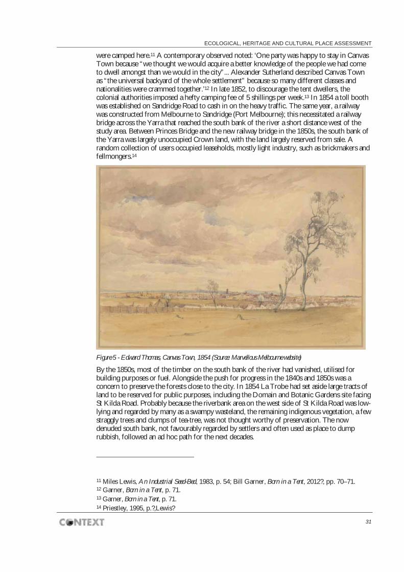
ECOLOGICAL, HERITAGE AND CULTURAL PLACE ASSESSMENT
31
were camped here.11 A contemporary observed noted: ‘One party was happy to stay in Canvas Town because “we thought we would acquire a better knowledge of the people we had come to dwell amongst than we would in the city”... Alexander Sutherland described Canvas Town as “the universal backyard of the whole settlement” because so many different classes and nationalities were crammed together.’12 In late 1852, to discourage the tent dwellers, the colonial authorities imposed a hefty camping fee of 5 shillings per week.13 In 1854 a toll booth was established on Sandridge Road to cash in on the heavy traffic. The same year, a railway was constructed from Melbourne to Sandridge (Port Melbourne); this necessitated a railway bridge across the Yarra that reached the south bank of the river a short distance west of the study area. Between Princes Bridge and the new railway bridge in the 1850s, the south bank of the Yarra was largely unoccupied Crown land, with the land largely reserved from sale. A random collection of users occupied leaseholds, mostly light industry, such as brickmakers and fellmongers.14
Figure 5 - Edward Thomas, Canvas Town, 1854 (Source: Marvellous Melbourne website)
By the 1850s, most of the timber on the south bank of the river had vanished, utilised for building purposes or fuel. Alongside the push for progress in the 1840s and 1850s was a concern to preserve the forests close to the city. In 1854 La Trobe had set aside large tracts of land to be reserved for public purposes, including the Domain and Botanic Gardens site facing St Kilda Road. Probably because the riverbank area on the west side of St Kilda Road was low-lying and regarded by many as a swampy wasteland, the remaining indigenous vegetation, a few straggly trees and clumps of tea-tree, was not thought worthy of preservation. The now denuded south bank, not favourably regarded by settlers and often used as place to dump rubbish, followed an ad hoc path for the next decades.
11 Miles Lewis, An Industrial Seed-Bed, 1983, p. 54; Bill Garner, Born in a Tent, 2012?, pp. 70–71. 12 Garner, Born in a Tent, p. 71. 13 Garner, Born in a Tent, p. 71. 14 Priestley, 1995, p.?,Lewis?

SOUTHBANK BOULEVARD & DODDS STREET
32
Figure 6 - Emerald Hill from St Kilda Road, c.1860-79
4.3.3 The impact on Aboriginal people For Aboriginal people, the development of the township of Melbourne from the mid 1830s resulted in the loss of traditional lands and resources, frontier violence, the spread of disease, and social breakdown. Aboriginal people from other clans and language groups also moved to Melbourne for a variety of reasons, and this makes it difficult to identify and document the history of clan groups after the period of initial settlement.
Aboriginal people camped at various locations in close proximity to the township of Melbourne in the early post-contact period, and this continued even after many were forced to move to mission stations. George Langhorne’s Anglican Mission was established in 1838 on the site of the Botanic Gardens, not far from the study area. Mostly they were Wurundjeri and Bunurong (or Boon Wurrung) whose preferred camping places were along the south bank of the Yarra River15, but clans from other language groups of the Kulin Nation also camped in the vicinity of Melbourne (i.e. Taungurong at Clifton Hill) from where they would make excursions into the township. In 1839 George Augustus Robinson, Chief Protector of Aborigines in the Port Phillip District, requested a census of Aboriginal people living in and around Melbourne, and this found that the probable Aboriginal population at this time consisted of 140 Wurundjeri, 50 Wathaurong and 12 Bunurong.16 However it is likely that the numbers of Aboriginal people in Melbourne varied greatly throughout this period.
Robinson reportedly spent much time throughout the late 1830s to mid 1840s attempting to ‘break up’ Aboriginal camps by the Yarra River and discouraging Aboriginal people from
15 Clark, I. & Heydon T. The Confluence of the Merri Creek and Yarra River: A History of the Western Port Aboriginal Protectorate and the Merri Creek Aboriginal School, 1998 16 Lakic, M & Wrench R. (eds.) Through Their Eyes: An Historical Record of Aboriginal People of Victoria as Documented by the Officials of the Port Phillip Protectorate 1839-1841, 1994. However, it is important to note that the census figures do not account for Aboriginal people in Melbourne who were of mixed parentage: i.e. Aboriginal and non-Aboriginal

ECOLOGICAL, HERITAGE AND CULTURAL PLACE ASSESSMENT
33
visiting the township itself. The number of Aboriginal people in the area dwindled as a result of high mortality rates and forced movement, and they were either reduced to begging in Melbourne or removed to mission stations, Aboriginal reserves or Government depots. The introduction of the Aborigines Protection Act (the so-called ‘Half Caste’ Act) 1886 which required all male ‘half castes’ under the age of 35 to leave mission stations and government reserves, resulted in Aboriginal people moving back to Melbourne, attracted by work opportunities.17
4.4 The social dimension
4.4.1 Crimes and misdemeanours The south bank of the river and the stretch of St Kilda Road near Canvas Town developed some notoriety during the early years of white settlement as a haunt of thieves and petty criminals. The history painting by William Strutt, titled Bushrangers on the St Kilda Road, 1887, portrays the frontier nature of urban Melbourne during the gold rush period.
Through the nineteenth century and into the early twentieth century, there were cases of infanticide and suicide on the Yarra, as well as accidental drownings. The fictional murder in Melbourne’s celebrated early crime novel, Fergus Hume’s The Mystery of a Hansom Cab (1886), was committed along St Kilda Road. The Snowden Gardens at Princes Bridge was the scene of many an attack, brawl or theft. In 1925, the Gardens were described as ‘picturesque but unpoliced’, and as ‘the rendezvous for a large portion of the scum of Melbourne’.18 The Yarra Bank provided refuge for the poor and the vagrant, who were attracted by the relatively large areas of vacant land so close to the city.
4.4.2 Social welfare Since the days of Canvas Town in the early 1850s, when suitable housing for newly arrived immigrants was in short supply, efforts have been made to provide for those in need on the south bank of the river. The Immigrants’ Aid Society opened the Immigrants’ Home on St Kilda Road in 1853, originally designed “for the amelioration of the fearful distress amongst the newly arrived population”.’ The building was extended in 1887.19 Later, its purpose was more akin to a night shelter for those who were vulnerable or in need.20
The Immigrants’ Aid Society also opened a reformatory school for boys and girls (mostly orphans) at the military reserve on St Kilda Road in 1860. The institution was criticised for its unhealthy position adjacent to the military swamp.21 Girls and boys were housed separately, with many of the boys working in the Botanic Gardens and the girls entering domestic service at an early age.
There were various other welfare measures provided in the area. In addition to the Protestant Orphanage, Catholic religious orders operated two orphanages in South Melbourne — the St Vincent’s Boys’ Home and Girls’ Home — as well as a Magdalen Asylum for ‘Fallen’ Women. A branch of the Salvation Army Corps was established in Coventry Street. The Homeopathic Hospital on St Kilda Road was opened in 1876 in an effort to make more affordable medical
17 Rhodes, J. Debney, T., Grist, M. Maribyrnong Aboriginal Heritage Study, 1999 18 Argus, 22 April 1925. 19 Argus, 19 April 1887. 20 Shurlee Swain, ‘Immigrants Home’, in Andrew Brown-May and Shurlee Swain (eds), Encyclopedia of Melbourne, Cambridge University Press, Cambridge, 2005. 21 Argus, 20 March 1860; Argus, 1 April 1872.

SOUTHBANK BOULEVARD & DODDS STREET
34
services available to poorer classes.22 This was renamed St Henry’s Hospital in 1934 (now demolished).
The relocation in 1925 of the YMCA Hostel from a warehouse in Flinders Street to new purpose-built premises on City Road, close to St Kilda Road, continued the association of this area with those in need of overnight accommodation.23
4.4.3 Residential development The less savoury underside of ‘Marvellous Melbourne’ was also evident on the south bank of the Yarra: here there were poorly built homes that were crowded and un-sewered, under-nourished children, the unemployed, those who needed welfare assistance. There was terraced housing in a few streets close to the river, like Bright Street.24 Some factory managers or caretakers also lived in the area in on-site premises or in an adjacent residence. In the early 1880s there were residential lots surveyed along Kavanagh Street and City Road.25
In the 1920s there remained some small pockets of working-class housing among the factories at the western end of the precinct, for example in Bright Street, where factory workers were accommodated. These were mostly small working-class terraces, probably timber built. In the 1880s Ireland Street provided a through way between streets planned for residential housing. (but these may not have eventuated) Local residents worked in local factories as well as in a range of other occupations. Men worked as waterside workers, shipwrights, carriers, ferrymen, railway workers, carpenters, and a myriad of other occupations; women worked as machinists in the clothing factories across the river in Flinders Street West, or locally as whiteworkers, outworkers or milliners.
There was sufficient residential population in the area or, at least, projected future population, in 1873 to warrant the Government’s purpose of a large state school site on Sandridge Road. An impressive three-storeyed Gothic-style brick state school, designed by the Victorian Government architect Henry Bastow, opened here in 1884 and provided local children with non-denominational elementary education. The school was converted to a girls’ domestic high school in the 1920s, reflecting prevailing public attitudes and expectations about the suitable education of working-class girls at that time. The school was renamed the J.H. Boyd Domestic College for Girls in 1932, following an endowment from J.H. Boyd for that purpose.
The area was served with public transport by way of a cable tram (later electrified) that ran from St Kilda Road into City Road and south into Sturt Street. During the interwar period, City Road was a busy thoroughfare for all manner of vehicles, motorised and horse-drawn, private and commercial vehicles and heavy cartage, and the clang of the cable trams.26
There was little to no residential housing built in the area in the first part of the twentieth century, with the notable exception of the Alexandra Mansions, which was a residential apartment built in 1912 through the adaption of the former Hoadley jam factory; the building was demolished in 1958.27 The late 1960s saw an increase in public housing in South Melbourne, with the creation of high-rise residential towers, such as Park Towers, which replaced a large area of demolished poor-quality working-class housing.
22 Buckridge, Melbourne’s Grand Boulevard, 1996 23 Schuhkraft & Co warehouse, heritage citation: www.mcc.gov.vic.au (The YMCA building on City Road was demolished in 1982). 24 See Fahey, Grimshaw and Raymond, ‘The Other Side of Marvellous Melbourne’ in Jane Beer et al (eds), Colonial Frontiers and Family Fortunes, University of Melbourne, Parkville, 1989, p. ? [check housing question] 25 Map of South Melbourne, 1881, SLV. 26 Priestley, 1995, p. 314. 27 Lewis, 1983, p. 75.

ECOLOGICAL, HERITAGE AND CULTURAL PLACE ASSESSMENT
35
4.5 The industrial underside of Melbourne This section examines the development of the dense industrial zone on the south bank of the Yarra, tracing its early beginnings where its use was a function of convenience and affordability, through the 1870s and 1880s when more substantial factories were built and the street layout was defined.
4.5.1 Embryonic industry From its early use as a brick-makers’ camp in the late 1830s, the south bank of the river emerged early on as a suitable site for Melbourne’s industry. With easy access to the river (as both a water supply and a transport route), the ports, Princes Bridge, and the new railway, this was a convenient location for industrial works, initially for ship-building and ship repairs, as well as light metal works, boiler-making and heavy engineering operations.
A decade of gold fortunes had transformed Melbourne from a frontier settlement into a rising metropolis, furnished with all manner of public and private institutions. The city centre was a scene of progress and activity. By contrast, on the opposite side of the river, this lower lying land remained largely unallocated and largely undesirable. Images of the area from the 1850s and 1860s show a surprising absence of any development, though at the same time a virtual absence of any original vegetation, indicating that the area was denuded of any useful timber it had left. By 1862, Patrick Hanna’s ferry service was established, connecting King Street in Melbourne with the south side of the river. His namesake, Hanna Street, later became part of Kings Way. Other early industries in this area in the 1860s included Ramsden’s paper mill, Borthwick’s varnish company, and a ropeworks.
The south bank of the river was overwhelmingly a utilitarian and functional space — providing cheap leaseholds with ready access to the river and transport networks. The majority of buildings were constructed of timber and galvanised iron. The area was relatively tree-less and dominated by workaday buildings, industrial complexes, and brick and stone warehouses. The local council, the Borough of Emerald Hill, made little effort at beautification in this area, aside from planting street trees in Sandridge Road (c.1860s?).28
A Commission of Inquiry was held in July 1872 into the utilisation of low-lying lands near Melbourne on both banks of the Yarra, with the task of determining the best use of these lands for public and commercial purposes.29
4.5.2 ‘Marvellous Melbourne’ The building boom that created ‘Marvellous Melbourne’ began in the 1870s. On the south bank, developments were apace to provide an ideal industrial zone. Much of the low-lying, flood-prone land was filled in, and land previously available only as Crown leaseholds was made available for sale. Many occupants transferred from leasehold to freehold, while retaining their allotments.30 By the 1880s, Melbourne’s rapid growth and golden wealth earned it the tag, ‘Marvellous Melbourne’. It had grown exponentially since the 1850s, leaving the central city area a dense grid of high-rise towers and commercial buildings. In 1880, Melbourne boasted the tallest building in the Southern Hemisphere.
The level of industrial activity across the river in South Melbourne increased substantially in the 1880s.31 This was made possible by new incentives for industry. The government drained large areas of land and made it available. New regulations in 1885 stipulated the permitted uses
28 These trees are clearly visible in the Holtermann photo from Government House, dated 1876 (SLV). 29 See VGG, 1872. 30 Lewis, ‘An Industrial Seed-Bed’, 1983 31 Daley, History of South Melbourne, 1940, p. 133.

SOUTHBANK BOULEVARD & DODDS STREET
36
for 21-year leases of Crown land sites on the south bank of the river: The following uses were deemed permitted: Stores, Dwellings, Warehouses, Factories, Boat building and repairing, and General engineering works.32 By the end of the decade, a diverse collection of industries were represented in the block bounded by St Kilda Road, the Yarra River, Hanna Street (later Kings Way), and Coventry Street.
The south side of the river became the engine house of ‘Marvellous Melbourne’. Here the hydraulic passenger and goods lifts, powered by the Yan Yean water supply, were manufactured by Otis Engineering, and Johns & Waygood. The new-fangled fully-plumbed bathroom fittings of suburban Melbourne were supplied by John Danks’ brass foundry in City Road.33 Countless storage yards of building materials were located here, in convenient proximity to the growing city. The 1880s also saw greater development of refrigeration, which was critical for exporting industries such as meat and dairy; this enabled the establishment of an ice-works on the Yarra Bank.
Figure 7 - Industrial buildings on the Yarra Bank, c.1885-1920 (Source: SLV)
Replacing an earlier bridge over the Falls, the new iron-built Queens Bridge was completed in 1889, improving access between central Melbourne and the south bank.34 The Princes Bridge had also been replaced in 1888. Moray Street North was elevated with the new name of Queensbridge Street and was suitably planted with street trees. Emerald Hill had been renamed South Melbourne, but the Yarra Bank area was regarded as more a part of the City of Melbourne than of South Melbourne.
32 VGG, xx xx 1885, p. 967. 33 Priestley, 1996 34 Lewis, ‘An Industrial Seed-Bed’, 1983, p. 25.

ECOLOGICAL, HERITAGE AND CULTURAL PLACE ASSESSMENT
37
The 1890s depression saw a slump in industrial activity, but Melbourne’s economic progress was rejuvenated by the early 1900s. By 1901, the south bank was a thriving industrial area, with suppliers of metal, iron, timber, asbestos and cement. Additional land had been reclaimed for the purpose of sale in the late nineteenth century and with the security of freehold title, proprietors erected superior industrial buildings on these sites (for example the Nicholas Aspro building). A number of substantial industrial buildings were erected on the south bank in the period from the 1900s to the 1920s, including the Australian Paper Mills building (1925).
Figure 8 - John Sharp & Sons, timber merchants, City Road (Source: Victorian Places website)

SOUTHBANK BOULEVARD & DODDS STREET
38
The historic route of Southbank Boulevard
The current path of Southbank Boulevard commences at St Kilda Road and follows a route south-west to a point just before the Yarra bank at the site of the Falls and Queen’s Bridge. It corresponds with the former route of Nolan Street, which was formed in 1888 in gazetted in 1895). It then crosses a path parallel with the former route of Ireland Street (formed by 1886) but at a point just north of Ireland Street, before following the route of what was formerly Maffra Street (gazetted in 1895). Superimposing this new road on the original street layout of the 1870s and 1880s finds it cutting through the industrial heart of the south bank area.
Beginning at the intersection of St Kilda Road and Southbank Boulevard (or Nolan Street as it was formerly known at this point) there would have been a sense of open space, with the east side of St Kilda occupied by parkland, and the St Kilda Road frontage south of Nolan Street largely undeveloped (construction of the new police buildings did not commence until 1912). The north side of the Nolan Street corner was unoccupied, but possibly leased for various purposes. Wirth’s Circus took up a large leasehold site here from the early 1900s until the early 1950s. Moving south-westerly along Southbank Boulevard, we cross Dodds Street and Sturt Street, passing the site of various former factories.
Crossing Kavanagh Street, which was sparsely occupied on the south side, there were several occupants on the north side, including S. Cooke & Co. mill works and engineers, J.H. Craven’s machinery store; and T.S. Harrison & Co., cork importers. Here, the route of Southbank Boulevard passes across land that was formerly freehold land, and would have corresponded approximately with the site of T.S. Harrison & Co., cork importers.
Southbank Boulevard then crosses City Road, where it connects up with the former route of Maffra Street. At Maffra Street, the Jones bonded store stands today as a relic of the 1880s. Further north along Maffra Street, past other warehouses, eventually ends at the railway line and beyond that Queen’s Bridge (the former site of the Falls Bridge).

ECOLOGICAL, HERITAGE AND CULTURAL PLACE ASSESSMENT
39
Figure 9 - Johns & Waygood, c.1890 (Source: VHD website)
Figure 10 - A.P. Sutherland, 2 Maffra Street, South Melbourne, 1956 (Source: SLV)

SOUTHBANK BOULEVARD & DODDS STREET
40
The view in 1901
The junction of Southbank Boulevard (Maffra Street at this point) with City Road in 1901 was the centre of a busy industrial area. The smell of smoke, smouldering iron and industrial fumes would be wafting through the air. There would be a constant din of industry — clanks of metal, the whir of steam mills, the hammering of smithies, the sounds of chopping and sawing from the timber yards, the periodic yells of foremen, and the constant clip-clop of work horses. City Road and Maffra Street were metalled, but the adjacent side streets and lanes were cobbled in bluestone. On a weekday there was a steady stream of horse-drawn traffic, from small drays to large heavily laden goods carts, crossing the intersection. Workers passed on foot while those who could afford their own vehicle rode in carriages or two-wheel jinkers. Few women were visible although there were certainly women working in the factories and in their own homes as outworkers. Some of those travelling on City Road were passengers en-route to, or returning from, Station Pier.
The view of the immediate environs was of mostly low-rise timber-framed buildings, in linear form, with gabled iron-clad roofs. This extensive gabled landscape was punctuated by tall brick chimneys and the occasional multi-storey warehouse. Some of the low, more rudimentary structures probably dated to the era when much of this land was leasehold only. The more enterprising establishments were substantial premises with impressive frontages on City Road or Maffra Street, and were emblazoned with bold signage. Many of the factory buildings had attached offices and stables. Some allotments were designated as storage yards; others remained vacant.
Looking north up Maffra Street, with the Sandridge railway line visible in the distance, the Jones bonded stores occupied both the east and west sides of the street. Flett’s Cooperage and vat builders were located beyond the Jones bonded store on the west side of Maffra Street.35 It was a dog-leg turn from Maffra Street into Ireland Street. Nothing fronted Ireland Street but the opening to the bluestone paved laneway behind the frontages on City Road would have been visible.
Looking eastwards up City Road there was James Wright’s timber yard, and beyond that the substantial business of Brooks Robinson & Co, glass manufacturers. Further in the distance could be heard the sound of the bustle of St Kilda Road.
Looking westwards along City Road towards South Melbourne, there was a dense line of commercial and industrial enterprises. There was greater development of the north side of the road, which included timber yards.
35 Australasian, 3 June 1899.

ECOLOGICAL, HERITAGE AND CULTURAL PLACE ASSESSMENT
41
4.5.3 Government services Alongside the various private manufacturing and commercial enterprises on the south bank of the river, various government departments and public authorities responsible for building, land management and services infrastructure also set up works depots and storage yards here, due to affordability and close proximity to the city. The Melbourne & Metropolitan Board of Works (MMBW), established in 1891, had a works depot and storage yard in Wells Street behind the military reserve of Victoria Barracks, where pipes were stored, as well as a House Connections Branch in Wells Street [check]. The Public Works Department also established a works depot on the south bank. The Melbourne General Post Office (GPO) also established its stables and telegraph post store yard in Sturt Street, between St Kilda Road and Grant Street.36 The City of South Melbourne’s council abattoirs were also located on the Yarra Bank.
Here there were a number of essential services that required public land. The government ice-works was also established here. A morgue was also located on the south bank.
4.6 Making public space
4.6.1 Arrival The south side of the river was the most common entry point for new arrivals to Melbourne - for all those immigrants who arrived by sea at Station Pier. The Immigrants’ Depot, opened in 1853, sensitive to the needs of those whose only resource was Canvas Town, reflects this history. Much later, after the First World War, in 1918–19, the reception depot for returned soldiers was also located on the south bank of the river.
The proximity to the City of Melbourne and to its main southern approaches of Sandridge Road (City Road) and St Kilda Road, made the northern end of South Melbourne important and useful for formal civic purposes. Countless notable visitors, including royalty and vice-regal representatives, proceeded up the Sandridge Road to Princes Bridge, where they crossed into Melbourne proper. Early historian of South Melbourne, Charles Daley, asserted the singular importance of City Road in Melbourne’s history:
No road in Melbourne has had more historic associations or has had closer connection with more vivid character or vivid contrasts than what is now City Road, linking the overseas through a populous city with the metropolis itself … Over its varying surface have passed pioneers of settlement, immigrants in thousands of the early ’forties, the inrush of goldseekers in the ’fifties … On foot, horseback, by coach, wagonette, hansom and every kind of vehicle, there have passed to and fro, countless travellers and passengers in every station of life. Royalty on several occasions, vice-regal rulers … peers of the realm…, [etc etc]37
The point where City Road crosses the current Southbank Boulevard represents a point of this much frequented route. Soldiers departing for the Boer War (1899–1902) and World War I (1914–1918) followed the route down City Road to Station Pier, marching in formation for the last time on Victorian soil before their departure.38
Members of the public lined the route for many famous ingresses to and egresses from Melbourne. In 1867 the local municipality erected an impressive ‘welcome’ archway on Sandridge Road for the visiting Prince Alfred (who was difficult to impress). Sandridge Road provided the Prince’s first impression of Melbourne and one observer noted his discomfort when the Prince’s party passed through a section of the road that was noticeably absent of buildings.
36 Sands & McDougall Melbourne and Suburban Directory, 1901. 37 Daley, The History of South Melbourne, 1940, p. 332. 38 Daley, The History of South Melbourne, 1940, p. 331.

SOUTHBANK BOULEVARD & DODDS STREET
42
Princes Bridge was festooned and ornamented with a decorative archway for the occasion of the Queen’s Golden Jubilee in 1897. A few years later in 1901, the celebration of Federation and the opening of the Federal Parliament by the Duke of York was an occasion of perhaps unsurpassed civic pride and of civic preparedness in Melbourne. To attend official functions in Melbourne, the Duke and Duchess of York were ceremoniously driven from Government House in the Domain, along St Kilda Road where Southbank Boulevard (formerly Nolan Street) commences; they then proceeded along a short length of St Kilda Road before crossing Princes Bridge. A celebratory archway was erected on Princes Bridge and swarms of people lined the street along St Kilda Road between Government House Drive and Princes Bridge. Civic authorities sought to present the city in its best possible light for the occasion of Federation. As well as extensive landscape works being carried out along the east side of St Kilda Road, the edge of the Domain parklands, there was considerable beautification of St Kilda Road itself. On the west side of St Kilda Road in the 1890s, there was an unsightly collection of poor quality industrial and other temporary structures erected on Crown leaseholds, which Mr Kent Hughes deplored as ‘rotting tin sheds’.39 To remedy this, a strip of land facing St Kilda Road was reserved for public purposes in 1899 as a means of widening the road, and this was swiftly beautified with plantations that reflected those on the east side of St Kilda Rd, thus forming a grand.40 The ornamental Snowden Gardens at the entrance to Princes Bridge were established in 1903; the MCC authorised the reserve by lit with electricity after dark.41 A postcard, of the Snowden Gardens shows rockeries and public seating amidst a variety of foliage, tastefully arranged on the gently undulating river bank. Street trees, possibly London Planes, were also planted along the Yarra Bank road, probably around the same time.
Figure 11 - Postcard of the Snowden Gardens, 1918 (Source: SLV)
39 Daley, The History of South Melbourne, 1940, p. 274. 40 Georgina Whitehead, ‘Imagineering the City Beautiful: Parks, gardens and town planning thought’ in Whitehead (ed.), Planting the Nation, Australian Garden History Society, Melbourne, 2001, p. 179. 41 Age, 28 July 1903.
ECOLOGICAL, HERITAGE AND CULTURAL PLACE ASSESSMENT
43
Subsequent royal visits took place in 1920 and 1927, when St Kilda Road was again the focus of civic beautification. The royal visit of 1927 was seriously marred with the air collision of two display aircraft, which fell to ground in Dodds Street, leaving 4 people dead.
Thirty years after Federation, the south side of the Yarra again attracted civic focus with the unprecedented extent of events associated with the Victorian Centenary Celebrations of 1934-35.
The potential of this area as a prominent public space was identified in 1921 by A.J. Macdonald who proposed an elaborate new civic complex for the site for the City of Melbourne (although its location was then the City of South Melbourne rather than the City of Melbourne). Macdonald’s plan was published in John Sulman’s influential An Introduction to the Study of Town Planning in Australia (1921), but went no further towards fruition.42
4.6.2 A military presence A large area fronting St Kilda Road was reserved for military purposes in 1853/54. The first building at Victoria Barracks was completed in 1856–58, with various additions developed at later stages. The large body of water behind the barracks was known as the military swamp. The land around the swamp was reserved from public sale for several decades, as it was felt that residential development here would compromise the security and wellbeing of the military personnel. Eventually the swamp was filled in and the land sold, largely taken up for industrial purposes. The presence of the military defined the character of the west side of St Kilda Road for many decades, with both routine training of personnel, and ceremonial events like military funerals commanding attention from onlookers.
The prominent site immediately adjacent to the Princes Bridge on the west side of St Kilda Road was reserved for ‘military purposes’ in the c.1880s/90s, possibly for strategic reasons. The South Melbourne parish plan shows this reservation, comprising just over 1 acre on the corner of St Kilda Road and the Yarra Bank Road (which later became the Snowden Gardens).
Directly opposite the Victoria Barracks, within the King’s Domain, the new Shrine of Remembrance was completed in 1934. Each Anzac Day, since the 1930s, war veterans have marched along St Kilda Road, past the junction of Nolan Street (now Southbank Boulevard), and onwards towards the Shrine. In the lead-up to the Anzac Day March in 1927, First World War veterans of the Light Horse gathered in Sloss Street, behind Wirth’s Park off Nolan Street.43 Nearby in Nolan Street, the Repatriation Department Trade School for returned soldiers operated in the 1920s.44
4.6.3 PoliceA large area north of the Victoria Barracks, bounded by Nolan Street, St Kilda Road and Dodds Street, and formerly part of the extensive military reserve, was designated for police purposes in the early 1900s. A large complex of buildings was developed including the New Victorian Police Depot (1925-26), the Police Hospital (1913-14), and the Mounted Police Stables (1912) with 53 loose boxes, a riding school and an armoury.45 The complex is currently used by the Victoria College of the Arts (see Appendix B for VHR listing for the Former Victoria Police Depot (Victoria College of the Arts), H1541).
42 Lewis, 1983, p. 76. 43 Argus, 22 April 1927. Sloss Street does not survive; it was swallowed up in the development of the NGV and the Arts Centre. 44 Sands & McDougall Melbourne and Suburban Directory for 1920, Melbourne, 1920. 45 Graeme Butler, ‘South Bank: Architectural and historical study’, vol. 1, September 1982, pp. 59-64.

SOUTHBANK BOULEVARD & DODDS STREET
44
Figure 12 - Holtermann view of the military reserve south of St Kilda Road, taken from Government House, 1870s (Source: SLV)
4.6.4 Public entertainment Possibly the earliest recreational activity established on the south bank of the Yarra was the swimming baths in the early 1840s. These were short-lived, being washed away in a flood in 1844.46 From 1871, before the establishment of the present-day showgrounds in Flemington, early agricultural shows were held on the military reserve on St Kilda Road. The Government granted the National Agricultural Society of Victoria society a site of nearly 18 acres next to the military barracks, which it used until the 1880s.47
An early circus took up residency on the military swamp in the 1860s. In 1877, Cooper and Baileys Great American Circus arrived in Melbourne and briefly occupied the frontage to St Kilda Road, between Princes Bridge and what is now Southbank Boulevard. This same reserve was then taken by Wirths’ Circus in 1907, which became a permanent fixture on the reserve for nearly fifty years. Wirth Brothers established a large complex of buildings, although occupying a relatively short-term leasehold. There was great excitement amongst Melbournians in 1917 when an escaped lioness from Wirths’ Circus wandered amongst through the Snowden Gardens on the Yarra Bank before being recaptured by circus staff.48 Tragedy struck in 1953 when a fire destroyed the Wirth’s Circus buildings and some of the circus animals.49
46 Lewis, An Industrial Seed-bed’, 1983, p. 45. 47 Australasian, 2 December 1871; Victorian Government Gazette, 1870. 48 Argus, 25 October 1917. 49 Newspaper report, 1953.

ECOLOGICAL, HERITAGE AND CULTURAL PLACE ASSESSMENT
45
Figure 13 - Princes Court funfair, 1906 (Source: Marvellous Melbourne website)
Figure 14 - Wirths’ Circus site fronting St Kilda Road, c.1910 (Source: Marvellous Melbourne website)
Around the same time, c.1905, the Prince’s Court funfair, was developed on land adjacent to the circus. Popular attractions included a water chute, open-air skating, helter-skelter and other amusements.50 Other entertainment facilities included the Green Mill dance hall and Club 40. The Glaciarium ice-skating rink opened on City Road in the early 1900s. The annual Moomba Parade, which commenced in 1954, followed a route along St Kilda Road.
50 Table Talk, 7 November 1907.

SOUTHBANK BOULEVARD & DODDS STREET
46
4.7 The south bank transformed
4.7.1 Arts and culture From the early 1900s it became a common complaint that the buildings on the south side of St Kilda Road failed to measure up to what many considered appropriate for the gateway to the city. Many considered the circus buildings on Wirths’ Park and the Green Mill dance hall to be an eyesore. Something of a conflict of taste emerged, with the vaudevillian circus acts and the colourful attractions of Princes Court vying for attention alongside more high-brown concerns, such as the ‘Playhouse Theatre’ (probably a temporary structure) in Snowden Gardens, where the Melbourne Reparatory Theatre Company performed in 1916.51
In the 1920s private developers drew up plans to erect an ‘amusement palace’ on the corner of Wirths’ Park, promoting the proposal as suitable for such a prominent site. The restriction by the Melbourne Harbour Trust to allow only short-term (i.e. 15 year) leases on this site, however, limited the quality of the building proposed, and there was strong opposition to the erection of a poor-grade on such a prominent location at the gateway to Melbourne.52 In 1934, the local paper argued that the hideous monstrosities on Crown leaseholds ‘disfigured the gateway to Melbourne’.53 Progress on developing the coveted corner site on St Kilda Road stalled for many years.
Plans for a new building on the site of the Green Mill dancing club (also known as the Trocadero Palais) and Club 40 on St Kilda Road were proposed in 1937. One local councillor stated that ‘He hoped the end of “tin sheds” in this important area was within sight and that the battles waged by the council for nearly fifty years was at last to be rewarded with victory’.54 Structures close to the corner of Sloss Street and Sturt Street were partially destroyed by fire in 1941, which added pressure for the site’s redevelopment.55 In the early 1940s, there emerged a shift in the envisaged future use of the Wirths’ Circus site — away from a desire for carnival-style public entertainment towards a more sophisticated arts and cultural development. Wirths’ Park was identified as a suitable site for a much needed new art gallery and arts centre for Melbourne. Prominent figures Sir Keith Murdoch and composer Margaret Sutherland were key advocates, although much public debate ensued as to the relative merits of different public needs in Melbourne during wartime — a period of considerable financial strain.
By the 1950s, plans were underway for a new art gallery and arts centre on St Kilda Road, between Princes Bridge and Nolan Street (now Southbank Boulevard). Around the same time a new Museum was proposed for a site within the Domain on the east side of St Kilda Road. Melbourne architect Roy Grounds was appointed in 1959 to design the new complex, and construction commenced in 1961. The National Gallery of Victoria opened in 1968 and the Victorian Arts Centre was completed in 1984 to a design by Robin Boyd.
4.7.2 Embracing the river Postwar immigration and the decline of industrial activity in the city centre would irrevocably change the appearance of the Yarra’s south bank. The economic troubles of the 1930s had hampered many of the industries along the river bank. During the postwar period, many factories faltered and failed. Buildings were neglected. Charles Davey recalled in the 1940s that
51 Australasian, 17 June 1916. 52 See Record, 26 February 1927. 53 Record, 3 March 1934. 54 Record, 7 August 1937. 55 Age, 28 Feb 1941.
ECOLOGICAL, HERITAGE AND CULTURAL PLACE ASSESSMENT
47
the once ornamental Snowden Gardens had become a rubbish dump.56 In the 1950s, prominent surviving buildings on the south bank included the Nicholas Aspro Factory, the Glaciarium, the APM building and the YMCA Hostel (City Road). In the late 1960s a new prize-winning neon sign for Allen’s Sweets was erected high above a warehouse on the Yarra, which became an instant Melbourne landmark. But overall, by the 1960s, the industrial south bank had developed a decidedly dilapidated, run-down character. The bulk of these industrial buildings would ultimately be removed. The Jones Bonded Store (1888) built in Maffra Street (now Southbank Boulevard) (VHR HO828) is a rare survivor.
The original form of the south bank precinct was also altered by changed roadways. New transport demands saw the construction of the West Gate Bridge, completed in 1978, which necessitated the loss of parts of some South Melbourne streets, including Moray Street. Alexander Avenue had also been extended by an underpass at St Kilda Road in c.1965, with its continuation, City Road, provided a feeder route to the West Gate Bridge.
The post-industrial decline of the south bank of the Yarra led ultimately in the 1990s to its transformation and rejuvenation with the construction of residential high-rise apartments, commercial offices, a new shopping precinct, hotels and a casino. The Victorian Government had defined the need for the area’s redevelopment in 1984 and outlined a strategic approach to doing so.57 The Ministry for Planning commissioned a heritage report on the area in 1982.58 Melbourne urban historian Seamus O’Hanlon notes that ‘the original proposal was to retain some of the sites industrial buildings and rehabilitate them as heritage tourism draw cards’.59
Construction of the new developments, Riverside Quay and Southgate, commenced in 1992, which provided shopping malls, offices, restaurants and cafes.60 Melbourne’s Southbank, as it became known, was influenced by other riverside and dockside urban renewal developments around the world that reclaimed disused industrial land for housing, for example in London and Boston. Nevertheless, changes to the ‘south bank’ in Melbourne were swift and radical for what was at the time a relatively conservative city.
Another high-rise residential development, along with the lavish Crown Casino and the Melbourne Exhibition Centre, transformed the south river bank in the 1990s. Crown Casino, built on a 99-year Crown leasehold opened in 1997 amidst much controversy. The casino divided Melburnians; many critics felt such a development was vulgar and ostentatious in both its function and its aesthetic.61 The complex also included the Crown Towers residential development. Additional developments have created a complex of high-rise towers, with the tallest to date being the Eureka Tower (2006).
The development of Southbank Promenade from 1990 embraced the Yarra River as a place of beauty and interest. It presented a new and previously little appreciated southerly perspective to the city buildings on the river’s opposite northern side, reinventing Melbourne’s view of itself but at the same time reinforcing Melbourne’s enthusiasm for culture and the arts.
By the early 1990s, there was a new enthusiasm for arts and culture in Melbourne, with the Spoleto Festival reinvented as the Melbourne International Festival in 1990, opening in grand style with fireworks on the Yarra.
56 Daley, 1940, p. 357. 57 The Shaw Factor: http://shawfactor.com/gazetteer/victoria/southbank/ 58 Butler, ‘South Bank Architectural and Historical Study’, vol. 1, 1983, p. i. 59 Seamus O’Hanlon with Tony Dingle, Melbourne Remade, Arcade Publications, Melbourne, 2010, p. 62. 60 Kristen Otto, Yarra: A diverting history, Text, Melbourne, 2009, p. 204. 61 O’Hanlon, Melbourne Remade, 2010, p. 65.

SOUTHBANK BOULEVARD & DODDS STREET
48
The NGV was redeveloped in 2001 under the celebrated Italian architect Mario Bellini.62 The Melbourne Concert Hall in the Victorian Arts Centre was renamed Hamer Hall in 2004 in honour of former Liberal Premier Rupert Hamer, and was further remodelled in 2010-12, including extensive refurbishment, but also gained a new entrance facing the river. The Arts Centre spire was also extended higher, to fulfil Roy Grounds original conceived plan. Further downstream, a new footbridge was constructed to encourage pedestrian traffic from Melbourne city to Southbank. The new Melbourne Convention and Entertainment Centre, with its 6-star energy rating, opened in c.2011. The river was now firmly established as an object of public gaze rather than as simply a transport route or a drain for effluent, which had been its main role in the nineteenth century.
4.8 Chronology of maps and aerial photographs The following pages set out a series of historic maps and aerial photographs illustrating the development of the Study Area and the wider Southbank area.
Figure 15 – Extract from Hoddle’s plan of south Melbourne c.1838-39 showing the approximate location of the Study Area. The area is shown as open with vegetation along the bank of the Yarra (Source: SLV)
62 Stephen Townshend, The Rough Guide to Melbourne, 2001, p. 63.

ECOLOGICAL, HERITAGE AND CULTURAL PLACE ASSESSMENT
49
Figure 16 – Extract from Henry Cox’s map of Melbourne dated 1865, showing the beginnings of development on the south bank of the Yarra around City Road and the lake to the south. The Study Area is shown as an orange outline (Source: SLV)

SO
UTH
BA
NK
BO
ULE
VA
RD
& D
OD
DS
STR
EE
T
50
Fi
gure
17 –
Ext
ract
from
1879
map
of h
arbo
ur w
orks
to be
und
ertak
en b
y Melb
ourn
e Har
bour
Tru
st as
atta
ched
to S
ir Jo
hn C
oode
's rep
ort,
show
ing t
hat m
ore r
iversi
de p
lots h
ad b
een d
eline
ated
–
these
will
hav
e con
tain
ed st
ructu
res w
hich
are n
ot sh
own,
but t
here
was s
till r
elativ
ely li
ttle d
evelop
ment
in th
e area
at t
hat t
ime.
The l
ake t
o the
sout
h is
no lo
nger
show
n an
d ha
d lik
ely b
een fi
lled b
y th
at ti
me (S
ource
: Uni
versit
y of M
elbou
rne)

EC
OLO
GIC
AL,
HE
RIT
AG
E A
ND
CU
LTU
RA
L P
LAC
E A
SS
ES
SM
EN
T 51
Fi
gure
18 –
The
Sou
thba
nk ar
ea in
193
1 sh
owing
its a
lmost
comp
lete i
ndus
trial,
and
par
tly re
siden
tial,
devel
opme
nt (S
ource
: Lan
d V
ictori
a Hist
oric
Aeri
al Ph
otogra
phy L
ibrar
y)

SO
UTH
BA
NK
BO
ULE
VA
RD
& D
OD
DS
STR
EE
T
52
Fi
gure
19 -
The S
outh
bank
area
in 1
945
(Sou
rce: C
ity of
Melb
ourn
e)

EC
OLO
GIC
AL,
HE
RIT
AG
E A
ND
CU
LTU
RA
L P
LAC
E A
SS
ES
SM
EN
T 53
Fi
gure
20 -
The S
outh
bank
area
in 1
951
(Sou
rce: L
and
Vict
oria
Hist
oric
Aeri
al Ph
otogra
phy L
ibrar
y)
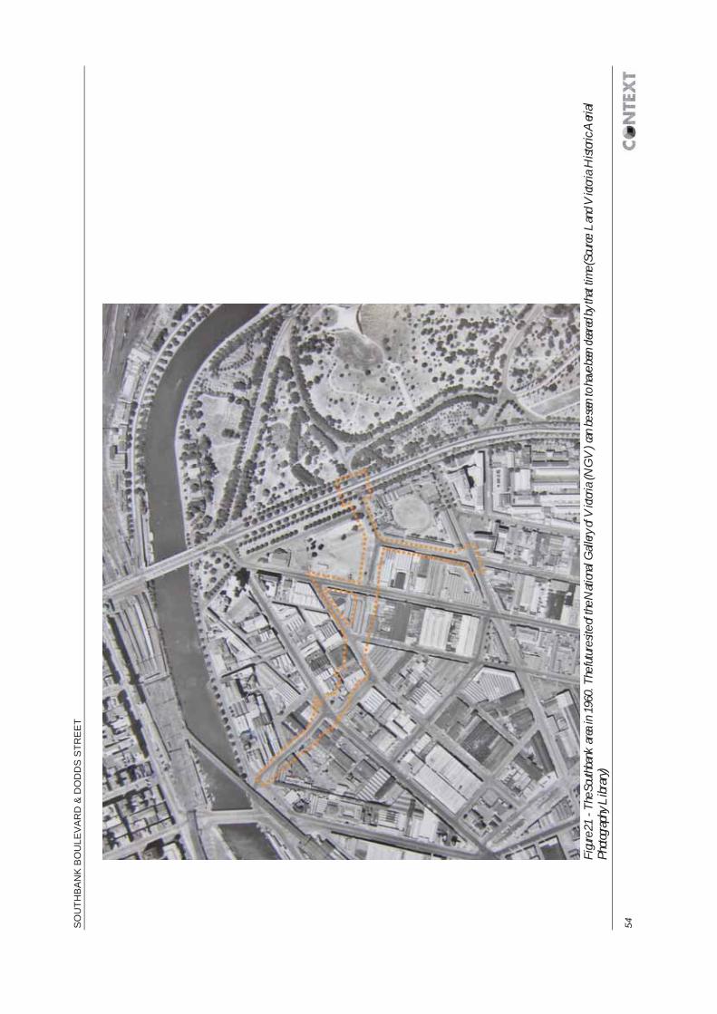
SO
UTH
BA
NK
BO
ULE
VA
RD
& D
OD
DS
STR
EE
T
54
Fi
gure
21 -
The S
outh
bank
area
in 1
960.
The
futu
re sit
e of t
he N
ation
al G
allery
of V
ictor
ia (N
GV
) can
be s
een to
hav
e been
clea
red b
y tha
t tim
e (So
urce:
Lan
d V
ictor
ia H
istor
ic A
erial
Photo
graph
y Libr
ary)

EC
OLO
GIC
AL,
HE
RIT
AG
E A
ND
CU
LTU
RA
L P
LAC
E A
SS
ES
SM
EN
T 55
Fi
gure
22 -
The S
outh
bank
area
in 1
970,
show
ing t
he re
cently
comp
leted
NG
V (S
ource
: Lan
d V
ictori
a Hist
oric
Aeri
al Ph
otogra
phy L
ibrar
y)

SO
UTH
BA
NK
BO
ULE
VA
RD
& D
OD
DS
STR
EE
T
56
Fi
gure
23 -
The S
outh
bank
area
in 1
982,
show
ing t
he re
cently
comp
leted
Vict
orian
Arts
Cen
tre &
Ham
er H
all (S
ource
: Lan
d V
ictor
ia H
istor
ic A
erial
Photo
graph
y Libr
ary)

EC
OLO
GIC
AL,
HE
RIT
AG
E A
ND
CU
LTU
RA
L P
LAC
E A
SS
ES
SM
EN
T 57
Fi
gure
24 -
The S
outh
bank
area
in 1
989,
show
ing t
he n
ewly
constr
ucted
Sou
thba
nk B
oulev
ard
joini
ng M
affra
Stre
et to
the w
est a
nd N
olan
Stree
t to t
he ea
st. C
ompa
rison
with
the a
rea in
198
2 (F
igure
23) i
llustr
ates
the r
apid
devel
opme
nt of
the a
rea in
the i
nterv
enin
g yea
rs. T
he or
igina
l int
entio
n –
for S
outh
bank
Bou
levar
d to
conne
ct wi
th Q
ueen
sbrid
ge St
reet a
t its
weste
rn en
d, ca
n be
seen
(S
ource
: Lan
d V
ictor
ia H
istor
ic A
erial
Photo
graph
y Libr
ary)

SO
UTH
BA
NK
BO
ULE
VA
RD
& D
OD
DS
STR
EE
T
58
Fi
gure
25 –
The
Stu
dy A
rea to
day,
show
ing t
he ex
tent o
f high
-rise
devel
opme
nt a
cross
Sout
hban
k (S
ource
: City
of M
elbou
rne)

EC
OLO
GIC
AL,
HE
RIT
AG
E A
ND
CU
LTU
RA
L P
LAC
E A
SS
ES
SM
EN
T 59

SOUTHBANK BOULEVARD & DODDS STREET
60
5 LISTED HERITAGE PLACES This chapter lists the places in the vicinity of the Study Area which are recorded on the various relevant heritage lists.
This desktop exercise has informed a walkover survey which is described in the following chapter.
5.1 Methodology Information on known places in and around the Study Area has been derived from a series of heritage databases, as listed below. These provide details on individual sites registered on the relevant heritage lists, each of which carry varying statutory and non-statutory obligations.
The databases and heritage lists consulted are as follows:
The Australian Heritage Database:
o World Heritage List
o National Heritage List (NHL)
o Commonwealth Heritage List (CHL)
Heritage Victoria’s ‘HERMES’ database and its accompanying Interactive Map:
o Victorian Heritage Register (VHR)
o Victorian Heritage Inventory (VHI) (including delisted places)
o National Trust Register
Victorian Planning Schemes Online website and CoM i-Heritage database:
o CoM Heritage Overlay (HO)
OAAV’s ‘ACHRIS’ database:
o Victorian Aboriginal Heritage Register (VAHR), and its accompanying list of historic places
For ease of reference, these have been divided below as follows:
places that are within or immediately adjacent to the Study Area; and
places which are in the vicinity of the Study Area - for the purposes of this assessment this is defined as within 200m of the Study Area’s boundary, such that such that development within it could be informed by or impact on these places.
Plan 1 shows all of the heritage listed places in the Study Area.
5.2 Known heritage places in and adjacent to the Study Area The following lists places that are within or immediately adjacent to the Study Area.
Probably because the Study Area only covers road corridors, only two places which are currently included on a statutory heritage list coincide with the Study Area. These are the South Melbourne Precinct, included on the CoM Heritage Overlay as HO5, which coincides with the Study Area along the length of Dodds Street and at Southbank Boulevard’s junction with St Kilda Road, and the South Yarra Precinct (HO6) which also coincides with the Study Area at the St Kilda Road junction (the two precincts cover the west and east sides of the road respectively).

ECOLOGICAL, HERITAGE & CULTURAL PLACE ASSESSMENT
61
5.2.1 Places subject to the Commonwealth EPBC Act There are no World Heritage List, National Heritage List or Commonwealth Heritage List places adjacent to the Study Area.
5.2.2 Victorian Heritage Register There are five VHR sites adjacent to the Study Area, as set out in the following table. The full citations for these places are included in Appendix B.
VHR place name VHR No. HO No.
Jones Bond Store, 1 Riverside Quay H0828 HO763
Victorian Arts Centre & Hamer Hall, 2-128 St Kilda Road H1500 HO760
National Gallery of Victoria, 130-200 St Kilda Road H1499 HO792
Former Victoria Police Depot (Victoria College of the Arts), 234 St Kilda Rd, 1-39 Dodds St and 148-170 Southbank Blvd
H1541 HO910
Domain Parklands, St Kilda Road and Domain Road H2304 HO398
5.2.3 Victorian Heritage Inventory There is one site adjacent to the Study Area listed on the VHI, as set out in the following table. The full citation for this place is included in Appendix B.
VHI place name VHI No.
23-31 Sturt Street, Southbank H7822-0832
5.2.4 City of Melbourne HO In addition to the South Melbourne (HO5) and South Yarra (HO6) Precincts, ten places are listed on the CoM HO as adjacent to the Study Area. Five of these are duplicated from the above VHR listing (under Section 48 of the Heritage Act 1995).
Most of these places were added to the HO as a result of the South Melbourne Conservation Study undertaken in 1997 (Raworth). The full citations for these places are included in Appendix B, but, as is unfortunately common for studies of this vintage undertaken in the city, these citations are not extensive.
HO place name HO No.
Jones Bond Store, 1 Riverside Quay (see also VHR) HO763
115-141 City Road HO366
40-46 Kavanagh Street HO384
102-118 Sturt Street HO391
23-31 Sturt Street (see also VHI) HO388
43-45 Sturt Street HO389
Victorian Arts Centre & Hamer Hall, 2-128 St Kilda Road (see also VHR) HO760
National Gallery of Victoria, 130-200 St Kilda Road (see also VHR) HO792
Former Victoria Police Depot (Victoria College of the Arts) (see also VHR) HO910
Domain Parklands, St Kilda Road and Domain Road (see also VHR) HO398
South Melbourne Precinct HO5
South Yarra Precinct HO6

SOUTHBANK BOULEVARD & DODDS STREET
62
It should be noted that HO384, HO391, HO388 and HO389 have been removed in recent years, although they remain listed in the relevant registers. HO366 has also been largely removed, with only its street-front façade remaining. The current site of each of these places is described in the following chapter.
5.2.5 Victorian Aboriginal Heritage Register No places are listed on the VAHR as adjacent to the Study Area.
5.2.6 AAV sensitivity mapping As described in 3.4.1 above, OAAV has created a series of broad-brush maps showing areas of Aboriginal cultural heritage sensitivity to determine the requirement for a CHMP. These are based on the analysis of landscape attributes which indicate a greater likelihood of cultural sites; including geographical location (on high ground for example), proximity to resources (near to water or food sources for example) and development history (i.e. whether an area has been disturbed by development). These maps are intended to assist users in the identification of areas of cultural heritage sensitivity, as prescribed in Part 2, Division 3 of the Aboriginal Heritage Regulations 2007.
The western part of the Study Area (to the west of City Road), lies within area deemed to be of cultural heritage sensitivity owing to its being within 200m of the Yarra River.
It should be noted that the nature of such a state-wide broad-brush model is that it can rarely be considered highly accurate at a local level, and that more accurately applying its principles at a larger scale should serve to achieve better protection for Aboriginal heritage sites – by better targeting CHMPS. The lack of precision is reinforced by the statutory need to anchor the predictive model to legally acceptable references – for example, under the 2007 Regulations, the corridor along a waterway (a radius of 200m) is only considered sensitive if that waterway is registered under the Geographic Place Names Act 1998. Thus historic waterways, such as that which followed the course of Elizabeth Street (and is still culverted beneath it), are not included, despite the likelihood that they would have provided just as much focus for Aboriginal people as other such waterways prior to being overtaken by development. With regards to the Study Area, the resource-rich wetlands to the south of the Yarra River are known to have been major focusses for Aboriginal people prior to European colonisation and in the early years afterwards and should therefore be considered sensitive, as should the area around the lake which existed until the later 19th century to the south of the Study Area – see Figure 16.
Some ‘prior waterways’ are recognised under the Regulations (Regulation 24). However, only four instances of such features are specified, and none lies within the City of Melbourne.
This matter is discussed further in the ‘Actions Report’ which accompanies the CoM IHAP 2012-2015 (Context Pty Ltd 2015).
5.2.7 Places on non-statutory heritage lists No sites that are adjacent to the Study Area are listed on the National Trust Register, nor on the Trust’s Significant Tree Register.
Most of the above are included in Heritage Victoria’s HERMES database, and several also replicate entries on the now defunct Register of the National Estate, but neither contains additional sites adjacent to the Study Area that are not recorded above.
5.3 Known heritage places in the vicinity of the Study Area The following lists places which are in the vicinity of the Study Area - for the purposes of this assessment this is defined as within 200m of the Study Area’s boundary, such that such that development within it could be informed by or impact on these places.

ECOLOGICAL, HERITAGE & CULTURAL PLACE ASSESSMENT
63
5.3.1 Places subject to the Commonwealth EPBC Act There are no World Heritage List or National Heritage List places in the vicinity of the Study Area.
The CHL listed Victoria Barracks Precinct is located approximately 100m to the south east of the Study Area (the junction of Dodds Street and Grant Street).
The full citation for this place is included in Appendix C.
5.3.2 Victorian Heritage Register
There are four VHR sites in the vicinity of the Study Area, as set out in the following table. The full citations for these places are included in Appendix C.
VHR place name VHR No. HO No.
Queens Bridge, Queens Bridge Street H1448 HO791
Princes Walk Vaults, 1-9 Batman Avenue H0646 HO523
Sandridge Railway Line Bridge, over Yarra River H0994 HO762
Flinders Street Railway Station, 207-361 Flinders Street H1083 HO649
5.3.3 Victorian Heritage Inventory There are five sites in the vicinity of the Study Area which are listed on the VHI and four which have been delisted, as set out in the following table. The full citations for these places are included in Appendix C.
Place name VHI ID
Queens Wharf H7822-0597
Lower South Wharf H7822-0598
Yarra Swinging Basin #1 H7822-0594
Grant Street Old Nurses Home H7822-0219
Victoria Barracks (see CHL) H7822-0210
Delisted VHI places
Falls/ Falls Dam/ Falls Bridge/ Queens St Bridge D7822-0726
Le Souef's Falls Punt/ Ferry D7822-0725
Yarra River Embankment (1860s) D7822-0724
Watt's Punt/ Princes Bridge D7822-0721
5.3.4 City of Melbourne HO There are eight further places in the vicinity of the Study Area which are listed on the CoM HO as set out in the following table. Four of these are duplicated from the above VHR listing (under Section 48 of the Heritage Act 1995).
Place name Overlay No.
Queens Bridge, Queens Bridge Street (see also VHR) HO791
Princes Walk Vaults, 1-9 Batman Avenue (see also VHR) HO523
Sandridge Railway Line Bridge, over Yarra River (see also VHR) HO762
163-165 City Road HO367

SOUTHBANK BOULEVARD & DODDS STREET
64
93 Kavanagh Street HO381
Malthouse Theatre 113-115 Sturt Street HO390
Flinders Street Railway Station 207-361 Flinders Street (see also VHR) HO649
234-254 St. Kilda Road HO387
5.3.5 Aboriginal heritage places It is expected that a full investigation of Aboriginal heritage in the Study Area will be undertaken through the production of a Cultural Heritage Management Plan (CHMP) at the appropriate juncture. The following is thus a brief overview of the recorded heritage places.
There are no Victorian Aboriginal Heritage Register (VAHR) sites recorded within the Study Area. The nearest VAHR site is the Kings Domain Resting Place (VAHR 7822-2938-0002) approximately 200m to the north east of the Study Area – see the following chapter.
Two places in the vicinity of the Study Area are recorded on the OAAV Historical Place Register. These are:
An art installation ‘The Travellers’, which relates to Aboriginal heritage; and
The site of the Yarra Falls.
Both of these places are described in the following chapter.
City of Melbourne Aboriginal Heritage Database Developed as part of the works on the IHAP 2012-2015 (see Chapter 2 above), the CoM Aboriginal Heritage Database is a GIS-linked database that is intended to provide a single repository for information on Aboriginal heritage places. Its multiple purposes are to assist the CoM in fulfilling its responsibilities and aspirations in relation to Aboriginal heritage, to provide a tool for Traditional Owners and Aboriginal organisations to gather and store information on their heritage and to present this heritage, as appropriate, to the wider community. In its current, initial, form, the database contains information on the collated during Stage 1 of the CoM Indigenous Heritage Study – including places on the VAHR and accompanying Historical Place Register, together with information on Aboriginal artworks in the City and on places included in the CoM document Celebrate Indigenous Melbourne.
The database includes each of the places listed above: the Kings Domain Resting Place, The Travellers art installation and the Yarra Falls.
In addition it records the following place as being located to the west of the Study Area – the exact location is unknown:
Turneet (Rivolla or Rivolia) - In 1840 Chief Protector George Augustus Robinson purchased eight hectares on land which the local Aboriginal people said was called ‘Turneet’. The land was cleared and a house with a garden in two hectares was constructed using bricks from the missionary Landhorne's cottage/ The property was named 'Rivolia or Rivolia' by 1848.
5.3.6 Places on non-statutory lists There are no sites within the Study Area listed on the National Trust Register, nor on the National Trust’s Significant Tree Register.
Place name ID
Rotunda – Mounted Police Stables B3824

ECOLOGICAL, HERITAGE & CULTURAL PLACE ASSESSMENT
65
5.4 Previous investigations The following sets out the results of previous investigations which are relevant to the archaeological assessment of the Study Area.
5.4.1 Investigations of Aboriginal archaeology in the vicinity As described above, it is expected that a full investigation of Aboriginal heritage in the Study Area will be undertaken through the production of a CHMP at the appropriate juncture, but the following general comments can be made
No Aboriginal cultural heritage assessments have been undertaken which overlap with the Study Area, and from which direct conclusions might be drawn regarding the likelihood for pre-contact or early post-contact Aboriginal cultural material to exist within it.
Presland (1983) conducted a desktop assessment and survey of the whole Melbourne metropolitan region. This broad assessment did not include any specific survey data or predictive modelling for the Melbourne CBD, but it discussed the Melbourne metropolitan area (including inner city Melbourne) in terms of five landscape units, of which the unit containing the Melbourne CBD and the Study Area is classified as flat plain, including the Yarra and Maribyrnong Rivers. Presland states that this was characterised by a featureless landscape, widespread swamps and marshy areas with silty soils occurring in the river valleys and delta and sands/clayey sands to the south of the Yarra (Presland 1983). The study recognised that this variety of pre-settlement environment would have provided a wide range of resources to local Aboriginal groups.
At the time of Presland’s assessment, the inner city and CBD were not considered to have preserved any remnant of previous occupation as a result of their urban and light industrial development, and these areas were excluded from any further assessment (Presland 1983). As a result numerous sites in the CBD were developed without being investigated for Aboriginal cultural heritage. However, in recent years a number of investigations have been undertaken – generally prompted by the potential for historic (‘non-Indigenous’) archaeological deposits, which have demonstrated that Aboriginal sites do survive in these circumstances. As a result, an increasing number of CHMPs are being commissioned in the CBD, although this is often as a risk-mitigation exercise to avoid very costly delays to a construction timetable that may arise from the presence of cultural heritage material.
5.4.2 Investigations of post-contact archaeology in the vicinity No archaeological investigations have been undertaken within the Study Area.
Following European colonisation, the city grew through development and occupation across individual land parcels. The idiosyncratic nature of this activity is such that little beyond general trends can be deduced about the history of the Study Area from an examination of other nearby historic sites, but the development history of the Site from the mid-19th century is well documented, and some previous archaeological investigations have been undertaken in the vicinity from which some deductions can be made.
In November 2005 Andrew Long and Associates undertook a historical archaeological planning study for the property at 23-316 Sturt Street (in advance of the site’s development for the Melbourne Recital Centre) (Howell-Meurs 2005). At that time the Southbank Boulevard frontage of the Recital Centre site was occupied by an unsealed carpark, a large 1950s warehouse occupied its Dodds Street frontage and the remainder was occupied by the former Alcocks Billiard Table Manufactory (this building was that listed as HO388 – see above).
The assessment determined that the occupation and built history of its study area could be divided into two main phases of historical activity. As described in the report, these phases comprised:
Phase 1: 1852-1976: Ecclesiastical. This phase is characterised by the ongoing ecclesiastical use of the site as the site for a church, Sunday school and parsonage.

SOUTHBANK BOULEVARD & DODDS STREET
66
Phase 2: 1976-2004 Commercial/residential. Beginning in the early 1970s the focus of the church holdings within the study area moved from the Cecil Street frontage to the Dorcas Street frontage. The main change in site usage came about by 1976 in association with the formation of the Uniting Church of Australia.
On the basis of the assessment results, the study area was divided into two main zones of archaeological potential and sensitivity. The western two-thirds of the study area was predicted to have moderate archaeological potential. Historically this area accommodated a number of timber structures, including at least one house, a brick and or stone schoolhouse, and at least five cesspits were identified along the southern boundary of the site. The assessed level of potential was also owing to this area having undergone substantially less documented disturbance than the eastern section of the study area along the Cecil Street frontage. The eastern third of the study area, along its Cecil Street frontage, was assessed to have low archaeological potential as the area had undergone substantial disturbance in association with the construction of a service station at the comer of Dorcas and Cecil Streets and three-storey blocks of flats along the rest of the Cecil Street frontage of the study area.
The investigation did not involve any intrusive investigation through which to confirm this identified potential, but on the basis of the assessment the site was listed on the Victorian Heritage Inventory as H7822-0832
As regards recommendations for further works, the assessment advised that mechanical testing of the zone of moderate potential should take place subsequent to the demolition of the structures that were occupying the study area and prior to any subsurface excavation associated with the proposed development. It further advised that ground works across the area should be subject to archaeological monitoring in order to document any archaeological materials present prior to their removal. However, from the available records it is not clear whether these further works were undertaken in this instance.

ECOLOGICAL, HERITAGE & CULTURAL PLACE ASSESSMENT
67
6 WALKOVER SURVEY Following collation of the information set out above, a walkover survey was undertaken to characterize the Study Area, identify surviving heritage fabric and inform the assessment of the archaeological potential of the Study Area which is set out in Chapter 8.
The Study Area has changed enormously in the past few decades, following the creation of Southbank Boulevard in 1988. The following describes its current situation in three sections; Queensbridge Square to City Road, City Road to Sturt Street and Sturt Street to St Kilda Road. These sections neatly reflect the historic origin of the current road; the first and third originated in the 19th century - as Maffra Street and Nolan Street respectively, whilst the intervening section was cut through what has previously been industrial lots to create the thoroughfare of today.
6.1 Queensbridge Square to City Road Southbank Boulevard now begins at Queensbridge Square which was created in 2001 when the western end of Southbank Boulevard was closed to traffic. The ‘square’ comprises a large open riverside area on the South Bank promenade where it is met by Queens Bridge (listed on the VHR, H1448) and crossed by Queensbridge Street. It was opened up in the late 1980s when the rail line from Flinders Station to St Kilda and Port Melbourne was replaced with tram services along alternate routes, and the viaduct over Queensbridge Street and the embankment across the South Bank were removed. The former Sandridge rail bridge (VHR H0994), last used in 1987, was retained, and following a number of redevelopment plans proposed during the 1990s it was eventually unveiled three days before the 2006 Commonwealth Games in Melbourne as a new pedestrian and cycle path and public space, connecting a new Queensbridge Square at Southbank to Flinders Walk on the north bank. Only the eastern half of the bridge is surfaced and used for this purpose, the western half retaining only the historic iron bridge superstructure.
The Sandridge Bridge and the square accommodate a major art installation entitled ‘The Travellers’. Commissioned by the CoM and the State government and launched in 2005, the work by artist Nadim Karam is composed of ten abstract sculptures, accompanied by 128 etched glass panels, which each represent a different group of immigrants who arrived by train over the bridge from Station Pier, as defined by historian Dr James Jupp AM (CoM Fact Sheet). The sculptures are each approximately 7.5 metres tall and collectively incorporate 3.7 kilometres of stainless steel. Nine of the sculptures; ‘First Settler’ (convict period); ‘Melbourne Beauty’ (gold rushes); ‘Walker and His Tucker Bag’ (assisted migration); ‘Shelter’ (displaced persons), ‘Urban Wheel’ (European migration); ‘Running Couple’ (refugees); ‘Butterfly Girl’ (Asian and Middle Eastern migration); ‘Technoman’ (students and professionals); and ‘Walking Sun’ (Multiculturalism), move across the bridge in a 15-minute sequence, carried on bogies running between the two bridge spans. The tenth, Gayip (Aboriginal period), was designed in collaboration with Wurundjeri artist Mandy Nicholson to represent the ceremonial meeting of the different Australian Aboriginal clans, where they would interact with each other through stories, dance, story telling.
Significantly, the ‘Gayip’ sculpture overlooks the last visible remnant of the Yarra Falls – the c.1.5m high basalt ledge that once ran across the river, dividing it into two different freshwater and salt water ecosystems and providing the only crossing point for several kilometres. This point was of great importance to Aboriginal people who met here at least twice a year to settle grievances and for other matters (Eidelson, M 1997), and this location features prominently in 19th century illustrations of the area. The falls were destroyed with dynamite in 1883 order to make the upper Yarra navigable.
Queensbridge Square is promoted as space for events and public performance, a reflected by the installation of the Red Stair amphitheatre which essentially fills the entrance to Southbank Boulevard from the square.

SOUTHBANK BOULEVARD & DODDS STREET
68
Figure 26 – Queensbridge Square viewed from Queens Bridge (VHR H1448) to its north west, showing the Red Stair amphitheatre (with Southbank Boulevard beyond) and ‘Gayip’ one of the sculptures of ‘The Travellers’ art installation. At the bottom right of the picture can be seen the only extant remnant of the ‘Yarra Falls’ – the basalt ledge that was dynamited in 1883 in order to make the upper Yarra navigable (VHI D7822-0726) (Source: Context Pty Ltd)
Figure 27 – Looking north west from the Red Stair amphitheatre towards Queens Bridge (VHR H1448), the now pedestrianised Sandridge Railway Line Bridge (VHR H0994) and the site of the Yarra Falls between the two (Source: Context Pty Ltd)

ECOLOGICAL, HERITAGE & CULTURAL PLACE ASSESSMENT
69
In addition to providing performance space, the amphitheatre structure covers the entrance to an underground car park at the western end of Southbank Boulevard (see Figure 28).
Figure 28 – Looking north west along Southbank Boulevard, from its junction with Freshwater Place at the rear of the Red Stair amphitheatre and the underground car park entrance beneath it (Source: Context Pty Ltd)
This section of Southbank Boulevard represents the route of the historic Maffra Street, and it is therefore narrower than the newer section to the south east, comprising a dual carriageway divided by a median strip lined with London Plane trees (Platanus X acerifolia). To date this section of the Study Area has been the most extensively redeveloped, owing to its desirable riverside location and the tallest buildings around the Study Area flank this section, including the Eureka Tower in the block to the north east of Southbank Boulevard, between Riverside Quay and City Road. Between that building and the road stands the VHR listed Jones Bond Store (H0828) site. This comprises the remains of a group of warehouse buildings which are of historical significance as one of the largest extant 19th century store complexes in Victoria and, as the only remaining 19th century structures on Southbank Boulevard, as one of the few remaining links with Southbank’s early industrial and maritime past.
The Store B & C building, dating from 1888, is the most intact element of the complex. This is a prominent five storey building in red brick with contrasting string courses of cream bricks set between the levels and around oculus windows set into the end gables. Each facade is peppered with double hung sash windows, alternating between round and segmental heads by floor, and there is a series of large doorways at ground floor level, a few of which have been altered. Store A, on the north west corner of the site, is only partially intact, its upper level having been demolished in 1977. It survives as a single-storey external wall of English bond brickwork with large blind arches which defines this corner of the junction with City Road. On the other side of the Store B & C building (to its immediate south east), Stores 11 and 12 and the Waverley Bond Store all survived in 1997 to be recorded and heritage listed as a result of the South Melbourne Conservation Study of that year (Raworth). Their footprint is included on the HO (HO763) and Store 11 is also included in the VHR listing, but all of these structures appear to have been removed since then and replaced with modern apartments, and the Store B & C Building appears to be the only structure that survives. A small section of bluestone wall remaining along Southbank Boulevard would appear to be all that remains of the 1870-71 Waverley Bond store which is recorded as being stone-built with heavy buttressing (see Figure

SOUTHBANK BOULEVARD & DODDS STREET
70
32). The VHR citation suggests that this is robust construction was to withstand potential explosions, but it makes no mention of the basis for this reasoning (i.e. materials stored there).
Figure 29 - Looking south east along Southbank Boulevard from its junction with Freshwater Place and Riverside Quay. The Jones Bond Store is on the far side of the junction, with the surviving wall of Store A on the corner (not subject to heritage listing) and the State-listed five storey Stores B and C beyond the tree-line. The south west face of the Eureka Tower is visible in the top left of the image (Source: Context Pty Ltd)

ECOLOGICAL, HERITAGE & CULTURAL PLACE ASSESSMENT
71
Figure 30 – The five storey Stores B and C of the Jones Bond Store site (VHR H0828) facing onto Southbank Boulevard (Source: Context Pty Ltd)
Figure 31 – Looking north west along Southbank Boulevard from its junction with City Road, showing the 19th century Jones Bond Store at the right of picture contrasting with the 21st century tower development on the opposite side of the thoroughfare (Source: Context Pty Ltd)

SOUTHBANK BOULEVARD & DODDS STREET
72
Figure 32 - Section of bluestone masonry, including a buttress, probably represents part of the stone Waverley Bond store built in 1870-71. The extant B and C stores building, dating to 1888, is in the background (Source: Context Pty Ltd)

ECOLOGICAL, HERITAGE & CULTURAL PLACE ASSESSMENT
73
6.2 City Road to Sturt Street In 1988 this section of road was cut through what had previously been industrial lots and linked with Maffra Street and Nolan Street to create the new Southbank Boulevard as a major connector road between the south of the city and the western CBD. The newer section of road is thus broader, not being restricted by historic boundaries, and is a true ‘boulevard’ – a broad street of six lanes with a wide median containing two rows of London Plane trees (Platanus X acerifolia) and a further row of trees along each pavement (see Figure 40).
With regard to built form, the area is in the midst of a rapid transition from predominantly two-storey light industrial premises dating to the early 20th century – of which examples still survive between City Road and Fawkner Street to the north of Southbank Boulevard (see Figure 34), to high-rise residential and office towers with commercial premises at ground floor level. The impact on the historic fabric of the area which is inherent in this transformation has been extensive, including the removal of fabric which has previously been heritage listed - nearby properties at 157-165 City Road (HO367), 93 Kavanagh Street (HO381) and 40-46 Kavanagh Street (HO384) appear to have been removed in their entirety (see Figure 42). The impact of new development has been mitigated in part at the southern corner of City Road and Southbank Boulevard, where allowance has been made in the redevelopment of 115-141 City Road for the retention of the original warehouse facades. These Italianate structures, of Edwardian date (1900-15), which are classically inspired and feature pilasters and large pediment surmounted cornices, have already been incorporated into new development at numbers 133-135 and 137-141 City Road and, at the time of writing, the façade of 115-131 was freestanding, the rest of the site having been cleared in advance of development.
Inspection (from the adjacent pavement) of the recently cleared site at 115-131 City Road (see Figure 37) did not reveal any evidence of subsurface remains relating to the site’s earlier use. But at the same time the demolition works do not appear to have involved substantial excavations, and so any such remains can be expected to survive undisturbed, at least until construction works commence.
Figure 33 – Looking across the expansive junction of Southbank Boulevard and City Road towards the Edwardian classical revival façade of 115-131 City Road (part of HO366) (Source: Context Pty Ltd)

SOUTHBANK BOULEVARD & DODDS STREET
74
Figure 34 – Surviving early 20th century buildings (not heritage listed) on Fawkner Street (previously Bridge Street), looking south west towards Southbank Boulevard. These buildings also have contemporary frontages onto City Road (Source: Context Pty Ltd)
Figure 35 – Looking south east across City Road at its junction with Southbank Boulevard at the retained Edwardian classical revival façade of 115-131 City Road (part of HO366) (Source: Context Pty Ltd)

ECOLOGICAL, HERITAGE & CULTURAL PLACE ASSESSMENT
75
Figure 36 - Looking north east along City Road at the Edwardian classical revival façades of 115-141 City Road (HO366) (Source: Context Pty Ltd)
Figure 37 – The rear of the retained façade of 115-131 City Road (part of HO366) and the now cleared site, evidently awaiting redevelopment (Source: Context Pty Ltd)

SOUTHBANK BOULEVARD & DODDS STREET
76
Figure 38 – Looking west at the retained façade of 115-131 City Road (part of HO366) from the south side of Southbank Boulevard (Source: Context Pty Ltd)
Figure 39 - Surviving 19th century bluestone pitchers on Fawkner Street (previously Bridge Street) between Southbank Boulevard and Power Street to the south (Source: Context Pty Ltd)

ECOLOGICAL, HERITAGE & CULTURAL PLACE ASSESSMENT
77
On the south west boundary of the 115-131 City Road plot, Fawkner Street (Bridge Street prior to the creation of Southbank Boulevard) retains its 19th century paving of bluestone pitchers (see Figure 39). It may be the case that other streets in the vicinity also retain similar original surfacing but that this has been asphalted over (as has occurred across Melbourne’s inner municipalities), but no other examples were observed during the walkover, and the impression is that they have been removed in every other nearby location.
Figure 40 – Looking north west from the junction of Kavanagh Street and the south side of Southbank Boulevard. The corridor between this point and City Road (marked by the traffic lights) comprises the western part of the new section of road created to connect Maffra Street and Nolan Street in 1988 (Source: Context Pty Ltd)

SOUTHBANK BOULEVARD & DODDS STREET
78
Figure 41 - Looking south east from the junction of Fawkner Street and north side of Southbank Boulevard. The corridor between this point and Sturt Street (in the far distance) comprises the eastern part of the new section of road created to connect Maffra Street and Nolan Street in 1988 (Source: Context Pty Ltd)
Figure 42 – Looking south west along Kavanagh Street from Southbank Boulevard, showing the location of HO384 where the historic structure appears to have been replaced by the purple building (Source: Context Pty Ltd)

ECOLOGICAL, HERITAGE & CULTURAL PLACE ASSESSMENT
79
Further to the south east, residential and commercial development gives way to new office developments and the premises of a series of major cultural institutions. Offices line the north side of Southbank Boulevard, and the triangle formed between it and the northern parts of Kavanagh Street and Sturt Street. On the south side of the street, the modern Australian Broadcasting Corporation (ABC) Southbank Centre, fills the block between Moore Street and Sturt Street.
The property to the rear of the ABC building, at 102-118 Sturt Street, is listed on the CoM Heritage Overlay (HO391), but it has been removed in its entirety to make way for the expansion of the ABC facility (see Figure 43).
Figure 43 – Looking south east across the junction of Southbank Boulevard and Moore Street, showing the new extension to the rear of the existing ABC studios which has replaced HO391 (Source: Context Pty Ltd)
6.3 Sturt Street to St Kilda Road The eastern section of the Study Area is dominated by the premises and grounds of several major cultural institutions, including the National Gallery of Victoria (NGV), Melbourne Recital Centre, Southbank Theatre and Victorian College of the Arts (VCA).
This section of Southbank Boulevard is again following the course of a historic street – in this case the previous Nolan Street, and so it narrows slightly from the wider new section.
From Sturt Street to St Kilda Road the northern side of the road at the eastern end of the Study Area is lined by the 1960s bluestone perimeter wall of the VHR listed NGV (H1499) which stands to a height equivalent to around two storeys and is punctuated with a row of rectangular mirror-glass windows and vehicle access roller doors. The wall steps down to around single storey height and then levels, thus shrinking relative to street level as Southbank Boulevard climbs to its junction with St Kilda Road. Despite this decrease in size, the barrier effect of this section of the wall is maintained by the substantial presence of the gallery building itself beyond (see Figure 47).
The Victorian Arts Centre (VHR H1500) is to the north of the NGV. Like the latter, the Arts Centre is a massive complex and it is additionally topped by a tall spire, but a combination of the relatively low course of Sturt Street (although no cutting is apparent), the NGV’s bluestone perimeter wall and the lower service level of the Arts Centre itself combine to create a substantial barrier (see Figure 44). Indeed, the most direct public access to the Arts Centre is achieved via a staircase further along Sturt Street.

SOUTHBANK BOULEVARD & DODDS STREET
80
Figure 44 – Looking north east in the direction of the Victorian Arts Centre (VHR H1500) from the edge of the Study Area at the junction of Kavanagh Street and Sturt Street showing the substantial barrier created by the lower course of Sturt Street, the bluestone perimeter wall of the NGV (right of picture) and the lower service level of the Arts Centre itself (Source: Context Pty Ltd)
Figure 45 - Looking east along Southbank Boulevard across its junction with Sturt Street. The bluestone perimeter wall of the National Gallery of Victoria is at the left of picture with the Melbourne Recital Centre on the right (Source: Context Pty Ltd)

ECOLOGICAL, HERITAGE & CULTURAL PLACE ASSESSMENT
81
Figure 46 – Looking north east from the junction of Sturt Street and Southbank Boulevard at the bluestone perimeter wall of the VHR-listed NGV (H1499) (Source: Context Pty Ltd)
On the south side of the road, the Melbourne Recital Centre and Southbank Theatre occupy the block between Sturt Street and Dodds Street. Part of the Recital Centre footprint is listed on the CoM Heritage Overlay (23-31 Sturt Street, HO388) but the listed structure - an inter-war warehouse building with a Moderne style façade, has evidently been replaced by the modern facility which opened in 2009. An archaeological investigation undertaken in 2005 in advance of the site’s development which led to the site being listed on the VHI as a site of archaeological potential (H7822-0832).
To the rear of the Southbank Theatre, the large two storey brick mid-20th century warehouse buildings that line the west side of Dodds Street are not subject to heritage listing. However, the Dodds Street and Grant Street corridors themselves are part of the South Melbourne Precinct listing on the CoM Heritage Overlay (HO5). As such they are the only part of the Study Area which is directly subject to a heritage designation.

SOUTHBANK BOULEVARD & DODDS STREET
82
Figure 47 – Looking north east from the junction of Dodd Street and Southbank Boulevard at the bluestone perimeter wall of the NGV showing where it steps down and levels out as the street climbs to meet St Kilda Road. The substantial presence of the gallery building beyond maintains the barrier effect. On the opposite side of the street (right of picture) the eastern corner of Southbank Boulevard’s junction with Dodds Street is defined by the original perimeter wall of the Former Victoria Police Depot (c.1916-20) which is now occupied by the VCA (VHR H1541) (Source: Context Pty Ltd)
Figure 48 – Looking south across the junction of Southbank Boulevard and Sturt Street at the Melbourne Recital Centre. This facility has replaced a previous heritage-listed building - the former Alcocks Billiard Table Manufactory (HO388) (Source: Context Pty Ltd)

ECOLOGICAL, HERITAGE & CULTURAL PLACE ASSESSMENT
83
Figure 49 – Looking south along Dodds Street, showing the original perimeter wall of the Former Victoria Police Depot, formed by the former Workshops and Stores (c.1916-20) building and then former Stables, Drill Hall and Riding School building (1912-13) in the distance. The whole site, which is now occupied by the VCA, is listed on the VHR (H1541). In strong contrast, on the opposite side of the street is the modern Southbank Theatre building. Dodds Street itself, from the traffic island shown in this image, is part of the South Melbourne Precinct (HO5) (Source: Context Pty Ltd)
Figure 50 – Looking north along Dodds Street towards Southbank Boulevard from the former’s junction with Grant Street. On the right side of the street is the Stables, Drill Hall and Riding School block, constructed in 1912-13, of the VHR listed Former Victoria Police Depot (H1541, now occupied by the VCA). The mid 20th century building on the opposite side of the street is not subject to heritage listing, but the Dodds Street and Grant Street corridors themselves form part of the South Melbourne Precinct (HO5) (Source: Context Pty Ltd)

SOUTHBANK BOULEVARD & DODDS STREET
84
Between Dodds Street and St Kilda Road, the whole block to the south of Southbank Boulevard is occupied by the site of the VHR listed Former Victoria Police Depot (H1499), constructed between 1912 and 1929 as the headquarters for police training and mounted police operations in Victoria. The site is an important one in the history of Melbourne, having previously been the location of Canvas Town in 1852-54 and the Immigrants Home from 1856-1914. The Victorian College of the Arts began occupying the site from 1973, erecting substantial additional buildings, and this organisation now occupies the whole site.
The buildings which line the Study Area are the former Police Hospital (constructed in 1914) at the junction of Southbank Boulevard and St Kilda Road, the Dispensers Residence (1914) and Rough Riders Residence (1929) to its west, the Workshops and Stores building (c.1916-20) on the corner with Dodds Street and the Stables, Drill Hall and Riding School (1912-13) lining the east side of that thoroughfare and part of Grant Street. The whole of the land, including each of these buildings, is significant as the curtilage of the historic depot, notwithstanding the buildings which have been erected or modified by the VCA, and, despite these additions, the whole forms a quite coherent precinct of buildings dating to the Federation/Edwardian Period (1902-c.1918) with some later related additions. The VHR citation identifies each of these buildings as historically significant for their association with the Victoria Police, and in particular the Mounted Police Branch, since 1912. It also identifies them as architecturally significant as being representative of their particular types and for providing in some cases extremely rare and unique solutions to the institution's requirements.
Along the Southbank Street frontage of the Former Victoria Police Depot are a series of trees which represent almost the only examples in the Study Area which are not London plane trees (gen. Platanus). These trees, which partially screen the Dispensers Residence and Rough Riders Residence from the street, appear to comprise be Kurrajong (Brachychiton populneus), a Norfolk Island hibiscus or ‘pyramid tree’ (Lagunaria Patersonia), a southern silky oak (Grevillea robusta) and an Australian cheesewood/Victorian box (Pittopsorum undulatum). All of these are cultivated Australian natives favoured by William Guilfoyle (1840-1912), the architect of the Royal Botanic Gardens and many parks and gardens in Melbourne and his followers.
Figure 51 – Looking south west across Southbank boulevard from its junction with St Kilda Road, showing (from left to right) the Dispensers Residence (1914), Rough Riders Residence (1929, concealed by trees) and Workshops and Stores (c.1916-20) of the Former Victoria Police Depot (H1541). The contrastingly modern Southbank Theatre is at the right of picture, beyond the junction with Dodds Street (Source: Context Pty Ltd)

ECOLOGICAL, HERITAGE & CULTURAL PLACE ASSESSMENT
85
Figure 52 – Looking west towards the eastern end of Southbank Boulevard, across its junction with St Kilda Road, from the Domain Parklands. The Police Hospital (1914) of the VHR listed Former Victoria Police Depot is to its left with the VHR listed NGV (H1499) to its right (Source: Context Pty Ltd)
The study area extends to the edge of the Domain Parklands, a significant heritage landscape within the city that is listed on the VHR (H2304) and contains a number of other heritage items within its boundaries. However, Southbank Boulevard is effectively separated from the parklands by the broad expanse of St Kilda Road – which at this point comprises eight lanes of traffic and a tram line divided by three median strips. The sense of separation is heightened by the relative anonymity of this end of Southbank Boulevard which drops down from the junction before quickly turning away and is tightly framed at this point by the Former Police Depot (VCA) and NGV.
This section of St Kilda Road is itself included on the CoM Heritage Overlay as part of the South Melbourne Precinct (HO5 – west side of the street) and the South Yarra Precinct (HO6 – east side of the street).

SOUTHBANK BOULEVARD & DODDS STREET
86
Figure 53 - Looking north east towards the Domain Parklands (VHR H2304) across Southbank Boulevard’s junction with St Kilda Road (Source: Context Pty Ltd)
The nearest recorded VAHR place, the Kings Domain Resting Place (VAHR 7822-2938-0002) is approximately 200m to the north east of the Study Area, on a north west facing slope overlooking Linithgow Avenue. Buried here is a concrete sepulchre containing the skeletal remains of thirty eight Aboriginal people from tribes across Unungan (Victoria) which had been in the collections of the Museum of Victoria until their return to tribal elders in 1985. The site is marked by a large granite rock with a plaque and the National Aboriginal Flag. Previously it was also marked by a cluster of five painted Eucalypt poles adorned with images of the spirit people, the Rainbow serpent and red ribbons, but these have been removed.

ECOLOGICAL, HERITAGE & CULTURAL PLACE ASSESSMENT
87
7 TRADITIONAL OWNER CONNECTIONS This chapter is intended to provide the CoM with clarification and direction in relation to consultation with the Traditional Owner groups for the project. It provides advice on the following:
The status of the Study Area as regards Registered Aboriginal Parties recognised under the Aboriginal Heritage Act 2006;
Links with the new Aboriginal Heritage Action Plan 2015-2015 (AHAP); and
Appropriate approaches to consultation with relevant Traditional Owner groups – as determined through recent work on the CoM Indigenous Heritage Action Plan 2012-2015 (IHAP).
The Office of Aboriginal Affairs Victoria (OAAV) provides advice to the Victorian Government on Aboriginal policy and delivers a range of programs, including administering legislation that protects Aboriginal cultural heritage.
The City of Melbourne is the traditional country of the Woi wurrung and Boon wurrung peoples. Today these groups are represented by the Wurundjeri Tribe Land Compensation and Cultural Heritage Council, the Bunurong Land Council Aboriginal Corporation and the Boon Wurrung Foundation.
7.2 Registered Aboriginal Party status of the Study Area The Victorian Aboriginal Heritage Act came into effect in 2006, followed in 2007 by the supporting Aboriginal Heritage Regulations. The Act introduced the concept of ‘Registered Aboriginal Parties’ (RAPs), which are Traditional Owner representative groups recognised under the legislation.
According to the Department of Premier and Cabinet, ‘…at a local level, Registered Aboriginal Parties (RAPs) are the voice of Aboriginal people in the management and protection of Aboriginal cultural heritage in Victoria’ (DPC 2015:1). According to Section 148 of the Act, a central function of a RAP is ‘...to act as a primary source of advice and knowledge for the Minister, Secretary and Council on matters relating to Aboriginal places located in or Aboriginal objects originating from the area for which the party is registered’.
It is for these reasons that RAPs are generally acknowledged as the most appropriate first point of contact when seeking to consult with Aboriginal community members on matters relating to cultural heritage management of particular geographic areas.
Currently there is no appointed RAP for the area containing the Melbourne CBD and Southbank, and no RAP applications currently before the Victorian Aboriginal Heritage Council for the Study Area. There have however been a number of RAP applications made over the Study Area by various organisations since the Act came into effect. These are detailed in the following table.
Applicant Period of consideration
Outcome
Boon Wurrung Foundation (BWFL)
01.06.2007-27.08.2009
Declined
Both BWFL and BLCAC made their applications to become a RAP on the basis they are organisations that represent people with traditional or familial links to the area. The Council expressed the view that appointing a single inclusive organisation as a RAP, rather than two non-inclusive organisations, would give best effect to Council’s principle of aligning with native title arrangements.

SOUTHBANK BOULEVARD & DODDS STREET
88
Boon Wurrung Foundation (BWFL)
23.12.2011 - 13.01.2012
Withdrawn
Bunurong Land Council Aboriginal Corporation (BLCAC)
06.07.2007 - 27.08.2009
Declined
Both BWFL and BLCAC made their applications to become a RAP on the basis they are organisations that represent people with traditional or familial links to the area. The Council expressed the view that appointing a single inclusive organisation as a RAP, rather than two non-inclusive organisations, would give best effect to Council’s principle of aligning with native title arrangements.
Bunurong Land Council Aboriginal Corporation (Bunurong)
4.11.2010 - 1.07.2011
Declined
Council does not wish to diminish or undermine the traditional and familial links to Country which it accepts are held by members of the BLCAC, and which it considers are also held by some members of the BWFL. However, Council remains of the view that the most appropriate vehicle to protect and promote Aboriginal cultural heritage in the Application area is a single, inclusive organisation.
Wandoon Estate Aboriginal Corporation (Wandoon Estate)
22.01.2008 - 03.12.2009
Declined It decided that it was not appropriate to appoint two RAPs to represent Woi wurrung Traditional Owners in this case. In August 2008 the Council appointed Wurundjeri Tribe Land and Compensation Cultural Heritage Council Inc (Wurundjeri Inc) as a RAP representing Woi wurrung people in their traditional country, south of the Great Dividing Range. It also noted that all members of Wandoon Estate are currently members of Wurundjeri Inc. or are eligible for membership.
Wurundjeri Tribe Land and Compensation Cultural Heritage Council (Wurundjeri) CHECK
22.08.2008 - 4.04.2014
Declined
Wurundjeri’s application area has overlapped with the RAP applications of the Boon Wurrung Foundation (BWF) and the Bunurong Land Council Aboriginal Corporation (BLCAC) for several years, and most recently, also with the application of the Bunurong Land and Sea Association (BLSA). Council is unable to determine any positive outcomes of discussions between Wurundjeri and organisations representing Boon Wurrung and Bunurong Traditional Owners to resolve competing claims. On the information before it, Council is unable to determine the extent of Wurundjeri Country in the Decision Area.
Wurundjeri Tribe Land and Compensation Cultural Heritage Council (Wurundjeri)
2.12.2014 - 3.09.15
Declined
This decision has yet to be published in an official notification by the Victorian Aboriginal Heritage Council, but it is understood the application was declined due to the current lack of clarity around boundaries between Wurundjeri and Boon Wurrung / Bunurong Traditional Owner groups.
(Source: VAHC 2009, 2011 & 2014).
7.2.1 Traditional Owner consultation in the absence of a RAP The outcome of any RAP application in no way reflects that an applicant does not have traditional connections to a given area. When an application is declined, as is the case for the above examples, it can instead be a reflection of ongoing work by the groups and the Victorian

ECOLOGICAL, HERITAGE & CULTURAL PLACE ASSESSMENT
89
Aboriginal Heritage Council to understand the most appropriate RAP organisation/s and the most appropriate area boundaries to represent an area under a relatively new legislative framework.
In the case of the Study Area, the Victorian Aboriginal Heritage Council recognises that both Woi Wurrung (Wurundjeri tribe in particular) and Boon Wurrung/Bunurong people have traditional and contemporary connections to the Study Area. Reflecting this, all of the previous RAP applications for the Study Area have been from organisations representing these two Traditional Owner groups.
In the absence of a RAP for a given area, there is no specific approach to Aboriginal community consultation, however based on Consultation when preparing a Cultural Heritage Management Plan, an Open Letter to cultural heritage advisors produced by the Office of Aboriginal Affairs Victoria (Sweeney 2015) and Ask First: a guide to respecting Indigenous heritage places and values (Australian Heritage Commission 2002), it is generally advised that the activity sponsor engages with relevant Traditional Owner groups in a considered and ethical manner. It should also be remembered that Aboriginal community members may have traditional and/or contemporary connections to a place, and who the best individual/group to consult with may depend on the project. However, generally a recognised Traditional Owner organisation is the best place to start.
For the Study Area, and based on Context’s recent and relevant Traditional Owner consultation work for the CoM (Indigenous Heritage Action Play 2012-2015), it is recommended that the following Traditional Owner groups be consulted with for this project:
Boon Wurrung / Bunurong Traditional Owner organisations
The Boon Wurrung Foundation
The Bunurong Land and Sea Association
The Bunurong Land Council
Boon wurrung (Bunurong) are a Kulin group from the east of Port Phillip Bay, Western Port, Cape Liptrap and surrounding areas (VAHC 2009c:2). The Traditional Country of the Boon wurrung (Bunurong) people covers an area around Port Phillip Bay (VAHC 2011:4).
Wurundjeri Traditional Owner organisation
Wurundjeri Tribe Land and Compensation Cultural Heritage Councili
The Woi wurrung are the Traditional Owners of country in central Victoria, south of the Great Dividing Range (VAHC 2009a:1).
7.3 Links to the Aboriginal Heritage Action Plan 2015-2018 The CoM recently endorsed the AHAP 2015-2018 (Aboriginal Heritage Action Plan). The AHAP builds on the work of the IHAP 2012-2015 (Indigenous Heritage Action Plan). As set out in Chapter 2, the following AHAP actions should be taken into account during the consultation and implementation process of this project:
Action 1.2 Use multiple methods for capturing information about previously unrecorded or unknown sites, including voluntary Cultural Heritage Management Plans (CHMP), community consultation, oral histories, and community forums.
Action 2.1 Share and celebrate existing publicly acknowledged places around Melbourne.
Action 2.2 Increase the level of interpretation at key places in a culturally appropriate manner while also ensuring sensitive places are protected.
Action 2.3 Develop the “Aboriginal Melbourne” website – and/or interactive multimedia tool promoting Aboriginal heritage in Melbourne.

SOUTHBANK BOULEVARD & DODDS STREET
90
Action 3.1 Work with Traditional Owner and Aboriginal community groups to acknowledge and protect Aboriginal heritage in a culturally appropriate and meaningful way.
Action 3.3 In alignment with the Arts Strategy 2014 - 17 acknowledge and make visible the city’s Aboriginal heritage.
7.4 Proposed approach to Traditional Owner consultation It is recommended that Traditional Owner consultation be undertaken through workshops with each of the Traditional Owner organisations listed above, mirroring the process undertaken for the IHAP. This is deemed to represent the most content and resource effective approach to ethically consult for the project.
A two to three hour workshop is recommended for each group. The aim of each workshop would be to inform the groups of the planned creation of a new public space in Southbank, find out what the space means to each group in terms of Aboriginal cultural heritage, and seek input from each representative group regarding proposed content and medium development and implementation.
This approach would maintain the momentum achieved through work on the AHAP and its predecessor with regards to consultation with Traditional Owner groups in relation to the management and interpretation of their heritage in the city. The establishment of a familiar approach will enable more effective consultation on this and future projects, whilst the CoM committing to further consultation in this way will strengthen the Traditional Owners’ confidence that Aboriginal heritage will be increasingly acknowledged in the City.

ECOLOGICAL, HERITAGE & CULTURAL PLACE ASSESSMENT
91
8 CONCLUSIONS Based on the above, this chapter draws conclusions regarding the nature of the ecology and cultural heritage present in the Study Area.
8.1 Extant ecology and heritage fabric As with the great majority of central Melbourne, no remnant of the pre-contact environment remains in the Study Area. Indeed, such has been the change in the suburb over the past few decades that the area is virtually unrecognisable from the industrial neighbourhood of the mid 20th century.
In terms of ecology, there is no evidence of pre-contact flora, and certainly not of pre-contact fauna, within the area, and the only vegetation which pre-dates the creation of Southbank Boulevard in the late 1980s is that bordering the Former Victorian Police Depot at the eastern end of the Study Area.
Chapter 5 describes the designated heritage places in, adjacent to and in the vicinity of the Study Area, and Chapter 6 then relates the results of a walkover survey which identified some additional unlisted heritage fabric. The walkover survey also confirmed that some of the nearby heritage places which are listed on the CoM Heritage Overlay have in fact been removed in recent years, other considerations having been deemed to outweigh their heritage significance.
Listed heritage elements at the west end of the Study Area are limited to the remaining components of the Jones Bond Store - the B and C building (H0828), and the façades of 115-141 City Road (HO366) on its corner with Southbank Boulevard. But these are supplemented by two unlisted 19th century elements in the form of the remnant bluestone laneway along Fawkner Street (previously Bridge Street) and the section of buttressed bluestone wall probably relating to the 1870-71 Waverley Bond store at the north west corner of the Southbank Boulevard and City Road junction. There are no extant heritage elements adjacent to the central section of the Study Area - that portion of Southbank Boulevard created in 1988, now that the heritage overlay places in this area have been removed. The eastern end of the Study Area is entirely flanked by heritage listed properties, although these are relatively late - early 20th century in the case of the Former Victorian Police Depot, and late 20th century in the case of the elements of the substantial art precinct to the north.
With regard to the presentation of the Study Area’s ecology and cultural heritage, the following table illustrates to what degree this is represented by the extant heritage within it by relating the known places to the themes identified in the environmental land use history in Chapter 3.
Theme/Sub-theme Evidence in and around the Study Area
4.2 Ecological heritage
4.2.3 Development of the pre-contact landscape Remnant of Yarra Falls (nearby)
4.2.4 Pre-contact ecology, flora and fauna -
4.2.5 Ecology at contact: resources used by settlers -
4.2.6 How ecology has changed with development (Evident in surrounding urban environment)
4.3 A place of natural beauty
4.3.2 Newcomers arrive (Course of City Road)
4.3.3 The impact on Aboriginal people - 4.4 The social dimension 4.4.1 Crimes and misdemeanors - 4.4.2 Social welfare -

SOUTHBANK BOULEVARD & DODDS STREET
92
4.4.3 Residential development 19th century bluestone paving on Fawkner Street (previously Bridge Street)
4.5 The industrial underside of Melbourne 4.5.1 Embryonic industry (Course of Maffra Street and Nolan Street) 4.5.2 ‘Marvellous Melbourne’ Small section of bluestone wall from 1870-71
Waverley Bond store Jones Bond Store B & C building (1888)(H0828) Façades of 115-141 City Road (1900-15)(HO366)
4.5.3 Government services -
4.6 Making public space 4.6.1 Arrival (Course of City Road and Princes Bridge) 4.6.2 A military presence Victoria Barracks (CHL 105232) (nearby) 4.6.3 Police Former Victoria Police Depot (H1541, now the
VCA) 4.6.4 Public entertainment -
4.7 The south bank transformed 4.7.1 Arts and culture Former Victoria Police Depot (now the
VCA)(H1541) National Gallery of Victoria (H1499) Victorian Arts Centre & Hamer Hall (H1500) (also unlisted premises of other arts institutions)
4.7.2 Embracing the river (Modern high-rise development from last 30 years)
8.2 The potential for archaeological deposits in the Study Area It is likely that, in addition to the extant (above ground) heritage listed above, the heritage material in and around the Study Area also comprises sub-surface archaeological material, as described below.
8.2.1 Potential for pre-contact Aboriginal deposits The site is not now known to contain any Aboriginal cultural material. But the western part of the Study Area is considered an area of cultural heritage sensitivity and, as described in 5.2.6 above, notwithstanding the extent of the broad-brush sensitivity mapping on which this determination is based, much of the remainder of the Study Area should also be considered sensitive owing to its pre- and early post-contact situation as an area of resource-rich wetlands.
Contrary to the previous assumption that substantial recent development will have removed previous archaeological deposits in the city, a number of sites have recently be found elsewhere in the Melbourne CBD. There is therefore the potential for Aboriginal cultural material to survive in and around the Study Area, particularly in areas that have been subject to relatively little disturbance such as the lengths of historic road corridor (Maffra Street, Dodds Street and Nolan Street in particular).
From what is known of the Aboriginal use of the area, the types of Aboriginal cultural material that could be located within the Study Area would be stone artefacts (either isolated artefacts or artefact scatters), shell middens, rock shelters, quarries and stone procurement sites or burials. Of these sites types, based on the location, original topography and disturbance by

ECOLOGICAL, HERITAGE & CULTURAL PLACE ASSESSMENT
93
post-contact development, that most likely to survive in the area, if any, would be stone artefacts, and this type has accounted for all of the sites recorded in the CBD to date.
A more detailed and specific assessment of the Aboriginal cultural heritage in the Study Area will result from the anticipated CHMP.
8.2.2 Potential for post-contact deposits From the late 1860s, the Study Area and its surrounds gradually became increasingly built up with industrial and some residential development. Activity prior to this was more ephemeral – for example including the appearance of ‘Canvas Town’, and whilst this was accompanied by some limited industrial development in the area, the evidence of this earlier activity will likely have been erased by the more intensive development of the 1870s building boom. An assessment of the potential for post-contact deposits in the Study Area must therefore largely be based on the question of the extent to which the remains of the late 19th century and early 20th century constructions survive within it.
As described in 5.4.2 above, the only archaeological investigation undertaken to date adjacent to the Study Area identified a low to moderate potential for the survival of deposits, including structural remains and associated features such as rubbish and cess pits. This investigation was of an adjacent block, whereas the Study Area comprises road reserves along which less historic development could be expected. This will likely be the case at the west and east ends of the Study Area, which follow the historic course of Maffra Street and Nolan Street respectively, although the modern widening of these corridors may have included the frontages of historic plots. But the middle section of the Study Area comprises the length of roadway that was cut through blocks to join these two thoroughfares to form Southbank Boulevard in 1988. Examination of Figure 54, which shows the Study Area overlaid on the Melbourne and Metropolitan Board of Works (MMBW) plan of 1896, shows that the new section of road cut through the courses of Bridge Street (the remainder of which is now Fawkner Street), Kavanagh Street, Moore Street and Sturt Street, and that in the intervening blocks is overran the premises of several industrial premises, including most substantially the following:
‘Stone works’ between City Road and Bridge Street;
‘Cork works’ between Bridge Street and Kavanagh Street; and
‘Engineering works’ (exact type not specified), including rails for trams and a travelling crane.
These will likely have been substantial constructions – further research, perhaps including examination of historic photographs, which confirm this, and some subsurface evidence of them can be expected to survive, depending on the extent of ground disturbance involved in their demolition and the construction of the roadway.
Some insight can be provided by the survival of archaeological deposits in car parks. Generally speaking, in the Melbourne CBD and elsewhere in similar circumstances, these areas have been shown to contain relatively well preserved underlying archaeological features and deposits, often surprisingly close to the surface. Car parks of mid-20th century vintage were generally established in a fairly expedient fashion through levelling, rather than through extensive cut and fill exercises and the removal or introduction of significant quantities of material, and the absence of structures means that deep excavation was usually limited to services and other infrastructure which involve discrete rather than widespread disturbance, if any. Combined, this results in archaeological deposits being truncated but not totally removed, and in these instances an often quite thin asphalt surface has effectively capped significant archaeological sites. Recent cark park examples in Melbourne include nearby at Queen Victoria Market and famously Casselden place, whilst significant remains relating to demolished historic structures were also found at shallow depths at the College of Surgeons site. The survival of subsurface deposits in roadways is likely to be less because they are of more substantial construction, and generally also subject to greater, and continued, disturbance through the installation of services. However, the survival of at least some material can be expected.

SOUTHBANK BOULEVARD & DODDS STREET
94
Figure 54 – The Study Area boundary overlaid onto combined 1896 MMBW detail plans for the area, showing the series of industrial works which previously existed along the length of Southbank Boulevard (Source: Context Pty Ltd)
8.3 Potential impacts on archaeological deposits Based upon the above description of the Study Area, the following activities which may arise in relation to the proposed creation of public space have the potential to disturb or destroy archaeological deposits:
Ground works – clearing and/or levelling, particularly in advance of any construction works;
Excavations for the construction of transport infrastructure foundations or the installation of services (electricity, telecommunications); or
Movement of heavy machinery over deposits, should such become exposed during works
8.4 Recommendations for the management of impacts Cultural heritage places and sites provide us with evidence of past human activity.
The nature of human activity is that the places used in the past are affected by the actions of the present, such as urban expansion, and heritage places are thus a diminishing resource.

ECOLOGICAL, HERITAGE & CULTURAL PLACE ASSESSMENT
95
Heritage places are valuable, not only for the information about the past they provide, but as a part of our human environment and for their social significance, and where possible, these places should be protected in order to be handed down to future generations.
This report and its management recommendations have been prepared with the knowledge of Heritage Victoria. Although all cultural heritage management decisions will take the findings and recommendations of a consultant’s report into consideration, this should not be taken to imply automatic approval of those findings and recommendations by Heritage Victoria.
The following recommendations are designed to inform future planning for the Study Area and to minimise any impacts on heritage which might arise from its development.
8.4.1 Heritage input to planning The wider project should be informed by this report and its findings.
There should be a presumption in favour of retaining heritage places and deposits in situ, and the need for archaeological investigation and recording as a mitigation to any impact should be understood.
8.4.2 Consideration of designated heritage resources Any development that may entail a direct physical impact on a designated heritage resource should be informed by a Heritage Impact Assessment specific to that activity.
Any proposed developments should consider the potential for indirect impacts on the settings of statutorily designated heritage resources, in line CoM policy.
8.4.3 Incorporation of unlisted fabric The unlisted heritage elements identified in the Study Area – namely the 19th century bluestone paving on Fawkner Street (previously Bridge Street) and the small section of bluestone wall from 1870-71 Waverley Bond store, should ideally be retained and incorporated within the new public space.
8.4.4 Archaeological testing In the part of the Study Area most likely to contain subsurface archaeological deposits – i.e. that new section of Southbank Boulevard between City Road and Sturt Street, it is recommended that a program of archaeological testing be undertaken to clarify the extent of disturbance associated with the road’s construction (and therefore the likelihood that remains survive) to inform further works. This investigation should ideally be undertaken in the footprint of one of the premises shown on the 1896 MMBW plan and listed in 8.2.2 above.
Testing should certainly be undertaken well in advance of any proposed development works, to enable an appropriate mitigation strategy to be formulated.
All works should comply with Heritage Victoria’s Guidelines for Investigating Historical Archaeological Artefacts and Sites (2012).
8.4.5 Monitoring of intrusive works across the Study Area Although this assessment has developed an impression of the relative potential of various areas of the Study Area to contain archaeological deposits, this is not an absolute determination, and significant deposits could potentially exist in any part of it.
It is recommended that any geotechnical testing or other intrusive works should be monitored by a suitably qualified archaeologist, at least initially.
8.4.6 Interpretation and presentation of archaeological remains The archaeological deposits most likely to survive within the Study Area will be structural, including foundations. With the appropriate curation, this type of material lends itself well to open air presentation and would be well complemented by the wealth of historical records.

SOUTHBANK BOULEVARD & DODDS STREET
96
Excavated remains could therefore be left open and incorporated into the newly created public space. Interpretation should aim to relate to historical themes listed above and to other locations in Melbourne at which archaeology is presented; i.e. Old Melbourne Gaol, Casselden Place, the Old Customs House and potentially the Former Royal Mint site and Pentridge Prison.
8.4.7 Requirement for a CHMP Part of the Study Area is defined as of cultural heritage sensitivity and a mandatory CHMP would be required in advance of any proposed ‘high impact’ development. It is though understood that, regardless of this requirement, the CoM intends to undertake a CHMP for the whole Study Area on a voluntary basis, in line with CoM policy.
A more detailed and specific assessment of the Aboriginal cultural heritage in the Study Area will result from this anticipated CHMP.
8.5 Intangible heritage associations The above describes the actual and likely survival of tangible heritage fabric in and around the Study Area. However, it is likely that the area also holds significance intangible associations for the community. These could include the remembrances of people who lived or worked in, or visited, the area. They will also almost certainly include particular associations with the area for the Traditional Owner community.
It is anticipated that these intangible heritage associations will be identified, and can be reflected in the design of the new public space, through the upcoming program of community consultation.

ECOLOGICAL, HERITAGE & CULTURAL PLACE ASSESSMENT
97
9 MANAGEMENT AND DESIGN RECOMMENDATIONS This Chapter provides the CoM with guidance on how the results of the above can be incorporated into the creation of new public space in the Study Area.
9.1 Introduction In Chapter 4, it is noted that 2.5 hectares of new public space can be created in a series of spaces chain extending from the Yarra River through to the Domain Parklands. Three major characteristics or influences, based on proximity to existing institutions and building, have become evident in this process and are likely to shape the flavor of the new public space.
The Riverside area from City Road to the Yarra River; Local Neighbourhood precinct –– from Moore Street to City Road; The Civic/Arts Precinct –– St. Kilda Road to Moore Street.
These three precincts within the Study Area also provide a useful way of organising the material for design directions.
This chapter provides a synthesis and summary of the key heritage aspects, highlights physical character, opportunities and challenges and design directions. Figure 55 indicates the extent of each precinct, the location of heritage assets and design opportunities and challenges. Design directions are general concepts arising from heritage and character and are useful in contributing to site analysis in the pre-design phase of landscape design.
9.2 Riverside precinct
9.2.1 Key heritage aspects The natural heritage of the Yarra River has changed profoundly from wetland to impermeable surfaces; from indigenous to exotic flora set within a much drier landscape of altered drainage patterns. Exotic fauna now compete with a few species of indigenous fauna that have adapted to new habitat. The small rocky ledge that remains of The Falls is a rare and important remnant of pre-European settlement.
Southbank as a site of industry for the period between the 1860s and the 1960s has also largely vanished. The Jones bonded store remains an altered but rare reminder of Southbank’s maritime and industrial past whilst Southbank Boulevard recalls the alignment of Maffra Street. Urban renewal since the 1980s has reclaimed industrial land for residential, office and public use and open space has been created.
9.2.2 CharacterThe areas of the public space correspond to the strategic plan for Southbank as part of riverside urban renewal. The relatively large, paved and open pedestrian space of Queensbridge Square is visually separated from Freshwater Place and the rest of Southbank Boulevard by the ‘red amphitheatre’. Buildings are located either on or close to the street frontages. There is a huge contrast in scale of buildings from five storeys to twenty or more, and the areas is overshadowed by the ninety-one storeys of the Eureka tower in nearby Riverside Quay. The brick colour, texture and relatively small scale of the Jones bonded store contrasts with the surrounding post 1990s development. Southbank Boulevard at this point is wide enough to include a median strip of a single row of plantings. The public space is formally planned and surfaces are impermeable.
9.2.3 Opportunities and challenges For landscape design work in this area there would appear to be opportunities that arise from its heritage values.

SOUTHBANK BOULEVARD & DODDS STREET
98
The significance of the Falls and the Yarra River to Aboriginal people suggests opportunities for landscape design to reinterpret the natural and cultural heritage of the area.
As a key feature of maritime and industrial history Jones bonded store is a focal point for historic heritage.
Challenges of this area include those of the termination of Southbank Boulevard at the river and the differential scale of buildings adjacent to Southbank Boulevard.
The large red carpark entrance that is the flip side of the red amphitheatre visually separates and disconnects the end of Southbank Boulevard from the river.
The formal spaces around Fresh water Place feel as if they have been gleaned from the building developments rather than generously given over to the public space..
The median planting space in Southbank Boulevard is narrower than the adjacent Local Neighbourhood precinct and part of the Civic/Arts precinct. It is planted with trees that are relatively small in height compared with the highly differential scale of surrounding buildings.
9.2.4 Design directions For the Riverside precinct the following directions are indicated.
There are opportunities with the existing public space to:
Explore the impact of the different building scales lining the boulevard and how landscape may relate to this.
Interpret through landscape the natural history and Aboriginal meanings and attachments to the riverside area and The Falls.
Interpret the industrial and maritime history through a landscape elements relating to Jones bonded store.
Monitor areas where sub-surface deposits are likely to be found.
9.3 Local neighbourhood precinct
9.3.1 Key heritage aspects The low ridgeline that defined the location of the former Sandridge (now City) Road is just discernible at the Southbank Boulevard intersection. This intersection as a historic crossing point between the port and the river is a significant location. The bluestone pitcher paving of Fawkner Street and the remaining façade of commercial buildings at the corner of City Road and Southbank Boulevard remain as signposts to earlier visions of Southbank. Profound changes have removed most of the traces of industry that formed part of this area with the exception of the façades of the classical warehouses at 115-131, 133-135 and 137-141 City Road.
9.3.2 CharacterThe transition of Southbank in this precinct is almost complete, having changed from two-storey light industrial premises towards high-rise residential and office towers with commercial premises at ground floor level. The Local Neighbourhood precinct includes Kavanagh Street north of Southbank Boulevard as the buildings are a mixture of smaller scale frontages of commercial and residential uses and are therefore quite unlike the adjacent Civic/Arts precinct. Building scale currently ranges from two storeys (about to be redeveloped) to some at five storeys and above. Some higher buildings concede setback space above a certain floor level. Many additional towers have been approved for construction in the area.

ECOLOGICAL, HERITAGE & CULTURAL PLACE ASSESSMENT
99
The late twentieth century buildings are built to the street line with generally minimal or no public space apart from what can be recovered from roadway reservations. The buildings include entrances to carparks at ground or below ground level and as a result crossovers form part of the public space. Existing trees along Kavanagh Street are fairly large and mature. The width of Southbank Boulevard in this precinct allows for a double row of median plantings.
9.3.3 Opportunities and challenges The mixed use nature of this precinct provides an opportunity to engage with residents and workers in the vicinity. As people are living and working in the adjoining buildings they may be considered to be stakeholders in any future design process.
Even small spaces can become meaningful if people connect with them. Engaging residents and employees of businesses may provide this precinct with local ‘belonging’.
This area also provides an opportunity to acknowledge the historic significance of the City road/Southbank Boulevard intersection.
The two storey City Road warehouse facades provide an opportunity for interpretation of industries that have been replaced.
The width of Southbank Boulevard allows more opportunities for plantings and other landscape elements.
Challenges in this precinct include:
The public space is somewhat compromised through the use of crossovers between streets, where maintaining visibility for public safety must be paramount.
There may be specific environmental challenges as a result of the narrow dimension of Kavanagh Street north of Southbank Boulevard, and the amount of light accessible to ground level. The street may also cause a wind tunnel effect generated by overly tall buildings.
9.3.4 Design directions For the Local Neighbourhood precinct the following directions are indicated:
Encourage conservation of the bluestone paving in Fawkner Street between Southbank Boulevard and Power Street.
Engage with local residents and workers in order to inform the design process and to engender a sense of belonging to specific areas of public space
Interpret aspects of former local industry using the retained facades of 115-141 City Road
Interpret the historic significance of the City Road/Southbank Boulevard intersection
Investigate the environmental conditions in Kavanagh Street north of Southbank Boulevard to inform future design processes
Monitor areas where sub-surface deposits are likely to be found.
9.4 Civic/Arts precinct
9.4.1 Key heritage aspects The Civic/Arts precinct has the highest concentration of heritage listed sites flanking both sides of Southbank Boulevard, culminating in St Kilda Road and the Domain Parklands. Southbank Boulevard adopts its earlier alignment of Nolan Street and also includes later alignment from Moore Street to City Road.
Whilst smaller heritage listed sites at 102-118 and 23-31 Sturt Street have been removed and the sites subsequently redeveloped, the precinct includes the former Victoria Police Depot

SOUTHBANK BOULEVARD & DODDS STREET
100
(now Victorian College of the Arts) that has significant early twentieth century buildings and earlier historic associations as the location of Canvas Town and the Immigrants Home. The National Gallery is a contrast with the Police Depot and is a significant modern building and a symbol of Melbourne’s cultural life. The bluestone perimeter wall at the rear of the National Gallery is a key heritage feature of Sturt Street.
Newer developments for the Southbank Theatre and the Recital Centre may be destined to be heritage of the future but are too recent to be considered as heritage places at the present time. The Dodds Street warehouses are a reminder of industrial activity between the wars. The South Melbourne Precinct HO5 covers Dodds and Grant Streets, creating a ‘heritage buffer’ to the Victorian College of the Arts.
9.4.2 CharacterThere are two quite different urban characters represented in this precinct. One character is derived from the large cultural institutions with particular architectural expression of the periods in which they were constructed. Dodds Street has a different character with a smaller human scale and a finer grain.
The median strip of plantings in Southbank Boulevard extends only as far as Dodds Street where Southbank Boulevard narrows before culminating at St Kilda Road.
There are two terminating points, one culminating in a view of the green space of the Domain Parklands, and the other by the substantial visual barrier created by the lower course of Sturt Street as it dips under the Arts Centre.
9.4.3 Opportunities and challenges Opportunities in the Civic /Arts precinct include:
The linear space of Dodds Street provides a human-scaled environment less dominated by car-oriented urban design. Dodds Street provides a substantial opportunity to create a public space enhancing its linear form and complementing the consistent architectural scale and materials.
The intersection of Southbank Boulevard with St Kilda Road and the Domain provides an opportunity for a focal point to the Domain, despite the particular challenges presented by the major transport corridor of St Kilda Road.
Southbank Boulevard as it passes the major arts institutions could provide opportunities for exceptional public art combined with landscaping elements in order to reinforce the significance of these places. It is this precinct that can accommodate the grand gestures to complement the existing uses of the buildings and their particular architectural expressions.
The two story wall of the National Gallery along the east side of Sturt Street has a high heritage status and is also a fine piece of urban design. Landscape associated with the wall could provide contrast to the texture and colour of the bluestone in order to highlight this attribute.
A particular challenge in this precinct is the view along Sturt Street north of Southbank Boulevard.
The termination of Sturt Street with the vehicle entries to the National Gallery and its undercroft where Sturt Street passes are particularly challenging for the introduction of landscape elements.
9.4.4 Design directions For the Civic/Arts precinct the following directions are indicated:
Differentiate between Sturt Street, Dodds Street and Southbank Boulevard in requiring different design approaches to the public space

ECOLOGICAL, HERITAGE & CULTURAL PLACE ASSESSMENT
101
Explore the architectural expression of the National Gallery wall along Sturt Street within the context of the new public spaces.
Consider the intersection of Southbank Boulevard and St Kilda Road as an opportunity to link the Domain Parklands and new public on Southbank Boulevard.
Maintain the human scale of Dodds Street with detailed design that encourages engagement by pedestrians.
Combine public art and landscaping for Southbank Boulevard outside key institutions.
Monitor areas where sub-surface deposits are likely to be found.

SO
UTH
BA
NK
BO
ULE
VA
RD
& D
OD
DS
STR
EE
T
102
Fi
gure
55 -
The e
xten
t of e
ach
preci
nct,
the l
ocatio
n of
herit
age a
ssets
and
desig
n op
portu
nitie
s and
chall
enges
(Sou
rce: C
ontex
t Pty
Ltd)

ECOLOGICAL, HERITAGE & CULTURAL PLACE ASSESSMENT
103
BIBLIOGRAPHY
Primary sources NEWSPAPERS
Advocate.
Age.
Argus.
Australasian.
Emerald Hill Chronicle, 1914-1918.
Illustrated Australian News.
Record (Emerald Hill).
DIRECTORIES
Butler and Brooke. National Directory of Victoria, 1866-67. Butler and Brooke, Melbourne, 1866. [on GB]
Sands and McDougall Melbourne and Suburban Directory for 1881. Melbourne, 1881.
Sands and McDougall Melbourne and Suburban Directory for 1901. Melbourne, 1901.
Sands and McDougall Melbourne and Suburban Directory for 1920. Melbourne, 1920.
Wise, H. The Official Post Office Directory of Victoria. Bailliere, Melbourne, 1869. [on GB] – this includes a few people on Sandridge Road – inc importer, publican
Wright’s Australian and American Commercial Directory and Gazeteer, 1881. [includes two hotels on Sandridge Road, as well as Ice Works, etc]
Secondary sources PUBLICATIONS
[author] ‘Southbank Library at Boyd: Heritage among the high-rise’, Incite, Vol. 34, No. 1/2, Jan/Feb 2013: pp. 33–34.
Annear, Robyn. Bearbrass: Imaginng early Melbourne. Reed Books, Port Melbourne, 1996 (first published 1995).
Australian Heritage Council document Identifying Commonwealth Heritage Values and Establishing a Heritage Register, a guideline for Commonwealth agencies 2010
Blainey, Geoffrey. Johns and Waygood Limited: One hundred years, 1856–1956. Johns and Waygood, Melbourne, 1956. [not cited]
Boldrewood, Rolf. A Romance of Canvas Town and Other Stories. [date?]
Bonwick, James. The Port Phillip Settlement. [details]
Boyce, James. 1835: The founding of Melbourne and the conquest of Australia. Black Inc., Melbourne, 2012.
Buckridge, Judith. Melbourne’s Grand Boulevard: The story of St Kilda Road. State Library of Victoria, Melbourne, 1996.
Cannon, Michael (ed.). Historical Records of Victoria - all vols [for Lonsdale’s dam]
Chambers’s Journal, vol. XI, Jan- June 1859, pp. 146-48. [on GB]
City of Melbourne Southbank Structure Plan 2010

SOUTHBANK BOULEVARD & DODDS STREET
104
City of Melbourne Open Space Strategy 2011
City of Melbourne Melbourne Arts Precinct Blueprint 2011
City of Melbourne Reconciliation Action Plan 2011
City of Melbourne Urban Forest Strategy 2012
City of Melbourne Indigenous Heritage Action Plan 2012-2015, 2012
City of Melbourne Heritage Strategy 2013
City of Melbourne Aboriginal Heritage Action Plan 2015-2018, 2015
Commonwealth of Australia Environment Protection and Biodiversity Act 1999
Conole, L.E. and J.B. Kirkpatrick, ‘Functional and spatial differentiation of urban bird assemblages at the landscape scale’, Landscape and Urban Planning, 100, 2011, pp. 11–23.
Daley, Charles. The History of South Melbourne. Robertson & Mullens, Melbourne, 1940.
Darian-Smith, Kate and Nikki Henningham. ‘Site, school, community: educating modern girls at the J.H. Boyd Domestic College, South Melbourne, 1930s-1980s’, History of Education Review, July, 2014, vol. 43(2), p. 152(20).
Davison, Graeme (ed.). Melbourne on Foot: 15 walks through historic Melbourne. Rigby, Adelaide , 1980.
Davison, Graeme. The Rise and Fall of Marvellous Melbourne. Melbourne University Press, Carlton, 1978.
Department of Environment and Heritage Management Plans for Places on the Commonwealth Heritage List: A guide for Commonwealth Agencies 2006
Department of the Environment, Water, Heritage and the Arts Working Together: Managing Commonwealth Heritage Places. A Guide for Commonwealth Agencies 2008
Dingle, Tony. Vital Connections: The MMBW. 1991.
Eidelson, M 1997, The Melbourne Dreaming: A Guide to the Aboriginal Places of Melbourne, Aboriginal Studies Press, Canberra.
Eidelsen, Meyer. Walks in Port Phillip: A guide to the cultural landscapes of a city. City of Port Phillip, 2001.
Fairfax, Vicki. A Place Across the River: The aspired to create the Victorian Arts Centre. Macmillan, South Melbourne, 2002.
Flannery, Tim (ed.), The Birth of Melbourne, Text Publishing, Melbourne, 2002.
Flannery, Tim (ed.). The Explorers. 1998.
Garner, Bill. Born in a Tent: How camping makes us Australian. NewSouth, Sydney, 2012.
‘Garryowen’ (Edmund Finn). The Chronicles of Early Melbourne, 1835-1852, Melbourne, 1888.
Gray, M. and J. Knight et al., Flora of Melbourne, Society for Growing Australian Plants Maroondah Inc., Melbourne, 1993.
Fahey, Charles, Patricia Grimshaw and Melanie Raymond, ‘The Other Side of Marvellous Melbourne’ in Jane Beer et al. (eds), Colonial Frontiers and Family Fortunes. History Department, University of Melbourne, Parkville, 1989.
Heritage Victoria Guidelines for Investigating Historical Archaeological Artefacts and Sites 2014
Howitt, William. Land, Labour and Gold: Or, two years in Victoria. details, 1855.
Hume, Fergus. Mystery of a Hansom Cab. 1886.

ECOLOGICAL, HERITAGE & CULTURAL PLACE ASSESSMENT
105
Isbell, R.F. The Australian Soil Classification, Australian Soil and Land Survey handbook, vol. 4. CSIRO Publications, Melbourne, 1996.
Jubilee History of the City of South Melbourne and Illustrated Handbook. Periodicals Publishing Co., 1905. [not cited]
Kerr J.F. 1839 in Glimpses of Life in Victoria by a ‘Resident’; cited in Jill Barnard with Sonia Jennings, Welcome and Farewell: The story of Station Pier, Arcadia, Melbourne, 2004, p. 2.
O’Hanlon, Seamus with Tony Dingle, Melbourne Remade: The inner city since the 70s. Arcade Publications, Melbourne, 2010.
Otto, Kristin. Yarra: A diverting history. Text Publishing, Melbourne, 2009.
Presland, Gary, The Place for a Village: How nature has shaped the City of Melbourne, Museum Victoria, Melbourne, 2009.
Priestley, Susan. Making Their Mark. Fairfax, Syme & Weldon, McMahons Point, 1984.
Priestley, Susan. South Melbourne: A history. 1996.
Shillinglaw, J.J. (ed.). Historical Records of Port Phillip: The first annals of the Colony of Victoria. John Ferres, Government Printer, Melbourne, 1879.
Sutherland, Alexander (ed.). Victoria and Its Metropolis. 2 vols, McCarron Bird & Cameron, Melbourne, 1888.
Thomas, D.E., Geology of the Melbourne district, Victoria, Geological Survey of Victoria, Bulletin no. 59, Government Printer, Melbourne, 1967.
Townshend, Stephen. The Rough Guide to Melbourne. Rough Guides, London, 2001.
Victorian Government Aboriginal Heritage Act 2006
Victorian Government Aboriginal Heritage Regulations 2007
Victorian Government Heritage Act 1995
Victorian Government Gazette.
Whitehead G, ‘Imagineering the City Beautiful: Parks, gardens and town planning thought’ in Whitehead (ed.), Planting the Nation, Australian Garden History Society, Melbourne, 2001, p. 179.
Williams, Lloyd C. History Trails in Melbourne. Angus and Robertson, Sydney, 1957. (See Chapter VIII ’The Gateway to the City)
UNPUBLISHED REPORTS
Allom Lovell Sanderson Pty Ltd. ‘South Melbourne Urban Conservation Study’: 4 vols. 1987.
Allom Lovell and Associates Pty Ltd in association with Dr Philip Goad. Victorian Arts Centre: conservation management plan, 3 vols. Allom Lovell and Associates, 1995. [PM – not cited]
Allom Lovell and Associates Pty Ltd. Former Police Depot Drill Hall (Grant Street Theatre), Victorian College of the Arts, Southbank: conservation management plan. Allom Lovell and Associates Pty Ltd, 2004.
Allom Lovell and Associates Pty Ltd. Former Police Hospital (Arts House), Victorian College of the Arts, Southbank: Conservation management plan. Allom Lovell and Associates Pty Ltd, 2005.
Australian Heritage Commission (2002) Ask First: a guide to respecting Indigenous heritage places and values.

SOUTHBANK BOULEVARD & DODDS STREET
106
Buildings Services Agency. Former Police Depot St Kilda Road, Melbourne: Conservation analysis for the Victorian College of the Arts. Buildings Services Agency ; Department of Infrastructure, Melbourne, 1997.
Butler, Graeme. ‘South Bank: Architectural and Historical Survey’, vol. 1, Department of Planning, Melbourne, 1982.
Lewis, Miles. ‘An Industrial Seed-bed: Architectural and historical survey of South Bank’, vol. 2, Department of Planning, Melbourne, 1983.
Heritage Council of Victoria Acknowledgement of Places with Shared Heritage Values 2015
Milner, Peter. ‘Some Significant Industiral Sites in South Melbourne’. 1989 [check – not sited]
Raworth B 1997 South Melbourne Conservation Study
South Melbourne’s Heritage. ‘City of South Melbourne [and] Ministry for Planning and Environment, Melbourne, 1988.
Sweeney, Jane 2015, ‘Consultation when preparing a Cultural Heritage Management Plan’ Open Letter to cultural heritage advisors, prepared by the Director of Heritage Services, Office of Aboriginal Affairs Victoria, 21 May.
Taylor, Delia. ‘South Bank Maritime Precinct: conservation analysis of four building complexes : Buchanan and Brock Ship Repairers, Cargo Sheds Numbered 4 to 9 and associated wharf structures, Titan Wire Products Factory, and Amalgamated Marine Engineering’.
Victorian Aboriginal Heritage Council (VAHC) 2009a, Decision of the Victorian Aboriginal Heritage Council in relation to an application by Wandoon Estate Aboriginal Corporation to be a Registered Aboriginal Party, 9 December.
Victorian Aboriginal Heritage Council (VAHC) 2009b, Decision of the Victorian Aboriginal Heritage Council in relation to an application by Bunurong Land Council Aboriginal Corporation to be a Registered Aboriginal Party, 27 August.
Victorian Aboriginal Heritage Council (VAHC) 2009c, Decision of the Victorian Aboriginal Heritage Council in relation to an application by Boon Wurrung Foundation to be a Registered Aboriginal Party, 22 August.
Victorian Aboriginal Heritage Council (VAHC) 2011, Decision of the Victorian Aboriginal Heritage Council in relation to an application by Bunurong Land Council Aboriginal Corporation to be a Registered Aboriginal Party, 1 July.
Victorian Aboriginal Heritage Council (VAHC) 2014, Decision of the Victorian Aboriginal Heritage Council in relation to an application by Wurundjeri Tribe Land And Compensation Cultural Heritage Council Inc. to be a Registered Aboriginal Party, 4 April.
Yuncken Freeman Architects Pty Ltd. ‘South Melbourne Conservation Study’, report to South Melbourne Council, June 2nd, 1975.
DIGITAL RESOURCES
Arts Centre Melbourne: Our History: http://www.artscentremelbourne.com.au/~/media/artscentre/files/about-us/corp-media-kits/corp-media-kit--history.ashx?la=en
Butler, Graeme. ‘South Bank Lost’, 20 images on Flickr: https://www.flickr.com/photos/7849945@N02/albums/72157647618217269
Department of Environment, Land, Water and Planning, Biodiversity Interactive Map http://mapshare2.dse.vic.gov.au/MapShare2EXT/imf.jsp?site=bim
Department of Premier and Cabinet (DPC) 2015, Registered Aboriginal Parties, http://www.dpc.vic.gov.au/index.php/aboriginal-affairs/registered-aboriginal-parties

ECOLOGICAL, HERITAGE & CULTURAL PLACE ASSESSMENT
107
Heritage Victoria, HERMES Interactive Map http://services.land.vic.gov.au/maps/hermes.jsp
Immigrants’ Aid Society (1853-1902) http://www.findandconnect.gov.au/guide/vic/E000351
Melbourne University Archives: add link
Port Phillip City Collections Art and Heritage Database: http://catalogue.portphillip.vic.gov.au/cgi-bin/spydus.exe/MSGTRN/HERDB/BSEARCH
Public Record Office Victoria: add link
‘Southbank’ (local history), the Shaw Factor: http://shawfactor.com/gazetteer/victoria/southbank/
Streets of South Melbourne: https://streetsofsouthmelbourne.wordpress.com/category/discontinued/page/2/
St John’s Lutheran Church, Southbank: http://www.stjohnssouthgate.com.au
Urban Melbourne: https://urban.melbourne/culture/2013/04/19/allens-sweets-southbank
Victorian Heritage Database:
Victorian Places: http://www.victorianplaces.com.au
Wikipedia: add link [e.g. entries on St Kilda Road, etc]
The History of the Arts Centre Site by ‘Danno’, http://marvmelb.blogspot.com.au/2012_12_01_archive.html

SOUTHBANK BOULEVARD & DODDS STREET
108
PLANS
Plan 1: Listed Heritage Places in the Study Area

ECOLOGICAL, HERITAGE & CULTURAL PLACE ASSESSMENT
109
APPENDICES

SOUTHBANK BOULEVARD & DODDS STREET
110
A Directory listings, 1881, 1901, 1920
OCCUPANTS 1881 (Ref: Sands and McDougall Melbourne and Suburban Directory for 1881)
Byrne Street Not listed
Dodds Street Not listed
Ireland Street Not listed
Kavanagh Street Not listed
Maffra Street Not listed
Yarra Bank (listed in Melbourne proper) [to add]
Moore Street Not listed
Moray Street North (later Queensbridge Street) [to add]
Nolan Street Not listed
Queensbridge Street Not listed
Sandridge Road (later City Road) [to add]
St Kilda Road St [to add]
Sturt Street Not listed (gazetted 1895)

ECOLOGICAL, HERITAGE & CULTURAL PLACE ASSESSMENT
111
OCCUPANTS 1901 (Ref: Sands and McDougall Melbourne and Suburban Directory for 1901)
Byrne Street (NORTH SIDE) [Maffra Street] Vacant Vacant [Kilby gro] (SOUTH SIDE) [Maffra Street] 12 Purser, Wm, Hnery 10 Casey, James 8 Johnson, Alfred 4 Scott, William 2 Hecker, Arthur [Kilby gro]
City Road (formerly Sandridge Road) [to add]
Dodds Street (SOUTH SIDE – all Immigrants Home?) no mention in Dir
Ireland Street Not listed
Kavanagh Street (NORTH SIDE) [Sturt Street] [Fanning Street] Nutter, George Adams, Reubens Cooke, S. and Co. mill works, engineers Craven, J.H. machinery store Harrison T.S. & Co., cork importers Vacant [Ireland Street] [Power Street] Reid, Robert Fisher, J and W cooperage [Balston Street] [Hanna Street] (SOUTH SIDE) [Sturt Street]

SOUTHBANK BOULEVARD & DODDS STREET
112
Moloney, James [Moore Street] Hill, J. & C., commercial free store Moore, J., timber yard Wilson, Corbeu & Co., stone masons Sharp, John & Sons, storage yards Moore, J., store yard Cruise, John Moore, James, stables [Power Street] McCulloch, Wm & Co., Ltd, free store McAdam, Andrew Oliver, Robert Sharp, J. & Sons, stables and timber yard [Balston Street] Austral Otis Engineering Co. Ltd – Rigby E.J. and Wilson H., managing directors Ganz & Co., milling and electrical engineers Symonds, James W., metal dealer [Hanna Street]
Miller Street (late Yarra Bank) (EAST FROM QUEENS BRIDGE) [Queen Street Bridge] Sweeney, Wm , fruit merchant Ardley, George W., tobacconist and hairdresser Queen’s Bridge dining rooms – Borthwick, Archibald J. Victorian Varnish Co. Prop. Ltd. – Borthwick, A., manager Reid, Morgan & Charlton, brassfounders & coppersmiths [Maffra Street] Cramer, W.G. insurance broker Pure Milk and Dairy Co. Pty Ltd Glacier Butter Box Co. Ltd Glacier Patent Rabbit Box Co. Ltd Billst & Bills Bros mfrs of wire mat Sennitt, John P., ice works Orchard J., general director Bryce, Thom., case maker Linton and Scott, asbestos boiler covers [Brown Street] [Aikman Street]
Moore Street [Kavanagh Street] Bridgeford, James Murray, Thomas

ECOLOGICAL, HERITAGE & CULTURAL PLACE ASSESSMENT
113
[Power Street] [Grant Street]
Nolan Street Not listed
Sturt Street (EAST SIDE) [St Kilda Road] [Nolan Street] Mintaro Flagstone & Slate Co. Robinson, George [nb. Deakin chair of Co.] Train, Wm & Co., marble and slt works G.P.O. Stables – T.W. Brain in charge G.P.O. telegraph post store yard – B. Grntion, caretaker [Grant Street] Castlemaine Brewery Co., malting house Mitchell & Sons, cartage contractors (WEST SIDE) [St Kilda Road] White, Dan. & Co., carriage builders Vacant Vacant Vacant White, Dan., & Co., workshops Wright, J. & Sons, Carron timber yards Moore, James, timber yard Paterson Bros (Grosvenor Paint Works), house painters and decorators Vacant Peacock, W.C. & Bros, disc plough makers Wright, J. & Sons Johns & Waygood Ltd, engineers – Lawson, Chas., managing director [Grant Street] Tye & Co. Pty Ltd, furniture manufactures [Hanna Street]
Maffra Street (EAST SIDE) Yarra Bank [Miller Street] Vic Crmry & Butter Co., ice works – F.W. Noble, mgr Certified Milk Co. – F C Alsop, mgrrs Lucchinall, E., & Son, marble mers Brewer, William H., boiler covering & asbestos pnt mfrs Ward, Michael [Byrne Street]

SOUTHBANK BOULEVARD & DODDS STREET
114
Jones’ bond and free stores [City Road] (WEST SIDE) Yarra Bank Flett & Son, cooperage Jones’s bonded stores [City Road]
Queensbridge Street (late Moray Street North) (EAST SIDE) Railway Bridge Queen’s Bridge htl – A.J. Borthwick Australian Sanitary Engineering Co. – Mrs E. William, proprietess Youngs Universal Stores – S.D. Young, proprietor Darsley, T., brassfounder Tarrant Motor and Engineering Co. – W.H. Lewis, Mgr Albion Iron Works – Sloss & Son Edington, John C. & Son, timber merchants Bassett, Tom, bicycle works Renshaw, John C. & Co., engineers [illeg?] Hildyard, Ronald J.I., engineer Robur Tea Co., Services J. & Co., proprietors Castlemaine Brewing Co’s bottling store Castlemaine Hotel – Mrs J.A. Schultz [City Road] (WEST SIDE) Railway [Whiteman Street] Melbourne Builders’ Lime and Cement Co. Ltd Alston, James, mfr of iron wind mills Danks, J., & Son, Pty Ltd, brassfounders – R. Ferguson, mgr Danks & Son Welch, Perrin & Co., indnts & mfrs’ ags Vacant – C. McGachie, caretaker Castlemaine Brewing Co Ltd – N. Fitzgerald, managing director [Hanna Street] [City Road]
OCCUPANTS 1920 (Ref: Sands and McDougall Melbourne and Suburban Directory for 1920)
Bright Street
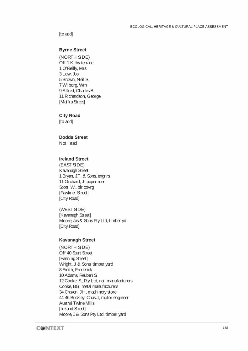
ECOLOGICAL, HERITAGE & CULTURAL PLACE ASSESSMENT
115
[to add]
Byrne Street (NORTH SIDE) Off 1 Kilby terrace 1 O’Reilly, Mrs 3 Low, Jos 5 Brown, Neil S. 7 Wilborg, Wm 9 Alfred, Charles B 11 Richardson, George [Maffra Street]
City Road [to add]
Dodds Street Not listed
Ireland Street (EAST SIDE) Kavanagh Street 1 Bryan, J.T. & Sons, engnrs 11 Orchard, J., paper mer Scott, W., blr covrg [Fawkner Street] [City Road] (WEST SIDE) [Kavanagh Street] Moore, Jas & Sons Pty Ltd, timber yd [City Road]
Kavanagh Street (NORTH SIDE) Off 40 Sturt Street [Fanning Street] Wright, J. & Sons, timber yard 8 Smith, Frederick 10 Adams, Reuben S. 12 Cooke, S., Pty Ltd, nail manufacturers Cooke, BG, metal manufacturers 34 Craven, J H, machinery store 44-46 Buckley, Chas J., motor engineer Austral Twine Mills [Ireland Street] Moore, J & Sons Pty Ltd, timber yard

SOUTHBANK BOULEVARD & DODDS STREET
116
Austral Otis Engineering Co Ltd [Power Street] Moore, J & Sons, Pty Ltd, timber yard Oliver, Robert, caretaker 116 Sharp, J & Sons Ltd, timber yard [Ralston Street] [Hanna Street]
(SOUTH SIDE) Off 40 Sturt Street 17 Nesbitt, William J 29 Jones Free Store Moore, James timber yard Bennett, J P,stables Roberts & Co, engineers Barlow J G, polish manufacturer 69 Kirchner and Shadwick, engineers Sharp, J & Sons 75 Hind, James Moore, J & Sons, Pty Ltd, stables [Power Street] 83 Sharp, J & Sons 95 Logan, Malcolm, caretaker Sharp, J & Sons [Ralston Street] Austral Otis Engineering Co Ltd [Hanna Street]
Maffra Street (EAST SIDE) Off 111 Riverside Avenue 1 Sennitt, John P., & Son, Pty Ltd, ice works Hyland, D., & Sons Pty Ltd, poulterers and exporters Brooks Robinson & Co Ltd, gls importers – J Bateson, caretaker [Byrne Street] 25 Jones’ bond and free stores [City Road] (WEST SIDE) Off 111 Miller Street Miller & Co Pty Ltd, macy mers 2 Sterling Engineeting Supply Co (Aust) Pty Ltd Firth, Thomas & Sons (Aust) Pty Lts, steel mnfrs Alston, Jas. & Sons, windmill mnfrs 28 Flett & Sons, cooperage Millars Timber & Trading Co Ltd … sawmillers and timber merchants; Offices: Maffra Street, Queen’s Bridge Road Jones Bonded Stores [City Road]

ECOLOGICAL, HERITAGE & CULTURAL PLACE ASSESSMENT
117
Miller Street (NORTH SIDE) East from Queens Bridge River Yarra Sweeney, Wm, fruit merchant Queen Street Bridge (SOUTH SIDE) [Maffra Street] Reid, Angus G., brass founders and coppersmiths Victoria Varnish Co Pty Ltd 141 Borthwick, Alex, (managing director), paint and varnish manufacturers, dry colour makers and oil refiners, Est 1853. 143 O’Keefe, Mrs Jennie, dining rooms 145 Beckfeld, Hy W., hairdresser and tobacconist Queen Street Bridge Nolan Street(NORTH SIDE) [Sturt Street] Repatriation Dept Trades School- Edward Barry, caretaker [Sloss Street] [St Kilda Road] (SOUTH SIDE) [Sturt Street] Peters, A., builder [Dodds Street] Police Hospital [St Kilda Road] Ralston Street Off 171 City Road John & Sons Co Ltd, timber merch [Fawkner Street] John & Sons Co Ltd, timber merch [Kavanagh Street] Riverside Avenue [to add] St Kilda Road (WEST SIDE) [Princes Bridge] [City Road] [Nolan Street] Military Base hospital [Grant Street] Sturt Street

SOUTHBANK BOULEVARD & DODDS STREET
118
(EAST SIDE) [St Kilda Road] Wirths Park and circus buildings [Nolan Street] 101-111 Mintaro (The) Slate and Flagstone Co. Ltd., flagging, hearths, shelves, steps, urinals, landings, monumental slabs, billiard table tops, etc. 119-121 Alcock & Co. Pty Ltd, Billiard Table manufacturers and timber mers 133 Lindgren, Wm. Neuchatel Asphaltic Co. Ltd Train, Wm & Co, marble and stone merchants 149 GPO Stables 179 GPO Mtr work shops and electricity str Grant Street (WEST SIDE) [St Kilda Road] Hoyts Lyceum 16-38 Wright J. and Sons, timber yard [Kavanagh Street] 40 Beath, Scuilless and Co., stables 64-78 Sargood Bros, clothing factory Alcock and co, store 86-92 White, D. and Co, carriage builders 94-100 Comwith Barbed Wire and Nail Works Pty Lrd 110 Langwill Bros, and Davies Pty Ltd, machinery merchants 112 Wright, J, & Sons, timber yard 118-124 Australian Glass Manufacturers Co. Ltd 130-36 Gill, Thomas S., manufacturer of show cases [to be continued]
Wells Street (WEST SIDE) Off 29 Grant Street Stewarts and Loyds Ltd Store MMBW str yard 104 Public Works Dept storeyard; Thomas D Kendall, storeman [Miles Street] Queensbridge Street (EAST SIDE) Railway Bridge Off 145 Miller Street 1-3 Queen’s Bridge Hotel – James Dwyer 5-7 Shanks & Co Pty Ltd, sanitary engineers 25 Willis & Taylor Pty Ltd, clothing mfrs 27 Miller & Co Pty Ltd, machinery merchants 33-45 Russell, George Pty Ltd, bulk stores 51 Edington,J.C. & Son, timber merchants 71-73 Benson Bros Ltd, machinery merchants 81 Lowther & Jarvis, engineers 83 Halls & Honeyman, pattern makers

ECOLOGICAL, HERITAGE & CULTURAL PLACE ASSESSMENT
119
85 Welch, Perrin & Co. Pty Ltd (pattern shop) 93 Vacuum Oil Pty Ltd, store 95-105 Globe Motor and Taxi Co Ltd 107 Hall, C J, perambulator, etc, mfr 111 Robur Tea Store – James Service & Co. 115 Bond Manufacturing Co, salt merchants 131 McIntyre Bros, tea warehouse 131 Loftus, Moran, tea merchant 135 Castlemaine Hotel – Thomas Goodwin [City Road]
(WEST SIDE) Off 2 Whiteman Street 2 Waugh & Ferrall, pattern mkrs 12 Melbourne Builders’ Lime and Cement Co. Ltd sanitary ware dept 20 Brit Imp Oil Co. Ltd (str) 28 Danks, J. & Son Pty Ltd, brassfounders 46 Guy, H.E., dealer old metals 48 Welch, Perrin & Co., indts & mfrs ags 58 Yencken, E.L. & Co. Pty Ltd, stores Wunderlich Ltd Wills, George Co. Ltd, indentors 84 Klipto Pty Ltd, mfg stationers Vic Producers Co-op Co. Ltd (Grain str) Broken Hill Association Smelters Pty Ltd [Hanna Street] [City Road] Yarra Bank Road [to add]

SOUTHBANK BOULEVARD & DODDS STREET
120
B Listed places adjacent to the Study Area
Victorian Heritage Register (VHR)
Jones Bond Store, H0828 (HO763)
ADDRESS
1 Riverside Quay, Southbank
HISTORY
The site of the Jones Bond Store first appears to have been occupied by William B. Jones from around 1866. Jones was described as a Lighterman and free store keeper and he appears to have run a kerosene store at the site, with other premises elsewhere in the town. The rate book descriptions from 1865-6 until 1868-9 list "three timber and iron kerosene stores (Nos. 1,2 & 3) and a four room timber house with stables". By 1868-9, two additional stores (Nos. 4 & 5) were listed but appear to have been replaced in 1870-71 by the Waverley Bond, a stone store built with heavy buttressing, presumably to withstand potential explosions. In 1872-73 a brick store is mentioned (No. 1) and another one (No. 3) in the following year. By 1874-5 a brick "New York store" is mentioned and two more brick stores (Nos. 2 & 6).
STATEMENT OF SIGNIFICANCE
What is significant?
The Jones Bond Store was a large complex of store buildings, the first being constructed on the site around 1865. The extant registered buildings are Stores B and C and building No. 11. These probably date from 1888. The B and C stores were constructed of English-bond face brickwork with cast-iron columns and timber floors and roof trusses. The five storeys are delineated by corbelled brick string courses, and arched and flat arched window heads alternate with each floor. An oculus in each gable is surrounded by cream brick with quoins on the four axes. Building 11 was constructed of brick and bluestone and has a shallow gable roof. How is it significant?
The Jones Bond Store is of historical and architectural significance to the State of Victoria. Why is it significant?
The Jones Bond Store is of historical significance as one of the largest extant 19th century store complexes in Victoria and one of the few remaining links with Southbank's early industrial and maritime past. The buildings provide evidence of the character of late-19th century warehousing and are a reminder of the fact that the river bank in their vicinity was once a hive of shipping activity. They show how warehouses and shipping freight facilities were more closely integrated in the fabric of the city in the years before containerisation and heavy freight haulage demanded more specialised and separate freight precincts. The simple but substantial character of the buildings reflects Melbourne's growing importance as a port city in the post-gold rush years. The Jones Bond Store is of architectural significance because it documents a development in building design, namely the multi-storey warehouse, a development which was influenced by the introduction of hydraulic lift technology in the mid 1880s.
Victorian Arts Centre & Hamer Hall, H1500 (HO760)
ADDRESS
2-128 St Kilda Road, Southbank
HISTORY
After the National Gallery of Victoria opened in 1968 as the first stage of the Victorian Arts Centre, attention turned to the completion of the remainder of the complex. This included a concert hall, theatres and spire, which had all been conceived by Roy Grounds in his original master plan in 1960, as one building, under a spire, and linked to the gallery via a covered porch. He died before seeing the final completion of this project which he began in 1959. The site selected for this complex, just south of the Yarra, was first proposed in 1943, proclaimed in 1957, and construction of the gallery component finally commenced in 1962. A competition was not

ECOLOGICAL, HERITAGE & CULTURAL PLACE ASSESSMENT
121
held for the design of the Arts Centre and in 1959 Grounds, Romberg and Boyd were appointed architects. In awarding this commission, emphasis was placed on Grounds thirty years of experience and he subsequently became responsible for the job. He then devoted much of his time, from the 1960s to the 1980s, to this building complex. The rectangular gallery building was constructed to the south of the selected site in St Kilda Road, a triangular art school constructed to the west in 1970, and the area to the north, known as the North End, was allocated to the theatre and concert facilities, located under a circular spire. Nine years after producing the master plan, and with the gallery complete, Grounds turned his attention to the design of the theatre and concert facilities. Initial plans had been for a new gallery building and a multi-purpose auditorium, however plans for the auditoria components grew, and the State government was persuaded to annex land all the way to the Yarra. The design for the State Theatre was altered to accommodate 2000 patrons and concerns over the implications of structural works associated with underground proposals, particularly after the collapse of the West Gate Bridge in 1970, forced Grounds to look at alternatives. The Theatres Building was modified and extended above St Kilda Road level as an undistinguished bush-hammered concrete building, and the spire, lifted to house the flytower, became an enormous latticed space frame. The Concert Hall, also originally intended to be underground, became a massive, sandstone coloured precast panelled, cylinder. As a result, Ground’s initial concept for the complex was greatly compromised. Responsibility for the project lay with the Building Committee, established in 1956, and comprising a number of representative members from the community, local councils, regional Victoria, the Victorian Government and the National Gallery of Victoria. These included Kenneth Myer, who was chairman from 1965 to 1989, Professor Joseph Burke and later Professor Margaret Manion from the Fine Arts Department at Melbourne University, Councillor Michael Winneke and Sir Ian Potter. For twenty five years this committee was a consistent force in the completion of the complex. It became the Victorian Arts Centre Trust in 1980, with actor and film director, George Fairfax, as its first General Manager, a position he held until 1989. Originally appointed as a technical officer, and Chief Executive Officer in 1972, Fairfax played an influential role in the development of the Arts Centre. Work began on the theatre site in 1973, with excavation work not completed until 1977-8, two years later than expected. Work on the more stable concert hall site began in 1976. As work began on the substructures, fully developed sketch plans of the buildings and their interiors were completed. Academy Award-winning expatriate set designer, John Truscott, was employed to decorate the interiors and his theatrical connections added another dimension to the project. His work on the interiors was constrained only by a requirement to leave elements already constructed, such as Ground?s faceted cave Concert Hall interior, to which he applied jewelled finishes, and his steel mesh draped ceiling in the State Theatre, to which he added perforated brass balls. The lushness of Truscott?s interiors, contrasted with the sombre character of Ground?s exterior. The Concert Hall opened in November 1982, while substantial work remained to be done on the Theatres site. The rest of the Arts Centre was opened progressively in 1984, with the Theatres building officially opened in October that year. This signified the completion of one of the largest public works projects in Victorian history, which had been undertaken over a period of almost twenty five years. The draft statement of significance and the above history were produced as part of an Online Data Upgrade Project 2005. Sources were as follows: Allom Lovell & Associates. Victorian Arts Centre Conservation Management Plan. Melbourne 1995 V. Fairfax. A Place Across the River. They Aspired to Create the Victorian Arts Centre. Melbourne 2002
STATEMENT OF SIGNIFICANCE
What is significant?
After the National Gallery of Victoria opened in 1968 as the first stage of the Victorian Arts Centre, attention turned to the completion of the remainder of the complex. This included a concert hall, theatres and spire, which had all been conceived by Roy Grounds in his original master plan in 1960, as one building, under a spire, and linked to the gallery via a covered porch. He died before seeing the final completion of this project which he began in 1959. The site selected for this complex, just south of the Yarra, was first proposed in 1943, proclaimed in 1957, and construction of the gallery component finally commenced in 1962. A competition was not held for the design of the Arts Centre and in 1959 Grounds, Romberg and Boyd were appointed architects. In awarding this commission, emphasis was placed on Grounds thirty years of experience and he subsequently became responsible for the job. He then devoted much of his time, from the 1960s to the 1980s, to this building complex. The rectangular gallery building was constructed to the south of the selected site in St Kilda Road, a triangular art school constructed to the west in 1970, and the area to the

SOUTHBANK BOULEVARD & DODDS STREET
122
north, known as the North End, was allocated to the theatre and concert facilities, located under a circular spire. Nine years after producing the master plan, and with the gallery complete, Grounds turned his attention to the design of the theatre and concert facilities. Initial plans had been for a new gallery building and a multi-purpose auditorium, however plans for the auditoria components grew, and the State government was persuaded to annex land all the way to the Yarra. The design for the State Theatre was altered to accommodate 2000 patrons and concerns over the implications of structural works associated with underground proposals, particularly after the collapse of the West Gate Bridge in 1970, forced Grounds to look at alternatives. The Theatres Building was modified and extended above St Kilda Road level as an undistinguished bush-hammered concrete building, and the spire, lifted to house the flytower, became an enormous latticed space frame. The Concert Hall, also originally intended to be underground, became a massive, sandstone coloured precast panelled, cylinder. As a result, Ground's initial concept for the complex was greatly compromised. Responsibility for the project lay with the Building Committee, established in 1956, and comprising a number of representative members from the community, local councils, regional Victoria, the Victorian Government and the National Gallery of Victoria. These included Kenneth Myer, who was chairman from 1965 to 1989, Professor Joseph Burke and later Professor Margaret Manion from the Fine Arts Department at Melbourne University, Councillor Michael Winneke and Sir Ian Potter. For twenty five years this committee were a consistent force in the completion of the complex. It became the Victorian Arts Centre Trust in 1980, with actor and film director, George Fairfax, as its first General Manager, a position he held until 1989. Originally appointed as a technical officer, and Chief Executive Officer in 1972, Fairfax played an influential role in the development of the Arts Centre. Work began on the theatre site in 1973, with excavation work not completed until 1977-8, two years later than expected. Work on the more stable concert hall site began in 1976. As work began on the substructures, fully developed sketch plans of the buildings and their interiors were completed. Academy Award-winning expatriate set designer, John Truscott, was employed to decorate the interiors and his theatrical connections added another dimension to the project. His work on the interiors was constrained only by a requirement to leave elements already constructed, such as Ground's faceted cave Concert Hall interior, to which he applied jewelled finishes, and his steel mesh draped ceiling in the State Theatre, to which he added perforated brass balls. The lushness of Truscott's interiors, contrasted with the sombre character of Ground's exterior. The Concert Hall opened in November 1982, while substantial work remained to be done on the Theatres site. The rest of the Arts Centre was opened progressively in 1984, with the Theatres building officially opened in October that year. This signified the completion of one of the largest public works projects in Victorian history, which had been undertaken over a period of almost twenty five years. How is it significant?
The Victorian Arts Centre is of architectural, aesthetic, historical and social significance to the State of Victoria. Why is it significant?
The Victorian Arts Centre is of architectural significance as a major work by noted Australian architect, Roy Grounds, who, together with his former partners Robin Boyd and Frederick Romberg, was one of the most influential architects of his generation, pioneering modernist design. Together with the gallery, the Arts Centre occupied much of his time from the 1960s to 1980s. Grounds significance as an architect was confirmed when he was awarded the RAIA Gold Medal in 1968 and was knighted the same year. The Arts Centre is of architectural and aesthetic significance for the high standards of design and detail evident in the distinctive interiors of the performance and ancillary spaces, designed by John Truscott. The Victorian Arts Centre is of historical significance as one of the largest public works projects in Victoria's history. This ambitious project, undertaken over a period of almost twenty five years, encompassed complex planning, design, documentation and construction phases. It has associations with prominent individuals in Victoria's cultural history including George Fairfax and John Truscott. The Arts Centre is of historical significance as a major cultural institution and as the primary focus for the arts in Victoria. Once constructed, the complex, with its distinctive spire, provided Melbourne with an important visual image. The Arts Centre is of social significance for the unusual level of public interest and support it afforded. A large number of Victorians were involved with the planning and financing of the complex and a

ECOLOGICAL, HERITAGE & CULTURAL PLACE ASSESSMENT
123
number of major and minor corporate and individual sponsors were involved.
National Gallery of Victoria, H1499 (HO792)
ADDRESS
130-200 St Kilda Road, Southbank
HISTORY
The National Gallery of Victoria was opened in 1968 as the first stage of the Victorian Arts Centre. Designed by noted Melbourne architect Roy Grounds, this building created great controversy both before and after construction, and caused the split in 1962 of the important and influential partnership Grounds had with Robin Boyd and Frederick Romberg. The National Gallery was originally established in the Public Library in Swanston Street in 1861. Calls for a new and separate gallery building began after the generous Felton Bequest in 1905 enabled the acquisition of a large collection of art, however this was not fulfilled for another sixty years. In 1943 the State Government proposed that a new art gallery be constructed on crown land just south of the Yarra River on a site known as Wirth’s Park, occupied at the time by a number of entertainment facilities. Proclamation of the site was delayed until 1957, after Henry Bolte was elected Premier, and construction on the site finally commenced in 1962. A competition was not held for the design and in 1959 Grounds, Romberg and Boyd were appointed architects. In awarding this commission, emphasis was placed on Grounds thirty years of experience and he subsequently became responsible for the job. He then devoted much of his time, from the 1960s to the 1980s, to this building complex. The master plan produced by Grounds, placed the Gallery at the southern end of the St Kilda Road site, with the northern end reserved for the future construction of a theatre and concert hall complex. The Director of the Gallery at the time, Eric Westbrook, produced a brief outlining the aims of a new Gallery building and, together with Grounds, undertook a three month tour of Europe and America to view international gallery designs. Grounds had already gained a reputation in Victoria for his highly innovative work, playing a key role in the early 1930s in bringing the Modern Movement to Australia. His fascination with geometry was evident in his work from the early 1950s and can be clearly seen in his gallery design. In response to the specific site, the original master plan included a triangular planned Art School to the west of the gallery and circular spire to the north, and in 1970 the former was opened. Associated auditoria and theatres were also planned for future development and these were completed in the early 1980s. A major redevelopment of the National Gallery was opened in 2003. Designed by Italian architect Mario Bellini, in conjunction with Melbourne architects, Metier 3, it retained the basic design and inserted a new gallery. Many important features of the original Grounds design remain intact, including the exterior bluestone walls, Leonard French ceiling, water wall entry (although moved), and many of the original internal finishes. References The draft statement of significance and the above history were produced as part of an Online Data Upgrade Project 2005. Sources were as follows: Allom Lovell and Associates. National Gallery of Victoria Conservation Management Plan. Volume 1. 1994 Meredith Gould. National Gallery of Victoria Conservation Plan. 1998
STATEMENT OF SIGNIFICANCE
What is significant?
The National Gallery of Victoria was opened in 1968 as the first stage of the Victorian Arts Centre. Designed by noted Melbourne architect Roy Grounds, this building created great controversy both before and after construction, and caused the split in 1962 of the important and influential partnership Grounds had with Robin Boyd and Frederick Romberg. The National Gallery was originally established in the Public Library in Swanston Street in 1861. Calls for a new and separate gallery building began after the generous Felton Bequest in 1905 enabled the acquisition of a large collection of art, however this was not fulfilled for another sixty years. In 1943 the State Government proposed that a new art gallery be constructed on crown land just south of the Yarra River on a site known as Wirth's Park, occupied at the time by a number of entertainment facilities. Proclamation of the site was delayed until 1957, after Henry Bolte was elected Premier, and construction on the site finally commenced in 1962. A competition was not held for the design and in 1959 Grounds,

SOUTHBANK BOULEVARD & DODDS STREET
124
Romberg and Boyd were appointed architects. In awarding this commission, emphasis was placed on Grounds thirty years of experience and he subsequently became responsible for the job. He then devoted much of his time, from the 1960s to the 1980s, to this building complex. The master plan produced by Grounds, placed the Gallery at the southern end of the St Kilda Road site, with the northern end reserved for the future construction of a theatre and concert hall complex. The Director of the Gallery at the time, Eric Westbrook, produced a brief outlining the aims of a new Gallery building and, together with Grounds, undertook a three month tour of Europe and America to view international gallery designs. Grounds had already gained a reputation in Victoria for his highly innovative work, playing a key role in the early 1930s in bringing the Modern Movement to Australia. His fascination with geometry was evident in his work from the early 1950s and can be clearly seen in his gallery design. The large palazzo-like gallery building is rectangular in form with three internal courtyards providing light and external views to surrounding galleries. The bluestone clad, reinforced concrete building is relieved only by a large entrance archway and a bronze Victorian coat of arms by Norma Redpath on the front facade. The oriental influenced floating roof, with upturned eaves, is separated from the walls by a continuous band of high clerestory windows, and a moat surrounds the entire building. The water theme is continued at the entry where a flow of water runs down a glass screen, now known as the water wall. The brief required the inclusion of a reception hall for State functions and this is four storeys in height and features an abstract ceiling of multi-coloured glass by the artist Leonard French. Two principal double height floors, at ground and second floor levels, contain the main gallery spaces, with intermediary floors containing many of the service areas. Contrasting internal finishes include bluestone, bush-hammered concrete and Victorian ash veneer panels, baffles and gapped lining boards. Grant and Mary Featherston were commissioned to design the furniture and fittings for the gallery in 1966. They were required to address a wide range of issues, including security, atmospheric control and the housing of a variety of objects, and, in response to their brief, developed a system of butt jointed glass cases which provided an unencumbered view of the objects on display. These were supported on rectilinear frames of Victorian ash, consistent with the material used throughout the interior. In response to the specific site, the original master plan included a triangular planned Art School to the west of the gallery and circular spire to the north, and in 1970 the former was opened. Associated auditoria and theatres were also planned for future development and these were completed in the early 1980s. A major redevelopment of the National Gallery was opened in 2003. Designed by Italian architect Mario Bellini, in conjunction with Melbourne architects, Metier 3, it retained the basic design and inserted a new gallery. Many important features of the original Grounds design remain intact, including the exterior bluestone walls, Leonard French ceiling, water wall entry (although moved), and many of the original internal finishes. How is it significant?
The National Gallery of Victoria is of architectural, historical and social significance to the State of Victoria. Why is it significant?
The National Gallery of Victoria is of architectural significance as the most ambitious and most successful of the works from the post-Second World War period to 1960, in the development of a modern Australian architecture. This period of experimentation in structure and expression was influenced by the Modern Movement in Europe and America, and resulted in a specific Australian response. The National Gallery of Victoria is of architectural significance as a major work by noted Australian architect, Roy Grounds, who, together with his former partners Robin Boyd and Frederick Romberg, was one of the most influential architects of his generation, pioneering modernist design. The gallery represents the peak of his five decades of practice. It is his best known work and a building that provoked a mixed reaction from the architectural profession. Grounds is significance as an architect was confirmed when he was awarded the RAIA Gold Medal in 1968 and was knighted the same year. The Gallery is of architectural significance as a highly detailed, integrated design. This is seen in the variety of internal finishes employed, the design of furniture and fittings, and in the integration of art work in the building, such as the ceiling by artist Leonard French and the coat of arms by Norma Redpath. The Gallery is of historical significance as the first major public building to be constructed in Victoria in

ECOLOGICAL, HERITAGE & CULTURAL PLACE ASSESSMENT
125
the fifty years following the First World War, and the first entirely new Art Gallery to be constructed in Australia after the Second World War. It set new standards for exhibition layout, art storage and conservation and represented a new era in the arts and public architecture. The site became the primary focus for the arts in Victoria and provided Melbourne with an important visual image. The National Gallery is of social significance for the high level of public ownership and affection it attracts. This is particularly evident in the large amount of money raised by public appeal and the strong attachment felt with the visible images of the water wall and the Great Hall.
Former Victoria Police Depot (Victoria College of the Arts), H1541 (HO910)
ADDRESS
234 St Kilda Rd, 1-39 Dodds St & 148-170 Southbank Blvd, Southbank
HISTORY
The Site & Buildings The site of the former South Melbourne Police Depot is bounded by St. Kilda Road, Southbank Boulevard, Dodds Street and Grant Street. The area has been gradually taken over by the Victorian College of the Arts since 1973. However, the Victorian Police still occupy the Stables and the Riding School in the south west corner of the site. Aboriginal Use The Study Area lies within the tribal territory of the Woiworung or Wurundjeri people. The territory of the Wurundjeri has been described as all the land drained by the river Yarra and its tributaries. Until 5000 or 6000 years ago, the Port Phillip Bay coastline was roughly along the line of St Kilda Road. It is likely that Aboriginal people used the bay foreshore and waters for fish, shellfish and plants. When the water level fell, the swampy areas around Albert Park and South Melbourne were exposed. The swamps contained eels which the Aborigines caught at certain times of the year. Birds and water fowl were plentiful around the swamp land, providing food for the Aborigines. The area selected by the first settlers for the town of Melbourne was the place used for intertribal gatherings of the Kulin, the confederacy of tribes occupying the Port Phillip area. Agriculture and Brick making The first known use of the site by European settlers of the land on the west side of St Kilda Road was for agriculture and brick making. The brick fields extended from the Government House reserve to the base of Emerald Hill. Garryowen claimed that they were ?the resort of a drunken, bloodthirsty, thieving crew?. Canvas Town and the Immigrants? Home When gold was discovered in Victoria in December 1851, the resulting influx of population could not be accommodated in Melbourne. The government established two ‘Immigrants’ Homes’. In November 1852 the Public Houseless Immigrants Home opened on the Government Reserve south of the Yarra. The government also leased a building at the foot of Batman’s Hill which had been the city abattoirs. It was subdivided into fifty small rooms to accommodate 200 people. There was a charge of one shilling a night per head for lodging in this establishment. In addition two acres of land on the south side of the Yarra were covered with wooden buildings to take in 400 to 500 people. These measures were inadequate to cope with the vast numbers needing accommodation. The Immigrants Aid Society was founded in May 1853 to help ‘the fearful distress amongst the newly arrived population’. It urged the government to take further steps to help the new arrivals. Lieutenant-Governor La Trobe also set aside land on the west side of St. Kilda Road for those with tents across the river from Melbourne. The settlement quickly filled up with tent-dwellers and became known as Canvas Town. (Fig. 1) By the end of the year Canvas Town held over seven thousand people paying 5s per week, and tradesmen of all kinds had moved in to supply local needs. Men lived there in conditions corresponding to their natures, in reasonable extemporized comfort or in squalor and filth... Many of the residents were the poverty-stricken families of those trying their luck on the fields, ?forlorn, wretched, outcast?. Many had pitched their tents on swampy ground and paid the penalty, for in the summer the encampment was swept with low fever, ague and children’s diseases. Canvas Town stretched for about a mile along the western side of St Kilda Road, south of City Road. The government closed down its immigrants’ institutions in 1854 and Canvas Town in the same year.

SOUTHBANK BOULEVARD & DODDS STREET
126
The Immigrants Aid Society took over the buildings on the east side of St Kilda Road in 1855, paying the government £1000 raised by public subscription.(Fig. 2) However the government soon took back the site of the Immigrants Homes to house the 40th regiment which was transferred from Sydney to Melbourne. The inmates of the Immigrants Home were then moved across to the west side of St Kilda Road. Six years later, the military moved out and the buildings were returned to the Society. The Society found themselves providing accommodation for the destitute in a casual ward. If the same person returned night after night to the casual ward, they were admitted to a permanent ward where inmates had to contribute their labour in return for their board and lodging. Men worked at oakum picking or stone breaking and women did sewing and washing and other household tasks. The Society also established a hospital for destitute persons who were discharged from the Melbourne Hospital, either to convalesce or to die. By 1868, on the west side of St. Kilda Road there was ?an auxiliary establishment including a good brick building used as a hospital and a handsome cottage, the residence of the efficient Superintendent of the Home, Mr. J. S. Greig. The Society took on a number of other functions as time went on. One of these was to educate children who came into the Home. The construction of Government House completed in 1876 was the impetus to tidy up the straggling buildings on the east side of St. Kilda Road. It was decided that the brick buildings could be allowed to remain if they were hidden by trees. The wooden buildings on both sides of St. Kilda Road were demolished. The Women’s Department stayed in the brick building on the east side of St. Kilda Road. The Male Hospital was on the west side and the Casuals were accommodated in the Military Barracks still on the east side. In 1882, the Male Division moved to Royal Park. By February 1914 all trace of the Immigrants Home was removed from the east side of St. Kilda Road when the Female Division also moved to Royal Park. The Casuals Ward was moved to La Trobe Street, leaving a brick Immigrants Home building on the west side. (Fig.3) Victoria Barracks It was considered important in the nineteenth century that the low-lying land around the military barracks be free of settlement. The military reserve was originally extended back to Moray Street, but this was changed to Hanna Street (King’s Way) in 1862. The need to protect the soldiers from disease was an impetus to providing parks and gardens for Melbourne as a buffer zone between the barracks and the nearest residential housing to prevent infection passing from the residents of the swampy land to the soldiers: It is indispensably necessary for the healthy state, not only of the Barracks but of the whole City, that the low-lying land should be kept permanently free from human habitation. Should a population be allowed at any time to settle there, the whole cost of the barracks building would be thrown away, as the troops would certainly be withdrawn for sanitary reasons. There had been several locations for Police Barracks throughout Melbourne in the second half of the nineteenth century, but following the closure of the Barracks on the corner of Punt Road and Wellington Parade in 1881, the men and horses were transferred to buildings within the Victoria Barracks on St. Kilda Road. They occupied a number of buildings at the Victoria Barracks site. The police were quartered in the building now known as G Block. During this period separate facilities were maintained for the police and the military. In 1882, when a military canteen was opened, the police were reminded that their own canteen was for the use and convenience of the Police Force only ... in future liquor is not to be served out of it to any other person.? The part of the site occupied by the police was fenced off from that used by the military. The eight to ten foot high fence ran alongside the north end of G Building, effectively separating the military parade ground from the much smaller police parade ground. The building now known as J Block was used as the Police Hospital from 1881 to the end of World War I. After Federation the Commonwealth took control of the Victoria Barracks as part of the Department of Defence, so the police could not continue to use part of the Barracks as their base. The police then took over the site on which the Immigrants Depot had its hospital. A 1905 plan shows a Continental Picture Garden on the part of the site later occupied by the Police Hospital. Police depot The setting up of the Police Depot on the present St. Kilda Road site arose from the need to move the police from the Victoria Barracks once it was taken over by the Commonwealth Defence Department c.1910. The Police Depot was built in three stages. It was decided that the complex would be built on the five

ECOLOGICAL, HERITAGE & CULTURAL PLACE ASSESSMENT
127
acre site and that the work would be carried out in sections, attention being first directed to provision of necessary accommodation for 60 men in order to vacate the Barracks as early as possible. There was to be a hospital, a riding school, a drill-hall, extensive stores for all the police departments, stables for 75 horses, workshops for mechanics, horse-breaking yards, quarters for sub-officers and wagon and van sheds. However, the first building for the Police Department constructed on the site from September 1912 was the stables, with a street front to Dodds Street and an octagonal entrance hall at the intersection of Dodds and Grant Streets. The stables consisted of 53 loose boxes around a central basalt pitchered access way. A riding school and drillhall were built along Grant Street. The stables were put to use as a military hospital during World War I and also after the war as a hospital for influenza patients in the pandemic that swept the world in 1919. The beds were placed in rows with the heads against the walls of the loose boxes and a central aisle allowed the nursing staff to move amongst the patients. The temporary wards were illustrated in an issue of Police Life Magazine. One of the fringe benefits received by police was free medical treatment in the Police Hospital. In the 1860s the Police Medical Officer reported that in a two year period more than 60 admissions to the Police Hospital out of a total of 356 were for gun-shot wounds, broken bones, lacerations and contusions. Other occupational hazards in the nineteenth century included tuberculosis, dysentery and typhoid fever. From 1881 to 1914 police were treated in the Police Hospital within the Victoria Barracks. The new purpose-built Police Hospital was constructed in 1913-14 by contractor R. S. Phillips at a cost of £6567.15.9. Constructed in pavilion form, it consisted of three sections. On the ground floor, the front single-storey portion nearest to St. Kilda Road contained an office for the doctor, a dispensary and services such as kitchen, scullery, and dining room. The middle section consisted of a store, a two-bed ward and a single ward off a passage opening into a large 8 or 10 bed ward with verandahs on two sides providing fresh air, cross-ventilation and space for convalescing patients to be in the open air. This reflected hospital design since the 1860s and followed Florence Nightingale’s dictum that ‘No ward is in any sense a good ward in which the sick are not at all times supplied with pure air, light and a due temperature.’ At the back of the ward on the ground floor was a corridor leading to the single storey operating theatre. The ward section was duplicated on the first floor. The outbuildings to the hospital consisted of a free-standing fuel store and a cook’s residence. The building was renovated in 1927. It has become the Arts Building of the Victorian College of the Arts. To the west of the Police Hospital was built the dispenser’s residence. This three bedroom house facing Nolan Street cost £1124.19.5 in 1913-14. The old Immigrants Home building on the southern corner of the site was used as the first police barracks for recruits in the Police Depot and for mounted police. The first organised training for police recruits was introduced in 1919 by Chief Commissioner Steward, who implemented a seven-week training course at the Police Depot. The course included classes in law and police procedure, drill, ?physical culture, instruction in the care and use of rifles and revolvers, first aid, swimming and life saving, and how to manage a boat and drag for a body.? Steward also introduced training for detectives. In November 1923 the police went on strike as a protest against the internal arrangements of the force. The construction of a new building for Police Barracks on the St. Kilda Road site in 1925 was directly related to the police strike and the subsequent attempts by the Government to improve working and living conditions for the police. The 1924 Royal Commission on the Police revealed disgraceful living conditions in many barracks and stations. At the St. Kilda depot the hospital, the stables, the riding school and drill hall stand out as suitable for their several purposes. The stables appeared to lack nothing essential to the health and comfort of their occupants and the horses are much better served than the men. This depot is occupied by recruits in training, also by a reserve of mounted men. Their dwellings are ancient and forlorn of aspect when seen from without; within they are austere to a degree. Apparently none of the most ordinary comforts of home are permitted. Certainly none are visible. A typical dormitory held about a dozen beds. Above each was a narrow shelf, with, for covering, a strip of newspaper. Otherwise the walls were bare. No picture or ornament of any kind was observed. No lockers or other suitable receptacle for the men?s belongings were in evidence. In the dining-room, it was noted that the seats were forms without backs. The whole effect was one of repelling cheerlessness, if not of actual discomfort in any body of men compelled to share them. The Royal Commission suggested a connection between the physical conditions the men were expected

SOUTHBANK BOULEVARD & DODDS STREET
128
to live under and their propensity to strike. As a result, police capital expenditure increased after the strike by 144% in the first year and continued to increase. The new Barracks was built in St Kilda Road, the Russell Street Barracks were remodeled the Bourke Street West Police Station was renovated and works done at dozens of police stations throughout the state. The 1925 Barracks dramatically improved living conditions for recruits and staff and also provided facilities for training of recruits. The building was constructed of three storeys. On the ground floor was a kitchen, servery, officers? mess and constables? mess, married mens’ lunchroom, and offices. Classrooms, a billiard room and single bedrooms for 22 men were located on the first floor. The second floor accommodated 45 men in 22 single rooms and three dormitories. In c.1916-20 a building containing the Stores and Workshops was constructed. This was added to in 1929. The Store Room had a counter to issue uniform to police officers. The architectural plan showed shelving for overcoats, helmets, blankets and other stores. At the same time a residence for the ‘Rough-Riders’, those in connection with the breaking of horses for police work, was built between the dispenser’s residence and the workshops. Horse yards for training purposes with a crush gate were constructed in the stable yard in 1933 at a cost of £136.3.0. Victorian College of the Arts/Mounted Police, 1973-present In 1973 the Police acquired the former seminary, Corpus Christi College at Glen Waverley for use as the Police Training Academy. The major part of the St. Kilda Road site with the exception of the stables and the hospital was taken over by the Victorian College of the Arts. In 1981 the Police Hospital moved in to a new building at the back of the Prince Henry’s Hospital, and the old police hospital on St. Kilda Road became part of the Victorian College of the Arts. The police retained the Mounted Police Stables, which are the Operational Headquarters for the Mounted Police in Victoria. The riding school for police is no longer in use. The training school is now located at Attwood, near Broadmeadows, where the Police Stud is also located. In 1995 a strip of land along Grant Street taking in part of the Police Stables was reserved for the purposes of the City Link Act. The Victorian College of the Arts took over the Barracks first (now the Administration Building) and in 1981 the Police Hospital, which is now the Arts Building. The Dispenser’s Residence is now used by the Australian Dance Council while the Rough Riders’ Residence is used to accommodate both the Artist in Residence and a workshop for the student opera’s wardrobe department. The College has also constructed a number of additional buildings on the site which have obliterated the outdoor facilities provided for the police , such as the parade ground, cricket ground and tennis court. The Architects The architectural division of the Victorian Public Works Department was responsible for the design of each of the buildings at the Police Depot. The buildings were erected during a seventeen year period from 1912 to 1929, and during this period, the Department’s highest position of Chief Architect was filled by three architects. George Watson was born in England on 25 September 1850 and migrated to Australia at the age of twenty two years. Shortly after his arrival on 26 October 1872, he gained his first position with the Public Works Department as a temporary Assistant Draftsman. He was upgraded from this position to a temporary Draftsman in 1879, and three years later, he was promoted to temporary Assistant Architect. On 1 February 1885, Watson was made a permanent staff member with his new position of Assistant Architect for the Central District. In 1910, he was appointed to the newly created position of Chief Architect, following the 1909 Grainger Report on the practices of the architectural branch of the Department. Watson remained in this position until his retirement in 1915. During Watson?s time at the Public Works Department, he worked on many projects such as the Bendigo Post Office (1882), the Richmond Post Office (1879) and the Port Fairy Post Office (1880) as well as the Bendigo Law Courts (1890), the Stawell Court House (1878) and the Shepparton Court House (1881). Watson also worked on the Sunbury Lunatic Asylum, the new Female Prison at Pentridge and the State Government Offices for the Department of Agriculture at 3 Treasury Place, Melbourne. He also collaborated with S. C. Brittingham on the design for the Administration Building of the Mont Park Hospital complex. Watson was an Associate of the Royal Institute of British Architects as well as the Australian representative of the London Society of Architects. He also held the rank of Major in the local forces and was in command of the Army Service Corps. He was appointed ADC to His Excellency the Acting-

ECOLOGICAL, HERITAGE & CULTURAL PLACE ASSESSMENT
129
Governor during his term of office and Honorary ADC to the Lieutenant Governor of the State of Victoria. Samuel C. Brittingham was born on 12 June 1860. Once joining the Victorian Public Works Department in 1875, he worked in the junior architectural positions of Trainee Draftsman in the State Schools Division and later as Assistant Architect (2nd Grade) for the North Western District. In 1908 Brittingham took the position of District Architect for the Central area, and in 1915 following the retirement of George Watson, he became the acting Chief Architect. Brittingham was officially appointed to the position of Chief Architect in 1916, and he remained in the position until 1922. During his time with the Public Works Department, Brittingham worked on the design of many buildings including the Bourke Street West Police Station (1888), the Parkville Post Office (1889) and a number of other Post Offices and Court Houses throughout country Victoria. Later in his career he worked on many buildings in the Mont Park complex, including the Administration Building (1913), the former Paying Patients Block (1911-13), the Paying Patients Wards (1911-13), the Chronic Wards (1914-16) and the Military Mental Ward (1919-23). Edwin Evan Smith was born in Montrose, Scotland on 4 October 1870. He was articled to an unknown architect in Scotland before migrating to Australia in August 1889. In 1898, Smith gained a position as a draftsman in the Queensland Department of Public Works. Fourteen years later, he was employed by the Commonwealth Department of Works in Queensland, where he remained until 1922. At this time he was appointed Chief Architect of the Public Works Department in Victoria. In December 1929, Smith was appointed government architect of New South Wales and he remained in that position until he retired in October 1935. He died in August 1965. During his term as Chief Architect of the Victorian Public Works Department, Smith supervised the design of many buildings, including the State Government Offices at Bendigo (1928), police buildings at South Melbourne (1925) and Malvern (1929) and the former Police Barracks on St. Kilda Road (1925). He also supervised the design of many new schools and court houses throughout metropolitan Melbourne and country Victoria. E. Evan Smith was awarded the Royal Victorian Institute of Architects Street Architecture Medal in 1930 for his design of the Emily McPherson College of Domestic Economy, corner Russell and Victoria Streets. He was also a Fellow of the Royal Institute of British Architects
STATEMENT OF SIGNIFICANCE
What is significant?
The Former Victoria Police Depot, including the Stables, the Riding School, and Drill Hall (1912-13), Police Hospital and Dispensers Residence (1914) , Police Stores and Workshop, (c.1916-20), Police Barracks (1925 ) and Rough Riders Residence (1929) , was constructed between 1912 and 1929 as the headquarters for police training and mounted police operations in Victoria. The building resulted from the Federal Government's decision to establish the Victoria Barracks as the headquarters for the newly formed Commonwealth Department of Defence in 1906. As the Victoria Police had occupied a significant proportion of the Barracks since 1881, provisions were made by the Government to relocate the Police to the nearby St Kilda Road site. The St. Kilda Road site of the former Barracks has important associations with the history of Melbourne as the location of Canvas Town in 1852-54 and the Immigrants Home from 1856-1914. The Victorian College of the Arts began occupying the police buildings on the site from 1973. They subsequently erected substantial buildings and now occupy all the site except the Police Stables which remain in their original use by the Police as the Operational Headquarters for Mounted Police in Victoria. The whole of the land is significant as the curtilage of the island site of the Victoria Police Depot notwithstanding the buildings which have been erected or modified by the Victoria College of the Arts. How is it significant?
The former Victoria Police Depot is architecturally and historically important to the state of Victoria. Why is it significant?
The Former Victoria Police Depot is historically significant as a police training establishment of the early twentieth century and a police hospital. The Former Police Depot demonstrates the association of the site with the Victoria Police and in particular the Mounted Police Branch since 1912. The St. Kilda Road site of the former Depot has important associations with the history of Melbourne as the location of Canvas Town in 1852-54 and the Immigrants Home from 1856-1914. The Police Barracks within the Police Depot (now the Administration Building for the Victorian College of the Arts) is historically significant for its association to the police strike of November 1923 and subsequent Royal Commission in 1924, which found that many police barracks and stations provided

SOUTHBANK BOULEVARD & DODDS STREET
130
poor living conditions for officers. As a result, the old Immigrants Home buildings previously used by the Police recruits were demolished and construction of the new barracks was commenced. The new building set new standards for the accommodation of recruits with the provision of comfortable living conditions and recreational grounds and facilities. The former Rough Riders' Residence within the Police Depot is historically significant as a representative example of a police residence, but also as one for a special use as it was erected to accommodate those involved with breaking in new horses acquired for police work. The Police Depot is architecturally significant in providing an extremely rare and unique solution to the institution's requirements. The architectural form of the stables, riding school and drill hall demonstrates the reliance on the horse as a means of transport for police work at that time. The combination of stables, octagonal entrance hall, riding school and drill hall was regarded with pride at the time it was built. The Stables is one of the largest stable buildings to have been constructed and to still remain in metropolitan Melbourne. The original design for the Riding School and former Drill Hall was for one large open space divided in the centre by a mezzanine viewing platform. The Riding School is located in the wing extending east from the octagonal entrance hall. The former Police Hospital is historically and architecturally significant as the first purpose-built Police Hospital to be constructed in Victoria and one of the few Police buildings to still remain in metropolitan Melbourne. Its design was based on the pavilion principle, which expressed the late nineteenth and early twentieth century attitudes to hospital design. The design was intended to provide ample sunlight and ventilation for the convalescing patients, and included a two-levelled verandah on the north and south elevations. The hospital building included a dispensary, reflecting the function carried out by the dispenser in medical practice at that time. The hospital also included a single storey operating theatre attached to the western end of the building. The associated former Dispenser's Residence remains virtually intact. It is significant in medical history as it demonstrates the role of the dispenser in the early twentieth century medicine, in providing 24 hour medical assistance to the Police Hospital. The Rough Riders' Residence is historically significant in the history of mounted police in Victoria, as it is contemporaneous with the continuing training of police horses on this site in the period after the introduction of motor transport to police work. In the twentieth century the emphasis was changed from general transport use in city and rural areas. Horses had to be trained for ceremonial work and the control of hostile crowds, a use which continues to be necessary today. The police stores and workshop buildings as remaining elements of the entire complex help link the buildings and contribute to an understanding of the historical use and appearance of the site. The former Police Barracks is architecturally significant as a notable example of the Georgian Revival style which developed in Australia during the early twentieth century. The building is a rare example of the combination of this building type with the Georgian Revival style, as it was an aesthetic usually reserved for private residences or commercial buildings such as banks and offices. The design of the former Police Barracks is a major example of the work of the architect, E. Evan Smith. As Chief Architect of the Public Works Department from 1922-1929, Smith was responsible for many buildings, none of which were as controversial or publicly discussed as this. Smith's signature style of Georgian Revival also forms an important part of Australia's architectural history as it was the first time that an earlier style practised in this country was revived.
Domain Parklands, H2304 (HO398)
ADDRESS
St Kilda Road and Domain Road, Melbourne
HISTORY
Contextual History The Domain Parklands is part of a British tradition of establishing large Government domains around colonial government houses. The tradition was adapted from British royal estates which included large landscaped parks as settings for royal residences and the nineteenth century concept of public parks. Examples of parklands associated with vice-regal residences can be found in Sydney, Melbourne, Hobart and Adelaide, as well as other colonies of the British Empire including South Africa, New Zealand and Canada. Several large reserves for public purposes and recreation were established around the Melbourne settlement, on land reserved from sale by Charles La Trobe, Superintendent of the Port Phillip District after his arrival in 1839. These included the Botanic Gardens, South Yarra; Alexandra Gardens, Queen

ECOLOGICAL, HERITAGE & CULTURAL PLACE ASSESSMENT
131
Victoria Gardens, Kings Domain (the Domain Parklands), Royal Park, Fitzroy Gardens, Treasury Gardens and Yarra Park. Significant Figures in the Development of the Domain Parklands: Ferdinand von Mueller (1825-1896) [based on Australian Dictionary of Biography entry by Deirdre Morris] Ferdinand von Mueller trained as a pharmacist in Germany and developed a particular interest in, and knowledge of, botany before arriving in Adelaide in 1847. In 1852 Mueller travelled to Melbourne where he was appointed government botanist the following year by Lieutenant-Governor La Trobe. In this role he travelled extensively in Victoria, including areas little explored, and discovered and collected many species of indigenous vegetation. As botanist to the North Australian Exploring Expedition, Mueller travelled across the continent in 1855, observing some 800 species new to Australian botany. After his return to Melbourne he was appointed director to the Botanic Gardens in August 1857, in addition to his role as government botanist. He organised the construction of an herbarium to which he contributed his extensive collection, and began work on his 12 part Fragmenta Phytographiae Australiae (1858-82). As director, Mueller exchanged seeds and plants with Australian, European and American herbaria. He contributed to the seven volume Flora Australiensis between 1863 and 1878. Mueller's interest lay largely in the scientific and educational aspects of his work, rather than in the development of parklands in Melbourne for aesthetic and recreational purposes. In 1868 it was noted that no statues or structures had been erected in the gardens and Mueller was being criticised for his lack of directorship of the Botanic Gardens. As a result Mueller was replaced in the role by William Guilfoyle in 1873. Mueller was a tireless worker and he published over 800 papers and major works on Australian botany and lectured on a large range of topics, both scientific and historical. In 1877 he surveyed a large part of the forests and coast of Western Australia at the request of the government. The first part of The Native Plants of Victoria, a work which remained unfinished, was also issued that year. He was involved in a number of societies, awarded a royal medal of the Royal Society, London in 1888 and won many European honours. Based on his research and exploration, Mueller made recommendations on the use of land and plants and exported eucalyptus seeds to a number of countries. His European scientific contacts were important for the development of Australian science and his work helped gain international recognition for Australian scientific endeavour. His contribution to botany in Australia was immense and long lasting. William Guilfoyle (1840-1912) [based on Australian Dictionary of Biography entry by Alan Gross] William Guilfoyle was born in England and his family migrated to Sydney in 1849. His father was a nurseryman and he established two nurseries on his arrival in Sydney. William acquired an interest in botany and collected specimens on trips to northern NSW and Queensland, some of which he sent to Mueller in Melbourne to identify. In 1868 he joined a scientific expedition to the South Sea islands before growing sugar and tobacco near the Tweed River. In July 1873 Guilfoyle was appointed curator of the Royal Botanic Gardens in Melbourne and by the time he retired from this position in 1909 he had transformed them into gardens of world-wide repute. He replaced Mueller whose primary interest lay in the scientific aspects of the gardens at the expense of the aesthetic and recreational aspects. Guilfoyle proceeded to design the gardens with sweeping lawns, extensive plantings and picturesque built forms and in this way created panoramic vistas within the gardens. He also managed the cultivated land at Government House and land in the outer Domain, and designed several regional botanic gardens and private gardens. In addition to his practical landscape gardening pursuits, Guilfoyle continued botanical studies and produced published works including the First Book of Australian Botany in 1874. Guilfoyle earned his reputation as a brilliant, original and practical landscaper in Victoria, particularly through his extensive and influential work at the Botanic Gardens. Carlo Catani (1852-1918) [based on Australian Dictionary of Biography entry by Ronald McNicoll] Carlo Catani was born in Italy in 1852 and trained as a civil engineer before working in railway construction. In 1876 Catani and two colleagues migrated first to New Zealand and then to Australia. The three Italian men joined the Department of Lands and Survey as draftsmen and in 1880 Catani was registered as a surveyor. Transferred to the Public Works Department in 1882, Catani was employed as an engineering draftsman, and as an assistant engineer in 1886. As head of his section, he directed the

SOUTHBANK BOULEVARD & DODDS STREET
132
draining of the Koo-Wee-Rup swamp in Gippsland. In 1896 he was in charge of the widening and improvement of the Yarra River upstream from Princes Bridge and the scope of the project were greatly enlarged at his urging. It included the design and construction of Alexandra Parade, river bank works to the Cremorne railway bridge, and the laying out and planting of the Alexandra Gardens on the banks of the Yarra River. Other works that Catani was involved with include the roads to Arthur's Seat and Mt Donna Buang, the Mt Buffalo Plateau development and the damming of the Eurobin Creek to form the lake that bears his name. His last major work was the reclamation of the St Kilda foreshore and the design of the Catani Gardens. Hugh Linaker (1872-1938) Hugh Linaker was born in Ballarat in 1872 and began his career in 1889 as an apprentice to the Ballarat Town Council. In 1901 he was appointed curator of Parks and Gardens for the Municipality of Ararat. In this position he landscaped the area known as Alexandra Park and his work was highly regarded in the community. In 1912 Linaker was appointed landscape gardener for the Mont Park Hospital for the Insane and his role included giving advice to other similar institutions such as Yarra Bend, Kew, Ararat, Beechworth, Sunbury, Ballarat and Royal Park. Work began on the 1200 acre site at Mont Park in 1910. Linaker was appointed Superintendent of Parks and Gardens for Victoria in the early 1930s and in this role he was involved in a number of planting schemes including that of the Shrine of Remembrance and the enlarged King's Domain in 1933. These were his largest and most ambitious projects. He was also involved with the design of such public spaces as Buchan Caves Reserve, Castlemaine Botanic Gardens and Princes Park, Maryborough; private work such as Burnham Beeches for the Alfred Nicholas family and various road reserves in Victoria. Place History In 1839 the first surveyors described the area south of the Yarra as "hilly forest land - thin of trees". When Charles Joseph La Trobe arrived in 1839 as Superintendent of the Port Phillip District he found that brickmakers, quarrymen and woodcutters were causing "great detriment" to the land south of the Yarra River and he restricted the brickmakers to nine hectares in the vicinity of Princes Bridge. The land was swampy and subsequently became scarred by brickmakers' pits that became lagoons. The high ground overlooking the Yarra was reserved in 1841 as parkland for a future vice-regal residence. Together with the Royal Botanic Gardens, set aside in 1846, the area consisted of 121 hectares. A "canvas town" grew up on the higher ground south of the Yarra following the gold rush population explosion in the early 1950s. The Government built a number of shelters to house the immigrants on the high ground adjacent to St Kilda Road. After a short time these buildings were used for other purposes. In 1853 Ferdinand von Mueller was appointed government botanist and commenced the National Herbarium. In 1857 Mueller became Director of the Botanic Gardens and under his direction the Botanic Gardens embarked on a scientific program, introducing foreign plants from other parts of Australia and overseas. Many plants and animals were acclimatised for scientific research and education. Mueller was instrumental in supporting the establishment of regional Botanic Gardens and parks by providing many plants and advice, resulting in an exceptional collection of nineteenth century Botanic Gardens and plants in Victoria. Control of the Domain was vested in the Board of Land and Works in 1857. However, soon after Mueller was appointed Director of the Botanic Gardens, he asked for temporary control of the land and commenced improvements to transform the reserve between the Gardens and Princes Bridge into a public park. He gradually extended the area under his charge to include all the land bounded by the Yarra River, St Kilda Road, Domain Road and Anderson Street. Mueller envisaged the Domain as an exotic pine forest interspersed with hundreds of Cordyline and groups of palms for contrast, providing dramatic views from the city. A large variety of both exotic and indigenous trees were planted in Mueller's attempt to transform the whole reserve into a park. His work included the conversion of one of the largest quarries into a rockery and fern gully, the provision of Domain Drive across the parkland and the beautification of the lagoons near Princes Bridge. During this time some areas of the Domain were set aside for other uses, both temporary and permanent. A site was reserved in 1861 for the Observatory and this was extended and permanently reserved in 1868 when a new equatorial telescope was installed. Houses for the Government Astronomer and Assistant Astronomer were built south west of the observatory in 1863 and a botanical museum was built to the south of the observatory. Adjacent land on the corner of St Kilda and Domain Roads was set aside for a military hospital, however this was never built and a large residence
ECOLOGICAL, HERITAGE & CULTURAL PLACE ASSESSMENT
133
constructed in 1866. This three hectare property, which became known as The Grange, was acquired by the government in 1912, the house demolished and the site reserved as public parkland. In 1914 the astronomer's residence was relocated from the Grange site to the stables area in the Domain for garden staff quarters. Mueller also had a botanical museum built south of the observatory for his collections and gardeners' houses were built in the old quarries. Timber stables were constructed in late 1859 in the southern reserve of the Domain to accommodate camels for the ill-fated Burke and Wills expedition of 1860 and as part of the zoo collection housed at the Gardens. However, the camels were housed instead at the Parliament House stables, and then Royal Park, the expedition's departure point. The collection of the Zoological Society of Victoria was relocated to the Royal Melbourne Zoological Gardens in 1860. The stables were used to house horses belonging to the Gardens and for storage and later as an office. Largely due to his scientific and educational approach to converting the Domain to a grand forest, Mueller met with a great deal of criticism from the public, the press and a Board of Inquiry. As a result he was asked to resign as Director of the Gardens in 1873, although he retained his post as Government Botanist until his death in 1896. In 1873 William Guilfoyle was appointed curator of the Gardens, Government House Reserve and the Domain. A design competition had been held in 1872 for the construction of Government House which included an ornamental park for the vice-regal residence and public parkland in the rest of the Domain. None of the submitted schemes won, but a subsequent design by Caulfield resident Joseph Sayce was modified and adopted. Government House was constructed in 1872-76. Dismissed three months after his appointment, Sayce was replaced by Guilfoyle who took over the implementation of Sayce's plan and made modifications. This modified plan saw the completion of a new road from St Kilda Road to South Yarra in 1874, known as South Yarra Drive (renamed Birdwood Avenue in 1939), the establishment of Government House Drive and the planting of avenues of trees to line these roads and their paths. Government House grounds were enclosed and developed and the lagoon near Princes Bridge was formed into a modified version of the lake layout proposed by Sayce, requiring construction of a river embankment. Islands in the lake were planted with large trees and shrubs. Many trees planted by Mueller were transplanted within the reserve to relieve overcrowding and open up vistas, a nursery was established near The Grange and a service road constructed which later became Dallas Brooks Drive. In 1880 1200 trees and shrubs were planted in Government House grounds and the Domain. Major developments were undertaken in the northern sections of the Domain Parklands from 1896. Carlo Catani, Chief Engineer of the Public Works Department, was involved in these developments, the first of which was to straighten, deepen and widen adjacent sections of the Yarra River to control flooding. Catani was involved in many large projects, including the development of Mount Buffalo as a tourist resort and reclamation works along the St Kilda foreshore. Excavated material from the Yarra was subsequently used to fill the lagoons and raise the level of low lying land on the south bank. In 1901 provision was made for the construction of a public road, Alexandra Avenue, on reclaimed land along the southern bank of the river between Anderson Street and St Kilda Road. Its innovative design by Catani featured four separate lanes for carriages, horses, bicycles and pedestrians across its 200 foot width. The equestrian lane, the southern-most track, was the original 'Tan', and was 1.6 kilometres in length between Anderson Street and St Kilda Road. The sections of roadway were separated by plantations edged with large rocks and planted with avenues of oaks, elms, planes and silver poplars. The Duke of York (later King George V) opened the new boulevard which was named in honour of his mother, Queen Alexandra, wife of the new king, Edward VII. Another road, named Linlithgow Avenue in 1924, was formed around the boundary of the Government House Reserve, joining the newly formed Alexandra Avenue and the existing South Yarra Drive. The reserve incorporating these new roads was named Alexandra Park and included the areas now known as Alexandra Gardens, Queen Victoria Gardens, Toms Block and land along Alexandra Avenue. Alexandra Gardens themselves were laid out in c.1902-4, probably to Catani's design. They featured a star-shaped flowerbed which was used for floral displays and may have symbolised the Federation Star, a popular emblem after Federation in 1901. A feature of Catani's designs was rockwork which he used to delineate public open spaces by forming planting beds to define roadway sections and also as a form of ornamentation. Rockeries were used in the newly developed Alexandra Gardens and at either end of Linlithgow Avenue in the form of fountains. The latter were of concrete and volcanic boulder construction. Boat houses were established along the Yarra River and by 1895 six buildings were located to the east of the existing boat sheds. The earliest of the still extant boat houses, Melbourne University Boat Club Shed was built in 1908, after the Alexandra Gardens had been laid out. The Henley Lawn developed to

SOUTHBANK BOULEVARD & DODDS STREET
134
the east of the boat houses once the Henley Regatta became a popular annual rowing event from 1904, and this was laid out with a symmetrical path system by 1911. The Military Engineers' Depot, was located in between and relocated in the mid-1930s. The Engineers Lawn subsequently became a popular place to stage events. A kiosk was built facing Henley Lawn in 1927 and this was demolished in 1990. After Queen Victoria's death in 1901, a triangular site near the new Alexandra Gardens was chosen as the location for her memorial statue (VHR H0369) and this was unveiled in 1907. The Melbourne City Council appointed a committee which included Carlo Catani to design the surrounding Queen Victoria Gardens, which was the only major garden to be developed by the Council. Much of the land was low lying, with extensive filling required before work could commence, and the subsequent design included a lake and island. The development of the Gardens was not completed until 1913 when the existing Immigrants Home was demolished and the two acre area it occupied incorporated into the Gardens. After the death of philanthropist Lady Janet Clarke in 1909, subscriptions were called for an ornamental bandstand to be built in her honour. The classical style rotunda was designed as part of a competition won by architect Herbert Black and was built at the edge of the Gardens next to Linlithgow Avenue and opened in 1913. Following the death of Edward VII in 1910, Bertram MacKennal was commissioned to execute a large equestrian statue of the monarch and this was unveiled in 1920 on the site of the original Immigrants' Home. The planting scheme in these gardens included the use of a variety of native trees and shrubs. A late 19th century drinking fountain was relocated from the corner of Elizabeth and Collins Street, firstly to the eastern section of Alexandra Gardens and later to the Queen Victoria Gardens. In 1904 a South Africa Memorial (VHR H0382) was erected in St Kilda Road, near its existing location at the southern end of the Alexandra Gardens. Designed by the architect George De Lacy Evans and commemorating Australian troops serving in the Boer War, this was the first of many memorials established in honour of Australian servicemen in this vicinity. To the south of this memorial, opposite the entrance to Government House, a statue of the first Governor General of Australia (1901-02) and Governor of Victoria (1889-1895), the Marquis of Linlithgow (VHR H0366), was erected in 1911. The demolition of The Grange at the corner of St Kilda Road and Domain Road in 1912 enabled this land to be integrated into the Domain. After the First World War a cricket ground was established on the eastern part of the site and Melbourne Grammar funded construction of an oval. With the exception of two small areas, the Alexandra Park Act 1904 vested c19 hectares bounded by St Kilda Road, the river, Anderson Street, the Botanic Gardens, Government House Reserve, the Domain cow paddock and the approach to Government House gates, in the Board of Land and Works and the Melbourne City Council. In 1922 Melbourne City Council assumed management of Alexandra Park through its Parks and Gardens Committee and responsibility for the park drives was given to the City Engineer. A major development in the inter-war period was the establishment of the Shrine of Remembrance (H0848) on a triangular area of land in the south west corner of the Domain. Constructed between 1927 and 1934, the Shrine features strong axial north-south and east-west roadways and diagonal paths leading to and from the memorial, with plantings playing an important symbolic role. The MacPherson Robertson Fountain was constructed in the Shrine Reserve at the corner of Domain and St Kilda Roads. In contrast to the well maintained Alexandra and Queen Victoria Gardens, the northern section of the Domain had been largely neglected when in 1933 provision was made for the Domain and the surrounds of the Shrine of Remembrance to be laid out as public gardens and their control handed to the Council. At this time 17 hectares of the Government House Reserve adjoining the Shrine, and north-east to Alexandra Avenue, were added to the Domain and this 31 hectare park became known as the King's Domain. The State Superintendent for Parks and Gardens from 1933, Hugh Linaker, designed the King's Domain as informal parkland with avenue plantings, winding pathways and lawn areas with scattered specimen trees. Ornamental shrubbery beds were restricted to boundary treatment to Government House and the Observatory sites. Linaker continued a scattered use of specimen trees in his Shrine landscape design, but with a more formal approach either side of the approaches to the building. A fountain was installed near the corner of St Kilda and Domain Roads as part of Linaker's scheme. Two 'Birdwood Avenue' signs were installed at either end of this road which was renamed in 1939. The 'Tan' equestrian track was extended along Linlithgow Avenue and Birdwood Avenue to the Shrine in 1935 to an overall length of 2.4 kilometres. At this time it was used by up to 200 horse riders on weekends. 19th century tea rooms on Alexandra Avenue were demolished and replaced with eleven rock cairns to define the area used by horses and a concrete horse trough in 1936. The development of King's Domain in 1933-35 included two features on original stone quarry sites.

ECOLOGICAL, HERITAGE & CULTURAL PLACE ASSESSMENT
135
These were a grotto, fern gully and waterfall near the botanic gardens and stone bridge with arbour seats and pond to the north of the King's Domain site. Both include distinctive rockwork, bridges and water features. The Pioneer Women's Garden was also constructed near an old quarry in the north east of the King's Domain in 1934-36 to a design by Linaker. It was funded by the Women's Centenary Council to commemorate the State's pioneer women as part of Melbourne's Centenary celebrations in 1935 and took the form of a sunken garden with pool and semi-spherical grotto. The new work was an incentive to remove buildings no longer needed, including the botanical museum. A large shelter was built in 1937 to a design by Frank Stapley to take advantage of views across the skyline and in 1933 a substation was constructed in Domain Road. Developments after World War Two included: the remodelling of the northern forecourt to the Shrine to accommodate the Second World War memorial; the establishment of a Peace Garden on 1.5 hectares in King's Domain and the construction of two entrance arbours; the construction of a memorial to Sir John Monash, unveiled in 1950 at the corner of Birdwood Avenue (formerly South Yarra Drive) and Government House Drive, a memorial to George V, located in the Domain facing St Kilda Road completed in 1952 and a memorial to Field Marshall Sir Thomas Blamey at the corner of Government House Drive and Linlithgow Avenue in 1960. The original concept of Alexandra Park was lost when Alexandra Avenue and Linlithgow Avenue were proclaimed public highways in 1958. Further alienation occurred when Alexandra Avenue was reconstructed to pass under St Kilda Road in 1970 and portions of the former tan track, bicycle and pedestrian paths were excised. In 1959 the Sidney Myer Music Bowl (H1772) was constructed on a 1.5 hectare site in the northern section of King's Domain. This required extensive excavation and grading, and the construction of associated facilities. An upgrade in 1989 absorbed more of the surrounding parkland. The prefabricated La Trobe's cottage was relocated to the Domain parklands in 1963 and relocated within the parklands in 1999. A floral clock was installed in the Queen Victoria Gardens in 1966. The 'Tan' was extended and redeveloped in 1974 into a 3.8 kilometre jogging and walking circuit with extensions along Birdwood Avenue and Anderson Street. The construction of the Arts Centre in St Kilda Road in the 1960s, increased visitation to the Queen Victoria Gardens opposite and an upgrade occurred as a result. The lakes were remodelled and re-landscaped and a series of sculptures were installed in the 1970s. A number of other statues, memorials and sculptures have been added throughout the vast site over a period of time. These include the Aboriginal Reburial Stone, installed in 1985, with the remains of thirty-eight Aboriginal people interred under the large granite memorial boulder. References P Jellie and G Whitehead. 'A Landscape History of the Melbourne Domain. 1992 J Patrick Pty Ltd in association with Allom Lovell & Associates Pty Ltd. 'Domain Parklands Conservation Analysis'. 2003 [for City of Melbourne] G Whitehead. Civilising the City, a History of Melbourne's Public Gardens. Melbourne 1997 Australian Dictionary of Biography, various editions
STATEMENT OF SIGNIFICANCE
What is significant?
The Domain Parklands includes a number of reserves in the area bounded by St Kilda Road to the west, the Yarra River to the north, Anderson Street to the east and Domain Road to the south. These reserves include Alexandra Gardens, Alexandra Park, Queen Victoria Gardens, King's Domain North and King's Domain South. The high ground south of the Yarra River overlooking Melbourne was reserved in 1841 as parkland for a future vice-regal residence. This area also included the Royal Botanic Gardens (VHR H1459), which were set aside in 1846. Soon after Baron Sir Ferdinand von Mueller was appointed the first Director of the Royal Botanic Gardens in 1857, he commenced improvements to transform the Domain reserve between the Gardens and Princes Bridge into a public park. He gradually extended the area under his charge to include all the land bounded by the Yarra River, St Kilda Road, Domain Road and Anderson Street. Portions of the Domain were set aside for both temporary and permanent uses, including an Immigrants' Home in the northern area (demolished 1913) and an Observatory (VHR H1087) and associated houses, a Botanical Museum (demolished) and stables in the southern section. The latter were constructed in 1859 to accommodate camels for the Burke and Wills expedition the following year. The stables were never used for this purpose as the camels were housed at the Parliament House stables, and

SOUTHBANK BOULEVARD & DODDS STREET
136
later Royal Park, the expedition's departure point. The building was used to stable horses used by the Botanic Gardens and for storage, and later as an office. After von Mueller's departure in 1873, a plan was drawn up for the Domain by Joseph Sayce with curving paths and drives, spacious lawns, vistas and an ornamental lake. The plan was aimed at transforming von Mueller's pine and eucalypt forest into a more picturesque setting for Government House (VHR H1620). The works were adapted and implemented by renowned landscape gardener William Guilfoyle, curator of the various reserves, and included the formation of South Yarra Drive (later Birdwood Avenue), Government House Drive and the planting of avenues of trees. Engineer Carlo Catani was involved in the development of significant new features in the Domain. In 1896, major works were carried out in the northern areas of the Domain to control flooding of the Yarra River. Excavated material was used to fill the lagoons and raise the level of low lying land on the south bank and in 1901 a new boulevard, Alexandra Avenue, was constructed along the river bank. Its innovative design by Catani featured four separate lanes across its 200 foot width. Catani also appears to have designed the Alexandra Gardens which were laid out in c1904 between Princes Bridge and an engineers' depot. These gardens included a star-shaped flower bed, part of which remains, and extensive rockwork. The Henley Lawn developed to the east as rowing gained in popularity from 1904 and the Victorian Rowing Association War Memorial (1924) and Oarsmen's Memorial Judge's Box (1930) were erected. Rockwork for both ornamentation and the definition of garden beds and roadways were a feature of Catani's designs, and the newly constructed road around the north-west boundary of the Government House Reserve (later Linlithgow Avenue) included rockery fountains at either end. A triangular site to the south of the new Alexandra Gardens was chosen as the location for Queen Victoria's memorial statue (VHR H0369) which was unveiled in 1907. A committee, including Carlo Catani, designed the surrounding Queen Victoria Gardens which were not completed until 1913 when the former Immigrants' Home was demolished and the area it occupied incorporated into the Gardens. Lakes were formed and memorials to Janet Lady Clarke (1913) and King Edward VII (1911-1920) erected. A new recreation reserve incorporating these new roads and gardens was created in 1904 and named Alexandra Park. After the First World War, land in the south west corner of the Domain was chosen as the site for the Shrine of Remembrance (VHR H0848). In 1933, 17 hectares of the Government House Reserve adjoining the Shrine were added to the Domain and became known as the King's Domain. Hugh Linaker's design of the King's Domain with its avenue plantings, winding pathways and lawn areas with scattered specimen trees struck a balance between the strong geometry and regimented planting of the Shrine and Guilfoyle's picturesque landscaping around Government House. Linaker's work included the design of such distinctive elements as a rockery and fern gully, a stone bridge, arbor seats and pond and a Pioneer Women's Garden to commemorate the State's pioneer women as part of Melbourne's Centenary celebrations in 1935. Also in 1935, part of the Domain Parkland was dedicated to honour the work of Rotary International, an organisation which has played a significant role in supporting charitable causes in Victoria and elsewhere. About 45 trees have been planted or dedicated to commemorate distinguished Rotarians or mark a significant Rotary event in recognition of the significant community role Rotary has made in Victoria. The design of the Rotary Park garden reflects the shape of the organisation's emblem - the Rotary Wheel. The former riding tan established in 1901 as part of Alexandra Avenue was extended to the Shrine in 1935 and developed further into a jogging and walking circuit in the 1970s. La Trobe's cottage (VHR H1076), relocated to the King's Domain in 1963, was relocated again within the parklands in 1999. The Domain Parklands contain a number of well established and intact avenues and groups of trees to create a landscape of outstanding quality and diversity. There are avenues, rows and/or specimen trees of Ulmus, Platanus, Populus, Quercus, Ficus, Eucalyptus, Corymbia, Angophora, Callitris, Agathis, Schinus, Juniperus, Pittosporum, Erythrina, Rapanea, Brachychiton, Elaeodendron, Calodendrum, Cedrus, Pinus, Cupressus, Araucaria, Olea, Cinnamomum, Magnolia, Grevillea, Fraxinus, Alectryon, Agonis, Syncarpia, Syzygium, Lophostemon, Lagunaria, and Butia, Phoenix and Washingtonia palms. The wide variety of tree forms, evergreen, deciduous trees providing autumn colour, leaf shapes and palm fronds, dense conifer foliage (green, golden and blue), bark texture and colour, all combine to give a contrasting and diverse landscape of high landscape and aesthetic value. A large number of other significant memorials, statues and structures are located at key positions to enhance, frame and terminate views throughout the reserve. These include memorials to the Boer War (VHR H0382) (1904, relocated 1966), Marquis of Linlithgow (VHR H0366) (1911), George V (1937-52), Sir John Monash (1936-50), Field Marshall and Sir Thomas Albert Blamey (1960) and an Aboriginal

ECOLOGICAL, HERITAGE & CULTURAL PLACE ASSESSMENT
137
Reburial Stone with remains of 38 people interred (1985). Buildings and structures include stables (1859); a former astronomer's residence (1863 and relocated to site adjacent to stables in 1914); a gardener's cottage at the former Engineers' Depot (relocated c1894 from Jolimont); an Electricity Substation (c1934); Government House Guardhouse (1935); the Stapely Pavilion (1937-39); the Melbourne Grammar School Boat House (Mockridge, Stahle and Mitchell, 1953) and the Sidney Myer Music Bowl (VHR H1772, 1959). An array of other structures, statues and memorials are found within the Parklands and these contribute interest and diversity to the landscape. These include the Water Nymph statue (1925), Apollo and Hercules statue (1928), a relocated 19th century drinking fountain, stone cairns and a horse trough (1936), Birdwood Avenue signs (1939), Peace Garden stone arbours (1946), Rotary Seat (1953), Edith Cavell Memorial (1926 and relocated 1961), E G Honey Memorial (1965), the Floral Clock (1966), Genie, Pathfinder and Phoenix statues (1970s), Walker Fountain (1981), Maltese George Cross Memorial (1994), Sir Edward 'Weary' Dunlop Memorial (1995), Tilly Aston Bell (1995), Australian Hellenic War Memorial (2001) and Victoria Police Memorial (2002). This site is part of the traditional land of the Kulin Nation. How is it significant?
The Domain Parklands is of historical, archaeological, aesthetic, architectural, scientific (horticultural), and social significance to the State of Victoria. Why is it significant?
The Domain Parklands is of historical importance for its associations with the early settlement of Melbourne and the foundation of British colonial administration in Victoria. The Domain is a tangible link with the British Colonial tradition of establishing a large Government Domain surrounding the vice-regal residence. The Domain has close associations with Government House, the Observatory, the Shrine of Remembrance and the Royal Botanic Gardens, and includes memorials and statuary which reflect the links with the administration of the colony. Buildings such as the stables, former astronomer's residence, gardener's cottage and Government House Guardhouse are illustrative of the variety of activities that took place within the parklands. The Domain Parklands is of historical significance for its associations with important figures in Victoria, including Ferdinand von Mueller, Government Botanist (1853-96) and first Director of the Royal Botanic Gardens (1857-73), who established the initial layout and planting of the Domain; William Guilfoyle, von Mueller's successor as Director who was responsible for the late 19th century layout and planting of the Domain and Government House to Joseph Sayce's plan; Carlo Catani, Chief Engineer of the Public Works Department, who was the main influence in the design of Alexandra Avenue, Alexandra Gardens and the Queen Victoria Gardens and Hugh Linaker, prolific public landscape designer in Victoria and responsible for the layout of the King's Domain. . The Domain Parklands is of archaeological significance for its potential to contain historical archaeological deposits, features and/or objects associated with previous activities and uses. This may include archaeological material associated with such sites as the former Immigration Home and the Engineers' Depot. The Domain Parklands is of aesthetic significance for its extensive scale and collection of planting, landscape styles and features. The Domain has contrasting informal and formal areas, layers of 19th and 20th century character and features such as statuary, monuments, numerous vistas and views and picturesque boulevards and avenues, including Alexandra Avenue with its innovative design, the 1934 Hugh Linaker designed Pioneer Women's Memorial Garden of a formal layout and planting, a grotto, a fern gully in a former quarry, ponds and rockeries, and two unusual rockery fountains. Landmark views include the Yarra River from Alexandra Avenue, glimpses of the tower of Government House and the Shrine from Swanston Street and St Kilda Road. The oak, plane and elm and other tree avenues and rows along Birdwood, Linlithgow and Alexandra Avenues, the Tan, King George V path, St Kilda and Domain Roads, Jeffries Parade, are all of aesthetic significance. The Domain Parklands is of scientific (horticultural) significance for the outstanding collection of plants, including avenues and rows, and/or specimens of Ulmus, Platanus × acerifolia, Populus Quercus, Ficus macrophylla, Eucalyptus, Araucaria, Pinaceae, Pinus, Cupressus, Olea and Arecaceae. The Domain Parklands contain buildings and structures which are of architectural significance including the Janet Lady Clarke Memorial designed by Herbert Black (1913); the Electricity Substation (c1934) and the Stapely Pavilion designed by Frank Stapely (1937-39). The Domain Parklands is of social significance for the highly valued recreational role it holds for Victorian's, residents and visitors. The Domain continues to be a key venue for walking, cycling, rowing, jogging along the Tan, and the setting for major outdoor events such as concerts at the Sidney Myer

SOUTHBANK BOULEVARD & DODDS STREET
138
Music Bowl, Anzac Day ceremonies, the Moomba Festival and rowing regattas.The Aboriginal reburial site within the Domain Parklands is of social significance and potentially of spiritual significance to the Aboriginal community as a commemorative site of remembrance. It contains unprovenanced skeletal remains which represent 38 Victorian Aboriginal tribes.
Victorian Heritage Inventory (VHI)
22-31 Sturt Street, (H7822-0832)
Physical Description
Site comprises a large block at corner of Sturt St and Southbank Blv. Site is subject to a number of land uses including open carpark, 1950s warehouse and 1920s billiard table machinery.
Heritage Inventory Threats (at time of recording)
Imminent redevelopment
Statement of Significance
Local - limited late 19th-century development. Limited archaeological potential. Later developments likely to have substantially impacted large areas of the site.
City of Melbourne Heritage Overlay
Jones Bond Store, 1 Riverside Quay, HO763 (larger than VHR area)
Period 1876-99 - Victorian
History
William B Jones, described as a 'lighterman and free store keeper', was listed as having premises on the Sandridge Road ( Now City Rd) from as early as 1866. In 1868 - 69 Jones' establishment was detailed as having three timber and iron kerosene stores and a four room timber house with stables. In the following year two additional stores were listed and in 1870 -71, these appear to have been replaced by the Waverley Bond Store, a stone store built with heavy buttressing. In 1872 -73, a brick store was mentioned for the first time. In 1888 Lloyd Tayler, architect, advertised for tenders to erect a large brick factory on behalf of W.B. Jones, and for the demolition of seven brick stores on the corner of Maffra St and Sandridge Rd , while by 1890 the site was listed as being occupied by Jones Bond Stores for the Malthouse Storage Company.
Description/Notable Features (in 1997)
Notable features include a significant fence. This five storey warehouse building is finished in red brick with string courses of contrasting cream brick at each floor level. The windows alternate between round and segmental heads from floor to floor. It has recently undergone renovation as housing units but remains in excellent condition externally. The site is also distinguished by a brick wall with inset blind arcading which has survived from the original warehouse complex of the late nineteenth century. As it stands, there are five stores either substantially or partially intact. Store A is on the north east [west?] corner of the site and is only partially intact. It was originally two storeyed with a wrought iron trussed roof. The upper level was demolished in 1977, and the remaining wall is of English bond brickwork with large blind arches set into it. Store B & C is the most intact of the complex and is the prominent five storeyed brick building designed by Tayler. The whole is built in red brick with contrasting string courses of cream bricks set between the levels and around oculus windows set into the end gables. Each facade is peppered with double hung sash windows, alternating between round and segmental heads between the floors, while there is a series of large doorways at ground floor level, few of which have been altered.
Statement of Significance
The buildings of the Jones Bond Store Complex are of significance for having been built to house one of the major industrial complexes developed in South

ECOLOGICAL, HERITAGE & CULTURAL PLACE ASSESSMENT
139
Melbourne during the nineteenth century. The buildings are of significance for remaining in a state sufficiently intact to clearly indicate their original use and utilitarian character and for being the last such complex to remain in an area once dominated by such activities. The buildings that remain are : Store B & C, Store 11, Store 12 and the remaining sections of Store A and the Waverley Bond Store, and all are integral to the significance of the complex.
115-141 City Road, HO366Composed of the following:
115-131 City Road No citation available
133-135 City Road
Architectural Style
Classical Revival
Period 1900-15 - Edwardian
History -
Description/Notable Features (in 1997)
Elaboration / high standard design of cement rendered surfaces
Statement of Significance
Although this expansive, two storey building has been subdivided to form a number or small retail and office tenancies, much of the fabric of the original Italianate warehouse remains. Classically inspired pilasters occur along the facade and large pediments surmount the cornice at a number or locations.
137-141 City Road
Architectural Style
Classical Revival
Period 1900-15 - Edwardian
History -
Description/Notable Features (in 1997)
-
Statement of Significance
Although this expansive, two storey building has been subdivided to form a number or small retail and office tenancies, much of the fabric of the original Italianate warehouse remains. Classically inspired pilasters occur along the facade and large pediments surmount the cornice at a number or locations.
40-46 Kavanagh Street, HO384 [Demolished but still listed] No citation available
102-118 Sturt Street, HO391 [Demolished but still listed]
Architectural Style
Moderne
Period 1926-39 - Inter War
History -
Description/Notable Features
Notable features include an elaborate/ high standard design of cement rendered surfaces. Collins Mitsubishi occupies inter-war retail premises which have been extensively modified. Large openings at ground floor level have largely erased the

SOUTHBANK BOULEVARD & DODDS STREET
140
(in 1997) original retail character. The building is constructed of cement rendered brickwork and is noteworthy for its stucco detailing and its stylish clock tower.
Statement of Significance
-
23-31 Sturt Street, HO388 [Demolished but still listed] (see also VHI H7822-0832)
Architectural Style
Moderne
Period 1926-39 - Inter War
History -
Description/Notable Features (in 1997)
Notable features include an elaborate / high standard design of cement rendered surfaces. This building is essentially a tin shed with a Moderne facade in rendered brick. Two sympathetic wings, also in rendered brick, appear to have been added at a later stage to create a tripartite form. The building has retained its original stucco details at the entry.
Statement of Significance
-
Victorian Arts Centre & Hamer Hall, Victorian Arts Centre, HO760 (see VHR above)
National Gallery of Victoria, HO792 (see VHR above)
Former Victoria Police Depot (Victoria College of the Arts), HO910(see VHR above)
South Melbourne Precinct, Southbank, HO5 No citation available
Includes:
102 Dodds Street
131 Sturt Street
141 Sturt Street
6 Miles Street
Cityview on Southbank (161 Sturt Street)
Coventry Gardens Apartments (62 Coventry Street)
Kings Park on Southbank (12 Wells Street)
Miles and Dodds Street Park (Miles Street)
Performing Arts Complex (13 Sturt Street)
Southbank Gardens Apartments (110 Dodds Street)
Southbank Royale (90 Wells Street)
Sturt Street Shopping Centre (153 Sturt Street)
The Keep (82 Wells Street)

ECOLOGICAL, HERITAGE & CULTURAL PLACE ASSESSMENT
141
The Melburnian (236 St Kilda Road)
The Sovereign (6 Wells Street)
Victorian College of the Arts (45 Sturt Street)
South Yarra Precinct, Southbank, HO6 No citation available
Domain Parklands, HO398 (see VHR above)

SOUTHBANK BOULEVARD & DODDS STREET
142
C Listed places in the vicinity of the Study Area
Commonwealth Heritage List (CHL)
Victoria Barracks Precinct (Place ID 105232)
ADDRESS
St Kilda Road Southbank
HISTORY
Prior to the construction of Victoria Barracks in Melbourne there had been various military barracks in different locations in the town from the 1830s. These were mostly temporary structures. From 1851 the goldrushes put great strain on Victoria's administration and the colony needed more Imperial troops. In 1854 Britain's military headquarters in Australia moved from Sydney to Melbourne. The colonial government now had a responsibility to provide accommodation for the British forces, and the decision was made to build a new barracks complex. The site was chosen during 1855-56, and the two officers most closely involved with the initial planning were Major General Sir Edward Macarthur and Captain Charles Pasley, Colonial Engineer for Victoria. Temporary buildings were erected, and then the first major building was G Block (see RNE 5441) in 1856 which was built by the 40th Regiment and accommodated 250 men. F Block (RNE 5458) may have been the next built, and then the similar J Block (RNE 5459). The first sections of A Block (RNE 5440), B Block (RNE 15396), C Block (RNE 15405) and the Keep (RNE 5442) were also erected during the first phase of building up to 1862. All these buildings built after G Block were designed by the Victorian Public Works Department and were constructed by civilian contractors. The complex by now had a strong axial layout, the major axes north-south and east-west bisecting the Parade Ground. Imperial troops left the colonies in 1870, and so those in Melbourne departed Victoria Barracks. A small Victorian paid artillery force occupied part of the complex, and the Barracks continued to be the headquarters of the colony's defence administration. As the new volunteer forces did not need barracks accommodation, the complex was used for other purposes. These included an industrial school for neglected and criminal children, and from 1881 the Victoria Police Force used much of the complex through to the 1920s. During the 1890 Maritime Strike, various military units were brought into the Barracks as a reserve force. Although the volunteer units did not need barrack accommodation, they made much use of the complex for drill, tuition, field practice and parade purposes. In 1884 the School of Military Instruction for the Victorian forces was founded at Victoria Barracks. Troops destined for the South African (or Boer) War trained at the complex. Through until the First World War there were few alterations to the complex. Upon Federation, Victoria Barracks was transferred to the Commonwealth Government as Australia's defence headquarters. The first federal Minister for Defence, Sir John Forrest, established his office at Victoria Barracks in April 1901, and the secretary of the Department of Defence was also based there: the complex therefore played a central national administrative role. This role continued until Defence's move to Canberra in 1958. Concurrently, troop accommodation declined as the need for office accommodation increased. Victoria Barracks played a very significant administrative role during the First World War and this is where the major Defence decision-making took place. There was some building expansion (eg A1 Block). During the interwar period, the complex became the headquarters of the newly formed RAAF, and thus all three services had their headquarters at Victoria Barracks. In the Second World War the complex again figured centrally in the decision-making process. This was especially the case with A1 Block, where meetings of the War Cabinet and the Advisory War Council were held. Many temporary buildings were erected, especially on the Parade Ground. Also, nearly all wartime comedy radio shows emanated from Victoria Barracks using army personnel as the audience. Jack Davey figured largely in these programs. The next major change at Victoria Barracks was in 1958 when, with the accelerating development of the national capital, Defence was moved to Canberra. A Victorian defence administration remained at the Barracks. During recent years many of the First and Second World War buildings have been demolished and the Parade Ground cleared. The RIMA project (Rationalisation of Inner Melbourne Accommodation) has seen works carried out at the complex. Victoria Barracks remains in Defence hands.

ECOLOGICAL, HERITAGE & CULTURAL PLACE ASSESSMENT
143
Building History A Block was built as officers quarters and was constructed over several stages. J Duncan was the successful tenderer for construction and work began in 1860. The building was designed by Victorian Public Works Department architect Gustav Joachimi. The north wing was added in the 1870s. Part of the building was occupied as apartments by the most senior military officers during the later nineteenth and early twentieth centuries. Among the most significant officers were Colonel (subsequently Major General) John Hoad who became Inspector General of Commonwealth Military Forces. Another senior resident was Colonel (later Major General) William Throsby Bridges who subsequently played a leading role in the Gallipoli campaign until his fatal wounding there. There is also a strong association with Colonel Anderson, another important officer. During the First World War A Block accommodated the whole of the Department of Defence's headquarters and so played a major role in Australia's wartime history. The building continued to accommodate much of the headquarters until 1958. A1 Block was added to A Block in 1915-18 after designs were drawn by Commonwealth architect John Smith Murdoch. The new block was required in order to deal with the need for more space. The building accommodated Department of Defence offices, and significantly Ministers and Secretaries of Defence. The building accommodated the War Cabinet Room (Room 108, first floor) during the Second World War and so has direct associations with the nation's leaders Menzies, Curtin and Chifley, as well as various Allied military leaders, during the war. Defence headquarters staff continued to use the building until the 1958 Canberra move. As mentioned above, G Block was the first substantial building erected in the complex and was the soldiers barracks. It was begun in 1856 and was occupied in 1859. It was built by the men of the 40th Regiment to an unattributed design. In 1870 when the Imperial troops left, the block was occupied in part by the Victorian Artillery Corps. A ball court and skittles alley was built at the northern end (and was later demolished and replaced with the 1933 Officers Mess attached to the block). It was G Block to which the children were brought in 1871, part of an attempt by the Victorian Government to deal with the question of destitute children in the city. The industrial school system was not ultimately successful. Members of the Victoria Police Force arrived in 1881 to occupy the northern end of the block and they remained here and in other buildings for several decades. The last resident soldiers left the block in 1914, and the police moved out after transfer of the complex to the Commonwealth. From the First World War onwards, the block played an office function rather than a residential one. Early in the Second World War, the block was the offices for the 3rd Military District headquarters. During the war the RAAF administration moved into the upper floor of the southern section. The basement of the southern section was converted to a sergeants mess. The north end extension has continued to operate as an officers mess. B Block was built as the Guardhouse in 1862. It was designed by the Victorian Public Works Department and built by contractor G.D.Langridge; the amount of the contract may have been 1796 pounds. The purpose of the building was to incarcerate soldiers who had disobeyed various military rules and laws, eg drunkenness, using prostitutes, or being absent without leave etc. With the decline in the accommodation role of Victoria Barracks, the building's function changed. By the early twentieth century it was an ammunition store. Then in 1910 it was converted to the Chemical Adviser's Laboratory. This was the Department of Defence's first laboratory and was established in connection with the Commonwealth Government's desire to make Australia self sufficient in munitions production. The lab was run by Superintendent Marcus Bell, and its services were able to be used by other government departments and private industry. The laboratory moved to Maribyrnong in 1922 and is now known as the Material Research Laboratories. Meanwhile B Block became the Defence Library in the 1930s. More recently the building has accommodated Barracks Office staff. By 1999 B Block had been converted to a museum. C Block was begun in 1860 and completed in 1861 and was the Armoury and Ordnance building. The Armoury was in the eastern wing, and the Ordnance Stores and Ordnance Offices were in the central and west wings. The building was constructed in two parts, with the Armoury tender being called in September 1860, and the Ordnance tender being called later that year. Contractors were Mason, Turnbull and Co, with the contract for the Armoury being 1845 pounds and that for the Ordnance 2,795 pounds. The design of the buildings was influenced by Captain Peter Scratchley of the Royal Engineers and the block is the only major building at Victoria Barracks to have a design association with him. Scratchley was to play a salient role in Australia's defence history by making extensive recommendations on colonial defences later in the century. The building played an important arms storage role in the life of Victoria Barracks. After Federation, the role of the block was to change. In 1912 substantial alterations and additions were made to convert the Ordnance section to office accommodation for the headquarters for the new Royal

SOUTHBANK BOULEVARD & DODDS STREET
144
Australian Navy. The Armoury wing was converted to ordnance use, and subsequently was used to accommodate naval offices. F Block was erected in 1856-57 as the Military Hospital. It was designed by the Victorian Public Works Department and cost 2,959 pounds. Due to its proximity to a nearby swamp the building was viewed as being temporary, but was never replaced by a permanent hospital. Its function did change however, and by the late 1880s the building was the Ordnance Stores Office (due to its close proximity to the Ordnance and Armoury building, ie C Block). Part of F Block was used for storage and offices until the Second World War. Since then it has been entirely converted for offices. By 1999 the block was being used for file storage in compactuses. F Block is the earliest known surviving hospital building in Victoria. J Block, built as the Staff Sergeant's Quarters and Mess Establishment, was designed by Charles Barrett of the Public Works Department in 1858. Tenders were called in July 1858 and James Duncan was selected as contractor, the price being 4633 pounds. After the Imperial forces moved out and the police moved in, the building was converted to the Police Hospital in 1880-81. The two-storey verandah was added at this time. The police left after Federation, and during the First World War J Block was used by the Army Records Office. In 1922 the Civil Aviation Branch of the Department of Defence moved in to J Block. Later in the decade this Branch moved out and senior echelons of the RAAF moved in. J Block's first floor now housed the Air Board, and the Chief of the Air Staff, the Director of Organization and Intelligence, the Director of Staff Duties and the Staff Officer Intelligence were the most senior positions in the RAAF. On the ground floor were clerical staff. The RAAF remained in the building until recently. The Keep is part of the original defensive wall at Victoria Barracks. Tenders for the wall were called in 1859, and the selected contractor was S. Amess, the price being 4,794 pounds. As well as having defensive functions, the Keep also had rather prosaic utilitarian purposes, as it housed earth closets for troops. The Keep retained its role as an ablution block for a long period. As for its defensive purpose, the Keep like the rest of the wall changed; the original wall became anachronistic as buildings were built more and more outside the wall, and sections of the wall were demolished. The Keep's role was more symbolic than strategic. Today the Keep is used as a wine store. The Keep and the wall may have been built to repel civilian uprisings as much as foreign invasions, having been erected only five years after the Eureka Stockade rebellion. The masonry does not seem capable of withstanding artillery bombardment. The surviving sections of the Motor Transport Depot occupy the site previously used for stables and for mounted troops and mounted police. The decline in these mounted forces led to the clearing of the site in 1924. Ten years later the depot was built. Most of the depot was demolished in 1980 but elements remain. The former Married Men's Quarters date from 1862; the contractor was Thomas Pickering and the cost was 207 pounds. The building fulfilled a residential function until very recently when it was converted to a chapel. Timber skillions to the north and east were demolished in 1981-82. The former Repatriation Outpatients Clinic was designed by noted Commonwealth architect George Hallandal, built by Blease, McPherson and Co and opened in 1937. New wings were added in 1946-47. Recently the building was converted to offices, although by 1999 it was unoccupied and in disrepair. The position of the Parade Ground was defined by 1856 as buildings began, and was further delineated by the construction of the other early buildings. By the 1880s the present Moreton Bay Figs may have already been growing along the south side. The Parade Ground has been the scene of major events, such as parades for departing troops. It was the main assembly area and was used for training and drill etc. During the First and Second World Wars it was gradually covered by other buildings but these have now been removed.
STATEMENT OF SIGNIFICANCE
Victoria Barracks, Melbourne, built substantially in the late 1850s-early 1860s, with some additions in later periods, is highly significant. Historically, the precinct is associated with a vast span of Australia's defence history. The Barracks were built when Imperial forces defended the Australian colonies. With the departure of British forces, the change to colonial defences and then with Federation and the Commonwealth's assumption of responsibility for defence matters, the Barracks' accommodation role changed and the complex was used increasingly for offices. Victoria Barracks became the headquarters for Australia's defence administration, and the complex retained this role until the Department of Defence moved to Canberra in the late 1950s. Victoria Barracks played a crucial role during both World

ECOLOGICAL, HERITAGE & CULTURAL PLACE ASSESSMENT
145
Wars, and this was especially so during the Second World War when the War Cabinet met within the complex. Also, nearly all wartime comedy radio programs emanated from Victoria Barracks. (Criterion A.4) (Themes: 7.7.1 Providing for the common defence, 7.7.3 Going to war) Victoria Barracks is a fine representation of traditional military planning. Key characteristics such as the axial planning, remnant perimeter walling, central parade ground so fully enclosed by surrounding buildings, and the strong functional relationship between the buildings and the parade ground are highly significant. The axial plan established at the beginning of the complex's development is intact due to the survival of the early buildings. The Parade Ground was the focal point for military activities and it emphasises the relationship between the buildings. The space and its significance are visually represented by several important vistas. These are the vista from the south gate and those to the south and west of the parade ground, over the silhouette of C and G Blocks, unchanged since 1859 (G Block) and 1912 (C Block). The arrangement of individual buildings, for example officers' quarters vis a vis soldiers' barracks, is also important, as are the buildings themselves as examples of military buildings from their respective periods. The Keep and remaining sections of perimeter walling draw on centuries of military planning for defensive sites and are highly symbolic. The original and early fabric of the buildings, together with the spaces between and around them, are all part of this significance. (Criteria D.2 and F.1) The basalt buildings of the 1850s and 1860s are very fine examples of design by the Victorian Public Works Department and workmanship by Melbourne stonemasons of the period. This is especially seen in the dressing of the stone walling. Further, various architectural styles are illustrated in the complex. Victorian Georgian design is seen in C Block, F Block, J Block and G Block, while Victorian Italianate and Second Empire elements are seen in A Block, and Art Deco motifs are evident in the Repatriation Clinic and part of the later perimeter wall. The successful and sympathetic additions represented by A1 Block and the extensions to C Block are considerable design achievements. (Criteria D.2 and F.1) The complex as a whole is associated with a large number of significant Australians and others. These people include Prime Ministers, Secretaries of the Department of Defence, senior military figures, military leaders from Allied countries, notable military planners, significant architects, and wartime entertainers. (Criterion H.1) With its many bluestone buildings and their hipped roofs (a number clad with slate), the complex has a very definite historical character. This ambience, together with the complex's axial planning, the views within the complex over the Parade Ground and associated buildings, the complementarity of the materials, the architectural styles of the buildings, the relatively low scale of the structures, the landscaping, and the formal and imposing face that the Barracks shows toward busy St Kilda Road, all contribute to significant aesthetic qualities. (Criterion E.1) Due to its 150 year association with defence and military history, and its place within inner Melbourne, Victoria Barracks has considerable social significance for both the military community and the general public. (Criterion G.1)
Victorian Heritage Register (VHR)
Queens Bridge, H1448 (HO791)
ADDRESS
Queens Bridge Street, Melbourne
HISTORY
Contextual History In Melbourne punts were operating across the Yarra River at the city and Richmond in the late 1830s. In 1845 the Melbourne Bridge Co. was licensed to build an iron toll bridge below the present site of Princes Bridge, but could only raise enough capital to erect a wooden bridge. The company charged pedestrians crossing the river 1d each; cattle and horses 2d a head; horse and bullock drays 6d; and private carriages 1s each. The significance of such early developments was that they established main arterial routes for all time, regardless of future needs or sound engineering principles. By the time increasing traffic forced government authorities to intervene and build public bridges, the shape of cities and near suburbs had been determined by thousands of private decisions and accidents of fate. Place History Queens Bridge crosses the Yarra at a point where a rocky waterfall originally prevented further navigation upstream. John Batman’s only son was drowned at the age of nine while playing on the rocks. The waterfall prevented the mixing of fresh water with the sea water. This river water above the falls was

SOUTHBANK BOULEVARD & DODDS STREET
146
the only source of fresh water until the establishment of the Yan Yean Reservoir many years later . As a result of the increasing amount of vehicular traffic generated from the growing industrial area south of the Yarra, the timber ?Falls Bridge? built in 1860 at Queen Street was demolished in 1883 and replaced with a more substantial bridge. The first bridge could also could not stand up to the blasting operations nearby which were carried out to remove a bar in the river . Built by David Munro for £44, 242, the plans were prepared by Frederick M. Hynes, the Chief Design Engineer for the ‘Harbour Jetties and Coast Works Department’ of the Public Works Department. The bridge was officially opened to traffic by the Governor, Lord Hopetoun, on 18 April 1890 . David Munro was also the contractor responsible for Princes Bridge and the Sandridge Railway Bridge and was a prominent contractor and speculator during the Melbourne boom period . The bridge carried cable trams from South Melbourne until 1937. Electric tram tracks constructed in 1944 went into service in 1946. It was designed to extend 314 feet on five spans, and to be 99 feet wide like the streets of Melbourne, with substantial walkways and a tramway reservation down its centre. The bridge was named after Queen Victoria. David Munro David Munro (1844 -98), contractor, engineer, speculator, contractor, born in Scotland, came to Victoria in 1854. He worked with his father, John Munro, a blacksmith and contractor, in King Street, Melbourne. Following his father’s insolvency, David started his own engineering and machinery supply business. During the construction and railway boom of the 1870s and 1880s David Munro and Co. was one of the colony’s biggest employers of labour. They built the new Prince’s Bridge in 1890 for 45,000 pounds. Other railway contracts included the Fitzroy-Whittlesea Line for 100,000 pounds and the Frankston-Crib Point Line for 53,000 pounds. Munro was president of the Chamber of Commerce. He was a brother of James Munro, the notorious ‘land boomer’ and became involved in land speculation himself through his close links with Thomas Bent. Munro and Bent shared the construction of the Nepean Road tramway and were directors in the Brighton Gas Co. Ltd. David Munro’s end was a tragic one. By 1889 he was in serious financial difficulties, which involved all members of his family. His losses on contracts amounted to 90,000 pounds. He and his wife moved from their mansion in Kooyong to a small cottage in Parkville where, in March 1898, Munro died of a hemorrhage and alcoholism. Associated People: Lord Hopetoun
STATEMENT OF SIGNIFICANCE
What is significant?
Queens Bridge which crosses the Yarra at the southern extension of Market Street, replaced an earlier timber footbridge erected in 1860, known as Falls Bridge. The present structure, named after Queen Victoria, was designed by Frederick M Hynes, the Chief Design Engineer for the "Harbour Jetties and Coast Works Department" of the Public Works Department. The chief contractor for its construction was David Munro, who also erected Princes Bridge, and the Sandridge Railway Bridge over the Yarra River. The bridge was officially opened by the Governor, Lord Hopetoun, on 18 April 1890. Queens Bridge is built in a very flat arch, reflecting the minimal rise and fall of the Yarra River. It is a five span structure constructed of wrought iron continuous plate girders. The bridge rests on iron cylinders filled with concrete, in groups of eight, with arched bracing between. The abutments are built in basalt and Stawell freestone. The bridge has an ornamental cast iron balustrade and a series of inverted foliated consoles beneath the balustrade. How is it significant?
Queens Bridge is of architectural, aesthetic and historical importance to the State of Victoria. Why is it significant?
Queens Bridge is of architectural and aesthetic importance for its unusual very flat arch which reflects the minimal rise and fall of the Yarra River. The iron cylinders filled with concrete which support the bridge are architecturally important as an unusual and innovative method of bridge construction. Queens Bridge is of aesthetic importance as an elegant feature on the Yarra River with its contrasting substantial structure and fine detailing. The bridge is an important landmark and is a contributory element in the distinct series of bridges which cross the Yarra within the city vicinity. The bridge represents a notable example of the work of David Munro who was also responsible for the

ECOLOGICAL, HERITAGE & CULTURAL PLACE ASSESSMENT
147
construction of Princes Bridge and Sandridge Railway Bridge and who was a prominent contractor and speculator during Melbourne's boom period of the 1870s and 1880s. Queens Bridge is of historical and social importance for its role in the early establishment of main thoroughfares in and around the city. A bridge was first built at this location in 1860. These early thoroughfares, and in particular river crossings contributed greatly in forming the shape of the city. The bridge played a significant role in linking port, recreational and industrial facilities with the city, facilitating the economic, suburban and demographic development of Melbourne.
Princes Walk Vaults, H0646 (HO523)
ADDRESS
1-9 Batman Avenue, Melbourne
HISTORY
Contextual History In Melbourne punts were operating across the Yarra River at the city and Richmond in the late 1830s. In 1845 the Melbourne Bridge Co. was licensed to build an iron toll bridge below the present site of Princes Bridge, but could only raise enough capital to erect a wooden bridge. The company charged pedestrians crossing the river 1d each; cattle and horses 2d a head; horse and bullock drays 6d; and private carriages 1s each. The significance of such early developments was that they established main arterial routes for all time, regardless of future needs or sound engineering principles. By the time increasing traffic forced government authorities to intervene and build public bridges, the shape of cities and near suburbs had been determined by thousands of private decisions and accidents of fate. The need for a bridge across the Yarra was recognised in the earliest days of the settlement, but not until 1845 was the first of the three Princes Bridges built to give a more direct connection for ships anchored in the bay. Until then, passengers and luggage were transferred to either flat bottomed barges or boats which put them ashore at Williamstown, leaving them an uncomfortable nine mile journey by horse or bullock dray to the settlement. Alternatively, passengers were loaded into small craft which took them about the same distance up the river. The quickest way was three miles overland from Port Melbourne, but only inadequate ferries were available at the river to take passengers across the main settlement on the other side. Place History The Princes Bridge vaults were constructed by A W McKenzie for the City of Melbourne in 1889-90. Contract drawings show that the vaults were designed to abut the bridge abutments. Batman Avenue was then known as Yarra Bank Road and was realigned when the bridge was constructed. The vaults construction as a retaining wall allowed the new road to be supported above. Sands & McDougall directories show that the vualts have been in almost continuous use by a variety of commercial and entertainment interests.
STATEMENT OF SIGNIFICANCE
What is significant?
The Princes Walk Vaults were constructed for the City of Melbourne in 1889/90 by AW Mckenzie. The vaults are part of the major works involved in the construction of the new Princes Bridge. The previous Princes Bridge, dating from 1850, had to be replaced as part of the widening of the Yarra River to deal with flood problems, and to deal with increased traffic from the southern suburbs. Construction associated with the vaults included the rail connection of the Princes Bridge and Flinders Street Railway stations, and the realignment of Yarra Bank Road, now known as Batman Avenue. The realigned road was carried up and over the vaults to intersect with St Kilda Road. The retaining wall is approximately 200 metres long. The twenty barrel vaulted cells with openings facing the river are constructed of brick and are faced in coursed rusticated Malmsbury basalt. The ten supporting piers are capped with Harcourt granite and support cast iron light standards designed in a similar fashion to those of Princes Bridge. The stairway design is from Grainger's original design for Princes Bridge. How is it significant?
The Princes Walk Vaults are of historical and aesthetical significance to the State of Victoria. Why is it significant?
The Princes Walk Vaults are historically significant as a major component of the engineering works undertaken in association with the construction of the new Princes Bridge. The Princes Walk Vaults are finely crafted with stone facing and designed in a manner to carefully integrate with the bridge.

SOUTHBANK BOULEVARD & DODDS STREET
148
The Princes Walk Vaults are aesthetically significant as a self-contained space divorced from the tumult of the Flinders Street Station and Swanston Street intersection above. The Princes Walk Vaults are an unusual and significant element of Melbourne’s varied urban environment.
Sandridge Railway Line Bridge, H0994 (HO762)
ADDRESS
Over Yarra River, Melbourne and Southbank
HISTORY
Place History By the late 1830s the landing at Sandridge had become a popular alternative to the Williamstown anchorage and a plan was proposed by Robert Hoddle in 1839 to include a railway from Sandridge to the settlement in Melbourne. The scheme did not come to fruition until the Melbourne and Hobson’s Bay Railway Co. was formed and the first passenger railway in Australia was opened in 1854. The important role of the Port Melbourne line for goods traffic began to decline in the 1890s following the opening of the Coode Canal and the Victoria Docks. The decline was offset partly by the increasing popularity of paddle steamers from the railway pier. The railway continued to handle goods until around 1930. (National Trust, Port Melbourne and St Kilda Railway Lines, 1986) David Munro David Munro, Contractor, (1844 -98) Engineer, speculator, contractor, born in Scotland, came to Victoria in 1854. He worked with his father, John Munro, a blacksmith and contractor, in King Street, Melbourne. Following his father’s insolvency, Munro started his own engineering and machinery supply business. During the construction and railway boom of the 1870s and 1880s David Munro and Co. was one of the colony’s biggest employers of labour. They built the new Prince’s Bridge in 1890 for 45,000 pounds. Other railway contracts included the Fitzroy-Whittlesea Line for 100 000 pounds and the Frankston-Crib Point Line for 53 000 pounds. Munro was president of the Chamber of Commerce. He was a brother of James Munro, the notorious land boomer and became involved in land speculation himself through his close links with Thomas Bent. Munro and Bent shared the construction of the Nepean Road tramway and were directors in the Brighton Gas Co. Ltd. David Munro’s end was a tragic one. By 1889 he was in serious financial difficulties, which involved all members of his family. His losses on contracts amounted to 90 000 pounds. He and his wife moved from their mansion in Kooyong to a small cottage in Parkville where, in March 1898, Munro died of a hemorrhage and alcoholism. Associated People: David Munro (1844-1898)
STATEMENT OF SIGNIFICANCE
What is significant?
The Sandridge Railway Line Bridge was the third successive bridge at this location to carry the rail link from Flinders Street Station to Port Melbourne and St Kilda. The bridge is on the line of the original Hobson's Bay Railway Company line to Sandridge, the first passenger railway line in Australia in 1854. The bridge was designed by the Victorian Railways Department and the contract let to David Munro & Co in 1886. It is a metal girder bridge with five spans totaling 178m and with a maximum span of 36.9m. The four railway lines were opened for railway traffic in 1888. The Sandridge Railway Line Bridge is constructed from steel with hollow iron columns filled with concrete to support the plate girders and cross girders. The columns, set parallel to the stream flow in groups of three, were intended to reduce the impact of flooding. On either side of the river the steel girders are supported by bluestone and brick buttresses. On the south side the structure is continued as a brickwork viaduct. The location of the Flinders Street Station, the widening of the river and the great strength of its all-metal construction resulted in the unusual slanted angle of the bridge across the river, with the tracks at an angle of about 33 degrees to the stream flow. In 1925 overhead electrical masts were added and the original timber deck was replaced with rail and concrete slabs. The bridge is no longer used. How is it significant?
The Sandridge Railway Line Bridge is of historical, technical and architectural significance to the State of

ECOLOGICAL, HERITAGE & CULTURAL PLACE ASSESSMENT
149
Victoria.Why is it significant?
The Sandridge Railway Line Bridge is historically significant as a surviving link across the River Yarra of Australia's first passenger railway line. The bridge has a strong historical association with the Port Melbourne and St Kilda railway lines which played a vital role in the development of Melbourne as a great commercial city of the nineteenth century. Each of these two lines was provided with twin tracks, making the bridge the first railway bridge in Victoria with more than two tracks. The bridge played a significant role in linking both port and recreational facilities with the city, facilitating the economic, suburban and demographic development of Melbourne. It is also historically significant as a notable example of the work of engineer, speculator and contractor David Munro, whose other work included Queens Bridge and Princes Bridge. The Sandridge Railway Line Bridge is technically significant as possibly the earliest example of the use of steel bridge girders on the Victorian railway system. The columns, innovative in construction design, are similar in design to Queens Bridge. The bridge is of considerable size, both in terms of its maximum span and its length. Its maximum span is among the ten longest metal girder bridge spans in Australia. The bridge is also an unusual example of bridge design for its skewed angle over the River Yarra. The Sandridge Railway Line Bridge is architecturally significant as an essentially intact and rare example of a building type, and as the only known example of a railway bridge in Victoria carrying substantial ornamentation. The bridge demonstrates a notable application of classical decorative schemes in its piers, columns, pediments, fanlight motifs and arched braces across the piers.
Flinders Street Railway Station, H1083 (HO649)
ADDRESS
207-361 Flinders Street, Melbourne
HISTORY
The site upon which Flinders Street Station now stands was occupied by an open-air fish market in the 1840s. In 1865 the Melbourne City Council constructed an enclosed fish market on the site. This building was demolished in 1900 to make way for the new station building. The first railway line in Australia was opened in 1854. Its two storey station building was located opposite the end of Elizabeth Street, and the company terminus fronted Flinders Street just to the east. Both of these buildings were demolished to make way for the new station in 1900. Two long goods sheds were positioned back from Flinders Street, one to the west and the other to the east of Elizabeth Street. These were demolished in the 1870s and 1880s. Along the Swanston Street frontage, adjacent to the fish market, was the station booking office, erected in the 1880s. From 1859, the Princes Bridge Station, to the east of Swanston Street, was the terminus of the Windsor and Brighton lines. This station was closed in 1866 when the lines were connected with Flinders Street Station and did not re-open until 1879 when it was known as the Victorian Gippsland Railway Station. A competition for new station buildings at both Flinders and Spencer Streets was held in 1883 and won by William Salway. However, nothing was to come of this effort, and it wasn't until 1890 that another planning attempt was made. After the construction of some platforms, work on the 1890 plan was stopped, probably for financial reasons. This was a time of massive and often corrupt and wasteful expenditure on Melbourne's railways, and by the early 1890s there was considerable criticism and political controversy over railway spending. By 1896 the Railways Department had come up with a new plan but this was rejected. Another plan was submitted in 1899 but the Parliamentary Standing Committee was again dissatisfied and suggested a competition to find a design. Accordingly, a competition was held in late 1899 and adjudicated in early 1900. Despite some controversy over the conduct of the competition, a winning design, by James Fawcett, an architect on the staff of the Railways Department, and H.P.C. Ashworth, a departmental engineer, was selected. Associated People: H P C Ashworth
STATEMENT OF SIGNIFICANCE
What is significant?
The Flinders Street Railway Station Complex occupies a site that has been one of the central points of Melbourne's rail system since the 1850s. The first train line at Flinders Street was constructed in 1854 and further lines and platforms were installed and rearranged both before and after construction of the main station building. It was the town terminus for the Melbourne & Hobson's Bay Railway Co, which in 1854 was the first steam locomotive hauled passenger railway operation in Australia. Later, private

SOUTHBANK BOULEVARD & DODDS STREET
150
company operations from adjacent Princes Bridge Station were linked up under Swanston Street to Flinders Street Station by the expanded Melbourne & Hobson's Bay United Railway Co. in 1865. This company and its assets were taken over by the Victorian Railways in 1878 In 1891 the Victorian Railways connected Flinders Street to its existing major station at Spencer Street with a viaduct . By the 1880s the original buildings at Flinders Street were considered inadequate and a competition was held for redesign of the station. The competition was won by James Fawcett and HPC Ashworth of the Railways Department. Demolition of the original station and other buildings on the site commenced in 1900. The foundations were begun in 1902 and Peter Rodger commenced construction in 1905. He was dismissed in 1908 and the work was taken over by the Railways Department using day labour. The station was completed in 1910. The imposing design of the Edwardian baroque style station building reflects the importance of the new Station to the city. The three-storey station building designed originally was intended to accommodate passenger, administration and staff facilities. Changes made during construction added a basement and a third floor containing facilities for the Victorian Railway Institute. The Elizabeth Street and the Central/Degraves Street subways ran under the Station with stairs from the platforms to the Central/Degraves Subway and ramps from the platforms to the Elizabeth St Subway. The subways were constructed at the same time as the Station to protect passengers changing platforms from the smoke and steam of steam trains, while Campbell Arcade (between the Central / Degraves Street subway and Degraves Street) opened in 1955. The Parcels Yard and Dock (formerly known as the Milk Dock), was established as the Station's main loading point and road connection. At the eastern end there is an entrance ramp from Flinders Street, and loading bay adjacent to the west facade of the main Station building (the original parcels yard) and, further west, a siding (dock platform), located to the rear (north) of platform 1 and adjacent to the vaults. The Banana Alley Vaults are located underneath the railway viaduct linking Flinders Street Railway Station to Spencer Street Railway Station. The viaduct between Flinders Street Railway Station and Spencer Street Railway Station was constructed in two stages between 1888 and 1915. The Banana Alley Vaults underneath the viaduct were constructed by the Railways Department in 1892 as commercial properties benefiting from their close proximity to the two railway stations and Queens Wharf, which remained in operation until 1927. The vaults also provided the Department with potential rental income from an otherwise unusable space beneath the viaduct. Despite community opposition, extensive changes were made to the Booking Hall and Swanston Street concourse area from 1983 to 1999. The major change was the staged removal of all the ramps to the platforms from the Swanston Street concourse, including the stone entrances to these ramps as well as the installation of escalators and lifts to the platforms and the creation of Clocks Bistro. A major refurbishment of the centre of the concourse included demolition of original toilets and newspaper stalls to create a large open space and new toilets and shops. All the pale blue and green ceramic tiles lining the main booking hall were replaced with pink granite tiles and the bluestone and asphalt platforms and surviving Elizabeth St ramps were resurfaced with cement and white tiles. The Flinders Street Station Mural mosaic mural by Mirka Mora was commissioned by the Department of Transport and created in 1986, replacing the Riverside booking office. This site is part of the traditional land of the Kulin Nation. How is it significant?
The Flinders Street Railway Station Complex is of historical, aesthetic, architectural, technical and social significance to the State of Victoria. It satisfies the following criterion for inclusion in the Victorian Heritage Register: Criterion A Importance to the course, or pattern, of Victoria's cultural history Criterion E Importance in exhibiting particular aesthetic characteristics Criterion F Importance in demonstrating a high degree of creative or technical achievement at a particular period. Criterion G Strong or special association with a particular community or cultural group for social, cultural or spiritual reasons. This includes the significance of a place to Indigenous peoples as part of their continuing and developing cultural traditions Why is it significant?
The Flinders Street Railway Station Complex is significant at the State level for the following reasons:

ECOLOGICAL, HERITAGE & CULTURAL PLACE ASSESSMENT
151
The Flinders Street Railway Station Complex is historically significant as the centre of the suburban railway system and is a major landmark building of the city and State. When completed, its imposing scale symbolised the importance of the railways to Melbourne and the primacy of Melbourne. Campbell Arcade was the first major public infrastructure to be built in the city following WWII, generating considerable public interest. [Criterion A] The main station building at the Flinders Street Railway Station Complex is architecturally and aesthetically significant as one of the most important public buildings in Victoria and as an excellent example of a great railway building of the early 20th century. Described by its architects as "French Renaissance in a free manner", the design of the Station encompasses a range of stylistic sources. In combining elements of French Renaissance sources, overlaid internally with Art Nouveau, it is a building with no direct comparison. Its eclectic design is unique and it represents an extraordinary example of a building type. The main station building's architectural significance is accentuated by its strategic location on the southern boundary of the city grid, where it is a gateway building dominating both the corner of Swanston and Flinders Streets and the view of the city from Southbank. [Criteria A and E] The layout of the platforms and subways is architecturally and historically significant because it has remained virtually intact since its construction in the first decade of the twentieth century, with the exception of the major refurbishment of the centre of the concourse and the replacement of the Swanston ramps with escalators and lifts. The open truss verandahs with circular steel brackets add a decorative element to each of the platforms and unify the design of the canopies over the external areas of the Station. The original cast and wrought iron balustrading surrounding the subway and shop entrance stairs also contributes to the overall level of ornamentation. Each of the platform entrances to the saw-tooth shelters over the Elizabeth Street Subway ramps feature decorative pressed metal sheeting to moulded entablatures. Campbell Arcade is a rare and substantial example of late Art Deco design in a distinctive 1950s colour scheme. The parcels siding and dock and associated infrastructure at the western end of platform 1 are also largely intact and demonstrate the original functions of this platform. The six early surviving signalling and electrification structures remain an integral part of the Station infrastructure. [Criteria A and E) The main station building at the Flinders Street Railway Station Complex is of aesthetic significance for the high standard of detailing using many of the architectural decoration techniques available in the early twentieth century, including pressed metal work (ferrous and non-ferrous), cast and wrought iron, copper domes, leadlight and stained glass and glazed Majolica and 1950s wall tiles. It has the most extensive use of Edwardian and 1950s wall tiles of any Station or building in the State. Campbell Arcade, designed in 1949, is of aesthetic significance as one of the most intact early post WWII public interiors in Melbourne with its salmon pink wall tiles, pink and black terrazzo floor, polished black granite columns and chromed steel shopfronts. The Flinders Street Station Mural, a mosaic mural by renowned Melbourne artist Mirka Mora is of aesthetic significance as an outstanding example of Mora's playful and sensuous iconography that is beloved by many Melbournians. The brick facade of the Banana Alley vaults dating to the construction of the railway viaduct in the early 1890s is of aesthetic significance for its balanced composition of exposed bluestone foundations, brick walls and rendered dressings. [Criterion E] The Flinders Street Railway Station Complex is of technical significance for its extensive use of four types of decorative and functional pressed metal work. It represents one of the largest and most extensive uses of pressed metal work in a public building in Victoria. This building offers a rare example of the use of this technique in large scale external wall cladding; structurally in the Träegerwellblech system of floor and ceiling construction; and in the copper for the roof domes, as well as extensive interior decorative use. The significance of this metalwork is enhanced by its high level of intactness. The early surviving signal bridges and the overhead tensioning and switching structures are also of technical significance. [Criterion F] The Flinders Street Railway Station Complex is socially significant as one of the best known and most heavily used public spaces in Melbourne. The station has a treasured place in the consciousness of many of the city's inhabitants, and the steps under the clocks at the entrance of the main station building have been a popular meeting place for generations of Melburnians. As Melbourne's central station, particularly before the City Loop was constructed, it was the primary entrance point to the CBD for city workers and shoppers alike for many decades. In addition, the main station building represents an extraordinary example of a public building offering a range of activities and functions to the general public and railway employees, aside from its primary function as a railway station. The facilities are unique for a public building of this period. The dining and refreshment room interiors on the first floor and the former Victorian Railways Institute rooms on the third floor are more akin to the gentlemen's club than to a railway station. Beyond a consideration of their relatively lavish interiors, these spaces have been extremely important in the twentieth century in providing large numbers of metropolitan

SOUTHBANK BOULEVARD & DODDS STREET
152
railway employees with a social, sporting and organisational base. The cheap and easy availability of Victorian Railway Institute clubrooms for meetings and functions of a large and eclectic number of Melbourne clubs and societies broadens and emphasises the place's social significance. [Criterion G] The Flinders Street Railway Station Complex is also significant for the following reasons, but not at the State level: For its historical and ongoing role as the heart of the suburban railway system. For its association with Mirka Mora, the creator of The Flinders Street Station Mural. Mora has contributed artistically to the enlivening of the city of Melbourne. She is one of the artists who from the 1950s contributed to the transformation of Melbourne from quiet provincial town to a sophisticated multicultural city.
Victorian Heritage Inventory (VHI)
Queens Wharf, H7822-0597
Physical Description
A series of wharves were established between King and Spencer St on the northern bank of the Yarra River. Wharf, piles and associated archaeological deposit from the site's former use. Archeological Potential: Good
History Queen's Wharf The Queens Wharf area has a long history associated with vessel anchoring and mooring. The wharf area is first shown in 1839 (Lewis, 1983: 15). In 1841, vessels tied up to stumps and stakes along the bank in this area, where raised walkways and planks were used to access the settlement through the swamps (Lewis, 1983: 48). Original structural elements of the Queens Wharf may now under land reclamation and the river embankment. La Trobe's Wharf Lonsdale proposed in 1839 that a new wharf be built of tree trunks on the north side of the river opposite the Customs House. It was built from 1840-1842 between King and Williams Streets, and was the first government wharf in the area (Lewis, 1983: 44). Coltherd's Shipsmiths George Coltherd established this business between Spencer and King St in 1879 (Lewis, 1983: 63). These wharves were amongst the earliest wharves built in Melbourne, and proved the foundation for later successive shipping facilities to be built in the same region. Coles' Wharf Built by Captain George Cole in 1841 between Spencer and Kings St, this was the first private wharf built in the area (Lewis, 1983: 44). The wharf was forty five feet long and 100ft deep and was located between Spencer and King St (Buchrich, 2002:39). Coles wharf is shown in 1862 with Raleigh’s Wharf to the immediate west, then Hughes Dock westward again on Spencer Street (Lewis, 1983: 61). Raleigh's Wharf Raleigh’s Wharf was located nearby Queens St before 1847, and was involved in shipping and exporting (Vines, 1989: 19). The site is located on the northern side of Yarra, between Spencer St Bridge and Queens Bridge and is the current site of Batman's Reserve bordered Swing Basin in 1855. A new wharf was constructed just west of the falls in 1879 (Lewis, 1983: 63). The wharf was used in conjunction with the Yarra Swing basin to provide port access for many years before it became redundant when the Queens

ECOLOGICAL, HERITAGE & CULTURAL PLACE ASSESSMENT
153
Bridge was constructed in 1890 Hughes' Wharf This wharf is shown in an 1862 plan situated at the riverfront on the east side of Spencer Street, bounded by Raleigh’s Wharf (Lewis, 1983: 61). Coles Wharf was the earliest private wharves in Melbourne, and jointly these wharves formed a nucleus for the waterfront of early Melbourne.
Interpretation of site
The site was not inspected, but remains are probably located under Batman Park between Spencer and King Street. Remnants of the wharf are likely to remain under the reclaimed land of Batman Park. These wharves were amongst the earliest wharves built in Melbourne, and proved the foundation for later successive shipping facilities to be built in the same region. These were the earliest private wharves in Melbourne, and formed a nucleus for the waterfront of early Melbourne.
Lower South Wharf, H7822-0598
Physical Description Timber wharves and adjacent land.
History The Coode Canal provided a shorter route to Melbourne, and also more wharfage area. It led to the redundancy of the former Yarra River course and changed the maritime waterfront of Melbourne. It is a highly significant feature of the current Port of Melbourne. Parts of the South Wharves may constitute part of the original Coode Canal Embankments. This entire southern wharves area has seen informal use as wharves since the settlement of Melbourne. The Yarra River was widened from 1913-1934 (Lee, 1993). The docks on both sides of the river from Victoria Dock downstream were extended down to the river mouth in the 1920s (Buchrich, 2002:169; Barnard, 2003:17-18). In 1929 the wharves in this area were predominantly used for vessels involved in the coal trade at the western end, and ships transporting goods to and from the plaster mills (Lee, 1993: 66). The extreme west end of the wharf down to the timber wharves were still being developed in 1929. The eastern extremity of the wharves are timber, and probably of original fabric. Even in areas towards the western end of the wharves where it has been extensively capped with concrete or reconstructed with new piles, it is likely that old structure has been incorporated. The archaeological potential under the wharves is high, but minimal deposits are probable directly alongside as the area has been subject to constant and extensive dredging since they were built. The western wharf extremity is used for Steelcrete exports (a steel and concrete mix), with the midsection operating as a tugboat depot (Somerville, pers. comm.). The eastern extremity is used for loading associated with Boral Industries, and there are some disused timber wharf sections east of this point.
Interpretation of site
Mainly 1913 to 1920s infrastructure. There may be earlier sites in adjacent land. Timber wharves probably original fabric in eastern area.
Yarra Swinging Basin #1, H7822-0594
Physical Description The Yarra Swinging Basin is still evident, although its snortheastern corner has been reclaimed. Swing basin, wharf walls, possible structural remains of capstan for turning vessels, and archaeological deposits associated with the site's former use. Archeological Potential: Good
History A natural wide pool once existed at the base of the Yarra falls, which was used to turn and moor ships in 1836. During the 1840s, the natural basin was deepened when the government contracted a dredging machine to make the Yarra River navigable for larger vessels. In 1851, Blackburn proposed

SOUTHBANK BOULEVARD & DODDS STREET
154
that the pool be widened to form a large trapezoidal dock, and that it be connected to the proposed Straight Cut Canal. Lying between King and Queens St, it was bordered by Queens Wharf on Northern Side in 1855 (Jones). The basin was built and is shown as the furthest accessible point for sailing ships in 1910 (Reed). The Metropolitan Town Planning Commission recommended filling in the basin in 1929.
Interpretation of site
Lying between King and Queens St, it was bordered by Queen's Wharf on Northern Side in 1855 (Jones). The basin was built and is shown as the furthest accessible point for sailing ships in 1910 (Reed). The Metropolitan Town Planning Commission recommended filling in the basin in 1929. The Yarra Swinging Basin is still evident, although its NE corner has been reclaimed. The level of dredging in the river here, along with the annual river floods are likely to have removed most of the deposits associated with the wharf usage, but piles from the original wharves may still exist under the embankment walls on either side. Possible capstan for turning vessels. Part of the original swing basin has been reclaimed and now lies under Batman Park (east end). There is a high potential for relics in the basin post dating the construction of the Spencer Street Bridge, when dredging had ceased. The stone walls surrounding the swing basin are later additions, from when the basin was widened. The basin is still evident, although its NE corner has been reclaimed. The level of dredging in the river here, along with the annual river floods are likely to have removed most of the deposits associated with the wharf usage, but piles from the original wharves may still exist under the embankment walls on either side. This was the first swing basin built in the Yarra River, which utilised the previous natural basin feature. It is a significant feature of the current and past Melbourne waterfront.
Grant Street Old Nurses Home, H7822-0219
Physical Description The nurses home was constructed in the 1950s over small residences of one storey. These residences were either galvanised iron and/or wood and may not have left substantial foundations. David White & Co.'s wooden carriage factory was in operation from around 1891 to 1911 on the same block, although details are sketchy. Some garbage pits associated with the oldest of the single storey residences may still exist, although its likely garbage services were running in the area from the late 1880s.
History -
Interpretation of site -
Victorian Heritage Inventory (VHI) - delisted
Falls/ Falls Dam/ Falls Bridge/ Queens St Bridge, D7822-0726
Physical Description No archaeological remains were identified at the site given The Falls were removed. Bridge and possible associated archaeological deposits from the bridge's former use. Archeological Potential: Fair
History When the Yan Yean Water pipeline was connected to Melbourne in 1857, it reduced the need for the fresh water to drawn from above falls, and calls were made to remove the Falls to improve river navigability in 1857. By 1862, the Falls Bridge had been built on the site. Coode recommended the removal of rock obstructions from the river above Princes Bridge to below Falls Bridge n 1879, and the Falls reef face was blasted and removed soon after, allowing the Yarra River salt and fresh water to mix freely. The

ECOLOGICAL, HERITAGE & CULTURAL PLACE ASSESSMENT
155
Queens Bridge was designed to replace the Falls Bridge, and when it opened in 1890, it was built low to underpass the railway and blocked river traffic to all but small boats after that time.
Interpretation of site
The falls themselves have been removed, archaeological deposits associated with the crossing point are unlikely to remain on the river bed and its approaches. The Falls were used as a route across the Yarra and separated the upper Yarra (freshwater section) from the lower (saltwater section). A bridge was built on the site after the falls were blasted away around 1879, and the Queens Bridge now stands on the site. The site has been used for crossing the Yarra since the colony's inception, and has been a focus for travel in the Melbourne landscape since that time. Queen's Bridge is of state level significance and listed on the Victorian Heritage Register.
Le Souef's Falls Punt/ Ferry, D7822-0725
Physical Description No archaeological remains were identified in the area. Possible landings may exist under reclamation works. Archaeological deposits on the river bed is unlikely due to river flooding. The site was not inspected. Archeological Potential: Fair
History Charles Henry Le Souef established a punt and ferry in 1840, ten yards upstream from falls by on behalf of the government. As his punt connected to the road to Sandridge, it offered a more convenient crossing than the Swanston Street Punt in 1841. By 1841, the punts were critical to the development of south bank area.
Interpretation of site
Possible landings may exist under the reclamation work. Archaeological deposits on the river bed is unlikely due to river flooding. The site was not inspected. This was one of nine ferries that crossed the Yarra between Montague St and Jolimont Street, and were essential transport links between Melbourne City and Sandridge/ Emerald Hill/ Port Melbourne. This ferry was one of the early services in the Queen's Bridge Area area, and demonstrates the gradual progression of ferry/punt services downstream as bridges were established further upstream.
Yarra River Embankment (1860s), D7822-0724
Physical Description Timber piling was identified at Gosch's Paddock along the river bank. Timber sheet piling and associated archaeological deposits. Features may not be along current Yarra River course. Archeological Potential: Fair
History After floods caused extensive damage to Yarra River foreshore industries in 1837, 1842, 1844, and five times in 1848, there were calls to erect an embankment to curtail these risks. By the 1860's, the Melbourne Council had embarked on an expensive program to install embankments along the river. Lines of sheet piling were driven along river bank from the Falls to Swanston St in 1862. The worst flood encountered up until that time proved the embankments were ineffective, and led to the establishment of the Flood Board in 1863. Floods again damaged the foreshore and its industries in 1864, 1866, 1876, 1878, and major works were required every time in an attempt to ameliorate the problem. In 1879, Coode recommended the extension of substantial embankments from the Botanic Gardens to the sea, and this was undertaken as part of the Coode Canal Project.
Interpretation of site
Lines of timber sheet piling were driven along the river bank from the Falls to Swanston St in 1862. Further upriver similar piling may be extant, as seen at Gosch's Paddock. The former embankments probably lie under the current embankments (or are part of them) or

SOUTHBANK BOULEVARD & DODDS STREET
156
have been removed during the river straightening. The embankment is of archaeological significance for its potential to provide evidence relating to the construction of the embankments and the use of the river from the mid 19th century.
Watt's Punt/ Princes Bridge, D7822-0721
Physical Description No archaeological evidence was identified at this site. Possible landings under reclamation, archaeological deposits on the river bed are unlikely expected due to river flooding - the site was not inspected Archaeological Potential: Fair
History In 1839, Thomas Watt built a punt to cross the Yarra River at Swanston Street, and the service was opened on Easter Sunday, where he operated until 1839. It was the first regular punt to cross to the south bank, and travellers previously had to wade across the falls at Swanston Street. His licence was revoked in the same year. The Melbourne Bridge Company bought the two private punts and proposed a bridge at Swanston St in 1840. The first Princes Bridge was established in 1850, and had been replaced by a later stone bridge by the late 1880s.
Interpretation of site
Remains may be buried under land reclamation on the river banks although previous flooding of the site is likely to have removed most archaeological deposits from the river bed. This was one of nine ferries that crossed the Yarra between Montague St and Jolimont Street, and were essential transport links between Melbourne City and Sandridge/ Emerald Hill/ Port Melbourne. This ferry was one of the three earliest ferry services in the area, and demonstrates the gradual progression of ferry/punt services downstream as bridges were established further upstream.


![BEFORE THE FEDERAL ELECTION COMMISSION 1 …Family First. 4288 Armstrong Boulevard, Batavia, Ohio 45103 [C00335364]. Timothy Dodds, Treasurer. 15. Family First is a political committee](https://static.fdocuments.us/doc/165x107/5f51fd4b89fcac1b6d0d320b/before-the-federal-election-commission-1-family-first-4288-armstrong-boulevard.jpg)