South Stamford Accessibility & MNRR Bridge Replacement ...€¦ · South Stamford Accessibility &...
55
South Stamford Accessibility & MNRR Bridge Replacement Feasibility Study State Project No. 135-301 Stamford, Connecticut PRELIMINARY ENGINEERING REPORT Volume 1 of 7 Project Overview January 4, 2012 500 Enterprise Drive, Suite 3B Rocky Hill, CT 06067 Tel.: (860) 529-8882 Fax: (860) 529-3991 www.urscorp.com State of Connecticut Department of Transportation
Transcript of South Stamford Accessibility & MNRR Bridge Replacement ...€¦ · South Stamford Accessibility &...
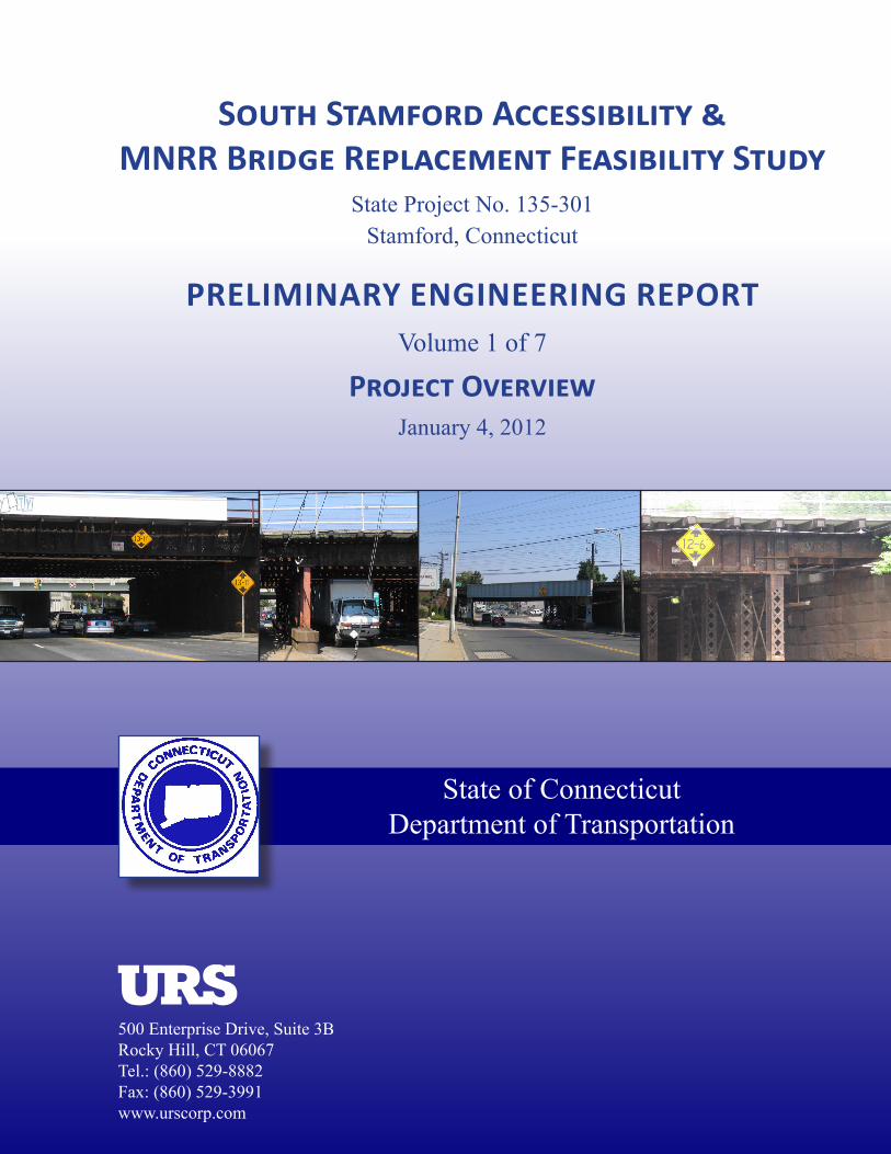
South Stamford Accessibility &MNRR Bridge Replacement Feasibility Study
State Project No. 135-301Stamford, Connecticut
PRELIMINARY ENGINEERING REPORTVolume 1 of 7
Project OverviewJanuary 4, 2012
500 Enterprise Drive, Suite 3BRocky Hill, CT 06067Tel.: (860) 529-8882Fax: (860) 529-3991www.urscorp.com
State of Connecticut Department of Transportation

TABLE OF CONTENTS
EXECUTIVE SUMMARY i
Introduction and Purpose of Project i
Background and Need i
Proposed Improvements ii
Summary ii
PURPOSE OF PROJECT 1
The Problem and the Opportunity 1
BACKGROUND AND NEED 2
The Master Plan 2
The Stamford Intermodal Transportation Center 3
Development of the South End 3
Complete Streets and Transit Access Project 4
The Stamford Urban Transitway 5
Transit Studies 5
Other Design Considerations 6
TRAFFIC OVERVIEW 6
SUMMARY OF PROPOSED IMPROVEMENTS 7
GENERAL DESIGN CRITERIA 8
SUMMARY OF CONSTRUCTION IMPACTS 8
SUMMARY OF BENEFICIAL IMPROVEMENTS 9
OVERVIEW OF GREENWICH AVENUE 10
OVERVIEW OF ATLANTIC STREET 13
OVERVIEW OF CANAL STREET 16
OVERVIEW OF ELM STREET 19
OVERVIEW OF U.S. ROUTE 1 (EAST MAIN STREET) 22
CONCLUSIONS 25
APPENDIX
Appendix A – Figures 26
Appendix B – Construction Cost Estimates 30
LIST OF FIGURES
Figure 1 – City of Stamford Master Plan 2002 – General Land Use Plan
Figure 2 – Harbor Point Improvement District
Figure 3 – City of Stamford, Street Car Alignment

Page i
Rendering of a Redeveloped South End – Stamford, CT Rendering Courtesy of: Harbor Point Development
Executive Summary
Introduction and Purpose of Project
This report summarizes the findings of a preliminary engineering study which examined how
the reconstruction of five railroad bridges in the City of Stamford can help reduce congestion
and eliminate bottlenecking at these crossings. The five bridges studied include: Greenwich
Avenue, Atlantic Street, Canal Street, Elm Street, and U.S. Route 1 (East Main Street). The
reconstruction of these bridges will allow for additional travel lanes for through and turning
traffic within the Connecticut Department of Transportation’s right-of-way, and will
accommodate plans for increased bus service and the potential construction of a streetcar
transit system. These five locations also
compliment operational improvements already
being undertaken at adjacent locations under the
Stamford Urban Transitway (SUT) project to
improve mobility, provide smart growth, and
enhance livability in Stamford.
Background and Need
Metro-North Railroad’s (MNR) New Haven Line
runs through the center of Stamford in an east /
west direction. It divides the city into north and
south sections. With most residents and the
downtown area located to the north of the railroad,
access to the south is limited to the underpasses beneath the MNR tracks. The Stamford
Intermodal Transportation Center (SITC), as well as its parking facilities, is located south of
the tracks. In addition, there are developments currently on-going and new development
opportunities available to the south. The success of these developments will rely heavily on
sufficient access.
Most of the five underpasses
were constructed in the late
19th
century and were not
designed to accommodate
current traffic volumes. The
roads extending from the
underpasses have been
widened to accommodate
increased traffic capacity for
the growing demand, but the
underpasses, restricted by the
bridges’ span lengths, have
remained, in some cases, two
lanes wide. Bottlenecks occur
at these locations. The
existing low vertical clearance
at these bridges also limits the
Overhead View of Construction at Harbor Point Photo Courtesy of: Harbor Point Development

Page ii
passage of legal sized vehicles and hinders the development of Stamford’s public
transportation system. Low vertical clearance bridges are frequently hit by underpassing trucks
and equipment, further aggravating congestion and delay.
Currently, there is limited pedestrian access to the SITC from core pedestrian areas such as
downtown Stamford. This is mainly due to poor sidewalk continuity in and around the SITC.
Limited pedestrian access encourages the use of vehicles, contributing to the city’s congestion
problems.
Proposed Improvements
Proposed improvements for this study include the addition of travel lanes at each of the five
bridges. These additional lanes will help to improve the flow of traffic under the bridges and
through the intersections adjacent to them. Sidewalks are proposed to be included for each
underpass on both sides of the roadway to promote walkability. A sidewalk is also proposed
along the south side of South State Street to provide pedestrian access from Atlantic Street to
the north side of the SITC. Two-foot shoulders will be provided on both sides of each
roadway, and bike lanes are proposed for U.S. Route 1 (East Main Street) and Greenwich
Avenue. U.S. Route 1 (East Main Street) is a designated emergency route for I-95. The U.S.
Route 1 (East Main Street) undergrade bridge has an existing vertical clearance of only 13’-1”.
Because of this, many trucks must detour around the bridge, traveling on local streets not
designed to accommodate such truck loading. At Atlantic Street, two lanes (one in each
direction) could potentially be shared-use for a future streetcar system or to facilitate existing
bus service. With the reconstruction of these bridges, not only will there be an improvement in
capacity with the additional travel lanes, but the proposed bridges and the roadway will be
designed to provide an improved vertical clearance of 14’-6”. A pedestrian bridge is proposed
to cross over Atlantic Street, south of the bridge, providing pedestrians access from the east
sidewalk on Atlantic Street directly to the station at the northbound platform.
Summary
The reconstruction of the roadways and the replacement of the associated bridges at the five
proposed locations is a feasible transportation system improvement project that will improve
traffic flow in the city of Stamford. The total construction cost for the five sites is estimated to
be approximately $232,400,000.
Construction cost estimates have been developed based on the weighted unit prices listed in the
Connecticut Department of Transportation’s Item Master File (December 2010) and the
Department’s Preliminary Cost Estimating Guidelines (January 2011). The cost estimates do
not include costs associated with environmental studies, environmental remediation, rights-of-
way acquisitions, or professional services for survey, design, or construction engineering and
inspection.
2011 and 2016 nominal dollars are provided in the following table. 2016 nominal dollars
were calculated using a construction cost escalation of 5% per year, per CTDOT Estimating
Guidelines, giving a 1.276 escalation factor. 2016 is considered to be the mid-point of
construction based on an anticipated 2014 start-date.

Page iii
Bridge
Location Cost Description Cost (2011) Cost (2016)
Greenwich
Avenue
Roadway, Drainage, Traffic & Structures $ 17,394,000 $ 22,200,000
Utilities $ 2,191,000 $ 2,796,000
Railroad $ 3,962,000 $ 5,057,000
Incidentals & Contingencies $ 5,740,000 $ 7,326,000
Total Estimated Construction Costs $ 29,300,000 $ 37,400,000
Atlantic
Street
Alternative 2: Basis for Comparison
Roadway, Drainage, Traffic & Structures $ 36,282,000 $ 46,306,000
Utilities $ 3,158,000 $ 4,030,000
Railroad $ 8,598,000 $ 10,973,000
Incidentals & Contingencies $ 10,159,000 $ 12,966,000
Total Estimated Construction Costs $ 58,200,000 $ 74,300,000
Alternative 1: Total Differential Cost ($ 4,600,000) ($ 5,900,000)
Alternative 3: Total Differential Cost ($12,400,000) ($ 15,800,000)
Canal
Street
Roadway, Drainage, Traffic, Structures &
Rail Operations
$ 27,477,000 $ 35,068,000
Utilities $ 110,000 $ 140,000
Railroad $ 7,647,000 $ 9,760,000
Incidentals & Contingencies $ 7,693,000 $ 9,818,000
Total Estimated Construction Costs $ 43,000,000 $ 54,800,000
Elm Street
Roadway, Drainage, Traffic, Structures,
& Rail Operations
$ 27,877,000 $ 35,579,000
Utilities $ 1,564,000 $ 1,996,000
Railroad $ 10,575,000 $ 13,497,000
Incidentals & Contingencies $ 7,806,000 $ 9,963,000
Total Estimated Construction Costs $ 47,800,000 $ 61,000,000
U.S. Route 1
(East Main
St)
Roadway, Drainage, Traffic, Structures &
Rail Operations
$ 30,495,000 $ 38,920,000
Utilities $ 1,586,000 $ 2,024,000
Railroad $ 13,502,000 $ 17,232,000
Incidentals & Contingencies $ 8,538,000 $ 10,897,000
Total Estimated Construction Costs $ 54,100,000 $ 69,100,000
Subtotals
for 5
Bridges
Roadway, Drainage, Traffic, Structures,
& Rail Operations
$ 139,525,000 $ 178,073,000
Utilities $ 8,609,000 $ 10,988,000
Railroad $ 44,284,000 $ 56,519,000
Incidentals & Contingencies $ 39,936,000 $ 50,970,000
Total Estimated Construction Costs $ 232,400,000 $ 296,550,000
1Subtotals for
Phase 1
Roadway, Drainage, Traffic, Structures,
& Rail Operations
$ 94,654,000 $ 120,805,000
Utilities $ 6,308,000 $ 8,051,000
Railroad $ 32,675,000 $ 41,703,000
Incidentals (18%) & Contingencies (10%) $ 26,503,000 $ 33,825,000
Net Savings ($ 10,158,000) ($ 12,964,000)
Total Estimated Construction Costs $ 150,000,000 $ 191,400,000
1 Construction of Atlantic Street, Elm Street and U.S. Route 1 (East Main Street) simultaneously

Page 1
Stamford Intermodal Transportation Center
PURPOSE OF PROJECT
The Problem and the Opportunity
The city of Stamford is one of the largest cities in southwestern Connecticut’s Fairfield
County. Stamford is an appealing city, attracting New York City commuters who wish to
reside in a more suburban setting. Stamford has many cultural, recreational, and retail
attractions. The close proximity of Interstate 95 (I-95), the Merritt Parkway, and Metro-North
Railroad’s (MNR) New Haven Line provides residents and commuters access to a multi-modal
transportation network that allows mobility throughout the region. Additionally, recent trends
show that businesses are relocating from New York City to sites where operating a business
can be more affordable, such as Stamford. Currently, much of Stamford’s workforce
commutes into Stamford from surrounding communities. With increasing employment
opportunities, and new residential and commercial developments to provide for future growth,
Stamford has become an even more attractive place in which to live and work.
Many of Stamford’s neighborhoods are densely populated but do not have good access to
public transportation. The use of personal vehicles is inherently promoted by the limited
mobility options that are available. The effect this
has on roads within the city is that they are more
than likely to experience congestion. The road
network in Stamford experiences high levels of
congestion, particularly during the AM and PM
peak hours as commuters make their way to and
from work.
The Stamford Intermodal Transportation Center
(SITC) is located along the New Haven Line
between Washington Boulevard and Atlantic Street
with drop off locations on both the north and south
side of the tracks. The parking garage is located
south of the MNR New Haven Line between Washington Boulevard and Atlantic Street. The
SITC is a major transportation hub, the busiest station second only to Grand Central Terminal
along the New Haven Line. Currently, walkup access from north of the New Haven Line is
limited to Washington Boulevard, and transit access from Stamford and the surrounding
communities is only provided by the local bus service. The most common means for riders to
access the station is by car. Because public transit from the station to surrounding employment
locations is limited to the bus system, people commuting into Stamford may find using a
personal vehicle to be the most appealing means of transportation.
Stamford faces the unique challenge of being divided by the New Haven Line. With most
residents and the downtown area located north of the tracks, access to the south is limited to
the underpasses beneath the MNR tracks (referred to as “undergrade bridges”2). Many of these
undergrade bridges were constructed in the late 19th
century and were not designed to
2 An “Undergrade Bridge” refers to a road going under the grade or under the track. In the case of Stamford, the
bridges carry the tracks over each of the five roadways resulting in five undergrade bridges.

Page 2
Map of the Downtown Centers of Gravity
accommodate the traffic volumes or the vehicle shapes and sizes seen passing beneath them
today. Over the years, the roads extending from the underpasses have been widened to
accommodate more lanes of traffic for the growing demand, but the underpasses, restricted by
the bridges’ span lengths, have remained, in some cases, only two lanes wide. Bottlenecks
occur at these locations as cars cross north and south beneath the tracks.
I-95 runs parallel to and just to the north of the New Haven Line. Entrance and exit ramps
from I-95 are located at major intersections adjacent to the bridges at Greenwich Avenue,
Atlantic Street, and Elm Street. These intersections further add to the congestion. The heavy
turning movements exacerbate congestion and create safety concerns and queuing conflicts.
BACKGROUND AND NEED
The Master Plan
The City has devised a Master Plan using smart growth policies to manage the city’s growth
and address concerns about congestion. This plan integrates commercial development,
residential development, and intermodal connectivity, allowing for more people to live and
work in the city and simultaneously reduce congestion. Integrated planning will promote a
more complete lifestyle including mobility options, housing located closer to employment, and
greenspace for social and recreational activities. For a map of the 2002, Stamford Master Plan
- General Land Use Plan, please refer to Figure 1 located on page 27.
The growth of the City has
gravitated around two core
centers; the larger being the
business developments along
I-95 and Tresser Boulevard, and
the other being the more
pedestrian-friendly centered
around the intersection of
Atlantic Street and Broad Street.
Stamford will continue to nurture
larger business developments
and expand these to the new
Stamford Urban Transitway
(SUT), and will also continue to
maintain and foster the growth of
the pedestrian core of the
downtown area. Within this
study is the provision for safe pedestrian access from Atlantic Street to the SITC. A walkup,
south of the tracks, from the east side of Atlantic Street to a new walkway extension from the
southbound platform is proposed.
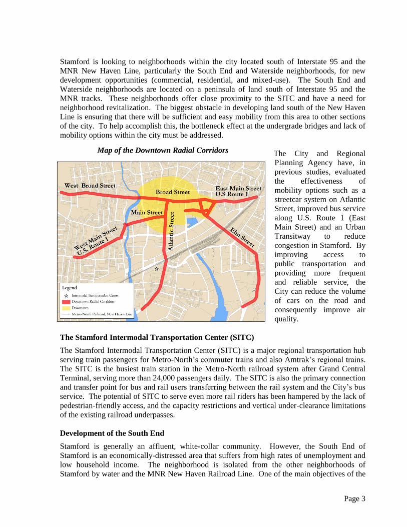
The most important vehicle roadways feeding the downtown area are the “radial corridors”
which include Elm Street, East and West Main Streets, Broad Street and Atlantic Street. These
“radial corridors” link adjacent neighborhoods to the pedestrian core of the downtown area.
Page 3
Map of the Downtown Radial Corridors
Stamford is looking to neighborhoods within the city located south of Interstate 95 and the
MNR New Haven Line, particularly the South End and Waterside neighborhoods, for new
development opportunities (commercial, residential, and mixed-use). The South End and
Waterside neighborhoods are located on a peninsula of land south of Interstate 95 and the
MNR tracks. These neighborhoods offer close proximity to the SITC and have a need for
neighborhood revitalization. The biggest obstacle in developing land south of the New Haven
Line is ensuring that there will be sufficient and easy mobility from this area to other sections
of the city. To help accomplish this, the bottleneck effect at the undergrade bridges and lack of
mobility options within the city must be addressed.
The City and Regional
Planning Agency have, in
previous studies, evaluated
the effectiveness of
mobility options such as a
streetcar system on Atlantic
Street, improved bus service
along U.S. Route 1 (East
Main Street) and an Urban
Transitway to reduce
congestion in Stamford. By
improving access to
public transportation and
providing more frequent
and reliable service, the
City can reduce the volume
of cars on the road and
consequently improve air
quality.
The Stamford Intermodal Transportation Center (SITC)
The Stamford Intermodal Transportation Center (SITC) is a major regional transportation hub
serving train passengers for Metro-North’s commuter trains and also Amtrak’s regional trains.
The SITC is the busiest train station in the Metro-North railroad system after Grand Central
Terminal, serving more than 24,000 passengers daily. The SITC is also the primary connection
and transfer point for bus and rail users transferring between the rail system and the City’s bus
service. The potential of SITC to serve even more rail riders has been hampered by the lack of
pedestrian-friendly access, and the capacity restrictions and vertical under-clearance limitations
of the existing railroad underpasses.
Development of the South End
Stamford is generally an affluent, white-collar community. However, the South End of
Stamford is an economically-distressed area that suffers from high rates of unemployment and
low household income. The neighborhood is isolated from the other neighborhoods of
Stamford by water and the MNR New Haven Railroad Line. One of the main objectives of the

Page 4
Rendering of housing development proposed for the
South End.
Photo courtesy of: Harbor Point Development
Construction at Harbor Point.
Photo courtesy of: Harbor Point Development
City’s Master Plan is to promote affordable homeowner housing, particularly in this
neighborhood. Compared with renters, studies show that homeowners are typically more
vested in their neighborhoods and would therefore help to cultivate the neighborhood
revitalization effort.
Recently UBS and the Royal Bank of Scotland established their North American headquarters
in Stamford. These megabanks were enticed by
the City and State to locate to Stamford largely
based on the benefits the SITC provides.
Improvements to mobility throughout the city,
housing, retail, and commercial developments at
or near the SITC will further this success and
will attract more businesses to Stamford.
Complete Streets and Transit Access Project
A Complete Streets and Transit Access Project
has been undertaken (and is currently in the
grant application phase) to supplement the
City’s effort to redevelop the South End. The
project will help foster redevelopment, which in turn will create jobs, generate tax revenue for
the City, and provide affordable housing. This project will have a significant impact on both
the local and regional levels.
The Complete Streets element of the project targets the redevelopment of four urban collectors
critical to the success of the urban roadway network in the South End: Washington Boulevard,
Pacific Street, Atlantic Street, and Canal Street. Improvements being considered include:
roadway widening and resurfacing, landscaping, enhanced lighting, incorporation of bike
lanes, sidewalk replacement, and intersection improvements. These improvements are
designed to enhance access between
the South End and the SITC, improve
safety, encourage bicycle and
pedestrian use, reduce vehicular
congestion, and enhance livability.
For a map of the Complete Streets
location in the South End, please refer
to Figure 2 located on page 28.
The transit element of the project
includes the purchase of new specialty
transit vehicles and the establishment of three fixed-schedule routes that will provide access to
the SITC. This system will serve 4,000 residences throughout the city. The transit plan was
the result of a Bus Rapid Transit study conducted by the Southwest Regional Planning Agency
(SWRPA) and is discussed at greater length under the subtitle “Transit Studies”.

Page 5
Final Layout for the Stamford Urban Transitway (SUT); created by Fuss and O’Neill for the City of Stamford.
The Stamford Urban Transitway (SUT)
To improve east-west connectivity in Stamford, the City has developed, and has already
completed a portion of, an urban transitway. The SUT is located just south of the New Haven
Railroad Line between U.S. Route 1 (East Main Street) and Atlantic Street (intersecting
Atlantic Street opposite Station Place, the south access point to the SITC). The addition of the
SUT will provide more direct access to the SITC from the East Side. The City of Stamford
estimates that transit riders using the SUT from the East Side will experience a 10-20%
reduction in travel time due to transit prioritization of traffic signals and dedicated travel lanes.
The construction of the initial phase of the SUT project between Atlantic Street and Elm Street
has been completed. The second phase, from Elm Street to U.S. Route 1 (East Main Street), is
in the design phase and scheduled for completion of construction in the spring of 2014.
Transit Studies
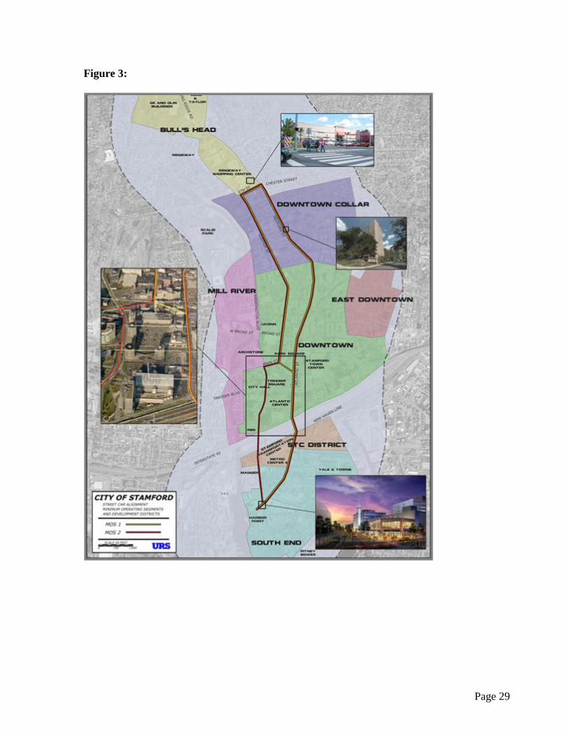
Other modes of transit have also been evaluated to supplement the existing bus service. These
include a streetcar system and a Bus Rapid Transit (BRT) system. North-south alignments for
a streetcar system were reviewed in a study commissioned by the City of Stamford. The
proposed alignment is shown in Figure 3, located on page 29. The conclusions of the study
indicate that a streetcar system has the potential to increase development growth above what is
already projected, increase total assessed property values within the streetcar corridor, and
increase property tax revenues. One of the recommendations in the report, essential to
implementing a streetcar system, is to provide adequate horizontal geometry and vertical
clearance in the Atlantic Street undergrade bridge design to allow for streetcar use without the
disruption of vehicular traffic.
SWRPA conducted a BRT study for the U.S. Route 1 corridor between Greenwich and
Norwalk. While there currently is an adequate bus service in the Route 1 corridor, buses are
not considered to be competitive with the New Haven Railroad Line service, or the use of
personal vehicles. Some conclusions taken from the study are that “travel times are affected by
specific bottlenecks in congested areas” and “non-transit users are more likely to consider a
new bus service if it is frequent, reliable, and convenient to both work and home.” Improving
traffic flow at the U.S. Route 1 (East Main Street) underpass by adding travel lanes, in addition
to the construction of the SUT, would greatly reduce travel time for a bus route along U.S.

Page 6
Traffic stopped on the new SUT
Route 1 (East Main Street) to the SITC, and greatly improve the attractiveness of transit
options for the U.S. Route 1 corridor.
Other Design Considerations
I-95 Operational Lanes
The I-95 highway is a major urban freeway providing interstate access across southern
Connecticut and the City of Stamford. Within the city, it provides access to the downtown area
and the SITC. As a major transportation facility, it has been evaluated periodically by the
Connecticut Department of Transportation (CTDOT) to assess existing operating conditions
and to address future needs. The I-95 roadway was constructed during the 1950’s and now
experiences traffic volumes exceeding the original projections. A recent study conducted by
CTDOT identified the implementation of additional operational lanes as a feasible solution for
improving traffic operations through the City of Stamford. The construction of these
operational lanes has been a long-term goal of the City of Stamford. The geometric design of
the proposed improvements at the five railroad crossings under this study will not preclude the
implementation of these operational lanes in the future.
MNR Tracks 5 & 7
Track 5 is the most northern track on the New Haven Line and runs from the New Canaan
Branch into the SITC. Trains on the New Canaan Branch currently terminate at the SITC on
Track 5. Prior to returning to New Canaan, these trains layover on Track 5 for various periods
of time, occupying a platform while the train is not being used. Using this track to layover
trains reduces the SITC’s capacity to serve both Amtrak and Metro-North trains traveling
through the station.
Track 7 is north of Track 5 and runs from just west of Elm Street to just east of Atlantic Street.
Track 7 is currently used as an overnight storage track, part of the Stamford Rail Yard.
Providing for a potential future extension of Track 7 into the SITC would allow for an
additional passenger platform track. This additional platform track would increase train
capacity and operational flexibility through the Stamford Station area. These improvements
are long term goals of MNR. Currently the railroad right-of-way is most restricted at the
Atlantic Street overpass. The Atlantic Street overpass could be widened to allow for this future
improvement.
TRAFFIC OVERVIEW
The southern portions of the City of Stamford,
consisting of the neighborhoods of Cove-East
Side, Shippan, South End, Waterside and
West Side are all located on peninsulas of
land south of the Interstate 95 highway and
the New Haven Railroad Line. Access
between these neighborhoods and downtown
Stamford, or between the neighborhoods and
I-95, require crossing the railroad on a

Page 7
The Atlantic Street, SUT intersection as seen from the
SUT looking west.
north/south street. Between Greenwich Avenue and U.S. Route 1 (East Main Street), there are
five north/south crossings under the MNR tracks, one east/west crossing under the tracks, and
the I-95 crossing over the tracks. All street crossings except Washington Boulevard (five in
total) are included in this report.
As discussed previously, a new corridor, the SUT, is currently under construction just south of,
and parallel to the railroad, between Atlantic Street and U.S. Route 1 (East Main Street).
Traffic analyses throughout this corridor were completed by a Consultant for the City, and
updated in August of 2010. This study points out several severe deficiencies in the roadway
network’s ability to provide access to the South End and Cove-East Side neighborhoods.
The 2002 Stamford Master Plan identified Atlantic Street and Elm Street as unique links
between these neighborhoods and the Stamford downtown area. It also encouraged planning to
reinforce these streets’ identities as radial corridors to the Interstate and downtown area. The
Master Plan calls for the continued growth of these neighborhoods as primary residential areas,
with some mixed-use development to enhance their livability. Although the reports include
planned expansion of transit opportunities, including potential ferry service to New York, it is
recognized that increased development of the
neighborhoods will increase the traffic burden
on the roadways crossing the railroad.
Geometric improvements at all five bridges
have been studied to improve the operating
conditions anticipated by increasing capacity,
safety, and reducing queuing and congestion. In
most cases, this involves adding operational
through or turning lanes and modifying the road
geometry to better accommodate the alignment
with the SUT. In all cases, the improvements
also include the addition of sidewalks on both
sides of the street to provide better pedestrian
routes between the south end neighborhoods, the SITC, and the downtown Stamford area. In
addition, bicycle lanes are proposed on U.S. Route 1 (East Main Street) and Greenwich
Avenue to enhance bicycle use in the corridor. On the whole, these improvements will provide
substantial benefits to existing users of the area’s streets, and will promote opportunities for
growth as the south end neighborhoods are revitalized in the future.
SUMMARY OF PROPOSED IMPROVEMENTS
Proposed improvements for this study include:
The addition of travel lanes at each of the five undergrade bridges to allow for more
capacity
Eight-foot sidewalks on both sides of the roadway to improve walkability
Two-foot shoulders will be provided on both sides of each direction of traffic

Page 8
Two 5-foot bike lanes are proposed for U.S. Route 1 (East Main Street) and Greenwich
Avenue to promote safe bike passage
Of the six travel lanes proposed for Atlantic Street, two lanes (one in each direction)
could potentially be shared-use for a future streetcar system or for existing bus service,
allowing two lanes of traffic to be maintained while a bus is stopped
Improved vertical clearance of 14’-6” allowing access by all legal sized vehicles
Enhanced pedestrian access along the south side of the railroad tracks to the northbound
platform of the SITC
A continuous sidewalk along South State Street connecting Atlantic Street with the
north side of the SITC
Complements the Stamford Complete Streets project
GENERAL DESIGN CRITERIA
Roadway design based on roadway classification is assumed for all concepts presented
in the report
A design speed of 30 mph was determined to be appropriate
The City of Stamford requires storm sewer design to accommodate a 25-year event.
CTDOT Drainage Manual used for all other requirements
The bridges were designed to provide a minimum vertical clearance of 14’-6”
Bridge design compliant with AREMA
SUMMARY OF CONSTRUCTION IMPACTS
MNR tracks will be taken out of service for bridge replacement, one at a time, in either
a north to south or south to north progression. Please refer to individual bridge
volumes for specific details.
Traffic will be maintained with reduced lanes at all locations with the exception of
Atlantic Street. Atlantic Street will be closed to traffic during construction.
A Traffic Management Plan will be developed as the project design progresses.
Pedestrian detours will be developed whenever a sidewalk under a bridge is closed, as
the project design progresses.
There will be critical impacts to MNR service when Track 6 is replaced during the
construction of the Canal Street Bridge. This track is the primary route for all revenue
service trains originating and terminating in Stamford. It is also used for trains being
routed into and out of the MNR Maintenance of Equipment facility.
During the continuous track outages at Greenwich Avenue and Atlantic Street, the use
of the SITC platforms will be impacted and the normal routing of trains into the station
will need to be adjusted. The SITC platforms will be accessible with bridge plates.

Page 9
The replacement of Track 5 at Elm Street and East Main Street will require a temporary
track 3-5 cut-and-throw to be installed just east of each of the appropriate bridges. This
will allow MNR to maintain service along the New Canaan Branch.
During the replacement of Track 8 at Elm Street, the lead tracks into Lower Stamford
Yard and Maintenance of Equipment facility will be taken out of service. A cut-and-
throw is not an option in this area. This stage of construction will have critical impacts
to MNR train operations.
Summary of Beneficial Improvements
Beneficial Improvements Greenwich
Avenue
Atlantic
Street
Canal
Street
Elm
Street
U.S. Rte. 1
(East Main St)
Increases Capacity x x x x x
Reduces Queuing and Congestion x x x x x
Improves Safety x x x x x
Improves Vertical Clearance to
Provide for All Legal Vehicles x x x x x
Complements the SUT x x x x
Eliminates a Structurally Deficient
Bridge x x x x x
Provides Geometric Improvements
at Intersecting Streets x
Improves Pedestrian Access in and
around the SITC x
Key Component to a Future
Streetcar System x
Accommodates a Potential Future
Extension of MNR Track 7 x
Accommodates Potential Future
Operational Lanes on I-95 x
Atlantic Street Alternative 2
Improves I-95 N.B. Interchange 8
Geometry & Capacity
x
Provides a Safe Route for Bikes
with Designated Bike Lanes x x
Complements the Stamford
Complete Streets Project x x

Page 10
Overview of Greenwich Avenue
Greenwich Avenue is located the furthest west of
all the bridges considered in this study, and sits
opposite the Rippowam River (known locally as the
Mill River). Stamford currently has plans to
improve a half-mile portion of Greenwich Avenue,
from South State Street (McCullough Street) south
to Selleck Avenue. These improvements are
considered critical to managing traffic in this area,
understanding that Stamford cannot simply build
more roads to increase capacity.
Access to the SITC from the Waterside
neighborhood requires crossing the Rippowam
River. South of I-95 it is possible to cross the river
at two locations: Pulaski Drive and South State
Street/McCullough Street. Both of these roads
intersect with Greenwich Avenue. The intersection
of South State Street/McCullough Street and
Greenwich
Avenue is
also where the I-95 northbound Exit-7 ramp touches down.
Here, commuters traveling northbound on I-95 may exit to
access the SITC, creating a busy intersection. Current
plans to expand the parking at the SITC will attract many
more commuters to the station from the surrounding areas.
Although capacity analyses using existing traffic volumes
indicate that the Greenwich Avenue corridor operates
below capacity, the present lane arrangements produce
queues that exceed available storage,
in some cases by twice the available
capacity. Continued growth in
vehicular use out to the projected
design horizon of 2029 will cause
severe increases in congestion in this
area. Most intersections will exceed
their available capacity, and
virtually all northbound and
southbound queues will exceed the
available storage between
intersections. The proposed
reconstruction will provide
additional capacity for cars traveling
north/south of the MNR tracks.
N
N
Map of the Greenwich Avenue
undergrade bridge and adjacent streets.

Page 11
Greenwich Avenue – Typical Cross Section Looking Northbound
Greenwich Avenue: Minor Arterial Roadway
Existing Proposed
No. of Lanes NB 1 3
SB 1 2
Lane Width 13’-0” 11’-0”
Shoulder Width NA 2’-0”
Bike Lanes NA 5’-0”
Sidewalks Approx. 5’-0” 5’-10”
Bridge Configuration 3-span 2-span
Controlling Span Length 40’ 64’-6”
Vertical Clearance 13’-7” 14’-6”
Exceptions to Geometric Design Criteria
Design Element Recommended Design
Value Proposed Design Value
Design Speed 30 – 40 mph 20 mph
Roadside Clearzones 14’ 10’
Intersection Sight Distance 355’ 265’
Minimum Vertical Clearance
under New Bridge 16’-3” 14’-6”

Page 12
Rights-of-Way Impacts: Partial land acquisitions due to the reconstruction of the bridge include:
To the south of the bridge and west of Greenwich Avenue, a vacant lot and a commercial
property
To the south of the bridge and to the east of Greenwich Avenue, a housing complex
To the north of the bridge and west of Greenwich Avenue, First Stamford Place
There are also MNR facilities located at all corners of the existing bridge that will require
demolition.
Maintenance and Protection of Traffic: One lane of traffic in each direction will be maintained
during construction.
Construction Duration: The estimated construction duration for the Greenwich Avenue Bridge
is two years and six months.
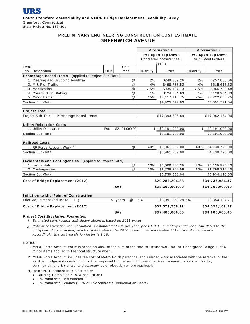
Construction Costs: Total estimated construction cost for the Greenwich Avenue Bridge is
$29,300,000. This construction cost includes a replacement undergrade structure consisting of a
two-span ballasted deck bridge that supports the four (4) existing railroad tracks. The
superstructure consists of precast concrete encased steel girders supported on concrete abutments
founded on mini-piles and a pier founded on drilled shafts or on a spread footing on mini-piles.

Page 13
Overview of Atlantic Street
Atlantic Street is considered to be a gateway
between downtown Stamford and the South End
linking waterfront developments and revitalized
south end neighborhoods to the downtown area.
However, the present configuration of the
existing bridge imposes many restrictions on the
flow of vehicles along Atlantic Street.
As part of their effort to revitalize the city
through residential and commercial
developments and transportation enhancement
projects, Stamford must reconsider the roadway
grid in the South End. The City’s Master Plan
recommends redesigning Atlantic and Pacific
Streets to be tree-lined, residential roads with
two-way traffic patterns. The Master Plan
brings
special attention to the role that Atlantic Street plays in
the city as a radial corridor that links the South End to
Downtown.
Capacity analyses of existing traffic volumes indicate
that the Atlantic Street corridor operates below capacity.
However, the present lane arrangements produce queues
that exceed available storage, and compromise the
operation of the entire corridor.
Continued growth in vehicular use out to the projected design horizon of 2029 will cause severe
increases in congestion on both sides of the New Haven Railroad Line. Most intersections will
exceed their available capacity, and virtually all northbound and southbound queues will exceed
the available storage between intersections. The MNR bridge presents a choke point due to its
span length which restricts the
roadway width.
The proposed geometry and lane
arrangements for Atlantic Street
were chosen to accommodate the
proposed Stamford Urban
Transitway (six lane cross-section).
This will result in a re-alignment of
the Atlantic Street, Manhattan
Street and Station Place
intersection. There will be a provision for two through lanes and an exclusive right turn lane
northbound as well as three through travel lanes southbound under the structure. An exclusive
N
Map of the Atlantic Street undergrade
bridge and adjacent streets.

Page 14
left turn lane will start just south of the bridge in the southbound direction. These lanes will
provide additional capacity and lane continuity with the proposed SUT, reduce queues and
improve operations on Atlantic Street.
In addition to the horizontal chokepoint that occurs
at Atlantic Street, some of the City’s emergency
vehicles (including a HazMat truck and the police
department’s command vehicle, both of which are
12’-6” high) are unable to use this underpass,
restricted by the low vertical clearance. The City
is unable to consider Atlantic Street for future
public transit alignments without considering the
reconstruction of the bridge. The low vertical
clearance of the existing structure precludes any
type of streetcar system.
Atlantic Street – Typical Cross Section Looking Northbound
Atlantic Street Alternatives:
1. Alternative 1 proposes that Atlantic Street be lowered to obtain a vertical clearance of 14’-6”.
The I-95 northbound Exit-8 ramp will continue to touch down at Atlantic Street, north of the
New Haven Railroad Line. Re-grading of the exit ramp will be necessary, resulting in a
steeper grade.
2. Alternative 2 proposes that Atlantic Street be lowered to obtain a vertical clearance of 14’-6”.
It is also proposed that a fly-over bridge be constructed to divert the I-95 northbound Exit-8
ramp traffic, from Atlantic Street further east on South State Street. Under this scenario,
ramp traffic will flow to Canal Street, rather than Atlantic Street.
3. Alternative 3 proposes that Atlantic Street be lowered to provide a vertical clearance of
13’-9” rather than 14’-6”. The I-95 northbound Exit-8 ramp will still touch down at Atlantic
Street, but re-grading of the ramp will result in a shallower grade than Alternative 1. It is
important to note that a vertical clearance of 13’-9” is not high enough to accommodate a
future streetcar system and may compromise clearance for legal height trucks.

Page 15
Atlantic Street: Minor Urban Arterial north of the underpass.
Urban Collector south of the underpass.
Existing Proposed
No. of Lanes NB 1 3
SB 1 3
Lane Width 23’ to 33’ 11’-0”
Shoulder Width NA 2’-0”
Bike Lanes NA NA
Sidewalks 8’-10” 8’-0”
Bridge Configuration 3-span 2-span
Controlling Span Length 64.5’ 62’-10”
Vertical Clearance 12’-7” 14’-6”
Exceptions to Geometric Design Criteria
Design Element Recommended
Design Value Proposed Design Value
Alternative 1 Alternative 2 Alternative 3
Design Speed 30 – 40 mph 25 mph 25 mph 25 mph
Roadside Clearzones 14’ 10’ 10’ 10’
Shoulder Width (Right) 4’-8’ 2’ 2’ 2’
Minimum Vertical Clearance
under New Bridge 16’-3” 14’-6” 14’-6” 13’-9”
Rights-of-Way Impacts: None.
Maintenance and Protection of Traffic: It is not possible to construct the proposed pier and
keep Atlantic Street open to traffic; therefore, Atlantic Street will be closed during construction.
Construction Duration: The estimated construction duration for the Atlantic Street Bridge is
two years and eleven months.
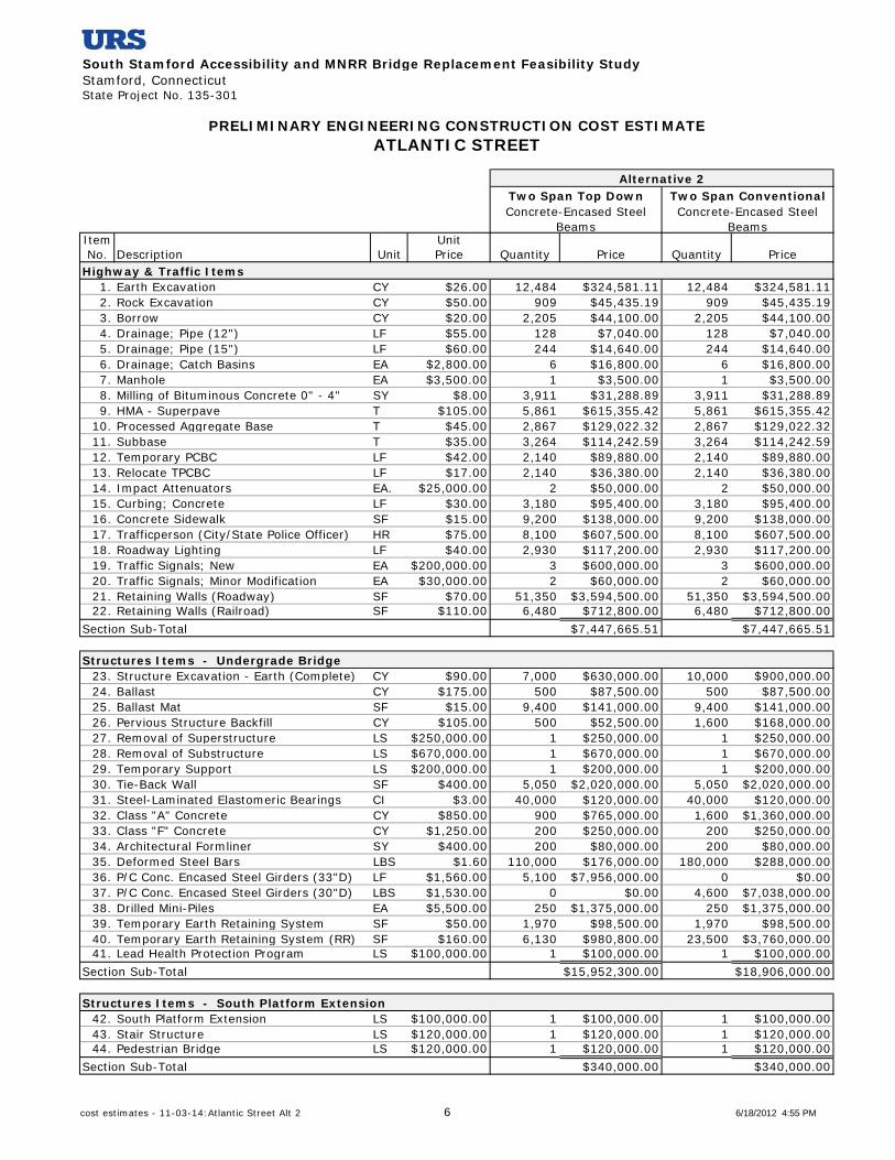
Construction Costs: The total estimated construction cost for the preferred Atlantic Street
alternative (Alternative 2) is $58,200,000. This construction cost includes a replacement
undergrade structure consisting of a two-span ballasted deck bridge that supports the five (5)
existing railroad tracks and an I-95 off-ramp single span fly-over bridge. The undergrade bridge
superstructure consists of precast concrete encased steel girders supported on concrete abutments
and a pier founded on mini-piles.
Page 16
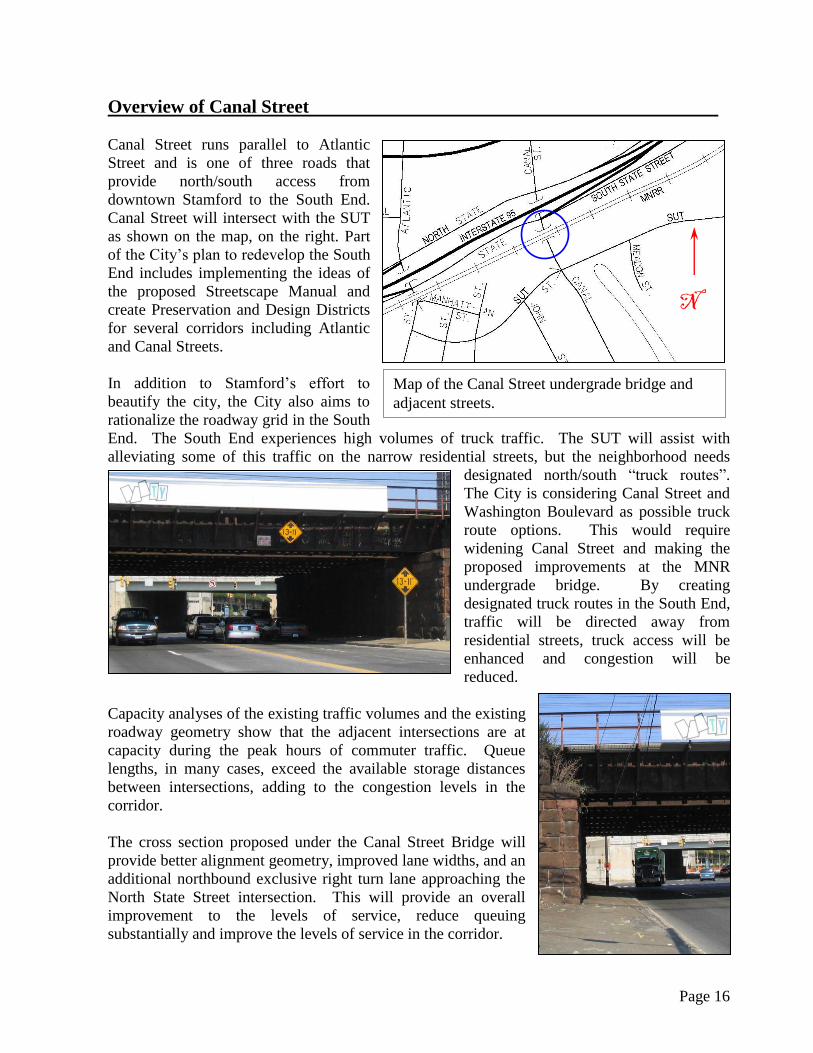
Overview of Canal Street
Canal Street runs parallel to Atlantic
Street and is one of three roads that
provide north/south access from
downtown Stamford to the South End.
Canal Street will intersect with the SUT
as shown on the map, on the right. Part
of the City’s plan to redevelop the South
End includes implementing the ideas of
the proposed Streetscape Manual and
create Preservation and Design Districts
for several corridors including Atlantic
and Canal Streets.
In addition to Stamford’s effort to
beautify the city, the City also aims to
rationalize the roadway grid in the South
End. The South End experiences high volumes of truck traffic. The SUT will assist with
alleviating some of this traffic on the narrow residential streets, but the neighborhood needs
designated north/south “truck routes”.
The City is considering Canal Street and
Washington Boulevard as possible truck
route options. This would require
widening Canal Street and making the
proposed improvements at the MNR
undergrade bridge. By creating
designated truck routes in the South End,
traffic will be directed away from
residential streets, truck access will be
enhanced and congestion will be
reduced.
Capacity analyses of the existing traffic volumes and the existing
roadway geometry show that the adjacent intersections are at
capacity during the peak hours of commuter traffic. Queue
lengths, in many cases, exceed the available storage distances
between intersections, adding to the congestion levels in the
corridor.
The cross section proposed under the Canal Street Bridge will
provide better alignment geometry, improved lane widths, and an
additional northbound exclusive right turn lane approaching the
North State Street intersection. This will provide an overall
improvement to the levels of service, reduce queuing
substantially and improve the levels of service in the corridor.
N
Map of the Canal Street undergrade bridge and
adjacent streets.

Page 17
Canal Street – Typical Cross Section Looking Northbound
Canal Street: Urban Collector
Existing Proposed
No. of Lanes NB 2 3
SB 2 2
Lane Width 10’-0” 11’-0”
Shoulder Width NA 2’-0”
Bike Lanes NA NA
Sidewalks 6’ to 8’ 8’-0”
Bridge Configuration 1-span 2-span
Controlling Span Length 65’ 55’-10”
Vertical Clearance 14’-2” 14’-6”
Exceptions to Geometric Design Criteria
Design Element Recommended Design
Value Proposed Design Value
Roadside Clearzones 14’ 10’
Intersection Sight Distance 355’ 260’

Page 18
Rights-of-Way Impacts: Partial property acquisitions include a parking lot south of the
underpass and a catenary tower.
Maintenance and Protection of Traffic: One lane of traffic will be maintained during
construction.
Construction Duration: The estimated construction duration for the Canal Street Bridge is
three years and ten months.
Construction Costs: Total estimated construction cost for the Canal Street Bridge is
$43,000,000. This construction cost includes a replacement undergrade structure consisting of a
two-span ballasted deck bridge that supports the seven (7) existing railroad tracks. The
undergrade bridge superstructure consists of precast concrete encased steel girders supported on
concrete abutments and pier founded on mini-piles.

Page 19
Overview of Elm Street
The north/south access provided by Elm
Street is the furthest east between Stamford’s
downtown area and the neighborhoods south
of the New Haven Railroad Line. Elm Street
will intersect with the proposed SUT at
Myrtle Street.
Elm Street is considered to be a main line to
downtown Stamford from the predominantly
residential Cove-East Side and Shippan
neighborhoods. Surveys have shown that the
18,000 residents that live in these two
neighborhoods feel disconnected from the
rest of the city. Residents feel confined by
the limited number of roads providing access to and from downtown Stamford and also by the
fact that these corridors are usually choked with traffic. There are also neighborhood parks and
other city-wide destinations located within Cove-East
Side and Shippan that attract people from outside of
these neighborhoods, increasing congestion and
causing use and traffic conflicts.
Capacity analyses show that the intersections along
Elm Street are currently operating close to capacity,
and will continue to do so. In some cases, they will
exceed capacity through the 2029 design year.
Queuing is problematic
in the corridor, with
several northbound and southbound queue lengths exceeding the
available distance between intersections due to individual lane
groups and approaches exceeding capacity during the peak hours.
The roadway cross section proposed under the bridge will
provide better alignment geometry and will increase vehicular
capacity for Elm Street. There will be an added second
southbound through lane and a third northbound lane for right
turning traffic. In
addition, shoulders
will be provided in
both directions. These lane arrangements are
designed to accommodate the SUT improvements at
the Cherry Street/Elm Court intersection, which
include the widening and realignment of the
north/south legs, the elimination of the east/west dog
leg, and the provision for signal control at the
Area map of the Elm Street undergrade
bridge and adjacent streets.
N
Page 20
intersection. These additional lanes will provide overall better levels of service, increased safety,
reduced queuing, and reduced levels of congestion along the Elm Street corridor.
Elm Street – Typical Cross Section
Looking Northbound
Elm Street: Minor Urban Arterial
Existing Proposed
No. of Lanes NB 2 3
SB 1 2
Lane Width 12’-0” 11’-0”
Shoulder Width NA 2’-0”
Bike Lanes NA NA
Sidewalks 8’ to 10’ 8’-0”
Bridge Configuration 3-span 2-span
Controlling Span Length 37’ 57’-0”
Vertical Clearance 12’-9” 14’-6”

Page 21
Exceptions to Geometric Design Criteria
Design Element Recommended Design
Value Proposed Design Value
Shoulder Width Right 4’ – 8’ 2’
Left 2’ – 4’ 2'
Roadside Clearzones 14’ 10’
Intersection Sight Distance 355’ 250’
Minimum Vertical Clearance
under New Bridge 16’-3” 14’-6”
Rights–of-Way Impacts: Partial and full property acquisitions include:
Three small buildings south of the underpass (part of MNR facility)
A commercial property at the southeast corner of the underpass
Maintenance and Protection of Traffic: One lane of traffic will be maintained during
construction. This lane may be one directional or alternating directions (by time of day).
Construction Duration: The estimated construction duration for the Elm Street Bridge is three
years and ten months.
Construction Costs: Total estimated construction cost for the Elm Street Bridge is
$47,800,000. This construction cost includes a replacement undergrade structure consisting of a
two-span ballasted deck bridge that supports the seven (7) existing railroad tracks. The
undergrade bridge superstructure consists of precast concrete encased steel girders supported on
concrete abutments and pier founded on mini-piles.

Page 22
Overview of U.S. Route 1 (East Main Street)
U.S. Route 1 (East Main Street) is the
only roadway evaluated in our study
located north of I-95. It travels in a
basically east/west direction, and
does not provide primary access
between the north and south areas of
the city. The U.S. Route 1 (East
Main Street) undergrade bridge is
considered to be the city’s eastern
gateway to the downtown area.
U. S. Route 1 (East Main Street) is a
Principal Urban Arterial. It provides
parallel through movements to I-95
across the entire state of Connecticut, and is an important arterial route in the city of Stamford.
U.S. Route 1 (East Main Street) serves as an alternative emergency route to I-95 and is
considered to be one of the radial corridors that link adjacent
neighborhoods to Downtown, connecting the Hope Street and
Glenbrook Road neighborhoods to the downtown area.
Capacity analyses of existing conditions show that the
intersections along Route 1 are generally operating below
capacity, although the existing queues interfere with operations at
adjacent intersections. As
traffic grows through the
2029 design year, queuing
is anticipated to get
worse, and operations will continue to suffer. Several
turning movements may be blocked by queues from
adjoining intersections.
U.S. Route 1 (East Main Street) currently provides two
wide lanes with shoulders as it passes under the bridge, one designated for each direction. The
proposed cross section will provide increased capacity for the Route 1 corridor by adding a
second lane and shoulders in each direction. In addition, widening is proposed to accommodate
a dedicated bicycle lane in each direction. These lane
arrangements are designed to align with the SUT
improvements, including the reconstruction and
signalization of the Maple Street intersection. These
additional lanes will provide better levels of service,
increased safety, multi-modal capability, reduced
queuing, and reduced congestion levels on the Route 1
corridor.
Map of the U.S. Route 1 (East Main Street)
undergrade bridge and adjacent streets.
N

Page 23
U.S. Route 1 (East Main Street) – Typical Cross Section Looking Westbound
U.S. Route 1 (East Main Street): Principal Urban Arterial
Existing Proposed
No. of Lanes NB 1 2
SB 1 2
Lane Width 21’-0” 11’-0”
Shoulder Width NA 2’-0”
Bike Lanes NA 5’-0”
Sidewalks 8’-0” 8’-0”
Bridge Configuration 3-span 2-span
Controlling Span Length 71’ 74’-0”
Vertical Clearance 13’-3” 14’-6”
Exceptions to Geometric Design Criteria
Design Element Recommended Design
Value Proposed Design Value
Roadside Clearzones 14’ 13’
Intersection Sight Distance 355’ 270’
Minimum Vertical Clearance
under New Bridge 16’-3” 14’-6”

Page 24
Rights-of-Way Impacts: Partial property acquisitions include:
The parking lot and driveways of the plaza located west of Crystal Street and east of
Myrtle Street
A partial take of 876 East Main Street on the west side of Crystal Street
Maintenance and Protection of Traffic: One lane of traffic will be maintained in each
direction during construction.
Construction Duration: The estimated construction duration for the U.S. Route 1 (East Main
Street) bridge is two years and eleven months.
Construction Costs: Total estimated construction cost for the U.S. Route 1 (East Main Street)
bridge is $54,100,000 for the preferred alternative (Alternative 1). This construction cost
includes a replacement undergrade structure consisting of a two-span ballasted deck bridge that
supports the five (5) existing railroad tracks. The undergrade bridge superstructure consists of
precast concrete encased steel girders supported on concrete abutments and pier founded on
mini-piles.

Page 25
CONCLUSIONS
With the reconstruction of these five bridges: Greenwich Avenue, Atlantic Street, Canal Street,
Elm Street, and U.S. Route 1 (East Main Street), the City of Stamford will increase vehicular
mobility and allow for better traffic flow between the northern and southern neighborhoods.
This project will relieve heavy congestion by opening up bottle necks. It is also critical to the
success of other transit projects the City is currently undertaking. Completion of these
improvements will allow the City to better focus on how to increase inner-city mobility
without the concerns or limitations imposed by the existing substandard underpasses.
Reconstruction of these bridges will also add sidewalks and bike lanes to allow safer access
around the city by foot or by bicycle. These features will allow workers and residents to move
safely to mobility hubs (particularly the SITC) without requiring the use of personal vehicles.
Construction Cost Estimates
Construction cost estimates have been developed based on the weighted unit prices listed in the
Connecticut Department of Transportation’s Item Master File (December 2010) and the
Department’s Preliminary Cost Estimating Guidelines (January 2011). The unit prices have
been adjusted to reflect construction costs at the mid-point of construction in the year 2016.
The cost estimates do not include costs associated with environmental studies, environmental
remediation, rights-of-way acquisitions, or professional services for survey, design, or
construction engineering and inspection. The 2011 construction costs for the five individual
bridges, inclusive of roadway work, utility relocation, structures, railroad force account work,
and drainage work, are summarized as follows:
Greenwich Avenue $ 29,300,000
Atlantic Street $ 58,200,000
Canal Street $ 43,000,000
Elm Street $ 47,800,000
U.S. Route 1 (East Main Street) $ 54,100,000
Totals $ 232,400,000
To minimize impacts to rail operations, this study developed a proposed phased construction
schedule. The development of this schedule included an analysis of the concurrent
reconstruction of three bridges: Atlantic Street, Elm Street, and U.S. Route 1 (East Main
Street) and includes considerations to rail operations. A savings of approximately $10,100,000
is realized by an elimination of overlapping work, in a reduction of the railroad force account
work, and efficiencies gained by packaging the three bridges together. The 2011 construction
costs for the proposed phased sites are summarized as follows:
Atlantic Street $ 58,200,000
Elm Street $ 47,800,000
U.S. Route 1 (East Main Street)
Net Savings (by constructing 3 at once)
$
$
54,100,000
(10,100,000)
Totals $ 150,000,000

Page 26
APPENDIX A – FIGURES
List of Figures:
1. Master Plan 2002 – General Land Use Plan Page 27
2. Harbor Point Improvement District Page 28
3. Proposed Streetcar Alignment (from a separate study) Page 29

Page 27
Figure 1:

Page 28
Figure 2:
Page 29
Figure 3:

Page 30
APPENDIX B – CONSTRUCTION COST ESTIMATES

South Stamford Accessibility and MNRR Bridge Replacement Feasibility StudyStamford, ConnecticutState Project No. 135-301
Item UnitNo. Description Unit Price Quantity Price Quantity Price
1. Earth Excavation CY $26.00 7,953 $206,778.00 7,953 $206,778.002. Rock Excavation CY $50.00 884 $44,200.00 884 $44,200.003. Drainage; Pipe (15") LF $60.00 290 $17,400.00 290 $17,400.004. Drainage; Pipe (30") LF $90.00 90 $8,100.00 90 $8,100.005. Drainage; Pipe (48") LF $185.00 80 $14,800.00 80 $14,800.006. Drainage; Catch Basins EA $2,800.00 6 $16,800.00 6 $16,800.007. Manhole EA $4,500.00 3 $13,500.00 3 $13,500.008. Bit. Driveway / Parking Lot SY $40.00 1,111 $44,440.00 1,111 $44,440.009. HMA - Superpave T $105.00 2,261 $237,405.00 2,261 $237,405.00
10. Processed Aggregate Base T $35.00 2,261 $79,135.00 2,261 $79,135.0011. Subbase T $35.00 2,574 $90,090.00 2,574 $90,090.0012. Formation of Subgrade SY $5.00 7,721 $38,605.00 7,721 $38,605.0013. Temporary PCBC LF $42.00 370 $15,540.00 370 $15,540.0014. Impact Attenuators EA $25,000.00 2 $50,000.00 2 $50,000.0015. Curbing; Concrete LF $30.00 2,672 $80,160.00 2,672 $80,160.0016. Concrete Sidewalk SF $15.00 14,712 $220,680.00 14,712 $220,680.0017. Trafficperson (City/State Police Officer) HR $75.00 15,360 $1,152,000.00 15,360 $1,152,000.0018. Roadway Lighting LF $40.00 100 $4,000.00 100 $4,000.0019. Traffic Signals; New EA $200,000.00 1 $200,000.00 1 $200,000.0020. Traffic Signals; Minor Modification EA $30,000.00 1 $30,000.00 1 $30,000.00
Section Sub-Total $2,563,633.00 $2,563,633.00
21. Structure Excavation - Earth (Complete) CY $90.00 4,500 $405,000.00 4,500 $405,000.0022. Ballast CY $175.00 390 $68,250.00 460 $80,500.0023. Ballast Mat SF $15.00 7,360 $110,400.00 8,640 $129,600.0024. Pervious Structure Backfill CY $105.00 1,100 $115,500.00 1,100 $115,500.0025. Granular Fill CY $40.00 110 $4,400.00 110 $4,400.0026. Removal of Superstructure LS $200,000.00 1 $200,000.00 1 $200,000.0027. Removal of Substructure LS $150,000.00 1 $150,000.00 1 $150,000.0028. Steel-Laminated Elastomeric Bearings CI $3.00 87,400 $262,200.00 62,100 $186,300.0029. Class "A" Concrete CY $850.00 670 $569,500.00 640 $544,000.0030. Class "F" Concrete CY $1,250.00 290 $362,500.00 250 $312,500.0031. Architectural Formliner SY $400.00 120 $48,000.00 120 $48,000.0032. Deformed Steel Bars LBS $1.60 83,800 $134,080.00 80,000 $128,000.0033. Deformed Steel Bars (Epoxy Coated) LBS $1.65 60,000 $99,000.00 75,000 $123,750.0034. Structural Steel LBS $3.25 0 $0.00 1,665,000 $5,411,250.0035. Precast Concrete Encased Steel Girders LF $2,100.00 2,280 $4,788,000.00 0 $0.0036. Drilled Mini-Piles EA $10,000.00 60 $600,000.00 50 $500,000.0037. Drilled Shaft LF $2,000.00 80 $160,000.00 80 $160,000.0038. Temporary Earth Retaining System (RR) SF $160.00 10,800 $1,728,000.00 10,800 $1,728,000.0039. Lead Health Protection Program LS $100,000.00 1 $100,000.00 1 $100,000.00
Section Sub-Total $9,904,830.00 $10,326,800.00
Highway & Traffic + Structure $12,468,463.00 $12,890,433.00Project Sub-Total
PRELIMINARY ENGINEERING CONSTRUCTION COST ESTIMATEGREENWICH AVENUE
Alternative 1 Alternative 2Two Span Top Down Two Span Top DownConcrete-Encased Steel
BeamsMulti Steel Girders
Highway & Traffic Items
Structures Items - Undergrade Bridge
cost estimates - 11-03-14:Greenwich Avenue 1 6/18/2012 4:55 PM
South Stamford Accessibility and MNRR Bridge Replacement Feasibility StudyStamford, ConnecticutState Project No. 135-301
Item UnitNo. Description Unit Price Quantity Price Quantity Price
PRELIMINARY ENGINEERING CONSTRUCTION COST ESTIMATEGREENWICH AVENUE
Alternative 1 Alternative 2Two Span Top Down Two Span Top DownConcrete-Encased Steel
BeamsMulti Steel Girders
1. Clearing and Grubbing Roadway @ 2% $249,369.26 2% $257,808.662. M & P of Traffic @ 4% $498,738.52 4% $515,617.323. Mobilization @ 7.5% $935,134.73 7.5% $966,782.484. Construction Staking @ 1% $124,684.63 1% $128,904.335. Minor Items @ 25% $3,117,115.75 25% $3,222,608.25
Section Sub-Total $4,925,042.89 $5,091,721.04
Project Sub-Total + Percentage Based Items
1. Utility Relocation Est. $2,191,000.00 1 $2,191,000.00 1 $2,191,000.00Section Sub-Total
1. RR Force Account Work1&2 @ 40% $3,961,932.00 40% $4,130,720.00Section Sub-Total
1. Incidentals @ 23% $4,000,506.35 23% $4,135,895.432. Contingencies @ 10% $1,739,350.59 10% $1,798,215.40
Section Sub-Total
Cost of Bridge Replacement (2012)
SAY
Price Adjustment (adjust to 2017) 5 years @ 5% $8,091,263.29 5% $8,354,197.71
Cost of Bridge Replacement (2017)
SAY
1.
2.
NOTES:1.
2.
3. Items NOT included in this estimate: Building Demolition / ROW acquisitions Environmental Remediation Environmental Studies (20% of Environmental Remediation Costs)
MNRR Force Account includes the cost of Metro North personnel and railroad work associated with the removal of the existing bridge and construction of the proposed bridge, including removal & replacement of railroad tracks, communications & signals, and catenary pole relocation where applicable.
Incidentals and Contingencies (applied to Project Total)
$5,739,856.94 $5,934,110.83
$29,286,294.83 $30,237,984.87
Inflation to Mid-Point of Construction
$37,377,558.12 $38,592,182.57
$37,400,000.00 $38,600,000.00
MNRR Force Account value is based on 40% of the sum of the total structure work for the Undergrade Bridge + 25% minor items applied to the total structure work.
$29,300,000.00
Rate of construction cost escalation is estimated at 5% per year, per CTDOT Estimating Guidelines, calculated to the mid-point of construction, which is anticipated to be 2016 based on an anticipated 2014 start of construction. Accordingly, the cost escalation factor is 1.28.
$30,200,000.00
Estimated construction cost shown above is based on 2011 prices. Project Cost Escalation Footnotes:
Railroad Costs
$3,961,932.00 $4,130,720.00
Percentage Based Items (applied to Project Sub-Total)
Project Total$17,393,505.89 $17,982,154.04
Utility Relocation Costs
$2,191,000.00 $2,191,000.00
cost estimates - 11-03-14:Greenwich Avenue 2 6/18/2012 4:55 PM

South Stamford Accessibility and MNRR Bridge Replacement Feasibility StudyStamford, ConnecticutState Project No. 135-301
Item UnitNo. Description Unit Price Quant. Price Quant. Price Quant. Price
1. Earth Excavation CY $26.00 11,434 $297,284.00 11,434 $297,284.00 11,434 $297,284.002. Rock Excavation CY $50.00 1,270 $63,522.22 1,270 $63,522.22 1,270 $63,522.223. Borrow CY $20.00 1,067 $21,340.00 1,067 $21,340.00 1,067 $21,340.004. Drainage; Pipe (12") LF $55.00 128 $7,040.00 128 $7,040.00 128 $7,040.005. Drainage; Pipe (15") LF $60.00 244 $14,640.00 244 $14,640.00 244 $14,640.006. Drainage; Catch Basins EA $2,800.00 6 $16,800.00 6 $16,800.00 6 $16,800.007. Manhole EA $3,500.00 1 $3,500.00 1 $3,500.00 1 $3,500.008. Milling of Bituminous Concrete 0"-4" SY $8.00 978 $7,822.22 978 $7,822.22 978 $7,822.229. HMA - Superpave T $105.00 2,661 $279,375.25 2,661 $279,375.25 2,661 $279,375.25
10. Processed Aggregate Base T $45.00 2,480 $111,600.72 2,480 $111,600.72 2,480 $111,600.7211. Subbase T $35.00 2,823 $98,816.67 2,823 $98,816.67 2,823 $98,816.6712. Temporary PCBC LF $42.00 1,620 $68,040.00 1,620 $68,040.00 1,620 $68,040.0013. Relocate TPCBC LF $17.00 1,620 $27,540.00 1,620 $27,540.00 1,620 $27,540.0014. Impact Attenuators EA. $25,000.00 2 $50,000.00 2 $50,000.00 2 $50,000.0015. Curbing; Concrete LF $30.00 2,110 $63,300.00 2,110 $63,300.00 2,110 $63,300.0016. Concrete Sidewalk SF $15.00 9,200 $138,000.00 9,200 $138,000.00 9,200 $138,000.0017. Trafficperson (City/State Police) HR $75.00 5,100 $382,500.00 5,100 $382,500.00 5,100 $382,500.0018. Roadway Lighting LF $40.00 1,675 $67,000.00 1,675 $67,000.00 1,675 $67,000.0019. Traffic Signals; New EA $200,000.00 1 $200,000.00 1 $200,000.00 1 $200,000.0020. Traffic Signals; Minor Modification EA $30,000.00 1 $30,000.00 1 $30,000.00 1 $30,000.0021. Retaining Walls (Roadway) SF $70.00 31,655 $2,215,850.00 31,655 $2,215,850.00 31,655 $2,215,850.0022. Retaining Walls (Railroad) SF $110.00 18,950 $2,084,500.00 18,950 $2,084,500.00 18,950 $2,084,500.00
Section Sub-Total
23. Structure Excavation - Earth CY $90.00 7,000 $630,000.00 10,000 $900,000.00 7,800 $702,000.0024. Ballast CY $175.00 500 $87,500.00 500 $87,500.00 500 $87,500.0025. Ballast Mat SF $15.00 9,400 $141,000.00 9,400 $141,000.00 9,400 $141,000.0026. Pervious Structure Backfill CY $105.00 500 $52,500.00 1,600 $168,000.00 600 $63,000.0027. Removal of Superstructure LS $250,000.00 1 $250,000.00 1 $250,000.00 1 $250,000.0028. Removal of Substructure LS $670,000.00 1 $670,000.00 1 $670,000.00 1 $670,000.0029. Temporary Support LS $200,000.00 1 $200,000.00 1 $200,000.00 1 $200,000.0030. Tie-Back Wall SF $400.00 5,050 $2,020,000.00 5,050 $2,020,000.00 5,050 $2,020,000.0031. Steel-Laminated Elastomeric Brgs. CI $3.00 40,000 $120,000.00 40,000 $120,000.00 40,000 $120,000.0032. Class "A" Concrete CY $850.00 900 $765,000.00 1,600 $1,360,000.00 1,100 $935,000.0033. Class "F" Concrete CY $1,250.00 200 $250,000.00 200 $250,000.00 400 $500,000.0034. Architectural Formliner SY $400.00 200 $80,000.00 200 $80,000.00 200 $80,000.0035. Deformed Steel Bars LBS $1.60 110,000 $176,000.00 180,000 $288,000.00 150,000 $240,000.0036. P/C Conc. Enc. Steel Grdrs (33"D) LF $1,560.00 5,100 $7,956,000.00 0 $0.00 0 $0.0037. P/C Conc. Enc. Steel Grdrs (30"D) LBS $1,530.00 0 $0.00 4,600 $7,038,000.00 0 $0.0038. P/C Conc. Enc. Steel Grdrs (26"D) LBS $1,500.00 0 $0.00 0 $0.00 6,200 $9,300,000.0039. Drilled Mini-Piles EA $5,500.00 250 $1,375,000.00 250 $1,375,000.00 420 $2,310,000.0040. Temp. Earth Retaining System SF $50.00 1,970 $98,500.00 1,970 $98,500.00 5,900 $295,000.0041. Temp. Earth Retaining System (RR) SF $160.00 6,130 $980,800.00 23,500 $3,760,000.00 6,130 $980,800.0042. Lead Health Protection Program LS $100,000.00 1 $100,000.00 1 $100,000.00 1 $100,000.00
Section Sub-Total
43. South Platform Extension LS $100,000.00 1 $100,000.00 1 $100,000.00 1 $100,000.0044. Stair Structure LS $120,000.00 1 $120,000.00 1 $120,000.00 1 $120,000.0045. Pedestrian Bridge LS $120,000.00 1 $120,000.00 1 $120,000.00 1 $120,000.00
Section Sub-Total
Concrete-Encased Steel Beams
Concrete-Encased Steel Beams
Two Span ConventionalConcrete-Encased Steel
Beams
PRELIMINARY ENGINEERING CONSTRUCTION COST ESTIMATEATLANTIC STREET
Alternative 1Two Span Top Down Four Span Top Down
Highway & Traffic Items
Structures Items - Undergrade Bridge
Structures Items - South Platform Extension
$6,248,471.08$6,248,471.08$6,248,471.08
$340,000.00$340,000.00$340,000.00
$15,952,300.00 $18,906,000.00 $18,994,300.00
cost estimates - 11-03-14:Atlantic Street Alt 1 3 6/18/2012 4:55 PM

South Stamford Accessibility and MNRR Bridge Replacement Feasibility StudyStamford, ConnecticutState Project No. 135-301
Item UnitNo. Description Unit Price Quant. Price Quant. Price Quant. Price
Concrete-Encased Steel Beams
Concrete-Encased Steel Beams
Two Span ConventionalConcrete-Encased Steel
Beams
PRELIMINARY ENGINEERING CONSTRUCTION COST ESTIMATEATLANTIC STREET
Alternative 1Two Span Top Down Four Span Top Down
46. Temporary Platform3 (Stamford Sta.)LF $350.00 2,000 $700,000.00 2,000 $700,000.00 2,000 $700,000.0047. Bridge Plates EA $9,000.00 20 $180,000.00 20 $180,000.00 20 $180,000.0048. Removal & Erection - Bridge Plates EA $1,200.00 20 $24,000.00 20 $24,000.00 20 $24,000.00
Section Sub-Total
Highway & Traffic + Structure + Rail Operations
1. Clearing and Grubbing Roadway @ 2% $468,895.42 2% $527,969.42 2% $529,735.422. M & P of Traffic @ 4% $937,790.84 4% $1,055,938.84 4% $1,059,470.843. Mobilization @ 7.5% $1,758,357.83 7.5% $1,979,885.33 7.5% $1,986,507.834. Construction Staking @ 1% $234,447.71 1% $263,984.71 1% $264,867.715. Minor Items @ 25% $5,861,192.77 25% $6,599,617.77 25% $6,621,692.77
Section Sub-Total
Project Sub-Total + Percentage Based Items
1. Utility Relocation Est. $3,157,500.00 1 $3,157,500.00 1 $3,157,500.00 1 $3,157,500.00Section Sub-Total
1. RR Force Account Work1&2 @ 40% $8,598,150.00 40% $10,075,000.00 40% $10,119,150.00Section Sub-Total
1. Incidentals @ 18% $5,886,982.02 18% $6,628,656.09 18% $6,650,828.222. Contingencies @ 10% $3,270,545.57 10% $3,682,586.72 10% $3,694,904.57
Section Sub-Total
Cost of Bridge Replacement (2012)
SAY
Price Adjustment (adj. to 2017) 5 years @ 5% $14,813,839.77 5% $16,679,010.17 5% $16,734,768.89
Cost of Bridge Replacement (2017)
SAY
Rail Operations
Project Sub-Total
$904,000.00$904,000.00$904,000.00
$77,048,620.13
$77,000,000.00
Percentage Based Items (applied to Project Sub-Total)
Project Total$32,705,455.66 $36,949,045.66
Utility Relocation Costs
$10,427,396.08$9,260,684.58
$36,825,867.16
Railroad Costs
$68,432,473.01 $77,306,197.34
$68,400,000.00 $77,300,000.00
$10,119,150.00
Incidentals and Contingencies (applied to Project Total)
$9,157,527.58 $10,345,732.78
$53,618,633.24 $60,571,428.44
$10,075,000.00
$10,311,242.80
$60,369,609.96
$23,444,771.08 $26,398,471.08 $26,486,771.08
$3,157,500.00 $3,157,500.00
$10,462,274.58
$3,157,500.00
Inflation to Mid-Point of Construction
$8,598,150.00
$53,600,000.00 $60,400,000.00 $60,600,000.00
cost estimates - 11-03-14:Atlantic Street Alt 1 4 6/18/2012 4:55 PM

South Stamford Accessibility and MNRR Bridge Replacement Feasibility StudyStamford, ConnecticutState Project No. 135-301
1. Estimated construction cost shown above is based on 2011 prices.
2.
NOTES:1.
2.
3. Temporary Platform includes 1000-ft of installation and 1000-ft of removal.
4. Items NOT included in this estimate: Building Demolition / ROW acquisitions Environmental Remediation Environmental Studies (20% of Environmental Remediation Costs)
MNRR Force Account includes the cost of Metro North personnel and railroad work associated with the removal of the existing bridge and construction of the proposed bridge, including removal & replacement of railroad tracks, communications & signals, and catenary pole relocation where applicable.
Project Cost Escalation Footnotes:
Rate of construction cost escalation is estimated at 5% per year, per CTDOT Estimating Guidelines, calculated to the mid-point of construction, which is anticipated to be 2016 based on an anticipated 2014 start of construction. Accordingly, the cost escalation factor is 1.28.
MNRR Force Account value is based on 40% of the sum of the total structure and rail operations work for the Undergrade Bridge and Platform Extension + 25% minor items applied to the total structure work.
PRELIMINARY ENGINEERING CONSTRUCTION COST ESTIMATEATLANTIC STREET
Alternative 1
cost estimates - 11-03-14:Atlantic Street Alt 1 - notes 5 6/18/2012 4:55 PM
South Stamford Accessibility and MNRR Bridge Replacement Feasibility StudyStamford, ConnecticutState Project No. 135-301
Item UnitNo. Description Unit Price Quantity Price Quantity Price
1. Earth Excavation CY $26.00 12,484 $324,581.11 12,484 $324,581.112. Rock Excavation CY $50.00 909 $45,435.19 909 $45,435.193. Borrow CY $20.00 2,205 $44,100.00 2,205 $44,100.004. Drainage; Pipe (12") LF $55.00 128 $7,040.00 128 $7,040.005. Drainage; Pipe (15") LF $60.00 244 $14,640.00 244 $14,640.006. Drainage; Catch Basins EA $2,800.00 6 $16,800.00 6 $16,800.007. Manhole EA $3,500.00 1 $3,500.00 1 $3,500.008. Milling of Bituminous Concrete 0" - 4" SY $8.00 3,911 $31,288.89 3,911 $31,288.899. HMA - Superpave T $105.00 5,861 $615,355.42 5,861 $615,355.42
10. Processed Aggregate Base T $45.00 2,867 $129,022.32 2,867 $129,022.3211. Subbase T $35.00 3,264 $114,242.59 3,264 $114,242.5912. Temporary PCBC LF $42.00 2,140 $89,880.00 2,140 $89,880.0013. Relocate TPCBC LF $17.00 2,140 $36,380.00 2,140 $36,380.0014. Impact Attenuators EA. $25,000.00 2 $50,000.00 2 $50,000.0015. Curbing; Concrete LF $30.00 3,180 $95,400.00 3,180 $95,400.0016. Concrete Sidewalk SF $15.00 9,200 $138,000.00 9,200 $138,000.0017. Trafficperson (City/State Police Officer) HR $75.00 8,100 $607,500.00 8,100 $607,500.0018. Roadway Lighting LF $40.00 2,930 $117,200.00 2,930 $117,200.0019. Traffic Signals; New EA $200,000.00 3 $600,000.00 3 $600,000.0020. Traffic Signals; Minor Modification EA $30,000.00 2 $60,000.00 2 $60,000.0021. Retaining Walls (Roadway) SF $70.00 51,350 $3,594,500.00 51,350 $3,594,500.0022. Retaining Walls (Railroad) SF $110.00 6,480 $712,800.00 6,480 $712,800.00
Section Sub-Total $7,447,665.51 $7,447,665.51
23. Structure Excavation - Earth (Complete) CY $90.00 7,000 $630,000.00 10,000 $900,000.0024. Ballast CY $175.00 500 $87,500.00 500 $87,500.0025. Ballast Mat SF $15.00 9,400 $141,000.00 9,400 $141,000.0026. Pervious Structure Backfill CY $105.00 500 $52,500.00 1,600 $168,000.0027. Removal of Superstructure LS $250,000.00 1 $250,000.00 1 $250,000.0028. Removal of Substructure LS $670,000.00 1 $670,000.00 1 $670,000.0029. Temporary Support LS $200,000.00 1 $200,000.00 1 $200,000.0030. Tie-Back Wall SF $400.00 5,050 $2,020,000.00 5,050 $2,020,000.0031. Steel-Laminated Elastomeric Bearings CI $3.00 40,000 $120,000.00 40,000 $120,000.0032. Class "A" Concrete CY $850.00 900 $765,000.00 1,600 $1,360,000.0033. Class "F" Concrete CY $1,250.00 200 $250,000.00 200 $250,000.0034. Architectural Formliner SY $400.00 200 $80,000.00 200 $80,000.0035. Deformed Steel Bars LBS $1.60 110,000 $176,000.00 180,000 $288,000.0036. P/C Conc. Encased Steel Girders (33"D) LF $1,560.00 5,100 $7,956,000.00 0 $0.0037. P/C Conc. Encased Steel Girders (30"D) LBS $1,530.00 0 $0.00 4,600 $7,038,000.0038. Drilled Mini-Piles EA $5,500.00 250 $1,375,000.00 250 $1,375,000.0039. Temporary Earth Retaining System SF $50.00 1,970 $98,500.00 1,970 $98,500.0040. Temporary Earth Retaining System (RR) SF $160.00 6,130 $980,800.00 23,500 $3,760,000.0041. Lead Health Protection Program LS $100,000.00 1 $100,000.00 1 $100,000.00
Section Sub-Total $15,952,300.00 $18,906,000.00
42. South Platform Extension LS $100,000.00 1 $100,000.00 1 $100,000.0043. Stair Structure LS $120,000.00 1 $120,000.00 1 $120,000.0044. Pedestrian Bridge LS $120,000.00 1 $120,000.00 1 $120,000.00
Section Sub-Total $340,000.00 $340,000.00
PRELIMINARY ENGINEERING CONSTRUCTION COST ESTIMATEATLANTIC STREET
Concrete-Encased Steel Beams
Concrete-Encased Steel Beams
Alternative 2Two Span Top Down Two Span Conventional
Structures Items - South Platform Extension
Highway & Traffic Items
Structures Items - Undergrade Bridge
cost estimates - 11-03-14:Atlantic Street Alt 2 6 6/18/2012 4:55 PM

South Stamford Accessibility and MNRR Bridge Replacement Feasibility StudyStamford, ConnecticutState Project No. 135-301
Item UnitNo. Description Unit Price Quantity Price Quantity Price
PRELIMINARY ENGINEERING CONSTRUCTION COST ESTIMATEATLANTIC STREET
Concrete-Encased Steel Beams
Concrete-Encased Steel Beams
Alternative 2Two Span Top Down Two Span Conventional
45. Structure Excavation - Earth (Complete) CY $90.00 3,700 $333,000.00 3,700 $333,000.0046. Pervious Structure Backfill CY $105.00 1,500 $157,500.00 1,500 $157,500.0047. Steel-Laminated Elastomeric Bearings CI $3.00 5,300 $15,900.00 5,300 $15,900.0048. Class "A" Concrete CY $850.00 460 $391,000.00 460 $391,000.0049. Class "F" Concrete CY $1,250.00 140 $175,000.00 140 $175,000.0050. Deformed Steel Bars LBS $1.60 46,000 $73,600.00 46,000 $73,600.0051. Deformed Steel Bars Epoxy Coated LBS $1.70 16,800 $28,560.00 16,800 $28,560.0052. Structural Steel LBS $3.25 54,800 $178,100.00 54,800 $178,100.0053. Temporary Sheet Piling SF $50.00 240 $12,000.00 240 $12,000.00
Section Sub-Total $1,364,660.00 $1,364,660.00
54. Temporary Platform3 (Stamford Station) LF $350.00 2,000 $700,000.00 2,000 $700,000.0055. Bridge Plates EA $9,000.00 20 $180,000.00 20 $180,000.0056. Removal & Erection Cycle - Bridge Plates EA $1,200.00 20 $24,000.00 20 $24,000.00
Section Sub-Total $904,000.00 $904,000.00
Highway & Traffic + Structure + Rail Operations
1. Clearing and Grubbing Roadway @ 2% $520,172.51 2% $579,246.512. M & P of Traffic @ 4% $1,040,345.02 4% $1,158,493.023. Mobilization @ 7.5% $1,950,646.91 7.5% $2,172,174.414. Construction Staking @ 1% $260,086.26 1% $289,623.265. Minor Items @ 25% $6,502,156.38 25% $7,240,581.38
Section Sub-Total
Project Sub-Total + Percentage Based Items
1. Utility Relocation Est. $3,157,500.00 1 $3,157,500.00 1 $3,157,500.00Section Sub-Total
1. RR Force Account Work1&2 @ 40% $8,598,150.00 40% $10,075,000.00Section Sub-Total
1. Incidentals @ 18% $6,530,765.87 18% $7,272,439.942. Contingencies @ 10% $3,628,203.26 10% $4,040,244.41
Section Sub-Total
Cost of Bridge Replacement (2012)
SAY
Price Adjustment (adjust to 2017) 5 years @ 5% $16,078,661.87 5% $17,943,832.27
Cost of Bridge Replacement (2017)
SAY
Rail Operations
Structures Items - Ramp Fly-Over Bridge
Project Sub-Total
Percentage Based Items (applied to Project Sub-Total)
Project Total
$26,008,625.51 $28,962,325.51
$11,440,118.58$10,273,407.08
$58,196,651.72 $64,947,628.44
Inflation to Mid-Point of Construction
$11,312,684.35
$3,157,500.00 $3,157,500.00
$8,598,150.00 $10,075,000.00
$58,200,000.00 $64,900,000.00
$36,282,032.59 $40,402,444.09
$10,158,969.13
Utility Relocation Costs
Railroad Costs
Incidentals and Contingencies (applied to Project Total)
$74,275,313.59 $82,891,460.70
$74,300,000.00 $82,900,000.00
cost estimates - 11-03-14:Atlantic Street Alt 2 7 6/18/2012 4:55 PM

South Stamford Accessibility and MNRR Bridge Replacement Feasibility StudyStamford, ConnecticutState Project No. 135-301
1.
2.
NOTES:1.
2.
3. Temporary Platform includes 1000-ft of installation and 1000-ft of removal.
4. Items NOT included in this estimate: Building Demolition / ROW acquisitions Environmental Remediation Environmental Studies (20% of Environmental Remediation Costs)
Rate of construction cost escalation is estimated at 5% per year, per CTDOT Estimating Guidelines, calculated to the mid-point of construction, which is anticipated to be 2016 based on an anticipated 2014 start of construction. Accordingly, the cost escalation factor is 1.28.
MNRR Force Account value is based on 40% of the sum of the total structure and rail operations work for the Undergrade Bridge and Platform Extension + 25% minor items applied to the total structure work.
MNRR Force Account includes the cost of Metro North personnel and railroad work associated with the removal of the existing bridge and construction of the proposed bridge, including removal & replacement of railroad tracks, communications & signals, and catenary pole relocation where applicable.
PRELIMINARY ENGINEERING CONSTRUCTION COST ESTIMATEATLANTIC STREET
Alternative 2
Project Cost Escalation Footnotes:Estimated construction cost shown above is based on 2011 prices.
cost estimates - 11-03-14:Atlantic Street Alt 2 - notes 8 6/18/2012 4:55 PM
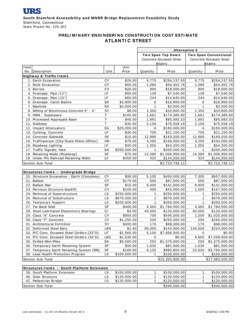
South Stamford Accessibility and MNRR Bridge Replacement Feasibility StudyStamford, ConnecticutState Project No. 135-301
Item UnitNo. Description Unit Price Quantity Price Quantity Price
1. Earth Excavation CY $26.00 9,775 $254,137.00 9,775 $254,137.002. Rock Excavation CY $50.00 1,086 $54,302.78 1,086 $54,302.783. Borrow CY $20.00 900 $18,000.00 900 $18,000.004. Drainage; Pipe (12") LF $55.00 128 $7,040.00 128 $7,040.005. Drainage; Pipe (15") LF $60.00 244 $14,640.00 244 $14,640.006. Drainage; Catch Basins EA $2,800.00 6 $16,800.00 6 $16,800.007. Manhole EA $3,500.00 1 $3,500.00 1 $3,500.008. Milling of Bituminous Concrete 0" - 4" SY $8.00 1,350 $10,800.00 1,350 $10,800.009. HMA - Superpave T $105.00 1,661 $174,386.80 1,661 $174,386.80
10. Processed Aggregate Base T $45.00 1,891 $85,083.33 1,891 $85,083.3311. Subbase T $35.00 2,159 $75,558.19 2,159 $75,558.1912. Impact Attenuators EA. $25,000.00 6 $150,000.00 6 $150,000.0013. Curbing; Concrete LF $30.00 705 $21,150.00 705 $21,150.0014. Concrete Sidewalk SF $15.00 12,880 $193,200.00 12,880 $193,200.0015. Trafficperson (City/State Police Officer) HR $75.00 3,200 $240,000.00 3,200 $240,000.0016. Roadway Lighting LF $40.00 1,355 $54,200.00 1,355 $54,200.0017. Traffic Signals; New EA $200,000.00 1 $200,000.00 1 $200,000.0018. Retaining Walls (Roadway) SF $70.00 14,385 $1,006,950.00 14,385 $1,006,950.0019. Under-Pin Railroad Retaining Walls LF $450.00 320 $144,000.00 320 $144,000.00
Section Sub-Total $2,723,748.11 $2,723,748.11
20. Structure Excavation - Earth (Complete) CY $90.00 5,100 $459,000.00 7,300 $657,000.0021. Ballast CY $175.00 500 $87,500.00 500 $87,500.0022. Ballast Mat SF $15.00 9,400 $141,000.00 9,400 $141,000.0023. Pervious Structure Backfill CY $105.00 400 $42,000.00 1,500 $157,500.0024. Removal of Superstructure LS $250,000.00 1 $250,000.00 1 $250,000.0025. Removal of Substructure LS $670,000.00 1 $670,000.00 1 $670,000.0026. Temporary Support LS $200,000.00 1 $200,000.00 1 $200,000.0027. Tie-Back Wall SF $400.00 4,460 $1,784,000.00 4,460 $1,784,000.0028. Steel-Laminated Elastomeric Bearings CI $3.00 40,000 $120,000.00 40,000 $120,000.0029. Class "A" Concrete CY $850.00 700 $595,000.00 1,200 $1,020,000.0030. Class "F" Concrete CY $1,250.00 200 $250,000.00 200 $250,000.0031. Architectural Formliner SY $400.00 170 $68,000.00 170 $68,000.0032. Deformed Steel Bars LBS $1.60 90,000 $144,000.00 140,000 $224,000.0033. P/C Conc. Encased Steel Girders (33"D) LF $1,560.00 5,100 $7,956,000.00 0 $0.0034. P/C Conc. Encased Steel Girders (30"D) LBS $1,530.00 0 $0.00 4,600 $7,038,000.0035. Drilled Mini-Piles EA $5,500.00 250 $1,375,000.00 250 $1,375,000.0036. Temporary Earth Retaining System SF $50.00 1,630 $81,500.00 1,630 $81,500.0037. Temporary Earth Retaining System (RR) SF $160.00 6,130 $980,800.00 23,500 $3,760,000.0038. Lead Health Protection Program LS $100,000.00 1 $100,000.00 1 $100,000.00
Section Sub-Total $15,303,800.00 $17,983,500.00
39. South Platform Extension LS $100,000.00 1 $100,000.00 1 $100,000.0040. Stair Structure LS $120,000.00 1 $120,000.00 1 $120,000.0041. Pedestrian Bridge LS $120,000.00 1 $120,000.00 1 $120,000.00
Section Sub-Total $340,000.00 $340,000.00
Concrete-Encased Steel Beams
Concrete-Encased Steel Beams
PRELIMINARY ENGINEERING CONSTRUCTION COST ESTIMATEATLANTIC STREET
Alternative 3Two Span Top Down Two Span Conventional
Highway & Traffic Items
Structures Items - Undergrade Bridge
Structures Items - South Platform Extension
cost estimates - 11-03-14:Atlantic Street Alt 3 9 6/18/2012 4:55 PM

South Stamford Accessibility and MNRR Bridge Replacement Feasibility StudyStamford, ConnecticutState Project No. 135-301
Item UnitNo. Description Unit Price Quantity Price Quantity Price
Concrete-Encased Steel Beams
Concrete-Encased Steel Beams
PRELIMINARY ENGINEERING CONSTRUCTION COST ESTIMATEATLANTIC STREET
Alternative 3Two Span Top Down Two Span Conventional
42. Temporary Platform3 (Stamford Station) LF $350.00 2,000 $700,000.00 2,000 $700,000.0043. Bridge Plates EA $9,000.00 20 $180,000.00 20 $180,000.0044. Removal & Erection Cycle - Bridge Plates EA $1,200.00 20 $24,000.00 20 $24,000.00
Section Sub-Total $904,000.00 $904,000.00
Highway & Traffic + Structure + Rail Operations
1. Clearing and Grubbing Roadway @ 2% $385,430.96 2% $439,024.962. M & P of Traffic @ 4% $770,861.92 4% $878,049.923. Mobilization @ 7.5% $1,445,366.11 7.5% $1,646,343.614. Construction Staking @ 1% $192,715.48 1% $219,512.485. Minor Items @ 25% $4,817,887.03 25% $5,487,812.03
Section Sub-Total
Project Sub-Total + Percentage Based Items
1. Utility Relocation Est. $3,157,500.00 1 $3,157,500.00 1 $3,157,500.00Section Sub-Total
1. RR Force Account Work1&2 @ 40% $8,273,900.00 40% $9,613,750.00Section Sub-Total
1. Incidentals @ 18% $4,839,085.73 18% $5,511,958.402. Contingencies @ 10% $2,688,380.96 10% $3,062,199.11
Section Sub-Total
Cost of Bridge Replacement (2012)
SAY
Price Adjustment (adjust to 2017) 5 years @ 5% $12,665,486.24 5% $14,357,634.09
Cost of Bridge Replacement (2017)
SAY
Project Total
Rail Operations
Project Sub-Total$19,271,548.11 $21,951,248.11
Percentage Based Items (applied to Project Sub-Total)
$7,612,261.50 $8,670,743.00
$45,842,676.30 $51,967,398.62
$26,883,809.61 $30,621,991.11
Utility Relocation Costs
$3,157,500.00 $3,157,500.00
Railroad Costs
$8,273,900.00 $9,613,750.00
Incidentals and Contingencies (applied to Project Total)
$7,527,466.69 $8,574,157.51
Inflation to Mid-Point of Construction
$58,508,162.53 $66,325,032.71
$58,500,000.00 $66,300,000.00
$45,800,000.00 $52,000,000.00
cost estimates - 11-03-14:Atlantic Street Alt 3 10 6/18/2012 4:55 PM
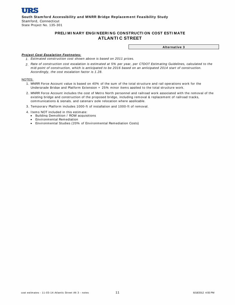
South Stamford Accessibility and MNRR Bridge Replacement Feasibility StudyStamford, ConnecticutState Project No. 135-301
1.
2.
NOTES:1.
2.
3. Temporary Platform includes 1000-ft of installation and 1000-ft of removal.
4. Items NOT included in this estimate: Building Demolition / ROW acquisitions Environmental Remediation Environmental Studies (20% of Environmental Remediation Costs)
MNRR Force Account value is based on 40% of the sum of the total structure and rail operations work for the Undergrade Bridge and Platform Extension + 25% minor items applied to the total structure work.
MNRR Force Account includes the cost of Metro North personnel and railroad work associated with the removal of the existing bridge and construction of the proposed bridge, including removal & replacement of railroad tracks, communications & signals, and catenary pole relocation where applicable.
Project Cost Escalation Footnotes:
PRELIMINARY ENGINEERING CONSTRUCTION COST ESTIMATEATLANTIC STREET
Alternative 3
Estimated construction cost shown above is based on 2011 prices.
Rate of construction cost escalation is estimated at 5% per year, per CTDOT Estimating Guidelines, calculated to the mid-point of construction, which is anticipated to be 2016 based on an anticipated 2014 start of construction. Accordingly, the cost escalation factor is 1.28.
cost estimates - 11-03-14:Atlantic Street Alt 3 - notes 11 6/18/2012 4:55 PM
South Stamford Accessibility and MNRR Bridge Replacement Feasibility StudyStamford, ConnecticutState Project No. 135-301
Item UnitNo. Description Unit Price Quantity Price Quantity Price
1. Earth Excavation CY $26.00 1,009 $26,234.00 1,009 $26,234.002. Rock Excavation CY $50.00 112 $5,600.00 112 $5,600.003. Drainage; Pipe (15") LF $60.00 504 $30,240.00 504 $30,240.004. Drainage; Catch Basins EA $2,800.00 3 $8,400.00 3 $8,400.005. Manhole EA $3,500.00 1 $3,500.00 1 $3,500.006. Milling of Bituminous Concrete 0" - 4" SY $8.00 183 $1,464.00 183 $1,464.007. HMA - Superpave T $105.00 447 $46,935.00 447 $46,935.008. Processed Aggregate Base T $45.00 447 $20,115.00 447 $20,115.009. Subbase T $35.00 509 $17,815.00 509 $17,815.00
10. Temporary PCBC LF $42.00 430 $18,060.00 430 $18,060.0011. Relocate TPCBC LF $17.00 430 $7,310.00 430 $7,310.0012. PCBC (Vertical and "F" Shape) LF $100.00 210 $21,000.00 210 $21,000.0013. Impact Attenuators EA $25,000.00 2 $50,000.00 2 $50,000.0014. Curbing; Concrete LF $30.00 230 $6,900.00 230 $6,900.0015. Concrete Sidewalk SF $15.00 3,600 $54,000.00 3,600 $54,000.0016. Trafficperson (City/State Police Officer) HR $75.00 700 $52,500.00 700 $52,500.0017. Roadway Lighting LF $40.00 225 $9,000.00 225 $9,000.0018. Traffic Signals; New EA $200,000.00 1 $200,000.00 1 $200,000.00
Section Sub-Total $579,073.00 $579,073.00
19. Structure Excavation - Earth (Complete) CY $90.00 8,300 $747,000.00 8,300 $747,000.0020. Ballast CY $175.00 550 $96,250.00 550 $96,250.0021. Ballast Mat SF $15.00 10,400 $156,000.00 10,400 $156,000.0022. Pervious Structure Backfill CY $105.00 1,800 $189,000.00 1,800 $189,000.0023. Removal of Superstructure LS $350,000.00 1 $350,000.00 1 $350,000.0024. Removal of Substructure LS $440,000.00 1 $440,000.00 1 $440,000.0025. Tie-Back Wall SF $400.00 6,220 $2,488,000.00 6,220 $2,488,000.0026. Steel-Laminated Elastomeric Bearings CI $3.00 56,400 $169,200.00 58,000 $174,000.0027. Class "A" Concrete CY $850.00 1,100 $935,000.00 1,100 $935,000.0028. Class "F" Concrete CY $1,250.00 200 $250,000.00 200 $250,000.0029. Architectural Formliner SY $400.00 280 $112,000.00 280 $112,000.0030. Deformed Steel Bars LBS $1.60 130,000 $208,000.00 130,000 $208,000.0031. Structural Steel (Site No. 1) LBS $3.25 0 $0.00 1,705,700 $5,543,525.0032. Precast Concrete Encased Steel Girders LF $1,270.00 6,720 $8,534,400.00 0 $0.0033. Drilled Mini-Piles EA $10,000.00 320 $3,200,000.00 320 $3,200,000.0034. Temporary Earth Retaining System SF $50.00 1,380 $69,000.00 1,380 $69,000.0035. Temporary Earth Retaining System (RR) SF $160.00 6,710 $1,073,600.00 6,710 $1,073,600.0036. Lead Health Protection Program LS $100,000.00 1 $100,000.00 1 $100,000.00
Section Sub-Total $19,117,450.00 $16,131,375.00
Highway & Traffic + Structure $16,710,448.00$19,696,523.00
CANAL STREETPRELIMINARY ENGINEERING CONSTRUCTION COST ESTIMATE
Highway & Traffic Items
Structures Items - Undergrade Bridge
Alternative 1
Concrete-Encased Steel Beams
Alternative 2
Multi Steel GirdersTwo Span Top Down Two Span Top Down
Project Sub-Total
cost estimates - 11-03-14:Canal Street 12 6/18/2012 4:55 PM

South Stamford Accessibility and MNRR Bridge Replacement Feasibility StudyStamford, ConnecticutState Project No. 135-301
Item UnitNo. Description Unit Price Quantity Price Quantity Price
CANAL STREETPRELIMINARY ENGINEERING CONSTRUCTION COST ESTIMATE
Alternative 1
Concrete-Encased Steel Beams
Alternative 2
Multi Steel GirdersTwo Span Top Down Two Span Top Down
1. Clearing and Grubbing Roadway @ 2% $393,930.46 2% $334,208.962. M & P of Traffic @ 4% $787,860.92 4% $668,417.923. Mobilization @ 7.5% $1,477,239.23 7.5% $1,253,283.604. Construction Staking @ 1% $196,965.23 1% $167,104.485. Minor Items @ 25% $4,924,130.75 25% $4,177,612.00
Section Sub-Total $7,780,126.59 $6,600,626.96
Project Sub-Total + Percentage Based Items
1. Utility Relocation Est. $110,000.00 1 $110,000.00 1 $110,000.00Section Sub-Total
1. RR Force Account Work1&2 @ 40% $7,646,980.00 40% $6,452,550.00Section Sub-Total
1. Incidentals @ 18% $4,945,796.93 18% $4,195,993.492. Contingencies @ 10% $2,747,664.96 10% $2,331,107.50
Section Sub-Total
Cost of Bridge Replacement (2012)
SAY
Price Adjustment (adjust to 2017) 5 years @ 5% $11,859,963.90 5% $10,056,849.44
Cost of Bridge Replacement (2017)
SAY
1.
2.
NOTES:1.
2.
3. Items NOT included in this estimate: Building Demolition / ROW acquisitions Environmental Remediation Environmental Studies (20% of Environmental Remediation Costs)
Railroad Costs
$6,527,100.99$7,693,461.88
$7,646,980.00 $6,452,550.00
$110,000.00 $110,000.00
$23,311,074.96$27,476,649.59
MNRR Force Account includes the cost of Metro North personnel and railroad work associated with the removal of the existing bridge and construction of the proposed bridge, including removal & replacement of railroad tracks, communications & signals, and catenary pole relocation where applicable.
MNRR Force Account value is based on 40% of the sum of the total structure work for the Undergrade Bridge + 25% minor items applied to the total structure work.
Utility Relocation Costs
Percentage Based Items (applied to Project Sub-Total)
Incidentals and Contingencies (applied to Project Total)
Inflation to Mid-Point of Construction
Project Total
$54,787,055.37 $46,457,575.39
$54,800,000.00 $46,500,000.00
$36,400,725.95$42,927,091.47
$43,000,000.00 $36,400,000.00
Project Cost Escalation Footnotes:Estimated construction cost shown above is based on 2011 prices.
Rate of construction cost escalation is estimated at 5% per year, per CTDOT Estimating Guidelines, calculated to the mid-point of construction, which is anticipated to be 2016 based on an anticipated 2014 start of construction. Accordingly, the cost escalation factor is 1.28.
cost estimates - 11-03-14:Canal Street 13 6/18/2012 4:55 PM
South Stamford Accessibility and MNRR Bridge Replacement Feasibility StudyStamford, ConnecticutState Project No. 135-301
Item UnitNo. Description Unit Price Quantity Price Quantity Price
1. Earth Excavation CY $26.00 3,154 $82,012.67 3,154 $82,012.672. Rock Excavation CY $50.00 350 $17,524.07 350 $17,524.073. Drainage; Pipe (15") LF $60.00 208 $12,480.00 208 $12,480.004. Drainage; Pipe (18") LF $67.00 64 $4,288.00 64 $4,288.005. Drainage; Pipe (30") LF $90.00 200 $18,000.00 200 $18,000.006. Drainage; Catch Basins EA $2,800.00 6 $16,800.00 6 $16,800.007. Drainage; Double Catch Basins EA $4,500.00 1 $4,500.00 1 $4,500.008. Manhole EA $3,500.00 2 $7,000.00 2 $7,000.009. Milling of Bituminous Concrete 0" - 4" SY $8.00 453 $3,622.22 453 $3,622.22
10. HMA - Superpave T $105.00 1,028 $107,962.68 1,028 $107,962.6811. Processed Aggregate Base T $45.00 1,028 $46,269.72 1,028 $46,269.7212. Subbase T $35.00 1,171 $40,969.44 1,171 $40,969.4413. Temporary PCBC LF $42.00 430 $18,060.00 430 $18,060.0014. Relocate TPCBC LF $17.00 430 $7,310.00 430 $7,310.0015. PCBC (Vertical and "F" Shape) LF $100.00 240 $24,000.00 240 $24,000.0016. Impact Attenuators EA. $25,000.00 2 $50,000.00 2 $50,000.0017. Curbing; Concrete LF $30.00 1,490 $44,700.00 1,490 $44,700.0018. Concrete Sidewalk SF $15.00 9,920 $148,800.00 9,920 $148,800.0019. Trafficperson (City/State Police Officer) HR $75.00 1,300 $97,500.00 1,300 $97,500.0020. Roadway Lighting LF $40.00 745 $29,800.00 745 $29,800.0021. Traffic Signals; New EA $200,000.00 1 $200,000.00 1 $200,000.0022. Retaining Walls SF $70.00 923 $64,575.00 923 $64,575.00
Section Sub-Total $1,046,173.81 $1,046,173.81
23. Structure Excavation - Earth (Complete) CY $90.00 7,800 $702,000.00 7,800 $702,000.0024. Ballast CY $175.00 550 $96,250.00 550 $96,250.0025. Ballast Mat SF $15.00 11,100 $166,500.00 11,100 $166,500.0026. Pervious Structure Backfill CY $105.00 1,300 $136,500.00 1,300 $136,500.0027. Removal of Superstructure LS $350,000.00 1 $350,000.00 1 $350,000.0028. Removal of Substructure LS $730,000.00 1 $730,000.00 1 $730,000.0029. Tie-Back Wall SF $400.00 7,470 $2,988,000.00 7,470 $2,988,000.0030. Steel-Laminated Elastomeric Bearings CI $3.00 51,100 $153,300.00 21,100 $63,300.0031. Class "A" Concrete CY $850.00 1,200 $1,020,000.00 1,200 $1,020,000.0032. Class "F" Concrete CY $1,250.00 200 $250,000.00 200 $250,000.0033. Architectural Formliner SY $400.00 300 $120,000.00 300 $120,000.0034. Deformed Steel Bars LBS $1.60 140,000 $224,000.00 140,000 $224,000.0035. Structural Steel (Site No. 1) LBS $3.25 0 $0.00 1,966,900 $6,392,425.0036. P/C Conc. Encased Steel Girders (32"D) LF $1,180.00 6,100 $7,198,000.00 0 $0.0037. Drilled Mini-Piles EA $10,000.00 330 $3,300,000.00 330 $3,300,000.0038. Temporary Earth Retaining System SF $50.00 2,030 $101,500.00 2,030 $101,500.0039. Temporary Earth Retaining System (RR) SF $160.00 6,540 $1,046,400.00 6,540 $1,046,400.0040. Lead Health Protection Program LS $100,000.00 1 $100,000.00 1 $100,000.00
Section Sub-Total $18,682,450.00 $17,786,875.00
41. Bridge Plates EA $9,000.00 25 $225,000.00 25 $225,000.0042. Removal & Erection Cycle - Bridge Plates EA $1,200.00 25 $30,000.00 25 $30,000.00
Section Sub-Total $255,000.00 $255,000.00
Highway & Traffic + Structure + Rail OperationsProject Sub-Total
PRELIMINARY ENGINEERING CONSTRUCTION COST ESTIMATEELM STREET
Alternative 1 Alternative 2Two Span Top Down Two Span Top DownConcrete-Encased Steel
BeamsMulti Steel Girders
Highway & Traffic Items
Structures Items - Undergrade Bridge
Rail Operations
$19,983,623.81 $19,088,048.81
cost estimates - 11-03-14:Elm Street 14 6/18/2012 4:55 PM

South Stamford Accessibility and MNRR Bridge Replacement Feasibility StudyStamford, ConnecticutState Project No. 135-301
Item UnitNo. Description Unit Price Quantity Price Quantity Price
PRELIMINARY ENGINEERING CONSTRUCTION COST ESTIMATEELM STREET
Alternative 1 Alternative 2Two Span Top Down Two Span Top DownConcrete-Encased Steel
BeamsMulti Steel Girders
1. Clearing and Grubbing Roadway @ 2% $399,672.48 2% $381,760.982. M & P of Traffic @ 4% $799,344.95 4% $763,521.953. Mobilization @ 7.5% $1,498,771.79 7.5% $1,431,603.664. Construction Staking @ 1% $199,836.24 1% $190,880.495. Minor Items @ 25% $4,995,905.95 25% $4,772,012.20
Section Sub-Total $7,893,531.40 $7,539,779.28
Project Sub-Total + Percentage Based Items
1. Utility Relocation Est. $1,563,500.00 1 $1,563,500.00 1 $1,563,500.00Section Sub-Total
1. RR Force Account Work1&2 @ 40% $7,574,980.00 40% $7,216,750.002. Temporary Cut and Throw Est. $3,000,000.00 1 $3,000,000.00 1 $3,000,000.00
Section Sub-Total
1. Incidentals @ 18% $5,017,887.94 18% $4,793,009.062. Contingencies @ 10% $2,787,715.52 10% $2,662,782.81
Section Sub-Total
Cost of Bridge Replacement (2012)
SAY
Price Adjustment (adjust to 2017) 5 years @ 5% $13,212,126.54 5% $12,671,341.65
Cost of Bridge Replacement (2017)
SAY
1.
2.
NOTES:1.
2.
3. Items NOT included in this estimate: Building Demolition / ROW acquisitions Environmental Remediation Environmental Studies (20% of Environmental Remediation Costs)
Percentage Based Items (applied to Project Sub-Total)
Project Total$27,877,155.21 $26,627,828.09
Estimated construction cost shown above is based on 2011 prices.
Utility Relocation Costs
$1,563,500.00 $1,563,500.00
Railroad Costs
$10,574,980.00 $10,216,750.00
Rate of construction cost escalation is estimated at 5% per year, per CTDOT Estimating Guidelines, calculated to the mid-point of construction, which is anticipated to be 2016 based on an anticipated 2014 start of construction. Accordingly, the cost escalation factor is 1.28.
MNRR Force Account includes the cost of Metro North personnel and railroad work associated with the removal of the existing bridge and construction of the proposed bridge, including removal & replacement of railroad tracks, communications & signals, and catenary pole relocation where applicable.
Incidentals and Contingencies (applied to Project Total)
$7,805,603.46 $7,455,791.86
$47,821,238.67 $45,863,869.95
Inflation to Mid-Point of Construction
$61,033,365.21 $58,535,211.60
$61,000,000.00 $58,500,000.00
MNRR Force Account value is based on 40% of the sum of the total structure and rail operations work for the Undergrade Bridge + 25% minor items applied to that total.
$47,800,000.00 $45,900,000.00
Project Cost Escalation Footnotes:
cost estimates - 11-03-14:Elm Street 15 6/18/2012 4:55 PM

South Stamford Accessibility and MNRR Bridge Replacement Feasibility StudyStamford, ConnecticutState Project No. 135-301
Item UnitNo. Description Unit Price Quant. Price Quant. Price Quant. Price
1. Earth Excavation CY $26.00 3,348 $87,056.67 3,348 $87,056.67 2,784 $72,374.472. Rock Excavation CY $50.00 372 $18,601.85 372 $18,601.85 309 $15,464.633. Drainage; Pipe (12") LF $55.00 96 $5,280.00 96 $5,280.00 96 $5,280.004. Drainage; Pipe (15") LF $60.00 104 $6,240.00 104 $6,240.00 104 $6,240.005. Drainage; Pipe (72") LF $165.00 204 $33,660.00 204 $33,660.00 204 $33,660.006. Drainage; Catch Basins EA $2,800.00 7 $19,600.00 7 $19,600.00 7 $19,600.007. Manhole EA $3,500.00 3 $10,500.00 3 $10,500.00 3 $10,500.008. Milling of Bituminous Concrete 0"-4" SY $8.00 719 $5,755.56 719 $5,755.56 628 $5,022.229. HMA - Superpave T $105.00 1,051 $110,336.80 1,051 $110,336.80 1,020 $107,057.44
10. Processed Aggregate Base T $45.00 1,051 $47,287.20 1,051 $47,287.20 1,020 $45,881.7611. Subbase T $35.00 1,196 $41,870.37 1,196 $41,870.37 1,161 $40,625.9312. Temporary PCBC LF $42.00 600 $25,200.00 600 $25,200.00 600 $25,200.0013. Relocate TPCBC LF $17.00 600 $10,200.00 600 $10,200.00 600 $10,200.0014. PCBC (Vertical and "F" Shape) LF $100.00 270 $27,000.00 270 $27,000.00 800 $80,000.0015. Impact Attenuators EA. $25,000.00 2 $50,000.00 2 $50,000.00 2 $50,000.0016. Curbing; Concrete LF $30.00 1,100 $33,000.00 1,100 $33,000.00 1,050 $31,500.0017. Concrete Sidewalk SF $15.00 8,800 $132,000.00 8,800 $132,000.00 8,400 $126,000.0018. Trafficperson (City/State Police) HR $75.00 1,100 $82,500.00 1,100 $82,500.00 1,100 $82,500.0019. Roadway Lighting LF $40.00 450 $18,000.00 450 $18,000.00 450 $18,000.0020. Traffic Signals; Minor Modification EA $30,000.00 2 $60,000.00 2 $60,000.00 2 $60,000.0021. Retaining Walls SF $70.00 450 $31,500.00 450 $31,500.00 450 $31,500.00
Section Sub-Total
22. Structure Excavation - Earth CY $90.00 7,000 $630,000.00 10,900 $981,000.00 7,700 $693,000.0023. Ballast CY $175.00 750 $131,250.00 650 $113,750.00 810 $141,750.0024. Ballast Mat SF $15.00 10,800 $162,000.00 10,800 $162,000.00 10,800 $162,000.0025. Pervious Structure Backfill CY $105.00 800 $84,000.00 9,900 $1,039,500.00 900 $94,500.0026. Removal of Superstructure LS $250,000.00 1 $250,000.00 1 $250,000.00 1 $250,000.0027. Removal of Substructure (Two Span LS $530,000.00 1 $530,000.00 1 $530,000.00 0 $0.0028. Removal of Substructure (Four SpanLS $750,000.00 0 $0.00 0 $0.00 1 $750,000.0029. Temporary Support LS $250,000.00 0 $0.00 0 $0.00 0 $0.0030. Tie-Back Wall SF $400.00 6,550 $2,620,000.00 0 $0.00 9,240 $3,696,000.0031. Steel-Laminated Elastomeric Brgs. CI $3.00 37,000 $111,000.00 37,000 $111,000.00 74,000 $222,000.0032. Class "A" Concrete CY $850.00 1,200 $1,020,000.00 2,300 $1,955,000.00 2,200 $1,870,000.0033. Class "F" Concrete CY $1,250.00 200 $250,000.00 200 $250,000.00 500 $625,000.0034. Architectural Formliner SY $400.00 250 $100,000.00 350 $140,000.00 350 $140,000.0035. Deformed Steel Bars LBS $1.60 140,000 $224,000.00 250,000 $400,000.00 270,000 $432,000.0036. Structural Steel LBS $3.25 0 $0.00 0 $0.00 0 $0.0037. P/C Conc. Enc. Steel Grdrs (34"D) LF $1,570.00 0 $0.00 5,700 $8,949,000.00 0 $0.0038. P/C Conc. Enc. Steel Grdrs (39"D) LF $1,620.00 6,400 $10,368,000.00 0 $0.00 0 $0.0039. P/C Conc. Enc. Steel Grdrs (28"D) LF $1,510.00 0 $0.00 0 $0.00 7,100 $10,721,000.0040. Drilled Mini-Piles EA $10,000.00 340 $3,400,000.00 340 $3,400,000.00 545 $5,450,000.0041. Repointed Masonry SY $80.00 85 $6,800.00 0 $0.00 0 $0.0042. Temp. Earth Retaining System SF $50.00 2,030 $101,500.00 2,030 $101,500.00 6,090 $304,500.0043. Temp. Earth Retaining System (RR) SF $160.00 4,130 $660,800.00 18,000 $2,880,000.00 4,130 $660,800.0044. Lead Health Protection Program LS $100,000.00 1 $100,000.00 1 $100,000.00 1 $100,000.00
Section Sub-Total
48. Bridge Plates EA $9,000.00 25 $225,000.00 25 $225,000.00 25 $225,000.0049. Removal & Erection - Bridge Plates EA $1,200.00 25 $30,000.00 25 $30,000.00 25 $30,000.00
Section Sub-Total
PRELIMINARY ENGINEERING CONSTRUCTION COST ESTIMATEU.S. ROUTE 1 (EAST MAIN STREET)
Alternative 1Two Span Top Down Two Span Conventional Four Span Top Down
Concrete-Encased Steel Beams
Concrete-Encased Steel Beams
Concrete-Encased Steel Beams
Highway & Traffic Items
$855,588.44 $855,588.44 $876,606.44
Structures Items - Undergrade Bridge
$20,749,350.00 $21,362,750.00 $26,312,550.00
Rail Operations
$255,000.00 $255,000.00 $255,000.00cost estimates - 11-03-14:East Main Street Alt 1 16 6/18/2012 4:55 PM

South Stamford Accessibility and MNRR Bridge Replacement Feasibility StudyStamford, ConnecticutState Project No. 135-301
Item UnitNo. Description Unit Price Quant. Price Quant. Price Quant. Price
PRELIMINARY ENGINEERING CONSTRUCTION COST ESTIMATEU.S. ROUTE 1 (EAST MAIN STREET)
Alternative 1Two Span Top Down Two Span Conventional Four Span Top Down
Concrete-Encased Steel Beams
Concrete-Encased Steel Beams
Concrete-Encased Steel Beams
Highway & Traffic + Structure + Rail Operations
1. Clearing and Grubbing Roadway @ 2% $437,198.77 2% $449,466.77 2% $548,883.132. M & P of Traffic @ 4% $874,397.54 4% $898,933.54 4% $1,097,766.263. Mobilization @ 7.5% $1,639,495.38 7.5% $1,685,500.38 7.5% $2,058,311.734. Construction Staking @ 1% $218,599.38 1% $224,733.38 1% $274,441.565. Minor Items @ 25% $5,464,984.61 25% $5,618,334.61 25% $6,861,039.11
Section Sub-Total
Project Sub-Total + Percentage Based Items
1. Utility Relocation Est. $1,585,500.00 1 $1,585,500.00 1 $1,585,500.00 1 $1,585,500.00Section Sub-Total
1. RR Force Account Work1&2 @ 40% $10,502,175.00 40% $10,808,875.00 40% $13,283,775.002. Temporary Cut and Throw Est. $3,000,000.00 1 $3,000,000.00 1 $3,000,000.00 1 $3,000,000.00
Section Sub-Total
1. Incidentals @ 18% $5,489,030.54 18% $5,643,055.28 18% $6,891,227.682. Contingencies @ 10% $3,049,461.41 10% $3,135,030.71 10% $3,828,459.82
Section Sub-Total
Cost of Bridge Replacement (2012)
SAY
Price Adjustment (adj. to 2017) 5 years @ 5% $14,952,573.96 5% $15,339,917.13 5% $18,475,931.85
Cost of Bridge Replacement (2017)
SAY
1.
2.
NOTES:1.
2.
3. Items NOT included in this estimate: Building Demolition / ROW acquisitions Environmental Remediation Environmental Studies (20% of Environmental Remediation Costs)
$21,859,938.44 $22,473,338.44 $27,444,156.44Project Sub-Total
$13,502,175.00 $13,808,875.00 $16,283,775.00
Percentage Based Items (applied to Project Sub-Total)
$8,634,675.69 $8,876,968.69 $10,840,441.80
Project Total$30,494,614.13 $31,350,307.13 $38,284,598.24
Utility Relocation Costs
$1,585,500.00 $1,585,500.00 $1,585,500.00
Railroad Costs
Incidentals and Contingencies (applied to Project Total)
$8,538,491.96 $8,778,086.00 $10,719,687.51
$54,120,781.09 $55,522,768.13 $66,873,560.75
MNRR Force Account value is based on 40% of the sum of the total structure and rail operations work for the Undergrade Bridge + 25% minor items applied to the total structure work.
MNRR Force Account includes the cost of Metro North personnel and railroad work associated with the removal of the existing bridge and construction of the proposed bridge, including removal & replacement of railroad tracks, communications & signals, and catenary pole relocation where applicable.
Inflation to Mid-Point of Construction
$69,073,355.05 $70,862,685.26 $85,349,492.60
$69,100,000.00 $70,900,000.00 $85,300,000.00
Rate of construction cost escalation is estimated at 5% per year, per CTDOT Estimating Guidelines, calculated to the mid-point of construction, which is anticipated to be 2016 based on an anticipated 2014 start of construction. Accordingly, the cost escalation factor is 1.28.
$54,100,000.00 $55,500,000.00 $66,900,000.00
Project Cost Escalation Footnotes:Estimated construction cost shown above is based on 2011 prices.
cost estimates - 11-03-14:East Main Street Alt 1 17 6/18/2012 4:55 PM
South Stamford Accessibility and MNRR Bridge Replacement Feasibility StudyStamford, ConnecticutState Project No. 135-301
Item UnitNo. Description Unit Price Quant. Price Quant. Price Quant. Price
1. Earth Excavation CY $26.00 3,348 $87,056.67 3,348 $87,056.67 2,784 $72,374.472. Rock Excavation CY $50.00 372 $18,601.85 372 $18,601.85 309 $15,464.633. Drainage; Pipe (12") LF $55.00 96 $5,280.00 96 $5,280.00 96 $5,280.004. Drainage; Pipe (15") LF $60.00 104 $6,240.00 104 $6,240.00 104 $6,240.005. Drainage; Pipe (72") LF $165.00 204 $33,660.00 204 $33,660.00 204 $33,660.006. Drainage; Catch Basins EA $2,800.00 7 $19,600.00 7 $19,600.00 7 $19,600.007. Manhole EA $3,500.00 3 $10,500.00 3 $10,500.00 3 $10,500.008. Milling of Bituminous Concrete 0"-4" SY $8.00 719 $5,755.56 719 $5,755.56 628 $5,022.229. HMA - Superpave T $105.00 1,051 $110,336.80 1,051 $110,336.80 1,020 $107,057.44
10. Processed Aggregate Base T $45.00 1,051 $47,287.20 1,051 $47,287.20 1,020 $45,881.7611. Subbase T $35.00 1,196 $41,870.37 1,196 $41,870.37 1,161 $40,625.9312. Temporary PCBC LF $42.00 600 $25,200.00 600 $25,200.00 600 $25,200.0013. Relocate TPCBC LF $17.00 600 $10,200.00 600 $10,200.00 600 $10,200.0014. PCBC (Vertical and "F" Shape) LF $100.00 270 $27,000.00 270 $27,000.00 800 $80,000.0015. Impact Attenuators EA. $25,000.00 2 $50,000.00 2 $50,000.00 2 $50,000.0016. Curbing; Concrete LF $30.00 1,100 $33,000.00 1,100 $33,000.00 1,050 $31,500.0017. Concrete Sidewalk SF $15.00 8,800 $132,000.00 8,800 $132,000.00 8,400 $126,000.0018. Trafficperson (City/State Police) HR $75.00 1,100 $82,500.00 1,100 $82,500.00 1,100 $82,500.0019. Roadway Lighting LF $40.00 450 $18,000.00 450 $18,000.00 450 $18,000.0020. Traffic Signals; Minor Modification EA $30,000.00 2 $60,000.00 2 $60,000.00 2 $60,000.0021. Retaining Walls SF $70.00 450 $31,500.00 450 $31,500.00 450 $31,500.00
Section Sub-Total
22. Structure Excavation - Earth CY $90.00 7,000 $630,000.00 10,900 $981,000.00 7,700 $693,000.0023. Ballast CY $175.00 750 $131,250.00 650 $113,750.00 810 $141,750.0024. Ballast Mat SF $15.00 10,800 $162,000.00 10,800 $162,000.00 10,800 $162,000.0025. Pervious Structure Backfill CY $105.00 800 $84,000.00 9,900 $1,039,500.00 900 $94,500.0026. Removal of Superstructure LS $250,000.00 1 $250,000.00 1 $250,000.00 1 $250,000.0027. Removal of Substructure (Two Span LS $530,000.00 1 $530,000.00 1 $530,000.00 0 $0.0028. Removal of Substructure (Four SpanLS $750,000.00 0 $0.00 0 $0.00 1 $750,000.0029. Temporary Support LS $200,000.00 1 $200,000.00 1 $200,000.00 1 $200,000.0030. Tie-Back Wall SF $400.00 6,550 $2,620,000.00 0 $0.00 9,240 $3,696,000.0031. Steel-Laminated Elastomeric Brgs. CI $3.00 21,300 $63,900.00 21,300 $63,900.00 21,300 $63,900.0032. Class "A" Concrete CY $850.00 1,200 $1,020,000.00 2,300 $1,955,000.00 2,200 $1,870,000.0033. Class "F" Concrete CY $1,250.00 200 $250,000.00 200 $250,000.00 500 $625,000.0034. Architectural Formliner SY $400.00 250 $100,000.00 350 $140,000.00 350 $140,000.0035. Deformed Steel Bars LBS $1.60 140,000 $224,000.00 250,000 $400,000.00 270,000 $432,000.0036. Structural Steel LBS $3.25 3,262,700 $10,603,775.00 3,009,700 $9,781,525.00 3,323,000 $10,799,750.0037. P/C Conc. Enc. Steel Grdrs (34"D) LF $1,570.00 0 $0.00 0 $0.00 0 $0.0038. P/C Conc. Enc. Steel Grdrs (39"D) LF $1,620.00 0 $0.00 0 $0.00 0 $0.0039. P/C Conc. Enc. Steel Grdrs (28"D) LF $1,510.00 0 $0.00 0 $0.00 0 $0.0040. Drilled Mini-Piles EA $10,000.00 340 $3,400,000.00 340 $3,400,000.00 545 $5,450,000.0041. Repointed Masonry SY $80.00 85 $6,800.00 0 $0.00 0 $0.0042. Temp. Earth Retaining System SF $50.00 2,030 $101,500.00 2,030 $101,500.00 6,090 $304,500.0043. Temp. Earth Retaining System (RR) SF $160.00 4,130 $660,800.00 18,000 $2,880,000.00 4,130 $660,800.0044. Lead Health Protection Program LS $100,000.00 1 $100,000.00 1 $100,000.00 1 $100,000.00
Section Sub-Total
48. Bridge Plates EA $9,000.00 25 $225,000.00 25 $225,000.00 25 $225,000.0049. Removal & Erection - Bridge Plates EA $1,200.00 25 $30,000.00 25 $30,000.00 25 $30,000.00
Section Sub-Total
PRELIMINARY ENGINEERING CONSTRUCTION COST ESTIMATEU.S. ROUTE 1 (EAST MAIN STREET)
Alternative 2Two Span Top Down Two Span Conventional Four Span Top Down
Half-Through Girders Half-Through Girders Half-Through Girders
Highway & Traffic Items
$855,588.44 $855,588.44 $876,606.44
Structures Items - Undergrade Bridge
$21,138,025.00 $22,348,175.00 $26,433,200.00
Rail Operations
$255,000.00 $255,000.00 $255,000.00cost estimates - 11-03-14:East Main Street Alt 2 18 6/18/2012 4:55 PM

South Stamford Accessibility and MNRR Bridge Replacement Feasibility StudyStamford, ConnecticutState Project No. 135-301
Item UnitNo. Description Unit Price Quant. Price Quant. Price Quant. Price
PRELIMINARY ENGINEERING CONSTRUCTION COST ESTIMATEU.S. ROUTE 1 (EAST MAIN STREET)
Alternative 2Two Span Top Down Two Span Conventional Four Span Top Down
Half-Through Girders Half-Through Girders Half-Through Girders
Highway & Traffic + Structure + Rail Operations
1. Clearing and Grubbing Roadway @ 2% $444,972.27 2% $469,175.27 2% $551,296.132. M & P of Traffic @ 4% $889,944.54 4% $938,350.54 4% $1,102,592.263. Mobilization @ 7.5% $1,668,646.01 7.5% $1,759,407.26 7.5% $2,067,360.484. Construction Staking @ 1% $222,486.13 1% $234,587.63 1% $275,648.065. Minor Items @ 25% $5,562,153.36 25% $5,864,690.86 25% $6,891,201.61
Section Sub-Total
Project Sub-Total + Percentage Based Items
1. Utility Relocation Est. $1,585,500.00 1 $1,585,500.00 1 $1,585,500.00 1 $1,585,500.00Section Sub-Total
1. RR Force Account Work1&2 @ 40% $10,696,512.50 40% $11,301,587.50 40% $13,344,100.002. Temporary Cut and Throw Est. $3,000,000.00 1 $3,000,000.00 1 $3,000,000.00 1 $3,000,000.00
Section Sub-Total
1. Incidentals @ 18% $5,586,626.84 18% $5,890,495.50 18% $6,921,522.902. Contingencies @ 10% $3,103,681.58 10% $3,272,497.50 10% $3,845,290.50
Section Sub-Total
Cost of Bridge Replacement (2012)
SAY
Price Adjustment (adj. to 2017) 5 years @ 5% $15,198,010.23 5% $15,962,182.61 5% $18,552,118.60
Cost of Bridge Replacement (2017)
SAY
1.
2.
NOTES:1.
2.
3. Items NOT included in this estimate: Building Demolition / ROW acquisitions Environmental Remediation Environmental Studies (20% of Environmental Remediation Costs)
$22,248,613.44 $23,458,763.44 $27,564,806.44Project Sub-Total
$13,696,512.50 $14,301,587.50 $16,344,100.00
Percentage Based Items (applied to Project Sub-Total)
$8,788,202.31 $9,266,211.56 $10,888,098.55
Project Total$31,036,815.76 $32,724,975.01 $38,452,904.99
Utility Relocation Costs
$1,585,500.00 $1,585,500.00 $1,585,500.00
Railroad Costs
Incidentals and Contingencies (applied to Project Total)
$8,690,308.41 $9,162,993.00 $10,766,813.40
$55,009,136.67 $57,775,055.51 $67,149,318.39
MNRR Force Account value is based on 40% of the sum of the total structure and rail operations work for the Undergrade Bridge + 25% minor items applied to the total structure work.
MNRR Force Account includes the cost of Metro North personnel and railroad work associated with the removal of the existing bridge and construction of the proposed bridge, including removal & replacement of railroad tracks, communications & signals, and catenary pole relocation where applicable.
Inflation to Mid-Point of Construction
$70,207,146.90 $73,737,238.12 $85,701,436.99
$70,200,000.00 $73,700,000.00 $85,700,000.00
Rate of construction cost escalation is estimated at 5% per year, per CTDOT Estimating Guidelines, calculated to the mid-point of construction, which is anticipated to be 2016 based on an anticipated 2014 start of construction. Accordingly, the cost escalation factor is 1.28.
$55,000,000.00 $57,800,000.00 $67,100,000.00
Project Cost Escalation Footnotes:Estimated construction cost shown above is based on 2011 prices.
cost estimates - 11-03-14:East Main Street Alt 2 19 6/18/2012 4:55 PM

South Stamford Accessibility and MNRR Bridge Replacement Feasibility StudyStamford, ConnecticutState Project No. 135-301
Description
Atlantic Street - Alternate 2 $36,282,000.00 $36,282,000.00Elm Street $27,877,000.00 $27,877,000.00East Main Street - (Alternate 1) $30,495,000.00 $30,495,000.00Net Savings in Rail Operation Costs (between Elm and East Main) -$255,000.00 $0.00Section Sub-Total
Atlantic Street - Alternate 2 $3,158,000.00 $3,158,000.00Elm Street $1,564,000.00 $1,564,000.00East Main Street $1,586,000.00 $1,586,000.00Section Sub-Total
Atlantic Street - Alternate 2Elm StreetEast Main StreetNet Savings by constructing 3 bridges at once -$9,903,000.00 $0.00Section Sub-Total
1. Incidentals @ 18% $16,992,000.00 18% $17,037,720.002. Contingencies @ 10% $9,440,000.00 10% $9,465,400.00
Section Sub-Total
Cost of Bridge Rehabilitation (2012)
SAY
Price Adjustment (adjust to 2017) 5 years @ 5% $41,417,645.32 5% $44,243,762.57
Cost of Bridge Replacement (2017)
SAY
1.
2.
Inflation to Mid-Point of Construction
$191,328,645.32 $204,383,882.57
$191,400,000.00 $204,400,000.00
Combined ConstructionCost Totals
Individual BridgeCost Totals
PRELIMINARY ENGINEERING CONSTRUCTION COST ESTIMATEPHASE I CONSTRUCTION
Phase 1 Construction Phase 1 Construction
$160,200,000.00
Utility Relocation Costs
$6,308,000.00 $6,308,000.00
Railroad Costs (incl. Force Account)
$22,772,000.00 $32,675,000.00
$8,598,000.00 $8,598,000.00
Estimated construction cost shown above is based on 2011 prices.
Rate of construction cost escalation is estimated at 5% per year, per CTDOT Estimating Guidelines, calculated to the mid-point of construction, which is anticipated to be 2016 based on an anticipated 2014 start of construction. Accordingly, the cost escalation factor is 1.276.
$94,399,000.00 $94,654,000.00
Project Cost Escalation Footnotes:
Incidentals and Contingencies (applied to Project Total)
$26,432,000.00 $26,503,120.00
$149,911,000.00 $160,140,120.00
$150,000,000.00
Price Price
$10,575,000.00 $10,575,000.00$13,502,000.00 $13,502,000.00
Project Total
cost estimates - 11-03-14:Phase 1 20 6/18/2012 4:55 PM