SOUTH FORK FISH BARRIER SURVEY PRELIMINARY REPORTsouthforkjohnday.com/files/120973890.pdf · SOUTH...
36
SOUTH FORK FISH BARRIER SURVEY PRELIMINARY REPORT for all Steelhead Critical Habitat in DEER CREEK and its tributaries By Jeff Neal 27608 Sunset Rd John Day, OR 97845 (541) 575-2840 home (541) 620-0967 cell 1
Transcript of SOUTH FORK FISH BARRIER SURVEY PRELIMINARY REPORTsouthforkjohnday.com/files/120973890.pdf · SOUTH...

SOUTH FORK FISH BARRIER SURVEYPRELIMINARY REPORT
for all Steelhead Critical Habitat in DEER CREEK and its tributaries
By Jeff Neal
27608 Sunset RdJohn Day, OR 97845(541) 575-2840 home(541) 620-0967 cell
1

Table of Contents
INTRODUCTION
PROJECT JUSTIFICATION
METHODS AND MATERIALS Creating Survey MapsWalk-through SurveysBarrier LocationsBarrier MeasurementsBarrier Severity RatingsPrioritization of Barriers for Corrective TreatmentGuidelines for installing new culverts that meet fish passage criteria
RESULTSMap of Steelhead Critical Habitat in Murderers and Deer CreeksTable 1. Ranking for 12 barriers found on Deer CreekTable 2. 16 Barriers that were inventoried but found to be passable
LITERATURE CITED
APPENDIX I - Data Sheets for each barrier
Dry stream channel at the mouth of Deer CrBuck Cr lower culvertBlue Cr middle culvertBlue Cr upper culvertCorral Cr wooden culvertSfk Deer Cr rock check damsNfk Deer Cr rock check damsSfk Deer Cr lower culvertVester Cr at Huge boulderDeer Cr Falls on BLMBuck Cr culvert at 308 rdVester Cr culvert at Stout's drivewayDeer Cr Falls on USFSDeer Cr at Buck Cr roadDeer Cr at Vester Cr roadDeer Cr above Thorpe Cr roadDeer Cr above Corral Cr roadDeer Cr at 089 roadDeer Cr at 599 roadSfk Deer Cr upper culvertNfk Deer Cr at 514 roadNfk Deer at 24 roadBuck Cr upper culvertVester Cr middle culvertBlue Cr lower culvertCorral Cr upper culvertCorral Cr middle culvertCorral Cr lower culvert
2
INTRODUCTION The following inventory of fish passage barriers within DEER CREEK, a tributary of the South Fork of the John Day River,was conducted during June, July and August 2016 under contract with the South Fork John Day Watershed Council (SFJDWC). The contract objective was to identify and measure all barriers to juvenile and adult salmonids within 94 miles of federally designated Mid-Columbia Steelhead Habitat and to prioritize corrective treatments for fish passage. A map showing the location of each potential barrier is included below and Table 1 lists each barrier in an order from high to low priority based on the included site-specific considerations. An Appendix at the end of this report includes data sheets for each location with embedded photographs.
PROJECT JUSTIFICATIONThe South Fork John Day watershed contains numerous tributary streams that serve as spawning and rearing habitat for federally listed Mid-Columbia Wild Summer Steelhead, resident Columbia River trout and juvenile spring Chinook Salmon.These tributaries form the bulk of the high quality rearing habitat in the watershed due to the South Fork's muddy flows in spring and high water temperatures in summer. Steelhead juveniles and resident rainbow trout must be able to migrate up and down these tributaries to access the best areas for feeding, predator avoidance and spawning over a wide range of stream flows. Juvenile steelhead may rear in freshwater for up to three years prior to out-migration. Wild juvenile salmon must be able to migrate into tributary streams for dispersal from spawning areas and for summer thermal refuge. Thus, juveniles of both species are highly dependent on accessing many different kinds of stream habitat. (citation)
Unfortunately many potential rearing areas are blocked by fish barriers in the form of road culverts, rock check dams and dry sections of stream channel. Some barriers block all fish migration (full barriers) or block only juveniles (partial barriers). The South Fork John Day Watershed Council (SFJDWC) is committed to correcting these barriers but initially an assessment survey must be completed to locate, measure and prioritize all barriers. Very few barriers were identified in pastsurveys on BLM and Malheur National Forest Lands and many occur on private land that has never been surveyed.
Fish passage through barriers is an important factor in the recovery of depleted salmonid populations throughout the Pacific Northwest. Passage restorations are extremely efficient in that they result in the restoration of a large amount of habitat, while only resulting in a small on the ground construction footprint. Passage projects have the ability to return fish to mature, functioning riparian habitats. No other type of stream restoration has that ability (Washington Trout 2004). Although most fish-bearing streams within the South Fork tend to be relatively small in size, many of these exist and the cumulative effect of blocked habitat is quite significant. Subsurface stream flow may block fish passage at certain times if stream reaches are not connected except during extremely high flow periods during heavy rain or snow melt. In these cases, there is a defined stream channel but no evidence of overland flow during the time of the year when fish need to migrate. Subsurface stream flows can be caused by natural events or result from man-made structures. Reaches where subsurface stream flow can form a barrier will be documented as a feature for purposes of this inventory. Natural barriers encountered were documented and evaluated similar to human-made features. Only natural barriers that are considered permanent or long-term were documented, including waterfalls, high gradient stream sections, or subsurface flow. Transitory features such as beaver dams and log jams were not documented. Natural instream features that were found to be passable were not documented.
Typical passage problems at barriers are: • Excessive jump height. Oregon statewide standard is 0.5ft for juvenile salmonids• Inadequate pool depth below the waterfall or culvert outlet inhibiting jumping ability• Excessive water velocities within a culvert that surpass the swimming speed of juvenile fish • Lack of water depth within a culvert • Debris accumulation at a culvert inlet that blocks passage on an otherwise passable culvert.
During passage studies in other States numerous observations have provided valuable insight into salmonid migration: (adapted from Taylor and Love 2002)1. Most upstream migration occurred after the high water peak and during the falling limb of storm hydrographs.2. Regardless of jumping abilities cited in literature, most perched culverts were migration problems for adult salmonids. Site-specific hydraulics at culvert outlets appeared to create confusing flow patterns to migrating salmonids. 3. When individual fish made repeated jump attempts, these often occurred at regular intervals spaced about five to 12 minutes apart and often occurred at the same location. Individuals were rarely observed attempting leaps from a variety of
3
locations at an outlet.
Even if barriers are eventually overcome, excess energy expended by fish may result in their death prior to spawning, or reductions in viability of eggs and offspring. Migrating fish concentrated in pools and stream reaches below barriers are alsomore vulnerable to predation by a variety of avian and mammalian species, as well as being eaten by larger fish. Barriers limit the distribution of spawning, often resulting in under-seeded headwaters and superimposition of redds in lower stream reaches.
Anadromous salmonids will benefit from this inventory effort which will assist agencies in proposal development and help them achieve higher rankings on submitted proposals when seeking State and Federal grants to implement treatments.
METHODS AND MATERIALS
Conducting the barrier inventory included the following tasks: 1. Creating survey maps for each tributary showing the location of all road crossings and the upper limit of Steelhead Critical Habitat. 2. Performing a walk through survey to the upper limit of Critical Habitat.3. Locating each potential fish barrier, taking a GPS location, taking several length and elevation measurements and taking photographs.4. Filling out a data sheet for each fish barrier found. 5. Evaluating each site with the “GREEN-GRAY-RED” severity rating. 6. Prioritization of sites for corrective treatment.
Creating Survey MapsThe National Marine Fisheries Service (NMFS) produced maps, spreadsheets and GPS locations for Steelhead Critical Habitat in the South Fork John Day watershed. These were published in the Federal Register volume 70, No. 170 dated Sept. 2, 2005. These coordinates were used to identify which tributaries to survey and where the end of designated Critical Habitat was located on each portion of stream. USFS, BLM and USGS TOPOGRAPHICAL maps were used for marking all road/stream intersections within Critical Habitat designated stream reaches. Walk-through SurveyBeginning at the mouth of Deer Creek, a walking survey proceeded upstream until a potential barrier was found. The survey was halted until all measurement were taken. Then the survey was resumed. Each tributary designated as Critical Habitat was also surveyed in the same upstream manner until the upper limit of designated Critical Habitat was reached. A total of 25.15 miles of stream were inventoried for this preliminary report.
Barrier Location The location of each barrier was described by: stream name, road number, passage ID number and latitude and longitude in degrees° decimal minutes'. If more than one barrier was found on a single stream each was named lower, middle or upper proceeding in an upstream direction. Lat/long coordinates were determined using a hand held Garmin Rino 650 GPS. All lat/long coordinates were provided in the North American 1927 datum (NAD27). All data and information were recorded on data sheets. Data sheets were then entered into a computer data file to provide back-ups in case of loss or destruction of the originals.
4

Barrier Measurements
For each barrier the following specifications were measured:1. Jump height2. Jump pool depth and length3. Depth of downstream controlling riffle4. Water velocity above and below5. Stream slope above and below6. Active channel width above and below7. The potential for debris blockage8. The average stream substrate size For each culvert these additional specifications were measured:
1. Length (to nearest 1/10 of foot)2. Diameter (circular), or height and width (smashed culverts)3. Type: corrugated metal pipe (CMP), Wood or Pipe Arch.4. Overall condition of pipe (good, fair, poor, extremely poor)5. Height of the rust line (if present)6. Height of jump required to enter culvert7. Maximum pool depth within five feet of the outlet8. Culvert slope9. Previous modifications (if any) to improve fish passage10. Road surface width and height above culvert inlet11. Position of the culvert relative to the road surface (culvert skew)
For vertical measurement I utilized a self leveling rotary laser head (Johnson Model 6515 with an accuracy of ± 1/100 ft), mounted on a 6 ft surveyor’s tripod and a 13’ stadia rod in 1/100’ increments. For horizontal measurements I utilized the stadia rod and a 300ft surveyors tape in 1/100 ft increments.
Active channel width was measured as the distance between each edge of the stream bank, or the distance to the edge of frequently scoured substrate, or the distance between each edge of rooted vegetation. All sections of the stream channel above and below each barrier were walked to detect the presence of salmonids and provide additional information regardinghabitat conditions. Length of potential salmonid habitat upstream of each county culvert was estimated off of digitized USGS 7.5 Minute Series topographic maps
A photograph of each barrier was taken showing the jump height, pool depth, culvert inlet and road surface. Any evidence of beaver activity at the site was noted.
Barrier severity ratings • GREEN: Conditions adequate for passage of all salmonid life stages. PASSABLE• GRAY: Conditions not adequate for all salmonid life stages. PASSABLE TO ADULTS ONLY• RED: Conditions do not meet passage criteria. NOT PASSABLE
5
Water SurfaceCulvert inlet
road surface width
Culvert outlet Jump height
Jump pool depth
Controlling riffle depth Culvert slope
Stream slope
Stream bed
Prioritization of barriers for Corrective Treatment Table 1 lists each barrier in an order from high to low priority based on the included site-specific considerations. Because the South Fork Watershed Council intends on correcting barriers by submitting proposals to various fisheries restoration funding sources, additional opportunities for re-evaluating the biological merit of potential projects will occur through coordination with land management agencies and proposal review committees composed of biologists from ODFW, BLM, USDA and other agencies. Each site must be re-evaluated by its corresponding land management agency requiring more extensive surveys and evaluation which may affect the final order of treatment.
USFS barrier assessment protocol was not used for this inventory. The following information collected is intended to alert USFS teams about which barriers need more intensive data collection and where they are located. This inventory also does not yield enough information for design of a replacement structure. Depending on the site, the design process may require much more information, such as a full site survey, hydraulic modeling and a geomorphology assessment.
Guidelines for installing new culverts that meet fish passage criteria (adapted from Taylor and Love 2002).
Culvert Setting and Dimensions • Culvert Width – the minimum culvert width shall be equal to, or greater than, the bankfull channel width. The
minimum culvert width shall not be less than six feet. • Culvert Slope - the culvert slope shall approximate the slope of the stream through the reach in which it is being
placed. The maximum slope shall not exceed 6%. • Embedment – the bottom of the culvert shall be buried into the stream bed, not less than 30% and not more than
50% of the culvert height. Embedment does not apply to bottomless culverts.
Substrate Configuration and Stability • Culverts with slopes greater than 3% shall have the bed inside the culvert arranged into a series of step-pools with
the drop at each step not exceeding 0.5 feet for juvenile salmonids. • Smooth walled culverts with slopes greater than 3% may require bed retention sills within the culvert to maintain
the bed stability under elevated flows. • The gradation of the native stream bed material or engineered fill within the culvert shall address stability at high
flows and shall include fine sediment to minimize interstitial flow through it.
6
RESULTS
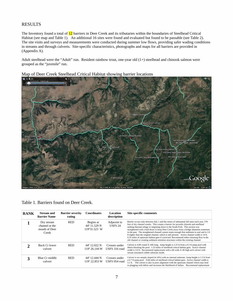
The Inventory found a total of 12 barriers in Deer Creek and its tributaries within the boundaries of Steelhead Critical Habitat (see map and Table 1). An additional 16 sites were found and evaluated but found to be passable (see Table 2). The site visits and surveys and measurements were conducted during summer low flows, providing safer wading conditions in streams and through culverts. Site-specific characteristics, photographs and maps for all barriers are provided in (Appendix A).
Adult steelhead were the “Adult” run. Resident rainbow trout, one-year old (1+) steelhead and chinook salmon were grouped as the “juvenile” run.
Map of Deer Creek Steelhead Critical Habitat showing barrier locations
Table 1. Barriers found on Deer Creek.
RANK Stream andBarrier Name
Barrier severityrating
Coordinates Locationdescription
Site-specific comments
1 Dry streamchannel at themouth of Deer
Creek
RED Begins at 44º 11.529 N
119º31.523 W
Adjacent toUSFS 24
Barrier occurs only between July 1 and the return of substantial fall rains each year. 570 feet of dry channel results. This creates a barrier for juvenile chinook and steelhead seeking thermal refuge or migrating down to the South Fork. This section was straightened with a bull dozer to keep Deer Creek away from a bridge abutment sometime in the past. The straightened channel cannot retain enough fine sediment to seal and is 2.0 ft higher than the original channel, which is still present. Active channel width is 14 ft. 0.35 miles of upstream habitat gain if corrected. Recommend either returning flow to the old channel or creating sediment retention structures within the existing channel.
2 Buck Cr lowerculvert
RED 44º 12.022 N119º 26.144 W
Crosses underUSFS 316 road
Culvert is 4.0ft round X 34ft long. Jump height is 2.25 ft from a 0.5 ft jump pool with debris blocking the pool. 1.53 miles of steelhead critical habitat gain. Active channel width is 3.9 ft. Recommend replacement with a 6ft wide X 4ft high arch culvert with stream simulated cobble substrate inside.
3 Blue Cr middleculvert
RED 44º 12.444 N119º 22.853 W
Crosses underUSFS 054 road
Culvert is too steeply sloped (4.14%) with no internal substrate. Jump height is 1.5 ft from a 0.7 ft jump pool. 0.66 miles of steelhead critical habitat gain. Active channel width is 3.1 ft. The culvert is also in poor alignment with the upstream channel which may lead to plugging with debris and increases the likelihood of failure. Recommend replacement
7

with a 5ft wide X 4ft high arch culvert installed at less than 2% slope with stream simulated cobble substrate inside.
4 Blue Cr upperculvert
RED 44º 12.924 N119º 22.543 W
Crosses underUSFS 054 road
Culvert is 3.0 ft dia X 40.3ft long with damaged inlet. Jump height (0.25ft) and pool depth (1.5ft) are adequate but culvert is too steeply sloped (2.9 %) with no internal substrate. Located immediately below a riparian recovery project and is compromising its effectiveness. 0.54 miles of steelhead critical habitat gain if corrected. Active channel width is 3.1ft. Recommend replacement with a 5ft wide X 3ft high arch culvert set to a flatter slope with stream simulated cobble substrate inside.
5 Corral Crwooden culvert
RED 44º 10.432 N119º 21.527 W
Crosses underUSFS 450 road
Culvert is 3ft diameter and made of wood. Jump height is 1.9ft from a 2.1ft deep jump pool with debris blocking the inlet. 0.40 miles of steelhead critical habitat gain if corrected. Active channel width is 5.5ft. Recommend replacement with an 8ft wide X 5ft high arch culvert with stream simulated cobble substrate inside.
6 Sfk Deer RockCheck Dams
RED Lower-44º10.846 N
119º 20.002W
Upper-44º10.594 N
119º19.980 W
Adjacent toUSFS 425 road
Barrier consists of 16 porous rock check dams installed in the 1970's to restore an incised channel. 11 of these are now impassable barriers due to stream flows passing through the dams instead of over the dams. 2.36 miles of steelhead critical habitat gain if corrected. Recommend modification of each impassable dam to seal porosity.
7 Nfk Deer RockCheck Dams
RED Lower-44º11.342 N
119º19.428 W
Upper-44º11.413 N
119º 19.216 W
Adjacent toUSFS 24 road
Barrier consists of 7 porous rock check dams installed in the 1970's to restore an incised channel. 6 of these are now impassable barriers due to stream flows passing through the dams instead of over the dams. 1.77 miles of steelhead critical habitat gain if corrected. Recommend modification of each impassable dam to seal porosity.
8 Sfk Deer lowestculvert
GREYtemporarilypasses adult
steelhead only
44º 10.954 N119º 20.093 W
Crosses underUSFS 24 road
Culvert is 4.8ft wide, 2.9ft high X 30.5ft long but is too steeply sloped (3.15%) with no internal substrate. Although there is only a 6” jump height there is no jump pool. The jump height is only this small because a large clump of willows collects all debris that passes through the culvert. When this willow dies the culvert will become impassable. 0.23 miles of steelhead critical habitat gain if corrected. Recommend counter-sinking the culvert an additional two feet or creating a permanent grade control structure 10ft below the outlet.
9 Vester Cr atHuge Boulder
RED 44º 11.552 N119º 23.730 W
Adjacent toUSFS 338 road
Barrier is 0.8 road miles up and consists of a 0.5ft falls with no jump pool immediately followed by a 2.7ft falls with no jump pool. These falls were created when the stream wasmoved to the opposite side of a huge boulder to make room for the 338 road. 1.38 miles of steelhead critical habitat gain if corrected. Active channel width is 3.0ft. Recommend modifying boulders causing blockage until channel gradient approaches 2.0 %.
10 Deer Cr Falls atRM 0.35
RED forjuveniles
Passable to AdultSteelhead duringhigh flows only
44º 11.594 N119º 31.254 W
Adjacent toUSFS 24
Barrier consists of 4 to 20ft diameter boulders shoved into a steep stream section as a result of road construction in the 1970's. 6 jumps from 2.2 to 5.0ft all within 195ft of stream. Overall gradient is 14%. All waterfalls have small jump pools which increase in depth during April snow melt but do not permit passage of juveniles after mid-May. 24.85 miles of steelhead critical habitat above. Bankfull width is 14.0ft.Recommend removing large boulders from the upstream end until channel gradient approaches 5 or 6 %.
11 Buck Cr culvertat 308 road
RED 44º 10.947 N119º 25.357 W
Crosses OVERUSFS 308 road
Barrier consists of a buried culvert that can no longer be seen. The crossing now looks like a stream ford. Buck Cr flows underneath this rock fill or drops 6.3 ft if it flowed over. Active channel width is 4.1ft. Potential upstream steelhead critical habitat gain is only 0.25 miles. Recommend removing all fill and rebuilding the buried culvert in a passable configuration, or removing entirely since this is a closed road.
12 Vester Cr Culvertat Stout'sdriveway
UNKNOWN 44º 10.738 N119º 23.301 W
on privatedriveway
Culvert was identified as a barrier in the late 1990's and it became the upper boundary of steelhead critical habitat. Unable to survey without landowner permission.
8
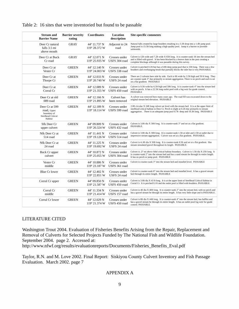
Table 2: 16 sites that were inventoried but found to be passable
Stream andBarrier Name
Barrier severityrating
Coordinates Locationdescription
Site-specific comments
Deer Cr naturalfalls 3.5 mi
above mouth
GRAY 44º 11.737 N119º 28.372 W
Adjacent to 24road
Natural falls created by large boulders resulting in a 3.3ft drop into a 1.4ft jump pool. Jump pool is 15.5ft long making a high quality pool. Jump is a barrier to juvenile salmonids.
Deer Cr at BuckCr road
GRAY 44º 12.071 N119º 25.935 W
Crosses underUSFS 304 road
Culvert is 12ft wide and 7.2ft wide X 65ft long. It is counter-sunk 1ft into the stream bed and is filled with gravel. It has been blocked by a beaver dam in the past creating a complete blockage although it was passable during this survey.
Deer Cr atVester Cr
GREEN 44º 12.140 N119º 24.003 W
Crosses underUSFS 338 road
Culvert is perched 0.2ft but has a 0.8ft deep jump pool that is 33ft long. There was a few boulders and overhanging brush that partially blocks the inlet but is very PASSABLE.
Deer Cr atThorpe Cr
GREEN 44º 12.033 N119º 20.740 W
Crosses underUSFS 24 road
There are 2 culverts here side by side. Each is 6ft wide by 3.5ft high and 50 ft long. They are counter-sunk 3” due primarily to stream aggregation. There is no perch and each is set on a flat gradient. PASSABLE
Deer Cr atCorral Cr
GREEN 44º 12.089 N119º 21.355 W
Crosses underUSFS 450 road
Culvert is 9.5ft wide by 6.5ft high and 50ft long. It is counter-sunk 4” into the stream bed with no perch. It has a 22.5ft long outlet pool with a log weir for grade control. PASSABLE
Deer Cr at old089 road
GREEN 44º 12.166 N119º 21.895 W
Culvert hasbeen removed
A culvert was removed here many years ago. The road fill was excavated down to the original stream bed elevation. PASSABLE
Deer Cr at 599road, Upperboundary of
Steelhead CriticalHabitat
GREEN 44º 12.189 N119º 18.114 W
Crosses underUSFS 599 road
2.0ft circular X 24ft long culvert set level with the stream bed. It is at the upper limit of steelhead critical habitat in Deer Cr. Perch is slight at 0.2ft due primarily to stream aggregation . There is an adequate jump pool 0.7ft deep and 10.3ft long. PASSABLE
Sfk Deer Crupper culvert
GREEN 44º 09.809 N119º 20.324 W
Crosses underUSFS 432 road
Culvert is 3.0ft dia X 30ft long. It is counter-sunk 3” and set at a flat gradient. PASSABLE.
Nfk Deer Cr at514 road
GREEN 44º 11.441 N119º 19.126 W
Crosses underUSFS 514 road
Culvert is 3.0ft dia X 30ft long. It is counter-sunk 1.5ft at inlet and 2.5ft at outlet due to impressive stream aggregation. Culvert was set at a flat gradient. PASSABLE.
Nfk Deer Cr at24 road
GREEN 44º 11.225 N119º 19.692 W
Crosses underUSFS 24 road
Culvert is 4..0ft dia X 50ft long. It is counter-sunk 0.5ft and set at a flat gradient. Has stream simulated gravel throughout its length. PASSABLE.
Buck Cr upperculvert
GREEN 44º 10.872 N119º 25.055 W
Crosses underUSFS 304 road
Culvert is .27 mi above Sthd critical habitat boundary. Culvert is 1.5ft dia X 25ft long. It is counter-sunk 2” into the stream bed and has a sand stream be through its entire length. It has no perch or jump pool. PASSABLE
Vester Crmiddle
GREEN 44º 10.886 N119º 23.187 W
Crosses underUSFS 361 road
Culvert is counter-sunk 3” into the stream bed and installed level. PASSABLE
Blue Cr lower GREEN 44º 12.402 N119º 22.851 W
Crosses underUSFS 24 road
Culvert is counter-sunk 8” into the stream bed and installed level. It has a gravel stream bed through its entire length. PASSABLE
Corral Cr upper GREEN 44º 09.850 N119º 21.587 W
Crosses underUSFS 450 road
Culvert is 3.0ft dia X 43 ft long. It is at the upper limit of Steelhead Critical Habitat in Corral Cr. It is perched 0.1ft and the outlet pool is filled with boulders. PASSABLE.
Corral Crmiddle
GREEN 44º 11.334 N119º 21.414 W
Crosses underUSFS 157 road
Culvert is 4ft dia X 40ft long. It is counter-sunk 2” into the stream bed, with no perch and has a gravel stream be through its entire length. It has very little slope and is PASSABLE.
Corral Cr lower GREEN 44º 12.029 N119º 21.374 W
Crosses underUSFS 450 road
Culvert is 8ft dia X 44ft long. It is counter-sunk 4” into the stream bed, has baffles and has a gravel stream be through its entire length. It has an outlet pool log weir for grade control. PASSABLE.
LITERATURE CITED
Washington Trout 2004. Evaluation of Fisheries Benefits Arising from the Repair, Replacement and Removal of Culverts for Selected Projects Funded by The National Fish and Wildlife Foundation. September 2004. page 2. Accessed at: http://www.nfwf.org/results/evaluationreports/Documents/Fisheries_Benefits_Eval.pdf
Taylor, R.N. and M. Love 2002. Final Report: Siskiyou County Culvert Inventory and Fish Passage Evaluation. March 2002. page 7
APPENDIX A
9

Fish Passage Evaluation Data Sheet
Stream: Dry stream channel at the mouth of Deer Cr on BLM
Road # n/a Passage ID:
Coordinates:
Begins at: Lat 44 ° 11.530 Long 119 ° 31.523
Ends at: Lat 44 ° 11.487 Long 119 ° 31.621
Date: Oct 10, 2016 Crew: Neal
General
Type: Culvert | Irrigation | Other Dam | Natural
Rating: RED | GREY | GREEN
Fish bearing: No | below only | above | potentially
Impassable| adults only| juveniles| meets criteria
Barrier occurs only between July 1 and the return of substantial fall rains each year. 570 feet
of dry channel results. This creates a barrier for juvenile chinook and steelhead seeking
thermal refuge or migrating down to the South Fork. This section was straightened with a bull
dozer to keep Deer Creek away from a bridge abutment sometime in the past. The
straightened channel cannot retain enough fine sediment to seal and is 2.0 ft higher than the
original channel, which is still present. Recommend either returning flow to the old channel
or creating sediment retention structures within the existing channel.
Stream Substrate size: 6 to 12 inch cobble with some 3ft boulders
Potential for debris blockage: Yes | No
Stream Slope through the entire reach:
rise 16 ft / run 570 ft = 2.81%
Photos
Mouth of Deer Cr June 15 (flowing)
Mouth of Deer Cr Oct 10 (dry)
Bankfull Width/Active Channel Width
Bankfull Width: 14 ft
Road Width: n/a ft
Wildlife
Beaver Presence: Yes | No
Beaver Created Obstruction: Yes | No
0.35 miles of upstream habitat gain if corrected.
Sketch
10
Deer Cr.
BLM
Rd
2 4
No Utilities present
Path of original channel before it was straightened
Stream is 2 ft higher here than the original channel
Stream goes sub-surface here each summer about July 1
Mouth of Deer Creek South Fork

Fish Passage Evaluation Data Sheet
Stream: Buck Cr. - Lower
Road # 316 Passage ID:
Coordinates: Lat 44 ° 12.022 Long 119 ° 26.144
Date: 5/27/2016 Crew: Neal / Stiner
General
Type: Culvert | Irrigation | Other Dam | Natural
Rating: RED | GREY | GREEN
Fish bearing: No | below only | above | potentially
Impassable| adults only| juveniles| meets criteria
Jump height to Pool: 2.25 ft,
2nd jump: n/a ft, 3 rd jump: n/a ft
Depth of jump Pool: 0.5 ft
Length of jump Pool: 7.5 ft
Debris blocking jump pool yes | no
Water Velocity:
Above: ________ft / _______seconds = 0.56 fps
Below: ________ft / _______seconds = 0.97 fps
Stream Substrate size: 3 mm
Potential for debris blockage: Yes | No
Stream Slope
Above: rise 0.14 ft, run 71 ft = 0.2%
Below: rise 1.26 ft, run 37 ft = 3.4%
Photos
Buck Lower inlet
Buck Lower o u tl et
Buck Lower road surface looking upstream
Culvert statistics
Shape: Circular | Smashed | Damaged
Material: CMP | Other
Condition: Bent inlet | Debris plugging inlet | Bottom worn
through| Water under culvert |
Fill eroding | Rust present
Other Rock Debris blockage at inlet
Overall Condition: Good | Fair | Poor | Critical
Length: 34 ft, Width: 4 ft, Height: 4 ft
Culvert Slope: rise 0.8 ft, / run 34 ft = 2.4 %
Substrate inside of Culvert: None
Road Skewed from Culvert: 25 degrees
Inlet
Blockage: None | <10% | >10%
Outfall
Drop to Pool: 2.25 ft [perch height]
Depth of Pool: 0.5 ft
Depth of downstream controlling riffle: 0.2 ft
Bankfull Width/Active Channel Width
Bankfull Width at Culvert inlet: 4.4 ft
Two bankfull width measurements above and three below
culvert = 4.6 ft + 4.4 ft + 4.1 ft + 3.1 ft + 3.5 ft / 5 = 3.94 ft
Road Width: 19.5 ft
Surface: Dirt | Gravel | Pavement
Road Surface Height above inlet base: 6.23 ft
Wildlife
Beaver Presence: Yes | No
Beaver Created Obstruction: Yes | No
Additional habitat accessed if corrected =1.54 mi
Sketch
11
Buck Cr.
USFS Rd 316 Road surface width = 19.5 ftSkewed 25° from stream
Round CMP culvert 4ft dia X 34ft long2.4% slope
Perch = 2.25 ftPool depth = 0.5 ftPool length = 7.5 ft
No Utilities present

Fish Passage Evaluation Data Sheet
Stream: Blue Cr Middle
Road # 054 Passage ID: _______________
Coordinates: Lat 44 °12.444 Long 119 ° 22.853
Date: July 7, 2016 Crew: Neal
General
Type: Culvert | Irrigation | Other Dam | Natural
Rating: RED | GREY | GREEN
Fish bearing: No | below only | above | potentially
Impassable| adults only| juveniles| meets criteria
Jump height to Pool: 1.51 ft,
2nd jump: n/a ft, 3 rd jump: n/a ft
Depth of jump Pool: 0.71 ft, Length of jump Pool: 9.8 ft
Water Velocity:
Above: 7.0 ft / 9.5 seconds = 0.74 fps
Below: 9.0 ft / 23.0 seconds = 0.39 fps
Stream Substrate size: 73.5 mm
Potential for debris blockage: Yes | No
Stream Slope
Above: rise 0.58 ft, run 14.1 ft = 4.1 %
Below: rise 0.02 ft, run 10.0 ft = 0.2 %
Photos
Blue middle inlet.JPG
Blue middle outlet.JPG
Blue middle road bed looking upstream
Culvert statistics
Shape: Circular | Smashed | Damaged
Material: CMP Aluminum | Other
Condition: Bent inlet | Debris plugging inlet | Bottom worn
through| Water under culvert |Fill eroding | Rust present
Overall Condition: Good | Fair | Poor | Critical
Length: 40.3 ft, Width: 3.0 ft, Height: 3.0 ft
Culvert Slope: rise 1.67_ft, / run 40.3 ft = 4.14 %
Substrate inside of Culvert: None
Road Skewed from Culvert: 15 degrees
Inlet
Blockage: None | <10% | >10%
Outfall
Drop to Pool: 1.51 ft [perch height]
Depth of Pool: 0.71 ft
Depth of downstream controlling riffle: 0.1 ft
Bankfull Width/Active Channel Width
Bankfull Width at Culvert inlet: 4.3 ft
Two bankfull width measurements above and three below
culvert = 3.4 ft + 3.8 ft + 2.2 ft + 3.0 ft + 3.3 ft / 5 = 3.14 ft
Road Width: 19.5 ft
Surface: Dirt | Gravel | Pavement
Road Surface Height Above Inlet: 4.55 ft
Wildlife
Beaver Presence: Yes | No
Beaver Created Obstruction: Yes | No
Additional habitat accessed if corrected = 0.61 mi
Sketch
12
Blue Cr.
USFS Rd 054 Road surface width = 19.5 ftSkewed 15° from culvert
Aluminum CMP culvert 3 ft dia X 40.3 ft long4.14% slope
Perch = 1.51 ftPool depth = 0.71 ftPool length = 9.8 ft
No Utilities present
Fish Passage Evaluation Data Sheet
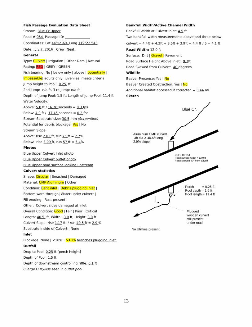
Stream: Blue Cr Upper
Road # 054 Passage ID: _______________
Coordinates: Lat 44 °12.924 Long 119 ° 22.543
Date: July 7, 2016 Crew: Neal
General
Type: Culvert | Irrigation | Other Dam | Natural
Rating: RED | GREY | GREEN
Fish bearing: No | below only | above | potentially |
Impassable| adults only| juveniles| meets criteria
Jump height to Pool: 0.25 ft,
2nd jump: n/a ft, 3 rd jump: n/a ft
Depth of jump Pool: 1.5 ft, Length of jump Pool: 11.4 ft
Water Velocity:
Above: 5.0 ft / 16.76 seconds = 0.3 fps
Below: 4.0 ft / 17.45 seconds = 0.2 fps
Stream Substrate size: 30.5 mm (Serpentine)
Potential for debris blockage: Yes | No
Stream Slope
Above: rise 2.03 ft, run 75 ft = 2.7%
Below: rise 3.09 ft, run 57 ft = 5.4%
Photos
Blue Upper Culvert Inlet photo
Blue Upper Culvert outlet photo
Blue Upper road surface looking upstream
Culvert statistics
Shape: Circular | Smashed | Damaged
Material: CMP Aluminum | Other
Condition: Bent inlet | Debris plugging inlet |
Bottom worn through| Water under culvert |
Fill eroding | Rust present
Other: Culvert sides damaged at inlet
Overall Condition: Good | Fair | Poor | Critical
Length: 40.5 ft, Width: 3.0 ft, Height: 3.0 ft
Culvert Slope: rise 1.17 ft, / run 40.5 ft = 2.9 %
Substrate inside of Culvert: None
Inlet
Blockage: None | <10% | >10% branches plugging inlet
Outfall
Drop to Pool: 0.25 ft [perch height]
Depth of Pool: 1.5 ft
Depth of downstream controlling riffle: 0.1 ft
8 large O.Mykiss seen in outlet pool
Bankfull Width/Active Channel Width
Bankfull Width at Culvert inlet: 4.5 ft
Two bankfull width measurements above and three below
culvert = 4.4ft + 4.3ft + 3.5ft + 3.9ft + 4.4 ft / 5 = 4.1 ft
Road Width: 12.0 ft
Surface: Dirt | Gravel | Pavement
Road Surface Height Above Inlet: 9.7ft
Road Skewed from Culvert: 40 degrees
Wildlife
Beaver Presence: Yes | No
Beaver Created Obstruction: Yes | No
Additional habitat accessed if corrected = 0.44 mi
Sketch
13
Blue Cr.
USFS Rd 054 Road surface width = 12.0 ftRoad skewed 40° from culvert
Aluminum CMP culvert 3ft dia X 40.5ft long2.9% slope
Perch = 0.25 ftPool depth = 1.5 ftPool length = 11.4 ft
No Utilities present
Plugged wooden culvert still present under road
Fish Passage Evaluation Data Sheet
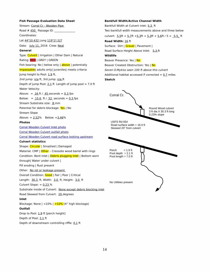
Stream: Corral Cr - Wooden Pipe
Road # 450_ Passage ID: _______________
Coordinates:
Lat 44 ° 10.432 Long 119 °21.527
Date: July 11, 2016 Crew: Neal
General
Type: Culvert | Irrigation | Other Dam | Natural
Rating: RED | GREY | GREEN
Fish bearing: No | below only | above | potentially
Impassable| adults only| juveniles| meets criteria
Jump height to Pool: 1.9 ft,
2nd jump: n/a ft, 3rd jump: n/a ft
Depth of jump Pool: 2.1 ft Length of jump pool = 7.0 ft
Water Velocity:
Above: = 16 ft / 45 seconds = 0.3 fps
Below: = 15.6 ft / 52 seconds = 0.3 fps
Stream Substrate size: 8 mm
Potential for debris blockage: Yes | No
Stream Slope
Above: = 2.52% Below: =3.46%
Photos
Corral Wooden Culvert Inlet photo
Corral Wooden Culvert o utfall photo
Corral Wooden Culvert road surface looking upstream
Culvert statistics
Shape: Circular | Smashed | Damaged
Material: CMP | Other – Creosote wood barrel with rings
Condition: Bent inlet | Debris plugging inlet | Bottom worn
through| Water under culvert |
Fill eroding | Rust present
Other: No rot or leakage present
Overall Condition: Good | Fair | Poor | Critical
Length: 30.3 ft, Width: 3.0 ft, Height: 3.0 ft
Culvert Slope: = 0.23 %
Substrate inside of Culvert: None except debris blocking inlet
Road Skewed from Culvert: 20 degrees
Inlet
Blockage: None | <10% | >10% (4” high blockage)
Outfall
Drop to Pool: 1.9 ft [perch height]
Depth of Pool: 2.1 ft
Depth of downstream controlling riffle: 0.1 ft
Bankfull Width/Active Channel Width
Bankfull Width at Culvert inlet: 5.3 ft
Two bankfull width measurements above and three below
culvert: 5.5ft + 5.7ft +5.3ft + 5.3ft + 5.6ft / 5 = _5.5_ ft
Road Width: 16 ft
Surface: Dirt | Gravel | Pavement |
Road Surface Height Above Inlet: 5.3 ft
Wildlife
Beaver Presence: Yes | No
Beaver Created Obstruction: Yes | No
Seven O.Mykiss seen 100 ft above this culvert
Additional habitat accessed if corrected = 0.7 miles
Sketch
14
Corral Cr.
USFS Rd 054 Road surface width = 16.0 ftSkewed 20° from culvert
Round Wood culvert 3 ft dia X 30.3 ft long0.23% slope
Perch = 1.9 ftPool depth = 2.1 ftPool length = 7.0 ft
No Utilities present

Fish Passage Evaluation Data Sheet
Stream: Sfk Deer Cr check dams
Road # n/a Passage ID:
Coordinates: (see table)
Date: July 19, 2016 Crew: Neal
General
Type: Culvert | Irrigation | Other Dam | Natural
Rating: RED | GREY | GREEN
Fish bearing: No | below only | above | potentially
Impassable| adults only| juveniles| meets criteria
Water Velocity:
Above: 15.4 ft / 19.34 seconds = 0.8 fps
Below: 13.5 ft / 12.22 seconds = 1.1 fps
Stream Substrate size: 0.5 mm (very fine silt)
Stream Slope
Above: rise 0.16 ft / run 17.0 ft = 0.9 %
Below: rise 0.29 ft / run 23.0 ft = 1.26%
Photos
Sfk Deer log weir and check dam # 7
Sfk Deer check dam #14
Sfk Deer check dam #16
Bankfull Width/Active Channel Width
Bankfull Width : varies from 0.9 ft to 100 ft
Stream should be about 2.8 ft bankfull width through this reach.
Stream is ponded behind each check dam and much wider than it
should be.
Road Width: n/a ft
No roads cross any of these check dams
Check dam Width: Each check dam appears to be about 40 ft wide
and keyed into each bank about 10 ft.
Dam Number Coordinates Passage status
1 N 44° 10.944 W 119° 20.065 passable
2 N 44° 10.938 W 119° 20.041 passable
3 N 44° 10.906 W 119° 20.036 passable
4 N 44° 10.886 W 119° 20.030 passable
5 N 44° 10.846 W 119° 20.002 impassable
6 N 44° 10.821 W 119° 19.975 impassable
7 N 44° 10.802 W 119° 19.980 impassable
8 N 44° 10.790 W 119° 19.980 passable
9 N 44° 10.799 W 119° 19.990 Impassable
10 N 44° 10.740 W 119° 19.995 Impassable
11 N 44° 10.724 W 119° 19.986 Impassable
12 N 44° 10.697 W 119° 19.987 Impassable
13 N 44° 10.665 W 119° 19.973 Impassable
14 N 44° 10.634 W 119° 19.963 Impassable
15 N 44° 10.618 W 119° 19.972 Impassable
16 N 44° 10.594 W 119° 19.980 Impassable
Metal flow
measuring
device
N 44° 10.578 W 119° 19.969 passable
Notes: These check dams were installed in the 1970's to arrest channel incision and restore a severely
degraded meadow. It was assumed the ponds behind them would fill with sediment within a few years and fish
passage would be restored. Unfortunately the dams are porus to water, stopped all sediment flow and remain
barriers to fish movement during all but the highest flows. Corrections need to be made in the form of sealing
the face and the spillway of each impassable dam. Or the alternative of digging a new stream channel around
them and using the excavated material to cover the dams. They are located in, and block access to, some of
the best salmonid rearing habitat in the headwaters of Deer Creek.
Wildlife
Beaver Presence: Yes | No No beaver have used the ponds or built
dams across the rock dams
Sketch
15
Sfk Deer Cr.
US
FS
425
Rd
USFS 24 Rd
No Utilities present
9
12
2
6
7
1
3
4
8
5
1110
16
Old Irrigation dam
13
14
15

Fish Passage Evaluation Data Sheet
Stream: Nfk Deer Cr check dams
Road # n/a Passage ID:
Coordinates: (see table)
Date: July 22, 2016 Crew: Neal
General
Type: Culvert | Irrigation | Other Dam | Natural
Rating: RED | GREY | GREEN
Fish bearing: No | below only | above | potentially
Impassable| adults only| juveniles| meets criteria
Water Velocity:
Above: 13.5 ft / 27.3 seconds = 0.5 fps
Below: 18.3 ft / 14.2 seconds = 1.3 fps
Stream Substrate size: 0.5 mm (very fine ash)
Stream Slope
Above: rise 0.29 ft / run 24.2 ft = 1.2 %
Below: rise 0.68 ft / run 27.0 ft = 2.5 %
Photos
Check dam # 6
Flow measuring device at dam # 7
Bankfull Width/Active Channel Width
Bankfull Width : varies from 0.7 ft to 55.0 ft
Bankfull cannot be measured because stream is ponded behind each check dam and
much wider than it should be. Stream should be about 2.3 ft bankfull width through
this reach.
Road Width: n/a ft
No roads cross any of these check dams
Check dam Width: Each check dam appears to be about 30 ft wide
and keyed into each bank about 8 ft
Wildlife
Beaver Presence: Yes | No Beaver have used only pond #2 and built
a small dam across it.
Dam Number Coordinates Passage status
1 N 44° 11.342 W 119° 19.34 impassable
2 N 44° 11.360 W 119° 19.393 passable
3 N 44° 11.379 W 119° 19.363 impassable
4 N 44° 11.383 W 119° 19.328 passable
5 N 44° 11.380 W 119° 19.289 impassable
6 N 44° 11.410 W 119° 19.249 Impassable
7 N 44° 11.413 W 119° 19.216 impassable
Metal flow
measuring
device
Located at the
top of dam 7
passable
Notes: These check dams were installed in the 1970's to arrest channel incision and restore a severely degraded
meadow. It was assumed the ponds behind them would fill with sediment within a few years and fish passage
would be restored. Unfortunately the dams are porous to water and did not fill with sediment. They remain
barriers to fish movement during all but the highest flows. Corrections need to be made by either sealing the face
and the spillway of each impassable dam or digging a new stream channel around them and using the excavated
material to fill in behind the dams. They are located in, and block access to, some of the best salmonid rearing
habitat in the headwaters of Deer Creek.
Dead Injun Creek is blocked by an impassable check dam. It is not classified as fish-bearing but could be if this
barrier was modified.
Sketch
16
Nfk Deer Cr.
US
FS
24
Rd
US
FS 544 R
d
No Utilities present
2
6
7
1
3
4
5
Deer Creek Guard Station
Dead Injun Creek
Dead Injun Creek barrier dam
Fish Passage Evaluation Data Sheet
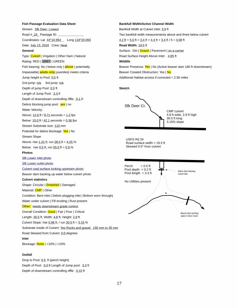
Stream: Sfk Deer- Lowest
Road #_24_ Passage ID:
Coordinates: Lat 44 °10.954 Long 119 °20.093
Date: July 13, 2016 Crew: Neal
General
Type: Culvert | Irrigation | Other Dam | Natural
Rating: RED | GREY | GREEN
Fish bearing: No | below only | above | potentially
Impassable| adults only| juveniles| meets criteria
Jump height to Pool: 0.5 ft
2nd jump: n/a 3rd jump: n/a
Depth of jump Pool: 0.0 ft
Length of Jump Pool: 3.3 ft
Depth of downstream controlling riffle: 0.1 ft
Debris blocking jump pool: yes | no
Water Velocity:
Above: 12.0 ft / 9.71 seconds = 1.2 fps
Below: 15.0 ft / 42.1 seconds = 0.36 fps
Stream Substrate size: 110 mm
Potential for debris blockage: Yes | No
Stream Slope
Above: rise 1.21 ft, run 28.5 ft = 4.25 %
Below: rise 0.5 ft, run 55.0 ft = 0.9 %
Photos
Sfk Lower i nlet photo
Sfk Lower o ut let photo
Culvert road surface looking upstream photo
Beaver dam backing up water below culvert photo
Culvert statistics
Shape: Circular | Smashed | Damaged
Material: CMP | Other
Condition: Bent inlet | Debris plugging inlet | Bottom worn through|
Water under culvert | Fill eroding | Rust present
Other: needs downstream grade control
Overall Condition: Good | Fair | Poor | Critical
Length: 30.5 ft, Width: 4.8 ft, Height: 2.9 ft
Culvert Slope: rise 0.96 ft, / run 30.5 ft = 3.15 %
Substrate inside of Culvert: Yes Rocks and gravel. 150 mm to 35 mm
Road Skewed from Culvert: 0.0 degrees
Inlet
Blockage: None | <10% | >10%
Outfall
Drop to Pool: 0.5 ft (perch height)
Depth of Pool: 0.0 ft Length of Jump pool: 3.3 ft
Depth of downstream controlling riffle: 0.10 ft
Bankfull Width/Active Channel Width
Bankfull Width at Culvert inlet: 3.9 ft
Two bankfull width measurements above and three below culvert
4.2 ft + 5.0 ft + 3.4 ft + 4.4 ft + 3.4 ft / 5 = 4.08 ft
Road Width: 19.5 ft
Surface: Dirt | Gravel | Pavement | on a corner
Road Surface Height Above Inlet: 4.85 ft
Wildlife
Beaver Presence: Yes | No (Active beaver dam 180 ft downstream)
Beaver Created Obstruction: Yes | No
Additional Habitat access if corrected = 2.56 miles
Sketch
17
Sfk Deer Cr.
USFS Rd 24 Road surface width = 19.5 ftSkewed 0.0° from culvert
CMP culvert 4.8 ft wide, 2.9 ft high 30.5 ft long3.15% slope
Perch = 0.5 ftPool depth = 0.2 ftPool length = 3.3 ft
No Utilities present
Beaver dam ponding water in Deer Creek
Debris dam blocking culvert inlet
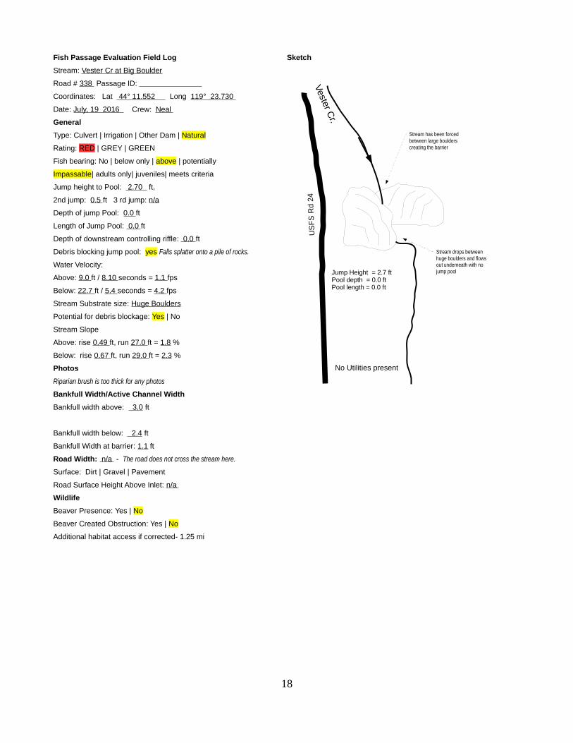
Fish Passage Evaluation Field Log
Stream: Vester Cr at Big Boulder
Road # 338 Passage ID:
Coordinates: Lat 44 ° 11.552 Long 119 ° 23.730
Date: July, 19 2016 Crew: Neal
General
Type: Culvert | Irrigation | Other Dam | Natural
Rating: RED | GREY | GREEN
Fish bearing: No | below only | above | potentially
Impassable| adults only| juveniles| meets criteria
Jump height to Pool: 2.70 ft,
2nd jump: 0.5 ft 3 rd jump: n/a
Depth of jump Pool: 0.0 ft
Length of Jump Pool: 0.0 ft
Depth of downstream controlling riffle: 0.0 ft
Debris blocking jump pool: yes Falls splatter onto a pile of rocks.
Water Velocity:
Above: 9.0 ft / 8.10 seconds = 1.1 fps
Below: 22.7 ft / 5.4 seconds = 4.2 fps
Stream Substrate size: Huge Boulders
Potential for debris blockage: Yes | No
Stream Slope
Above: rise 0.49 ft, run 27.0 ft = 1.8 %
Below: rise 0.67 ft, run 29.0 ft = 2.3 %
Photos
Riparian brush is too thick for any photos
Bankfull Width/Active Channel Width
Bankfull width above: 3.0 ft
Bankfull width below: 2.4 ft
Bankfull Width at barrier: 1.1 ft
Road Width: n/a - The road does not cross the stream here.
Surface: Dirt | Gravel | Pavement
Road Surface Height Above Inlet: n/a
Wildlife
Beaver Presence: Yes | No
Beaver Created Obstruction: Yes | No
Additional habitat access if corrected- 1.25 mi
Sketch
18
Vester Cr.
US
FS
Rd
24
Jump Height = 2.7 ftPool depth = 0.0 ftPool length = 0.0 ft
No Utilities present
Stream drops between huge boulders and flows out underneath with no jump pool
Stream has been forced between large boulders creating the barrier

Fish Passage Evaluation Data Sheet
Stream: Deer Cr Falls
Road # n/a Passage ID:
Coordinates: Lat_ 44 ° 11.594 Long 119 ° 31.254
Date: July 21, 2016 Crew: Neal / Stiner / Delgado
General
Type: Culvert | Irrigation | Other Dam | Natural
Rating: RED | GREY | GREEN
Fish bearing: No | below only | above | potentially
Impassable| adults only| juveniles| meets criteria
Greatest Jump height to Pool: 5.02 ft,
2nd highest jump: 4.15 ft, 3 rd jump: 2.51ft
All 3 jumps pools were over 1.5 ft deep
All 3 jumps pools were over 4.0 ft long
Debris blocking jump pool: yes | no
Stream Substrate size: 4 to 12 ft Boulders
Potential for debris blockage: Yes | No
Stream Slope through the entire reach:
rise 27.34 ft, run 195.2 ft = 14.0 %
Photos
4 th barrier photo
Bankfull Width/Active Channel Width
Bankfull Width above Falls: 14 ft
Road Width: n/a
Wildlife
Beaver Presence: Yes | No
Beaver Created Obstruction: Yes | No
Additional habitat access if corrected = 3.5 mi
Sketch
19
Deer C
r.
BLM R
d 24
Original road construction probably created these barriers by dumping several large boulders into the stream
No Utilities present
Stream drops 2.51 ft over boulders creating 4th barrier
Stream drops 4.15 ft over boulders creating 3rd barrier
Stream drops 2.50 ft over boulders creating 2nd barrier
Stream drops 5.02 ft over boulders creating 1st barrier
0.3 mi to m
outh
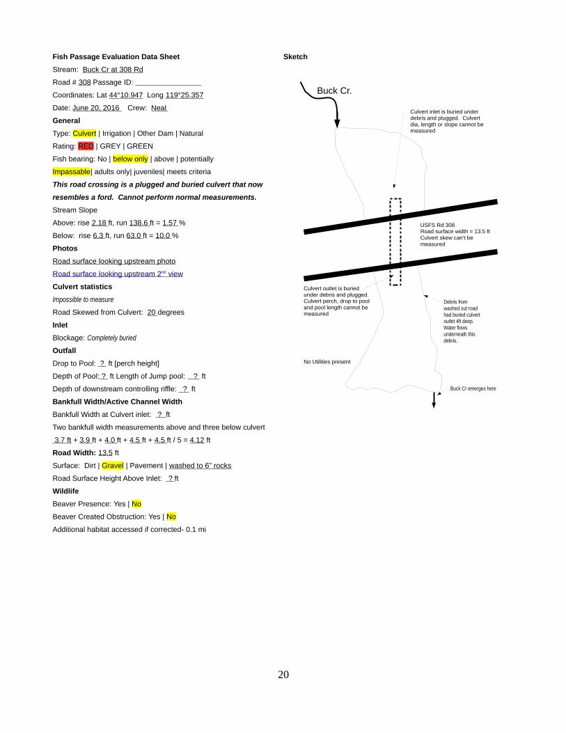
Fish Passage Evaluation Data Sheet
Stream: Buck Cr at 308 Rd
Road # 308 Passage ID:
Coordinates: Lat 44 °10.947 Long 119 °25.357
Date: June 20, 2016 Crew: Neal
General
Type: Culvert | Irrigation | Other Dam | Natural
Rating: RED | GREY | GREEN
Fish bearing: No | below only | above | potentially
Impassable| adults only| juveniles| meets criteria
This road crossing is a plugged and buried culvert that now
resembles a ford. Cannot perform normal measurements.
Stream Slope
Above: rise 2.18 ft, run 138.6 ft = 1.57 %
Below: rise 6.3 ft, run 63.0 ft = 10.0 %
Photos
Road surface looking upstream photo
R oad surface looking upstream 2 nd view
Culvert statistics
Impossible to measure
Road Skewed from Culvert: 20 degrees
Inlet
Blockage: Completely buried
Outfall
Drop to Pool: ? ft [perch height]
Depth of Pool: ? ft Length of Jump pool: ? ft
Depth of downstream controlling riffle: ? ft
Bankfull Width/Active Channel Width
Bankfull Width at Culvert inlet: ? ft
Two bankfull width measurements above and three below culvert
3.7 ft + 3.9 ft + 4.0 ft + 4.5 ft + 4.5 ft / 5 = 4.12 ft
Road Width: 13.5 ft
Surface: Dirt | Gravel | Pavement | washed to 6” rocks
Road Surface Height Above Inlet: ? ft
Wildlife
Beaver Presence: Yes | No
Beaver Created Obstruction: Yes | No
Additional habitat accessed if corrected- 0.1 mi
Sketch
20
Buck Cr.
USFS Rd 308Road surface width = 13.5 ftCulvert skew can't be measured
Culvert inlet is buried under debris and plugged. Culvert dia, length or slope cannot be measured
Culvert outlet is buried under debris and plugged. Culvert perch, drop to pool and pool length cannot be measured
No Utilities present
Buck Cr emerges here
Debris from washed out road had buried culvert outlet 4ft deep. Water flows underneath this debris.

Fish Passage Evaluation Data Sheet
Stream: Deer at Buck Cr Rd 304
Road # 304 Passage ID: _______________
Coordinates:
Lat 44 °12.071 Long 119 °25.935
Date: July 6, 2016 Crew: Neal
General
Type: Culvert | Irrigation | Other Dam | Natural
Rating: RED | GREY | GREEN
Fish bearing: No | below only | above | potentially
Impassable| adults only| juveniles| meets criteria
Jump height to Pool: 0.0 ft,
Depth of jump Pool: 2.0 ft
Water Velocity:
Above: = 0.68 fps
Below: = 0.53 fps
Stream Substrate size: 51 mm
Potential for debris blockage: Yes | No
Stream Slope
Above: = 0.2% Below: = 0.1%
Photos
Culvert i nlet photo
Culvert o ut let photo
Culvert road surface looking upstream photo
Culvert statistics
Shape: Circular | Smashed | Damaged
Material: CMP | Other
Condition: Bent inlet | Debris plugging inlet | Bottom worn through|
Water under culvert |
Fill eroding | Rust present
Other A few rust holes on side of outlet
Overall Condition: Good | Fair | Poor | Critical
Length: 65 ft, Width: 12 ft, Height: 7.2 ft
Culvert Slope: = 0.4 %
Substrate inside of Culvert: Silt, sticks and 30mm gravel
Inlet
Blockage: None | <10% | >10%
Outfall (Culvert outfall is submerged under 4” of water)
Drop to Pool: 0.0 ft (perch height)
Depth of Pool: 2.0 ft
Length of Pool: 72 ft
Depth of downstream controlling riffle: - 0.25 ft
Bankfull Width/Active Channel Width
Bankfull Width at Culvert inlet: 14 ft
Two bankfull width measurements above and three below culvert
9.0ft + 12.0ft + 11.0ft +11.0ft +13.0 ft / 5 = 11.2 ft
Road Width: 15 ft
Surface: Dirt | Gravel | Pavement |
Road Surface Height Above Inlet: 9.5 ft
Road Skewed from Culvert: 20 degrees
Wildlife
Beaver Presence: Yes | No (beaver have plugged this culvert in years past)
Beaver Created Obstruction: Yes | No
Sketch
21
Deer Cr.
USFS Rd 304 Road surface width = 15.0 ftSkewed 20° from culvert
Smashed CMP culvert 7.2 ft high X 12 ft wide 65.0 ft long0.4 % slope
Perch = 0.0 ftPool depth = 2.0 ftPool length = 72 ft
No Utilities present
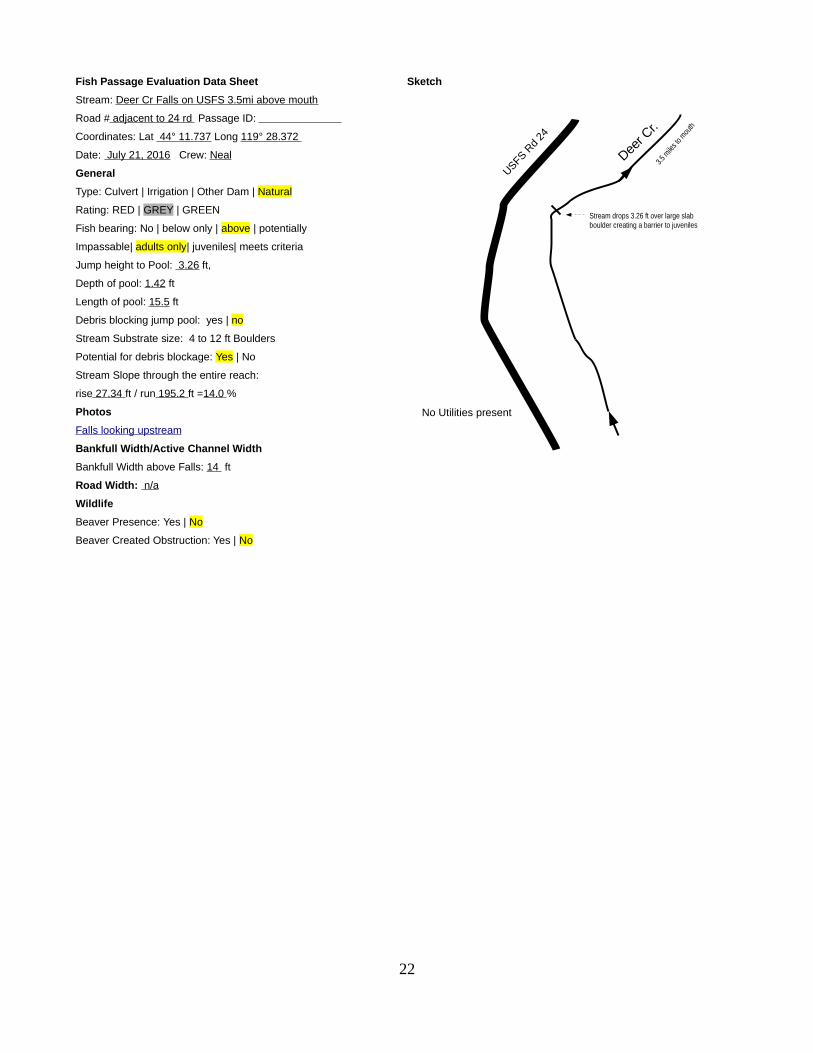
Fish Passage Evaluation Data Sheet
Stream: Deer Cr Falls on USFS 3.5mi above mouth
Road # adjacent to 24 rd Passage ID:
Coordinates: Lat 44 ° 11.737 Long 119 ° 28.372
Date: July 21, 2016 Crew: Neal
General
Type: Culvert | Irrigation | Other Dam | Natural
Rating: RED | GREY | GREEN
Fish bearing: No | below only | above | potentially
Impassable| adults only| juveniles| meets criteria
Jump height to Pool: 3.26 ft,
Depth of pool: 1.42 ft
Length of pool: 15.5 ft
Debris blocking jump pool: yes | no
Stream Substrate size: 4 to 12 ft Boulders
Potential for debris blockage: Yes | No
Stream Slope through the entire reach:
rise 27.34 ft / run 195.2 ft =14.0 %
Photos
Falls looking upstream
Bankfull Width/Active Channel Width
Bankfull Width above Falls: 14 ft
Road Width: n/a
Wildlife
Beaver Presence: Yes | No
Beaver Created Obstruction: Yes | No
Sketch
22
Deer C
r.
USFS Rd
24
No Utilities present
Stream drops 3.26 ft over large slab boulder creating a barrier to juveniles
3.5 m
iles t
o mou
th

Fish Passage Evaluation Data Sheet
Stream: Deer Cr at Vester Cr Rd 338
Road # 338 Passage ID:
Coordinates: Lat 44 ° 12.140 Long 119 ° 24.033
Date: July 14, 2016 Crew: Neal
General
Type: Culvert | Irrigation | Other Dam | Natural
Rating: RED | GREY | GREEN
Fish bearing: No | below only | above | potentially
Impassable| adults only| juveniles| meets criteria
Jump height to Pool: 0.2 ft,
Depth of jump Pool: 0.8 ft
Length of jump Pool: 33.0 ft
Depth of downstream controlling riffle: 0.2 ft
Debris blocking jump pool: yes | no
Debris blocking inlet: a few boulders and overhanging brush
Photos:
This culvert meets all standards of fish passage criteria so no
additional measurements were taken.
23
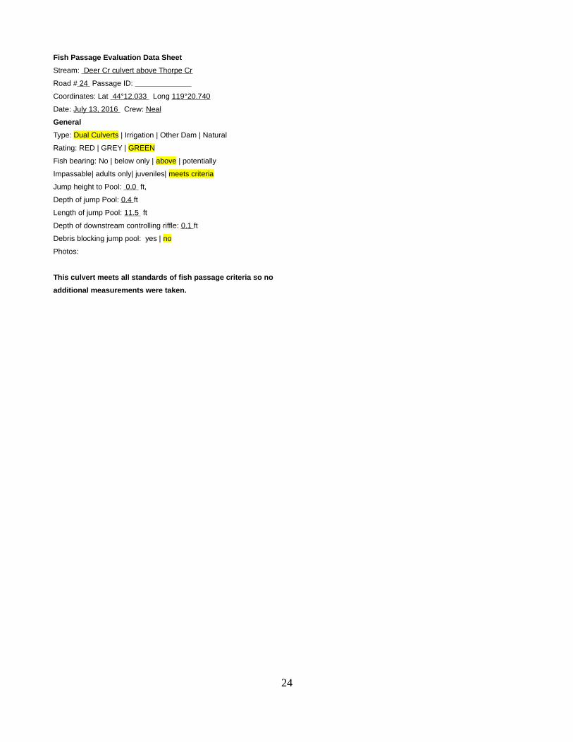
Fish Passage Evaluation Data Sheet
Stream: Deer Cr culvert above Thorpe Cr
Road # 24 Passage ID:
Coordinates: Lat 44 °12.033 Long 119 °20.740
Date: July 13, 2016 Crew: Neal
General
Type: Dual Culverts | Irrigation | Other Dam | Natural
Rating: RED | GREY | GREEN
Fish bearing: No | below only | above | potentially
Impassable| adults only| juveniles| meets criteria
Jump height to Pool: 0.0 ft,
Depth of jump Pool: 0.4 ft
Length of jump Pool: 11.5 ft
Depth of downstream controlling riffle: 0.1 ft
Debris blocking jump pool: yes | no
Photos:
This culvert meets all standards of fish passage criteria so no
additional measurements were taken.
24

Fish Passage Evaluation Data Sheet
Stream: Deer Cr @ Corral Cr rd 450
Road #450 Passage ID:
Coordinates: Lat 44 ° 12.089 Long 119 ° 21.355
Date: July 12, 2016 Crew: Neal
General
Type: Culvert | Irrigation | Other Dam | Natural
Rating: RED | GREY | GREEN
Fish bearing: No | below only | above | potentially
Impassable| adults only| juveniles| meets criteria
Jump height to Pool: 0.0 ft
Depth of jump Pool: 0.4 ft
Length of jump Pool: 22.5 ft
Depth of downstream controlling log weir: 0.1 ft
Debris blocking jump pool: yes | no
Photos:
This culvert meets all standards of fish passage criteria so no
additional measurements were taken.
25

Fish Passage Evaluation Data Sheet
Stream: Deer Cr @ 089 Rd
Road # 089 Passage ID:
Coordinates: Lat 44 ° 12.166 Long 119 ° 21.895
Date: July 14, 2016 Crew: Neal
General
Type: Culvert | Irrigation | Other Dam | Natural
Rating: RED | GREY | GREEN
Fish bearing: No | below only | above | potentially
Impassable| adults only| juveniles| meets criteria
This culvert has been removed
This culvert meets all standards of fish passage criteria so no
additional measurements were taken.
26

Fish Passage Evaluation Data Sheet
Stream: Deer Cr @ 599 rd (Critical Habitat Bndry)
Road # 599 Passage ID:
Coordinates: Lat 44 ° 12.189 Long 119 °18.114
Date: July 14, 2016 Crew: Neal
General
Type: Culvert | Irrigation | Other Dam | Natural
Rating: RED | GREY | GREEN
Fish bearing: No | below only | above | potentially
Impassable| adults only| juveniles| meets criteria
Jump height to Pool: 0.2 ft
Depth of jump Pool: 0.7 ft
Length of jump Pool: 10.3 ft
Depth of downstream controlling riffle: 0.1 ft
Debris blocking jump pool: yes | no
Photos:
This culvert meets all standards of fish passage criteria so no
additional measurements were taken.
27
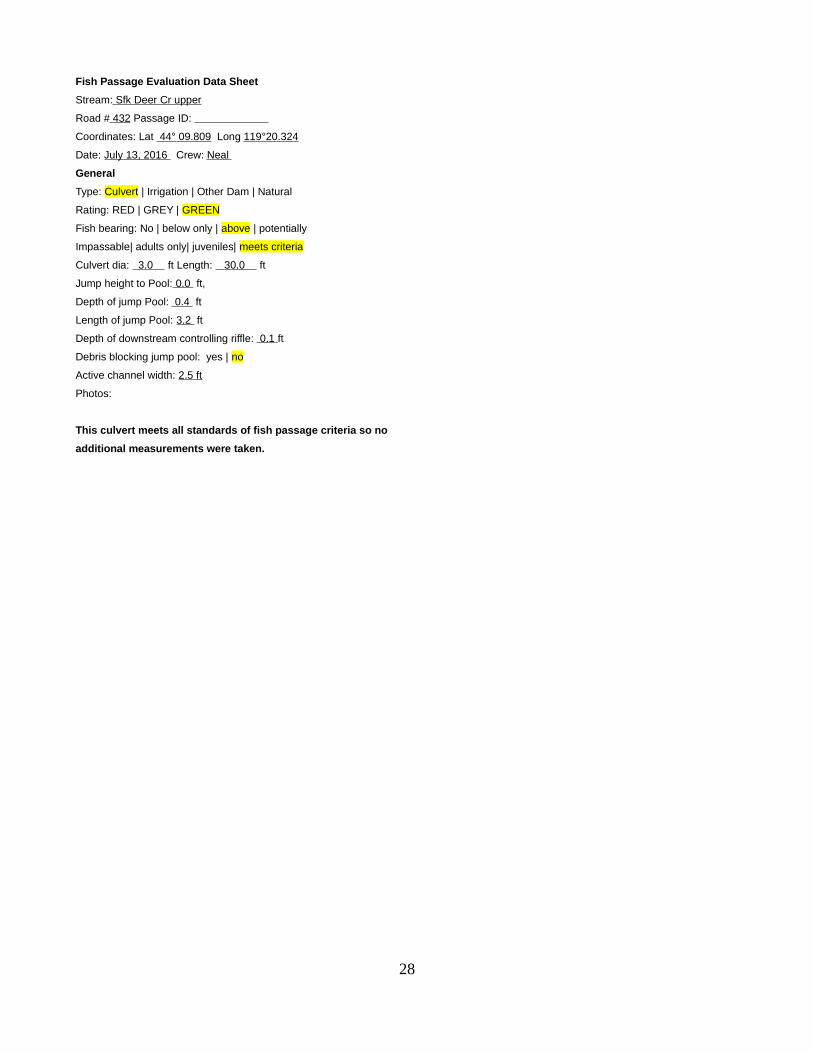
Fish Passage Evaluation Data Sheet
Stream: Sfk Deer Cr upper
Road # 432 Passage ID:
Coordinates: Lat 44 ° 09.809 Long 119 °20.324
Date: July 13, 2016 Crew: Neal
General
Type: Culvert | Irrigation | Other Dam | Natural
Rating: RED | GREY | GREEN
Fish bearing: No | below only | above | potentially
Impassable| adults only| juveniles| meets criteria
Culvert dia: 3.0 ft Length: 30.0 ft
Jump height to Pool: 0.0 ft,
Depth of jump Pool: 0.4 ft
Length of jump Pool: 3.2 ft
Depth of downstream controlling riffle: 0.1 ft
Debris blocking jump pool: yes | no
Active channel width: 2.5 ft
Photos:
This culvert meets all standards of fish passage criteria so no
additional measurements were taken.
28

Fish Passage Evaluation Data Sheet
Stream: Nfk Deer at 514 rd (Upper limit of Sthd critical habitat)
Road # 514 Passage ID:
Coordinates: Lat 44 ° 11.441 Long 119 ° 19.126
Date: July 14, 2016 Crew: Neal
General
Type: Culvert | Irrigation | Other Dam | Natural
Rating: RED | GREY | GREEN
Fish bearing: No | below only | above | potentially
Impassable| adults only| juveniles| meets criteria
Culvert dia: 3.0 ft Length: 31.0 ft
Jump height to Pool: 0.0 ft,
Depth of jump Pool: 2.5 ft
Length of jump Pool: 3.2 ft
Depth of downstream controlling riffle: 0.1 ft
Debris blocking jump pool: yes | no
Active channel width: 1.5 ft
3 ft dia culvert that is countersunk 1.5 ft at inlet and 2.5 ft at
outlet. PASSABLE
Photos:
This culvert meets all standards of fish passage criteria so no
additional measurements were taken.
29

Fish Passage Evaluation Data Sheet
Stream: Nfk Deer Cr at 24 rd
Road # 24 Passage ID:
Coordinates: Lat 44 ° 11.225 Long 119 ° 19.692
Date: July 14, 2016 Crew: Neal
General
Type: Culvert | Irrigation | Other Dam | Natural
Rating: RED | GREY | GREEN
Fish bearing: No | below only | above | potentially
Impassable| adults only| juveniles| meets criteria
Jump height to Pool: 0.0 ft,
Culvert is countersunk 0.5 ft with a flat slope and stream
substrate all the way through.
Debris blocking jump pool: yes | no
This culvert meets all standards of fish passage criteria so no
additional measurements were taken.
30
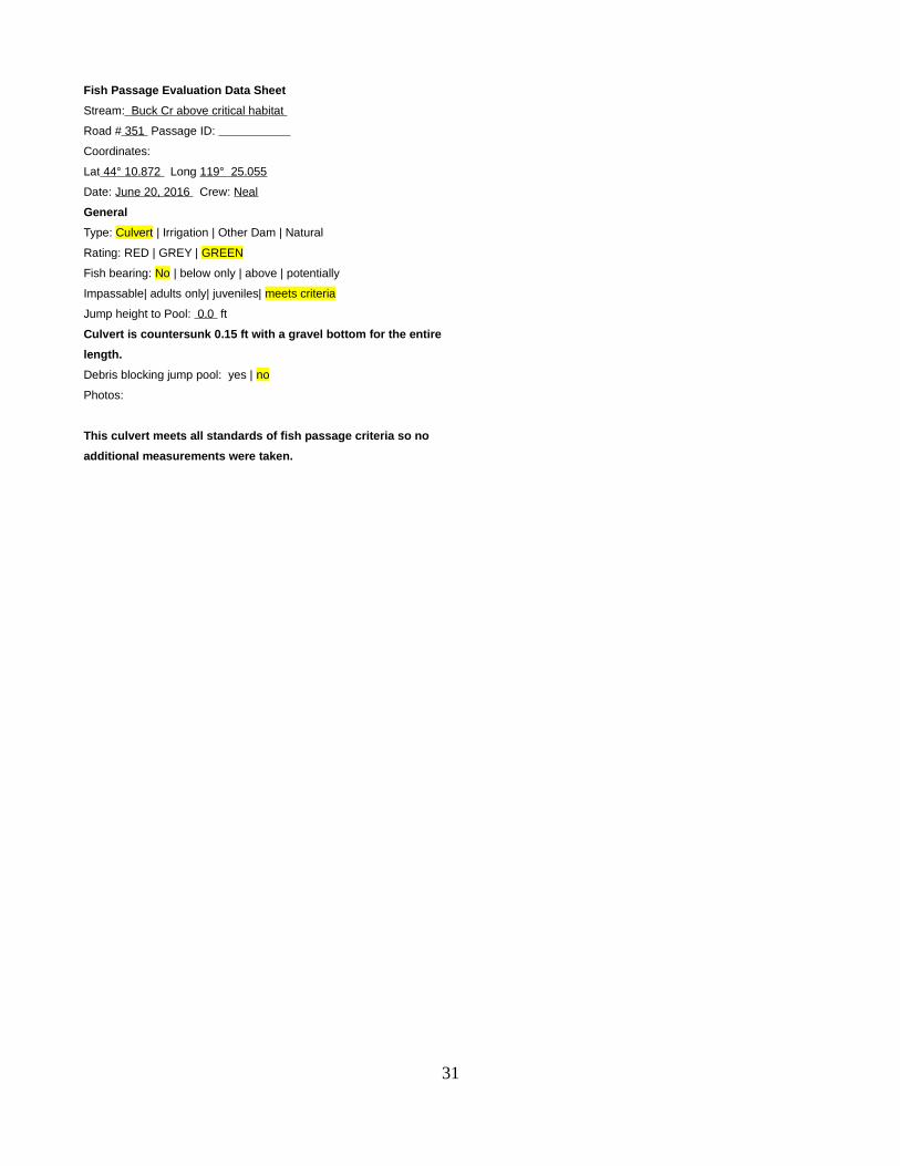
Fish Passage Evaluation Data Sheet
Stream: Buck Cr above critical habitat
Road # 351 Passage ID:
Coordinates:
Lat 44 ° 10.872 Long 119 ° 25.055
Date: June 20, 2016 Crew: Neal
General
Type: Culvert | Irrigation | Other Dam | Natural
Rating: RED | GREY | GREEN
Fish bearing: No | below only | above | potentially
Impassable| adults only| juveniles| meets criteria
Jump height to Pool: 0.0 ft
Culvert is countersunk 0.15 ft with a gravel bottom for the entire
length.
Debris blocking jump pool: yes | no
Photos:
This culvert meets all standards of fish passage criteria so no
additional measurements were taken.
31
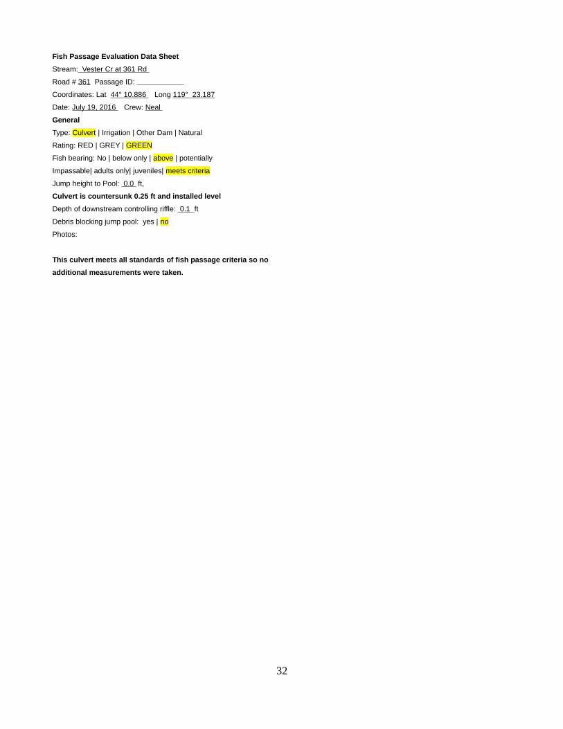
Fish Passage Evaluation Data Sheet
Stream: Vester Cr at 361 Rd
Road # 361 Passage ID:
Coordinates: Lat 44 ° 10.886 Long 119 ° 23.187
Date: July 19, 2016 Crew: Neal
General
Type: Culvert | Irrigation | Other Dam | Natural
Rating: RED | GREY | GREEN
Fish bearing: No | below only | above | potentially
Impassable| adults only| juveniles| meets criteria
Jump height to Pool: 0.0 ft,
Culvert is countersunk 0.25 ft and installed level
Depth of downstream controlling riffle: 0.1 ft
Debris blocking jump pool: yes | no
Photos:
This culvert meets all standards of fish passage criteria so no
additional measurements were taken.
32

Fish Passage Evaluation Data Sheet
Stream: Blue Cr at 24 Rd
Road # 24 Passage ID:
Coordinates: Lat 44 ° 12.402 Long 119 ° 22.851
Date: July 14, 2016 Crew: Neal
General
Type: Culvert | Irrigation | Other Dam | Natural
Rating: RED | GREY | GREEN
Fish bearing: No | below only | above | potentially
Impassable| adults only| juveniles| meets criteria
Jump height to Pool: - 0.6 ft,
Depth of jump Pool: 0.0 ft
Length of jump Pool: 0.0 ft
Depth of downstream controlling riffle: 0.1 ft
Debris blocking jump pool: yes | no
Culvert is countersunk 0.6 ft at outlet with cobble and gravel inside the
entire length.
Photos:
This culvert meets all standards of fish passage criteria so no
additional measurements were taken.
33

Fish Passage Evaluation Data Sheet
Stream: Corral Cr. (Upper end of Sthd critical habitat
Road # 450 Passage ID:
Coordinates: Lat 44 °09.850 Long 119 °21.587
Date: July 7, 2016 Crew: Neal
General
Type: Culvert | Irrigation | Other Dam | Natural
Rating: RED | GREY | GREEN
Fish bearing: No | below only | above | potentially
Impassable| adults only| juveniles| meets criteria
Jump height to Pool: 0.1 ft,
Depth of jump Pool: 0.1 ft (filled with boulders)
Length of jump Pool: 3.5 ft
Depth of downstream controlling riffle: 0.1 ft
Debris blocking jump pool: yes | no
Photos:
This culvert meets all standards of fish passage criteria so no
additional measurements were taken.
34

Fish Passage Evaluation Data Sheet
Stream: Corral Cr mid-lower
Road # 157 Passage ID:
Coordinates: Lat 44 ° 11.334 Long 119 °21.414
Date: July 12, 2016 Crew: Neal
General
Type: Culvert | Irrigation | Other Dam | Natural
Rating: RED | GREY | GREEN
Fish bearing: No | below only | above | potentially
Impassable| adults only| juveniles| meets criteria
Jump height to Pool: 0.0 ft
Depth of jump Pool: 0.2 ft
Length of jump Pool: 3.0 ft
Depth of downstream controlling riffle: 0.1 ft
Debris blocking jump pool: yes | no
Photos:
This culvert meets all standards of fish passage criteria so no
additional measurements were taken.
35

Fish Passage Evaluation Data Sheet
Stream: Corral Cr. Lower
Road # 450 Passage ID:
Coordinates: Lat 44 ° 12.029 Long 119 ° 21.374
Date: July 12,2016 Crew: Neal
General
Type: Culvert | Irrigation | Other Dam | Natural
Rating: RED | GREY | GREEN
Fish bearing: No | below only | above | potentially
Impassable| adults only| juveniles| meets criteria
Jump height to Pool: 0.0 ft
Depth of jump Pool: 0.33 ft
Length of jump Pool: 12.0 ft
Depth of downstream controlling riffle: 0.1 ft
Debris blocking jump pool: yes | no
Photos:
This culvert meets all standards of fish passage criteria so no
additional measurements were taken.
36