South Cumberland State Park - Savage Gulf Natural€¦ · · 2017-12-19Map Symbols Trails Scale...
2
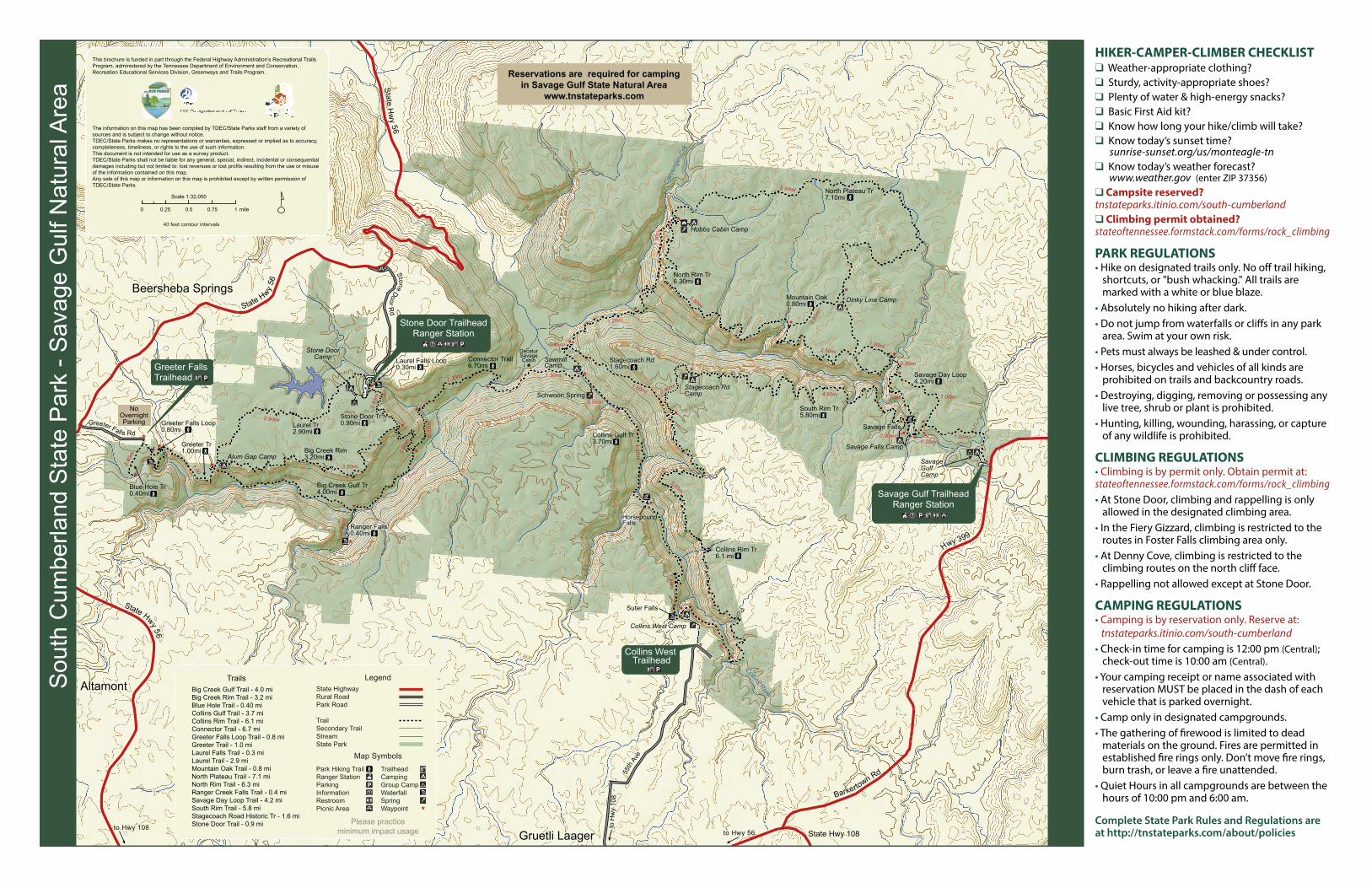
1 , 8 0 0 1 ,8 0 0 1 , 8 0 0 1 , 8 0 0 1,4 0 0 1 , 4 0 0 1 , 6 0 0 1 , 0 0 0 1 , 4 0 0 1 , 4 0 0 1 , 2 0 0 1 , 0 0 0 1 , 8 0 0 1 , 8 00 1 , 80 0 1 , 2 0 0 1 , 2 0 0 1, 8 0 0 1, 600 2 , 0 0 0 Laurel Tr 2.90mi Stone Door Tr 0.90mi Big Creek Rim 3.20mi Greeter Tr 1.00mi Big Creek Gulf Tr 4.00mi Ranger Falls 0.40mi Connector Trail 6.70mi Stagecoach Rd 1.60mi North Plateau Tr 7.10mi North Rim Tr 6.30mi Mountain Oak 0.80mi South Rim Tr 5.80mi Collins Gulf Tr 3.70mi Blue Hole Tr 0.40mi Savage Day Loop 4.20mi Laurel Falls Loop 0.30mi Greeter Falls Loop 0.80mi Collins Rim Tr 6.1 mi B ar ker tow n Rd H w y 39 9 S t a t e H w y 5 6 S t ate H w y 5 6 Stat e H w y 5 6 S t o n e D o o r R d Gre e t er F a ll s Rd State Hwy 108 5 5 t h A v e Collins River Carvenger Crk 1.30mi 1.60mi 0.90mi 0.90mi 1.15mi 1.95mi 2.90mi 3.20mi 1.00 0.40mi 0.45mi 1.20mi 0.90mi 3.50mi 5.90mi 2.50mi 4.60mi 0.50mi 1.30mi 1.90mi 5.20mi 0.90 1.20mi 0.80mi 1.00mi 1.00mi 0.30mi 0.20mi 1.00mi 0.30mi 1.90mi 0.55mi 0.40mi 1.30mi Horsepound Falls Suter Falls Schwoon Spring Decatur Savage Cabin Savage Falls Altamont Gruetli Laager to Hwy 108 to Hwy 56 to Hwy 108 Beersheba Springs Hobbs Cabin Camp Dinky Line Camp Savage Falls Camp Savage Gulf Camp Stagecoach Rd Camp Sawmill Camp Alum Gap Camp Collins West Camp Stone Door Camp The information on this map has been compiled by TDEC/State Parks staff from a variety of sources and is subject to change without notice. TDEC/State Parks makes no representations or warranties, expressed or implied as to accuracy, completeness, timeliness, or rights to the use of such information. This document is not intended for use as a survey product. TDEC/State Parks shall not be liable for any general, special, indirect, incidental or consequential damages including but not limited to: lost revenues or lost profits resulting from the use or misuse of the information contained on this map. Any sale of this map or information on this map is prohibited except by written permission of TDEC/State Parks. 40 feet contour intervals South Cumberland State Park - Savage Gulf Natural Area State Highway Rural Road Park Road Trail Secondary Trail Stream State Park Big Creek Gulf Trail - 4.0 mi Big Creek Rim Trail - 3.2 mi Blue Hole Trail - 0.40 mi Collins Gulf Trail - 3.7 mi Collins Rim Trail - 6.1 mi Connector Trail - 6.7 mi Greeter Falls Loop Trail - 0.8 mi Greeter Trail - 1.0 mi Laurel Falls Trail - 0.3 mi Laurel Trail - 2.9 mi Mountain Oak Trail - 0.8 mi North Plateau Trail - 7.1 mi North Rim Trail - 6.3 mi Ranger Creek Falls Trail - 0.4 mi Savage Day Loop Trail - 4.2 mi South Rim Trail - 5.8 mi Stagecoach Road Historic Tr - 1.6 mi Stone Door Trail - 0.9 mi Greeter Falls Trailhead Stone Door Trailhead Ranger Station Savage Gulf Trailhead Ranger Station Collins West Trailhead No Overnight Parking Reservations are required for camping in Savage Gulf State Natural Area www.tnstateparks.com Please practice minimum impact usage This brochure is funded in part through the Federal Highway Administration’s Recreational Trails Program, administered by the Tennessee Department of Environment and Conservation, Recreation Educational Services Division, Greenways and Trails Program. Park Hiking Trail Ranger Station Parking Information Restroom Picnic Area Trailhead Camping Group Camp Waterfall Spring Waypoint Legend Map Symbols Trails Scale 1:32,000 0 0.25 0.5 0.75 1 mile HIKER-CAMPER-CLIMBER CHECKLIST ❑ Weather-appropriate clothing? ❑ Sturdy, activity-appropriate shoes? ❑ Plenty of water & high-energy snacks? ❑ Basic First Aid kit? ❑ Know how long your hike/climb will take? ❑ Know today’s sunset time? sunrise-sunset.org/us/monteagle-tn ❑ Know today’s weather forecast? www.weather.gov (enter ZIP 37356) ❑ Campsite reserved? tnstateparks.itinio.com/south-cumberland ❑ Climbing permit obtained? stateoftennessee.formstack.com/forms/rock_climbing PARK REGULATIONS • Hike on designated trails only. No off trail hiking, shortcuts, or "bush whacking." All trails are marked with a white or blue blaze. • Absolutely no hiking after dark. • Do not jump from waterfalls or cliffs in any park area. Swim at your own risk. • Pets must always be leashed & under control. • Horses, bicycles and vehicles of all kinds are prohibited on trails and backcountry roads. • Destroying, digging, removing or possessing any live tree, shrub or plant is prohibited. • Hunting, killing, wounding, harassing, or capture of any wildlife is prohibited. CLIMBING REGULATIONS • Climbing is by permit only. Obtain permit at: stateoftennessee.formstack.com/forms/rock_climbing • At Stone Door, climbing and rappelling is only allowed in the designated climbing area. • In the Fiery Gizzard, climbing is restricted to the routes in Foster Falls climbing area only. • At Denny Cove, climbing is restricted to the climbing routes on the north cliff face. • Rappelling not allowed except at Stone Door. CAMPING REGULATIONS • Camping is by reservation only. Reserve at: tnstateparks.itinio.com/south-cumberland • Check-in time for camping is 12:00 pm (Central); check-out time is 10:00 am (Central). • Your camping receipt or name associated with reservation MUST be placed in the dash of each vehicle that is parked overnight. • Camp only in designated campgrounds. • The gathering of firewood is limited to dead materials on the ground. Fires are permitted in established fire rings only. Don’t move fire rings, burn trash, or leave a fire unattended. • Quiet Hours in all campgrounds are between the hours of 10:00 pm and 6:00 am. Complete State Park Rules and Regulations are at http://tnstateparks.com/about/policies
Transcript of South Cumberland State Park - Savage Gulf Natural€¦ · · 2017-12-19Map Symbols Trails Scale...
1,800 1 ,800
1,800
1 ,800
1,400
1,400
1,600
1,00 0
1 ,400
1,400
1 ,200
1,0 00
1, 800
1,80
0
1,800
1,200
1 ,200
1, 800
1,600
2,000
Laurel Tr2.90mi
Stone Door Tr0.90mi
Big Creek Rim3.20mi
Greeter Tr1.00mi
Big Creek Gulf Tr4.00mi
Ranger Falls0.40mi
Connector Trail6.70mi
Stagecoach Rd1.60mi
North Plateau Tr7.10mi
North Rim Tr6.30mi
Mountain Oak0.80mi
South Rim Tr5.80mi
Collins Gulf Tr3.70mi
Blue Hole Tr0.40mi
Savage Day Loop4.20mi
Laurel Falls Loop0.30mi
Greeter Falls Loop0.80mi
Collins Rim Tr6.1 mi
Barkertown Rd
Hwy 399
State Hw
y 56
State Hwy 56
State Hwy 56
Stone Door Rd
Greeter Falls Rd
State Hwy 108
55th
Ave
Collins River
Carv
enge
r Crk
1.30mi
1.60mi
0.90
mi
0.90
mi
1.15mi1.95mi
2.90mi
3.20mi1.00
0.40
mi
0.45mi
1.20mi
0.90mi
3.50mi
5.90mi
2.50mi
4.60mi0.50mi
1.30mi
1.90mi
5.20mi
0.90
1.20mi
0.80
mi
1.00mi
1.00mi
0.30mi0.20mi
1.00mi
0.30mi
1.90
mi
0.55
mi
0.40
mi
1.30mi
HorsepoundFalls
Suter Falls
Schwoon Spring
DecaturSavageCabin
Savage Falls
Altamont
Gruetli Laager
to H
wy
108
to Hwy 56to Hwy 108
Beersheba Springs
Hobbs Cabin Camp
Dinky Line Camp
Savage Falls Camp
SavageGulfCamp
Stagecoach RdCamp
SawmillCamp
Alum Gap Camp
Collins West Camp
Stone DoorCamp
The information on this map has been compiled by TDEC/State Parks staff from a variety of sources and is subject to change without notice.TDEC/State Parks makes no representations or warranties, expressed or implied as to accuracy, completeness, timeliness, or rights to the use of such information.This document is not intended for use as a survey product.TDEC/State Parks shall not be liable for any general, special, indirect, incidental or consequential damages including but not limited to: lost revenues or lost profits resulting from the use or misuse of the information contained on this map.Any sale of this map or information on this map is prohibited except by written permission of TDEC/State Parks.
40 feet contour intervals
Sou
th C
umbe
rland
Sta
te P
ark
- Sav
age
Gul
f Nat
ural
Are
a
State HighwayRural RoadPark Road
TrailSecondary TrailStreamState Park
Big Creek Gulf Trail - 4.0 miBig Creek Rim Trail - 3.2 miBlue Hole Trail - 0.40 miCollins Gulf Trail - 3.7 miCollins Rim Trail - 6.1 miConnector Trail - 6.7 miGreeter Falls Loop Trail - 0.8 miGreeter Trail - 1.0 miLaurel Falls Trail - 0.3 miLaurel Trail - 2.9 miMountain Oak Trail - 0.8 miNorth Plateau Trail - 7.1 miNorth Rim Trail - 6.3 miRanger Creek Falls Trail - 0.4 miSavage Day Loop Trail - 4.2 mi South Rim Trail - 5.8 miStagecoach Road Historic Tr - 1.6 miStone Door Trail - 0.9 mi
Greeter FallsTrailhead
Stone Door TrailheadRanger Station
Savage Gulf TrailheadRanger Station
Collins West Trailhead
NoOvernightParking
Reservations are required for campingin Savage Gulf State Natural Area
www.tnstateparks.com
Please practiceminimum impact usage
This brochure is funded in part through the Federal Highway Administration’s Recreational Trails Program, administered by the Tennessee Department of Environment and Conservation, Recreation Educational Services Division, Greenways and Trails Program.
Park Hiking TrailRanger StationParkingInformationRestroomPicnic Area
TrailheadCampingGroup CampWaterfallSpringWaypoint
Legend
Map Symbols
Trails
Scale 1:32,000
0 0.25 0.5 0.75 1 mile
HIKER-CAMPER-CLIMBER CHECKLIST❑ Weather-appropriate clothing?❑ Sturdy, activity-appropriate shoes?❑ Plenty of water & high-energy snacks?❑ Basic First Aid kit?❑ Know how long your hike/climb will take?❑ Know today’s sunset time?
sunrise-sunset.org/us/monteagle-tn❑ Know today’s weather forecast?
www.weather.gov (enter ZIP 37356)❑ Campsite reserved?tnstateparks.itinio.com/south-cumberland❑ Climbing permit obtained?stateoftennessee.formstack.com/forms/rock_climbing
PARK REGULATIONS• Hike on designated trails only. No off trail hiking,
shortcuts, or "bush whacking." All trails are marked with a white or blue blaze.
• Absolutely no hiking after dark.• Do not jump from waterfalls or cliffs in any park
area. Swim at your own risk.• Pets must always be leashed & under control.• Horses, bicycles and vehicles of all kinds are
prohibited on trails and backcountry roads. • Destroying, digging, removing or possessing any
live tree, shrub or plant is prohibited.• Hunting, killing, wounding, harassing, or capture
of any wildlife is prohibited.
CLIMBING REGULATIONS• Climbing is by permit only. Obtain permit at:stateoftennessee.formstack.com/forms/rock_climbing• At Stone Door, climbing and rappelling is only
allowed in the designated climbing area. • In the Fiery Gizzard, climbing is restricted to the
routes in Foster Falls climbing area only. • At Denny Cove, climbing is restricted to the
climbing routes on the north cliff face.• Rappelling not allowed except at Stone Door.
CAMPING REGULATIONS• Camping is by reservation only. Reserve at: tnstateparks.itinio.com/south-cumberland• Check-in time for camping is 12:00 pm (Central);
check-out time is 10:00 am (Central).• Your camping receipt or name associated with
reservation MUST be placed in the dash of each vehicle that is parked overnight.
• Camp only in designated campgrounds. • The gathering of firewood is limited to dead
materials on the ground. Fires are permitted in established fire rings only. Don’t move fire rings, burn trash, or leave a fire unattended.
• Quiet Hours in all campgrounds are between the hours of 10:00 pm and 6:00 am.
Complete State Park Rules and Regulations are at http://tnstateparks.com/about/policies
South Cumberland State ParkVisitor Center
11745 US 41Monteagle, TN 37356
(931) 924-2980
Stone Door Ranger Station1183 Stone Door RdBeersheba Springs, TN 37305(931) 692-3887OVERNIGHT PARKING FOR CAMPING ONLYDistance from Visitor Center: 25.7 miles
Savage Gulf Ranger Station3177 State Road 399Palmer, TN 37365(931) 779-3532OVERNIGHT PARKING FOR CAMPING ONLYDistance from Visitor Center: 27.0 miles
Foster Falls (Fiery Gizzard - South End)498 Foster Falls RdSequatchie, TN 37374OVERNIGHT PARKING FOR CAMPING ONLDistance from Visitor Center: 12.6 miles
Grundy Forest (Fiery Gizzard - North End)131 Fiery Gizzard RdTracy City, TN 37387OVERNIGHT PARKING FOR CAMPING ONLDistance from Visitor Center: 4.4 miles
Collins West Parking Area2689 55th Ave (approx)Gruetli-Laager, TN 37339OVERNIGHT PARKING FOR CAMPING ONLYDistance from Visitor Center: 22.6 miles
Greeter Falls Parking Area550 Greeter Falls Rd (approx)Altamont, TN 37301NO OVERNIGHT PARKINGDistance from Visitor Center: 21.2 miles
Grundy Lakes587 Lakes RdTracy City, TN 37387NO OVERNIGHT PARKINGDistance from Visitor Center: 4.7 miles
Sewanee Natural Bridge591 Natural Bridge RdSewanee, TN 37375NO OVERNIGHT PARKINGDistance from Visitor Center: 10.6 miles
Carter State Natural AreaBuggytop Cave / Lost Cove8398 Sherwood Rd (Hwy 56)Sherwood, TN 37376 NO OVERNIGHT PARKINGDistance from Visitor Center: 14.4 miles
I24
I24
I24
N
S
EW 399
56
8
108
108
56
28
28
56
50
108
72
41A
41
41
STONE DOORRANGER STATION
GRUNDYLAKES
COLLINSWEST
GREETERFALLS
SAVAGE GULFSTATE NATURAL
AREA
TO NASHVILLE
TO CHATTANOOGA
NATURALSEWANEE
BRIDGE
156
156
SOUTH CUMBERLANDSTATE PARK
VISITOR CENTER
FOSTER FALLS
GIZZARDFIERY
SHERWOODFOREST
BUGGYTOPCAVE
DENNYCOVE
41A
41
SAVAGE GULFRANGER STATION
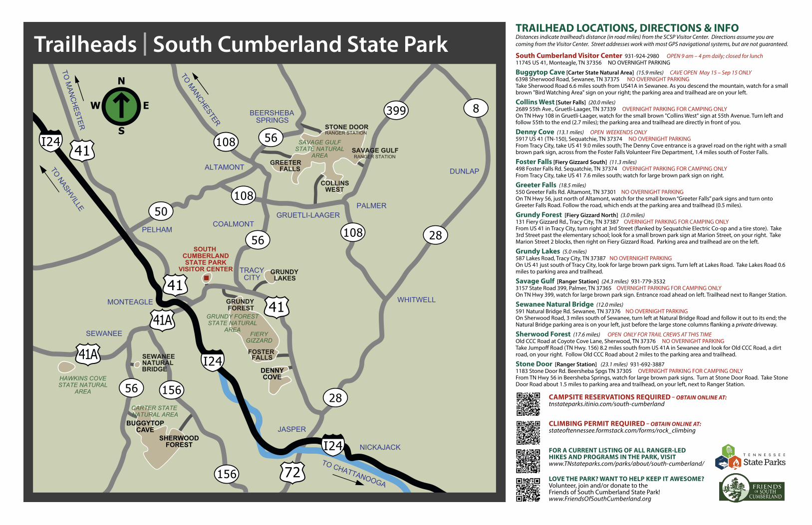
Trailheads | South Cumberland State Park
TO MANCHESTER
TO M
ANC
HESTER
GRUNDY FORESTSTATE NATURAL
AREA
CARTER STATE NATURAL AREA
HAWKINS COVESTATE NATURAL
AREA
GRUNDY FOREST
MONTEAGLE WHITWELL
JASPER
DUNLAP
SEWANEE
NICKAJACK
PALMER
BEERSHEBASPRINGS
GRUETLI-LAAGER
TRACYCITY
COALMONTPELHAM
ALTAMONT
TRAILHEAD LOCATIONS, DIRECTIONS & INFODistances indicate trailhead’s distance (in road miles) from the SCSP Visitor Center. Directions assume you are coming from the Visitor Center. Street addresses work with most GPS navigational systems, but are not guaranteed.
South Cumberland Visitor Center 931-924-2980 OPEN 9 am – 4 pm daily; closed for lunch11745 US 41, Monteagle, TN 37356 NO OVERNIGHT PARKING
Buggytop Cave [Carter State Natural Area] (15.9 miles) CAVE OPEN May 15 – Sep 15 ONLY6398 Sherwood Road, Sewanee, TN 37375 NO OVERNIGHT PARKINGTake Sherwood Road 6.6 miles south from US41A in Sewanee. As you descend the mountain, watch for a small brown "Bird Watching Area" sign on your right; the parking area and trailhead are on your left.
Collins West [Suter Falls] (20.0 miles)2689 55th Ave., Gruetli-Laager, TN 37339 OVERNIGHT PARKING FOR CAMPING ONLYOn TN Hwy 108 in Gruetli-Laager, watch for the small brown "Collins West" sign at 55th Avenue. Turn left and follow 55th to the end (2.7 miles); the parking area and trailhead are directly in front of you.
Denny Cove (13.1 miles) OPEN WEEKENDS ONLY5917 US 41 (TN-150), Sequatchie, TN 37374 NO OVERNIGHT PARKINGFrom Tracy City, take US 41 9.0 miles south; The Denny Cove entrance is a gravel road on the right with a small brown park sign, across from the Foster Falls Volunteer Fire Department, 1.4 miles south of Foster Falls.
Foster Falls [Fiery Gizzard South] (11.3 miles)498 Foster Falls Rd. Sequatchie, TN 37374 OVERNIGHT PARKING FOR CAMPING ONLYFrom Tracy City, take US 41 7.6 miles south; watch for large brown park sign on right.
Greeter Falls (18.5 miles)550 Greeter Falls Rd. Altamont, TN 37301 NO OVERNIGHT PARKINGOn TN Hwy 56, just north of Altamont, watch for the small brown “Greeter Falls” park signs and turn onto Greeter Falls Road. Follow the road, which ends at the parking area and trailhead (0.5 miles).
Grundy Forest [Fiery Gizzard North] (3.0 miles)131 Fiery Gizzard Rd., Tracy City, TN 37387 OVERNIGHT PARKING FOR CAMPING ONLYFrom US 41 in Tracy City, turn right at 3rd Street (flanked by Sequatchie Electric Co-op and a tire store). Take 3rd Street past the elementary school; look for a small brown park sign at Marion Street, on your right. Take Marion Street 2 blocks, then right on Fiery Gizzard Road. Parking area and trailhead are on the left.
Grundy Lakes (5.0 miles) 587 Lakes Road, Tracy City, TN 37387 NO OVERNIGHT PARKINGOn US 41 just south of Tracy City, look for large brown park signs. Turn left at Lakes Road. Take Lakes Road 0.6 miles to parking area and trailhead.
Savage Gulf [Ranger Station] (24.3 miles) 931-779-3532 3157 State Road 399, Palmer, TN 37365 OVERNIGHT PARKING FOR CAMPING ONLYOn TN Hwy 399, watch for large brown park sign. Entrance road ahead on left. Trailhead next to Ranger Station.
Sewanee Natural Bridge (12.0 miles)591 Natural Bridge Rd. Sewanee, TN 37376 NO OVERNIGHT PARKINGOn Sherwood Road, 3 miles south of Sewanee, turn left at Natural Bridge Road and follow it out to its end; the Natural Bridge parking area is on your left, just before the large stone columns flanking a private driveway.
Sherwood Forest (17.6 miles) OPEN ONLY FOR TRAIL CREWS AT THIS TIMEOld CCC Road at Coyote Cove Lane, Sherwood, TN 37376 NO OVERNIGHT PARKINGTake Jumpoff Road (TN Hwy. 156) 8.2 miles south from US 41A in Sewanee and look for Old CCC Road, a dirt road, on your right. Follow Old CCC Road about 2 miles to the parking area and trailhead.
Stone Door [Ranger Station] (23.1 miles) 931-692-3887 1183 Stone Door Rd. Beersheba Spgs TN 37305 OVERNIGHT PARKING FOR CAMPING ONLYFrom TN Hwy 56 in Beersheba Springs, watch for large brown park signs. Turn at Stone Door Road. Take Stone Door Road about 1.5 miles to parking area and trailhead, on your left, next to Ranger Station.
CAMPSITE RESERVATIONS REQUIRED – OBTAIN ONLINE AT:tnstateparks.itinio.com/south-cumberland
CLIMBING PERMIT REQUIRED – OBTAIN ONLINE AT:stateoftennessee.formstack.com/forms/rock_climbing
FOR A CURRENT LISTING OF ALL RANGER-LED HIKES AND PROGRAMS IN THE PARK, VISIT www.TNstateparks.com/parks/about/south-cumberland/
LOVE THE PARK? WANT TO HELP KEEP IT AWESOME?Volunteer, join and/or donate to the Friends of South Cumberland State Park!www.FriendsOfSouthCumberland.org