South Cooper Mountain Community Plan - Beaverton, Oregon
43
South Cooper Mountain Community Plan December 2014
Transcript of South Cooper Mountain Community Plan - Beaverton, Oregon
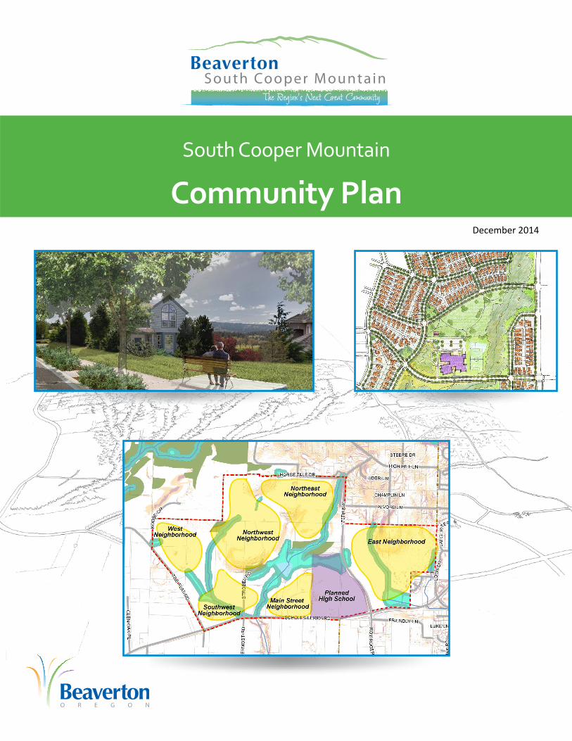
South Cooper Mountain
Community PlanDecember 2014

Funding for the South Cooper Mountain Concept & Community Plans was provided by Metro Community Planning & Development Grants, private contributions, and the City of Beaverton.

ACKNOWLEDGEMENTS
South Cooper Mountain Community Plan Page i November 26, 2014
Beaverton City Council Beaverton Planning
Commission Cate Arnold Mimi Doukas, Vice Chair
Betty Bode Greg Kiene
Denny Doyle, Mayor Jennifer Nye
Mark Fagin, Council President Kim Overhage, Chair
Ian King Ric Stephens
Marc San Soucie Linda Wilson
Scott Winter
South Cooper Mountain Citizens Advisory Committee
Ed Bartholemy, South Cooper Mountain (SCM) property owner
Ed Chadwick, Bierly Family properties, SCM
Kathy Cobb, Urban Reserve Area property owner
John Cooper, Urban Reserve Area property owner
Mimi Doukas, Chair, City of Beaverton Planning Commission; Kim Overhage (alternate), City
of Beaverton Planning Commission
David Dunahugh, Crescent Grove Cemetery Association, SCM property owner
Ron Dyches, Dyches Family LLC, SCM property owner
David Harrison, Beaverton Committee for Community Involvement (BCCI)
Liles Garcia, Washington County Planning Commission, Community Planning Organization 6
Matt Grady, Gramor Development
Dan Grimberg, Arbor Homes/Crescent Grove Cemetery property interest
Barbara Gross, Cooper Mountain Winery, North Cooper Mountain (NCM) and SCM property
owner
Alton Harvey, Neighbors Southwest Neighborhood Association Committee (NAC)
Martin Moore, Urban Reserve Area property owner
Jamie Morgan-Stasny, Metropolitan Land Group, SCM property owner
Boyce Smith, NCM property owner; Lori Smith (alternate), NCM property owner
Brian Wegener, Tualatin Riverkeepers
Ramsey Weit, Community Housing Fund
Justin Wood, Homebuilders Association
Please see Appendix A for Project Committees and Team.

South Cooper Mountain Community Plan Page ii November 26, 2014
TABLE OF CONTENTS Introduction ................................................................................................................................... 1
Community Plan Boundary ........................................................................................................ 1
About the South Cooper Mountain Community Plan and Concept Plan ................................... 1
Planning Process ...................................................................................................................... 6
Planning Area Context .................................................................................................................. 7
Landscape Setting ..................................................................................................................... 7
Transportation Context .............................................................................................................. 8
Services and Service Providers ................................................................................................ 8
Community Plan Elements .......................................................................................................... 10
Guiding Principles: Overarching Policies for the South Cooper Mountain Community Plan ... 10
Land Use ................................................................................................................................. 12
Transportation ......................................................................................................................... 22
Resource Protection and Enhancement .................................................................................. 27
Infrastructure Provision ........................................................................................................... 31

South Cooper Mountain Community Plan Page 1 November 26, 2014
INTRODUCTION
Community Plan Boundary The South Cooper Mountain Community Plan encompasses approximately 544 acres located at the southwest edge of the City of Beaverton (see Figure 1). This area, referred to in this plan as the Community Plan area, was added to the Urban Growth Boundary in 2011 and was annexed by the City of Beaverton in 2013.1 The plan area is located generally north of SW Scholls Ferry Road, south of Horse Tale Drive, east of SW Tile Flat Road, and west of SW Loon Drive. The Community Plan area boundary is shown in Figure 2.
About the South Cooper Mountain Community Plan and Concept Plan The South Cooper Mountain Community Plan (Community Plan) was created as part of a larger planning effort that produced the South Cooper Mountain Concept Plan (Concept Plan). The Concept and Community Plans were developed through an intergovernmental process with extensive community involvement, described beginning on page 6. The geographic scope and role of each document are summarized below.
South Cooper Mountain Concept Plan The Concept Plan establishes the overall vision and long range planning strategies2 for South Cooper Mountain, and guides comprehensive planning for areas within the Urban Growth Boundary (UGB). There are three subareas referenced in Concept Plan:
The South Cooper Mountain Annexation Area, now referred to as the South Cooper Mountain Community Plan area – the 544-acre area within the UGB and the City of Beaverton that is the subject of this Community Plan;3
The Urban Reserve Area – the 1,242-acre area of land designated as Urban Reserve north of the Community Plan area;4 and
1 During much of the process that led to the creation of this plan, this area was referred to as the South Cooper Mountain Annexation Area (SCMAA).
2 The Concept Plan includes near-term recommendations which guide planning and development in the next twenty years, and long-term recommendations intended to guide planning and development in the 20-50 year time frame.
3 This is the subject area of this Community Plan, and is referred to herein as the Community Plan area.
4 The Urban Reserve adjacent to the Community Plan area was called Urban Reserve 6B during the Urban and Rural Reserves designation process. For more on the Urban and Rural Reserves program, visit http://www.oregonmetro.gov/index.cfm/go/by.web/id=26257.
Figure 1: Community Plan Context Map

South Cooper Mountain Community Plan Page 2 November 26, 2014
North Cooper Mountain – a 504-acre area included within the Urban Growth Boundary in 2002 that is within the urban area of unincorporated Washington County.
These subareas are displayed in Figure 3.
Pursuant to Metro Urban Growth Management Functional Plan (UGMFP) Title 11,5 a concept plan is intended to guide, not bind, amendments to city or county comprehensive plans or land use regulations following addition of an area to the UGB. The SCM Concept Plan lays the groundwork for amendments to City of Beaverton and Washington County comprehensive plans and land use regulations that will implement the plan. The Concept Plan also serves to guide and help coordinate future planning and infrastructure investments by the City of Beaverton and other service providers. The Concept Plan sets the stage for: coordinated and cohesive land use patterns; transportation networks; trails, bicycle and pedestrian networks; natural resource protection; access to Cooper Mountain Nature Park; public services and facilities; and infrastructure funding.
In compliance with Metro requirements,6 the Concept Plan is inclusive of land within the 1,242 acre
5 Metro UGMFP Title 11, section 3.07.1110 Planning for Areas Designated Urban Reserve.
6 Metro Ord. No. 11-1264B, Exhibit B, South Cooper Mountain, condition #1: “The city of Beaverton, in coordination with Washington County and Metro, shall adopt comprehensive plan provisions and land use regulations for Area 3 to authorize urbanization, pursuant to Metro Code section 3.07.1120. To implement Principle 1 of Exhibit B to the Reserves IGA between Metro and Washington County, the city shall undertake and complete this planning for the whole of Urban Reserve Area 6B, in order to provide appropriate protection and enhancement to the public lands and natural features, and protect and enhance the integrity of Titles 3 and 13 resources in the area. Planning for trail and pedestrian and bicycle travel shall be coordinated with Metro and the county to ensure appropriate access to Cooper Mountain Nature Park.”
Figure 2: SCM Community Plan Boundary Map

South Cooper Mountain Community Plan Page 3 November 26, 2014
Urban Reserve Area, as well as the 544-acre area recently added to the UGB and annexed into Beaverton.
The landscape character of the Concept Pan area is illustrated in Figure 4, and the Concept Plan map is shown in Figure 5.
Figure 3: South Cooper Mountain Concept Plan Subareas

South Cooper Mountain Community Plan Page 4 November 26, 2014
Figure 4: South Cooper Mountain Concept Plan Landscape Character

South Cooper Mountain Community Plan Page 5 November 26, 2014
Figure 5: South Cooper Mountain Concept Plan Map

South Cooper Mountain Community Plan Page 6 November 26, 2014
South Cooper Mountain Community Plan The South Cooper Mountain Community Plan is part of the City’s Comprehensive Plan. It provides regulatory policies and maps, along with descriptions and illustrations of the context for those policies and maps. The Community Plan was developed in compliance with Metro’s requirements for new urban areas, which are codified in Title 11 of Metro’s Urban Growth Management Functional Plan. It addresses only the 544 acres that are within the City of Beaverton, and is intended to implement the vision established by the Concept Plan for the South Cooper Mountain area.
Planning Process The Concept and Community Plans were developed through an 18-month planning process that included a variety of opportunities for input from stakeholders and the general public. A Technical Advisory Committee (TAC) composed of staff from affected jurisdictions, agencies, service providers and districts, provided input and guidance to the project team about technical aspects of the planning process. A Citizens Advisory Committee (CAC) composed of community representatives including residents, property owners, businesses, developers, city and county planning commissioners, citizen involvement organizations, advocacy groups, and other affected stakeholders provided feedback to the project team throughout the planning process. In addition, the Beaverton City Council and Planning Commission provided direction at key milestones during the planning process. The general public was invited to participate at key points through open houses, online workshops, and community outreach meetings.
The first phase of the planning process included establishment of Guiding Principles for the project (see page 10) followed by study and documentation of existing conditions and future needs in the planning area. The project team evaluated land use, transportation, the real estate market, water and sewer infrastructure, stormwater, natural resources, parks, and energy as a part of the existing conditions assessment.7
The second phase of the project began with a visioning workshop, attended by roughly 60 interested parties, with another 20 people participating through an online version of the workshop. This workshop solicited input on priorities and preferences for future land use and transportation scenarios in the Concept Plan area. Results of this workshop were used to develop three initial Concept Plan “scenarios” addressing future land use and transportation patterns for the planning area.8 These three scenarios were vetted by the project’s TAC and CAC and then fully analyzed to evaluate and compare transportation, infrastructure, park, school, natural resource, and land use implications. Based on the findings from the scenario evaluation, two hybrid scenarios were created that combined the best-performing elements of the three original scenarios. The two hybrid scenarios were discussed by the TAC and CAC and shared with the public at an open house and community outreach meetings. Based on input from those groups, a preferred scenario was developed. That preferred scenario became the basis for the Concept Plan and for the more detailed and refined set of recommendations that are embodied in this Community Plan.
7 South Cooper Mountain Concept & Community Plans, SUMMARY REPORT: Existing Conditions & Future Needs, June 6, 2013.
8 South Cooper Mountain Concept & Community Plans, Scenarios for Future Growth, September 12, 2013.

South Cooper Mountain Community Plan Page 7 November 26, 2014
PLANNING AREA CONTEXT
Landscape Setting The Community Plan area sits at the base of the south slope of Cooper Mountain. The topography gradually climbs up in elevation moving north from Scholls Ferry Road (at approximately 300’ elevation), with several small hills and hummocks. There are four distinct high points that present constraints with respect to road connectivity, but also provide opportunities for viewpoints and the shaping of development patterns. Views are primarily to the southwest, capturing the scenic vista of Chehalem Ridge. Views of Mt. Hood to the east are available from the central high point.
The Community Plan area includes three small tributaries of the Tualatin River. The central tributary is surrounded by a chain of linked upland, riparian forest and wetland areas that provide important habitat value. The remaining tributaries have been degraded by farming and forestry activities. All three tributaries are recognized as resource areas under state, regional and local regulations.
Figure 6: Community Plan Area Topography and Resources
Of the 544 total acres in the Community Plan area, roughly 364 acres are considered developable after accounting for natural resource and slope constraints. The 364 acres represent a “gross buildable

South Cooper Mountain Community Plan Page 8 November 26, 2014
acreage”, and includes land for future roads, stormwater management facilities, civic uses such as parks and schools9, and commercial and residential development.
Transportation Context East-west and north-south connections are limited both within and around the Community Plan area, and several important area roadways that serve regional traffic are nearing capacity. SW Scholls Ferry Road and SW 175th Avenue / Roy Rogers Road in particular carry large volumes of through-traffic. North-south commute patterns between Tualatin / Sherwood / Yamhill County and Washington County employment destinations rely heavily on SW 175th Avenue, despite its terrain, narrow width, and sharp curves. SW Tile Flat and SW Grabhorn Roads presently serve more through-traffic than their current rural nature and sharp curves would suggest. SW Tile Flat Road forms the western edge of the UGB in the Community Plan area.
Roads within the Community Plan area are not currently built to urban standards, and need improvements to resolve safety issues and accommodate new growth. There are no sidewalks or bike lanes at this time because existing roads were designed according to rural road standards.10 Other existing issues in the vicinity include the “kink” or hairpin turn on SW 175th Avenue at High Hill Lane, the skewed intersection at SW Kemmer Road and SW 175th Avenue, the multiple 90-degree turns on SW Grabhorn Road, and congestion at the intersection of Roy Rogers Road / 175th Avenue and SW Scholls Ferry Road. The closest transit service is available on SW Scholls Ferry Road at SW Teal Boulevard.
Transportation is the most-often cited concern of area residents, including motorist safety, bicycle and pedestrian safety, and traffic congestion.
Services and Service Providers Service providers for the Community Plan area and the current public facilities and services available to the area are summarized below. Future facilities needed to serve the area are described under “Institutional / Civic Uses” starting on page 15 for schools and parks and under “Infrastructure Provision” starting on page 31 for water, sewer, and stormwater.
Drinking Water & Sanitary Sewer The City of Beaverton will provide drinking water to the Community Plan area, although the Tualatin Valley Water District (TVWD) also has water distribution lines adjacent to the northeastern side of the Community Plan area. The City has existing water lines in SW Loon Drive and within the Churchill Forest subdivision to the east of the Community Plan area as well as a new line within SW Scholls Ferry Road as far west as SW 175th Avenue.
9 The planned Beaverton School District future high school, the location of which has been determined and land has been acquired, is not included in the “developable” acreage.
10 As of the writing of this Community Plan, SW Scholls Ferry Road is being widened by Washington County, including sidewalks and bike lanes within the UGB, with concurrent extension of sanitary sewer and water lines by the cities of Beaverton and Tigard.

South Cooper Mountain Community Plan Page 9 November 26, 2014
The City of Beaverton will be responsible for providing sanitary sewer infrastructure in the Community Plan area through an inter-governmental agreement (IGA) with Clean Water Services (CWS). The closest existing sewer facilities are located to the southeast of the Community Plan area, including a new line recently extended in SW Scholls Ferry Road as far west as SW 175th Avenue.
Fire and Public Safety Tualatin Valley Fire & Rescue (TVF&R) provides fire and emergency medical services in the area. The TVF&R station closest to the Community Plan area is Station 69 on SW 175th Avenue south of SW Kemmer Road.
The Beaverton Police Department (BPD) provides law enforcement within the Community Plan area. All BPD public services are provided through the main police department offices in Beaverton City Hall, which is the base of operations for all BPD personnel. In addition, there are inter-governmental agreements in place for emergency response that allow Sheriff’s deputies from Washington County to respond to calls within city limits based on proximity, regardless of boundaries.
Schools and Parks The Community Plan area is divided, with the Beaverton School District (BSD) serving the eastern portion, and the Hillsboro School District (HSD) serving the western portion. BSD is planning to build a new high school within the Community Plan area, at the northwest corner of SW Scholls Ferry Road and SW 175th Avenue. The site is roughly 45 acres, and will include a comprehensive high school along with sports fields and other facilities. The closest existing BSD elementary school is Scholls Heights Elementary, located just east of the Community Plan area on SW Loon Drive. On the Hillsboro School District (HSD) side, the nearest elementary school is Groner Elementary, which is located several miles west of the plan area.
The Beaverton School Facility Plan was updated and adopted as part of the city’s comprehensive plan in 2010. The Hillsboro School District last updated Population and Enrollment Forecasts in April 2012. These plans were considered in determining the amount of land and improvements needed for public school facilities to serve the SCM Community Plan area, as required by Metro.11
Tualatin Hills Park and Recreation District (THPRD) is anticipated to be the primary park and recreation service provider for the Community Plan area.12 The city’s Development Code currently does not require annexation to THPRD if it can be demonstrated that commensurate parks and recreational facilities can be provided by the developer.13
11 Per Metro UGMFP Title 11, 3.07.1120.C.5.
12 THPRD is the designated service provider for the Community Plan area, as well as for the URA to the north; however, property owners are not required to annex into the district.
13 Per Section 40.93 of the Beaverton Community Development Code (Tualatin Hills Park And Recreation District Annexation Waiver), an applicant may request approval of a Tualatin Hills Park and Recreation District (THPRD) Annexation Waiver which would waive the requirement to annex property into the District as a condition of approval of any development as specified in Section 60.33 of the Development Code. A THPRD annexation waiver may only be requested by the property owner(s) for any development proposed outside of THPRD boundaries who wish to provide their own park and recreation facilities and services rather than annex the site to THPRD.

South Cooper Mountain Community Plan Page 10 November 26, 2014
Libraries The City, as a member of the Washington County Cooperative Library Services (WCCLS) receives funding to support library services from Washington County. The branch closest to the study area is the Beaverton City Library at Murray Scholls, an approximately 10,500 square foot facility located in the Murray Scholls Town Center. The Murray-Scholls branch library is heavily used and the City is currently looking to lease additional space to expand library services in south Beaverton.
Solid Waste & Recycling The City of Beaverton Solid Waste & Recycling program regulates seven franchised haulers and sets rates for the collection of garbage, recycling and yard debris from all customers within the city limits. Waste Management (WM) of Oregon is the hauler in the area.
Electricity & Natural Gas Portland General Electric (PGE) provides electric power to the area in and around the area. There is a new substation located immediately south of the Community Plan area across Scholls Ferry Road.
NW Natural provides natural gas to customers in the vicinity of the Community Plan area. A natural gas transmission pipeline runs down SW Scholls Ferry Road to SW Roy Rogers Road at the southern edge of the Community Plan area and another runs down SW Scholls Ferry Road to SW Pleasant Valley Road southwest of the Community Plan area; a third runs within the power line easement east of the Community Plan area.14
COMMUNITY PLAN ELEMENTS
Guiding Principles: Overarching Policies for the South Cooper Mountain
Community Plan
Context The policies listed below are refined policy statements from the SCM Guiding Principles.15 These policies established the foundation for, and helped shape, the South Cooper Mountain Concept Plan. Developed in 2013, the original Guiding Principles captured ideas from previous planning work and agreements by the City of Beaverton, Metro and Washington County, and, added new vision statements agreed upon by the TAC and the CAC. The principles served as broad criteria for decision making for the entire 2,300-acre SCM Concept Plan area, including the Community Plan area. In this Community Plan, the guiding principles serve as overarching policies.
14 Pipeline and Hazardous Materials Safety Administration, National Pipeline Mapping System Public Map Viewer: https://www.npms.phmsa.dot.gov/PublicViewer/, accessed 4/30/13. These do not include distribution pipelines serving individual users.
15 Please see South Cooper Mountain Concept Plan for the full text of the Guiding Principles.

South Cooper Mountain Community Plan Page 11 November 26, 2014
Overarching Policies
1. Implement the Concept Plan. Implement the South Cooper Mountain Concept Plan in a comprehensive and proactive manner, through the: Comprehensive Plan; Development Code; land use reviews; infrastructure planning; natural resource planning; coordination with service providers; capital improvement planning; community involvement, and other means as needed.
2. Create Beaverton’s next great community. Create a community that is walkable, family-friendly, livable, and includes quality neighborhoods, great green spaces, community focal points, a Main Street, and well-designed development.
3. Create a sustainable community. Create a community that meets the needs of Beaverton and the South Cooper Mountain area today and tomorrow, while minimizing negative environmental, social, and economic impacts. Support low-carbon economies and lifestyles, energy efficiency and security, health and well-being, and ecosystem stewardship; and enable future residents and the broader community to meet their own needs.
4. Implement a realistic funding plan for infrastructure. Work closely with the public and private sector to implement the SCM Infrastructure Funding Plan. Coordinate with Tigard, Washington County, and all service providers to plan, fund and deliver the infrastructure needed to implement community plans on South Cooper Mountain.
5. Provide housing choices. Provide a variety of housing types and densities to provide options for a range of income levels. Provide housing choices consistent with the overall housing needs of Beaverton.
6. Provide transportation options. Provide a well-connected transportation network that promotes options for all modes of travel, and encourages walking, biking and future transit service. Address north-south, east-west, and other regional travel issues in coordination with neighboring cities, Washington County, Metro, Tri-Met and Oregon Department of Transportation.
7. Provide appropriate protection, enhancement and access to Cooper Mountain’s natural resources and public lands. Avoid and minimize impacts, protect key natural resources, and design new growth so that it is integrated with natural areas and other open spaces. Provide appropriately located access to natural areas and open space.
8. Coordinate with regional requirements and plans. Coordinate with Metro, Washington County, Tigard and other governments regarding Urban Growth Boundary expansion areas and Urban Reserves. Coordinate transportation planning with the 2035 Regional Transportation Plan and Regional Transportation Functional Plan. Promote connections from South Cooper Mountain to the area’s regional trails and green spaces.
9. Coordinate with other planning in the area. Coordinate with the River Terrace and South Hillsboro Community Plans. Coordinate with planning for regional water facilities. As additional planning projects in the area are identified, provide information and promote coordination with the South Cooper Mountain Concept Plan.
10. Ensure that the plan complements existing neighborhoods and commercial areas so that South Cooper Mountain is a part of greater Beaverton.
11. Plan new civic uses so they are focal points for the community. Ensure schools, parks and other civic uses are centers of community activity. Integrate the planned new high school with neighborhoods and other development within the plan.

South Cooper Mountain Community Plan Page 12 November 26, 2014
12. Promote compatibility with adjacent rural areas. Promote compatibility between urban uses and agricultural/forestry uses outside the Urban Growth Boundary.
Land Use
Land Use Implementation
Context
Land Use Designations Land use designations for the South Cooper Mountain Community Plan area are shown on the Land Use Map (Figure 7). The Land Use Map is the term used for the Comprehensive Plan Map in the City of Beaverton Comprehensive Plan.16
The designations on the Land Use Map displayed in Figure 7 serve as the Comprehensive Plan designations for the area. They are implemented by zoning districts as listed in Chapter 3.14 of the Comprehensive Plan and as shown in the Zoning District Matrix included in Table 1 below.
16 The Land Use Map published in this document is advisory - the city’s official Land Use Map is the controlling map of Comprehensive Plan designations.

South Cooper Mountain Community Plan Page 13 November 26, 2014
Figure 7: Community Plan Land Use Map
Table 1: Comprehensive Plan and Zoning District Matrix
Comprehensive Plan and Zoning District Matrix: South Cooper Mountain Community Plan
Comprehensive Plan Designation Zoning District Near-Term Land Use Development
Type from SCM Concept Plan
Standard Density Residential R7, R5 Single Family Neighborhood
Medium Density Residential R4, R2 Compact Neighborhood 50% of Urban Neighborhood
High Density Residential R1 50% of Urban Neighborhood
Main Street Neighborhood Service, R1, R2 Main Street Commercial

South Cooper Mountain Community Plan Page 14 November 26, 2014
The Land Use Map and Zoning Strategy – Balancing Certainty and Flexibility The Land Use Map designations have been applied to implement the South Cooper Mountain Concept Plan. The boundaries of the Land Use designations are intended to reflect key outcomes of the Concept Plan, for example:
Providing a transition of density from areas of higher density (e.g. along SW Scholls Ferry Road) to areas of lower density (e.g. near SW Loon Drive).
Coordinating land use with the network of arterial streets, collectors, neighborhood routes, and local streets.
Protecting natural resource areas and integrating them as amenities for future development.
Providing a range of residential areas that ultimately result in a variety of housing types, neighborhood framework, and amount of new housing that is consistent with the estimates made in the South Cooper Mountain Concept Plan.
For all of the above reasons, the boundaries of the Land Use designations follow the intended outcomes of the Concept Plan. In some cases, the boundaries follow property lines; in other cases they follow planned roads or logical dimensions between property lines, resulting in more than one designation on a parcel. It is anticipated and expected that refinements to the boundaries of the Land Use designations may be needed as zoning is applied when land use applications are brought forward.
The zoning map for the Community Plan will be created over time through review of development proposals that implement the density of the land use designations. This approach allows for implementation of zoning districts based upon community designs that are sensitive to existing topography and responsive to unknown constraints associated with design and construction of new infrastructure, but still satisfy the density goals of the Community Plan. This approach is intended to achieve a balance of certainty and flexibility. The City’s intent is to:
Implement the vision and concepts described in the Concept Plan;
Implement the policies in this Community Plan and applicable requirements of the Beaverton Development Code and other regulations; and,
Provide flexibility for phased development and adjustments needed for site specific conditions, design ideas, and market needs.
Provide an efficient process for applying new zoning, through use of the City’s zone map amendment procedures, where applicable.
The Land Use Implementation Policies describe the steps and requirements that the City will use to achieve a balance of certainty and flexibility for land use in the Community Plan area.
Overall Development Program The overall development program for the Community Plan area is summarized in Table 2 by Land Use designation, with the projected dwelling unit capacity of each district, and total for the planning area. For the Medium and Standard Density Residential comprehensive plan designations, capacity estimates are provided based on assumptions of the mix of the R-2 vs. R-4 and R-5 vs. R-7 zones, respectively, that are consistent with the Concept Plan. Capacity estimates for all residential zones do

South Cooper Mountain Community Plan Page 15 November 26, 2014
not include the land needed for civic / institutional uses. Civic/institutional uses are identified in Table 3 – they are typically conditional uses in residential zones and the assumed acreage for these uses has been deducted from the table below.
Table 2: Land Use Designations and Capacity Estimates
Land Use Designation
Gross Acres17
Gross Residential
Acres18
Net Residential
Acres19
Assumed Mix of Zones
Estimated Housing Capacity (units)20
Minimum Housing Capacity (units)21
High Density 109 59 27 100% R-1 1,090 950
Medium Density
237 221 128 30% R-2 70% R-4 1,810 1,450
Standard Density
170 159 89 30% R-5 70% R-7 620 500
Main Street 9 0 0 100% NS N/A N/A
Total 525 438 245 3,530 2,900
Institutional / Civic Uses The need for the following civic uses has been identified through the planning process in order to meet the needs of the new growth. School needs were coordinated with the Beaverton School District and the Hillsboro School District. Park needs were coordinated with the Tualatin Hills Park and Recreation District.
Table 3: Civic Use Land Needs
Use Estimated Land Need
Neighborhood Parks Nine to 11 acres (three to four parks)
Elementary Schools 20 acres (two 10-acre school sites)
High School 45 acres (BSD high school site)
17 Gross acres in Table 2 excludes existing right-of-way, which accounts for the difference from the 544-acre total area of the SCM Community Plan area.
18 Excludes land for civic uses. In the Main Street designation, does not include land assumed to be designated NS. While residential uses are allowed in the NS zone, this area is anticipated to be developed primarily with commercial uses.
19 Net acreage, as defined in the city’s development code, excludes street dedications, environmentally constrained lands, and land set aside in separate tracts or dedicated to a public entity for schools, parks, or open spaces.
20 The regulatory maximum capacity under the city’s Development Code is calculated based on gross acres, per section 20.25.15 of the Beaverton Development Code. However, this calculation produces an unrealistically high estimate of capacity that is rarely, if ever, achieved in practice. The more realistic estimate of capacity included in Table 2 was based on net acres and the allowed densities in each zone, consistent with the city’s capacity estimates for the rest of the city.
21 Minimum residential density is calculated based on net acres rather than gross acres. The minimum number of units is calculated by dividing 80% of the net acres by the minimum land area per unit.

South Cooper Mountain Community Plan Page 16 November 26, 2014
It is assumed that the service providers (THPRD and Beaverton and Hillsboro School Districts) will use their standard site selection and land acquisition processes to acquire the land needed for these facilities (BSD is already in possession of the 45-acre high school site). In addition, current development review practices provide for coordination through the requirement to obtain Service Provider Letters indicating that service levels are, or can be made to be, sufficient to support proposed development.
Land Use Implementation Policies
1. The City shall adopt a Land Use Map as part of the Community Plan that establishes initial comprehensive plan map designations for the South Cooper Mountain Community Plan area.
2. Washington County zoning, as administered by the City, shall remain in place until new City zoning is applied. Existing agricultural uses in the Community Plan area shall be allowed to continue until the property owner decides to transition to urban development and submits a development application to the City, at which time the property will be rezoned consistent with the Community Plan. City of Beaverton development code requirements are applicable to all site modifications, such as resource protection and grading standards, and shall be enforced throughout the SCM Community Plan area regardless of whether urban or rural zoning is in place.
3. Zoning may be applied22 through initiation by the City or as requested by an applicant. Zoning and development review applications may be requested concurrently. The mix of zones applied to a given development site shall be generally consistent with the assumed mix of zones shown in Table 2. Deviations of up to 10 percentage points may be allowed from the mix shown in Table 2 (e.g. if the mix shown is 30/70 then the deviation may be between 20/80 and 40/60). The percentage shall be calculated based on gross site acres.
4. Amendments to the boundaries of Land Use Map designations may be proposed as individual requests prior to development, or simultaneously when development is proposed. This policy is intended to provide a means for the Land Use map and zoning to be aligned with site-specific conditions, and the placement of roads, housing densities, parks, schools and other development that will occur incrementally over time.
5. All Land Use map amendments will be required to demonstrate consistency with all policies in this Community Plan in addition to applicable Comprehensive Plan policies, Development Code requirements, and other applicable regulations. In addition, amendments to the Land Use Map will be required to demonstrate that the affected neighborhood(s) (as depicted on Figure 8) continue to provide a mix of land use designations and opportunities for a variety of housing types. The goal of this policy is to ensure that South Cooper Mountain’s neighborhoods and livability are enhanced by variety in the type and design of housing.
6. The City will support efforts by THPRD and Beaverton and Hillsboro School Districts to find, acquire and develop appropriate sites for neighborhood parks and elementary schools within the Community Plan area. The following location criteria shall guide the selection of appropriate sites:
a. Neighborhood Parks
22 Section 40.97 of the Development Code of the City of Beaverton (Zoning Map Amendment) outlines various applications used in applying City zoning to properties within the City.

South Cooper Mountain Community Plan Page 17 November 26, 2014
i. Two to four acres per neighborhood park of unconstrained, relatively level land for active recreation facilities
ii. Good frontage on a local street or Neighborhood Route with on-street parking iii. Good connections to trails iv. Focal points for neighborhoods, with walkable “catchment areas” v. Co-location adjacent to a school is highly desirable
b. Elementary Schools
i. Eight to ten acres of unconstrained, relatively level land per elementary school ii. Good access from Neighborhood Routes or Collector roads iii. Generally not adjacent to an arterial road iv. Focal points for neighborhoods, centrally-located within walkable attendance areas v. Opportunities to co-locate schools adjacent to parks should be sought
7. As a matter of policy and planning for neighborhood cohesiveness, the City encourages BSD and HSD to work toward an adjustment of the boundary that would result in all of the Community Plan area being served by BSD.
Neighborhoods and Housing
Context
Neighborhood Framework Existing topography, natural resources and existing and planned streets provide the backdrop for new neighborhoods in the Community Plan area. Conceptual neighborhood areas have been drawn and are illustrated as yellow subareas on Figure 8. (The purple subarea on Figure 8 is the site of the planned BSD high school.) Each neighborhood is ½ mile or less across, representing a walking distance of about 5 minutes from center of the neighborhood to its edge.
Housing Variety Providing a variety of housing types can improve the aesthetic character of the neighborhoods by avoiding large, monotonous areas of the same building form. A variety of housing also helps provide different housing types for different income levels.
Table 4 below lists the housing types and supporting uses that are allowed within each of the zones that will implement the Plan Designations of the Community Plan.

South Cooper Mountain Community Plan Page 18 November 26, 2014
Figure 8: Conceptual Neighborhoods
Table 4: Allowed Uses & Housing Types Zoning District
Uses & Housing Types Allowed
R-1 Attached housing, detached housing allowed outright; schools, parks, churches and certain other commercial & civic uses allowed conditionally
R-2 Attached housing, detached housing allowed outright; schools, parks and, churches certain other commercial & civic uses allowed conditionally
R-4 Detached housing allowed outright, limited attached housing allowed conditionally; schools, parks, churches and certain other commercial & civic uses allowed conditionally
R-5 Detached housing allowed outright, duplexes allowed conditionally; schools, parks, churches and certain other commercial & civic uses allowed conditionally
R-7 Detached housing allowed outright; schools, parks, churches and certain other commercial & civic uses allowed conditionally
NS Many commercial uses, including retail, service, eating and drinking establishments, and offices allowed outright; attached and detached housing allowed conditionally; schools and parks allowed outright, churches and certain other civic uses allowed conditionally

South Cooper Mountain Community Plan Page 19 November 26, 2014
Housing Affordability Planning for a mix of housing types and densities allows construction of housing units that are affordable to different income levels. The neighborhood adjacent to the Main Street is an appropriate location for a small affordable housing development because it will be zoned for mixed use and high density, will have local shops, and will be close to future transit. However, the Main Street neighborhood is not the only suitable location. For the Community Plan area, it will be important to provide a variety of options and locations where affordable housing development is possible and can be integrated into neighborhoods as they develop.
The City’s existing policies and standards provide incentives for integration of affordable housing into Planned Unit Developments. The City also uses the following tools as affordable housing incentives:
Tax exemptions for non-profits who provide affordable housing;
Fee waivers for planning and site review fees;
SDC waivers and subsidies;
Use of Community Development Block Grants to fund infrastructure serving affordable housing;
Acquisition, banking and write-downs of land; and
Assignment of staff to assist affordable housing projects through the funding, development review and permit process.
The City is also considering a new tool that would defer payment of SDCs until occupancy for housing that qualifies as affordable.
Neighborhood and Housing Policies
1. Development shall contribute to creating walkable neighborhoods. This policy is implemented by demonstrating consistency with the neighborhood design principles listed below:
a. Clear focal points shall be provided. Focal points include but are not limited to: parks, schools, community gathering spaces, neighborhood services (i.e. day care), scenic viewpoints, and/or natural areas that are visually and physically accessible to the public. Residential developments shall provide at least one focal point per 40 acres of gross site area. The decision-making authority may require additional focal points or require provision of a focal point for smaller sites in order to ensure that all neighborhoods have at least one focal point or to ensure cohesiveness and legibility among adjacent developments.
b. A network of walkable blocks and trails, consistent with the Transportation Framework Plan and the Bicycle and Pedestrian Framework Plan, shall be provided.
c. The orientation of streets, blocks, development and/or trails shall be planned so that natural areas are not “walled off”, but rather are as physically and visually accessible to the public as practicable.
d. The provision of parks shall be coordinated with the Tualatin Hills Park and Recreation District.

South Cooper Mountain Community Plan Page 20 November 26, 2014
2. Residential developments shall provide a variety of housing types consistent with the applicable zone(s). The goal of this policy and implementing code standards is to ensure that, over time and multiple individual development reviews, South Cooper Mountain’s neighborhoods and livability are enhanced by variety in the type and design of housing in order to promote aesthetically pleasing residential neighborhoods as well as opportunities for people of varying incomes and life stages to live within the same neighborhood.
3. The City will support efforts to provide affordable housing in South Cooper Mountain. The City will evaluate the feasibility of pro-active involvement in affordable housing projects and supportive programs benefiting South Cooper Mountain.
Figure 9: Neighborhood Design Principles in a Medium Density Residential Neighborhood
School as neighborhood focal point
Variety of housing types
Network of walkable blocks
Additional setback adjacent
to rural area
Natural areas are physically and
visually accessible
Colocation of school and neighborhood park

South Cooper Mountain Community Plan Page 21 November 26, 2014
Main Street
Context “Main Streets” are a “design type” identified in Metro’s 2040 Growth Concept. As described in Chapter 3 of the Comprehensive Plan, they are intended to include small-scale retail and services to serve adjacent neighborhoods, along with some medium- to high-density housing, and should have access to transit. The City’s goal is to provide Main Street areas with a vibrant mix of neighborhood commercial and residential uses in a pedestrian friendly environment that includes wide sidewalks with pedestrian amenities. They are intended to develop as cohesive communities with design features promoting an urban scale and pedestrian environment. The Main Street Comprehensive Plan designation is implemented by the Neighborhood Service, R1 and R2 zones.
The SCM Main Street is planned to be located adjacent to the planned BSD high school (see Figure 7 and 8), creating a community focal point and potential future transit node. Visibility from Scholls Ferry Road, and proximity to the High School, are key location and site planning criteria for the Main Street. It is planned to have a clear structure of blocks, and direct street and trail connections to the nearby neighborhoods, the high school, and the emerging River Terrace neighborhood located to the south of SCM in Tigard. Strong street, pedestrian and bike connections will support the success of the businesses in the Main Street and reduce reliance on the automobile for future SCM residents to meet their daily needs. The more pedestrian-oriented the Main Street is designed to be, the more it will establish a unique identity and draw community use.
The amount of land designated for a future Main Street was determined based on a market study considering the estimated household expenditures of existing and future residents of the South Cooper Mountain Concept Plan area. Because the portion of household expenditures on neighborhood retail varies widely, based on availability of retail, how accessible it is, and the appeal of the retail to nearby households, there is some inherent uncertainty in how much retail area the market will demand and support at this particular location. The visible location along Scholls Ferry Road and proximity to employees, students and community events at the High School are intended to enhance the viability of the retail on Main Street.
Main Street Policies
1. Plan the Main Street area to provide local shopping opportunities. Main Street should complement and not compete with larger centers such as Progress Ridge.
2. Ensure that the Main Street area is designed as a pedestrian-oriented center that also provides for excellent accessibility by car and bicycle.
3. Ensure that the Main Street area is designed to have a complementary relationship with the adjacent High School and associated civic and recreational uses. Access and pedestrian routes should be coordinated. Uses within the Main Street should support the school district’s policies for healthy food choices and active lifestyles.
4. The design of the Main Street are should follow these principles:
a. Land uses and circulation should be organized into a series of walkable blocks.
South Cooper Mountain Community Plan Page 22 November 26, 2014
b. Buildings should be oriented to the street along key routes. The City should consider tailored building orientation standards so that the storefront character is continuous along the most active edges of the blocks.
c. Mixed use buildings, 2 stories and taller, are encouraged.
d. Future transit should be anticipated and accommodated.
e. Public gathering spaces should be accommodated through a plaza, festival street, or parking area that can be converted to Saturday-market type use during community events.
Transportation
Streets
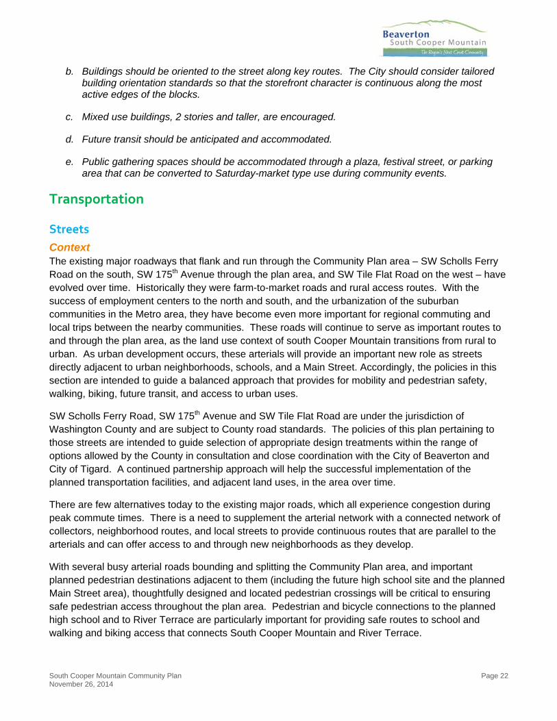
Context The existing major roadways that flank and run through the Community Plan area – SW Scholls Ferry Road on the south, SW 175th Avenue through the plan area, and SW Tile Flat Road on the west – have evolved over time. Historically they were farm-to-market roads and rural access routes. With the success of employment centers to the north and south, and the urbanization of the suburban communities in the Metro area, they have become even more important for regional commuting and local trips between the nearby communities. These roads will continue to serve as important routes to and through the plan area, as the land use context of south Cooper Mountain transitions from rural to urban. As urban development occurs, these arterials will provide an important new role as streets directly adjacent to urban neighborhoods, schools, and a Main Street. Accordingly, the policies in this section are intended to guide a balanced approach that provides for mobility and pedestrian safety, walking, biking, future transit, and access to urban uses.
SW Scholls Ferry Road, SW 175th Avenue and SW Tile Flat Road are under the jurisdiction of Washington County and are subject to County road standards. The policies of this plan pertaining to those streets are intended to guide selection of appropriate design treatments within the range of options allowed by the County in consultation and close coordination with the City of Beaverton and City of Tigard. A continued partnership approach will help the successful implementation of the planned transportation facilities, and adjacent land uses, in the area over time.
There are few alternatives today to the existing major roads, which all experience congestion during peak commute times. There is a need to supplement the arterial network with a connected network of collectors, neighborhood routes, and local streets to provide continuous routes that are parallel to the arterials and can offer access to and through new neighborhoods as they develop.
With several busy arterial roads bounding and splitting the Community Plan area, and important planned pedestrian destinations adjacent to them (including the future high school site and the planned Main Street area), thoughtfully designed and located pedestrian crossings will be critical to ensuring safe pedestrian access throughout the plan area. Pedestrian and bicycle connections to the planned high school and to River Terrace are particularly important for providing safe routes to school and walking and biking access that connects South Cooper Mountain and River Terrace.

South Cooper Mountain Community Plan Page 23 November 26, 2014
Street Policies
1. The streets planned for the Community Plan area are illustrated in Figure 10. The Beaverton Transportation System Plan and Washington County Transportation System Plans will be updated consistent with Figure 10 and will be the controlling documents for transportation planning. Should conflicts arise between the maps in Chapter 6 of the City’s Comprehensive Plan and the maps in this document, those in Chapter 6 shall prevail.
2. The City of Beaverton will work with the Beaverton School District, the City of Tigard, Washington County, Tualatin Valley Fire and Rescue, Tualatin Hills Park and Recreation District, and other service providers to establish appropriate access and circulation serving the community.
3. SW Scholls Ferry Road, SW 175th Avenue, and SW Tile Flat Road are under Washington County jurisdiction. The City of Beaverton will coordinate with Washington County through transportation facility design and land use regulations and review to recognize and balance the urban mobility needs with the multi-modal urban community functions of these key roadways. The city will advocate for the objectives for each street provided below during planning and design for improvement projects affecting those streets within the Community Plan area.
a. SW 175th Avenue within the Community Plan area shall be improved through a coordinated approach between the City, County and adjacent land owners. The City shall proactively initiate this coordination. SW 175th Avenue should be designed to provide for mobility needs and provide an attractive and welcoming entrance to the area. Safe, protected pedestrian crossing opportunities shall be provided near important pedestrian destinations, such as the future high
Figure 10: Community Plan Street Framework

South Cooper Mountain Community Plan Page 24 November 26, 2014
school site, when a need is demonstrated and such crossings are appropriately and safely designed and located.
b. SW Scholls Ferry Road adjacent to the Community Plan area should be designed to provide for efficient movement of vehicles, including freight, but should also provide for safe bicycle and pedestrian facilities, especially in the vicinity of the Main Street. The City of Beaverton will work with City of Tigard and Washington County to explore coordinated access, and a pedestrian crossing, in the vicinity of the high school and Main Street.
c. SW Tile Flat Road adjacent to the Community Plan area should retain a rural design, particularly on the west side adjacent to land designated as Rural Reserve. All expansions requiring additional right-of-way should be to the east (urban) side. Safe bicycle and pedestrian movements shall be accommodated by a shared-use pathway adjacent to the road on the east side, with trees and other landscaping to provide a visual buffer to adjacent rural lands.
4. The new east-west Collector street is intended to provide a parallel route to SW Scholls Ferry Road that connects through the full width of the Community Plan area. This street shall be designed to provide a safe and comfortable connection for pedestrians and bicyclists as well as cars and to create a clear, direct and convenient route that connects the eastern, northern and western neighborhoods.
5. The new north-south Collector road from SW Scholls Ferry Road through the Community Plan area is intended to provide connectivity through the Community Plan area.
6. North of SW Scholls Ferry Road, this new collector shall serve as the Main Street area of South Cooper Mountain. The Main Street section of this Collector road shall be designated as a Major Pedestrian Route. Pedestrian-oriented features appropriate to a Main Street and features that encourage cars to travel more slowly through the Main Street area should be emphasized in design of the road.
7. The alignment of the North-South Collector shall account for, and not preclude, future extension to the west to SW Grabhorn Road and south to serve Urban Reserve 6C.
8. Within the Community Plan area, new neighborhoods shall be served and linked by a connected network of streets. Neighborhood Route connections shall provide connectivity between neighborhoods. The preferred network is illustrated in Figure 10. The City may permit flexibility to adapt to site specific conditions and ownerships provided the conceptual network in Figure 10, or equivalent, is provided.
9. The City shall coordinate with Washington County to evaluate the need for, and feasibility of, any proposed Neighborhood Route connections to Arterial roads.
10. In refining specific alignments for new roads identified on the Community Plan Street Framework map through the development review or project design process, impacts to natural resources shall be minimized to the extent possible while retaining key connections.
11. Low Impact Development and “green street” techniques to manage stormwater runoff shall be utilized whenever feasible in the design of new streets and urban upgrades within the SCM Community Plan area, subject to the approval of the City Engineer.
12. Conceptual Road: New roads shown located outside the current Urban Growth Boundary (UGB). Conceptual Roads demonstrate how roads within city limits may be extended or connected

South Cooper Mountain Community Plan Page 25 November 26, 2014
in the long-term future. Alignments and functional classifications of Conceptual Roads are preliminary, tentative, and may ultimately be under the jurisdiction of another body.
Bicycle and Pedestrian Framework
Context Provision of a diverse and connected bicycle and pedestrian network consistent with regional active transportation goals is one of the great opportunities for the Community Plan area. The bicycle and pedestrian network will provide for local travel on bike and on foot, and support the overarching goal to create Beaverton’s next great community. The network also serves to connect to destinations outside of the Community Plan area, such as Cooper Mountain Nature Park, the future Cooper Mountain Regional Trail, and River Terrace’s trail system.
While the ultimate trail widths and designs will be determined at time of design and development, the following trail typology is recommended for planning purposes, based on THPRD’s 2006 Trails Plan:
Community Multi-Use Trails: These trails link important land uses and areas of interest with one another and connect users to the regional trail system. They are assumed to be paved paths that accommodate pedestrians (including those with disabilities) and bicyclists, recognizing that topographic constraints may be challenging. Within the planning area, it is assumed that multi-use trails that parallel roadways will be separated by a landscaped area. Trail width should be 8 to 10 feet paved width one- to two-foot gravel shoulders.
Pedestrian-Only Nature Trails: These are assumed to be soft-surface trails that are for pedestrians only (though they should be accessible to those with disabilities whenever feasible). They provide connections through and along natural areas, including links to the Cooper Mountain Nature Park trail system. Widths may range from 3 to 8 feet.
A conceptual bicycle and pedestrian framework plan is included in Figure 11, illustrating the plan to achieve the policy objectives listed below.
Bicycle and Pedestrian Framework Policies
1. Bicycle and Pedestrian Crossings: While the location and design of specific crossing points will be determined through further site-specific engineering evaluation, safe, protected pedestrian crossing opportunities should be provided near important pedestrian destinations, such as the future high school site, when a need is demonstrated and such crossings can be appropriately and safely designed and located, as determined by an engineering-level safety analysis.
2. Trails: Trails within the Community Plan area shall be provided as shown on Figure 11; however, the City may permit flexibility to adapt to site specific conditions and ownerships provided the conceptual network in Figure 11, or equivalent, is provided. The following principles shall provide guidance in the refinement of trail alignments within the Community Plan area:
a. Stream Corridor Trails: Trails along stream corridors shall be built at the outer edge(s) of the vegetated corridors wherever possible, consistent with CWS standards. Such trails shall be designed to provide a recreational amenity and safe, pleasant pedestrian and/or bicycle connections between neighborhoods, as well as offering visual access to the resource area. Additional native vegetation shall be provided to either side of such trails wherever possible in order to enhance their value as wildlife corridors as well as transportation corridors.

South Cooper Mountain Community Plan Page 26 November 26, 2014
b. Trails through Resource Areas: The site specific design and location of providing trail connections across wetland resource areas within the Community Plan area shall be addressed on a case-by-case basis. There is a need to provide safe and convenient pedestrian and/or bicycle across the central natural resource area located north of the high school and Main Street. There is also a need to provide access to the River Terrace Trail south of SW Scholls Ferry Road. These, and other trails through resource areas, shall be designed to minimize impacts to the natural resources. Maintenance and enhancement of wildlife corridors and connections between resource areas should be considered when designing and locating trails.
c. School to School Trail: A multi-use path shall link from SW Loon Drive at Scholls Heights Elementary school to SW 175th Avenue at the planned high school site as shown in Figure 11 in order to provide safe routes to both schools and to connect neighborhoods to the east to the planned high school.
d. Western Edge Trail: The community multi-use trail along the east side of SW Tile Flat Road within the Community Plan area shall be designed with trees and other landscaping to provide a visual buffer to adjacent rural lands. This trail shall be designed so that it can be extended further north, paralleling SW Grabhorn Road as far as Cooper Mountain Nature Park, when that portion of the Urban Reserve Area is brought into the UGB and developed.
3. Conceptual Trail: New pedestrian and or bicycle facilities shown located outside the current Urban Growth Boundary (UGB). Conceptual Trail demonstrate how pedestrian and bicycle facilities within city limits may be extended or connected in the long-term future. Alignments and functional classifications of Conceptual Trail are preliminary, tentative, and may ultimately be under the jurisdiction of another body.
Figure 11: Community Plan Bicycle & Pedestrian Framework
South Cooper Mountain Community Plan Page 27 November 26, 2014
Resource Protection and Enhancement
Significant Natural Resources & Open Space Edges
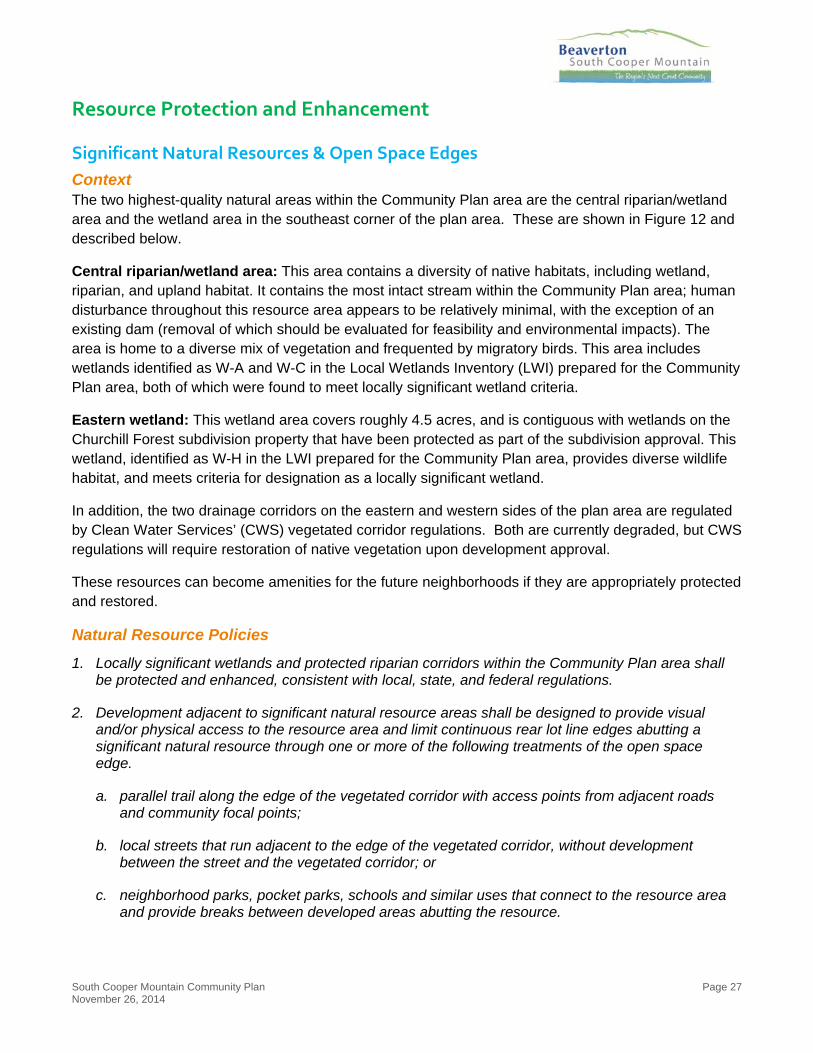
Context The two highest-quality natural areas within the Community Plan area are the central riparian/wetland area and the wetland area in the southeast corner of the plan area. These are shown in Figure 12 and described below.
Central riparian/wetland area: This area contains a diversity of native habitats, including wetland, riparian, and upland habitat. It contains the most intact stream within the Community Plan area; human disturbance throughout this resource area appears to be relatively minimal, with the exception of an existing dam (removal of which should be evaluated for feasibility and environmental impacts). The area is home to a diverse mix of vegetation and frequented by migratory birds. This area includes wetlands identified as W-A and W-C in the Local Wetlands Inventory (LWI) prepared for the Community Plan area, both of which were found to meet locally significant wetland criteria.
Eastern wetland: This wetland area covers roughly 4.5 acres, and is contiguous with wetlands on the Churchill Forest subdivision property that have been protected as part of the subdivision approval. This wetland, identified as W-H in the LWI prepared for the Community Plan area, provides diverse wildlife habitat, and meets criteria for designation as a locally significant wetland.
In addition, the two drainage corridors on the eastern and western sides of the plan area are regulated by Clean Water Services’ (CWS) vegetated corridor regulations. Both are currently degraded, but CWS regulations will require restoration of native vegetation upon development approval.
These resources can become amenities for the future neighborhoods if they are appropriately protected and restored.
Natural Resource Policies
1. Locally significant wetlands and protected riparian corridors within the Community Plan area shall be protected and enhanced, consistent with local, state, and federal regulations.
2. Development adjacent to significant natural resource areas shall be designed to provide visual and/or physical access to the resource area and limit continuous rear lot line edges abutting a significant natural resource through one or more of the following treatments of the open space edge.
a. parallel trail along the edge of the vegetated corridor with access points from adjacent roads and community focal points;
b. local streets that run adjacent to the edge of the vegetated corridor, without development between the street and the vegetated corridor; or
c. neighborhood parks, pocket parks, schools and similar uses that connect to the resource area and provide breaks between developed areas abutting the resource.

South Cooper Mountain Community Plan Page 28 November 26, 2014
Urban Forestry Management
Context Trees provide a variety of important environmental services, in addition to offering aesthetic benefits. The environmental services include: contributing to stormwater management by intercepting rainfall; moderating temperature; providing habitat; enhancing air quality; and improving soil stability on sloping terrain. Large stands of mature trees in the Community Plan area were removed prior to annexation to the City of Beaverton and in the interim period during which the SCM Concept Plan and Community Plan were being developed. Efforts should be made to restore and maintain tree canopy throughout the Community Plan area.
Title 13 of Metro’s Urban Growth Management Functional Plan requires that local governments protect identified regionally significant upland wildlife areas within UGB expansion areas.23 Several areas meeting Metro’s criteria for designation as “Class A Upland Habitat” have been identified in the SCM Community Plan area, along with areas that meet the criteria for “Class B Upland Habitat” and “Class C
23 Metro UGMFP Title 13, section 3.07.1330 Implementation Alternatives for Cities and Counties and section 3.07.1370 Future Metro Urban Growth Boundary Expansion Areas.
Figure 12: Natural Resources in the Community Plan area

South Cooper Mountain Community Plan Page 29 November 26, 2014
Upland Habitat”.24 The City of Beaverton has tree protection and mitigation standards for certain types of trees, including Landscape Trees, Community Trees, Significant Individual Trees, Trees within Significant Natural Resource Areas and Trees within Significant Groves.25
Urban Forestry Policies
1. The City shall explore options to encourage and incentivize tree planting and retention of mature trees within the Community Plan area.
2. Tree planting already required by City regulations (e.g. landscaped areas, street trees) shall be maximized as a method to increase the tree canopy in the Community Plan area.
3. Regionally Significant Upland Habitat within the SCM Community Plan area shall be protected through application of the City’s existing tree protection standards and incentives for Habitat Benefit Area preservation, as appropriate.
Scenic Views
Context Scenic views are recognized as resources in Chapter 7 of the Comprehensive Plan. There are a number of locations within the Community Plan area that offer scenic views of the Tualatin Valley and Chehalem ridge to the southwest. These views are an integral component of the unique character of the Community Plan area, and are key amenities to be retained and enhanced as urbanization occurs. In addition to aesthetic qualities, scenic viewpoints provide a visual connection between the contemporary growth of the city and rural heritage of the area.
Scenic View Policies
1. The city will encourage protection of view corridors for the enjoyment of adjacent neighborhoods and the broader community on lands that currently offer views of the Chehalem Ridge. Viewpoints should provide seating and space for passersby and should provide for the permanent protection of the view through measures such as easements. Techniques for view corridor preservation may include:
a. Streets that “T”, stub, or curve at a location offering a viewpoint, with a break between buildings;
b. Neighborhood or pocket parks situated to offer a viewpoint;
c. Gaps between buildings with small seating areas adjacent to the sidewalk (see Figure 13 for an illustration of this concept); and/or
d. Limitations on building heights down-slope from a viewpoint.
24 See DRAFT Natural Resources Memorandum by David Evans and Associates, Inc., June 3, 2013.
25 Beaverton Development Code Chapter 60, Section 60.60. Trees and Vegetation.

South Cooper Mountain Community Plan Page 30 November 26, 2014
Figure 13: Scenic Viewpoint Visualization
Rural Edges and Transitions
Context The Community Plan area abuts land outside the UGB, west of SW Tile Flat Road, that is designated Rural Reserve and zoned for Exclusive Farm Use, a rural resource zone. Since this land is assumed to be retained for agricultural use over the next several decades, or until the urban reserves have all been added to the UGB, the border between urban and rural lands should be sensitive to adjacent rural uses. Measures to enhance compatibility between farm/forest lands and UGB expansion areas are also required as a condition of the UGB expansion for the SCM Community Plan area.26
Due to urban density targets for the plan area, and the unconstrained nature of the land available for development immediately east of SW Tile Flat Road, it is not appropriate to substantially reduce planned densities adjacent to the rural edge in the interest of an urban-rural transition. Further, even standard single-family neighborhoods can have a visual and spill-over impact on adjacent rural areas if not carefully designed. Therefore, the policies below emphasize a design approach to rural edges and transitions.
Rural Transition Policies
1. Require that development abutting SW Tile Flat Road provide a landscaped buffer with trees and shrubs that provide a visual screen for adjacent rural uses.
26 Metro Ord. No. 11-1264B condition #4 for SCM states that “Land use regulations shall include provision – such as setbacks, buffers and designated lanes for movement of slow-moving machinery – to enhance compatibility between urban uses and agricultural and forest practices on adjacent land outside the UGB that is zoned for farm or forest use pursuant to statewide planning Goal 3 or 4.”

South Cooper Mountain Community Plan Page 31 November 26, 2014
Figure 14: Rural to Urban Transition along SW Tile Flat Road
Infrastructure Provision
Context
Drinking Water As with other planning strategies for South Cooper Mountain, the water system for the Community Plan was conceptually planned during the Concept Plan process and evaluating the area as a whole. The water system expansion into South Cooper Mountain, and the SCM Community Plan area specifically, will be based on the largest single point demand in the area: fire service flow. Although providing domestic and irrigation services to the area is essential, the water system expansion will be developed to provide sufficient fire flow while maintaining a minimum water pressure.
The new 24-inch water line in SW Scholls Ferry Road will extend to SW 175th Avenue and the planned High School site. Additional development to the north and west will require expanded network connections.
A new 24-inch water line is planned to extend along SW 175th Avenue, ultimately connecting to a future five-million-gallon tank to be located near the intersection of SW 175th Avenue/SW Weir Road. By supplementing the existing system with this new five million-gallon storage tank, there will be adequate water storage to serve the entire planning area. It is scheduled to be constructed by 2020.
Other major water lines will be constructed in large loops within the existing or future right-of-ways of SW Scholls Ferry Road (west of SW 175th Avenue), the planned east-west collector roadway through the Community Plan area, the planned north-south Main Street collector roadway, and SW Tile Flat Road. Development occurring within the interior of SCMAA area will connect to one of these mainlines. The conceptual water system plan for the full Concept Plan area is shown in Figure 15. Water line alignments are conceptual and subject to further design and engineering. Water lines outside of Community Plan area are also conceptual and shown only for context and to inform future planning in the area.

South Cooper Mountain Community Plan Page 32 November 26, 2014
A planning-level cost estimate to construct these facilities is approximately $9.1 million for the Community Plan area (including soft costs such as engineering and contingency but excluding the cost of the planned storage tank).27
Sanitary Sewer The SCM Community Plan area will be served by different sewer line locations, as shown in the conceptual sanitary sewer system plan for the full Concept Plan area in Figure 15.
An existing 21-inch gravity sanitary sewer located in SW Scholls Ferry Road can serve some of the area east of 175th Avenue and north of Scholls Ferry Road as well as the planned High School site.
With the exception of the high school area, the areas west of SW 175th Avenue will be conveyed towards the low point in SW Scholls Ferry Road (at the creek crossing near SW Vandermost Road) and eventually be conveyed to the new River Terrace Pump Station. The River Terrace Pump Station will be located within the urban growth boundary along the creeks south of SW Scholls Ferry Road and west of SW Roy Rogers Road. The River Terrace Pump Station is anticipated to be in operation by the end of 2015, and all flows from this proposed pump station will be directed to the intersection of Scholls Ferry Road and 175th Avenue to connect to the 21-inch Scholls Ferry Road Sanitary Sewer Extension and ultimately to the Durham Wastewater Treatment Plant.
Major sewer lines will be extended within future collector road right-of-ways, as well as in SW Tile Flat Road and SW Scholls Ferry Road west of SW 175th Avenue. In addition, the low lying creek will have sanitary sewers on each side to convey waste water to the low point in SW Scholls Ferry Road.
A planning-level cost estimate to construct these facilities is approximately $12.3 million (including soft costs such as engineering and contingency but excluding the cost of the planned River Terrace Pump Station).28
The conceptual sewer system plan for the full Concept Plan area is shown in 13. Sewer line alignments are conceptual and subject to further design and engineering. Sewer lines outside of Community Plan area are also conceptual and shown only for context and to inform future planning in the area.
Stormwater Conceptual storm water management planning was conducted during scenarios phase of the Concept Plan. The work identifiedr: (1) A preference by the City of Beaverton and Clean Water Services (CWS) for an approach that uses Regional Stormwater Facilities (RSFs); (2) Recognition that there are challenges to implementing RSFs, and flexibility is needed to apply site-scale storm water management instead of, or in combination with, RSFs; and (3) Changing water quality regulations merit further planning for South Cooper Mountain, including the creation of a Storm Water Management Plan for the
27 Details of the cost estimates and planned water system are available in the Water System Concept Plan – Summary Findings and Planning Level Cost Estimates memorandum prepared by David Evans and Associates, Inc., June 11, 2014.
28 Details of the cost estimates and planned sewer system are available in the Sanitary Sewer Concept Plan – Summary Findings and Planning Level Cost Estimates memorandum prepared by David Evans and Associates, Inc., June 11, 2014.

South Cooper Mountain Community Plan Page 33 November 26, 2014
Community Plan area. The description below summarizes elements of the work that was prepared for the Concept Plan.29
The preferred approach for implementing Overarching Principles 3 (sustainability), 4 (funding plan), and 7 (natural resources) is to plan for large scale dry detention ponds, termed Regional Stormwater Facilities (RSFs) by CWS, in order to manage peak runoff rates to avoid downstream impacts. This approach is preferred because it is consistent with planning in other new areas added to the Urban Growth Boundary; it provides planned, comprehensive flow control in a cost-effective manner; and, it provides the highest level of certainty of meeting the flow management guidelines being established by CWS. In addition, RSFs will meet water quality requirements (capture and treatment of stormwater pollutants) as well as preserving the stream health of the receiving channel by avoiding hydrographic modification.
It should be noted that RSFs require a high level of coordinated implementation. Options should be available so that there is some flexibility as how to design and construct facilities to serve individual properties prior to regional facilities being available.
29 For the scenario level evaluation, please see Stormwater and Water Quality Scenario Summary, David Evans and Associates, December 19, 2014.

South Cooper Mountain Community Plan Page 34 November 26, 2014
Figure 15: Conceptual Future Water System for SCM Concept Plan Area

South Cooper Mountain Community Plan Page 35 November 26, 2014
Figure 16: Conceptual Future Sanitary Sewer System for SCM Concept Plan Area

South Cooper Mountain Community Plan Page 36 November 26, 2014
In the scenarios phase of the Concept Plan, RSFs were tentatively sized and located based on estimates of impervious area upland of the facilities. The sizing tool was the Western Washington Hydrologic Model, which matches flow-duration curves for a range of storms pre- and post-development. CWS is in the process of updating its conveyance and detention standards based on a similar approach. Thus the work prepared during the Concept Plan was an approximation of that anticipated standard of care. Fine tuning of the location, upland area, and final facility size (including buffer and access areas) will be required as future planning and development occurs.
Additional site-specific reviews of opportunities for Low Impact Development Approaches (LIDA) are encouraged as part of development, which may reduce the size of downstream detention facilities. This would be a joint decision of CWS and the City of Beaverton and would need to be decided prior to the commitment for any particular facility.
No matter what specific storm water management facilities are planned, it is essential that the detention ponds and conveyance work are planned and designed in combination with other elements of the Community Plan, including: protection and enhancement of natural resource areas, provision of parks and open spaces, and management of stormwater at the site and street scale.
Infrastructure Policies
1. Urban development shall not be allowed until urban services, including water and sewer, are available to the subject property.
2. The City shall work with service providers and property owners to extend urban services in a coordinated and efficient manner.
3. The City of Beaverton will coordinate closely with the City of Tigard on the final location and timing of the River Terrace Pump Station.
4. The City shall use the South Cooper Mountain Infrastructure Funding Plan as the basis of financing decisions for public facilities and services in the SCM Community Plan area.
5. The City shall develop memorandums of understanding with service providers to implement the South Cooper Mountain Infrastructure Funding Plan.
6. The City shall work with Clean Water Services to develop a Stormwater Management Plan for the SCM Community Plan area. In the interim, the City will work with Clean Water Services and developers to apply existing storm water management regulations.
7. In identifying specific alignments for new water and sewer infrastructure, impacts to natural resources shall be avoided or minimized to the extent possible.

APPENDIX A: PROJECT COMMITTEES
AND TEAM
South Cooper Mountain Community Plan Appendix A November 26, 2014
South Cooper Mountain Technical Advisory Committee Susan Shanks, City of Tigard
Dyami Valentine, Washington County Department of Land Use and Transportation
Kevin Hanway, City of Hillsboro Water Department; Tyler Wubbena (alternate), City of Hillsboro Water Department
Jeannine Rustad, City of Hillsboro Planning Department; Daniel Rutzick (alternate), City of Hillsboro Planning Department
Anne Debbaut, Department of Land Conservation and Development (DLCD)
Tim O’Brien, Metro
Lidwien Rahman, Oregon Department of Transportation (ODOT)
Tom Mills, TriMet
Carrie Pak, Clean Water Services (CWS)
Aisha Willits, Tualatin Hills Parks and Recreation District (THPRD)
Richard Hoffman, Tualatin Valley Fire & Rescue (TVF&R)
Mark Knudsen, Tualatin Valley Water District (TVWD); Stu David (alternate), TVWD
Dick Steinbrugge, Beaverton School District (BSD); David Etchart (alternate), BSD
Adam Stewart, Hillsboro School District (HSD); Loren Rogers (alternate), HSD
Finance Task Force John O’Neill
Martin Moore
Dan Grimberg
David Waffle
Toby LaFrance
Andy Braun
Aisha Willits
David Winship
Jabra Khasho
Dyami Valentine
Matt Wellner
Guests: Wally Remmers, Tom Brian, Kenny Asher, Susan Shanks

APPENDIX A: PROJECT COMMITTEES
AND TEAM
South Cooper Mountain Community Plan Appendix A November 26, 2014
City of Beaverton
South Cooper Mountain Planning Team Valerie Sutton, Senior Planner, Project Manager
Steve Sparks, Principal Planner
Leigh Crabtree, Associate Planner
Cassera Phipps, Assistant Planner
Juston Manville, GIS Manager
Sheila Martin, Administrative Assistant
City of Beaverton Core Project Team Jabra Khasho
Cindy Dolezel
Peter Arellano
Jim Duggan
Lani Parr
Jason Wachs
Jeff Salvon
Andrea Nelson
Kenneth Rencher
Luke Pelz
Wendy Prather
Brion Barnett
David Winship
Andrew Barrett
Mark Boguslawski
Eric Oathes
Geoff Spalding
Alma Flores
Patrick O'Claire
Dave Waffle
Bill LaMarche
Todd Juhasz
Megan Cohen
Randy Ealy

APPENDIX A: PROJECT COMMITTEES
AND TEAM
South Cooper Mountain Community Plan Appendix A November 26, 2014
Consultant Team Angelo Planning Group Joe Dills, Angelo Planning Group, Project Manager
Becky Hewitt, Angelo Planning Group, Planner and Assistant Project Manager
Cathy Corliss, Angelo Planning Group, Principal
Matt Hastie, Angelo Planning Group, Finance Task Force Facilitator
Andrew Parish, Angelo Planning Group, Planner
David Evans and Associates Claudia Sterling, David Evans and Associates, Storm Water Engineer
Ethan Rosenthal, David Evans and Associates, Ecologist
Paul Fendt, David Evans and Associates, Storm Water Engineer
Steve Harrison, David Evans and Associates, Engineer
Sara Gilbert, David Evans and Associates, GIS Specialist
DKS Associates Carl Springer, DKS Associates, Transportation Planner
Kevin Chewuk, DKS Associates, Transportation Planner
ECONorthwest Nick Popenuk, ECONorthwest, Funding Plan Manager
Lisa Wall, ECONorthwest, Analyst
Anne Fifield, ECONorthwest, Market Analyst
Fregonese Associates Glen Bolen, Fregonese Associates, Planner
Max Bolen, Fregonese Associates, Scenario Analyst
JLA Public Involvement Eryn Deeming Kehe, JLA Public Involvement, Public Involvement Advisor
Kalin Schmoldt, JLA Public Involvement, Public Involvement Manager
Walker Macy Ken Pirie, Walker Macy, Urban Designer
Mike Zilis, Walker Macy, Urban Designer
Nathan Kappen, Walker Macy, Urban Designer
Saumya Kini, Walker Macy, Urban Designer