
SonarWiz 5 - Frequently Asked Questions - and · PDF fileSonarWiz 5 - Frequently Asked...
62
SonarWiz 5 - Frequently Asked Questions - and Tips Revision 5.08.0012 (final), 12/16/2016 Chesapeake Technology, Inc. eMail: [email protected] Main Web site: http://www.chesapeaketech.com Support Web site: http://www.chestech-support.com 1605 W. El Camino Real, Suite 100 Mountain View, CA 94040 Tel: 650-967-2045 Fax: 650-450-9300
Transcript of SonarWiz 5 - Frequently Asked Questions - and · PDF fileSonarWiz 5 - Frequently Asked...

SonarWiz 5 - Frequently Asked Questions - and Tips
Revision 5.08.0012 (final), 12/16/2016
Chesapeake Technology, Inc.
eMail: [email protected] Main Web site: http://www.chesapeaketech.com
Support Web site: http://www.chestech-support.com
1605 W. El Camino Real, Suite 100 Mountain View, CA 94040
Tel: 650-967-2045 Fax: 650-450-9300

SonarWiz5_faq.pdf Chesapeake Technology, Inc. copyright 2015-2016
Rev 5.08.0012 12/16/2015 [email protected] 650-967-2045 Page 2
Table of Contents
1 SonarWiz 5 – General Capabilities FAQs .............................................. 5
1.1 Most frequent question - Is SonarWiz 5 Windows10 compatible? ..................... 5
1.2 SonarWiz – What are the licensing purchase options for SonarWiz? ................ 6 1.2.1 Post-processing features are sold in 4 categories ....................................... 6 1.2.2 Multi-seat Network Dongles – supported for Post-processing licenses ....... 7 1.2.3 Survey features of SonarWiz are sold for specific models ........................... 7 1.2.4 Choose your options using the QUOTE REQUEST form ............................ 7
1.3 SonarWiz – What are the PC and OS platform requirements? .......................... 7 1.4 SonarWiz - What can I do to improve project performance? .............................. 8 1.5 SonarWiz – Use PROJECT EXPLORER SubGroups to speed up projects! ...... 9
1.6 SonarWiz – Why would my project start random misbehavior or fail to open? ... 9 1.7 SonarWiz – MML file – special control file, and how to use it? ......................... 11 1.8 SonarWiz – My project will not open – what to do? .......................................... 12
1.9 SonarWiz – What's the best way to get SUPPORT help on my issue? ............ 14
2 SonarWiz - Data Acquisition FAQs ...................................................... 16
2.1 SonarWiz - Why don’t we log X/Y by default during XTF data collection ........ 16
2.2 SonarWiz - Our surveys cover multiple UTM zones - how to handle ? ........... 17 2.3 SonarWiz - Which thermal printers are supported by SonarWiz? ................... 17
2.4 SonarWiz – Viewing target detail without pausing R-T recording in a S & R? .. 18
3 SonarWiz - Post-Processing FAQs...................................................... 19
3.1 SonarWiz – My imported sonar data are white stripes! What did I do wrong? . 19
3.2 SonarWiz – Can I swap chs 1 & 2 (e.g. port & stbdd) SS data during import? . 20
3.3 SonarWiz – Importing a batch of MST files - what’s the easiest way? ............. 23 3.4 SonarWiz – Feature labels – How do we hide them?....................................... 23 3.5 SonarWiz – Mosaic Cropping (Polygon/Rect Trimming) – How do we do this? 24
3.6 SonarWiz - Can automatically-created contact names be re-used? ................ 24 3.7 SonarWiz – File-type specific import advice? ................................................... 25
3.7.1 SonarWiz – Importing JSF Files? .............................................................. 25 3.7.2 SonarWiz – Is there a Maximum CSF-file count for a project? .................. 27 3.7.3 SonarWiz – Advice on importing SEGY files with discontinuities in depth?28
3.8 SonarWiz – Applying User Controlled Gain (UGC) – and where you see it ..... 33
3.9 SonarWiz – My project loads very slowly, or fails to open at all! ...................... 33 3.10 SonarWiz – EGN Processing Issues ............................................................ 35 3.11 SonarWiz - Auto-TVG / Thresholding – Image ghosting issues .................... 35 3.12 SonarWiz – Seabed Classification Processing Issues .................................. 36
3.13 SonarWiz – Is exporting a mosaic-perimeter feature possible? .................... 37 3.14 SonarWiz – Is there a maximum file-size? .................................................... 37 3.15 SonarWiz – How can we designateSV for water-column and strata? ........... 37
3.16 SonarWiz – Can data be corrected for TIDE effects in SonarWiz? ............... 39 3.16.1 Bathymetry Tide Correction ....................................................................... 40 3.16.2 Sub-bottom Data Tide Correction .............................................................. 40
4 SonarWiz - Maps FAQs ....................................................................... 41
4.1 SonarWiz – What’s the best source of NOAA basemaps for USA? ................. 41

SonarWiz5_faq.pdf Chesapeake Technology, Inc. copyright 2015-2016
Rev 5.08.0012 12/16/2015 [email protected] 650-967-2045 Page 3
4.2 SonarWiz – Speaking of SHP files, mine won't display! What's wrong? .......... 41
5 SonarWiz - Views FAQs ...................................................................... 41
6 SonarWiz - Tools FAQs ....................................................................... 41
6.1 CTI3DViewer is not allowed to run in evaluation license? Why? ...................... 41
7 SonarWiz - Help FAQs ........................................................................ 43
8 SonarWiz – Webinar2 Questions – 3/8/2011 ....................................... 43
9 BathyMetric Feature Set (5.06 series software) Set FAQs .................. 45
9.1 Bathy: When was the bathymetric feature-set introduced, and how can I see it? 45
9.2 Bathy: What are the licensing options for bathymetry feature set? .................. 47 9.3 Bathy: What type of sonar data are imported in bathymetry post-processing? 47 9.4 Bathy: Does SonarWiz bathy support a patch-test calibration? ....................... 48
9.5 Bathy: What types of configuration settings are necessary in bathy surveying? 49
9.6 Bathy: What types of environmental factors affect a bathy survey? ................. 51 9.7 Bathy: What types of bathy export data formats are available? ....................... 55
SonarWiz5_faq.pdf Chesapeake Technology, Inc. copyright 2015-2016
Rev 5.08.0012 12/16/2015 [email protected] 650-967-2045 Page 4
<< This Page Intentionally Left Blank >>

SonarWiz5_faq.pdf Chesapeake Technology, Inc. copyright 2015-2016
Rev 5.08.0012 12/16/2015 [email protected] 650-967-2045 Page 5
This Frequently Asked Questions (FAQs) document about the Chesapeake Technology, Inc SonarWiz software product is a supplement to the SonarWiz 5 User Guide, which is recommended as your primary reference on these topics.
Here are the two best ways to find your topic in this document:
1. You may click on a Table of Contents section and navigate directly to that question, if
you see your topic there. This is perhaps the easiest way to get your answer. Or ...
2. Press CTRL-F to bring up the FIND dialog, and enter a keyword, like 'mosaic' (no
quotes required), and press ENTER, and you can step through the document
looking for that word:
Continue to each next instance by clicking on Find Next.
1 SonarWiz 5 – General Capabilities FAQs
To be clear, SonarWiz 5 is now a legacy product. The final version created was
4/6/2015, version 5.08.0012. The newer product which is current and actively developed
and maintained, is SonarWiz 6. Anyone with an active (paid) Extended Maintenance
Agreement (EMA) on their SonarWiz license key is eligible to upgrade to SonarWiz 6,
and should do so.
1.1 Most frequent question - Is SonarWiz 5 Windows10 compatible?
For SonarWiz 5.08.0012, the compatibility answer is below in section 1.3. What about
for older versions of SonarWiz 5? Which ones are compatible with Windows10?
We made SonarWiz compatible with Windows10 in January, 2015, even before the
official release of Windows10, since as a Windows development vendor, we had access
to early release.

SonarWiz5_faq.pdf Chesapeake Technology, Inc. copyright 2015-2016
Rev 5.08.0012 12/16/2015 [email protected] 650-967-2045 Page 6
Windows10 was officially released to the public July 29, 2015. See:
https://www.google.com/#q=Windows10+release+date
In SonarWiz, the versions we certify to be fully Windows10 compatible are:
SonarWiz 5 - version 5.08.0004 or later
SonarWiz 6 - ALL VERSIONS
So that's our official guarantee. To be prudent, and safeguard your initial investment of
capital in the SonarWiz software, it makes sense to renew the
Extended Maintenance Agreement (EMA) and upgrade to a newer version of SonarWiz.
The SonarWiz 5 series finalized 4/6/2015 - with a final version of 5.08.0012.
SonarWiz 6 is still an active series, evolving from 6.01.0001 in January, 2015, to version
6.05.0005 today, December, 2016. It is certainly the best ever!
Soon though, SonarWiz 7 will be arriving. Really the only way to keep up is
to renew the EMA.
1.2 SonarWiz – What are the licensing purchase options for SonarWiz?
Question: What are the licensing options for SonarWiz? May I post-process sidescan
data, or do I need to buy all the features?
Answer: SonarWiz may be purchased as a set of modular feature sets. The Fist main
category is:
(1) Post-processing features, and
(2) Survey (real-time acquisition) features.
1.2.1 Post-processing features are sold in 4 categories
(1) Sidescan post-processing – supports import, post-processing, and export of
many file types of sidescan sonar data;
(2) Sub-bottom post-processing – supports import, post-processing, and export of
many types of sub-bottom sonar data;
(3) Bathymetric post-processing – supports import, post-processing, and export of
many types of interferometric sonar data;

SonarWiz5_faq.pdf Chesapeake Technology, Inc. copyright 2015-2016
Rev 5.08.0012 12/16/2015 [email protected] 650-967-2045 Page 7
(4) Magnetometry post-processing – supports import, post-processing, and export of
many types of magnetometry data;
Within a post-processing category, you are licensed to import all file types of that
category – e.g. with a sidescan post-processing license, you may import and post-
process JSF, XTF, RDF, etc. file types. The supported file-types for import in each
category are described here:
https://www.chesapeaketech.com/wp-content/uploads/2016/04/SonarWiz_Interfaces_and_FileFormats.pdf
1.2.2 Multi-seat Network Dongles – supported for Post-processing licenses
Post-processing licenses may be purchased as individual license keys, or features may
be supported for multiple post-processing users on a single “network dongle” type
license key.
1.2.3 Survey features of SonarWiz are sold for specific models
Sonar interfaces are sold more specifically to support a particular vendor mode of sonar
towfish or sub-bottom profile for real-time acquisition. For example, a separate license is
required for Edgetech 4200, Klein 3000, R2Sonic, etc. Purchase options such as all-
digital sidescan models, and the like exist, as well as discounts for multiple interfaces
purchased at the same time.
1.2.4 Choose your options using the QUOTE REQUEST form
We keep an on-line form up-to-date with the purchase options for SonarWiz, which is a
menu-type PDF showing all the categories of licensing available. Please check it out
here:
www.chesapeaketech.com/products/request-a-quote/
1.3 SonarWiz – What are the PC and OS platform requirements?
Question: I want to buy a new PC for the boat or office, and wish to know if it will run
SonarWiz. How can I tell?
Also ... We are in the process of purchasing new computers for the department and I
am wondering whether purchasing PC’s with 8 core processors as oppose to 6 will
make SonarWiz run any faster? If not then there is no need for us to spend the extra
money but if it will then it is a worthwhile investment.
Answer: The platform requirements (PC configuration requirements and supported
Operating System (OS) requirements) are well-defined in a technical note on our
support site. Please access that document here:

SonarWiz5_faq.pdf Chesapeake Technology, Inc. copyright 2015-2016
Rev 5.08.0012 12/16/2015 [email protected] 650-967-2045 Page 8
http://www.chestech-
support.com/download/ctisupport/SonarWiz_5/UserDocs/SonarWiz_PC_OS_Recomme
ndations.pdf
This document might answer all your questions. The short answer is that real PCs are
supported, recommendation is 4GB of RAM or more, and operating systems in 32-bit or
64-bit supported are Windows7, and Windows10. For running a real-time server, more
RAM is best - 8GB.
Our developer also notes: There are a few areas in SonarWiz that currently will use all
of the cores in a multi-processor system. We plan to expand the multi-core code as we
migrate SonarWiz to 64-bits over the next year. If the cost difference is not that bad I
would recommend going with the 8 core systems--even my laptop has 8 cores (4 real X
2 with hyperthreading). (April, 2014, J.Gann)
1.4 SonarWiz - What can I do to improve project performance?
Question: Is there anything I might do routinely to improve the overall screen-refresh
performance of my project?
Answer: Yes! The 3 most important techniques would be to
(1) maintain smaller project size (source file count), and
(2) use local hard drives for your entire project. The more files you have in a project,
and the longer they take to access, the more time it will take for some operations.
(3) Switch to SonarWiz 6 64-bit. It can directly access more than 4GB RAM and makes
post-processing considerably faster.
Most users find project performance best using local drives for raw sonar location. This
is preferable, for example, to having part of the project stored on a USB stick or network
drive, because access time is faster on the local hard drive. Our practice
recommendation for source file location is to move or copy the source sonar or
magnetometry files to a local hard drive folder, such as the MAG (for magnetometry) or
SBP (for sub-bottom), or XTF (for sidescan), folders of the project. These are the
default "save to" folders when recording data with SonarWiz. The benefits of following
this practice are felt more as project size (source file count) increases.
Example PROJECT_1:
C:\SonarWiz-Projects\PROJECT_1\MAG Move or copy the source magnetometry files
here
C:\SonarWiz-Projects\PROJECT_1\SBP Move or copy the source sub-bottom files

SonarWiz5_faq.pdf Chesapeake Technology, Inc. copyright 2015-2016
Rev 5.08.0012 12/16/2015 [email protected] 650-967-2045 Page 9
here
C:\SonarWiz-Projects\PROJECT_1\XTF Move or copy the source sidescan files
here
1.5 SonarWiz – Use PROJECT EXPLORER SubGroups to speed up projects!
Question: As the number of sonar lines to be displayed has grown in my project, how
can I create display sub-groups to reduce the main map (plan) view screen refresh time
after project operations?
Answer: You’re on the right track to do that … creating sub-groups of your lines. For
example, if you had 100 lines in your project, creating 4 groups of 25 lines would speed
up the display refresh time by a factor of 4, by displaying only one sub-group at a time.
To do this, create 4 project folders in PROJECT EXPLORER here:
Right-click over SIDESCAN FILES (or SUB-BOTTOM FILES) in the project explorer,
and you get a drop-menu, and there you choose “New SubGroup”, just like creating a
new folder in Windows File Explorer. Then you can drag subsets of files into the
various folders. Once you segregate things like that you can use the folder level
checkbox to turn on and off the subgroups you're not actively working on a speed things
up. (J.Gann, 8/2013)
1.6 SonarWiz – Why would my project start to present random misbehavior or
fail to open?
Question: My project crashes when trying to present the mosaic. Other times it opens
up but gets stuck in a display mode – like sidescan-> COVERAGE mode, and I cannot
get it to revert to DRAFT mode. What could be causing this?

SonarWiz5_faq.pdf Chesapeake Technology, Inc. copyright 2015-2016
Rev 5.08.0012 12/16/2015 [email protected] 650-967-2045 Page 10
Answer: These errors can be cause by sonar lines importing with error-messages,
which might show in the SYSTEM OUTPUT view of the SonarWiz.log file, but may have
been ignored. Unfortunately, and errant import like this needs to be manually detected
and then removed from the project, before the project will behave properly again. There
are two ways to verify if a file did not import properly, but then was populated in the
project as a CSF file:
(1) Use Tools-> Open Log File Folder, and then open the SonarWiz.log file, and
starting from the bottom of the file, scroll up searching for the word “error”.
Chances are you will find a file import operation that had an error, but the file
imported anyway. Then select this line in the PROJECT EXPLORER, and delete
it form the project.
(2) A second way to see such an errant import file is to close the SonarWiz
application, and use NOTEPAD to edit the project MML file, which has the same
name as the project folder, and is inside the project folder. Look for a CSF file
line-item where the file extent points (start and end positions) are listed as
0.00,0.00,0.00,0.00 … this will cause all sorts of random project misbehavior.
Here’s an example:
Then again, open SonarWiz, and select the line and delete it from the project.
NOTE: The advice above applies when running any version prior to 5.06.0047. In
5.06.0047, a major effort to fix this issue was put into the software (see VERSION
HISTORY at www.chestech-support.com, for details), and when a file tries to import like

SonarWiz5_faq.pdf Chesapeake Technology, Inc. copyright 2015-2016
Rev 5.08.0012 12/16/2015 [email protected] 650-967-2045 Page 11
this into a CSF file, or an existing project is opened and an errant CSF file is detected,
the file is not allowed to remain in the project, and the user is warned.
1.7 SonarWiz – MML file – special control file, and how to use it?
Question: I have noticed that there is a special file called <project_name>.mml in my
project folder. It gets updated during the project, and is essential to open the project. Is
there anything else I should know about it?
Answer: The MML file is indeed a special part of SonarWiz design. It will always be
there after you create a NEW project, and it does get updated every time you open and
close the project, saving any changes you made to the project, including information
like:
1. What version of SonarWiz is in use;
2. What coordinate system was used for the project
3. What coordinate system was used to import the files
4. Values of the JSF scalar and gains used during file import
5. The “palette” choices used to display files,
6. The project location in latitude and longitude, and
7. The entire list of imported files converted to CSF (common sonar format) files,
listed in the sequence in which the files were added to the project.
This important MML file is created when you are running SonarWiz and issue a
CREATE NEW PROJECT dialog. It gets updated during the program operation
when you make changes, as new information gets “remembered” here in the file.
When you OPEN (start) the application after a project exists, a backup copy of the
MML file is created and copied to the project sub-folder named BACKUP.
Using this information can help you in case the program or the PC stops suddenly,
before a write-operation to the MML file might have saved valuable information. For
example, if your PC suddenly stopped, it’s possible part of the information that
SHOULD have been saved to the MML file is missing, and it may still be there in the
BACKUP folder copy of the MML file. Knowing this, you can be careful to make a
copy of the MML file or backup MML file periodically (manually), in case you need to
recover information from it, when something goes wrong like the computer of
application crashes. (SC 4/29/2013)

SonarWiz5_faq.pdf Chesapeake Technology, Inc. copyright 2015-2016
Rev 5.08.0012 12/16/2015 [email protected] 650-967-2045 Page 12
NOTA BENE - SonarWiz 6.02.0008 and beyond has a reliable MML-file BACKUP
folder queue design to prevent any MML-file loss - and EXCELLENT reason to
upgrade to SonarWiz 6.
1.8 SonarWiz – My project will not open – what to do?
Question: My project (or computer) stopped during a SonarWiz session, and will not
open. How can I get going again?
Answer: There are two ways to circumvent this:
(1) Hold the SHIFT key while starting SonarWiz, and the application will start without
opening the previous project.
(2) A second option is to rename the previously opened project folder, so that when
SonarWiz runs and tries to open the “previous project”, it will not be found, but
SonarWiz will run anyway.
Usually the reason a project will not open, is that there is a problem in the project
data (see section 1.5 above), and it needs to be diagnosed and repaired. (SC,
12/2013)
(3) To permanently set SonarWiz to not open the "previously open project" when it
runs, just change the state of the control checkbox here:

SonarWiz5_faq.pdf Chesapeake Technology, Inc. copyright 2015-2016
Rev 5.08.0012 12/16/2015 [email protected] 650-967-2045 Page 13
An OPEN checkbox means SonarWiz will start and present this screen:

SonarWiz5_faq.pdf Chesapeake Technology, Inc. copyright 2015-2016
Rev 5.08.0012 12/16/2015 [email protected] 650-967-2045 Page 14
1.9 SonarWiz – What's the best way to get SUPPORT help on my issue?
Question: What's the best way to get help from Chesapeake Technology?
Answer: Please send us an e-mail, and include the MML file from your project, as an
attachment. This e-mail address is monitored even after M-F working hours, PST or
PDT California time. Here are more details.
Send us an e-mail to [email protected] . Using the Help ->
MySupportInfo button does three things for us:
(1) it shares your return e-mail address with us, and your name
(2) tells us what version of SonarWiz you are using
(3) tells us what license key (dongle) you are using, and when its EMA expires, so
we can tell if you are eligible for a newer version of software.

SonarWiz5_faq.pdf Chesapeake Technology, Inc. copyright 2015-2016
Rev 5.08.0012 12/16/2015 [email protected] 650-967-2045 Page 15
If the project MML file is not automatically attached to the e-mail created, please
attach it. You will find it in the project folder, and it will have the same NAME as the
project, but the file EXTENSION will be .MML. You may have to enable display of file
extensions for "well known" files, to see the extension, in Windows.
Here's an example e-mail result:

SonarWiz5_faq.pdf Chesapeake Technology, Inc. copyright 2015-2016
Rev 5.08.0012 12/16/2015 [email protected] 650-967-2045 Page 16
Your e-mail to us may not look exactly like this, as the automated content changes
over time, but you get the idea ... it has our e-mail address, and is an easy way to
add comments and describe your issue.
If we ask for additional larger files, you will receive the following PDF document from
us in an e-mail, and a Phone Log (PL) code like "PL4755", to help you communicate
with us in the eventual back-and-forth set of e-mails we will use to receive your files,
explain and resolve your issue.
The FTP process PDF is available here:
CTI Support FTP (File transfer protocol) Process PDF for Uploading Files
2 SonarWiz - Data Acquisition FAQs
2.1 SonarWiz - Why don’t we log X/Y by default during XTF data collection
Question: Is there a reason why the logging of x and y in the XTF files is un-checked
by default? It has in the past given some trouble in the processing when an
inexperienced user has returned with a survey without grid coordinates in the header.

SonarWiz5_faq.pdf Chesapeake Technology, Inc. copyright 2015-2016
Rev 5.08.0012 12/16/2015 [email protected] 650-967-2045 Page 17
Answer: By default, SonarWiz records the coordinates in the same format as they are
received from the navigation source. So for example, if the navigation sensor is
providing latitude/longitude then the XTF files will be recorded with latitude/longitude. If
the navigation source is providing eastings and northings then the XTF file will be
recorded with X/Y. Some customers prefer that the XTF files are recorded with X/Y
when the navigation system is providing latitude/longitude. Most customers however
appreciate the fact that the navigation data that was sent to SonarWiz is the navigation
data that is written into the XTF file. Some customers however asked for an option
where they could connect a navigation source that provided latitude and longitude but
wanted SonarWiz to convert the lat/lon to X/Y coordinates and store that into the XTF
file. This option found under File Specific Options in the File Preferences section is for
those users. (John Gann, 9/2010)
2.2 SonarWiz - Our surveys cover multiple UTM zones – can SonarWiz handle
that?
Question: I have customers who work on several projection zones (for the GPS data).
When crossing the borderline between 2 zones (e.g. UTM-30N to UTM-31N), would the
software automatically change to the zone coordinates, or the change of zone is based
on user changing the parameters ? Otherwise can the SonarWiz store the data in
longitude and latitude ?
Answer: SonarWiz can record the SEGY data in either X/Y coordinates or as
latitude/longitude--that is a user selectable option in SonarWiz. If the navigation input is
providing latitude/longitude and the user has selected the X/Y coordinates for the SEGY
recording then SonarWiz will convert the incoming latitude/longitude values to the UTM
zone configured in the project. If the navigation input is X/Y for example from Hypack
and the user has configured X/Y for the navigation coordinates in SEGY, then SonarWiz
records the X/Y values exactly as they are received from the navigation system. (John
Gann, 1/2011)
2.3 SonarWiz - Which thermal printers are supported by SonarWiz?
Question: According to the SonarWiz User Guide, there is a supported list of thermal
printers described in section 4.5.6. Are these the only printing options?
Answer: Actually, many of the thermal plotters are quite finicky and will require a
parallel port something that is becoming quite rare.
As an alternative, did you know you can use any old printer that is compatible with Windows? SonarWiz includes and application called VPrint that allows you to send the printer output to any device that smells like a printer to Windows. You can set up the page format to define how many pings you want per page, the color settings, gamma correction and so on. You can even print to a PDF file if you have one of the free PDF

SonarWiz5_faq.pdf Chesapeake Technology, Inc. copyright 2015-2016
Rev 5.08.0012 12/16/2015 [email protected] 650-967-2045 Page 18
printer drivers installed and then reprint at your leisure or simply provide the digital copy and save a few trees. (John Gann, 3/2011)
2.4 SonarWiz – Can we view target detail without pausing real-time recording in
a search and rescue application?
Question: I am a Police officer, with the XYZ Police Department, assigned to
the Underwater Search and Recovery Unit. My supervisors and I are interested in your
hardware and/or software to assist with our underwater searches. I was wondering if
you currently have any other departments using your products in this manner, and if so
which products they are using. We currently have a Marine Sonic Technology
"Centurian" 900/1800 kHz side scan sonar.
We are looking for a way to compile the data we obtain from the side scan. Currently
we are limited to pausing a real time display and zooming on a particular target of
interest, while in the meantime we are missing the incoming data from the tow-fish. It
appears as though your equipment would allow us to examine targets and continue to
record incoming data. Recently we were tasked with a search for a drowned boater. It
was unclear where exactly the boater had gone in the water. There was a large search
area, and without any way to put all the side-scan data together it was difficult to ensure
we had thoroughly covered the entire area. In searching for a way to better use our
sonar I came across your company.
First I would like to find out if your products are compatible with our current sonar and
adaptable to our mission of underwater searches. Second I would like to hear your
recommendation for a system to accomplish our mission, and find out a general idea of
what the initial costs would be for the system. I look forward to hearing from you.
Answer: Thank you for your inquiry regarding our products. Yes, our SonarWiz product
is compatible with your Centurion system and yes other police forces here in the US
and abroad are using our software for just the situation you describe.
SonarWiz may be purchased to assemble the 'mosaic' of sonar files on the fly as you
drive down each lane of your grid pattern. SW5 includes tools to help you generate the
most efficient search pattern and then to guide the boat driver down the line to ensure
that no 'holidays' or gaps occur in the coverage. Potential targets may be marked
and analyzed in real-time without stopping the scrolling waterfall view or the data
recording.
Some of our police users include Broward County Sheriff Department (Florida), Quincy
Police Department (Massachusetts), Charleston County Sheriffs (South Carolina)

SonarWiz5_faq.pdf Chesapeake Technology, Inc. copyright 2015-2016
Rev 5.08.0012 12/16/2015 [email protected] 650-967-2045 Page 19
Victoria Water Police (Melbourne, Australia), NW Police Dive Unit (United Kingdom),
Western Australia Police, (Western Australia).
In addition the US Explosive Ordinance Division (EOD) as well as port authorities and
harbor security firms use our software for detecting small objects on the seafloor.
The complete system to work with your Marine Sonic sonar system is $8995. That
includes the functionality described above as well as the complete post-processing
capabilities that include generating reports, Google Earth images and much more.
Our software connects to the Centurion system via an Ethernet cable. Your system
may or may not yet have a network card installed but one will be required to use our
software. Once the network card is installed, the SeaScan PC software can be started
but then you don't normally have to look at it again while you are surveying. SonarWiz
records and maps the data as you go.
You might consider coming out to our next training class. In addition to learning first-
hand how to use SonarWiz you will also be able to network with other users to see how
they are using our products. Plus, if you do purchase SonarWiz within 60 days of the
workshop the cost of the training class is waived. Full details on the upcoming training
workshops may always be found here:
https://www.chesapeaketech.com/events/
We also offer on-site customized training and installation if you are interested at the rate
of $1750/day (2010 price - please confirm current price with CTI sates staff) plus all
incurred expenses.
Please let me know if you have any additional questions. (J.Gann, 10/2010)
3 SonarWiz - Post-Processing FAQs
3.1 SonarWiz – My imported sonar data are white stripes! What did I do wrong?
Question: While data seem visible during recording, when it is imported into SonarWiz,
the recorded sonar files appear as white stripes in the main map view, with no color or
texture. What can I do?
Answer: The usual remedy in this case is gain adjustment. Check the Post Processing-
>Import Side Scan option as shown below:

SonarWiz5_faq.pdf Chesapeake Technology, Inc. copyright 2015-2016
Rev 5.08.0012 12/16/2015 [email protected] 650-967-2045 Page 20
If the files were imported with No Gain as a setting, try re-importing with successively
higher gain, such as these options for gain:
Usually after adding gain, colors and texture become visible in the sonar lines on the
main map view, and you can proceed to other post-processing techniques for improving
the quality of the images for export and reporting.
In addition, file-type specific gain manipulation can help, for example if the imported
sonar is GCF or JSF. In these cases, select File Type Specific Options, and if you see
your file type there, adjust the 'amplitude scalar' to bring out color and texture in your
imported lines. (S.Cutcomb 9/2010)
3.2 SonarWiz – Can I swap chs 1 & 2 (e.g. port & starboard) SS data during
import?
Question: Is it possible in SonarWiz to use a software toggle to invert (swap) the
channel assignments on sidescan data? For example - traditional data on a sidescan
towfish operating normally comes in as starboard and port channels, correct (with some
kind of identifier in the data strings or headers that tells SonarWiz which channel is

SonarWiz5_faq.pdf Chesapeake Technology, Inc. copyright 2015-2016
Rev 5.08.0012 12/16/2015 [email protected] 650-967-2045 Page 21
which)? What if I wanted to invert (swap) the data - that is to say, assign the data from
the port channel to the starboard, and vice-versa...is this something I can do? Is it
something that can be done in real-time with SonarWiz during acquisition with real-time
mosaicing??
Answer: You should be able to swap channels when importing data in SW5. There is a
channel selector on the Import Sidescan dialog that allows you to select the channel
mapping. Sounds like you would want to choose the Channel 2 and 1 (Swapped)
option:

SonarWiz5_faq.pdf Chesapeake Technology, Inc. copyright 2015-2016
Rev 5.08.0012 12/16/2015 [email protected] 650-967-2045 Page 22
In the real-time mosaic button on the Data Acquisition ribbon you can choose the same channel configuration but I have never tried doing it in real-time and I'm doubtful that it would work in RT. (J.Gann, 4/18/2011).
SonarWiz5_faq.pdf Chesapeake Technology, Inc. copyright 2015-2016
Rev 5.08.0012 12/16/2015 [email protected] 650-967-2045 Page 23
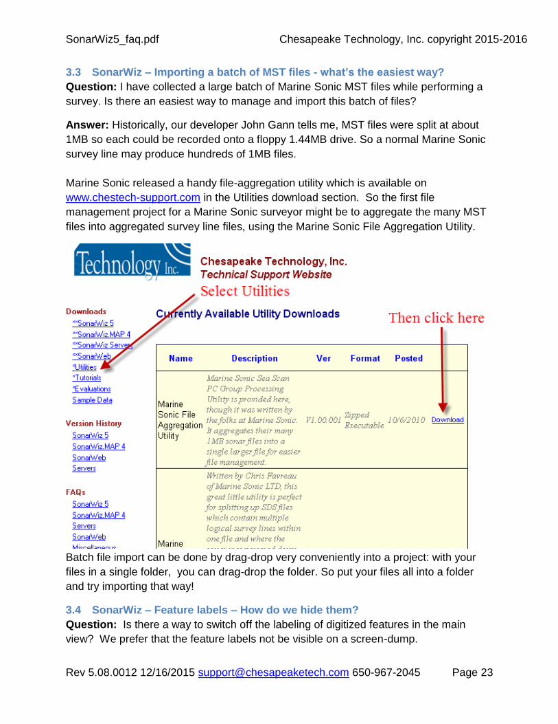
3.3 SonarWiz – Importing a batch of MST files - what’s the easiest way?
Question: I have collected a large batch of Marine Sonic MST files while performing a
survey. Is there an easiest way to manage and import this batch of files?
Answer: Historically, our developer John Gann tells me, MST files were split at about
1MB so each could be recorded onto a floppy 1.44MB drive. So a normal Marine Sonic
survey line may produce hundreds of 1MB files.
Marine Sonic released a handy file-aggregation utility which is available on
www.chestech-support.com in the Utilities download section. So the first file
management project for a Marine Sonic surveyor might be to aggregate the many MST
files into aggregated survey line files, using the Marine Sonic File Aggregation Utility.
Batch file import can be done by drag-drop very conveniently into a project: with your
files in a single folder, you can drag-drop the folder. So put your files all into a folder
and try importing that way!
3.4 SonarWiz – Feature labels – How do we hide them?
Question: Is there a way to switch off the labeling of digitized features in the main
view? We prefer that the feature labels not be visible on a screen-dump.

SonarWiz5_faq.pdf Chesapeake Technology, Inc. copyright 2015-2016
Rev 5.08.0012 12/16/2015 [email protected] 650-967-2045 Page 24
Answer: You should be able to simply open the Digitized Feature Manager and
uncheck the "Label" check box column 2 header and turn off all of the text labels, or just
click on the individual row checkboxes and disable selected features. Screen-shot
example:
(John Gann)
3.5 SonarWiz – Mosaic Cropping (Polygon/Rect Trimming) – How do we do this?
Question: A user with SonarWiz version 5.01.0033 and would like to export mosaics as
"defined rectangles" (as listed under version history in section 5.01.0025). He cannot
find it.
"Implement cool new feature that allows users to clip the mosaic bounds to any closed
polygon. Draw a closed polygon or rectangle feature around the sonar data that you
want to keep. Right-click on the polygon and choose the menu option labeled _Trim the
Sonar Data to Feature Extents_. Quick easy cropping."
Answer: First you want to probably download the very latest V5.01.0035 (or later)
version of SonarWiz if it is available to you. We just enhanced the trimming function so
that it will allow you to undo the data that was trimmed from the mosaic. Then it is just a
matter of these two steps below...
Step 1. Draw a rectangle or closed polygon around the area you want to trim. Step 2. Right click on the polygon so it is selected and then choose the option to Trim the Sonar Data. To Undo the trimming, right click on one of the trimmed files and select the option to "Undo Trimming on ALL files. (John Gann, 9/2010)
3.6 SonarWiz - Can automatically-created contact names be re-used?
Question: In SonarWiz, is there any way to delete the created contacts so that I can
use the number of the contact again? If I delete it, it is only removed from the project,
but it is also saved in the deleted folder. Help?
SonarWiz5_faq.pdf Chesapeake Technology, Inc. copyright 2015-2016
Rev 5.08.0012 12/16/2015 [email protected] 650-967-2045 Page 25
Answer: Currently there is no way to re-use deleted contact names when automatic
naming is turned on. For example, you digitize six contacts named Contact_0001 to
Contact_0006. Then you delete Contact_0004. The next contact you capture will be
named Contact_0007. I can see why re-using deleted names would be useful in some
situations, and it may be possible to implement this as an option in the future. In the
meantime, there is a workaround that may help you...just turn off auto contact naming
and manually enter the contact names for those that have been deleted. To do this,
click the "Preferences" button on the Contact Manager dialog. Then in the Names
section of the preferences dialog click "Prompt at Capture Time". This way, the program
will ask you for a contact name when the contact is digitized and you can enter anything
you like, including names of contacts that have been deleted. When you have filled in
the holes, so to speak, you can switch back to auto naming. (Mark Bradshaw, 8/2010)
3.7 SonarWiz – File-type specific import advice?
3.7.1 SonarWiz – Importing JSF Files?
Question 1: What specific advice can you give about importing JSF files?
Answer 1: See User Guide section 5.3.2. You will likely need to set the JSF Scalar
values for the low and high frequency channels. These scalars convert the raw values
from the sonar into a number that is between -32K and +32K so that the data can be
displayed in SonarWiz. These values should be by trial and error process, once the
sonar is deployed in the environment in which it will be used. Then it’s best not to
change these values for the duration of the survey. The scaled value is displayed and
the scalars are recorded along with the original raw data from the sonar, so even if the
values are not optimal, the raw data has been preserved.
The JSF controls likely to have the most significant effect will be selection of a suitable
value for the JSF scalar. With the 5.04 series of SonarWiz, this is semi-automated as
well: you can choose to let SonarWiz decide the best value for the scalar, using “Auto
JSF Scalar” like so:

SonarWiz5_faq.pdf Chesapeake Technology, Inc. copyright 2015-2016
Rev 5.08.0012 12/16/2015 [email protected] 650-967-2045 Page 26
If you do un-check this box, manually entered values for JSF scalar to use can range
from 0.001 to 10000.0 and it makes sense to try a large step quickly: i.e. if 1.0 does not
work well and the data still imports white, try 100.0, 100.0, 5000.0, and 10000.0 in that
sequence and see what the results look like on import.
Recently we have seen files that present well only with a manual JSF scalar value in the
range 0.01 to 0.001, so definitely try a value LESS THAN 1.0 if you are unable to see
your data properly in the Bottom Track or Digitizer View screens, in current software
(e.g. 5.06.0011).
Another common issue is that – surprise! – the file only contained data in channels 3 &
4, and your default setting says import from chs 1 & 2. The result may appear like “no
records match input criteria” and the file fails to import and convert to a CSF file. Just try
importing from channels 3 & 4 in this case.

SonarWiz5_faq.pdf Chesapeake Technology, Inc. copyright 2015-2016
Rev 5.08.0012 12/16/2015 [email protected] 650-967-2045 Page 27
4/29/2013 NOTE: Excellent new advice on JSF file import may now be found here:
www.chestech-
support.com/download/ctisupport/SonarWiz_5/UserDocs/ImportingJSFFiles.pdf
(J.Gann, 10/2011)
Question 2: I sometimes try a JSF import and get this error message in the System Log
window: “No records detected that match input criteria”, and the file fails to import.
What’s wrong there?
Answer 2: That means the channel selection on the import dialog does not match the
contents of the JSF file. For example, you have the channel selector set to 1 and 2 but
the JSF files only contain high frequency channels. So while it’s not the most elegant
solution the way to resolve it is simply to change the channel selector on the Import
Sidescan File dialog, such as specifying channels 3 and 4 for import.
(J.Gann, 1/2012)
3.7.2 SonarWiz – Is there a Maximum CSF-file count for a project?
Question: What is the maximum number of CSF files that can be put into a sonar
project? Or is the max determined by total MB ?
Answer: Great question, and we have no specific answer on it. Use your intuition.
When the
project starts getting too slow to refresh a screen, you're into an ergonomic reason,
and that's a good warning flag.
We have had a project with 660 CSF files, and it became imperative to reduce it
by dividing the project in half. Personally, I prefer working with a project 200 CSFs
max.
We do not have an elegant warning that your project is approaching a limit. Obviously
a 200 file project with 1MB MST files would run with less threat of resource exhaustion
than a project with 200 files 40MB each.
I do feel that there is a risk of projects getting too large without a clear warning that it
has happened, so think small. The smaller projects just seem to have less risk of hitting
an
unseen limit and becoming troublesome.

SonarWiz5_faq.pdf Chesapeake Technology, Inc. copyright 2015-2016
Rev 5.08.0012 12/16/2015 [email protected] 650-967-2045 Page 28
Specifically with MST projects, I recommended to a customer recently that
they plan on aggregating adjacent lines using the MST aggregation utility before
importing into
SonarWiz, or aggregating first thing after Import. See the WORKFLOW section of the
SonarWiz User Guide, section 1.6. The thing is to give the application the best chance
of working with your data, and a smaller file-count seems like a good direction to me.
(Steve C., 2/14/11)
3.7.3 SonarWiz – Advice on importing SEGY files with discontinuities in depth?
Question: I imported my SEGY file and it displays in bottom-track like this. What did I
do wrong?
Answer: Recordings like this typically occur when there is a tremendous depth change
across the record. To account for this, many recording systems will adjust the “recording
delay” in msec, which shows up in a SEG-Y file in bytes 109-110 as DELRECT. This
can be seen when viewing the trace header field values in SEISEE, the free SEG-Y
viewing/editing utility. In the recording above, DELRECT was 3840 msec for many
records, then made an abrupt shift to 3720 msec, and later changed again to an even
smaller value.

SonarWiz5_faq.pdf Chesapeake Technology, Inc. copyright 2015-2016
Rev 5.08.0012 12/16/2015 [email protected] 650-967-2045 Page 29
To perform topographic correction on a file imported like this, simply re-import but select
the FILE-TYPE SPECIFIC OPTIONs for SEG-Y files, and designate SENSOR DEPTH
to be read from bytes 109-110 DELAY:
Then the re-import of the SEG-Y file will display in a bottom-track view like this:

SonarWiz5_faq.pdf Chesapeake Technology, Inc. copyright 2015-2016
Rev 5.08.0012 12/16/2015 [email protected] 650-967-2045 Page 30
Alternatively, some users have found that a pressure-sensor input records to the SEG
trace-header bytes 49-52, listed as SDBS (sensor depth below surface), and this field
may also be used for topo correction. The trace header is seen below in such a SEG file
in SEISEE:
Uncorrected, the SEG file imports and displays like this:

SonarWiz5_faq.pdf Chesapeake Technology, Inc. copyright 2015-2016
Rev 5.08.0012 12/16/2015 [email protected] 650-967-2045 Page 31
When the SEG file is import, using the SEG file-type-specific option set like this:

SonarWiz5_faq.pdf Chesapeake Technology, Inc. copyright 2015-2016
Rev 5.08.0012 12/16/2015 [email protected] 650-967-2045 Page 32
Then when the SEG file is displayed in BottomTrack view with topo correct ON, it shows
like this:

SonarWiz5_faq.pdf Chesapeake Technology, Inc. copyright 2015-2016
Rev 5.08.0012 12/16/2015 [email protected] 650-967-2045 Page 33
3.8 SonarWiz – Applying User Controlled Gain (UGC) – and where you see it
Question: I selected a sonar file, right-clicked, and selected Settings, then enabled
User Controlled Gain (UGC) and clicked APPLY. I saw the changes in the mosaic, and I
see the changes in the Digitizer View. However, when I went to Bottom-track, the UGC
had not been applied? Why is that? (See examples of this effect below).
Answer: When UGC is applied to the data, it shows in the digitizer view, and in the
mosaic presentation of the sonar line, as explained in User Guide section 5.11. What is
not mentioned there, is that the bottom tracker always shows the data as it was
imported before any gains are applied. (11/2/2010 J. Gann)
3.9 SonarWiz – My project loads very slowly, or fails to open at all!
Question: A project that used to open quickly, started to open more and more slowly,
then failed to open at all. What could cause this?
Answer: There are a few issues which can slow a project open process, or stop it
entirely, so this answer will be 3-fold.
1. First off, take a look at the project size. In general, the larger the project (CSF file
count), the slower it will open and display. This may not be apparent until the file-
count exceeds 200+ lines (see section 3.7.2 above), but eventually it makes an
impact on your ergonomic experience.
2. A second cause of a slowing project is files location. You may enjoy zippy project
open / display refresh performance when all the files of the project are located in
a sub-folder of C:\SonarWiz-Projects, but see a performance hit if some or all of
the files are on a shared drive or network drive, as network bandwidth factors
come into play. Moving MB of data across a network is just typically slower than
reading it from a local hard drive.
3. If a project eventually fails to open at all … our first course of analysis is to ask
you to send us your project MML file, and look as it with NOTEPAD (it is a text
file). The MML file for project DEMO1, for example, will have the same name as
the project. The project folder path would typically be:
C:\SonarWiz-Projects\DEMO1
And the MML file would be:
C:\SonarWiz-Projects\DEMO1\DEMO1.mml
If you do not have file-extensions visible for “well-known” file types in your
Windows, the file may appear there as:

SonarWiz5_faq.pdf Chesapeake Technology, Inc. copyright 2015-2016
Rev 5.08.0012 12/16/2015 [email protected] 650-967-2045 Page 34
C:\SonarWiz-Projects\DEMO1\DEMO1
Inside the MML file, there is a list of the CSF (common sonar format) files in your
project, each of which was created during import of an individual raw sonar file.
In cases where the import process went well, the CSF file description in the MML
file will be noted like this good example:
The yellow numbers are coordinates, and are all NON-ZERO, valid data.
If a CSF file was created, but had import errors, it will appear in the MML file like
this, with problematic data (ZEROS) in the pink area:
The remedy in a case like this, is to identify the CSF file which may be a problem,
and remove it from the project, then try to re-open the project, try re-importing
that particular line, and look closely at the SYSTEM OUTPUT window for any
error messages during the re-import of that file.
If your project still totally fails to open, and you cannot use SonarWiz at all, you
might have to re-name the project folder so that SonarWiz cannot find it. This is
one remedy if the project was identified at the “last used project” and SonarWiz
Advanced Settings is set to open the previously used project here:

SonarWiz5_faq.pdf Chesapeake Technology, Inc. copyright 2015-2016
Rev 5.08.0012 12/16/2015 [email protected] 650-967-2045 Page 35
A second technique is the HOLD SHIFT KEY down during SonarWiz start, and it
will not open the previously used project. (8/2012 S.Cutcomb)
3.10 SonarWiz – EGN Processing Issues
Question 1: My project will not open, and appears to present a message saying
“loading EGN” was in progress when it stops. Now the project is unusable.
Answer 1: This issue affected projects up until SonarWiz release 5.05.0023, when it
was fixed. If you are using an earlier version and this happens, simply delete the *.EGN
file from your project root folder, and you will be able to open and use the project again.
(11/2012)
Question 2: In a project with 500 CSFs, we use 15 CSFs to build the EGN table, and it
applies quickly to most CSFs. Some though, take much longer, and we get a Summary
Log message like this: I was wondering if you could explain why I get the message
ApplyPortTable():no return for Y:x at range: x and perhaps offer a solution?
Answer 2: It sounds like just using the 15 or so XTF files to build the EGN table is
insufficient. When there is no data available in the EGN table at a range/altitude pair
(from one of the other 500 XTF files) then this message gets emitted and SonarWiz
attempts to interpolate or extrapolate the EGN value. Since building the EGN table is
rather quick and a one-time thing, I would suggest using all 500 files (assuming that you
have bottom tracked them first) to build the EGN table. That should eliminate any
interpolation and would also give better normalization results. (J.Gann, 11/2012)
NOTE: See the excellent EGN Processing tutorial video, by Mike Brissette, here:
EGN Tutorial Video (10.7MB, MP4 QuickTime video format):
www.chestech-support.com/download/ctisupport/Training/SonarWiz_EGN_Tutorial.mp4
3.11 SonarWiz - Auto-TVG / Thresholding – Image ghosting issues
Question 1: We had relatively homogeneous sonar sidescan with some large, dark
objects only in one side of the record. We imported using Auto-TVG, as well as
Thresholding, and noticed prominent light ghost-images from the dark objects on the
opposite side? Why are they happening and how can we prevent them from showing?
Answer 1: This issue was caused by the Auto-TVG function being applied during
import. Auto-TVG, TVG, and EGN are all homomorphic functions, considering both
starboard and port sides together in their computation of a median value. In other
words, The AutoTVG uses a homomorphic technique that considers the contents of
both channels when computing its gain curve. With a high-reflecting “dark” object only
on one side of the record, a ghost image of it may form by subtraction from the
homomorphic median, on the opposite side. So these results are specific to a

SonarWiz5_faq.pdf Chesapeake Technology, Inc. copyright 2015-2016
Rev 5.08.0012 12/16/2015 [email protected] 650-967-2045 Page 36
combination of a particular asymmetric data set, and a homomorphic post-processing
function.
More details:
Q2: Is there a specific reason why Auto-TVG is applied to both channels simultaneously? A2: Yes, it is one potential gain candidate for channel level matching although as one can see, it can have a negative side-effect (ghosting) when asymmetric strong targets are present. Q3: Shouldn’t this also create problems when surveying along a slope? A3: It might, but on a slope you will need to account for the different angles of insonification somehow, right? Q4: What happens to 4-channel files (e.g. low- and high-frequency data in one file)? Is Auto TVG then applied to all 4 channels? A4: There is no mixing of frequencies the channels are processed in port/starboard pairs. Q5: Would it improve SonarWiz to change this Auto-TVG behavior and de-couple the channels? A5: In our opinion, no. There are times when AutoTVG can create a beautifully balanced record--not in every case--but our approach in SonarWiz is to provide more than just one gain tool to give users options. Again, this is just our technical opinion, and design choice, but we'd rather have more than one option to try and get the best looking record. (Tech Support team, 8/ 2013)
3.12 SonarWiz – Seabed Classification Processing Issues
Question: (paraphrased): When I change the color class on one of my classes in the classification window the color do not change after the processing but the previous color gets reapplied automatically. Also, there is inconsistency across the same seabed characteristic (i.e. sand ) that is classified differently, more based on the darkness or lightness of the image instead of working on acoustic characteristics.
Answer: There is a tutorial/webinar available on our support site that describes in some
detail how to use the Seabed Classification tools. Probably the most important fact to
note is that the SonarWiz Seabed Classification tools are based on image processing
algorithms, not acoustic algorithms. So it is important to fully process the mosaic image
as best as possible to eliminate any geometric artifacts of towing a sidescan. So at a
minimum, you would want to import your data, bottom track it and apply EGN or some
other signal processing. Once the mosaic is in a state where the data looks fairly

SonarWiz5_faq.pdf Chesapeake Technology, Inc. copyright 2015-2016
Rev 5.08.0012 12/16/2015 [email protected] 650-967-2045 Page 37
normalized across the image then you will have more success with the Seabed
Classification tools. (J.Gann, 12/2012)
3.13 SonarWiz – Is exporting a mosaic-perimeter feature possible?
Question: (paraphrased): It would be helpful to have a perimeter feature trace the boundaries of my mosaic, and I have been doing this manually. Is there any automatic way to do it?
Answer: SonarWiz does automatically generate a convex hull file whenever it builds the
mosaic. The ‘convex hull’ is the minimum bounding polygon around the area of the
mosaic. This file is written as an ESRI shapefile, and stored in the GeoTiff folder of your
project, and is always named: MosaicConvexHull.shp. (J,Gann, 1/10/2013)
3.14 SonarWiz – Is there a maximum file-size?
Question: (paraphrased): We sometimes collect a large file – say 100k pings. Is it possible to import and post-process this in SonarWiz?
Answer: Large sidescan and sub-bottom files are each able to be imported when ping-
count exceeds 32k. However, to view the file effectively within the bottom-track or
digitizer view windows, which are presented based upon a JPEG image, the ping count
is limited to 32k pings. For this reason, plan on splitting your file before import (SB files),
or within SonarWiz (sidescan files), so that perhaps 30K pings (maximum) is the file
size, and you can comfortably view and post-process the file segments in the bottom-
track, or digitizer view windows. (J,Gann, 1/10/2013)
3.15 SonarWiz – How can we designate SV for water-column and strata?
Question: (paraphrased): We would like to designate different sound velocities, for the water column, and one or more sediment layers within the sub-bottom profile, e.g between the seafloor and a buried pipeline. How can we do this?
Answer: Overall sound velocity in post-processing, e.g. for the water column, is
controlled in the SETTINGS and PREFERENCES area of SonarWiz, and may range
from 1200-1800m/sec:

SonarWiz5_faq.pdf Chesapeake Technology, Inc. copyright 2015-2016
Rev 5.08.0012 12/16/2015 [email protected] 650-967-2045 Page 38
In sediment, you may control the sound velocity used between the seafloor and a
reflector, by setting an associated sound velocity, as described in the SonarWiz User
Guide "Add Reflector" description section (5.16.4.1 in the 5.06.0035 version):

SonarWiz5_faq.pdf Chesapeake Technology, Inc. copyright 2015-2016
Rev 5.08.0012 12/16/2015 [email protected] 650-967-2045 Page 39
So the global sound velocity specified in the Preferences Advanced window is used
everywhere, unless you digitize a reflector at the pipe depth. Then the reflector dialog
gives you an option to set the SV at the depth of the reflector (e.g. pipe) and that will be
used to compute the depth below the seafloor surface.
We are planning to add a global sediment velocity option and relabel the existing global
SV as water velocity so this would provide a little more accuracy without having to
create the reflector but that's not in the software just yet.
(J,Gann, 4/2014)
3.16 SonarWiz – Can data be corrected for TIDE effects in SonarWiz?
Question: (paraphrased): We would like to compensate some data in SonarWiz, for tide effects at the time of the survey. Can this be done?
SonarWiz5_faq.pdf Chesapeake Technology, Inc. copyright 2015-2016
Rev 5.08.0012 12/16/2015 [email protected] 650-967-2045 Page 40
Answer: SonarWiz has excellent options for tide-compensation of either bathymetry
survey data, or sub-bottom data. Here are the options.
3.16.1 Bathymetry Tide Correction
If you have a bathymetry post-processing license in SonarWiz, just import your tide file,
and select to apply tide correction. We have a tutorial video on the subject of importing
tide files, and the bathymetry tutorial PDFs (bathymetry workflow process) and tutorial
video of DEMO 1 - St. Pete's project shows an example of importing the tide file and
applying it to the bathy data.
3.16.2 Sub-bottom Data Tide Correction
As of release 6.01.0016, in SonarWiz there is no direct way specific to tide effects by
which we can compensate sub-bottom data, and adjust a seafloor. There are 3 effective
indirect ways to do it though, and these are described below:
(1) manually adjusting the sub-bottom bottom-tracked seafloor can be done according
to a tide level using SET SENSOR DEPTH. You would do this file by file according
to the tide effect at the time the file was recorded. It's time-consuming, but precise,
and easy. One value per file could be used, e.g. -.3m for one file, -.4m for the next
file, as tide level varied according to each file's time of recording. The same single
offset value would be applied to the entire file.
(2) The "heave compensation" injected into a SEG file, for example, may be a heave
function recorded by an MRU, or it actually can be a static level reflecting tide offset.
Either way it can be added to the sub-bottom data as an effect. You would use
NavInjectorPro to inject the exact tide value at each time, and the function could vary
in time nicely as the file was recorded. Time-consuming, prices, but a little more
complex to do.
(3) Best of all would be if you had a multi-beam survey grid over the same area. Then
the "datum align" function could be used against SB data. This is less time-consuming,
even higher precision, and relatively easy, but does require the reference grid.
We have PDFs describing the complex features of heave compensation and datum
alignment. Please take a look and see what will work best for you. We suggest
prototyping any plan, using a few files just in a test project, rather than doing the entire
set when wondering where things went wrong.
The reference PDFs on Heave Compensation, and Datum Align, are at www.chestech-
support.com in the SonarWiz 5 downloads area, TECH NOTES section.

SonarWiz5_faq.pdf Chesapeake Technology, Inc. copyright 2015-2016
Rev 5.08.0012 12/16/2015 [email protected] 650-967-2045 Page 41
4 SonarWiz - Maps FAQs
4.1 SonarWiz – What’s the best source of NOAA basemaps for USA?
Question: Is there a web-site you recommend for obtaining free NOAA basemap charts
for U.S. waters?
Answer: Here is the best site in the US for free scanned nautical charts:
http://www.nauticalcharts.noaa.gov/mcd/Raster/download_agreement.htm
Here's the best link for US vector charts:
http://www.nauticalcharts.noaa.gov/mcd/enc/download_agreement.htm
(6/14/2012 J. Gann)
4.2 SonarWiz – Speaking of SHP files, mine won't display! What's wrong?
Question: (paraphrased): We imported a SHP file as an overlay, trying it as a shapefile or legacy shapefile, and can't see it. How can we bring it into view?
Answer: The problem in many cases like this is the SHP file color. Often a SHP file
imports and the color is "default". Once it imports, check the color in the MAP
MANAGER and set it to a non-default color, to make sure it will be visible. "Default" may
be black, for example, and on a black background, that will be invisible. So the steps to
see your shaprfile would be:
(1) Add as OVERLAY
(2) Set color to a non-default value in MAP MANAGER
(3) Click Fit-to-View ALL in the main map view and it should center in the view
(J,Gann, 3/12/2014)
5 SonarWiz - Views FAQs
6 SonarWiz - Tools FAQs
6.1 CTI3DViewer is not allowed to run in evaluation license? Why?
Question: When I have an evaluation license, and I use the START menu to choose
CTI3DViewer:

SonarWiz5_faq.pdf Chesapeake Technology, Inc. copyright 2015-2016
Rev 5.08.0012 12/16/2015 [email protected] 650-967-2045 Page 42
it gives me this license error:
Answer: Try these two steps, to launch the CTI3DViewer, when running SonarWiz with
an evaluation license.

SonarWiz5_faq.pdf Chesapeake Technology, Inc. copyright 2015-2016
Rev 5.08.0012 12/16/2015 [email protected] 650-967-2045 Page 43
The reason you need to do this, is that for the CTI3DViewer, if no dongle is present the
licensing is provided by the running SonarWiz application.
So, you can start CTI3DViewer from the Start Menu but SonarWiz would need to be running at the time, or you can start CTI3DViewer from the Tools menu in SonarWiz. (JGann, 06/2013)
7 SonarWiz - Help FAQs
8 SonarWiz – Webinar2 Questions – 3/8/2011
CTI conducted a Webinar entitled “Intro to SonarWiz”, conducted by Mike Brisette, 8a,
PST 3/8/2011, and users were invited to send in questions. Here are the answers which
John Gann responded to 8 selected questions.
Question 1: What is your future webinar schedule? Where can we find it?
Answer 1: We do not yet have a formal webinar schedule as this was our first. Our
goal is to try and do one webinar per quarter.
Question 2: (regarding our Seabed Classification feature) In GeoTexture, to designate
the classes you can select a homogeneous area and the software will group that. You
then can select another area from the remaining sidescan instead of guessing at a
number of substrates. Will SonarWiz do something like this?
Answer 2: Currently, the Seabed Classification (SC) function is not interactive in the
way that you describe. Our plan was to put the initial version out there and get
feedback from users like you in which directions to drive it to improve its usefulness.
We will definitely consider your suggestion as the SC functions evolve.
Question 3: I would like to ask for an explanation of the layback/cable out. I am not
totally sure how I have to set it. So far I checked with profiles in two directions not to end
up with offsets.
Usually we run our side scan with fixed cable length due to the shallowness of the
water. How do I then define layback and cable out? Set cable out is the distance from
GPS antenna to fish, layback is 100% or no layback? If we change cable length, do we
need to start a new file to change layback in the file manager during post processing
accordingly?
Could you please elaborate on the correct procedure?
Answer 3: I will outline the general steps. You will likely have to refer to the User Guide
for the various steps I explain. The key to adjusting layback in the Sonar File Manager is

SonarWiz5_faq.pdf Chesapeake Technology, Inc. copyright 2015-2016
Rev 5.08.0012 12/16/2015 [email protected] 650-967-2045 Page 44
to first ensure that you import the sonar data using “Ship Position” and not “Fish
Position” or “Auto”. Once you have this you must then tell SonarWiz what the Sheave
Offset is for each file (in Sonar File Manager). Next ensure that the cable out values are
correct in the file. If they need to be corrected go to the Bottom Tracker and “Add
Nodes”. Now choose the layback algorithm in Sonar File Manager based on whether or
not your sonar had a depth sensor installed. Finally adjust the layback percentages until
objects line up (in the along-track direction) in the Map Window.
Question 4: In the Seabed Classification (SC) feature), is the sediment classification
purely a reflection strength or is there further in-depth analysis to determine
classifications?
Answer 4: The SC functions employ two types of “texturers” that consider various user
selectable characteristics of the seafloor. These characteristics include backscatter
amplitude, entropy and others. The current texturers are both statistical in nature. The
simple texture is home-grown and the gray-level co-occurrence matrix (GLCM) texturer
is a well published algorithm for image processing.
Question 5: Regarding the NAV, does SonarWiz export any type of NAV for plotting ?
(This is useful for trackplotsrortt. ) And if the answer is yes, does it plot with events
(fixes), or times ?
Answer 5: Yes: Under the menu: Tools --> Shape Files. The function can generate a
shapefile with all of the unique event numbers in the project which can then be added
as a map overlay.
Question 6: I noticed that there isn't any overlap between the runs (in your demo data).
How do you handle seeing the individual runs, versus seeing through our overlap
sections. In our case, we've really scanned the same area twice, due to the overlap we
use.
Answer 6: Select the type of Overlap mode in the View Menu or Use the Transparency
function in concert with cover up:

SonarWiz5_faq.pdf Chesapeake Technology, Inc. copyright 2015-2016
Rev 5.08.0012 12/16/2015 [email protected] 650-967-2045 Page 45
Question 7: Can you export classifications? And how is this classification different than
other programs like QTC?
Answer 7: We are not familiar with the technology used by the QTC product but you
are welcome to work with our free trial.
The Chesapeake Seabed Classification mapping tool works on fully processed sidescan
sonar and multi-beam backscatter processed in SonarWiz. The process use a Gray
Level Co-Occurrence Matrix (GLCM) to select a set of textures based on one or more
selectable attributes of the imagery data. Those attributes currently include entropy,
standard deviation of the pixel intensity and others.
Question 8: How would you import Georeference camera images from an AUV camera
system?
Answer 8: If your camera images are already georeferenced then they can simply be
added as standard basemap image files. We have a customer with a BlueFin AUV
doing just that. SonarWiz does not yet have the functionality to rectify images although
that is something on the todo list.
9 BathyMetric Feature Set (5.06 series software) Set FAQs
NOTA BENE - Bathymetry post-processing evolved enormously in SonarWiz 6 and
goes far beyond the capabilities of SonarWiz 5. Considet the section below, a primer
and overview ... but it falls far short of describing the full SonarWiz 6 capabilities.
9.1 Bathy: When was the bathymetric feature-set introduced, and how can I see
it?
Question: When was the bathymetric feature-set introduced, and how can I see it?
Answer: The bathymetric post-processing feature-set add-on option was developed
during 2012-2013. You may have noticed PostProcessing -> Import -> Bathymetric
Files, which was present, but greyed out as a menu choice, since early 2013. On
September 30, 2013, Chesapeake Technology, Inc announced the availability of this
feature-set in a Press Release. In SonarWiz version 5.06.0035 and subsequent
releases, it is available for evaluation and purchase:

SonarWiz5_faq.pdf Chesapeake Technology, Inc. copyright 2015-2016
Rev 5.08.0012 12/16/2015 [email protected] 650-967-2045 Page 46
Figure 9.1: Bathy import choices
Free evaluation of this feature-set is being made available to (1) customers and (2) non-
customers alike. Here’s how to try out this new feature set, FREE!
(1) Existing Customers: For customers, we temporarily enable the bathymetric feature
set for an evaluation period, using a license-file (DUK file) update to your existing
dongle (license key). Please e-mail us at [email protected] to obtain an
evaluation license this way.
(2) New users who do not yet own SonarWiz may request a free evaluation license,
which includes the bathymetric feature set, using this evaluation request link:
http://www.chestech-support.com/ctisupport/requesteval.asp
We have updates out Evaluation tutorial PDF to include a new section 5 on the
bathymetric feature set. This document is available here:
http://www.chestech-
support.com/download/ctisupport/Training/SonarWiz_EVAL_Advice.pdf
Inside, it walks you through an exploration adventure of the new dialogs and capabilities
of the bathymetric add-on feature set, helping you import and post-process a sample
bathymetric data set..
A useful overview tutorial PowerPoint slide set is also available here, to give you a bit
more of an in-depth explanation of the bathymetric post-processing workflow:

SonarWiz5_faq.pdf Chesapeake Technology, Inc. copyright 2015-2016
Rev 5.08.0012 12/16/2015 [email protected] 650-967-2045 Page 47
https://www.hightail.com/download/OGhkM25OUnFTRTd2bk1UQw
NOTE: If you see functions that are useful, or expected functions you wish
were supported – your feedback to us about that would be valuable and
appreciated. Please send comments and feedback re the bathymetric
feature set to: [email protected] and we will improve the
product with your help.
9.2 Bathy: What are the licensing options for bathymetry feature set?
Question: What are the licensing options for bathymetry feature set?
Answer: Bathymetry is offered currently ad a stand-alone, or add-on post-processing
feature set. For example, you could purchase SonarWiz with only bathymetry post-
processing, or add it to an existing license, such as a sidescan or sub-bottom or
magnetometry post-processing license. The feature set is support for both local (single-
PC dedicated key) or network-dongle licensing schemes.
9.3 Bathy: What type of sonar data are imported in bathymetry post-processing?
Question: What type of sonar data are imported in bathymetry post-processing?
Answer: Bathymetry data re created by recording from interferometric sonar, such as
the Edgetech 4600, GeoSwath Swath Plus. This type of sonar has two sonar beams
and can record phase-difference in the sonar response. Using beam angle and phase
difference, the response can reveal distance and depth information. If may not be as
accurate as multi-beam sonar data, but it provides much richer and high-resolution
depth information than sidescan recordings. The two can be used in tandem too, with a
bathymetric surfaces used to drape a sidescan image atop it, for dramatic image
results.
Initially SonarWiz bathymetric feature set is defined to support import of these types of
interferometric sonar data files:
With import of navigation data (position), and bathymetric sonar results, SonarWiz can
combine these to produce a detailed Bathy XYZ result, and export these results in
image, numeric, contour, or grid format.

SonarWiz5_faq.pdf Chesapeake Technology, Inc. copyright 2015-2016
Rev 5.08.0012 12/16/2015 [email protected] 650-967-2045 Page 48
9.4 Bathy: Does SonarWiz bathy support a patch-test calibration?
Question: Does SonarWiz bathy support a patch-test calibration?
Answer: Yes, SonarWiz bathy supports an iterative-style patch-test calibration
technique. Small regions (patches) of a pair of adjacent, overlapping interferometric
sonar lines may be compared in a patch-test, to see how they appear. For example,
identical positions from both lines should have the same depth. Using numerical
comparison of data from each line, adjustments in roll, pitch, and heading may be
made, settings adopted for the survey, and sonar lines re-presented using the
adjustments:
Angle Adjustments which may be made are:
Roll is positive for starboard down
Pitch is positive for nose up
Heading is positive clockwise, looking down
+x
-x
+y
-y
-z
+z
forwardstarboard
do
wn
roll
headingpitch
Figure 9.2 Roll, Pitch, heading orientations
Once you have made these adjustments, you can use them in as many surveys as you
like, or repeat thepatch test later to readjust. Here’s an example view of the Patch Test
option for adjustments to check for in am MRU (motion recording unit), where pitch, roll,
heading, and time-base can be checked:

SonarWiz5_faq.pdf Chesapeake Technology, Inc. copyright 2015-2016
Rev 5.08.0012 12/16/2015 [email protected] 650-967-2045 Page 49
Figure 9.3 Patch Test Settings Example
9.5 Bathy: What types of configuration settings are necessary in bathy
surveying?
Question: What types of configuration settings are necessary in bathy surveying, and
do they need to be done for every survey?
Answer: There are two types of pre-survey set-up that you might configure one before
a survey, and then make minor adjustments on subsequent surveys. SonarWiz helps
you save time by retaining the previous settings in a profile, which may be re-used and
adjusted. These two sets of configuration data are listed as:
(1) VESSEL configuration data, and
(2) SETTINGS configuration data
Here’s how those are presented in SonarWiz bathy feature set:
(1) VESSEL Editor – makes possible the definition of your particular vessel set-up,
the position and type of all sensors, with respect to a reference position (RP). For
example, GOS, motion sensor, fathometer, sonar, can all be defined at fixed
X,Y,Z positions with respect to your RP. You save a named vessel configuration,
can re-use it on other surveys, and make variations. Example screenshot of the
VESSEL Editor:

SonarWiz5_faq.pdf Chesapeake Technology, Inc. copyright 2015-2016
Rev 5.08.0012 12/16/2015 [email protected] 650-967-2045 Page 50
Figure 9.4 Vessel Editor Example
(2) SETTINGS Editing - This is menu-based and allows you to specify the exact
dimensions of the sonar recording heads on your particular sonar, such as
production values for an Edgetech 4600, the number and position of the factory-
positioned transducer heads, or any custom adjustments you have made. This
can be retained and used in project after project, or re-saved with slight
differences.
Example screenshot:

SonarWiz5_faq.pdf Chesapeake Technology, Inc. copyright 2015-2016
Rev 5.08.0012 12/16/2015 [email protected] 650-967-2045 Page 51
Figure 9.5 Bathy Settings Editing Example
9.6 Bathy: What types of environmental factors affect a bathy survey?
Question: What types of environmental factors affect a bathy survey, and how are
these handled?
Answer: Tides, sound-velocity changes with depth, ambient noise, navigation gaps
when GPS experiences a temporary reception outage, factors like this can affect your
survey, and SonarWiz helps you account for, and adjust, in response to all these
factors. You need to see this to believe it, but SonarWiz bathy has incredible controls for
adjusting and editing the bathy data. In addition to the vessel and settings configuration
controls mentioned earlier there are 4 more separate editors which help make
adjustments possible (yellow highlight region):

SonarWiz5_faq.pdf Chesapeake Technology, Inc. copyright 2015-2016
Rev 5.08.0012 12/16/2015 [email protected] 650-967-2045 Page 52
Figure 9.6 Bathy Utilities Selection Example
(1) TIDE Editor – This editor allows the import and customization of tide tables that
were in effect at the time of your bathy survey. You may account for the effect of
daily tide position on your survey depth values, for example.

SonarWiz5_faq.pdf Chesapeake Technology, Inc. copyright 2015-2016
Rev 5.08.0012 12/16/2015 [email protected] 650-967-2045 Page 53
Figure 9.7 Tide Editor Example
(2) SOUND VELOCITY Editor – This editor allows the import and customization of
sound-velocity tables that were in effect at the site of your survey. Deeper water
is compressed and sound moves faster, and these effects may be taken into
account in the bathy data interpretation.
(3) Bathy Navigation and Attitude Editor - This editor helps for navigation and
attitude repair and adjustment Much like sidescan, sub-bottom and
magnetometry data were previously repaired using the ZEDIT and
NavInjectorPro utilities in SonarWiz, bathymetric data presented a new challenge
and needed its own navigation repair utility, called the CTIBathyNavEditor.
User-controlled rectangle or lasso region-capture is followed by data correction,
such as interpolate between end-points.

SonarWiz5_faq.pdf Chesapeake Technology, Inc. copyright 2015-2016
Rev 5.08.0012 12/16/2015 [email protected] 650-967-2045 Page 54
Figure 9.8 Bathy Navigation & Attitude Editor Example
(4) Processed Bathymetry Editor – CTI2D3DEditor is used to present the bathy
data visually in 3D (left side) or 2D (right side) perspective, and allows manual
region-grab and editing for outliers.
Screenshot example - 3D (left-side) and 2D (right side) editor view of bathy data:

SonarWiz5_faq.pdf Chesapeake Technology, Inc. copyright 2015-2016
Rev 5.08.0012 12/16/2015 [email protected] 650-967-2045 Page 55
Figure 9.9 Bathy 2D/3D Editor Example
9.7 Bathy: What types of bathy export data formats are available?
Question: What types of bathy export data formats are supported by SonarWiz bathy?
Answer: The main export formats, and viewing options, are
(1) ASCII numeric Bathy XYZ data, (2) Bathy grid data, and (3) Bathy contour data. (4) Sidescan data draped over a Bathy grid surface, viewed in the 3D viewer

SonarWiz5_faq.pdf Chesapeake Technology, Inc. copyright 2015-2016
Rev 5.08.0012 12/16/2015 [email protected] 650-967-2045 Page 56
Example 1: Bathy Sample Data Set 1 – Bathy XYZ ASCII text file numeric export:
Example 2: Grid export control dialog, showing export resolution choices:
You may add the GRD file back into the project as a basemap, open the 3D viewer and
see it, or find the file easily by opening the containing folder, after the GRD file has been
created.

SonarWiz5_faq.pdf Chesapeake Technology, Inc. copyright 2015-2016
Rev 5.08.0012 12/16/2015 [email protected] 650-967-2045 Page 57
Screenshot1 : Grid data exported to be viewed in CTI3DViewer, before outliers
editing:
Figure 9.10 Bathy Grid – CTI3DViewer Example

SonarWiz5_faq.pdf Chesapeake Technology, Inc. copyright 2015-2016
Rev 5.08.0012 12/16/2015 [email protected] 650-967-2045 Page 58
Screenshot2 : Grid data exported to be viewed in CTI3DViewer, after outliers
editing:
Figure 9.11 Edited Data Grid Export – CTI3DViewer view
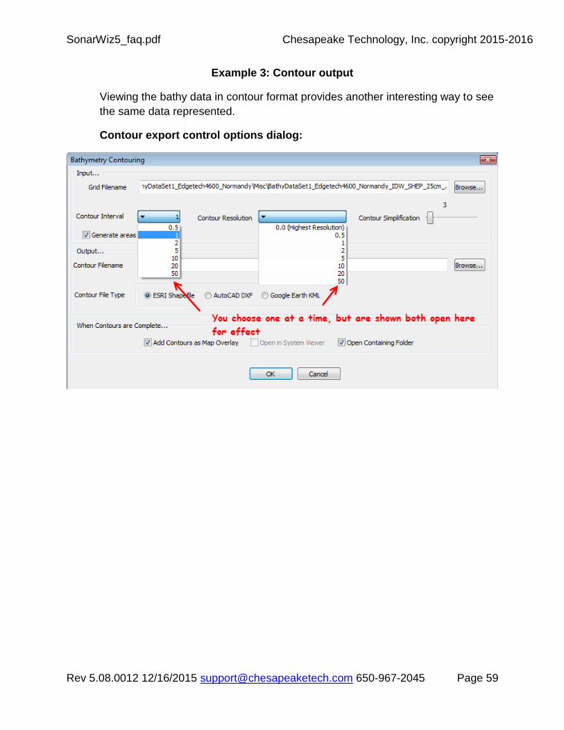
SonarWiz5_faq.pdf Chesapeake Technology, Inc. copyright 2015-2016
Rev 5.08.0012 12/16/2015 [email protected] 650-967-2045 Page 59
Example 3: Contour output
Viewing the bathy data in contour format provides another interesting way to see
the same data represented.
Contour export control options dialog:

SonarWiz5_faq.pdf Chesapeake Technology, Inc. copyright 2015-2016
Rev 5.08.0012 12/16/2015 [email protected] 650-967-2045 Page 60
Sample export contours (yellow) presented on bathy basemap:
Figure 9.12 Bathy yellow contours overlay a bathy grid imported as a basemap

SonarWiz5_faq.pdf Chesapeake Technology, Inc. copyright 2015-2016
Rev 5.08.0012 12/16/2015 [email protected] 650-967-2045 Page 61
Sample 0.5 m resolution bathy export contour SHP file presented as an overlay
on the Edgetech 4600 JSF sidescan data set (presented as RED grid, but of
course you can choose the color.):
Figure 9.13 Bathy red contours overlay JSF sidescan mosaic data

SonarWiz5_faq.pdf Chesapeake Technology, Inc. copyright 2015-2016
Rev 5.08.0012 12/16/2015 [email protected] 650-967-2045 Page 62
Example 4: Merged sidescan and bathy data images – Viewed in 3D Viewer.
Figure 9.14 Combined sidescan draped over bathy grid surface, viewed in CTI3DViewer