Some Features of the Tributaries to Lake Superior in ...
10
SOME FEATURES OF THE TRIBUTARIES TO LAKE SUPERIOR IN NORTHEASTERN MINNESOTA KARL VER STEEG.i College of Wooster, Wooster, Ohio More than thirty streams, extending from Duluth to the Pigeon River, along the north shore of Lake Superior, flow from the upland into this lake. Many of these have falls and rapids in their lower courses. They either rise in glacial lakes or marshes or flow through them, having broad, boulder-strewn channels but at a comparatively short distance from the lake, their gradients are steep. Here they cut deep, narrow gorges through the basalt flows, diabase dikes and sills of Keweenawan age. The streams have taken advantage of the vertical jointing and the weaker amygdaloidal zones in excavating their channels. Numerous well-developed potholes are found along the courses of some of the streams. The waterfalls and cascades are of exceptional beauty. The rejuvenation of the streams which is responsible for the gorges, is attributed to the gradual lowering of the glacial lake levels as new outlets were opened by the recession of the Lake Superior ice-lobe, the post-glacial tilting of the land, and the deepening and widening of the Lake Superior trough by the glacier. DESCRIPTION AND BASIC FACTS Along the north shore of .Lake Superior, the hills are close to the shoreline and cascades and waterfalls are present on many streams near their outlet. There are more than thirty rushing, tumbling streams between Duluth and the Canadian border, some of which descend as much as a thousand feet or more in their short courses to Lake Superior. The interstream divides rise to 400 feet and in some places nearly a thousand feet within a distance of a mile from the lake. There are numerous lakes at the headwaters of these streams which serve as storage reservoirs and supply a constant flow during dry seasons which adds to their value as future sources of water power. The principal streams, named in order from Duluth to the international boundary are the Lester, Gooseberry, Beaver Bay, Baptism (Fig. 2), Manitou (Fig. 3), Cross, Temperance, Poplar, Cascade, Devil's Track, Brule and Pigeon rivers. None are large streams and their drainage areas are comparatively small. The largest is the Pigeon River (Fig. 4), which has a drainage of 628 square miles. The others, in order of size, have the following drainage areas: 2 Brule, 282 sq. mi.; Temperance, 198 sq. mi.; Poplar, 144 sq. mi.; Baptism, 135 sq. mi.; Beaver Bay, 120 sq. mi.; Gooseberry, 85 sq. mi.; Cascade, 84 sq. mi.; Devil's Track, 75 sq. mi.; Manitou, 71 sq. mi.; Lester, 55 sq. mi., and Cross, 32 sq. mi The streams tributary to Lake Superior on the north shore flow from the upland with gradients averaging 250 feet in a distance of about one and one-half miles. The rapids and falls begin at points as close to Lake Superior as .05 mile, up to points greater than a mile. The altitude of their courses on the glaciated upland varies from 1650 to 1950 feet, averaging 1800 feet. In general, the minor tributaries on the north shore of Lake Superior have a rapid fall from source to mouth except for short distances through lakes or swamps. When traced from their outlets at Lake Superior to their sources, the general sequence of features is as follows: at the junction of the river and the lake there is usually a gravel bar ACKNOWLEDGMENTS: Thefieldwork was carried out by means of aid from a grant from the William Wilson Research Fund at the College of Wooster. 2 Leverett, Prank. Moraines and Shorelines of the Lake Superior Basin. U. S. Geol. Survey, Professional Paper 154, p. 11. 56
Transcript of Some Features of the Tributaries to Lake Superior in ...

SOME FEATURES OF THE TRIBUTARIES TO LAKE SUPERIORIN NORTHEASTERN MINNESOTA
KARL VER STEEG.iCollege of Wooster,
Wooster, Ohio
More than thirty streams, extending from Duluth to the Pigeon River, alongthe north shore of Lake Superior, flow from the upland into this lake. Many ofthese have falls and rapids in their lower courses. They either rise in glaciallakes or marshes or flow through them, having broad, boulder-strewn channelsbut at a comparatively short distance from the lake, their gradients are steep.Here they cut deep, narrow gorges through the basalt flows, diabase dikesand sills of Keweenawan age. The streams have taken advantage of the verticaljointing and the weaker amygdaloidal zones in excavating their channels. Numerouswell-developed potholes are found along the courses of some of the streams. Thewaterfalls and cascades are of exceptional beauty.
The rejuvenation of the streams which is responsible for the gorges, is attributedto the gradual lowering of the glacial lake levels as new outlets were opened bythe recession of the Lake Superior ice-lobe, the post-glacial tilting of the land,and the deepening and widening of the Lake Superior trough by the glacier.
DESCRIPTION AND BASIC FACTSAlong the north shore of .Lake Superior, the hills are close to the shoreline
and cascades and waterfalls are present on many streams near their outlet. Thereare more than thirty rushing, tumbling streams between Duluth and the Canadianborder, some of which descend as much as a thousand feet or more in their shortcourses to Lake Superior. The interstream divides rise to 400 feet and in someplaces nearly a thousand feet within a distance of a mile from the lake. Thereare numerous lakes at the headwaters of these streams which serve as storagereservoirs and supply a constant flow during dry seasons which adds to their valueas future sources of water power.
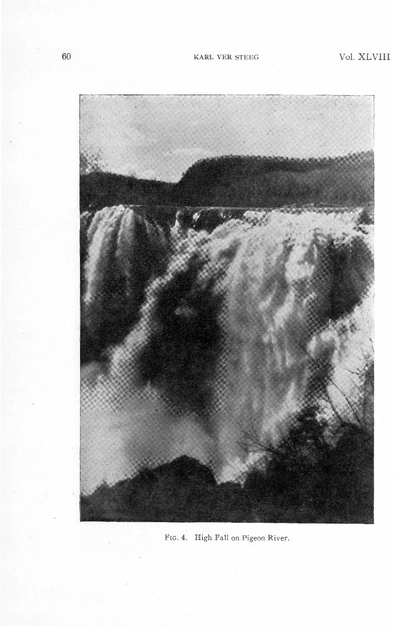
The principal streams, named in order from Duluth to the internationalboundary are the Lester, Gooseberry, Beaver Bay, Baptism (Fig. 2), Manitou(Fig. 3), Cross, Temperance, Poplar, Cascade, Devil's Track, Brule and Pigeonrivers. None are large streams and their drainage areas are comparatively small.The largest is the Pigeon River (Fig. 4), which has a drainage of 628 square miles.The others, in order of size, have the following drainage areas:2 Brule, 282 sq. mi.;Temperance, 198 sq. mi.; Poplar, 144 sq. mi.; Baptism, 135 sq. mi.; Beaver Bay,120 sq. mi.; Gooseberry, 85 sq. mi.; Cascade, 84 sq. mi.; Devil's Track, 75 sq. mi.;Manitou, 71 sq. mi.; Lester, 55 sq. mi., and Cross, 32 sq. mi
The streams tributary to Lake Superior on the north shore flow from theupland with gradients averaging 250 feet in a distance of about one and one-halfmiles. The rapids and falls begin at points as close to Lake Superior as .05 mile,up to points greater than a mile. The altitude of their courses on the glaciatedupland varies from 1650 to 1950 feet, averaging 1800 feet. In general, the minortributaries on the north shore of Lake Superior have a rapid fall from source tomouth except for short distances through lakes or swamps. When traced fromtheir outlets at Lake Superior to their sources, the general sequence of features is asfollows: at the junction of the river and the lake there is usually a gravel bar
ACKNOWLEDGMENTS: The field work was carried out by means of aid from a grant fromthe William Wilson Research Fund at the College of Wooster.
2Leverett, Prank. Moraines and Shorelines of the Lake Superior Basin. U. S. Geol.Survey, Professional Paper 154, p. 11.
56

No. 2 TRIBUTARIES TO LAKE SUPERIOR 57
thrown across the mouth by the vigorous waves from the lake. Because of theabsence of a bar at its mouth, the Temperance River was given its unique name.Behind the bars there may be a gentle gradient with rather quiet water for a shortdistance. In some instances, the falls and rapids begin not far back from theshoreline. For a distance of a mile, more or less, the streams flow through narrowgorges, leaping from ledge to ledge by cascades and waterfalls. Beyond the fallsand rapids on the upland, the streams open into wide, flat-bottomed, boulder-strewn channels. Their courses on the upland do not appear to follow any definitepreglacial channels and wind about through lakes and swamps, following the linesof least resistance. This condition is characteristic of immature drainage inglaciated regions.
The small tributaries to Lake Superior on the north shore, in Minnesota, areassociated with some of the finest scenery in the north country. They pass throughconiferous forests in deep, narrow, angular, vertically-walled gorges throughwhich the water leaps from pothole to pothole by a series of falls or rapids. Theyare, in many instances, easily accessible from the highway by trails constructedby the State Highway Department.
Perhaps the most spectacular of the falls are those on the Pigeon, Manitou(Fig. 3), Temperance, Cascade, Devil's Track (Fig. 6), Brule, Gooseberry andCross rivers. The Pigeon River has the highest falls (Fig. 4), 120 feet, and a narrowspectacular gorge in its lower course. The Temperance River is unique for itsextremely narrow gorge which is less than ten feet wide in places and 50 to 75feet deep. The thunder of the water as it passes from ledge to ledge, throughopenings not more than three feet wide, is awe-inspiring.
One of the most interesting features in the gorges of some of these streams isthe well-developed potholes. In the courses of the Temperance and Cascaderivers these potholes are especially well displayed (Fig. 5). In the opinion ofthe writer, there are few places in the country where one can see a finer display ofpotholes. Cut out of the solid rock, their sides are smoothly polished. Thegorges of the Temperance and Cascade rivers, for long distances, consist of a seriesof potholes, some large and others small. These streams flow through a forestedregion and their waters carry little material in suspension. The sediment is madeup of gravel, cobblestones and boulders, mainly of glacial origin, which makesexcellent material for grinding potholes in solid rock. In a number of instances,the writer found potholes from 6 inches to a foot or more in diameter, cut downvertically in the diabase for depths of two to three feet. So perfect are they thatthey appear to have been cut by a drill. The pebbles which served as grindingtools are still present in some of them. In some cases, the potholes are huge,being as much as 25 feet in diameter and shaped like a jug. The junction betweenpotholes is frequently sharp and triangular in outline. At one spot in the fallsof the Brule (Arrowhead) River, a large part of the water dashes down into apothole or circular pit about 8 to 10 feet in diameter, known as the "Devil'sKettle." The water disappears from view and the place where it makes itsreappearance at the surface is not visible. Hence, the belief that the pit is bottom-less and has no outlet. The water probably finds an outlet to the main channelby a subterranean course, not visible at the surface. Above the gorge of theTemperance River there is evidence that the water flowed originally in a broaderchannel. A deep abandoned pothole occurs along the trail not far from the edgeof the gorge, indicating that the stream at higher levels abandoned its course inplaces and sought new less resistant avenues of escape as it cut downward.
The conditions for the formation of the narrow angular gorges and potholesare ideal. The Keweenawan flows have amygdaloidal zones which are weakerand less resistant sedimentaries occur interstratified with the flows. The diabase

LEGENDI-LESTER RIVER I2-PIGE0N RIVER
13-PART RIDGE FALLS
14-FORT CHARLOTTE
15-GRAND PORTAGE TRAIL
16-HIGH FALLS
17-SPLIT ROCK CANYON
I8-S0UTH FOWL LK.
19-STUMP LAKE
20-STUMP RIVER.
21-GRAND PORTAGE CREEK
2-G00SEBERRY R1V.
3-BEAVER BAY RIV.
4-BAPTISM RIVER
5-MANITOU RIVER
6-CROSS RIVER
7-TEMPERANCE RIV.
8-POPLAR RIVER
9-CASCADE RIVER
10-DEVIL TRACK RIV.
H-BRULE RIVER
FIG. 1. A map showing some features of the tributaries to Lake Superior in northeastern Minnesota.
58 K
AR
L V
ER
STE
EG
V
ol. X
LV
III

No. 2 TRIBUTARIES TO LAKE SUPERIOR 59
FIG. 2. Falls of theBaptism River.
FIG. 3. Manitou Fallson Manitou River.
60 KARL VER STEEG Vol. XLVIII
FIG. 4. High Fall on Pigeon River.

No. 2 TRIBUTARIES TO LAKE SUPERIOR 61
FIG. 5. Cascade Falls on Cascade River.

62 KARL VER STEEG Vol. XLVIII
FIG. 6. Devil Track Fall on Devil Track River.

No. 2 TRIBUTARIES TO LAKE SUPERIOR 63
dikes and sills have well developed vertical jointing along which the streamshave cut their channels.
EFFECTS OF GLACIATION
In preglacial time the drainage lines were oriented in a general northeast-southwest direction, the result of the monoclinal ridge and valley topographyof the area. No doubt, the drainage in northeastern Minnesota was quite differentfrom that of today. It is probable that the body of water now known as LakeSuperior did not exist in preglacial time. It is more likely that its present sitewas a broad lowland occupied by a river system. Before the ice-age, the streamsin the area occupied broad open valleys of low gradient, such as characterize aregion in an advanced stage in the cycle of erosion. The advent of the ice-sheetschanged that condition; old streams were obliterated; others were forced to takenew courses and entirely new streams came into being. Numerous lakes andswamps are now present where none existed before.
Many of the youthful post-glacial streams have cut deep, narrow gorges havingnumerous waterfalls and rapids. One cannot but be impressed by the size anddepth of some of these post-glacial gorges. It may be that the enormous volumeof melt-water from the shrinking ice-sheets was responsible for the rapid erosionnecessary to produce gorges of such width and depth.
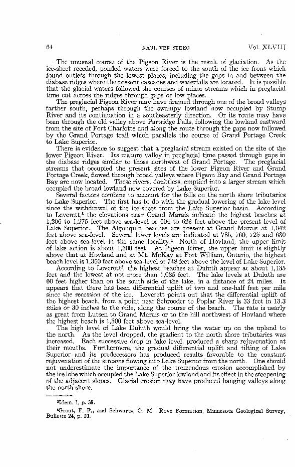
The Pigeon River has a comparatively low gradient in its lower course, ascompared with the slopes of the smaller streams along the north shore of LakeSuperior. This is accounted for by the fact that the Pigeon River is locatedprincipally on the Rove Slate which is weaker than the Keweenawan flows andintrusives. Pigeon River has an average gradient of 28 feet per mile in a distanceof 30 miles. For a distance of one and one-half miles from its mouth, it has erodedits channel down to the level of Lake Superior, whereas the other streams tributaryto the lake descend over rock ledges to points within short distances of the shoreline.
From a point above Partridge Falls about 20 miles from its outlet to one about1.7 miles from its mouth, the Pigeon River descends through deep, narrow gorgesby a series of waterfalls and rapids. From South Fowl Lake to Partridge Falls,a distance of 10.6 miles, the gradient of Pigeon River is only 11.3 feet per mile.Along the lower 20 miles the gradient averages 33 feet per mile. The gorge,cascades and falls are conspicuous where the river cuts through the resistantdiabase sills and dikes. At High Falls (Fig. 4), the Rove Slate is intruded by adike, trending N. 50 E., which forms the falls and a ridge on each side of the river.The fall of large masses of diabase from the face, resulting from prominent jointing,produces a vertical wall over which the water plunges a distance of 120 feet. Thepresence of a second dike, a short distance below High Falls is responsible foranother cataract of lesser height. Partridge Falls, 50 feet high, was formed bythe intrusion of a diabase dike into the Rove Slate.
On Pigeon River, about one and one-half miles northeast of Partridge Falls, isSplit Rock Canyon, a deep narrow gorge cut for the most part in the Rove Slate.The river has cut its channel so rapidly since the recession of the ice-sheet, thatlittle time has elapsed for widening the gorge by weathering and slope wash.
For a distance of about eight miles above Partridge Falls, the Pigeon Riverflows parallel to the diabase ridges and the escarpment formed by the Keweenawanflows, through a broad open valley on the Rove Slate, with continuous swamps to apoint near the outlet of South Fowl Lake and up the Stump River lowland toStump Lake. There is a great contrast in the course of the Pigeon River, belowand above Partridge Falls; the marked difference of a broad, open swampy valleyabove the steep-sided, narrow gorges with cascades and waterfalls below thatpoint. Apparently the post-glacial Pigeon River has not entrenched its gorge inthe old preglacial valley above Partridge Falls.
64 KARL VER STEEG Vol. XLVIII
The unusual course of the Pigeon River is the result of glaciation. As theice-sheet receded, ponded waters were forced to the south of the ice front whichfound outlets through the lowest places, including the gaps in and between thediabase ridges where the present cascades and waterfalls are located. It is possiblethat the glacial waters followed the courses of minor streams which in preglacialtime cu-t across the ridges through gaps or low places.
The preglacial Pigeon River may have drained through one of the broad valleysfarther south, perhaps through the swampy lowland now occupied by StumpRiver and its continuation in a southeasterly direction. Or its route may havebeen through the old valley above Partridge Falls, following the lowland eastwardfrom the site of Fort Charlotte and along the route through the gaps now followedby the Grand Portage trail which parallels the course of Grand Portage Creekto Lake Superior.
There is evidence to suggest that a preglacial stream existed on the site of thelower Pigeon River. Its mature valley in preglacial time passed through gaps inthe diabase ridges similar to those northwest of Grand Portage. The preglacialstreams that occupied the present sites of the lower Pigeon River and GrandPortage Creek, flowed through broad valleys where Pigeon Bay and Grand PortageBay are now located. These rivers, doubtless, emptied into a larger stream whichoccupied the broad lowland now covered by Lake Superior.
Several factors combine to account for the falls on the north shore tributariesto Lake Superior. The first has to do with the gradual lowering of the lake levelsince the withdrawal of the ice-sheet from the Lake Superior basin. Accordingto Leverett,3 the elevations near Grand Marais indicate the highest beaches at1,206 to 1,275 feet above sea-level or 604 to 623 feet above the present level ofLake Superior. The Algonquin beaches are present at Grand Marais at 1,042feet above sea-level. Several lower levels are indicated at 785, 760, 725 and 630feet above sea-level in the same locality.4 North of Hovland, the upper limitof lake action is about 1,300 feet. At Pigeon River, the upper limit is slightlyabove that at Hovland and at Mt. McKay at Fort William, Ontario, the highestbeach level is 1,350 feet above sea-level or 748 feet above the level of Lake Superior.
According to Leverett2, the highest beaches at Duluth appear at about 1,135feet and the lowest at not more than 1,085 feet. The lake levels at Duluth are60 feet higher than on the south side of the lake, in a distance of 24 miles. Itappears that there has been differential uplift of two and one-half feet per milesince the recession of the ice. Leverett points out that the differential uplift ofthe highest beach, from a point near Schroeder to Poplar River is 33 feet in 13.3miles or 30 inches to the mile, along the course of the beach. The rate is nearlyas great from Lutsen to Grand Marais or to the hill northwest of Hovland wherethe highest beach is 1,300 feet above sea-level.
The high level of Lake Duluth would bring the water up on the upland tothe north. As the level dropped, the gradient to the north shore tributaries wasincreased. Each successive drop in lake level, produced a sharp rejuvenation attheir mouths. Furthermore, the gradual differential uplift and tilting of LakeSuperior and its predecessors has produced results favorable to the constantrejuvenation of the streams flowing into Lake Superior from the north. One shouldnot underestimate the importance of the tremendous erosion accomplished bythe ice lobe which occupied the Lake Superior lowland and its effect in the steepeningof the adjacent slopes. Glacial erosion may have produced hanging valleys alongthe north shore.
8Idem. 1, p. 59.4Grout, F. F., and Schwartz, G. M. Rove Formation, Minnesota Geological Survey,
Bulletin 24, p. 10.

No. 2 TRIBUTARIES TO LAKE SUPERIOR 65
The steep shores of Lake Superior have been attributed to faulting. In thewriter's opinion, not enough emphasis has been placed on the effects of glacialerosion in the Lake Superior trough. The lake basin was deepened and its sideseroded, producing on the north side, a steep regular slope which has been modifiedby the waves and currents since the ice-age.
A feature which can be pointed out here, is that the convex profile of the northshore tributaries to Lake Superior is significant.4 This is interpreted by thewriter as an indication that the erosive power of the streams has not been able tokeep pace with the rise of the land.
4Idem. 1, Profile of the St. Louis River, Figure 3, p. 9.