SOLUTIONS FOR ENERGY, INFRASTRUCTURE AND … · disruption or environmental degradation. Hazards...
8
SOLUTIONS FOR ENERGY, INFRASTRUCTURE AND THE ENVIRONMENT
Transcript of SOLUTIONS FOR ENERGY, INFRASTRUCTURE AND … · disruption or environmental degradation. Hazards...

SOLUTIONS FOR ENERGY, INFRASTRUCTURE AND THE ENVIRONMENT
2
Pöyry has more than 100 years of experience in consulting and engineering services. Around 6,000 specialists and generalists ensure competent advice all over the world. The interdisciplinary cooperation of our experienced specialists provides for short response time. New ideas are immediately taken into account and implemented. You have a professional partner who organises all activities, solves your problems and saves you time and money.
Introduction
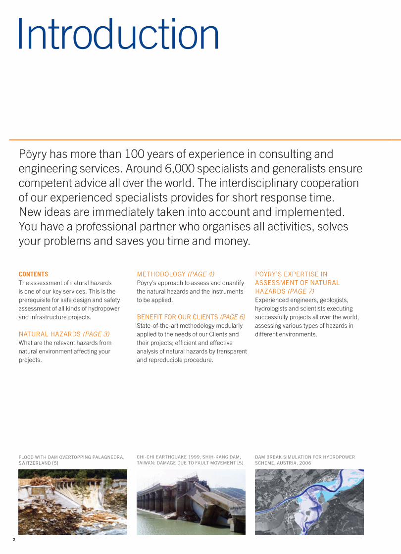
FLOOD WITH DAM OVERTOPPING PALAGNEDRA, SWITZERLAND [5]
CHI-CHI EARTHQUAKE 1999, SHIH-KANG DAM, TAIWAN: DAMAGE DUE TO FAULT MOVEMENT [5]
DAM BREAK SIMULATION FOR HYDROPOWER SCHEME, AUSTRIA, 2006
CONTENTSThe assessment of natural hazards is one of our key services. This is the prerequisite for safe design and safety assessment of all kinds of hydropower and infrastructure projects.
NATURAL HAZARDS (PAGE 3)What are the relevant hazards from natural environment affecting your projects.
METHODOLOGY (PAGE 4)Pöyry’s approach to assess and quantifythe natural hazards and the instrumentsto be applied.
BENEFIT FOR OUR CLIENTS (PAGE 6)State-of-the-art methodology modularly applied to the needs of our Clients and their projects; efficient and effective analysis of natural hazards by transparent and reproducible procedure.
PÖYRY’S EXPERTISE IN ASSESSMENT OF NATURAL HAZARDS (PAGE 7)Experienced engineers, geologists, hydrologists and scientists executing successfully projects all over the world, assessing various types of hazards in different environments.

3
Natural Hazards
SLOPE FAILURE AFTER HEAVY RAINFALL, SRI LANKA, 2012
ROCK FALL PROTECTION BARRIERS ABOVE OVA SPIN DAM, SWISS ALPS, 2015
INSTABLE SLOPES ABOVE STILLING BASIN, PRADELLA, SWISS ALPS, 2014
Various types of natural hazards can bedistinguished, depending on topographic and climatic conditions in the project area.
HAZARDSA potentially damaging physical event, that may cause the loss of life or injury, property damage, social and economic disruption or environmental degradation. Hazards can be single, sequential or combined in their origin and effects. Each hazard is characterised by its location, intensity and probability (Ref. [1]).
They represent a serious threat to humanlife and assets. Therefore a thorough assessment of the prevailing hazards and risks in a specific region is imperative for any kind of development activity. This is particularly important in disaster-prone areas, like floodplains, steep valleys in mountainous regions, areas of high seismicity or areas exposed to storms and high precipitation.
GEOLOGICAL HAZARDS• Earthquake• Landslides / Slope Failure• Block and Rock Fall / Rock
Avalanche• Debris Flow• Ground Subsidence• Dissolution of Rock, etc.
METEOROLOGICAL AND HYDROLOGICAL HAZARDS• Heavy Rain• Flash Flood• River Flood• Strong Wind• Wild Fire• Snow Avalanche• Anomalies of Temperatures, etc.
The time-dependence of the different hazards, which plays an increasing role in connection with climatic change, mustbe addressed. This requires periodic reassessment of the hazards when new information is available.

4
4. PLANNING OF MEASURES ACCORDING TO SUSTAINABILITY
PRINCIPLES• Planning of measures, applying an
integrated approach by following applicable codes, regulations and recommendations
• Planning of sustainable solutions• Partnership with all project
stakeholders and authorities
An integrated approach for reduction ofhazards and risks demands well estab-lished hazard and risk assessments.
Pöyry’s approach in the assessment of natural hazards will mainlyfollows the methods developed and used successfully in infra-structure projects in Switzerland and abroad, which are located in difficult geological, topographical and climatic environments.
Methodology
RISKThe probability of harmful consequences, or expected losses resulting from inter-actions between natural hazards and vulnerable conditions. Conventionally risk is expressed by the notation Risk = Hazards x Vulnerability (Ref. [1]).
Pöyry’s approach to assess and quantify the natural hazards and the instruments to be applied.
1. RISK ASSESSMENT• Analysis of all prevailing hazards• Analysis of vulnerabilities• Use of harmonized and natural
hazard-consistent procedures
2. RISK EVALUATION AND DEFINITION OF PROTECTION GOALS
3. DEFINITION OF DESIGN CRITERIA
Reduction of risks from natural hazards has a long tradition in Switzerland, startingwith the construction of the railways through the Alps and the development of the water resources by run-of-river power plants and large storage schemes, some of them have been in successful operation for more than 100 years. Today, risk-based approaches for particular natural hazards such as flood and earthquakes are gaining importance.
A risk-based approach comprises stand-ardized procedures, clearly defined and logic steps of activities, allowing a flexible application of the methodology depending on the project’s size and complexity, present hazard types and their potential of impact.
VULNERABILITYThe conditions determined by physical, social, economic, and environmental factors or processes, which increase the susceptibility of a community to the impact of hazards. The vulnerability is determined by the exposure, the value and the susceptibility to be damaged (“References”, page 7).
THE APPLIED RISK CONZEPT [1]

5
MAP OF PHENOMENA, GOESCHENERALP DAM, SWISS ALPS [2]
DANGER MAP, GOESCHENERALP DAM, SWISS ALPS [2]
WAVE PROPAGATION IN IN A RIVER AFTER SLOPE FAILURE [3]
THE PRIMARY GOAL IS TO FIND ANSWERS TO THE FOLLOWING QUESTIONS
1. What can happen (slope failure, rock fall, flood, etc.) and where will it happen? >> Identification of hazards2. How often and how intense will it happen, how big is the expected damage? >> Analysis of hazards and vulnerabilities and risk3. What are the most efficient ways to protect people and assets? >> Planning of measures
The bases for answering these questions are a series of map types (Ref. [1]):
1. EVENT MAP AND EVENT REGISTER
Record events occurred in the past and provide a first overview.
2. MAP OF PHENOMENA
Documents past events and phenomena/ sources indicating future, potential events.
3. HAZARD INDICATION MAP
Shows where a hazardous process can occur; hazards are distinguished according to the type of hazard, source area, flow path and impact area.
4. DANGER MAP
Shows intensity and probability of the process: Primary management tool, justi-fication for structural protection measures, basis for site monitoring and emergency planning, basis for risk assessment.
5. VULNERABILITY MAP (MAP OF POTENTIAL
DAMAGE)
Contents economic assets and is used as tool for emergency planning, priority setting and basis for production of risk maps.
6. RISK MAP
Shows either a qualitative classification of risk, an average loss per event or per year, a number of deaths per event or per year. Is the basis for the chronological and
financial prioritisation of protection measures and is the most appropriate tool for decision making about structural and non-structural measures.
7. EARTHQUAKE MAP
Shows the probabilistic earthquakehazard of the area.
8. INTENSITY MAP
Provides the spatial extent and thecorresponding intensities of a naturalevent, having a specific return period orprobability of occurrence.
The type and complexity of the projectdefines which map types will be appliedfor the assessment.

6
This methodological approach gives the following benefits to the Client:
Benefit for the Client
STATE-OF-THE ART METHODOLOGYThe working steps are well defined, standardized and can be successfully applied for different natural hazards and infrastructure projects.
MODULAR CONCEPT APPLICABLE TO THE NEEDSThe level of applied instruments and level of assessed details (simplification) can be adjusted to the size and complexity of the situation / project.
EFFICIENT AND EFFECTIVE TREATMENT OF NATURAL HAZARDSOnly hazards with real impact on the project will be treated and the mitigation measures can be tailored to the risk. However, all possible hazards will be considered.
TRANSPARENT AND REPRODUCIBLE PROCEDURE
The standardisation of the steps and instruments enables transparency and reproducibility of the results for all stakeholders.
COSTOur tailored studies to the Clients needs lead to the most cost efficient solutions.
INUNDATION AND FLOOD HAZARD MAPS FOR A RIVER VALLEY IN TURKEY [4]
MASS MOVEMENTS INTO ZIPINGPU RESERVOIR, WENCHUAN EARTHQUACKE, MAY 2008, CHINA [5]
7
Our Experience& References
WORLD-WIDE FIELD EXPERIENCEPöyry with its countless and successfully
executed projects has the required experience
and knowledge from all different geographical
regions in the world.
NATURAL HAZARD EXPERTSOur experts are familiar with the Swiss
approach of natural hazard assessment and
many other state-of-the-art methodologies and
have long experience from hydropower and
other infrastructure projects world-over.
YOUR CONTACTS FOR NATURAL HAZARD ASSESSMENTGEOLOGICAL HAZARDS:Dr. Thomas Dietler, geologist, Zurich,
Switzerland; 33 years of professional
experience in geological fieldwork and natural
hazard assessments in Switzerland, Norway,
Sri Lanka, India, Papua New Guinea, Iran,
Mozambique, etc.
EARTHQUAKE HAZARDS:Dr. Martin Wieland, senior dam engineer
and earthquake expert, Zurich, Switzerland
45 years of professional experience in the
seismic safety evaluation of some of the
world’s largest dams and other infrastructure
projects. He has been the Chairman of the
ICOLD Committee on Seismic Aspects of Dam
Design since 1999.
METEOROLOGICAL HAZARDS:Dr. Martin Fuchs, hydrologist, Vienna, Austria;
18 years of professional experience in the field
of climate change, climate resilience, hydro-
meteorology and hydrology in water resources
and hydropower systems worldwide.
REFERENCES[1] Zimmermann, M. et al., 2005:
Hazard maps and related instruments
– The Swiss system and its application abroad:
Capitalisation of experience; Vademecum,
publ. by SDC Swiss Agency
for Development and Cooperation, Bern.
[2] Dietler, T., 2011: Goescheneralp dam – impact of natural
hazards on construction site and free-board
optimisation. In: Proceedings of the
international Symposium on Dams and
Reservoirs under changing Challenges – 79
annual Meeting of ICOLD, Swiss Committee
on Dams, Lucerne, Switzerland, 1 June 2011;
Editors: Schleiss, A.J. & Boes, R.M.
[3] Jung, G. et al., 2015: Landslides and triggering of flood waves in
reservoirs and lakes: Conference Paper
EUROCK 2015 Salzburg, Regional Symposium
of International Society for Rock Mechanics.
[4] Fuchs, M. et al., 2015: Current international practice in emergency
planning and use of modern tools for dam-break
flood simulation with emphasis on their
applicability in Turkey, DSI 2nd Dams Congress,
February 13-15th 2014, Istanbul, Turkey.
[5] Wieland, M. 2016: Seismic Hazards of Large Storage Dams,
Proc. Hydro 2016 Achievements,
Opportunities and Challenges, International
Conference and Exhibition, Montreux,
Switzerland, 10-12 October 2016.
PROJECT REFERENCES (SELECTION)2006; Siah Bisheh Pumped Storage
Hydropower Scheme, Albroz Mountains, I.R.
Iran: Assessment of slope stabilities along
the reservoir rims.
2009; Seismic hazard assessment of the
proposed 325 m high Bakhtiary arch dam
in Iran.
2010; KW Goeschenen, Goescheneralp dam,
Swiss Alps: Assessment of natural hazard risks
around embankment dam and reservoir area.
2011; Seismic hazard assessment and design
of the 1500 MW Mphanda Nkuwa run-of-river
power plant at the Zambezi River in Mozambique.
2012; Baspa Stage II HEP, Himachal Pradesh,
India: Detailed analysis of retrogressive erosion
damages on the scheme after the flash flood
event of July 2005.
2014; Seyhan and Ceyhan Hydropower
Cascades, SE- Anatolia Region, Turkey.
Emergency Action Plans for Impounding and
Operation.
2015; Safety evaluation of the 131 m high
Main Dam and Main Dyke of the Angat storage
scheme in the Philippines (Manila Water
Supply). 2016; Hapimag, flood protection for
Scerne di Pineto Hotel Resort, Teramo, Italy.
The professional assessment of Natural Hazards requires a long experience of observations and mapping in the field. We can provide this important precondition.
www.poyry.com
Pöyry has a global office network - please visit:www.poyry.com/contacts
Our Hydropower offices:
Pöyry Schweiz AG, ZurichHerostrasse 12, P.O. Box CH-8048 ZÜ[email protected]: +41 44 355 5555
Pöyry Energy GmbH, ViennaKranichberggasse 4, J2 1120 VIENNA [email protected]: +43 1 536 05-0
Pöyry Energy Ltd, BangkokVanit Building II 22nd Floor, Room No. 2202-2204 1126/2 New Petchburi Road Makkasan, Rajchthewi TH-10400 BANGKOK [email protected]: +66 2 108 1000
Pöyry (Peru) S.A.C., LimaAv. José Gálvez Barrenechea 223 San Isidro LIMA 27 [email protected]: +51 1 2249 111
Consulting. Engineering. Projects. Operations.
Smart solutions across power generation, transmission & distribution,
forest industry, chemicals & biorefining, mining & metals, transportation and water.
6000 experts. 45 countries. 150 offices.