Soil Survey of Jefferson County, Tennessee - Natural Resources
178
United States Department of Agriculture Natural Resources Conservation Service Soil Survey of In cooperation with the Tennessee Agricultural Experiment Station, the Jefferson County Board of Commissioners, and the Tennessee Department of Agriculture Jefferson County, Tennessee Detailed maps are available in two formats. Digital copies (SSURGO) that can be used in a Geographic Information System (GIS) can be accessed at http://www.ftw.nrcs.usda.gov/ssur_data.html. (The State Soil Survey Area ID is TN089.) Paper copies of the maps can be obtained from the Natural Resources Conservation Service, 1230 Circle Drive, Dandridge, TN 37725 (telephone number 423-397-3151).
Transcript of Soil Survey of Jefferson County, Tennessee - Natural Resources

United StatesDepartment ofAgriculture
NaturalResourcesConservationService
Soil Survey ofIn cooperation withthe Tennessee AgriculturalExperiment Station, theJefferson CountyBoard of Commissioners,and the TennesseeDepartment of Agriculture
Jefferson County,Tennessee
Detailed maps are available in two formats. Digital copies (SSURGO)that can be used in a Geographic Information System (GIS) can beaccessed at http://www.ftw.nrcs.usda.gov/ssur_data.html. (The StateSoil Survey Area ID is TN089.) Paper copies of the maps can beobtained from the Natural Resources Conservation Service, 1230 CircleDrive, Dandridge, TN 37725 (telephone number 423-397-3151).


General Soil Map
The general soil map, which is a color map, shows the survey area divided into groups of associated soils calledgeneral soil map units. This map is useful in planning the use and management of large areas.
To find information about your area of interest, locate that area on the map, identify the name of the map unit in thearea on the color-coded map legend, then refer to the section General Soil Map Units for a general description ofthe soils in your area.
Detailed Soil Maps
The detailed soil maps can be useful in planning the use andmanagement of small areas.
To find information about your areaof interest, locate that area on theIndex to Map Sheets. Note thenumber of the map sheet and turnto that sheet.
Locate your area of interest onthe map sheet. Note the map unitsymbols that are in that area. Turnto the Contents, which lists themap units by symbol and nameand shows the page where eachmap unit is described.
The Contents shows which tablehas data on a specific land use foreach detailed soil map unit. Alsosee the Contents for sections ofthis publication that may addressyour specific needs.
3
How to Use This Soil Survey

4
Additional information about the Nation’s natural resources is available on theNatural Resources Conservation Service home page on the World Wide Web. Theaddress is http://www.nrcs.usda.gov (click on “Technical Resources”).
This soil survey is a publication of the National Cooperative Soil Survey, a joint effortof the United States Department of Agriculture and other Federal agencies, Stateagencies including the Agricultural Experiment Stations, and local agencies. TheNatural Resources Conservation Service (formerly the Soil Conservation Service)leads the Federal part of the National Cooperative Soil Survey.
Major fieldwork for this soil survey was completed in 1988. Soil names anddescriptions were approved in 1991. Unless otherwise indicated, statements in thispublication refer to conditions in the survey area in 1988. This survey was madecooperatively by the Natural Resources Conservation Service, the TennesseeAgricultural Experiment Station, the Jefferson County Board of Commissioners, and theTennessee Department of Agriculture. The survey is part of the technical assistancefurnished to the Jefferson County Soil Conservation District.
Soil maps in this survey may be copied without permission. Enlargement of thesemaps, however, could cause misunderstanding of the detail of mapping. If enlarged,maps do not show the small areas of contrasting soils that could have been shown at alarger scale.
The United States Department of Agriculture (USDA) prohibits discrimination in all itsprograms on the basis of race, color, national origin, gender, religion, age, disability,political beliefs, sexual orientation, and marital or family status. (Not all prohibited basesapply to all programs.) Persons with disabilities who require alternative means forcommunication of program information (Braille, large print, audiotape, etc.) shouldcontact USDA’s TARGET Center at 202-720-2600 (voice and TDD).
To file a complaint of discrimination, write USDA, Director, Office of Civil Rights,Room 326-W, Whitten Building, 14th and Independence Avenue, SW, Washington, DC20250-9410 or call 202-720-5964 (voice and TDD). USDA is an equal opportunityprovider and employer.
Cover: Pasture and woodland are major land uses in Jefferson County. Dunmore and Fullertonsoils are dominant on this landscape.

5
Contents
How to Use This Soil Survey .................................. 3Contents .................................................................. 5Foreword ................................................................. 9General Nature of the County ................................. 11
History and Development ................................... 11Resources and Development ............................. 12Transportation .................................................... 12Physiography, Geology, Relief, and Drainage ..... 12Climate ............................................................... 13
How This Survey Was Made ................................... 13General Soil Map Units ........................................ 15
1. Dandridge-Sequoia ...................................... 152. Dewey-Etowah ............................................. 153. Dunmore-Fullerton-Dewey ........................... 164. Talbott-Rock Outcrop ................................... 175. Collegedale-Armuchee-Talbott-Rock
Outcrop ................................................... 176. Nolichucky-Swafford-Purdy .......................... 187. Allen-Bouldin ................................................ 18
Detailed Soil Map Units ........................................ 19AeC—Arents, clayey, 2 to 12 percent slopes ...... 20AnC2—Allen sandy loam, 5 to 12 percent
slopes, eroded ............................................. 20AnD2—Allen sandy loam, 12 to 20 percent
slopes, eroded ............................................. 20AnE—Allen sandy loam, 20 to 40 percent
slopes .......................................................... 21ArD2—Armuchee channery silt loam,
10 to 25 percent slopes, eroded ................... 21ArE3—Armuchee channery silty clay loam,
15 to 45 percent slopes, severely eroded ..... 22ArF2—Armuchee channery silt loam, 25 to
60 percent slopes, eroded ........................... 22Be—Beason silt loam, occasionally flooded ....... 23BoD—Bouldin cobbly sandy loam, 12 to
25 percent slopes, very stony ...................... 23BoF—Bouldin cobbly sandy loam, 25 to
70 percent slopes, very stony ...................... 23CoB2—Collegedale silt loam, 2 to 5 percent
slopes, eroded ............................................. 25CoC2—Collegedale silt loam, 5 to 12 percent
slopes, eroded ............................................. 25CoC3—Collegedale silty clay loam, 5 to
15 percent slopes, severely eroded ............. 26
CoD2—Collegedale silt loam, 12 to20 percent slopes, eroded ........................... 26
CtD2—Collegedale-Talbott-Rock outcropcomplex, 5 to 20 percent slopes, eroded...... 27
CtE2—Collegedale-Talbott-Rock outcropcomplex, 20 to 35 percent slopes,eroded ......................................................... 27
DaC2—Dandridge channery silt loam, 5 to12 percent slopes, eroded ........................... 28
DaD2—Dandridge channery silt loam,12 to 25 percent slopes, eroded ................... 29
DaD3—Dandridge channery silty clay loam,10 to 25 percent slopes, severely eroded ..... 29
DaE3—Dandridge channery silty clay loam,25 to 50 percent slopes, severely eroded ..... 30
DaF2—Dandridge channery silt loam,25 to 70 percent slopes, eroded ................... 30
DcB2—Decatur silt loam, 2 to 5 percentslopes, eroded ............................................. 31
DeC2—Dewey silt loam, 5 to 12 percentslopes, eroded ............................................. 31
DeC3—Dewey silty clay loam, 5 to12 percent slopes, severely eroded ............. 31
DeD2—Dewey silt loam, 12 to 20 percentslopes, eroded ............................................. 32
DeD3—Dewey silty clay loam, 12 to20 percent slopes, severely eroded ............. 32
DfD2—Dewey-Rock outcrop complex, 5 to20 percent slopes, eroded ........................... 33
Dm—Dumps, mine ............................................. 33DuB2—Dunmore silt loam, 2 to 5 percent
slopes, eroded ............................................. 33DuC2—Dunmore silt loam, 5 to 12 percent
slopes, eroded ............................................. 34DuC3—Dunmore silty clay loam, 5 to
12 percent slopes, severely eroded ............. 34DuD2—Dunmore silt loam, 12 to
20 percent slopes, eroded ........................... 35DuD3—Dunmore silty clay loam, 12 to
20 percent slopes, severely eroded ............. 35DuE2—Dunmore silt loam, 20 to 40 percent
slopes, eroded ............................................. 36DuE3—Dunmore silty clay loam, 20 to
40 percent slopes, severely eroded ............. 36

6
DwE3—Dunmore and Fullerton soils, 10 to30 percent slopes, gullied ............................ 37
DxE2—Dunmore and Fullerton soils, karst,10 to 30 percent slopes, eroded ................... 37
Em—Emory silt loam, rarely flooded .................. 38En—Ennis cobbly loam, occasionally
flooded ......................................................... 38EtB—Etowah silt loam, 2 to 5 percent slopes ..... 39EtC—Etowah silt loam, 5 to 12 percent
slopes .......................................................... 39EtD—Etowah silt loam, 12 to 25 percent
slopes .......................................................... 39FaE2—Farragut silt loam, 20 to 40 percent
slopes, eroded ............................................. 40FuC2—Fullerton gravelly silt loam, 5 to
12 percent slopes, eroded ........................... 40FuD2—Fullerton gravelly silt loam, 12 to
25 percent slopes, eroded ........................... 40FuE2—Fullerton gravelly silt loam, 25 to
45 percent slopes, eroded ........................... 41GpD2—Gilpin channery silt loam, 12 to
25 percent slopes, eroded ........................... 41GpF—Gilpin channery silt loam, 25 to
70 percent slopes ........................................ 42GuE3—Gullied land-Dandridge complex, 15
to 50 percent slopes, severely eroded.......... 42Ln—Lindside silt loam, occasionally flooded ...... 42MnC—Minvale gravelly silt loam, 5 to
15 percent slopes ........................................ 43MoC—Montevallo channery silt loam, 2 to
10 percent slopes ........................................ 43MoD—Montevallo channery silt loam,
10 to 20 percent slopes ................................ 44MpE—Montevallo-Armuchee complex,
15 to 50 percent slopes, gullied.................... 44MuB—Muse silt loam, 2 to 5 percent slopes ...... 45MuC—Muse silt loam, 5 to 12 percent
slopes .......................................................... 45MwE—Muskingum silt loam, 25 to
50 percent slopes ........................................ 45Ne—Newark silt loam, frequently flooded ........... 46NkB2—Nolichucky loam, 2 to 5 percent
slopes, eroded ............................................. 46
NkC2—Nolichucky loam, 5 to 12 percentslopes, eroded ............................................. 47
NkD2—Nolichucky loam, 12 to 20 percentslopes, eroded ............................................. 47
NmD2—Nolichucky gravelly loam, 10 to20 percent slopes, eroded ........................... 47
No—Nolin silt loam, occasionally flooded ........... 48Pu—Purdy silt loam ............................................ 48RaD—Ramsey-Rock outcrop complex,
12 to 25 percent slopes ................................ 49RaF—Ramsey-Rock outcrop complex,
25 to 70 percent slopes ................................ 49SeB2—Sequoia silt loam, 2 to 5 percent
slopes, eroded ............................................. 50SeC2—Sequoia silt loam, 5 to 12 percent
slopes, eroded ............................................. 50SeC3—Sequoia silty clay loam, 5 to
12 percent slopes, severely eroded ............. 50SeD2—Sequoia silt loam, 12 to 20 percent
slopes, eroded ............................................. 51St—Staser fine sandy loam, overwash, rarely
flooded ......................................................... 51SwB—Swafford silt loam, 1 to 4 percent
slopes, rarely flooded ................................... 52TaE2—Talbott-Rock outcrop complex, karst,
10 to 35 percent slopes, eroded ................... 52TsB—Tasso silt loam, 2 to 5 percent
slopes .......................................................... 53WaC2—Waynesboro loam, 5 to 12 percent
slopes, eroded ............................................. 53WaD2—Waynesboro loam, 12 to
20 percent slopes, eroded ........................... 53Wb—Whitesburg silt loam, occasionally
flooded ......................................................... 54Prime Farmland .................................................... 55Use and Management of the Soils ...................... 57
Crops and Pasture ............................................. 57Yields per Acre ............................................... 58Land Capability Classification ........................ 58
Woodland Management and Productivity ........... 59Recreation .......................................................... 60Wildlife Habitat ................................................... 61Engineering ........................................................ 62

7
Issued 2000
Building Site Development ............................. 63Sanitary Facilities ........................................... 64Construction Materials ................................... 65Water Management ........................................ 66
Soil Properties ...................................................... 69Engineering Index Properties ............................. 69Physical and Chemical Properties ...................... 70Soil and Water Features ..................................... 71
Classification of the Soils .................................... 73Soil Series and Their Morphology ........................... 73
Allen Series ........................................................ 73Armuchee Series ................................................ 74Beason Series .................................................... 75Bouldin Series .................................................... 76Collegedale Series ............................................. 76Dandridge Series ............................................... 77Decatur Series ................................................... 78Dewey Series ..................................................... 79Dunmore Series ................................................. 79Emory Series ..................................................... 80Ennis Series ....................................................... 81Etowah Series .................................................... 82Farragut Series ................................................... 82Fullerton Series .................................................. 83Gilpin Series ....................................................... 84Lindside Series ................................................... 84Minvale Series .................................................... 85Montevallo Series ............................................... 86Muse Series ....................................................... 86Muskingum Series .............................................. 87Newark Series .................................................... 88Nolichucky Series ............................................... 88Nolin Series ........................................................ 89
Purdy Series ...................................................... 89Ramsey Series ................................................... 90Sequoia Series ................................................... 91Staser Series ..................................................... 91Swafford Series .................................................. 92Talbott Series ..................................................... 93Tasso Series ...................................................... 93Waynesboro Series ............................................ 94Whitesburg Series .............................................. 95
References ............................................................ 97Glossary ................................................................ 99Tables ................................................................ 113
Table 1.—Temperature and Precipitation .......... 114Table 2.—Freeze Dates in Spring and Fall ........ 115Table 3.—Growing Season ............................... 115Table 4.—Acreage and Proportionate Extent
of the Soils ................................................. 116Table 5.—Prime Farmland ................................ 118Table 6.—Land Capability and Yields per
Acre of Crops and Pasture ......................... 119Table 7.—Woodland Management and
Productivity ................................................ 124Table 8.—Recreational Development ............... 132Table 9.—Wildlife Habitat .................................. 137Table 10.—Building Site Development .............. 142Table 11.—Sanitary Facilities ........................... 147Table 12.—Construction Materials .................... 152Table 13.—Water Management ........................ 157Table 14.—Engineering Index Properties ......... 162Table 15.—Physical and Chemical Properties
of the Soils ................................................. 170Table 16.—Soil and Water Features ................. 175Table 17.—Classification of the Soils ................ 178


9
This soil survey contains information that affects land use planning in JeffersonCounty. It contains predictions of soil behavior for selected land uses. The survey alsohighlights soil limitations, improvements needed to overcome the limitations, and theimpact of selected land uses on the environment.
This soil survey is designed for many different users. Farmers, ranchers, foresters,and agronomists can use it to evaluate the potential of the soil and the managementneeded for maximum food and fiber production. Planners, community officials,engineers, developers, builders, and home buyers can use the survey to plan land use,select sites for construction, and identify special practices needed to ensure properperformance. Conservationists, teachers, students, and specialists in recreation, wildlifemanagement, waste disposal, and pollution control can use the survey to help themunderstand, protect, and enhance the environment.
Various land use regulations of Federal, State, and local governments may imposespecial restrictions on land use or land treatment. The information in this report isintended to identify soil properties that are used in making various land use or landtreatment decisions. Statements made in this report are intended to help the land usersidentify and reduce the effects of soil limitations that affect various land uses. Thelandowner or user is responsible for identifying and complying with existing laws andregulations.
Great differences in soil properties can occur within short distances. Some soils areseasonally wet or subject to flooding. Some are shallow to bedrock. Some are toounstable to be used as a foundation for buildings or roads. Clayey or wet soils arepoorly suited to use as septic tank absorption fields. A high water table makes a soilpoorly suited to basements or underground installations.
These and many other soil properties that affect land use are described in this soilsurvey. Broad areas of soils are shown on the general soil map. The location of eachsoil is shown on the detailed soil maps. Each soil in the survey area is described.Information on specific uses is given for each soil. Help in using this publication andadditional information are available at the local office of the Natural ResourcesConservation Service or the Cooperative Extension Service.
Foreword
James W. FordState ConservationistNatural Resources Conservation Service


11
JEFFERSON COUNTY is in the northeastern part ofTennessee (fig. 1). It covers 314 square miles, or200,900 acres. Its boundaries are the Holston Riverand Hamblen County on the north, the French BroadRiver and Cocke County on the east, Sevier Countyon the south, and Knox and Sevier Counties on thewest.
The population of the county in 1986, according tothe Chamber of Commerce, was 33,400. Dandridge,the county seat, is on the French Broad River, 30miles east of Knoxville. Dandridge was named forMartha Dandridge Washington, wife of GeorgeWashington. Jefferson City, with a population of 6,000,is the largest town in the county. Other towns are NewMarket, Strawberry Plains, Talbott, White Pine,Piedmont, Oak Grove, Shady Grove, Chestnut Hill,Pleasant Hill, and Sandy Ridge.
Two large reservoirs are in the county. CherokeeReservoir is an impoundment of the Holston River.It forms part of the northern boundary of the county.Douglas Reservoir is an impoundment of theFrench Broad River. It covers part of the southeastcorner of the county and forms part of the easternboundary.
The U.S. Department of Agriculture publishedthe first soil survey of Jefferson County in 1941(Moon 1941). The present survey updates the1941 survey, provides a more detailed soil surveyon aerial photography, and contains moreinterpretative information on the composition anduses of the soils.
General Nature of the CountyThis section gives general information about the
county. It describes history and development;resources and development; transportation;physiography, geology, relief, and drainage; andclimate.
History and Development
The first permanent white settlers, largelyfrom Virginia and North Carolina, arrived in whatis now Jefferson County in 1782-83. Most were of
Soil Survey of
Jefferson County, TennesseeBy Clarence T. Conner, Natural Resources Conservation Service
Fieldwork by Clarence T. Conner, David E. McKinney, and Laurence A. Rochat,Natural Resources Conservation Service; and Jeffrey Cox and Stanley H. Crownover,Jefferson County Board of Commissioners and Tennessee Department of Agriculture
United States Department of Agriculture, Natural Resources Conservation Service,in cooperation withthe Tennessee Agricultural Experiment Station, the Jefferson County Board ofCommissioners, and the Tennessee Department of Agriculture
Figure 1.—Location of Jefferson County in Tennessee.
12 Soil Survey
Scotch-Irish and English descent. Some of them hadfought at the Battle of King’s Mountain in theRevolutionary War and had passed through the surveyarea on their way home. They found fertile soil; easytransportation on the Holston, French Broad, andNolichucky Rivers; temperate climate; and splendidmountains.
By 1792, the population of the survey area hadincreased so much that William Blount, Governor ofthe Territory South of the Ohio River, as Tennesseewas then called, issued an ordinance formingJefferson County from Hawkins and Greene Counties.Several settlers were prominent in organizing the ill-fated State of Franklin (1784-88). In 1793, they helpedto organize Jefferson County, with Dandridge as thecounty seat.
The first schools were largely private or parochial.In 1806, Maury Academy opened in Dandridge withpartial State funding. It was open to students from allover the county. Later, smaller schools wereconsolidated to improve curriculums. In 1987, thecounty had a large central high school and eightmiddle and elementary schools. It had a totalattendance of 5,667 students and a staff of 327principals, teachers, and assistants. Carson-NewmanCollege, a private 4-year school, is located inJefferson City.
The county courthouse in Dandridge has recordsdating back to 1792. Built in 1845-48 and expanded inthe 1950’s, it provides for the county’s growingpopulation and is part of the Dandridge HistoricDistrict. It also houses a county museum. Among themuseum’s collection are Davy Crockett’s 1806marriage license; numerous Indian and Civil Warartifacts; an antique gun collection; and photographs,newspapers, and other Americana.
During the Civil War, several minor battles werefought in the county. The county’s populace andchurches were politically divided, but the majoritysupported the Union.
In 1987, the county ranked 36th in Tennessee witha population of about 35,000. Most employment isfound in agriculture, mining, and manufacturing.Several industrial parks provide employment.Cherokee Dam on the Holston River and DouglasDam on the French Broad River promote tourism. Thedams were built by the Tennessee Valley Authority(TVA) in the early 1940’s.
Resources and Development
Farming in Jefferson County consists of tobacco,beef or dairy cattle, and chicken or pork operations.
Limestone bedrock supports two limestone plants.Carson-Newman College and a technical work forcehelp to drive the economy. Two TVA lakes provideopportunities for public fishing and boating. Woodlandin the greater county area supports 13 furniture andbuilding material manufacturers. Several plantsproduce rock, sand, concrete, or asphalt for road andbuilding construction. Zinc is produced at two zincmines. Other industries include manufacturers ofboats, garments, luggage, paper rolls and labels,signs, specialty machines and mill wright material,concrete mixing equipment, pickup and autoaccessories, hydraulic hose, and power lines. Thecounty also has a silver refinery, a cannery, and achocolate factory.
Transportation
Jefferson County has excellent transportationfacilities. A main branch of the SouthernRailway System, Interstates 40 and 81, andU.S. Highways 11-E, 25-E, 25-W, and 70 crossthe county.
For carrying farm produce to market, Statehighways link a network of good county roads toDandridge and to neighboring counties and states.Most county roads are paved.
Physiography, Geology, Relief, andDrainage
Jefferson County is primarily in the Great Valley ofEast Tennessee, part of the Valley and Ridge provinceof the Appalachian Highlands. This area consists ofalternating ridges and valleys. Long, parallel ridgesseparated by narrow valleys extend across the countyin a northeast-southwest direction. A small part of thesoutheast corner of the county is in the Blue Ridgeprovince of the Appalachian Highlands. This areaconsists of a small part of English Mountain, which ishigh and steep and has narrow, uneven tops andsteep, rugged side slopes.
The geology of the county is complex. Great Valleybedrock consists of dolomite, shale, sandstone, andlimestone with severe folding and faulting. These rocksrange in age from Late Cambrian to MiddleOrdovician. Blue Ridge bedrock consists mainly ofsandstone and shale of Early Cambrian age.
Generally, slope and drainage both are northeast tosouthwest. Minor tributaries flow in a transversedirection toward the Holston and French Broad Rivers.These rivers unite just east of Knoxville, forming theTennessee River.

Jefferson County, Tennessee 13
Climate
Table 1 gives data on temperature and precipitationfor the survey area as recorded at Jefferson City,Tennessee, in the period 1951 to 1984. Table 2 showsprobable dates of the first freeze in fall and the lastfreeze in spring. Table 3 provides data on length of thegrowing season.
In winter, the average temperature is 38 degrees Fand the average daily minimum temperature is 28degrees. The lowest temperature on record, whichoccurred on January 24, 1963, is -11 degrees. Insummer, the average temperature is 74 degrees andthe average daily maximum temperature is 86degrees. The highest recorded temperature, whichoccurred on September 2, 1953, is 103 degrees.
Growing degree days are shown in table 1. Theyare equivalent to “heat units.” During the month,growing degree days accumulate by the amount thatthe average temperature each day exceeds a basetemperature (50 degrees F). The normal monthlyaccumulation is used to schedule single or successiveplantings of a crop between the last freeze in springand the first freeze in fall.
The total annual precipitation is about 46 inches. Ofthis, about 22 inches, or 45 percent, usually falls inApril through September. The growing season for mostcrops falls within this period. In 2 years out of 10, therainfall in April through September is less than 18inches. The heaviest 1-day rainfall during the period ofrecord was 3.93 inches on December 10, 1972.Thunderstorms occur on about 47 days each year,and most occur in summer.
The average seasonal snowfall is about 7 inches.The greatest snow depth at any one time during theperiod of record was 16 inches. On average, 1 day ofthe year has at least 1 inch of snow on the ground.
The average relative humidity in midafternoon isabout 60 percent. Humidity is higher at night, and theaverage at dawn is about 85 percent. The sun shines60 percent of the time possible in summer and45 percent in winter. The prevailing wind is from thenortheast. Average wind speed is highest, 9 milesper hour, in spring.
How This Survey Was MadeThis survey was made to provide information about
the soils and miscellaneous areas in the survey area.The information includes a description of the soils andmiscellaneous areas and their location and adiscussion of their suitability, limitations, andmanagement for specified uses. Soil scientists
observed the steepness, length, and shape of theslopes; the general pattern of drainage; the kinds ofcrops and native plants; and the kinds of bedrock.They dug many holes to study the soil profile, which isthe sequence of natural layers, or horizons, in a soil.The profile extends from the surface down into theunconsolidated material in which the soil formed. Theunconsolidated material is devoid of roots and otherliving organisms and has not been changed by otherbiological activity.
The soils and miscellaneous areas in the surveyarea are in an orderly pattern that is related to thegeology, landforms, relief, climate, and naturalvegetation of the area. Each kind of soil andmiscellaneous area is associated with a particular kindof landform or with a segment of the landform. Byobserving the soils and miscellaneous areas in thesurvey area and relating their position to specificsegments of the landform, a soil scientist develops aconcept, or model, of how they were formed. Thus,during mapping, this model enables the soil scientistto predict with a considerable degree of accuracy thekind of soil or miscellaneous area at a specific locationon the landscape.
Commonly, individual soils on the landscape mergeinto one another as their characteristics graduallychange. To construct an accurate soil map, however,soil scientists must determine the boundaries betweenthe soils. They can observe only a limited number ofsoil profiles. Nevertheless, these observations,supplemented by an understanding of the soil-vegetation-landscape relationship, are sufficient toverify predictions of the kinds of soil in an area and todetermine the boundaries.
Soil scientists recorded the characteristics of thesoil profiles that they studied. They noted color,texture, size and shape of soil aggregates, kind andamount of rock fragments, distribution of plant roots,reaction, and other features that enable them toidentify soils. After describing the soils in the surveyarea and determining their properties, the soilscientists assigned the soils to taxonomic classes(units). Taxonomic classes are concepts. Eachtaxonomic class has a set of soil characteristicswith precisely defined limits. The classes are usedas a basis for comparison to classify soilssystematically. Soil taxonomy, the system oftaxonomic classification used in the United States, isbased mainly on the kind and character of soilproperties and the arrangement of horizons within theprofile. After the soil scientists classified and namedthe soils in the survey area, they compared theindividual soils with similar soils in the same
14
taxonomic class in other areas so that they couldconfirm data and assemble additional data based onexperience and research.
While a soil survey is in progress, samples of someof the soils in the area generally are collected forlaboratory analyses and for engineering tests. Soilscientists interpret the data from these analyses andtests as well as the field-observed characteristics andthe soil properties to determine the expected behaviorof the soils under different uses. Interpretations for allof the soils are field tested through observation of thesoils in different uses and under different levels ofmanagement. Some interpretations are modified to fitlocal conditions, and some new interpretations aredeveloped to meet local needs. Data are assembledfrom other sources, such as research information,production records, and field experience of specialists.For example, data on crop yields under defined levelsof management are assembled from farm records andfrom field or plot experiments on the same kinds ofsoil.
Predictions about soil behavior are based notonly on soil properties but also on such variables
as climate and biological activity. Soil conditionsare predictable over long periods of time, but theyare not predictable from year to year. For example,soil scientists can predict with a fairly high degreeof accuracy that a given soil will have a high watertable within certain depths in most years, butthey cannot predict that a high water table willalways be at a specific level in the soil on a specificdate.
After soil scientists located and identified thesignificant natural bodies of soil in the survey area,they drew the boundaries of these bodies on aerialphotographs and identified each as a specific mapunit. Aerial photographs show trees, buildings, fields,roads, and rivers, all of which help in locatingboundaries accurately.
The descriptions, names, and delineations of thesoils in this survey area do not fully agree with thoseof the soils in adjacent survey areas. Differences arethe result of a better knowledge of soils, modificationsin series concepts, or variations in the intensity ofmapping or in the extent of the soils in the surveyareas.

15
The general soil map at the back of this publicationshows broad areas that have a distinctive pattern ofsoils, relief, and drainage. Each map unit on thegeneral soil map is a unique natural landscape.Typically, it consists of one or more major soils ormiscellaneous areas and some minor soils ormiscellaneous areas. It is named for the major soils ormiscellaneous areas. The components of one map unitcan occur in another but in a different pattern.
The general soil map can be used to compare thesuitability of large areas for general land uses. Areasof suitable soils can be identified on the map. Likewise,areas where the soils are not suitable can beidentified.
Because of its small scale, the map is not suitablefor planning the management of a farm or field or forselecting a site for a road or building or other structure.The soils in any one map unit differ from place to placein slope, depth, drainage, and other characteristicsthat affect management.
1. Dandridge-Sequoia
Gently sloping to very steep, shallow and moderatelydeep, excessively drained and well drained soils thathave a clayey subsoil; on uplands
This map unit is characterized by highly dissectedhillsides and narrow, winding ridgetops (fig. 2). Itmakes up about 20 percent of the county. It is about65 percent Dandridge soils, 17 percent Sequoia soils,and 18 percent soils of minor extent.
The sloping to very steep Dandridge soils are onhillsides and narrow ridgetops. They are shallow andexcessively drained. They have many shale fragmentsthroughout and are underlain by calcareous shale.
The gently sloping to moderately steep Sequoiasoils are on the broader, rounded ridgetops and theupper part of hillsides. They are moderately deep andwell drained. These soils are underlain by acid shale.
Of minor extent in this map unit are Muse soils on
foot slopes, areas of gullied land on hillsides, andWhitesburg soils in narrow drainageways.
About 30 percent of this unit is cleared, and the restis mixed hardwood forest intermingled with pines andcedars. A few cultivated areas are on the broaderridgetops and on narrow flood plains. Tobacco andvegetables are the main row crops. Pasture is acommon use except on the steepest slopes. Most ofthis unit is suited to pasture and trees. Steepness ofslope, the erosion hazard, root zone depth, anddroughtiness are the most serious managementproblems.
These soils are poorly suited to urban usesbecause of slope, moderately slow permeability,and depth to bedrock.
2. Dewey-Etowah
Gently sloping to moderately steep, very deep, welldrained soils that have a clayey and loamy subsoil; onuplands and intermediate terraces
This map unit is characterized by broad, gentlysloping ridgetops and smooth, sloping to moderatelysteep hillsides. Sinkholes and depressions arecommon in this unit.
This map unit makes up about 9 percent ofthe county. It is about 46 percent Dewey soils,30 percent Etowah soils, and 24 percent soils ofminor extent.
Dewey soils are on ridgetops and hillsides. Theyhave a clayey subsoil.
Etowah soils are on foot slopes and in depressions.They have a loamy subsoil.
Of minor extent in this map unit are Dunmore andDecatur soils on uplands, Emory soils in depressions,and Nolin and Lindside soils in drainageways.
Most of this unit is farmed. It is the best agriculturalarea in the county. On a large acreage of this unit, cornand small grain are grown for silage. The remainder ofthe farmland is used for pasture, hay, tobacco, or
General Soil Map Units

16 Soil Survey
vegetable crops. Dairy farming is the main agriculturalenterprise. Slope and the erosion hazard are the mostsignificant management problems.
This unit is well suited to most urban uses but isused mainly for farming. Urbanization is expandingalong the U.S. Highway 11-W corridor.
3. Dunmore-Fullerton-Dewey
Gently sloping to steep, very deep, well drained soilswith a clayey subsoil; on uplands
This map unit consists of high, rounded hills that aredissected by numerous meandering drainageways andsinkholes. It is the most extensive unit in the county.
This map unit makes up about 45 percent of the
county. It is about 50 percent Dunmore soils,22 percent Fullerton soils, 10 percent Dewey soils, and18 percent soils of minor extent.
Dunmore and Dewey soils are on the broadest,rolling ridgetops and side slopes. They contain lessthan 15 percent chert fragments throughout.
Fullerton soils are on the highest ridgetops andsteep side slopes. They contain more than 15 percentchert fragments throughout.
Of minor extent in this map unit are Etowah soilson foot slopes and Emory and Nolin soils indepressions, sinkholes, and narrow drainageways.Lindside soils are in wider drainageways and onnarrow flood plains.
Most of this unit is cleared and farmed. Beef cattleproduction is the main farm enterprise, but there are a
Figure 2.—Typical landscape in the Dandridge-Sequoia general soil map unit.
Jefferson County, Tennessee 17
few dairy farms. The main crops are hay and pasture.Some corn and wheat are grown for silage on the dairyfarms. Tobacco, fruits, and vegetables are importantcash crops. Slope and the erosion hazard are the mostsignificant management problems. Trees are productiveon this unit, and the steeper side slopes are wooded.
These soils are moderately suited or poorly suited tourban uses. Steepness of slope is a limitation for mostuses. The underlying cavernous limestone is alimitation or hazard for most urban uses. Some areasare subject to slides when cuts are made across thebase of long, steep slopes. Investigations should bemade before sites for structures and other facilities areselected.
4. Talbott-Rock Outcrop
Sloping to steep, moderately deep, well drained soilswith a clayey subsoil and numerous outcrops oflimestone bedrock; on uplands
This map unit is characterized by low-lying hills thathave short, steep side slopes and rolling ridgetops.Limestone bedrock outcrops as ledges and bands thatare generally parallel to the slope. Sinkholes anddepressions are common on this unit.
This map unit makes up about 3 percent of thecounty. It is about 55 percent Talbott soils, 25 percentRock outcrop, and 20 percent soils of minor extent.
Talbott are the only major soils in this unit. Outcropsof limestone are scattered throughout the unit. Someof the outcrops extend 2 to 3 feet above the surface.
Of minor extent in this map unit are Etowah soils onfoot slopes, Emory soils in sinkholes and depressions,and Collegedale soils on uplands.
About 40 percent of this unit is cleared. Most of thecleared acreage is used for pasture. The unit is poorlysuited to row crops because of the many rock ledgesand outcrops. A few of the larger sinkholes anddepressions are used for tobacco and vegetables.Steepness of slope, numerous rock outcrops, anddroughtiness are the most serious managementproblems.
This unit is poorly suited to urban uses because ofnumerous rock outcrops, depth to rock, slope, andmoderately slow permeability.
5. Collegedale-Armuchee-Talbott-RockOutcrop
Gently sloping to steep, very deep and moderatelydeep, well drained soils that have a clayey subsoil andnumerous outcrops of limestone; on uplands
This map unit consists of low, rounded hills thathave bands of rock outcrop in the valleys and forest onthe steep ridges. Sinkholes and depressions arecommon in the valleys.
This map unit makes up about 14 percent of thecounty. It is about 37 percent Collegedale soils, 27percent Armuchee soils, 12 percent Talbott soils, 12percent Rock outcrop, and 12 percent soils of minorextent.
Collegedale soils are on ridgetops and side slopesand are very deep. Outcrops of limestone bedrock areassociated with these soils.
Armuchee soils are on the highest ridges. They aremoderately deep over shale bedrock.
Talbott soils are on low hills and in valleys. They aremoderately deep over limestone bedrock and havenumerous outcrops of limestone bedrock.
Rock outcrop is associated with the Collegedale andTalbott soils. The outcrops commonly occur as ledgesand bands and extend from a few inches to about 3feet above the surface.
Of minor extent in this map unit are the somewhatpoorly drained Newark and Beason soils and themoderately well drained Lindside soils on flood plainsand low terraces. Also of minor extent are Muse soilson foot slopes and Montevallo and Muskingum soilson uplands.
About 70 percent of this unit is cleared. Some acresare idle and are reverting to woodland. Most of thecleared areas are used for pasture or hay. These soilsare best suited to pasture and hay, which are the bestuses for this unit. This unit is poorly suited to row cropsbecause of rock outcrops, steepness of slope, depth ofthe root zone, and droughtiness. The steepest areasand those with the most rock outcrops are in woodland,which is their best use.
This unit is poorly suited to urban uses because ofdepth to bedrock, rockiness, moderately slow and slowpermeability, and steepness of slope.

18
6. Nolichucky-Swafford-Purdy
Nearly level to moderately steep, very deep, welldrained to poorly drained soils with a loamy and clayeysubsoil; on high and low terraces and in uplanddepressions
This map unit consists of broad, nearly level andgently sloping, low terraces and gently sloping tomoderately steep, high terraces.
This map unit makes up about 6 percent of thecounty. It is about 50 percent Nolichucky soils, 20percent Swafford soils, 12 percent Purdy soils, and 18percent soils of minor extent.
The gently sloping to moderately steep Nolichuckysoils are on high terraces. They are very deep andwell drained. They have a loamy subsoil.
The gently sloping Swafford soils are on broadterraces. They are very deep and moderately welldrained. They have a loamy subsoil.
The nearly level Purdy soils are on low terraces.They are very deep and poorly drained and have aclayey subsoil.
Of minor extent in this map unit are the somewhatpoorly drained Beason soils on nearly level, lowterraces, the well drained Sequoia soils on shaleknobs, and Ramsey and Gilpin soils on the steep sideslopes of high knobs.
About 65 percent of the acreage in this unit iscleared. The wooded areas are mostly cutover oakand hickory intermingled with pine and redcedar.Several of the shale knobs that were cleared arereverting to eastern redcedar and pine. Most of thisunit is used for growing hay and pasture for beef cattleoperations. There are a few dairies, mostly along theHolston River. Growing vegetables for market isimportant near White Pine. Tobacco is grownthroughout this unit. The nearly level and gently slopingterraces are well suited to row crops, but care shouldbe taken to minimize erosion. Rotations with haycrops, minimum tillage, and stripcropping are suitableerosion-control measures. The steeper hills and shaleknobs are moderately suited to pasture and hay, butproduction is limited by droughtiness. The erosionhazard, droughtiness, and steepness of slope are themost serious management problems.
Most of the soils on the low terraces are poorlysuited to urban uses because of wetness, slow
permeability, the seasonal high water table, and rareflooding on the Purdy and Swafford soils. The morenearly level Nolichucky soils are well suited to mosturban uses, but the steeper areas of these soils arelimited by the slope.
7. Allen-Bouldin
Sloping to very steep, very deep, well drained soilsthat have a loamy subsoil; on sides of mountains,benches, and foot slopes
This map unit is characterized by steep, dissectedslopes of English Mountain and the foot slopes at thebase of the mountain. English Mountain’s crest is3,500 feet in elevation, and Chestnut Hill, at the bottomof the foot slopes, is 1,300 feet in elevation.
This map unit makes up about 3 percent of thecounty. It is about 61 percent Allen soils, 21 percentBouldin soils, and 18 percent soils of minor extent.
The sloping to steep Allen soils are onmountainsides, benches, and foot slopes.
The moderately steep to very steep Bouldin soilsare on concave mountain slopes and in ravines anddrainageways of English Mountain. They have a largenumber of cobbles, stones, and boulders on thesurface and throughout the soil profile.
Of minor extent in this map unit are Dunmore,Dewey, and Waynesboro soils on the hills at the foot ofthe mountain and Ennis soils in drainageways.
Most of this unit is mixed hardwood forest withsome scattered pines. Some of the foot slopes andadjacent hills have been cleared and are farmed. Mostof the farms are small, averaging less than 100 acresin size. The cleared areas are used for pasture, hay,tobacco, or vegetable crops. The erosion hazard andsteepness of slope are the most serious managementproblems on cultivated land. Conservation practices,such as stripcropping, crop rotations, andconservation tillage, are needed to prevent excessivesoil loss.
The mountain part of this unit is poorly suited tourban uses because of steepness of slope and thehigh content of stones on the surface and throughoutthe soils. The Allen soils on foot slopes are moderatelysuited or poorly suited to urban uses because of slope.These soils are subject to slides if cuts are made nearthe base of long slopes.

19
The map units delineated on the detailed maps atthe back of this survey represent the soils ormiscellaneous areas in the survey area. The map unitdescriptions in this section, along with the maps, canbe used to determine the suitability and potential of aunit for specific uses. They also can be used to planthe management needed for those uses. Moreinformation about each map unit is given under theheading “Use and Management of the Soils.”
A map unit delineation on a map represents an areadominated by one or more major kinds of soil ormiscellaneous areas. A map unit is identified andnamed according to the taxonomic classification of thedominant soils or miscellaneous areas. Within ataxonomic class there are precisely defined limits forthe properties of the soils. On the landscape, however,the soils and miscellaneous areas are naturalphenomena, and they have the characteristicvariability of all natural phenomena. Thus, the range ofsome observed properties may extend beyond thelimits defined for a taxonomic class. Areas of soils of asingle taxonomic class rarely, if ever, can be mappedwithout including areas of other taxonomic classes.Consequently, every map unit is made up of the soilsor miscellaneous areas for which it is named andsome “included” areas that belong to other taxonomicclasses.
Most included soils have properties similar to thoseof the dominant soil or soils in the map unit, and thusthey do not affect use and management. These arecalled noncontrasting, or similar, inclusions. They mayor may not be mentioned in the map unit description.Other included soils and miscellaneous areas,however, have properties and behavioralcharacteristics divergent enough to affect use or torequire different management. These are calledcontrasting, or dissimilar, inclusions. They generallyare in small areas and could not be mappedseparately because of the scale used. Some smallareas of strongly contrasting soils or miscellaneous
areas are identified by a special symbol on the maps.The included areas of contrasting soils ormiscellaneous areas are mentioned in the map unitdescriptions. A few included areas may not have beenobserved, and consequently they are not mentioned inthe descriptions, especially where the pattern was socomplex that it was impractical to make enoughobservations to identify all the soils and miscellaneousareas on the landscape.
The presence of included areas in a map unit in noway diminishes the usefulness or accuracy of the data.The objective of mapping is not to delineate puretaxonomic classes but rather to separate thelandscape into landforms or landform segments thathave similar use and management requirements. Thedelineation of such segments on the map providessufficient information for the development of resourceplans, but if intensive use of small areas is planned,onsite investigation is needed to define and locate thesoils and miscellaneous areas.
An identifying symbol precedes the map unit namein the map unit descriptions. Each description includesgeneral facts about the unit and gives the principalhazards and limitations to be considered in planningfor specific uses.
Soils that have profiles that are almost alike makeup a soil series. Except for differences in texture of thesurface layer, all the soils of a series have majorhorizons that are similar in composition, thickness,and arrangement.
Soils of one series can differ in texture of thesurface layer, slope, stoniness, salinity, degree oferosion, and other characteristics that affect their use.On the basis of such differences, a soil series isdivided into soil phases. Most of the areas shown onthe detailed soil maps are phases of soil series. Thename of a soil phase commonly indicates a featurethat affects use or management. For example,Fullerton gravelly silt loam, 5 to 12 percent slopes,eroded, is a phase of the Fullerton series.
Detailed Soil Map Units

20 Soil Survey
Some map units are made up of two or moremajor soils or miscellaneous areas. These map unitsare complexes or undifferentiated groups.
A complex consists of two or more soils ormiscellaneous areas in such an intricate patternor in such small areas that they cannot be shownseparately on the maps. The pattern andproportion of the soils or miscellaneous areas aresomewhat similar in all areas. Montevallo-Armucheecomplex, 15 to 50 percent slopes, gullied, is anexample.
An undifferentiated group is made up of two ormore soils or miscellaneous areas that could bemapped individually but are mapped as one unitbecause similar interpretations can be made for useand management. The pattern and proportion of thesoils or miscellaneous areas in a mapped area are notuniform. An area can be made up of only one of themajor soils or miscellaneous areas, or it can be madeup of all of them. Dunmore and Fullerton soils, karst,10 to 30 percent slopes, eroded, is an undifferentiatedgroup in this survey area.
This survey includes miscellaneous areas. Suchareas have little or no soil material and support little orno vegetation. The map unit Dumps, mine, is anexample.
Table 4 gives the acreage and proportionateextent of each map unit. Other tables give propertiesof the soils and the limitations, capabilities, andpotentials for many uses. The Glossary definesmany of the terms used in describing the soils ormiscellaneous areas.
AeC—Arents, clayey, 2 to 12 percentslopes
This map unit consists of clayey soils that were cutand filled and partially reshaped during theconstruction of Cherokee Dam. It is mainly in areasnear the dam but is also in a few small areas nearurban developments in other parts of the county. Theoriginal soils were mostly Fullerton, Dunmore, andCollegedale soils. Individual areas of the unit rangefrom about 5 to 100 acres in size.
Most of this map unit is used for a specificpurpose. The suitability of an individual area foran alternative use must be determined by onsiteinvestigation. If good management practices areapplied, a cover of grasses and trees can bemaintained.
This map unit has not been assigned a landcapability classification.
AnC2—Allen sandy loam, 5 to 12 percentslopes, eroded
This is a sloping, very deep, well drained soil mainlyon benches, foot slopes, and lower side slopes ofEnglish Mountain. It formed in residuum and colluviumderived from sandstone and shale. Individual areas ofthis soil range from 5 to 50 acres in size.
In a typical area the surface layer of this soil isbrown sandy loam about 6 inches thick. In the upperpart the subsoil is yellowish brown sandy loam andyellowish red sandy clay loam. In the lower part, to adepth of 65 inches, it is red clay loam that has strongbrown mottles.
This soil is strongly acid or very strongly acid, butwhere limed the surface layer is less acid. Permeabilityis moderate. Available water capacity is high. Depth tobedrock is more than 60 inches.
Included with this Allen soil in mapping are smallareas of Dunmore and Waynesboro soils, which havea clayey subsoil. Also included are small areas ofBouldin soils, which have stones on the surface andhave more than 35 percent rock fragments in thesubsoil.
This soil is used mostly for cropland, hay, andpasture. It is well suited to hay and pasture andmoderately suited to row crops. This soil is suited toall adapted crops, grasses, and legumes. Erosion is ahazard if cultivated crops are grown. Combinedconservation practices help to reduce runoff, to controlerosion, to conserve moisture, and to maintain tilth.
This soil is well suited to woodland. Yellow poplar,shortleaf pine, and loblolly pine are suited. Plantcompetition is the main management concern. Withoutsite preparation and maintenance, undesirable plantsprevent adequate natural or artificial reforestation.
This soil is well suited to most urban uses. Slope isthe main limitation. Designing structures and facilitiesto fit the landscape helps to overcome slope.
This soil is in land capability subclass IIIe.
AnD2—Allen sandy loam, 12 to 20 percentslopes, eroded
This is a moderately steep, very deep, well drainedsoil mostly on benches, foot slopes, and lower sideslopes of English Mountain. It formed in residuum andcolluvium derived from sandstone and shale. Individualareas range from 5 to 50 acres in size.
In a typical area the surface layer of this soil isbrown sandy loam about 6 inches thick. In the upperpart the subsoil is yellowish brown sandy loam and

Jefferson County, Tennessee 21
yellowish red sandy clay loam. In the lower part, to adepth of 65 inches, it is red clay loam that has strongbrown mottles.
This soil is strongly acid or very strongly acid, butwhere limed the surface layer is less acid. Permeabilityis moderate. Available water capacity is high. Depth tobedrock is more than 60 inches.
Included with this Allen soil in mapping are areas ofBouldin, Dunmore, and Waynesboro soils. Dunmoreand Waynesboro soils are clayey in the subsoil.Bouldin soils have stones on the surface. They alsohave more than 35 percent rock fragments throughoutthe subsoil.
This soil is used mostly for hay and pasture. It ismoderately suited to hay and pasture and poorlysuited to row crops. It is suited to all adapted crops,grasses, and legumes. Erosion is a severe hazard ifcultivated crops are grown. Combined conservationpractices help to reduce runoff, to control erosion, toconserve moisture, and to maintain tilth.
This soil is well suited to woodland. Yellow poplar,shortleaf pine, and loblolly pine are suited to planting.Because of slope, erosion is a hazard duringharvesting and reforestation. Slope makes use ofequipment more hazardous. Without site preparationand maintenance, undesirable plants preventadequate natural or artificial reforestation.
This soil is moderately suited to most urban uses.Slope is the main limitation. In most areas designingstructures and facilities to fit the landscape helps toovercome slope.
This soil is in land capability subclass IVe.
AnE—Allen sandy loam, 20 to 40 percentslopes
This is a steep, very deep, well drained soil mostlyon side slopes and in coves of English and BaysMountains. It formed in residuum and colluviumderived from sandstone and shale. Individual areas ofthis soil range from 5 to 100 acres in size.
In a typical area the surface layer of this soil isbrown sandy loam about 6 inches thick. In the upperpart the subsoil is yellowish brown sandy loam andyellowish red sandy clay loam. In the lower part, to adepth of 65 inches, it is red clay loam that has strongbrown mottles.
This soil is strongly acid or very strongly acid, butthe surface layer is less acid where limed. Permeabilityis moderate. Available water capacity is high. Depth tobedrock is more than 60 inches.
Included with this Allen soil in mapping are areasof Bouldin, Dunmore, and Waynesboro soils. Dunmoreand Waynesboro soils are clayey in the subsoil.
Bouldin soils have stones on the surface and morethan 35 percent rock fragments throughout the subsoil.
This soil is used mostly as woodland. In a few areasit is used for pasture. It is poorly suited to hay andpasture and unsuited to row crops. Good pasturemanagement is needed to control erosion and tomaintain productivity. It includes fertilization, weedcontrol, and avoidance of overgrazing.
This soil is moderately suited to woodland. Yellowpoplar, shortleaf pine, and loblolly pine are suited toplanting. Because of slope, erosion is a hazard duringharvesting and reforestation. Steep slopes make useof equipment more hazardous or limit the usefulnessof certain types of equipment.
This soil is poorly suited to most urban usesbecause of steep slopes. It can be used for somestructures and facilities designed to fit the landscape.Landslides are a hazard if cuts are made in longslopes or at the base of short slopes.
This soil is in land capability subclass VIIe.
ArD2—Armuchee channery silt loam,10 to 25 percent slopes, eroded
This is a moderately steep, moderately deep, welldrained soil on side slopes and tops of shale ridges. Itformed in residuum derived from shale. Individualareas range from 5 to 100 acres in size.
In a typical area the surface layer of this soil isdark grayish brown channery silt loam about 4inches thick. The subsoil, to a depth of 18 inches, isbrown channery silt loam and strong brown channerysilty clay. The substratum is strong brown verychannery silty clay. Weathered shale is at a depth of24 inches.
This soil is strongly acid or very strongly acid.Available water capacity is low. Permeability ismoderately slow. Depth to bedrock ranges from 20 to40 inches.
Included with this Armuchee soil in mapping are afew small areas of Gilpin, Montevallo, and Sequoiasoils. Gilpin soils have a thicker subsoil than theArmuchee soil and are loamy in the subsoil. Sequoiasoils have a thicker subsoil and a slightly deeper rootzone than the Armuchee soil. Montevallo soils are lessthan 20 inches deep over weathered shale. In a fewplaces narrow bands of limestone outcrops areincluded.
This soil is used mostly for hay and pasture. It ispoorly suited to row crops and hay. It is moderatelysuited to pasture. The main soil problems are slope,the erosion hazard, low available water capacity, anddepth of the root zone. Good pasture management isneeded to control erosion and to maintain productivity.

22 Soil Survey
It includes fertilization, weed control, and avoidance ofovergrazing.
This soil is moderately suited to woodland. Treessuited to planting include loblolly pine and Virginiapine. Low available water capacity and depthof the root zone limit productivity. Because of slope,erosion is a hazard during harvesting andreforestation. Moderately steep slopes make use ofequipment more hazardous.
This soil is poorly suited to most urban usesbecause of moderately steep slopes, depth tobedrock, and moderately slow permeability.Overcoming these limitations through designing andbuilding structures and facilities that function properlywould be expensive.
This soil is in land capability subclass VIe.
ArE3—Armuchee channery silty clayloam, 15 to 45 percent slopes, severelyeroded
This is a moderately steep and steep, moderatelydeep, well drained soil on the sides of shale ridges. Itformed in residuum derived from acid shale. Individualareas of this soil range from 5 to 90 acres in size.
In a typical area the surface layer of this soil isstrong brown channery silty clay loam about 6 inchesthick. The surface layer consists mainly of materialfrom the subsoil because the original surface layer hasbeen removed by erosion. The subsoil, to a depth of18 inches, is strong brown channery silty clay. Thesubstratum is strong brown very channery silty clay.Weathered shale is at a depth of 20 inches.
This soil is strongly acid or very strongly acid.Available water capacity is low. Permeability ismoderately slow. Depth to bedrock ranges from 20 to40 inches.
Included with this Armuchee soil in mapping are afew small areas of Dandridge, Gilpin, and Sequoiasoils. Dandridge soils are less than 20 inches deepover weathered shale. Gilpin soils have a thickersubsoil than that of the Armuchee soil and are loamyin the subsoil. Sequoia soils have a thicker subsoil anda slightly deeper root zone than the Armuchee soil.
In most areas this soil is used as woodland. In a fewareas it is used for pasture. Southern red oak, hickory,Virginia pine, and shortleaf pine are suited to planting.The soil is poorly suited to woodland because of steepslopes, low available water capacity, and depth of theroot zone. Because of slope, erosion is a hazardduring harvesting and reforestation. Steep slopesmake the use of equipment more hazardous or limitthe usefulness of certain types of equipment.
This soil is poorly suited to pasture and is not suitedto hay or cultivated crops. The main limitations aresteep slopes, low available water capacity, and depthof the root zone.
This soil is poorly suited to most urban usesbecause of steep slopes, depth to bedrock, andmoderately slow permeability. Overcoming thelimitations through designing and building structuresand facilities that function properly would beexpensive.
This soil is in land capability subclass VIIe.
ArF2—Armuchee channery silt loam, 25to 60 percent slopes, eroded
This is a steep and very steep, moderately deep,well drained soil on the sides of shale ridgesthroughout the county. It formed in residuum derivedfrom acid shale. Individual areas of this soil range from5 to 100 acres in size.
In a typical area the surface layer of this soil is darkgrayish brown channery silt loam about 4 inches thick.The subsoil, to a depth of 18 inches, is brownchannery silt loam and strong brown channery siltyclay. The substratum is strong brown very channerysilty clay. Weathered shale is at a depth of 24 inches.
This soil is strongly acid or very strongly acid.Available water capacity is low. Permeability ismoderately slow. Depth to bedrock ranges from 20 to40 inches.
Included with this Armuchee soil in mapping are afew small areas of Dandridge, Gilpin, and Sequoiasoils. Dandridge soils are less than 20 inches deepover weathered shale. Gilpin soils have a thickersubsoil than that of the Armuchee soil and are loamyin the subsoil. Sequoia soils have a thicker subsoil anda slightly deeper root zone than the Armuchee soil.
This soil is used almost entirely as woodland.Southern red oak, hickory, Virginia pine, and shortleafpine are suited to planting. The soil is poorly suited towoodland because of steep slopes, low availablewater capacity, and depth of the root zone. Because ofslope, erosion is a hazard during harvesting andreforestation. Steep slopes make the use of equipmentmore hazardous or limit the usefulness of certaintypes of equipment.
This soil is poorly suited to pasture and is not suitedto hay or crops because of steep slopes, low availablewater capacity, and depth of the root zone.
This soil is poorly suited to most urban usesbecause of steep slopes, depth to bedrock, andmoderately slow permeability. Overcoming thelimitations through designing and building structures
Jefferson County, Tennessee 23
and facilities that function properly would beexpensive.
This soil is in land capability subclass VIIe.
Be—Beason silt loam, occasionallyflooded
This is a deep, nearly level, somewhat poorlydrained soil on low terraces and toe slopes. It formedin alluvium. Individual areas of this soil are 5 to 40acres. Slopes range from 0 to 2 percent.
In a typical area the surface layer of this soil isbrown silt loam about 9 inches thick. The subsoilextends to a depth of 46 inches. In the upper part it isbrown silt loam that has grayish brown mottles. In themiddle part it is light olive brown and yellowish brownsilty clay loam that has light gray mottles. In the lowerpart it is silty clay and silty clay loam mottled in shadesof brown and gray. The substratum to a depth of 60inches is clay loam mottled in shades of brown andgray.
This soil is strongly acid or very strongly acid, butwhere limed the surface layer is less acid. Permeabilityis moderately slow. Available water capacity is high.Depth to bedrock is more than 60 inches. In mostyears the seasonal high water table is at a depth of 1to 2 feet from December through April. This soil issubject to occasional flooding of very brief duration.
Included with this Beason soil in mapping are a fewsmall areas of Newark and Purdy soils. Newark soilsare on slightly lower bottom lands. Purdy soils are inpositions similar to those of the Beason soil but arepoorly drained. Also included are a few areas of soilsthat are similar to the Beason soil but that aremoderately well drained.
This soil is used mainly for pasture and hay. Insome areas it is used for row crops. It is well suited tohay and pasture if such water-tolerant grasses andlegumes as tall fescue and ladino clover are used. It isonly moderately suited to row crops because ofwetness. Water-sensitive crops such as tobacco arepoorly suited.
This soil is well suited to woodland. Trees suited toplanting include yellow poplar, sweetgum, and loblollypine. Harvesting is confined to summer and fall, whenthe soil is not saturated. Without site preparation andmaintenance, undesirable plants prevent adequatenatural or artificial reforestation.
This soil is not suited to most urban uses becauseof flooding and a high water table. Drainage and floodprevention measures are needed to overcome theselimitations, but in most areas they are not feasible.
This soil is in land capability subclass IIw.
BoD—Bouldin cobbly sandy loam, 12 to25 percent slopes, very stony
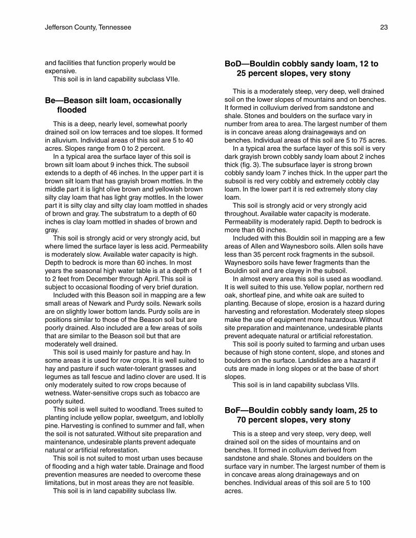
This is a moderately steep, very deep, well drainedsoil on the lower slopes of mountains and on benches.It formed in colluvium derived from sandstone andshale. Stones and boulders on the surface vary innumber from area to area. The largest number of themis in concave areas along drainageways and onbenches. Individual areas of this soil are 5 to 75 acres.
In a typical area the surface layer of this soil is verydark grayish brown cobbly sandy loam about 2 inchesthick (fig. 3). The subsurface layer is strong browncobbly sandy loam 7 inches thick. In the upper part thesubsoil is red very cobbly and extremely cobbly clayloam. In the lower part it is red extremely stony clayloam.
This soil is strongly acid or very strongly acidthroughout. Available water capacity is moderate.Permeability is moderately rapid. Depth to bedrock ismore than 60 inches.
Included with this Bouldin soil in mapping are a fewareas of Allen and Waynesboro soils. Allen soils haveless than 35 percent rock fragments in the subsoil.Waynesboro soils have fewer fragments than theBouldin soil and are clayey in the subsoil.
In almost every area this soil is used as woodland.It is well suited to this use. Yellow poplar, northern redoak, shortleaf pine, and white oak are suited toplanting. Because of slope, erosion is a hazard duringharvesting and reforestation. Moderately steep slopesmake the use of equipment more hazardous. Withoutsite preparation and maintenance, undesirable plantsprevent adequate natural or artificial reforestation.
This soil is poorly suited to farming and urban usesbecause of high stone content, slope, and stones andboulders on the surface. Landslides are a hazard ifcuts are made in long slopes or at the base of shortslopes.
This soil is in land capability subclass VIIs.
BoF—Bouldin cobbly sandy loam, 25 to70 percent slopes, very stony
This is a steep and very steep, very deep, welldrained soil on the sides of mountains and onbenches. It formed in colluvium derived fromsandstone and shale. Stones and boulders on thesurface vary in number. The largest number of them isin concave areas along drainageways and onbenches. Individual areas of this soil are 5 to 100acres.

24 Soil Survey
In a typical area the surface layer of this soil is verydark grayish brown cobbly sandy loam about 2 inchesthick. The subsurface layer is strong brown cobblysandy loam 7 inches thick. In the upper part thesubsoil is red very cobbly and extremely cobbly clayloam. In the lower part it is red extremely stony clayloam.
This soil is strongly acid or very strongly acidthroughout. Available water capacity is moderate.Permeability is moderately rapid. Depth to bedrock ismore than 60 inches.
Included with this Bouldin soil in mapping are afew areas of Allen, Gilpin, and Waynesboro soils.Allen soils have less than 35 percent rock fragmentsin the subsoil. Gilpin soils are less than 40 inches
deep over shale. Waynesboro soils have fewer rockfragments than the Bouldin soil and are clayey in thesubsoil.
In almost every area this soil is used as woodland.It is moderately suited to this use. Yellow poplar,northern red oak, shortleaf pine, and white oak aresuited to planting. Because of slope, erosion is ahazard during harvesting and reforestation. Steep andvery steep slopes make the use of equipment morehazardous and limit the usefulness of certain types ofequipment. Without site preparation and maintenance,undesirable plants prevent adequate natural orartificial reforestation.
This soil is poorly suited to farming and urban usesbecause of high stone content, slope, and stones and
Figure 3.—An area of Bouldin cobbly sandy loam, 12 to 25 percent slopes, very stony. This soil has cobbles and stones throughoutthe profile. In most areas it is used for woodland. It is well suited to woodland.

Jefferson County, Tennessee 25
boulders on the surface. This soil is very susceptible tolandslides if cuts are made in the long slopes.
This soil is in land capability subclass VIIs.
CoB2—Collegedale silt loam, 2 to5 percent slopes, eroded
This is a gently sloping, very deep, well drained soilon low uplands. It formed in residuum derived fromlimestone. Individual areas of this soil are 5 to 40acres.
In a typical area the surface layer of this soil isbrown silt loam about 5 inches thick. The subsoilextends to a depth of 65 inches. In the upper fewinches it is strong brown silty clay loam. Below that it isyellowish red silty clay and clay that has mottles inshades of yellow, red, and brown.
This soil is strongly acid or very strongly acid, butwhere limed the surface layer is less acid. Permeabilityis moderately slow. Available water capacity ismoderate or high. Depth to bedrock is more than 60inches.
Included with this Collegedale soil in mapping areareas of similar soils that are less than 60 inches deepto bedrock and a few areas of rock outcrop. Alsoincluded are small areas of Dunmore, Fullerton, andTalbott soils.
In most areas this soil is used for cropland, hay, orpasture. It is well suited to hay and pasture andmoderately suited to row crops. The clayey subsoilslows the movement of water and impedes the growthof roots. Erosion is a severe hazard if cultivated cropsare grown. Combined conservation practices help toreduce runoff, to control erosion, to conservemoisture, and to maintain tilth.
This soil is well suited to woodland. Yellowpoplar, southern red oak, white oak, shortleaf pine,Virginia pine, and loblolly pine are suited to planting.The clayey subsoil has low strength and is amoderate limitation for equipment during wet periods.Without site preparation and maintenance, undesirableplants prevent adequate natural or artificialreforestation.
The soil is moderately suited to some urban uses. Itis poorly suited to septic tank absorption fieldsbecause of moderately slow permeability. For roads,adding rock to the subgrade is needed because of lowstrength. Foundations for buildings need to bedesigned to overcome the shrinking and swelling thatoccurs during wetting and drying of the soil.
This soil is in land capability subclass IIIe.
CoC2—Collegedale silt loam, 5 to12 percent slopes, eroded
This is a sloping, very deep, well drained soilon uplands. It formed in residuum derived fromlimestone. Individual areas are 5 to 40 acres insize.
In a typical area the surface layer of this soil isbrown silt loam about 5 inches thick. The subsoilextends to a depth of 65 inches. In the upper fewinches it is strong brown silty clay loam. Below thatit is yellowish red silty clay and clay that has mottlesin shades of yellow, red, and brown.
This soil is strongly acid or very strongly acid, butwhere limed the surface layer is less acid. Permeabilityis moderately slow. Available water capacity ismoderate or high. Depth to bedrock is more than 60inches.
Included with this Collegedale soil in mapping areareas of Talbott soils, which are less than 40 inchesdeep over bedrock. Also included are a few areas ofsoils that are less than 20 inches deep over bedrockand small areas of limestone outcrops. Also includedare areas of soils that are similar to the Collegedalesoil but that have a cherty surface layer.
This soil is used mostly for pasture, hay, and smallgrain. It is moderately suited to these uses and ispoorly suited to row crops. The clayey subsoil slowsthe movement of water and impedes the growth ofroots. Erosion is a severe hazard if cultivated cropsare grown. Combined conservation practices help toreduce runoff, to control erosion, to conservemoisture, and to maintain tilth.
This soil is well suited to woodland. Yellow poplar,southern red oak, white oak, shortleaf pine, Virginiapine, and loblolly pine are suited. The clayey subsoilhas low strength and is a moderate limitation to use ofequipment during wet periods. Without site preparationand maintenance, undesirable plants preventadequate natural or artificial reforestation.
The soil is moderately suited to some urban uses. Itis poorly suited to septic tank absorption fieldsbecause of the moderately slow permeability. Forroads, adding rock to the subgrade is needed becauseof low strength. Foundations for buildings need to bedesigned to overcome shrinking and swelling duringwetting and drying of the soil.
This soil is in land capability subclass IVe.

26 Soil Survey
CoC3—Collegedale silty clay loam, 5 to15 percent slopes, severely eroded
This is a sloping, very deep, well drained soil onuplands. It formed in residuum derived from limestone.Individual areas of this soil are 5 to 40 acres.
In a typical area the surface layer of this soil isstrong brown silty clay loam about 5 inches thick. Thesurface layer consists mainly of material from thesubsoil because the original surface layer has beenremoved by erosion. The subsoil extends to a depth of65 inches. It is yellowish red silty clay and clay withmottles in shades of yellow, red, and brown.
This soil is strongly acid or very strongly acid,but where limed the surface layer is less acid.Permeability is moderately slow. Available watercapacity is moderate. Depth to bedrock is more than60 inches.
Included with this Collegedale soil in mapping areareas of Talbott soils, which are less than 40 inchesdeep over bedrock. Also included are a few areas ofsoils that are less than 20 inches deep over bedrockand small areas of limestone outcrops. Also includedare a few areas of Dunmore and Fullerton soils.
In most areas this soil is used for pasture. It ismoderately suited to pasture, poorly suited to hay, andin most areas not suited to row crops. The mainlimitations are slope, the erosion hazard, availablewater capacity, poor tilth, and moderately slowpermeability. Good pasture management is needed tocontrol erosion and to maintain productivity. It includesfertilization, weed control, and avoidance ofovergrazing.
This soil is moderately suited to woodland. Treessuited to planting include loblolly pine, shortleaf pine,and Virginia pine. The low strength in the clayeysubsoil is a moderate limitation for equipment duringwet periods. Seedling survival is a moderate problembecause of a moisture deficiency. The problem isworse on south- and west-facing slopes, which arewarmer and drier. Increasing the planting rate helps toobtain an adequate stand. Without site preparation andmaintenance, undesirable plants prevent adequatenatural or artificial reforestation.
The soil is moderately suited to some urban uses. Itis poorly suited to septic tank absorption fieldsbecause of the moderately slow permeability. Forroads, adding rock to the subgrade is needed becauseof low strength. Foundations for buildings need to bedesigned to overcome shrinking and swelling duringwetting and drying of the soil.
This soil is in land capability subclass VIe.
CoD2—Collegedale silt loam, 12 to20 percent slopes, eroded
This is a moderately steep, very deep, well drainedsoil on uplands. It formed in residuum derived fromlimestone. Individual areas of this soil are 5 to 40acres.
In a typical area the surface layer of this soil isbrown silt loam about 5 inches thick. The subsoilextends to a depth of 65 inches. In the upper fewinches it is strong brown silty clay loam. Below that it isyellowish red silty clay and clay with mottles in shadesof yellow, red, and brown.
This soil is strongly acid or very strongly acid, butwhere limed the surface layer is less acid. Permeabilityis moderately slow. Available water capacity ismoderate or high. Depth to bedrock is more than 60inches.
Included with this Collegedale soil in mapping areareas of Talbott soils, which are less than 40 inchesdeep to bedrock. Also included are a few areas of soilsthat are less than 20 inches deep to bedrock andsmall areas of limestone outcrops. Also included areareas of severely eroded Collegedale soils and areasof soils that are similar to the Collegedale soil but thathave a cherty surface layer.
In most areas this soil is used for pasture. It ismoderately suited to pasture, poorly suited to hay, andnot suited to row crops. The clayey subsoil slows themovement of water and impedes the growth of roots.Good pasture management is needed to controlerosion and to maintain productivity. It includesfertilization, weed control, and avoidance ofovergrazing.
This soil is moderately suited to woodland.Yellow poplar, southern red oak, white oak, shortleafpine, Virginia pine, and loblolly pine are suited toplanting. Because of slope, erosion is a hazardduring harvesting and reforestation. Moderatelysteep slopes make the use of equipment morehazardous. During wet periods the low strength inthe clayey subsoil is also a limitation for equipment.Without site preparation and maintenance,undesirable plants prevent adequate natural orartificial reforestation.
This soil is poorly suited to most urban usesbecause of slope, moderately slow permeability, andlow strength. It can be used for home sites if sewersare available and if the foundations are properlydesigned. For roads, adding rock to the subgrade isneeded because of low strength.
This soil is in land capability subclass VIe.

Jefferson County, Tennessee 27
CtD2—Collegedale-Talbott-Rock outcropcomplex, 5 to 20 percent slopes,eroded
This map unit consists of Collegedale and Talbottsoils and Rock outcrop in areas so intermingled thatthe components could not be separated in mapping.These soils and Rock outcrop are sloping andmoderately steep. They are on the tops and sides ofhills and ridges. Individual areas of these soils androck outcrops range from 5 to 200 acres in size.
The Collegedale soil makes up about 40 percent ofeach mapped area. In a typical area the surface layerof this soil is brown silt loam about 5 inches thick. Thesubsoil extends to a depth of 65 inches. In the upperfew inches it is strong brown silty clay loam. Below thatit is yellowish red silty clay and clay with mottles inshades of yellow, red, and brown.
This soil is strongly acid or very strongly acid butwhere limed the surface layer is less acid. Permeabilityis moderately slow. Available water capacity ismoderate or high. Depth to bedrock is more than60 inches.
The Talbott soil makes up about 30 percent ofeach mapped area. In a typical area the surfacelayer of this soil is dark brown silt loam about4 inches thick. In the upper few inches the subsoilis yellowish red silty clay loam. Below that it isyellowish red and red clay. Limestone is at a depthof 32 inches.
This soil is slightly acid to strongly acid.Permeability is moderately slow. Available watercapacity is low or moderate. Depth to bedrock rangesfrom 20 to 40 inches.
Rock outcrop makes up about 20 percent of eachmapped area. It consists of limestone outcrops mostlyin bands parallel to the slope. The outcrops protrude afew inches to about 3 feet above the surface.
Included with the Collegedale and Talbott soils andRock outcrop in mapping are small areas of soils thatare 40 to 60 inches deep over bedrock and areas ofsoils that are less than 20 inches deep over bedrock.Also included are some spots of severely eroded soilsthat have a reddish, clayey surface layer.
In most areas this map unit is used as woodland(fig. 4). In a few areas it is used as pasture. It ismoderately suited to woodland. Southern red oak,white oak, shortleaf pine, Virginia pine, and easternredcedar grow on the unit. Slope, rock outcrop, andthe clayey subsoil limit the use of equipment. Withoutsite preparation and maintenance, undesirable plantsprevent adequate natural or artificial reforestation.
This map unit is poorly suited to farming and urban
uses because of numerous rock outcrops, depth tobedrock, moderately slow permeability, available watercapacity, and low strength.
This map unit is in land capability subclass VIs.
CtE2—Collegedale-Talbott-Rock outcropcomplex, 20 to 35 percent slopes,eroded
This map unit consists of Collegedale and Talbottsoils and Rock outcrop in areas so intermingled thatthe components could not be separated in mapping.The Collegedale and Talbott soils and Rock outcropare steep. They are mainly on the sides of hills andridges. Individual areas of these soils and rockoutcrops range from 5 to 200 acres in size.
The Collegedale soil makes up about 40 percent ofeach mapped area. In a typical area the surface layeris brown silt loam about 5 inches thick. The subsoilextends to a depth of 65 inches. In the upper fewinches it is strong brown silty clay loam. Below that it isyellowish red silty clay and clay with mottles in shadesof yellow, red, and brown.
This soil is strongly acid or very strongly acid, butwhere limed the surface layer is less acid. Permeabilityis moderately slow. Available water capacity ismoderate or high. Depth to bedrock is more than 60inches.
The Talbott soil makes up about 30 percent of eachmapped area. In a typical area the surface layer of thissoil is dark brown silt loam about 4 inches thick. In theupper few inches the subsoil is yellowish red silty clayloam. Below that it is yellowish red and red clay.Limestone is at a depth of 32 inches.
This soil is slightly acid to strongly acid.Permeability is moderately slow. Available watercapacity is low or moderate. Depth to bedrock rangesfrom 20 to 40 inches.
Rock outcrop makes up about 20 percent of eachmapped area. It consists of limestone outcrops thatoccur mostly in bands parallel to the slope. Theoutcrops protrude a few inches to about 3 feet abovethe surface.
Included with the Collegedale and Talbott soils andRock outcrop in mapping are small areas of soils thatare 40 to 60 inches deep over bedrock and areas ofsoils that are less than 20 inches deep over bedrock.Also included are some spots of severely eroded soilsthat have a reddish, clayey surface layer.
This map unit is used almost entirely as woodland.It is moderately suited to woodland. Southern red oak,white oak, shortleaf pine, Virginia pine, and easternredcedar grow on the unit. Slope, rock outcrop, and

28 Soil Survey
the clayey subsoil limit the use of equipment. Withoutsite preparation and maintenance, undesirableplants prevent adequate natural or artificialreforestation.
This map unit is poorly suited to farming and urbanuses because of slope, numerous rock outcrops,depth to bedrock, moderately slow permeability,available water capacity, and low strength.
This map unit is in land capability subclass VIIs.
DaC2—Dandridge channery silt loam, 5 to12 percent slopes, eroded
This is a sloping, shallow, excessively drained soilon ridgetops of highly dissected uplands. This soilformed mostly in calcareous shale that has some thinbeds of limestone. Areas of this soil range from 5 to100 acres in size.
In a typical area the surface layer of this soil isbrown channery silt loam about 3 inches thick. In theupper part the subsoil is yellowish brown verychannery silty clay loam that has intermittent pocketsof dark yellowish brown very channery silty clay. In thelower part it is light yellowish brown very channerysilty clay loam. Soft, weathered, calcareous shale isbetween depths of 17 and 35 inches. Hard, calcareousshale is at a depth of 35 inches.
This soil is neutral to moderately alkaline. Availablewater capacity is very low. Permeability is moderatelyslow. Depth to bedrock is less than 20 inches.
Included with this Dandridge soil in mapping, on thebroadest ridgetops, are a few small areas of soils thatare deeper than 20 inches to soft shale. Also includedare some spots of severely eroded soils and somerock outcrops.
This soil is used mostly as pasture and woodland.
Figure 4.—An area of Collegedale-Talbott-Rock outcrop complex, 5 to 20 percent slopes, eroded. In most areas this map unit isused for woodland.

Jefferson County, Tennessee 29
It is poorly suited to hay and pasture. It is not suitedto cropland because of the shallow root zone and thevery low available water capacity. Good pasturemanagement is needed to control erosion and tomaintain productivity. It includes fertilization, weedcontrol, and avoidance of overgrazing.
This soil is moderately suited to woodland.Southern red oak, Virginia pine, and eastern redcedarare common on this soil. Seedling survival is amoderate problem because of a moisture deficiency.The problem is worse on south- and west-facingslopes, which are warmer and drier. Increasing theplanting rate helps to obtain an adequate stand.Windthrow is a severe hazard because of the shallowroot zone.
This soil is poorly suited to most urban usesbecause of the shallow depth to bedrock and the largeamount of rock fragments in the soil.
This soil is in land capability subclass VIe.
DaD2—Dandridge channery silt loam,12 to 25 percent slopes, eroded
This is a moderately steep, shallow, excessivelydrained soil. It is on ridgetops and the upper sideslopes of highly dissected uplands. It formed mostly incalcareous shale that has some thin beds oflimestone. Areas of this soil range from 5 to 100 acresin size.
In a typical area the surface layer of this soil isbrown channery silt loam about 3 inches thick. In theupper part the subsoil is yellowish brown verychannery silty clay loam that has pockets of darkyellowish brown very channery silty clay. In the lowerpart it is light yellowish brown very channery silty clayloam. Soft, weathered, calcareous shale is betweendepths of 17 and 35 inches. Hard, calcareous shale isat a depth of 35 inches.
This soil is neutral to moderately alkaline. Availablewater capacity is very low. Permeability is moderatelyslow. Depth to bedrock is less than 20 inches.
Included with this Dandridge soil in mapping, on thebroadest ridgetops, are a few small areas of soils thatare more than 20 inches deep to soft shale. Alsoincluded are some spots of severely eroded soils andsome rock outcrops.
In most areas this soil is used as pasture orwoodland. It is poorly suited to hay and pasture. It isnot suited to cropland because of the shallow rootzone and the very low available water capacity. Goodpasture management is needed to control erosion andto maintain productivity. It includes fertilization, weedcontrol, and avoidance of overgrazing.
This soil is only moderately suited to woodland.Southern red oak, Virginia pine, and eastern redcedarare common on this soil. Seedling survival is amoderate problem on this soil because of a moisturedeficiency. It is worse on south- and west-facingslopes, which are warmer and drier. Increasing theplanting rate helps to obtain an adequate stand.Windthrow is a severe hazard because of the shallowroot zone.
This soil is poorly suited to most urban usesbecause of slope, shallow depth to bedrock, and thelarge amount of rock fragments in the soil.
This soil is in land capability subclass VIe.
DaD3—Dandridge channery silty clayloam, 10 to 25 percent slopes, severelyeroded
This is a moderately steep, shallow, excessivelydrained soil. It is on ridgetops and the upper sideslopes of highly dissected uplands. It formed mostly incalcareous shale that has some thin beds oflimestone. Areas of this soil range from 5 to 200 acresin size.
In a typical area the surface layer of this soil isyellowish brown channery silt loam about 5 inchesthick. The surface layer consists mainly of materialfrom the subsoil because the original surface layer hasbeen removed by erosion. The subsoil is light yellowishbrown very channery silty clay loam. Soft, weathered,calcareous shale is between depths of 10 and 25inches. Hard, calcareous shale is at a depth of 25inches.
This soil is neutral to moderately alkaline. Availablewater capacity is very low. Permeability is moderatelyslow. Depth to bedrock is less than 20 inches.
Included with this Dandridge soil in mapping aresome areas of rock outcrops.
In most areas this soil is used mostly as woodland.In a few areas it is used as pasture. This soil is poorlysuited to woodland because of the shallow or veryshallow root zone and the very low available watercapacity. Virginia pine and eastern redcedar arecommon on this soil. Seedling survival is a severeproblem on this soil because of a moisture deficiency.It is worse on south- and west-facing slopes, whichare warmer and drier. Increasing the planting ratehelps to obtain an adequate stand. Windthrow is asevere hazard because of the shallow root zone.
This soil is poorly suited to hay and pasture. It is notsuited to cropland because of the shallow or veryshallow root zone and the very low available watercapacity. Good pasture management helps to control

30 Soil Survey
erosion and to maintain productivity. It includesfertilization, weed control, and avoidance ofovergrazing.
This soil is poorly suited to most urban usesbecause of slope, shallow depth to bedrock, and thelarge amount of rock fragments in the soil.
This soil is in land capability subclass VIIe.
DaE3—Dandridge channery silty clayloam, 25 to 50 percent slopes, severelyeroded
This is a steep, shallow, excessively drained soil onside slopes of highly dissected uplands. It formedmostly in calcareous shale that has some thin beds oflimestone. Areas of this soil range from 5 to 200 acresin size.
In a typical area the surface layer of this soil isyellowish brown channery silty clay loam about 5inches thick. The surface layer consists mainly ofmaterial from the subsoil because the original surfacelayer has been removed by erosion. The subsoil is lightyellowish brown very channery silty clay loam. Soft,weathered, calcareous shale is between depths of 10and 25 inches. Hard, calcareous shale is at a depth of25 inches.
This soil is neutral to moderately alkaline. Availablewater capacity is very low. Permeability is moderatelyslow. Depth to bedrock is less than 20 inches.
Included with this Dandridge soil in mapping aresome areas of rock outcrops.
In most areas this soil is used as woodland. In a fewareas it is used as pasture. It is poorly suited towoodland because of the shallow or very shallow rootzone and the very low available water capacity. Virginiapine and eastern redcedar are common on this soil.Because of slope, erosion is a hazard duringharvesting and reforestation. Steep slopes make theuse of equipment more hazardous or limit theusefulness of certain types of equipment. Seedlingsurvival is a severe problem on this soil because of amoisture deficiency. The problem is worse on south-and west-facing slopes, which are warmer and drier.Increasing the planting rate helps to obtain anadequate stand. Windthrow is a severe hazardbecause of the shallow or very shallow root zone.
This soil is poorly suited to pasture. It is not suitedto hay and cropland because of steep slopes, theshallow or very shallow root zone, and the very lowavailable water capacity. Good pasture management isneeded to control erosion and maintain productivity. Itincludes fertilization, weed control, and avoidance ofovergrazing.
This soil is poorly suited to most urban usesbecause of steep slopes, shallow depth tobedrock, and the large amount of rock fragmentsin the soil.
This soil is in land capability subclass VIIe.
DaF2—Dandridge channery silt loam,25 to 70 percent slopes, eroded
This is a steep and very steep, shallow, excessivelydrained soil on the side slopes of highly dissecteduplands. It formed mostly in calcareous shale that hassome thin beds of limestone. Areas of this soil rangefrom 40 to 70 acres in size.
In a typical area the surface layer of this soil isbrown channery silt loam about 3 inches thick. In theupper part the subsoil is yellowish brown verychannery silty clay loam that has intermittent pocketsof dark yellowish brown very channery silty clay. In thelower part it is light yellowish brown very channerysilty clay loam. Soft, weathered, calcareous shale isbetween depths of 17 and 35 inches. Hard, calcareousshale is at a depth of 35 inches.
This soil is neutral to moderately alkaline. Availablewater capacity is very low. Permeability is moderatelyslow. Depth to bedrock is less than 20 inches.
Included with this Dandridge soil in mapping are afew small areas of soils that are deeper than 20 inchesto soft shale. Also included are some spots of severelyeroded soils and some rock outcrops.
In most areas this soil is used as woodland.Although the soil is poorly suited to commercial timberproduction, woodland is the most feasible use.Southern red oak, Virginia pine, and eastern redcedarare common on this soil. Because of slope, erosion isa hazard during harvesting and reforestation. Steepslopes make the use of equipment more hazardous orlimit the usefulness of certain types of equipment.Seedling survival is a moderate problem because of amoisture deficiency. The problem is worse on south-and west-facing slopes, which are warmer and drier.Increasing the planting rate helps to obtain anadequate stand. Windthrow is a severe hazardbecause of the shallow root zone.
This soil is poorly suited to pasture. It is not suitedto hay or cropland because of the steep or very steepslopes, shallow root zone, and very low availablewater capacity.
This soil is poorly suited to urban uses. The mainlimitations are the steep or very steep slopes, shallowdepth to bedrock, and the large amount of rockfragments in the soil.
This soil is in land capability subclass VIIe.

Jefferson County, Tennessee 31
DcB2—Decatur silt loam, 2 to 5 percentslopes, eroded
This is a gently sloping, very deep, well drained soilon broad, smooth ridgetops on uplands. This soilformed in residuum derived from limestone. Individualareas of this soil range from 5 to 40 acres in size.
In a typical area the surface layer of this soil is darkreddish brown silt loam about 6 inches thick. In theupper part the subsoil is dark reddish brown silt loamand dark reddish brown and dark red silty clay loam. Inthe lower part it is dark red and red silty clay to adepth of 65 inches or more.
This soil is medium acid or strongly acid, but wherelimed the surface layer is less acid. Permeability ismoderate. Available water capacity is high. Depth tobedrock is more than 72 inches.
Included with this Decatur soil in mapping are areasof Dewey soils on the steepest part of the unit. Alsoincluded are some small, concave areas of Etowahsoils.
This soil is used mainly for row crops and smallgrain. It is well suited to row crops, small grain, hay,and pasture. It is suited to all adapted crops, grasses,and legumes. Erosion is a hazard if cultivated cropsare grown. A combination of conservation practiceshelps to reduce runoff, to control erosion, to conservemoisture, and to maintain tilth.
This soil is well suited to woodland. Yellow poplar,white oak, southern red oak, shortleaf pine, loblollypine, and eastern white pine are all suited to this soil.Plant competition is the only significant managementconcern. Without site preparation and maintenance,undesirable plants prevent adequate natural orartificial reforestation.
This soil is well suited to most urban uses. Shrink-swell potential and low strength are moderatelimitations for some uses. These limitations can beovercome by proper design of structures and facilities.
This soil is in land capability subclass IIe.
DeC2—Dewey silt loam, 5 to 12 percentslopes, eroded
This is a sloping, very deep, well drained soil onconvex ridgetops and on the upper side slopes ofuplands. This soil formed in 1 to 2 feet of old alluviumand in the underlying residuum derived fromlimestone. Individual areas of this soil range from 5 to60 acres in size.
In a typical area the surface layer of this soil is darkbrown silt loam about 7 inches thick. The subsoil isdark red and red silty clay to a depth of 65 inches ormore.
This soil is strongly acid or very strongly acid, butwhere limed the surface layer is less acid. Permeabilityis moderate. Available water capacity is moderate orhigh. Depth to bedrock is more than 60 inches.
Included with this Dewey soil in mapping are somesmall areas of Dunmore and Etowah soils. Dunmoresoils do not have dark red colors anywhere in thesubsoil. Etowah soils are in concave areas and have aloamy subsoil. Also included, on knolls and shoulderslopes, are some areas of severely eroded soils.
This soil is used mostly for cropland, hay, andpasture. It is moderately suited to row crops and is wellsuited to small grains, hay, and pasture. It is suited tomost adapted crops, grasses, and legumes. Erosion isa severe hazard if cultivated crops are grown.Combined conservation practices help to reducerunoff, to control erosion, to conserve moisture, and tomaintain tilth.
This soil is well suited to woodland. Yellow poplar,white oak, southern red oak, shortleaf pine, loblollypine, and Virginia pine are suited to this soil. Plantcompetition is a management concern. Without sitepreparation and maintenance, undesirable plantsprevent adequate natural or artificial reforestation.
This soil is moderately suited to most urban uses.Slope, shrinking and swelling, and low strength in theclayey subsoil are moderate limitations for severaluses. This soil can be used for structures and facilitiesdesigned to overcome these limitations.
This soil is in land capability subclass IIIe.
DeC3—Dewey silty clay loam, 5 to12 percent slopes, severely eroded
This is a sloping, very deep, well drained soil onconvex ridgetops and on the upper side slopes ofuplands. This soil has some shallow gullies. It formedin a thin layer of old alluvium and in the underlyingresiduum of limestone. Individual areas of this soilrange from 5 to 60 acres in size.
In a typical area the surface layer of this soil is darkreddish brown silty clay loam about 5 inches thick. Thesurface layer consists mainly of material from thesubsoil because the original surface layer has beenremoved by erosion. The subsoil is dark red and redsilty clay to a depth of 65 inches or more.
This soil is strongly acid or very strongly acid,but where limed the surface layer is less acid.Permeability is moderate. Available water capacity ismoderate or high. Depth to bedrock is more than 60inches.
Included with this Dewey soil in mapping are somesmall areas of Dunmore and Etowah soils. Dunmoresoils do not have dark red colors anywhere in the
32 Soil Survey
subsoil. Etowah soils are in concave areas and have aloamy subsoil. Also included are some areas ofmoderately eroded soils.
This soil is used mostly for hay and pasture. It ispoorly suited to row crops and moderately suited tosmall grains, hay, and pasture. Erosion is a severehazard if cultivated crops are grown. Combinedconservation practices help to reduce runoff, to controlerosion, to conserve moisture, and to maintain tilth.
This soil is well suited to woodland. Yellow poplar,white oak, southern red oak, shortleaf pine, loblollypine, and Virginia pine are suited to this soil. Plantcompetition is a management concern. Without sitepreparation and maintenance, undesirable plantsprevent adequate natural or artificial reforestation.
This soil is moderately suited to most urban uses.Slope, shrinking and swelling, and the low strength ofthe clayey subsoil are moderate limitations for mostuses. This soil can be used for structures and facilitiesdesigned to overcome the limitations.
This soil is in land capability subclass IVe.
DeD2—Dewey silt loam, 12 to 20 percentslopes, eroded
This is a moderately steep, very deep, well drainedsoil on side slopes of ridges on uplands. This soilformed in 1 to 2 feet of old alluvium and in theunderlying residuum of limestone. Individual areas ofthis soil range from 5 to 40 acres in size.
In a typical area the surface layer of this soil is darkbrown silt loam about 7 inches thick. The subsoil isdark red and red silty clay to a depth of 65 inches ormore.
This soil is strongly acid or very strongly acid, butwhere limed the surface layer is less acid. Permeabilityis moderate. Available water capacity is moderate orhigh. Depth to bedrock is more than 60 inches.
Included with this Dewey soil in mapping are somesmall areas of Etowah soils. Etowah soils are inconcave areas and have a loamy subsoil. Alsoincluded are some areas of severely eroded soils onknolls and shoulder slopes.
This soil is used mostly for hay and pasture. It ispoorly suited to row crops and moderately suited tohay and pasture. This soil is suited to most adaptedgrasses and legumes. Erosion is a severe hazard ifcultivated crops are grown. Good pasturemanagement is needed to control erosion and tomaintain productivity. It includes fertilization, weedcontrol, and avoidance of overgrazing.
This soil is well suited to woodland. Yellow poplar,white oak, southern red oak, shortleaf pine, loblolly
pine, and Virginia pine are suited to this soil. Becauseof slope the erosion hazard and the equipmentlimitation are moderate during timber harvesting.Without site preparation and maintenance, undesirableplants prevent adequate natural or artificialreforestation.
This soil is moderately suited to most urban uses.Slope, shrinking and swelling, and the low strength ofthe clayey subsoil are limitations for most uses. Thissoil can be used for structures and facilities designedto overcome the limitations.
This soil is in land capability subclass IVe.
DeD3—Dewey silty clay loam, 12 to20 percent slopes, severely eroded
This is a moderately steep, very deep, well drainedsoil on side slopes of ridges on uplands. It has someshallow gullies. It formed in a thin layer of old alluviumand in the underlying residuum of limestone. Individualareas of this soil range from 5 to 40 acres in size.
In a typical area the surface layer of this soil is darkreddish brown silty clay loam about 5 inches thick. Thesurface layer consists mostly of material from thesubsoil because the original surface layer has beenremoved by erosion. The subsoil is dark red and redsilty clay to a depth of 65 inches or more.
This soil is strongly acid or very strongly acid,but where limed the surface layer is less acid.Permeability is moderate. Available water capacity ismoderate or high. Depth to bedrock is more than 60inches.
Included with this Dewey soil in mapping are somesmall areas of Dunmore and Etowah soils. Dunmoresoils are not dark red anywhere in the subsoil. Etowahsoils are in concave areas and have a loamy subsoil.Also included are some areas of moderately erodedsoils.
This soil is used mostly for hay and pasture. It ispoorly suited to row crops, small grain, and hay. It ismoderately suited to pasture. Erosion is a very severehazard if cultivated crops are grown. Good pasturemanagement is needed to control erosion and tomaintain productivity. It includes fertilization, weedcontrol, and avoidance of overgrazing.
This soil is moderately suited to woodland. Loblollypine, Virginia pine, eastern white pine, and easternredcedar are suited to planting. Because of slope, theerosion hazard and the equipment limitation aremoderate during timber harvesting. Seedling survivalis a moderate problem on this soil because of amoisture deficiency. The problem is worse on south-and west-facing slopes, which are warmer and drier.

Jefferson County, Tennessee 33
Increasing the planting rate helps to obtain anadequate stand. Without site preparation andmaintenance, undesirable plants prevent adequatenatural or artificial reforestation.
This soil is moderately suited to most urban uses.Slope, shrinking and swelling, and the low strength inthe clayey subsoil are limitations for most uses. Thissoil can be used for structures and facilities designedto overcome the limitations.
This soil is in land capability subclass VIe.
DfD2—Dewey-Rock outcrop complex, 5 to20 percent slopes, eroded
This map unit consists of a sloping and moderatelysteep Dewey soil and Rock outcrop in areas so smalland so intermingled that the components could not beseparated in mapping. The unit is on the tops andsides of ridges. Areas of this soil and rock outcropsrange from 5 to 60 acres in size.
The Dewey soil makes up about 65 percent of eachmapped area. In a typical area the surface layer isdark brown silt loam about 7 inches thick. The subsoilis dark red and red silty clay to a depth of 65 inches ormore.
This soil is strongly acid or very strongly acid, butwhere limed the surface layer is less acid. Permeabilityis moderate. Available water capacity is moderate orhigh. Depth to bedrock is more than 60 inches.
Rock outcrop makes up about 25 percent of eachmapped area. It consists of limestone outcrops, mostof which extend a few inches to about 3 feet above thesurface.
Included with the Dewey soil and rock outcrops inmapping are small areas of Collegedale and Talbottsoils. Collegedale soils are yellowish red in the subsoiland do not have a dark surface layer. Talbott soils areless than 40 inches deep to limestone.
This map unit is used mostly for woodland and ismoderately suited to this use. Because of slope,erosion is a moderate hazard during timber harvesting.Slope and numerous rock outcrops are moderatelimitations to use of equipment. Without sitepreparation and maintenance, undesirable plantsprevent adequate natural or artificial reforestation.
This map unit is not suited to crops and hay. It ispoorly suited to pasture. Good pasture management isdifficult because of numerous rock outcrops.
This map unit is poorly suited to most urban usesbecause of slope and numerous rock outcrops. Someareas can be used for structures and facilitiesdesigned around rock outcrops.
This map unit is in land capability subclass VIs.
Dm—Dumps, mine
This unit consists of areas stockpiled during theunderground mining of sphalerite (zinc sulfide). Thespoil has been smoothed to form nearly level tomoderately steep tops and moderately steep to verysteep side slopes. The tops are 100 to 1,500 feet ormore across. The sides are more than 100 feet high inplaces. These piles of spoil are located mainly in theareas of Jefferson City and New Market.
Mapped areas range from 10 to 100 acres in size.Slopes are dominantly 5 to 12 percent on the tops, butthe range is 2 to 20 percent. The side slopes rangefrom 20 to 75 percent or more and are commonlynearly vertical.
The spoil is consistent in color, texture, andthickness. It is light gray loamy fine sand that extendsto a depth of 6 feet or more.
Natural fertility, organic matter content, andavailable water capacity are low. Reaction ranges frommildly alkaline to strongly alkaline.
Included with Dumps, mine, in mapping are smallareas of Collegedale and Talbott soils, which have notbeen covered by mine spoil. Also included are piles oflimestone spoil.
Dumps, mine, are not suited to farming, woodland,or urban uses. These materials are a difficult mediumin which to grow plants. They are droughty and highlyalkaline and have steep side slopes. Experimentalplots are needed to determine which grasses andtrees will grow on these materials.
This map unit is not assigned to a land capabilitysubclass.
DuB2—Dunmore silt loam, 2 to 5 percentslopes, eroded
This is a gently sloping, very deep, well drained soilon ridgetops on uplands. It formed in residuum derivedfrom dolomitic limestone. Individual areas of this soilare 5 to 60 acres.
In a typical area the surface layer of this soil is darkbrown silt loam about 6 inches thick. In the upper partthe subsoil is yellowish red silty clay loam and siltyclay. In the lower part it is yellowish red and red clay toa depth of 65 inches or more.
This soil is strongly acid or very strongly acid, butwhere limed the surface layer is less acid. Permeabilityis moderate. Available water capacity is moderate orhigh. Depth to bedrock is more than 60 inches.
Included with this Dunmore soil in mapping aresome small areas of Fullerton and Minvale soils.Fullerton soils contain 15 to 35 percent chert

34 Soil Survey
fragments in the subsoil. Minvale soils are on benchesand foot slopes and have a loamy subsoil.
This soil is used mostly for row crops, hay, andpasture. It is well suited to these uses. It is suited tomost adapted crops, grasses, and legumes. Erosion isa moderate hazard if cultivated crops are grown.Combined conservation practices help to reducerunoff, to control erosion, to conserve moisture, and tomaintain tilth. Good pasture management is needed tocontrol erosion and to maintain productivity. It includesfertilization, weed control, and avoidance ofovergrazing.
This soil is well suited to woodland. Yellow poplar,black walnut, loblolly pine, shortleaf pine, and easternwhite pine are suited to planting. Plant competition is amanagement concern. Without site preparation andmaintenance, undesirable plants prevent adequatenatural or artificial reforestation.
The soil is moderately suited to most urban uses.Moderate permeability, moderate shrink-swellpotential, and low strength are limitations for severaluses. This soil can be used for structures and facilitiesdesigned to overcome the limitations.
This soil is in land capability subclass IIe.
DuC2—Dunmore silt loam, 5 to 12 percentslopes, eroded
This is a sloping, very deep, well drained soil onconvex ridgetops and upper side slopes. It formed inresiduum derived from dolomitic limestone. Individualareas of this soil are 5 to 75 acres in size.
In a typical area the surface layer of this soil is darkbrown silt loam about 6 inches thick. In the upper partthe subsoil is yellowish red silty clay loam and siltyclay. In the lower part it is yellowish red and red clay toa depth of 65 inches or more.
This soil is strongly acid or very strongly acid, butwhere limed the surface layer is less acid. Permeabilityis moderate. Available water capacity is moderate orhigh. Depth to bedrock is more than 60 inches.
Included with this Dunmore soil in mapping aresome small areas of Fullerton soils. Fullerton soilscontain 15 to 35 percent chert fragments in thesubsoil.
In most areas this soil is used for row crops, hay, orpasture. It is moderately suited to these uses. It issuited to most adapted crops, grasses, and legumes.Erosion is a severe hazard if cultivated crops aregrown. Combined conservation practices help toreduce runoff, to control erosion, to conservemoisture, and to maintain tilth. Good pasturemanagement is needed to control erosion and to
maintain productivity. It includes fertilization, weedcontrol, and avoidance of overgrazing.
This soil is well suited to woodland. Yellow poplar,black walnut, loblolly pine, shortleaf pine, and easternwhite pine are suited to planting. Plant competitionis the only significant management concern. Withoutsite preparation and maintenance, undesirableplants prevent adequate natural or artificialreforestation.
The soil is moderately suited to most urban uses.Slope, moderate permeability, moderate shrink-swellpotential, and low strength are limitations for severaluses. This soil can be used for structures and facilitiesdesigned to overcome the limitations.
This soil is in land capability subclass IIIe.
DuC3—Dunmore silty clay loam, 5 to12 percent slopes, severely eroded
This is a sloping, very deep, well drained soil onconcave ridgetops and side slopes. It formed inresiduum derived from dolomitic limestone. In someareas it has a few shallow gullies. Depressions andother karst features are common on this soil. Individualareas commonly are less than 15 acres in size, butthey range to 60 acres.
In a typical area the surface layer of this soil isstrong brown or yellowish red silty clay loam about 6inches thick. The surface layer consists mainly ofmaterial from the subsoil because the original surfacelayer has been removed by erosion. In the upper partthe subsoil is yellowish red silty clay. In the lower part itis yellowish red and red clay to a depth of 65 inches ormore.
This soil is strongly acid or very strongly acid, butwhere limed the surface layer is less acid. Permeabilityis moderate. Available water capacity is moderate orhigh. Depth to bedrock is more than 60 inches.
Included with this Dunmore soil in mapping aresome small areas of Fullerton, Minvale, and Tassosoils. Fullerton soils are in positions similar to those ofthe Dunmore soil and contain 15 to 35 percent chertfragments in the subsoil. Minvale and Tasso soils areon foot slopes and in depressions. They have a loamysubsoil. Tasso soils have a weak fragipan in thesubsoil.
This soil is used mostly for hay and pasture. It ispoorly suited to row crops and moderately suited tohay and pasture. Erosion is a severe hazard ifcultivated crops are grown. Combined conservationpractices help to reduce runoff, to control erosion, toconserve moisture, and to maintain tilth. Good pasturemanagement is needed to control erosion and to

Jefferson County, Tennessee 35
maintain productivity. It includes fertilization, weedcontrol, and avoidance of overgrazing.
This soil is moderately suited to woodland. Treessuited to planting include loblolly pine, shortleaf pine,Virginia pine, eastern white pine, and easternredcedar. The severely eroded surface layer and theclayey subsoil cause a moderate equipment limitationand moderate seedling mortality. Increasing theplanting rate helps to obtain an adequate stand.Without site preparation and maintenance, undesirableplants prevent adequate natural or artificialreforestation.
The soil is moderately suited to most urban uses.Slope, moderate permeability, moderate shrink-swellpotential, and low strength are limitations for severaluses. This soil can be used for structures and facilitiesdesigned to overcome the limitations.
This soil is in land capability subclass IVe.
DuD2—Dunmore silt loam, 12 to20 percent slopes, eroded
This is a moderately steep, very deep, well drainedsoil on side slopes of uplands. It formed in residuumderived from dolomitic limestone. Some delineationshave depressions and other karst features. Individualareas of this soil are commonly less than 20 acres butrange to 40 acres.
In a typical area the surface layer of this soil is darkbrown silt loam about 6 inches thick. In the upper partthe subsoil is yellowish red silty clay loam and siltyclay. In the lower part it is yellowish red and red clay toa depth of 65 inches or more.
This soil is strongly acid or very strongly acid, butwhere limed the surface layer is less acid. Permeabilityis moderate. Available water capacity is moderate orhigh. Depth to bedrock is more than 60 inches.
Included with this Dunmore soil in mapping aresome small areas of Fullerton soils. Fullerton soilscontain 15 to 35 percent chert fragments in thesubsoil. Also included are some spots of severelyeroded soils that have more clay in the surface layer.
In most areas this soil is used for hay or pasture. Insome areas it is used as woodland. It is poorly suitedto row crops and moderately suited to hay andpasture. It is suited to most adapted grasses andlegumes. Erosion is a very severe hazard if cultivatedcrops are grown. Good pasture management isneeded to control erosion and to maintain productivity.It includes fertilization, weed control, and avoidance ofovergrazing.
This soil is well suited to woodland. Yellow poplar,black walnut, loblolly pine, shortleaf pine, and easternwhite pine are suited to planting. Slope causes a
moderate erosion hazard and equipment limitation.Without site preparation and maintenance, undesirableplants prevent adequate natural or artificialreforestation.
The soil is poorly suited to most urban uses. Slope,moderate permeability, moderate shrink-swellpotential, and low strength are limitations for severaluses. This soil can be used for structures and facilitiesdesigned to overcome the limitations.
This soil is in land capability subclass IVe.
DuD3—Dunmore silty clay loam, 12 to20 percent slopes, severely eroded
This is a moderately steep, very deep, well drainedsoil on side slopes of uplands. It formed in residuumderived from dolomitic limestone. In some areas it hasa few shallow gullies. Depressions and other karstfeatures are common on this soil. Individual areasrange from 4 to 20 acres in size.
In a typical area the surface layer of this soil isstrong brown or yellowish red silty clay loam about 6inches thick. The surface layer consists mainly ofmaterial from the subsoil because the original surfacelayer has been removed by erosion. In the upper partthe subsoil is yellowish red silty clay. In the lower part itis yellowish red and red clay to a depth of 65 inches ormore.
This soil is strongly acid or very strongly acid, butwhere limed the surface layer is less acid. Permeabilityis moderate. Available water capacity is moderate orhigh. Depth to bedrock is more than 60 inches.
Included with this Dunmore soil in mapping aresome small areas of Fullerton soils. Fullerton soils arein positions similar to those of the Dunmore soil andcontain 15 to 35 percent chert fragments in thesubsoil. Also included are some areas of moderatelyeroded soils.
This soil is used mostly for pasture and woodland. Itis not suited to row crops, poorly suited to hay, andmoderately suited to pasture. Good pasturemanagement is needed to control erosion and tomaintain productivity. It includes fertilization, weedcontrol, and avoidance of overgrazing.
This soil is moderately suited to woodland. Loblollypine, shortleaf pine, Virginia pine, eastern white pine,and eastern redcedar are suited to planting. Becauseof slope, erosion is a moderate hazard during timberharvesting. The severely eroded surface layer and theclayey subsoil cause a moderate equipment limitationand moderate seedling mortality. Increasing theplanting rate helps to obtain an adequate stand.
This soil is poorly suited to most urban uses. Slope,moderate permeability, moderate shrink-swell

36 Soil Survey
potential, and low strength are limitations for severaluses. This soil can be used for structures and facilitiesdesigned to overcome the limitations.
This soil is in land capability subclass VIe.
DuE2—Dunmore silt loam, 20 to40 percent slopes, eroded
This is a steep, very deep, well drained soil on sideslopes of uplands. It formed in residuum derived fromdolomitic limestone. Some delineations havedepressions and other karst features. Individual areasof this soil range from 5 to 50 acres in size.
In a typical area the surface layer of this soil is darkbrown silt loam about 6 inches thick. In the upper partthe subsoil is yellowish red silty clay loam and siltyclay. In the lower part it is yellowish red and red clay toa depth of 65 inches or more.
This soil is strongly acid or very strongly acid, butwhere limed the surface layer is less acid. Permeabilityis moderate. Available water capacity is moderate orhigh. Depth to bedrock is more than 60 inches.
Included with this Dunmore soil in mapping aresome small areas of Fullerton and Etowah soils.Fullerton soils contain 15 to 35 percent chertfragments in the subsoil. Etowah soils are on footslopes and in depressions. They have a loamy subsoil.Also included are some spots of severely eroded soilsthat have more clay in the surface layer than theDunmore soil.
This soil is used mostly as woodland and pasture. Itis not suited to row crops and hay and is poorly suitedto pasture. Good pasture management is needed tocontrol erosion and to maintain productivity. It includesfertilization, weed control, and avoidance ofovergrazing.
This soil is moderately suited to woodland. Yellowpoplar, white oak, southern red oak, loblolly pine,shortleaf pine, and eastern white pine are commonon this soil. Because of slope, erosion is a hazardduring harvesting and reforestation. Steep slopesmake the use of equipment more hazardous or limitthe usefulness of certain types of equipment. Withoutsite preparation and maintenance, undesirableplants prevent adequate natural or artificialreforestation.
The soil is poorly suited to most urban uses. Slopeis a severe limitation. Moderate permeability, moderateshrink-swell potential, and low strength are moderatelimitations for several uses. For most uses the slopelimitation is difficult and expensive to overcome.
This soil is in land capability subclass VIIe.
DuE3—Dunmore silty clay loam, 20 to40 percent slopes, severely eroded
This is a steep, very deep, well drained soil on sideslopes of uplands. It formed in residuum derived fromdolomitic limestone. In some areas it has a few shallowgullies. Depressions and other karst features arecommon on this soil. Individual areas of this soil rangefrom 5 to 30 acres in size.
In a typical area the surface layer of this soil isstrong brown or yellowish red silty clay loam about 6inches thick. The surface layer consists mainly ofmaterial from the subsoil because the original surfacelayer has been removed by erosion. In the upper partthe subsoil is yellowish red silty clay. In the lower part itis yellowish red and red clay to a depth of 65 inches ormore.
This soil is strongly acid or very strongly acid,but where limed the surface layer is less acid.Permeability is moderate. Available water capacity ismoderate or high. Depth to bedrock is more than60 inches.
Included with this Dunmore soil in mapping aresome small areas of Fullerton soils. Fullerton soils arein positions similar to those of the Dunmore soil andcontain 15 to 35 percent chert fragments in thesubsoil. Also included are some areas of moderatelyeroded soils.
This soil is used mostly for woodland and pasture. Itis not suited to row crops or hay and is poorly suited topasture. Good pasture management is needed tocontrol erosion and to maintain productivity. It includesfertilization, weed control, and avoidance ofovergrazing.
This soil is moderately suited to woodland. Loblollypine, shortleaf pine, Virginia pine, eastern white pine,and eastern redcedar are suited. Because of slope,erosion is a moderate hazard during timber harvesting.The severely eroded surface layer and the clayeysubsoil cause a moderate equipment limitation andmoderate seedling mortality. Increasing the plantingrate helps to obtain an adequate stand.
This soil is poorly suited to most urban uses.Slope is a severe limitation. Moderate permeability,moderate shrink-swell potential, and low strength aremoderate limitations for several uses. For most usesthe slope limitation is difficult and expensive toovercome.
This soil is in land capability subclass VIIe.

Jefferson County, Tennessee 37
DwE3—Dunmore and Fullerton soils, 10to 30 percent slopes, gullied
This map unit consists of Dunmore and Fullertonsoils that are severely eroded in most areas and thathave numerous gullies. These are moderately steepand steep, very deep, and well drained soils on thesides of ridges on uplands. Both gullied, these soilsare similar in use and management. The gullies coverabout 10 percent of each of these soils. They are 2 to5 feet deep and 5 to 12 feet wide. Individual areas ofDunmore and Fullerton soils range from 5 to 50 acresin size.
Dunmore soils make up about 40 percent of thisunit, but the actual percentage varies. In a typical areathe surface layer of Dunmore soils is strong brown oryellowish red silty clay loam about 6 inches thick. Thesurface layer consists mainly of material from thesubsoil because the original surface layer has beenremoved by erosion. In the upper part the subsoil isyellowish red silty clay. In the lower part it is yellowishred and red clay to a depth of 65 inches or more.
Dunmore soils are strongly acid or very stronglyacid, but where limed the surface layer is less acid.Permeability is moderate. Available water capacity ismoderate or high. Depth to bedrock is more than 60inches.
Fullerton soils make up about 35 percent of thisunit, but the actual percentage varies. In a typical areathe surface layer of Fullerton soils is strong browngravelly silty clay loam about 8 inches thick. Thesurface layer consists mainly of material from thesubsoil because the original surface layer has beenremoved by erosion. The subsoil is yellowish red andred gravelly clay to a depth of 65 inches or more.
Fullerton soils are strongly acid or very stronglyacid, but where limed the surface layer is less acid.Permeability is moderate. Available water capacity ismoderate. Depth to bedrock is more than 60 inches.
Included with Dunmore and Fullerton soils inmapping are small areas of Collegedale and Talbottsoils and some limestone outcrops. Also included aresome areas of moderately eroded Dunmore andFullerton soils.
In most areas Dunmore and Fullerton soils areused as woodland. A small acreage is used forpasture.
These soils are poorly suited to both farming andurban uses. Gullies and steep slopes are severelimitations. In many areas planting pines and easternredcedar is needed to control erosion.
These soils are poorly suited to commercial timberproduction. Virginia pine, loblolly pine, and easternredcedar are common on these soils. Slope and the
gullies cause an erosion hazard and an equipmentlimitation and limit seedling survival. Seedling survivalis worse on south- and west-facing slopes, which arewarmer and drier. Increasing the planting rate helps toobtain an adequate stand. Without site preparation andmaintenance, undesirable plants prevent adequatenatural or artificial reforestation.
These soils are in capability subclass VIIe.
DxE2—Dunmore and Fullerton soils,karst, 10 to 30 percent slopes, eroded
This map unit consists of areas of Dunmore andFullerton soils. Numerous sinkholes and depressionsin this unit have been caused by solution caverns inlimestone bedrock. The irregular slopes formed bysinkholes and depressions result in karst topography.Dunmore and Fullerton soils are moderately steep andsteep, very deep, and well drained. In somedelineations they are intermingled; in others they arenot. These soils are similar in use and management.
Dunmore soils make up about 40 percent of theunit. In a typical area the surface layer of Dunmoresoils is dark brown silt loam about 6 inches thick. Inthe upper part the subsoil is yellowish red silty clayloam and silty clay. In the lower part it is yellowish redand red clay to a depth of 65 inches or more.
Dunmore soils are strongly acid or very stronglyacid, but where limed the surface layer is less acid.Permeability is moderate. Available water capacity ismoderate or high. Depth to bedrock is more than 60inches.
Fullerton soils make up about 35 percent of the unit.In a typical area the surface layer of Fullerton soils isbrown gravelly silt loam about 8 inches thick. In theupper few inches the subsoil is strong brown gravellysilty clay loam. Below that, it is yellowish red and redgravelly clay to a depth of 65 inches or more.
Fullerton soils are strongly acid or very stronglyacid, but where limed the surface layer is less acid.Permeability is moderate. Available water capacity ismoderate. Depth to bedrock is more than 60 inches.
Included with Dunmore and Fullerton soils inmapping are small areas of Emory and Nolin soils atthe bottoms of sinkholes and depressions and Minvalesoils on foot slopes. These soils have a loamy subsoil.Also included, on side slopes, are small areas ofCollegedale and Talbott soils and some limestoneoutcrops.
Dunmore and Fullerton soils are used mostly forhay and pasture. They are moderately suited to hayand pasture and poorly suited to row crops. Somesmall fields of tobacco and truck crops are on footslopes and in the bottom of large depressions. The

38 Soil Survey
soils are moderately suited to these uses. Goodpasture management is needed to control erosion andto maintain productivity. It includes fertilization, weedcontrol, and avoidance of overgrazing.
These soils are moderately suited to woodland.Yellow poplar, black walnut, southern red oak, loblollypine, shortleaf pine, and eastern white pine are suitedto planting. Because of slope, the erosion hazard andthe equipment limitation are moderate during timberharvesting and planting. Without site preparation andmaintenance, undesirable plants prevent adequatenatural or artificial reforestation.
These soils are poorly suited to most urban usesbecause of karst topography and slope. In most areassurface water drains into sinkholes and depressions. Itis a potential hazard for ground water pollution. Thesolution caverns are a hazard for heavy structures.Geological investigations are needed before any largestructures are built on these soils.
This map unit is in land capability subclass VIe.
Em—Emory silt loam, rarely flooded
This is a nearly level, very deep, well drained soil indrainageways and in the bottoms of sinkholes anddepressions. It formed in local alluvium washed fromsoils on nearby slopes. Individual areas range from 5to about 25 acres in size. Slopes range from 0 to 3percent.
In a typical area the surface layer of the Emory soilis dark reddish brown silt loam about 7 inches thick.The subsoil is dark reddish brown silt loam. A buriedsoil is between depths of 21 and 65 inches or more. Itis dark reddish brown silt loam over dark brown siltloam.
This soil is medium acid or strongly acid, but wherelimed the surface layer is less acid. Permeability ismoderate. Available water capacity is high. Depth tobedrock is more than 60 inches. In most areas the soilis subject to rare flooding or ponding for very briefperiods.
Included with this Emory soil in mapping are smallareas of Etowah and Nolin soils. Etowah soils are onslightly higher foot slopes. Nolin soils are in the lowestareas. Also included are a few areas of soils that havesome gravel on the surface and some small areas ofsoils that have a few inches of red, clayey overwashon the surface.
This soil is used mostly for row crops, hay, andpasture. It is well suited to these uses. It is suited toall adapted crops, grasses, and legumes. Row cropscan be grown every year if crop residue is left on the
soil to maintain the content of organic matter and soiltilth.
This soil is well suited to woodland. Yellow poplar,black walnut, and loblolly pine are suited to planting.Plant competition is a management concern. Withoutsite preparation and maintenance, undesirable plantsprevent adequate natural or artificial reforestation.
This soil is poorly suited to most urban uses whereit is subject to flooding or ponding. The soil is suited tomost urban uses if the flooding or ponding isovercome.
This soil is in land capability class I.
En—Ennis cobbly loam, occasionallyflooded
This is a nearly level and gently sloping, very deep,well drained soil. It is in drainageways and on narrowflood plains radiating from English Mountain. This soilformed in alluvium derived from soils underlain bylimestone, shale, and sandstone. Slopes range from 0to 4 percent. Areas of this soil are mostly long andnarrow and range from 5 to 50 acres in size.
In a typical area the surface layer of this soil isbrown cobbly loam about 8 inches thick. The subsoil isyellowish brown cobbly loam to a depth of 30 inches.The substratum is yellowish brown very cobbly sandyloam to a depth of 60 inches or more.
This soil is medium acid to very strongly acid, butwhere limed the surface layer is less acid. Permeabilityis moderately rapid. Available water capacity ismoderate. Depth to bedrock is more than 60 inches.This soil is subject to occasional flooding for briefperiods.
Included with this Ennis soil in mapping are a fewsmall areas of moderately well drained Lindside soils.Also included, on low stream terraces, are small areasof moderately well drained Swafford soils.
This soil is used for hay and pasture and is wellsuited to these uses. It is moderately suited tocultivated crops. The main limitations are the smallsize of the areas of this soil and the cobbles in thesurface layer.
This soil is moderately suited to woodland. Yellowpoplar, black walnut, and loblolly pine arerecommended for planting. Plant competition is amanagement concern. Without site preparation andmaintenance, undesirable plants prevent adequatenatural or artificial reforestation.
This soil is not suited to most urban uses becauseof flooding.
This soil is in land capability subclass IIIs.

Jefferson County, Tennessee 39
EtB—Etowah silt loam, 2 to 5 percentslopes
This is a gently sloping, very deep, well drained soilon stream terraces, foot slopes, and benches. Itformed in alluvium or colluvium. Individual areas of thissoil are mostly less than 10 acres, but the range is 4 to25 acres in size.
In a typical area the surface layer of this soil is darkbrown silt loam about 10 inches thick. The subsoil isyellowish red and red silty clay loam to a depth of 65inches or more.
This soil is strongly acid or very strongly acid, butwhere limed the surface layer is less acid. Availablewater capacity is high. Permeability is moderate. Depthto bedrock is more than 60 inches.
Included with this Etowah soil in mapping are somesmall areas of Emory soils in depressions and alongdrainageways.
This soil is used mostly for row crops. It is wellsuited to row crops, hay, and pasture. It is suited to alladapted crops, grasses, and legumes. Erosion is amoderate hazard if cultivated crops are grown.Combined conservation practices help to reducerunoff, to control erosion, to conserve moisture, and tomaintain tilth.
This soil is well suited to woodland. Yellow poplar,southern red oak, and loblolly pine are well suited toplanting. Plant competition is a management concern.Without site preparation and maintenance, undesirableplants prevent adequate natural or artificialreforestation.
This soil is well suited to most urban uses.Permeability and low strength are moderate limitationsfor some uses. For some uses structures and facilitiesneed to be designed to overcome the limitations.
This soil is in land capability subclass IIe.
EtC—Etowah silt loam, 5 to 12 percentslopes
This is a sloping, very deep, well drained soil onstream terraces, foot slopes, and benches. It formed inalluvium or colluvium. Individual areas of this soil aremostly less than 10 acres, but the range is 4 to 45acres.
In a typical area the surface layer of this soil is darkbrown silt loam about 10 inches thick. The subsoil isyellowish red and red silty clay loam to a depth of 65inches or more.
This soil is strongly acid or very strongly acid, butwhere limed the surface layer is less acid. Availablewater capacity is high. Permeability is moderate. Depthto bedrock is more than 60 inches.
Included with this Etowah soil in mapping are somesmall areas of Emory soils in depressions and alongdrainageways.
This soil is used mostly for row crops, hay, andpasture. It is moderately suited to row crops and wellsuited to hay and pasture. It is suited to all adaptedcrops, grasses, and legumes. Erosion is a severehazard if cultivated crops are grown. Combinedconservation practices help to reduce runoff, to controlerosion, to conserve moisture, and to maintain tilth.
This soil is well suited to woodland. Yellow poplar,southern red oak, and loblolly pine are well suited toplanting. Plant competition is a management concern.Without site preparation and maintenance, undesirableplants prevent adequate natural or artificialreforestation.
This soil is moderately suited to most urban uses.Slope, permeability, and low strength are moderatelimitations for most uses. This soil can be used forstructures and facilities designed to overcome thelimitations.
This soil is in land capability subclass IIIe.
EtD—Etowah silt loam, 12 to 25 percentslopes
This is a moderately steep, very deep, well drainedsoil on side slopes of high stream terraces and on footslopes. It formed in alluvium or colluvium. Individualareas range from 4 to 20 acres in size.
In a typical area the surface layer of this soil is darkbrown silt loam about 10 inches thick. The subsoil isyellowish red and red silty clay loam to a depth of 65inches or more.
This soil is strongly acid or very strongly acid, butwhere limed the surface layer is less acid. Availablewater capacity is high. Permeability is moderate. Depthto bedrock is more than 60 inches.
Included with this Etowah soil in mapping are a fewsmall areas of soils that have slopes greater than 25percent.
This soil is used mostly for hay and pasture. It ispoorly suited to row crops and moderately suited tohay and pasture. It is suited to all adapted grasses andlegumes. Erosion is a very severe hazard if cultivatedcrops are grown. Combined conservation practiceshelp to reduce runoff, to control erosion, to conservemoisture, and to maintain tilth. Good pasturemanagement is needed to control erosion and tomaintain productivity. It includes fertilization, weedcontrol, and avoidance of overgrazing.
This soil is well suited to woodland. Yellow poplar,southern red oak, and loblolly pine are well suited to

40 Soil Survey
planting. Because of slope, erosion is a hazard duringtimber harvesting and reforestation. Moderately steepslopes make the use of equipment more hazardous.Without site preparation and maintenance, undesirableplants prevent adequate natural or artificialreforestation.
This soil is poorly suited to several urban uses.Slope is a limitation for most uses, and permeabilityand low strength are moderate limitations for someuses. This soil can be used for structures and facilitiesdesigned to overcome the limitations.
This soil is in land capability subclass IVe.
FaE2—Farragut silt loam, 20 to 40 percentslopes, eroded
This is a steep, deep, well drained soil on sideslopes of highly dissected uplands. This soil formed ina thin layer of colluvium and in the underlyingresiduum of shale. Individual areas of this soil rangefrom 5 to 50 acres in size.
In a typical area the surface layer of this soil is darkreddish brown silt loam about 6 inches thick. Thesubsoil extends to a depth of 51 inches. It is yellowishred and red silty clay loam in the upper part, red siltyclay in the middle part, and red silty clay loam in thelower part. The substratum to a depth of 65 inches isred channery silty clay loam.
This soil is strongly acid or very strongly acid, butwhere limed the surface layer is less acid. Availablewater capacity is high. Permeability is moderately slow.Depth to bedrock ranges from 48 to 70 inches ormore.
Included with this Farragut soil in mapping are a fewsmall areas of Sequoia and Dandridge soils. Sequoiasoils are less than 40 inches deep to shale. Dandridgesoils are less than 20 inches deep to shale.
This soil is used for pasture and woodland. It is notsuited to row crops, small grain, or hay and is poorlysuited to pasture. Good pasture management isneeded to control erosion and to maintain productivity.It includes fertilization, weed control, and avoidance ofovergrazing.
The soil is moderately suited to woodland. Yellowpoplar, southern red oak, loblolly pine, and shortleafpine are common on this soil. Because of slope,erosion is a hazard during timber harvesting andreforestation. Steep slopes make use of equipmentmore hazardous or limit the usefulness of certaintypes of equipment.
This soil is not suited to most urban uses. Steepslopes, moderately slow permeability, and low strengthare the main limitations.
This soil is in land capability subclass VIIe.
FuC2—Fullerton gravelly silt loam, 5 to12 percent slopes, eroded
This is a sloping, very deep, well drained soil onnarrow ridgetops of dissected uplands. It formed inresiduum derived from cherty dolomite. Individualareas of this soil range from 4 to 20 acres in size.
In a typical area the surface layer of this soil isbrown gravelly silt loam about 8 inches thick. In theupper few inches the subsoil is strong brown gravellysilty clay loam. Below that, it is yellowish red and redgravelly clay to a depth of 65 inches or more.
This soil is strongly acid or very strongly acid, butwhere limed the surface layer is less acid. Permeabilityis moderate. Available water capacity is moderate.Depth to bedrock is more than 60 inches.
Included with this Fullerton soil in mapping area few areas of Dewey and Dunmore soils. Deweyand Dunmore soils both have less than 15 percentchert fragments in the surface layer and in thesubsoil.
In most areas this soil is used for row crops, hay, orpasture. It is moderately suited to row crops, hay, andpasture. Moderate available water capacity and thesmall size of the areas of this soil are limitations forcrops or pasture. The narrow ridgetops aresurrounded by mostly wooded, steeper slopes.Erosion is a moderate hazard if cultivated crops aregrown. Combined conservation practices help toreduce runoff, to control erosion, to conservemoisture, and to maintain tilth.
This soil is well suited to woodland. Yellow poplar,southern red oak, and loblolly pine are well suited toplanting. Plant competition is a management concern.Without site preparation and maintenance, undesirableplants prevent adequate natural or artificialreforestation.
This soil is moderately suited to use as sites fordwellings. It is poorly suited to subdivisions orcommercial developments because it is located onnarrow ridgetops. Deep cuts are needed in buildinglarge structures.
This soil is in land capability subclass IIIe.
FuD2—Fullerton gravelly silt loam, 12 to25 percent slopes, eroded
This is a moderately steep, very deep, well drainedsoil on upper side slopes of dissected uplands. Itformed in residuum derived from cherty dolomite.Individual areas of this soil range from 10 to 50 acresin size.
In a typical area the surface layer of this soil isbrown gravelly silt loam about 8 inches thick. In the

Jefferson County, Tennessee 41
upper few inches the subsoil is strong browngravelly silty clay loam. Below that it is yellowishred and red gravelly clay to a depth of 65 inchesor more.
This soil is strongly acid or very strongly acid, butwhere limed the surface layer is less acid. Permeabilityis moderate. Available water capacity is moderate.Depth to bedrock is more than 60 inches.
Included with this Fullerton soil in mapping are afew areas of Dunmore soils. Dunmore soils have lessthan 15 percent chert fragments in the surface layerand in the subsoil. Also included are a few areas ofsoils that are gravelly sandy loam in the surface layerand in the upper part of the subsoil and some spots ofseverely eroded soils that have a surface layer ofgravelly silty clay loam.
This soil is used mostly as woodland and ismoderately suited to this use. Yellow poplar, southernred oak, shortleaf pine, and loblolly pine are commonon this soil. Because of slope, erosion is a hazardduring timber harvesting and reforestation. Steepslopes make the use of equipment more hazardous orlimit the usefulness of certain types of equipment.Without site preparation and maintenance, undesirableplants prevent adequate natural or artificialreforestation.
This soil is poorly suited to row crops and hay andis moderately suited to pasture. Erosion is a severehazard if cultivated crops are grown. Combinedconservation practices help to reduce runoff, to controlerosion, to conserve moisture, and to maintain tilth.Good pasture management is needed to controlerosion and to maintain productivity. It includesfertilization, weed control, and avoidance ofovergrazing.
This soil is poorly suited to most urban usesbecause of slope. It can be used as sites for dwellingswith septic tanks that are well designed and properlyinstalled. Deep cuts are needed in building largestructures.
This soil is in land capability subclass IVe.
FuE2—Fullerton gravelly silt loam, 25 to45 percent slopes, eroded
This is a steep, very deep, well drained soil on sideslopes of dissected uplands. It formed in residuumderived from cherty dolomite. Individual areas of thissoil range from 6 to 50 acres in size.
In a typical area the surface layer of this soil isbrown gravelly silt loam about 8 inches thick. In theupper few inches the subsoil is strong brown gravellysilty clay loam. Below that it is yellowish red and redgravelly clay to a depth of 65 inches or more.
This soil is strongly acid or very strongly acid, butwhere limed the surface layer is less acid. Permeabilityis moderate. Available water capacity is moderate.Depth to bedrock is more than 60 inches.
Included with this Fullerton soil in mapping are afew areas of Dunmore soils. Dunmore soils have lessthan 15 percent chert fragments in the surface layerand in the subsoil. Also included are some areas ofsoils that have chert fragments as much as 15 inchesin diameter on the surface and small areas of soilsthat have rock outcrops and rock bluffs along thelarger streams.
In nearly all areas this soil is used as woodland. It ismoderately suited to this use. Yellow poplar, southernred oak, shortleaf pine, and loblolly pine are commonon this soil. Because of slope, erosion is a hazardduring timber harvesting and reforestation. Steepslopes make the use of equipment more hazardous orlimit the usefulness of certain types of equipment.
This soil is not suited to row crops and is poorlysuited to pasture because of steep slopes. Goodpasture management is needed to control erosion andto maintain productivity. It includes fertilization, weedcontrol, and avoidance of overgrazing.
This soil is not suited to most urban uses becauseof steep slopes.
This soil is in land capability subclass VIIe.
GpD2—Gilpin channery silt loam, 12 to25 percent slopes, eroded
This is a moderately steep, moderately deep, welldrained soil on side slopes of ridges. It formed inresiduum of acid shale and siltstone. Individual areasof this soil range from 5 to 40 acres in size.
In a typical area the surface layer of this soil isbrown channery silt loam about 6 inches thick. In theupper part the subsoil is yellowish brown and strongbrown silt loam. In the lower part it is strong brownchannery silt loam and very channery silty clay loam.Soft, weathered, acid shale is at a depth of about32 inches.
This soil is strongly acid or very strongly acid, butwhere limed the surface layer is less acid. Availablewater capacity is low. Permeability is moderate. Depthto bedrock ranges from 20 to 40 inches.
Included with this Gilpin soil in mapping are a fewsmall areas of Armuchee and Sequoia soils.Armuchee soils have a thin, clayey subsoil. Sequoiasoils have a clayey subsoil that is redder than that ofthe Gilpin soil. Also included are some small areas ofsoils that have a surface layer of cobbly loam.
This soil is used mostly for pasture and woodland. Itis poorly suited to row crops and hay and moderately
42 Soil Survey
suited to pasture. Good pasture management isneeded to control erosion and to maintain productivity.It includes fertilization, weed control, and avoidance ofovergrazing.
This soil is moderately suited to woodland.Southern red oak, Virginia pine, and shortleaf pine arecommon on this soil. Because of slope, erosion is ahazard during timber harvesting and reforestation.Moderately steep slopes make the use of equipmentmore hazardous or limit the usefulness of certaintypes of equipment.
This soil is poorly suited to most urban uses. Slopeand depth to bedrock are the main limitations.
This soil is in land capability subclass VIe.
GpF—Gilpin channery silt loam, 25 to70 percent slopes
This is a steep and very steep, moderately deep,well drained soil on side slopes of English Mountainand on shale ridges throughout the county. Thissoil formed in residuum derived from acid shale.Individual areas of this soil range from 5 to 150 acresin size.
In a typical area the surface layer of this soil isbrown channery silt loam about 6 inches thick. Inthe upper part the subsoil is yellowish brown andstrong brown silt loam. In the lower part it is strongbrown channery silt loam and very channery siltyclay loam. Soft, weathered, acid shale is at a depth ofabout 32 inches.
This soil is strongly acid or very strongly acid.Available water capacity is low. Permeability ismoderate. Depth to bedrock ranges from 20 to 40inches.
Included with this Gilpin soil in mapping are a fewsmall areas of Armuchee and Ramsey soils.Armuchee soils have a thin, clayey subsoil. Ramseysoils are less than 20 inches deep over sandstone.
In almost every area this soil is used as woodland.Southern red oak, Virginia pine, and shortleaf pine arecommon on this soil. The soil is poorly suited towoodland because of the steep and very steep slopes,low available water capacity, and depth to bedrock.Because of slope, erosion is a hazard during timberharvesting and reforestation. Steep slopes make theuse of equipment more hazardous or limit theusefulness of certain types of equipment.
This soil is not suited to crops and pasture orurban uses because of the steep and very steepslopes.
This soil is in land capability subclass VIIe.
GuE3—Gullied land-Dandridge complex,15 to 50 percent slopes, severelyeroded
This complex consists of Dandridge soil and gulliesso intermingled they could not be separated inmapping. The Dandridge soil is moderately steep andsteep, shallow, and excessively drained. It is severelyeroded and is between the V-shaped gullies. TheDandridge soil formed in residuum derived fromcalcareous shale on hillsides of dissected uplands.Individual areas of Gullied land and the Dandridge soilrange from 5 to 50 acres.
Gullied land makes up about 50 percent of eachmapped area. In a typical area the gullies are 2 to 5feet deep and 6 to 12 feet wide.
The Dandridge soil makes up about 40 percent ofeach mapped area. In a typical area the surface layerof this soil is yellowish brown channery silty clay loamabout 5 inches thick. The surface layer consists mainlyof material from the subsoil because the originalsurface layer has been removed by erosion. Thesubsoil extends to a depth of 13 inches. It is lightyellowish brown very channery silty clay loam. Soft,weathered, calcareous shale is at a depth of 13inches. Hard, calcareous shale is at a depth of 25inches.
This soil is neutral to moderately alkaline. Availablewater capacity is very low. Permeability is moderatelyslow. Depth to bedrock is less than 20 inches.
Included in this complex in mapping are a few areasof Montevallo and Armuchee soils. Also included areareas of shale outcrops.
In most areas this map unit is used for pasture, butit supports only sparse vegetation consisting of a fewbushes, native grasses, and weeds.
This unit is not suited to crops and hay and ispoorly suited to pasture, woodland, and urban uses.The main limitations are shallow depth to bedrock,very low available water capacity, steep slopes, andgullies. Virginia pine and eastern redcedar are suitedto planting.
This map unit is in land capability subclass VIIe.
Ln—Lindside silt loam, occasionallyflooded
This is a nearly level, very deep, moderately welldrained soil on flood plains. It formed in alluvium.Slopes range from 0 to 3 percent. Areas are mostlylong and narrow. They range from 5 to 40 acres insize.

Jefferson County, Tennessee 43
In a typical area the surface layer of this soil is darkbrown silt loam about 10 inches thick. The subsoil isbrown silt loam to a depth of 46 inches. In the lowerpart it is mottled in shades of brown and gray. Thesubstratum extends to a depth of 60 inches or more. Itis yellowish brown silt loam that has mottles in shadesof gray and brown.
This soil is neutral or slightly acid. Available watercapacity is high. Permeability is moderate. Depth tobedrock is more than 60 inches. In most areas the soilis subject to occasional flooding, but in some areasalong the Holston River it is subject to rare flooding.
Included with this Lindside soil in mapping aresome small areas of Nolin and Newark soils. Nolinsoils are well drained. They are in slightly higherpositions than the Lindside soil. Newark soils aresomewhat poorly drained. They are in lower positionsthan the Lindside soil. Also included are a few areas ofsoils that have gravel in the surface layer.
In most areas this soil is used for row crops orpasture. It is well suited to row crops, hay, and pasture.It is well suited to most adapted crops, grasses, andlegumes. It is only moderately suited to alfalfa andtobacco because of wetness.
This soil is well suited to woodland. Yellow poplar,white oak, black walnut, southern red oak, easternwhite pine, and loblolly pine are suited to planting.Plant competition is a management concern. Withoutsite preparation and maintenance, undesirable plantsprevent adequate natural or artificial reforestation.
This soil is not suited to most urban uses becauseof flooding.
This soil is in land capability subclass IIw.
MnC—Minvale gravelly silt loam, 5 to15 percent slopes
This is a sloping, very deep, well drained soil onbenches and foot slopes. It formed in colluvium andthe underlying residuum derived from cherty dolomiticlimestone. Individual areas of this soil are mostly lessthan 10 acres, but the range is 4 to 30 acres.
In a typical area the surface layer of this soil is darkbrown and yellowish brown gravelly silt loam about9 inches thick. The subsoil is strong brown gravelly siltloam and gravelly silty clay loam in the upper part, redgravelly silty clay loam in the middle part, and redgravelly silty clay in the lower part.
This soil is strongly acid or very strongly acid, butwhere limed the surface layer is less acid. Availablewater capacity is moderate or high. Permeability ismoderate. Depth to bedrock is more than 60 inches.
Included with this Minvale soil in mapping are a fewareas of Minvale soils that have less than 15 percentgravel in the surface layer. Also included are a fewareas of Fullerton soils on footslopes and a few areasof soils that have a surface layer of gravelly sandyloam and a subsoil of gravelly sandy clay loam.
This soil is used mostly for pasture, hay, and rowcrops. It is moderately suited to row crops and wellsuited to hay and pasture. Erosion is a moderatehazard if cultivated crops are grown. Combinedconservation practices help to reduce runoff, to controlerosion, to conserve moisture, and to maintain tilth.
This soil is well suited to woodland. Yellow poplar,white oak, black walnut, and loblolly pine are suited toplanting. Plant competition is a management concern.Without site preparation and maintenance, undesirableplants prevent adequate natural or artificialreforestation.
This soil is moderately suited to most urban uses.Slope and the landscape position of this soil are themain limitations. Designing structures and facilities tofit the landscape helps to overcome the limitations.
This soil is in land capability subclass IIIe.
MoC—Montevallo channery silt loam, 2 to10 percent slopes
This is a gently sloping and sloping, shallow, welldrained soil on low, rolling hills. It formed in residuumderived from acid shale. Individual areas of this soilrange from 5 to 75 acres in size.
In a typical area the surface layer of this soil is darkbrown and brown channery silt loam about 8 inchesthick. The subsoil is yellowish brown very channeryand extremely channery silt loam. Soft, thin-bedded,acid shale is at a depth of 16 inches.
In unlimed areas this soil ranges from medium acidto very strongly acid. Available water capacity is verylow. Permeability is moderate. Depth to bedrock is lessthan 20 inches.
Included with this Montevallo soil in mapping are afew areas of soils that have a clayey subsoil and thatcontain fewer shale fragments. Also included, on someknolls, are soils that are less than 10 inches deep tosoft shale. Also included, in swales, are moderatelywell drained soils that are deeper to shale than theMontevallo soil.
This soil is used mostly for pasture and woodland. Itis poorly suited to row crops and is only moderatelysuited to hay and pasture. The main limitations areshallow depth to bedrock, very low available watercapacity, and low fertility. Good pasture management

44 Soil Survey
is needed to control erosion and to maintainproductivity. It includes fertilization, weed control, andavoidance of overgrazing.
This soil is poorly suited to commercial timberproduction. Virginia pine and eastern redcedar aresuited to planting. Seedling survival is a problem onthis soil because of the shallow root zone and the verylow available water capacity. Increasing the plantingrate helps to obtain an adequate stand. Windthrow is ahazard because of the shallow root zone.
This soil is poorly suited to urban uses. The mainlimitation is the shallow depth to bedrock. The soil canbe used for dwellings without basements or for smallcommercial buildings if a sewer system is available.Adding topsoil during landscaping is needed.
This soil is in land capability subclass IVe.
MoD—Montevallo channery silt loam,10 to 20 percent slopes
This is a moderately steep, shallow, well drainedsoil on low, rolling hills. It formed in residuum derivedfrom acid shale. Individual areas of this soil range from5 to 50 acres in size.
In a typical area the surface layer of this soil is darkbrown and brown channery silt loam about 8 inchesthick. The subsoil is yellowish brown very channeryand extremely channery silt loam. Soft, thin-bedded,acid shale is at a depth of 16 inches.
This soil ranges from medium acid to very stronglyacid except where limed. Available water capacity isvery low. Permeability is moderate. Depth to bedrock isless than 20 inches.
Included with this Montevallo soil in mapping are afew areas of Sequoia and Talbott soils. Also included,on some knolls, are soils that are less than 10 inchesdeep to soft shale. Also included, in swales, aremoderately well drained soils that are deeper to shalethan the Montevallo soil.
This soil is used mostly for woodland and pasture. Itis not suited to row crops and is poorly suited to hayand pasture. The main limitations are slope, shallowdepth to bedrock, and very low available watercapacity. Good pasture management is needed tocontrol erosion and to maintain productivity. It includesfertilization, weed control, and avoidance ofovergrazing.
This soil is poorly suited to commercial timberproduction. Virginia pine and eastern redcedar aresuited to planting. Because of slope, erosion is ahazard during timber harvesting and planting. Seedlingsurvival is a problem on this soil because of theshallow root zone and the very low available watercapacity. Increasing the planting rate helps to obtain
an adequate stand. Windthrow is a hazard because ofthe shallow root zone.
This soil is poorly suited to urban uses. The mainlimitations are slope and the shallow depth to shale.
This soil is in land capability subclass VIe.
MpE—Montevallo-Armuchee complex,15 to 50 percent slopes, gullied
This map unit consists of moderately steep andsteep Montevallo and Armuchee soils on side slopesof dissected uplands. The Montevallo soil is shallowand well drained. The Armuchee soil is moderatelydeep and well drained. These soils are so intermingledthey could not be separated at the scale selected formapping. They formed in residuum derived from shale.Individual areas of these soils range from 5 to 50acres.
The Montevallo soil makes up about 45 percent ofeach mapped area. In a typical area the surface layeris brown channery silt loam about 5 inches thick. Thesubsoil is yellowish brown very channery andextremely channery silt loam. Soft, thin-bedded, acidshale is at a depth of 14 inches.
The Montevallo soil ranges from medium acid tovery strongly acid except where limed. Available watercapacity is very low. Permeability is moderate. Depthto bedrock is less than 20 inches.
The Armuchee soil makes up 35 percent of eachmapped area. In a typical area the surface layer of thissoil is dark grayish brown channery silt loam about 4inches thick. The subsoil is brown channery silt loamand strong brown channery silty clay. The substratumis strong brown very channery silty clay. Weatheredshale is at a depth of 24 inches.
The Armuchee soil is strongly acid or very stronglyacid. Available water capacity is low. Permeability ismoderately slow. Depth to bedrock ranges from 20 to40 inches.
Gullies make up about 10 percent of each mappedarea. They are intermingled with the Montevallo andArmuchee soils. In a typical area they are 2 to 4 feetdeep and 6 to 10 feet wide.
Included with the Montevallo and Armuchee soils inmapping are a few areas of Muse soils. Muse soils aredeeper than 40 inches to bedrock.
These soils are used mostly for woodland. They arepoorly suited to commercial timber production.Southern red oak, Virginia pine, and shortleaf pine arecommon on these soils. Because of slope, erosion is ahazard during timber harvesting and reforestation.Steep slopes make the use of equipment morehazardous or limit the usefulness of certain types ofequipment. Seedling survival and windthrow are

Jefferson County, Tennessee 45
problems on the Montevallo soil because of a shallowroot zone.
These soils are poorly suited to farming and urbanuses. Steep slopes, shallow depth to bedrock, andgullies are difficult limitations to overcome.
This map unit is in land capability subclass VIIe.
MuB—Muse silt loam, 2 to 5 percentslopes
This is a gently sloping, deep, well drained soil onfoot slopes and benches. It formed in colluvium andthe underlying residuum derived from shale. Individualareas of this soil range from 4 to 40 acres in size.
In a typical area the surface layer of this soil is darkbrown silt loam about 9 inches thick. In the upper 7inches the subsoil is brown silty clay loam. In themiddle part it is strong brown and yellowish red siltyclay. In the lower part it is yellowish red channery siltyclay to a depth of 54 inches. The substratum isyellowish red very channery silty clay. Soft, clayeyshale is at a depth of 60 inches.
This soil is strongly acid or very strongly acid,but where limed the surface layer is less acid.Available water capacity is moderate or high.Permeability is slow. Depth to bedrock ranges from40 to 60 inches.
Included with this Muse soil in mapping are smallareas of Sequoia and Collegedale soils. Collegedalesoils are very deep. Sequoia soils are moderatelydeep. Collegedale and Sequoia soils are on uplandsand in higher landscape positions than the Muse soil.
This soil is used mostly for row crops, hay, andpasture and is well suited to these uses. Erosion is amoderate hazard if cultivated crops are grown.Combined conservation practices help to reducerunoff, to control erosion, to conserve moisture, and tomaintain tilth. Good pasture management is needed tocontrol erosion and to maintain productivity. It includesfertilization, weed control, and avoidance ofovergrazing.
This soil is well suited to woodland. Trees suited toplanting include white oak, southern red oak, yellowpoplar, shortleaf pine, and eastern white pine. Plantcompetition is a management concern. Without sitepreparation and maintenance, undesirable plantsprevent adequate natural or artificial reforestation.
This soil is moderately suited to most urban uses.The main limitations are the clayey subsoil, the slowpermeability, and low strength. This soil can be usedfor structures and facilities designed to overcome thelimitations. Special designs are needed for septic tankabsorption fields because of the slow permeability.
This soil is in land capability subclass IIe.
MuC—Muse silt loam, 5 to 12 percentslopes
This is a sloping, deep, well drained soil on footslopes and benches. It formed in colluvium and theunderlying residuum derived from shale. Individualareas of this soil range from 4 to 40 acres in size.
In a typical area the surface layer of this soil is darkbrown silt loam about 9 inches thick. In the upper 7inches the subsoil is brown silty clay loam. In themiddle part it is strong brown and yellowish red siltyclay. In the lower part it is yellowish red channery siltyclay to a depth of 54 inches. The substratum isyellowish red very channery silty clay. Soft, clayeyshale is at a depth of 60 inches.
This soil is strongly acid or very strongly acid, butwhere limed the surface layer is less acid. Availablewater capacity is moderate or high. Permeability isslow. Depth to bedrock ranges from 40 to 60 inches.
Included with this Muse soil in mapping are smallareas of Sequoia and Collegedale soils. Collegedalesoils are very deep. Sequoia soils are moderatelydeep. Collegedale and Sequoia soils are on uplandsand in higher landscape positions than the Muse soil.
This soil is used mostly for row crops, hay, andpasture. It is moderately suited to row crops and is wellsuited to hay and pasture. Erosion is a moderatehazard if cultivated crops are grown. Combinedconservation practices help to reduce runoff, to controlerosion, to conserve moisture, and to maintain tilth.Good pasture management is needed to controlerosion and to maintain productivity. It includesfertilization, weed control, and avoidance ofovergrazing.
This soil is well suited to woodland. White oak,southern red oak, yellow poplar, shortleaf pine, andeastern white pine are suited to planting on this soil.Plant competition is a management concern. Withoutsite preparation and maintenance, undesirable plantsprevent adequate natural or artificial reforestation.
This soil is moderately suited to most urban uses.The main limitations are slope, the clayey subsoil, slowpermeability, and low strength. This soil can be usedfor structures and facilities designed to overcome thelimitations. Special design is needed for septic tankabsorption fields because of the slow permeability.
This soil is in land capability subclass IIIe.
MwE—Muskingum silt loam, 25 to50 percent slopes
This is a steep, moderately deep, well drained soilon side slopes of highly dissected uplands. This soilformed in colluvium and residuum derived from shale,

46 Soil Survey
siltstone, and sandstone. Individual areas of this soilare 10 to 80 acres in size.
In a typical area the surface layer of this soil is verydark grayish brown and brown silt loam about 3 inchesthick. The subsurface layer is yellowish brown silt loam5 inches thick. The subsoil is yellowish brown andstrong brown silt loam. Soft, rippable siltstone andshale are at a depth of 30 inches.
This soil is strongly acid or very strongly acid.Available water capacity is moderate. Permeability ismoderate. Depth to bedrock ranges from 20 to 40inches.
Included with this Muskingum soil in mapping areareas of Gilpin soils. Also included, in coves, are someareas of soils that are deeper than 40 inches tobedrock.
This soil is used almost entirely as woodland and ismoderately suited to this use. Northern red oak, yellowpoplar, Virginia pine, eastern white pine, and shortleafpine are common on this soil. Because of slope,erosion is a hazard during timber harvesting andreforestation. Steep slopes make the use of equipmentmore hazardous or limit the usefulness of certaintypes of equipment. Without site preparation andmaintenance, undesirable plants prevent adequatenatural or artificial reforestation.
This soil is poorly suited to farming and urban usesbecause of steep slopes and depth to bedrock.
This soil is in land capability subclass VIIe.
Ne—Newark silt loam, frequently flooded
This is a nearly level, very deep, somewhat poorlydrained soil on flood plains. It formed in alluvium.Individual areas of this soil range from 5 to 40 acres insize. Slopes range from 0 to 2 percent.
In a typical area the surface layer of this soil isbrown silt loam about 6 inches thick. In the upper partthe subsoil is yellowish brown silt loam that hasmottles in shades of gray and brown. In the lower partit is light brownish gray silt loam to a depth of 30inches. It is mottled in shades of brown. Thesubstratum extends to a depth of 65 inches. It is lightbrownish gray silt loam that has mottles in shades ofbrown.
This soil ranges from medium acid to mildlyalkaline. Available water capacity is high. Permeabilityis moderate. Depth to bedrock is more than 60 inches.A seasonal high water table is at a depth of 0.5 foot to1.5 feet in winter and early spring. This soil is subjectto frequent flooding of brief duration.
Included with this Newark soil in mapping are a fewsmall areas of Beason, Purdy, and Swafford soils.Beason soils are somewhat poorly drained. Purdy
soils are poorly drained. Beason and Purdy soils areclayey in the subsoil and are more acid than theNewark soil. Swafford soils are moderately welldrained and have a fragipan.
This soil is used mostly for hay and pasture. It ismoderately suited to corn and soybeans. It is wellsuited to such water-tolerant grasses and legumes astall fescue and ladino clover. It is poorly suited toalfalfa and tobacco, which are sensitive to theseasonal high water table and flooding.
This soil is well suited to woodland. Trees suited toplanting include eastern cottonwood, sweetgum, andAmerican sycamore. Use of equipment is restricted tosummer and fall, when the soil is driest. Without sitepreparation and maintenance, undesirable plantsprevent adequate natural or artificial reforestation.
This soil is not suited to most urban uses becauseof the seasonal high water table and flooding. Theselimitations are very difficult to overcome.
This soil is in land capability subclass IIIw.
NkB2—Nolichucky loam, 2 to 5 percentslopes, eroded
This is a gently sloping, very deep, well drained soil.It is on high terraces along the French Broad andHolston Rivers. It formed in old alluvium. Individualareas of this soil are 5 to 30 acres.
In a typical area the surface layer of this soil isbrown loam about 8 inches thick. In the upper fewinches the subsoil is strong brown loam. Below that, itis yellowish red and red clay loam to a depth of 60inches or more.
This soil is strongly acid or very strongly acid,but where limed the surface layer is less acid.Available water capacity is moderate or high.Permeability is moderate. Depth to bedrock is morethan 60 inches.
Included with this Nolichucky soil in mapping aresmall areas of Waynesboro soils. Waynesboro soilshave a clayey subsoil. Also included are a few smallareas of soils that have cobbles on the surface.
This soil is used mostly for cropland, hay, andpasture. It is well suited to row crops, hay, and pasture.Erosion is a moderate hazard if cultivated crops aregrown. Combined conservation practices help toreduce runoff, to control erosion, to conservemoisture, and to maintain tilth.
This soil is well suited to woodland. Yellow poplar,eastern white pine, loblolly pine, and shortleaf pine aresuited to planting. Plant competition is a managementconcern. Without site preparation and maintenance,undesirable plants prevent adequate natural orartificial reforestation.

Jefferson County, Tennessee 47
This soil is well suited to most urban uses. Themoderate permeability and clay content in the subsoilare moderate limitations for some uses, but theselimitations are fairly easy to overcome.
This soil is in land capability subclass IIe.
NkC2—Nolichucky loam, 5 to 12 percentslopes, eroded
This is a sloping, very deep, well drained soil onside slopes of high terraces along the French Broadand Holston Rivers. It formed in old alluvium. Individualareas of this soil range from 5 to 50 acres.
In a typical area the surface layer of this soil isbrown loam about 8 inches thick. In the upper fewinches the subsoil is strong brown loam. Below that, itis yellowish red and red clay loam to a depth of 60inches or more.
This soil is strongly acid or very strongly acid, butwhere limed the surface layer is less acid. Availablewater capacity is moderate or high. Permeability ismoderate. Depth to bedrock is more than 60 inches.
Included with this Nolichucky soil in mapping aresmall areas of Fullerton and Waynesboro soils.Fullerton and Waynesboro soils have a clayey subsoil.Fullerton soils also have more than 15 percent gravelthroughout. Also included are a few small areas ofsoils that have cobbles on the surface.
This soil is used mostly for cropland, hay, andpasture. It is moderately suited to row crops and wellsuited to hay and pasture. Erosion is a severe hazardif cultivated crops are grown. Combined conservationpractices help to reduce runoff, to control erosion, toconserve moisture, and to maintain tilth. Good pasturemanagement is needed to control erosion and tomaintain productivity. It includes fertilization, weedcontrol, and avoidance of overgrazing.
This soil is well suited to woodland. Yellow poplar,eastern white pine, loblolly pine, and shortleaf pine aresuited to planting. Plant competition is a managementconcern. Without site preparation and maintenance,undesirable plants prevent adequate natural orartificial reforestation.
This soil is moderately suited to most urban uses.Slope, permeability, and the clay content in the subsoilare moderate limitations that generally can beovercome.
This soil is in land capability subclass IIIe.
NkD2—Nolichucky loam, 12 to 20 percentslopes, eroded
This is a moderately steep, very deep, welldrained soil on side slopes of high terraces along the
French Broad and Holston Rivers. It formed in oldalluvium. Individual areas of this soil range from 5 to30 acres.
In a typical area the surface layer of this soil isbrown loam about 8 inches thick. In the upper fewinches the subsoil is strong brown loam. Below that, itis yellowish red and red clay loam to a depth of 60inches or more.
This soil is strongly acid or very strongly acid, butwhere limed the surface layer is less acid. Availablewater capacity is moderate or high. Permeability ismoderate. Depth to bedrock is more than 60 inches.
Included with this Nolichucky soil in mapping aresmall areas of Fullerton and Waynesboro soils.Fullerton and Waynesboro soils have a clayey subsoil.Fullerton soils also have more than 15 percent gravelthroughout. Also included are a few small areas ofsoils that have cobbles on the surface.
This soil is used mostly for hay and pasture. It ispoorly suited to row crops and moderately suited tohay and pasture. Erosion is a very severe hazard ifcultivated crops are grown. Combined conservationpractices help to reduce runoff, to control erosion, toconserve moisture, and to maintain tilth. Good pasturemanagement is needed to control erosion and tomaintain productivity. It includes fertilization, weedcontrol, and avoidance of overgrazing.
This soil is well suited to woodland. Yellow poplar,eastern white pine, loblolly pine, and shortleaf pine aresuited to planting. Because of slope, erosion is ahazard during harvesting and reforestation.Moderately steep slopes make the use of equipmentmore hazardous. Without site preparation andmaintenance, undesirable plants prevent adequatenatural or artificial reforestation.
This soil is moderately suited or poorly suited tomost urban uses. Slope, permeability, and the claycontent in the subsoil are limitations. This soil can beused for structures and facilities designed to overcomethe limitations.
This soil is in land capability subclass IVe.
NmD2—Nolichucky gravelly loam, 10 to20 percent slopes, eroded
This is a moderately steep, very deep, well drainedsoil on side slopes of high terraces along the FrenchBroad and Holston Rivers. It formed in old alluvium.Individual areas of this soil range from 5 to 30 acres.
In a typical area the surface layer of this soil isbrown gravelly loam about 8 inches thick. In the upperfew inches the subsoil is strong brown loam. Belowthat, it is yellowish red and red clay loam to a depth of60 inches or more.

48 Soil Survey
This soil is strongly acid or very strongly acid, butwhere limed the surface layer is less acid. Availablewater capacity is moderate or high. Permeability ismoderate. Depth to bedrock is more than 60 inches.
Included with this Nolichucky soil in mapping aresmall areas of Fullerton and Waynesboro soils.Fullerton and Waynesboro soils have a clayey subsoil.Fullerton soils also have more than 15 percent gravelthroughout. Also included are a few small areas ofsoils that have cobbles on the surface.
This soil is used mostly for hay and pasture. It ispoorly suited to row crops and moderately suited tohay and pasture. Erosion is a severe hazard ifcultivated crops are grown. Combined conservationpractices help to reduce runoff, to control erosion, toconserve moisture, and to maintain tilth. Gravel in thesurface layer hinders tillage. Good pasturemanagement is needed to control erosion and tomaintain productivity. It includes fertilization, weedcontrol, and avoidance of overgrazing.
This soil is well suited to woodland. Yellow poplar,eastern white pine, loblolly pine, and shortleaf pine aresuited to planting. Because of slope, erosion is ahazard during harvesting and reforestation.Moderately steep slopes make the use of equipmentmore hazardous. Without site preparation andmaintenance, undesirable plants prevent adequatenatural or artificial reforestation.
This soil is poorly suited to most urban uses. Slope,gravel in the surface layer, permeability, and the claycontent in the subsoil are limitations. This soil can beused for structures and facilities designed to overcomethe limitations.
This soil is in land capability subclass IVe.
No—Nolin silt loam, occasionally flooded
This is a nearly level, very deep, well drained soilalong narrow drainageways. It formed in local alluviumderived mainly from soils underlain by limestone andcalcareous shale. Individual areas of this soil rangefrom 5 to 30 acres in size. Slopes range from 0 to 3percent.
In a typical area the surface layer of this soil is darkbrown silt loam about 7 inches thick. In the upper partthe subsoil is dark yellowish brown silt loam. In thelower part it is dark brown silt loam to a depth of 60inches or more.
This soil is medium acid to moderately alkaline.Available water capacity is high. Permeability ismoderate. Depth to bedrock is more than 60 inches.This soil is subject to occasional flooding of briefduration in winter and early spring.
Included with this Nolin soil in mapping are a few
small areas of Muse, Lindside, and Newark soils.Muse soils are on higher foot slopes and have aclayey subsoil. Lindside soils are moderately welldrained. Newark soils are somewhat poorly drained.Lindside and Newark soils are in lower landscapepositions than the Nolin soil.
In most areas this soil is used for row crops orpasture. It is in long, narrow areas and is in the sameland uses as adjoining soils. It is well suited to rowcrops, hay, and pasture. It is suited to all adaptedcrops, grasses, and legumes. In some years floodingdelays the planting of crops.
This soil is well suited to woodland. Black walnut,yellow poplar, cherrybark oak, and eastern white pineare well suited to planting. Plant competition is amanagement concern. Without site preparation andmaintenance, undesirable plants prevent adequatenatural or artificial reforestation.
This soil is poorly suited to most urban usesbecause of occasional flooding. A seasonal high watertable below a depth of 3 feet for short periods can limitsome uses. The other soil properties favor most uses.
This soil is in land capability subclass IIw.
Pu—Purdy silt loam
This is a nearly level, very deep, poorly drained soilon terraces and in depressions on uplands. It formedin clayey, slack-water deposits. Slopes are 0 to 2percent. Individual areas of this soil are 5 to 200 acres.
In a typical area the surface layer of this soil is darkgrayish brown and grayish brown silt loam about 5inches thick. In the upper part the subsoil is grayishbrown silt loam and silty clay loam and has brownishmottles. In the lower part it has brownish mottles andis grayish brown silty clay and clay to a depth of 50inches. The substratum to a depth of 65 inches is lightbrownish gray silty clay.
This soil is strongly acid in the surface layer and inthe subsoil and slightly acid or neutral in thesubstratum. Available water capacity is high.Permeability is slow or very slow. Depth to bedrock ismore than 60 inches. In most years the seasonal highwater table is within a depth of 1 foot in winter andearly spring. Water is frequently ponded on this soil fora few days to about 2 weeks.
Included with this Purdy soil in mapping are a fewsmall areas of Beason and Newark soils. Beason soilsare somewhat poorly drained. They are in a slightlyhigher position on the landscape than the Purdy soil.Newark soils are somewhat poorly drained. They areon adjacent flood plains. Also included are areas ofsoils that are similar to the Purdy soil but have graveland cobbles in the subsoil.

Jefferson County, Tennessee 49
In most areas this soil is used as woodland. In a fewareas it is used for pasture. It is poorly suited to rowcrops because of the seasonal high water table andponding. It is moderately suited to pasture if planted tosuch water-tolerant grasses as tall fescue.
This soil is moderately suited to woodland. Willowoak, sweetgum, eastern cottonwood, and Americansycamore are suited to this soil. The seasonal highwater table limits the use of equipment and seedlingsurvival. In most years harvesting is confined tosummer and early fall, when the soil is driest. Withoutsite preparation and maintenance, undesirable plantsprevent adequate natural or artificial reforestation.
This soil is not suited to urban uses because of theseasonal high water table and the slowly permeable,clayey subsoil.
This soil is in land capability subclass IVw.
RaD—Ramsey-Rock outcrop complex,12 to 25 percent slopes
This map unit consists of a Ramsey soil and Rockoutcrop in areas so intermingled that the componentscould not be separated in mapping. The Ramsey soilis moderately steep, shallow, and somewhatexcessively drained. It formed in residuum andcolluvium derived from sandstone on the tops ofEnglish Mountain and on nearby high ridges. Individualareas of the Ramsey soil and Rock outcrop rangefrom 5 to 30 acres.
The Ramsey soil makes up about 60 percent of thisunit. In a typical area the surface layer is very darkgrayish brown loam about 1 inch thick. The subsurfacelayer is brown loam 3 inches thick. The subsoil isbrown and yellowish brown loam. Hard sandstone is atdepth of 18 inches.
This soil is strongly acid or very strongly acid.Available water capacity is very low. Permeability israpid. Depth to bedrock is less than 20 inches.
Rock outcrop makes up about 30 percent of theunit. The outcrops consist of large sandstone rocksand cliffs that protrude 2 to 10 feet above the surface.
Included with the Ramsey soil and Rock outcrop inmapping are areas of Gilpin and Muskingum soils.These soils both formed in siltstone and shaleresiduum. They are 20 to 40 inches deep overbedrock.
In almost every area this map unit is used aswoodland. It is poorly suited to commercial woodlandproduction. Northern red oak, hickory, Virginia pine,and shortleaf pine are common on this unit. Becauseof slope, erosion is a hazard during harvesting andreforestation. Moderately steep slopes make the useof equipment more hazardous or limit the usefulness
of certain types of equipment. The very low availablewater capacity and shallow depth to bedrock causemoderate seedling mortality and a severe windthrowhazard.
This map unit is not suited to farming or most urbanuses. Slope, depth to bedrock, and rock outcrops aresevere limitations for these uses.
This map unit is in land capability subclass VIs.
RaF—Ramsey-Rock outcrop complex,25 to 70 percent slopes
This map unit consists of a Ramsey soil and Rockoutcrop in areas so intermingled that the componentscould not be separated in mapping. The Ramsey soilis steep and very steep, shallow, and somewhatexcessively drained. It formed in residuum andcolluvium derived from sandstone on the sides ofEnglish Mountain and of nearby high ridges. Individualareas of the Ramsey soil and Rock outcrop rangefrom 5 to 75 acres.
The Ramsey soil makes up about 60 percent of thisunit. In a typical area the surface layer of this soil isvery dark grayish brown loam about 1 inch thick. Thesubsurface layer is brown loam 3 inches thick. Thesubsoil is brown and yellowish brown loam. Hardsandstone is at a depth of 18 inches.
This soil is strongly acid or very strongly acid.Available water capacity is very low. Permeability israpid. Depth to bedrock is less than 20 inches.
Rock outcrop makes up about 30 percent of theunit. It consists of large sandstone rocks and cliffs thatprotrude 2 to 10 feet above the surface.
Included with the Ramsey soil and Rock outcrop inmapping are areas of Gilpin and Muskingum soils.These soils both formed in siltstone and shaleresiduum. They are 20 to 40 inches deep overbedrock.
In nearly all areas this map unit is used aswoodland. It is poorly suited to commercial woodlandproduction. Northern red oak, hickory, Virginia pine,and shortleaf pine are common on this soil. Becauseof slope, erosion is a hazard during harvesting andreforestation. Steep slopes make the use of equipmentmore hazardous or limit the usefulness of certaintypes of equipment. The very low available watercapacity and shallow depth to bedrock causemoderate seedling mortality and a severe windthrowhazard.
This map unit is not suited to farming or urban uses.The severe limitations of steep slopes, depth tobedrock, and rock outcrops are very difficult toovercome.
This map unit is in land capability subclass VIIs.

50 Soil Survey
SeB2—Sequoia silt loam, 2 to 5 percentslopes, eroded
This is a gently sloping, moderately deep, welldrained soil on ridgetops of dissected uplands. Thesesoils formed in clayey residuum derived from acidshale. Individual areas of this soil range from 3 to 20acres in size.
In a typical area the surface layer of this soil is darkyellowish brown silt loam about 5 inches thick. Thesubsoil is dark yellowish brown silty clay loam in theupper part, strong brown silty clay in the middle part,and strong brown silty clay loam in the lower part. Softshale is at a depth of 35 inches.
This soil is strongly acid or very strongly acid, butwhere limed the surface layer is less acid. Availablewater capacity is low or moderate. Permeability ismoderately slow. Depth to bedrock ranges from 20 to40 inches.
Included with this Sequoia soil in mapping are smallareas of Dandridge, Montevallo, and Muse soils.Dandridge and Montevallo soils are less than 20inches deep over shale. Muse soils are more than 40inches deep over bedrock.
In most areas this soil is used for hay, pasture, orwoodland. It is moderately suited to row crops and wellsuited to hay and pasture. The low or moderateavailable water capacity and the moderately deepbedrock are limitations. Erosion is a moderate hazardif cultivated crops are grown. Combined conservationpractices help to reduce runoff, to control erosion, toconserve moisture, and to maintain tilth.
This soil is well suited to woodland. Northern redoak, Virginia pine, and shortleaf pine are common onthis soil. Plant competition is a management concern.Without site preparation and maintenance, undesirableplants prevent adequate natural or artificialreforestation.
This soil is moderately suited or poorly suited tomost urban uses. The main limitations are depth tobedrock, shrinking and swelling, the clayey subsoil,and moderately slow permeability. The soil can beused for structures and facilities designed to overcomethe limitations.
This soil is in land capability subclass IIIe.
SeC2—Sequoia silt loam, 5 to 12 percentslopes, eroded
This is a sloping, moderately deep, well drained soilon narrow, convex ridgetops and side slopes ofdissected uplands. These soils formed in clayeyresiduum derived from acid shale. Individual areasrange from 5 to 40 acres in size.
In a typical area the surface layer of this soil is darkyellowish brown silt loam about 5 inches thick. Thesubsoil is dark yellowish brown silty clay loam in theupper part, strong brown silty clay in the middle part,and strong brown silty clay loam in the lower part. Softshale is at a depth of 35 inches.
This soil is strongly acid or very strongly acid, butwhere limed the surface layer is less acid. Availablewater capacity is low or moderate. Permeability ismoderately slow. Depth to bedrock ranges from 20 to40 inches.
Included with this Sequoia soil in mapping are smallareas of Dandridge and Montevallo soils. Dandridgeand Montevallo soils are less than 20 inches deepover shale. Also included, near Douglas Lake, are afew areas of soils that have a loamy terrace deposit inthe upper part.
In most areas this soil is used for hay, pasture, orwoodland. It is poorly suited to row crops and wellsuited to hay and pasture. Slope, depth to bedrock,and low or moderate available water capacity arelimitations. Erosion is a severe hazard if cultivatedcrops are grown. Combined conservation practiceshelp to reduce runoff, to control erosion, to conservemoisture, and to maintain tilth. Good pasturemanagement is needed to control erosion and tomaintain productivity. It includes fertilization, weedcontrol, and avoidance of overgrazing.
This soil is well suited to woodland. Northern redoak, Virginia pine, and shortleaf pine are common onthis soil. Plant competition is a management concern.Without site preparation and maintenance, undesirableplants prevent adequate natural or artificialreforestation.
This soil is moderately suited or poorly suited tomost urban uses because of slope, depth to bedrock,shrinking and swelling, the clayey subsoil, andmoderately slow permeability. This soil can be used forstructures and facilities designed to overcome thelimitations.
This soil is in land capability subclass IVe.
SeC3—Sequoia silty clay loam, 5 to12 percent slopes, severely eroded
This is a sloping, moderately deep, well drained soilon narrow, convex ridgetops and side slopes ofdissected uplands. These soils formed in clayeyresiduum derived from acid shale. Individual areas ofthis soil range from 3 to 15 acres in size.
In a typical area the surface layer of this soil is darkyellowish brown silty clay loam about 5 inches thick.The surface layer consists mainly of material from thesubsoil because the original surface layer has been

Jefferson County, Tennessee 51
removed by erosion. In the upper few inches thesubsoil is strong brown silty clay loam. Below that, it isstrong brown silty clay and channery silty clay. Softshale is at a depth of 30 inches.
This soil is strongly acid or very strongly acid, butwhere limed the surface layer is less acid. Availablewater capacity is low or moderate. Permeability ismoderately slow. Depth to bedrock ranges from 20 to40 inches.
Included with this Sequoia soil in mapping areareas of moderately eroded soils that have a surfacelayer of silt loam.
In most areas this soil is used for pasture orwoodland. It is not suited to row crops and ismoderately suited to pasture. The low or moderateavailable water capacity, the texture of the surfacelayer, slope, and depth to bedrock are limitations.Good pasture management is needed to controlerosion and to maintain productivity. It includesfertilization, weed control, and avoidance ofovergrazing.
This soil is moderately suited to woodland. Northernred oak, Virginia pine, and shortleaf pine are commonon this soil. The clay content of the severely erodedsurface layer and the clayey subsoil limit equipmentuse and seedling survival. Without site preparation andmaintenance, undesirable plants prevent adequatenatural or artificial reforestation.
This soil is moderately suited or poorly suited tomost urban uses because of slope, depth to bedrock,shrinking and swelling, the clayey subsoil, andmoderately slow permeability. This soil can be used forstructures and facilities designed to overcome thelimitations.
This soil is in land capability subclass VIe.
SeD2—Sequoia silt loam, 12 to 20 percentslopes, eroded
This is a moderately steep, moderately deep, welldrained soil on side slopes of dissected uplands. Itformed in clayey residuum derived from acid shale.Individual areas range from 5 to 40 acres in size.
In a typical area the surface layer of this soil is darkyellowish brown silt loam about 5 inches thick. Thesubsoil is dark yellowish brown and strong brown siltyclay loam in the upper part, strong brown silty clay inthe middle part, and strong brown channery silty clayin the lower part. Soft shale is at a depth of 35 inches.
This soil is strongly acid or very strongly acid, butwhere limed the surface layer is less acid. Availablewater capacity is low or moderate. Permeability ismoderately slow. Depth to bedrock ranges from 20 to40 inches.
Included with this Sequoia soil in mapping are smallareas of Dandridge, Montevallo, and Muse soils.Dandridge and Montevallo soils are in positions similarto those of the Sequoia soil and are less than 20inches deep over shale. Muse soils are on foot slopesand are more than 40 inches deep over bedrock.
In most areas this soil is used for pasture orwoodland. It is not suited to row crops and ismoderately suited to pasture. Slope, depth to bedrock,and low or moderate available water capacity are themain limitations. Good pasture management is neededto control erosion and to maintain productivity. Itincludes fertilization, weed control, and avoidance ofovergrazing.
This soil is moderately suited to woodland. Northernred oak, Virginia pine, and shortleaf pine are commonon this soil. Because of slope, erosion is a hazardduring harvesting and reforestation. Moderately steepslopes make the use of equipment more hazardous orlimit the usefulness of certain types of equipment.Without site preparation and maintenance, undesirableplants prevent adequate natural or artificialreforestation.
This soil is poorly suited to most urban usesbecause of slope, depth to bedrock, shrinking andswelling, the clayey subsoil, and moderately slowpermeability. This soil can be used for structures andfacilities designed to overcome the limitations.
This soil is in land capability subclass VIe.
St—Staser fine sandy loam, overwash,rarely flooded
This is a nearly level, very deep, well drained soil onbottom lands of the Holston River. It formed in loamyalluvium. Individual areas of this soil range in size from5 to 30 acres. Most areas are long and narrow. Slopesrange from 0 to 2 percent.
In a typical area the surface layer is dark brown finesandy loam about 10 inches thick. The subsurfacelayer is dark brown and very dark grayish brown loamand silt loam to a depth of 28 inches. The subsoil isdark brown and brown silt loam and loam to a depth of65 inches.
This soil is medium acid to neutral. Available watercapacity is high. Permeability is moderate ormoderately rapid. Depth to bedrock is more than 60inches. A flood-control dam protects this soil, but rareflooding is a hazard in some areas. A seasonal highwater table is below a depth of 3 feet in winter andearly spring.
Included with this Staser soil in mapping are smallareas of Sequatchie soils on slightly higher terracesand small areas of moderately well drained soils in
52 Soil Survey
positions slightly lower than those of the Staser soil.Also included are some small sand and gravel bars.
In most areas this soil is used for row crops or hay.It is well suited to these uses. Turning under cropresidue and green manure crops adds organic matterto the soil and maintains good tilth.
This soil is well suited to woodland. Yellow poplar,black walnut, white oak, and loblolly pine are wellsuited to planting. Plant competition is a managementconcern. Without site preparation and maintenance,undesirable plants prevent adequate natural orartificial reforestation.
This soil is not suited to some urban uses becauseof flooding. It is not suited to some sanitary facilitiesbecause of seepage. In planning sites for dwellings orsmall commercial buildings, an onsite investigation isneeded to determine if flooding is a hazard.
This soil is in land capability class I.
SwB—Swafford silt loam, 1 to 4 percentslopes, rarely flooded
This is a nearly level and gently sloping, very deep,moderately well drained soil that has a weak fragipanin the subsoil. This soil formed in old alluvium on broadterraces of major streams. Individual areas are longand narrow and range from 5 to 50 acres.
In a typical area the surface layer of this soil isbrown silt loam about 9 inches thick. In the upper partthe subsoil is yellowish brown silt loam. In the middlepart it is brownish yellow clay loam that is compactand brittle. In the lower part it is strong brown clayloam. In the middle and lower parts it is mottled inshades of gray and red.
This soil is strongly acid or very strongly acid, butwhere limed the surface layer is less acid. Availablewater capacity is high. Permeability is moderately slow.Depth to bedrock is more than 60 inches. This soil issubject to rare flooding. A seasonal high water table isat a depth of 2 to 3 feet in winter and early spring.
Included with this Swafford soil in mapping aresmall areas of Sequatchie soils on slightly higherterraces. Also included are small areas of Lindsideand Newark soils on slightly lower bottom lands.
This soil is used mostly for row crops, hay, andpasture. It is well suited to these uses. It is poorlysuited to alfalfa and tobacco, which are sensitive towetness. Erosion is a slight hazard if cultivated cropsare grown.
This soil is poorly suited to most urban usesbecause of the seasonal high water table, themoderately slow permeability, and rare flooding.
The soil is in land capability subclass IIe.
TaE2—Talbott-Rock outcrop complex,karst, 10 to 35 percent slopes,eroded
This map unit consists of a Talbott soil and Rockoutcrop in areas so intermingled that the componentscould not be separated in mapping. The Talbott soil ismoderately steep and steep, moderately deep, andwell drained. It has numerous sinkholes anddepressions caused by solution caverns in theunderlying limestone bedrock. The irregular slopesformed by the sinkholes and depressions create thekarst topography. Individual areas of the Talbott soiland rock outcrops range from 5 to 100 acres in size.
The Talbott soil makes up about 50 percent of thisunit, but the percentage varies from one area toanother. In a typical area the surface layer of this soilis dark brown silt loam about 4 inches thick. In theupper few inches the subsoil is yellowish red silty clayloam. Below that, it is yellowish red and red clay.Limestone is at a depth of 32 inches.
The Talbott soil ranges from slightly acid to stronglyacid. Available water capacity is low or moderate.Permeability is moderately slow. Depth to bedrockranges from 20 to 40 inches.
Rock outcrop makes up about 40 percent of thisunit, but the percentage varies from 30 to 50 percent.The outcrops consist of limestone rocks that aremostly in bands parallel to the slope and that protrudea few inches to about 3 feet above the surface.
Included with the Talbott soil and Rock outcrop inmapping are small areas of soils similar to the Talbottsoil. Depth to bedrock in these included soils is lessthan 20 inches in some areas and more than 40inches in other areas. These included soils areadjacent to tilted bedrock. Also included are soils thathave a dark surface layer and a brown and olive claysubsoil. Also included, on bluffs along major streams,are some soils that have slopes of more than 35percent.
In nearly all areas this map unit is used aswoodland. In a few areas it is used for pasture. It ispoorly suited to commercial woodland production.Blackjack oak, eastern redcedar, Virginia pine, andshortleaf pine are common on this unit. Rock outcrops,the clayey soil, and slope limit the use of equipment.
This soil is poorly suited to farming and urban uses.Numerous rock outcrops, sinkholes, clayey soil,moderately slow permeability, and irregular slopes arevery difficult limitations to overcome for most uses.Pasture management is not feasible on this unitbecause of rock outcrops and low forage production.
This map unit is in land capability subclass VIIs.

Jefferson County, Tennessee 53
TsB—Tasso silt loam, 2 to 5 percentslopes
This is a gently sloping, very deep, well drained soilon foot slopes and benches on uplands. It has a weakor discontinuous fragipan in the subsoil. It formed incolluvium and in the underlying residuum derived fromlimestone or shale or in old alluvium. Individual areasof this soil range from 5 to 25 acres in size.
In a typical area the surface layer of this soil isbrown silt loam about 7 inches thick. In the upper partthe subsoil is yellowish brown silt loam. In the middlepart it is strong brown and yellowish brown silty clayloam that is a weak or discontinuous fragipan. In thelower part it is red silty clay loam to a depth of 65inches.
This soil is strongly acid or very strongly acid, butwhere limed the surface layer is less acid. Availablewater capacity is moderate or high. Permeability ismoderately slow. Depth to bedrock is more than 60inches.
Included with this Tasso soil in mapping are areasof Minvale and Nolin soils. Minvale soils are on footslopes and have more than 15 percent chertfragments throughout. Nolin soils are in small bottomsand do not have a fragipan. They have less clay in thesubsoil than the Tasso soil.
This soil is used for row crops, hay, and pasture. Itis well suited to these uses. Erosion is a moderatehazard if cultivated crops are grown. Combinedconservation practices help to reduce runoff, to controlerosion, to conserve moisture, and to maintain tilth.
This soil is well suited to woodland. Virginia pine,loblolly pine, and shortleaf pine are well suited toplanting. Plant competition is a management concern.Without site preparation and maintenance, undesirableplants prevent adequate natural or artificialreforestation.
This soil is moderately suited to most urban uses.Moderately slow permeability is a severe limitation forseptic tank absorption fields. Absorption fields needspecial design to function satisfactorily.
This soil is in land capability subclass IIe.
WaC2—Waynesboro loam, 5 to 12 percentslopes, eroded
This is a sloping, very deep, well drained soil onconvex ridgetops and side slopes of high terraces. Itformed in old alluvium. Individual areas range from 5to 40 acres in size.
In a typical area the surface layer of this soil isyellowish brown loam about 6 inches thick. In theupper part the subsoil is yellowish red and red clay
loam. In the lower part it is dark red clay to a depth of65 inches or more.
This soil is strongly acid or very strongly acid, butwhere limed the surface layer is less acid. Availablewater capacity is high. Permeability is moderate. Depthto bedrock is more than 60 inches.
Included with this Waynesboro soil in mapping areareas of Dewey and Etowah soils. Dewey soils haveless sand in the subsoil than the Waynesboro soil.Etowah soils are in the lower lying areas and have lessclay in the subsoil than the Waynesboro soil. Alsoincluded are a few areas of soils that contain morethan 15 percent gravel and cobbles and some areas ofseverely eroded soils.
This soil is used mostly for cropland, hay, andpasture. It is moderately suited to row crops. It is wellsuited to hay and pasture. It is suited to all adaptedcrops, grasses, and legumes. Erosion is a severehazard if cultivated crops are grown. Combinedconservation practices help to reduce runoff, to controlerosion, to conserve moisture, and to maintain tilth.Good pasture management is needed to controlerosion and to maintain productivity. It includesfertilization, weed control, and avoidance ofovergrazing.
This soil is well suited to woodland. Yellow poplar,black walnut, loblolly pine, and shortleaf pine are wellsuited to planting. Plant competition is a managementconcern. Without site preparation and maintenance,undesirable plants prevent adequate natural orartificial reforestation.
This soil is moderately suited to most urban uses.Slope, moderate permeability, and the clayey subsoilare limitations. This soil can be used for structures andfacilities designed to overcome the limitations.
This soil is in land capability subclass IIIe.
WaD2—Waynesboro loam, 12 to20 percent slopes, eroded
This is a moderately steep, very deep, well drainedsoil on side slopes of high terraces. It formed in oldalluvium. Individual areas of this soil range from 5 to40 acres in size.
In a typical area the surface layer of this soil isyellowish brown loam about 6 inches thick. In theupper part the subsoil is yellowish red and red clayloam. In the lower part it is dark red clay to a depth of65 inches or more.
This soil is strongly acid or very strongly acid, butwhere limed the surface layer is less acid. Availablewater capacity is high. Permeability is moderate. Depthto bedrock is more than 60 inches.
Included with this Waynesboro soil in mapping are
54
areas of Dewey and Etowah soils. Dewey soils haveless sand in the subsoil than the Waynesboro soil.Etowah soils are in lower lying areas. They have lessclay in the subsoil than the Waynesboro soil. Alsoincluded are some areas of severely eroded soils.
In most areas this soil is used for hay or pasture. Itis poorly suited to row crops and moderately suited tohay and pasture. This soil is suited to all adaptedgrasses and legumes. Erosion is a very severe hazardif cultivated crops are grown. Combined conservationpractices help to reduce runoff, to control erosion, toconserve moisture, and to maintain tilth. Good pasturemanagement is needed to control erosion and tomaintain productivity. It includes fertilization, weedcontrol, and avoidance of overgrazing.
This soil is well suited to woodland. Yellow poplar,black walnut, loblolly pine, and shortleaf pine are wellsuited to planting. Because of slope, erosion is ahazard during harvesting and reforestation. Steepnessof slope makes the use of equipment more hazardous.Without site preparation and maintenance, undesirableplants prevent adequate natural or artificialreforestation.
This soil is moderately suited to most urban uses.The main limitations are slope, moderate permeability,and the clayey subsoil. This soil can be used forstructures and facilities designed to overcome thelimitations.
This soil is in land capability subclass IVe.
Wb—Whitesburg silt loam, occasionallyflooded
This is a nearly level, deep, moderately well drainedsoil in drainageways and on narrow bottoms and toeslopes. It formed in alluvium derived from calcareousshale. Slopes range from 0 to 3 percent. Areas rangefrom 5 to 30 acres in size.
In a typical area the surface layer of this soil is darkyellowish brown silt loam about 7 inches thick. Thesubsoil, to a depth of 31 inches, is yellowish brownsilty clay loam. It has brownish mottles in the upperpart and grayish and brownish mottles in the lowerpart. The substratum is brown silty clay loam that hasgrayish and brownish mottles. Soft, calcareous shaleis at a depth of 41 inches.
This soil is neutral or mildly alkaline. Availablewater capacity is high. Permeability is moderate.Depth to bedrock ranges from 40 to 60 inches. Thissoil is subject to occasional flooding of very briefduration in winter and early spring. The seasonal highwater table is at a depth of 2 to 4 feet in winter andearly spring.
Included with this Whitesburg soil in mapping are afew small areas of Lindside and Muse soils. Lindsidesoils are deeper than 60 inches to bedrock. Muse soilsare on toe slopes. They are well drained and have aclayey subsoil. Also included, on toe slopes, are smallareas of Whitesburg soils that have slopes of morethan 3 percent.
In most areas this soil is used for hay or pastureand is well suited to these uses. It is well suited tomost row crops. Most areas of this soil are narrow andadjacent to steeper soils; thus, growing row crops onthis soil is not feasible. In some years the seasonalhigh water table or flooding damages tobacco grownon this soil.
This soil is well suited to woodland. Yellow poplar,black walnut, sweetgum, and eastern white pine aresuited to planting. Plant competition is a managementconcern. Without site preparation and maintenance,undesirable plants prevent adequate natural orartificial reforestation.
This soil is not suited to most urban uses. For mostuses the seasonal high water table and occasionalflooding are difficult limitations to overcome.
This soil is in land capability subclass IIw.

55
Prime farmland is one of several kinds of importantfarmland defined by the U.S. Department ofAgriculture. It is of major importance in meeting theNation’s short- and long-range needs for food andfiber. Because the supply of high-quality farmland islimited, the U.S. Department of Agriculture recognizesthat responsible levels of government, as well asindividuals, should encourage and facilitate the wiseuse of our Nation’s prime farmland.
Prime farmland, as defined by the U.S. Departmentof Agriculture, is land that has the best combination ofphysical and chemical characteristics for producingfood, feed, forage, fiber, and oilseed crops and isavailable for these uses. It could be cultivated land,pastureland, forest land, or other land, but it is noturban or built-up land or water areas. The soil qualities,growing season, and moisture supply are thoseneeded to economically produce sustained high yieldsof crops when proper management, including watermanagement, and acceptable farming methods areapplied. In general, prime farmland has an adequateand dependable supply of moisture from precipitationor irrigation, a favorable temperature and growingseason, acceptable acidity or alkalinity, an acceptablesalt and sodium content, and few or no rocks. It ispermeable to water and air. It is not excessivelyerodible or saturated with water for long periods, and iteither is not frequently flooded during the growingseason or is protected from flooding. The slope ranges
mainly from 0 to 6 percent. More detailed informationabout the criteria for prime farmland is available at thelocal office of the Natural Resources ConservationService.
About 21,035 acres in the survey area, or nearly12 percent of the total acreage, meets the soilrequirements for prime farmland. Most areas of thisland are in general soil map units 2, 3, and 6. Most ofthe prime farmland is on the broad, gently slopingridgetops, on stream terraces, and on the bottomlands. It is used mostly for crops and pasture. Someprime farmland is lost each year to urban expansionand to building or improving highways. About 14,725acres of this prime farmland is used for row crops.
A recent trend in land use in some parts of thesurvey area has been the loss of some prime farmlandto industrial and urban uses. The loss of primefarmland to other uses puts pressure on marginallands, which generally are more erodible, droughty,and less productive and cannot be easily cultivated.
The map units in the survey area that areconsidered prime farmland are listed in table 5. Thislist does not constitute a recommendation for aparticular land use. The extent of each listed mapunit is shown in table 4. The location is shown on thedetailed soil maps at the back of this publication.The soil qualities that affect use and managementare described under the heading “Detailed Soil MapUnits.”
Prime Farmland


57
This soil survey is an inventory and evaluation ofthe soils in the survey area. It can be used to adjustland uses to the limitations and potentials of naturalresources and the environment. Also, it can help toprevent soil-related failures in land uses.
In preparing a soil survey, soil scientists,conservationists, engineers, and others collectextensive field data about the nature and behavioralcharacteristics of the soils. They collect data onerosion, droughtiness, flooding, and other factors thataffect various soil uses and management. Fieldexperience and collected data on soil properties andperformance are used as a basis in predicting soilbehavior.
Information in this section can be used to plan theuse and management of soils for crops and pasture;as woodland; as sites for buildings, sanitary facilities,highways and other transportation systems, and parksand other recreational facilities; and for wildlife habitat.It can be used to identify the limitations of each soil forspecific land uses and to help prevent constructionfailures caused by unfavorable soil properties.
Planners and others using soil survey informationcan evaluate the effect of specific land uses onproductivity and on the environment in all or part of thesurvey area. The survey can help planners to maintainor create a land use pattern in harmony with thenatural soil.
Contractors can use this survey to locate sourcesof sand and gravel, roadfill, and topsoil. They can useit to identify areas where bedrock, wetness, or veryfirm soil layers can cause difficulty in excavation.
Health officials, highway officials, engineers, andothers may also find this survey useful. The surveycan help them plan the safe disposal of wastes andlocate sites for pavements, sidewalks, campgrounds,playgrounds, lawns, and trees and shrubs.
Crops and Pasture
John L. Kazda, agronomist, Natural Resources ConservationService, helped to prepare this section.
General management needed for crops and pastureis suggested in this section. The crops or pastureplants best suited to the soils, including some not
commonly grown in the survey area, are identified; theestimated yields of the main crops and pasture plantsare listed for each soil; and the system of landcapability classification used by the Natural ResourcesConservation Service is explained.
Planners of management systems for individualfields or farms should consider the detailedinformation given in the description of each soil underthe heading “Detailed Soil Map Units.” Specificinformation can be obtained from the local office of theNatural Resources Conservation Service or theCooperative Extension Service.
According to the 1987 Census of Agriculture,70,854 acres in the survey area was used for cropsand pasture. Of this total, 28,966 acres was used asharvested cropland; 35,986 acres was cropland usedonly for pasture or grazing; and 5,902 acres was usedas other cropland.
Urban development and highway construction arecompeting with agriculture for land suited to farming. Ingeneral, the soils in the survey area that are wellsuited to crops and pasture are also well suited tourban development, except for areas of soils that aresubject to flooding. Data on specific soils in the soilsurvey can be used in determining future land usepriorities. Potential productive capacity of the soil foragricultural products should be weighed against thelimitations and potential for nonfarm development.
Protecting the soils used for cultivated crops fromdamaging erosion is not difficult because most ofthe acreage used for these crops consists of nearlylevel or gently sloping bottom lands and streamterraces.
Livestock farms require pasture and hay. Includinggrasses and legumes in the cropping system helps tocontrol erosion on sloping land, provides nitrogen, andimproves tilth for the following crop.
On Dunmore, Collegedale, Dewey, Decatur, andFullerton soils, most slopes are so short that terracingis not practical. On these soils a cropping system thatprovides a substantial plant cover is needed to controlerosion unless minimum tillage is used. Minimizingtillage and leaving crop residue on the surfaceconserve moisture and help to reduce runoff and tocontrol erosion.
Use and Management of the Soils
58 Soil Survey
Diversions reduce the length of slopes and thusreduce runoff and the hazard of erosion. They areeffective on steep or long slopes above soils on toeslopes.
Contouring and contour stripcropping are effectiveerosion-control practices in the survey area. They arebest adapted to fairly smooth, uniform slopes,including many areas of the sloping Dewey, Decatur,and Etowah soils.
Information on the design of erosion-controlpractices for each kind of soil is contained in the FieldOffice Technical Guide available in the local office ofthe Natural Resources Conservation Service.
Soil drainage is a minor management need on mostof the acreage used for crops and pasture in thesurvey area. About 800 acres of somewhat poorlydrained Beason soils and about 1,200 acres of poorlydrained Purdy soils are in the survey area. About halfof these soils are in native forest. The artificialdrainage installed in some areas of these soils makesthem suitable for crops and pasture.
Most soils on uplands are very strongly acid orstrongly acid in their natural state. Unless these soilshave been already limed, applying ground limestonewill raise the pH level sufficiently for good growth ofcrops that grow best on slightly acid or neutral soils.Available phosphorus and potash levels are naturallylow in most soils on uplands.
Ennis, Lindside, Newark, Nolin, Whitesburg, andother soils on flood plains range from very stronglyacid to mildly alkaline. They are naturally higher inplant nutrients than soils on uplands.
Additions of lime and fertilizer should be based onthe results of soil tests, on the need of the crop, on thecropping history for the past 3 to 5 years, and on arealistic level of yield. The soil testing laboratory of theCooperative Extension Service can help indetermining the kinds and amounts of fertilizer andlime to be applied.
A small acreage in the survey area is used forcommercial specialty crops, including vegetables,fruits, and greenhouse and nursery plants. A largevegetable canning and warehouse operation is in thecounty. It provides a good potential for expanding theacreage used for adapted vegetables and small fruits.The latest information and suggestions on growingspecialty crops can be obtained from local offices ofthe Cooperative Extension Service and the NaturalResources Conservation Service.
Yields per Acre
The average yields per acre that can be expectedof the principal crops under a high level of
management are shown in table 6. In any given year,yields may be higher or lower than those indicated inthe table because of variations in rainfall and otherclimatic factors. The land capability classification alsois shown in the table.
The yields are based mainly on the experience andrecords of farmers, conservationists, and extensionagents. Available yield data from nearby counties andresults of field trials and demonstrations are alsoconsidered.
The management needed to obtain the indicatedyields of the various crops depends on the kind of soiland the crop. Management can include drainage,erosion control, and protection from flooding; theproper planting and seeding rates; suitable high-yielding crop varieties; appropriate and timely tillage;control of weeds, plant diseases, and harmful insects;favorable soil reaction and optimum levels of nitrogen,phosphorus, potassium, and trace elements for eachcrop; effective use of crop residue, barnyard manure,and green manure crops; and harvesting that ensuresthe smallest possible loss.
The estimated yields reflect the productive capacityof each soil for each of the principal crops. Yields arelikely to increase as new production technology isdeveloped. The productivity of a given soil comparedwith that of other soils, however, is not likely tochange.
Crops other than those shown in table 6 are grownin the survey area, but estimated yields are not listedbecause the acreage of such crops is small. The localoffice of the Natural Resources Conservation Serviceor of the Cooperative Extension Service can provideinformation about the management and productivity ofthe soils for those crops.
Land Capability Classification
Land capability classification shows, in a generalway, the suitability of soils for most kinds of field crops(USDA 1961). Crops that require special managementare excluded. The soils are grouped according to theirlimitations for field crops, the risk of damage if they areused for crops, and the way they respond tomanagement. The criteria used in grouping the soilsdo not include major and generally expensivelandforming that would change slope, depth, or othercharacteristics of the soils, nor do they includepossible but unlikely major reclamation projects.Capability classification is not a substitute forinterpretations designed to show suitability andlimitations of groups of soils for woodland or forengineering purposes.
Jefferson County, Tennessee 59
In the capability system, soils are generallygrouped at three levels: capability class, subclass,and unit. Only class and subclass are used in thissurvey.
Capability classes, the broadest groups, aredesignated by numerals I through VIII. The numeralsindicate progressively greater limitations and narrowerchoices for practical use. The classes are defined asfollows:
Class I soils have few limitations that restrict theiruse.
Class II soils have moderate limitations that reducethe choice of plants or that require moderateconservation practices.
Class III soils have severe limitations that reducethe choice of plants or that require specialconservation practices, or both.
Class IV soils have very severe limitations thatreduce the choice of plants or that require very carefulmanagement, or both.
Class V soils are not likely to erode but have otherlimitations, impractical to remove, that limit their use.There are no class V soils identified in JeffersonCounty.
Class VI soils have severe limitations that makethem generally unsuitable for cultivation.
Class VII soils have very severe limitations thatmake them unsuitable for cultivation.
Class VIII soils and miscellaneous areas havelimitations that nearly preclude their use forcommercial crop, pasture, or woodland production.There are no class VIII soils identified in JeffersonCounty.
Capability subclasses are soil groups within oneclass. They are designated by adding a small letter, e,w, s, or c, to the class numeral, for example, IIe. Theletter e shows that the main hazard is the risk oferosion unless close-growing plant cover ismaintained; w shows that water in or on the soilinterferes with plant growth or cultivation (in somesoils the wetness can be partly corrected by artificialdrainage); s shows that the soil is limited mainlybecause it is shallow, droughty, or stony; and c,used in only some parts of the United States, showsthat the chief limitation is climate that is very cold orvery dry. The designation c is not used in JeffersonCounty.
In class I there are no subclasses because the soilsof this class have few limitations.
The capability class and subclass for the mapunits in this survey area are given in the section“Detailed Soil Map Units” and in table 6.
Woodland Management and Productivity
Joseph H. Paugh, forester, Natural Resources ConservationService, helped to prepare this section.
Woodland covers 58,500 acres, or about 34 percentof the land area, in Jefferson County. Nearly all of thiswoodland is under private ownership.
The oak-hickory type, covering 32,500 acres, is themost common forest type. Generally, it is on uplands.The loblolly-shortleaf pine type, covering 13,000acres, grows throughout the county. It is commonlyplanted in eroded areas. The oak-pine type covers theremaining 13,000 acres of woodland. Typically, it is ondry ridges and steep south- and west-facing slopes.
Jefferson County is in an area of Tennessee whereaverage woodland growth is 36 cubic feet per acre peryear. Potential average growth for this area is 66 cubicfeet per acre per year. The greatest growth potential isnormally on the lower third of north- and east-facingslopes, where growth may reach 120 cubic feet peracre per year. Other values of woodland includewildlife habitat, recreation, natural beauty, andwatershed protection.
Table 7 can be used by woodland owners or forestmanagers in planning the use of soils for wood crops.Only those soils suitable for wood crops are listed. Inthe table, slight, moderate, and severe indicate thedegree of the major soil limitations to be considered inmanagement.
Erosion hazard is the probability that damage willoccur as a result of site preparation and cutting wherethe soil is exposed along roads, skid trails, and firelanes and in log-handling areas. Forests that havebeen burned or overgrazed are also subject to erosion.Ratings of the erosion hazard are based on thepercent of the slope. A rating of slight indicates that noparticular prevention measures are needed underordinary conditions. A rating of moderate indicates thaterosion-control measures are needed in certainsilvicultural activities. A rating of severe indicates thatspecial precautions are needed to control erosion inmost silvicultural activities.
Equipment limitation reflects the characteristics andconditions of the soil that restrict use of the equipmentgenerally needed in woodland management orharvesting. The chief characteristics and conditionsconsidered in the ratings are slope, stones on thesurface, rock outcrops, soil wetness, and texture of thesurface layer. A rating of slight indicates that undernormal conditions the kind of equipment and seasonof use are not significantly restricted by soil factors.

60 Soil Survey
Soil wetness can restrict equipment use, but the wetperiod does not exceed 1 month. A rating of moderateindicates that equipment use is moderately restrictedbecause of one or more soil factors. If the soil is wet,the wetness restricts equipment use for a period of 1to 3 months. A rating of severe indicates thatequipment use is severely restricted either as to thekind of equipment that can be used or the season ofuse. If the soil is wet, the wetness restricts equipmentuse for more than 3 months.
Seedling mortality refers to the death of naturallyoccurring or planted tree seedlings, as influenced bythe kinds of soil, soil wetness, or topographicconditions. The factors used in rating the soils forseedling mortality are texture of the surface layer,depth to a seasonal high water table and the length ofthe period when the water table is high, rockfragments in the surface layer, effective rooting depth,and slope aspect. A rating of slight indicates thatseedling mortality is not likely to be a problem undernormal conditions. Expected mortality is less than 25percent. A rating of moderate indicates that someproblems from seedling mortality can be expected.Extra precautions are advisable. Expected mortality is25 to 50 percent. A rating of severe indicates thatseedling mortality is a serious problem. Extraprecautions are important. Replanting may benecessary. Expected mortality is more than 50percent.
Windthrow hazard is the likelihood that trees will beuprooted by the wind because the soil is not deepenough for adequate root anchorage. The mainrestrictions that affect rooting are a seasonal highwater table and the depth to bedrock, a fragipan, orother limiting layers. A rating of slight indicates thatunder normal conditions no trees are blown down bythe wind. Strong winds may damage trees, but they donot uproot them. A rating of moderate indicates thatsome trees can be blown down during periods whenthe soil is wet and winds are moderate or strong. Arating of severe indicates that many trees can beblown down during these periods.
Plant competition ratings indicate the degree towhich undesirable species are expected to invade andgrow when openings are made in the tree canopy. Themain factors that affect plant competition are depth tothe water table and the available water capacity. Arating of slight indicates that competition fromundesirable plants is not likely to prevent naturalregeneration or suppress the more desirable species.Planted seedlings can become established withoutundue competition. A rating of moderate indicates thatcompetition may delay the establishment of desirablespecies. Competition may hamper stand development,
but it will not prevent the eventual development of fullystocked stands. A rating of severe indicates thatcompetition can be expected to prevent regenerationunless precautionary measures are applied.
The potential productivity of common trees on a soilis expressed as a site index and as a volume number.Common trees are listed in the order of their observedgeneral occurrence. Generally, only two or three treespecies dominate.
The site index is determined by taking heightmeasurements and determining the age of selectedtrees within stands of a given species. This index is theaverage height, in feet, that the trees attain in aspecified number of years. This index applies to fullystocked, even-aged, unmanaged stands.
The volume is the yield likely to be produced by themost important trees, expressed in cubic feet per acreper year calculated at the age of culmination of meanannual increment. Cubic feet can be converted toboard feet by multiplying by a factor of about 5. Forexample, a volume of 114 means the soil can beexpected to produce about 570 board feet per acre peryear.
Trees to plant are those that are used forreforestation or, under suitable conditions, naturalregeneration. They are suited to the soils and canproduce a commercial wood crop. The desiredproduct, topographic position (such as a low, wetarea), and personal preference are three factorsamong many that can influence the choice of trees foruse in reforestation.
Recreation
Joseph H. Paugh, forester, Natural Resources ConservationService, helped to prepare this section.
Jefferson County has the potential for a wide varietyof recreational activities. The potential is high for watersport areas; vacation cabins; vacation farms; ridingstables; campgrounds; picnic and field sport areas;golf courses; warm water fishing; small game hunting;and natural, scenic, and historic areas. The potential ismedium for cold water fishing, shooting preserves, andbig game and waterfowl hunting.
The soils in the county generally have propertiesthat are moderately suited to recreational activities.Attention should be given to the properties of the soilsat potential recreational sites. Most limitations causedby soil properties can be overcome by careful siteselection and proper design of facilities.
The soils of the survey area are rated in table 8according to limitations that affect their suitability forrecreation. The ratings are based on restrictive soil

Jefferson County, Tennessee 61
features, such as wetness, slope, and texture of thesurface layer. Susceptibility to flooding is considered.Not considered in the ratings, but important inevaluating a site, are the location and accessibility ofthe area, the size and shape of the area and its scenicquality, vegetation, access to water, potential waterimpoundment sites, and access to public sewer lines.The capacity of the soil to absorb septic tank effluentand the ability of the soil to support vegetation are alsoimportant. Soils subject to flooding are limited forrecreational uses by the duration and intensity offlooding and the season when flooding occurs. Inplanning recreational facilities, onsite assessment ofthe height, duration, intensity, and frequency offlooding is essential.
In the table, the degree of soil limitation isexpressed as slight, moderate, or severe. Slightmeans that soil properties are generally favorable andthat limitations are minor and easily overcome.Moderate means that limitations can be overcome oralleviated by planning, design, or special maintenance.Severe means that soil properties are unfavorable andthat limitations can be offset only by costly soilreclamation, special design, intensive maintenance,limited use, or a combination of these measures.
The information in the table can be supplementedby other information in this survey, for example,interpretations for septic tank absorption fields intable 11 and interpretations for dwellings withoutbasements and for local roads and streets in table 10.
Camp areas require site preparation, such asshaping and leveling the tent and parking areas,stabilizing roads and intensively used areas, andinstalling sanitary facilities and utility lines. Campareas are subject to heavy foot traffic and somevehicular traffic. The best soils have mild slopes andare not wet or subject to flooding during the period ofuse. The surface has few or no stones or boulders,absorbs rainfall readily but remains firm, and is notdusty when dry. Strong slopes and stones or boulderscan greatly increase the cost of constructingcampsites.
Picnic areas are subject to heavy foot traffic. Mostvehicular traffic is confined to access roads andparking areas. The best soils for picnic areas are firmwhen wet, are not dusty when dry, are not subject toflooding during the period of use, and do not haveslopes or stones or boulders that increase the cost ofshaping sites or of building access roads and parkingareas.
Playgrounds require soils that can withstandintensive foot traffic. The best soils are almost leveland are not wet or subject to flooding during theseason of use. The surface is free of stones and
boulders, is firm after rains, and is not dusty when dry.If grading is needed, the depth of the soil over bedrockor a hardpan should be considered.
Paths and trails for hiking and horseback ridingshould require little or no cutting and filling. The bestsoils are not wet, are firm after rains, are not dustywhen dry, and are not subject to flooding more thanonce a year during the period of use. They havemoderate slopes and few or no stones or boulders onthe surface.
Golf fairways are subject to heavy foot traffic andsome light vehicular traffic. Cutting or filling may berequired. The best soils for use as golf fairways arefirm when wet, are not dusty when dry, and are notsubject to prolonged flooding during the period of use.They have moderate slopes and no stones or boulderson the surface. The suitability of the soil for tees orgreens is not considered in rating the soils.
Wildlife Habitat
Gerald Montgomery, biologist, Natural Resources ConservationService, helped to prepare this section.
The populations of wildlife and fish in JeffersonCounty are varied. The abundance and distributionof any particular species depends on the land use,amount of water, and kind of vegetation present.Some species prefer the open land of cropland,pasture, brushy fence rows, thickets, and scatteredwoodlots. They include cottontail, bobwhite quail,mourning dove, meadowlark, eastern bluebird,groundhog, and cardinal. These species are mostabundant in a diversified vegetative cover. Somespecies prefer forested conditions of woodlots andtimber tracts. They include white-tailed deer, greysquirrel, raccoon, and a variety of nongame birds.Shallow lakes and other wetlands provide a breedinghabitat for wood ducks and resting and feeding areasfor other migratory waterfowl. Wetlands are alsoimportant to such furbearers as mink, muskrat, andaquatic nongame birds. In most areas of the county,increasing the food, water, and cover that wildlife needcould improve wildlife habitat.
The streams, lakes, and ponds of Jefferson Countysupport crappie, bream, smallmouth bass, trout, andcatfish. Nongame species, such as carp, buffalo, anddrum, are also abundant, especially in lakes.
Soils affect the kind and amount of vegetationavailable to wildlife as food and cover. They also affectthe construction of water impoundments. The kind andabundance of wildlife depend largely on the amountand distribution of food, cover, and water. Wildlifehabitat can be created or improved by planting
62 Soil Survey
appropriate vegetation, by maintaining the existingplant cover, or by promoting the natural establishmentof desirable plants.
In table 9, the soils in the survey area are ratedaccording to their potential for providing habitat forvarious kinds of wildlife. This information can be usedin planning parks, wildlife refuges, nature study areas,and other developments for wildlife; in selecting soilsthat are suitable for establishing, improving, ormaintaining specific elements of wildlife habitat; and indetermining the intensity of management needed foreach element of the habitat.
The potential of the soil is rated good, fair, poor, orvery poor. A rating of good indicates that the elementor kind of habitat is easily established, improved, ormaintained. Few or no limitations affect management,and satisfactory results can be expected. A rating offair indicates that the element or kind of habitat can beestablished, improved, or maintained in most places.Moderately intensive management is required forsatisfactory results. A rating of poor indicates thatlimitations are severe for the designated element orkind of habitat. Habitat can be created, improved, ormaintained in most places, but management is difficultand must be intensive. A rating of very poor indicatesthat restrictions for the element or kind of habitat arevery severe and that unsatisfactory results can beexpected. Creating, improving, or maintaining habitatis impractical or impossible.
Elements of Wildlife Habitat
Grain and seed crops are domestic grains andseed-producing herbaceous plants. Soil propertiesand features that affect the growth of grain and seedcrops are depth of the root zone, texture of the surfacelayer, available water capacity, wetness, slope, surfacestoniness, and flooding. Soil temperature and soilmoisture are also considerations. Examples of grainand seed crops are corn, wheat, and soybeans.
Grasses and legumes are domestic perennialgrasses and herbaceous legumes. Soil properties andfeatures that affect the growth of grasses and legumesare depth of the root zone, texture of the surface layer,available water capacity, wetness, surface stoniness,flooding, and slope. Soil temperature and soil moistureare also considerations. Examples of grasses andlegumes are fescue, lovegrass, orchardgrass, clover,annual lespedeza, and alfalfa.
Wild herbaceous plants are native or naturallyestablished grasses and forbs, including weeds. Soilproperties and features that affect the growth of theseplants are depth of the root zone, texture of thesurface layer, available water capacity, wetness,surface stoniness, and flooding. Soil temperature and
soil moisture are also considerations. Examples of wildherbaceous plants are crabgrass, goldenrod,beggarweed, ragweed, and partridge pea.
Hardwood trees and woody understory producenuts or other fruit, buds, catkins, twigs, bark, andfoliage. Soil properties and features that affect thegrowth of hardwood trees and shrubs are depth of theroot zone, available water capacity, and wetness.Examples of these plants are oak, poplar, maple,sweetgum, ash, dogwood, hickory, walnut, blackberry,and blueberry. Examples of fruit-producing shrubs thatare suitable for planting on soils rated good are shrublespedeza, autumn-olive, and crabapple.
Coniferous plants furnish browse and seeds. Soilproperties and features that affect the growth ofconiferous trees, shrubs, and ground cover are depthof the root zone, available water capacity, andwetness. Examples of coniferous plants are pine andcedar.
Wetland plants are annual and perennial wildherbaceous plants that grow on moist or wet sites.Submerged or floating aquatic plants are excluded.Soil properties and features affecting wetland plantsare texture of the surface layer, wetness, reaction,salinity, slope, and surface stoniness. Examples ofwetland plants are smartweed, wild millet, rushes,sedges, and reeds.
Shallow water areas have an average depth of lessthan 5 feet. Some are naturally wet areas. Others arecreated by dams, levees, or other water-controlstructures. Soil properties and features affectingshallow water areas are depth to bedrock, wetness,surface stoniness, slope, and permeability. Examplesof shallow water areas are marshes, lake margins, andponds.
Habitat for Various Kinds of Wildlife
Habitat for openland wildlife consists of cropland,pasture, meadows, and areas that are overgrown withgrasses, herbs, shrubs, and vines. These areasproduce grain and seed crops, grasses and legumes,and wild herbaceous plants.
Habitat for woodland wildlife consists of areas ofdeciduous plants or coniferous plants or both andassociated grasses, legumes, and wild herbaceousplants.
Habitat for wetland wildlife consists of open, marshyor swampy shallow water areas.
Engineering
This section provides information for planning landuses related to urban development and to watermanagement. Soils are rated for various uses, and the

Jefferson County, Tennessee 63
most limiting features are identified. Ratings are givenfor building site development, sanitary facilities,construction materials, and water management. Theratings are based on observed performance of thesoils and on the estimated data and test data in the“Soil Properties” section.
Information in this section is intended for land useplanning, for evaluating land use alternatives, and forplanning site investigations prior to design andconstruction. The information, however, has limitations.For example, estimates and other data generally applyonly to that part of the soil within a depth of 5 or 6 feet.Because of the map scale, small areas of differentsoils may be included within the mapped areas of aspecific soil.
The information is not site specific and does noteliminate the need for onsite investigation of the soilsor for testing and analysis by personnel experienced inthe design and construction of engineering works.
Government ordinances and regulations thatrestrict certain land uses or impose specific designcriteria were not considered in preparing theinformation in this section. Local ordinances andregulations should be considered in planning, in siteselection, and in design.
Soil properties, site features, and observedperformance were considered in determining theratings in this section. During the fieldwork for this soilsurvey, determinations were made about grain-sizedistribution, liquid limit, plasticity index, soil reaction,depth to bedrock, hardness of bedrock within 5 or 6feet of the surface, soil wetness, depth to a seasonalhigh water table, slope, likelihood of flooding, naturalsoil structure aggregation, and soil density. Data werecollected about kinds of clay minerals, mineralogy ofthe sand and silt fractions, and the kinds of adsorbedcations. Estimates were made for erodibility,permeability, corrosivity, shrink-swell potential,available water capacity, and other behavioralcharacteristics affecting engineering uses.
This information can be used to evaluate thepotential of areas for residential, commercial,industrial, and recreational uses; make preliminaryestimates of construction conditions; evaluatealternative routes for roads, streets, highways,pipelines, and underground cables; evaluatealternative sites for sanitary landfills, septic tankabsorption fields, and sewage lagoons; plan detailedonsite investigations of soils and geology; locatepotential sources of gravel, sand, earthfill, and topsoil;plan drainage systems, irrigation systems, ponds,terraces, and other structures for soil and waterconservation; and predict performance of proposedsmall structures and pavements by comparing the
performance of existing similar structures on the sameor similar soils.
The information in the tables, along with the soilmaps, the soil descriptions, and other data provided inthis survey, can be used to make additionalinterpretations.
Some of the terms used in this soil survey have aspecial meaning in soil science and are defined in theGlossary.
Building Site Development
Table 10 shows the degree and kind of soillimitations that affect shallow excavations, dwellingswith and without basements, small commercialbuildings, local roads and streets, and lawns andlandscaping. The limitations are considered slight ifsoil properties and site features are generallyfavorable for the indicated use and limitations areminor and easily overcome; moderate if soil propertiesor site features are not favorable for the indicated useand special planning, design, or maintenance isneeded to overcome or minimize the limitations; andsevere if soil properties or site features are sounfavorable or so difficult to overcome that specialdesign, significant increases in construction costs, andpossibly increased maintenance are required. Specialfeasibility studies may be required where the soillimitations are severe.
Shallow excavations are trenches or holes dug to amaximum depth of 5 or 6 feet for basements, graves,utility lines, open ditches, and other purposes. Theratings are based on soil properties, site features, andobserved performance of the soils. The ease ofdigging, filling, and compacting is affected by the depthto bedrock or a very firm dense layer; stone content;soil texture; and slope. The time of the year thatexcavations can be made is affected by the depth to aseasonal high water table and the susceptibility of thesoil to flooding. The resistance of the excavation wallsor banks to sloughing or caving is affected by soiltexture and depth to the water table.
Dwellings and small commercial buildings arestructures built on shallow foundations on undisturbedsoil. The load limit is the same as that for single-familydwellings no higher than three stories. Ratings aremade for small commercial buildings withoutbasements, for dwellings with basements, and fordwellings without basements. The ratings are basedon soil properties, site features, and observedperformance of the soils. A high water table, flooding,and shrinking and swelling can cause the movementof footings. A high water table, depth to bedrock or to acemented pan, large stones, slope, and flooding affectthe ease of excavation and construction. Landscaping

64 Soil Survey
and grading that require cuts and fills of more than 5or 6 feet are not considered.
Local roads and streets have an all-weather surfaceand carry automobile and light truck traffic all year.They have a subgrade of cut or fill soil material; a baseof gravel, crushed rock, or stabilized soil material; anda flexible or rigid surface. Cuts and fills are generallylimited to less than 6 feet. The ratings are based onsoil properties, site features, and observedperformance of the soils. Depth to bedrock, a highwater table, flooding, large stones, and slope affect theease of excavating and grading. Soil strength (asinferred from the engineering classification of the soil),shrink-swell potential, and depth to a high water tableaffect the traffic-supporting capacity.
Lawns and landscaping require soils on which turfand ornamental trees and shrubs can be establishedand maintained. The ratings are based on soilproperties, site features, and observed performance ofthe soils. Soil reaction, a high water table, depth tobedrock, and the available water capacity in the upper40 inches affect plant growth. Flooding, wetness,slope, stoniness, and the amount of sand, clay, ororganic matter in the surface layer affect trafficabilityafter vegetation is established.
Sanitary Facilities
Table 11 shows the degree and kind of soillimitations that affect septic tank absorption fields,sewage lagoons, and sanitary landfills. The limitationsare considered slight if soil properties and site featuresare generally favorable for the indicated use andlimitations are minor and easily overcome; moderate ifsoil properties or site features are not favorable for theindicated use and special planning, design, ormaintenance is needed to overcome or minimize thelimitations; and severe if soil properties or site featuresare so unfavorable or so difficult to overcome thatspecial design, significant increases in constructioncosts, and possibly increased maintenance arerequired.
The table also shows the suitability of the soils foruse as daily cover for landfill. A rating of goodindicates that soil properties and site features arefavorable for the use and good performance and lowmaintenance can be expected; fair indicates that soilproperties and site features are moderately favorablefor the use and one or more soil properties or sitefeatures make the soil less desirable than the soilsrated good; and poor indicates that one or more soilproperties or site features are unfavorable for the useand overcoming the unfavorable properties requiresspecial design, extra maintenance, or costly alteration.
Septic tank absorption fields are areas in which
effluent from a septic tank is distributed into the soilthrough subsurface tiles or perforated pipe. Only thatpart of the soil between depths of 24 and 72 inches isevaluated. The ratings are based on soil properties,site features, and observed performance of the soils.Permeability, a high water table, depth to bedrock, andflooding affect absorption of the effluent. Large stonesand bedrock interfere with installation.
Unsatisfactory performance of septic tankabsorption fields, including excessively slowabsorption of effluent, surfacing of effluent, and hillsideseepage, can affect public health. Ground water canbe polluted if highly permeable sand and gravel orfractured bedrock is less than 4 feet below the base ofthe absorption field, if slope is excessive, or if thewater table is near the surface. There must beunsaturated soil material beneath the absorption fieldto filter the effluent effectively. Many local ordinancesrequire that this material be of a certain thickness.
Sewage lagoons are shallow ponds constructed tohold sewage while aerobic bacteria decompose thesolid and liquid wastes. Lagoons should have a nearlylevel floor surrounded by cut slopes or embankmentsof compacted soil. Lagoons generally are designed tohold the sewage within a depth of 2 to 5 feet. Nearlyimpervious soil material for the lagoon floor and sidesis required to minimize seepage and contamination ofground water.
The table gives ratings for the natural soil thatmakes up the lagoon floor. The surface layer and,generally, 1 or 2 feet of soil material below the surfacelayer are excavated to provide material for theembankments. The ratings are based on soilproperties, site features, and observed performance ofthe soils. Considered in the ratings are slope,permeability, a high water table, depth to bedrock,flooding, and large stones.
Excessive seepage resulting from rapidpermeability in the soil or a water table that is highenough to raise the level of sewage in the lagooncauses a lagoon to function unsatisfactorily. Pollutionresults if seepage is excessive or if floodwaterovertops the lagoon. Slope and bedrock can causeconstruction problems, and large stones can hindercompaction of the lagoon floor.
Sanitary landfills are areas where solid waste isdisposed of by burying it in soil. There are two types oflandfill—trench and area. In a trench landfill, the wasteis placed in a trench. It is spread, compacted, andcovered daily with a thin layer of soil excavated at thesite. In an area landfill, the waste is placed insuccessive layers on the surface of the soil. The wasteis spread, compacted, and covered daily with a thinlayer of soil from a source away from the site.
Jefferson County, Tennessee 65
Both types of landfill must be able to bear heavyvehicular traffic. Both types involve a risk of ground-water pollution. Ease of excavation and revegetationshould be considered.
The ratings in the table are based on soilproperties, site features, and observed performance ofthe soils. Permeability, depth to bedrock, a high watertable, slope, and flooding affect both types of landfill.Texture, stones and boulders, and soil reaction affecttrench landfills. Unless otherwise stated, the ratingsapply only to that part of the soil within a depth ofabout 6 feet. For deeper trenches, a limitation ratedslight or moderate may not be valid. Onsiteinvestigation is needed.
Daily cover for landfill is the soil material that isused to cover compacted solid waste in an areasanitary landfill. The soil material is obtained offsite,transported to the landfill, and spread over the waste.
Soil texture, wetness, coarse fragments, and slopeaffect the ease of removing and spreading the materialduring wet and dry periods. Loamy or silty soils thatare free of large stones or excess gravel are the bestcover for a landfill. Clayey soils are sticky or cloddyand are difficult to spread; sandy soils are subject towind erosion.
After soil material has been removed, the soilmaterial remaining in the borrow area must be thickenough over bedrock or the water table to permitrevegetation. The soil material used as the final coverfor a landfill should be suitable for plants. The surfacelayer generally has the best workability, more organicmatter, and the best potential for plants. Material fromthe surface layer should be stockpiled for use as thefinal cover.
Construction Materials
Table 12 gives information about the soils as asource of roadfill, sand, gravel, and topsoil. The soilsare rated good, fair, or poor as a source of roadfill andtopsoil. They are rated as a probable or improbablesource of sand and gravel. The ratings are based onsoil properties and site features that affect the removalof the soil and its use as construction material. Normalcompaction, minor processing, and other standardconstruction practices are assumed. Each soil isevaluated to a depth of 5 or 6 feet.
Roadfill is soil material that is excavated in oneplace and used in road embankments in anotherplace. In this table, the soils are rated as a source ofroadfill for low embankments, generally less than 6feet high and less exacting in design than higherembankments.
The ratings are for the soil material below thesurface layer to a depth of 5 or 6 feet. It is assumed
that soil layers will be mixed during excavating andspreading. Many soils have layers of contrastingsuitability within their profile. The table showingengineering index properties provides detailedinformation about each soil layer. This information canhelp to determine the suitability of each layer for useas roadfill. The performance of soil after it is stabilizedwith lime or cement is not considered in the ratings.
The ratings are based on soil properties, sitefeatures, and observed performance of the soils. Thethickness of suitable material is a major consideration.The ease of excavation is affected by large stones, ahigh water table, and slope. How well the soil performsin place after it has been compacted and drained isdetermined by its strength (as inferred from theengineering classification of the soil) and shrink-swellpotential.
Soils rated good contain significant amounts ofsand or gravel or both. They have at least 5 feet ofsuitable material, a low shrink-swell potential, fewcobbles and stones, and slopes of 15 percent or less.Depth to the water table is more than 3 feet. Soilsrated fair are more than 35 percent silt- and clay-sizedparticles and have a plasticity index of less than 10.They have a moderate shrink-swell potential, slopes of15 to 25 percent, or many stones. Depth to the watertable is 1 to 3 feet. Soils rated poor have a plasticityindex of more than 10, a high shrink-swell potential,many stones, or slopes of more than 25 percent. Theyare wet and have a water table at a depth of less than1 foot. They may have layers of suitable material, butthe material is less than 3 feet thick.
Sand and gravel are natural aggregates suitable forcommercial use with a minimum of processing. Theyare used in many kinds of construction. Specificationsfor each use vary widely. In the table, only theprobability of finding material in suitable quantity isevaluated. The suitability of the material for specificpurposes is not evaluated, nor are factors that affectexcavation of the material.
The properties used to evaluate the soil as a sourceof sand or gravel are gradation of grain sizes (asindicated by the engineering classification of the soil),the thickness of suitable material, and the content ofrock fragments. Kinds of rock, acidity, and stratificationare given in the soil series descriptions. Gradation ofgrain sizes is given in the table on engineering indexproperties.
A soil rated as a probable source has a layer ofclean sand or gravel or a layer of sand or gravel that isup to 12 percent silty fines. This material must be atleast 3 feet thick and less than 50 percent, by weight,large stones. All other soils are rated as an improbablesource. Coarse fragments of soft bedrock, such as

66 Soil Survey
shale and siltstone, are not considered to be sand andgravel.
Topsoil is used to cover an area so that vegetationcan be established and maintained. The upper 40inches of a soil is evaluated for use as topsoil. Alsoevaluated is the reclamation potential of the borrowarea.
Plant growth is affected by toxic material and bysuch properties as soil reaction, available watercapacity, and fertility. The ease of excavating, loading,and spreading is affected by rock fragments, slope, awater table, soil texture, and thickness of suitablematerial. Reclamation of the borrow area is affected byslope, a water table, rock fragments, bedrock, andtoxic material.
Soils rated good have friable, loamy material to adepth of at least 40 inches. They are free of stonesand cobbles, have little or no gravel, and have slopesof less than 8 percent. They are low in content ofsoluble salts, are naturally fertile or respond well tofertilizer, and are not so wet that excavation isdifficult.
Soils rated fair are sandy soils, loamy soils thathave a relatively high content of clay, soils that haveonly 20 to 40 inches of suitable material, soils thathave an appreciable amount of gravel, stones, orsoluble salts, or soils that have slopes of 8 to 15percent. The soils are not so wet that excavation isdifficult.
Soils rated poor are very sandy or clayey, have lessthan 20 inches of suitable material, have a largeamount of gravel, stones, or soluble salts, have slopesof more than 15 percent, or have a seasonal highwater table at or near the surface.
The surface layer of most soils is generallypreferred for topsoil because of its organic mattercontent. Organic matter greatly increases theabsorption and retention of moisture and nutrients forplant growth.
Water Management
Table 13 gives information on the soil propertiesand site features that affect water management. Thedegree and kind of soil limitations are given for pondreservoir areas and for embankments, dikes, andlevees. The limitations are considered slight if soilproperties and site features are generally favorable forthe indicated use and limitations are minor and areeasily overcome; moderate if soil properties or sitefeatures are not favorable for the indicated use andspecial planning, design, or maintenance is needed toovercome or minimize the limitations; and severe if soilproperties or site features are so unfavorable or sodifficult to overcome that special design, significant
increase in construction costs, and possibly increasedmaintenance are required.
This table also gives for each soil the restrictivefeatures that affect drainage, irrigation, terraces anddiversions, and grassed waterways.
Pond reservoir areas hold water behind a dam orembankment. Soils best suited to this use have lowseepage potential in the upper 60 inches. Theseepage potential is determined by the permeability ofthe soil and the depth to fractured bedrock or otherpermeable material. Excessive slope can affect thestorage capacity of the reservoir area.
Embankments, dikes, and levees are raisedstructures of soil material, generally less than 20 feethigh, constructed to impound water or to protect landagainst overflow. In this table, the soils are rated as asource of material for embankment fill. The ratingsapply to the soil material below the surface layer to adepth of about 5 feet. It is assumed that soil layers willbe uniformly mixed and compacted duringconstruction.
The ratings do not indicate the ability of the naturalsoil to support an embankment. Soil properties to adepth even greater than the height of the embankmentcan affect performance and safety of the embankment.Generally, deeper onsite investigation is needed todetermine these properties.
Soil material in embankments must be resistant toseepage, piping, and erosion and have favorablecompaction characteristics. Unfavorable featuresinclude less than 5 feet of suitable material and ahigh content of stones or boulders, organic matter,or salts or sodium. A high water table affects theamount of usable material. It also affectstrafficability.
Drainage is the removal of excess surface andsubsurface water from the soil. How easily andeffectively the soil is drained depends on the depthto bedrock, to a cemented pan, or to other layers thataffect the rate of water movement; permeability;depth to a high water table or depth of standing waterif the soil is subject to ponding; slope; susceptibilityto flooding; subsidence of organic layers; and thepotential for frost action. Excavating and gradingand the stability of ditchbanks are affected by depthto bedrock or to a cemented pan, large stones,slope, and the hazard of cutbanks caving. Theproductivity of the soil after drainage is adverselyaffected by extreme acidity or by toxic substancesin the root zone, such as salts, sodium, and sulfur.Availability of drainage outlets is not considered inthe ratings.
Irrigation is the controlled application of water tosupplement rainfall and support plant growth. The

Jefferson County, Tennessee 67
design and management of an irrigation system areaffected by depth to the water table, the need fordrainage, flooding, available water capacity, intakerate, permeability, erosion hazard, and slope. Theconstruction of a system is affected by large stonesand depth to bedrock or to a cemented pan. Theperformance of a system is affected by the depth ofthe root zone, the amount of salts or sodium, and soilreaction.
Terraces and diversions are embankments or acombination of channels and ridges constructedacross a slope to control erosion and conservemoisture by intercepting runoff. Slope, wetness, largestones, and depth to bedrock or to a cemented panaffect the construction of terraces and diversions. A
restricted rooting depth, a severe hazard of winderosion or water erosion, an excessively coarsetexture, and restricted permeability adversely affectmaintenance.
Grassed waterways are natural or constructedchannels, generally broad and shallow, thatconduct surface water to outlets at a nonerosivevelocity. Large stones, wetness, slope, and depth tobedrock or to a cemented pan affect the constructionof grassed waterways. A hazard of wind erosion,low available water capacity, restricted rootingdepth, toxic substances such as salts and sodium,and restricted permeability adversely affect thegrowth and maintenance of the grass afterconstruction.


69
Data relating to soil properties are collected duringthe course of the soil survey. The data and theestimates of soil and water features, listed in tables,are explained on the following pages.
The methods used to determine soil propertieswere field examination of the soils and laboratoryindex testing of some benchmark soils. Establishedstandard procedures are followed. During the survey,many shallow borings are made and examined toidentify and classify the soils and to delineate them onthe soil maps. Samples are taken from some typicalprofiles and tested in the laboratory to determinegrain-size distribution, plasticity, and compactioncharacteristics.
Estimates of soil properties are based on fieldexaminations, on laboratory tests of samples from thesurvey area, and on laboratory tests of samples ofsimilar soils in nearby areas. Tests verify fieldobservations, verify properties that cannot beestimated accurately by field observation, and help tocharacterize key soils.
The estimates of soil properties shown in the tablesinclude the range of grain-size distribution andAtterberg limits, the engineering classification, and thephysical and chemical properties of the major layers ofeach soil. Pertinent soil and water features also aregiven.
Engineering Index Properties
Table 14 gives estimates of the engineeringclassification and of the range of index properties forthe major layers of each soil in the survey area. Mostsoils have layers of contrasting properties within theupper 5 or 6 feet.
Depth to the upper and lower boundaries of eachlayer is indicated. The range in depth and informationon other properties of each layer are given for eachsoil series under the heading “Soil Series and TheirMorphology.”
Texture is given in the standard terms used by theU.S. Department of Agriculture. These terms aredefined according to percentages of sand, silt, and
clay in the fraction of the soil that is less than 2millimeters in diameter. “Loam,” for example, is soil thatis 7 to 27 percent clay, 28 to 50 percent silt, and lessthan 52 percent sand. If the content of particlescoarser than sand is as much as about 15 percent, anappropriate modifier is added, for example, “gravelly.”Textural terms are defined in the Glossary.
Classification of the soils is determined according tothe Unified soil classification system (ASTM 1993) andthe system adopted by the American Association ofState Highway and Transportation Officials (AASHTO1986).
The Unified system classifies soils according toproperties that affect their use as constructionmaterial. Soils are classified according to grain-sizedistribution of the fraction less than 3 inches indiameter and according to plasticity index, liquid limit,and organic matter content. Sandy and gravelly soilsare identified as GW, GP, GM, GC, SW, SP, SM, andSC; silty and clayey soils as ML, CL, OL, MH, CH, andOH; and highly organic soils as PT. Soils exhibitingengineering properties of two groups can have a dualclassification, for example, CL-ML.
The AASHTO system classifies soils according tothose properties that affect roadway construction andmaintenance. In this system, the fraction of a mineralsoil that is less than 3 inches in diameter is classifiedin one of seven groups from A-1 through A-7 on thebasis of grain-size distribution, liquid limit, andplasticity index. Soils in group A-1 are coarse grainedand low in content of fines (silt and clay). At the otherextreme, soils in group A-7 are fine grained. Highlyorganic soils are classified in group A-8 on the basis ofvisual inspection.
If laboratory data are available, the A-1, A-2, and A-7 groups are further classified as A-1-a, A-1-b, A-2-4,A-2-5, A-2-6, A-2-7, A-7-5, or A-7-6. As an additionalrefinement, the suitability of a soil as subgradematerial can be indicated by a group index number.Group index numbers range from 0 for the bestsubgrade material to 20 or higher for the poorest.
Rock fragments 3 to 10 inches in diameter areindicated as a percentage of the total soil on a dry-
Soil Properties
70 Soil Survey
weight basis. The percentages are estimatesdetermined mainly by converting volume percentagein the field to weight percentage.
Percentage (of soil particles) passing designatedsieves is the percentage of the soil fraction less than3 inches in diameter based on an ovendry weight. Thesieves, numbers 4, 10, 40, and 200 (USA StandardSeries), have openings of 4.76, 2.00, 0.420, and 0.074millimeters, respectively. Estimates are based onlaboratory tests of soils sampled in the survey areaand in nearby areas and on estimates made in thefield.
Liquid limit and plasticity index (Atterberg limits)indicate the plasticity characteristics of a soil. Theestimates are based on test data from the survey areaor from nearby areas and on field examination.
The estimates of grain-size distribution, liquid limit,and plasticity index are generally rounded to thenearest 5 percent. Thus, if the ranges of gradation andAtterberg limits extend a marginal amount (1 or 2percentage points) across classification boundaries,the classification in the marginal zone is omitted in thetable.
Physical and Chemical Properties
Table 15 shows estimates of some characteristicsand features that affect soil behavior. These estimatesare given for the major layers of each soil in the surveyarea. The estimates are based on field observationsand on test data for these and similar soils.
Clay as a soil separate consists of mineral soilparticles that are less than 0.002 millimeter indiameter. In this table, the estimated clay content ofeach major soil layer is given as a percentage, byweight, of the soil material that is less than 2millimeters in diameter.
The amount and kind of clay greatly affect thefertility and physical condition of the soil. Theydetermine the ability of the soil to adsorb cations andto retain moisture. They influence shrink-swellpotential, permeability, plasticity, the ease of soildispersion, and other soil properties. The amount andkind of clay in a soil also affect tillage and earthmovingoperations.
Moist bulk density is the weight of soil (ovendry) perunit volume. Volume is measured when the soil is atfield moisture capacity, that is, the moisture content at1/3-bar moisture tension. Weight is determined afterdrying the soil at 105 degrees C. In this table, theestimated moist bulk density of each major soilhorizon is expressed in grams per cubic centimeter of
soil material that is less than 2 millimeters in diameter.Bulk density data are used to compute shrink-swellpotential, available water capacity, total pore space,and other soil properties. The moist bulk density of asoil indicates the pore space available for water androots. A bulk density of more than 1.6 can restrictwater storage and root penetration. Moist bulk densityis influenced by texture, kind of clay, content of organicmatter, and soil structure.
Permeability refers to the ability of a soil to transmitwater or air. The estimates indicate the rate ofdownward movement of water when the soil issaturated. They are based on soil characteristicsobserved in the field, particularly structure, porosity,and texture. Permeability is considered in the design ofsoil drainage systems and septic tank absorptionfields.
Available water capacity refers to the quantity ofwater that the soil is capable of storing for use byplants. The capacity for water storage is given ininches of water per inch of soil for each major soillayer. The capacity varies, depending on soilproperties that affect the retention of water and thedepth of the root zone. The most important propertiesare the content of organic matter, soil texture, bulkdensity, and soil structure. Available water capacity isan important factor in the choice of plants or crops tobe grown and in the design and management ofirrigation systems. Available water capacity is not anestimate of the quantity of water actually available toplants at any given time.
Soil reaction is a measure of acidity or alkalinity andis expressed as a range in pH values. The range in pHof each major horizon is based on many field tests. Formany soils, values have been verified by laboratoryanalyses. Soil reaction is important in selecting cropsand other plants, in evaluating soil amendments forfertility and stabilization, and in determining the risk ofcorrosion.
Shrink-swell potential is the potential for volumechange in a soil with a loss or gain in moisture. Volumechange occurs mainly because of the interaction ofclay minerals with water and varies with the amountand type of clay minerals in the soil. The size of theload on the soil and the magnitude of the change insoil moisture content influence the amount of swellingof soils in place. Laboratory measurements of swellingof undisturbed clods were made for many soils. Forothers, swelling was estimated on the basis of the kindand amount of clay minerals in the soil and on thebasis of measurements of similar soils.
If the shrink-swell potential is rated moderate to

Jefferson County, Tennessee 71
very high, shrinking and swelling can cause damageto buildings, roads, and other structures. Specialdesign is often needed.
Shrink-swell potential classes are based on thechange in length of an unconfined clod as moisturecontent is increased from air-dry to field capacity. Theclasses are low, a change of less than 3 percent;moderate, 3 to 6 percent; high, more than 6 percent;and very high, greater than 9 percent.
Erosion factor K indicates the susceptibility of a soilto sheet and rill erosion by water. Factor K is one of sixfactors used in the Universal Soil Loss Equation(USLE) to predict the average annual rate of soil lossby sheet and rill erosion in tons per acre per year. Theestimates are based primarily on percentage of silt,sand, and organic matter (up to 4 percent) and on soilstructure and permeability. Values of K range from0.02 to 0.64. Other factors being equal, the higher thevalue, the more susceptible the soil is to sheet and rillerosion by water.
Erosion factor T is an estimate of the maximumaverage annual rate of soil erosion by wind or waterthat can occur without affecting crop productivity overa sustained period. The rate is in tons per acre peryear.
Organic matter is the plant and animal residue inthe soil at various stages of decomposition. In thetable, the estimated content of organic matter isexpressed as a percentage, by weight, of the soilmaterial that is less than 2 millimeters in diameter.
The content of organic matter in a soil can bemaintained or increased by returning crop residue tothe soil. Organic matter affects the available watercapacity, infiltration rate, and tilth. It is a source ofnitrogen and other nutrients for crops.
Soil and Water Features
Table 16 gives estimates of various soil and waterfeatures. The estimates are used in land use planningthat involves engineering considerations.
Hydrologic soil groups are based on estimates ofrunoff potential. Soils are assigned to one of fourgroups according to the rate of water infiltration whenthe soils are not protected by vegetation, arethoroughly wet, and receive precipitation from long-duration storms.
The four hydrologic soil groups are:Group A. Soils having a high infiltration rate (low
runoff potential) when thoroughly wet. These consistmainly of deep, well drained to excessively drainedsands or gravelly sands. These soils have a high rateof water transmission.
Group B. Soils having a moderate infiltration ratewhen thoroughly wet. These consist chiefly ofmoderately deep or deep, moderately well drained orwell drained soils that have moderately fine texture tomoderately coarse texture. These soils have amoderate rate of water transmission.
Group C. Soils having a slow infiltration ratewhen thoroughly wet. These consist chiefly of soilshaving a layer that impedes the downward movementof water or soils of moderately fine texture or finetexture. These soils have a slow rate of watertransmission.
Group D. Soils having a very slow infiltration rate(high runoff potential) when thoroughly wet. Theseconsist chiefly of clays that have a high shrink-swellpotential, soils that have a high water table, soils thathave a claypan or clay layer at or near the surface,and soils that are shallow over nearly imperviousmaterial. These soils have a very slow rate of watertransmission.
If a soil is assigned to two hydrologic groups in thetable, the first letter is for drained areas and thesecond is for undrained areas.
Flooding, the temporary inundation of an area,is caused by overflowing streams, by runoff fromadjacent slopes, or by tides. Water standing forshort periods after rainfall or snowmelt is notconsidered flooding, and water standing in swampsand marshes is considered ponding rather thanflooding.
The table gives the frequency and duration offlooding and the time of year when flooding is mostlikely.
Frequency, duration, and probable dates ofoccurrence are estimated. Frequency is expressed asnone, rare, occasional, and frequent. None means thatflooding is not probable; rare that it is unlikely butpossible under unusual weather conditions (thechance of flooding is nearly 0 percent to 5 percent inany year); occasional that it occurs, on the average,once or less in 2 years (the chance of flooding is 5 to50 percent in any year); and frequent that it occurs, onthe average, more than once in 2 years (the chance offlooding is more than 50 percent in any year).Common is used when the occasional and frequentclasses are grouped for certain purposes. Duration isexpressed as very brief if less than 2 days, brief if 2 to7 days, long if 7 days to 1 month, and very long ifmore than 1 month. Probable dates are expressed inmonths. About two-thirds to three-fourths of all floodingoccurs during the stated period.
The information is based on evidence in the soilprofile, namely thin strata of gravel, sand, silt, or clay
72
deposited by floodwater; irregular decrease in organicmatter content with increasing depth; and little or nohorizon development.
Also considered are local information about theextent and levels of flooding and the relation of eachsoil on the landscape to historic floods. Information onthe extent of flooding based on soil data is lessspecific than that provided by detailed engineeringsurveys that delineate flood-prone areas at specificflood frequency levels.
High water table (seasonal) is the highest level ofa saturated zone in the soil in most years. Theestimates are based mainly on observations of thewater table at selected sites and on the evidence of asaturated zone, namely grayish colors or mottles(redoximorphic features) in the soil. Indicated in thetable are the depth to the seasonal high water table;the kind of water table—that is, perched, apparent, orartesian; and the months of the year that the watertable commonly is high. A water table that isseasonally high for less than 1 month is not indicatedin the table.
An apparent water table is a thick zone of free waterin the soil. It is indicated by the level at which waterstands in an uncased borehole after adequate time isallowed for adjustment in the surrounding soil. Aperched water table is water standing above anunsaturated zone. In places an upper, or perched,water table is separated from a lower one by a dryzone. An artesian water table is under hydrostatichead, generally below an impermeable layer. Whenthis layer is penetrated, the water level rises in anuncased borehole.
Two numbers in the column showing depth to thewater table indicate the normal range in depth to asaturated zone. Depth is given to the nearest half foot.The first numeral in the range indicates the highest
water level. A plus sign preceding the range in depthindicates that the water table is above the surface ofthe soil. “More than 6.0” indicates that the water tableis below a depth of 6 feet or that it is within a depth of6 feet for less than a month.
Depth to bedrock is given if bedrock is within adepth of 5 feet. The depth is based on many soilborings and on observations during soil mapping. Therock is either soft or hard. If the rock is soft orfractured, excavations can be made with trenchingmachines, backhoes, or small rippers. If the rock ishard or massive, blasting or special equipmentgenerally is needed for excavation.
Risk of corrosion pertains to potential soil-inducedelectrochemical or chemical action that dissolves orweakens uncoated steel or concrete. The rate ofcorrosion of uncoated steel is related to such factorsas soil moisture, particle-size distribution, acidity, andelectrical conductivity of the soil. The rate of corrosionof concrete is based mainly on the sulfate and sodiumcontent, texture, moisture content, and acidity of thesoil. Special site examination and design may beneeded if the combination of factors results in a severehazard of corrosion. The steel in installations thatintersect soil boundaries or soil layers is moresusceptible to corrosion than steel in installations thatare entirely within one kind of soil or within one soillayer.
For uncoated steel, the risk of corrosion, expressedas low, moderate, or high, is based on soil drainageclass, total acidity, electrical resistivity near fieldcapacity, and electrical conductivity of the saturationextract.
For concrete, the risk of corrosion is also expressedas low, moderate, or high. It is based on soil texture,acidity, and amount of sulfates in the saturationextract.

73
The system of soil classification used by theNational Cooperative Soil Survey has six categories(USDA 1975). Beginning with the broadest, thesecategories are the order, suborder, great group,subgroup, family, and series. Classification is based onsoil properties observed in the field or inferred fromthose observations or from laboratory measurements.Table 17 shows the classification of the soils in thesurvey area. The categories are defined in thefollowing paragraphs.
ORDER. Eleven soil orders are recognized. Thedifferences among orders reflect the dominant soil-forming processes and the degree of soil formation.Each order is identified by a word ending in sol. Anexample is Entisol.
SUBORDER. Each order is divided into subordersprimarily on the basis of properties that influence soilgenesis and are important to plant growth orproperties that reflect the most important variableswithin the orders. The last syllable in the name of asuborder indicates the order. An example is Aquent(Aqu, meaning water, plus ent, from Entisol).
GREAT GROUP. Each suborder is divided into greatgroups on the basis of close similarities in kind,arrangement, and degree of development ofpedogenic horizons; soil moisture and temperatureregimes; type of saturation; and base status. Eachgreat group is identified by the name of a suborderand by a prefix that indicates a property of the soil. Anexample is Fluvaquent (Fluv, meaning flood plain, plusaquent, the suborder of the Entisols that has an aquicmoisture regime).
SUBGROUP. Each great group has a typicsubgroup. Other subgroups are intergrades orextragrades. The typic subgroup is the central conceptof the great group; it is not necessarily the mostextensive. Intergrades are transitions to other orders,suborders, or great groups. Extragrades have someproperties that are not representative of the greatgroup but do not indicate transitions to any othertaxonomic class. Each subgroup is identified by one ormore adjectives preceding the name of the greatgroup. The adjective Aeric identifies a subgroup that isan intergrade to another subgroup that is aerated
more or saturated less. An example is AericFluvaquents.
FAMILY. Families are established within a subgroupon the basis of physical and chemical properties andother characteristics that affect management.Generally, the properties are those of horizons belowplow depth where there is much biological activity.Among the properties and characteristics consideredare particle size, mineral content, soil temperatureregime, soil depth, and reaction. A family nameconsists of the name of a subgroup preceded by termsthat indicate soil properties. An example is fine-silty,mixed, nonacid, mesic Aeric Fluvaquents.
SERIES. The series consists of soils within a familythat have horizons similar in color, texture, structure,reaction, consistence, mineral and chemicalcomposition, and arrangement in the profile. Anexample is the Newark series.
Soil Series and Their MorphologyIn this section, each soil series recognized in the
survey area is described. Characteristics of the soiland the material in which it formed are identified foreach series. A pedon, a small three-dimensional areaof soil, that is typical of the series in the survey area isdescribed. The detailed description of each soilhorizon follows standards in the “Soil Survey Manual”(USDA 1993). Many of the technical terms used in thedescriptions are defined in “Soil Taxonomy” (USDA1975) and in “Keys to Soil Taxonomy” (USDA 1992).Unless otherwise indicated, colors in the descriptionsare for moist soil. Following the pedon description isthe range of important characteristics of the soils inthe series.
The map units of each soil series are described inthe section “Detailed Soil Map Units.”
Allen Series
The Allen series consists of very deep, welldrained, moderately permeable soils. These soilsformed in colluvium and residuum derived from
Classification of the Soils

74 Soil Survey
sandstone and shale. They are on hillsides, footslopes, and benches. Slopes range from 5 to 40percent.
Allen soils are near Bouldin soils, which containmore than 35 percent rock fragments in the subsoil.
Typical pedon of Allen sandy loam, 20 to 40 percentslopes, 0.3 mile east on Collier Loop off County LineRoad:
Oi—1 inch to 0; hardwood and pine leaf litter.Ap—0 to 6 inches; brown (10YR 4/3) sandy loam;
moderate medium granular structure; very friable;many fine and medium and few coarse roots;common fine and medium tubular pores; 10percent fragments of sandstone up to 3 inches indiameter; medium acid; abrupt smooth boundary.
BA—6 to 11 inches; yellowish brown (10YR 5/6) sandyloam; weak fine subangular blocky structure; veryfriable; many fine, common medium, and fewcoarse roots; many fine and common mediumtubular pores; 5 percent fragments of sandstoneup to 5 inches in diameter; strongly acid; clearsmooth boundary.
Bt1—11 to 16 inches; yellowish red (5YR 5/6) sandyclay loam; common medium distinct red (2.5YR4/6) mottles; moderate fine subangular blockystructure; friable; many fine and few medium roots;many fine and common medium tubular pores; fewfaint clay films on faces of peds; 5 percentfragments of sandstone up to 5 inches indiameter; strongly acid; clear smooth boundary.
Bt2—16 to 26 inches; red (2.5YR 4/6) clay loam;common medium prominent strong brown (7.5YR5/6) mottles; weak medium subangular blockystructure; friable; common fine and medium roots;common fine and medium tubular pores; commondistinct clay films on faces of peds; 5 percentfragments of sandstone up to 3 inches indiameter; strongly acid; clear wavy boundary.
Bt3—26 to 47 inches; red (2.5YR 4/6) clay loam;common medium prominent strong brown (7.5YR5/6) mottles; moderate medium subangular blockystructure; firm; few fine, medium, and coarse roots;common very fine and medium tubular pores;common distinct clay films on faces of peds; 5percent fragments of sandstone up to 2 inches indiameter; strongly acid; gradual wavy boundary.
Bt4—47 to 65 inches; red (2.5YR 4/6) clay loam;common medium prominent strong brown (7.5YR4/6) mottles; moderate medium subangular blockystructure; firm; few fine, medium, and coarse roots;common very fine and few fine tubular pores;common distinct clay films on faces of peds; 2percent fragments of sandstone up to 1 inch indiameter; very strongly acid.
Thickness of the solum and depth to bedrock bothare more than 60 inches. The soils are strongly acid orvery strongly acid throughout, but where limed thesurface layer is less acid. Rock fragments range from0 to 15 percent in each horizon.
The Ap horizon has hue of 10YR or 7.5YR, value of4 or 5, and chroma of 3 or 4. It is sandy loam, finesandy loam, or loam. In severely eroded areas it hashue of 5YR and chroma of 6 to 8 and is sandy clayloam or clay loam.
The BA horizon has hue of 10YR or 7.5YR, value of4 or 5, and chroma of 4 to 6. It is sandy loam or finesandy loam.
The Bt horizon has hue of 5YR or 2.5YR, value of 4to 6, and chroma of 6 to 8. It is mottled in shades ofbrown, yellow, and red. It is clay loam or sandy clayloam, but in some pedons it ranges to clay in the lowerpart.
Armuchee Series
The Armuchee series consists of moderately deep,well drained soils. These soils formed in residuumderived from acid shale. They are on highly dissecteduplands. Slopes range from 10 to 60 percent.
Armuchee soils are near Sequoia, Montevallo,Gilpin, and Muskingum soils. Sequoia and Montevallosoils are on adjacent ridgetops. Sequoia soils have asolum more than 20 inches thick. Montevallo soils areless than 20 inches deep to weathered shale. Gilpinand Muskingum soils have a loamy subsoil.
Typical pedon of Armuchee channery silt loam, 25to 60 percent slopes, eroded, in a site in the AppleValley subdivision, 0.5 mile east of main road onprivate road and 100 feet south of road:
Oe—1 inch to 0; very dark gray (5YR 3/1) soilmaterial mixed with partly decomposedhardwood litter.
A—0 to 4 inches; dark grayish brown (10YR 4/2)channery silt loam; weak fine granular structure;very friable; many fine and medium and fewcoarse roots; few fine tubular pores; 20 percentfragments of shale up to 1 inch in diameter;strongly acid; abrupt smooth boundary.
BE—4 to 10 inches; brown (7.5YR 5/4) channery siltloam; weak fine subangular blocky structure;friable; common fine and medium and few coarseroots; few fine and medium tubular pores; 30percent fragments of shale up to 1 inch indiameter; very strongly acid; clear wavy boundary.
Bt—10 to 18 inches; strong brown (7.5YR 5/6)channery silty clay; moderate medium subangularblocky structure; firm; common medium fine roots;few fine tubular pores; common distinct clay films

Jefferson County, Tennessee 75
on faces of peds; 25 percent fragments of shaleup to 1 inch in diameter; very strongly acid; clearwavy boundary.
C—18 to 24 inches; strong brown (7.5YR 5/6) verychannery silty clay; common fine prominent lightyellowish brown (2.5Y 6/4) mottles; massive;breaks into blocky pieces along fracture planes ofweathered bedrock; firm; few fine roots; 50 percentfragments of shale up to 2 inches in diameter;very strongly acid; clear wavy boundary.
Cr—24 to 50 inches; rippable shale bedrock that hasthin seams of fine earth in fractures.
The solum ranges from 8 to 20 inches in thickness.Depth to weathered shale is 20 to 40 inches. Inunlimed areas the soils are strongly acid or verystrongly acid. Fragments of shale range from 5 to 25percent in the A horizon, 15 to 35 percent in the Bhorizon, and 40 to 80 percent in the C horizon.
The A horizon has hue of 10YR, value of 4 or 5,and chroma of 2 to 4. In the fine earth fraction it is siltloam.
The BE horizon has hue of 7.5YR or 10YR, value of5, and chroma of 4 to 6. In the fine earth fraction it issilt loam.
The Bt horizon has hue of 5YR or 7.5YR, value of5, and chroma of 6 to 8. In the fine earth fraction it issilty clay or silty clay loam.
The C horizon has hue of 7.5YR or 10YR, value of5, and chroma of 4 to 8. It has mottles in shades ofbrown, yellow, and red. In the fine earth fraction it issilty clay loam or silty clay.
Beason Series
The Beason series consists of very deep,somewhat poorly drained soils. These soils formed inold alluvium on low stream terraces and toe slopes.Slopes range from 0 to 2 percent.
Beason soils are on the same landscapes asNewark and Purdy soils. Newark soils are on bottomlands and do not have an argillic horizon. Purdy soilsare in positions similar to those of Beason soils but arepoorly drained.
Typical pedon of Beason silt loam, occasionallyflooded, 100 yards northeast of the intersection ofBarker and Christopher Drives; in a pastured area:
Ap—0 to 9 inches; brown (10YR 5/3) silt loam;moderate medium granular structure; very friable;many fine and medium roots; common fine tubularpores; strongly acid; abrupt smooth boundary.
AB—9 to 14 inches; brown (10YR 5/3) silt loam; fewmedium distinct grayish brown (2.5Y 5/2) mottles;weak medium subangular blocky structure; friable;
common fine and few medium roots; common finetubular pores; very strongly acid; clear smoothboundary.
Bt1—14 to 20 inches; light olive brown (2.5Y 5/6) siltyclay loam; few medium prominent light gray(10YR 6/2) mottles; moderate medium subangularblocky structure; friable; common fine roots;common fine and medium tubular pores; fewdistinct clay films on faces of peds and in pores;few fine pebbles; very strongly acid; clear smoothboundary.
Bt2—20 to 25 inches; yellowish brown (10YR 5/6) siltyclay loam; common medium distinct light gray(10YR 7/2) mottles; moderate medium subangularblocky structure; firm; common fine roots; fewdistinct clay films on faces of peds and in pores;few fine pebbles; very strongly acid; clear smoothboundary.
Bt3—25 to 35 inches; mottled yellowish brown (10YR5/6), strong brown (7.5YR 5/8), and light gray(10YR 7/2) silty clay; moderate fine and mediumsubangular blocky structure; very firm; few fineroots; few fine and few medium tubular pores; fewdistinct clay films on faces of peds and in pores; 5percent fine gravel; very strongly acid; gradualwavy boundary.
BC—35 to 46 inches; mottled light yellowish brown(10YR 6/4), light gray (10YR 7/2), and yellowishbrown (10YR 5/8) silty clay loam; weak mediumsubangular blocky structure; very firm; few fineroots; common fine tubular pores; few distinct clayfilms on faces of peds and in pores; 5 percent finegravel; very strongly acid; gradual smoothboundary.
C—46 to 60 inches; mottled yellowish brown (10YR5/8) and light gray (10YR 7/1) clay loam; massive;very firm; few fine tubular pores; 5 percent finegravel; very strongly acid.
The solum ranges from 40 to 70 inches inthickness. Depth to bedrock is more than 60 inches.The soils are strongly acid or very strongly acid, butwhere limed the surface layer is less acid. Content ofgravel ranges from 0 to 5 percent in each horizon.
The A horizon has hue of 10YR, value of 4, andchroma of 2 or 3. It is silt loam.
The AB horizon has hue of 10YR, value of 4 or 5.and chroma of 2 or 3. It is silt loam.
The Bt horizon has hue of 10YR or 2.5Y, value of 5,and chroma of 6 to 8. In the upper 10 inches it hasgray mottles. In some pedons the lower part is mottledin shades of brown and gray without a dominant color.This horizon is silty clay loam or silty clay.
The BC and C horizons have hue of 10YR, value of5 or 6, and chroma of 1 to 4 or are mottled in shades

76 Soil Survey
of brown and gray without a dominant color. They aresilty clay loam, silty clay, or clay loam.
Bouldin Series
The Bouldin series consists of very deep, welldrained soils that have a high content of cobbles andstones. These soils formed in colluvium from soils onhigher slopes that formed in residuum derived fromsandstone and shale. They are on the sides ofmountains and benches. Slopes range from 12 to 70percent.
Bouldin soils are near Allen soils, which are on footslopes and contain less than 15 percent rockfragments.
Typical pedon of Bouldin cobbly sandy loam, 25 to70 percent slopes, very stony, at a site 1 milesoutheast on Hensley Road from intersection ofGrapevine Hollow Road and Hensley Road:
Oi—2 inches to 1 inch; hardwood leaf litter.Oe—1 inch to 0; partly decomposed leaf litter.A—0 to 2 inches; very dark grayish brown (10YR 3/2)
cobbly sandy loam; weak fine granular structure;very friable; many fine, medium, and coarse roots;common fine and medium tubular pores; 15percent sandstone cobbles up to 4 inches indiameter; very strongly acid; abrupt smoothboundary.
BE—2 to 9 inches; strong brown (7.5YR 5/6) cobblysandy loam; weak fine subangular blockystructure; very friable; many fine, medium, andcoarse roots; common fine and few mediumtubular pores; 30 percent sandstone cobbles up to4 inches in diameter; very strongly acid; clearsmooth boundary.
Bt1—9 to 20 inches; red (2.5YR 4/8) very cobbly clayloam; moderate medium subangular blockystructure; friable; many fine, medium, and coarseroots; common fine and medium and few coarsecontinuous tubular pores; common distinct clayfilms on faces of peds; 40 percent sandstonecobbles up to 4 inches in diameter; very stronglyacid; clear wavy boundary.
Bt2—20 to 35 inches; red (2.5YR 4/8) extremelycobbly clay loam; moderate medium subangularblocky structure; friable; many fine, medium, andcoarse roots; many fine and common mediumtubular pores; common distinct clay films on facesof peds; 65 percent sandstone cobbles and stonesup to 12 inches in diameter; very strongly acid;gradual wavy boundary.
Bt3—35 to 55 inches; red (2.5YR 4/8) extremely stonyclay loam; moderate medium subangular blockystructure; friable; many fine and medium and fewcoarse roots; many fine and common medium andcoarse tubular pores; many distinct clay films onfaces of peds; 65 percent sandstone cobbles andstones up to 15 inches in diameter; very stronglyacid; gradual wavy boundary.
Bt4—55 to 65 inches; red (2.5YR 4/8) extremely stonyclay loam; moderate medium subangular blockystructure; friable; common fine and few mediumroots; common fine and medium tubular pores;common distinct clay films on faces of peds; 65percent sandstone cobbles and stones up to 24inches in diameter; strongly acid.
Thickness of the solum and depth to bedrock aremore than 60 inches. The soils are strongly acid orvery strongly acid, but where limed the surface layeris less acid. Fragments of sandstone range from 15to 40 percent in the A horizon and from 35 to 65percent in the B horizon. They range from gravel tostones.
The A horizon has hue of 10YR and has value of 3and chroma of 1 or 2 or value of 4 and chroma of 2.Some pedons have an E horizon, which has hue of10YR, value of 4 to 6, and chroma of 3 or 4. In thefine earth fraction the A and E horizons are sandyloam or loam.
The BE horizon has hue of 7.5YR or 5YR, value of4 or 5, and chroma of 6 to 8. In the fine earth fraction itis sandy loam or loam.
The Bt horizon has hue of 2.5YR or 5YR, value of 4or 5, and chroma of 6 to 8. In the fine earth fraction itis clay loam or sandy clay loam.
Collegedale Series
The Collegedale series consists of very deep, welldrained soils. These soils formed in residuum oflimestone on dissected uplands. Slopes range from 2to 35 percent.
Collegedale soils are in positions similar to those ofTalbott and Dunmore soils and are near those soils.Talbott soils are less than 40 inches deep to bedrock.Dunmore soils are kaolinitic and have moderatepermeability.
Typical pedon of Collegedale silt loam, 5 to 12percent slopes, eroded, 320 feet east of Mine Road atits junction with Universal Road, about 1 mile south ofHighway 11E, near Jefferson City:
Ap—0 to 5 inches; brown (10YR 4/3) silt loam;

Jefferson County, Tennessee 77
moderate medium granular structure; friable; manyfine roots; common fine and few medium pores; 5percent fragments of chert; strongly acid; abruptsmooth boundary.
BA—5 to 8 inches; strong brown (7.5YR 5/6) silty clayloam; weak medium subangular blocky structure;common fine roots; common fine pores; clearsmooth boundary.
Bt1—8 to 17 inches; yellowish red (5YR 5/8) silty clay;common medium prominent brownish yellow(10YR 6/8) and red (2.5YR 4/6) mottles; moderatemedium and fine subangular blocky structure; firm;common fine roots; few distinct clay films on facesof peds; few fragments of chert; strongly acid;clear smooth boundary.
Bt2—17 to 23 inches; yellowish red (5YR 5/8) clay;common medium prominent yellowish brown(10YR 6/8) and red (2.5YR 4/6) mottles; moderatemedium angular blocky structure; very firm;common fine roots; common very fine and finepores; many prominent clay films on faces of peds;5 percent fragments of chert; strongly acid; clearsmooth boundary.
Bt3—23 to 35 inches; yellowish red (5YR 5/8) clay;common medium and fine prominent brownishyellow (10YR 6/8) and red (2.5YR 5/6) mottles;very firm; few fine roots; common very fine andfine pores; many prominent clay films on faces ofpeds; 5 percent fragments of chert; strongly acid;clear wavy boundary.
Bt4—35 to 51 inches; yellowish red (5YR 5/8) clay;many medium prominent brownish yellow (10YR6/8) and few pale brown (10YR 6/3) mottles;moderate medium angular blocky structure; veryfirm; few very fine and fine pores; many prominentclay films on faces of peds; strongly acid; clearwavy boundary.
Bt5—50 to 65 inches; yellowish red (5YR 5/8) clay;many medium prominent brownish yellow (10YR6/8) and pale brown (10YR 6/3) mottles; moderatemedium angular blocky structure; very firm; manydistinct clay films on some faces of peds; stronglyacid.
Thickness of the solum and depth to bedrock aremore than 60 inches. The soils are strongly acid orvery strongly acid, but where limed the surface layer isless acid. Fragments of chert range from 0 to 10percent in each horizon.
The Ap horizon has hue of 10YR, value of 4 or 5,and chroma of 3 or 4. In eroded areas it also has hueof 7.5YR or 5YR, value of 4 or 5, and chroma of 4 to 6.It is silt loam or silty clay loam.
The BA horizon has hue of 5YR or 7.5YR, value of
4 or 5, and chroma of 4 to 6. It is silt loam or silty clayloam.
The Bt horizon has hue of 5YR or 2.5YR, value of 4or 5, and chroma of 6 to 8. It is mottled in shades ofyellow, brown, red, or olive. In some pedons the lowerpart is so mottled that no one color is dominant. Thishorizon is silty clay or clay.
Dandridge Series
The Dandridge series consists of shallow,excessively drained soils on highly dissected uplands.These soils formed in residuum derived fromcalcareous shale and limestone. Slopes range from 5to 70 percent.
Dandridge soils are near Sequoia, Muse, andWhitesburg soils. Sequoia soils are on adjacent hillsand are 20 to 40 inches deep to soft shale. Muse soilsare on adjacent foot slopes and are more than 40inches deep to soft shale. Whitesburg soils are onnarrow flood plains and are more than 40 inches tobedrock.
Typical pedon of Dandridge channery silt loam, 25to 70 percent slopes, eroded, 0.6 mile east of Highway92 on Mullins Road, 100 feet north of road; inwoodland:
Oe—1 inch to 0; partly decomposed hardwood leaves.A—0 to 3 inches; brown (10YR 4/3) channery silt
loam; moderate medium granular structure; veryfriable; many fine, medium, and coarse roots;common fine tubular pores; 20 percent fragmentsof shale up to 2 inches in diameter; mildly alkaline;abrupt smooth boundary.
Bw/Bt1—3 to 7 inches; yellowish brown (10YR 5/4)channery silty clay loam (Bw part); intermittentpockets of dark yellowish brown (10YR 4/4) verychannery silty clay loam with few distinct clay filmson faces of peds (Bt part); weak fine subangularblocky structure; firm; common fine, medium, andcoarse roots; common fine tubular pores; 35percent fragments of shale up to 3 inches indiameter; moderately alkaline; clear smoothboundary.
Bw/Bt2—7 to 12 inches; yellowish brown (10YR 5/4)very channery silty clay loam (Bw part);intermittent pockets of dark yellowish brown(10YR 4/4) very channery silty clay with fewdistinct clay films on faces of peds (Bt part); weakfine and medium subangular blocky structure; firm;common fine, medium, and coarse roots; commonfine tubular pores; 55 percent fragments of shaleup to 3 inches in diameter; moderately alkaline;clear smooth boundary.

78 Soil Survey
BC—12 to 17 inches; light yellowish brown (10YR 6/4)very channery silty clay loam; weak finesubangular blocky structure; friable; common fineand medium and few coarse roots; common finetubular pores; 60 percent fragments of shale andlimestone up to 5 inches in diameter; moderatelyalkaline; clear wavy boundary.
Cr—17 to 35 inches; weathered, calcareous shalebedrock with a few thin strata of limestone.
R—35 inches; hard, calcareous shale bedrock.
The solum ranges from 4 to 15 inches in thickness.Depth to soft shale ranges from 8 to 20 inches. Depthto hard bedrock is normally less than 40 inches. Thesoils are neutral to moderately alkaline. Fragments ofshale and limestone range from 10 to 35 percent inthe A horizon and from 35 to 65 percent in the B andC horizons.
The A or Ap horizon has hue of 10YR, value of 3 to5, and chroma of 2 to 4. Some pedons have an Ehorizon, which has hue of 10YR, value of 4 to 6, andchroma of 2 to 4. In the fine earth fraction the A, Ap,and E horizons are silt loam or silty clay loam.
The Bw and Bt horizons have hue of 10YR or7.5YR, value of 4 or 5, and chroma of 4 to 6. Theyhave no mottles or few or common mottles in shadesof brown, yellow, and red. In the fine earth fraction theyare silty clay loam, silty clay, or clay. The higher claycontent in the Bw horizon derived from the parentrock.
The BC horizon or the C horizon, where it occurs,has hue of 2.5Y, 10YR, or 7.5YR, value of 4 to 6, andchroma of 4 to 6. It has no mottles or few or commonmottles in shades of brown, yellow, or red. In the fineearth fraction it is silty clay loam, silty clay, or clay.
Decatur Series
The Decatur series consists of very deep, welldrained soils. These soils formed in residuum derivedfrom limestone or old alluvium on broad, smoothuplands. Slopes range from 2 to 5 percent.
Decatur soils are near Dewey and Etowah soils.Dewey soils are in positions similar to those ofDecatur soils, but the topography is not as smooth. Inthe surface layer they have colors lighter than those ofDecatur soils. Etowah soils are on terraces, benches,and foot slopes. They are less clayey than Decatursoils.
Typical pedon of Decatur silt loam, 2 to 5 percentslopes, eroded, 0.5 mile southwest of Highway 92intersection on Mine Road, 100 feet past bridge onwest side of road, under a power line:
Ap—0 to 6 inches; dark reddish brown (5YR 3/3) silt
loam; moderate medium granular structure; veryfriable; many fine and medium and few coarseroots; common medium tubular pores; neutral;abrupt wavy boundary.
BA—6 to 11 inches; dark reddish brown (5YR 3/3) siltloam; many coarse distinct yellowish red (5YR 4/6)mottles; moderate medium subangular blockystructure; friable; many fine, common medium,and few coarse roots; common fine and fewmedium tubular pores; neutral; clear wavyboundary.
Bt1—11 to 23 inches; dark reddish brown (2.5YR 3/4)silty clay loam; common fine distinct red (2.5YR3/6) mottles; moderate medium subangular blockystructure; friable; common fine and few mediumroots; common fine and medium tubular pores; fewfaint clay films on faces of peds; 5 percent gravel;common medium black concretions; medium acid;gradual wavy boundary.
Bt2—23 to 33 inches; dark red (2.5YR 3/6) silty clayloam; moderate fine and medium subangularblocky structure; firm; common fine and fewmedium roots; common fine and medium tubularpores; common prominent clay films on faces ofpeds; few manganese concentrations andcommon medium black concretions; medium acid;clear wavy boundary.
Bt3—33 to 43 inches; dark red (2.5YR 3/6) silty clay;moderate medium subangular blocky structure;firm; common fine and few medium roots;common fine and medium tubular pores; manyprominent clay films lining pores and on faces ofpeds; few fine manganese concentrations and fewfine black concretions; strongly acid; clear wavyboundary.
Bt4—43 to 65 inches; red (2.5YR 4/6) silty clay;moderate medium subangular blocky structure;firm; few fine roots; few fine and common mediumtubular pores; many prominent clay films liningpores and on faces of peds; 3 percent fragmentsof chert; few fine manganese concentrations andfew fine black concretions; strongly acid.
Thickness of the solum and depth to bedrock aremore than 72 inches. The soils are medium acid orstrongly acid in each horizon, but where limed thesurface layer is less acid. Fragments of gravel andchert up to 3 inches in diameter range from none to 10percent in all horizons.
The A horizon has hue of 5YR or 2.5YR, value of 3,and chroma of 2 to 4. It is silt loam or silty clay loam.
The BA horizon, where it occurs, has hue of 5YR or2.5YR, value of 3, and chroma of 3 or 4. It is silt loamor silty clay loam.
The Bt horizon has hue of 2.5YR or 10R, value of

Jefferson County, Tennessee 79
3, and chroma of 4 to 6. It is silty clay or clay, but in theupper part it is also silty clay loam.
Dewey Series
The Dewey series consists of very deep, welldrained soils on uplands. These soils formed inresiduum derived from limestone or in 1 to 2 feet of oldalluvium and in the underlying residuum derived fromlimestone. Slopes range from 5 to 20 percent.
Dewey soils are near Decatur and Etowah soils.Decatur soils are on smoother topography and have adarker surface layer than Dewey soils. Etowah soilsare on lower slopes and benches than Dewey soils.They are fine-loamy.
Typical pedon of Dewey silt loam, 5 to 12 percentslopes, eroded, 150 feet southeast of intersection ofOld Andrew Johnson Highway and Odyssey Road:
Ap—0 to 7 inches; dark brown (7.5YR 4/4) silt loam;moderate medium granular structure; friable; manyfine and medium roots; common fine tubularpores; neutral; clear smooth boundary.
BA—7 to 10 inches; dark reddish brown (5YR 3/4) siltloam; moderate fine subangular blocky structure;friable; many fine and medium roots; common fineand medium tubular pores; neutral; clear wavyboundary.
Bt1—10 to 27 inches; dark red (2.5YR 3/6) silty clay;moderate medium subangular blocky structure;firm; common fine and few medium roots; commonfine and medium tubular pores; many distinct clayfilms on faces of peds; 2 percent fragments ofchert up to 1/2 inch in diameter; few fine roundblack concretions 1/8 inch in size; strongly acid;gradual wavy boundary.
Bt2—27 to 34 inches; red (2.5YR 4/6) silty clay; fewmedium prominent strong brown (7.5YR 5/8)mottles; moderate medium subangular blockystructure; firm; few fine and medium roots;common fine and few medium tubular pores; manyprominent clay films on faces of peds; 5 percentfragments of chert up to 1 inch in diameter;strongly acid; clear wavy boundary.
Bt3—34 to 48 inches; red (2.5YR 4/6) silty clay;common medium prominent strong brown (7.5YR5/8) mottles; moderate medium subangular blockystructure parting to strong medium and fineangular blocky; firm; few fine and medium roots;common fine and medium tubular pores; manyprominent clay films on faces of peds; 5 percentfragments of chert up to 1 inch in diameter;strongly acid; clear wavy boundary.
Bt4—48 to 65 inches; red (2.5YR 4/6) silty clay; manymedium prominent strong brown (7.5YR 5/8)mottles; moderate medium subangular blockystructure parting to strong medium and fineangular blocky; firm; few fine and medium roots;common fine and medium tubular pores; manyprominent clay films on faces of peds; 2 percentfragments of chert up to 1/2 inch in diameter; fewfine black concretions; strongly acid.
Thickness of the solum and depth to bedrock aremore than 60 inches. The soils are strongly acid orvery strongly acid, but where limed the surface layer isless acid. Fragments of chert range from 0 to 15percent in the upper 40 inches and 0 to 25 percentbelow a depth of 40 inches.
The Ap horizon has hue of 7.5YR or 5YR, value of3 or 4, and chroma of 3 or 4. In some severely erodedareas, it has hue of 2.5YR and chroma of 6. It is siltloam or silty clay loam.
The BA horizon has hue of 5YR or 7.5YR, value of3 or 4, and chroma of 4 to 6. It is silt loam or silty clayloam.
The Bt horizon has hue of 2.5YR or 5YR, value of 3to 5, and chroma of 6 to 8. It has mottles in shades ofyellow, brown, or red. It is silty clay or clay.
Dunmore Series
The Dunmore series consists of very deep, welldrained soils. These soils formed in residuum derivedfrom dolomitic limestone. They are on ridgetops andhillsides in dissected uplands. Slopes range from 2 to40 percent.
Dunmore soils are near Fullerton, Tasso, andMinvale soils. Fullerton soils are in positions on thelandscape similar to those of Dunmore soils andcontain more than 15 percent fragments of chert in theB horizon. Tasso soils are on foot slopes and indepressions on uplands. They are moderately welldrained and are fine-loamy. Minvale soils are onbenches and foot slopes and are fine-loamy.
Typical pedon of Dunmore silt loam, 5 to 12 percentslopes, eroded, 0.2 mile northwest of Highway 66 onBriarwood Acres subdivision road, east of road; in afield:
Ap—0 to 6 inches; dark brown (10YR 4/3) silt loam;moderate medium granular structure; very friable;many fine and medium roots; common fine tubularpores; 10 percent fragments of chert up to 1/2inch in diameter; slightly acid; abrupt smoothboundary.
Bt1—6 to 10 inches; yellowish red (5YR 5/6) silty clay

80 Soil Survey
loam; common medium prominent yellowish brown(10YR 5/4) mottles; moderate fine subangularblocky structure; friable; common fine and mediumroots; common fine and medium tubular pores;common distinct clay films on faces of peds; 10percent fragments of chert up to 1/2 inch indiameter; slightly acid; clear smooth boundary.
Bt2—10 to 24 inches; yellowish red (5YR 5/6) siltyclay; few fine prominent brownish yellow (10YR6/8) and common medium faint strong brown(7.5YR 5/6) mottles; moderate mediumsubangular blocky structure; firm; common fineand few medium roots; common fine and mediumtubular pores; common distinct clay films on facesof peds; 5 percent fragments of chert up to 1/2inch in diameter; strongly acid; clear wavyboundary.
Bt3—24 to 36 inches; yellowish red (5YR 5/6) clay; fewfine prominent red (2.5YR 4/8) and commonmedium prominent brownish yellow (10YR 6/8)mottles; moderate coarse subangular blockystructure; very firm; common fine roots; many fineand common medium tubular pores; many distinctclay films on faces of peds; 2 percent fragments ofchert up to 1/2 inch in diameter; strongly acid;clear wavy boundary.
Bt4—36 to 54 inches; yellowish red (5YR 5/6) clay; fewfine faint strong brown (7.5YR 5/6) and commonmedium prominent brownish yellow (10YR 6/8)mottles; moderate medium subangular blockystructure; very firm; few fine roots; few fine andmedium tubular pores; many prominent clay filmson faces of peds; 2 percent fragments of chert upto 1/2 inch in diameter; strongly acid; gradual wavyboundary.
Bt5—54 to 65 inches; red (2.5YR 4/8) clay; few fineprominent strong brown (7.5YR 5/6) and commonmedium prominent yellowish red (5YR 5/6) andbrownish yellow (10YR 6/8) mottles; strong fineand medium angular blocky structure; very firm;common fine and medium tubular pores; manyprominent clay films on faces of peds; 2 percentfragments of chert up to 1/2 inch in diameter;strongly acid.
Thickness of the solum and depth to bedrock aremore than 60 inches. The soils are strongly acid orvery strongly acid, but where limed the surface layer isless acid. Fragments of chert range from 0 to 15percent in each horizon.
The Ap horizon has hue of 7.5YR or 10YR, value of4 or 5, and chroma of 3 or 4. It is silt loam or silty clayloam.
Some pedons have a BA horizon, which has hue of7.5YR or 5YR, value of 4 or 5, and chroma of 6 to 8.This horizon is silt loam or silty clay loam.
The Bt horizon has hue of 5YR or 2.5YR, value of4 or 5, and chroma of 6 to 8. It has mottles in shadesof brown, yellow, and red. It is clay or silty clay, but insome pedons it is silty clay loam in the upper fewinches.
Emory Series
The Emory series consists of very deep, welldrained soils. These soils formed in local alluviumderived from soils on nearby slopes. They are indrainageways and in bottoms of sinkholes anddepressions. Slope ranges from 0 to 3 percent.
Emory soils are near Dewey and Decatur soils.Dewey and Decatur soils are on adjacent uplandsand have a clayey subsoil.
Typical pedon of Emory silt loam, rarely flooded,0.4 mile south of Old Andrew Johnson Highwayintersection on Odyssey Road, 100 yards east of road;in a depression:
Ap—0 to 7 inches; dark reddish brown (5YR 3/3) siltloam; moderate medium granular structure; veryfriable; many fine and common medium roots;common fine tubular pores; medium acid; clearsmooth boundary.
Bw—7 to 21 inches; dark reddish brown (5YR 3/4) siltloam; weak medium and fine subangular blockystructure; firm; common fine and medium roots;common fine tubular pores; few fine manganeseconcentrations; medium acid; clear smoothboundary.
Ab—21 to 27 inches; dark reddish brown (5YR 3/4) siltloam; moderate medium granular structure; friable;many fine and common medium roots; commonfine tubular pores; medium acid; clear smoothboundary.
Btb1—27 to 42 inches; reddish brown (5YR 4/4) siltloam; common fine distinct yellowish red(5YR 5/8) mottles; moderate medium subangularblocky structure; friable; common fine roots;common fine and few medium tubular pores; fewfaint clay films in pores; few fine manganeseconcentrations; medium acid; abrupt smoothboundary.
Btb2—42 to 52 inches; dark brown (7.5YR 4/4) siltloam; few fine distinct yellowish red (5YR 5/6)mottles; weak fine subangular blocky structure;friable; few fine roots; common fine tubular pores;

Jefferson County, Tennessee 81
few distinct clay films on faces of peds and inpores; few fine black nodules and concentrations;medium acid; clear smooth boundary.
Btb3—52 to 65 inches; dark brown (7.5YR 4/4) siltloam; few fine distinct yellowish red (5YR 5/6)mottles; weak medium subangular blockystructure; friable; common fine and mediumtubular pores; few distinct clay films on faces ofpeds and in pores; 2 percent fragments of chert;many fine and medium round black nodules;medium acid.
The local alluvium over the buried soil ranges from20 to 36 inches in thickness. Depth to bedrock is morethan 60 inches. The soils are medium acid or stronglyacid, but where limed the surface layer is less acid.Coarse fragments, mainly chert, range from none to10 percent in each horizon.
The Ap horizon has hue of 5YR, value of 3, andchroma of 2 to 4 or hue of 7.5YR, value of 3, andchroma of 2. It is silt loam or silty clay loam.
The Bw horizon has hue of 5YR, value of 3 to 5,and chroma of 3 or 4. It is silt loam or silty clay loam.
The Ab horizon has hue of 5YR, value of 3,and chroma of 2 to 4. It is silt loam or silty clayloam.
The Btb horizon has hue of 5YR or 7.5YR, value of4 or 5, and chroma of 3 to 6. It has no mottles or fewor common mottles in shades of red, yellow, andbrown. It is silty clay loam, clay loam, or, in somepedons, silty clay.
Ennis Series
The Ennis series consists of very deep, welldrained soils. These soils formed in alluvium derivedfrom soils underlain by limestone, shale, andsandstone. They are in drainageways and on narrowflood plains. Slopes range from 0 to 4 percent.
Ennis soils are near Lindside and Swafford soils.Lindside soils are in positions similar to those of Ennissoils on the landscape; they are moderately welldrained and contain fewer fragments. Swafford soilsare on low terraces, are moderately well drained, andare fragic in the subsoil.
Typical pedon of Ennis cobbly loam, occasionallyflooded, near creek bank 200 feet south on HensleyRoad, 200 feet west along Clear Creek:
Ap—0 to 8 inches; brown (10YR 4/3) cobbly loam;moderate medium granular structure; very friable;many fine and medium and common coarse roots;many very fine and common fine tubular pores; 20percent sandstone gravel and cobbles up to
4 inches in diameter; strongly acid; clear smoothboundary.
Bw1—8 to 13 inches; yellowish brown (10YR 5/4)cobbly loam; weak medium subangular blockystructure; very friable; many fine and mediumand common coarse roots; many very fine andcommon fine tubular pores; 15 percentsandstone gravel and cobbles up to 4 inches indiameter; very strongly acid; clear smoothboundary.
Bw2—13 to 20 inches; yellowish brown (10YR 5/6)cobbly loam; weak medium subangular blockystructure; friable; many fine and common mediumand coarse roots; many very fine and commonfine tubular pores; 20 percent sandstone cobblesup to 5 inches in diameter; very strongly acid;clear smooth boundary.
Bw3—20 to 30 inches; yellowish brown (10YR 5/6)cobbly loam; weak medium subangular blockystructure; friable; common fine and few mediumand coarse roots; common fine and mediumtubular pores; 30 percent sandstone cobbles andgravel up to 10 inches in diameter; very stronglyacid; clear smooth boundary.
C1—30 to 40 inches; yellowish brown (10YR 5/6)very cobbly sandy loam; few fine distinct strongbrown (7.5YR 5/6) mottles; massive; very friable;common fine and few medium and coarse roots;common very fine and fine tubular pores; 50percent sandstone cobbles up to 10 inches indiameter; very strongly acid; gradual wavyboundary.
C2—40 to 60 inches; yellowish brown (10YR 5/6) verycobbly sandy loam; common fine distinct strongbrown (7.5YR 5/6) mottles; massive; very friable;common fine roots; common very fine and finetubular pores; 55 percent sandstone cobbles andgravel up to 10 inches in diameter; very stronglyacid.
The solum ranges from 25 to 60 inches inthickness. Depth to bedrock is more than 60 inches.The soils are medium acid to very strongly acid, butwhere limed the surface layer is less acid. Cobblesand gravel range from 15 to 30 percent in the A and Bhorizons and up to 55 percent in the C horizon.
The Ap horizon has hue of 10YR, value of 4 or 5,and chroma of 2 to 4. It is cobbly loam.
The B horizon has hue of 10YR or 2.5Y, value of 4or 5, and chroma of 4 to 6. It is cobbly silt loam orcobbly loam.
The C horizon has hue of 10YR or 2.5Y, value of 4or 5, and chroma of 2 to 6. In the fine earth fraction itis loam or sandy loam.

82 Soil Survey
Etowah Series
The Etowah series consists of very deep, welldrained soils. These soils formed in old alluvium orcolluvium. They are on intermediate terraces along thelarger streams and on foot slopes adjacent to uplands.Slopes range from 2 to 25 percent.
Etowah soils are near Emory, Decatur, and Deweysoils. Decatur and Dewey soils are higher on thelandscape than Etowah soils and have a clayeysubsoil. Emory soils are in drainageways and indepressions. They formed in local alluvium over aburied soil.
Typical pedon of Etowah silt loam, 5 to 12 percentslopes, in Jefferson City, about 850 feet west ofhospital, across railroad at south end of gradedstorage area:
Ap—0 to 10 inches; dark brown (7.5YR 3/2) silt loam;moderate medium granular structure; friable; manyfine and medium and common coarse roots; 5percent small fragments of chert; medium acid;abrupt smooth boundary.
Bt1—10 to 17 inches; yellowish red (5YR 4/6) silty clayloam; moderate medium subangular blockystructure; friable; common fine and medium andfew coarse roots; common fine tubular pores; fewfaint clay films on faces of peds; 5 percent smallfragments of chert; common black concretions;strongly acid; clear smooth boundary.
Bt2—17 to 30 inches; red (2.5YR 4/6) silty clay loam;moderate medium subangular blocky structure;friable; common fine and medium roots; commonfine and medium tubular pores; common distinctclay films on faces of peds; 5 percent smallfragments of chert; common black concretionsand stains; strongly acid; clear smooth boundary.
Bt3—30 to 40 inches; red (2.5YR 4/6) silty clay loam;moderate medium subangular blocky structure;firm; few fine and medium roots; few mediumtubular pores; common distinct clay films on facesof peds; 5 percent small fragments of chert;common black concretions and stains; stronglyacid; clear smooth boundary.
Bt4—40 to 48 inches; red (2.5YR 4/8) silty clay loam;moderate medium subangular blocky structure;firm; few fine roots; few medium tubular pores;common distinct clay films on faces of peds; 5percent small fragments of chert; few blackconcretions; strongly acid; clear smooth boundary.
Bt5—48 to 65 inches; red (2.5YR 4/6) silty clay loam;moderate medium subangular blocky structure;firm; few medium tubular pores; common distinctclay films on faces of peds; 5 percent fragments ofchert; strongly acid.
The solum is more than 60 inches thick. Depth tobedrock is more than 72 inches. The soils are stronglyacid or very strongly acid, but where limed the surfacelayer is less acid. Coarse fragments, mainly chert,range from none to 15 percent in each horizon.
The A horizon has hue of 7.5YR or 10YR, value of3, and chroma of 2 to 4. It is silt loam or loam.
Some pedons have a BA horizon, which has hue of7.5YR or 5YR, value of 4, and chroma of 4 to 6. Thishorizon is silt loam or loam.
The Bt horizon has hue of 7.5YR to 2.5YR, value of4 or 5, and chroma of 6 to 8. In some pedons it has afew mottles in shades of brown or red. It is silty clayloam or clay loam.
Farragut Series
The Farragut series consists of deep, well drainedsoils. These soils formed in a thin layer of colluviumand in the underlying residuum derived from shale.They are on highly dissected uplands. Slopes rangefrom 20 to 40 percent.
Farragut soils are near Dewey, Sequoia, andDandridge soils. Dewey soils are on ridgetops andadjacent hillsides. They have a solum more than 60inches thick. Sequoia soils are on adjacent hillsides.They are less than 40 inches deep to shale.Dandridge soils are on adjacent hillsides. They areless than 20 inches deep to shale.
Typical pedon of Farragut silt loam, 20 to 40percent slopes, eroded, 0.25 mile south on farm roadfrom intersection of Russell Gap Road and Highway25W, 500 feet west of road; in woodland:
Ap—0 to 6 inches; dark reddish brown (5YR 3/4)silt loam; moderate medium granular structure;very friable; many fine and medium andcommon coarse roots; common fine and mediumtubular pores; strongly acid; clear smoothboundary.
Bt1—6 to 11 inches; yellowish red (5YR 4/6) silty clayloam; moderate fine subangular blocky structure;friable; many fine, medium, and coarse roots;common fine and medium tubular pores; few faintclay films in pores; strongly acid; clear wavyboundary.
Bt2—11 to 19 inches; red (2.5YR 4/6) silty clay loam;weak medium subangular blocky structure partingto moderate fine subangular blocky; firm; manyfine, medium, and coarse roots; many fine and fewmedium tubular pores; common distinct clay filmson faces of peds; 5 percent fragments of shale upto 2 inches in diameter; very strongly acid; clearwavy boundary.

Jefferson County, Tennessee 83
Bt3—19 to 38 inches; red (2.5YR 4/6) silty clay; fewmedium prominent yellowish brown (10YR 5/6)mottles; weak medium subangular blockystructure; firm; many fine, medium, and coarseroots; many very fine and common fine tubularpores; common distinct clay films on faces ofpeds; 5 percent fragments of shale up to 2 inchesin diameter; very strongly acid; gradual wavyboundary.
BC—38 to 51 inches; red (2.5YR 4/6) silty clay loam;common medium prominent yellowish brown(10YR 5/6) mottles; weak medium subangularblocky structure; friable; common fine and mediumroots; common fine tubular pores; few distinct clayfilms on faces of peds; 10 percent fragments ofshale up to 3 inches in diameter; very stronglyacid; gradual wavy boundary.
C—51 to 65 inches; red (2.5YR 4/6) channery siltyclay loam; few fine prominent yellowish brown(10YR 5/6) mottles; massive; friable; few fine andmedium roots; common fine tubular pores; 30percent fragments of shale up to 3 inches indiameter; very strongly acid.
The solum ranges from 40 to 55 inches inthickness. Depth to bedrock ranges from 48 to 70inches or more. The soils are strongly acid or verystrongly acid, but where limed the surface layer isless acid. Rock fragments range from 0 to 10 percentin the solum and from 15 to 35 percent in the Chorizon.
The Ap horizon has hue of 5YR, value of 3, andchroma of 3 or 4. It is silt loam.
The Bt horizon has hue of 5YR or 2.5YR, value of 3or 4, and chroma of 6. It is silty clay loam, silty clay, orclay. It is mottled in shades of brown and red.
The BC and C horizons have hue of 5YR or 2.5YR,value of 4 or 5, and chroma of 6. They are mottled inshades of brown, yellow, or red. In the fine earthfraction they are silty clay loam or silty clay.
Fullerton Series
The Fullerton series consists of very deep, welldrained soils. These soils formed in residuum derivedfrom cherty dolomite. They are on dissected uplandsthat have rolling ridgetops and steep hillsides. Slopesrange from 5 to 45 percent.
Fullerton soils are near Dunmore and Minvale soils.Dunmore soils are in positions similar to those ofFullterton soils and contain less than 15 percent chert.Minvale soils are on foot slopes and are fine-loamy.
Typical pedon of Fullerton gravelly silt loam, 5 to 12
percent slopes, eroded, near Griffy Road, 800 feetnorth of Nance’s Ferry Road, 2,200 feet from theHolston River:
Ap—0 to 8 inches; brown (10YR 4/3) gravelly silt loam;moderate medium granular structure; very friable;many fine roots; 20 percent fragments of chertranging from 0.1 inch to 2 inches in diameter;strongly acid; abrupt smooth boundary.
Bt1—8 to 17 inches; strong brown (7.5YR 5/6) gravellysilty clay loam; weak fine subangular blockystructure; friable; common fine roots; few fine andmedium tubular pores; few faint clay films on facesof peds; 20 percent fragments of chert rangingfrom 0.1 inch to 2 inches in diameter; very stronglyacid; abrupt wavy boundary.
Bt2—17 to 25 inches; yellowish red (5YR 5/8) gravellyclay; moderate fine angular blocky structure; firm;few fine roots; few fine and medium tubular pores;common distinct clay films on faces of peds; 20percent fragments of chert ranging from 0.1 inchto 2 inches in diameter; very strongly acid; clearwavy boundary.
Bt3—25 to 45 inches; red (2.5YR 5/6) gravelly clay;moderate fine angular blocky structure; firm; veryfew fine roots; few fine and medium tubular pores;many distinct clay films on faces of peds; 15percent fragments of chert ranging from 0.1 inchto 3 inches in diameter; some fragments of chertweathered to crushable fragments; very stronglyacid; gradual smooth boundary.
Bt4—45 to 65 inches; yellowish red (5YR 5/8) gravellyclay; strong medium angular blocky structure; firm;few fine tubular pores; many distinct clay films onfaces of peds; 30 percent fragments of chertranging from 0.1 inch to 6 inches in diameter; verystrongly acid; gradual wavy boundary.
Thickness of the solum and depth to bedrock aremore than 60 inches. In unlimed areas the soils arestrongly acid or very strongly acid. Fragments of chertrange from 15 to 35 percent in each horizon.
The Ap horizon has hue of 10YR or 7.5YR, value of4 or 5, and chroma of 2 to 4. Some pedons have a thinA horizon, which has hue of 10YR, value of 3 or 4, andchroma of 2 or 3. The Ap or A horizon is gravelly siltloam or gravelly loam.
Some pedons have an E horizon, which has hue of10YR, value of 4 or 5, and chroma of 2 to 4. Thishorizon is gravelly silt loam or gravelly loam.
The Bt horizon has hue of 7.5YR to 2.5YR, value of4 or 5, and chroma of 6 to 8. It is gravelly silty clay orgravelly clay, but in some pedons the upper part isgravelly silty clay loam.

84 Soil Survey
Gilpin Series
The Gilpin series consists of moderately deep,well drained soils. These soils formed in residuumderived from acid shale and siltstone. They are onhighly dissected uplands. Slopes range from 12 to 70percent.
Gilpin soils are near Armuchee, Muse, Muskingum,and Sequoia soils. Armuchee and Sequoia soils areclayey. They are in positions similar to those of Gilpinsoils. Muse soils are more than 40 inches deep overshale. Muskingum soils do not have an argillic horizon.
Typical pedon of Gilpin channery silt loam, 25 to 70percent slopes, 1.3 miles southeast of Rex ThorntonRoad on trail, 500 feet east of road, on side of EnglishMountain:
Oi—4 to 2 inches; hardwood leaf litterOe—2 inches to 0; partly decomposed leaf litterA—0 to 6 inches; brown (10YR 4/3) channery silt
loam; moderate medium granular structure; veryfriable; many fine, medium, and coarse roots;many fine and common medium tubular pores; 20percent fragments of shale up to 2 inches indiameter; strongly acid; abrupt smooth boundary.
BE—6 to 11 inches; yellowish brown (10YR 5/6) siltloam; moderate fine subangular blocky structure;very friable; common fine and medium and fewcoarse roots; many fine and common mediumtubular pores; 10 percent fragments of shale up to2 inches in diameter; strongly acid; clear smoothboundary.
Bt1—11 to 16 inches; strong brown (7.5YR 5/6) siltloam; weak medium subangular blocky structure;friable; common fine and medium and few coarseroots; many fine and common medium tubularpores; few distinct clay films on faces of peds andin pores; 10 percent fragments of shale up to 2inches in diameter; strongly acid; clear smoothboundary.
Bt2—16 to 26 inches; strong brown (7.5YR 4/6)channery silt loam; moderate fine and mediumsubangular blocky structure; friable; common fineand medium and few coarse roots; common fineand medium tubular pores; few distinct clay filmson faces of peds and in pores; 20 percentfragments of shale up to 3 inches in diameter;strongly acid; gradual wavy boundary.
Bt3—26 to 32 inches; strong brown (7.5YR 4/6) verychannery silty clay loam; moderate finesubangular blocky structure; friable; common fineand medium roots; few fine and medium tubularpores; few distinct clay films on faces of peds andin pores; 40 percent fragments of shale up to
3 inches in diameter; strongly acid; clear wavyboundary.
Cr—32 to 45 inches; soft, weathered, acid shale.
The solum ranges from 18 to 36 inches inthickness. Depth to soft shale ranges from 20 to 40inches. The soils are strongly acid or very stronglyacid, but where limed the surface layer is less acid.Fragments of shale and siltstone range from 5 to 40percent in individual horizons of the solum and from40 to 80 percent in the C horizon.
The A or Ap horizon has hue of 10YR, value of 3 to5, and chroma of 2 to 4. Some pedons have an Ehorizon, which has hue of 10YR, value of 4 or 5, andchroma of 2 to 4. In the fine earth fraction the A, Ap,and E horizons are silt loam or loam.
The BE horizon has hue of 10YR, value of 4 or 5,and chroma of 4 to 6. In the fine earth fraction it is siltloam or loam.
The Bt horizon has hue of 7.5YR or 10YR, value of4 or 5, and chroma of 4 to 8. In the fine earth fraction itis silt loam or silty clay loam.
Some pedons have a C horizon. This horizon hashue of 10YR or 2.5YR, value of 4 or 5, and chroma of3 to 6. In the fine earth fraction it is silt loam or siltyclay loam.
Lindside Series
The Lindside series consists of very deep,moderately well drained soils. These soils formed inalluvium on flood plains. Slopes range from 0 to 3percent.
Lindside soils are near Nolin, Staser, Newark, andBeason soils. Nolin and Staser soils are on floodplains and are well drained. Newark soils are onadjacent flood plains and are somewhat poorlydrained. Beason soils are on low terraces and have anargillic horizon.
Typical pedon of Lindside silt loam, occasionallyflooded, 0.5 mile east of Nance Road on Highway11E, 100 feet north of road; in a pastured area:
Ap—0 to 10 inches; dark brown (10YR 4/3) silt loam;moderate medium granular structure; very friable;common fine and medium roots; few fine andmedium tubular pores; neutral; clear wavyboundary.
Bw1—10 to 22 inches; brown (7.5YR 4/4) silt loam;common medium distinct yellowish brown (10YR5/4) mottles; weak fine subangular blockystructure; very friable; common fine and mediumroots; few fine and common medium tubular pores;neutral; clear wavy boundary.
Jefferson County, Tennessee 85
Bw2—22 to 32 inches; brown (10YR 4/3) silt loam; fewmedium distinct strong brown (7.5YR 4/6) andcommon medium faint grayish brown (10YR 5/2)mottles; weak medium subangular blockystructure; very friable; few fine and commonmedium roots; common fine tubular pores; manyfine irregular black manganese concentrations;neutral; clear smooth boundary.
Bw3—32 to 46 inches; brown (10YR 4/3) silt loam;common medium distinct grayish brown (10YR5/2) and yellowish brown (10YR 5/4) mottles;weak medium subangular blocky structure; veryfriable; few fine tubular pores; common fine blackmanganese concentrations; neutral; clear wavyboundary.
C—46 to 60 inches; yellowish brown (10YR 5/4) siltloam; common medium distinct grayish brown(10YR 5/2) and few fine distinct strong brown(7.5YR 4/6) mottles; massive; friable; few finetubular pores; few fine black manganeseconcentrations; neutral.
The solum ranges from 25 to 50 inches inthickness. Depth to bedrock is more than 60 inches.The soils are slightly acid or neutral. Rockfragments range from 0 to 5 percent within a depthof 40 inches and from 0 to 30 percent below adepth of 40 inches.
The Ap horizon has hue of 7.5YR or 10YR, value of3 or 4, and chroma of 3. It is silt loam.
The Bw horizon has hue of 7.5YR or 10YR, valueof 4 or 5, and chroma of 3 or 4. It is mottled in shadesof gray or brown. Depth to mottles with chroma of 2 orless ranges from 14 to 24 inches. The horizon is siltloam.
The C horizon has hue of 10YR or 2.5Y, value of 4to 6, and chroma of 1 to 4. It is mottled in shades ofgray or brown. In the fine earth fraction it is silt loam,silty clay loam, or, in a few pedons, loam.
Minvale Series
The Minvale series consists of very deep, welldrained soils at the base of slopes. These soils formedin cherty colluvium and residuum derived fromdolomitic limestone. They are on benches and footslopes. Slopes range from 5 to 15 percent.
Minvale soils are near Fullerton and Dunmore soils,which are on adjacent uplands and have a clayeysubsoil.
Typical pedon of Minvale gravelly silt loam, 5 to 15percent slopes, 0.3 mile west of Highway 92 on ClineRoad, 300 yards south of road; in woodland:
Oi—1 inch to 0; hardwood leaf litter.
A—0 to 2 inches; dark brown (10YR 4/3) gravelly siltloam; moderate medium granular structure; veryfriable; many fine and medium roots; few finepores; 20 percent chert fragments up to 4 inchesin diameter; strongly acid; abrupt wavy boundary.
E—2 to 9 inches; yellowish brown (10YR 5/4) gravellysilt loam; weak fine and medium granularstructure; very friable; many fine and mediumroots; few fine and medium pores; 25 percentchert fragments up to 2 inches in diameter;strongly acid; clear wavy boundary.
Bt1—9 to 21 inches; strong brown (7.5YR 5/6) gravellysilt loam; common fine faint brownish yellow(10YR 6/6) mottles; moderate medium subangularblocky structure; friable; common fine and mediumroots; few fine and medium tubular pores; few faintclay films on faces of peds and in pores; 30percent fragments of chert up to 3 inches indiameter; few fine black concentrations ofmanganese; strongly acid; clear wavy boundary.
Bt2—21 to 28 inches; strong brown (7.5YR 5/6)gravelly silty clay loam; common medium distinctbrownish yellow (10YR 6/6) and common fineprominent yellowish red (5YR 5/8) mottles;moderate medium subangular blocky structure;friable; common fine and medium roots; commonfine tubular pores; many distinct clay films onfaces of peds; 30 percent fragments of chert up to3 inches in diameter; few fine black concentrationsof manganese; strongly acid; clear smoothboundary.
Bt3—28 to 42 inches; red (2.5YR 4/8) gravelly siltyclay loam; common fine prominent strong brown(7.5YR 5/6) mottles; moderate mediumsubangular blocky structure; firm; few fine andmedium roots; common fine and few mediumtubular pores; many distinct clay films on faces ofpeds; 35 percent fragments of chert up to 3 inchesin diameter; common fine concretions and few fineblack concentrations of manganese; strongly acid;clear wavy boundary.
Bt4—42 to 65 inches; red (2.5YR 4/6) gravelly siltyclay; moderate medium subangular blockystructure; firm; few fine roots; many distinct clayfilms on faces of peds; 35 percent fragments ofchert up to 3 inches in diameter; strongly acid.
Thickness of the solum and depth to bedrock aremore than 60 inches. The soils are strongly acid orvery strongly acid, but where limed the surface layer isless acid. Fragments of chert range from 20 to 35percent in each horizon.
The A horizon has hue of 10YR or 7.5YR, value of4 or 5, and chroma of 3 or 4. It is gravelly silt loam orgravelly loam.
86 Soil Survey
The E horizon, where it occurs, has hue of 10YR or7.5YR, value of 5 or 6, and chroma of 2 to 4. It isgravelly silt loam or gravelly loam.
The Bt horizon has hue of 7.5YR to 2.5YR, value of4 or 5, and chroma of 4 to 8. In the fine earth fraction itis silt loam or silty clay loam in the upper part and siltyclay loam or clay in the lower part. It has mottles inshades of yellow, brown, and red. In some pedons thelower part is mottled in shades of gray.
Montevallo Series
The Montevallo series consists of shallow, welldrained soils. These soils formed in material derivedfrom silty shale or siltstone. They are on low, rollinghills on uplands. Slopes range from 2 to 50 percent.
Montevallo soils are near Armuchee soils.Armuchee soils are in positions similar to those ofMontevallo soils. Armuchee soils have a clayey subsoiland contain fewer fragments of shale.
Typical pedon of Montevallo channery silt loam, 2 to10 percent slopes, 500 feet west of Ault Lake, inRocky Valley Community; in a pastured area:
Ap1—0 to 3 inches; dark brown (10YR 3/3) channerysilt loam; moderate fine and medium granularstructure; very friable; common fine roots; few finetubular pores; 20 percent fragments of shale up to1 inch in diameter; medium acid; abrupt smoothboundary.
Ap2—3 to 8 inches; brown (10YR 4/3) channery siltloam; moderate fine and medium granularstructure; very friable; common fine roots; few finetubular pores; 20 percent fragments of shale up to1 inch in diameter; medium acid; abrupt smoothboundary.
Bw1—8 to 12 inches; yellowish brown (10YR 5/6) verychannery silt loam; weak fine and mediumsubangular blocky structure; very friable; few fineroots; few fine tubular pores; 40 percent fragmentsof shale up to 1 inch in diameter; medium acid;abrupt wavy boundary.
Bw2—12 to 16 inches; yellowish brown (10YR 5/4)extremely channery silt loam; weak finesubangular blocky structure; very friable; few veryfine tubular pores; 80 percent fragments of shaleup to 3 inches in diameter; medium acid; abruptwavy boundary.
Cr—16 to 38 inches; soft, thin-bedded, acid shale.
Thickness of the solum and depth to bedrock rangefrom 10 to 20 inches. Reaction is medium acid to verystrongly acid, but where limed the surface layer is lessacid. Fragments of shale, by volume, range from 15 to
35 percent in the A horizon and from 35 to 80 percentin the B horizon.
The A or Ap horizon has hue of 10YR or 7.5YR,value of 3 to 5, and chroma of 2 to 4. In the fine earthfraction it is silt loam.
The Bw horizon has hue of 10YR or 7.5YR, value of4 or 5, and chroma of 4 to 6. In the fine earth fraction itis silt loam, loam, or silty clay loam.
Muse Series
The Muse series consists of deep, well drainedsoils. These soils formed in colluvium and residuumderived from acid shale. They are on foot slopes andbenches. Slopes range from 2 to 12 percent.
Muse soils are near Sequoia, Dandridge, andWhitesburg soils. Sequoia and Dandridge soils are onthe higher slopes. Sequoia soils are less than 40inches deep to bedrock. Dandridge soils are less than20 inches deep to bedrock. Whitesburg soils are onnarrow flood plains and do not have an argillic horizon.
Typical pedon of Muse silt loam, 5 to 12 percentslopes, 0.5 mile east of Bluff Road, on south side ofBeaver Creek Road:
Ap—0 to 9 inches; dark brown (10YR 4/3) silt loam;moderate medium granular structure; very friable;many fine and medium roots; few fine tubularpores; 5 percent fragments of shale up to 1 inch indiameter; few fine dark reddish brown concretions;medium acid; clear smooth boundary.
Bt1—9 to 16 inches; brown (7.5YR 5/4) silty clay loam;common medium distinct strong brown (7.5YR5/8) mottles; moderate medium subangular blockystructure; friable; common fine and medium roots;common fine and few medium tubular pores; 5percent fragments of shale up to 1 inch indiameter; few fine dark reddish brown concretions;very strongly acid; clear smooth boundary.
Bt2—16 to 31 inches; strong brown (7.5YR 5/6) siltyclay; common fine prominent yellowish red (5YR5/8) and few fine distinct brownish yellow (10YR6/6) mottles; moderate medium subangular blockystructure; firm; common fine and few mediumroots; common fine tubular pores; common distinctclay films on faces of peds; 5 percent fragments ofshale up to 1 inch in diameter; few fine darkreddish brown concretions; very strongly acid;clear smooth boundary.
Bt3—31 to 44 inches; yellowish red (5YR 5/6) siltyclay; common fine faint brownish yellow (10YR6/6) mottles; weak medium subangular blockystructure; firm; common fine and medium roots;common fine and few medium tubular pores;

Jefferson County, Tennessee 87
common distinct clay films on faces of peds; 10percent fragments of shale up to 2 inches indiameter; very strongly acid; clear smoothboundary.
Bt4—44 to 54 inches; yellowish red (5YR 5/6)channery silty clay; many medium prominent lightyellowish brown (10YR 6/4) mottles; weak mediumsubangular blocky structure; firm; few mediumroots; few fine tubular pores; common distinct clayfilms on faces of peds; 30 percent fragments ofshale; very strongly acid; clear wavy boundary.
C—54 to 60 inches; yellowish red (5YR 5/6) verychannery silty clay; many medium prominent lightyellowish brown (10YR 6/4) and light olive brown(2.5Y 5/4) mottles; massive; 50 percent fragmentsof weathered shale up to 2 inches in diameter;very strongly acid; abrupt wavy boundary.
Cr—60 to 68 inches; light olive brown (2.5Y 5/4) clayeyshale that is less than 5 percent fines in fractures.
The solum ranges from 40 to 60 inches inthickness. Depth to bedrock ranges from 40 to 80inches. Reaction is strongly acid or very strongly acid,but where limed the surface layer is less acid.Fragments of shale range from 5 to 35 percent in thesolum and from 25 to 60 percent in the C horizon.
The A or Ap horizon has hue of 10YR, value of 4 or5, and chroma 2 to 4. Some pedons have an Ehorizon, which has hue of 10YR, value of 5, andchroma of 3 or 4. In the fine earth fraction the A, Ap,and E horizons are silt loam.
The Bt horizon has hue of 10YR, 7.5YR, or 5YR,value of 4 or 5, and chroma of 6 to 8. It has mottles inshades of brown, yellow, and red. In the fine earthfraction it is silty clay loam or silty clay.
The C horizon has the same colors and textures asthose in the Bt horizon.
Muskingum Series
The Muskingum series consists of moderatelydeep, well drained soils. These soils formed inmaterials derived from shale, sandstone, and siltstone.They are on the side slopes of highly dissecteduplands. Slopes range from 25 to 50 percent.
Muskingum soils are near Gilpin, Armuchee, Muse,and Dandridge soils. Gilpin soils have an argillichorizon. Armuchee and Muse soils have a clayeysubsoil. Dandridge soils are clayey-skeletal and areless than 20 inches deep to calcareous shale.
Typical pedon of Muskingum silt loam, 25 to 50percent slopes, on Highway 92 north to first road onthe right past Dumplin Valley Road, 0.3 mile northeast,50 feet south; in woodland:
Oe—1/2 inch to 0; partly decomposed hardwood leaflitter.
A1—0 to 1 inch; very dark grayish brown (10YR 3/2)silt loam; moderate fine granular structure; veryfriable; many fine and medium roots; common finetubular pores; 5 percent fragments of siltstone upto 1 inch in diameter; medium acid; abrupt smoothboundary.
A2—1 to 3 inches; brown (10YR 4/3) silt loam;moderate medium granular structure; very friable;common fine and medium and few coarse roots;common fine tubular pores; 5 percent fragments ofsiltstone up to 1 inch in diameter; strongly acid;clear wavy boundary.
E—3 to 8 inches; yellowish brown (10YR 5/4) silt loam;weak fine and medium granular structure; veryfriable; common fine and medium roots; commonfine tubular pores; 12 percent fragments ofsiltstone up to 1 inch in diameter; very stronglyacid; gradual wavy boundary.
Bw1—8 to 15 inches; yellowish brown (10YR 5/6) siltloam; moderate medium subangular blockystructure; friable; common fine and medium roots;few fine and medium tubular pores; 10 percentfragments of siltstone up to 1 inch in diameter; fewfine black concentrations on faces of peds and onfragments; very strongly acid; clear wavyboundary.
Bw2—15 to 30 inches; strong brown (7.5YR 5/6) siltloam; moderate medium subangular blockystructure; friable; common fine and medium roots;few fine and medium tubular pores; 10 percentfragments of siltstone and shale up to 2 inchesin diameter; very strongly acid; clear wavyboundary.
Cr—30 to 45 inches; weathered shale andsiltstone.
Thickness of the solum and depth to rippablebedrock range from 20 to 40 inches. The soils arestrongly acid or very strongly acid. Fragments of shale,siltstone, and sandstone make up 5 to 15 percent ofthe A and E horizons, 10 to 30 percent of the Bwhorizon, and, where the C horizon occurs, 35 to 60percent of the C horizon.
The A horizon has hue of 10YR, value of 3 or 4,and chroma of 2 or 3. The E horizon has hue of 10YR,value of 4 or 5, and chroma of 3 or 4. The A and Ehorizons are silt loam.
The Bw horizon has hue of 10YR or 7.5YR, value of4 or 5, and chroma of 4 to 6. In the fine earth fraction itis silt loam or loam.
Some pedons have a thin C horizon, which, in thefine earth fraction, has colors and textures similar tothose of the Bw horizon.

88 Soil Survey
Newark Series
The Newark series consists of very deep,somewhat poorly drained soils. These soils formed inmixed alluvium on flood plains. Slopes range from 0 to2 percent.
Newark soils are near Beason and Lindside soils.Beason soils are on low stream terraces and have anargillic horizon. Lindside soils are on flood plains andare moderately well drained.
Typical pedon of Newark silt loam, frequentlyflooded, 0.8 mile east on Russell Gap Road from itsintersection with Rock Valley Road, 100 feet southwestof road; in pasture:
Ap—0 to 6 inches; brown (10YR 4/3) silt loam;moderate medium granular structure; very friable;many fine and medium roots; common fine tubularpores; mildly alkaline; abrupt smooth boundary.
Bw—6 to 19 inches; yellowish brown (10YR 5/4) siltloam; many medium distinct strong brown (7.5YR5/6) and light brownish gray (10YR 6/2) mottles;weak medium subangular blocky structure; friable;common fine and medium roots; few fine mediumtubular pores; many medium iron and manganeseconcentrations; mildly alkaline; clear wavyboundary.
Bg—19 to 30 inches; light brownish gray (10YR 6/2)silt loam; many medium distinct strong brown(7.5YR 5/6) and pale brown (10YR 6/3) mottles;weak medium subangular blocky structure; friable;few fine and medium roots; few fine tubular pores;many medium iron and manganeseconcentrations; mildly alkaline; clear wavyboundary.
Cg—30 to 65 inches; light brownish gray (10YR 6/2)silt loam; many fine distinct strong brown (7.5YR5/6) and common fine faint pale brown (10YR 6/3)mottles; massive; friable; few fine tubular pores;many coarse iron and manganese concentrations;neutral.
The solum ranges from 22 to 44 inches inthickness. Depth to bedrock is more than 60 inches.Reaction ranges from medium acid to mildly alkaline.Gravel ranges from 0 to 5 percent within a depth of 30inches and 0 to 15 percent below that depth.
The Ap horizon has hue of 10YR, value of 4 or 5,and chroma of 3 or 4. It is silt loam.
The Bw horizon has hue of 10YR or 2.5Y, value of 4or 5, and chroma of 2 to 4. It has few to many mottlesin shades of gray and brown. It is silt loam or silty clayloam.
The Bg horizon has hue of 10YR or 2.5Y, value of 5or 6, and chroma of 1 or 2, or it is neutral. It has few to
many mottles in shades of brown. It is silt loam or siltyclay loam.
The Cg horizon has hue of 10YR or 2.5Y, value of 5or 6, and chroma of 1 or 2, or it is neutral. It has few tomany mottles in shades of brown. It is silt loam or lightsilty clay loam.
Nolichucky Series
The Nolichucky series consists of very deep, welldrained soils. These soils formed in old alluvium onhigh stream terraces. Slopes range from 2 to 20percent.
Nolichucky soils are near Sequoia, Swafford, andWaynesboro soils. Sequoia soils are on adjacent shaleknobs and are less than 40 inches deep to shale.Swafford soils are on adjacent low terraces and aremoderately well drained. Waynesboro soils have aclayey subsoil. They are in positions similar to those ofNolichucky soils.
Typical pedon of Nolichucky loam, 2 to 5 percentslopes, eroded, 0.1 mile southwest of sharp bend inLoy Road, on gravel driveway, 70 feet north ofdriveway; in hayland:
Ap—0 to 8 inches; brown (10YR 4/3) loam; moderatemedium granular structure; very friable; many fineand medium roots; common very fine tubularpores; 5 percent fine gravel; neutral; abrupt wavyboundary.
Bt1—8 to 15 inches; strong brown (7.5YR 5/6) loam;weak medium subangular blocky structure; friable;common fine and medium roots; common fine andfew medium tubular pores; few faint clay films onfaces of peds; few fine pebbles; neutral; clear wavyboundary.
Bt2—15 to 23 inches; yellowish red (5YR 5/8) clayloam; moderate medium subangular blockystructure; friable; common fine and medium roots;common fine and few medium tubular pores; fewdistinct clay films on faces of peds; few finepebbles; strongly acid; clear wavy boundary.
Bt3—23 to 36 inches; red (2.5YR 4/6) clay loam;strong medium subangular blocky structure;friable; common fine and few medium roots; fewfine and common medium tubular pores; manydistinct clay films on faces of peds; few finepebbles; few medium black concentrations liningold root channels; strongly acid; clear wavyboundary.
Bt4—36 to 45 inches; red (2.5YR 4/6) clay loam;moderate medium subangular blocky structure;friable; few fine roots; few fine tubular pores;common distinct clay films on faces of peds; few

Jefferson County, Tennessee 89
fine pebbles; very strongly acid; clear wavyboundary.
Bt5—45 to 60 inches; yellowish red (2.5YR 4/8) clayloam; weak medium and coarse subangular blockystructure; friable; few fine tubular pores; fewdistinct clay films on faces of peds; few finepebbles; very strongly acid.
Thickness of the solum and depth to bedrock aremore than 60 inches. The soils are strongly acid orvery strongly acid, but where limed the surface layerand the upper part of the subsoil are less acid. Gravelranges from 0 to 25 percent in the Ap horizon andfrom 0 to 15 percent in the Bt horizon.
The Ap horizon has hue of 10YR or 7.5YR, value of4 or 5, and chroma of 3 or 4. In the fine earth fraction itis loam or sandy loam.
The Bt horizon has hue of 2.5YR or 5YR, value of 4or 5, and chroma of 6 to 8. It is clay loam, but in somepedons the lower part ranges to clay.
Nolin Series
The Nolin series consists of very deep, well drainedsoils. These soils formed in alluvium on flood plains.Slopes range from 0 to 3 percent.
Nolin soils are near Etowah, Lindside, Newark, andMuse soils. Etowah and Muse soils are on adjacentfoot slopes and have an argillic horizon. Lindside soilsare in positions similar to those of Nolin soils. They aremoderately well drained. Newark soils are in lowerareas and are somewhat poorly drained.
Typical pedon of Nolin silt loam, occasionallyflooded, along Long Creek, 0.9 mile east of Highway25E, 30 feet north of creek; in pasture:
Ap—0 to 7 inches; dark brown (10YR 4/3) silt loam;moderate fine and medium granular structure;very friable; many fine roots; few fine tubularpores; few fine pebbles; slightly acid; abruptsmooth boundary.
Bw1—7 to 16 inches; dark yellowish brown (10YR 4/4)silt loam; moderate fine and weak mediumsubangular blocky structure; very friable; commonfine and medium roots; common fine tubularpores; slightly acid; clear smooth boundary.
Bw2—16 to 30 inches; dark yellowish brown (10YR4/4) silt loam; common fine faint yellowish brown(10YR 5/4) mottles; moderate medium subangularblocky structure; friable; common fine and fewmedium roots; common fine tubular pores; slightlyacid; clear wavy boundary.
Ab—30 to 36 inches; dark brown (10YR 4/3) silt loam;common medium faint dark yellowish brown
(10YR 4/4) mottles; moderate medium granularand fine subangular blocky structure; friable;common fine and few medium roots; few finetubular pores; common wormcasts; neutral; clearwavy boundary.
Bwb1—36 to 48 inches; dark brown (10YR 4/3) siltloam; common medium faint dark grayish brown(10YR 4/2) and dark yellowish brown (10YR 4/4)mottles; weak medium subangular blockystructure; friable; common fine roots; common finetubular pores; neutral; gradual wavy boundary.
Bwb2—48 to 60 inches; dark brown (10YR 4/3) siltloam; few fine distinct light brownish gray (10YR6/2) and few fine faint dark yellowish brown (10YR4/4) mottles; weak medium subangular blockystructure; friable; few fine roots; few fine tubularpores; few fine manganese concentrations;neutral.
The solum is more than 40 inches thick. Depth tobedrock is more than 60 inches. The soils are mediumacid to moderately alkaline. Coarse fragments rangefrom 0 to 5 percent in each horizon.
The Ap horizon has hue of 10YR, value of 4 or 5,and chroma of 2 or 3. It is silt loam.
The Bw horizon has hue of 10YR or 7.5YR, value of4 or 5, and chroma of 4. It is silt loam. In some pedonsit has common mottles in shades of brown.
The Ab horizon has hue of 10YR, value of 3 or 4,and chroma of 3. It is silt loam. It has mottles inshades of brown.
The Bwb horizon has hue of 10YR or 7.5YR, valueof 4 or 5, and chroma of 3 or 4. It is silt loam or siltyclay loam. It has no mottles or few or common mottlesin shades of brown and gray.
Purdy Series
The Purdy series consists of very deep, poorlydrained soils. These soils formed in clayey, slack-waterdeposits. They are on terraces and in depressions onuplands. Slopes range from 0 to 2 percent.
Purdy soils are near Beason and Newark soils.Beason soils are somewhat poorly drained and are inslightly higher positions than those of Purdy soils.Newark soils are on bottom lands and do not have anargillic horizon.
Typical pedon of Purdy silt loam, from theintersection of Old Airport and Leadvale Roads, 0.2mile on Old Airport Road, 100 feet into woodland:
Oi—1/2 inch to 0; hardwood leaf litter.A1—0 to 3 inches; dark grayish brown (10YR 4/2) silt
loam; moderate medium granular structure; very

90 Soil Survey
friable; many fine and medium and few coarseroots; few fine tubular pores; strongly acid; abruptsmooth boundary.
A2—3 to 5 inches; grayish brown (10YR 5/2) silt loam;weak medium granular structure; friable; commonfine and medium and few coarse roots; few veryfine and fine tubular pores; strongly acid; abruptwavy boundary.
BA—5 to 12 inches; grayish brown (2.5Y 5/2) silt loam;many medium prominent yellowish brown (10YR5/6) mottles; weak medium subangular blockystructure; friable; common fine and few mediumand coarse roots; few very fine and fine tubularpores; strongly acid; clear smooth boundary.
Btg1—12 to 22 inches; grayish brown (2.5Y 5/2) siltyclay loam; many medium prominent yellowishbrown (10YR 5/8) mottles; weak mediumsubangular blocky structure; firm; common fineand few medium and coarse roots; few fine andmedium tubular pores; few distinct clay films onfaces of peds; strongly acid; clear wavy boundary.
Btg2—22 to 32 inches; grayish brown (2.5Y 5/2) siltyclay; many medium distinct yellowish brown (10YR5/8) mottles; moderate medium subangular blockystructure; firm; common fine roots; few fine tubularpores; common distinct clay films on faces ofpeds; strongly acid; clear wavy boundary.
Btg3—32 to 50 inches; grayish brown (2.5Y 5/2) clay;many medium prominent yellowish brown (10YR5/8) mottles; moderate medium and weak coarsesubangular blocky structure; firm; few fine roots;few fine and medium tubular pores; many distinctclay films on faces of peds; strongly acid; clearwavy boundary.
Cg—50 to 65 inches; light brownish gray (2.5Y 6/2)silty clay; few fine prominent yellowish brown(10YR 5/8) mottles; massive; very firm; commonvery fine and few fine tubular pores; neutral.
The solum ranges from 30 to 50 inches inthickness. Depth to bedrock is more than 60 inches.The soils are strongly acid in the A and B horizons andslightly acid or neutral in the C horizon.
The A horizon has hue of 10YR, value of 4 or 5,and chroma of 1 or 2. It is silt loam.
The BA horizon has hue of 10YR or 2.5Y, value of 4or 5, and chroma of 2. It has mottles in shades ofbrown. It is silt loam.
The Btg horizon has hue of 10YR or 2.5Y, value of4 or 5, and chroma of 1 or 2, or it is neutral. It hasmottles in shades of brown or gray. It is silty clay loam,silty clay, or clay.
The Cg horizon has hue of 10YR or 2.5Y, value of 5
or 6, and chroma of 1 or 2, or it is neutral. It hasmottles in shades of brown. It is silty clay or clay.
Ramsey Series
The Ramsey series consists of shallow, somewhatexcessively drained soils. These soils formed inresiduum and colluvium derived from sandstone. Theyare on the tops and the upper side slopes ofmountains. Slopes range from 12 to 70 percent.
Ramsey soils are near Muskingum and Gilpin soils.Muskingum and Gilpin soils are in positions similar tothose of Ramsey soils. Muskingum and Gilpin soilsboth are higher in silt content than Ramsey soils. Theyare 20 to 40 inches deep to bedrock.
Typical pedon of Ramsey loam, in an area ofRamsey-Rock outcrop complex, 25 to 70 percentslopes, 0.6 mile north of lower Rhinehart Road fromHighway 411, about 750 feet northeast of road; inwoodland:
Oi—2 inches to 1 inch; hardwood leaf litter.Oe—1 inch to 0; partly decomposed hardwood leaf
litter.A—0 to 1 inch; very dark grayish brown (10YR 3/2)
loam; weak medium granular structure; veryfriable; common fine, medium, and coarse roots;common fine tubular pores; 5 percent fragments ofsandstone up to 1 inch in diameter; very stronglyacid; abrupt smooth boundary.
E—1 to 4 inches; brown (10YR 4/3) loam; weak fineand medium granular structure; very friable;common fine, medium, and coarse roots; commonfine tubular pores; 5 percent fragments ofsandstone up to 1 inch in diameter; very stronglyacid; clear smooth boundary.
Bw1—4 to 10 inches; brown (10YR 5/3) loam; weakfine and medium subangular blocky structure;very friable; common fine and medium and fewcoarse roots; common fine and medium tubularpores; 5 percent fragments of sandstone up to 1inch in diameter; very strongly acid; clear wavyboundary.
Bw2—10 to 18 inches; yellowish brown (10YR 5/6)loam; weak medium subangular blocky structure;very friable; common fine and medium roots;common fine and medium tubular pores; 13percent fragments of sandstone up to 2 inches indiameter; strongly acid; clear wavy boundary.
R—18 inches; hard sandstone.
Thickness of the solum and depth to sandstonebedrock range from 7 to 20 inches. The soils are

Jefferson County, Tennessee 91
strongly acid or very strongly acid. Fragments ofsandstone range from 0 to 15 percent in the A and Ehorizons and from 5 to 35 percent in the Bw and Chorizons.
The A horizon has hue of 10YR, value of 3 or 4,and chroma of 2 or 3. It is loam or sandy loam.
The Bw horizon has hue of 10YR, value of 4 or 5,and chroma of 3 to 6. In the fine earth fraction it isloam or sandy loam.
Some pedons have a BC or C horizon, which hascolors similar to those of the Bw horizon. In the fineearth fraction the BC or C horizon ranges from loam toloamy sand.
Sequoia Series
The Sequoia series consists of moderately deep,well drained soils. These soils formed in residuumderived from acid shale. They are on moderatelydissected uplands. Slopes range from 2 to 20 percent.
Sequoia soils are near Armuchee, Dandridge,Gilpin, and Muse soils. Armuchee, Dandridge, andGilpin soils are on adjacent hillsides. Armuchee soilshave an argillic horizon less than 10 inches thick.Dandridge soils are less than 20 inches deep tocalcareous shale. Gilpin soils have a loamy subsoil.Muse soils are on foot slopes and are more than 40inches deep to bedrock.
Typical pedon of Sequoia silt loam, 2 to 5 percentslopes, eroded, 0.1 mile south of Cook Mill Road onBailey School Road, 200 yards northeast of road; inpasture:
Ap—0 to 5 inches; dark yellowish brown (10YR 4/4)silt loam; moderate medium granular structure;very friable; many fine and medium roots; commonfine and few medium tubular pores; slightly acid;abrupt smooth boundary.
Bt1—5 to 10 inches; dark yellowish brown (10YR 4/4)silty clay loam; common medium distinct yellowishbrown (10YR 5/6) mottles; weak mediumsubangular blocky structure; friable; many fine andcommon medium roots; common fine and mediumtubular pores; 5 percent fragments of shale up to1/2 inch in diameter; slightly acid; abrupt smoothboundary.
Bt2—10 to 29 inches; strong brown (7.5YR 5/8) siltyclay; few medium distinct yellowish brown (10YR5/8) mottles; moderate medium subangular blockystructure; firm; common fine roots; common finetubular pores; common distinct clay films on facesof peds; 10 percent fragments of shale up to
1/2 inch in diameter; strongly acid; clear wavyboundary.
BC—29 to 35 inches; strong brown (7.5YR 5/6) siltyclay loam; common medium prominent dark red(2.5YR 3/6) and common medium distinctyellowish brown (10YR 5/8) mottles; weak mediumsubangular blocky structure; firm; few fine roots;common fine tubular pores; 15 percent fragmentsof shale up to 1/2 inch in diameter; strongly acid;abrupt wavy boundary.
Cr—35 to 50 inches; soft, acid shale.
Thickness of the solum and depth to soft shalerange from 20 to 40 inches. The soils are strongly acidor very strongly acid, but where limed the surfacehorizon is less acid. Fragments of shale range from 0to 10 percent in the A horizon and from 5 to 25percent in the B and C horizons.
The Ap horizon has hue of 10YR or 7.5YR, value of4 or 5, and chroma of 3 to 6. It is silt loam or silty clayloam.
In the upper part the Bt horizon has hue of 10YR to5YR, value of 4 or 5, and chroma of 4 to 6. In the lowerpart it has hue of 7.5YR to 2.5YR, value of 4 or 5, andchroma of 6 to 8. It has mottles in shades of brown,yellow, or red. In the fine earth fraction it is silty clayloam, silty clay, or clay.
The BC or C horizon has hue of 10YR to 5YR,value of 5, and chroma of 6 to 8. It has mottles inshades of brown, yellow, or red. In the fine earthfraction the BC or C horizon is silty clay loam or siltyclay.
Staser Series
The Staser series consists of very deep, welldrained soils. These soils formed in loamy alluvium onflood plains. Slopes range from 0 to 2 percent.
Staser soils are near Lindside, Newark, Swafford,and Sequatchie soils. Lindside and Newark soils areon adjacent flood plains. Lindside soils are moderatelywell drained. Newark soils are somewhat poorlydrained. Swafford and Sequatchie soils are on lowterraces adjacent to Staser soils and have an argillichorizon.
Typical pedon of Staser fine sandy loam, overwash,rarely flooded, 1.1 mile north of Bluff Road on BeaverCreek Road, 0.4 mile northeast of road; in pasture:
Ap—0 to 10 inches; dark brown (10YR 4/3) fine sandyloam; weak medium granular structure; veryfriable; many fine and few medium roots; few finepores; medium acid; abrupt smooth boundary.

92 Soil Survey
A1—10 to 16 inches; dark brown (10YR 3/3) loam;weak medium granular structure; very friable;many very fine and fine roots; common fine pores;medium acid; abrupt wavy boundary.
A2—16 to 28 inches; very dark grayish brown (10YR3/2) silt loam; weak medium granular and finesubangular blocky structure; friable; many veryfine and common fine roots; common fine and fewmedium tubular pores; few pebbles and cobbles;neutral; clear wavy boundary.
Bw1—28 to 40 inches; dark brown (10YR 3/3) siltloam; weak medium subangular blocky structure;friable; common very fine and fine roots; commonfine and few medium tubular pores; few pebblesand cobbles; neutral; clear wavy boundary.
Bw2—40 to 55 inches; brown (10YR 5/3) silt loam;common coarse distinct dark yellowish brown(10YR 4/4) and grayish brown (10YR 5/2) mottles;weak fine prismatic structure parting to weakmedium subangular blocky; firm; few very fine andfine roots; common fine and few medium tubularpores; few pebbles and cobbles; slightly acid; clearsmooth boundary.
Bw3—55 to 65 inches; brown (7.5YR 4/4) loam;common fine distinct brown (10YR 5/3) andgrayish brown (10YR 5/2) mottles; weak fineprismatic structure parting to weak mediumsubangular blocky; firm; few very fine roots; fewfine and medium tubular pores; few pebbles andcobbles; few black manganese concretions;medium acid.
The mollic epipedon ranges from 24 to 40 inches inthickness. Depth to bedrock is more than 60 inches.The soils range from medium acid to neutral. Graveland cobbles range from 0 to 5 percent in each horizon.Recent overwash ranges from 8 to 15 inches inthickness.
The Ap horizon has hue of 10YR, value of 3 or 4,and chroma of 3 or 4. It consists of recent overwash. Itis fine sandy loam or loam.
The A horizon has hue of 10YR, value of 2 or 3,and chroma of 2 or 3. It is silt loam or loam.
The Bw horizon has hue of 10YR or 7.5YR, value of3 to 5, and chroma of 3 or 4. It is silt loam or loam. Ithas mottles in shades of brown and gray. Depth tomottles with chroma of 2 or less is more than 36inches.
Some pedons have a C horizon, which has colorslike those of the Bw horizon and is fine sandy loam orloam.
Swafford Series
The Swafford series consists of very deep,moderately well drained soils. These soils have afragic layer in the subsoil. They formed in old alluviumon low stream terraces. Slopes range from 1 to 4percent.
Swafford soils are near Staser, Lindside, andNolichucky soils. Staser soils are on adjacent bottomlands and are well drained. Lindside soils are onbottom lands and do not have an argillic horizon.Nolichucky soils are on higher terraces and are welldrained.
Typical pedon of Swafford silt loam, 1 to 4 percentslopes, rarely flooded, 100 feet east of the intersectionof Barker Drive and Christopher Drive; on cropland:
Ap—0 to 9 inches; brown (10YR 4/3) silt loam;moderate medium granular and weak finesubangular blocky structure; very friable;many fine and medium roots; commonfine pores; medium acid; abrupt smoothboundary.
BA—9 to 14 inches; yellowish brown (10YR 5/4) siltloam; weak medium subangular blocky structure;very friable; many fine and medium roots; commonfine and medium tubular pores; strongly acid; clearsmooth boundary.
Bt1—14 to 21 inches; yellowish brown (10YR 5/6) siltloam; weak medium subangular blocky structure;very friable; common fine and few medium roots;common very fine and fine tubular pores; fewdistinct clay films on faces of peds; strongly acid;clear wavy boundary.
Bt2—21 to 28 inches; yellowish brown (10YR 5/6) siltloam; few fine distinct light yellowish brown (10YR6/4) mottles; moderate medium subangular blockystructure; friable; common fine roots; common fineand few medium pores; common distinct clay filmson faces of peds; strongly acid; abrupt wavyboundary.
Btx1—28 to 40 inches; brownish yellow (10YR 6/6)clay loam; many fine prominent yellowish red (5YR5/8) and many medium distinct light gray (10YR7/2) mottles; moderate coarse prismatic structureparting to moderate medium subangular blocky;very firm; few fine roots on faces of prisms;common very fine and few fine pores; commondistinct clay films on faces of peds; 40 to 60percent brittle, by volume; very strongly acid; clearwavy boundary.

Jefferson County, Tennessee 93
Btx2—40 to 48 inches; brownish yellow (10YR 6/6)clay loam; many coarse prominent light gray(10YR 7/2) and many medium prominent yellowishred (5YR 5/8) mottles; weak coarse prismaticstructure parting to moderate medium subangularblocky; very firm; common fine and few mediumpores; few distinct clay films on faces of peds; 40to 60 percent brittle, by volume; very strongly acid;clear wavy boundary.
B´t—48 to 65 inches; strong brown (7.5YR 5/8) clayloam; many medium prominent light gray (10YR7/2) mottles; weak coarse angular blockystructure; very firm; few fine pores; commondistinct clay films on faces of peds; few finepebbles; very strongly acid.
Thickness of the solum and depth to bedrock aremore than 60 inches. Depth to the fragic layer rangesfrom 18 to 36 inches. The soils are strongly acid orvery strongly acid, but where limed the surface layer isless acid. Gravel ranges from 0 to 10 percent in eachhorizon. Depth to mottles with chroma of 2 or lessranges from 18 to 30 inches.
The Ap horizon has hue of 10YR, value of 4 or 5,and chroma of 3 or 4. It is silt loam or loam.
The BA horizon has hue of 10YR, value of 4 or 5,and chroma of 4 to 6. It is silt loam or loam.
The Bt horizon has hue of 10YR or 7.5YR, value of4 or 5, and chroma of 4 to 6. In the lower part it hasmottles in shades of brown, yellow, and gray. It is siltloam, loam, or clay loam.
The Btx horizon has hue of 10YR or 7.5YR, value of5 or 6, and chroma of 4 to 8. It has few to manymottles in shades of gray, brown, yellow, or red. It isclay loam, loam, or silt loam.
The B´t horizon has hue of 10YR or 7.5YR, value of5 or 6, and chroma of 4 to 8. It has common or manymottles in shades of gray or brown. It is clay loam,loam, or silt loam.
Talbott Series
The Talbott series consists of moderately deep, welldrained soils. These soils formed in clayey residuumderived from limestone on uplands. Slopes range from5 to 35 percent.
Talbott soils are near Collegedale, Dewey, andMontevallo soils. Collegedale and Dewey soils are inpositions similar to those of Talbott soils. They aredeeper than 60 inches to limestone bedrock.Montevallo soils are less than 20 inches deep to shalebedrock.
Typical pedon of Talbott silt loam, in an area ofTalbott-Rock outcrop complex, karst, 10 to 35 percent
slopes, eroded, 1,750 feet south of exit for DeepSprings off I-40, about 300 feet southeast of theintersection of Scarlett Road and Deep Springs Road:
Oe—1 inch to 0; decomposed hardwood leaf litter.Ap—0 to 4 inches; dark brown (7.5YR 4/4) silt loam;
moderate medium granular structure; friable; manyfine and medium roots; common very fine and finepores; medium acid; abrupt wavy boundary.
Bt1—4 to 7 inches; yellowish red (5YR 4/6) silty clayloam; moderate medium subangular blockystructure; friable; few distinct clay films on faces ofpeds; many fine and medium roots; common veryfine and fine pores; medium acid; clear smoothboundary.
Bt2—7 to 21 inches; yellowish red (5YR 5/6) clay;moderate fine and medium angular blockystructure; firm; many distinct clay films on faces ofpeds; common fine and medium roots; commonvery fine and fine pores; medium acid; clearsmooth boundary.
Bt3—21 to 29 inches; red (2.5YR 4/6) clay; moderatemedium and fine angular blocky structure; veryfirm; many distinct clay films on faces of peds; fewfine and medium roots; few very fine and finepores; medium acid; clear wavy boundary.
BC—29 to 32 inches; yellowish red (5YR 4/6) clay;common medium distinct dark reddish brown(5YR 3/2) and fine prominent strong brown (7YR5/8) mottles; weak coarse blocky structure; veryfirm; few fine roots; few faint clay films on faces ofpeds; slightly acid; abrupt wavy boundary.
R—32 inches; limestone.
Thickness of the solum and depth to bedrock rangefrom 20 to 40 inches. The soils range from slightly acidto strongly acid. Rock fragments range from 0 to 10percent in each horizon.
The Ap horizon has hue of 10YR or 7.5YR, value of4 or 5, and chroma of 3 or 4. It is silt loam.
The Bt horizon has hue of 7.5YR, 5YR, or 2.5YR,value of 4 or 5, and chroma of 4 to 8. It has mottles inshades of brown, yellow, or red. It is silty clay or clay,but in the upper few inches it is also silty clay loam.
The BC or C horizon has hue of 2.5Y to 5YR, valueof 4 to 6, and chroma of 4 to 8. It has few to manymottles in shades of brown, yellow, red, and gray. It issilty clay or clay.
Tasso Series
The Tasso series consists of very deep, welldrained soils that have a fragic layer in the subsoil.These soils formed in colluvium and in the underlyingresiduum derived from limestone or shale or in old

94 Soil Survey
alluvium. They are on foot slopes and benches. Slopesrange from 2 to 5 percent.
Tasso soils are near Dunmore, Fullerton, andMinvale soils. Dunmore and Fullerton soils are onadjacent hillsides and are clayey. Minvale soils are onfoot slopes and do not have a fragic layer in thesubsoil.
Typical pedon of Tasso silt loam, 2 to 5 percentslopes, 1.2 miles north of Highway 139 on PattersonRoad, 200 feet east of road; in a pastured area:
Ap—0 to 7 inches; brown (10YR 5/3) silt loam;moderate medium granular structure; very friable;many fine, medium, and coarse roots; commonfine and few medium tubular pores; 10 percentfragments of chert up to 2 inches in diameter; verystrongly acid; clear smooth boundary.
BA—7 to 13 inches; yellowish brown (10YR 5/4) siltloam; weak fine subangular blocky structure; veryfriable; many fine and medium roots; common fineand medium tubular pores; 10 percent fragmentsof chert up to 2 inches in diameter; very stronglyacid; clear smooth boundary.
Bt—13 to 19 inches; yellowish brown (10YR 5/6) siltloam; few fine prominent yellowish red (5YR 4/6)mottles; weak fine subangular blocky structure;very friable; many fine and common medium roots;common fine and medium tubular pores; few faintclay films on faces of peds and in pores; 15percent fragments of chert up to 2 inches indiameter; very strongly acid; clear smoothboundary.
Btx1—19 to 24 inches; strong brown (7.5YR 4/6) siltyclay loam; common fine distinct pale brown (10YR6/3) and few fine distinct red (5YR 4/6) mottles;weak medium prismatic structure parting to weakmedium subangular blocky; firm; fine rootsbetween prisms; common fine and few mediumtubular pores; common distinct clay films on facesof peds; 5 percent fragments of chert up to 2inches in diameter; very strongly acid; clear wavyboundary.
Btx2—24 to 33 inches; yellowish brown (10YR 5/6)silty clay loam; common medium prominent red(2.5YR 4/6) and few fine distinct pale brown (10YR6/3) mottles; moderate coarse prismatic structureparting to moderate medium subangular blocky;firm; fine roots between prisms; few fine andmedium tubular pores; common distinct clay filmson faces of peds; 2 percent fragments of chert upto 1 inch in diameter; very strongly acid; clearwavy boundary.
2Bt1—33 to 48 inches; red (2.5YR 4/6) silty clay loam;common fine prominent strong brown (2.5YR 5/8)and few fine prominent light brownish gray (10YR
6/2) and pale brown (10YR 6/3) mottles; moderatefine and medium subangular blocky structure; firm;few fine roots; common fine and medium tubularpores; many distinct clay films on faces of peds; 2percent fragments of chert up to 1 inch indiameter; strongly acid; gradual wavy boundary.
2Bt2—48 to 65 inches; red (2.5YR 4/6) silty clay loam;common fine prominent strong brown (7.5YR 5/8)mottles; weak medium subangular blockystructure; firm; few fine and medium tubular pores;many distinct clay films on faces of peds; 2percent fragments of chert up to 1 inch indiameter; strongly acid.
Thickness of the solum and depth to bedrock aremore than 60 inches. Reaction is strongly acid or verystrongly acid, but where limed the surface layer is lessacid. Fragments of chert and gravel range from 0 to 15percent in the A, BA, and Bt horizons and from 0 to 25percent in the Btx and 2Bt horizons.
The Ap horizon has hue of 10YR, value of 4 or 5,and chroma of 3 or 4. It is silt loam.
The BA horizon has hue of 10YR or 7.5YR, value of4 or 5, and chroma of 4 to 8. It is silt loam.
The Bt horizon has hue of 10YR or 7.5YR, valueof 4 or 5, and chroma of 4 to 8. It has mottles inshades of brown, yellow, or red. It is silt loam or siltyclay loam.
The Btx horizon has hue of 10YR or 7.5YR, value of5, and chroma of 4 to 8. It has mottles in shades ofgray, brown, yellow, red, or gray. Below a depth of 30inches it has mottles with chroma of 2 or less. It is siltyclay loam. It is, by volume, 40 to 60 percent brittle.
The 2Bt horizon has hue of 7.5YR, 5YR, or 2.5YR,value of 4 or 5, and chroma of 6 to 8. It has mottles inshades of brown, red, yellow, or gray. It is silty clayloam or clay.
Waynesboro Series
The Waynesboro series consists of very deep, welldrained soils. These soils formed in old alluvium onhigh terraces. Slopes range from 5 to 20 percent.
Waynesboro soils are near Nolichucky and Etowahsoils. Nolichucky soils are in positions similar to thoseof Waynesboro soils but are fine-loamy. Etowah soilsare normally below Waynesboro soils, have a surfacelayer darker than that of Waynesboro soils, and arefine-loamy.
Typical pedon of Waynesboro loam, 5 to 12 percentslopes, eroded, from the intersection of Dickey andStiles Roads, 0.3 mile south on Stiles Road; in aroadbank:
Ap—0 to 6 inches; yellowish brown (10YR 5/4) loam;

Jefferson County, Tennessee 95
moderate medium granular structure; very friable;many fine and common medium roots; commonfine and medium tubular pores; 5 percent chertand quartzite gravel up to 2 inches in diameter;neutral; clear smooth boundary.
Bt1—6 to 10 inches; yellowish red (5YR 4/6) clayloam; weak fine and medium subangular blockystructure; friable; many fine and medium roots;common fine and medium tubular pores; fewdistinct clay films on faces of peds; 5 percentchert and quartzite gravel up to 2 inches indiameter; strongly acid; clear smooth boundary.
Bt2—10 to 20 inches; red (2.5YR 4/6) clay loam;moderate medium subangular blocky structure;friable; many fine and common medium roots;common fine and medium tubular pores;common distinct clay films on faces of peds; 10percent chert and quartzite gravel up to 2 inchesin diameter; strongly acid; clear smoothboundary.
Bt3—20 to 34 inches; red (2.5YR 4/6) clay loam;moderate medium subangular blocky structure;friable; common fine roots; common fine and fewmedium tubular pores; common distinct clay filmson faces of peds; 10 percent chert and quartzitegravel up to 2 inches in diameter; strongly acid;clear smooth boundary.
Bt4—34 to 43 inches; dark red (2.5YR 3/6) clay;moderate medium subangular blocky structure;friable; common fine roots; common fine and fewmedium tubular pores; many distinct clay films onfaces of peds; 10 percent fragments of chert andquartzite gravel up to 2 inches in diameter; verystrongly acid; gradual smooth boundary.
Bt5—43 to 56 inches; dark red (2.5YR 3/6) clay;moderate medium subangular blocky structure;friable; few fine and medium tubular pores;common distinct clay films on faces of peds; 13percent fragments of chert and quartzite gravel upto 3 inches in diameter; very strongly acid; clearsmooth boundary.
Bt6—56 to 65 inches; dark red (2.5YR 3/6) clay;moderate fine and weak medium subangularblocky structure; friable; common very fine and fewfine tubular pores; common distinct clay films onfaces of peds; 13 percent fragments of chert andquartzite gravel up to 3 inches in diameter; verystrongly acid.
Thickness of the solum and depth to bedrock aremore than 60 inches. The soils are strongly acid orvery strongly acid, but where limed the surface is lessacid. Fragments of chert and quartzite gravel rangefrom 0 to 15 percent in all horizons.
The Ap horizon has hue of 10YR or 7.5YR, value of
4 or 5, and chroma of 3 or 4. It is loam or silt loam.The Bt horizon has hue of 5YR or 2.5YR, value of 4
or 5, and chroma 6 to 8, or it has hue of 2.5YR, valueof 3, and chroma of 6. In some pedons the lower parthas mottles in shades of brown, yellow, or red. Thishorizon is clay loam or clay.
Whitesburg Series
The Whitesburg series consists of deep,moderately well drained soils. These soils formed inalluvium derived from calcareous shale. They are indrainageways and on narrow bottoms and toe slopes.Slopes range from 0 to 3 percent.
Whitesburg soils are near Dandridge, Muse, andSequoia soils. Dandridge soils are on uplands, areclayey-skeletal, and are less than 20 inches deep tobedrock. Muse soils are on adjacent foot slopes. Theyare clayey and well drained. Sequoia soils are onuplands. They are clayey and less than 40 inchesdeep to bedrock.
Typical pedon of Whitesburg silt loam,occasionally flooded, 0.3 mile north of Muddy CreekRoad on Highway 92, about 0.2 mile west of highway;in pasture:
Ap—0 to 7 inches; dark yellowish brown (10YR 4/4)silt loam; moderate fine and weak mediumgranular structure; very friable; many fine andcommon medium roots; few fine tubular pores; 2percent small fragments of shale; mildly alkaline;abrupt smooth boundary.
Bw1—7 to 11 inches; yellowish brown (10YR 5/6) siltyclay loam; few medium faint yellowish brown(10YR 5/4) mottles; weak medium subangularblocky structure; friable; few fine and mediumroots; common very fine and few fine tubularpores; 5 percent small fragments of shale; mildlyalkaline; clear smooth boundary.
Bw2—11 to 21 inches; yellowish brown (10YR 5/4)silty clay loam; few fine prominent strong brown(7.5YR 5/8) and light yellowish brown (10YR 6/4)mottles; weak medium subangular blockystructure; friable; few fine roots; common very fineand fine tubular pores; 5 percent small fragmentsof shale; common fine concentrations ofmanganese; mildly alkaline; clear smoothboundary.
Bw3—21 to 31 inches; yellowish brown (10YR 5/6)silty clay loam; few fine distinct light brownish gray(10YR 6/2) and many medium distinct strongbrown (10YR 5/8) mottles; weak mediumsubangular blocky structure; friable; few fine roots;few fine and medium tubular pores; 5 percentsmall fragments of shale; common fine

96
concentrations of manganese; mildly alkaline;clear smooth boundary.
C—31 to 41 inches; brown (10YR 5/3) silty clay loam;common fine distinct light brownish gray (10YR6/2) and strong brown (7.5YR 5/6) mottles;massive; firm; few fine tubular pores; 13 percentfragments of shale and sandstone cobbles up to5 inches in diameter; many mediumconcentrations of manganese; mildly alkaline;abrupt wavy boundary.
Cr—41 to 50 inches; soft, rippable, calcareousshale.
The solum ranges from 25 to 40 inches inthickness. Depth to rippable shale ranges from 40 to
60 inches. The soils are neutral or mildly alkaline.Fragments of shale range from 0 to 10 percent in thesolum and from 5 to 15 percent in the C horizon.
The Ap horizon has hue of 10YR, value of 4, andchroma of 3 or 4. It is silt loam.
The Bw horizon has hue of 10YR or, in somepedons, 7.5YR, value of 4 or 5, and chroma of 4 to 6.It has mottles in shades of gray, brown, or yellow.Depth to mottles with chroma of 2 or less ranges from15 to 24 inches. This horizon is silt loam or silty clayloam.
The C horizon has hue of 7.5YR, value of 4 or 5,and chroma of 2 to 6. It is silty clay loam or clay loam.It has few to many mottles in shades of gray, brown, oryellow.

97
American Association of State Highway and Transportation Officials. 1986. Standardspecifications for highway materials and methods of sampling and testing. Ed. 14, 2vols.
American Society for Testing and Materials. 1993. Standard classification of soils forengineering purposes. ASTM Stand. D 2487.
Moon, J.W. 1941. Soil survey of Jefferson County, Tennessee. Ser. 1935, No. 20.
United States Department of Agriculture, Soil Conservation Service. 1961. Landcapability classification. U.S. Dep. Agric. Handb. 210.
United States Department of Agriculture, Soil Conservation Service. 1975. Soiltaxonomy: A basic system of soil classification for making and interpreting soil surveys.U.S. Dep. Agric. Handb. 436. (Revised in 1999)
United States Department of Agriculture, Soil Conservation Service. 1992. Keys to soiltaxonomy. 5th ed. Soil Surv. Staff, Soil Manage. Support Serv. Tech. Monogr. 19.(Revised in 1999)
United States Department of Agriculture, Soil Conservation Service. 1993. Soil surveymanual. Soil Surv. Staff, U.S. Dep. Agric. Handb. 18.
References


99
ABC soil. A soil having an A, a B, and a C horizon.Ablation till. Loose, permeable till deposited during
the final downwasting of glacial ice. Lenses ofcrudely sorted sand and gravel are common.
AC soil. A soil having only an A and a C horizon.Commonly, such soil formed in recent alluvium oron steep, rocky slopes.
Aeration, soil. The exchange of air in soil with air fromthe atmosphere. The air in a well aerated soil issimilar to that in the atmosphere; the air in apoorly aerated soil is considerably higher incarbon dioxide and lower in oxygen.
Aggregate, soil. Many fine particles held in a singlemass or cluster. Natural soil aggregates, such asgranules, blocks, or prisms, are called peds. Clodsare aggregates produced by tillage or logging.
Alkali (sodic) soil. A soil having so high a degree ofalkalinity (pH 8.5 or higher) or so high apercentage of exchangeable sodium (15 percentor more of the total exchangeable bases), or both,that plant growth is restricted.
Alluvial cone. The material washed down the sides ofmountains and hills by ephemeral streams anddeposited at the mouth of gorges in the form of amoderately steep, conical mass descendingequally in all directions from the point of issue.
Alluvial fan. The fanlike deposit of a stream where itissues from a gorge upon a plain or of a tributarystream near or at its junction with its main stream.
Alluvium. Material, such as sand, silt, or clay,deposited on land by streams.
Alpha,alpha-dipyridyl. A dye that when dissolved in1N ammonium acetate is used to detect thepresence of reduced iron (Fe II) in the soil. Apositive reaction indicates a type of redoximorphicfeature.
Animal unit month (AUM). The amount of foragerequired by one mature cow of approximately1,000 pounds weight, with or without a calf, for 1month.
Aquic conditions. Current soil wetness characterizedby saturation, reduction, and redoximorphicfeatures.
Area reclaim (in tables). An area difficult to reclaimafter the removal of soil for construction and other
uses. Revegetation and erosion control areextremely difficult.
Argillic horizon. A subsoil horizon characterized byan accumulation of illuvial clay.
Arroyo. The flat-floored channel of an ephemeralstream, commonly with very steep to verticalbanks cut in alluvium.
Aspect. The direction in which a slope faces.Association, soil. A group of soils or miscellaneous
areas geographically associated in a characteristicrepeating pattern and defined and delineated as asingle map unit.
Available water capacity (available moisturecapacity). The capacity of soils to hold wateravailable for use by most plants. It is commonlydefined as the difference between the amount ofsoil water at field moisture capacity and theamount at wilting point. It is commonly expressedas inches of water per inch of soil. The capacity, ininches, in a 40-inch profile or to a limiting layer isexpressed as:
Very low ............................................................ 0 to 2
Low ................................................................... 2 to 4
Moderate .......................................................... 4 to 6
High ........................................................ more than 6
Back slope. The geomorphic component that formsthe steepest inclined surface and principalelement of many hillsides. Back slopes in profileare commonly steep, are linear, and may or maynot include cliff segments.
Badland. Steep or very steep, commonly nonstony,barren land dissected by many intermittentdrainage channels. Badland is most common insemiarid and arid regions where streams areentrenched in soft geologic material. Local reliefgenerally ranges from 25 to 500 feet. Runoffpotential is very high, and geologic erosion isactive.
Basal area. The area of a cross section of a tree,generally referring to the section at breast heightand measured outside the bark. It is a measure ofstand density, commonly expressed in square feet.
Basal till. Compact glacial till deposited beneath theice.
Glossary

100 Soil Survey
Base saturation. The degree to which material havingcation-exchange properties is saturated withexchangeable bases (sum of Ca, Mg, Na, and K),expressed as a percentage of the total cation-exchange capacity.
Bedding planes. Fine strata, less than 5 millimetersthick, in unconsolidated alluvial, eolian, lacustrine,or marine sediment.
Bedding system. A drainage system made byplowing, grading, or otherwise shaping the surfaceof a flat field. It consists of a series of low ridgesseparated by shallow, parallel dead furrows.
Bedrock. The solid rock that underlies the soil andother unconsolidated material or that is exposed atthe surface.
Bedrock-controlled topography. A landscape wherethe configuration and relief of the landforms aredetermined or strongly influenced by theunderlying bedrock.
Bench terrace. A raised, level or nearly level strip ofearth constructed on or nearly on a contour,supported by a barrier of rocks or similar material,and designed to make the soil suitable for tillageand to prevent accelerated erosion.
Bisequum. Two sequences of soil horizons, each ofwhich consists of an illuvial horizon and theoverlying eluvial horizons.
Blowout. A shallow depression from which all or mostof the soil material has been removed by the wind.A blowout has a flat or irregular floor formed by aresistant layer or by an accumulation of pebbles orcobbles. In some blowouts the water table isexposed.
Bottom land. The normal flood plain of a stream,subject to flooding.
Boulders. Rock fragments larger than 2 feet (60centimeters) in diameter.
Breaks. The steep and very steep broken land at theborder of an upland summit that is dissected byravines.
Breast height. An average height of 4.5 feet abovethe ground surface; the point on a tree wherediameter measurements are ordinarily taken.
Brush management. Use of mechanical, chemical, orbiological methods to make conditions favorablefor reseeding or to reduce or eliminate competitionfrom woody vegetation and thus allow understorygrasses and forbs to recover. Brush managementincreases forage production and thus reduces thehazard of erosion. It can improve the habitat forsome species of wildlife.
Cable yarding. A method of moving felled trees to anearby central area for transport to a processingfacility. Most cable yarding systems involve use of
a drum, a pole, and wire cables in an arrangementsimilar to that of a rod and reel used for fishing. Toreduce friction and soil disturbance, felled treesgenerally are reeled in while one end is lifted orthe entire log is suspended.
Calcareous soil. A soil containing enough calciumcarbonate (commonly combined with magnesiumcarbonate) to effervesce visibly when treated withcold, dilute hydrochloric acid.
California bearing ratio (CBR). The load-supportingcapacity of a soil as compared to that of standardcrushed limestone, expressed as a ratio. Firststandardized in California. A soil having a CBR of16 supports 16 percent of the load that would besupported by standard crushed limestone, per unitarea, with the same degree of distortion.
Canopy. The leafy crown of trees or shrubs. (SeeCrown.)
Capillary water. Water held as a film around soilparticles and in tiny spaces between particles.Surface tension is the adhesive force that holdscapillary water in the soil.
Catena. A sequence, or “chain,” of soils on alandscape that formed in similar kinds of parentmaterial but have different characteristics as aresult of differences in relief and drainage.
Cation. An ion carrying a positive charge of electricity.The common soil cations are calcium, potassium,magnesium, sodium, and hydrogen.
Cation-exchange capacity. The total amount ofexchangeable cations that can be held by the soil,expressed in terms of milliequivalents per 100grams of soil at neutrality (pH 7.0) or at someother stated pH value. The term, as applied tosoils, is synonymous with base-exchange capacitybut is more precise in meaning.
Catsteps. Very small, irregular terraces on steephillsides, especially in pasture, formed by thetrampling of cattle or the slippage of saturated soil.
Cement rock. Shaly limestone used in themanufacture of cement.
Channery soil material. Soil material that is, byvolume, 15 to 35 percent thin, flat fragments ofsandstone, shale, slate, limestone, or schist asmuch as 6 inches (15 centimeters) along thelongest axis. A single piece is called a channer.
Chemical treatment. Control of unwanted vegetationthrough the use of chemicals.
Chiseling. Tillage with an implement having one ormore soil-penetrating points that shatter or loosenhard, compacted layers to a depth below normalplow depth.
Clay. As a soil separate, the mineral soil particles lessthan 0.002 millimeter in diameter. As a soil textural

Jefferson County, Tennessee 101
class, soil material that is 40 percent or more clay,less than 45 percent sand, and less than 40percent silt.
Clay depletions. Low-chroma zones having a lowcontent of iron, manganese, and clay because ofthe chemical reduction of iron and manganeseand the removal of iron, manganese, and clay. Atype of redoximorphic depletion.
Clay film. A thin coating of oriented clay on thesurface of a soil aggregate or lining pores or rootchannels. Synonyms: clay coating, clay skin.
Claypan. A slowly permeable soil horizon thatcontains much more clay than the horizons aboveit. A claypan is commonly hard when dry andplastic or stiff when wet.
Climax plant community. The stabilized plantcommunity on a particular site. The plant coverreproduces itself and does not change so long asthe environment remains the same.
Coarse textured soil. Sand or loamy sand.Cobble (or cobblestone). A rounded or partly
rounded fragment of rock 3 to 10 inches (7.6 to 25centimeters) in diameter.
Cobbly soil material. Material that is 15 to 35percent, by volume, rounded or partially roundedrock fragments 3 to 10 inches (7.6 to 25centimeters) in diameter. Very cobbly soil materialhas 35 to 60 percent of these rock fragments, andextremely cobbly soil material has more than 60percent.
Colluvium. Soil material or rock fragments, or both,moved by creep, slide, or local wash anddeposited at the base of steep slopes.
Complex slope. Irregular or variable slope. Planningor establishing terraces, diversions, and otherwater-control structures on a complex slope isdifficult.
Complex, soil. A map unit of two or more kinds of soilor miscellaneous areas in such an intricate patternor so small in area that it is not practical to mapthem separately at the selected scale of mapping.The pattern and proportion of the soils ormiscellaneous areas are somewhat similar in allareas.
Compressible (in tables). Excessive decrease involume of soft soil under load.
Concretions. Cemented bodies with crude internalsymmetry organized around a point, a line, or aplane. They typically take the form of concentriclayers visible to the naked eye. Calcium carbonate,iron oxide, and manganese oxide are commoncompounds making up concretions. If formed inplace, concretions of iron oxide or manganese
oxide are generally considered a type ofredoximorphic concentration.
Congeliturbate. Soil material disturbed by frostaction.
Conglomerate. A coarse grained, clastic rockcomposed of rounded or subangular rockfragments more than 2 millimeters in diameter. Itcommonly has a matrix of sand and finer texturedmaterial. Conglomerate is the consolidatedequivalent of gravel.
Conservation cropping system. Growing crops incombination with needed cultural andmanagement practices. In a good conservationcropping system, the soil-improving crops andpractices more than offset the effects of the soil-depleting crops and practices. Cropping systemsare needed on all tilled soils. Soil-improvingpractices in a conservation cropping systeminclude the use of rotations that contain grassesand legumes and the return of crop residue to thesoil. Other practices include the use of greenmanure crops of grasses and legumes, propertillage, adequate fertilization, and weed and pestcontrol.
Conservation tillage. A tillage system that does notinvert the soil and that leaves a protective amountof crop residue on the surface throughout the year.
Consistence, soil. Refers to the degree of cohesionand adhesion of soil material and its resistance todeformation when ruptured. Consistence includesresistance of soil material to rupture and topenetration; plasticity, toughness, and stickiness ofpuddled soil material; and the manner in which thesoil material behaves when subject tocompression. Terms describing consistence aredefined in the “Soil Survey Manual.”
Contour stripcropping. Growing crops in strips thatfollow the contour. Strips of grass or close-growingcrops are alternated with strips of clean-tilledcrops or summer fallow.
Control section. The part of the soil on whichclassification is based. The thickness variesamong different kinds of soil, but for many it is thatpart of the soil profile between depths of 10 inchesand 40 or 80 inches.
Coppice dune. A small dune of fine grained soilmaterial stabilized around shrubs or small trees.
Coprogenous earth (sedimentary peat). Fecalmaterial deposited in water by aquaticorganisms.
Corrosion. Soil-induced electrochemical or chemicalaction that dissolves or weakens concrete oruncoated steel.

102 Soil Survey
Cover crop. A close-growing crop grown primarily toimprove and protect the soil between periods ofregular crop production, or a crop grown betweentrees and vines in orchards and vineyards.
Cropping system. Growing crops according to aplanned system of rotation and managementpractices.
Crop residue management. Returning crop residueto the soil, which helps to maintain soil structure,organic matter content, and fertility and helps tocontrol erosion.
Cross-slope farming. Deliberately conductingfarming operations on sloping farmland in such away that tillage is across the general slope.
Crown. The upper part of a tree or shrub, including theliving branches and their foliage.
Cuesta. A hill or ridge that has a gentle slope on oneside and a steep slope on the other; specifically,an asymmetric, homoclinal ridge capped byresistant rock layers of slight or moderate dip.
Culmination of the mean annual increment (CMAI).The average annual increase per acre in thevolume of a stand. Computed by dividing the totalvolume of the stand by its age. As the standincreases in age, the mean annual incrementcontinues to increase until mortality begins toreduce the rate of increase. The point where thestand reaches its maximum annual rate of growthis called the culmination of the mean annualincrement.
Cutbanks cave (in tables). The walls of excavationstend to cave in or slough.
Decreasers. The most heavily grazed climax rangeplants. Because they are the most palatable, theyare the first to be destroyed by overgrazing.
Deferred grazing. Postponing grazing or restinggrazing land for a prescribed period.
Delta. A body of alluvium having a surface that isnearly flat and fan shaped; deposited at or nearthe mouth of a river or stream where it enters abody of relatively quiet water, generally a sea orlake.
Dense layer (in tables). A very firm, massive layer thathas a bulk density of more than 1.8 grams percubic centimeter. Such a layer affects the ease ofdigging and can affect filling and compacting.
Depth, soil. Generally, the thickness of the soil overbedrock. Very deep soils are more than 60 inchesdeep over bedrock; deep soils, 40 to 60 inches;moderately deep, 20 to 40 inches; shallow, 10 to20 inches; and very shallow, less than 10 inches.
Depth to rock (in tables). Bedrock is too near thesurface for the specified use.
Desert pavement. On a desert surface, a layer ofgravel or larger fragments that was emplaced byupward movement of the underlying sediments orthat remains after finer particles have beenremoved by running water or the wind.
Dip slope. A slope of the land surface, roughlydetermined by and approximately conforming tothe dip of the underlying bedrock.
Diversion (or diversion terrace). A ridge of earth,generally a terrace, built to protect downslopeareas by diverting runoff from its natural course.
Divided-slope farming. A form of field stripcroppingin which crops are grown in a systematicarrangement of two strips, or bands, across theslope to reduce the hazard of water erosion. Onestrip is in a close-growing crop that providesprotection from erosion, and the other strip is in acrop that provides less protection from erosion.This practice is used where slopes are not longenough to permit a full stripcropping pattern to beused.
Drainage class (natural). Refers to the frequency andduration of wet periods under conditions similar tothose under which the soil formed. Alterations ofthe water regime by human activities, eitherthrough drainage or irrigation, are not aconsideration unless they have significantlychanged the morphology of the soil. Sevenclasses of natural soil drainage are recognized—excessively drained, somewhat excessivelydrained, well drained, moderately well drained,somewhat poorly drained, poorly drained, andvery poorly drained. These classes are defined inthe “Soil Survey Manual.”
Drainage, surface. Runoff, or surface flow of water,from an area.
Draw. A small stream valley that generally is moreopen and has broader bottom land than a ravineor gulch.
Duff. A generally firm organic layer on the surface ofmineral soils. It consists of fallen plant materialthat is in the process of decomposition andincludes everything from the litter on the surface tounderlying pure humus.
Eluviation. The movement of material in true solutionor colloidal suspension from one place to anotherwithin the soil. Soil horizons that have lost materialthrough eluviation are eluvial; those that havereceived material are illuvial.
Endosaturation. A type of saturation of the soil inwhich all horizons between the upper boundary ofsaturation and a depth of 2 meters are saturated.
Eolian soil material. Earthy parent material

Jefferson County, Tennessee 103
accumulated through wind action; commonlyrefers to sandy material in dunes or to loess inblankets on the surface.
Ephemeral stream. A stream, or reach of a stream,that flows only in direct response to precipitation. Itreceives no long-continued supply from meltingsnow or other source, and its channel is above thewater table at all times.
Episaturation. A type of saturation indicating aperched water table in a soil in which saturatedlayers are underlain by one or more unsaturatedlayers within 2 meters of the surface.
Erosion. The wearing away of the land surface bywater, wind, ice, or other geologic agents and bysuch processes as gravitational creep.Erosion (geologic).—Erosion caused by geologicprocesses acting over long geologic periods andresulting in the wearing away of mountains andthe building up of such landscape features asflood plains and coastal plains. Synonym: naturalerosion.Erosion (accelerated).—Erosion much more rapidthan geologic erosion, mainly as a result of humanor animal activities or of a catastrophe in nature,such as a fire, that exposes the surface.
Erosion pavement. A layer of gravel or stones thatremains on the surface after fine particles areremoved by sheet or rill erosion.
Escarpment. A relatively continuous and steep slopeor cliff breaking the general continuity of moregently sloping land surfaces and resulting fromerosion or faulting. Synonym: scarp.
Excess fines (in tables). Excess silt and clay in thesoil. The soil does not provide a source of gravelor sand for construction purposes.
Excess lime (in tables). Excess carbonates in the soilthat restrict the growth of some plants.
Excess salts (in tables). Excess water-soluble salts inthe soil that restrict the growth of most plants.
Excess sodium (in tables). Excess exchangeablesodium in the soil. The resulting poor physicalproperties restrict the growth of plants.
Excess sulfur (in tables). Excessive amount of sulfurin the soil. The sulfur causes extreme acidity if thesoil is drained, and the growth of most plants isrestricted.
Extrusive rock. Igneous rock derived from deep-seated molten matter (magma) emplaced on theearth’s surface.
Fallow. Cropland left idle in order to restoreproductivity through accumulation of moisture.Summer fallow is common in regions of limitedrainfall where cereal grain is grown. The soil is
tilled for at least one growing season for weedcontrol and decomposition of plant residue.
Fan terrace. A relict alluvial fan, no longer a site ofactive deposition, incised by younger and loweralluvial surfaces.
Fast intake (in tables). The rapid movement of waterinto the soil.
Fertility, soil. The quality that enables a soil to provideplant nutrients, in adequate amounts and in properbalance, for the growth of specified plants whenlight, moisture, temperature, tilth, and other growthfactors are favorable.
Fibric soil material (peat). The least decomposed ofall organic soil material. Peat contains a largeamount of well preserved fiber that is readilyidentifiable according to botanical origin. Peat hasthe lowest bulk density and the highest watercontent at saturation of all organic soil material.
Field moisture capacity. The moisture content of asoil, expressed as a percentage of the ovendryweight, after the gravitational, or free, water hasdrained away; the field moisture content 2 or 3days after a soaking rain; also called normal fieldcapacity, normal moisture capacity, or capillarycapacity.
Fill slope. A sloping surface consisting of excavatedsoil material from a road cut. It commonly is on thedownhill side of the road.
Fine textured soil. Sandy clay, silty clay, or clay.Firebreak. Area cleared of flammable material to stop
or help control creeping or running fires. It alsoserves as a line from which to work and tofacilitate the movement of firefighters andequipment. Designated roads also serve asfirebreaks.
First bottom. The normal flood plain of a stream,subject to frequent or occasional flooding.
Flaggy soil material. Material that is, by volume, 15 to35 percent flagstones. Very flaggy soil materialhas 35 to 60 percent flagstones, and extremelyflaggy soil material has more than 60 percentflagstones.
Flagstone. A thin fragment of sandstone, limestone,slate, shale, or (rarely) schist 6 to 15 inches (15 to38 centimeters) long.
Flood plain. A nearly level alluvial plain that borders astream and is subject to flooding unless protectedartificially.
Fluvial. Of or pertaining to rivers; produced by riveraction, as a fluvial plain.
Foothill. A steeply sloping upland that has relief of asmuch as 1,000 feet (300 meters) and fringes amountain range or high-plateau escarpment.

104 Soil Survey
Foot slope. The inclined surface at the base of a hill.Forb. Any herbaceous plant not a grass or a sedge.Forest cover. All trees and other woody plants
(underbrush) covering the ground in a forest.Forest type. A stand of trees similar in composition
and development because of given physical andbiological factors by which it may be differentiatedfrom other stands.
Fragile (in tables). A soil that is easily damaged byuse or disturbance.
Fragipan. A loamy, brittle subsurface horizon low inporosity and content of organic matter and low ormoderate in clay but high in silt or very fine sand.A fragipan appears cemented and restricts roots.When dry, it is hard or very hard and has a higherbulk density than the horizon or horizons above.When moist, it tends to rupture suddenly underpressure rather than to deform slowly.
Frost action (in tables). Freezing and thawing of soilmoisture. Frost action can damage roads,buildings and other structures, and plant roots.
Genesis, soil. The mode of origin of the soil. Refersespecially to the processes or soil-forming factorsresponsible for the formation of the solum, or truesoil, from the unconsolidated parent material.
Gilgai. Commonly, a succession of microbasins andmicroknolls in nearly level areas or of microvalleysand microridges parallel with the slope. Typically,the microrelief of clayey soils that shrink and swellconsiderably with changes in moisture content.
Glacial drift. Pulverized and other rock materialtransported by glacial ice and then deposited.Also, the sorted and unsorted material depositedby streams flowing from glaciers.
Glacial outwash. Gravel, sand, and silt, commonlystratified, deposited by glacial meltwater.
Glacial till. Unsorted, nonstratified glacial driftconsisting of clay, silt, sand, and boulderstransported and deposited by glacial ice.
Gleyed soil. Soil that formed under poor drainage,resulting in the reduction of iron and otherelements in the profile and in gray colors.
Graded stripcropping. Growing crops in strips thatgrade toward a protected waterway.
Grassed waterway. A natural or constructedwaterway, typically broad and shallow, seeded tograss as protection against erosion. Conductssurface water away from cropland.
Gravel. Rounded or angular fragments of rock asmuch as 3 inches (2 millimeters to 7.6centimeters) in diameter. An individual piece is apebble.
Gravelly soil material. Material that is 15 to 35percent, by volume, rounded or angular rock
fragments, not prominently flattened, as much as3 inches (7.6 centimeters) in diameter.
Green manure crop (agronomy). A soil-improvingcrop grown to be plowed under in an early stageof maturity or soon after maturity.
Ground water. Water filling all the unblocked pores ofthe material below the water table.
Gully. A miniature valley with steep sides cut byrunning water and through which water ordinarilyruns only after rainfall. The distinction between agully and a rill is one of depth. A gully generally isan obstacle to farm machinery and is too deep tobe obliterated by ordinary tillage; a rill is of lesserdepth and can be smoothed over by ordinarytillage.
Hard bedrock. Bedrock that cannot be excavatedexcept by blasting or by the use of specialequipment that is not commonly used inconstruction.
Hardpan. A hardened or cemented soil horizon, orlayer. The soil material is sandy, loamy, or clayeyand is cemented by iron oxide, silica, calciumcarbonate, or other substance.
Head out. To form a flower head.Hemic soil material (mucky peat). Organic soil
material intermediate in degree of decompositionbetween the less decomposed fibric material andthe more decomposed sapric material.
High-residue crops. Such crops as small grain andcorn used for grain. If properly managed, residuefrom these crops can be used to control erosionuntil the next crop in the rotation is established.These crops return large amounts of organicmatter to the soil.
Hill. A natural elevation of the land surface, rising asmuch as 1,000 feet above surrounding lowlands,commonly of limited summit area and having awell defined outline; hillsides generally haveslopes of more than 15 percent. The distinctionbetween a hill and a mountain is arbitrary and isdependent on local usage.
Horizon, soil. A layer of soil, approximately parallel tothe surface, having distinct characteristicsproduced by soil-forming processes. In theidentification of soil horizons, an uppercase letterrepresents the major horizons. Numbers orlowercase letters that follow representsubdivisions of the major horizons. An explanationof the subdivisions is given in the “Soil SurveyManual.” The major horizons of mineral soil are asfollows:O horizon.—An organic layer of fresh anddecaying plant residue.A horizon.—The mineral horizon at or near the
Jefferson County, Tennessee 105
surface in which an accumulation of humifiedorganic matter is mixed with the mineral material.Also, a plowed surface horizon, most of which wasoriginally part of a B horizon.E horizon.—The mineral horizon in which the mainfeature is loss of silicate clay, iron, aluminum, orsome combination of these.B horizon.—The mineral horizon below an Ahorizon. The B horizon is in part a layer oftransition from the overlying A to the underlying Chorizon. The B horizon also has distinctivecharacteristics, such as (1) accumulation of clay,sesquioxides, humus, or a combination of these;(2) prismatic or blocky structure; (3) redder orbrowner colors than those in the A horizon; or(4) a combination of these.C horizon.—The mineral horizon or layer,excluding indurated bedrock, that is little affectedby soil-forming processes and does not have theproperties typical of the overlying soil material.The material of a C horizon may be either like orunlike that in which the solum formed. If thematerial is known to differ from that in the solum,an Arabic numeral, commonly a 2, precedes theletter C.Cr horizon.—Soft, consolidated bedrock beneaththe soil.R layer.—Consolidated bedrock beneath the soil.The bedrock commonly underlies a C horizon, butit can be directly below an A or a B horizon.
Humus. The well decomposed, more or less stablepart of the organic matter in mineral soils.
Hydrologic soil groups. Refers to soils groupedaccording to their runoff potential. The soilproperties that influence this potential are thosethat affect the minimum rate of water infiltration ona bare soil during periods after prolonged wettingwhen the soil is not frozen. These properties aredepth to a seasonal high water table, theinfiltration rate and permeability after prolongedwetting, and depth to a very slowly permeablelayer. The slope and the kind of plant cover are notconsidered but are separate factors in predictingrunoff.
Igneous rock. Rock formed by solidification from amolten or partially molten state. Major varietiesinclude plutonic and volcanic rock. Examples areandesite, basalt, and granite.
Illuviation. The movement of soil material from onehorizon to another in the soil profile. Generally,material is removed from an upper horizon anddeposited in a lower horizon.
Impervious soil. A soil through which water, air, or
roots penetrate slowly or not at all. No soil isabsolutely impervious to air and water all the time.
Increasers. Species in the climax vegetation thatincrease in amount as the more desirable plantsare reduced by close grazing. Increaserscommonly are the plants that are shorter and lesspalatable to livestock.
Infiltration. The downward entry of water into theimmediate surface of soil or other material, ascontrasted with percolation, which is movement ofwater through soil layers or material.
Infiltration capacity. The maximum rate at whichwater can infiltrate into a soil under a given set ofconditions.
Infiltration rate. The rate at which water penetratesthe surface of the soil at any given instant, usuallyexpressed in inches per hour. The rate can belimited by the infiltration capacity of the soil or therate at which water is applied at the surface.
Intake rate. The average rate of water entering thesoil under irrigation. Most soils have a fast initialrate; the rate decreases with application time.Therefore, intake rate for design purposes is not aconstant but is a variable depending on the netirrigation application. The rate of water intake, ininches per hour, is expressed as follows:
Less than 0.2 ............................................... very low
0.2 to 0.4 .............................................................. low
0.4 to 0.75 ......................................... moderately low
0.75 to 1.25 ................................................ moderate
1.25 to 1.75 ..................................... moderately high
1.75 to 2.5 .......................................................... high
More than 2.5 ............................................. very high
Intermittent stream. A stream, or reach of a stream,that flows for prolonged periods only when itreceives ground-water discharge or long,continued contributions from melting snow or othersurface and shallow subsurface sources.
Invaders. On range, plants that encroach into an areaand grow after the climax vegetation has beenreduced by grazing. Generally, plants invadefollowing disturbance of the surface.
Iron depletions. Low-chroma zones having a lowcontent of iron and manganese oxide because ofchemical reduction and removal, but having a claycontent similar to that of the adjacent matrix. Atype of redoximorphic depletion.
Irrigation. Application of water to soils to assist inproduction of crops. Methods of irrigation are:Basin.—Water is applied rapidly to nearly levelplains surrounded by levees or dikes.Border.—Water is applied at the upper end of a

106 Soil Survey
strip in which the lateral flow of water is controlledby small earth ridges called border dikes, orborders.Controlled flooding.—Water is released atintervals from closely spaced field ditches anddistributed uniformly over the field.Corrugation.—Water is applied to small, closelyspaced furrows or ditches in fields of close-growing crops or in orchards so that it flows in onlyone direction.Drip (or trickle).—Water is applied slowly andunder low pressure to the surface of the soil orinto the soil through such applicators as emitters,porous tubing, or perforated pipe.Furrow.—Water is applied in small ditches madeby cultivation implements. Furrows are used fortree and row crops.Sprinkler.—Water is sprayed over the soil surfacethrough pipes or nozzles from a pressure system.Subirrigation.—Water is applied in open ditches ortile lines until the water table is raised enough towet the soil.Wild flooding.—Water, released at high points, isallowed to flow onto an area without controlleddistribution.
Karst (topography). The relief of an area underlain bylimestone that dissolves in differing degrees, thusforming numerous depressions or small basins.
Knoll. A small, low, rounded hill rising above adjacentlandforms.
Landslide. The rapid downhill movement of a mass ofsoil and loose rock, generally when wet orsaturated. The speed and distance of movement,as well as the amount of soil and rock material,vary greatly.
Large stones (in tables). Rock fragments 3 inches(7.6 centimeters) or more across. Large stonesadversely affect the specified use of the soil.
Leaching. The removal of soluble material from soil orother material by percolating water.
Liquid limit. The moisture content at which the soilpasses from a plastic to a liquid state.
Loam. Soil material that is 7 to 27 percent clayparticles, 28 to 50 percent silt particles, and lessthan 52 percent sand particles.
Loess. Fine grained material, dominantly of silt-sizedparticles, deposited by wind.
Low-residue crops. Such crops as corn used forsilage, peas, beans, and potatoes. Residue fromthese crops is not adequate to control erosion untilthe next crop in the rotation is established. Thesecrops return little organic matter to the soil.
Low strength. The soil is not strong enough tosupport loads.
Marl. An earthy, unconsolidated deposit consistingchiefly of calcium carbonate mixed with clay inapproximately equal amounts.
Masses. Concentrations of substances in the soilmatrix that do not have a clearly defined boundarywith the surrounding soil material and cannot beremoved as a discrete unit. Common compoundsmaking up masses are calcium carbonate,gypsum or other soluble salts, iron oxide, andmanganese oxide. Masses consisting of iron oxideor manganese oxide generally are considered atype of redoximorphic concentration.
Mechanical treatment. Use of mechanical equipmentfor seeding, brush management, and othermanagement practices.
Medium textured soil. Very fine sandy loam, loam,silt loam, or silt.
Metamorphic rock. Rock of any origin altered inmineralogical composition, chemical composition,or structure by heat, pressure, and movement.Nearly all such rocks are crystalline.
Mineral soil. Soil that is mainly mineral material andlow in organic material. Its bulk density is morethan that of organic soil.
Minimum tillage. Only the tillage essential to cropproduction and prevention of soil damage.
Miscellaneous area. An area that has little or nonatural soil and supports little or no vegetation.
Moderately coarse textured soil. Coarse sandyloam, sandy loam, or fine sandy loam.
Moderately fine textured soil. Clay loam, sandy clayloam, or silty clay loam.
Mollic epipedon. A thick, dark, humus-rich surfacehorizon (or horizons) that has high base saturationand pedogenic soil structure. It may include theupper part of the subsoil.
Morphology, soil. The physical makeup of the soil,including the texture, structure, porosity,consistence, color, and other physical, mineral,and biological properties of the various horizons,and the thickness and arrangement of thosehorizons in the soil profile.
Mottling, soil. Irregular spots of different colors thatvary in number and size. Descriptive terms are asfollows: abundance—few, common, and many;size—fine, medium, and coarse; and contrast—faint, distinct, and prominent. The sizemeasurements are of the diameter along thegreatest dimension. Fine indicates less than 5millimeters (about 0.2 inch); medium, from 5 to 15millimeters (about 0.2 to 0.6 inch); and coarse,more than 15 millimeters (about 0.6 inch).
Mountain. A natural elevation of the land surface,rising more than 1,000 feet above surrounding

Jefferson County, Tennessee 107
lowlands, commonly of restricted summit area(relative to a plateau) and generally having steepsides. A mountain can occur as a single, isolatedmass or in a group forming a chain or range.
Muck. Dark, finely divided, well decomposed organicsoil material. (See Sapric soil material.)
Mudstone. Sedimentary rock formed by induration ofsilt and clay in approximately equal amounts.
Munsell notation. A designation of color by degreesof three simple variables—hue, value, andchroma. For example, a notation of 10YR 6/4 is acolor with hue of 10YR, value of 6, and chroma of4.
Natric horizon. A special kind of argillic horizon thatcontains enough exchangeable sodium to have anadverse effect on the physical condition of thesubsoil.
Neutral soil. A soil having a pH value of 6.6 to 7.3.(See Reaction, soil.)
Nodules. Cemented bodies lacking visible internalstructure. Calcium carbonate, iron oxide, andmanganese oxide are common compoundsmaking up nodules. If formed in place, nodules ofiron oxide or manganese oxide are consideredtypes of redoximorphic concentrations.
Nutrient, plant. Any element taken in by a plantessential to its growth. Plant nutrients are mainlynitrogen, phosphorus, potassium, calcium,magnesium, sulfur, iron, manganese, copper,boron, and zinc obtained from the soil and carbon,hydrogen, and oxygen obtained from the air andwater.
Organic matter. Plant and animal residue in the soil invarious stages of decomposition. The content oforganic matter in the surface layer is described asfollows:
Low .......................................... less than 2.0 percent
Moderate ....................................... 2.0 to 4.0 percent
High ....................................... more than 4.0 percent
Outwash plain. A landform of mainly sandy or coarsetextured material of glaciofluvial origin. Anoutwash plain is commonly smooth; where pitted,it generally is low in relief.
Pan. A compact, dense layer in a soil that impedes themovement of water and the growth of roots. Forexample, hardpan, fragipan, claypan, plowpan,and traffic pan.
Parent material. The unconsolidated organic andmineral material in which soil forms.
Peat. Unconsolidated material, largely undecomposedorganic matter, that has accumulated underexcess moisture. (See Fibric soil material.)
Ped. An individual natural soil aggregate, such as agranule, a prism, or a block.
Pedisediment. A thin layer of alluvial material thatmantles an erosion surface and has beentransported to its present position from higherlying areas of the erosion surface.
Pedon. The smallest volume that can be called “a soil.”A pedon is three dimensional and large enough topermit study of all horizons. Its area ranges fromabout 10 to 100 square feet (1 square meter to 10square meters), depending on the variability of thesoil.
Percolation. The downward movement of waterthrough the soil.
Percs slowly (in tables). The slow movement of waterthrough the soil adversely affects the specifieduse.
Permafrost. Layers of soil, or even bedrock, occurringin arctic or subarctic regions, in which atemperature below freezing has existedcontinuously for a long time.
Permeability. The quality of the soil that enables wateror air to move downward through the profile. Therate at which a saturated soil transmits water isaccepted as a measure of this quality. In soilphysics, the rate is referred to as “saturatedhydraulic conductivity,” which is defined in the “SoilSurvey Manual.” In line with conventional usage inthe engineering profession and with traditionalusage in published soil surveys, this rate of flowcontinues to be expressed as “permeability.” Termsdescribing permeability, measured in inches perhour, are as follows:
Very slow ..................................... less than 0.06 inch
Slow .................................................. 0.06 to 0.2 inch
Moderately slow ................................. 0.2 to 0.6 inch
Moderate ................................ 0.6 inch to 2.0 inches
Moderately rapid ............................ 2.0 to 6.0 inches
Rapid ....................................... more than 6.0 inches
Phase, soil. A subdivision of a soil series based onfeatures that affect its use and management, suchas slope, stoniness, and flooding.
pH value. A numerical designation of acidity andalkalinity in soil. (See Reaction, soil.)
Piping (in tables). Formation of subsurface tunnels orpipelike cavities by water moving through the soil.
Pitting (in tables). Pits caused by melting around ice.They form on the soil after plant cover is removed.
Plasticity index. The numerical difference betweenthe liquid limit and the plastic limit; the range ofmoisture content within which the soil remainsplastic.
108 Soil Survey
Plastic limit. The moisture content at which a soilchanges from semisolid to plastic.
Plateau. An extensive upland mass with relatively flatsummit area that is considerably elevated (morethan 100 meters) above adjacent lowlands andseparated from them on one or more sides byescarpments.
Plinthite. The sesquioxide-rich, humus-poor, highlyweathered mixture of clay with quartz and otherdiluents. It commonly appears as red mottles,usually in platy, polygonal, or reticulate patterns.Plinthite changes irreversibly to an ironstonehardpan or to irregular aggregates on repeatedwetting and drying, especially if it is exposed alsoto heat from the sun. In a moist soil, plinthite canbe cut with a spade. It is a form of laterite.
Plowpan. A compacted layer formed in the soildirectly below the plowed layer.
Ponding. Standing water on soils in closeddepressions. Unless the soils are artificiallydrained, the water can be removed only bypercolation or evapotranspiration.
Poor filter (in tables). Because of rapid or very rapidpermeability, the soil may not adequately filtereffluent from a waste disposal system.
Poorly graded. Refers to a coarse grained soil or soilmaterial consisting mainly of particles of nearlythe same size. Because there is little difference insize of the particles, density can be increased onlyslightly by compaction.
Poor outlets (in tables). Refers to areas wheresurface or subsurface drainage outlets are difficultor expensive to install.
Potential native plant community. See Climax plantcommunity.
Potential rooting depth (effective rooting depth).Depth to which roots could penetrate if the contentof moisture in the soil were adequate. The soil hasno properties restricting the penetration of roots tothis depth.
Prescribed burning. Deliberately burning an area forspecific management purposes, under theappropriate conditions of weather and soilmoisture and at the proper time of day.
Productivity, soil. The capability of a soil forproducing a specified plant or sequence of plantsunder specific management.
Profile, soil. A vertical section of the soil extendingthrough all its horizons and into the parentmaterial.
Proper grazing use. Grazing at an intensity thatmaintains enough cover to protect the soil andmaintain or improve the quantity and quality of thedesirable vegetation. This practice increases the
vigor and reproduction capacity of the key plantsand promotes the accumulation of litter and mulchnecessary to conserve soil and water.
Range condition. The present composition of theplant community on a range site in relation to thepotential natural plant community for that site.Range condition is expressed as excellent, good,fair, or poor on the basis of how much the presentplant community has departed from the potential.
Rangeland. Land on which the potential naturalvegetation is predominantly grasses, grasslikeplants, forbs, or shrubs suitable for grazing orbrowsing. It includes natural grasslands,savannas, many wetlands, some deserts, tundras,and areas that support certain forb and shrubcommunities.
Range site. An area of rangeland where climate, soil,and relief are sufficiently uniform to produce adistinct natural plant community. A range site is theproduct of all the environmental factorsresponsible for its development. It is typified by anassociation of species that differ from those onother range sites in kind or proportion of speciesor total production.
Reaction, soil. A measure of acidity or alkalinity of asoil, expressed in pH values. A soil that tests to pH7.0 is described as precisely neutral in reactionbecause it is neither acid nor alkaline. Thedegrees of acidity or alkalinity, expressed as pHvalues, are:
Extremely acid ..................................... less than 4.5
Very strongly acid ...................................... 4.5 to 5.0
Strongly acid .............................................. 5.1 to 5.5
Medium acid ............................................... 5.6 to 6.0
Slightly acid ................................................ 6.1 to 6.5
Neutral ........................................................ 6.6 to 7.3
Mildly alkaline ............................................. 7.4 to 7.8
Moderately alkaline .................................... 7.9 to 8.4
Strongly alkaline ........................................ 8.5 to 9.0
Very strongly alkaline .......................... more than 9.0
Red beds. Sedimentary strata that are mainly red andare made up largely of sandstone and shale.
Redoximorphic concentrations. Nodules,concretions, soft masses, pore linings, and otherfeatures resulting from the accumulation of iron ormanganese oxide. An indication of chemicalreduction and oxidation resulting from saturation.
Redoximorphic depletions. Low-chroma zones fromwhich iron and manganese oxide or a combinationof iron and manganese oxide and clay has beenremoved. These zones are indications of thechemical reduction of iron resulting fromsaturation.
Jefferson County, Tennessee 109
Redoximorphic features. Redoximorphicconcentrations, redoximorphic depletions, reducedmatrices, a positive reaction to alpha,alpha-dipyridyl, and other features indicating thechemical reduction and oxidation of iron andmanganese compounds resulting from saturation.
Reduced matrix. A soil matrix that has low chroma insitu because of chemically reduced iron (Fe II).The chemical reduction results from nearlycontinuous wetness. The matrix undergoes achange in hue or chroma within 30 minutes afterexposure to air as the iron is oxidized (Fe III). Atype of redoximorphic feature.
Regolith. The unconsolidated mantle of weatheredrock and soil material on the earth’s surface; theloose earth material above the solid rock.
Relief. The elevations or inequalities of a land surface,considered collectively.
Residuum (residual soil material). Unconsolidated,weathered or partly weathered mineral materialthat accumulated as consolidated rockdisintegrated in place.
Rill. A steep-sided channel resulting from acceleratederosion. A rill generally is a few inches deep andnot wide enough to be an obstacle to farmmachinery.
Road cut. A sloping surface produced by mechanicalmeans during road construction. It is commonly onthe uphill side of the road.
Rock fragments. Rock or mineral fragments having adiameter of 2 millimeters or more; for example,pebbles, cobbles, stones, and boulders.
Rooting depth (in tables). Shallow root zone. The soilis shallow over a layer that greatly restricts roots.
Root zone. The part of the soil that can be penetratedby plant roots.
Runoff. The precipitation discharged into streamchannels from an area. The water that flows off thesurface of the land without sinking into the soil iscalled surface runoff. Water that enters the soilbefore reaching surface streams is called ground-water runoff or seepage flow from ground water.
Saline soil. A soil containing soluble salts in anamount that impairs growth of plants. A saline soildoes not contain excess exchangeable sodium.
Salty water (in tables). Water that is too salty forconsumption by livestock.
Sand. As a soil separate, individual rock or mineralfragments from 0.05 millimeter to 2.0 millimeters indiameter. Most sand grains consist of quartz. As asoil textural class, a soil that is 85 percent or moresand and not more than 10 percent clay.
Sandstone. Sedimentary rock containing dominantlysand-sized particles.
Sapric soil material (muck). The most highlydecomposed of all organic soil material. Muck hasthe least amount of plant fiber, the highest bulkdensity, and the lowest water content at saturationof all organic soil material.
Saprolite. Unconsolidated residual materialunderlying the soil and grading to hard bedrockbelow.
Saturation. Wetness characterized by zero or positivepressure of the soil water. Under conditions ofsaturation, the water will flow from the soil matrixinto an unlined auger hole.
Scarification. The act of abrading, scratching,loosening, crushing, or modifying the surface toincrease water absorption or to provide a moretillable soil.
Second bottom. The first terrace above the normalflood plain (or first bottom) of a river.
Sedimentary rock. Rock made up of particlesdeposited from suspension in water. The chiefkinds of sedimentary rock are conglomerate,formed from gravel; sandstone, formed from sand;shale, formed from clay; and limestone, formedfrom soft masses of calcium carbonate. There aremany intermediate types. Some wind-depositedsand is consolidated into sandstone.
Seepage (in tables). The movement of water throughthe soil. Seepage adversely affects the specifieduse.
Sequum. A sequence consisting of an illuvial horizonand the overlying eluvial horizon. (See Eluviation.)
Series, soil. A group of soils that have profiles that arealmost alike, except for differences in texture ofthe surface layer. All the soils of a series havehorizons that are similar in composition, thickness,and arrangement.
Shale. Sedimentary rock formed by the hardening of aclay deposit.
Sheet erosion. The removal of a fairly uniform layer ofsoil material from the land surface by the action ofrainfall and surface runoff.
Shrink-swell (in tables). The shrinking of soil whendry and the swelling when wet. Shrinking andswelling can damage roads, dams, buildingfoundations, and other structures. It can alsodamage plant roots.
Silica. A combination of silicon and oxygen. Themineral form is called quartz.
Silica-sesquioxide ratio. The ratio of the number ofmolecules of silica to the number of molecules ofalumina and iron oxide. The more highlyweathered soils or their clay fractions in warm-temperate, humid regions, and especially those inthe tropics, generally have a low ratio.

110 Soil Survey
Silt. As a soil separate, individual mineral particlesthat range in diameter from the upper limit of clay(0.002 millimeter) to the lower limit of very finesand (0.05 millimeter). As a soil textural class, soilthat is 80 percent or more silt and less than 12percent clay.
Siltstone. Sedimentary rock made up of dominantlysilt-sized particles.
Similar soils. Soils that share limits of diagnosticcriteria, behave and perform in a similar manner,and have similar conservation needs ormanagement requirements for the major land usesin the survey area.
Sinkhole. A depression in the landscape wherelimestone has been dissolved.
Site index. A designation of the quality of a forest sitebased on the height of the dominant stand at anarbitrarily chosen age. For example, if the averageheight attained by dominant and codominant treesin a fully stocked stand at the age of 50 years is75 feet, the site index is 75.
Slickensides. Polished and grooved surfacesproduced by one mass sliding past another. Insoils, slickensides may occur at the bases of slipsurfaces on the steeper slopes; on faces of blocks,prisms, and columns; and in swelling clayey soils,where there is marked change in moisturecontent.
Slick spot. A small area of soil having a puddled,crusted, or smooth surface and an excess ofexchangeable sodium. The soil generally is silty orclayey, is slippery when wet, and is low inproductivity.
Slippage (in tables). Soil mass susceptible tomovement downslope when loaded, excavated, orwet.
Slope. The inclination of the land surface from thehorizontal. Percentage of slope is the verticaldistance divided by horizontal distance, thenmultiplied by 100. Thus, a slope of 20 percent is adrop of 20 feet in 100 feet of horizontal distance.
Slope (in tables). Slope is great enough that specialpractices are required to ensure satisfactoryperformance of the soil for a specific use.
Sloughed till. Water-saturated till that has flowedslowly downhill from its original place of deposit byglacial ice. It may rest on other till, on glacialoutwash, or on a glaciolacustrine deposit.
Slow intake (in tables). The slow movement of waterinto the soil.
Slow refill (in tables). The slow filling of ponds,resulting from restricted permeability in the soil.
Small stones (in tables). Rock fragments less than3 inches (7.6 centimeters) in diameter. Small
stones adversely affect the specified use of thesoil.
Sodic (alkali) soil. A soil having so high a degree ofalkalinity (pH 8.5 or higher) or so high apercentage of exchangeable sodium (15 percentor more of the total exchangeable bases), or both,that plant growth is restricted.
Sodicity. The degree to which a soil is affected byexchangeable sodium. Sodicity is expressed as asodium adsorption ratio (SAR) of a saturationextract, or the ratio of Na+ to Ca++ + Mg++. Thedegrees of sodicity and their respective ratios are:
Slight .................................................. less than 13:1
Moderate ....................................................... 13-30:1
Strong ................................................ more than 30:1
Soft bedrock. Bedrock that can be excavated withtrenching machines, backhoes, small rippers,and other equipment commonly used inconstruction.
Soil. A natural, three-dimensional body at the earth’ssurface. It is capable of supporting plants and hasproperties resulting from the integrated effect ofclimate and living matter acting on earthy parentmaterial, as conditioned by relief over periods oftime.
Soil separates. Mineral particles less than 2millimeters in equivalent diameter and rangingbetween specified size limits. The names andsizes, in millimeters, of separates recognized inthe United States are as follows:
Very coarse sand ....................................... 2.0 to 1.0
Coarse sand ............................................... 1.0 to 0.5
Medium sand ........................................... 0.5 to 0.25
Fine sand ............................................... 0.25 to 0.10
Very fine sand ........................................ 0.10 to 0.05
Silt ........................................................ 0.05 to 0.002
Clay .................................................. less than 0.002
Solum. The upper part of a soil profile, above the Chorizon, in which the processes of soil formationare active. The solum in soil consists of the A, E,and B horizons. Generally, the characteristics ofthe material in these horizons are unlike those ofthe material below the solum. The living roots andplant and animal activities are largely confined tothe solum.
Stone line. A concentration of coarse fragmentsin a soil. Generally, it is indicative of an oldweathered surface. In a cross section, theline may be one fragment or more thick. Itgenerally overlies material that weathered inplace and is overlain by recent sediment ofvariable thickness.

Jefferson County, Tennessee 111
Stones. Rock fragments 10 to 24 inches (25 to 60centimeters) in diameter if rounded or 15 to 24inches (38 to 60 centimeters) in length if flat.
Stony. Refers to a soil containing stones in numbersthat interfere with or prevent tillage.
Stripcropping. Growing crops in a systematicarrangement of strips or bands that providevegetative barriers to wind erosion and watererosion.
Structure, soil. The arrangement of primary soilparticles into compound particles or aggregates.The principal forms of soil structure are—platy(laminated), prismatic (vertical axis of aggregateslonger than horizontal), columnar (prisms withrounded tops), blocky (angular or subangular),and granular. Structureless soils are either singlegrained (each grain by itself, as in dune sand) ormassive (the particles adhering without anyregular cleavage, as in many hardpans).
Stubble mulch. Stubble or other crop residue left onthe soil or partly worked into the soil. It protectsthe soil from wind erosion and water erosion afterharvest, during preparation of a seedbed for thenext crop, and during the early growing period ofthe new crop.
Subsoil. Technically, the B horizon; roughly, the part ofthe solum below plow depth.
Subsoiling. Tilling a soil below normal plow depth,ordinarily to shatter a hardpan or claypan.
Substratum. The part of the soil below the solum.Subsurface layer. Technically, the E horizon.
Generally refers to a leached horizon lighter incolor and lower in content of organic matter thanthe overlying surface layer.
Summer fallow. The tillage of uncropped land duringthe summer to control weeds and allow storage ofmoisture in the soil for the growth of a later crop. Apractice common in semiarid regions, whereannual precipitation is not enough to produce acrop every year. Summer fallow is frequentlypracticed before planting winter grain.
Surface layer. The soil ordinarily moved in tillage, orits equivalent in uncultivated soil, ranging in depthfrom 4 to 10 inches (10 to 25 centimeters).Frequently designated as the “plow layer,” or the“Ap horizon.”
Surface soil. The A, E, AB, and EB horizons,considered collectively. It includes all subdivisionsof these horizons.
Talus. Fragments of rock and other soil materialaccumulated by gravity at the foot of cliffs or steepslopes.
Taxadjuncts. Soils that cannot be classified in aseries recognized in the classification system.
Such soils are named for a series they stronglyresemble and are designated as taxadjuncts tothat series because they differ in ways too small tobe of consequence in interpreting their use andbehavior. Soils are recognized as taxadjuncts onlywhen one or more of their characteristics areslightly outside the range defined for the family ofthe series for which the soils are named.
Terminal moraine. A belt of thick glacial drift thatgenerally marks the termination of importantglacial advances.
Terrace. An embankment, or ridge, constructedacross sloping soils on the contour or at a slightangle to the contour. The terrace interceptssurface runoff so that water soaks into the soil orflows slowly to a prepared outlet. A terrace in afield generally is built so that the field can befarmed. A terrace intended mainly for drainagehas a deep channel that is maintained inpermanent sod.
Terrace (geologic). An old alluvial plain, ordinarily flator undulating, bordering a river, a lake, or the sea.
Texture, soil. The relative proportions of sand, silt,and clay particles in a mass of soil. The basictextural classes, in order of increasing proportionof fine particles, are sand, loamy sand, sandyloam, loam, silt loam, silt, sandy clay loam, clayloam, silty clay loam, sandy clay, silty clay, andclay. The sand, loamy sand, and sandy loamclasses may be further divided by specifying“coarse,” “fine,” or “very fine.”
Thin layer (in tables). Otherwise suitable soil materialthat is too thin for the specified use.
Till plain. An extensive area of nearly level toundulating soils underlain by glacial till.
Tilth, soil. The physical condition of the soil as relatedto tillage, seedbed preparation, seedlingemergence, and root penetration.
Toe slope. The outermost inclined surface at the baseof a hill; part of a foot slope.
Too arid (in tables). The soil is dry most of the time,and vegetation is difficult to establish.
Topsoil. The upper part of the soil, which is the mostfavorable material for plant growth. It is ordinarilyrich in organic matter and is used to topdressroadbanks, lawns, and land affected by mining.
Toxicity (in tables). Excessive amount of toxicsubstances, such as sodium or sulfur, thatseverely hinder establishment of vegetation orseverely restrict plant growth.
Trace elements. Chemical elements, for example,zinc, cobalt, manganese, copper, and iron, in soilsin extremely small amounts. They are essential toplant growth.

112
Tuff. A compacted deposit that is 50 percent or morevolcanic ash and dust.
Unstable fill (in tables). Risk of caving or sloughing onbanks of fill material.
Upland. Land at a higher elevation, in general, thanthe alluvial plain or stream terrace; land above thelowlands along streams.
Valley fill. In glaciated regions, material deposited instream valleys by glacial meltwater. Innonglaciated regions, alluvium deposited byheavily loaded streams.
Variegation. Refers to patterns of contrasting colorsassumed to be inherited from the parent materialrather than to be the result of poor drainage.
Varve. A sedimentary layer or a lamina or sequence oflaminae deposited in a body of still water within ayear. Specifically, a thin pair of gradedglaciolacustrine layers seasonally deposited,usually by meltwater streams, in a glacial lake orother body of still water in front of a glacier.
Water bars. Smooth, shallow ditches or depressionalareas that are excavated at an angle across a
sloping road. They are used to reduce thedownward velocity of water and divert it off andaway from the road surface. Water bars can easilybe driven over if constructed properly.
Weathering. All physical and chemical changesproduced in rocks or other deposits at or near theearth’s surface by atmospheric agents. Thesechanges result in disintegration anddecomposition of the material.
Well graded. Refers to soil material consisting ofcoarse grained particles that are well distributedover a wide range in size or diameter. Such soilnormally can be easily increased in density andbearing properties by compaction. Contrasts withpoorly graded soil.
Wilting point (or permanent wilting point). Themoisture content of soil, on an ovendry basis, atwhich a plant (specifically a sunflower) wilts somuch that it does not recover when placed in ahumid, dark chamber.
Windthrow. The uprooting and tipping over of trees bythe wind.

113
Tables

114 Soil Survey
Table 1.--Temperature and Precipitation
(Recorded in the period 1951-84 at Jefferson City, Tennessee)
_______________________________________________________________________________________________________________ | | | Temperature | Precipitation | | __________________________________________________________________________________________________ | | | | 2 years in | | |2 years in 10| | | | | | 10 will have-- | Average | | will have-- | Average | _______________________ _____________ Month |Average|Average|Average| | |number of|Average| | |number of|Average | daily | daily | daily | Maximum | Minimum | growing | | Less | More |days with|snowfall |maximum|minimum| |temperature|temperature| degree | |than--|than--|0.10 inch| | | | | higher | lower | days* | | | | or more | | | | | than-- | than-- | | | | | |_______________________________________________________________________________________________________________ | oF | oF | oF | oF | oF | Units | In | In | In | | In | | | | | | | | | | | | | | | | | | | | | |January-----| 45.8 | 26.3 | 36.1 | 71 | -3 | 20 | 4.29 | 2.66 | 5.75 | 9 | 2.4 | | | | | | | | | | |February----| 50.6 | 28.8 | 39.7 | 75 | 3 | 36 | 3.99 | 1.98 | 5.74 | 8 | 1.7 | | | | | | | | | | |March-------| 60.0 | 36.0 | 48.0 | 81 | 14 | 105 | 5.16 | 3.42 | 6.73 | 10 | 1.1 | | | | | | | | | | |April-------| 69.6 | 44.0 | 56.8 | 86 | 27 | 223 | 3.99 | 2.50 | 5.32 | 8 | .0 | | | | | | | | | | |May---------| 77.1 | 53.0 | 65.1 | 89 | 34 | 468 | 3.83 | 2.47 | 5.05 | 8 | .0 | | | | | | | | | | |June--------| 83.6 | 60.5 | 72.1 | 94 | 46 | 663 | 3.70 | 1.92 | 5.26 | 7 | .0 | | | | | | | | | | |July--------| 86.9 | 64.6 | 75.8 | 96 | 53 | 800 | 4.13 | 2.47 | 5.61 | 8 | .0 | | | | | | | | | | |August------| 86.8 | 63.4 | 75.1 | 95 | 52 | 778 | 3.03 | 1.64 | 4.24 | 7 | .0 | | | | | | | | | | |September---| 81.8 | 57.4 | 69.6 | 95 | 41 | 588 | 2.97 | 1.70 | 4.09 | 6 | .0 | | | | | | | | | | |October-----| 70.5 | 44.3 | 57.4 | 86 | 26 | 246 | 2.81 | 1.33 | 4.12 | 5 | .0 | | | | | | | | | | |November----| 59.3 | 36.1 | 47.7 | 78 | 15 | 53 | 3.87 | 2.41 | 5.19 | 7 | .9 | | | | | | | | | | |December----| 49.4 | 29.5 | 39.5 | 72 | 5 | 34 | 4.30 | 2.35 | 6.02 | 8 | .8 | | | | | | | | | | |Yearly: | | | | | | | | | | | | | | | | | | | | | | Average----| 68.5 | 45.3 | 56.9 | --- | --- | --- | --- | --- | --- | --- | --- | | | | | | | | | | | Extreme----| --- | --- | --- | 98 | -5 | --- | --- | --- | --- | --- | --- | | | | | | | | | | | Total------| --- | --- | --- | --- | --- | 4,014 | 46.07 |40.68 |51.40 | 91 | 6.9 | | | | | | | | | | |_______________________________________________________________________________________________________________
* A growing degree day is a unit of heat available for plant growth. It can be calculated by adding themaximum and minimum daily temperatures, dividing the sum by 2, and subtracting the temperature below whichgrowth is minimal for the principal crops in the area (50 degrees F).
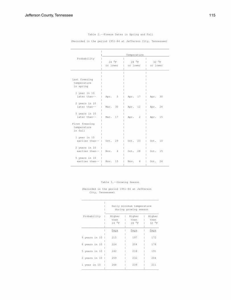
Jefferson County, Tennessee 115
Table 2.--Freeze Dates in Spring and Fall
(Recorded in the period 1951-84 at Jefferson City, Tennessee)
______________________________________________________________ | | Temperature |__________________________________________ Probability | | | | 24 oF | 28 oF | 32 oF | or lower | or lower | or lower | | |______________________________________________________________ | | | | | | Last freezing | | | temperature | | | in spring | | | | | | 1 year in 10 | | | later than-- | Apr. 5 | Apr. 17 | Apr. 30 | | | 2 years in 10 | | | later than-- | Mar. 30 | Apr. 12 | Apr. 24 | | | 5 years in 10 | | | later than-- | Mar. 17 | Apr. 2 | Apr. 15 | | | First freezing | | | temperature | | | in fall | | | | | | 1 year in 10 | | | earlier than-- | Oct. 29 | Oct. 23 | Oct. 10 | | | 2 years in 10 | | | earlier than-- | Nov. 4 | Oct. 28 | Oct. 15 | | | 5 years in 10 | | | earlier than-- | Nov. 15 | Nov. 6 | Oct. 24 | | |______________________________________________________________
Table 3.--Growing Season
(Recorded in the period 1951-84 at Jefferson City, Tennessee)
__________________________________________________ | | Daily minimum temperature | during growing season |___________________________________ Probability | Higher | Higher | Higher | than | than | than | 24 oF | 28 oF | 32 oF | | |__________________________________________________ | Days | Days | Days ____ ____ ____ | | |9 years in 10 | 215 | 197 | 172 | | |8 years in 10 | 224 | 204 | 178 | | |5 years in 10 | 242 | 218 | 191 | | |2 years in 10 | 259 | 232 | 204 | | |1 year in 10 | 268 | 239 | 211 | | |__________________________________________________

116 Soil Survey
Table 4.--Acreage and Proportionate Extent of the Soils ______________________________________________________________________________________________________________ | | | Map | Soil name | Acres |Percent symbol| | | ______________________________________________________________________________________________________________ | | | | | | AeC |Arents, clayey, 2 to 12 percent slopes---------------------------------------------| 659 | 0.3 AnC2 |Allen sandy loam, 5 to 12 percent slopes, eroded-----------------------------------| 905 | 0.5 AnD2 |Allen sandy loam, 12 to 20 percent slopes, eroded----------------------------------| 1,218 | 0.6 AnE |Allen sandy loam, 20 to 40 percent slopes------------------------------------------| 1,169 | 0.6 ArD2 |Armuchee channery silt loam, 10 to 25 percent slopes, eroded-----------------------| 1,084 | 0.5 ArE3 |Armuchee channery silty clay loam, 15 to 45 percent slopes, severely eroded--------| 2,313 | 1.2 ArF2 |Armuchee channery silt loam, 25 to 60 percent slopes, eroded-----------------------| 2,820 | 1.4 Be |Beason silt loam, occasionally flooded---------------------------------------------| 803 | 0.4 BoD |Bouldin cobbly sandy loam, 12 to 25 percent slopes, very stony---------------------| 559 | 0.3 BoF |Bouldin cobbly sandy loam, 25 to 70 percent slopes, very stony---------------------| 519 | 0.3 CoB2 |Collegedale silt loam, 2 to 5 percent slopes, eroded-------------------------------| 501 | 0.2 CoC2 |Collegedale silt loam, 5 to 12 percent slopes, eroded------------------------------| 2,217 | 1.1 CoC3 |Collegedale silty clay loam, 5 to 15 percent slopes, severely eroded---------------| 704 | 0.4 CoD2 |Collegedale silt loam, 12 to 20 percent slopes, eroded-----------------------------| 524 | 0.3 CtD2 |Collegedale-Talbott-Rock outcrop complex, 5 to 20 percent slopes, eroded-----------| 7,649 | 3.8 CtE2 |Collegedale-Talbott-Rock outcrop complex, 20 to 35 percent slopes, eroded----------| 5,084 | 2.5 DaC2 |Dandridge channery silt loam, 5 to 12 percent slopes, eroded-----------------------| 1,787 | 0.9 DaD2 |Dandridge channery silt loam, 12 to 25 percent slopes, eroded----------------------| 2,376 | 1.2 DaD3 |Dandridge channery silty clay loam, 10 to 25 percent slopes, severely eroded-------| 3,296 | 1.6 DaE3 |Dandridge channery silty clay loam, 25 to 50 percent slopes, severely eroded-------| 3,941 | 2.0 DaF2 |Dandridge channery silt loam, 25 to 70 percent slopes, eroded----------------------| 10,829 | 5.4 DcB2 |Decatur silt loam, 2 to 5 percent slopes, eroded-----------------------------------| 1,668 | 0.8 DeC2 |Dewey silt loam, 5 to 12 percent slopes, eroded------------------------------------| 6,211 | 3.1 DeC3 |Dewey silty clay loam, 5 to 12 percent slopes, severely eroded---------------------| 3,301 | 1.6 DeD2 |Dewey silt loam, 12 to 20 percent slopes, eroded-----------------------------------| 1,572 | 0.8 DeD3 |Dewey silty clay loam, 12 to 20 percent slopes, severely eroded--------------------| 2,931 | 1.5 DfD2 |Dewey-Rock outcrop complex, 5 to 20 percent slopes, eroded-------------------------| 1,247 | 0.6 Dm |Dumps, mine------------------------------------------------------------------------| 676 | 0.3 DuB2 |Dunmore silt loam, 2 to 5 percent slopes, eroded-----------------------------------| 913 | 0.5 DuC2 |Dunmore silt loam, 5 to 12 percent slopes, eroded----------------------------------| 12,121 | 6.0 DuC3 |Dunmore silty clay loam, 5 to 12 percent slopes, severely eroded-------------------| 3,813 | 1.9 DuD2 |Dunmore silt loam, 12 to 20 percent slopes, eroded---------------------------------| 5,578 | 2.8 DuD3 |Dunmore silty clay loam, 12 to 20 percent slopes, severely eroded------------------| 8,145 | 4.1 DuE2 |Dunmore silt loam, 20 to 40 percent slopes, eroded---------------------------------| 1,863 | 0.9 DuE3 |Dunmore silty clay loam, 20 to 40 percent slopes, severely eroded------------------| 2,281 | 1.1 DwE3 |Dunmore and Fullerton soils, 10 to 30 percent slopes, gullied----------------------| 1,736 | 0.9 DxE2 |Dunmore and Fullerton soils, karst, 10 to 30 percent slopes, eroded----------------| 7,523 | 3.7 Em |Emory silt loam, rarely flooded----------------------------------------------------| 1,295 | 0.6 En |Ennis cobbly loam, occasionally flooded--------------------------------------------| 171 | 0.1 EtB |Etowah silt loam, 2 to 5 percent slopes--------------------------------------------| 2,586 | 1.3 EtC |Etowah silt loam, 5 to 12 percent slopes-------------------------------------------| 1,846 | 0.9 EtD |Etowah silt loam, 12 to 25 percent slopes------------------------------------------| 257 | 0.1 FaE2 |Farragut silt loam, 20 to 40 percent slopes, eroded--------------------------------| 234 | 0.1 FuC2 |Fullerton gravelly silt loam, 5 to 12 percent slopes, eroded-----------------------| 3,912 | 1.9 FuD2 |Fullerton gravelly silt loam, 12 to 25 percent slopes, eroded----------------------| 6,822 | 3.4 FuE2 |Fullerton gravelly silt loam, 25 to 45 percent slopes, eroded----------------------| 3,346 | 1.7 GpD2 |Gilpin channery silt loam, 12 to 25 percent slopes, eroded-------------------------| 209 | 0.1 GpF |Gilpin channery silt loam, 25 to 70 percent slopes---------------------------------| 1,382 | 0.7 GuE3 |Gullied land-Dandridge complex, 15 to 50 percent slopes, severely eroded-----------| 528 | 0.3 Ln |Lindside silt loam, occasionally flooded-------------------------------------------| 3,206 | 1.6 MnC |Minvale gravelly silt loam, 5 to 15 percent slopes---------------------------------| 1,116 | 0.6 MoC |Montevallo channery silt loam, 2 to 10 percent slopes------------------------------| 954 | 0.5 MoD |Montevallo channery silt loam, 10 to 20 percent slopes-----------------------------| 409 | 0.2 MpE |Montevallo-Armuchee complex, 15 to 50 percent slopes, gullied----------------------| 939 | 0.5 MuB |Muse silt loam, 2 to 5 percent slopes----------------------------------------------| 894 | 0.4 MuC |Muse silt loam, 5 to 12 percent slopes---------------------------------------------| 911 | 0.5 MwE |Muskingum silt loam, 25 to 50 percent slopes---------------------------------------| 1,032 | 0.5 Ne |Newark silt loam, frequently flooded-----------------------------------------------| 489 | 0.2 NkB2 |Nolichucky loam, 2 to 5 percent slopes, eroded-------------------------------------| 2,884 | 1.4 NkC2 |Nolichucky loam, 5 to 12 percent slopes, eroded------------------------------------| 1,619 | 0.8 NkD2 |Nolichucky loam, 12 to 20 percent slopes, eroded-----------------------------------| 385 | 0.2 | | |

Jefferson County, Tennessee 117
Table 4.--Acreage and Proportionate Extent of the Soils--Continued ______________________________________________________________________________________________________________ | | | Map | Soil name | Acres |Percent symbol| | | ______________________________________________________________________________________________________________ | | | | | | NmD2 |Nolichucky gravelly loam, 10 to 20 percent slopes, eroded--------------------------| 299 | 0.1 No |Nolin silt loam, occasionally flooded----------------------------------------------| 1,437 | 0.7 Pu |Purdy silt loam--------------------------------------------------------------------| 1,247 | 0.6 RaD |Ramsey-Rock outcrop complex, 12 to 25 percent slopes-------------------------------| 348 | 0.2 RaF |Ramsey-Rock outcrop complex, 25 to 70 percent slopes-------------------------------| 509 | 0.3 SeB2 |Sequoia silt loam, 2 to 5 percent slopes, eroded-----------------------------------| 334 | 0.2 SeC2 |Sequoia silt loam, 5 to 12 percent slopes, eroded----------------------------------| 2,911 | 1.4 SeC3 |Sequoia silty clay loam, 5 to 12 percent slopes, severely eroded-------------------| 661 | 0.3 SeD2 |Sequoia silt loam, 12 to 20 percent slopes, eroded---------------------------------| 2,009 | 1.0 St |Staser fine sandy loam, overwash, rarely flooded-----------------------------------| 973 | 0.5 SwB |Swafford silt loam, 1 to 4 percent slopes, rarely flooded--------------------------| 2,048 | 1.0 TaE2 |Talbott-Rock outcrop complex, karst, 10 to 35 percent slopes, eroded---------------| 4,195 | 2.1 TsB |Tasso silt loam, 2 to 5 percent slopes---------------------------------------------| 1,276 | 0.6 WaC2 |Waynesboro loam, 5 to 12 percent slopes, eroded------------------------------------| 856 | 0.4 WaD2 |Waynesboro loam, 12 to 20 percent slopes, eroded-----------------------------------| 284 | 0.1 Wb |Whitesburg silt loam, occasionally flooded-----------------------------------------| 551 | 0.3 | Water-------------------------------------------------------------------------| 31,000 | 15.5 | |-----------|------- | Total--------------------------------------------------------------------| 200,900 | 100.0 | | | ______________________________________________________________________________________________________________

118 Soil Survey
Table 5.--Prime Farmland
(Only the soils considered prime farmland are listed. Urban or built-up areas of the soils listed are not considered prime farmland)
______________________________________________________________________________________________________________ | Map | Soil name symbol | ______________________________________________________________________________________________________________ | | Be |Beason silt loam, occasionally flooded CoB2 |Collegedale silt loam, 2 to 5 percent slopes, eroded DcB2 |Decatur silt loam, 2 to 5 percent slopes, eroded DuB2 |Dunmore silt loam, 2 to 5 percent slopes, eroded Em |Emory silt loam, rarely flooded EtB |Etowah silt loam, 2 to 5 percent slopes Ln |Lindside silt loam, occasionally flooded MuB |Muse silt loam, 2 to 5 percent slopes NkB2 |Nolichucky loam, 2 to 5 percent slopes, eroded No |Nolin silt loam, occasionally flooded St |Staser fine sandy loam, overwash, rarely flooded SwB |Swafford silt loam, 1 to 4 percent slopes, rarely flooded TsB |Tasso silt loam, 2 to 5 percent slopes Wb |Whitesburg silt loam, occasionally flooded | ______________________________________________________________________________________________________________

Jefferson County, Tennessee 119
Table 6.--Land Capability and Yields per Acre of Crops and Pasture
(Yields are those that can be expected under a high level of management. Absence of a yield indicates that the soil is not suited to the crop or the crop generally is not grown on the soil)
_______________________________________________________________________________________________________________ | | | | | | | Soil name and | Land | | | | | | map symbol |capability| Corn | Soybeans | Tobacco | Wheat | Alfalfa hay |Tall fescue- | | | | | | | ladino _______________________________________________________________________________________________________________ | | Bu | Bu | Lbs | Bu | Tons | AUM* __ __ ___ __ ____ ____ | | | | | | | AeC. | | | | | | | Arents | | | | | | | | | | | | | | AnC2------------| IIIe | 85 | 30 | 2,300 | 45 | 3.3 | 6.5 Allen | | | | | | | | | | | | | | AnD2------------| IVe | 75 | 26 | 2,050 | 42 | 3.0 | 6.0 Allen | | | | | | | | | | | | | | AnE-------------| VIIe | --- | --- | --- | --- | --- | 5.0 Allen | | | | | | | | | | | | | | ArD2------------| VIe | --- | --- | --- | --- | --- | 4.5 Armuchee | | | | | | | | | | | | | | ArE3------------| VIIe | --- | --- | --- | --- | --- | 3.5 Armuchee | | | | | | | | | | | | | | ArF2------------| VIIe | --- | --- | --- | --- | --- | --- Armuchee | | | | | | | | | | | | | | Be--------------| IIw | 75 | 35 | --- | --- | --- | 7.0 Beason | | | | | | | | | | | | | | BoD, BoF--------| VIIs | --- | --- | --- | --- | --- | --- Bouldin | | | | | | | | | | | | | | CoB2------------| IIIe | 80 | 28 | 2,150 | 45 | 3.0 | 6.0 Collegedale | | | | | | | | | | | | | | CoC2------------| IVe | 70 | --- | 1,950 | 42 | 2.8 | 5.5 Collegedale | | | | | | | | | | | | | | CoC3------------| VIe | --- | --- | --- | --- | --- | 4.5 Collegedale | | | | | | | | | | | | | | CoD2------------| VIe | --- | --- | --- | --- | --- | 5.0 Collegedale | | | | | | | | | | | | | | CtD2**----------| VIs | --- | --- | --- | --- | --- | 4.5 Collegedale- | | | | | | | Talbott-Rock | | | | | | | outcrop | | | | | | | | | | | | | | CtE2**----------| VIIs | --- | --- | --- | --- | --- | 3.5 Collegedale- | | | | | | | Talbott-Rock | | | | | | | outcrop | | | | | | | | | | | | | | DaC2------------| VIe | --- | --- | --- | --- | --- | 3.5 Dandridge | | | | | | | | | | | | | | DaD2------------| VIe | --- | --- | --- | --- | --- | 3.5 Dandridge | | | | | | | | | | | | | | DaD3------------| VIIe | --- | --- | --- | --- | --- | 3.0 Dandridge | | | | | | | | | | | | | |
See footnotes at end of table.

120 Soil Survey
Table 6.--Land Capability and Yields per Acre of Crops and Pasture--Continued _______________________________________________________________________________________________________________ | | | | | | | Soil name and | Land | | | | | | map symbol |capability| Corn | Soybeans | Tobacco | Wheat | Alfalfa hay |Tall fescue- | | | | | | | ladino _______________________________________________________________________________________________________________ | | Bu | Bu | Lbs | Bu | Tons | AUM* __ __ ___ __ ____ ____ | | | | | | | DaE3------------| VIIe | --- | --- | --- | --- | --- | --- Dandridge | | | | | | | | | | | | | | DaF2------------| VIIe | --- | --- | --- | --- | --- | --- Dandridge | | | | | | | | | | | | | | DcB2------------| IIe | 95 | 38 | 2,600 | 48 | 4.2 | 7.5 Decatur | | | | | | | | | | | | | | DeC2------------| IIIe | 85 | 32 | 2,400 | 45 | 3.8 | 7.0 Dewey | | | | | | | | | | | | | | DeC3------------| IVe | 70 | --- | --- | 38 | 3.0 | 6.0 Dewey | | | | | | | | | | | | | | DeD2------------| IVe | 75 | --- | --- | 40 | 3.4 | 6.0 Dewey | | | | | | | | | | | | | | DeD3------------| VIe | --- | --- | --- | --- | --- | 5.0 Dewey | | | | | | | | | | | | | | DfD2**----------| VIs | --- | --- | --- | --- | --- | 5.0 Dewey-Rock | | | | | | | outcrop | | | | | | | | | | | | | | Dm**. | | | | | | | Dumps | | | | | | | | | | | | | | DuB2------------| IIe | 85 | 32 | 2,400 | 46 | 3.8 | 7.0 Dunmore | | | | | | | | | | | | | | DuC2------------| IIIe | 75 | 28 | 2,200 | 44 | 3.6 | 6.5 Dunmore | | | | | | | | | | | | | | DuC3------------| IVe | 60 | --- | --- | 38 | 2.8 | 5.5 Dunmore | | | | | | | | | | | | | | DuD2------------| IVe | 65 | --- | --- | 40 | 3.2 | 6.0 Dunmore | | | | | | | | | | | | | | DuD3------------| VIe | --- | --- | --- | --- | --- | 5.0 Dunmore | | | | | | | | | | | | | | DuE2------------| VIIe | --- | --- | --- | --- | --- | 4.5 Dunmore | | | | | | | | | | | | | | DuE3------------| VIIe | --- | --- | --- | --- | --- | 4.0 Dunmore | | | | | | | | | | | | | | DwE3------------| VIIe | --- | --- | --- | --- | --- | 3.5 Dunmore and | | | | | | | Fullerton | | | | | | | | | | | | | | DxE2------------| VIe | --- | --- | --- | --- | --- | 5.0 Dunmore and | | | | | | | Fullerton | | | | | | | | | | | | | | Em--------------| I | 125 | 42 | 2,500 | 50 | 4.0 | 8.5 Emory | | | | | | | | | | | | | |
See footnotes at end of table.

Jefferson County, Tennessee 121
Table 6.--Land Capability and Yields per Acre of Crops and Pasture--Continued _______________________________________________________________________________________________________________ | | | | | | | Soil name and | Land | | | | | | map symbol |capability| Corn | Soybeans | Tobacco | Wheat | Alfalfa hay |Tall fescue- | | | | | | | ladino _______________________________________________________________________________________________________________ | | Bu | Bu | Lbs | Bu | Tons | AUM* __ __ ___ __ ____ ____ | | | | | | | En--------------| IIIs | 80 | 30 | --- | 42 | 3.0 | 7.0 Ennis | | | | | | | | | | | | | | EtB-------------| IIe | 115 | 43 | 2,900 | 55 | 4.5 | 8.0 Etowah | | | | | | | | | | | | | | EtC-------------| IIIe | 105 | 39 | 2,700 | 52 | 4.2 | 7.5 Etowah | | | | | | | | | | | | | | EtD-------------| IVe | 85 | 32 | 2,400 | 46 | 3.7 | 6.5 Etowah | | | | | | | | | | | | | | FaE2------------| VIIe | --- | --- | --- | --- | --- | 5.5 Farragut | | | | | | | | | | | | | | FuC2------------| IIIe | 75 | 28 | 2,000 | 38 | 2.8 | 6.0 Fullerton | | | | | | | | | | | | | | FuD2------------| IVe | --- | --- | --- | 32 | 2.5 | 5.5 Fullerton | | | | | | | | | | | | | | FuE2------------| VIIe | --- | --- | --- | --- | --- | 4.5 Fullerton | | | | | | | | | | | | | | GpD2------------| VIe | --- | --- | --- | --- | --- | 5.5 Gilpin | | | | | | | | | | | | | | GpF-------------| VIIe | --- | --- | --- | --- | --- | --- Gilpin | | | | | | | | | | | | | | GuE3------------| VIIe | --- | --- | --- | --- | --- | --- Gullied land- | | | | | | | Dandridge | | | | | | | | | | | | | | Ln--------------| IIw | 120 | 42 | 2,500 | 48 | 4.0 | 8.5 Lindside | | | | | | | | | | | | | | MnC-------------| IIIe | 85 | 30 | 2,250 | 40 | 3.6 | 7.0 Minvale | | | | | | | | | | | | | | MoC-------------| IVe | --- | --- | --- | --- | --- | 3.5 Montevallo | | | | | | | | | | | | | | MoD-------------| VIe | --- | --- | --- | --- | --- | 3.0 Montevallo | | | | | | | | | | | | | | MpE-------------| VIIe | --- | --- | --- | --- | --- | --- Montevallo- | | | | | | | Armuchee | | | | | | | | | | | | | | MuB-------------| IIe | 100 | 36 | 2,600 | 48 | 4.0 | 7.5 Muse | | | | | | | | | | | | | | MuC-------------| IIIe | 90 | 32 | 2,400 | 45 | 3.8 | 7.0 Muse | | | | | | | | | | | | | | MwE-------------| VIIe | --- | --- | --- | --- | --- | --- Muskingum | | | | | | | | | | | | | |
See footnotes at end of table.

122 Soil Survey
Table 6.--Land Capability and Yields per Acre of Crops and Pasture--Continued _______________________________________________________________________________________________________________ | | | | | | | Soil name and | Land | | | | | | map symbol |capability| Corn | Soybeans | Tobacco | Wheat | Alfalfa hay |Tall fescue- | | | | | | | ladino _______________________________________________________________________________________________________________ | | Bu | Bu | Lbs | Bu | Tons | AUM* __ __ ___ __ ____ ____ | | | | | | | Ne--------------| IIIw | 80 | 30 | --- | --- | --- | 7.0 Newark | | | | | | | | | | | | | | NkB2------------| IIe | 90 | 32 | 2,450 | 48 | 3.8 | 7.0 Nolichucky | | | | | | | | | | | | | | NkC2------------| IIIe | 80 | 28 | 2,250 | 45 | 3.6 | 6.5 Nolichucky | | | | | | | | | | | | | | NkD2------------| IVe | 65 | --- | 2,000 | 42 | 3.2 | 6.0 Nolichucky | | | | | | | | | | | | | | NmD2------------| IVe | --- | --- | --- | 40 | 3.0 | 5.5 Nolichucky | | | | | | | | | | | | | | No--------------| IIw | 135 | 45 | 2,800 | 55 | 4.3 | 9.0 Nolin | | | | | | | | | | | | | | Pu--------------| IVw | --- | --- | --- | --- | --- | 5.5 Purdy | | | | | | | | | | | | | | RaD**-----------| VIs | --- | --- | --- | --- | --- | 3.5 Ramsey-Rock | | | | | | | outcrop | | | | | | | | | | | | | | RaF**-----------| VIIs | --- | --- | --- | --- | --- | --- Ramsey-Rock | | | | | | | outcrop | | | | | | | | | | | | | | SeB2------------| IIIe | 70 | --- | 2,000 | 42 | 2.7 | 6.0 Sequoia | | | | | | | | | | | | | | SeC2------------| IVe | 60 | --- | 1,800 | 38 | 2.5 | 5.5 Sequoia | | | | | | | | | | | | | | SeC3------------| VIe | --- | --- | --- | --- | --- | 4.5 Sequoia | | | | | | | | | | | | | | SeD2------------| VIe | --- | --- | --- | --- | --- | 4.5 Sequoia | | | | | | | | | | | | | | St--------------| I | 130 | 45 | 2,800 | 55 | 4.5 | 9.0 Staser | | | | | | | | | | | | | | SwB-------------| IIe | 100 | 38 | 2,200 | 48 | 3.5 | 8.0 Swafford | | | | | | | | | | | | | | TaE2**----------| VIIs | --- | --- | --- | --- | --- | 3.5 Talbott-Rock | | | | | | | outcrop | | | | | | | | | | | | | | TsB-------------| IIe | 95 | 35 | 2,100 | 46 | 3.2 | 7.5 Tasso | | | | | | | | | | | | | | WaC2------------| IIIe | 90 | 32 | 2,400 | 46 | 3.8 | 7.0 Waynesboro | | | | | | | | | | | | | |
See footnotes at end of table.

Jefferson County, Tennessee 123
Table 6.--Land Capability and Yields per Acre of Crops and Pasture--Continued _______________________________________________________________________________________________________________ | | | | | | | Soil name and | Land | | | | | | map symbol |capability| Corn | Soybeans | Tobacco | Wheat | Alfalfa hay |Tall fescue- | | | | | | | ladino _______________________________________________________________________________________________________________ | | Bu | Bu | Lbs | Bu | Tons | AUM* __ __ ___ __ ____ ____ | | | | | | | WaD2------------| IVe | 80 | --- | --- | 42 | 3.4 | 6.5 Waynesboro | | | | | | | | | | | | | | Wb--------------| IIw | 90 | 34 | 2,200 | 45 | 3.2 | 7.5 Whitesburg | | | | | | | | | | | | | | _______________________________________________________________________________________________________________
* Animal unit month: The amount of forage or feed required to feed one animal unit (one cow, one horse, one mule, five sheep, or five goats) for 30 days. ** See description of the map unit for composition and behavior characteristics of the map unit.

124 Soil Survey
Table 7.--Woodland Management and Productivity
(Only the soils suitable for production of commercial trees are listed. Absence of an entry indicates that information was not available)
________________________________________________________________________________________________________________ | Management concerns | Potential productivity | _______________________________________________________________________________ Soil name and | | Equip- | | | | | | | map symbol |Erosion | ment |Seedling| Wind- | Plant | Common trees |Site |Volume*|Trees to plant |hazard | limita-|mortal- | throw |competi-| |index| | | | tion | ity | hazard | tion | | | | ________________________________________________________________________________________________________________ | | | | | | | | | | | | | | | | | | AeC. | | | | | | | | | Arents | | | | | | | | | | | | | | | | | | AnC2------------|Slight |Slight |Slight |Slight |Moderate|Yellow poplar-------| 87 | 86 |Yellow poplar, Allen | | | | | |Shortleaf pine------| 72 | 114 | loblolly pine. | | | | | | | | | shortleaf | | | | | | | | | pine. | | | | | | | | | AnD2, AnE-------|Moderate|Moderate|Slight |Slight |Moderate|Yellow poplar-------| 87 | 86 |Yellow poplar, Allen | | | | | |Shortleaf pine------| 72 | 114 | loblolly pine. | | | | | | | | | shortleaf | | | | | | | | | pine. | | | | | | | | | ArD2------------|Moderate|Moderate|Slight |Slight |Moderate|Shortleaf pine------| 60 | 86 |Loblolly pine, Armuchee | | | | | |Virginia pine-------| 60 | 86 | Virginia pine. | | | | | |Southern red oak----| 60 | 43 | | | | | | | | | | ArE3------------|Moderate|Moderate|Moderate|Slight |Moderate|Shortleaf pine------| 60 | 86 |Loblolly pine, Armuchee | | | | | |Virginia pine-------| 60 | 86 | Virginia pine, | | | | | |Southern red oak----| 60 | 43 | | | | | | | | | | ArF2------------|Severe |Severe |Slight |Slight |Moderate|Shortleaf pine------| 60 | 86 |Loblolly pine, Armuchee | | | | | |Virginia pine-------| 60 | 86 | Virginia pine, | | | | | |Southern red oak----| 60 | 43 | | | | | | | | | | Be--------------|Slight |Moderate|Moderate|Slight |Moderate|Yellow poplar-------| 90 | 86 |Loblolly pine, Beason | | | | | |Sweetgum------------| 80 | 86 | sweetgum, | | | | | |White oak-----------| 70 | 57 | yellow poplar. | | | | | |Southern red oak----| 70 | 57 | | | | | | |Loblolly pine-------| 80 | 114 | | | | | | | | | | BoD-------------|Slight |Moderate|Slight |Slight |Moderate|Yellow poplar-------| 90 | 86 |Yellow poplar, Bouldin | | | | | |Northern red oak----| 75 | 57 | shortleaf | | | | | |Shortleaf pine------| 70 | 114 | pine. | | | | | | | | | BoF-------------|Moderate|Severe |Slight |Slight |Moderate|Yellow poplar-------| 90 | 86 |Yellow poplar, Bouldin | | | | | |Northern red oak----| 75 | 57 | shortleaf | | | | | |Shortleaf pine------| 70 | 114 | pine. | | | | | | | | | CoB2, CoC2------|Slight |Moderate|Slight |Slight |Moderate|Southern red oak----| 70 | 57 |Yellow poplar, Collegedale | | | | | |Yellow poplar-------| 90 | 86 | loblolly pine, | | | | | |White oak-----------| 70 | 57 | shortleaf | | | | | |Shortleaf pine------| 70 | 114 | pine, Virginia | | | | | |Virginia pine-------| 70 | 114 | pine. | | | | | |Loblolly pine-------| 80 | 114 | | | | | | | | | | CoC3------------|Slight |Moderate|Moderate|Slight |Moderate|Loblolly pine-------| 70 | 86 |Loblolly pine, Collegedale | | | | | |Virginia pine-------| 60 | 86 | Virginia pine, | | | | | |Eastern redcedar----| 40 | 43 | shortleaf | | | | | | | | | pine. | | | | | | | | |
See footnotes at end of table.
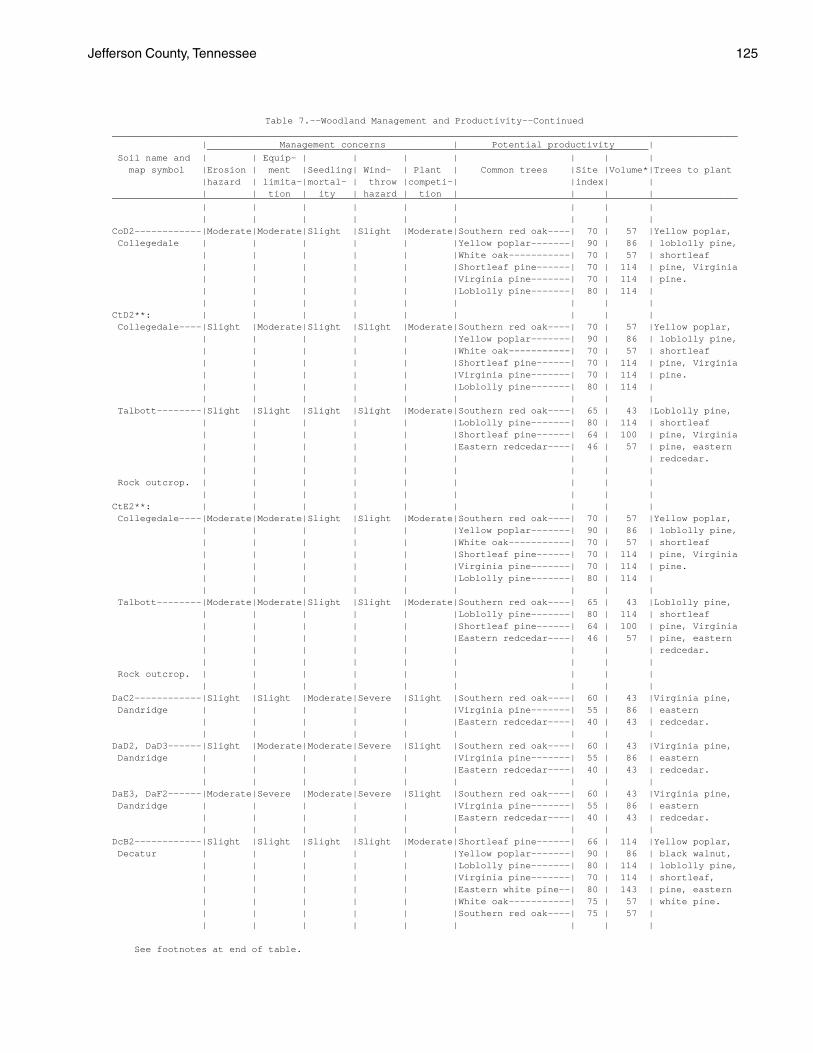
Jefferson County, Tennessee 125
Table 7.--Woodland Management and Productivity--Continued ________________________________________________________________________________________________________________ | Management concerns | Potential productivity | _______________________________________________________________________________ Soil name and | | Equip- | | | | | | | map symbol |Erosion | ment |Seedling| Wind- | Plant | Common trees |Site |Volume*|Trees to plant |hazard | limita-|mortal- | throw |competi-| |index| | | | tion | ity | hazard | tion | | | | ________________________________________________________________________________________________________________ | | | | | | | | | | | | | | | | | | CoD2------------|Moderate|Moderate|Slight |Slight |Moderate|Southern red oak----| 70 | 57 |Yellow poplar, Collegedale | | | | | |Yellow poplar-------| 90 | 86 | loblolly pine, | | | | | |White oak-----------| 70 | 57 | shortleaf | | | | | |Shortleaf pine------| 70 | 114 | pine, Virginia | | | | | |Virginia pine-------| 70 | 114 | pine. | | | | | |Loblolly pine-------| 80 | 114 | | | | | | | | | | CtD2**: | | | | | | | | | Collegedale----|Slight |Moderate|Slight |Slight |Moderate|Southern red oak----| 70 | 57 |Yellow poplar, | | | | | |Yellow poplar-------| 90 | 86 | loblolly pine, | | | | | |White oak-----------| 70 | 57 | shortleaf | | | | | |Shortleaf pine------| 70 | 114 | pine, Virginia | | | | | |Virginia pine-------| 70 | 114 | pine. | | | | | |Loblolly pine-------| 80 | 114 | | | | | | | | | | Talbott--------|Slight |Slight |Slight |Slight |Moderate|Southern red oak----| 65 | 43 |Loblolly pine, | | | | | |Loblolly pine-------| 80 | 114 | shortleaf | | | | | |Shortleaf pine------| 64 | 100 | pine, Virginia | | | | | |Eastern redcedar----| 46 | 57 | pine, eastern | | | | | | | | | redcedar. | | | | | | | | | Rock outcrop. | | | | | | | | | | | | | | | | | | CtE2**: | | | | | | | | | Collegedale----|Moderate|Moderate|Slight |Slight |Moderate|Southern red oak----| 70 | 57 |Yellow poplar, | | | | | |Yellow poplar-------| 90 | 86 | loblolly pine, | | | | | |White oak-----------| 70 | 57 | shortleaf | | | | | |Shortleaf pine------| 70 | 114 | pine, Virginia | | | | | |Virginia pine-------| 70 | 114 | pine. | | | | | |Loblolly pine-------| 80 | 114 | | | | | | | | | | Talbott--------|Moderate|Moderate|Slight |Slight |Moderate|Southern red oak----| 65 | 43 |Loblolly pine, | | | | | |Loblolly pine-------| 80 | 114 | shortleaf | | | | | |Shortleaf pine------| 64 | 100 | pine, Virginia | | | | | |Eastern redcedar----| 46 | 57 | pine, eastern | | | | | | | | | redcedar. | | | | | | | | | Rock outcrop. | | | | | | | | | | | | | | | | | | DaC2------------|Slight |Slight |Moderate|Severe |Slight |Southern red oak----| 60 | 43 |Virginia pine, Dandridge | | | | | |Virginia pine-------| 55 | 86 | eastern | | | | | |Eastern redcedar----| 40 | 43 | redcedar. | | | | | | | | | DaD2, DaD3------|Slight |Moderate|Moderate|Severe |Slight |Southern red oak----| 60 | 43 |Virginia pine, Dandridge | | | | | |Virginia pine-------| 55 | 86 | eastern | | | | | |Eastern redcedar----| 40 | 43 | redcedar. | | | | | | | | | DaE3, DaF2------|Moderate|Severe |Moderate|Severe |Slight |Southern red oak----| 60 | 43 |Virginia pine, Dandridge | | | | | |Virginia pine-------| 55 | 86 | eastern | | | | | |Eastern redcedar----| 40 | 43 | redcedar. | | | | | | | | | DcB2------------|Slight |Slight |Slight |Slight |Moderate|Shortleaf pine------| 66 | 114 |Yellow poplar, Decatur | | | | | |Yellow poplar-------| 90 | 86 | black walnut, | | | | | |Loblolly pine-------| 80 | 114 | loblolly pine, | | | | | |Virginia pine-------| 70 | 114 | shortleaf, | | | | | |Eastern white pine--| 80 | 143 | pine, eastern | | | | | |White oak-----------| 75 | 57 | white pine. | | | | | |Southern red oak----| 75 | 57 | | | | | | | | | |
See footnotes at end of table.

126 Soil Survey
Table 7.--Woodland Management and Productivity--Continued ________________________________________________________________________________________________________________ | Management concerns | Potential productivity | _______________________________________________________________________________ Soil name and | | Equip- | | | | | | | map symbol |Erosion | ment |Seedling| Wind- | Plant | Common trees |Site |Volume*|Trees to plant |hazard | limita-|mortal- | throw |competi-| |index| | | | tion | ity | hazard | tion | | | | ________________________________________________________________________________________________________________ | | | | | | | | | | | | | | | | | | DeC2------------|Slight |Slight |Slight |Slight |Moderate|Yellow poplar-------| 90 | 86 |Yellow poplar, Dewey | | | | | |White oak-----------| 70 | 57 | black walnut, | | | | | |Southern red oak----| 70 | 57 | loblolly pine, | | | | | |Shortleaf pine------| 73 | 114 | eastern white | | | | | |Virginia pine-------| 70 | 114 | pine. | | | | | |Loblolly pine-------| 78 | 114 | | | | | | | | | | DeC3------------|Slight |Moderate|Moderate|Slight |Moderate|Loblolly pine-------| 70 | 86 |Loblolly pine, Dewey | | | | | |Virginia pine-------| 60 | 86 | eastern | | | | | |Eastern redcedar----| 40 | 43 | redcedar, | | | | | |Eastern white pine--| 70 | 114 | eastern white | | | | | | | | | pine. | | | | | | | | | DeD2------------|Moderate|Moderate|Slight |Slight |Moderate|Yellow poplar-------| 90 | 86 |Yellow poplar, Dewey | | | | | |White oak-----------| 70 | 57 | black walnut, | | | | | |Southern red oak----| 70 | 57 | loblolly pine, | | | | | |Shortleaf pine------| 73 | 114 | eastern white | | | | | |Virginia pine-------| 70 | 114 | pine. | | | | | |Loblolly pine-------| 78 | 114 | | | | | | | | | | DeD3------------|Moderate|Moderate|Moderate|Slight |Moderate|Loblolly pine-------| 70 | 86 |Loblolly pine, Dewey | | | | | |Virginia pine-------| 60 | 86 | eastern | | | | | |Eastern redcedar----| 40 | 43 | redcedar, | | | | | |Eastern white pine--| 70 | 114 | eastern white | | | | | | | | | pine. | | | | | | | | | DfD2**: | | | | | | | | | Dewey----------|Moderate|Moderate|Moderate|Slight |Moderate|Loblolly pine-------| 70 | 86 |Loblolly pine, | | | | | |Virginia pine-------| 60 | 86 | eastern | | | | | |Eastern redcedar----| 40 | 43 | redcedar, | | | | | |Eastern white pine--| 70 | 114 | eastern white | | | | | | | | | pine. | | | | | | | | | Rock outcrop. | | | | | | | | | | | | | | | | | | Dm*. | | | | | | | | | Dumps | | | | | | | | | | | | | | | | | | DuB2, DuC2------|Slight |Slight |Slight |Slight |Moderate|Yellow poplar-------| 90 | 86 |Yellow poplar, Dunmore | | | | | |White oak-----------| 70 | 57 | black walnut, | | | | | |Southern red oak----| 70 | 57 | shortleaf | | | | | |Shortleaf pine------| 70 | 114 | pine, eastern | | | | | |Eastern white pine--| 80 | 143 | white pine, | | | | | |Virginia pine-------| 70 | 141 | loblolly pine. | | | | | | | | | DuC3------------|Slight |Moderate|Moderate|Slight |Moderate|Loblolly pine-------| 70 | 86 |Loblolly pine, Dunmore | | | | | |Virginia pine-------| 60 | 86 | eastern white | | | | | |Eastern white pine--| 70 | 114 | pine, eastern | | | | | |Eastern redcedar----| 40 | 43 | redcedar. | | | | | | | | | DuD2------------|Moderate|Moderate|Slight |Slight |Moderate|Yellow poplar-------| 90 | 86 |Yellow poplar, Dunmore | | | | | |White oak-----------| 70 | 57 | black walnut, | | | | | |Southern red oak----| 70 | 57 | shortleaf | | | | | |Shortleaf pine------| 70 | 114 | pine, eastern | | | | | |Eastern white pine--| 80 | 143 | white pine, | | | | | |Virginia pine-------| 70 | 114 | loblolly pine. | | | | | | | | |
See footnotes at end of table.

Jefferson County, Tennessee 127
Table 7.--Woodland Management and Productivity--Continued ________________________________________________________________________________________________________________ | Management concerns | Potential productivity | _______________________________________________________________________________ Soil name and | | Equip- | | | | | | | map symbol |Erosion | ment |Seedling| Wind- | Plant | Common trees |Site |Volume*|Trees to plant |hazard | limita-|mortal- | throw |competi-| |index| | | | tion | ity | hazard | tion | | | | ________________________________________________________________________________________________________________ | | | | | | | | | | | | | | | | | | DuD3------------|Moderate|Moderate|Moderate|Slight |Moderate|Loblolly pine-------| 70 | 86 |Loblolly pine, Dunmore | | | | | |Virginia pine-------| 60 | 86 | eastern white | | | | | |Eastern white pine--| 70 | 114 | pine, eastern | | | | | |Eastern redcedar----| 40 | 43 | redcedar. | | | | | | | | | DuE2------------|Moderate|Moderate|Slight |Slight |Moderate|Yellow poplar-------| 90 | 86 |Yellow poplar, Dunmore | | | | | |White oak-----------| 70 | 57 | black walnut, | | | | | |Southern red oak----| 70 | 57 | shortleaf | | | | | |Shortleaf pine------| 70 | 114 | pine, eastern | | | | | |Eastern white pine--| 80 | 143 | white pine, | | | | | |Virginia pine-------| 70 | 114 | loblolly pine. | | | | | | | | | DuE3------------|Moderate|Moderate|Moderate|Slight |Moderate|Loblolly pine-------| 70 | 86 |Loblolly pine, Dunmore | | | | | |Virginia pine-------| 60 | 86 | eastern white | | | | | |Eastern white pine--| 70 | 114 | pine, eastern | | | | | |Eastern redcedar----| 40 | 43 | redcedar. | | | | | | | | | DwE3**: | | | | | | | | | Dunmore--------|Moderate|Moderate|Moderate|Slight |Moderate|Loblolly pine-------| 70 | 86 |Loblolly pine, | | | | | |Virginia pine-------| 60 | 86 | eastern white | | | | | |Eastern white pine--| 70 | 114 | pine, eastern | | | | | |Eastern redcedar----| 40 | 43 | redcedar. | | | | | | | | | Fullerton------|Slight |Moderate|Moderate|Slight |Moderate|Southern red oak----| 60 | 43 |Loblolly pine, | | | | | |Shortleaf pine------| 60 | 86 | shortleaf | | | | | | | | | pine. | | | | | | | | | DxE2**: | | | | | | | | | Dunmore--------|Moderate|Moderate|Slight |Slight |Moderate|Yellow poplar-------| 90 | 86 |Yellow poplar, | | | | | |White oak-----------| 70 | 57 | black walnut, | | | | | |Southern red oak----| 70 | 57 | shortleaf | | | | | |Shortleaf pine------| 70 | 114 | pine, eastern | | | | | |Eastern white pine--| 80 | 143 | white pine, | | | | | |Virginia pine-------| 70 | 114 | loblolly pine. | | | | | | | | | Fullerton------|Moderate|Moderate|Slight |Slight |Moderate|Yellow poplar-------| 90 | 86 |Yellow poplar, | | | | | |Southern red oak----| 70 | 57 | loblolly pine. | | | | | |Shortleaf pine------| 67 | 100 | | | | | | | | | | Em--------------|Slight |Slight |Slight |Slight |Severe |Yellow poplar-------| 104 | 114 |Yellow poplar, Emory | | | | | |Northern red oak----| 80 | 57 | black walnut, | | | | | |Loblolly pine-------| 90 | 129 | loblolly pine. | | | | | |Black walnut--------| --- | --- | | | | | | |White ash-----------| --- | --- | | | | | | |Black cherry--------| --- | --- | | | | | | | | | | En--------------|Slight |Slight |Slight |Slight |Moderate|Yellow poplar-------| 100 | 114 |Yellow poplar, Ennis | | | | | |White oak-----------| 80 | 57 | black walnut, | | | | | |Loblolly pine-------| 90 | 129 | loblolly pine. | | | | | | | | | EtB, EtC--------|Slight |Slight |Slight |Slight |Moderate|Yellow poplar-------| 90 | 86 |Yellow poplar, Etowah | | | | | |Southern red oak----| 80 | 57 | black walnut, | | | | | |Loblolly pine-------| 90 | 129 | loblolly pine. | | | | | |Shortleaf pine------| 80 | 129 | | | | | | | | | | EtD-------------|Moderate|Moderate|Slight |Slight |Moderate|Yellow poplar-------| 90 | 86 |Yellow poplar, Etowah | | | | | |Southern red oak----| 80 | 57 | black walnut, | | | | | |Loblolly pine-------| 90 | 129 | loblolly pine. | | | | | |Shortleaf pine------| 80 | 129 | | | | | | | | | |
See footnotes at end of table.

128 Soil Survey
Table 7.--Woodland Management and Productivity--Continued ________________________________________________________________________________________________________________ | Management concerns | Potential productivity | _______________________________________________________________________________ Soil name and | | Equip- | | | | | | | map symbol |Erosion | ment |Seedling| Wind- | Plant | Common trees |Site |Volume*|Trees to plant |hazard | limita-|mortal- | throw |competi-| |index| | | | tion | ity | hazard | tion | | | | ________________________________________________________________________________________________________________ | | | | | | | | | | | | | | | | | | FaE2------------|Moderate|Moderate|Slight |Slight |Moderate|Yellow poplar-------| 90 | 86 |Yellow poplar, Farragut | | | | | |Southern red oak----| 70 | 57 | eastern white | | | | | |Loblolly pine-------| 80 | 114 | pine, black | | | | | |Shortleaf pine------| 70 | 114 | walnut, | | | | | | | | | loblolly pine. | | | | | | | | | FuC2------------|Slight |Slight |Slight |Slight |Moderate|Yellow poplar-------| 90 | 86 |Yellow poplar, Fullerton | | | | | |Southern red oak----| 70 | 57 | loblolly pine. | | | | | |Shortleaf pine------| 67 | 100 | | | | | | | | | | FuD2------------|Moderate|Moderate|Slight |Slight |Moderate|Yellow poplar-------| 90 | 86 |Yellow poplar, Fullerton | | | | | |Southern red oak----| 70 | 57 | loblolly pine. | | | | | |Shortleaf pine------| 67 | 100 | | | | | | | | | | FuE2------------|Severe |Severe |Slight |Slight |Moderate|Yellow poplar-------| 90 | 86 |Yellow poplar, Fullerton | | | | | |Southern red oak----| 70 | 57 | loblolly pine. | | | | | |Shortleaf pine------| 67 | 100 | | | | | | | | | | GpD2------------|Moderate|Moderate|Slight |Slight |Moderate|Southern red oak----| 80 | 57 |Virginia pine, Gilpin | | | | | |Yellow poplar-------| 95 | 100 | eastern white | | | | | |Shortleaf pine------| 70 | 114 | pine, loblolly | | | | | |Virginia pine-------| 65 | 100 | pine. | | | | | | | | | GpF-------------|Severe |Severe |Slight |Slight |Moderate|Southern red oak----| 80 | 57 |Virginia pine, Gilpin | | | | | |Yellow poplar-------| 95 | 100 | eastern white | | | | | |Shortleaf pine------| 70 | 114 | pine, loblolly | | | | | |Virginia pine-------| 65 | 100 | pine. | | | | | | | | | GuE3**: | | | | | | | | | Gullied land. | | | | | | | | | | | | | | | | | | Dandridge------|Slight |Moderate|Moderate|Severe |Slight |Southern red oak----| 60 | 43 |Virginia pine, | | | | | |Virginia pine-------| 55 | 86 | eastern | | | | | |Eastern redcedar----| 40 | 43 | redcedar. | | | | | | | | | Ln--------------|Slight |Slight |Slight |Slight |Severe |Southern red oak----| 86 | 72 |Eastern white Lindside | | | | | |Yellow poplar-------| 95 | 100 | pine, yellow | | | | | |Black walnut--------| --- | --- | poplar, black | | | | | |White ash-----------| 85 | 57 | walnut, | | | | | |White oak-----------| 85 | 72 | shortleaf | | | | | |Red maple-----------| --- | --- | pine, loblolly | | | | | | | | | pine. | | | | | | | | | MnC-------------|Slight |Slight |Slight |Slight |Moderate|Yellow poplar-------| 90 | 86 |Yellow poplar, Minvale | | | | | |White oak-----------| 70 | 57 | black walnut, | | | | | |Shortleaf pine------| 70 | 114 | loblolly pine. | | | | | |Loblolly pine-------| 80 | 114 | | | | | | |Virginia pine-------| 70 | 114 | | | | | | | | | | MoC-------------|Slight |Slight |Moderate|Moderate|Slight |Virginia pine-------| 61 | 86 |Virginia pine, Montevallo | | | | | |Southern red oak----| 55 | 43 | eastern | | | | | | | | | redcedar. | | | | | | | | | MoD-------------|Moderate|Moderate|Moderate|Moderate|Slight |Virginia pine-------| 61 | 86 |Virginia pine, Montevallo | | | | | |Southern red oak----| 55 | 43 | eastern | | | | | | | | | redcedar. | | | | | | | | |
See footnotes at end of table.

Jefferson County, Tennessee 129
Table 7.--Woodland Management and Productivity--Continued ________________________________________________________________________________________________________________ | Management concerns | Potential productivity | _______________________________________________________________________________ Soil name and | | Equip- | | | | | | | map symbol |Erosion | ment |Seedling| Wind- | Plant | Common trees |Site |Volume*|Trees to plant |hazard | limita-|mortal- | throw |competi-| |index| | | | tion | ity | hazard | tion | | | | ________________________________________________________________________________________________________________ | | | | | | | | | | | | | | | | | | MpE**: | | | | | | | | | Montevallo-----|Moderate|Moderate|Moderate|Moderate|Slight |Virginia pine-------| 61 | 86 |Virginia pine, | | | | | |Southern red oak----| 55 | 43 | eastern | | | | | | | | | redcedar. | | | | | | | | | Armuchee-------|Moderate|Moderate|Slight |Slight |Moderate|Shortleaf pine------| 60 | 86 |Loblolly pine, | | | | | |Virginia pine-------| 60 | 86 | Virginia pine. | | | | | |Southern red oak----| 60 | 43 | | | | | | | | | | MuB, MuC--------|Slight |Slight |Slight |Slight |Moderate|Shortleaf pine------| 79 | 129 |Shortleaf pine, Muse | | | | | |Virginia pine-------| 67 | 100 | white oak, | | | | | |White oak-----------| 59 | 43 | eastern white | | | | | |Red maple-----------| --- | --- | pine, yellow | | | | | |Yellow poplar-------| --- | --- | poplar, | | | | | |Black oak-----------| 56 | 43 | northern red | | | | | |Chestnut oak--------| 62 | 43 | oak. | | | | | | | | | MwE-------------|Moderate|Severe |Slight |Slight |Moderate|Northern red oak----| 78 | 57 |Eastern white Muskingum | | | | | |Yellow poplar-------| 95 | 100 | pine, yellow | | | | | |Virginia pine-------| 75 | 114 | poplar, | | | | | |Eastern white pine--| 85 | 157 | Virginia pine, | | | | | |Shortleaf pine------| 80 | 129 | shortleaf | | | | | | | | | pine, black | | | | | | | | | walnut. | | | | | | | | | Ne--------------|Slight |Moderate|Slight |Moderate|Severe |Pin oak-------------| 96 | 72 |Eastern Newark | | | | | |Eastern cottonwood--| 89 | 100 | cottonwood, | | | | | |Sweetgum------------| 85 | 86 | sweetgum, | | | | | |Green ash-----------| --- | -- | American | | | | | |Cherrybark oak------| --- | -- | sycamore. | | | | | |Shumard oak---------| --- | -- | | | | | | |Overcup oak---------| --- | -- | | | | | | | | | | NkB2, NkC2------|Slight |Slight |Slight |Slight |Moderate|Yellow poplar-------| 100 | 114 |Yellow poplar, Nolichucky | | | | | |Southern red oak----| 80 | 57 | eastern white | | | | | |Eastern white pine--| 90 | 172 | pine, loblolly | | | | | |Shortleaf pine------| 80 | 129 | pine, | | | | | |Virginia pine-------| 80 | 114 | shortleaf | | | | | | | | | pine. | | | | | | | | | NkD2, NmD2------|Moderate|Moderate|Slight |Slight |Moderate|Yellow poplar-------| 100 | 114 |Yellow poplar, Nolichucky | | | | | |Southern red oak----| 80 | 57 | eastern white | | | | | |Eastern white pine--| 90 | 172 | pine, loblolly | | | | | |Shortleaf pine------| 80 | 129 | pine, | | | | | |Virginia pine-------| 80 | 114 | shortleaf | | | | | | | | | pine. | | | | | | | | | No--------------|Slight |Slight |Slight |Slight |Severe |Yellow poplar-------| 107 | 114 |Yellow poplar, Nolin | | | | | |Sweetgum------------| 92 | 114 | eastern white | | | | | |Cherrybark oak------| 97 | 143 | pine, eastern | | | | | |Black walnut--------| --- | --- | cottonwood, | | | | | |American sycamore---| --- | --- | cherrybark | | | | | | | | | oak, sweetgum, | | | | | | | | | black walnut. | | | | | | | | |
See footnotes at end of table.
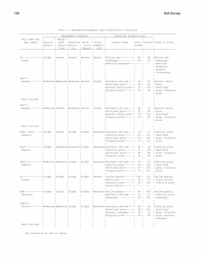
130 Soil Survey
Table 7.--Woodland Management and Productivity--Continued ________________________________________________________________________________________________________________ | Management concerns | Potential productivity | _______________________________________________________________________________ Soil name and | | Equip- | | | | | | | map symbol |Erosion | ment |Seedling| Wind- | Plant | Common trees |Site |Volume*|Trees to plant |hazard | limita-|mortal- | throw |competi-| |index| | | | tion | ity | hazard | tion | | | | ________________________________________________________________________________________________________________ | | | | | | | | | | | | | | | | | | Pu--------------|Slight |Severe |Severe |Severe |Severe |Willow oak----------| 85 | 86 |Willow oak, Purdy | | | | | |Sweetgum------------| 85 | 86 | sweetgum, | | | | | |American sycamore---| --- | --- | American | | | | | | | | | sycamore, | | | | | | | | | eastern | | | | | | | | | cottonwood. | | | | | | | | | RaD**: | | | | | | | | | Ramsey---------|Moderate|Moderate|Moderate|Severe |Slight |Northern red oak----| 60 | 43 |Eastern white | | | | | |Shortleaf pine------| 59 | 86 | pine, | | | | | |Eastern white pine--| 70 | 114 | shortleaf | | | | | |Virginia pine-------| 60 | 86 | pine, Virginia | | | | | | | | | pine. | | | | | | | | | Rock outcrop. | | | | | | | | | | | | | | | | | | RaF**: | | | | | | | | | Ramsey---------|Moderate|Severe |Moderate|Severe |Slight |Northern red oak----| 60 | 43 |Eastern white | | | | | |Shortleaf pine------| 59 | 86 | pine, | | | | | |Eastern white pine--| 70 | 114 | shortleaf | | | | | |Virginia pine-------| 60 | 86 | pine, Virginia | | | | | | | | | pine. | | | | | | | | | Rock outcrop. | | | | | | | | | | | | | | | | | | SeB2, SeC2------|Slight |Slight |Slight |Slight |Moderate|Northern red oak----| 70 | 57 |Loblolly pine, Sequoia | | | | | |Loblolly pine-------| 83 | 114 | shortleaf | | | | | |Shortleaf pine------| 63 | 100 | pine, Virginia | | | | | |Virginia pine-------| 71 | 114 | pine. | | | | | | | | | SeC3------------|Slight |Moderate|Moderate|Slight |Moderate|Northern red oak----| 60 | 43 |Loblolly pine, Sequoia | | | | | |Loblolly pine-------| 70 | 86 | shortleaf | | | | | |Shortleaf pine------| 60 | 86 | pine, Virginia | | | | | |Virginia pine-------| 60 | 86 | pine. | | | | | | | | | SeD2------------|Moderate|Moderate|Slight |Slight |Moderate|Northern red oak----| 70 | 57 |Loblolly pine, Sequoia | | | | | |Loblolly pine-------| 83 | 114 | shortleaf | | | | | |Shortleaf pine------| 63 | 100 | pine, Virginia | | | | | |Virginia pine-------| 71 | 114 | pine. | | | | | | | | | St--------------|Slight |Slight |Slight |Slight |Severe |Yellow poplar-------| 100 | 114 |Yellow poplar, Staser | | | | | |White oak-----------| 80 | 57 | black walnut, | | | | | |Loblolly pine-------| 90 | 129 | loblolly pine. | | | | | |Black walnut--------| --- | --- | | | | | | | | | | SwB-------------|Slight |Slight |Slight |Slight |Moderate|Yellow poplar-------| 95 | 100 |Yellow poplar, Swafford | | | | | |Northern red oak----| 75 | 57 | loblolly pine, | | | | | |Sweetgum------------| 90 | 100 | sweetgum. | | | | | | | | | TaE2**: | | | | | | | | | Talbott--------|Moderate|Moderate|Slight |Slight |Moderate|Southern red oak----| 65 | 43 |Loblolly pine, | | | | | |Shortleaf pine------| 64 | 100 | shortleaf | | | | | |Eastern redcedar----| 46 | 57 | pine, Virginia | | | | | |Virginia pine-------| 60 | 86 | pine, eastern | | | | | | | | | redcedar. | | | | | | | | | Rock outcrop. | | | | | | | | | | | | | | | | | |
See footnotes at end of table.

Jefferson County, Tennessee 131
Table 7.--Woodland Management and Productivity--Continued ________________________________________________________________________________________________________________ | Management concerns | Potential productivity | _______________________________________________________________________________ Soil name and | | Equip- | | | | | | | map symbol |Erosion | ment |Seedling| Wind- | Plant | Common trees |Site |Volume*|Trees to plant |hazard | limita-|mortal- | throw |competi-| |index| | | | tion | ity | hazard | tion | | | | ________________________________________________________________________________________________________________ | | | | | | | | | | | | | | | | | | TsB-------------|Slight |Slight |Slight |Slight |Moderate|Southern red oak----| 70 | 57 |Loblolly pine, Tasso | | | | | |Yellow poplar-------| 90 | 86 | shortleaf | | | | | |White oak-----------| 70 | 57 | pine, Virginia | | | | | |Shortleaf pine------| 70 | 114 | pine. | | | | | |Virginia pine-------| 70 | 114 | | | | | | | | | | WaC2------------|Slight |Slight |Slight |Slight |Moderate|Yellow poplar-------| 90 | 86 |Yellow poplar, Waynesboro | | | | | |Southern red oak----| 70 | 57 | shortleaf | | | | | |White oak-----------| 70 | 57 | pine, loblolly | | | | | |Loblolly pine-------| 80 | 114 | pine, black | | | | | | | | | walnut. | | | | | | | | | WaD2------------|Moderate|Moderate|Slight |Slight |Moderate|Yellow poplar-------| 90 | 86 |Yellow poplar, Waynesboro | | | | | |Southern red oak----| 70 | 57 | shortleaf | | | | | |White oak-----------| 70 | 57 | pine, loblolly | | | | | |Loblolly pine-------| 80 | 114 | pine, black | | | | | | | | | walnut. | | | | | | | | | Wb--------------|Slight |Slight |Slight |Slight |Severe |Yellow poplar-------| 95 | 100 |Eastern white Whitesburg | | | | | |Southern red oak----| 75 | 57 | pine, loblolly | | | | | |Sweetgum------------| 90 | 100 | pine, yellow | | | | | |Eastern white pine--| 90 | 172 | poplar, black | | | | | |Black locust--------| --- | --- | walnut, | | | | | | | | | sweetgum. | | | | | | | | | ________________________________________________________________________________________________________________
* Volume is the yield in cubic feet per acre per year calculated at the age of culmination of mean annual increment for fully stocked natural stands. ** See description of the map unit for composition and behavior characteristics of the map unit.

132 Soil Survey
Table 8.--Recreational Development
(Some terms that describe restrictive soil features are defined in the Glossary. See text for definitions of "slight," "moderate," and "severe." Absence of an entry indicates that the soil was not rated)
___________________________________________________________________________________________________________ | | | | | Soil name and | Camp areas | Picnic areas | Playgrounds |Paths and trails| Golf fairways map symbol | | | | | | | | | | ___________________________________________________________________________________________________________ | | | | | | | | | | AeC. | | | | | Arents | | | | | | | | | | AnC2------------------|Moderate: |Moderate: |Severe: |Slight----------|Moderate: Allen | slope. | slope. | slope. | | slope. | | | | | AnD2------------------|Severe: |Severe: |Severe: |Moderate: |Severe: Allen | slope. | slope. | slope. | slope. | slope. | | | | | AnE-------------------|Severe: |Severe: |Severe: |Severe: |Severe: Allen | slope. | slope. | slope. | slope. | slope. | | | | | ArD2------------------|Severe: |Severe: |Severe: |Moderate--------|Severe: Armuchee | slope. | slope. | slope, | | slope. | | | small stones. | | | | | | | ArE3, ArF2------------|Severe: |Severe: |Severe: |Severe: |Severe: Armuchee | slope. | slope. | slope, | slope. | slope. | | | small stones. | | | | | | | Be--------------------|Severe: |Moderate: |Severe: |Moderate: |Moderate: Beason | flooding, | wetness, | wetness. | wetness. | wetness, | wetness. | percs slowly. | | | flooding. | | | | | BoD-------------------|Severe: |Severe: |Severe: |Moderate: |Severe: Bouldin | slope. | slope. | slope, | large stones, | slope. | | | small stones. | slope. | | | | | | BoF-------------------|Severe: |Severe: |Severe: |Severe: |Severe: Bouldin | slope. | slope. | slope, | slope. | slope. | | | small stones. | | | | | | | CoB2------------------|Moderate: |Moderate: |Moderate: |Slight----------|Slight. Collegedale | percs slowly. | percs slowly. | slope, | | | | | small stones, | | | | | percs slowly. | | | | | | | CoC2------------------|Moderate: |Moderate: |Severe: |Slight----------|Moderate: Collegedale | slope, | slope, | slope. | | slope. | percs slowly. | percs slowly. | | | | | | | | CoC3------------------|Moderate: |Moderate: |Severe: |Slight----------|Moderate: Collegedale | slope, | slope, | slope. | | slope. | percs slowly. | percs slowly. | | | | | | | | CoD2------------------|Severe: |Severe: |Severe: |Moderate: |Severe: Collegedale | slope. | slope. | slope. | slope. | slope. | | | | | CtD2*: | | | | | Collegedale----------|Moderate: |Moderate: |Severe: |Slight----------|Moderate: | slope, | slope, | slope. | | slope. | percs slowly. | percs slowly. | | | | | | | | Talbott--------------|Moderate: |Moderate: |Severe: |Slight----------|Moderate: | slope, | slope, | slope. | | slope, | percs slowly. | percs slowly. | | | depth to rock. | | | | |
See footnote at end of table.

Jefferson County, Tennessee 133
Table 8.--Recreational Development--Continued ___________________________________________________________________________________________________________ | | | | | Soil name and | Camp areas | Picnic areas | Playgrounds |Paths and trails| Golf fairways map symbol | | | | | | | | | | ___________________________________________________________________________________________________________ | | | | | | | | | | CtD2*: | | | | | Rock outcrop. | | | | | | | | | | CtE2*: | | | | | Collegedale----------|Severe: |Severe: |Severe: |Severe: |Severe: | slope. | slope. | slope. | slope. | slope. | | | | | Talbott--------------|Severe: |Severe: |Severe: |Severe: |Severe: | slope. | slope. | slope. | slope. | slope. | | | | | Rock outcrop. | | | | | | | | | | DaC2------------------|Severe: |Severe: |Severe: |Slight----------|Severe: Dandridge | small stones, | depth to rock. | slope, | | small stones, | depth to rock. | | small stones, | | depth to rock. | | | depth to rock. | | | | | | | DaD2, DaD3------------|Severe: |Severe: |Severe: |Moderate: |Severe: Dandridge | slope, | slope, | slope, | slope. | small stones, | small stones, | depth to rock. | small stones, | | slope, | depth to rock. | | depth to rock. | | depth to rock. | | | | | DaE3, DaF2------------|Severe: |Severe: |Severe: |Severe: |Severe: Dandridge | slope, | slope, | slope, | slope. | small stones, | small stones, | depth to rock. | small stones, | | slope, | depth to rock. | | depth to rock. | | depth to rock. | | | | | DcB2------------------|Slight----------|Slight----------|Moderate: |Slight----------|Slight. Decatur | | | slope. | | | | | | | DeC2, DeC3------------|Moderate: |Moderate: |Severe: |Slight----------|Moderate: Dewey | slope. | slope. | slope. | | slope. | | | | | DeD2, DeD3------------|Severe: |Severe: |Severe: |Moderate: |Severe: Dewey | slope. | slope. | slope. | slope. | slope. | | | | | DfD2*: | | | | | Dewey----------------|Moderate: |Moderate: |Severe: |Slight----------|Moderate: | slope. | slope. | slope. | | slope. | | | | | Rock outcrop. | | | | | | | | | | Dm*. | | | | | Dumps | | | | | | | | | | DuB2------------------|Slight----------|Slight----------|Moderate: |Slight----------|Slight. Dunmore | | | slope, | | | | | small stones. | | | | | | | DuC2, DuC3------------|Moderate--------|Moderate--------|Severe: |Slight----------|Moderate: Dunmore | | | slope. | | slope. | | | | | DuD2, DuD3------------|Severe: |Severe: |Severe: |Moderate--------|Severe: Dunmore | slope. | slope. | slope. | | slope. | | | | | DuE2, DuE3------------|Severe: |Severe: |Severe: |Severe: |Severe: Dunmore | slope. | slope. | slope. | slope. | slope. | | | | |
See footnote at end of table.

134 Soil Survey
Table 8.--Recreational Development--Continued ___________________________________________________________________________________________________________ | | | | | Soil name and | Camp areas | Picnic areas | Playgrounds |Paths and trails| Golf fairways map symbol | | | | | | | | | | ___________________________________________________________________________________________________________ | | | | | | | | | | DwE3*, DxE2*: | | | | | Dunmore--------------|Severe: |Severe: |Severe: |Moderate--------|Severe: | slope. | slope. | slope. | | slope. | | | | | Fullerton------------|Severe: |Severe: |Severe: |Moderate: |Severe: | slope, | slope, | slope, | slope. | small stones, | small stones. | small stones. | small stones. | | slope. | | | | | Em--------------------|Severe: |Slight----------|Slight----------|Slight----------|Slight. Emory | flooding. | | | | | | | | | En--------------------|Severe: |Moderate: |Severe: |Moderate: |Severe: Ennis | flooding. | large stones, | large stones, | large stones. | large stones. | | small stones. | small stones. | | | | | | | EtB-------------------|Slight----------|Slight----------|Moderate: |Slight----------|Slight. Etowah | | | slope, | | | | | small stones. | | | | | | | EtC-------------------|Moderate: |Moderate: |Severe: |Slight----------|Moderate: Etowah | slope. | slope. | slope. | | slope. | | | | | EtD-------------------|Severe: |Severe: |Severe: |Moderate: |Severe: Etowah | slope. | slope. | slope. | slope. | slope. | | | | | FaE2------------------|Severe: |Severe: |Severe: |Moderate: |Severe: Farragut | slope. | slope. | slope. | slope. | slope. | | | | | FuC2------------------|Severe: |Severe: |Severe: |Slight----------|Severe: Fullerton | small stones. | small stones. | slope, | | small stones. | | | small stones. | | | | | | | FuD2------------------|Severe: |Severe: |Severe: |Moderate: |Severe: Fullerton | slope, | slope, | slope, | slope. | small stones, | small stones. | small stones. | small stones. | | slope. | | | | | FuE2------------------|Severe: |Severe: |Severe: |Severe: |Severe: Fullerton | slope, | slope, | slope, | slope. | small stones, | small stones. | small stones. | small stones. | | slope. | | | | | GpD2------------------|Severe: |Severe: |Severe: |Moderate: |Severe: Gilpin | slope. | slope. | small stones, | slope, | slope. | | | slope. | large stones. | | | | | | GpF-------------------|Severe: |Severe: |Severe: |Severe: |Severe: Gilpin | slope. | slope. | small stones, | slope. | slope. | | | slope. | | | | | | | GuE3*: | | | | | Gullied land. | | | | | | | | | | Dandridge------------|Severe: |Severe: |Severe: |Severe: |Severe: | slope, | slope, | slope, | slope. | small stones, | small stones, | depth to rock. | small stones, | | slope, | depth to rock. | | depth to rock. | | depth to rock. | | | | | Ln--------------------|Severe: |Moderate: |Moderate: |Moderate: |Moderate: Lindside | flooding. | wetness. | wetness, | wetness. | flooding. | | | flooding. | | | | | | |
See footnote at end of table.

Jefferson County, Tennessee 135
Table 8.--Recreational Development--Continued ___________________________________________________________________________________________________________ | | | | | Soil name and | Camp areas | Picnic areas | Playgrounds |Paths and trails| Golf fairways map symbol | | | | | | | | | | ___________________________________________________________________________________________________________ | | | | | | | | | | MnC-------------------|Moderate: |Moderate: |Severe: |Slight----------|Moderate: Minvale | slope, | slope, | slope, | | small stones, | small stones. | small stones. | small stones. | | slope. | | | | | MoC-------------------|Severe: |Severe: |Severe: |Slight----------|Severe: Montevallo | depth to rock. | depth to rock. | slope, | | droughty, | | | small stones, | | depth to rock. | | | depth to rock. | | | | | | | MoD-------------------|Severe: |Severe: |Severe: |Moderate: |Severe: Montevallo | slope, | slope, | slope, | slope. | droughty, | depth to rock. | depth to rock. | small stones, | | slope, | | | depth to rock. | | depth to rock. | | | | | MpE*: | | | | | Montevallo-----------|Severe: |Severe: |Severe: |Severe: |Severe: | slope, | slope, | slope, | slope. | droughty, | depth to rock. | depth to rock. | small stones, | | slope, | | | depth to rock. | | depth to rock. | | | | | Armuchee-------------|Severe: |Severe: |Severe: |Severe: |Severe: | slope. | slope. | slope, | slope. | slope. | | | small stones. | | | | | | | MuB-------------------|Moderate: |Moderate: |Severe: |Slight----------|Moderate: Muse | small stones, | small stones, | small stones. | | small stones. | percs slowly. | percs slowly. | | | | | | | | MuC-------------------|Moderate: |Moderate: |Severe: |Slight----------|Moderate: Muse | slope, | slope, | slope, | | small stones, | small stones, | small stones, | small stones. | | slope. | percs slowly. | percs slowly. | | | | | | | | MwE-------------------|Severe: |Severe: |Severe: |Severe: |Severe: Muskingum | slope. | slope. | slope. | slope. | slope. | | | | | Ne--------------------|Severe: |Severe: |Severe: |Severe: |Severe: Newark | flooding, | wetness. | wetness, | wetness. | wetness, | wetness. | | flooding. | | flooding. | | | | | NkB2------------------|Slight----------|Slight----------|Moderate: |Slight----------|Slight. Nolichucky | | | slope, | | | | | small stones. | | | | | | | NkC2------------------|Moderate: |Moderate: |Severe: |Slight----------|Moderate: Nolichucky | slope. | slope. | slope. | | slope. | | | | | NkD2------------------|Severe: |Severe: |Severe: |Moderate: |Severe: Nolichucky | slope. | slope. | slope. | slope. | slope. | | | | | NmD2------------------|Severe: |Severe: |Severe: |Moderate: |Severe: Nolichucky | slope. | slope. | slope, | slope. | slope. | | | small stones. | | | | | | | No--------------------|Severe: |Slight----------|Slight----------|Slight----------|Moderate: Nolin | flooding. | | | | flooding. | | | | | Pu--------------------|Severe: |Severe: |Severe: |Severe: |Severe: Purdy | wetness, | wetness, | wetness, | wetness. | wetness. | percs slowly. | percs slowly. | percs slowly. | | | | | | |
See footnote at end of table.

136 Soil Survey
Table 8.--Recreational Development--Continued ___________________________________________________________________________________________________________ | | | | | Soil name and | Camp areas | Picnic areas | Playgrounds |Paths and trails| Golf fairways map symbol | | | | | | | | | | ___________________________________________________________________________________________________________ | | | | | | | | | | RaD*: | | | | | Ramsey---------------|Severe: |Severe: |Severe: |Moderate: |Severe: | slope, | slope, | slope, | slope. | slope, | depth to rock. | depth to rock. | depth to rock. | | depth to rock. | | | | | Rock outcrop. | | | | | | | | | | RaF*: | | | | | Ramsey---------------|Severe: |Severe: |Severe: |Severe: |Severe: | slope, | slope, | slope, | slope. | slope, | depth to rock. | depth to rock. | depth to rock. | | depth to rock. | | | | | Rock outcrop. | | | | | | | | | | SeB2------------------|Moderate: |Moderate: |Moderate: |Slight----------|Moderate: Sequoia | percs slowly. | percs slowly. | slope, | | droughty. | | | depth to rock. | | | | | | | SeC2, SeC3------------|Moderate: |Moderate: |Severe: |Slight----------|Moderate: Sequoia | slope. | slope. | slope. | | droughty, | | | | | slope. | | | | | SeD2------------------|Severe: |Severe: |Severe: |Moderate: |Severe: Sequoia | slope. | slope. | slope. | slope. | slope. | | | | | St--------------------|Severe: |Slight----------|Slight----------|Slight----------|Slight. Staser | flooding. | | | | | | | | | SwB-------------------|Severe: |Moderate: |Moderate: |Slight----------|Slight. Swafford | flooding. | wetness, | slope, | | | | percs slowly. | small stones, | | | | | wetness. | | | | | | | TaE2*: | | | | | Talbott--------------|Severe: |Severe: |Severe: |Moderate: |Severe: | slope. | slope. | slope. | slope. | slope. | | | | | Rock outcrop. | | | | | | | | | | TsB-------------------|Moderate: |Moderate: |Moderate: |Slight----------|Slight. Tasso | percs slowly. | percs slowly. | slope, | | | | | small stones, | | | | | percs slowly. | | | | | | | WaC2------------------|Moderate: |Moderate: |Severe: |Slight----------|Moderate: Waynesboro | slope. | slope. | slope. | | slope. | | | | | WaD2------------------|Severe: |Severe: |Severe: |Moderate: |Severe: Waynesboro | slope. | slope. | slope. | slope. | slope. | | | | | Wb--------------------|Severe: |Moderate: |Moderate: |Slight----------|Moderate: Whitesburg | flooding. | wetness. | small stones, | | flooding. | | | flooding. | | | | | | | ___________________________________________________________________________________________________________
* See description of the map unit for composition and behavior characteristics of the map unit.

Jefferson County, Tennessee 137
Table 9.--Wildlife Habitat
(See text for definitions of "good," "fair," "poor," and "very poor." Absence of an entry indicates that the soil was not rated)
_____________________________________________________________________________________________________________ | Potential for habitat elements |Potential as habitat for-- _________________________________________________________________________________________ Soil name and | | | Wild | | | | | | | map symbol | Grain |Grasses | herba- |Hardwood| Conif- |Wetland |Shallow |Openland|Woodland|Wetland |and seed| and | ceous | trees | erous | plants | water |wildlife|wildlife|wildlife | crops |legumes | plants | | plants | | areas | | | _____________________________________________________________________________________________________________ | | | | | | | | | | | | | | | | | | | | AeC. | | | | | | | | | | Arents | | | | | | | | | | | | | | | | | | | | AnC2---------------|Fair |Good |Good |Good |Good |Very |Very |Good |Good |Very Allen | | | | | | poor. | poor. | | | poor. | | | | | | | | | | AnD2---------------|Poor |Fair |Good |Good |Good |Very |Very |Fair |Good |Very Allen | | | | | | poor. | poor. | | | poor. | | | | | | | | | | AnE----------------|Very |Fair |Good |Good |Good |Very |Very |Fair |Good |Very Allen | poor. | | | | | poor. | poor. | | | poor. | | | | | | | | | | ArD2---------------|Poor |Fair |Good |Fair |Fair |Very |Very |Fair |Fair |Very Armuchee | | | | | | poor. | poor. | | | poor. | | | | | | | | | | ArE3, ArF2---------|Very |Poor |Good |Fair |Fair |Very |Very |Poor |Fair |Very Armuchee | poor. | | | | | poor. | poor. | | | poor. | | | | | | | | | | Be-----------------|Poor |Fair |Fair |Good |Good |Fair |Fair |Fair |Good |Fair. Beason | | | | | | | | | | | | | | | | | | | | BoD, BoF-----------|Very |Very |Fair |Good |Good |Very |Very |Poor |Fair |Very Bouldin | poor. | poor. | | | | poor. | poor. | | | poor. | | | | | | | | | | CoB2---------------|Good |Good |Good |Good |Good |Poor |Very |Good |Good |Very Collegedale | | | | | | | poor. | | | poor. | | | | | | | | | | CoC2---------------|Fair |Good |Good |Good |Good |Very |Very |Good |Good |Very Collegedale | | | | | | poor. | poor. | | | poor. | | | | | | | | | | CoC3---------------|Fair |Fair |Fair |Good |Good |Very |Very |Fair |Good |Very Collegedale | | | | | | poor. | poor. | | | poor. | | | | | | | | | | CoD2---------------|Poor |Fair |Good |Good |Good |Very |Very |Fair |Good |Very Collegedale | | | | | | poor. | poor. | | | poor. | | | | | | | | | | CtD2*: | | | | | | | | | | Collegedale-------|Fair |Good |Good |Good |Good |Very |Very |Good |Good |Very | | | | | | poor. | poor. | | | poor. | | | | | | | | | | Talbott-----------|Fair |Good |Good |Good |Good |Very |Very |Good |Good |Very | | | | | | poor. | poor. | | | poor. | | | | | | | | | | Rock outcrop. | | | | | | | | | | | | | | | | | | | | CtE2*: | | | | | | | | | | Collegedale-------|Very |Fair |Good |Good |Good |Very |Very |Fair |Good |Very | poor. | | | | | poor. | poor. | | | poor. | | | | | | | | | | Talbott-----------|Poor |Fair |Good |Good |Good |Very |Very |Fair |Good |Very | | | | | | poor. | poor. | | | poor. | | | | | | | | | | Rock outcrop. | | | | | | | | | | | | | | | | | | | |
See footnote at end of table.

138 Soil Survey
Table 9.--Wildlife Habitat--Continued _____________________________________________________________________________________________________________ | Potential for habitat elements |Potential as habitat for-- _________________________________________________________________________________________ Soil name and | | | Wild | | | | | | | map symbol | Grain |Grasses | herba- |Hardwood| Conif- |Wetland |Shallow |Openland|Woodland|Wetland |and seed| and | ceous | trees | erous | plants | water |wildlife|wildlife|wildlife | crops |legumes | plants | | plants | | areas | | | _____________________________________________________________________________________________________________ | | | | | | | | | | | | | | | | | | | | DaC2---------------|Very |Poor |Poor |Very |Very |Very |Very |Very |Poor |Very Dandridge | poor. | | | poor. | poor. | poor. | poor. | poor. | | poor. | | | | | | | | | | DaD2, DaD3---------|Very |Poor |Poor |Very |Very |Very |Very |Very |Poor |Very Dandridge | poor. | | | poor. | poor. | poor. | poor. | poor. | | poor. | | | | | | | | | | DaE3, DaF2---------|Very |Very |Poor |Very |Very |Very |Very |Very |Poor |Very Dandridge | poor. | poor. | | poor. | poor. | poor. | poor. | poor. | | poor. | | | | | | | | | | DcB2---------------|Good |Good |Good |Good |Good |Very |Very |Good |Good |Very Decatur | | | | | | poor. | poor. | | | poor. | | | | | | | | | | DeC2---------------|Fair |Good |Good |Good |Good |Very |Very |Good |Good |Very Dewey | | | | | | poor. | poor. | | | poor. | | | | | | | | | | DeC3---------------|Very |Very |Fair |Good |Good |Very |Very |Poor |Poor |Very Dewey | poor. | poor. | | | | poor. | poor. | | | poor. | | | | | | | | | | DeD2---------------|Poor |Fair |Good |Good |Good |Very |Very |Fair |Good |Very Dewey | | | | | | poor. | poor. | | | poor. | | | | | | | | | | DeD3---------------|Very |Very |Fair |Good |Good |Very |Very |Poor |Poor |Very Dewey | poor. | poor. | | | | poor. | poor. | | | poor. | | | | | | | | | | DfD2*: | | | | | | | | | | Dewey-------------|Very |Very |Fair |Good |Good |Very |Very |Poor |Poor |Very | poor. | poor. | | | | poor. | poor. | | | poor. | | | | | | | | | | Rock outcrop. | | | | | | | | | | | | | | | | | | | | Dm*. | | | | | | | | | | Dumps | | | | | | | | | | | | | | | | | | | | DuB2---------------|Good |Good |Good |Good |Good |Poor |Very |Good |Good |Very Dunmore | | | | | | | poor. | | | poor. | | | | | | | | | | DuC2---------------|Fair |Good |Good |Good |Good |Very |Very |Good |Good |Very Dunmore | | | | | | poor. | poor. | | | poor. | | | | | | | | | | DuC3---------------|Very |Very |Good |Good |Good |Very |Very |Poor |Fair |Very Dunmore | poor. | poor. | | | | poor. | poor. | | | poor. | | | | | | | | | | DuD2---------------|Poor |Fair |Good |Good |Good |Very |Very |Fair |Good |Very Dunmore | | | | | | poor. | poor. | | | poor. | | | | | | | | | | DuD3---------------|Very |Very |Good |Good |Good |Very |Very |Poor |Fair |Very Dunmore | poor. | poor. | | | | poor. | poor. | | | poor. | | | | | | | | | | DuE2---------------|Very |Fair |Good |Good |Good |Very |Very |Fair |Good |Very Dunmore | poor. | | | | | poor. | poor. | | | poor. | | | | | | | | | | DuE3---------------|Very |Very |Good |Good |Good |Very |Very |Poor |Fair |Very Dunmore | poor. | poor. | | | | poor. | poor. | | | poor. | | | | | | | | | | DwE3*: | | | | | | | | | | Dunmore-----------|Very |Very |Good |Good |Good |Very |Very |Poor |Fair |Very | poor. | poor. | | | | poor. | poor. | | | poor. | | | | | | | | | | Fullerton---------|Very |Fair |Good |Good |Good |Very |Very |Fair |Good |Very | poor. | | | | | poor. | poor. | | | poor. | | | | | | | | | |
See footnote at end of table.

Jefferson County, Tennessee 139
Table 9.--Wildlife Habitat--Continued _____________________________________________________________________________________________________________ | Potential for habitat elements |Potential as habitat for-- _________________________________________________________________________________________ Soil name and | | | Wild | | | | | | | map symbol | Grain |Grasses | herba- |Hardwood| Conif- |Wetland |Shallow |Openland|Woodland|Wetland |and seed| and | ceous | trees | erous | plants | water |wildlife|wildlife|wildlife | crops |legumes | plants | | plants | | areas | | | _____________________________________________________________________________________________________________ | | | | | | | | | | | | | | | | | | | | DxE2*: | | | | | | | | | | Dunmore-----------|Poor |Fair |Good |Good |Good |Very |Very |Fair |Good |Very | | | | | | poor. | poor. | | | poor. | | | | | | | | | | Fullerton---------|Very |Fair |Good |Good |Good |Very |Very |Fair |Good |Very | poor. | | | | | poor. | poor. | | | poor. | | | | | | | | | | Em-----------------|Good |Good |Good |Good |Good |Poor |Very |Good |Good |Very Emory | | | | | | | poor. | | | poor. | | | | | | | | | | En-----------------|Good |Good |Good |Good |Good |Poor |Very |Good |Good |Poor. Ennis | | | | | | | poor. | | | | | | | | | | | | | EtB----------------|Good |Good |Good |Good |Good |Poor |Very |Good |Good |Very Etowah | | | | | | | poor. | | | poor. | | | | | | | | | | EtC----------------|Fair |Good |Good |Good |Good |Very |Very |Good |Good |Very Etowah | | | | | | poor. | poor. | | | poor. | | | | | | | | | | EtD----------------|Poor |Fair |Good |Good |Good |Very |Very |Fair |Good |Very Etowah | | | | | | poor. | poor. | | | poor. | | | | | | | | | | FaE2---------------|Poor |Fair |Good |Good |Good |Very |Very |Fair |Good |Very Farragut | | | | | | poor. | poor. | | | poor. | | | | | | | | | | FuC2---------------|Fair |Good |Good |Good |Good |Very |Very |Good |Good |Very Fullerton | | | | | | poor. | poor. | | | poor. | | | | | | | | | | FuD2---------------|Poor |Fair |Good |Good |Good |Very |Very |Fair |Good |Very Fullerton | | | | | | poor. | poor. | | | poor. | | | | | | | | | | FuE2---------------|Very |Poor |Good |Good |Good |Very |Very |Poor |Good |Very Fullerton | poor. | | | | | poor. | poor. | | | poor. | | | | | | | | | | GpD2---------------|Poor |Fair |Good |Fair |Fair |Very |Very |Fair |Fair |Very Gilpin | | | | | | poor. | poor. | | | poor. | | | | | | | | | | GpF----------------|Very |Poor |Good |Fair |Fair |Very |Very |Poor |Fair |Very Gilpin | poor. | | | | | poor. | poor. | | | poor. | | | | | | | | | | GuE3*: | | | | | | | | | | Gullied land. | | | | | | | | | | | | | | | | | | | | Dandridge---------|Very |Very |Poor |Very |Very |Very |Very |Very |Poor |Very | poor. | poor. | | poor. | poor. | poor. | poor. | poor. | | poor. | | | | | | | | | | Ln-----------------|Good |Good |Good |Good |Good |Poor |Poor |Good |Good |Poor. Lindside | | | | | | | | | | | | | | | | | | | | MnC----------------|Fair |Good |Good |Good |Good |Very |Very |Good |Good |Very Minvale | | | | | | poor. | poor. | | | poor. | | | | | | | | | | MoC, MoD-----------|Poor |Poor |Fair |Fair |Fair |Very |Very |Poor |Fair |Very Montevallo | | | | | | poor. | poor. | | | poor. | | | | | | | | | | MpE*: | | | | | | | | | | Montevallo--------|Very |Poor |Fair |Fair |Fair |Very |Very |Poor |Fair |Very | poor. | | | | | poor. | poor. | | | poor. | | | | | | | | | |
See footnote at end of table.

140 Soil Survey
Table 9.--Wildlife Habitat--Continued _____________________________________________________________________________________________________________ | Potential for habitat elements |Potential as habitat for-- _________________________________________________________________________________________ Soil name and | | | Wild | | | | | | | map symbol | Grain |Grasses | herba- |Hardwood| Conif- |Wetland |Shallow |Openland|Woodland|Wetland |and seed| and | ceous | trees | erous | plants | water |wildlife|wildlife|wildlife | crops |legumes | plants | | plants | | areas | | | _____________________________________________________________________________________________________________ | | | | | | | | | | | | | | | | | | | | MpE*: | | | | | | | | | | Armuchee----------|Very |Poor |Good |Fair |Fair |Very |Very |Poor |Fair |Very | poor. | | | | | poor. | poor. | | | poor. | | | | | | | | | | MuB----------------|Fair |Good |Good |Good |Good |Poor |Very |Good |Good |Very Muse | | | | | | | poor. | | | poor. | | | | | | | | | | MuC----------------|Fair |Good |Good |Good |Good |Very |Very |Good |Good |Very Muse | | | | | | poor. | poor. | | | poor. | | | | | | | | | | MwE----------------|Very |Poor |Good |Fair |Fair |Very |Very |Poor |Fair |Very Muskingum | poor. | | | | | poor. | poor. | | | poor. | | | | | | | | | | Ne-----------------|Poor |Fair |Fair |Good |Good |Fair |Fair |Fair |Good |Fair. Newark | | | | | | | | | | | | | | | | | | | | NkB2---------------|Good |Good |Good |Good |Good |Poor |Very |Good |Good |Very Nolichucky | | | | | | | poor. | | | poor. | | | | | | | | | | NkC2---------------|Fair |Good |Good |Good |Good |Very |Very |Good |Good |Very Nolichucky | | | | | | poor. | poor. | | | poor. | | | | | | | | | | NkD2, NmD2---------|Poor |Fair |Good |Good |Good |Very |Very |Fair |Good |Very Nolichucky | | | | | | poor. | poor. | | | poor. | | | | | | | | | | No-----------------|Good |Good |Good |Good |Good |Poor |Very |Good |Good |Very Nolin | | | | | | | poor. | | | poor. | | | | | | | | | | Pu-----------------|Poor |Fair |Fair |Fair |Fair |Good |Good |Fair |Fair |Good. Purdy | | | | | | | | | | | | | | | | | | | | RaD*, RaF*: | | | | | | | | | | Ramsey------------|Very |Poor |Poor |Very |Very |Very |Very |Very |Poor |Very | poor. | | | poor. | poor. | poor. | poor. | poor. | | poor. | | | | | | | | | | Rock outcrop. | | | | | | | | | | | | | | | | | | | | SeB2---------------|Good |Good |Good |Good |Good |Poor |Very |Good |Good |Very Sequoia | | | | | | | poor. | | | poor. | | | | | | | | | | SeC2, SeC3---------|Fair |Good |Good |Good |Good |Very |Very |Good |Good |Very Sequoia | | | | | | poor. | poor. | | | poor. | | | | | | | | | | SeD2---------------|Poor |Fair |Good |Good |Good |Very |Very |Fair |Good |Very Sequoia | | | | | | poor. | poor. | | | poor. | | | | | | | | | | St-----------------|Good |Good |Good |Good |Good |Poor |Very |Good |Good |Very Staser | | | | | | | poor. | | | poor. | | | | | | | | | | SwB----------------|Good |Good |Good |Good |Good |Poor |Poor |Good |Good |Poor. Swafford | | | | | | | | | | | | | | | | | | | | TaE2*: | | | | | | | | | | Talbott-----------|Poor |Fair |Good |Good |Good |Very |Very |Fair |Good |Very | | | | | | poor. | poor. | | | poor. | | | | | | | | | | Rock outcrop. | | | | | | | | | | | | | | | | | | | | TsB----------------|Good |Good |Good |Good |Good |Very |Very |Good |Good |Very Tasso | | | | | | poor. | poor. | | | poor. | | | | | | | | | |
See footnote at end of table.

Jefferson County, Tennessee 141
Table 9.--Wildlife Habitat--Continued _____________________________________________________________________________________________________________ | Potential for habitat elements |Potential as habitat for-- _________________________________________________________________________________________ Soil name and | | | Wild | | | | | | | map symbol | Grain |Grasses | herba- |Hardwood| Conif- |Wetland |Shallow |Openland|Woodland|Wetland |and seed| and | ceous | trees | erous | plants | water |wildlife|wildlife|wildlife | crops |legumes | plants | | plants | | areas | | | _____________________________________________________________________________________________________________ | | | | | | | | | | | | | | | | | | | | WaC2---------------|Fair |Good |Good |Good |Good |Very |Very |Good |Good |Very Waynesboro | | | | | | poor. | poor. | | | poor. | | | | | | | | | | WaD2---------------|Fair |Good |Good |Good |Good |Very |Very |Good |Good |Very Waynesboro | | | | | | poor. | poor. | | | poor. | | | | | | | | | | Wb-----------------|Good |Good |Good |Good |Good |Poor |Poor |Good |Good |Poor. Whitesburg | | | | | | | | | | | | | | | | | | | | _____________________________________________________________________________________________________________
* See description of the map unit for composition and behavior characteristics of the map unit.

142 Soil Survey
Table 10.--Building Site Development
(Some terms that describe restrictive soil features are defined in the Glossary. See text for definitions of "slight," "moderate," and "severe." Absence of an entry indicates that the soil was not rated. The information in this table indicates the dominant soil condition but does not eliminate the need for onsite investigation)
_________________________________________________________________________________________________________________ | | | | | | Soil name and | Shallow | Dwellings | Dwellings | Small | Local roads | Lawns and map symbol | excavations | without | with | commercial | and streets | landscaping | | basements | basements | buildings | | _________________________________________________________________________________________________________________ | | | | | | | | | | | | AeC. | | | | | | Arents | | | | | | | | | | | | AnC2-------------|Moderate: |Moderate: |Moderate: |Severe: |Moderate: |Moderate: Allen | too clayey, | slope. | slope. | slope. | low strength, | slope. | slope. | | | | slope. | | | | | | | AnD2, AnE--------|Severe: |Severe: |Severe: |Severe: |Severe: |Severe: Allen | slope. | slope. | slope. | slope. | slope. | slope. | | | | | | ArD2, ArE3, ArF2-|Severe: |Severe: |Severe: |Severe: |Severe: |Severe: Armuchee | slope. | slope. | slope. | slope. | low strength, | slope. | | | | | slope. | | | | | | | Be---------------|Severe: |Severe: |Severe: |Severe: |Severe: |Moderate: Beason | wetness. | flooding, | flooding, | flooding, | low strength, | wetness, | | wetness. | wetness. | wetness. | flooding. | flooding. | | | | | | BoD, BoF---------|Severe: |Severe: |Severe: |Severe: |Severe: |Severe: Bouldin | slope, | slope, | slope, | slope, | slope, | slope. | slippage. | slippage. | slippage. | slippage. | slippage. | | | | | | | CoB2-------------|Moderate: |Moderate: |Moderate: |Moderate: |Severe: |Slight. Collegedale | too clayey. | shrink-swell. | shrink-swell. | shrink-swell. | low strength. | | | | | | | CoC2, CoC3-------|Moderate: |Moderate: |Moderate: |Severe: |Severe: |Moderate: Collegedale | too clayey, | shrink-swell, | slope, | slope. | low strength. | slope. | slope. | slope. | shrink-swell. | | | | | | | | | CoD2-------------|Severe: |Severe: |Severe: |Severe: |Severe: |Severe: Collegedale | slope. | slope. | slope. | slope. | low strength, | slope. | | | | | slope. | | | | | | | CtD2*: | | | | | | Collegedale-----|Moderate: |Moderate: |Moderate: |Severe: |Severe: |Moderate: | too clayey, | shrink-swell, | slope, | slope. | low strength. | slope. | slope. | slope. | shrink-swell. | | | | | | | | | Talbott---------|Severe: |Moderate: |Severe: |Severe: |Severe: |Moderate: | depth to rock.| shrink-swell, | depth to rock.| slope. | low strength. | slope, | | slope, | | | | depth to rock. | | depth to rock.| | | | | | | | | | Rock outcrop. | | | | | | | | | | | | CtE2*: | | | | | | Collegedale-----|Severe: |Severe: |Severe: |Severe: |Severe: |Severe: | slope. | slope. | slope. | slope. | low strength, | slope. | | | | | slope. | | | | | | |
See footnote at end of table.

Jefferson County, Tennessee 143
Table 10.--Building Site Development--Continued__________________________________________________________________________________________________________________ | | | | | | Soil name and | Shallow | Dwellings | Dwellings | Small | Local roads | Lawns and map symbol | excavations | without | with | commercial | and streets | landscaping | | basements | basements | buildings | |__________________________________________________________________________________________________________________ | | | | | | | | | | | | CtE2*: | | | | | | Talbott---------|Severe: |Severe: |Severe: |Severe: |Severe: |Severe: | depth to rock,| slope. | depth to rock,| slope. | low strength, | slope. | slope. | | slope. | | slope. | | | | | | | Rock outcrop. | | | | | | | | | | | | DaC2-------------|Severe: |Moderate: |Severe: |Severe: |Moderate: |Severe: Dandridge | depth to rock.| shrink-swell, | depth to rock.| slope. | depth to rock,| small stones, | | slope, | | | slope, | depth to rock. | | depth to rock.| | | shrink-swell. | | | | | | | DaD2, DaD3, DaE3,| | | | | | DaF2------------|Severe: |Severe: |Severe: |Severe: |Severe: |Severe: Dandridge | depth to rock,| slope. | depth to rock,| slope. | slope. | small stones, | slope. | | slope. | | | slope, | | | | | | depth to rock. | | | | | | DcB2-------------|Moderate: |Moderate: |Moderate: |Moderate: |Moderate: |Slight. Decatur | too clayey. | shrink-swell. | shrink-swell. | shrink-swell. | low strength. | | | | | | | DeC2, DeC3-------|Moderate: |Moderate: |Moderate: |Severe: |Severe: |Moderate: Dewey | too clayey, | shrink-swell, | slope, | slope. | low strength. | slope. | slope. | slope. | shrink-swell. | | | | | | | | | DeD2, DeD3-------|Severe: |Severe: |Severe: |Severe: |Severe: |Severe: Dewey | slope. | slope. | slope. | slope. | low strength, | slope. | | | | | slope. | | | | | | | DfD2*: | | | | | | Dewey-----------|Moderate: |Moderate: |Moderate: |Severe: |Severe: |Moderate: | too clayey, | shrink-swell, | slope, | slope. | low strength. | slope. | slope. | slope. | shrink-swell. | | | | | | | | | Rock outcrop. | | | | | | | | | | | | Dm*. | | | | | | Dumps | | | | | | | | | | | | DuB2-------------|Moderate: |Moderate: |Moderate: |Moderate: |Moderate: |Slight. Dunmore | too clayey. | shrink-swell. | shrink-swell. | shrink-swell. | shrink-swell, | | | | | | low strength. | | | | | | | DuC2, DuC3-------|Moderate: |Moderate: |Moderate: |Severe: |Moderate: |Moderate: Dunmore | too clayey, | shrink-swell, | slope, | slope. | shrink-swell, | slope. | slope. | slope. | shrink-swell. | | low strength, | | | | | | slope. | | | | | | | DuD2, DuD3, DuE2,| | | | | | DuE3------------|Severe: |Severe: |Severe: |Severe: |Severe: |Severe: Dunmore | slope. | slope. | slope. | slope. | slope. | slope. | | | | | | DwE3*, DxE2*: | | | | | | Dunmore---------|Severe: |Severe: |Severe: |Severe: |Severe: |Severe: | slope. | slope. | slope. | slope. | slope. | slope. | | | | | | Fullerton-------|Severe: |Severe: |Severe: |Severe: |Severe: |Severe: | slope. | slope. | slope. | slope. | slope. | small stones, | | | | | | slope. | | | | | |
See footnote at end of table.

144 Soil Survey
Table 10.--Building Site Development--Continued _________________________________________________________________________________________________________________ | | | | | | Soil name and | Shallow | Dwellings | Dwellings | Small | Local roads | Lawns and map symbol | excavations | without | with | commercial | and streets | landscaping | | basements | basements | buildings | | _________________________________________________________________________________________________________________ | | | | | | | | | | | | Em---------------|Slight---------|Severe: |Severe: |Severe: |Severe: |Slight. Emory | | flooding. | flooding. | flooding. | low strength. | | | | | | | En---------------|Moderate: |Severe: |Severe: |Severe: |Severe: |Severe: Ennis | large stones, | flooding. | flooding. | flooding. | flooding. | large stones. | flooding. | | | | | | | | | | | EtB--------------|Moderate: |Slight---------|Slight---------|Slight---------|Moderate: |Slight. Etowah | too clayey. | | | | low strength. | | | | | | | EtC--------------|Moderate: |Moderate: |Moderate: |Severe: |Moderate: |Moderate: Etowah | too clayey, | slope. | slope. | slope. | low strength, | slope. | slope. | | | | slope. | | | | | | | EtD--------------|Severe: |Severe: |Severe: |Severe: |Severe: |Severe: Etowah | slope. | slope. | slope. | slope. | slope. | slope. | | | | | | FaE2-------------|Severe: |Severe: |Severe: |Severe: |Severe: |Severe: Farragut | slope. | slope. | slope. | slope. | low strength, | slope. | | | | | slope. | | | | | | | FuC2-------------|Moderate: |Moderate: |Moderate: |Severe: |Moderate: |Severe: Fullerton | too clayey, | shrink-swell, | slope, | slope. | shrink-swell, | small stones. | slope. | slope. | shrink-swell. | | low strength, | | | | | | slope. | | | | | | | FuD2, FuE2-------|Severe: |Severe: |Severe: |Severe: |Severe: |Severe: Fullerton | slope. | slope. | slope. | slope. | slope. | small stones, | | | | | | slope. | | | | | | GpD2, GpF--------|Severe: |Severe: |Severe: |Severe: |Severe: |Severe: Gilpin | slope. | slope. | slope. | slope. | slope. | slope. | | | | | | GuE3*: | | | | | | Gullied land. | | | | | | | | | | | | Dandridge-------|Severe: |Severe: |Severe: |Severe: |Severe: |Severe: | depth to rock,| slope. | depth to rock,| slope. | slope. | small stones, | slope. | | slope. | | | slope, | | | | | | depth to rock. | | | | | | Ln---------------|Severe: |Severe: |Severe: |Severe: |Severe: |Moderate: Lindside | wetness. | flooding. | flooding, | flooding. | flooding. | flooding. | | | wetness. | | | | | | | | | MnC--------------|Moderate: |Moderate: |Moderate: |Severe: |Moderate: |Moderate: Minvale | slope. | slope. | slope. | slope. | low strength, | small stones, | | | | | slope. | slope. | | | | | | MoC--------------|Severe: |Moderate: |Severe: |Moderate: |Moderate: |Severe: Montevallo | depth to rock.| depth to rock.| depth to rock.| slope, | depth to rock.| droughty, | | | | depth to rock.| | depth to rock. | | | | | | MoD--------------|Severe: |Severe: |Severe: |Severe: |Severe: |Severe: Montevallo | depth to rock,| slope. | depth to rock,| slope. | slope. | droughty, | slope. | | slope. | | | slope, | | | | | | depth to rock. | | | | | |
See footnote at end of table.

Jefferson County, Tennessee 145
Table 10.--Building Site Development--Continued _________________________________________________________________________________________________________________ | | | | | | Soil name and | Shallow | Dwellings | Dwellings | Small | Local roads | Lawns and map symbol | excavations | without | with | commercial | and streets | landscaping | | basements | basements | buildings | | _________________________________________________________________________________________________________________ | | | | | | | | | | | | MpE*: | | | | | | Montevallo------|Severe: |Severe: |Severe: |Severe: |Severe: |Severe: | depth to rock,| slope. | depth to rock,| slope. | slope. | droughty, | slope. | | slope. | | | slope, | | | | | | depth to rock. | | | | | | Armuchee--------|Severe: |Severe: |Severe: |Severe: |Severe: |Severe: | slope. | slope. | slope. | slope. | low strength, | slope. | | | | | slope. | | | | | | | MuB--------------|Moderate: |Moderate: |Moderate: |Moderate: |Severe: |Moderate: Muse | too clayey, | shrink-swell. | wetness, | shrink-swell. | low strength. | small stones. | wetness. | | shrink-swell. | | | | | | | | | MuC--------------|Moderate: |Moderate: |Moderate: |Severe: |Severe: |Moderate: Muse | too clayey, | shrink-swell, | wetness, | slope. | low strength. | small stones, | wetness, | slope. | slope, | | | slope. | slope. | | shrink-swell. | | | | | | | | | MwE--------------|Severe: |Severe: |Severe: |Severe: |Severe: |Severe: Muskingum | slope. | slope. | slope. | slope. | slope. | slope. | | | | | | Ne---------------|Severe: |Severe: |Severe: |Severe: |Severe: |Severe: Newark | wetness. | flooding, | flooding, | flooding, | low strength, | wetness, | | wetness. | wetness. | wetness. | wetness, | flooding. | | | | | flooding. | | | | | | | NkB2-------------|Slight---------|Slight---------|Slight---------|Slight---------|Moderate: |Slight. Nolichucky | | | | | low strength. | | | | | | | NkC2-------------|Moderate: |Moderate: |Moderate: |Severe: |Moderate: |Moderate: Nolichucky | slope. | slope. | slope. | slope. | low strength, | slope. | | | | | slope. | | | | | | | NkD2, NmD2-------|Severe: |Severe: |Severe: |Severe: |Severe: |Severe: Nolichucky | slope. | slope. | slope. | slope. | slope. | slope. | | | | | | No---------------|Moderate: |Severe: |Severe: |Severe: |Severe: |Moderate: Nolin | wetness, | flooding. | flooding. | flooding. | low strength, | flooding. | flooding. | | | | flooding. | | | | | | | Pu---------------|Severe: |Severe: |Severe: |Severe: |Severe: |Severe: Purdy | wetness. | wetness. | wetness. | wetness. | wetness, | wetness. | | | | | low strength, | | | | | | frost action. | | | | | | | RaD*, RaF*: | | | | | | Ramsey----------|Severe: |Severe: |Severe: |Severe: |Severe: |Severe: | depth to rock,| slope, | depth to rock,| slope, | depth to rock,| slope, | slope. | depth to rock.| slope. | depth to rock.| slope. | depth to rock. | | | | | | Rock outcrop. | | | | | | | | | | | | SeB2-------------|Moderate: |Moderate: |Moderate: |Moderate: |Severe: |Moderate: Sequoia | depth to rock,| shrink-swell. | depth to rock,| shrink-swell. | low strength. | droughty. | too clayey. | | shrink-swell. | | | | | | | | | SeC2, SeC3-------|Moderate: |Moderate: |Moderate: |Severe: |Severe: |Moderate: Sequoia | depth to rock,| shrink-swell, | depth to rock,| slope. | low strength. | droughty, | too clayey, | slope. | slope, | | | slope. | slope. | | shrink-swell. | | | | | | | | |
See footnote at end of table.

146 Soil Survey
Table 10.--Building Site Development--Continued _________________________________________________________________________________________________________________ | | | | | | Soil name and | Shallow | Dwellings | Dwellings | Small | Local roads | Lawns and map symbol | excavations | without | with | commercial | and streets | landscaping | | basements | basements | buildings | | _________________________________________________________________________________________________________________ | | | | | | | | | | | | SeD2-------------|Severe: |Severe: |Severe: |Severe: |Severe: |Severe: Sequoia | slope. | slope. | slope. | slope. | low strength, | slope. | | | | | slope. | | | | | | | St---------------|Moderate: |Severe: |Severe: |Severe: |Moderate: |Slight. Staser | wetness. | flooding. | flooding. | flooding. | flooding. | | | | | | | SwB--------------|Severe: |Severe: |Severe: |Severe: |Moderate: |Slight. Swafford | wetness. | flooding. | flooding, | flooding. | low strength, | | | | wetness. | | wetness, | | | | | | flooding. | | | | | | | TaE2*: | | | | | | Talbott---------|Severe: |Severe: |Severe: |Severe: |Severe: |Severe: | depth to rock,| slope. | depth to rock,| slope. | low strength, | slope. | slope. | | slope. | | slope. | | | | | | | Rock outcrop. | | | | | | | | | | | | TsB--------------|Moderate: |Slight---------|Moderate: |Slight---------|Moderate: |Slight. Tasso | too clayey. | | shrink-swell. | | low strength. | | | | | | | WaC2-------------|Moderate: |Moderate: |Moderate: |Severe: |Moderate: |Moderate: Waynesboro | too clayey, | slope. | slope. | slope. | low strength, | slope. | slope. | | | | slope. | | | | | | | WaD2-------------|Severe: |Severe: |Severe: |Severe: |Severe: |Severe: Waynesboro | slope. | slope. | slope. | slope. | slope. | slope. | | | | | | Wb---------------|Severe: |Severe: |Severe: |Severe: |Severe: |Moderate: Whitesburg | wetness. | flooding. | flooding, | flooding. | low strength, | flooding. | | | wetness. | | flooding. | | | | | | | _________________________________________________________________________________________________________________
* See description of the map unit for composition and behavior characteristics of the map unit.
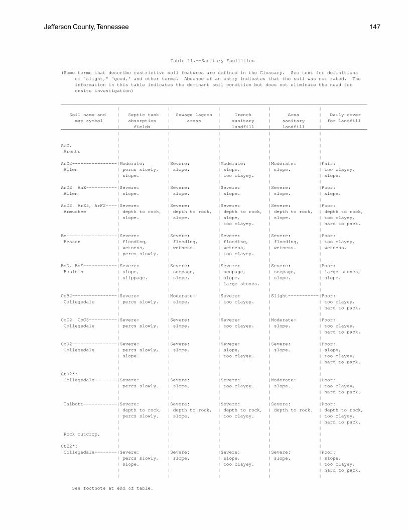
Jefferson County, Tennessee 147
Table 11.--Sanitary Facilities
(Some terms that describe restrictive soil features are defined in the Glossary. See text for definitions of "slight," "good," and other terms. Absence of an entry indicates that the soil was not rated. The information in this table indicates the dominant soil condition but does not eliminate the need for onsite investigation)
_______________________________________________________________________________________________________________ | | | | | Soil name and | Septic tank | Sewage lagoon | Trench | Area | Daily cover map symbol | absorption | areas | sanitary | sanitary | for landfill | fields | | landfill | landfill | ______________________________________________________________________________________________________________ | | | | | | | | | | AeC. | | | | | Arents | | | | | | | | | | AnC2----------------|Moderate: |Severe: |Moderate: |Moderate: |Fair: Allen | percs slowly, | slope. | slope, | slope. | too clayey, | slope. | | too clayey. | | slope. | | | | | AnD2, AnE-----------|Severe: |Severe: |Severe: |Severe: |Poor: Allen | slope. | slope. | slope. | slope. | slope. | | | | | ArD2, ArE3, ArF2----|Severe: |Severe: |Severe: |Severe: |Poor: Armuchee | depth to rock, | depth to rock, | depth to rock, | depth to rock, | depth to rock, | slope. | slope. | slope, | slope. | too clayey, | | | too clayey. | | hard to pack. | | | | | Be------------------|Severe: |Severe: |Severe: |Severe: |Poor: Beason | flooding, | flooding, | flooding, | flooding, | too clayey, | wetness, | wetness. | wetness, | wetness. | wetness. | percs slowly. | | too clayey. | | | | | | | BoD, BoF------------|Severe: |Severe: |Severe: |Severe: |Poor: Bouldin | slope, | seepage, | seepage, | seepage, | large stones, | slippage. | slope. | slope, | slope. | slope. | | | large stones. | | | | | | | CoB2----------------|Severe: |Moderate: |Severe: |Slight-----------|Poor: Collegedale | percs slowly. | slope. | too clayey. | | too clayey, | | | | | hard to pack. | | | | | CoC2, CoC3----------|Severe: |Severe: |Severe: |Moderate: |Poor: Collegedale | percs slowly. | slope. | too clayey. | slope. | too clayey, | | | | | hard to pack. | | | | | CoD2----------------|Severe: |Severe: |Severe: |Severe: |Poor: Collegedale | percs slowly, | slope. | slope, | slope. | slope, | slope. | | too clayey. | | too clayey, | | | | | hard to pack. | | | | | CtD2*: | | | | | Collegedale--------|Severe: |Severe: |Severe: |Moderate: |Poor: | percs slowly. | slope. | too clayey. | slope. | too clayey, | | | | | hard to pack. | | | | | Talbott------------|Severe: |Severe: |Severe: |Severe: |Poor: | depth to rock, | depth to rock, | depth to rock, | depth to rock. | depth to rock, | percs slowly. | slope. | too clayey. | | too clayey, | | | | | hard to pack. | | | | | Rock outcrop. | | | | | | | | | | CtE2*: | | | | | Collegedale--------|Severe: |Severe: |Severe: |Severe: |Poor: | percs slowly, | slope. | slope, | slope. | slope, | slope. | | too clayey. | | too clayey, | | | | | hard to pack. | | | | |
See footnote at end of table.

148 Soil Survey
Table 11.--Sanitary Facilities--Continued ______________________________________________________________________________________________________________ | | | | | Soil name and | Septic tank | Sewage lagoon | Trench | Area | Daily cover map symbol | absorption | areas | sanitary | sanitary | for landfill | fields | | landfill | landfill | ______________________________________________________________________________________________________________ | | | | | | | | | | CtE2*: | | | | | Talbott------------|Severe: |Severe: |Severe: |Severe: |Poor: | depth to rock, | depth to rock, | depth to rock, | depth to rock, | depth to rock, | percs slowly, | slope. | slope, | slope. | too clayey, | slope. | | too clayey. | | hard to pack. | | | | | Rock outcrop. | | | | | | | | | | DaC2----------------|Severe: |Severe: |Severe: |Severe: |Poor: Dandridge | depth to rock. | depth to rock, | depth to rock, | depth to rock. | depth to rock, | | slope. | too clayey. | | too clayey, | | | | | small stones. | | | | | DaD2, DaD3, DaE3, | | | | | DaF2---------------|Severe: |Severe: |Severe: |Severe: |Poor: Dandridge | depth to rock, | depth to rock, | depth to rock, | depth to rock, | depth to rock, | slope. | slope. | slope, | slope. | too clayey, | | | too clayey. | | small stones. | | | | | DcB2----------------|Slight-----------|Moderate: |Moderate: |Slight-----------|Fair: Decatur | | seepage, | too clayey. | | too clayey, | | slope. | | | hard to pack. | | | | | DeC2, DeC3----------|Moderate: |Severe: |Moderate: |Moderate: |Fair: Dewey | percs slowly, | slope. | slope, | slope. | too clayey, | slope. | | too clayey. | | hard to pack, | | | | | slope. | | | | | DeD2, DeD3----------|Severe: |Severe: |Severe: |Severe: |Poor: Dewey | slope. | slope. | slope. | slope. | slope. | | | | | DfD2*: | | | | | Dewey--------------|Moderate: |Severe: |Moderate: |Moderate: |Fair: | percs slowly, | slope. | slope, | slope. | too clayey, | slope. | | too clayey. | | hard to pack, | | | | | slope. | | | | | Rock outcrop. | | | | | | | | | | Dm*. | | | | | Dumps | | | | | | | | | | DuB2----------------|Moderate: |Moderate: |Moderate: |Slight-----------|Fair: Dunmore | percs slowly. | seepage, | too clayey. | | too clayey, | | slope. | | | hard to pack. | | | | | DuC2, DuC3----------|Moderate: |Severe: |Moderate: |Moderate: |Fair: Dunmore | percs slowly, | slope. | slope, | slope. | too clayey, | slope. | | too clayey. | | hard to pack, | | | | | slope. | | | | | DuD2, DuD3, DuE2, | | | | | DuE3---------------|Severe: |Severe: |Severe: |Severe: |Poor: Dunmore | slope. | slope. | slope. | slope. | slope. | | | | | DwE3*, DxE2*: | | | | | Dunmore------------|Severe: |Severe: |Severe: |Severe: |Poor: | slope. | slope. | slope. | slope. | slope. | | | | |
See footnote at end of table.

Jefferson County, Tennessee 149
Table 11.--Sanitary Facilities--Continued ______________________________________________________________________________________________________________ | | | | | Soil name and | Septic tank | Sewage lagoon | Trench | Area | Daily cover map symbol | absorption | areas | sanitary | sanitary | for landfill | fields | | landfill | landfill | ______________________________________________________________________________________________________________ | | | | | | | | | | DwE3*, DxE2*: | | | | | Fullerton----------|Severe: |Severe: |Severe: |Severe: |Poor: | slope. | slope. | slope. | slope. | small stones, | | | | | slope. | | | | | Em------------------|Moderate: |Severe: |Severe: |Moderate: |Fair: Emory | flooding, | flooding. | wetness. | flooding. | too clayey. | wetness, | | | | | percs slowly. | | | | | | | | | En------------------|Severe: |Severe: |Severe: |Severe: |Poor: Ennis | flooding. | seepage, | flooding, | flooding, | large stones. | | flooding. | seepage, | seepage. | | | | large stones. | | | | | | | EtB-----------------|Moderate: |Moderate: |Moderate: |Slight-----------|Fair: Etowah | percs slowly. | seepage, | too clayey. | | too clayey. | | slope. | | | | | | | | EtC-----------------|Moderate: |Severe: |Moderate: |Moderate: |Fair: Etowah | percs slowly, | slope. | slope, | slope. | too clayey. | slope. | | too clayey. | | | | | | | EtD-----------------|Severe: |Severe: |Severe: |Severe: |Poor: Etowah | slope. | slope. | slope. | slope. | slope. | | | | | FaE2----------------|Severe: |Severe: |Severe: |Severe: |Poor: Farragut | percs slowly, | slope. | depth to rock, | slope. | too clayey, | slope. | | slope, | | hard to pack, | | | too clayey. | | slope. | | | | | FuC2----------------|Moderate: |Severe: |Moderate: |Moderate: |Poor: Fullerton | percs slowly, | slope. | slope, | slope. | small stones. | slope. | | too clayey. | | | | | | | FuD2, FuE2----------|Severe: |Severe: |Severe: |Severe: |Poor: Fullerton | slope. | slope. | slope. | slope. | small stones, | | | | | slope. | | | | | GpD2, GpF-----------|Severe: |Severe: |Severe: |Severe: |Poor: Gilpin | depth to rock, | depth to rock, | depth to rock, | slope, | slope, | slope. | slope. | slope. | depth to rock. | area reclaim, | | | | | thin layer. | | | | | GuE3*: | | | | | Gullied land. | | | | | | | | | | Dandridge----------|Severe: |Severe: |Severe: |Severe: |Poor: | depth to rock, | depth to rock, | depth to rock, | depth to rock, | depth to rock, | slope. | slope. | slope, | slope. | too clayey, | | | too clayey. | | small stones. | | | | | Ln------------------|Severe: |Severe: |Severe: |Severe: |Fair: Lindside | flooding, | flooding, | flooding, | flooding, | too clayey, | wetness. | wetness. | wetness. | wetness. | wetness. | | | | | MnC-----------------|Moderate: |Severe: |Moderate: |Moderate: |Fair: Minvale | percs slowly, | slope. | slope, | slope. | too clayey, | slope. | | too clayey. | | small stones. | | | | |
See footnote at end of table.

150 Soil Survey
Table 11.--Sanitary Facilities--Continued ______________________________________________________________________________________________________________ | | | | | Soil name and | Septic tank | Sewage lagoon | Trench | Area | Daily cover map symbol | absorption | areas | sanitary | sanitary | for landfill | fields | | landfill | landfill | ______________________________________________________________________________________________________________ | | | | | | | | | | MoC-----------------|Severe: |Severe: |Severe: |Severe: |Poor: Montevallo | depth to rock. | depth to rock. | depth to rock. | depth to rock. | small stones, | | | | | depth to rock. | | | | | MoD-----------------|Severe: |Severe: |Severe: |Severe: |Poor: Montevallo | depth to rock, | depth to rock, | depth to rock, | depth to rock, | depth to rock, | slope. | slope. | slope. | slope. | small stones, | | | | | slope. | | | | | MpE*: | | | | | Montevallo---------|Severe: |Severe: |Severe: |Severe: |Poor: | depth to rock, | depth to rock, | depth to rock, | depth to rock, | depth to rock, | slope. | slope. | slope. | slope. | small stones, | | | | | slope. | | | | | Armuchee-----------|Severe: |Severe: |Severe: |Severe: |Poor: | depth to rock, | depth to rock, | depth to rock, | depth to rock, | depth to rock, | slope. | slope. | slope, | slope. | too clayey, | | | too clayey. | | hard to pack. | | | | | MuB-----------------|Severe: |Moderate: |Severe: |Moderate: |Poor: Muse | percs slowly. | depth to rock, | depth to rock, | depth to rock, | too clayey, | | slope, | wetness. | wetness. | hard to pack. | | wetness. | | | | | | | | MuC-----------------|Severe: |Severe: |Severe: |Moderate: |Poor: Muse | percs slowly. | slope. | depth to rock, | depth to rock, | too clayey, | | | wetness. | wetness, | hard to pack. | | | | slope. | | | | | | MwE-----------------|Severe: |Severe: |Severe: |Severe: |Poor: Muskingum | slope, | slope, | slope, | slope. | slope. | depth to rock. | depth to rock. | depth to rock. | | | | | | | Ne------------------|Severe: |Severe: |Severe: |Severe: |Poor: Newark | flooding, | flooding, | flooding, | flooding, | wetness. | wetness. | wetness. | wetness. | wetness. | | | | | | NkB2----------------|Moderate: |Moderate: |Moderate: |Slight-----------|Fair: Nolichucky | percs slowly. | seepage, | too clayey. | | too clayey, | | slope. | | | small stones. | | | | | NkC2----------------|Moderate: |Severe: |Moderate: |Moderate: |Fair: Nolichucky | percs slowly, | slope. | too clayey, | slope. | too clayey, | slope. | | slope. | | small stones. | | | | | NkD2, NmD2----------|Severe: |Severe: |Severe: |Severe: |Poor: Nolichucky | slope. | slope. | slope. | slope. | slope. | | | | | No------------------|Severe: |Severe: |Severe: |Severe: |Fair: Nolin | flooding, | seepage, | flooding, | flooding, | too clayey, | wetness. | flooding. | seepage, | wetness. | wetness. | | | wetness. | | | | | | | Pu------------------|Severe: |Severe: |Severe: |Severe: |Poor: Purdy | wetness, | wetness. | wetness, | wetness. | wetness, | percs slowly. | | too clayey. | | too clayey, | | | | | hard to pack. | | | | |
See footnote at end of table.
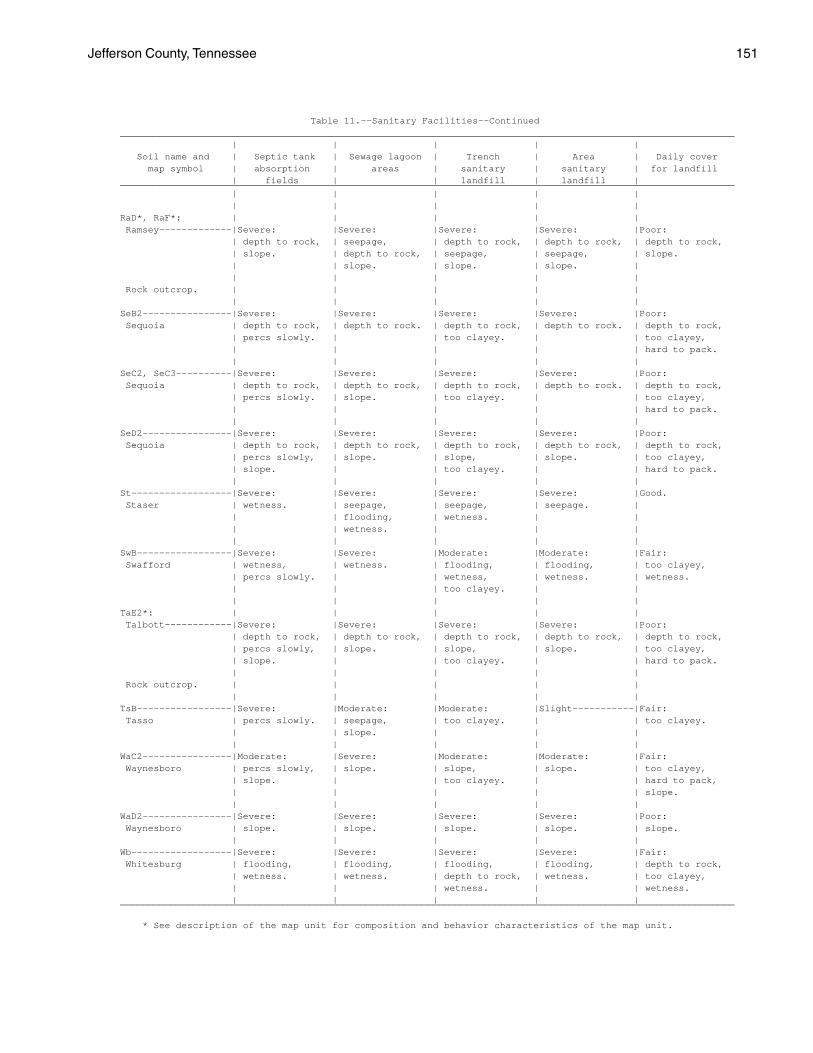
Jefferson County, Tennessee 151
Table 11.--Sanitary Facilities--Continued ______________________________________________________________________________________________________________ | | | | | Soil name and | Septic tank | Sewage lagoon | Trench | Area | Daily cover map symbol | absorption | areas | sanitary | sanitary | for landfill | fields | | landfill | landfill | ______________________________________________________________________________________________________________ | | | | | | | | | | RaD*, RaF*: | | | | | Ramsey-------------|Severe: |Severe: |Severe: |Severe: |Poor: | depth to rock, | seepage, | depth to rock, | depth to rock, | depth to rock, | slope. | depth to rock, | seepage, | seepage, | slope. | | slope. | slope. | slope. | | | | | | Rock outcrop. | | | | | | | | | | SeB2----------------|Severe: |Severe: |Severe: |Severe: |Poor: Sequoia | depth to rock, | depth to rock. | depth to rock, | depth to rock. | depth to rock, | percs slowly. | | too clayey. | | too clayey, | | | | | hard to pack. | | | | | SeC2, SeC3----------|Severe: |Severe: |Severe: |Severe: |Poor: Sequoia | depth to rock, | depth to rock, | depth to rock, | depth to rock. | depth to rock, | percs slowly. | slope. | too clayey. | | too clayey, | | | | | hard to pack. | | | | | SeD2----------------|Severe: |Severe: |Severe: |Severe: |Poor: Sequoia | depth to rock, | depth to rock, | depth to rock, | depth to rock, | depth to rock, | percs slowly, | slope. | slope, | slope. | too clayey, | slope. | | too clayey. | | hard to pack. | | | | | St------------------|Severe: |Severe: |Severe: |Severe: |Good. Staser | wetness. | seepage, | seepage, | seepage. | | | flooding, | wetness. | | | | wetness. | | | | | | | | SwB-----------------|Severe: |Severe: |Moderate: |Moderate: |Fair: Swafford | wetness, | wetness. | flooding, | flooding, | too clayey, | percs slowly. | | wetness, | wetness. | wetness. | | | too clayey. | | | | | | | TaE2*: | | | | | Talbott------------|Severe: |Severe: |Severe: |Severe: |Poor: | depth to rock, | depth to rock, | depth to rock, | depth to rock, | depth to rock, | percs slowly, | slope. | slope, | slope. | too clayey, | slope. | | too clayey. | | hard to pack. | | | | | Rock outcrop. | | | | | | | | | | TsB-----------------|Severe: |Moderate: |Moderate: |Slight-----------|Fair: Tasso | percs slowly. | seepage, | too clayey. | | too clayey. | | slope. | | | | | | | | WaC2----------------|Moderate: |Severe: |Moderate: |Moderate: |Fair: Waynesboro | percs slowly, | slope. | slope, | slope. | too clayey, | slope. | | too clayey. | | hard to pack, | | | | | slope. | | | | | WaD2----------------|Severe: |Severe: |Severe: |Severe: |Poor: Waynesboro | slope. | slope. | slope. | slope. | slope. | | | | | Wb------------------|Severe: |Severe: |Severe: |Severe: |Fair: Whitesburg | flooding, | flooding, | flooding, | flooding, | depth to rock, | wetness. | wetness. | depth to rock, | wetness. | too clayey, | | | wetness. | | wetness. | | | | | ______________________________________________________________________________________________________________
* See description of the map unit for composition and behavior characteristics of the map unit.

152 Soil Survey
Table 12.--Construction Materials
(Some terms that describe restrictive soil features are defined in the Glossary. See text for definitions of "good," "fair," and other terms. Absence of an entry indicates that the soil was not rated. The information in this table indicates the dominant soil condition but does not eliminate the need for onsite investigation)
_______________________________________________________________________________________________________________ | | | | Soil name and | Roadfill | Sand | Gravel | Topsoil map symbol | | | | | | | | ______________________________________________________________________________________________________________ | | | | | | | | AeC. | | | | Arents | | | | | | | | AnC2------------------|Fair: |Improbable: |Improbable: |Fair: Allen | low strength. | excess fines. | excess fines. | small stones. | | | | AnD2------------------|Fair: |Improbable: |Improbable: |Poor: Allen | low strength, | excess fines. | excess fines. | slope. | slope. | | | | | | | AnE-------------------|Poor: |Improbable: |Improbable: |Poor: Allen | slope. | excess fines. | excess fines. | slope. | | | | ArD2------------------|Poor: |Improbable: |Improbable: |Poor: Armuchee | depth to rock, | excess fines. | excess fines. | too clayey, | low strength. | | | small stones, | | | | slope. | | | | ArE3, ArF2------------|Poor: |Improbable: |Improbable: |Poor: Armuchee | depth to rock, | excess fines. | excess fines. | too clayey, | low strength, | | | small stones, | slope. | | | slope. | | | | Be--------------------|Poor: |Improbable: |Improbable: |Poor: Beason | low strength. | excess fines. | excess fines. | thin layer. | | | | BoD-------------------|Fair: |Improbable: |Improbable: |Poor: Bouldin | large stones, | excess fines, | excess fines, | area reclaim, | slope. | large stones. | large stones. | small stones, | | | | slope. | | | | BoF-------------------|Poor: |Improbable: |Improbable: |Poor: Bouldin | slope. | excess fines, | excess fines, | area reclaim, | | large stones. | large stones. | small stones, | | | | slope. | | | | CoB2, CoC2, CoC3------|Poor: |Improbable: |Improbable: |Poor: Collegedale | low strength. | excess fines. | excess fines. | too clayey. | | | | CoD2------------------|Poor: |Improbable: |Improbable: |Poor: Collegedale | low strength. | excess fines. | excess fines. | too clayey, | | | | slope. | | | | CtD2*: | | | | Collegedale----------|Poor: |Improbable: |Improbable: |Poor: | low strength. | excess fines. | excess fines. | too clayey. | | | | Talbott--------------|Poor: |Improbable: |Improbable: |Poor: | depth to rock, | excess fines. | excess fines. | too clayey. | low strength. | | | | | | | Rock outcrop. | | | | | | | |
See footnote at end of table.

Jefferson County, Tennessee 153
Table 12.--Construction Materials--Continued ______________________________________________________________________________________________________________ | | | | Soil name and | Roadfill | Sand | Gravel | Topsoil map symbol | | | | | | | | ______________________________________________________________________________________________________________ | | | | | | | | CtE2*: | | | | Collegedale----------|Poor: |Improbable: |Improbable: |Poor: | low strength, | excess fines. | excess fines. | too clayey, | slope. | | | slope. | | | | Talbott--------------|Poor: |Improbable: |Improbable: |Poor: | depth to rock, | excess fines. | excess fines. | too clayey, | low strength, | | | slope. | slope. | | | | | | | Rock outcrop. | | | | | | | | DaC2, DaD2, DaD3------|Poor: |Improbable: |Improbable: |Poor: Dandridge | depth to rock. | excess fines. | excess fines. | depth to rock, | | | | too clayey, | | | | small stones. | | | | DaE3, DaF2------------|Poor: |Improbable: |Improbable: |Poor: Dandridge | depth to rock, | excess fines. | excess fines. | depth to rock, | slope. | | | too clayey, | | | | small stones. | | | | DcB2------------------|Fair: |Improbable: |Improbable: |Poor: Decatur | low strength. | excess fines. | excess fines. | too clayey. | | | | DeC2, DeC3------------|Poor: |Improbable: |Improbable: |Poor: Dewey | low strength. | excess fines. | excess fines. | too clayey. | | | | DeD2, DeD3------------|Poor: |Improbable: |Improbable: |Poor: Dewey | low strength. | excess fines. | excess fines. | too clayey, | | | | slope. | | | | DfD2*: | | | | Dewey----------------|Poor: |Improbable: |Improbable: |Poor: | low strength. | excess fines. | excess fines. | too clayey. | | | | Rock outcrop. | | | | | | | | Dm*. | | | | Dumps | | | | | | | | DuB2, DuC2, DuC3------|Fair: |Improbable: |Improbable: |Poor: Dunmore | shrink-swell, | excess fines. | excess fines. | too clayey, | low strength. | | | small stones. | | | | DuD2, DuD3------------|Fair: |Improbable: |Improbable: |Poor: Dunmore | shrink-swell, | excess fines. | excess fines. | too clayey, | low strength, | | | small stones, | slope. | | | slope. | | | | DuE2, DuE3------------|Poor: |Improbable: |Improbable: |Poor: Dunmore | slope. | excess fines. | excess fines. | too clayey, | | | | small stones, | | | | slope. | | | | DwE3*, DxE2*: | | | | Dunmore--------------|Fair: |Improbable: |Improbable: |Poor: | shrink-swell, | excess fines. | excess fines. | too clayey, | low strength, | | | small stones, | slope. | | | slope. | | | |
See footnote at end of table.

154 Soil Survey
Table 12.--Construction Materials--Continued ______________________________________________________________________________________________________________ | | | | Soil name and | Roadfill | Sand | Gravel | Topsoil map symbol | | | | | | | | ______________________________________________________________________________________________________________ | | | | | | | | DwE3*, DxE2*: | | | | Fullerton------------|Fair: |Improbable: |Improbable: |Poor: | shrink-swell, | excess fines. | excess fines. | too clayey, | low strength, | | | small stones, | slope. | | | area reclaim. | | | | Em--------------------|Poor: |Improbable: |Improbable: |Fair: Emory | low strength. | excess fines. | excess fines. | small stones. | | | | En--------------------|Fair: |Improbable: |Improbable: |Poor: Ennis | large stones. | excess fines. | excess fines. | large stones, | | | | area reclaim. | | | | EtB-------------------|Fair: |Improbable: |Improbable: |Fair: Etowah | low strength, | excess fines. | excess fines. | small stones, | thin layer. | | | too clayey. | | | | EtC-------------------|Fair: |Improbable: |Improbable: |Fair: Etowah | low strength, | excess fines. | excess fines. | small stones, | thin layer. | | | too clayey, | | | | slope. | | | | EtD-------------------|Fair: |Improbable: |Improbable: |Poor: Etowah | low strength, | excess fines. | excess fines. | slope. | thin layer, | | | | slope. | | | | | | | FaE2------------------|Poor: |Improbable: |Improbable: |Poor: Farragut | low strength. | excess fines. | excess fines. | too clayey, | | | | slope, | | | | area reclaim. | | | | FuC2------------------|Fair: |Improbable: |Improbable: |Poor: Fullerton | shrink-swell, | excess fines. | excess fines. | too clayey, | low strength. | | | small stones, | | | | area reclaim. | | | | FuD2------------------|Fair: |Improbable: |Improbable: |Poor: Fullerton | shrink-swell, | excess fines. | excess fines. | too clayey, | low strength, | | | small stones, | slope. | | | area reclaim. | | | | FuE2------------------|Poor: |Improbable: |Improbable: |Poor: Fullerton | slope. | excess fines. | excess fines. | too clayey, | | | | small stones, | | | | area reclaim. | | | | GpD2------------------|Poor: |Improbable: |Improbable: |Poor: Gilpin | thin layer. | excess fines. | excess fines. | slope, | | | | small stones. | | | | GpF-------------------|Poor: |Improbable: |Improbable: |Poor: Gilpin | thin layer, | excess fines. | excess fines. | slope, | slope. | | | small stones. | | | | GuE3*: | | | | Gullied land. | | | | | | | |
See footnote at end of table.

Jefferson County, Tennessee 155
Table 12.--Construction Materials--Continued ______________________________________________________________________________________________________________ | | | | Soil name and | Roadfill | Sand | Gravel | Topsoil map symbol | | | | | | | | ______________________________________________________________________________________________________________ | | | | | | | | GuE3*: | | | | Dandridge------------|Poor: |Improbable: |Improbable: |Poor: | depth to rock, | excess fines. | excess fines. | depth to rock, | slope. | | | too clayey, | | | | small stones. | | | | Ln--------------------|Fair: |Improbable: |Improbable: |Fair: Lindside | low strength, | excess fines. | excess fines. | too clayey. | wetness. | | | | | | | MnC-------------------|Fair: |Improbable: |Improbable: |Poor: Minvale | low strength. | excess fines. | excess fines. | small stones, | | | | area reclaim. | | | | MoC-------------------|Poor: |Improbable: |Improbable: |Poor: Montevallo | depth to rock. | excess fines. | excess fines. | small stones, | | | | depth to rock. | | | | MoD-------------------|Poor: |Improbable: |Improbable: |Poor: Montevallo | depth to rock. | excess fines. | excess fines. | small stones, | | | | depth to rock, | | | | slope. | | | | MpE*: | | | | Montevallo-----------|Poor: |Improbable: |Improbable: |Poor: | depth to rock, | excess fines. | excess fines. | small stones, | slope. | | | depth to rock, | | | | slope. | | | | Armuchee-------------|Poor: |Improbable: |Improbable: |Poor: | depth to rock, | excess fines. | excess fines. | too clayey, | low strength, | | | small stones, | slope. | | | slope. | | | | MuB, MuC--------------|Poor: |Improbable: |Improbable: |Poor: Muse | low strength. | excess fines. | excess fines. | too clayey. | | | | MwE-------------------|Poor: |Improbable: |Improbable: |Poor: Muskingum | slope. | excess fines. | excess fines. | slope. | | | | Ne--------------------|Poor: |Improbable: |Improbable: |Poor: Newark | low strength, | excess fines. | excess fines. | wetness. | wetness. | | | | | | | NkB2, NkC2------------|Fair: |Improbable: |Improbable: |Poor: Nolichucky | low strength. | excess fines. | excess fines. | small stones, | | | | area reclaim. | | | | NkD2, NmD2------------|Fair: |Improbable: |Improbable: |Poor: Nolichucky | low strength, | excess fines. | excess fines. | small stones, | slope. | | | area reclaim, | | | | slope. | | | | No--------------------|Good-----------------|Improbable: |Improbable: |Fair: Nolin | | excess fines. | excess fines. | too clayey, | | | | area reclaim. | | | | Pu--------------------|Poor: |Improbable: |Improbable: |Poor: Purdy | low strength, | excess fines. | excess fines. | wetness, | wetness. | | | too clayey. | | | |
See footnote at end of table.

156 Soil Survey
Table 12.--Construction Materials--Continued ______________________________________________________________________________________________________________ | | | | Soil name and | Roadfill | Sand | Gravel | Topsoil map symbol | | | | | | | | ______________________________________________________________________________________________________________ | | | | | | | | RaD*: | | | | Ramsey---------------|Poor: |Improbable: |Improbable: |Poor: | depth to rock. | excess fines. | excess fines. | depth to rock, | | | | small stones, | | | | slope. | | | | Rock outcrop. | | | | | | | | RaF*: | | | | Ramsey---------------|Poor: |Improbable: |Improbable: |Poor: | depth to rock, | excess fines. | excess fines. | depth to rock, | slope. | | | small stones, | | | | slope. | | | | Rock outcrop. | | | | | | | | SeB2, SeC2, SeC3------|Poor: |Improbable: |Improbable: |Poor: Sequoia | depth to rock, | excess fines. | excess fines. | too clayey. | low strength. | | | | | | | SeD2------------------|Poor: |Improbable: |Improbable: |Poor: Sequoia | depth to rock, | excess fines. | excess fines. | too clayey, | low strength. | | | slope. | | | | St--------------------|Good-----------------|Improbable: |Improbable: |Poor: Staser | | excess fines. | excess fines. | small stones, | | | | area reclaim. | | | | SwB-------------------|Fair: |Improbable: |Improbable: |Fair: Swafford | low strength, | excess fines. | excess fines. | too clayey. | wetness. | | | | | | | TaE2*: | | | | Talbott--------------|Poor: |Improbable: |Improbable: |Poor: | depth to rock, | excess fines. | excess fines. | too clayey, | low strength. | | | slope. | | | | Rock outcrop. | | | | | | | | TsB-------------------|Poor: |Improbable: |Improbable: |Poor: Tasso | low strength. | excess fines. | excess fines. | small stones. | | | | WaC2------------------|Fair: |Improbable: |Improbable: |Poor: Waynesboro | low strength. | excess fines. | excess fines. | too clayey. | | | | WaD2------------------|Fair: |Improbable: |Improbable: |Poor: Waynesboro | low strength, | excess fines. | excess fines. | too clayey, | slope. | | | slope. | | | | Wb--------------------|Poor: |Improbable: |Improbable: |Fair: Whitesburg | low strength. | excess fines. | excess fines. | too clayey, | | | | small stones. | | | | ______________________________________________________________________________________________________________
* See description of the map unit for composition and behavior characteristics of the map unit.

Jefferson County, Tennessee 157
Table 13.--Water Management
(Some terms that describe restrictive soil features are defined in the Glossary. See text for definitions of "slight," "moderate," and "severe." Absence of an entry indicates that the soil was not evaluated. The information in this table indicates the dominant soil condition but does not eliminate the need for onsite investigation)
_________________________________________________________________________________________________________________ | Limitations for-- | Features affecting-- ______________________________________________________________________________________________ Soil name and | Pond | Embankments, | | | Terraces | map symbol | reservoir | dikes, and | Drainage | Irrigation | and | Grassed | areas | levees | | | diversions | waterways _________________________________________________________________________________________________________________ | | | | | | | | | | | | AeC. | | | | | | Arents | | | | | | | | | | | | AnC2, AnD2--------|Moderate: |Severe: |Deep to water |Slope----------|Slope----------|Slope. Allen | seepage. | piping. | | | | | | | | | | AnE---------------|Severe: |Severe: |Deep to water |Slope----------|Slope----------|Slope. Allen | slope. | piping. | | | | | | | | | | ArD2, ArE3, ArF2--|Severe: |Severe: |Deep to water |Droughty, |Slope, |Slope, Armuchee | slope. | hard to pack. | | depth to rock,| depth to rock,| erodes easily, | | | | slope. | erodes easily.| droughty. | | | | | | Be----------------|Slight---------|Severe: |Flooding------|Wetness, |Erodes easily, |Wetness, Beason | | wetness. | | erodes easily,| wetness. | erodes easily. | | | | flooding. | | | | | | | | BoD, BoF----------|Severe: |Severe: |Deep to water |Large stones, |Slope, |Large stones, Bouldin | seepage, | large stones. | | droughty, | large stones. | slope, | slope. | | | slope. | | droughty. | | | | | | CoB2--------------|Slight---------|Severe: |Deep to water |Percs slowly, |Erodes easily, |Erodes easily, Collegedale | | hard to pack. | | slope, | percs slowly. | percs slowly. | | | | erodes easily.| | | | | | | | CoC2--------------|Slight---------|Severe: |Deep to water |Percs slowly, |Slope, |Slope, Collegedale | | hard to pack. | | slope, | erodes easily,| erodes easily, | | | | erodes easily.| percs slowly. | percs slowly. | | | | | | CoC3--------------|Slight---------|Severe: |Deep to water |Slow intake, |Slope, |Slope, Collegedale | | hard to pack. | | percs slowly, | percs slowly. | percs slowly. | | | | slope. | | | | | | | | CoD2--------------|Slight---------|Severe: |Deep to water |Percs slowly, |Slope, |Slope, Collegedale | | hard to pack. | | slope, | erodes easily,| erodes easily, | | | | erodes easily.| percs slowly. | percs slowly. | | | | | | CtD2*: | | | | | | Collegedale------|Slight---------|Severe: |Deep to water |Percs slowly, |Slope, |Slope, | | hard to pack. | | slope, | erodes easily,| erodes easily, | | | | erodes easily.| percs slowly. | percs slowly. | | | | | | Talbott----------|Moderate: |Severe: |Deep to water |Depth to rock, |Slope, |Slope, | depth to rock.| hard to pack. | | slope. | depth to rock,| erodes easily, | | | | | erodes easily.| depth to rock. | | | | | | Rock outcrop. | | | | | | | | | | | | CtE2*: | | | | | | Collegedale------|Severe: |Severe: |Deep to water |Percs slowly, |Slope, |Slope, | slope. | hard to pack. | | slope, | erodes easily,| erodes easily, | | | | erodes easily.| percs slowly. | percs slowly. | | | | | |
See footnote at end of table.

158 Soil Survey
Table 13.--Water Management--Continued _________________________________________________________________________________________________________________ | Limitations for-- | Features affecting-- ______________________________________________________________________________________________ Soil name and | Pond | Embankments, | | | Terraces | map symbol | reservoir | dikes, and | Drainage | Irrigation | and | Grassed | areas | levees | | | diversions | waterways _________________________________________________________________________________________________________________ | | | | | | | | | | | | CtE2*: | | | | | | Talbott----------|Severe: |Severe: |Deep to water |Depth to rock, |Slope, |Slope, | slope. | hard to pack. | | slope. | depth to rock,| erodes easily, | | | | | erodes easily.| depth to rock. | | | | | | Rock outcrop. | | | | | | | | | | | | DaC2, DaD2, DaD3--|Severe: |Severe: |Deep to water |Droughty, |Slope, |Large stones, Dandridge | depth to rock.| thin layer. | | depth to rock,| large stones, | slope, | | | | slope. | depth to rock.| droughty. | | | | | | DaE3, DaF2--------|Severe: |Severe: |Deep to water |Droughty, |Slope, |Large stones, Dandridge | depth to rock,| thin layer. | | depth to rock,| large stones, | slope, | slope. | | | slope. | depth to rock.| droughty. | | | | | | DcB2--------------|Moderate: |Severe: |Deep to water |Slope----------|Favorable------|Favorable. Decatur | seepage. | hard to pack. | | | | | | | | | | DeC2, DeC3, DeD2, | | | | | | DeD3-------------|Slight---------|Severe: |Deep to water |Slope----------|Slope----------|Slope. Dewey | | hard to pack. | | | | | | | | | | DfD2*: | | | | | | Dewey------------|Slight---------|Severe: |Deep to water |Slope----------|Slope----------|Slope. | | hard to pack. | | | | | | | | | | Rock outcrop. | | | | | | | | | | | | Dm*. | | | | | | Dumps | | | | | | | | | | | | DuB2--------------|Moderate: |Severe: |Deep to water |Slope----------|Favorable------|Favorable. Dunmore | seepage. | hard to pack. | | | | | | | | | | DuC2, DuC3, DuD2, | | | | | | DuD3-------------|Slight---------|Severe: |Deep to water |Slope----------|Slope----------|Slope. Dunmore | | hard to pack. | | | | | | | | | | DuE2, DuE3--------|Severe: |Severe: |Deep to water |Slope----------|Slope----------|Slope. Dunmore | slope. | hard to pack. | | | | | | | | | | DwE3*, DxE2*: | | | | | | Dunmore----------|Severe: |Severe: |Deep to water |Slope----------|Slope----------|Slope. | slope. | hard to pack. | | | | | | | | | | Fullerton--------|Severe: |Severe: |Deep to water |Slope----------|Slope, |Large stones, | slope. | piping, | | | large stones. | slope. | | hard to pack. | | | | | | | | | | Em----------------|Moderate: |Severe: |Deep to water |Erodes easily |Erodes easily |Erodes easily. Emory | seepage. | piping. | | | | | | | | | | En----------------|Severe: |Severe: |Deep to water |Large stones, |Large stones---|Large stones, Ennis | seepage. | piping. | | droughty. | | droughty. | | | | | | EtB---------------|Moderate: |Moderate: |Deep to water |Slope, |Erodes easily |Erodes easily. Etowah | seepage. | thin layer, | | erodes easily.| | | | piping. | | | | | | | | | |
See footnote at end of table.

Jefferson County, Tennessee 159
Table 13.--Water Management--Continued _________________________________________________________________________________________________________________ | Limitations for-- | Features affecting-- ______________________________________________________________________________________________ Soil name and | Pond | Embankments, | | | Terraces | map symbol | reservoir | dikes, and | Drainage | Irrigation | and | Grassed | areas | levees | | | diversions | waterways _________________________________________________________________________________________________________________ | | | | | | | | | | | | EtC, EtD----------|Moderate: |Moderate: |Deep to water |Slope, |Slope, |Slope, Etowah | seepage. | thin layer, | | erodes easily.| erodes easily.| erodes easily. | | piping. | | | | | | | | | | FaE2--------------|Severe: |Severe: |Deep to water |Slope, |Slope, |Slope, Farragut | slope. | hard to pack. | | erodes easily.| erodes easily.| erodes easily. | | | | | | FuC2, FuD2--------|Slight---------|Severe: |Deep to water |Slope----------|Slope, |Large stones, Fullerton | | piping, | | | large stones. | slope. | | hard to pack. | | | | | | | | | | FuE2--------------|Severe: |Severe: |Deep to water |Slope----------|Slope, |Large stones, Fullerton | slope. | piping, | | | large stones. | slope. | | hard to pack. | | | | | | | | | | GpD2, GpF---------|Severe: |Severe: |Deep to water |Slope, |Slope, |Slope, Gilpin | slope. | thin layer. | | depth to rock.| depth to rock,| depth to rock, | | | | | large stones. | large stones. | | | | | | GuE3*: | | | | | | Gullied land. | | | | | | | | | | | | GuE3*: | | | | | | Dandridge--------|Severe: |Severe: |Deep to water |Droughty, |Slope, |Large stones, | depth to rock,| thin layer. | | depth to rock,| large stones, | slope, | slope. | | | slope. | depth to rock.| droughty. | | | | | | Ln----------------|Moderate: |Severe: |Flooding, |Flooding, |Wetness, |Erodes easily. Lindside | seepage. | piping. | frost action.| wetness, | erodes easily.| | | | | erodes easily.| | | | | | | | MnC---------------|Moderate: |Severe: |Deep to water |Slope----------|Slope----------|Slope. Minvale | seepage. | piping. | | | | | | | | | | MoC---------------|Severe: |Severe: |Deep to water |Droughty, |Depth to rock |Droughty, Montevallo | depth to rock.| thin layer. | | depth to rock,| | depth to rock. | | | | slope. | | | | | | | | MoD---------------|Severe: |Severe: |Deep to water |Droughty, |Slope, |Slope, Montevallo | depth to rock.| thin layer. | | depth to rock,| depth to rock.| droughty, | | | | slope. | | depth to rock. | | | | | | MpE*: | | | | | | Montevallo-------|Severe: |Severe: |Deep to water |Droughty, |Slope, |Slope, | depth to rock,| thin layer. | | depth to rock,| depth to rock.| droughty, | slope. | | | slope. | | depth to rock. | | | | | | Armuchee---------|Severe: |Severe: |Deep to water |Droughty, |Slope, |Slope, | slope. | hard to pack. | | depth to rock,| depth to rock,| erodes easily, | | | | slope. | erodes easily.| droughty. | | | | | | MuB---------------|Moderate: |Moderate: |Deep to water |Percs slowly, |Erodes easily, |Erodes easily, Muse | depth to rock.| hard to pack, | | slope, | percs slowly. | percs slowly. | | thin layer. | | erodes easily.| | | | | | | | MuC---------------|Moderate: |Moderate: |Deep to water |Percs slowly, |Slope, |Slope, Muse | depth to rock.| hard to pack, | | slope, | erodes easily,| erodes easily, | | thin layer. | | erodes easily.| percs slowly. | percs slowly. | | | | | |
See footnote at end of table.

160 Soil Survey
Table 13.--Water Management--Continued _________________________________________________________________________________________________________________ | Limitations for-- | Features affecting-- ______________________________________________________________________________________________ Soil name and | Pond | Embankments, | | | Terraces | map symbol | reservoir | dikes, and | Drainage | Irrigation | and | Grassed | areas | levees | | | diversions | waterways _________________________________________________________________________________________________________________ | | | | | | | | | | | | MwE---------------|Severe: |Severe: |Not needed----|Slope, |Slope, |Slope, Muskingum | slope. | piping. | | seepage. | piping. | erodes easily. | | | | | | Ne----------------|Moderate: |Severe: |Flooding, |Wetness, |Erodes easily, |Wetness, Newark | seepage. | piping, | frost action.| erodes easily,| wetness. | erodes easily. | | wetness. | | flooding. | | | | | | | | NkB2--------------|Moderate: |Slight---------|Deep to water |Slope----------|Favorable------|Favorable. Nolichucky | seepage. | | | | | | | | | | | NkC2, NkD2, NmD2--|Moderate: |Slight---------|Deep to water |Slope----------|Slope----------|Slope. Nolichucky | seepage. | | | | | | | | | | | No----------------|Severe: |Severe: |Deep to water |Erodes easily, |Erodes easily |Erodes easily. Nolin | seepage. | piping. | | flooding. | | | | | | | | Pu----------------|Slight---------|Severe: |Percs slowly, |Wetness, |Erodes easily, |Wetness, Purdy | | piping, | frost action.| percs slowly. | wetness, | erodes easily, | | hard to pack, | | | percs slowly. | percs slowly. | | wetness. | | | | | | | | | | RaD*, RaF*: | | | | | | Ramsey-----------|Severe: |Severe: |Deep to water |Droughty, |Slope, |Slope, | depth to rock,| piping. | | depth to rock,| depth to rock.| droughty, | slope. | | | slope. | | depth to rock. | | | | | | Rock outcrop. | | | | | | | | | | | | SeB2--------------|Moderate: |Severe: |Deep to water |Slope, |Depth to rock, |Erodes easily, Sequoia | depth to rock.| hard to pack. | | depth to rock.| erodes easily.| droughty. | | | | | | SeC2--------------|Moderate: |Severe: |Deep to water |Slope, |Slope, |Slope, Sequoia | depth to rock.| hard to pack. | | depth to rock.| depth to rock,| erodes easily, | | | | | erodes easily.| droughty. | | | | | | SeC3--------------|Moderate: |Severe: |Deep to water |Slope, |Slope, |Slope, Sequoia | depth to rock.| hard to pack. | | depth to rock.| depth to rock.| droughty. | | | | | | SeD2--------------|Moderate: |Severe: |Deep to water |Slope, |Slope, |Slope, Sequoia | depth to rock.| hard to pack. | | depth to rock.| depth to rock,| erodes easily, | | | | | erodes easily.| droughty. | | | | | | St----------------|Severe: |Severe: |Deep to water |Favorable------|Favorable------|Favorable. Staser | seepage. | piping. | | | | | | | | | | SwB---------------|Moderate: |Severe: |Favorable-----|Wetness, |Erodes easily, |Erodes easily. Swafford | seepage. | piping. | | erodes easily.| wetness. | | | | | | | TaE2*: | | | | | | Talbott----------|Severe: |Severe: |Deep to water |Depth to rock, |Slope, |Slope, | slope. | hard to pack. | | slope. | depth to rock,| erodes easily, | | | | | erodes easily.| depth to rock. | | | | | | Rock outcrop. | | | | | | | | | | | | TsB---------------|Moderate: |Moderate: |Deep to water |Slope, |Erodes easily |Erodes easily. Tasso | seepage. | piping. | | erodes easily.| | | | | | | | | | | | | |
See footnote at end of table.

Jefferson County, Tennessee 161
Table 13.--Water Management--Continued _________________________________________________________________________________________________________________ | Limitations for-- | Features affecting-- ______________________________________________________________________________________________ Soil name and | Pond | Embankments, | | | Terraces | map symbol | reservoir | dikes, and | Drainage | Irrigation | and | Grassed | areas | levees | | | diversions | waterways _________________________________________________________________________________________________________________ | | | | | | | | | | | | WaC2, WaD2--------|Slight---------|Severe: |Deep to water |Slope----------|Slope----------|Slope. Waynesboro | | piping, | | | | | | hard to pack. | | | | | | | | | | Wb----------------|Moderate: |Moderate: |Flooding------|Wetness, |Wetness--------|Favorable. Whitesburg | seepage, | thin layer, | | flooding. | | | depth to rock.| piping, | | | | | | wetness. | | | | | | | | | | _________________________________________________________________________________________________________________
* See description of the map unit for composition and behavior characteristics of the map unit.

162 Soil Survey
Table 14.--Engineering Index Properties
(The symbol < means less than; > means more than. Absence of an entry indicates that data were not estimated)
_________________________________________________________________________________________________________________ | | | Classification |Frag- | Percentage passing | | ____________________ Soil name and |Depth| USDA texture | | |ments | sieve number-- |Liquid | Plas- ___________________________ map symbol | | | Unified | AASHTO | 3-10 | | | | | limit | ticity | | | | |inches| 4 | 10 | 40 | 200 | | index _________________________________________________________________________________________________________________ | In | | | | Pct | | | | | Pct | __ ___ ___ | | | | | | | | | | | AeC. | | | | | | | | | | | Arents | | | | | | | | | | | | | | | | | | | | | | AnC2, AnD2, AnE--| 0-11|Sandy loam-------|ML, CL-ML,|A-4 | 0-5 |90-100|75-100|65-98 |40-80 | <26 | NP-10 Allen | | | SM, SC-SM| | | | | | | | |11-16|Clay loam, sandy |CL-ML, CL,|A-4, A-6,| 0-10 |85-100|75-100|65-98 |40-80 | 20-43 | 4-19 | | clay loam, loam.| SC | A-7-6 | | | | | | | |16-65|Clay loam, sandy |CL-ML, CL,|A-4, A-6,| 0-10 |85-100|70-98 |60-95 |45-80 | 21-48 | 5-22 | | clay loam, clay.| SC, SC-SM| A-7-6 | | | | | | | | | | | | | | | | | | ArD2-------------| 0-10|Channery silt |CL, ML, |A-4, A-6 | 0-2 |70-80 |65-75 |60-70 |50-65 | 25-39 | 5-15 Armuchee | | loam. | CL-ML | | | | | | | | |10-18|Channery silty |ML, CL, CH|A-6, A-7 | 0-2 |65-85 |60-80 |55-80 |50-70 | 37-65 | 16-35 | | clay, channery | | | | | | | | | | | silty clay loam.| | | | | | | | | |18-24|Very channery |GC, CL, CH|A-2, A-6,| 0-5 |35-75 |25-70 |20-65 |15-55 | 35-60 | 13-30 | | silty clay, very| | A-7 | | | | | | | | | channery silty | | | | | | | | | | | clay loam. | | | | | | | | | |24-60|Weathered bedrock| --- | --- | --- | --- | --- | --- | --- | --- | --- | | | | | | | | | | | ArE3-------------| 0-6 |Channery silty |CL, ML, |A-4, A-6 | 0-2 |70-80 |65-75 |60-70 |50-65 | 25-39 | 5-15 Armuchee | | clay loam. | CL-ML | | | | | | | | | 6-14|Channery silty |ML, CL, CH|A-6, A-7 | 0-2 |65-85 |60-80 |55-80 |50-70 | 37-65 | 16-35 | | clay, channery | | | | | | | | | | | silty clay loam.| | | | | | | | | |14-20|Very channery |GC, CL, CH|A-2, A-6,| 0-5 |35-75 |25-70 |20-65 |15-55 | 35-60 | 13-30 | | silty clay, very| | A-7 | | | | | | | | | channery silty | | | | | | | | | | | clay loam. | | | | | | | | | |20-60|Weathered bedrock| --- | --- | --- | --- | --- | --- | --- | --- | --- | | | | | | | | | | | ArF2-------------| 0-10|Channery silt |CL, ML, |A-4, A-6 | 0-2 |70-80 |65-75 |60-70 |50-65 | 25-39 | 5-15 Armuchee | | loam. | CL-ML | | | | | | | | |10-18|Channery silty |ML, CL, CH|A-6, A-7 | 0-2 |65-85 |60-80 |55-80 |50-70 | 37-65 | 16-35 | | clay, channery | | | | | | | | | | | silty clay loam.| | | | | | | | | |18-24|Very channery |GC, CL, CH|A-2, A-6,| 0-5 |35-75 |25-70 |20-65 |15-55 | 35-60 | 13-30 | | silty clay, very| | A-7 | | | | | | | | | channery silty | | | | | | | | | | | clay loam. | | | | | | | | | |24-60|Weathered bedrock| --- | --- | --- | --- | --- | --- | --- | --- | --- | | | | | | | | | | | Be---------------| 0-14|Silt loam--------|ML, CL, |A-4, A-6 | 0 | 100 |95-100|90-100|75-90 | 25-40 | 5-15 Beason | | | CL-ML | | | | | | | | |14-25|Silty clay loam, |CL |A-6 | 0 | 100 |95-100|90-100|80-95 | 25-40 | 11-20 | | silt loam. | | | | | | | | | |25-46|Silty clay loam, |CL |A-6, A-7 | 0 | 100 |95-100|90-95 |80-95 | 30-49 | 11-25 | | silty clay, | | | | | | | | | | | clay. | | | | | | | | | |46-60|Variable---------| --- | --- | --- | --- | --- | --- | --- | --- | --- | | | | | | | | | | |
See footnote at end of table.

Jefferson County, Tennessee 163
Table 14.--Engineering Index Properties--Continued _________________________________________________________________________________________________________________ | | | Classification |Frag- | Percentage passing | | ____________________ Soil name and |Depth| USDA texture | | |ments | sieve number-- |Liquid | Plas- ___________________________ map symbol | | | Unified | AASHTO | 3-10 | | | | | limit | ticity | | | | |inches| 4 | 10 | 40 | 200 | | index _________________________________________________________________________________________________________________ | In | | | | Pct | | | | | Pct | __ ___ ___ | | | | | | | | | | | BoD, BoF---------| 0-9 |Stony sandy loam,|SM, ML, |A-2, A-4 |10-30 |65-85 |55-85 |40-65 |30-55 | 15-25 | 2-7 Bouldin | | cobbly sandy | SC-SM, GM| | | | | | | | | | loam. | | | | | | | | | | 9-65|Extremely stony |GC, SC |A-2, A-4,|30-55 |55-75 |45-65 |35-60 |25-50 | 25-39 | 8-16 | | clay loam, very | | A-6 | | | | | | | | | stony sandy clay| | | | | | | | | | | loam, very | | | | | | | | | | | cobbly clay | | | | | | | | | | | loam, extremely | | | | | | | | | | | cobbly clay | | | | | | | | | | | loam. | | | | | | | | | | | | | | | | | | | | CoB2, CoC2-------| 0-8 |Silt loam, silty |ML, CL-ML,|A-4, A-6 | 0-2 |90-100|85-100|75-95 |70-90 | 24-39 | 5-16 Collegedale | | clay loam. | CL | | | | | | | | | 8-65|Silty clay, clay |MH, CH, CL|A-7 | 0-2 |95-100|90-100|80-95 |75-95 | 41-75 | 18-42 | | | | | | | | | | | CoC3-------------| 0-3 |Silty clay loam |CL, ML, |A-6, A-7 | 0-2 |95-100|90-100|80-95 |75-95 | 34-55 | 12-28 Collegedale | | | CH, MH | | | | | | | | | 3-65|Clay, silty clay |MH, CH, CL|A-7 | 0-2 |95-100|90-100|80-95 |75-95 | 41-75 | 18-42 | | | | | | | | | | | CoD2-------------| 0-8 |Silt loam, silty |ML, CL-ML,|A-4, A-6 | 0-2 |90-100|85-100|75-95 |70-90 | 24-39 | 5-16 Collegedale | | clay loam. | CL | | | | | | | | | 8-65|Silty clay, clay |MH, CH, CL|A-7 | 0-2 |95-100|90-100|80-95 |75-95 | 41-75 | 18-42 | | | | | | | | | | | CtD2*, CtE2*: | | | | | | | | | | | Collegedale-----| 0-8 |Silt loam, silty |ML, CL-ML,|A-4, A-6 | 0-2 |90-100|85-100|75-95 |70-90 | 24-39 | 5-16 | | clay loam. | CL | | | | | | | | | 8-65|Silty clay, clay |MH, CH, CL|A-7 | 0-2 |95-100|90-100|80-95 |75-95 | 41-75 | 18-42 | | | | | | | | | | | Talbott---------| 0-7 |Silt loam, silty |CL |A-4, A-6 | 0-5 |95-100|90-100|85-95 |75-95 | 25-40 | 8-16 | | clay loam. | | | | | | | | | | 7-32|Clay, silty clay |CL, MH, CH|A-7 | 0-10 |95-100|90-100|85-95 |80-95 | 41-80 | 20-45 | 32 |Unweathered | --- | --- | --- | --- | --- | --- | --- | --- | --- | | bedrock. | | | | | | | | | | | | | | | | | | | | Rock outcrop. | | | | | | | | | | | | | | | | | | | | | | DaC2, DaD2-------| 0-3 |Channery silt |CL, GC, SC|A-6, A-4 | 5-15 |35-90 |35-80 |35-75 |35-70 | 25-40 | 8-20 Dandridge | | loam. | | | | | | | | | | 3-17|Channery silty |GC |A-7, A-6,|15-20 |25-50 |25-50 |15-45 |15-40 | 35-60 | 15-35 | | clay loam, | | A-2 | | | | | | | | | channery silty | | | | | | | | | | | clay, very | | | | | | | | | | | channery silty | | | | | | | | | | | clay loam. | | | | | | | | | |17-35|Weathered bedrock| --- | --- | --- | --- | --- | --- | --- | --- | --- | | | | | | | | | | | DaD3, DaE3-------| 0-5 |Channery silty |CL, GC, SC|A-6, A-4 | 5-15 |35-90 |35-80 |35-75 |35-70 | 25-40 | 8-20 Dandridge | | clay loam. | | | | | | | | | | 5-13|Channery silty |GC |A-7, A-6,|15-20 |25-50 |25-50 |15-45 |15-40 | 35-60 | 15-35 | | clay loam, | | A-2 | | | | | | | | | channery silty | | | | | | | | | | | clay, very | | | | | | | | | | | channery silty | | | | | | | | | | | clay loam. | | | | | | | | | |13-25|Weathered bedrock| --- | --- | --- | --- | --- | --- | --- | --- | --- | | | | | | | | | | |
See footnote at end of table.

164 Soil Survey
Table 14.--Engineering Index Properties--Continued _________________________________________________________________________________________________________________ | | | Classification |Frag- | Percentage passing | | ____________________ Soil name and |Depth| USDA texture | | |ments | sieve number-- |Liquid | Plas- ___________________________ map symbol | | | Unified | AASHTO | 3-10 | | | | | limit | ticity | | | | |inches| 4 | 10 | 40 | 200 | | index _________________________________________________________________________________________________________________ | In | | | | Pct | | | | | Pct | __ ___ ___ | | | | | | | | | | | DaF2-------------| 0-3 |Channery silt |CL, GC, SC|A-6, A-4 | 5-15 |35-90 |35-80 |35-75 |35-70 | 25-40 | 8-20 Dandridge | | loam. | | | | | | | | | | 3-17|Channery silty |GC |A-7, A-6,|15-20 |25-50 |25-50 |15-45 |15-40 | 35-60 | 15-35 | | clay loam, | | A-2 | | | | | | | | | channery silty | | | | | | | | | | | clay, very | | | | | | | | | | | channery silty | | | | | | | | | | | clay loam. | | | | | | | | | |17-35|Weathered bedrock| --- | --- | --- | --- | --- | --- | --- | --- | --- | | | | | | | | | | | DcB2-------------| 0-11|Silt loam--------|CL, ML, |A-4, A-6 | 0-3 |90-100|90-98 |85-98 |65-80 | <32 | NP-12 Decatur | | | CL-ML | | | | | | | | |11-33|Silty clay loam, |ML, CL |A-7, A-4,| 0-3 |90-100|90-100|88-99 |78-92 | 30-49 | 8-22 | | silty clay, | | A-6, A-5| | | | | | | | | clay. | | | | | | | | | |33-65|Clay, silty clay.|CL, ML, |A-7, A-6 | 0-3 |90-100|90-100|88-98 |75-90 | 37-60 | 11-28 | | | MH, CH | | | | | | | | | | | | | | | | | | | DeC2-------------| 0-10|Silt loam--------|CL-ML, CL |A-4, A-6 | 0 |90-100|80-100|75-95 |65-80 | 24-30 | 5-11 Dewey |10-34|Clay, silty clay,|CL |A-6 | 0 |90-100|80-100|75-95 |70-85 | 27-40 | 12-20 | | silty clay loam.| | | | | | | | | |34-65|Clay, silty clay |CH, CL, |A-6, A-7 | 0-2 |85-100|75-100|70-95 |65-85 | 38-68 | 12-34 | | | MH, ML | | | | | | | | | | | | | | | | | | | DeC3-------------| 0-4 |Silty clay loam |CL |A-6 | 0 |90-100|80-100|75-95 |70-80 | 25-39 | 12-20 Dewey | 4-28|Clay, silty clay,|CL |A-6 | 0 |90-100|80-100|75-95 |70-85 | 27-40 | 12-20 | | silty clay loam.| | | | | | | | | |28-65|Clay, silty clay |CH, CL, |A-6, A-7 | 0-2 |85-100|75-100|70-95 |65-85 | 38-68 | 12-34 | | | MH, ML | | | | | | | | | | | | | | | | | | | DeD2-------------| 0-10|Silt loam--------|CL-ML, CL |A-4, A-6 | 0 |90-100|80-100|75-95 |65-80 | 24-30 | 5-11 Dewey |10-34|Clay, silty clay,|CL |A-6 | 0 |90-100|80-100|75-95 |70-85 | 27-40 | 12-20 | | silty clay loam.| | | | | | | | | |34-65|Clay, silty clay |CH, CL, |A-6, A-7 | 0-2 |85-100|75-100|70-95 |65-85 | 38-68 | 12-34 | | | MH, ML | | | | | | | | | | | | | | | | | | | DeD3-------------| 0-4 |Silty clay loam |CL |A-6 | 0 |90-100|80-100|75-95 |70-80 | 25-39 | 12-20 Dewey | 4-28|Clay, silty clay,|CL |A-6 | 0 |90-100|80-100|75-95 |70-85 | 27-40 | 12-20 | | silty clay loam.| | | | | | | | | |28-65|Clay, silty clay |CH, CL, |A-6, A-7 | 0-2 |85-100|75-100|70-95 |65-85 | 38-68 | 12-34 | | | MH, ML | | | | | | | | | | | | | | | | | | | DfD2*: | | | | | | | | | | | Dewey-----------| 0-10|Silt loam--------|CL |A-6 | 0 |90-100|80-100|75-95 |70-80 | 25-39 | 12-20 |10-34|Clay, silty clay,|CL |A-6 | 0 |90-100|80-100|75-95 |70-85 | 27-40 | 12-20 | | silty clay loam.| | | | | | | | | |34-65|Clay, silty clay |CH, CL, |A-6, A-7 | 0-2 |85-100|75-100|70-95 |65-85 | 38-68 | 12-34 | | | MH, ML | | | | | | | | | | | | | | | | | | | Rock outcrop. | | | | | | | | | | | | | | | | | | | | | | Dm*. | | | | | | | | | | | Dumps | | | | | | | | | | | | | | | | | | | | | | DuB2, DuC2-------| 0-10|Silt loam, silty |CL-ML, CL,|A-4, A-6 | 0-5 |80-100|75-90 |65-80 |60-75 | 18-30 | 3-11 Dunmore | | clay loam. | ML | | | | | | | | |10-65|Clay, silty clay |MH, CH |A-7 | 0-5 |85-100|75-95 |70-95 |65-95 | 50-70 | 20-36 | | | | | | | | | | | DuC3-------------| 0-4 |Silty clay loam |CL |A-6, A-7 | 0-5 |85-100|75-95 |70-95 |65-90 | 32-44 | 12-20 Dunmore | 4-65|Clay, silty clay |MH, CH |A-7 | 0-5 |85-100|75-95 |70-95 |65-95 | 50-70 | 20-36 | | | | | | | | | | |
See footnote at end of table.
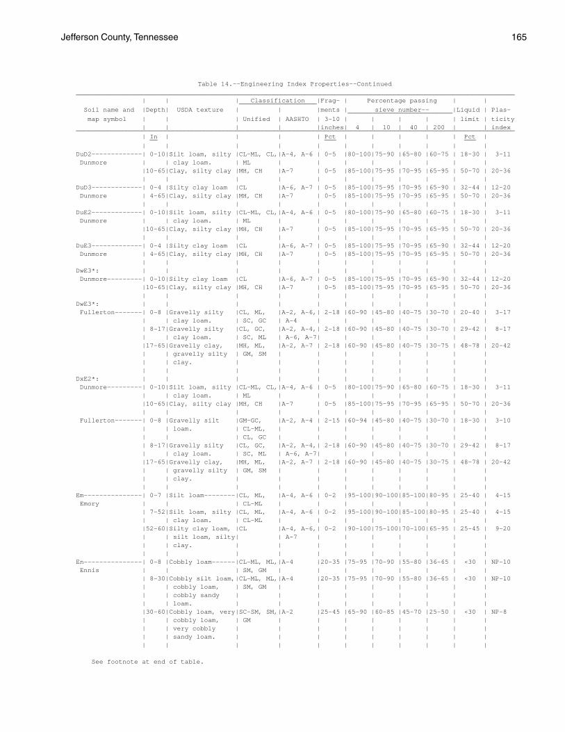
Jefferson County, Tennessee 165
Table 14.--Engineering Index Properties--Continued _________________________________________________________________________________________________________________ | | | Classification |Frag- | Percentage passing | | ____________________ Soil name and |Depth| USDA texture | | |ments | sieve number-- |Liquid | Plas- ___________________________ map symbol | | | Unified | AASHTO | 3-10 | | | | | limit | ticity | | | | |inches| 4 | 10 | 40 | 200 | | index _________________________________________________________________________________________________________________ | In | | | | Pct | | | | | Pct | __ ___ ___ | | | | | | | | | | | DuD2-------------| 0-10|Silt loam, silty |CL-ML, CL,|A-4, A-6 | 0-5 |80-100|75-90 |65-80 |60-75 | 18-30 | 3-11 Dunmore | | clay loam. | ML | | | | | | | | |10-65|Clay, silty clay |MH, CH |A-7 | 0-5 |85-100|75-95 |70-95 |65-95 | 50-70 | 20-36 | | | | | | | | | | | DuD3-------------| 0-4 |Silty clay loam |CL |A-6, A-7 | 0-5 |85-100|75-95 |70-95 |65-90 | 32-44 | 12-20 Dunmore | 4-65|Clay, silty clay |MH, CH |A-7 | 0-5 |85-100|75-95 |70-95 |65-95 | 50-70 | 20-36 | | | | | | | | | | | DuE2-------------| 0-10|Silt loam, silty |CL-ML, CL,|A-4, A-6 | 0-5 |80-100|75-90 |65-80 |60-75 | 18-30 | 3-11 Dunmore | | clay loam. | ML | | | | | | | | |10-65|Clay, silty clay |MH, CH |A-7 | 0-5 |85-100|75-95 |70-95 |65-95 | 50-70 | 20-36 | | | | | | | | | | | DuE3-------------| 0-4 |Silty clay loam |CL |A-6, A-7 | 0-5 |85-100|75-95 |70-95 |65-90 | 32-44 | 12-20 Dunmore | 4-65|Clay, silty clay |MH, CH |A-7 | 0-5 |85-100|75-95 |70-95 |65-95 | 50-70 | 20-36 | | | | | | | | | | | DwE3*: | | | | | | | | | | | Dunmore---------| 0-10|Silty clay loam |CL |A-6, A-7 | 0-5 |85-100|75-95 |70-95 |65-90 | 32-44 | 12-20 |10-65|Clay, silty clay |MH, CH |A-7 | 0-5 |85-100|75-95 |70-95 |65-95 | 50-70 | 20-36 | | | | | | | | | | | DwE3*: | | | | | | | | | | | Fullerton-------| 0-8 |Gravelly silty |CL, ML, |A-2, A-6,| 2-18 |60-90 |45-80 |40-75 |30-70 | 20-40 | 3-17 | | clay loam. | SC, GC | A-4 | | | | | | | | 8-17|Gravelly silty |CL, GC, |A-2, A-4,| 2-18 |60-90 |45-80 |40-75 |30-70 | 29-42 | 8-17 | | clay loam. | SC, ML | A-6, A-7| | | | | | | |17-65|Gravelly clay, |MH, ML, |A-2, A-7 | 2-18 |60-90 |45-80 |40-75 |30-75 | 48-78 | 20-42 | | gravelly silty | GM, SM | | | | | | | | | | clay. | | | | | | | | | | | | | | | | | | | | DxE2*: | | | | | | | | | | | Dunmore---------| 0-10|Silt loam, silty |CL-ML, CL,|A-4, A-6 | 0-5 |80-100|75-90 |65-80 |60-75 | 18-30 | 3-11 | | clay loam. | ML | | | | | | | | |10-65|Clay, silty clay |MH, CH |A-7 | 0-5 |85-100|75-95 |70-95 |65-95 | 50-70 | 20-36 | | | | | | | | | | | Fullerton-------| 0-8 |Gravelly silt |GM-GC, |A-2, A-4 | 2-15 |60-94 |45-80 |40-75 |30-70 | 18-30 | 3-10 | | loam. | CL-ML, | | | | | | | | | | | CL, GC | | | | | | | | | 8-17|Gravelly silty |CL, GC, |A-2, A-4,| 2-18 |60-90 |45-80 |40-75 |30-70 | 29-42 | 8-17 | | clay loam. | SC, ML | A-6, A-7| | | | | | | |17-65|Gravelly clay, |MH, ML, |A-2, A-7 | 2-18 |60-90 |45-80 |40-75 |30-75 | 48-78 | 20-42 | | gravelly silty | GM, SM | | | | | | | | | | clay. | | | | | | | | | | | | | | | | | | | | Em---------------| 0-7 |Silt loam--------|CL, ML, |A-4, A-6 | 0-2 |95-100|90-100|85-100|80-95 | 25-40 | 4-15 Emory | | | CL-ML | | | | | | | | | 7-52|Silt loam, silty |CL, ML, |A-4, A-6 | 0-2 |95-100|90-100|85-100|80-95 | 25-40 | 4-15 | | clay loam. | CL-ML | | | | | | | | |52-60|Silty clay loam, |CL |A-4, A-6,| 0-2 |90-100|75-100|70-100|65-95 | 25-45 | 9-20 | | silt loam, silty| | A-7 | | | | | | | | | clay. | | | | | | | | | | | | | | | | | | | | En---------------| 0-8 |Cobbly loam------|CL-ML, ML,|A-4 |20-35 |75-95 |70-90 |55-80 |36-65 | <30 | NP-10 Ennis | | | SM, GM | | | | | | | | | 8-30|Cobbly silt loam,|CL-ML, ML,|A-4 |20-35 |75-95 |70-90 |55-80 |36-65 | <30 | NP-10 | | cobbly loam, | SM, GM | | | | | | | | | | cobbly sandy | | | | | | | | | | | loam. | | | | | | | | | |30-60|Cobbly loam, very|SC-SM, SM,|A-2 |25-45 |65-90 |60-85 |45-70 |25-50 | <30 | NP-8 | | cobbly loam, | GM | | | | | | | | | | very cobbly | | | | | | | | | | | sandy loam. | | | | | | | | | | | | | | | | | | | |
See footnote at end of table.

166 Soil Survey
Table 14.--Engineering Index Properties--Continued _________________________________________________________________________________________________________________ | | | Classification |Frag- | Percentage passing | | ____________________ Soil name and |Depth| USDA texture | | |ments | sieve number-- |Liquid | Plas- ___________________________ map symbol | | | Unified | AASHTO | 3-10 | | | | | limit | ticity | | | | |inches| 4 | 10 | 40 | 200 | | index _________________________________________________________________________________________________________________ | In | | | | Pct | | | | | Pct | __ ___ ___ | | | | | | | | | | | EtB, EtC, EtD----| 0-10|Silt loam--------|ML, CL, |A-4 | 0 |80-100|75-100|70-95 |45-70 | 20-30 | 3-10 Etowah | | | SC-SM, | | | | | | | | | | | CL-ML | | | | | | | | |10-40|Silty clay loam, |CL |A-6 | 0 |80-100|75-100|70-95 |65-85 | 25-35 | 10-15 | | clay loam, silt | | | | | | | | | | | loam. | | | | | | | | | |40-65|Silty clay loam, |CL, ML, MH|A-6, A-7 | 0 |80-100|75-100|70-95 |65-85 | 39-60 | 15-25 | | clay loam, clay.| | | | | | | | | | | | | | | | | | | | FaE2-------------| 0-6 |Silt loam--------|ML, CL, |A-4, A-6 | 0 |95-100|95-100|90-100|70-90 | 20-35 | 3-15 Farragut | | | CL-ML | | | | | | | | | 6-51|Clay, silty clay,|CL, MH, CH|A-6, A-7 | 0 |90-100|85-100|80-95 |70-90 | 35-65 | 15-35 | | silty clay loam.| | | | | | | | | |51-65|Channery silty |CL, CH, GC|A-6, A-7,| 0-5 |40-65 |35-65 |30-60 |25-55 | 35-51 | 12-24 | | clay, channery | | A-2 | | | | | | | | | silty clay loam.| | | | | | | | | | | | | | | | | | | | FuC2, FuD2, FuE2-| 0-8 |Gravelly silt |GM-GC, |A-2, A-4 | 2-15 |60-94 |45-80 |40-75 |30-70 | 18-30 | 3-10 Fullerton | | loam. | CL-ML, | | | | | | | | | | | CL, GC | | | | | | | | | 8-17|Gravelly silty |CL, GC, |A-2, A-4,| 2-18 |60-90 |45-80 |40-75 |30-70 | 29-42 | 8-17 | | clay loam. | SC, ML | A-6, A-7| | | | | | | |17-65|Gravelly clay, |MH, ML, |A-2, A-7 | 2-18 |60-90 |45-80 |40-75 |30-75 | 48-78 | 20-42 | | gravelly silty | GM, SM | | | | | | | | | | clay. | | | | | | | | | | | | | | | | | | | | GpD2, GpF--------| 0-6 |Channery silt |GC, SC, |A-2, A-4,| 0-30 |50-90 |45-85 |35-75 |30-70 | 20-40 | 4-15 Gilpin | | loam. | CL, CL-ML| A-6 | | | | | | | | 6-26|Channery silt |GC, SC, |A-2, A-4,| 0-30 |50-95 |45-90 |35-85 |30-80 | 20-40 | 4-15 | | loam, silt loam,| CL, CL-ML| A-6 | | | | | | | | | silty clay loam.| | | | | | | | | |26-32|Channery loam, |GC, GM-GC |A-1, A-2,| 0-35 |25-55 |20-50 |15-45 |15-40 | 20-40 | 4-15 | | very channery | | A-4, A-6| | | | | | | | | silt loam, very | | | | | | | | | | | channery silty | | | | | | | | | | | clay loam. | | | | | | | | | | 32 |Unweathered | --- | --- | --- | --- | --- | --- | --- | --- | --- | | bedrock. | | | | | | | | | | | | | | | | | | | | GuE3*: | | | | | | | | | | | Gullied land. | | | | | | | | | | | | | | | | | | | | | | Dandridge-------| 0-5 |Channery silty |CL, GC, SC|A-6, A-4 | 5-15 |35-90 |35-80 |35-75 |35-70 | 25-40 | 8-20 | | clay loam. | | | | | | | | | | 5-13|Channery silty |GC |A-7, A-6,|15-20 |25-50 |25-50 |15-45 |15-40 | 35-60 | 15-35 | | clay loam, | | A-2 | | | | | | | | | channery silty | | | | | | | | | | | clay, very | | | | | | | | | | | channery silty | | | | | | | | | | | clay loam. | | | | | | | | | |13-25|Weathered bedrock| --- | --- | --- | --- | --- | --- | --- | --- | --- | | | | | | | | | | | Ln---------------| 0-10|Silt loam--------|ML, CL, |A-4, A-6 | 0 | 100 |95-100|80-100|55-90 | 20-35 | 2-15 Lindside | | | CL-ML | | | | | | | | |10-46|Silty clay loam, |CL, ML, |A-4, A-6 | 0 | 100 |95-100|90-100|70-95 | 25-40 | 4-18 | | silt loam, very | CL-ML | | | | | | | | | | fine sandy loam.| | | | | | | | | |46-60|Stratified silty |CL, ML, |A-2, A-4,| 0 |60-100|55-100|45-100|30-95 | 20-40 | 4-18 | | clay loam to | SM, SC | A-6 | | | | | | | | | gravelly sandy | | | | | | | | | | | loam. | | | | | | | | | | | | | | | | | | | |
See footnote at end of table.

Jefferson County, Tennessee 167
Table 14.--Engineering Index Properties--Continued _________________________________________________________________________________________________________________ | | | Classification |Frag- | Percentage passing | | ____________________ Soil name and |Depth| USDA texture | | |ments | sieve number-- |Liquid | Plas- ___________________________ map symbol | | | Unified | AASHTO | 3-10 | | | | | limit | ticity | | | | |inches| 4 | 10 | 40 | 200 | | index _________________________________________________________________________________________________________________ | In | | | | Pct | | | | | Pct | __ ___ ___ | | | | | | | | | | | MnC--------------| 0-9 |Gravelly silt |ML, CL, |A-4 | 0-5 |55-80 |50-75 |40-70 |36-60 | <30 | NP-10 Minvale | | loam. | GM, GC | | | | | | | | | 9-42|Gravelly silty |CL, CL-ML,|A-4, A-6 | 0-5 |50-75 |50-75 |40-70 |36-65 | 20-40 | 5-15 | | clay loam, | GC, GM-GC| | | | | | | | | | gravelly silt | | | | | | | | | | | loam, gravelly | | | | | | | | | | | loam. | | | | | | | | | |42-65|Gravelly silty |CL, ML, |A-4, A-6,| 0-5 |55-80 |50-75 |40-70 |36-65 | 25-50 | 7-23 | | clay loam, | GC, SC | A-7 | | | | | | | | | gravelly silty | | | | | | | | | | | clay. | | | | | | | | | | | | | | | | | | | | MoC, MoD---------| 0-8 |Channery silt |SC-SM, SC,|A-4 | 0-5 |60-88 |50-75 |45-70 |40-65 | <30 | NP-10 Montevallo | | loam. | CL-ML, CL| | | | | | | | | 8-16|Very channery |GM-GC, GC,|A-2, A-4,| 0-5 |35-70 |23-50 |15-45 |15-40 | 20-40 | 2-15 | | silt loam, | SC-SM, SC| A-6, | | | | | | | | | extremely | | A-1-b | | | | | | | | | channery silt | | | | | | | | | | | loam. | | | | | | | | | |16-38|Weathered bedrock| --- | --- | --- | --- | --- | --- | --- | --- | --- | | | | | | | | | | | MpE*: | | | | | | | | | | | Montevallo------| 0-5 |Channery silt |SC-SM, SC,|A-4 | 0-5 |60-88 |50-75 |45-70 |40-65 | <30 | NP-10 | | loam. | CL-ML, CL| | | | | | | | | 5-14|Very channery |GM-GC, GC,|A-2, A-4,| 0-5 |35-70 |23-50 |15-45 |15-40 | 20-40 | 2-15 | | silt loam, | SC-SM, SC| A-6, | | | | | | | | | extremely | | A-1-b | | | | | | | | | channery silt | | | | | | | | | | | loam. | | | | | | | | | |14-38|Weathered bedrock| --- | --- | --- | --- | --- | --- | --- | --- | --- | | | | | | | | | | | Armuchee--------| 0-10|Channery silt |CL, ML, |A-4, A-6 | 0-2 |70-80 |65-75 |60-70 |50-65 | 25-39 | 5-15 | | loam. | CL-ML | | | | | | | | |10-18|Channery silty |ML, CL, CH|A-6, A-7 | 0-2 |65-85 |60-80 |55-80 |50-70 | 37-65 | 16-35 | | clay, channery | | | | | | | | | | | silty clay loam.| | | | | | | | | |18-24|Very channery |GC, CL, CH|A-2, A-6,| 0-5 |35-75 |25-70 |20-65 |15-55 | 35-60 | 13-30 | | silty clay, very| | A-7 | | | | | | | | | channery silty | | | | | | | | | | | clay loam. | | | | | | | | | |24-60|Weathered bedrock| --- | --- | --- | --- | --- | --- | --- | --- | --- | | | | | | | | | | | MuB, MuC---------| 0-9 |Silt loam--------|ML, CL, |A-4, A-6 | 0 |80-100|70-100|60-100|55-95 | 20-40 | 2-20 Muse | | | CL-ML | | | | | | | | | 9-44|Silty clay loam, |CL, CH |A-7, A-6 | 0 |70-100|65-100|60-100|55-100| 35-65 | 15-35 | | silty clay, | | | | | | | | | | | channery silty | | | | | | | | | | | clay. | | | | | | | | | |44-60|Channery silty |MH, CH, |A-7, A-2 | 0 |50-100|40-95 |35-95 |30-95 | 40-75 | 20-40 | | clay, very | CL, GC | | | | | | | | | | channery clay, | | | | | | | | | | | clay. | | | | | | | | | |60-68|Weathered bedrock| --- | --- | --- | --- | --- | --- | --- | --- | --- | | | | | | | | | | | MwE--------------| 0-8 |Silt loam--------|ML, CL, |A-2, A-4 | 0-10 |75-100|70-95 |50-90 |30-80 | 20-35 | 2-10 Muskingum | | | SM, SC | | | | | | | | | 8-30|Silt loam, |GM, SM, |A-2, A-4 | 0-15 |70-90 |55-85 |50-80 |40-75 | 20-35 | 2-10 | | channery silt | ML, CL | | | | | | | | | | loam, channery | | | | | | | | | | | loam. | | | | | | | | | |30-45|Weathered bedrock| --- | --- | --- | --- | --- | --- | --- | --- | --- | | | | | | | | | | |
See footnote at end of table.

168 Soil Survey
Table 14.--Engineering Index Properties--Continued _________________________________________________________________________________________________________________ | | | Classification |Frag- | Percentage passing | | ____________________ Soil name and |Depth| USDA texture | | |ments | sieve number-- |Liquid | Plas- ___________________________ map symbol | | | Unified | AASHTO | 3-10 | | | | | limit | ticity | | | | |inches| 4 | 10 | 40 | 200 | | index _________________________________________________________________________________________________________________ | In | | | | Pct | | | | | Pct | __ ___ ___ | | | | | | | | | | | Ne---------------| 0-6 |Silt loam--------|ML, CL, |A-4 | 0 |95-100|90-100|80-100|55-95 | <32 | NP-10 Newark | | | CL-ML | | | | | | | | | 6-30|Silt loam, silty |ML, CL, |A-4, A-6,| 0 |95-100|90-100|85-100|70-100| 22-42 | 3-20 | | clay loam. | CL-ML | A-7 | | | | | | | |30-65|Silt loam, silty |ML, CL, |A-4, A-6,| 0-3 |75-100|70-100|65-100|55-95 | 22-42 | 3-20 | | clay loam. | CL-ML | A-7 | | | | | | | | | | | | | | | | | | NkB2, NkC2, NkD2-| 0-8 |Loam-------------|SC-SM, SC,|A-4, A-2 | 0-5 |80-100|75-100|50-95 |30-85 | 18-25 | 3-10 Nolichucky | | | CL, CL-ML| | | | | | | | | 8-15|Clay loam, |SC, GC, CL|A-4, A-2,| 0-20 |60-100|55-100|45-90 |20-75 | 25-35 | 8-15 | | gravelly clay | | A-6 | | | | | | | | | loam, loam. | | | | | | | | | |15-45|Clay loam, |CL, SC, GC|A-6, A-7,| 0-20 |60-100|55-100|45-95 |25-85 | 35-45 | 15-22 | | gravelly clay | | A-2 | | | | | | | | | loam, sandy clay| | | | | | | | | | | loam. | | | | | | | | | |45-60|Clay loam, clay, |CL, CH, |A-6, A-7,| 0-20 |60-100|55-100|45-95 |25-90 | 38-55 | 17-30 | | gravelly clay | SC, GC | A-2 | | | | | | | | | loam. | | | | | | | | | | | | | | | | | | | | NmD2-------------| 0-8 |Gravelly loam----|SC-SM, SC,|A-4, A-2,| 0-20 |60-75 |55-75 |30-70 |15-50 | 18-25 | 3-10 Nolichucky | | | GC, GM-GC| A-1-b | | | | | | | | 8-15|Clay loam, |SC, GC, CL|A-4, A-2,| 0-20 |60-100|55-100|45-90 |20-75 | 25-35 | 8-15 | | gravelly clay | | A-6 | | | | | | | | | loam, loam. | | | | | | | | | |15-45|Clay loam, |CL, SC, GC|A-6, A-7,| 0-20 |60-100|55-100|45-95 |25-85 | 35-45 | 15-22 | | gravelly clay | | A-2 | | | | | | | | | loam, sandy clay| | | | | | | | | | | loam. | | | | | | | | | |45-60|Clay loam, clay, |CL, CH, |A-6, A-7,| 0-20 |60-100|55-100|45-95 |25-90 | 38-55 | 17-30 | | gravelly clay | SC, GC | A-2 | | | | | | | | | loam. | | | | | | | | | | | | | | | | | | | | No---------------| 0-7 |Silt loam--------|CL, CL-ML |A-4, A-6 | 0 | 100 |95-100|90-100|80-100| 25-40 | 5-18 Nolin | 7-60|Silt loam, silty |CL, CL-ML |A-4, A-6,| 0 | 100 |95-100|85-100|75-100| 25-46 | 5-23 | | clay loam. | | A-7 | | | | | | | | | | | | | | | | | | Pu---------------| 0-12|Silt loam--------|ML, CL |A-4, A-6,| 0 |95-100|90-100|90-100|90-100| 25-50 | 4-20 Purdy | | | | A-7 | | | | | | | |12-50|Silty clay, clay,|CL, CH, MH|A-6, A-7 | 0 |95-100|90-100|85-100|75-85 | 30-65 | 11-30 | | clay loam. | | | | | | | | | |50-65|Silty clay, silty|CL, CH, MH|A-6, A-7 | 0 |95-100|90-100|85-100|70-95 | 30-65 | 11-30 | | clay loam, clay.| | | | | | | | | | | | | | | | | | | | RaD*, RaF*: | | | | | | | | | | | Ramsey----------| 0-4 |Loam-------------|SM, CL-ML,|A-4, A-2 | 0-10 |85-100|75-95 |60-75 |30-70 | <25 | NP-7 | | | ML, SC-SM| | | | | | | | | 4-18|Loam, sandy loam,|SM, CL-ML,|A-4, A-2 | 0-10 |85-100|75-95 |60-77 |30-70 | <25 | NP-7 | | fine sandy loam.| ML, SC-SM| | | | | | | | | 18 |Unweathered | --- | --- | --- | --- | --- | --- | --- | --- | --- | | bedrock. | | | | | | | | | | | | | | | | | | | | Rock outcrop. | | | | | | | | | | | | | | | | | | | | | | SeB2, SeC2-------| 0-5 |Silt loam--------|CL, CL-ML |A-4, A-6 | 0 |95-100|95-100|85-100|80-95 | 23-35 | 5-15 Sequoia | 5-35|Silty clay, clay,|CL, MH, CH|A-7 | 0 |70-100|65-100|60-100|55-95 | 43-74 | 20-40 | | channery silty | | | | | | | | | | | clay. | | | | | | | | | |35-50|Weathered bedrock| --- | --- | --- | --- | --- | --- | --- | --- | --- | | | | | | | | | | |
See footnote at end of table.

Jefferson County, Tennessee 169
Table 14.--Engineering Index Properties--Continued _________________________________________________________________________________________________________________ | | | Classification |Frag- | Percentage passing | | ____________________ Soil name and |Depth| USDA texture | | |ments | sieve number-- |Liquid | Plas- ___________________________ map symbol | | | Unified | AASHTO | 3-10 | | | | | limit | ticity | | | | |inches| 4 | 10 | 40 | 200 | | index _________________________________________________________________________________________________________________ | In | | | | Pct | | | | | Pct | __ ___ ___ | | | | | | | | | | | SeC3-------------| 0-5 |Silty clay loam |CL, ML, |A-6, A-7 | 0 |95-100|95-100|90-100|85-95 | 35-65 | 12-35 Sequoia | | | CH, MH | | | | | | | | | 5-30|Silty clay, clay,|CL, MH, CH|A-7 | 0 |70-100|65-100|60-100|55-95 | 43-74 | 20-40 | | channery silty | | | | | | | | | | | clay. | | | | | | | | | |30-50|Weathered bedrock| --- | --- | --- | --- | --- | --- | --- | --- | --- | | | | | | | | | | | SeD2-------------| 0-5 |Silt loam--------|CL, CL-ML |A-4, A-6 | 0 |95-100|95-100|85-100|80-95 | 23-35 | 5-15 Sequoia | 5-35|Silty clay, clay,|CL, MH, CH|A-7 | 0 |70-100|65-100|60-100|55-95 | 43-74 | 20-40 | | channery silty | | | | | | | | | | | clay. | | | | | | | | | |35-50|Weathered bedrock| --- | --- | --- | --- | --- | --- | --- | --- | --- | | | | | | | | | | | St---------------| 0-28|Fine sandy loam |CL, CL-ML,|A-4, A-6 | 0 |90-100|80-100|60-85 |55-80 | 20-35 | 3-15 Staser | | | ML | | | | | | | | |28-65|Silt loam, loam, |CL, CL-ML,|A-4, A-6,| 0-5 |45-100|40-100|35-80 |30-75 | 20-35 | 5-15 | | fine sandy loam.| SC, SC-SM| A-2 | | | | | | | | | | | | | | | | | | SwB--------------| 0-14|Silt loam--------|ML, CL-ML,|A-4 | 0 |90-100|85-100|75-100|55-85 | 20-35 | 2-10 Swafford | | | CL | | | | | | | | |14-28|Loam, clay loam, |CL, ML, |A-4, A-6 | 0 |90-100|85-100|75-95 |51-80 | 25-40 | 6-16 | | silt loam. | CL-ML | | | | | | | | |28-48|Loam, clay loam, |CL, ML, |A-4, A-6 | 0 |90-100|85-100|75-95 |51-80 | 25-40 | 6-16 | | silt loam. | CL-ML | | | | | | | | |48-65|Loam, clay loam, |CL, ML, |A-4, A-6 | 0 |90-100|85-100|75-95 |51-80 | 25-40 | 6-16 | | silt loam. | CL-ML | | | | | | | | | | | | | | | | | | | TaE2*: | | | | | | | | | | | Talbott---------| 0-7 |Silt loam, silty |CL |A-4, A-6 | 0-5 |95-100|90-100|85-95 |75-95 | 25-40 | 8-16 | | clay loam. | | | | | | | | | | 7-32|Clay, silty clay |CL, MH, CH|A-7 | 0-10 |95-100|90-100|85-95 |80-95 | 41-80 | 20-45 | 32 |Unweathered | --- | --- | --- | --- | --- | --- | --- | --- | --- | | bedrock. | | | | | | | | | | | | | | | | | | | | Rock outcrop. | | | | | | | | | | | | | | | | | | | | | | TsB--------------| 0-13|Silt loam--------|ML, CL-ML,|A-4 | 0-5 |90-100|80-95 |70-85 |60-75 | 20-30 | 3-9 Tasso | | | CL | | | | | | | | |13-19|Silt loam, loam, |CL |A-4, A-6 | 0-5 |90-100|80-95 |75-90 |65-80 | 27-36 | 9-15 | | silty clay loam.| | | | | | | | | |19-33|Silty clay loam, |CL |A-4, A-6 | 0-5 |70-100|65-95 |60-90 |50-85 | 27-36 | 9-15 | | clay loam, | | | | | | | | | | | gravelly silty | | | | | | | | | | | clay loam. | | | | | | | | | |33-65|Clay, clay loam, |CL, ML, |A-6, A-7 | 0-15 |80-100|70-95 |65-90 |55-85 | 35-55 | 14-25 | | silty clay loam.| MH, CH | | | | | | | | | | | | | | | | | | | WaC2, WaD2-------| 0-6 |Loam-------------|ML, CL-ML,|A-4 | 0-5 |85-100|80-100|70-95 |43-70 | 18-30 | 2-9 Waynesboro | | | CL, SM | | | | | | | | | 6-34|Clay loam, sandy |CL, SC |A-4, A-6,| 0-5 |90-100|85-100|75-95 |45-75 | 30-41 | 9-17 | | clay loam. | | A-7 | | | | | | | |34-65|Clay loam, sandy |MH, CL, ML|A-4, A-6,| 0-5 |90-100|80-100|70-98 |55-75 | 35-68 | 9-32 | | clay, clay. | | A-7 | | | | | | | | | | | | | | | | | | Wb---------------| 0-7 |Silt loam--------|CL, CL-ML,|A-4, A-6 | 0 |80-100|75-100|70-95 |55-85 | 20-35 | 3-13 Whitesburg | | | ML | | | | | | | | | 7-41|Silty clay loam, |CL |A-4, A-6 | 0 |80-100|75-100|70-95 |65-95 | 25-40 | 8-16 | | silt loam, clay | | | | | | | | | | | loam. | | | | | | | | | |41-50|Weathered bedrock| --- | --- | --- | --- | --- | --- | --- | --- | --- | | | | | | | | | | | _________________________________________________________________________________________________________________
* See description of the map unit for composition and behavior characteristics of the map unit.

170 Soil Survey
Table 15.--Physical and Chemical Properties of the Soils
(The symbol < means less than; > means more than. Entries under "Erosion factors--T" apply to the entire profile. Entries under "Organic matter" apply only to the surface layer. Absence of an entry indicates that data were not available or were not estimated)
______________________________________________________________________________________________________________ | | | | | | | | Erosion | Soil name and |Depth| Clay | Moist |Permeability |Available| Soil |Shrink-swell | factors | Organic _________ map symbol | | | bulk | | water |reaction| potential | | | matter | | | density | |capacity | | | K | T | ______________________________________________________________________________________________________________ | In | Pct | g/cc | In/hr | In/in | pH | | | | Pct __ ___ ____ _____ _____ __ ___ | | | | | | | | | | AeC. | | | | | | | | | | Arents | | | | | | | | | | | | | | | | | | | | AnC2, AnD2, AnE--| 0-11| 6-25 |1.30-1.50| 0.6-2.0 |0.14-0.19|4.5-5.5 |Low----------|0.28| 5 | .5-2 Allen |11-16| 18-35 |1.40-1.60| 0.6-2.0 |0.12-0.17|4.5-5.5 |Low----------|0.20| | |16-65| 20-45 |1.40-1.60| 0.6-2.0 |0.10-0.17|4.5-5.5 |Low----------|0.20| | | | | | | | | | | | ArD2-------------| 0-10| 22-32 |1.35-1.45| 0.6-2.0 |0.12-0.17|4.5-5.5 |Low----------|0.28| 3 | .5-2 Armuchee |10-18| 37-47 |1.40-1.50| 0.2-0.6 |0.10-0.14|4.5-5.5 |Moderate-----|0.37| | |18-24| 35-45 |1.40-1.50| 0.2-0.6 |0.05-0.10|4.5-5.5 |Moderate-----|0.32| | |24-60| --- | --- | --- | --- | --- |-------------|----| | | | | | | | | | | | ArE3-------------| 0-6 | 22-32 |1.35-1.45| 0.6-2.0 |0.12-0.17|4.5-5.5 |Low----------|0.28| 3 | <1 Armuchee | 6-14| 37-47 |1.40-1.50| 0.2-0.6 |0.10-0.14|4.5-5.5 |Moderate-----|0.37| | |14-20| 35-45 |1.40-1.50| 0.2-0.6 |0.05-0.10|4.5-5.5 |Moderate-----|0.32| | |20-60| --- | --- | --- | --- | --- |-------------|----| | | | | | | | | | | | ArF2-------------| 0-10| 22-32 |1.35-1.45| 0.6-2.0 |0.12-0.17|4.5-5.5 |Low----------|0.28| 3 | .5-2 Armuchee |10-18| 37-47 |1.40-1.50| 0.2-0.6 |0.10-0.14|4.5-5.5 |Moderate-----|0.37| | |18-24| 35-45 |1.40-1.50| 0.2-0.6 |0.05-0.10|4.5-5.5 |Moderate-----|0.32| | |24-60| --- | --- | --- | --- | --- |-------------|----| | | | | | | | | | | | Be---------------| 0-14| 22-35 |1.35-1.55| 0.6-2.0 |0.17-0.20|4.5-6.0 |Low----------|0.37| 5 | 1-2 Beason |14-25| 26-40 |1.40-1.60| 0.6-2.0 |0.17-0.20|4.5-5.5 |Low----------|0.32| | |25-46| 35-45 |1.45-1.65| 0.2-0.6 |0.14-0.18|4.5-5.5 |Low----------|0.32| | |46-60| --- | --- | --- | --- | --- |-------------|----| | | | | | | | | | | | BoD, BoF---------| 0-9 | 10-20 |1.35-1.50| 2.0-6.0 |0.06-0.10|4.5-5.5 |Low----------|0.20| 5 | .5-2 Bouldin | 9-65| 17-35 |1.40-1.55| 2.0-6.0 |0.06-0.10|4.5-5.5 |Low----------|0.20| | | | | | | | | | | | CoB2, CoC2-------| 0-8 | 20-35 |1.30-1.50| 0.6-2.0 |0.18-0.22|4.5-5.5 |Low----------|0.37| 5 | .5-2 Collegedale | 8-65| 40-60 |1.45-1.60| 0.2-0.6 |0.12-0.16|4.5-5.5 |Moderate-----|0.24| | | | | | | | | | | | CoC3-------------| 0-5 | 35-45 |1.40-1.60| 0.2-0.6 |0.14-0.20|4.5-5.5 |Moderate-----|0.28| 5 | <1 Collegedale | 5-65| 40-60 |1.50-1.70| 0.2-0.6 |0.12-0.16|4.5-5.5 |Moderate-----|0.24| | | | | | | | | | | | CoD2-------------| 0-8 | 20-35 |1.30-1.50| 0.6-2.0 |0.18-0.22|4.5-5.5 |Low----------|0.37| 5 | .5-2 Collegedale | 8-65| 40-60 |1.45-1.60| 0.2-0.6 |0.12-0.16|4.5-5.5 |Moderate-----|0.24| | | | | | | | | | | | CtD2*, CtE2*: | | | | | | | | | | Collegedale-----| 0-8 | 20-35 |1.30-1.50| 0.6-2.0 |0.18-0.22|4.5-5.5 |Low----------|0.37| 5 | .5-2 | 8-65| 40-60 |1.45-1.60| 0.2-0.6 |0.12-0.16|4.5-5.5 |Moderate-----|0.24| | | | | | | | | | | | Talbott---------| 0-7 | 15-27 |1.35-1.50| 0.6-2.0 |0.10-0.18|5.1-6.0 |Moderate-----|0.37| 2 | .5-2 | 7-32| 40-60 |1.40-1.60| 0.2-0.6 |0.10-0.14|5.1-6.0 |Moderate-----|0.24| | | 32 | --- | --- | --- | --- | --- |-------------|----| | | | | | | | | | | | Rock outcrop. | | | | | | | | | | | | | | | | | | | | DaC2, DaD2-------| 0-3 | 25-45 |1.40-1.50| 0.6-2.0 |0.08-0.14|6.1-7.8 |Low----------|0.17| 1 | .5-2 Dandridge | 3-17| 35-50 |1.40-1.55| 0.2-0.6 |0.06-0.10|6.1-7.8 |Moderate-----|0.17| | |17-35| --- | --- | --- | --- | --- |-------------|----| | | | | | | | | | | | DaD3, DaE3-------| 0-5 | 25-45 |1.40-1.50| 0.6-2.0 |0.08-0.14|6.1-7.8 |Low----------|0.17| 1 | <1 Dandridge | 5-13| 35-50 |1.40-1.55| 0.2-0.6 |0.06-0.10|6.1-7.8 |Moderate-----|0.17| | |13-25| --- | --- | --- | --- | --- |-------------|----| | | | | | | | | | | |
See footnote at end of table.

Jefferson County, Tennessee 171
Table 15.--Physical and Chemical Properties of the Soils--Continued ______________________________________________________________________________________________________________ | | | | | | | | Erosion | Soil name and |Depth| Clay | Moist |Permeability |Available| Soil |Shrink-swell | factors | Organic _________ map symbol | | | bulk | | water |reaction| potential | | | matter | | | density | |capacity | | | K | T | ______________________________________________________________________________________________________________ | In | Pct | g/cc | In/hr | In/in | pH | | | | Pct __ ___ ____ _____ _____ __ ___ | | | | | | | | | | DaF2-------------| 0-3 | 25-45 |1.40-1.50| 0.6-2.0 |0.08-0.14|6.1-7.8 |Low----------|0.17| 1 | .5-2 Dandridge | 3-17| 35-50 |1.40-1.55| 0.2-0.6 |0.06-0.10|6.1-7.8 |Moderate-----|0.17| | |17-35| --- | --- | --- | --- | --- |-------------|----| | | | | | | | | | | | DcB2-------------| 0-11| 15-27 |1.25-1.55| 0.6-2.0 |0.18-0.20|4.5-6.0 |Low----------|0.32| 5 | .5-2 Decatur |11-33| 35-60 |1.20-1.55| 0.6-2.0 |0.14-0.17|4.5-6.0 |Moderate-----|0.28| | |33-65| 35-60 |1.20-1.50| 0.6-2.0 |0.12-0.16|4.5-6.0 |Moderate-----|0.24| | | | | | | | | | | | DeC2-------------| 0-10| 17-27 |1.35-1.50| 0.6-2.0 |0.18-0.20|4.5-5.5 |Low----------|0.32| 5 | .5-2 Dewey |10-34| 35-50 |1.45-1.55| 0.6-2.0 |0.12-0.18|4.5-5.5 |Moderate-----|0.24| | |34-65| 45-60 |1.45-1.55| 0.6-2.0 |0.12-0.17|4.5-5.5 |Moderate-----|0.24| | | | | | | | | | | | DeC3-------------| 0-4 | 32-45 |1.40-1.50| 0.6-2.0 |0.14-0.19|4.5-5.5 |Low----------|0.28| 5 | <1 Dewey | 4-28| 35-50 |1.45-1.55| 0.6-2.0 |0.12-0.18|4.5-5.5 |Moderate-----|0.24| | |28-65| 45-60 |1.45-1.55| 0.6-2.0 |0.12-0.17|4.5-5.5 |Moderate-----|0.24| | | | | | | | | | | | DeD2-------------| 0-10| 17-27 |1.35-1.50| 0.6-2.0 |0.18-0.20|4.5-5.5 |Low----------|0.32| 5 | .5-2 Dewey |10-34| 35-50 |1.45-1.55| 0.6-2.0 |0.12-0.18|4.5-5.5 |Moderate-----|0.24| | |34-65| 45-60 |1.45-1.55| 0.6-2.0 |0.12-0.17|4.5-5.5 |Moderate-----|0.24| | | | | | | | | | | | DeD3-------------| 0-4 | 32-45 |1.40-1.50| 0.6-2.0 |0.14-0.19|4.5-5.5 |Low----------|0.28| 5 | <1 Dewey | 4-28| 35-50 |1.45-1.55| 0.6-2.0 |0.12-0.18|4.5-5.5 |Moderate-----|0.24| | |28-65| 45-60 |1.45-1.55| 0.6-2.0 |0.12-0.17|4.5-5.5 |Moderate-----|0.24| | | | | | | | | | | | DfD2*: | | | | | | | | | | Dewey-----------| 0-10| 32-45 |1.40-1.50| 0.6-2.0 |0.14-0.19|4.5-5.5 |Low----------|0.28| 5 | .5-2 |10-34| 35-50 |1.45-1.55| 0.6-2.0 |0.12-0.18|4.5-5.5 |Moderate-----|0.24| | |34-65| 45-60 |1.45-1.55| 0.6-2.0 |0.12-0.17|4.5-5.5 |Moderate-----|0.24| | | | | | | | | | | | Rock outcrop. | | | | | | | | | | | | | | | | | | | | Dm*. | | | | | | | | | | Dumps | | | | | | | | | | | | | | | | | | | | DuB2, DuC2-------| 0-10| 18-27 |1.40-1.55| 0.6-2.0 |0.17-0.20|4.5-6.0 |Low----------|0.32| 5 | .5-2 Dunmore |10-65| 40-65 |1.40-1.55| 0.6-2.0 |0.12-0.17|4.5-5.5 |Moderate-----|0.20| | | | | | | | | | | | DuC3-------------| 0-4 | 30-45 |1.40-1.55| 0.6-2.0 |0.15-0.18|4.5-5.5 |Low----------|0.28| 5 | <1 Dunmore | 4-65| 40-65 |1.40-1.55| 0.6-2.0 |0.12-0.17|4.5-5.5 |Moderate-----|0.20| | | | | | | | | | | | DuD2-------------| 0-10| 18-27 |1.40-1.55| 0.6-2.0 |0.17-0.20|4.5-6.0 |Low----------|0.32| 5 | .5-2 Dunmore |10-65| 40-65 |1.40-1.55| 0.6-2.0 |0.12-0.17|4.5-5.5 |Moderate-----|0.20| | | | | | | | | | | | DuD3-------------| 0-4 | 30-45 |1.40-1.55| 0.6-2.0 |0.15-0.18|4.5-5.5 |Low----------|0.28| 5 | <1 Dunmore | 4-65| 40-65 |1.40-1.55| 0.6-2.0 |0.12-0.17|4.5-5.5 |Moderate-----|0.20| | | | | | | | | | | | DuE2-------------| 0-10| 18-27 |1.40-1.55| 0.6-2.0 |0.17-0.20|4.5-6.0 |Low----------|0.32| 5 | .5-2 Dunmore |10-65| 40-65 |1.40-1.55| 0.6-2.0 |0.12-0.17|4.5-5.5 |Moderate-----|0.20| | | | | | | | | | | | DuE3-------------| 0-4 | 30-45 |1.40-1.55| 0.6-2.0 |0.15-0.18|4.5-5.5 |Low----------|0.28| 5 | <1 Dunmore | 4-65| 40-65 |1.40-1.55| 0.6-2.0 |0.12-0.17|4.5-5.5 |Moderate-----|0.20| | | | | | | | | | | | DwE3*: | | | | | | | | | | Dunmore---------| 0-10| 30-45 |1.40-1.55| 0.6-2.0 |0.15-0.18|4.5-5.5 |Low----------|0.28| 5 | <1 |10-65| 40-65 |1.40-1.55| 0.6-2.0 |0.12-0.17|4.5-5.5 |Moderate-----|0.20| | | | | | | | | | | | Fullerton-------| 0-8 | 27-40 |1.45-1.55| 0.6-2.0 |0.10-0.15|4.5-5.5 |Low----------|0.24| 5 | <1 | 8-17| 23-35 |1.45-1.55| 0.6-2.0 |0.10-0.15|4.5-5.5 |Low----------|0.24| | |17-65| 40-70 |1.45-1.55| 0.6-2.0 |0.10-0.14|4.5-5.5 |Moderate-----|0.20| | | | | | | | | | | |
See footnote at end of table.

172 Soil Survey
Table 15.--Physical and Chemical Properties of the Soils--Continued ______________________________________________________________________________________________________________ | | | | | | | | Erosion | Soil name and |Depth| Clay | Moist |Permeability |Available| Soil |Shrink-swell | factors | Organic _________ map symbol | | | bulk | | water |reaction| potential | | | matter | | | density | |capacity | | | K | T | ______________________________________________________________________________________________________________ | In | Pct | g/cc | In/hr | In/in | pH | | | | Pct __ ___ ____ _____ _____ __ ___ | | | | | | | | | | DxE2*: | | | | | | | | | | Dunmore---------| 0-10| 18-27 |1.40-1.55| 0.6-2.0 |0.17-0.20|4.5-6.0 |Low----------|0.32| 5 | .5-2 |10-65| 40-65 |1.40-1.55| 0.6-2.0 |0.12-0.17|4.5-5.5 |Moderate-----|0.20| | | | | | | | | | | | Fullerton-------| 0-8 | 15-27 |1.45-1.55| 0.6-2.0 |0.10-0.16|4.5-5.5 |Low----------|0.28| 5 | .5-2 | 8-17| 23-35 |1.45-1.55| 0.6-2.0 |0.10-0.15|4.5-5.5 |Low----------|0.24| | |17-65| 40-70 |1.45-1.55| 0.6-2.0 |0.10-0.14|4.5-5.5 |Moderate-----|0.20| | | | | | | | | | | | Em---------------| 0-7 | 20-35 |1.20-1.40| 0.6-2.0 |0.17-0.21|5.1-6.0 |Low----------|0.37| 5 | 1-3 Emory | 7-52| 20-35 |1.25-1.45| 0.6-2.0 |0.17-0.21|5.1-6.0 |Low----------|0.37| | |52-60| 32-45 |1.35-1.55| 0.6-2.0 |0.16-0.20|5.1-6.0 |Low----------|0.37| | | | | | | | | | | | En---------------| 0-8 | 12-25 |1.30-1.45| 2.0-6.0 |0.10-0.15|4.5-6.0 |Low----------|0.28| 5 | 1-2 Ennis | 8-30| 15-27 |1.30-1.50| 2.0-6.0 |0.08-0.15|4.5-6.0 |Low----------|0.28| | |30-60| 10-25 |1.35-1.50| 2.0-6.0 |0.06-0.14|4.5-6.0 |Low----------|0.20| | | | | | | | | | | | EtB, EtC, EtD----| 0-10| 15-27 |1.30-1.45| 0.6-2.0 |0.15-0.20|4.5-5.5 |Low----------|0.37| 5 | 1-3 Etowah |10-40| 23-35 |1.35-1.50| 0.6-2.0 |0.16-0.20|4.5-5.5 |Low----------|0.32| | |40-65| 32-45 |1.40-1.55| 0.6-2.0 |0.16-0.20|4.5-5.5 |Low----------|0.32| | | | | | | | | | | | FaE2-------------| 0-6 | 18-27 |1.30-1.50| 0.6-2.0 |0.15-0.20|4.5-5.5 |Low----------|0.37| 4 | 1-2 Farragut | 6-51| 35-55 |1.30-1.45| 0.6-2.0 |0.12-0.15|4.5-5.5 |Moderate-----|0.24| | |51-65| 35-55 |1.30-1.45| 0.2-0.6 |0.06-0.09|4.5-5.5 |Low----------|0.24| | | | | | | | | | | | FuC2, FuD2, FuE2-| 0-8 | 15-27 |1.45-1.55| 0.6-2.0 |0.10-0.16|4.5-5.5 |Low----------|0.28| 5 | .5-2 Fullerton | 8-17| 23-35 |1.45-1.55| 0.6-2.0 |0.10-0.15|4.5-5.5 |Low----------|0.24| | |17-65| 40-70 |1.45-1.55| 0.6-2.0 |0.10-0.14|4.5-5.5 |Moderate-----|0.20| | | | | | | | | | | | GpD2, GpF--------| 0-6 | 15-27 |1.20-1.40| 0.6-2.0 |0.12-0.16|3.6-5.5 |Low----------|0.24| 3 | .5-2 Gilpin | 6-26| 18-35 |1.20-1.50| 0.6-2.0 |0.12-0.16|3.6-5.5 |Low----------|0.24| | |26-32| 15-35 |1.20-1.50| 0.6-2.0 |0.08-0.12|3.6-5.5 |Low----------|0.24| | | 32 | --- | --- | --- | --- | --- |-------------|----| | | | | | | | | | | | GuE3*: | | | | | | | | | | Gullied land. | | | | | | | | | | | | | | | | | | | | Dandridge-------| 0-5 | 25-45 |1.40-1.50| 0.6-2.0 |0.08-0.14|6.1-7.8 |Low----------|0.17| 1 | <1 | 5-13| 35-50 |1.40-1.55| 0.2-0.6 |0.06-0.10|6.1-7.8 |Moderate-----|0.17| | |13-25| --- | --- | --- | --- | --- |-------------|----| | | | | | | | | | | | Ln---------------| 0-10| 15-27 |1.20-1.40| 0.6-2.0 |0.20-0.26|5.1-7.8 |Low----------|0.32| 5 | 1-3 Lindside |10-46| 18-35 |1.20-1.40| 0.2-2.0 |0.17-0.22|5.1-7.8 |Low----------|0.37| | |46-60| 18-35 |1.20-1.40| 0.2-6.0 |0.12-0.18|5.6-7.8 |Low----------|0.32| | | | | | | | | | | | MnC--------------| 0-9 | 15-30 |1.30-1.45| 2.0-6.0 |0.14-0.18|4.5-5.5 |Low----------|0.28| 5 | .5-2 Minvale | 9-42| 20-35 |1.40-1.55| 0.6-2.0 |0.12-0.18|4.5-5.5 |Low----------|0.28| | |42-65| 25-45 |1.40-1.55| 0.6-2.0 |0.11-0.17|4.5-5.5 |Low----------|0.28| | | | | | | | | | | | MoC, MoD---------| 0-8 | 7-27 |1.25-1.45| 0.6-2.0 |0.09-0.18|4.5-6.0 |Low----------|0.28| 1 | .5-2 Montevallo | 8-16| 15-35 |1.25-1.50| 0.6-2.0 |0.02-0.12|4.5-6.0 |Low----------|0.32| | |16-38| --- | --- | --- | --- | --- |-------------|----| | | | | | | | | | | | MpE*: | | | | | | | | | | Montevallo------| 0-5 | 7-27 |1.25-1.45| 0.6-2.0 |0.09-0.18|4.5-6.0 |Low----------|0.28| 1 | .5-2 | 5-14| 15-35 |1.25-1.50| 0.6-2.0 |0.02-0.12|4.5-6.0 |Low----------|0.32| | |14-38| --- | --- | --- | --- | --- |-------------|----| | | | | | | | | | | | Armuchee--------| 0-10| 22-32 |1.35-1.45| 0.6-2.0 |0.12-0.17|4.5-5.5 |Low----------|0.28| 3 | .5-2 |10-18| 37-47 |1.40-1.50| 0.2-0.6 |0.10-0.14|4.5-5.5 |Moderate-----|0.37| | |18-24| 35-45 |1.40-1.50| 0.2-0.6 |0.05-0.10|4.5-5.5 |Moderate-----|0.32| | |24-60| --- | --- | --- | --- | --- |-------------|----| | | | | | | | | | | |
See footnote at end of table.

Jefferson County, Tennessee 173
Table 15.--Physical and Chemical Properties of the Soils--Continued ______________________________________________________________________________________________________________ | | | | | | | | Erosion | Soil name and |Depth| Clay | Moist |Permeability |Available| Soil |Shrink-swell | factors | Organic _________ map symbol | | | bulk | | water |reaction| potential | | | matter | | | density | |capacity | | | K | T | ______________________________________________________________________________________________________________ | In | Pct | g/cc | In/hr | In/in | pH | | | | Pct __ ___ ____ _____ _____ __ ___ | | | | | | | | | | MuB, MuC---------| 0-9 | 7-27 |1.20-1.40| 0.6-2.0 |0.16-0.22|4.5-5.5 |Low----------|0.37| 3 | 1-3 Muse | 9-44| 28-60 |1.20-1.65| 0.06-0.2 |0.10-0.16|4.5-5.5 |Moderate-----|0.28| | |44-60| 40-60 |1.40-1.65| 0.06-0.2 |0.08-0.14|4.5-5.5 |Moderate-----|0.28| | |60-68| --- | --- | --- | --- | --- |-------------|----| | | | | | | | | | | | MwE--------------| 0-8 | 10-25 |1.20-1.40| 0.6-6.0 |0.12-0.18|4.5-6.0 |Low----------|0.37| 3 | .5-2 Muskingum | 8-30| 18-27 |1.20-1.50| 0.6-2.0 |0.08-0.14|4.5-5.5 |Low----------|0.28| | |30-45| --- | --- | --- | --- | --- |-------------|----| | | | | | | | | | | | Ne---------------| 0-6 | 7-27 |1.20-1.40| 0.6-2.0 |0.15-0.23|5.6-7.8 |Low----------|0.43| 5 | 1-3 Newark | 6-30| 18-35 |1.20-1.45| 0.6-2.0 |0.18-0.23|5.6-7.8 |Low----------|0.43| | |30-65| 12-40 |1.30-1.50| 0.6-2.0 |0.15-0.22|5.6-7.8 |Low----------|0.43| | | | | | | | | | | | NkB2, NkC2, NkD2-| 0-8 | 10-20 |1.30-1.45| 0.6-2.0 |0.18-0.22|4.5-6.5 |Low----------|0.28| 5 | .5-2 Nolichucky | 8-15| 18-30 |1.30-1.45| 0.6-2.0 |0.08-0.17|4.5-5.5 |Low----------|0.20| | |15-45| 25-35 |1.40-1.55| 0.6-2.0 |0.09-0.17|4.5-5.5 |Low----------|0.20| | |45-60| 30-50 |1.40-1.55| 0.6-2.0 |0.07-0.15|4.5-5.5 |Moderate-----|0.20| | | | | | | | | | | | NmD2-------------| 0-8 | 10-20 |1.30-1.45| 0.6-2.0 |0.08-0.14|4.5-6.5 |Low----------|0.15| 5 | .5-2 Nolichucky | 8-15| 18-30 |1.30-1.45| 0.6-2.0 |0.08-0.17|4.5-5.5 |Low----------|0.20| | |15-45| 25-35 |1.40-1.55| 0.6-2.0 |0.09-0.17|4.5-5.5 |Low----------|0.20| | |45-60| 30-50 |1.40-1.55| 0.6-2.0 |0.07-0.15|4.5-5.5 |Moderate-----|0.20| | | | | | | | | | | | No---------------| 0-7 | 12-35 |1.20-1.40| 0.6-2.0 |0.18-0.23|5.6-8.4 |Low----------|0.43| 5 | 1-3 Nolin | 7-60| 18-35 |1.25-1.50| 0.6-2.0 |0.18-0.23|5.6-8.4 |Low----------|0.43| | | | | | | | | | | | Pu---------------| 0-12| 18-35 |1.30-1.50| 0.2-0.6 |0.18-0.24|3.6-5.5 |Moderate-----|0.43| 3 | 1-3 Purdy |12-50| 35-50 |1.30-1.60| <0.2 |0.12-0.18|3.6-5.5 |Moderate-----|0.32| | |50-65| 35-50 |1.30-1.60| <0.2 |0.10-0.16|3.6-5.5 |Moderate-----|0.32| | | | | | | | | | | | RaD*, RaF*: | | | | | | | | | | Ramsey----------| 0-4 | 8-25 |1.25-1.50| 6.0-20 |0.09-0.12|4.5-5.5 |Low----------|0.20| 1 | .5-2 | 4-18| 8-25 |1.20-1.40| 6.0-20 |0.09-0.12|4.5-5.5 |Low----------|0.17| | | 18 | --- | --- | --- | --- | --- |-------------|----| | | | | | | | | | | | Rock outcrop. | | | | | | | | | | | | | | | | | | | | SeB2, SeC2-------| 0-5 | 15-27 |1.30-1.50| 0.6-2.0 |0.17-0.20|4.5-5.5 |Low----------|0.37| 3 | .5-2 Sequoia | 5-35| 35-60 |1.35-1.55| 0.2-0.6 |0.08-0.16|4.5-5.5 |Moderate-----|0.24| | |35-50| --- | --- | --- | --- | --- |-------------|----| | | | | | | | | | | | SeC3-------------| 0-5 | 27-45 |1.35-1.50| 0.6-2.0 |0.15-0.19|4.5-5.5 |Moderate-----|0.32| 3 | <1 Sequoia | 5-30| 35-60 |1.35-1.55| 0.2-0.6 |0.08-0.16|4.5-5.5 |Moderate-----|0.24| | |30-50| --- | --- | --- | --- | --- |-------------|----| | | | | | | | | | | | SeD2-------------| 0-5 | 15-27 |1.30-1.50| 0.6-2.0 |0.17-0.20|4.5-5.5 |Low----------|0.37| 3 | .5-2 Sequoia | 5-35| 35-60 |1.35-1.55| 0.2-0.6 |0.08-0.16|4.5-5.5 |Moderate-----|0.24| | |35-50| --- | --- | --- | --- | --- |-------------|----| | | | | | | | | | | | St---------------| 0-28| 18-27 |1.40-1.60| 0.6-2.0 |0.15-0.22|5.6-7.3 |Low----------|0.32| 5 | 2-4 Staser |28-65| 18-27 |1.40-1.60| 0.6-6.0 |0.07-0.18|5.6-7.3 |Low----------|0.28| | | | | | | | | | | | SwB--------------| 0-14| 12-25 |1.35-1.50| 0.6-2.0 |0.16-0.20|4.5-6.0 |Low----------|0.37| 5 | 1-2 Swafford |14-28| 18-32 |1.40-1.50| 0.6-2.0 |0.14-0.20|4.5-6.0 |Low----------|0.32| | |28-48| 18-32 |1.45-1.60| 0.2-0.6 |0.13-0.17|4.5-6.0 |Low----------|0.32| | |48-65| 18-32 |1.40-1.55| 0.6-2.0 |0.13-0.17|4.5-6.0 |Low----------|0.32| | | | | | | | | | | | TaE2*: | | | | | | | | | | Talbott---------| 0-7 | 15-27 |1.35-1.50| 0.6-2.0 |0.10-0.18|5.1-6.0 |Moderate-----|0.37| 2 | .5-2 | 7-32| 40-60 |1.40-1.60| 0.2-0.6 |0.10-0.14|5.1-6.0 |Moderate-----|0.24| | | 32 | --- | --- | --- | --- | --- |-------------|----| | | | | | | | | | | |
See footnote at end of table.

174 Soil Survey
Table 15.--Physical and Chemical Properties of the Soils--Continued ______________________________________________________________________________________________________________ | | | | | | | | Erosion | Soil name and |Depth| Clay | Moist |Permeability |Available| Soil |Shrink-swell | factors | Organic _________ map symbol | | | bulk | | water |reaction| potential | | | matter | | | density | |capacity | | | K | T | ______________________________________________________________________________________________________________ | In | Pct | g/cc | In/hr | In/in | pH | | | | Pct __ ___ ____ _____ _____ __ ___ | | | | | | | | | | TaE2*: | | | | | | | | | | Rock outcrop. | | | | | | | | | | | | | | | | | | | | TsB--------------| 0-13| 10-25 |1.35-1.45| 0.6-2.0 |0.17-0.20|4.5-5.5 |Low----------|0.37| 5 | .5-2 Tasso |13-19| 20-35 |1.40-1.55| 0.6-2.0 |0.17-0.19|4.5-5.5 |Low----------|0.32| | |19-33| 20-35 |1.50-1.70| 0.2-0.6 |0.10-0.15|4.5-5.5 |Low----------|0.32| | |33-65| 30-45 |1.35-1.50| 0.2-2.0 |0.10-0.15|4.5-5.5 |Moderate-----|0.28| | | | | | | | | | | | WaC2, WaD2-------| 0-6 | 10-30 |1.40-1.55| 0.6-2.0 |0.15-0.21|4.5-5.5 |Low----------|0.28| 5 | .5-2 Waynesboro | 6-34| 23-35 |1.40-1.55| 0.6-2.0 |0.14-0.20|4.5-5.5 |Low----------|0.28| | |34-65| 35-50 |1.40-1.55| 0.6-2.0 |0.13-0.18|4.5-5.5 |Low----------|0.28| | | | | | | | | | | | Wb---------------| 0-7 | 18-27 |1.35-1.50| 0.6-2.0 |0.15-0.22|6.1-7.8 |Low----------|0.37| 4 | 1-2 Whitesburg | 7-41| 25-35 |1.35-1.50| 0.6-2.0 |0.15-0.20|6.1-7.8 |Low----------|0.32| | |41-50| --- | --- | --- | --- | --- |-------------|----| | | | | | | | | | | | ______________________________________________________________________________________________________________
* See description of the map unit for composition and behavior characteristics of the map unit.
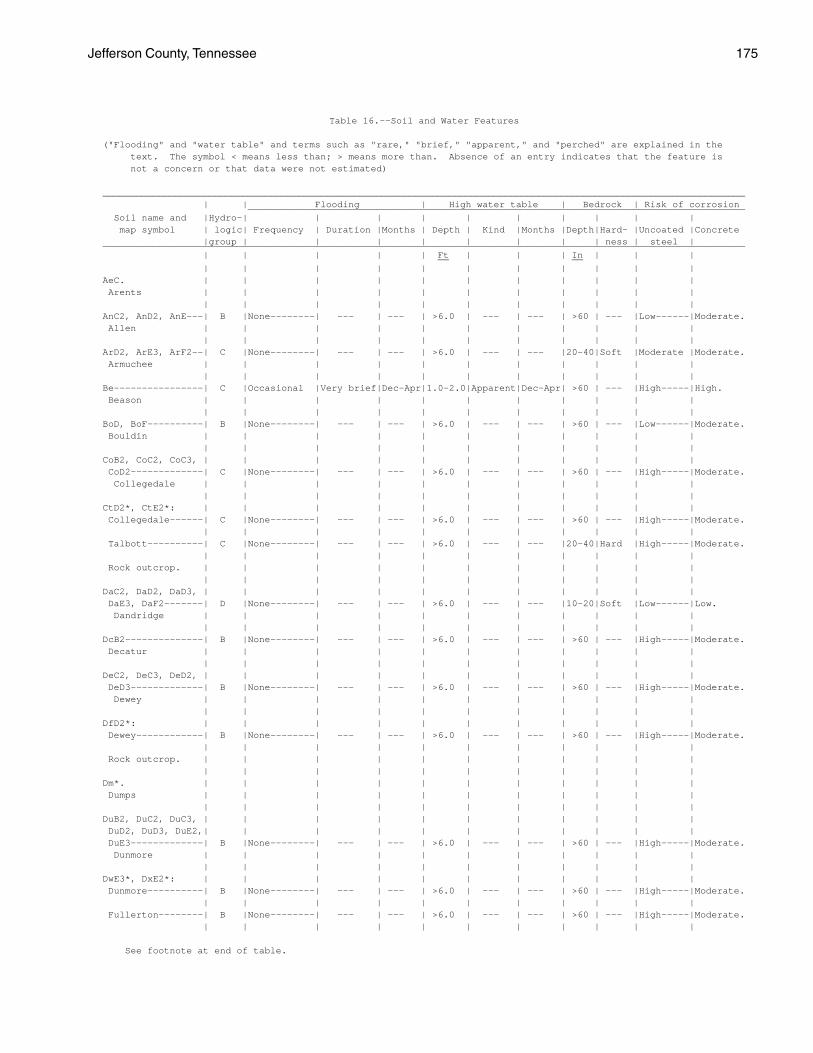
Jefferson County, Tennessee 175
Table 16.--Soil and Water Features
("Flooding" and "water table" and terms such as "rare," "brief," "apparent," and "perched" are explained in the text. The symbol < means less than; > means more than. Absence of an entry indicates that the feature is not a concern or that data were not estimated)
___________________________________________________________________________________________________________________ | | Flooding | High water table | Bedrock | Risk of corrosion _________________________________________________________________________________________ Soil name and |Hydro-| | | | | | | | | | map symbol | logic| Frequency | Duration |Months | Depth | Kind |Months |Depth|Hard- |Uncoated |Concrete |group | | | | | | | | ness | steel | ___________________________________________________________________________________________________________________ | | | | | Ft | | | In | | | __ __ | | | | | | | | | | | AeC. | | | | | | | | | | | Arents | | | | | | | | | | | | | | | | | | | | | | AnC2, AnD2, AnE---| B |None--------| --- | --- | >6.0 | --- | --- | >60 | --- |Low------|Moderate. Allen | | | | | | | | | | | | | | | | | | | | | | ArD2, ArE3, ArF2--| C |None--------| --- | --- | >6.0 | --- | --- |20-40|Soft |Moderate |Moderate. Armuchee | | | | | | | | | | | | | | | | | | | | | | Be----------------| C |Occasional |Very brief|Dec-Apr|1.0-2.0|Apparent|Dec-Apr| >60 | --- |High-----|High. Beason | | | | | | | | | | | | | | | | | | | | | | BoD, BoF----------| B |None--------| --- | --- | >6.0 | --- | --- | >60 | --- |Low------|Moderate. Bouldin | | | | | | | | | | | | | | | | | | | | | | CoB2, CoC2, CoC3, | | | | | | | | | | | CoD2-------------| C |None--------| --- | --- | >6.0 | --- | --- | >60 | --- |High-----|Moderate. Collegedale | | | | | | | | | | | | | | | | | | | | | | CtD2*, CtE2*: | | | | | | | | | | | Collegedale------| C |None--------| --- | --- | >6.0 | --- | --- | >60 | --- |High-----|Moderate. | | | | | | | | | | | Talbott----------| C |None--------| --- | --- | >6.0 | --- | --- |20-40|Hard |High-----|Moderate. | | | | | | | | | | | Rock outcrop. | | | | | | | | | | | | | | | | | | | | | | DaC2, DaD2, DaD3, | | | | | | | | | | | DaE3, DaF2-------| D |None--------| --- | --- | >6.0 | --- | --- |10-20|Soft |Low------|Low. Dandridge | | | | | | | | | | | | | | | | | | | | | | DcB2--------------| B |None--------| --- | --- | >6.0 | --- | --- | >60 | --- |High-----|Moderate. Decatur | | | | | | | | | | | | | | | | | | | | | | DeC2, DeC3, DeD2, | | | | | | | | | | | DeD3-------------| B |None--------| --- | --- | >6.0 | --- | --- | >60 | --- |High-----|Moderate. Dewey | | | | | | | | | | | | | | | | | | | | | | DfD2*: | | | | | | | | | | | Dewey------------| B |None--------| --- | --- | >6.0 | --- | --- | >60 | --- |High-----|Moderate. | | | | | | | | | | | Rock outcrop. | | | | | | | | | | | | | | | | | | | | | | Dm*. | | | | | | | | | | | Dumps | | | | | | | | | | | | | | | | | | | | | | DuB2, DuC2, DuC3, | | | | | | | | | | | DuD2, DuD3, DuE2,| | | | | | | | | | | DuE3-------------| B |None--------| --- | --- | >6.0 | --- | --- | >60 | --- |High-----|Moderate. Dunmore | | | | | | | | | | | | | | | | | | | | | | DwE3*, DxE2*: | | | | | | | | | | | Dunmore----------| B |None--------| --- | --- | >6.0 | --- | --- | >60 | --- |High-----|Moderate. | | | | | | | | | | | Fullerton--------| B |None--------| --- | --- | >6.0 | --- | --- | >60 | --- |High-----|Moderate. | | | | | | | | | | |
See footnote at end of table.
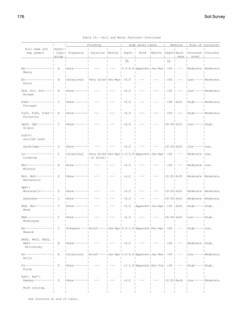
176 Soil Survey
Table 16.--Soil and Water Features--Continued ___________________________________________________________________________________________________________________ | | Flooding | High water table | Bedrock | Risk of corrosion _________________________________________________________________________________________ Soil name and |Hydro-| | | | | | | | | | map symbol | logic| Frequency | Duration |Months | Depth | Kind |Months |Depth|Hard- |Uncoated |Concrete |group | | | | | | | | ness | steel | ___________________________________________________________________________________________________________________ | | | | | Ft | | | In | | | __ __ | | | | | | | | | | | Em----------------| B |Rare--------| --- | --- |5.0-6.0|Apparent|Jan-Mar| >60 | --- |Moderate |Moderate. Emory | | | | | | | | | | | | | | | | | | | | | | En----------------| B |Occasional |Very brief|Dec-Mar| >6.0 | --- | --- | >60 | --- |Low------|Moderate. Ennis | | | | | | | | | | | | | | | | | | | | | | EtB, EtC, EtD-----| B |None--------| --- | --- | >6.0 | --- | --- | >60 | --- |Low------|Moderate. Etowah | | | | | | | | | | | | | | | | | | | | | | FaE2--------------| C |None--------| --- | --- | >6.0 | --- | --- | >48 |Soft |High-----|Moderate. Farragut | | | | | | | | | | | | | | | | | | | | | | FuC2, FuD2, FuE2--| B |None--------| --- | --- | >6.0 | --- | --- | >60 | --- |High-----|Moderate. Fullerton | | | | | | | | | | | | | | | | | | | | | | GpD2, GpF---------| C |None--------| --- | --- | >6.0 | --- | --- |20-40|Soft |Low------|High. Gilpin | | | | | | | | | | | | | | | | | | | | | | GuE3*: | | | | | | | | | | | Gullied land. | | | | | | | | | | | | | | | | | | | | | | Dandridge--------| D |None--------| --- | --- | >6.0 | --- | --- |10-20|Soft |Low------|Low. | | | | | | | | | | | Ln----------------| C |Occasional |Very brief|Dec-Apr|1.5-3.0|Apparent|Jan-Apr| >60 | --- |Moderate |Low. Lindside | | | or brief.| | | | | | | | | | | | | | | | | | | MnC---------------| B |None--------| --- | --- | >6.0 | --- | --- | >60 | --- |Moderate |Low. Minvale | | | | | | | | | | | | | | | | | | | | | | MoC, MoD----------| D |None--------| --- | --- | >6.0 | --- | --- |10-20|Soft |Moderate |Moderate. Montevallo | | | | | | | | | | | | | | | | | | | | | | MpE*: | | | | | | | | | | | Montevallo-------| D |None--------| --- | --- | >6.0 | --- | --- |10-20|Soft |Moderate |Moderate. | | | | | | | | | | | Armuchee---------| C |None--------| --- | --- | >6.0 | --- | --- |20-40|Soft |Moderate |Moderate. | | | | | | | | | | | MuB, MuC----------| C |None--------| --- | --- | >4.0 |Apparent|Jan-Apr| >40 |Soft |High-----|High. Muse | | | | | | | | | | | | | | | | | | | | | | MwE---------------| C |None--------| --- | --- | >6.0 | --- | --- |20-40|Soft |Low------|High. Muskingum | | | | | | | | | | | | | | | | | | | | | | Ne----------------| C |Frequent----|Brief-----|Jan-Apr|0.5-1.5|Apparent|Dec-Apr| >60 | --- |High-----|Low. Newark | | | | | | | | | | | | | | | | | | | | | | NkB2, NkC2, NkD2, | | | | | | | | | | | NmD2-------------| B |None--------| --- | --- | >6.0 | --- | --- | >60 | --- |Moderate |High. Nolichucky | | | | | | | | | | | | | | | | | | | | | | No----------------| B |Occasional |Brief-----|Jan-Apr|3.0-6.0|Apparent|Jan-Mar| >60 | --- |Low------|Moderate. Nolin | | | | | | | | | | | | | | | | | | | | | | Pu----------------| D |None--------| --- | --- | +1-1.0|Apparent|Dec-Jun| >60 | --- |High-----|High. Purdy | | | | | | | | | | | | | | | | | | | | | | RaD*, RaF*: | | | | | | | | | | | Ramsey-----------| D |None--------| --- | --- | >6.0 | --- | --- |10-20|Hard |Low------|Moderate. | | | | | | | | | | | Rock outcrop. | | | | | | | | | | | | | | | | | | | | | |
See footnote at end of table.

Jefferson County, Tennessee 177
Table 16.--Soil and Water Features--Continued ___________________________________________________________________________________________________________________ | | Flooding | High water table | Bedrock | Risk of corrosion _________________________________________________________________________________________ Soil name and |Hydro-| | | | | | | | | | map symbol | logic| Frequency | Duration |Months | Depth | Kind |Months |Depth|Hard- |Uncoated |Concrete |group | | | | | | | | ness | steel | ___________________________________________________________________________________________________________________ | | | | | Ft | | | In | | | __ __ | | | | | | | | | | | SeB2, SeC2, SeC3, | | | | | | | | | | | SeD2-------------| C |None--------| --- | --- | >6.0 | --- | --- |20-40|Soft |High-----|Moderate. Sequoia | | | | | | | | | | | | | | | | | | | | | | St----------------| B |Rare--------| --- | --- |3.0-4.0|Apparent|Jan-Mar| >60 | --- |Low------|Low. Staser | | | | | | | | | | | | | | | | | | | | | | SwB---------------| C |Rare--------| --- | --- |2.0-3.0|Perched |Jan-Mar| >60 | --- |Moderate |Moderate. Swafford | | | | | | | | | | | | | | | | | | | | | | TaE2*: | | | | | | | | | | | Talbott----------| C |None--------| --- | --- | >6.0 | --- | --- |20-40|Hard |High-----|Moderate. | | | | | | | | | | | Rock outcrop. | | | | | | | | | | | | | | | | | | | | | | TsB---------------| B |None--------| --- | --- | >6.0 | --- | --- | >60 | --- |Moderate |Moderate. Tasso | | | | | | | | | | | | | | | | | | | | | | WaC2, WaD2--------| B |None--------| --- | --- | >6.0 | --- | --- | >60 | --- |High-----|High. Waynesboro | | | | | | | | | | | | | | | | | | | | | | Wb----------------| C |Occasional |Very brief|Jan-Apr|2.0-4.0|Apparent|Jan-Mar|40-60|Soft |High-----|Low. Whitesburg | | | | | | | | | | | | | | | | | | | | | | ___________________________________________________________________________________________________________________
* See description of the map unit for composition and behavior characteristics of the map unit.

178
Table 17.--Classification of the Soils ______________________________________________________________________________________________________________ | Soil name | Family or higher taxonomic class | ______________________________________________________________________________________________________________ | | Allen---------------------| Fine-loamy, siliceous, thermic Typic Paleudults Arents--------------------| Arents Armuchee------------------| Clayey, mixed, thermic Ochreptic Hapludults Beason--------------------| Clayey, mixed, thermic Aquic Hapludults Bouldin-------------------| Loamy-skeletal, siliceous, mesic Typic Paleudults Collegedale---------------| Clayey, mixed, thermic Typic Paleudults Dandridge-----------------| Clayey-skeletal, mixed, mesic, shallow Ruptic-Alfic Eutrochrepts Decatur-------------------| Clayey, kaolinitic, thermic Rhodic Paleudults Dewey---------------------| Clayey, kaolinitic, thermic Typic Paleudults Dunmore-------------------| Clayey, kaolinitic, mesic Typic Paleudults Emory---------------------| Fine-silty, siliceous, thermic Fluventic Umbric Dystrochrepts Ennis---------------------| Fine-loamy, siliceous, thermic Fluventic Dystrochrepts Etowah--------------------| Fine-loamy, siliceous, thermic Typic Paleudults Farragut------------------| Clayey, mixed, thermic Humic Hapludults Fullerton-----------------| Clayey, kaolinitic, thermic Typic Paleudults Gilpin--------------------| Fine-loamy, mixed, mesic Typic Hapludults Lindside------------------| Fine-silty, mixed, mesic Fluvaquentic Eutrochrepts Minvale-------------------| Fine-loamy, siliceous, thermic Typic Paleudults Montevallo----------------| Loamy-skeletal, mixed, thermic, shallow Typic Dystrochrepts Muse----------------------| Clayey, mixed, mesic Typic Hapludults Muskingum-----------------| Fine-loamy, mixed, mesic Typic Dystrochrepts Newark--------------------| Fine-silty, mixed, nonacid, mesic Aeric Fluvaquents Nolichucky----------------| Fine-loamy, siliceous, mesic Typic Paleudults Nolin---------------------| Fine-silty, mixed, mesic Dystric Fluventic Eutrochrepts Purdy---------------------| Clayey, mixed, mesic Typic Ochraquults Ramsey--------------------| Loamy, siliceous, mesic Lithic Dystrochrepts Sequoia-------------------| Clayey, mixed, mesic Typic Hapludults Staser--------------------| Fine-loamy, mixed, thermic Cumulic Hapludolls Swafford------------------| Fine-loamy, siliceous, thermic Fragiaquic Paleudults Talbott-------------------| Fine, mixed, thermic Typic Hapludalfs Tasso---------------------| Fine-loamy, siliceous, thermic Fragic Paleudults Waynesboro----------------| Clayey, kaolinitic, thermic Typic Paleudults Whitesburg----------------| Fine-loamy, siliceous, mesic Aquic Dystric Eutrochrepts | ______________________________________________________________________________________________________________